Unit 8. earth's internal dynamics
16
1 Unit 8. Earth’s internal Processes. 1. THE INTERIOR OF THE EARTH IS HOTTER THAN THE EXTERIOR: ORIGIN OF THE EARTH’S INTERNAL HEAT The Earth is a heat engine. It remains geologically and biologically active, and evolves, because there are two great sources of energy. One source of energy is from the earth's molten core (that drives the internal geological processes), and the second is from the sun (that drives the external processes.) The earth grew from the accumulation of planetismals (meteorites and asteroids), over a period of 1‐200 million years about 4.3 to about 4.5 billion years ago. Toward the end of the accumulation a large mini‐planet hit a glancing blow with the earth. If the mini‐planet had hit directly the earth would have been shattered, and the debris scattered throughout the solar system ‐ no earth. As it was, the mini‐planet hit obliquely, and then spun off into an orbit around the earth ‐ to become the moon. If the earth had grown simply from the random accumulation of planetismals it would have been homogeneous ‐ more or less made of the same material throughout, and the earth cross section to the right would be a uniform blob with no structure. But the earth is stratified into layers by density (heavy core, intermediate mantle, light lithosphere), telling us that early in its history, the earth went through a molten stage that led to the heavy materials sinking inward to form the core, and the lighter materials floating toward the surface like a slag to form the crust. The heat for this melting came from meteorite impacts, the moon's impact, and the decay of radioactive elements. Imagine flying by the earth in a space ship about 4.3 billion years ago; all you would see is a glowing red hot ball of seething magma. All of the geological activity on the earth today is driven from this initial source of heat at the earth's formation, aided by continued radioactive decay of elements in the earth's interior. It has been found that the temperature in the interior of the Earth increases with depth, approximately 1 o C every 33 metres. The Earth's core is at approximately 4,000.C. However, the earth's heat engine ran faster at the beginning than now, about three times faster. Considering how active the earth is now with earthquakes and volcanoes it must have been a wonder four billion years ago to have it running even faster. But the earth is cooling off, and as time goes by there will be less and less heat to escape until there is none left at all. At that point the earth will die a heat death. 2. EARTH’S INTERNAL STRUCTURE The deepest places on the Earth are in South Africa, where mining companies have excavated 3.5 km into the Earth to extract gold. No one has seen deeper into the Earth than the South African miners because the heat and pressure felt at these depths prevents humans from going much deeper. Yet the Earth’s radius is 6,370 km ‐ how do we begin to know what is below the thin skin of the Earth when we cannot see it? Scientists use indirect methods. An earthquake occurs when rocks in a fault zone suddenly slip past each other, releasing stress that has built up over time. The slippage releases seismic energy, which is dissipated through two kinds of waves, P‐waves (primary or longitudinal waves) and S‐waves (secondary or transversal waves). Though both kinds of waves refract, or bend, when they cross a boundary into a different material, these two types of waves behave differently depending on the composition of the material they are passing through. One of the biggest differences is that S‐waves cannot travel through liquids whereas P‐waves can. We feel the arrival of the P‐ and S‐ waves at a given location as a ground‐shaking earthquake.
-
Upload
saragalanbiogeo -
Category
Education
-
view
57 -
download
0
Transcript of Unit 8. earth's internal dynamics

1
Unit 8. Earth’s internal Processes.
1. THE INTERIOR OF THE EARTH IS HOTTER THAN THE EXTERIOR: ORIGIN OF THE EARTH’S INTERNAL HEAT
The Earth is a heat engine. It remains geologically and biologically active, and evolves, because there are two great sources of energy. One source of energy is from the earth's molten core (that drives the internal geological processes), and the second is from the sun (that drives the external processes.) The earth grew from the accumulation of planetismals (meteorites and asteroids), over a period of 1‐200 million years about 4.3 to about 4.5 billion years ago. Toward the end of the accumulation a large mini‐planet hit a glancing blow with the earth. If the mini‐planet had hit directly the earth would have been shattered, and the debris scattered throughout the solar system ‐ no earth. As it was, the mini‐planet hit obliquely, and then spun off into an orbit around the earth ‐ to become the moon. If the earth had grown simply from the random accumulation of planetismals it would have been homogeneous ‐ more or less made of the same material throughout, and the earth cross section to the right would be a uniform blob with no structure. But the earth is stratified into layers by density (heavy core, intermediate mantle, light lithosphere), telling us that early in its history, the earth went through a molten stage that led to the heavy materials sinking inward to form the core, and the lighter materials floating toward the surface like a slag to form the crust. The heat for this melting came from meteorite impacts, the moon's impact, and the decay of radioactive elements. Imagine flying by the earth in a space ship about 4.3 billion years ago; all you would see is a glowing red hot ball of seething magma. All of the geological activity on the earth today is driven from this initial source of heat at the earth's formation, aided by continued radioactive decay of elements in the earth's interior. It has been found that the temperature in the interior of the Earth increases with depth, approximately 1oC every 33 metres. The Earth's core is at approximately 4,000.C. However, the earth's heat engine ran faster at the beginning than now, about three times faster. Considering how active the earth is now with earthquakes and volcanoes it must have been a wonder four billion years ago to have it running even faster. But the earth is cooling off, and as time goes by there will be less and less heat to escape until there is none left at all. At that point the earth will die a heat death.
2. EARTH’S INTERNAL STRUCTURE
The deepest places on the Earth are in South Africa, where mining companies have excavated 3.5 km into the Earth to extract gold. No one has seen deeper into the Earth than the South African miners because the heat and pressure felt at these depths prevents humans from going much deeper. Yet the Earth’s radius is 6,370 km ‐ how do we begin to know what is below the thin skin of the Earth when we cannot see it? Scientists use indirect methods.
An earthquake occurs when rocks in a fault zone suddenly slip past each other, releasing stress that has built up over time. The slippage releases seismic energy, which is dissipated through two kinds of waves, P‐waves (primary or longitudinal waves) and S‐waves (secondary or transversal waves).
Though both kinds of waves refract, or bend, when they cross a boundary into a different material, these two types of waves behave differently depending on the composition of the material they are passing through. One of the biggest differences is that S‐waves cannot travel through liquids whereas P‐waves can. We feel the arrival of the P‐ and S‐waves at a given location as a ground‐shaking earthquake.
2
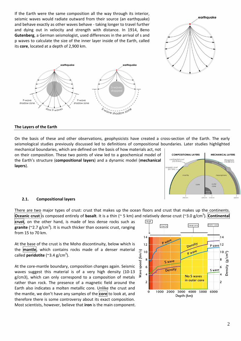
If the Earth were the same composition all the way through its interior, seismic waves would radiate outward from their source (an earthquake) and behave exactly as other waves behave ‐ taking longer to travel further and dying out in velocity and strength with distance. In 1914, Beno Gutenberg, a German seismologist, used differences in the arrival of s and p waves to calculate the size of the inner layer inside of the Earth, called its core, located at a depth of 2,900 km.
The Layers of the Earth
On the basis of these and other observations, geophysicists have created a cross‐section of the Earth. The early seismological studies previously discussed led to definitions of compositional boundaries. Later studies highlighted mechanical boundaries, which are defined on the basis of how materials act, not on their composition. These two points of view led to a geochemical model of the Earth’s structure (compositional layers) and a dynamic model (mechanical layers).
2.1. Compositional layers
There are two major types of crust: crust that makes up the ocean floors and crust that makes up the continents. Oceanic crust is composed entirely of basalt. It is a thin (~ 5 km) and relatively dense crust (~3.0 g/cm3). Continental crust, on the other hand, is made of less dense rocks such as granite (~2.7 g/cm3). It is much thicker than oceanic crust, ranging from 15 to 70 km.
At the base of the crust is the Moho discontinuity, below which is the mantle, which contains rocks made of a denser material called peridotite (~3.4 g/cm3).
At the core‐mantle boundary, composition changes again. Seismic waves suggest this material is of a very high density (10‐13 g/cm3), which can only correspond to a composition of metals rather than rock. The presence of a magnetic field around the Earth also indicates a molten metallic core. Unlike the crust and the mantle, we don’t have any samples of the core to look at, and therefore there is some controversy about its exact composition. Most scientists, however, believe that iron is the main component.

3
2.2. Mechanical layers
The compositional divisions of the Earth were understood decades before the development of the theory of plate tectonics ‐ the idea that the Earth’s surface consists of large plates that move. Lithospheric plates consist of the crust acting together with the uppermost part of the mantle; this rigid layer is called the lithosphere and it ranges in thickness from about 10 to 200 km.
There are nine large plates and a number of smaller plates. While most plates are comprised of both continental and oceanic crust (mixed plates), the giant Pacific Plate is almost entirely oceanic (oceanic plate), and the tiny Turkish‐Aegean Plate is entirely land (continental plate).
Rigid lithospheric plates were thought to be floating on a partially molten dense layer called the aesthenosphere. The aesthenosphere is not considered a layer any more as it is not found all over the planet but only in specific parts below the lithosphere.
3. CONSEQUENCES OF THE EARTH’S INTERNAL HEAT
The earth’s internal heat is responsible for many processes that are shown in the earth’s surface, such as volcanism, earthquakes, the shape of the continents, the origin of mountains and the isostasy. Apart from these processes, the internal heat also has consequences in the composition of the atmosphere, the magnetic field around the planet, the generation of geothermal energy that might be harnessed to produce heat and electricity, as well as hydrothermal phenomena like geysers or natural spa.
3.1. Earthquakes
An earthquake is a violent trembling of the Earth's crust which lasts a short time and which has a variable intensity. lt is produced when, at some point in the lithosphere, materials fracture abruptly, as they are unable to support the forces acting on them. This frees a large amount of energy. We can differentiate two important points in all earthquakes: the hypocentre and the epicentre. The point on the lithosphere where the earthquake has its origin is called the hypocentre. From the hypocentre, the energy released is transmitted in the form of seismic waves in all directions. The waves can cover the entire interior of the Earth, even crossing the core. The point on the Earth's surface where the effects of the earthquake are felt most strongly is called the epicenter. The energy is also transmitted from the epicentre in waves, which, in this case, are called superficial seismic waves. These waves cause catastrophes. The energy in an earthquake is enormous. A large earthquake is the equivalent of 100,000 atomic bombs like the one that destroyed the city of Hiroshima (Japan) in the Second World War. Fortunately, only a minimum amount of this energy is transmitted in the form of waves and reaches the Earth's surface.
4
Measuring earthquakes
The strength (magnitude) of an earthquake is measured using the Richter scale. The scale starts at zero. The amount of energy released increases greatly as the numbers increase. An earthquake that registered 7 would be about 30 times stronger than one that registered 6, and about 900 times stronger than one that registered 5. Most earthquakes that cause damage and loss of life register between 6 and 8 on the Richter scale.
3.2. Volcanoes
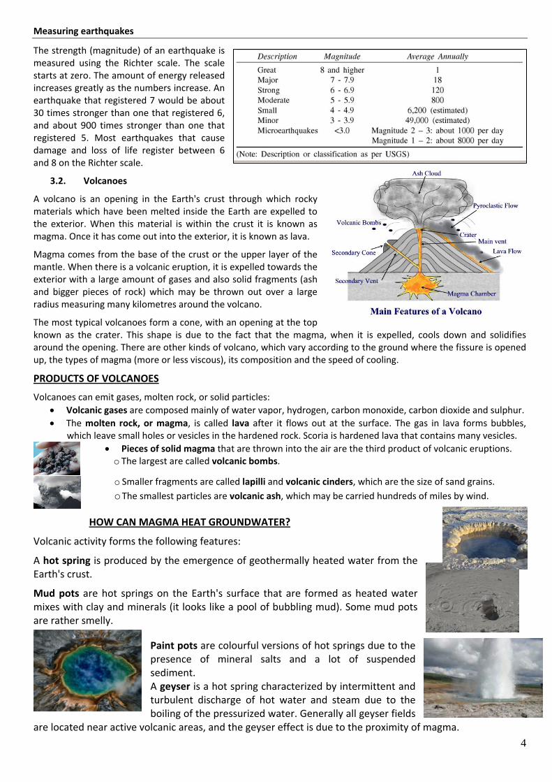
A volcano is an opening in the Earth's crust through which rocky materials which have been melted inside the Earth are expelled to the exterior. When this material is within the crust it is known as magma. Once it has come out into the exterior, it is known as lava.
Magma comes from the base of the crust or the upper layer of the mantle. When there is a volcanic eruption, it is expelled towards the exterior with a large amount of gases and also solid fragments (ash and bigger pieces of rock) which may be thrown out over a large radius measuring many kilometres around the volcano.
The most typical volcanoes form a cone, with an opening at the top known as the crater. This shape is due to the fact that the magma, when it is expelled, cools down and solidifies around the opening. There are other kinds of volcano, which vary according to the ground where the fissure is opened up, the types of magma (more or less viscous), its composition and the speed of cooling.
PRODUCTS OF VOLCANOES
Volcanoes can emit gases, molten rock, or solid particles: • Volcanic gases are composed mainly of water vapor, hydrogen, carbon monoxide, carbon dioxide and sulphur. • The molten rock, or magma, is called lava after it flows out at the surface. The gas in lava forms bubbles,
which leave small holes or vesicles in the hardened rock. Scoria is hardened lava that contains many vesicles. • Pieces of solid magma that are thrown into the air are the third product of volcanic eruptions.
o The largest are called volcanic bombs.
o Smaller fragments are called lapilli and volcanic cinders, which are the size of sand grains. o The smallest particles are volcanic ash, which may be carried hundreds of miles by wind.
HOW CAN MAGMA HEAT GROUNDWATER?
Volcanic activity forms the following features:
A hot spring is produced by the emergence of geothermally heated water from the Earth's crust.
Mud pots are hot springs on the Earth's surface that are formed as heated water mixes with clay and minerals (it looks like a pool of bubbling mud). Some mud pots are rather smelly.
Paint pots are colourful versions of hot springs due to the presence of mineral salts and a lot of suspended sediment. A geyser is a hot spring characterized by intermittent and turbulent discharge of hot water and steam due to the boiling of the pressurized water. Generally all geyser fields
are located near active volcanic areas, and the geyser effect is due to the proximity of magma.

5
A fumarole is an opening in Earth's crust, often near volcanoes, which emits steam and gases such as carbon dioxide and sulphur dioxide. Fumaroles are known as "dry geysers," from which gases go up into the air; they are also considered hot springs that lack a liquid component.
TYPES OF VOLCANOES All eruptions are different. The eruption depends on how much gas is in the magma and how thick the magma is.
a) Cinder‐cone volcano
Some magma is thick and has a lot of gas in it. The rocks build a cone with steep sides called a cinder‐cone volcano.
b) Shield volcano
Fluid magma. It is easier for gas to leave it. Lava looks like a fountain of fire as it leaves the vent. Lava hardens to make a wide, flat mound called a shield volcano.
c) Composite volcano
When eruptions vary on their behavior, a composite volcano is formed. Some composite volcanoes have symmetrical shapes.
3.3. The continents are moving
In 1910, the Austrian meteorologist, Alfred Wegener drew up the theory of continental drift.
According to Wegener, the continents of today come from the fracture of one original continent, Pangea, the fragments of which were displaced until they took up their current positions.
To draw up his hypothesis, Wegener based his ideas on how the West coast of Africa is an almost perfect fit for the East coast of South America, and on the similarities between the fossils found on the two continents, although today they are a long way from each other. These similarities suggest that, in the past, some of the continents were joined together.
Wegener's theory was not altogether right. ln the first place, he thought that the continents were only a part of the land which emerged above the water. Secondly, he did not explain what caused this drifting movement. However, despite his errors, his theories opened up the way for a whole series of new discoveries and research.
Later discoveries gave way to the theory of plate tectonics which we will see later. According to this theory, the Earth’s surface is made up of fragments, the lithospheric plates, which are continuously being displaced, crashing into each other at some points and separating at others. These movements are due to the internal energy of the planet.

=#--
platesTASK 10.2
t¡thosphericI
l
.lL-
lr
li
lri¡
j
li
ii f . The lithosphere is fragmented
We have learnt that the lithosphere, the most external layer ofour planet, consists of the Earth's crust and the upper mantle. lnfact, the lithosphere consists of a series of enormous fragments,the tectonic or Iithospheric plates. These fragments are likepieces of a puzzle and they are displaced independently. al-though very slowly: they separate, clraw close or collide. Themovement of the plates is not noticeable unless we use verysensitive instruments.
All the plates consist of a part of the crust and a part of theupper mantle. Depending on whether the crust is oceanic orcontinental, we can differentiate three kinds of lithosphericplates.
Oceanic plates: these form the bottom of the oceans anda part of the upper mantle. ln these plates, the averagethickness of the crust is 5-7 km.
Continental plates: these form the continents. They aremade up of the continental crust, with a thickness of 30-40km, which may be as much as 60 km in high mountainranges.
Mixed plates: these have oceanic and continenial crusi.They are the plates lvhich have a part which is emerged, thecontinental plate, and a part which is submerged.
Af ricanplate
ocea niccrust
AmericanAtlantic plate
'1
fOJ
f,c
mixedplate
continentalplate
cru st oceanic cruf
continental crust
-:F
\ PACIFIC
\PACIFIC
PLATE
NAZCA--- PTATE.
4-¿
,l^t1-
i
,\.o*
'&tI ¿'-
/^t*,.^*3-t9u_jllA$EIllcaN,) PLr''TE €
i j<-''t. I\2f.\_( -\r{- -¿¿
ANfARCTIC PLATE
- Limil of tectonic plate
r Oceanictrench
j.s Drsplacement velocity of theplates rn cm/year
¡ OrÍgin and direction of the
' displacement ol the plates
+1"+ Collision lines of the plates
mixednl:+a
continentalplate
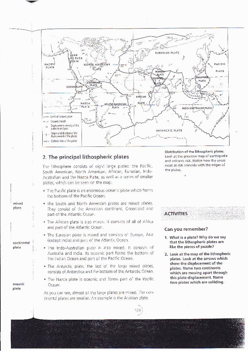
2. The principal lithospheric plates
The lithosphere consists of eight large plates: the Pacific,
South American, North American, African, Eurasian, lndo-
Australian and the Nazca Plate, as well as a series of smaller
plates, r¡",hich can be seen on the map.
" -lhe Pacific plate is an enormous oceanic plaie which Íorms
the bottom of the Pacific Ocean.
. The South and North American plates are mixed plates.
They consist of the Ame¡'ican continent, Greenland ¿nd
part of the Atlantic Ocean.
u The African plate is also mixed. lt consists of all of Afrlca
and part of the Atlantic Ocean.
o The Eurasian plate is mixed and consisis of Europe, Asra
(except lndia) and part of the Atlantic ocean.
" The lndo-Australian plate is also mixed. lt consists ofAustralia and lndia. lts oceanic part forms the bcttom ofthe lndian Ocean and part of the Pacific Ocean.
* The Antarctic plate, the last of the large mixed plates,
consists of Antarctica and the bottom of the Antarctic Ocean.
. The l{azca plate is oceanic anci forms part oÍ the PaciÍic
Ocean.
As you can see, almost all the large plates are mixed The con-
trnental plates are smaller. An exai-nple is the Arabian plate.
Distributior¡ of the lithospheric plates
Look at the previous map of earthquake
and volcanic risk. Notice how the areas
most at risk coincide with the edges ofthe plates.
.r:.ACT|V|TIES :- :" i 1
":'l l'-'--: : '
Can you remember?
1. What is a plate? WhY do we saythat the lithospheric Plates arelike the pieces of puzzle?
2. Look at the map of the lithospherkplates. l-ook at the arrows whichshow the displacement of theplates. Name two continentswhich are moving aPart through!his plate displacernent. Nametwo plates which are colliding'oceanld
plate

TAS|< 10 3
i. The types of boundary between plates
There are three iypes of boundary between plates: convergentboundanes, divergent boundaries and transform faults.
. Convergent boundaries are areas where the lithosphericplates are pushed iogether.
. .Divergent boundaries are where the lithospheric platesare moving away in opposite directions.
n Transform faults are where the Earth's lithospheric platesmove in opposite but parallel directions along a fracture(fault) in the lithosphere.
On the boundaries between plates, many rmportant phe-nomena occur. We shall analyse these by studying specificca5es.
2. A divergent bot¡ndary at the bottomof the Atlantic Ocean
The boundary between the South American and African plates rs
at the bottom of the Atlantic Ocean. There is a large submarinemountain range just on this boundary, the Atlantic ridge. Thismountain range runs right along theocean floor from North to South.
ln the ridge, we can see that there is agreat deal of volcanic activity. Meltedmaterials are continuously being ex-pelled and they cool down to becomethe oceanic crust.
This contlnuous production of the ocean-ic crust means that the land is displacedon both sides of the range. Likewise, Eu-rope and North America are separated.
There are many other ridges on theEarth. All of them are divergent bound-aries and all of them continue to formthe oceanic crust.
ln continental regions, we can also findridges in formation. An example is inAfrica. lf you look at the map of plateson the previous page, you will see thatthe Eastern part of Af rica is beingseparated from the rest. Currently, thereis an enormous valley in this regionknown as the Rift Valley. ln the fuiure (in
millions of years' time), the separation willbe completed and an ocean will appearhere with a ridge on the sea floor.
3" ee
ln thegent k
happe
n Jusl
coll
Plarpla
thethe
ln otlbounsignilhight
lnlThe
pla
thethi:MC
ar€
continent
hot zone
formation of oceaniccrust
prd Lc
contineniaicrust
4.4OntfamcCalif'
the F
Theeartlqual'
AsaCalif
ricartiner
part ofthe uppermantleridge
riit valley
crust
part ofthe uppermantie
^t
rpperlle
- plate
¡tinental5t
plate
Jst
rrt ofe upperantle
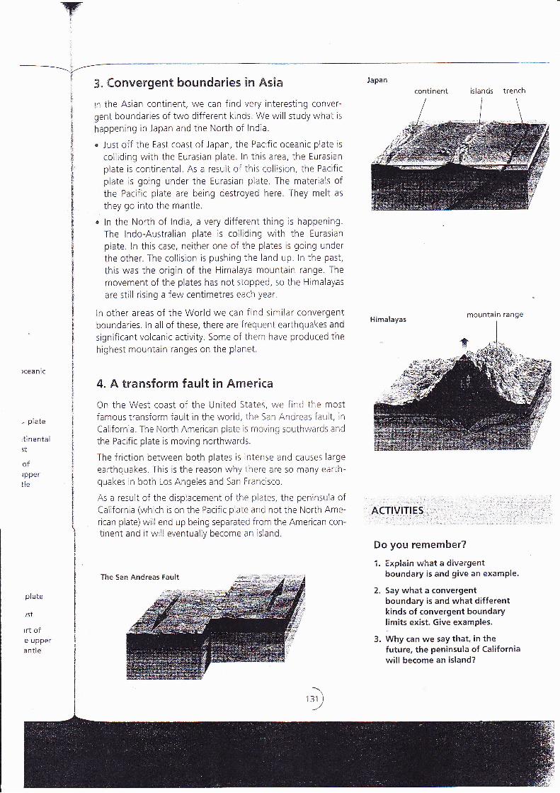
,{/-i A. eonvergerrt boundaries in Asia
ln ihe Asian continent, we can find very interesting conver-
gent boundaries of two different kinds. We will study what is
happening in Japan and the North oí lndia.
o Just off the East coast of Japan, the Pacific oceanic plate is
colliding with the Eurasian plate. ln this area, the Eurasian
plate is continental. As a result oÍ this collision, the Pacific
plate is going under the Eurasian plate. The materials ofthe Pacific plate are being destroyed here. They meli as
they go into the mantle.
. ln the North of lndia, a very different thing is happening.
The lndo-Australian plate is colliding with the Eurasian
plate. ln this case, neither one of the plates is going under
the other. The collision is pushing the land up. In the past,
this was the origin of the Himalaya mountain range. The
movement of the plates has not stopped, so the Himalayas
are still rising a few centimetres each year.
ln other areas of the World we can find similar convergentboundaries. ln all of these, there are frequent earthquakes and
significant volcanic activity. Some of them have produced the
highest mountain ranges on the planet.
4. A transform fault in Ameriea
On the West coast of the United States, we find the mostfamous transform fauli in the world, the San Andreas fault, in
California. The North American plate is rnoving southwards and
the Pacific plate is moving northwards.
The friction between both plates is intense and causes large
earthqr-rakes This is the reason why there are so many earth-quakes in both Los Angeles and San Francisco.
As a result of the displacement of the plates, the peninsula ofCalifornia (which is on the Pacific plate and not the North Ame-
rrcan plate)will end up being separated f rom the American con-tinent and it will eventually become an island.
The San Andreas Fault
continent islands trench
mountain range
Do you remember?
1. Explain what a divergentboundary is and give an example.
2. Say what a convergentboundary is and what differentkinds of convergent boundarylimits exist. Give examples.
3. Why can we say that, in thefuture, the peninsula of Californiawill become an island?
'')

wTASK 10,4
The Fag"thb nnternefl energy anC r"oe ks
1. Two ki¡lds of roek formed as a resultof the Ea¡.th"s internal enerEyThe Earth's internal energy is related to the formation of twokinds of rock: igneous rocks and metamorphic rocks.
Both types of rock are formed in extreme temperature condi_tions and under great pressure. The difference betweenthese rocks is that igneous rocks come from the solidif icationof liquid maierial (magma), whereas metamorphic rocks areformed from other rocks and never melt.
2. lgneous rocks
lgneous or magmatic rocks (from the Latin, ignis, meaningfire) are those formed by the cooling and solidification ofmagm¿. Magma, as we have already seen, is the rocky mate_rial which rises in a melted form from the b¿se of the Earth,scrust or the upper mantle and is expelled onto the Earth,ssurface.
There are two kinds of igneous rock, according to their com_position, their position in the crusi and the speed at whichthey cool.
" Extrusive, Also known as volcanic. These are rocks whichsolidify rapidly in areas close io or on iop of the Earth,ssurface. Basalt is an example of an extrusive rock.
" lntrusive. The cooling process is much slower and is pro_duced inside the Earth's crust, from large igneous masses.These are also known as plutonic rocks; an example isgranite.
During cooling, the minerals crystallise, forming rocks. Thespeed of cooling influences the final appearance of the rock.lí ii is ioo quick, large crysials cannoi be formed As a resuh,extrusive rocks have small crystals while intrusive rocksusually have large crystals.
The magma can also have different compositions which giverise to different kinds of rock.
Lava flows are formed when the magmacomes to the surface and flows until it coolsand solidif ies, forming extrusive igneousrocks. The volcanoes in Hawaii haveespecially fluid lava, so that the lava flowcan cover many kilometres befo¡-e itsoiidif ies.
Two igneous rocks:one extrusive - basalt (on the left), andthe other intrusive - granite (on the right).
i
-
/án<t
Metrock
the I
SOIIL
Quarock
QuaThe
f ron
l\4e'
volv
reqr
yeai
norEarl
' per
effa
S
ali:
Meph(
tenine
ier'tra I
m€
A{
2.

I
------------\ '
Yl
Jmait cools
touS
flow
t)
3, Metamorphre roal.(s
Metamorphic rocks are formed by the alteration of other
rocks, due to increases in temperature or pressure, or both at
the same trme. ln this transformation, the rocks always remain
solid.
Quartz and marble are examples of metamorphic rocks. Both
rocks are formed by the transformation of sedimentary rocks.
Quartz comes from sandstone, and marble Írom limestone.
The characteristics of quartz and marble are very different
from those of sandstone and limestone.
Metamorphism is the name given to the set of processes in-
volved rn these transformations. They are slow processes which
require a period of time which can be'as much as several millton
years. The environmental conditions ai'e generally extreme and
normally in areas which are deep wrthin the Earth, below the
Earth's crust. There are two kinds of metamorphic rock, de-
pending on the area affected.
. Regional metamorphism, when the volume of rocks
affected includes a region covering hundreds or even thou-sands of kilometres.
o Local metamorphism, when the number of rocks affectedis much smaller.
Metamorphism occurs when there is movement of the lithos-pheric plates. For example, at convergent boundaries, the in-
tense pressure and friction can cause these rocks to undergometamorphic transformations. At divergent boundaries, the high
temperatures of the melied materials of the mantle can cause
transformations in rocks which are nearby, without makrng them
melt.
ACTIVITIES
Do you rernember?
1. Why do we say that the internal energy of ourplanet is related to the formation of certaintypes of rock? What kinds of rock are these?
2. What is an igneous rock? What kinds ofigneous rocks exist? What are the differencesbetween the different kinds?
3. What is a metamorphic rock? What do we callthe set of processes which cause these kinds ofrock to form? What are these processes calleciwhen they cover a large or smalier area?
Two metamorphic rocks: quartz (above)
and marble (below).
Do you understand?
4. Think about these questions.
. What has the speed of solidificationof magma got to do with the finalappearance of the rock formed from it?
. Why do plutonic rocks have larger crystalsthan volcanic rocks?
5. Look at the map of the plates and giveexamples of áreas of the planet wheremetamorphism might be occurring as a resultof the plate movement.

-!F-:#d-:#t:;..#F:c.j'*:re_rc.r-
\ci YF
AetsvEtEes
I
I
il
I
ir
ii
ll
i
i1
@ onr*"r the following questions.
Test of knowledge Test of skills
rJi Explain the relationship between the follow- ,J; Label the diagrams.rng concepts: - r^^., _^¡ r^,.^r
o
o
e
a
a
n The internal energy of the Earth and seis-
mic waves
The formation of the planet and the inter-nal heat of the Earth
Plates and the Earth's relief
Lithospheric plates and ea rthquakes
Lithospheric plates and volcanoes
Magma and lava
Earthquakes and volcanoes '
a) What causes an earthquake? How is theenergy freed from the hypocentre to theepicentre?
b) Why do many volcanoes have a coneshape? Why do others, on the other hand,have a very different shape?
c) Where do the materials r¡¡hich are expelledfrom a volcano come from?
u Copy and label the following diagrarnsExplain what is happening in each of thedifferent parts of the drawings.
O Define the following terms.
Lithospheric plate
Volcanic cone
Convergent boundary
Hypocentre
Divergent boundary
É
e
€
o
e
(4) From the following phenomena, mark whichones are related to the displacement oftectonic plates and which are not.. The formation of a valley. A volcanic eruption
' An earthquake. The production of the oceanic crust
u The origin of a mountain range. The erosion of a cliff
The formation of igneous rocks
The fossilisation of an animal's remains
The formation of a delta in a river estuary
The fracturing of a continent that resultsin sub-continents separated by an ocean
c
\ 3 I Analyse the maps and draw conclusions.
Look at the map of the lithospheric plates.
Find the Andes mountain range r¡rith thehelp of a map showing the world's geogr-a-
phical relief. Say how this mountain ian.;1e
might have been formed.
nlI
(r, Solve the problems.
You have studied how the temperature in il"re
interior of the Earth increases by 1"C every 33
metres. Bearing in mind that the radius ol theEarth is 6,370 km, answer the following ques-
tions.
. What will the temperature be theoreti-cally at the centre of the Earth?
" Does the temperature you have óbte!redcoincide with the reai iemperature oí so¡¡e4,000"C. Give a hypothesis to expiarn thedifference.

Y¿
Jrams.of the
r in the,.rery 33
; of the
I ques-
eoreti-
rtained,f some
¡in the
n5,
pl ates.
th the
¡eogra-rang€
Resea rch
A very special place: The Canary lslands
The Canary lslands are clearly volcanic in origin. Thevolcanic activity is, furthermore, quite recent and ac-
tive and has brought about a unique landscape. TheCanary lslands are in an area of high volcanic activ-ity, situated on the f loor of the Atlantic Ocean. Theirformation is probably due to the convergence of twolithospheric plates, the European and the Africanplates.
lf you look at a map of the islands, you will see thatsome of the islands are almost round and have a
cone shape, like Gran Canaria. These form part of a
central volcano and the island, as we know it today,grew from the continuous accumulation of lava fromthe crater. A series of aligned volcanoes gave riseto the structure of the island. The bottom of the coneis the result of lava which entered the sea in one di-rection only.
The lava has left a myriad of geological formationsin its path: very long hollow tubes, subterraneancaves, 'jameos', and so on. The value of thesestrange surroundings is complemented by the exis-tence of a variety of ecosystems with flora and fau-na unique to the islands. There is enormous bio-logical diversity. Many species are endemic andexclusive to the Canary lslands. The diversity of
Unit map
Copy and complete the unit rnap.
thermometers
I
formed bythe cooling and
solidifying ofI
magma
rock liket
--- rnetamorphic rocks
I
I
formed by the
Nature in the Canary lslands is protected and thereare four National Parks, as well as areas dedicatedto Biosphere Reserves.
. Look for information about the geological com-position of the Canary lslands, especially theareas of volcanic origin. Make a short summaryof how the rocks were formed.
n Note down some of the strange forms of land re-
lief in the Canary lslands caused by volcanic erup-tions.
which is the origin of a theory ofI
r-_--I
wh¡ch states that the Earth'scrusi is made up of
The internal heat of the Earih can be observed by
i
-i-- continental drift
¡rland also by the formation of some kinds of
I lithospheric plates
I
-of three kindsi-
- mixedI
of other rocksurhose boundaries may be
13s )

Predicting ea rthq ua Kes.-',r
1
llSeismoloEy
Seismology is the study of earthquakes. Scientistslocate them, and draw up maps of seismic risk.A seismograph is a very useful tool for this work.It detects the vibrations that are producedin the interior of the Earth, their intensityand duration and reproduces them on a graph.
5'eismology endeavours to predicc whereand when an earthquake will occur and whatmagnitude it might have, so as to reduceits effects. Although this is an almost impossibletask, statistics can be drawn up to indicatethe probability of an event occurring. There areareas of the world with great seismic potential,where it is possible to verify cycles and specificperiods of seismic activity. ln general terms,earthquakes tend to happen in places wherethere has already been seismic activity.
But it is not that simple. For every largeearthquake, there are many more small ones.Sometimes a succession of small tremors
Prevention in high risk areas
ln certain areas, seismic activity is very frequent. Wecannot know exactly when an earthquake will hap-pen, but we can say how likely it is. ln these cases,
there are a series of measures that can be taken tohelp to reduce the effects.
Construct buildings and structures-which areable to resist earth tremors of average intensity.This is done by distributing the loads over as
large a part of the structure as possible; leavingspaces so that pillars and columns can move a
little when there is a tremor. The more rigid thestructure, the more easrly it will break. Buildingsshould have a cone shape, so that the base is
always wider than the top; the central structuresof the building should be reinforced.
When designing public buildings such as schools,hospitals, and so on, it is especially important tobear in mind the construction for preventingsersmic damage. lt ¡s also necessary to includeseveral exit routes for possible evacuations. Thesemust be adequately sign-postecl.
/.'. ,, /
may be the warning for a large earthquake,On the oiher hand, ii is also possible thai priorto a large earlhquake there will be a reductionin seismic activity. This is the calm before thestorm.
u Carry out evacuation drills so that people get
to know the exits and the safest places io t¿ke
shelter.
. Make sure that adveriisements, balconies and
anything ihat might fall on the people below are
fixed adequately. Thrs should also be appliecl toprivaie houses.
. Move beds and sofas away from windows ¿ncl
glass surfaces.
l-iowis ar¡
We ha'
in area
activitY
there ir
€ lf le
Don
othe
€lncpeo
¡ ldKr
resi:
.: i --, ';i:i. ¡.l=i.:.j¿a-&,
;::Ái*á'".dffi
itá¿r'í,#+7f^'::
ffiF#i.:::+riffif-:1: 4
Pirotc
DFE
Llury
Throstro)espestru(eruF5an^++den:ol ri
Hovírorthei
Havdc:in:ter:

15
Activities
1. Explain the differences between p‐waves and s‐waves
2. What are seismic discontinuities? How do scientists explain them?
3. Draw a picture of the geochemical model labelling on it the seismic discontinuities and the layers of the Earth.
4. If the oceans cover 70% of the Earth’s surface, why does the oceanic crust only account for 53%?
5. What is the Earth's crust made of?
6. What is the difference between the oceanic crust and the continental crust?
7. Where is the Earth's crust thicker, on the ocean floors or under the continental mountain ranges? Explain your answer.
8. Inner core and outer core have both the same composition. Inner core’s temperature is higher than outer core’s. How would you explain then that inner core is solid while outer core is liquid?
9. State the differences between these concepts:
a. Crust and lithosphere
b. Mantle and astenosphere
c. Continental crust and oceanic crust.
10. Is it possible to find in oceanic floor rocks as old as those in continental crust? Why?
11. Look at the diagram below and answer the questions bellow:
a) How deep does the speed of waves experience sudden changes? b) How are these zones called? Identify each one of them. c) How deep do S‐waves stop moving? Considering so, what conclusion can we draw? d) Write down in the diagram the name of the Earth’s layers represented.
12. List four things which prove that there is internal energy in the Earth.
13. The data table below shows the origin of depths of all large‐magnitude earthquakes over a 20‐year period. According to these data, most of these earthquakes occurred within Earth’s a) Lithosphere b) Asthenosphere c) Upper mantle d) Outer core
14. What does the shape of a volcano depend on? 15. State the differences between these concepts:
a. Geyser and fumarole
b. Volcanic cinders and volcanic bombs
16. Define the following terms in simple words:
a. Earthquake
16
b. Volcanic eruption
17. Define the following terms in simple words:
a. Continental drift
b. Lithospheric plate.
18. Find a map of the World and look at it. Explain the following questions.
a. What led Weneger to think that Africa and South America had been joined together in the past?
b. Are there more coincidences in other parts of the map? Where?
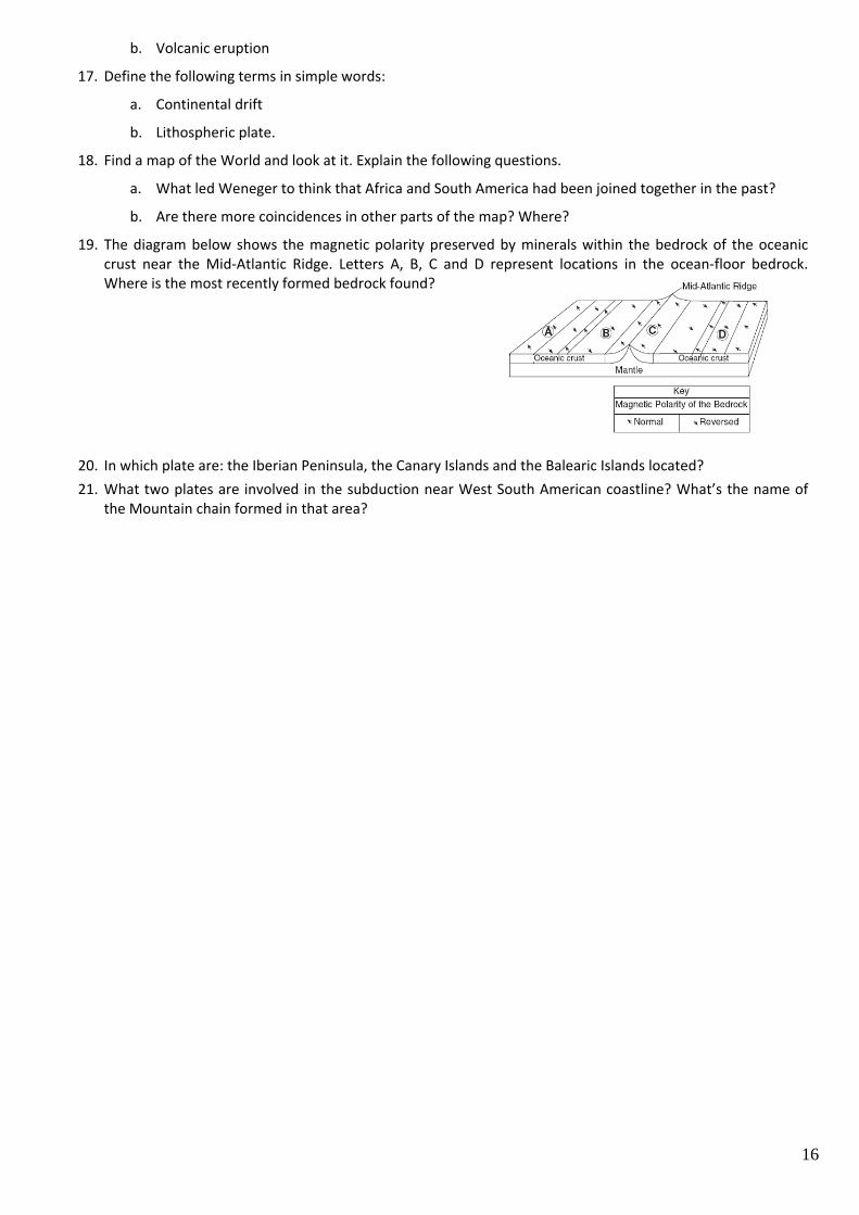
19. The diagram below shows the magnetic polarity preserved by minerals within the bedrock of the oceanic crust near the Mid‐Atlantic Ridge. Letters A, B, C and D represent locations in the ocean‐floor bedrock. Where is the most recently formed bedrock found?
20. In which plate are: the Iberian Peninsula, the Canary Islands and the Balearic Islands located? 21. What two plates are involved in the subduction near West South American coastline? What’s the name of
the Mountain chain formed in that area?