Unit 1: Introduction: OBJECTIVES: observations predictions...
26
1 Unit 1: Introduction : OBJECTIVES: 1. Define and give examples of: inferences, observations, predictions, and classification. 2. Describe what is meant by mass, volume and density. How is each determined? 3. Determine the density of a material (ESRT P.1). 4. Define and be able to find Percent Deviation. 5. Describe the factors that affect the density of a material. 6. Describe how the density changes as things change phases (solid, liquid, and gas). 7. Define Rate of Change and be able to find it (ESRT P. 1) 8. Describe what is meant by the following relationships: direct, indirect/inverse, cyclic and be able to show what these graphs look like. 9. Describe what is meant by an interface. 10. Describe what is meant by dynamic equilibrium THINGS TO REMEMBER: 1. Inference is a conclusion based on observations 2. The same uniform substance always has the same density 3. As pressure increases, density increases (direct relationship) 4. As temperature increases, density decreases (inverse relationship) 5. Water expands as it freezes (increases in volume, decreases in density) 6. Most changes are cyclic 7. Water is most dense at 4°C (in its liquid phase) 8. Use the Earth Science Reference Tables (P. 1) THINGS TO STUDY/CONSIDER: Percent Error (Percent Deviation) = calculating how far away your measurement is from the accepted standard, calculated as a percentage. Percent Error = Accepted value – Measured value X 100 Accepted value Interpreting graphs: Graphs express relationships between the values shown on the graph. The “X” axis is the horizontal axis and the “Y” axis is the vertical axis. Common relationships expressed in graphs: Graph (A) – as X increases, Y increases (a direct relationship) Graph (B) – as X increases, Y decreases (sloped the opposite way, would be as X decreases, Y increases) (an inverse relationship or indirect relationship). Graph (C) – as X increases, Y remains the same. Graph (D) – as Y increases, X remains the same. (A) (B) (C) (D) Direct Inverse As x inc., y remains the same As y inc., x remains the same (Indirect)
Transcript of Unit 1: Introduction: OBJECTIVES: observations predictions...

1
Unit 1: Introduction: OBJECTIVES: 1. Define and give examples of: inferences, observations, predictions, and classification. 2. Describe what is meant by mass, volume and density. How is each determined? 3. Determine the density of a material (ESRT P.1). 4. Define and be able to find Percent Deviation. 5. Describe the factors that affect the density of a material. 6. Describe how the density changes as things change phases (solid, liquid, and gas). 7. Define Rate of Change and be able to find it (ESRT P. 1) 8. Describe what is meant by the following relationships: direct, indirect/inverse, cyclic and be able to show
what these graphs look like. 9. Describe what is meant by an interface. 10. Describe what is meant by dynamic equilibrium THINGS TO REMEMBER: 1. Inference is a conclusion based on observations 2. The same uniform substance always has the same density 3. As pressure increases, density increases (direct relationship) 4. As temperature increases, density decreases (inverse relationship) 5. Water expands as it freezes (increases in volume, decreases in density) 6. Most changes are cyclic 7. Water is most dense at 4°C (in its liquid phase) 8. Use the Earth Science Reference Tables (P. 1) THINGS TO STUDY/CONSIDER: Percent Error (Percent Deviation) = calculating how far away your measurement is from the accepted standard, calculated as a percentage. Percent Error = Accepted value – Measured value X 100 Accepted value Interpreting graphs: Graphs express relationships between the values shown on the graph. The “X” axis is the horizontal axis and the “Y” axis is the vertical axis. Common relationships expressed in graphs: Graph (A) – as X increases, Y increases (a direct relationship)
Graph (B) – as X increases, Y decreases (sloped the opposite way, would be as X decreases, Y increases) (an inverse relationship or indirect relationship).
Graph (C) – as X increases, Y remains the same.
Graph (D) – as Y increases, X remains the same.
(A) (B) (C) (D)
Direct Inverse As x inc., y remains the same As y inc., x remains the same (Indirect)
2
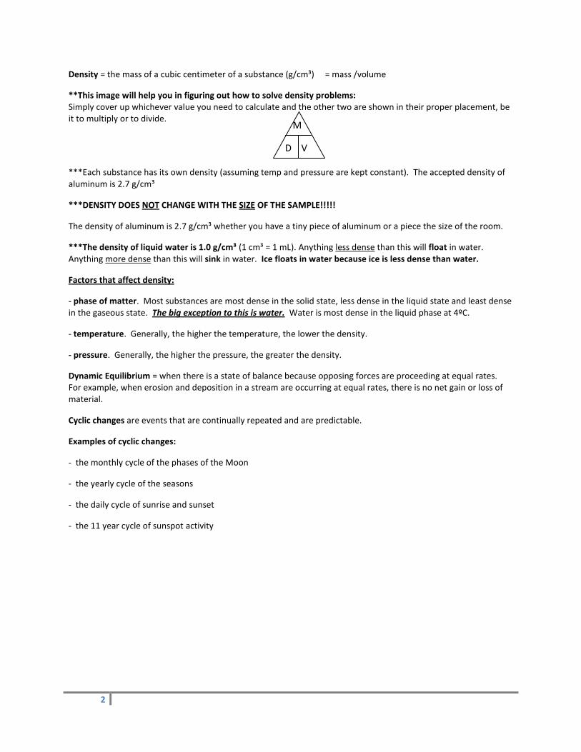
Density = the mass of a cubic centimeter of a substance (g/cm³) = mass /volume
**This image will help you in figuring out how to solve density problems: Simply cover up whichever value you need to calculate and the other two are shown in their proper placement, be it to multiply or to divide.
***Each substance has its own density (assuming temp and pressure are kept constant). The accepted density of aluminum is 2.7 g/cm³
***DENSITY DOES NOT CHANGE WITH THE SIZE OF THE SAMPLE!!!!!
The density of aluminum is 2.7 g/cm³ whether you have a tiny piece of aluminum or a piece the size of the room.
***The density of liquid water is 1.0 g/cm³ (1 cm³ = 1 mL). Anything less dense than this will float in water. Anything more dense than this will sink in water. Ice floats in water because ice is less dense than water.
Factors that affect density:
- phase of matter. Most substances are most dense in the solid state, less dense in the liquid state and least dense in the gaseous state. The big exception to this is water. Water is most dense in the liquid phase at 4ºC.
- temperature. Generally, the higher the temperature, the lower the density.
- pressure. Generally, the higher the pressure, the greater the density.
Dynamic Equilibrium = when there is a state of balance because opposing forces are proceeding at equal rates. For example, when erosion and deposition in a stream are occurring at equal rates, there is no net gain or loss of material.
Cyclic changes are events that are continually repeated and are predictable.
Examples of cyclic changes:
- the monthly cycle of the phases of the Moon
- the yearly cycle of the seasons
- the daily cycle of sunrise and sunset
- the 11 year cycle of sunspot activity
M
V D

3
Unit 2 and 3: Earth’s Shape and Structure, and Mapping OBJECTIVES: 1. Describe the shape of the Earth (actual and to scale) 2. What is the Lithosphere? The Atmosphere? The Hydrosphere? 3. What are the properties of each of the atmospheric layers? (ESRT P. 14) 4. What is the relationship between latitude and altitude of the Polaris? Why? 5. What is a model? Why are they used in sciences? 6. How to construct a topographic profile from a topographic map. 7. Finding the slope (gradient) of locations on a topographic map. (ESRT P. 1) 8. How can you tell which way a river flows on a topographic map? 9. What is the contour interval of a contour map? What is the elevation of an ocean? 10. What are latitude and longitude? How do you find the coordinates for locations in New York State? (ESRT P.
3) 11. How do you find distances on a topographic map? 12. What are the main elements in each of the Earth’s “spheres”. (ESRT P. 11) 13. Describe the Earth’s shape and give evidence for it. 14. Describe the inferred properties of the Earth’s interior (ESRT P. 10) 15. Determine a location’s latitude and longitude (ESRT P. 3, P. 5). 16. What are the pointer stars for the Big Dipper and Little Dipper for finding the Polaris? 17. Describe what is meant by: isolines, contour lines, isotherms and isobars and be able to draw them on a field
map. 18. Determine distances and elevations on a field map. 19. Be able to determine gradient on a field map or a word problem (ESRT P. 1) THINGS TO REMEMBER: 1. The best model of the Earth (to scale) is a sphere (or ball). 2. As depth increases, so do pressure and temperature (ESRT P. 10) 3. The altitude of the Polaris at a location is the latitude of that location (in the Northern Hemisphere). 4. Latitude lines run east-west, but measure degrees north or south of the Equator. 5. Longitude lines run north-south, but measure degrees east or west of the Prime Meridian 6. Longitude is based on observations of the sun. 7. Latitude is based on the observations of the Polaris. 8. The closer the lines are on a field map, the greater the gradient, or slope. 9. Use the Earth Science Reference Tables P. 1, 3, 10, and 14 THINGS TO STUDY/CONSIDER: Lithosphere - crust/solid portion of Earth’s surface consists of Silicon and Oxygen. Continental Crust – thick, made of granite, low density. Oceanic Crust – thinner, made of basalt, high density.
Hydrosphere – Earth’s water consists of Hydrogen and Oxygen
Atmopshere – layer of gas surrounding Earth consists of Nitrogen and Oxygen. Layers (Troposphere – where weather occurs, Stratosphere – Ozone Layer is located, Mesosphere, Thermosphere)
Oblate spheroid = the actual shape of the Earth. Earth is a nearly perfect sphere but is slightly flattened at the poles and slightly bulging at the equator. *** Pick the “perfect circle” diagram as best representing Earth’s true shape! The bulging and flattening are very, very slight.
4
Evidence that the Earth is spherical:
- photographs from space show a spherical Earth
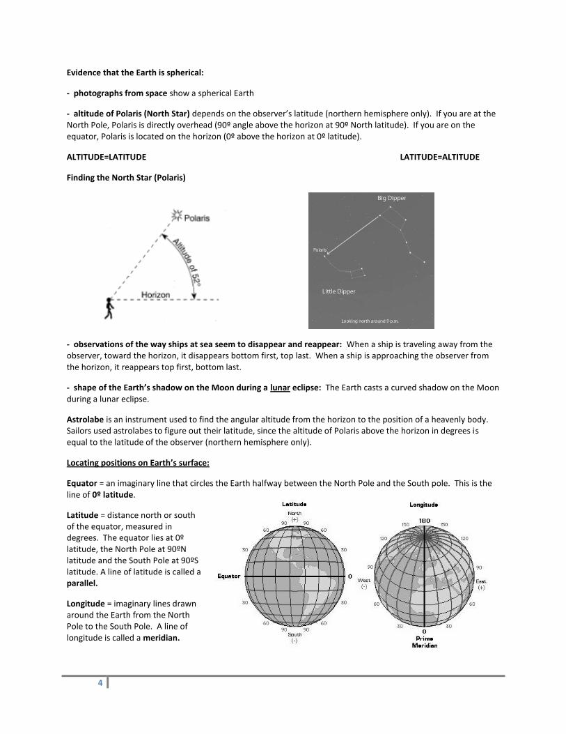
- altitude of Polaris (North Star) depends on the observer’s latitude (northern hemisphere only). If you are at the North Pole, Polaris is directly overhead (90º angle above the horizon at 90º North latitude). If you are on the equator, Polaris is located on the horizon (0º above the horizon at 0º latitude).
ALTITUDE=LATITUDE LATITUDE=ALTITUDE
Finding the North Star (Polaris)
- observations of the way ships at sea seem to disappear and reappear: When a ship is traveling away from the observer, toward the horizon, it disappears bottom first, top last. When a ship is approaching the observer from the horizon, it reappears top first, bottom last.
- shape of the Earth’s shadow on the Moon during a lunar eclipse: The Earth casts a curved shadow on the Moon during a lunar eclipse.
Astrolabe is an instrument used to find the angular altitude from the horizon to the position of a heavenly body. Sailors used astrolabes to figure out their latitude, since the altitude of Polaris above the horizon in degrees is equal to the latitude of the observer (northern hemisphere only).
Locating positions on Earth’s surface:
Equator = an imaginary line that circles the Earth halfway between the North Pole and the South pole. This is the line of 0º latitude.
Latitude = distance north or south of the equator, measured in degrees. The equator lies at 0º latitude, the North Pole at 90ºN latitude and the South Pole at 90ºS latitude. A line of latitude is called a parallel.
Longitude = imaginary lines drawn around the Earth from the North Pole to the South Pole. A line of longitude is called a meridian.

5
Topographic maps show the shape of the Earth’s surface by the use of contour lines.
Contour interval = the stated difference in elevation between contour lines on a topographic map.
****Where contour lines are close together, the slope of the land is steep.
****Where contour lines are far apart, the slope of the land is gentle.
Hachured lines are contour lines with little marks on them. They indicate areas of the land that go lower where one might expect the land to go higher. For example, hachured lines would indicate a crater at the top of a mountain.
**** “V”s in contour lines always point toward the higher elevations. Vees usually indicate the upstream direction of river flow. Rivers always flow from higher elevations to lower elevations.
A benchmark is a site whose elevation has been measured precisely. Benchmarks are indicated by a little “x” next to the number.
Know how to construct a Topographic Map Profile Interactive Link http://www.uwsp.edu/geo/faculty/ritter/geog101/textbook/manuals/instructor_manual/how_to/topographic_profile.html
6
Unit 4 and 5: Minerals and Rocks OBJECTIVES: 1. Describe the physical and chemical properties of the minerals and what causes them (color, hardness, streak,
luster, cleavage, fracture, crystal shape, magnetism, odor, acid reaction) 2. Describe how the three different rock types are formed (origin) and which rocks can form the different types 3. Using the ESRT, describe properties of the three types of rocks (ESRT P. 6 & 7) 4. Describe the properties of each type of rock and how you can tell what type you are looking at 5. Compare and contrast regional metamorphism and contact metamorphism 6. Describe what is meant by Moh’s Hardness Scale THINGS TO REMEMBER: 1. Minerals are naturally occurring substances that make up rocks. 2. The physical properties (hardness, streak, luster, cleavage/fracture, crystal shape, and density) are determined
by the internal arrangement of the atoms 3. Rocks are classified by origin (Igneous, Sedimentary and Metamorphic) 4. Igneous rocks form by melting and solidification of another rock. 5. Cool fast very small or no crystals (extrusive) 6. Cool slow large crystals (intrusive) 7. Sedimentary Rocks are formed by compaction or precipitation from seas 8. Sedimentary rocks contain fossils and are formed in horizontal layers 9. Metamorphic rocks are formed by heat and pressure (metamorphism) of another rock 10. Metamorphic rocks show banding, foliations and may be distorted 11. Any rock type may form any other rock type 12. Use the Earth Science Reference Tables P. 6, 7, 1 and 16 THINGS TO STUDY/CONSIDER: Rocks = the substances that make up the solid part of the Earth’s crust; are usually a mixture of minerals.
Minerals = naturally occurring, inorganic crystalline substances. Each mineral is a different compound or single element. Minerals are identified by their physical and chemical properties.
Physical and Chemical Properties of Minerals A. Physical Properties
Color = the color of the whole piece. (Unreliable; many minerals are same color.)
Streak = the color of the powdered mineral. Rub mineral on streak plate.
Cleavage and Fracture = the way in which a sample of mineral splits or breaks. Cleavage = breaks with parallel flat sides; Examples: halite – cubic cleavage) Fracture = breaks irregularly (no parallel flat sides.) Examples: Quartz, pyrite, magnetite.
Hardness = a mineral’s ability to resist being scratched. Soft (hardness 1 – 2.5) can be scratched with fingernail (mica, talc, gypsum)
Medium (hardness 3-5.5) cannot be scratched with fingernail and will not scratch glass (feldspar, fluorite)
Hard (hardness > 5.5) cannot be scratched with fingernail and will scratch glass (quartz, diamond)
Luster = the way that the mineral “shines” or reflects light. Metallic = shines like metal (galena, pyrite)
Nonmetallic = does not shine like a metal. Could be glassy, (quartz) dull (red hematite)

7
Chemical Properties = how a mineral reacts with other substances. For example, in the acid test, a few drops of HCl (hydrochloric acid) are put on a sample of the mineral. If there is a reaction, and bubbles of carbon dioxide (CO2) form, then the mineral is probably calcite.
FORMATION OF ROCKS:
Rocks are classified according to the way that they formed. There are three major categories of the ways rocks can form:
Igneous Rocks form when melted (molten) rock cools down and becomes solid.
Sedimentary Rocks form when particles of weathered and eroded rocks become cemented together, from the remains of plants or animal, or from minerals which form in water.
Metamorphic Rocks form when other types of rocks become changed by heat, pressure, and/or chemically active fluids, but have not been melted. (If they do become melted, they become igneous rocks when they cool off again.
Clues to help ID Rocks: Because igneous rocks have formed from molten magma or lava, they are composed of randomly arranged intergrown crystals. Rapid cooling, however can make the crystals too small to be visible. Igneous rocks are usually quite hard and dense, layering is rare. Gas bubbles (vesicles) sometimes give igneous rocks a frothy texture. “THIS IS AN IGNEOUS ROCK BECAUSE….:
1. Has random intergrown visible crystals
2. Has a glassy texture
3. Has vesicles
Most sedimentary rocks are composed of rounded fragments cemented in layers. In fine grained rocks the individual grains may be too small to be readily visible. A rock containing fossils is always a sedimentary rock. “THIS IS A SEDIMENTARY ROCK BECAUSE…:
1. It is clastic
2. It is made of cemented particles
3. It has fossils
4. It has ripple marks
Most metamorphic rocks, like igneous rocks, are usually composed of intergrown crystals. And, like sedimentary rocks they often show layering in the form of banding or foliation. The layers may be bent or distorted. “THIS IS A METAMORPHIC ROCK BECAUSE…:
1. Shows mineral banding
2. Has distorted layers
3. Has visible mineral crystals in the form of foliation
4. Mica crystals are aligned causing the rock to sparkle
Study pages 6 and 7 in the Reference Tables to learn how igneous, sedimentary, and metamorphic rocks are classified.
8
Unit 6 and 7: Dynamic Crust – Plate Tectonics, Earthquakes and Earth’s Interior OBJECTIVES: 1. Describe what the lithosphere is 2. Describe what is happening at plate boundaries and why (ESRT P. 5) 3. Describe what causes an earthquake 4. Describe what is meant by focus, epicenter, P-wave, S-wave, seismographs, and seismograms 5. Compare and contrast P-waves and S-waves (P. 11) 6. Determine the distance from an epicenter by p-wave and s-wave arrival times (ESRT P. 11) 7. Determine the location of an epicenter using arrival times from seismic stations (ESRT P. 11) 8. Determine the origin time of an earthquake 9. Compare and contrast Modified Mercalli Scale and Richter Scale 10. Describe the relationship between earthquakes and volcanoes 11. Describe what a tsunami is and what they may result in 12. Describe what is meant by the Shadow Zone 13. Describe the inferred properties of the Earth’s interior (ESRT P. 10). Describe how scientists came up with this
information. 14. Describe what is meant by Plate Tectonics and Continental Drift 15. Describe what is happening at Convergent, Divergent and Transform boundaries (ESRT P. 5) and give
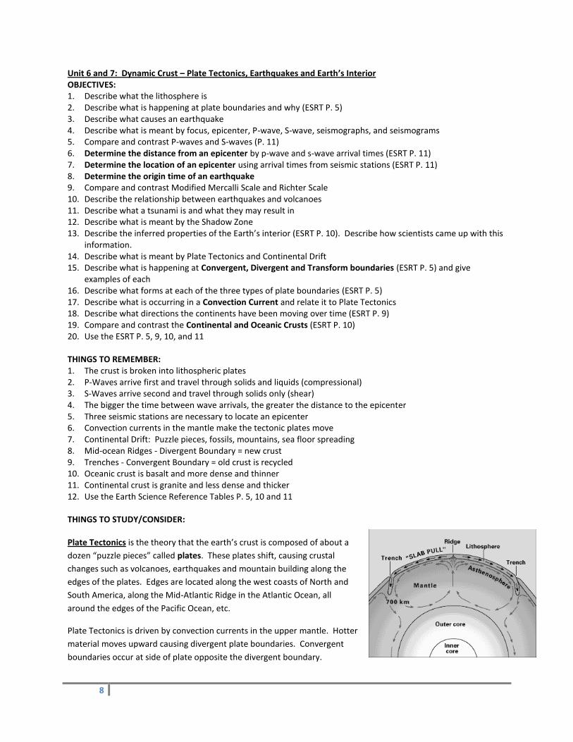
examples of each 16. Describe what forms at each of the three types of plate boundaries (ESRT P. 5) 17. Describe what is occurring in a Convection Current and relate it to Plate Tectonics 18. Describe what directions the continents have been moving over time (ESRT P. 9) 19. Compare and contrast the Continental and Oceanic Crusts (ESRT P. 10) 20. Use the ESRT P. 5, 9, 10, and 11 THINGS TO REMEMBER: 1. The crust is broken into lithospheric plates 2. P-Waves arrive first and travel through solids and liquids (compressional) 3. S-Waves arrive second and travel through solids only (shear) 4. The bigger the time between wave arrivals, the greater the distance to the epicenter 5. Three seismic stations are necessary to locate an epicenter 6. Convection currents in the mantle make the tectonic plates move 7. Continental Drift: Puzzle pieces, fossils, mountains, sea floor spreading 8. Mid-ocean Ridges - Divergent Boundary = new crust 9. Trenches - Convergent Boundary = old crust is recycled 10. Oceanic crust is basalt and more dense and thinner 11. Continental crust is granite and less dense and thicker 12. Use the Earth Science Reference Tables P. 5, 10 and 11 THINGS TO STUDY/CONSIDER: Plate Tectonics is the theory that the earth’s crust is composed of about a
dozen “puzzle pieces” called plates. These plates shift, causing crustal
changes such as volcanoes, earthquakes and mountain building along the
edges of the plates. Edges are located along the west coasts of North and
South America, along the Mid-Atlantic Ridge in the Atlantic Ocean, all
around the edges of the Pacific Ocean, etc.
Plate Tectonics is driven by convection currents in the upper mantle. Hotter
material moves upward causing divergent plate boundaries. Convergent
boundaries occur at side of plate opposite the divergent boundary.

9
Convergent Plate Boundaries are places where two or more tectonic plates are crashing together. Example: The
Pacific and North American plates are crashing into each other all along the west coast of North America.
Divergent Plate Boundaries are places where two or more tectonic plates are spreading apart.
The Mid-Atlantic Ridge is a divergent boundary.
Evidence of plate movement:
matching 250 million year old rocks and fossils found along the west coast of Africa and the east coast of South America.
edges of South America and Africa “match” in shape
rocks get progressively older on each side of Mid-Atlantic Ridge as you travel east or west of the Ridge.
earthquakes, mountain building and volcanoes along the edges of the plates show that there is movement and that heat is escaping.
Movement occurs along faults (breaks in Earth’s crust.)
Earthquakes happen when rocks get stressed by movement of tectonic plates, and finally break, causing
movement along a fault.
Most earthquakes happen in subduction zones (convergent boundaries) at plate edges. Pacific Ring of Fire (outlines Pacific Ocean) has most of world’s earthquakes and active volcanoes.
Earthquakes produce P-waves and S-waves.
P-waves travel faster and arrive first.
S-waves travel slower and arrive after P-waves.
Closer to the earthquake: P-wave and S-wave arrival times are closer together.
Farther from the earthquake: more time elapses between the arrival of the P-waves and the S-waves.
A focus is the place underground where the actual movement along a fault occurred during an earthquake.
An epicenter is the location at Earth’s surface just above the focus.
Damage from earthquake depends upon:
nearness to epicenter (closer, more damage)
type of rocks underlying area (igneous, metamorphic are stronger → less shaking; sedimentary are weaker → more shaking.)
whether tsunami results (giant ocean waves from earthquake in ocean)
whether or not buildings have been built to withstand quakes.
Earthquake Disaster Preparation:
Evacuation plan
Conduct drills in the home; have a family meeting place
first aid kit
supply of water, food, battery-operated radio, flashlights, supply of cash, special items for infant, elderly, or disabled family members
10
Pangaea is the name scientists have given to the “supercontinent” that existed about 250 million years ago, when
all of Earth’s major landmasses were joined together.
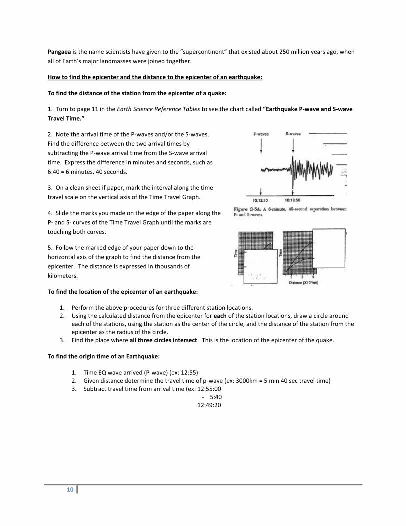
How to find the epicenter and the distance to the epicenter of an earthquake:
To find the distance of the station from the epicenter of a quake:
1. Turn to page 11 in the Earth Science Reference Tables to see the chart called “Earthquake P-wave and S-wave
Travel Time.”
2. Note the arrival time of the P-waves and/or the S-waves.
Find the difference between the two arrival times by
subtracting the P-wave arrival time from the S-wave arrival
time. Express the difference in minutes and seconds, such as
6:40 = 6 minutes, 40 seconds.
3. On a clean sheet if paper, mark the interval along the time
travel scale on the vertical axis of the Time Travel Graph.
4. Slide the marks you made on the edge of the paper along the
P- and S- curves of the Time Travel Graph until the marks are
touching both curves.
5. Follow the marked edge of your paper down to the
horizontal axis of the graph to find the distance from the
epicenter. The distance is expressed in thousands of
kilometers.
To find the location of the epicenter of an earthquake:
1. Perform the above procedures for three different station locations. 2. Using the calculated distance from the epicenter for each of the station locations, draw a circle around
each of the stations, using the station as the center of the circle, and the distance of the station from the epicenter as the radius of the circle.
3. Find the place where all three circles intersect. This is the location of the epicenter of the quake. To find the origin time of an Earthquake:
1. Time EQ wave arrived (P-wave) (ex: 12:55) 2. Given distance determine the travel time of p-wave (ex: 3000km = 5 min 40 sec travel time) 3. Subtract travel time from arrival time (ex: 12:55:00
- 5:40 12:49:20
11
Unit 8 and 9: Surface Processes (Weathering, Erosion and Deposition) and Landscapes OBJECTIVES: 1. Describe what is occurring in chemical weathering and physical weathering 2. Describe the type of climate each occurs best in 3. Describe agents that cause each type of erosion 4. Describe the properties of the soil horizons 5. Compare and contrast transported soil and residual soil 6. Describe how running water and glaciers shape the land 7. Describe where the most erosion/deposition is occurring in a meandering stream 8. Describe the factors that affect how quickly deposition occurs and tell how each affects it 9. Describe what is meant by horizontal sorting and vertical sorting and tell where each is seen 10. Describe the bedrock characteristics of the types of landscapes (mountains, plateaus and plains) 11. Find locations of each landscape in NY State (ESRT P. 2) 12. Describe how an area’s climate affects the shape of the land 13. Describe ways, in NY State, we can tell glaciers have been here before THINGS TO REMEMBER: 1. Chemical weathering occurs best in warm, humid climates 2. Physical weathering occurs best in climates where temperature varies 3. Gravity is the force behind most erosional agents 4. Streams are the number one agent of erosion (V-shaped valleys) 5. Stream velocity depends on slope (gradient) and discharge (volume) 6. Water is fastest on the outside of a curve (most erosion) and slowest on the inside of the curve (most
deposition) 7. Horizontal sorting: big, dense, round fall out first (rivers entering a body of water) 8. Vertical sorting: big, dense, and round land on bottom (dropping gravel in a pond) 9. Glaciers leave sediments unsorted and scratched (striated) and carve out a U-shaped valley 10. Arid (dry) Climates steep slopes, no vegetation, thin soil 11. Moist (wet) Climates rounded hills, vegetation, thicker soil 12. Physical Weathering - increases surface area to increase Chemical Weathering 13. Horizon A (top layer) has the most organic material (humus) 14. Mountains form by uplifting, folding and faulting 15. Dynamic equilibrium means a balance between 2 forces 16. Use Earth Science Reference Tables (P. 2, 3, and 6) THINGS TO STUDY/CONSIDER Physical weathering = changes in the size, shape and/or state of a rock, but not in chemical composition. No new
substances are formed.
Agents of physical weathering:
Frost action (repeated cycles of freezing and thawing; water expands when it freezes, breaks rocks)
Plant roots
Burrowing animals
Abrasion (usually in streams)
Wind
Chemical weathering = a change in the chemical composition of the rock caused by reactions with water,
chemicals in the environment and with the atmosphere. New substances form as a result of chemical weathering.
12
Agents of chemical weathering:
Water
Oxidation (Rusting)
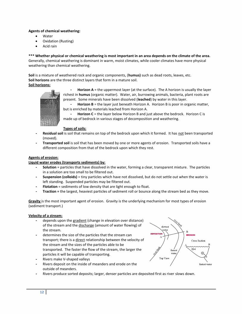
Acid rain *** Whether physical or chemical weathering is most important in an area depends on the climate of the area. Generally, chemical weathering is dominant in warm, moist climates, while cooler climates have more physical weathering than chemical weathering. Soil is a mixture of weathered rock and organic components, (humus) such as dead roots, leaves, etc. Soil horizons are the three distinct layers that form in a mature soil. Soil horizons:
- Horizon A = the uppermost layer (at the surface). The A horizon is usually the layer richest in humus (organic matter). Water, air, burrowing animals, bacteria, plant roots are present. Some minerals have been dissolved (leached) by water in this layer.
- Horizon B = the layer just beneath Horizon A. Horizon B is poor in organic matter, but is enriched by materials leached from Horizon A.
- Horizon C = the layer below Horizon B and just above the bedrock. Horizon C is made up of bedrock in various stages of decomposition and weathering.
Types of soils:
- Residual soil is soil that remains on top of the bedrock upon which it formed. It has not been transported (moved).
- Transported soil is soil that has been moved by one or more agents of erosion. Transported soils have a different composition from that of the bedrock upon which they rest.
Agents of erosion: Liquid water erodes (transports sediments) by:
- Solution = particles that have dissolved in the water, forming a clear, transparent mixture. The particles in a solution are too small to be filtered out.
- Suspension (colloids) = tiny particles which have not dissolved, but do not settle out when the water is left standing. Suspended particles may be filtered out.
- Flotation = sediments of low density that are light enough to float. - Traction = the largest, heaviest particles of sediment roll or bounce along the stream bed as they move.
Gravity is the most important agent of erosion. Gravity is the underlying mechanism for most types of erosion (sediment transport.) Velocity of a stream:
- depends upon the gradient (change in elevation over distance) of the stream and the discharge (amount of water flowing) of the stream.
- determines the size of the particles that the stream can transport; there is a direct relationship between the velocity of the stream and the sizes of the particles able to be transported. The faster the flow of the stream, the larger the particles it will be capable of transporting.
- Rivers make V-shaped valleys - Rivers deposit on the inside of meanders and erode on the
outside of meanders. - Rivers produce sorted deposits; larger, denser particles are deposited first as river slows down.

13
Erosion by wind: - occurs mainly in arid (dry) areas; sand particles blowing around cause abrasion; wind transports these
particles. Erosion by ice: A glacier is a large mass of moving ice.
Glaciers make U-shaped valleys.
Deposits are unsorted (all different sizes mixed together.); called glacial till. Glacial land formations include esker, drumlin, cirque.
Outwash plain is sorted deposits produced by glacial meltwaters forming rivers. North shore of L.I. is rocky because glaciers stopped here; outwash rivers carried finer material (sand) to south shore.
Ice ages periods of widespread continental glaciation.
There have been four ice ages in the NY area in the past million years (Pleistocene)
Glaciers formed Long Island (between 20,000 – 12,000 years ago.)
Striations are parallel scratches in bedrock caused by abrasion as the ice carried particles over the bedrock.
Rates of Deposition (how fast material is deposited) are affected by:
Particle size (larger settle more quickly)
Particle shape (flatter settle more slowly)
Particle density (denser settle more quickly)
the faster the water, the fewer particles that will settle\
Vertical sorting: Particles are deposited in layers, from largest in the bottommost layer to
the smallest in the topmost layer. (Example: bunch of stuff dumped into a lake all at once
settles this way.)
Horizontal sorting: As a river slows, particles drop out from largest to smallest along the riverbed.
Gradient: This is the change in height over distance traveled. Generally, erosion proceeds faster in areas of high gradient; deposition takes place in areas of low or no gradient. Dynamic equilibrium: This is when the rate of erosion is equal to the rate of deposition, so there is no net change in the level of the sediments. Oceans and coastal processes:
- Oceans cover nearly 71% of Earth’s surface, to an average depth of 4 kilometers (3 miles). - Waves near the shore and longshore currents (currents parallel to shoreline) change the land at the
edges of the oceans. - ***Waves out in the deep ocean do not carry water along; the wave of energy simple passes through the
water that is there.

14
Landscape Development: * A landscape is a region on the Earth’s surface in which the physical features of the region are related by a common origin. Examples of landscapes include mountains, plateaus, plains. Mountain landscapes: greatest changes in elevation; steep gradients; fast-flowing streams; commonly underlain by metamorphic rock, igneous rock, or folded sedimentary rock. (Rocky Mountains) Plateau landscapes: are relatively “flat,” but have greater elevations than plains; are the product of uplift; have deep valleys; commonly underlain by horizontal sedimentary rock layers. (Colorado Plateau, Allegheny Plateau.) Plains landscapes: are relatively “flat” and at low elevations; gentle slopes; low gradients; underlain by flat layers of sedimentary rock; have meandering streams with wide floodplains. Stream drainage patterns are determined largely by the type of bedrock underlying an area.
(A) Dendritic drainage has a tree-like, branching pattern. Dendritic drainage patterns form
where bedrock is made of flat-lying layers of uniform composition. There are no specific areas of weakness in the rocks.
(B)Trellis drainage is a rectangular pattern of streams that usually forms in an area where rocks have been folded. The incompetent layers erode away to form parallel valleys; the more competent layers form parallel ridges.
(C) Rectangular drainage is when streams flow and join at right angles. It forms when there are specific areas of weaker and more resistant rock layers that promote the formation of this pattern.
(D) Radial drainage is a pattern of streams radiating from a central area, such as down the sides of a volcano or a rounded hill. There is little difference in rock competence (weakness/strength) in the area.
Annular drainage resembles radial, but is a pattern of streams in concentric circles. It forms on mountains where there is a great difference in the competence of the exposed rock layers.
Landscape maturity depends on the portion of the land that has been worn down to base level (lowest possible elevations in the area). Maturities of landscapes:
- Youthful landscapes have high elevations, steep hill slopes, high gradients and narrow, fast-running streams. There may be waterfalls and rapids. Soils are immature. Rivers are downcutting their channels.
- Mature landscapes are more rounded and have lower elevations with gradual hill slopes. Stream valleys are broad, rivers have meanders and have developed floodplains. Streams have begun to deposit some of their sediments.
- Old age landscapes have had most of the land eroded down to near base level. The area is mostly flat, but there may be a few hills. Streams have a very low gradient, wide floodplains and many meanders. Soils are thick and well-developed. Streams are depositing much of their sediments.
- Rejuvenated landscapes form when an existing landscape is uplifted, causing slopes to increase in gradient and causing streams to begin downcutting again.
15
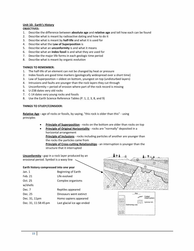
Unit 10: Earth’s History OBJECTIVES: 1. Describe the difference between absolute age and relative age and tell how each can be found 2. Describe what is meant by radioactive dating and how to do it 3. Describe what is meant by half-life and what it is used for 4. Describe what the Law of Superposition is 5. Describe what an unconformity is and what it means 6. Describe what an index fossil is and what they are used for 7. Describe the major life forms in each geologic time period 8. Describe what is meant by organic evolution THINGS TO REMEMBER: 1. The half-life of an element can not be changed by heat or pressure 2. Index fossils are good time markers (geologically widespread over a short time) 3. Law of Superposition = oldest on bottom, youngest on top (undisturbed layers) 4. Intrusions and faults are younger than the rock layers they cut through 5. Unconformity = period of erosion where part of the rock record is missing 6. U-238 dates very old rocks 7. C-14 dates very young rocks and fossils 8. Use the Earth Science Reference Tables (P. 1, 2, 3, 8, and 9) THINGS TO STUDY/CONSIDER: Relative Age - age of rocks or fossils, by saying, "this rock is older than this" - using principles
Principle of Superposition - rocks on the bottom are older than rocks on top
Principle of Original Horizontality - rocks are "normally" deposited in a horizontal arrangement Principle of Inclusions - rocks including particles of another are younger than the rocks the particles came from Principle of Cross-cutting Relationships - an interruption is younger than the structure that it interrupted
Unconformity - gap in a rock layer produced by an erosional period. Symbol is a wavy line Earth history compressed into one year
Jan. 1 Beginning of Earth
Feb. 21 Life evolved
Oct. 25 Complex organisms
w/shells
Dec. 7 Reptiles appeared
Dec. 25 Dinosaurs went extinct
Dec. 31, 11pm Homo sapiens appeared
Dec. 31, 11:58:45 pm Last glacial ice age ended
16
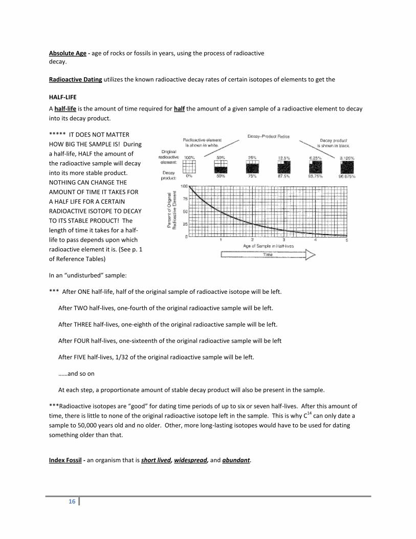
Absolute Age - age of rocks or fossils in years, using the process of radioactive
decay.
Radioactive Dating utilizes the known radioactive decay rates of certain isotopes of elements to get the
HALF-LIFE
A half-life is the amount of time required for half the amount of a given sample of a radioactive element to decay
into its decay product.
***** IT DOES NOT MATTER
HOW BIG THE SAMPLE IS! During
a half-life, HALF the amount of
the radioactive sample will decay
into its more stable product.
NOTHING CAN CHANGE THE
AMOUNT OF TIME IT TAKES FOR
A HALF LIFE FOR A CERTAIN
RADIOACTIVE ISOTOPE TO DECAY
TO ITS STABLE PRODUCT! The
length of time it takes for a half-
life to pass depends upon which
radioactive element it is. (See p. 1
of Reference Tables)
In an “undisturbed” sample:
*** After ONE half-life, half of the original sample of radioactive isotope will be left.
After TWO half-lives, one-fourth of the original radioactive sample will be left.
After THREE half-lives, one-eighth of the original radioactive sample will be left.
After FOUR half-lives, one-sixteenth of the original radioactive sample will be left
After FIVE half-lives, 1/32 of the original radioactive sample will be left.
……and so on
At each step, a proportionate amount of stable decay product will also be present in the sample.
***Radioactive isotopes are “good” for dating time periods of up to six or seven half-lives. After this amount of
time, there is little to none of the original radioactive isotope left in the sample. This is why C14
can only date a
sample to 50,000 years old and no older. Other, more long-lasting isotopes would have to be used for dating
something older than that.
Index Fossil - an organism that is short lived, widespread, and abundant.

17
Unit 11: Meteorology and Atmospheric Energy OBJECTIVES: 1. How does the temperature vary with the intensity and duration of insolation? 2. What are the Wet Bulb Temperature and Dry Bulb Temperature? 3. What is the Dew Point Temperature? How is this determined? (ESRT P. 12) 4. What is the Relative Humidity? How is this determined? (ESRT P. 12) 5. What is a Sling Psychrometer? 6. How do you convert temperatures in degrees Fahrenheit to Celsius and vise versa? (ESRT P. 13) 7. What are isotherms? 8. What is the air pressure? What is it measured by? 9. What does air pressure have to do with winds? 10. What controls the speed of winds? 11. What is determined by a wind vane? An anemometer? 12. What must happen to warm, moist air to make a cloud form? 13. How does elevation affect air pressure? 14. What causes a Sea Breeze? A Land Breeze? 15. How does an air mass change as it passes over a mountain range? How is the air on the windward side
compared to the leeward side? 16. What are the processes involved in the Water Cycle? 17. What is transpiration? 18. What is the specific heat of water? How does this affect the water or areas around it? 19. How is heat transferred through the following: Convection, Conduction and Radiation? 20. Why does the wind appear to blow in wind belts? (ESRT P. 14) 21. What are Zones of Convergence? Zones of Divergence? 22. What are the different types of air masses and the type of air they bring (mT, cT, mP, and cP)? 23. How does the air move around a Low Pressure Area (Cyclone)? An Anticyclone (High Pressure Area)? 24. What is happening at each of the four types of fronts? What are their symbols? (ESRT P. 13) 25. What is the information given on a Station Model? (ESRT P. 13) 26. What is the typical Storm Track in NY State? Why? 27. What conditions would hurricanes form in? Tornadoes? THINGS TO REMEMBER: 1. Air moves CCW inward around a LOW (Zone of Convergence) 2. Air moves CW outward around a HIGH (Zone of Divergence) 3. Good absorber = good radiator (black and rough) 4. As air temperature increases, pressure decreases (inverse relationship) 5. As humidity increases, pressure decreases (inverse relationship) 6. As elevation increases, pressure decreases 7. HIGHS are cool and dry 8. LOWS are warmer and moister (storms) 9. Wind speed is controlled by pressure gradient (fastest = closest lines) 10. Winds always blow from HIGH to LOW pressure areas 11. Winds are named by where they come from 12. The closer the air temperature (dry bulb) is to the DPT, the greater the chance of precipitation 13. Weather moves from West to East in the US (or toward NE) 14. Cold fronts move faster than warm fronts 15. Air cools as it rises due to expansion 16. Air warms as it sinks due to compression 17. Use the Earth Science Reference Tables (P. 12 & 13)

18
THINGS TO STUDY/CONSIDER: Atmospheric Pressure is a measure of the force exerted by the atmosphere. Changes in atmospheric pressure are
caused by changes in the density of the air.
*** Warmer air is less dense lower atmospheric pressure
*** Cooler air is more dense higher atmospheric pressure
*** Wetter (more humid) air is less dense lower atmospheric pressure
*** Dryer (less humid air) is more dense higher atmospheric pressure
Relative Humidity is a measure of the percentage of moisture saturation of the air. Relative humidity is measured with an instrument called a psychrometer, which tells us the wet bulb and dry bulb temperatures. We then use the Relative Humidity Chart in the Reference Tables to calculate the relative humidity. Relative humidity tells us how much moisture the air is currently holding as compared to how much moisture the air could hold at that temperature. A relative humidity of 80% would mean that the air is holding 80% as much moisture as it could hold at that temperature.
*** Air temperature determines the air’s capacity to hold moisture.
*** Warmer air can hold more moisture.
*** Cooler air can hold less moisture.
A relative humidity of 100% means that the air is holding the maximum amount possible at a particular
combination of air temperature and air pressure.
Absolute Humidity is not a weather factor! Absolute Humidity is the percentage of the entire atmosphere that is
composed of water vapor. This is always less than 1%
Formation of clouds
1. Warm air rises
2. As the air rises it expands
3. Expansion cause the air to cool
4. Air cools to the dew point
5. Once at dew point in condenses and forms the cloud
Wind direction tells you the direction the wind is coming from.
The Coriolis Effect causes the planetary wind belts to curve, generally to the right in the northern hemisphere and
to the left in the southern hemisphere. The Coriolis Effect is a result of the Earth’s rotation; the atmosphere lags
as the Earth rotates.
High Pressure = cool, dry air Low Pressure – warm, moist air
Air moves out and clockwise Air moves in and counterclockwise

19
Sea Breeze Land Breeze
Measuring Kinetic Energy
٠ A thermometer measures temperature, which is the average kinetic energy of the molecules (particles) in a
substance or object.
٠ Absolute Zero (0o Kelvin, -273
oCelsius) is the point at which there is a total absence of heat. At absolute zero,
there is no molecular movement at all. There is no temperature “colder” or lower than absolute zero!!!!!
Changes in Phase:
٠ occur when enough heat energy is added or
subtracted.
Melting is a phase change from solid to liquid.
Freezing is a phase change from liquid to solid.
Evaporation is a phase change from liquid to gas.
Condensation is a phase change from gas to
liquid.
Deposition is a change of state from a gas directly
to a solid, without passing through the liquid
phase.
Sublimation is a change of state from a solid
directly to a gas, without passing through the
liquid phase.
***** THERE IS NO TEMPERATURE CHANGE DURING A PHASE CHANGE!!!
O3 (ozone) absorbs ultraviolet (UV) radiation.
CO2 (carbon dioxide) absorbs infrared radiation (heat) and causes global warming. Fronts
Air Masses
20
Unit 11 cont…: Water Cycle and Climate OBJECTIVES: 1. Earth has been continuously recycling water. This is done by the Water (Hydrologic) Cycle 2. Explain what is happening in the processes of precipitation, evaporation, transpiration, runoff, infiltration 3. Explain how capillarity influences the above processes 4. Explain how climate, slope, soil, rock type, vegetation, land use, and saturation affect the amount of
precipitation infiltrating the ground 5. Explain how porosity, permeability and water retention affect runoff and infiltration 6. Explain how the intensity of insolation affects the climate of an area 7. Describe how color, texture, transparence, state of matter and specific heat affect the heating of materials 8. Heating within the atmosphere occurs through conduction, convection and radiation 9. Explain how the following affect the climate of an area: latitude, large bodies of water, ocean currents,
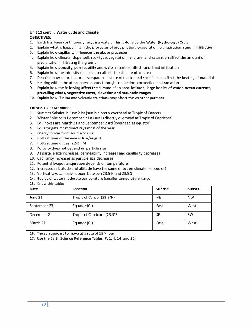
prevailing winds, vegetative cover, elevation and mountain ranges 10. Explain how El Nino and volcanic eruptions may affect the weather patterns THINGS TO REMEMBER: 1. Summer Solstice is June 21st (sun is directly overhead at Tropic of Cancer) 2. Winter Solstice is December 21st (sun is directly overhead at Tropic of Capricorn) 3. Equinoxes are March 21 and September 23rd (overhead at equator) 4. Equator gets most direct rays most of the year 5. Energy moves from source to sink 6. Hottest time of the year is July/August 7. Hottest time of day is 2-3 PM 8. Porosity does not depend on particle size 9. As particle size increases, permeability increases and capillarity decreases 10. Capillarity increases as particle size decreases 11. Potential Evapotranspiration depends on temperature 12. Increases in latitude and altitude have the same effect on climate (--> cooler) 13. Vertical rays can only happen between 23.5 N and 23.5 S 14. Bodies of water moderate temperature (smaller temperature range) 15. Know this table:
Date Location Sunrise Sunset
June 21 Tropic of Cancer (23.5°N) NE NW
September 23 Equator (0°) East West
December 21 Tropic of Capricorn (23.5°S) SE SW
March 21 Equator (0°) East West
16. The sun appears to move at a rate of 15°/hour 17. Use the Earth Science Reference Tables (P. 1, 4, 14, and 15)

21
THINGS TO STUDY/CONSIDER: Water Cycle
Potential Evapotranspiration (Ep) = temperature; higher temp = higher Ep
Porosity is unaffected by particle size.
Larger particles are more permeable; they let water pass
through more quickly (faster rate, less time.)
Capillarity (water retention) is most effective between
smaller particles
Methods of transfer of heat energy:
Radiation is energy transfer by means of electromagnetic waves. It is the only method of heat transfer that can
travel through empty space (a vacuum,) but it is not limited to traveling through empty space.
Conduction is energy transfer through solids, from molecule to molecule. Metals are particularly good conductors
of heat energy.
Convection is the way energy travels through fluids (liquids and gases). The warmer (more energetic) molecules
spread apart, becoming less dense and rising. The cooler molecules (which are closer together and therefore more
dense) move to take the place of the molecules that have risen. This sets up a circular pattern of warmer
molecules rising and cooler molecules falling. Uneven heating of the Earth’s atmosphere and oceans causes winds
and ocean currents to form.
Electromagnetic Energy is the form of energy we receive from the Sun. It is energy that travels in the form of
electromagnetic waves, usually by the process of radiation.
Electromagnetic Waves vary in wavelength and frequency.
The Electromagnetic Spectrum is composed of all the wavelengths of e.m. energy from the longest (radio waves)
to the shortest (gamma rays). (See the Reference Tables.)

22
Visible Light = the part of the e.m. spectrum that can be perceived by our eyes. Our eyes perceive the different
wavelengths of the visible spectrum as different colors. The visible portion of the e.m. spectrum males up only a
tiny part of the entire e.m. spectrum.
Reflection = bounced off, as light bounces off a mirror.
Refraction = scattered, bent, slowed down, shifted to lower wavelengths, as happens when light enters the thicker
portions of the atmosphere nearer to Earth’s surface. Refraction of sunlight causes the sky to appear “blue.”
Absorption = taken in – as when the sand on the beach gets hot on a summer day. The energy that is absorbed is
usually reradiated as electromagnetic energy of longer wavelengths (infrared,) if the object that absorbed the
radiation becomes warmer than its surroundings.
**** A good absorber is a good re-radiator.
Factors affecting Climate
Orographic Lifting
23
Unit 12: Astronomy OBJECTIVES: 1. Use eccentricity in context and know how to determine it. 2. Understand the relationships between: the planets’ distance from the Sun, gravitational force, period of
revolution, and speed of revolution 3. Determine the changing length of a shadow based on the motion of the Sun 4. Describe the relationship between gravity and inertia and its effects on the orbits of planets or satellites 5. Describe what causes each of the motions: daily cycle, yearly cycle, seasons, moon phases, eclipses, and tides 6. Describe how the force of gravity changes as the masses and distance between two objects changes 7. Describe the paths of the planets as an ellipse around the Sun with the Sun as one focus 8. Earth is orbited by one moon and many artificial satellites 9. Earth rotates at 15 °/hour 10. The Earth’s rotation is the basis for time measurements 11. Describe the Foucault Pendulum, the Coriolis Effect as evidence for the Earth’s rotation. 12. Describe the evidence for the Earth’s rotation and revolution. 13. Describe the changes in position of the Earth relative to the Sun throughout the year and how this affects us
on Earth 14. Describe how the apparent path of the Sun changes throughout the year 15. Describe how the oceans are affected by the moon 16. Describe the Geocentric Model and the Heliocentric Model 17. Develop a scale model of a planet and/or distances 18. Describe the current theories on the origin of the universe and evidence for it (cosmic background radiation
and red-shift) 19. Describe the changes stars go through in their life cycle and how each stage is different (H-R Diagram) 20. Describe how the planets came about and the general characteristics of them 21. Define asteroids, comets and meteors THINGS TO REMEMBER: 1. The universe began as a big explosion - “The Big Bang Theory” 2. Our solar system is located in one of the outer arms of the Milky Way Galaxy 3. The Earth rotates from W to E (CCW as you look down at North Pole) every 24 hours 4. Earth Revolves CCW around the Sun in 365.25 days (=> Leap year) 5. All celestial objects appear to rise in the east and set in the west moving around the Polaris 6. We see the moon in phases because it is revolving around the Earth (remember: half is always lit up) 7. Some planets show retrograde (backwards) motion because Earth passes them in space 8. The lower the altitude of the Sun, the longer the shadow 9. Foucault’s Pendulum and the Coriolis Effect prove that the Earth rotates on its axis 10. Earth is closest to the Sun in the winter (perihelion) but we have less direct rays 11. Earth is farthest from the Sun in the Summer (aphelion) but we have more direct rays 12. The closer a planet is to the Sun, the shorter its period of revolution 13. Use the Earth Science Reference Tables (P. 1 & 15) THINGS TO STUDY/CONSIDER: Spring Equinox ~ March 21 Fall Equinox ~ September 21
(Equinox = equal day and night)
Summer Solstice ~ June 21 (longest day of year in Northern hemisphere)
Winter Solstice ~ December 21 (shortest day of year in Northern hemisphere)
***The equator has about 12 hours of daytime every day of the year.

24
Geocentric Model:
- is Earth-centered; Earth is at the center of the universe; the Sun, the planets and all the stars circle the Earth.
- proposed by Ptolemy about 2000 years ago.
- the stars, the Sun and all the planets are located on transparent “spheres” that revolve around the Earth from
east to west once each day.
Observations explained by the geocentric model:
- the daily apparent motions of the Moon, the Sun and the stars
Observations NOT explained by the geocentric model:
- cannot predict exactly the future motions of the planets.
- cannot explain the change in direction of a pendulum’s swing (Foucault pendulum).
- cannot explain the Coriolis Effect – the curving of the paths of projectiles, winds and ocean currents.
Heliocentric Model:
- is Sun-centered; The Sun is located at
the center of the Solar System and does
not move. The planets circle around the
Sun.
- proposed by Copernicus in 1543;
added to and modified by Tyco Brahe
and Johannes Kepler.
Observations explained by the
heliocentric model:
- the apparent daily motion from east to west of all celestial objects around the Earth (is due to the rotation of
Earth on its axis, completed once every 24 hours).
- explains the eastward motion of the Sun through the stars.
- can predict accurately the motions of the other planets; states that each planet travels in its own orbit around the
Sun.
- explains the changing apparent diameter and the changing apparent brightness of the Sun and the planets; as
Earth orbits around the Sun, its distance from the Sun and from each of the planets varies. For example, the Sun
looks larger in the winter because Earth is closer to the Sun in winter than at any other time of the year.
- explains the motions of the Foucault pendulum and the existence of the Coriolus effect. Both are caused by the
rotational movement of the Earth.
- Earth rotates on its axis from West to East (counterclockwise) in 24 hrs or 15o/hr.
25
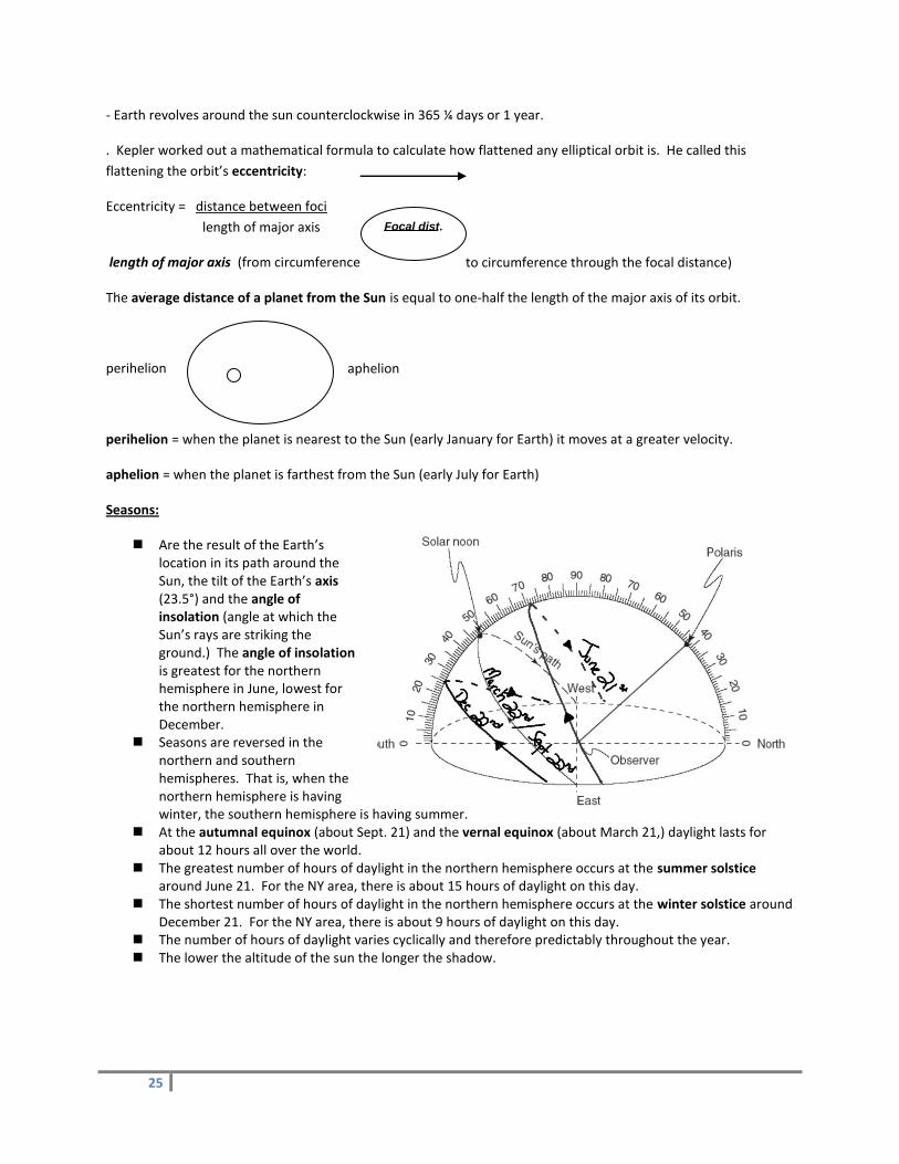
Focal dist.
- Earth revolves around the sun counterclockwise in 365 ¼ days or 1 year.
. Kepler worked out a mathematical formula to calculate how flattened any elliptical orbit is. He called this
flattening the orbit’s eccentricity:
Eccentricity = distance between foci
length of major axis
length of major axis (from circumference to circumference through the focal distance)
The average distance of a planet from the Sun is equal to one-half the length of the major axis of its orbit.
perihelion aphelion
perihelion = when the planet is nearest to the Sun (early January for Earth) it moves at a greater velocity.
aphelion = when the planet is farthest from the Sun (early July for Earth)
Seasons:
Are the result of the Earth’s location in its path around the Sun, the tilt of the Earth’s axis (23.5°) and the angle of insolation (angle at which the Sun’s rays are striking the ground.) The angle of insolation is greatest for the northern hemisphere in June, lowest for the northern hemisphere in December.
Seasons are reversed in the northern and southern hemispheres. That is, when the northern hemisphere is having winter, the southern hemisphere is having summer.
At the autumnal equinox (about Sept. 21) and the vernal equinox (about March 21,) daylight lasts for about 12 hours all over the world.
The greatest number of hours of daylight in the northern hemisphere occurs at the summer solstice around June 21. For the NY area, there is about 15 hours of daylight on this day.
The shortest number of hours of daylight in the northern hemisphere occurs at the winter solstice around December 21. For the NY area, there is about 9 hours of daylight on this day.
The number of hours of daylight varies cyclically and therefore predictably throughout the year. The lower the altitude of the sun the longer the shadow.

26
Phases of the Moon:
Phases = the cyclical changes in the apparent shape of the lighted portion of the Moon. One half of the Moon is always facing the Sun, but the lighted portion of the Moon is NOT always facing the Earth. The only part of the
Moon that we can see is the portion that is both lighted by the Sun and is facing towards the Earth.
A solar eclipse occurs when there is a new moon phase (the entire unlighted half of the Moon is facing the Earth and the Moon is passing in between the Sun and the Earth.) The Moon appears to block out the Sun as the Moon passes between the Sun and the Earth. This is rare, because all three bodies do not line up exactly very often.
A lunar eclipse occurs when the Earth passes in between the Sun and the full moon phase. The Earth’s shadow blocks out the Moon, causing the full moon to disappear and reappear.
It takes about 27.5 days for the Moon to complete one orbit around the earth. However, as a result of the Earth’s rotation, it takes 29.5 days. That is why it takes about 29.5 days for the Moon to complete its cycle of phases.
New Moon Waxing
Crescent 1st Qtr
Waxing
Gibbous Full Moon
Waning
Gibbous Last Qtr
Waning
Crescent
The right side of the Moon appears first (waxing phases). The left side of the Moon vanishes last (waning phases)
Tides Spring Tide Highest Tides – occur when the Moon is in the New Moon position working with the sun to draw the Earth’s water Neap Tide Lowest Tides – occur when the Moon is in the Qtr. Phases working against the sun to draw the Earth’s water Sun Source of sun’s energy is Nuclear Fusion


![Technical Bulletin - Polaris - Polaris 9300 Sport & Polaris 9300xi Sport[1]](https://static.fdocuments.us/doc/165x107/553b235d4a7959d8258b463f/technical-bulletin-polaris-polaris-9300-sport-polaris-9300xi-sport1.jpg)