Unerstanin the spatial organisaton of economc activitie n ...
23
The Journal of Space Syntax ISSN: 2044-7507 Year: 2016 volume: 6 issue: 2 Online Publicaon Date: 26 May 2016 hp://joss.bartle.ucl.ac.uk Understanding the spatial organisation of economic activities in early 19 th century Antwerp Francesca Froy Bartle School of Architecture University College London Pages: 225-246
Transcript of Unerstanin the spatial organisaton of economc activitie n ...
The Journal of Space SyntaxISSN: 2044-7507 Year: 2016 volume: 6 issue: 2 Online Publication Date: 26 May 2016
http://joss.bartlett.ucl.ac.uk
Understanding the spatial organisation of economic activities in early 19th century Antwerp
Francesca FroyBartlett School of Architecture University College London
Pages: 225-246

225
JOSS
Understanding the spatial organisation of economic activities in early 19th century Antwerp
Francesca FroyBartlett School of Architecture University College London
This article analyses the spatial organisation of
economic activities in Antwerp in the early 19th
century, exploring the influence of urban morphol-
ogy, and the accessibility of particular streets, to
the locational choices of artisans, merchants and
retailers at this time. When it comes to the location
of different economic activities in cities, it has long
been understood that accessibility plays an impor-
tant role. Economic geographers have, in particular,
sought to understand the relationship between the
location of economic activities and proximity to both
customers, and other businesses. Von Thunen’s ag-
ricultural model, Webber’s industrial location model,
Alonso’s residential location model and Christaller’s
retail location model all implicitly rely on accessibil-
ity as a driver for location choices (Sevtsuk, 2010).
Alonso (1964) for example, described a bid-rent
curve which helps to explain why central locations in
cities have higher commercial use and higher rents
due to their higher accessibility; a model which is
still very much in use today.
Historically there has been less analysis by
economic geographers of how urban form and
urban layouts might influence accessibility in cities,
beyond focusing on distance from particular central
points (Svetsuk, 2010). However, recently, geo-
This article uses space syntax analysis to explore the spatial organisation of economic activities in the city of Antwerp in the early 19th century. A cadastral map from 1835 and a commercial almanac for 1838 were used to map the occupations held by the inhabitants of some 10,667 plots. Economic activities were found to be relatively broadly distributed throughout the street system, as opposed to being clustered at particular points. However some trades and occupations were more likely to be found on a ‘foreground network’ of more accessible streets, and this was found to be statistically significant. Those occupations found in locations with high accessibility at all scales included retailers, wholesalers and artisans. While retailers would have prioritised access to passing trade, the latter two groups may have valued accessibility to the circulation of goods, products and knowledge as much as to the circulation of people.
Keywords:History, urban economy, Antwerp, trades, accessibility
graphical information systems (GIS) have enabled
economists to start using graph analysis to generate
more complex analysis of the location of economic
activities within urban street networks. Amongst
other things, graph analysis tools measure access
from each element of urban form (e.g. a street or
intersection) to every other element of urban form in
the graph. This means that it is possible to under-
stand how accessible a given economic activity is
to all customers or other economic activities within
a city at a given radius.
In the field of architecture, space syntax has
long used graph analysis to better understand the
relationship between urban form and the location
of economic activities (see for example, Hillier and
Penn, 1991, Hossain, 1999, van Nes, 2005, Penn
et al., 2009, Marcus, 2010, Vaughan et al., 2010,
Sayyar and Marcus, 2013, Navarez et al., 2014,
Vaughan, 2015). The use of graph analysis has
enabled space syntax to develop new insights
regarding the overall patterning of economic ac-
tivities in cities. Hillier, for example, has extended
understanding of the global organisation of cities
beyond the ‘centre-periphery’ model to argue that
cities develop organically in a ‘deformed wheel’
or ‘hub and spoke’ formation (Hillier, 2002). It is

226
JOSS
The Journal of Space Syntax
Volume 6 • Issue 2
not just the hub that is particularly accessible,
but the spokes themselves, generating a kind of
‘foreground network’ of streets across the city as
a whole (Hillier, 2009). Because the ‘foreground
network’ streets are particularly well-connected and
represent the quickest through routes to many differ-
ent destinations, they often host economic activity,
as businesses take advantage of the number of
‘passers-by’. Cities also host a background network
of other streets, which are often shorter and more
frequently at right angles to each other, and that are
more likely to be residential.
Hillier (1999) notes that some cities appear to
be more strongly shaped by economic drivers than
others. Cities that have grown up around production
and trade have an urban form that often appears to
prioritise the circulation of people and the provision
of spaces for interaction and encounter between
different economic actors. In the historic City of Lon-
don, for example, “the city’s urban space structure
is about the movement required to create a dense
encounter field” (ibid. p.119). Monuments, churches
and government buildings are well-embedded into
the urban fabric so that they do not disrupt move-
ment flows.
More recently, Hillier et al. (2012) identify that cit-
ies also vary in the degree to which their ‘foreground’
and ‘background’ networks are differentiated, po-
tentially influencing the degree to which economic
activities are spread out across the urban area.
In cities such as London and Tokyo, for example,
a strong foreground network diverts movement
and economic activity away from the background
network of streets. In places like Manhattan, in
contrast, the differentiation between the foreground
and background networks is much weaker, poten-
tially leading to a more egalitarian distribution of
economic development across the street network.
Relatively few space syntax studies have
examined the spatial organisation of economic
activities in cities at a fine grain, to look at the dif-
ferent arrangements of specific economic sectors
and their sub-sectors in space (Porta et al., 2012).
This is perhaps partly due to the difficulty in ac-
cessing contemporary data sets on establishments
in cities. Interestingly, Craane (2013) and Griffiths
(2016 forthcoming) have both used space syntax
to explore the fine-grained location of economic
activities in a historical context, focusing on the late
medieval-early modern economy of the Bailiwick of
‘s-Hertogenbosch in the Netherlands and in Shef-
field, England, respectively. Elsewhere in the field
of architecture and urban planning, detailed land
use patterns have also been analysed using differ-
ent graph analysis tools (see for example, Sevtsuk,
2010, Porta et al., 2012, Sevtsuk, 2014).
Learning from the city of AntwerpIn this article, the spatial arrangement of economic
activities is explored for a historic city - the city of
Antwerp in the 1830s. The spatial distribution of
different trades and occupations in Antwerp was
analysed to see whether any relationship could
be identified between the locational choices of
economic activities and the spatial configuration
of the city (Froy, 2014).
The research draws on a cadastral map from
1835 and commercial almanac for 1838 supplied by
the Antwerp Centre for Urban History. The cadastral
map shows the division of the city of Antwerp into
land parcels/plots (although only within the city
walls - there was also a substantial unplanned area
of dwellings outside which was not mapped). In its
gazetteer the names and addresses of the owners
of some 10,667 plots are provided, in addition to the
land and building values and the area of land that
they owned. The almanac lists the trades and oc-
cupations carried out in the city, by street address.
After a brief consideration of the urban form of
19th century Antwerp (following Hillier and Hanson,
1984 and Hillier et al., 2012), the spatial arrange-
ment of economic activities is mainly analysed using
a combination of ARCGIS and UCL DepthmapX1.
Notes: 1 DepthmapX (2012) Multi-Platform Spa-tial Network Analysis Software originally developed by Alasdair Turner. https://github.com/SpaceGroupUCL/Depthmap
227
JOSS
Understanding the spatial organisation of economic activities in early 19th century Antwerp
Froy, F.
As identified above, there are a number of different
technical tools that can be used to understand the
relationship between different networks and location
patterns, including GIS Network Analyst, TransCAD,
SANET, GeoDaNet and NetworkX. DepthmapX is
based on space syntax methodologies, and as
such is different from some other types of graph
analysis in that streets are identified as ‘nodes’, with
intersections as ‘edges’, following so-called ‘dual
graph theory’ (Scherngell, 2013). Recently, space
syntax research has focused mainly on particular
segments of streets, as opposed to whole streets
(or more accurately lines of sight or ‘axial lines’) as
the nodes within the system.
Using Depthmap, it is possible to look at two
different types of accessibility. The first is the depth
or distance of one location to all other locations in
the system - often defined in graph and network
theory as ‘closeness’ and in space syntax theory
as ‘integration’. The second is the extent to which
different nodes are used for ‘through movement’ as
people progress on journeys from all destinations in
the system to all others (defined in broader graph
theory as ‘betweeness’ and in space syntax theory
as ‘choice’).
The design of Depthmap also reflects the space
syntax understanding that pedestrians may not only
consider metric distance when choosing paths from
one place to the next. In addition to calculating
accessibility on the basis of metric distance, the
programme also supports analysis on the basis
of topology (the number of turns that need to be
taken from one node to another, as you move from
one segment or street to the next) and least angle
choice (the paths requiring the least angular change
from one destination to another). Space syntax has
traditionally privileged the latter two forms of analy-
sis because it is understood that people are more
likely to choose routes that are more direct i.e. that
require fewer turns, and that require turns of a less
acute angle. Depthmap also allows movement to be
analysed at a number of different radii, from small
journeys at 100 or 200m up to much larger journeys
that would cover the whole system (defined here as
radius Rn). For this research, least angular segment
analysis was chosen, to study the location of eco-
nomic activities against measurements of betwee-
ness or ‘choice’ using a number of different radii.
There is a strong body of historical research
on the city of Antwerp in the 18th-19th centuries
(see for example, Lis, 1986, Blondé and Damme,
2010, Winter, 2009, Greefs, 2013, Van Damme and
Van Aert, 2014). This includes a spatial analysis of
changing patterns of economic activity between
1796-1838 within one quarter of 1830s Antwerp by
Janssens et al. (2014). For a previous period of his-
tory, Bisschops (2012) also used GIS to map trades
and occupations in 1400. While (to the author’s
knowledge) this is the first application of space
syntax methodology to understanding economic
activities in historical Antwerp, Van Damme and
Van Aert have highlighted the changing importance
of particular arterial roads (from centre to edge)
between the 16th-19th century, while mapping the
principle shopping streets and markets in Antwerp
for the years 1638, 1700 and 1836 (Van Damme
and Van Aert, 2014).
Antwerp – a city of trade and productionSince its origins as a trading post on the river
Scheldt in the 2nd century AD, Antwerp has been
a centre of trade and industry. While the city was
an important centre for religious, intellectual and
artistic development during different parts of its
history, the economy has always played a dominant
role. Vasco de Gama of Portugal used the port in
the 15th century as a distribution point for oriental
products in Europe, buying precious metals from
Germany to trade with India and Africa. In its ‘golden
age’ in the 16th century it became one of the richest
cities in Europe and a “centre of fevered trading”
(Cauwenbergh, 1970), hosting the first purpose-built
stock exchange. The city’s craftsmen were known

228
JOSS
The Journal of Space Syntax
Volume 6 • Issue 2
for creating high quality goods, such as glass, paint-
ings, silver, furniture and textiles. Until the late 18th
century, these artisans were organised in guilds,
which were instrumental in maintaining standards
and regulating working conditions. The guilds had
fine buildings on the central Grande Place and
headed up the large festive and semi-religious
processions known as ‘Ommegangen’ that went
through Antwerp’s streets several times a year.
The spatial layout of the historic cityFor much of its early history, economic activities in
Antwerp were supported by a system of canals that
took boats right into the heart of the street network.
The canals allowed perishable goods and foodstuffs
to be taken close to the city’s markets, while peat
boats and coal boats could deliver goods directly
to artisans and manufacturers such as brewers,
soap boilers and dyers. By the 1830s many of
these canals had been covered over, and other
small planning changes had taken place. However
the city maintained much of its medieval structure
– including a set of fortified city walls [see Figure 1].
As might be expected from a city of trade and
production, the street layout of Antwerp in the 1830s
appeared to prioritise movement and encounter
over symbolic communication. In the centre of
the city, public buildings such as churches were
nested in with other buildings, rather than being
made ‘monumental’. The city cathedral faced into a
tight triangular space, and as a pedestrian it would
have been difficult to get a good perspective on its
frontage, which would have been glimpsed down a
series of small angular side streets on the way into
the Grande Place market square. Other churches
in the centre similarly had limited space in front
of their facades. Most public spaces in the town
were in effect broadened streets, or squares in the
interstices and triangles left by streets.
Figure 1:
Antwerp in 1572 (left) and in 1832 (right).
Source: Braun and Hogenberg (1572) and Clarke (1832)

229
JOSS
Understanding the spatial organisation of economic activities in early 19th century Antwerp
Froy, F.
Further, a more detailed analysis of settlement
layout (following Hillier and Hanson’s analysis of
settlement G in The Social Logic of Space, 1984)
identified that the city had a relatively ‘distributed’
street structure in 1835 despite having a relatively
organic and deformed layout. Both the system of
convex spaces and the system of axial lines were
relatively ‘ringy’, with broadly similar values to set-
tlement G [see Table 1 below]. This meant that as
they walked around the city, people had a number
of choices as to which route to take, with more op-
tions opening up as they went from one street to the
next. The buildings were ‘equal’ in their distribution
in space, with space being defined by the spaces
left between the buildings, in contrast to more ‘hier-
archical’ urban configurations where some buildings
were found inside a broader set of boundaries.
The space between the buildings was relatively
continuous, as opposed to being more broken up
into different convex spaces. At the same time, the
‘axiality’ of the system (the degree to which the linear
spaces were divided up into different ‘lines of sight’)
was relatively high in comparison with settlement G,
implying that the street network was broken up into
more tightly angled streets, as opposed to having
a strong linear foreground system.
Table 1:
Results of detailed set-tlement layout analysis.
9
Properties of the urban layout Value
Basic details
Number of convex spaces C 950
Number of axial lines L 463
Number of buildings B 10666
Number of islands I (i.e. a block of continuous
buildings, completely surrounded by y-space) 228
Articulation and synchrony
Convex articulation
= C/B 0.09
Axial integration of convex spaces
= L/C 0.49
Axial articulation
= L/B 0.04
Ringiness or distributedness
Convex ringiness
= 1
2C-5 0.12
Axial ringiness
= 1
2L-5 0.25
Griddiness
Grid convexity
= (√I+1)2
C 0.27
Grid axiality
=(√I x 2)+2
L 0.07
Grid axiality without ‘1:connected’ spaces
of which there are 421 0.08
Table 1: Results of detailed settlement layout analysis
Following Hillier et al. (2012), it is also interesting to compare the relative
importance of the foreground and background network in Antwerp with that of
other cities. Hillier et al. explored the relative strengths of foreground and

230
JOSS
The Journal of Space Syntax
Volume 6 • Issue 2
Following Hillier et al. (2012), it is also inter-
esting to compare the relative importance of the
foreground and background network in Antwerp
with that of other cities. Hillier et al. explored the
relative strengths of foreground and background
networks in cities using a normalised measure of
angular choice (or betweeness) known as NACH.
Space syntax has only recently been able to nor-
malise the choice measure and therefore compare
results across cities. For each city, the maximum
and mean values of NACH were obtained to analyse
the foreground and background networks respec-
tively. Mean NACH basically indexes the degree of
deviation from straight-line routes from each street
segment to all others in the system. It therefore ap-
proximately measures the degree of deviation from
a regular grid, and hence the degree of connected-
ness between different parts of a city’s ‘background
network’. In contrast, the maximum NACH values
measure the highest value lines within the system,
that give the city its ‘structure’ – and hence its ‘fore-
ground network’.
Hillier et al. compared NACH values (along with
normalised integration values (NAIN)) across 50 cit-
ies, including modern day Antwerp. The maximum
and mean NACH and NAIN values were used to
place cities on a comparative star diagram [see
Figure 2 below]. When max and mean NACH values
for 1835 Antwerp are compared with the cities in
Hillier et al.’s database, it appeared to have a rela-
tively strong background network with limited spatial
discontinuities, and a weak foreground network. It
is in the top of the second quartile of all 50 cities in
terms of its mean NACH, while max NACH is at the
bottom of the fourth quartile.
Table 2:
Mean and max nor-malised choice values for 1835 Antwerp and Antwerp today
10
background networks in cities using a normalised measure of angular choice
(or betweeness) known as NACH. Space syntax has only recently been able
to normalise the choice measure and therefore compare results across cities.
For each city, the maximum and mean values of NACH were obtained to
analyse the foreground and background networks respectively. Mean NACH
basically indexes the degree of deviation from straight-line routes from each
street segment to all others in the system. It therefore approximately
measures the degree of deviation from a regular grid, and hence the degree
of connectedness between different parts of a city’s ‘background network’. In
contrast, the maximum NACH values measure the highest value lines within
the system, that give the city its ‘structure’ – and hence its ‘foreground
network’.
Hillier et al. compared NACH values (along with normalised integration values
(NAIN)) across 50 cities, including modern day Antwerp. The maximum and
mean NACH and NAIN values were used to place cities on a comparative star
diagram [see Figure 2 below]. When max and mean NACH values for 1835
Antwerp are compared with the cities in Hillier et al.’s database, it appeared to
have a relatively strong background network with limited spatial
discontinuities, and a weak foreground network. It is in the top of the second
quartile of all 50 cities in terms of its mean NACH, while max NACH is at the
bottom of the fourth quartile.
Order Max NACH Order Mean NACH
1835 Antwerp 1.507 0.944
Antwerp today 1.586 0.968
Rank in 50 cities 41 15
Rank of Antwerp today 23 13

231
JOSS
Understanding the spatial organisation of economic activities in early 19th century Antwerp
Froy, F.
Hillier et al. speculate that in many cities the
continuity of the background network may be
sacrificed to prioritise a system of well-connected
foreground streets. However in Antwerp the back-
ground network forms a relatively continuous grid
with direct connections between the streets, rather
than being broken into discontinuous sub-areas.
The high mean NACH may reflect the pressure to
use all available land within the city walls, which
helped to create a completely urbanised system.
Further, the small size of the system (with 1348
segments) may help explain the weakness of the
foreground network – Hillier et al. suggest that cities
may have a tendency to develop their foreground
network as they grow, and indeed the max NACH
value for modern day Antwerp is higher.
Taking both these comparisons and the more
detailed settlement analysis into account, however,
it seems that the spatial configuration of Antwerp in
the 1830s was relatively ‘distributed’, with a strong
background network and a potential for supporting
economic activity throughout the street system.
Figure 2:
Comparing 1835 Ant-werp with the 49 cities reviewed in Hillier et al., 2012
Note: modern day Antwerp was excluded in the comparison
The foreground networkNevertheless, a foreground network did exist [see
Figure 3]. This set of streets formed a radial ‘centre
to edge’ structure and an inner ring, with normalised
choice values of predominantly 1.4 and above, with
one small segment at 1.5 to the north of the centre.
Higher-choice streets were also found leading north
from behind the cathedral. Some of these higher
choice streets were historic remnants of different
stages of the town’s development – what Hanson
described as “morphological permanences” (1989
p.186). The centre-edge routes constituted three
out of the four principal roads leading out towards
the city gates that had historically connected Ant-
werp to its rural surroundings. The inner ring was
formed by a covered rampart moat that had formerly
been used as a canal to bring goods into the city.
While this analysis used Hillier’s normalised choice
measure, these streets are also picked out as the
principal foreground network when using the tradi-
tional global choice (or betweeness) measure Rn.

232
JOSS
The Journal of Space Syntax
Volume 6 • Issue 2
Figure 3:
Normalised choice analysis for Antwerp, 1835.

233
JOSS
Understanding the spatial organisation of economic activities in early 19th century Antwerp
Froy, F.
The spatial organisation of trades and occupations in 1835 AntwerpWhat impact might the overall structure of Ant-
werp’s street network have had on the organisa-
tion of trades and occupation in the city? Spatially
mapping the trades and occupations in the 1838
almanac allows both a visual exploration of differ-
ent patterns in space, and the linking of plots to the
choice values of their adjacent streets to carry out
a more in-depth statistical analysis. Questions to
explore included whether trades and occupations
were concentrated in particular parts of the city or
were more distributed across the street network;
whether some occupations placed a premium on
locating on more accessible ‘foreground’ streets,
and; whether different types of trade or occupation
followed different patterns of distribution.
In early 19th century Antwerp the economy
had been going through a time of change. During
the 17th century, the city remained a centre for the
production of quality products including textiles,
paintings, furniture, silver and glass work. However,
following the turbulent political changes associated
with the Reformation, Antwerp went into decline,
both as a global port and a centre of production.
Caught up in the violent struggle between the Dutch
and the Spanish, the economy particularly suffered
when the River Scheldt was closed to international
traffic in 1648. The guilds were also abolished at the
end of the 18th century. However retail trade in the
city remained strong (Blondé and Damme, 2010),
boosted by new French fashions.
When the international port was reopened by
Napoleon in 1800, Antwerp rapidly reemerged as
a centre of world trade, becoming one of the top
20 world harbours by 1840 (Greefs, 2013). At this
time, Antwerp became increasingly specialised as
a port city, in common with 40% of the largest cities
in Europe (Lee, 1998). Some factories were also
beginning to emerge in the context of industrialisa-
tion. This led to a more hierarchical labour market as
people started to work for the docks or the factory
owners as opposed to for themselves, with these
changes being accompanied by rising poverty (Lis,
1986). However, independent artisans remained an
important part of the economy. In 1838 the three
biggest occupation types were artisans (26%), en-
trepreneurs, manufacturers, and merchants (15%),
and retailers (13%). There were also a significant
number of residents without a professional occupa-
tion (27%), with many being private investors.
Range and reach Initial analysis looked at the range and reach of
different trades and occupations across the town.
Griffiths (2016 forthcoming) argues that it is impor-
tant to differentiate between functional ‘reach’ (the
number of streets on which a given industrial func-
tion features) and ‘range’ (the number of different
functions on a given street) as this offers a simple
way of identifying whether trades and occupations
were clustered or more distributed.
As there were a myriad of different activities
going on in Antwerp at this time, activities were clas-
sified into 8 main categories and 47 sub-categories
[see Table 3 below] using a classification developed
by Furnée (2012) and used by Janssens et al.
(2014). This classification was chosen to support
cross-referencing with the broader GIStorical Ant-
werp project. The classification has the advantage
of breaking down broad categories such as ‘retail-
ers’ and ‘artisans’ into sub-categories. The category
of artisans, for example, is split into construction,
food processing, clothing & textile industries, fur-
niture & luxury industries, utensils, metallurgy, port
industry and others. However, for this research,
even more fine-grained analysis was also carried
out to check whether individual occupations had
a particularly interesting distribution. For example,
within metallurgy it was possible to look at the loca-
tions of tinsmiths and coppersmiths.

234
JOSS
The Journal of Space Syntax
Volume 6 • Issue 2
To carry out this analysis the 1838 commercial
almanac was first linked by the Antwerp Centre
for Urban History with the 1835 cadastral map in
Arcmap, using a File Geodatabase2 as part of the
GIStorical project. The parcel/plot number (in the
cadastral map) and the house number (in the alma-
nac) were used to achieve concordance between
the two data sources. The plots were then spatially
linked with a space syntax segment map of the city,
with each plot being linked to its nearest segment.
Non-normalised choice or betweeness analysis
was carried out, as comparisons were not being
made with other cities. The average choice value
for all the plots listed under a particular category
or sub-category was then calculated at different
scales (Rn, R400, R600 and R800). These values
were compared to an average of the choice or
betweeness values for all plots at each scale. The
results were analysed using T-tests to establish
their statistical significance (with values of 0.05 and
under identified as significant).
The results are set out below [see Table 3]. Sta-
tistically significant values are highlighted in black.
In addition, those values that are above average for
a particular scale of movement are starred.
For two types of occupation (civil servants and
employees), no categories were found to have
above-average choice or betweeness values that
were statistically significant. Within the liberal and
intellectual professions, pharmacists occupied
high choice plots at all scales. In the third category
(entrepreneurs, manufacturers and merchants),
wholesalers (a category which included the major-
ity of trading merchants) appear to have occupied
particularly high choice plots, again at all scales.
Of the artisans, metallurgy had higher than average
choice values at all scales, while food processing
and furniture/luxury industries had above average
values at the local and mid-ranges. All the retail
categories had higher than average choice values
for at least two scales that were statistically sig-
All trades and occupations appeared to have a
relatively high reach, which was broadly correlated
with their total number of establishments (r2: 0.73).
In fact many trades and occupations were slightly
over trend i.e. more distributed across the street
network than would be expected for their numbers.
The range of occupational categories on individual
streets was also high. 42% of streets had over 6
categories on them, with 8 being the full range.
88% of streets hosted artisans, 67% retailers and
48% wholesalers. When it came to occupational
sub-categories, a third had between 6-10 different
sub-categories, with 22% having 11-15 (from a full
range of 47).
The majority of the streets had values of close
to 1:1 in terms of plots per sub-category, with only
a few having significantly higher values signifying
a cluster of one sub-category. Some such concen-
trations can be related to specific advantages of a
particular geographic location – for example, brew-
ers were clustered around the north dock, served
by channels of fresh water. Inns and pubs were also
concentrated around the different gates into the city.
Different trades and occupations appear there-
fore to have been both well distributed across the
town and well mixed up in space. This echoes the
findings of Hanson in her study of medieval Lon-
don (1989), where it was not always easy to see
a clear correlation between the location of trades
and particular spatial areas or districts. She found
that trades at this time “seem to choose the most
unlikely neighbours” (p.285).
Relative accessibility of different occupations and tradesSome trades and occupations did however prioritise
Antwerp’s ‘foreground network’ of streets. When the
plots were linked with their nearest street segment,
it was apparent that some occupations and sub-
occupations were consistently on segments that
had higher choice values.
Notes: 2 Note that there were amendments to some 5% of plots between 1835 and 1838. Other limita-tions included multi-ple entries for some plots, the fact that the almanac only contained residential addresses (although work location and residence often corresponded). Only one occupation was usually listed for each plot so multiple trades may be underestimated. No occupation is listed for 1666 records.

235
JOSS
Understanding the spatial organisation of economic activities in early 19th century Antwerp
Froy, F.
18
Categories and subcategories Choice RN
Choice
R400
Choice
R600
Choice
R800
Civil Servants and Army Officers
Diplomats 8322 418 1467 2985
State officials & elected representatives 12590 483 1334 2882
Magistrates 115220* 977* 4561* 12570*
Senior civil servants 33342* 937* 3053* 6781*
Middle-ranking civil servants 17168 409 1309 2637
Lower-ranking civil servants 25318 666 2102 4257
Senior (army) officers 78733* 1752* 6693* 15915*
Subaltern (army) officers 8872 1515* 3228* 4514
Soldiers 46461* 1669* 5423* 10803*
Officers (general) 21640 638 1966 4162
Liberal and intellectual occupations
Lawyers, solicitors 22691 500 1640 3446
Physicians 30652* 736 2265 4805
Pharmacists 42607* 1110* 3516* 7376*
Clergymen 21038 662 2155 4499
Teachers 17981 534 1711 3703
Artists 21075 847* 2671* 5027
Office clerks 29044* 670 2159 4664
Accountants, translators 9408 469 1358 2600
Entrepreneurs, manufacturers and merchants
Bankers, stockbrokers, insurers,
managers 21953 502 1603 3526
Manufacturers 22955 696 2033 4110
Wholesalers 33311* 937* 2906* 6046*
Merchants 14931 853* 2307 4989
Middlemen 23604 806* 2470* 5091*
Artisans
Construction 25628 702 2127 4400
Food processing 29423* 1064* 2872* 5544*
Clothing & textile industries 22604 778 2222 4387
Furniture & luxury industries 32364* 1012* 3115* 6478*
Utensils 19047 721 1985 3745
Metallurgy 36335* 1028* 3117* 6401*
Port industry 19526 769 2176 4166
Artisans (general) and other 57593* 1567* 5631* 12032*
Retailers
19
Food, liquor, tobacco 28166* 1300* 3592* 6563*
Clothing & textiles 43359* 1314* 4033* 8176*
Furnishing & luxury goods 21672 1541* 4220* 7618*
Retailers (general) and others 33307* 936* 2880* 6041*
Other self-employed
Innkeepers and pub owners 16670 601 1672 3282
Stable keepers and transporters 7471 431 1143 2143
Farmers and gardeners 17486 344 1128 2462
Other self-employed 27275 853* 2371 4632
Employees
Wardens 22417 813 2492 4821
Domestics 46465* 947* 3413* 7882*
White-collar workers 19451 770 2140 4173
Blue-collar workers 22045 584 1712 3504
Dockworkers 8292 393 1109 2153
Without occupation
Minors 1365 209 641 721
Rentiers/investors 32312* 737 2416 5308*
Disabled/retirees 45426* 534 1947 4643
Average 27668 800 2441 5041
Table 3: Relative choice values of different occupations
For two types of occupation (civil servants and employees), no categories
were found to have above-average choice or betweeness values that were
statistically significant. Within the liberal and intellectual professions,
pharmacists occupied high choice plots at all scales. In the third category
(entrepreneurs, manufacturers and merchants), wholesalers (a category
which included the majority of trading merchants) appear to have occupied
particularly high choice plots, again at all scales. Of the artisans, metallurgy
had higher than average choice values at all scales, while food processing
and furniture/luxury industries had above average values at the local and mid-
ranges. All the retail categories had higher than average choice values for at
least two scales that were statistically significant. Of these, general retailers
and clothes/textiles retailers had higher than average choice values at all
scales. For those without occupation, rentiers or investors also had higher
Table 3:
Relative choice values of different occupa-tions.}

236
JOSS
The Journal of Space Syntax
Volume 6 • Issue 2
Figure 4:
Location of retail-ers against segment analysis showing global choice.

237
JOSS
Understanding the spatial organisation of economic activities in early 19th century Antwerp
Froy, F.
nificant. Of these, general retailers and clothes/
textiles retailers had higher than average choice
values at all scales. For those without occupation,
rentiers or investors also had higher than average
choice values that were statistically significant at
the global scale.
Why might some trades and occupations have
prioritised sites with higher accessibility? The fol-
lowing section explores this question by looking at
three types of occupation in more detail: artisans,
retailers and wholesalers/merchants.
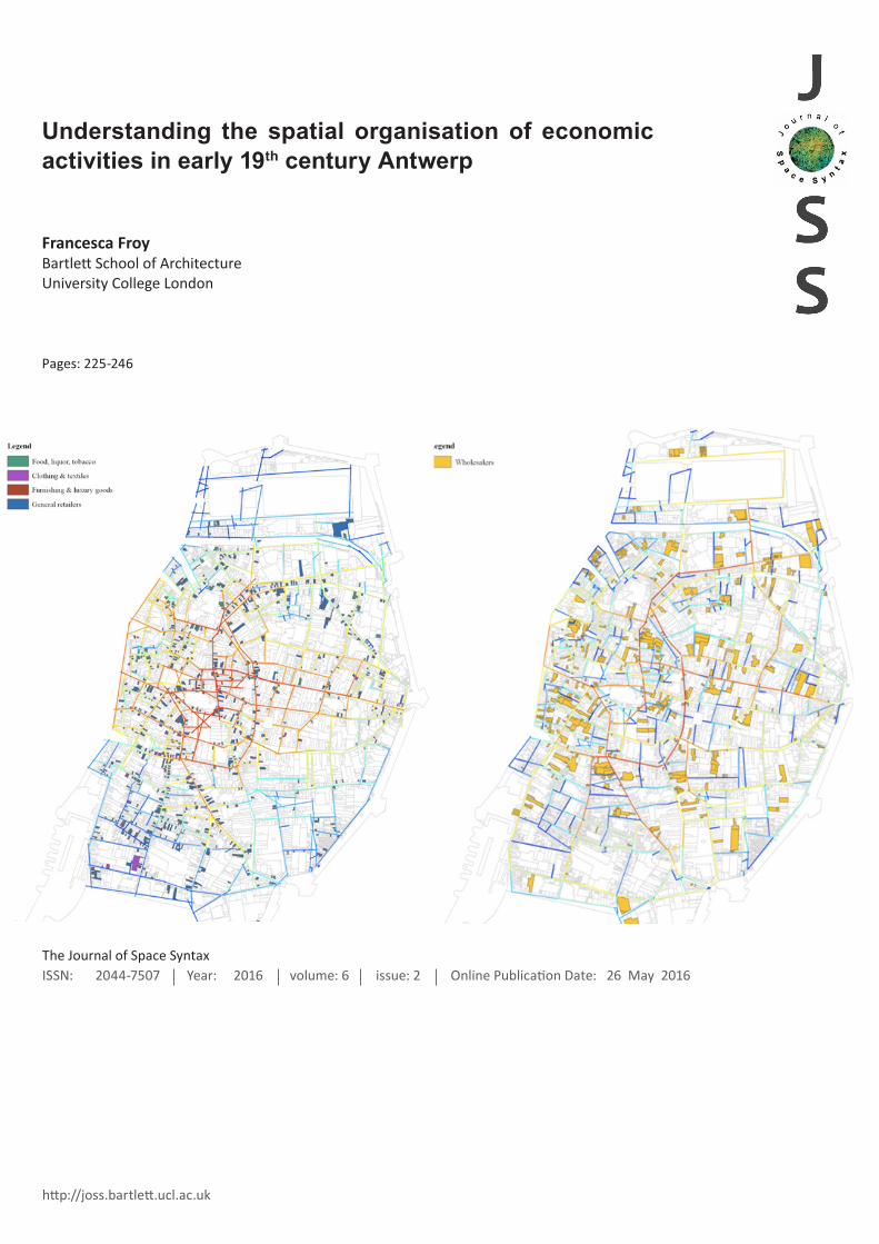
RetailersThe map above [Figure 4] shows the spatial dis-
tribution of different types of retailer in Antwerp
against global choice values. Retailers were par-
ticularly prevalent on the foreground network of
higher global choice streets, although less so on
the centre-edge street leading to the east and on
the inner ring. Interestingly, analysis of retail distri-
bution in earlier periods shows a more eastwards
distribution (Van Damme & Van Aert, 2014) .
The through movement of pedestrians would
have been important for retailers, with high ‘footfall’
being an important source of clients. Retail location
theory (Christaller, 1933 (1966)) suggests that dif-
ferent retailers would have sought different scales
of accessibility depending on their products and
clients, with goods such as bread that are pur-
chased fairly frequently requiring smaller market
areas than furniture, for example. Unfortunately it
is difficult to differentiate between different types of
retailers in the 1838 commercial almanac as many
are listed as ‘general retailers’ without specifying
the goods traded. However, shops selling daily
goods such as bakers were relatively dispersed
throughout the town, and often found at important
local junctions [see Figure 5].
In fact, historical analysis shows that food retail-
ers had previously been much more concentrated in
Antwerp, with 50% being located in the city centre
in 1636, before they slowly moved out and became
more evenly distributed across the town. This may
be due to the fact that provision of foodstuffs used
to be more highly regulated to ensure quality and
hygiene (Van Damme and Van Aert, 2014).
Some specialist shops appear to have been
more clustered in the 1830s. This is particularly the
case for clothes and textile retailers, which were
concentrated at a junction in the south that had high
choice values at all scales. This appears to have
been a particularly sustainable cluster, as clothes
and fashion retailers are still found in this area today,
in Antwerp’s ‘fashion quarter’. Van Damme and Van
Aert point out that specialist retailers were gradually
moving to more high rent locations over the 18th
and 19th centuries, polarising the shopping culture
so that certain sections of society went to certain
parts of the town for their shopping. At the same
time there was a move from retail establishments
that opened directly onto the streets in medieval
times to shops that were inside, behind large glass
windows, leading to higher levels of ‘window shop-
ping’ in prestigious shopping streets. This may go
some way to explaining the development of the
clothes retail cluster. The movement coincided with
the rise in a consumer culture based on fashionable
products that were broadly accessible to the middle
classes (Blondé and Damme, 2010).
Figure 5:
Map extract showing location of bakers

238
JOSS
The Journal of Space Syntax
Volume 6 • Issue 2
Figure 6:
Location of wholesalers/merchants against seg-ment analysis showing global choice.

239
JOSS
Understanding the spatial organisation of economic activities in early 19th century Antwerp
Froy, F.
Van Damme and Van Aert point out that markets
were also in decline during this period and were be-
ing replaced by fixed shops. However, in the 1830s
a number of markets still existed across Antwerp,
mainly for food and basic materials. Space syntax
convex analysis of the market locations reveals that
these markets were often in public spaces that had
relatively high global choice values, and hence
were accessible to global through movement.
However, the markets were again well distributed
across the town. Indeed a fruit and vegetable mar-
ket remained in the less spatially integrated Meir
well into the 19th century, encouraging a broader
set of city residents to mix with the wealthy owners
of mansions living in the street.
Wholesalers and merchantsWholesalers or merchants [see Figure 6] were an
important and growing segment of Antwerp society
in the 1830s following the reopening of the Scheldt
to international trade. The fact that they occupied
plots with above average choice value at all scales
is perhaps not surprising given the importance of
interaction and movement to this group. While they
were operating in large global networks, they also
had complex local networks in which they interacted
and exchanged. Some nationalities had leagues
(such as the Merchant Adventurers of London)
that provided important transpatial ties, in addition
to those of family and intermarriage. At the same
time the city’s exchange or ‘stock market’ provided
a very spatial and proximal site for deal making [see
Figure 7]. This exchange consisted of an enclosed
courtyard at the centre of a crossroads to the east of
the city centre. In the 1830s it actually extended the
10% ‘integration core’ of the city (the 10% of streets
that were ‘closest’ to all others, or more integrated)
for those with access to the exchange [see Figure 8].
Figure 7:
The Antwerp Stock Exchange in the 17th century.
Source: Guicciardini (1612)

240
JOSS
The Journal of Space Syntax
Volume 6 • Issue 2
Accessibility and circulation would have been
important to the merchants for the transmission
of goods and knowledge. Many of the merchants
stored goods in their houses, which needed to be
transferred to and from the port. Knowledge shar-
ing would have been vital not only to brokering new
deals, but also reducing risk. Greefs (2006) empha-
sises that wholesalers and merchants had to cope
with an uncertain world, where a ship could easily
be sunk, smugglers were rife, and deals could often
go wrong. The mitigation of risk required a constant
updating of knowledge, both through transpatial
relationships, and hearing the ‘word on the street’.
Inns were also important sites of exchange and in-
teraction. The merchants are described as dividing
their time between the office, the exchange, the inn
and the port, where they were often found “straining
their necks to see incoming ships” (Suykens et al.,
1986, p.138).
ArtisansDespite the abolishment of the guilds at the end
of the 18th century, artisans continued to play an
important role in the city. However, trades that were
directly related to the port often crowded out other
forms of production. As shown in the map above
[Figure 9], artisans were broadly dispersed across
the town, with construction and clothes/textiles
in particular having a large reach. There is some
concentration around the old port (the main docking
point prior to the construction of a new port to the
north), the old ramparts, and the centre-edge routes
out of the city to the north and south.
Some artisans prioritised accessibility more than
others. Metal workers in particular had above value
choice values at all scales, and within this category
tinsmiths and coppersmiths showed particularly
high choice values.
Figure 8:
Antwerp stock ex-changeThe expansion of the 10% integration core for those with access to the Antwerp Stock Exchange.
Left: 10% integration core Right: 10% integration core for those with access to the Antwerp Stock Exchange.

241
JOSS
Understanding the spatial organisation of economic activities in early 19th century Antwerp
Froy, F.
Figure 9:
Location of artisans against segment analysis showing global choice.

242
JOSS
The Journal of Space Syntax
Volume 6 • Issue 2
Many food-processing artisans can be found
in the streets around an old port to the west, which
pre-existed the new port to the north [see Figure 10].
The area shows high local choice values at R400,
so may have particularly attracted local through
movement. This was the area where many foodstuffs
had been brought in by boat to be processed and
distributed at market during medieval times, and
this concentration appears to have persisted over
time, with many artisans still crowded around the
old circular canal system after it had been covered
over. Many of the street names in this area still
made reference to different foodstuffs, such as the
sugar, butter and cheese canals (canals au sucre,
au beurre and au fromage), although these streets
did not themselves host many artisans in 1838.
Clothes artisans appear to have been relatively
dispersed across the town, although they had a
substantial presence in the south west of the city,
where many of the poorer workers lived. While
streets in this part of the city showed lower global
choice values, female tailors and second hand
clothes repairers were found to be in plots with high
local through movement. However, tailors in general
showed a high variation in terms of their choice
values at the different scales, perhaps because
they were working for very different types of client,
from the middle classes up to the rich merchants
(see Kershen, 1995).
Different types of artisan were often found
working in close proximity to each other, with con-
struction artisans, food processors, utensil makers,
Figure 8:
Figure 10: Food pro-cessing artisans near the old port against choice R400.

243
JOSS
Understanding the spatial organisation of economic activities in early 19th century Antwerp
Froy, F.
metal workers and clothes producers all operating
in close range and being mixed up in space. Ar-
tisans and retailers were often also either closely
intermingled or arranged in different segments of
the same street (see the map extract below [Figure
11] showing artisans and retailers on the Klapdorp,
part of the northernmost centre-edge street leading
to the city gates).
The priority given to locations with high ac-
cessibility is perhaps more surprising for artisans
than for retailers and merchants. High numbers
of passers-by may have helped artisans to sell
their wares, and indeed artisans selling consumer
durables were among the first to have fixed shops,
regulated under the old guild system. It may be that
the artisans who chose higher choice locations were
particularly likely to sell their wares. It might also be
that they were dependent on strong relationships
with other artisans. Griffiths (2016 forthcoming)
identifies how in Sheffield a ‘movement economy’
existed at the global scale that supported functional
linkages and synergies that were key to the cutlery
and metal industries in Sheffield between 1750-
1900. Although it is difficult to speculate without
further historical evidence, artisans in Antwerp may
well have been cooperating with each other and
sharing both raw materials and products. Indeed,
spatial relationships may have been particularly
important to artisans at this time given the collapse
of the ‘transpatial’ networks provided by the guilds.
ConclusionTo conclude, this article has sought to explore
the relationship between the spatial configuration
of cities and economic activities looking at one
particular city – Antwerp – at one point in history,
drawing on the detailed records available within
the commercial almanacs of this time. The spatial
analysis of Antwerp in the 1830s shows that the
city had a distributed set of streets that supported
‘through movement’ throughout the urban fabric.
Drawing on the conceptual framework for Hillier et
al.’s 2012 analysis, there was a strong background
network and a relatively weakly differentiated fore-
ground network.
Initial analysis of the distribution of economic
activities in early 19th century Antwerp suggests
that commercial activities were taking advantage
of the distributed spatial configuration of the city to
spread out across the street network. The relatively
Figure 11:
Artisans (in red) and retailers (in green) on the Klapdorp.

244
JOSS
The Journal of Space Syntax
Volume 6 • Issue 2
low level of clustering of different occupations sug-
gests that the global potential of the city to support
circulation and encounter was more important to
economic activities than the spatial advantages
offered by particular neighbourhoods. The exist-
ence of economic activities on most of the city’s
streets may also support the suggestion by Hillier
et al. (2012) that stronger background networks
can support a spreading out of economic activity.
However, while the foreground network may
have been weak, it still offered higher levels of ac-
cessibility that were particularly attractive to some
trades and occupations. It might be expected that
retailers privilege accessible sites, at both the global
and local scales. However wholesalers and artisans
were also taking advantage of more accessible
routes, perhaps due to their reliance on the circula-
tion of both knowledge and goods.
Economic activities are dynamic, and this
analysis provides just one snapshot during what
was a time of intense economic change. Both the
factory system, and the growing predominance of
port activities were transforming productive relation-
ships in Antwerp in the early 19th century. The city
was moving from a relatively egalitarian system of
artisanal occupations to a more hierarchical set of
‘employer-employed’ relationships. However, as
Hillier (1999) points out, “form changes only slowly
while function changes rapidly” (p.126). Although
the Antwerp economy was changing, the underlying
spatial configuration in the city had stayed much the
same since medieval times. While a more extensive
historical investigation would be required to test this,
one might speculate that the ‘generative’ nature of
this spatial configuration, and the economic relation-
ships and networks which operated within the city
streets, may have continued to support successful
‘bottom up’ economic activity long after the city
started to shift towards a more hierarchical system
of production.
AcknowledgementsThe author is indebted to Bruno Blondé, Ilja van Damme, Tim Soens and Ellen Janssens at the University of Ant-werp’s Centre for Urban History for their generosity in making data and maps available for this research from the GISistorical Antwerp project. Thanks are also due to Dr. Sam Griffiths and Professor Laura Vaughan who pro-vided valuable supervision as part of the MSc research dissertation that formed the basis of this article.
ReferencesAlonso, W. (1964), ‘Location and landuse: toward a
general theory of land rent’, Cambridge: Harvard
University Press.
Bisschops, T. (2012), ‘It is all about location: GIS,
property records and the role of space in shaping
late medieval urban life. The case of Antwerp around
1400’. In Post Classical Archaeologies (pca), Vol. 2,
p.83-106.
Blondé, B. and Damme, I. V. (2010), ‘Retail growth and
consumer changes in a declining urban economy:
Antwerp (1650-1750)’, In Economic History Review,
63, p.638-663
Braun, G. and Hogenberg, F. (1572), In Civitates Orbis
Terrarum, Vol. 1, Cologne.
Cauwenbergh, G. V. (1970), Antwerp, portrait of a port,
Uitg. Ontwikkeling.
Christaller, W. (1966), Central Places in Southern Ger-
many, Englewood Cliffs, NJ: Prentice-Hall.
Clarke, W. B. (1832), Antwerp Antwerpen Anvers with
Plan of the Scheldt and forts from Antwerp to Lillo,
London: Baldwin & Craddock.
Craane, M. L. (2013), Spatial patterns: The late-medie-
val and early-modern economy of the Bailiwick of ‘s-
Hertogenbosch from an interregional, regional and
local spatial perspective, Rotterdam: Platform P.
Froy, F. (2014), Understanding the spatial organisa-
tion of economic activity in 19th century Antwerp.
Dissertation submitted for Master of Science Built
Environment, University College London.
Furnée, J. H. (2012), Plaatsen van beschaafd vertier.
Standsbesef en stedelijke cultuur in Den Haag,
1850-1890, Amsterdam: Bert Bakker.

245
JOSS
Understanding the spatial organisation of economic activities in early 19th century Antwerp
Froy, F.
Greefs, H. (2006), ‘The role of women in the business
networks of men: the business elite in Antwerp dur-
ing the first half of the 19th century’. In XIV Interna-
tional Economic History Congress. Helsinki.
Greefs, H. (2013), ‘Reconnecting to the world: maritime
trade in Antwerp after the reopening of the River
Scheldt in 1795’. In Pennsylvania Economic History
Forum, Pennsylvania.
Griffiths, S. (2016 forthcoming), ‘Manufacturing innova-
tion as urban spatial practice: Sheffield’s cutlery
and metals industries c.1750-1900’. In: Damme, I.
V., Blondé, B. and Miles, A. (eds.), Unscrewing the
Creative City: The Historical Fabrication of Cities as
Agents of Economic Innovation and Creativity (by
permission of the author), Antwerp: University of
Antwerp.
Guicciardini, L. (1612), Beschrijvinghe van alle de Ned-
erlanden anderssins ghenoemt Neder-Duytslandt,
Amsterdam: Willem Silvius.
Hanson, J. (1989), Order and structure in urban space:
a morphological history of the City of London.
Doctoral dissertation, University College London
(University of London).
Hillier, B. (1999), Space is the Machine. A configura-
tional theory of architecture, Cambridge: Cambridge
University Press.
Hillier, B. (2002), ‘A theory of the city as object: or, how
spatial laws mediate the social construction of urban
space’. In Urban Design International, Vol. 7 (3)
p.153-179.
Hillier, B. (2009), ‘Studying cities to learn about minds:
some possible implications of space syntax for
spatial cognition’. In Environment and Planning B:
Planning and Design, Vol. 39 (1), p.12-32.
Hillier, B. and Penn, A. (1991), ‘Visible Colleges: Struc-
ture and Randomness in the Place of Discovery’. In
Science in Context, Vol. 4, p.23-50.
Hossain, N. A. (1999), ‘Syntactic approach to the
analysis of spatial patterns in spontaneous retail
development in Dhaka’. In Major, M.D. and Amorim,
L. (eds.), Proceedings of the Second International
Space Syntax Symposium, Brazilia: Universidade
de Brasilia.
Janssens, E., Klaarenbeek, R. and Greefs, H. (2014),
From guessing to GIS-ing: mapping socio-profes-
sional inequalities in time and space (Antwerp, late
eighteenth-early nineteenth century).
Kershen, A. (1995), Uniting the Tailors: Trade Unionism
Amongst the Tailors of London and Leeds, 1870-
1939, Essex: Frank Cass & Co.
Lee, R. (1998), ‘The socio-economic and demographic
characteristics of port cities: a typology for com-
parative analysis?’ In Urban History, Vol. 25 (02),
p.147-172.
Lis, C. 1986. Social change and the labouring poor: 1770-
1860, New Haven and London: Yale University Press.
Marcus, L. (2010), ‘Spatial Capital: A Proposal for an
Extension of Space Syntax into a More General
Urban Morphology’. In Journal of Space Syntax,
Vol. 1 (1), p.30-40.
Navarez, L., Penn, A. and Griffiths, S. (2014), ‘The
spatial dimentions of trade: from the geography of
uses to the architecture of local economies’. In ITU
Journal of the Faculty of Architecture, Vol. 11 (2),
p.209-230.
Penn, A., Perdikogianni, I. and Motram, C. (2009), ‘Gen-
eration of Diversity’. In: R. Cooper, and G. E., C.
Boyko (eds.) Designing sustainable cities, Chiches-
ter: Wiley Blackwell.
Porta, S., Latora, V., Wang, F., Rueda, S., Strano, E.,
Scellato, S., Cardillo, A., Belli, E., Cardenas, F., Cor-
menzana, B. and Latora, L. (2012), ‘Street centrality
and the location of economic activities in Barce-
lona’. In Urban Studies, Vol. 49 (7), p.1471-1488.
Sardari Sayyar, S. and Marcus, L. (2013), ‘Designing
difference: interpretating and testing Jane Jacobs’
criteria for urban diversity in space syntax terms’.
In: Yo Kim, H. T. Park., K.W. Seo., (eds). Proceed-
ings of the Ninth International Space Syntax Sympo-
sium, Seoul: Sejong University, p.094:1-094:15.
Scherngell, T. (2013), The geography of networks and
R&D collaborations, Switzerland: Springer Interna-
tional Publishing.
Sevtsuk, A. (2010), Path and Place: a Study of Urban
Geometry and Retail Activity in Cambridge and
Sommerville, Dissertation, Massachusetts Institute of
Technology.

246
JOSS
The Journal of Space Syntax
Volume 6 • Issue 2
Sevtsuk, A. (2014), ‘Location and agglomeration: the
distribution of retail and food businesses in dense
urban environments’. In Journal of Planning Educa-
tion and Research, Vol. 34, p.374-393.
Suykens, F., Assart, G., Vos, A. D., Thijs, A. and Ver-
aghtert, K. (1986), Antwerp, a Port for All Seasons,
Antwerp: MIM Publishing.
Van Damme, I. and Van Aert, L. (2014), ‘Antwerp goes
shopping! Continuity and change in retail space
and shopping integractions from the 16th to the 19th
century’. In: Furnée, J. H. and Lesger, C. (eds.), The
landscape of consumption: shopping streets and
cultures in Western Europe, 1600-1900, Basingstoke:
Palgrave Macmillan.
van Nes, A. (2005), ‘Typology of shopping areas in
Amsterdam’. In: van Nes, A. (ed.), Proceedings of the
Fifth International Space Syntax Symposium, Delft:
University of Technology, Vol. I, p.175-185.
Vaughan, L. (2015), Suburban Urbanities: Suburbs and
the Life of the High Street, London: UCL Press.
Vaughan, L., Jones, C. E., Griffiths, S. and Haklay, M.
M. (2010), ‘The Spatial Signature of Suburban Town
Centres’, In Journal of Space Syntax, Vol. 1, (1),
p.77-91.
Winter, A. (2009), Migrants and urban change: new-
comers to Antwerp, 1760-1860, London: Pickering
& Chatto.
About the author:
Francesca Froy([email protected])Francesca Froy is a PhD stu-dent at the Space Syntax Lab at the Bartlett School of Archi-tecture in London, focusing on the spatial organisation of economic activities in cit-ies. She is also a freelance research consultant at Whose City?, advising policy makers on local economic develop-ment. Previously she was a Senior Policy Analyst at the Organisation for Economic Cooperation and Develop-ment (OECD) in Paris (2005-2015). Trained as an anthro-pologist at UCL back in the 1990s, she took the MSc in Spatial Design: Architecture and Cities from 2012-14, researching economic pro-duction under railway arches in London, amongst other things. She is on the Editorial Board of the Local Economy journal, lectures annually at the London School of Eco-nomics and has been pub-lished widely by the OECD, and in the Oxford Review of Economic Policy.