Understanding Resilint PNT for Defense– An FAQ · • Positioning is the ability to accurately...
5
The military’s reliance on GNSS is ubiquitous, depending on critical positioning, navigation and timing (PNT) data for everything from navigation and positioning of ground vehicles and dismounted ground forces to weapon guidance and synchronizing elements of C4ISR. Yet the quality of GNSS signals cannot be guaranteed. Imagine if a military intelligence officer could not access essential information for mission operations, or received accurate data. The role of PNT in today’s defense is of critical importance to security around the world. Orolia Government has a long history of serving defense agencies with access to fail-safe PNT solutions. We understand the unique requirements for extremely reliable, tightly secure and highly accurate PNT data in the harsh and mobile conditions of military operations. Orolia’s expertise in ground, maritime and aviation PNT technologies has resulted in an innovative layered approach to PNT solutions. Only Orolia uses a configurable platform that combines small size, weight and power products with interference detection software and a range of robust PNT reference sources to meet specific requirements for land, sea or air. Orolia is the world leader in Resilient PNT, at the core of mission critical applications for a safer world. This document serves to answer the frequently asked questions about PNT, how it applies to defense and what current solutions exist to ensure the integrity of and access to PNT data. What is PNT? PNT is the acronym for Positioning, Navigation and Timing. The U.S. Department of Transportation provides the following descriptions of PNT: • Positioning is the ability to accurately and precisely determine one’s location and orientation. • Navigation is the ability to determine current and desired position and apply corrections to course, orientation, and speed to attain a desired position anywhere around the world, from surface to surface and from surface to space. • Timing is the ability to acquire and maintain accurate and precise time from a standard (Coordinated Universal Time, or UTC), anywhere in the world and within user-defined timeliness parameters. Understanding Resilient PNT - FAQ GNSS Resilient PNT Complementary PNT Technology What is Resilience in PNT? Resilient positioning, navigation and timing (RPNT) is the convergence of traditional positioning, navigation and timing technology with non-traditional and emerging technology to improve the reliability, performance and safety of mission-critical applications. Resilience offers trusted time and location information by protecting, authenticating and offering alternatives to existing PNT sources such as GNSS. The operational impact of Resilience is the ability to detect vulnerabilities in GNSS, such as spoofing or jamming incidents, issue alerts and provide alternative sources of navigation and positioning. orolia.com spectracom.com sarbe.com mcmurdogroup.com
Transcript of Understanding Resilint PNT for Defense– An FAQ · • Positioning is the ability to accurately...

Understanding Resilint PNT for Defense– An FAQ
The military’s reliance on GNSS is ubiquitous, depending on critical positioning, navigation and timing (PNT) data for everything from navigation and positioning of ground vehicles and dismounted ground forces to weapon guidance and synchronizing elements of C4ISR. Yet the quality of GNSS signals cannot be guaranteed. Imagine if a military intelligence officer could not access essential information for mission operations, or received accurate data. The role of PNT in today’s defense is of critical importance to security around the world.
Orolia Government has a long history of serving defense agencies with access to fail-safe PNT solutions. We understand the unique requirements for extremely reliable, tightly secure and highly accurate PNT data in the harsh and mobile conditions of military operations. Orolia’s expertise in ground, maritime and aviation PNT technologies has resulted in an innovative layered approach to PNT solutions. Only Orolia uses a configurable platform that combines small size, weight and power products with interference detection software and a range of robust PNT reference sources to meet specific requirements for land, sea or air. Orolia is the world leader in Resilient PNT, at the core of mission critical applications for a safer world.
This document serves to answer the frequently asked questions about PNT, how it applies to defense and what current solutions exist to ensure the integrity of and access to PNT data.
What is PNT? PNT is the acronym for Positioning, Navigation and Timing. The U.S. Department of Transportation provides the following descriptions of PNT:
• Positioning is the ability to accurately and precisely determine one’s location and orientation.• Navigation is the ability to determine current and desired position and apply corrections to course,
orientation, and speed to attain a desired position anywhere around the world, from surface to surface andfrom surface to space.
• Timing is the ability to acquire and maintain accurate and precise time from a standard (CoordinatedUniversal Time, or UTC), anywhere in the world and within user-defined timeliness parameters.
Understanding Resilient PNT - FAQ
GNSS
Resilient PNTComplementary PNT Technology
What is Resilience in PNT? Resilient positioning, navigation and timing (RPNT) is the convergence of traditional positioning, navigation and timing technology with non-traditional and emerging technology to improve the reliability, performance and safety of mission-critical applications. Resilience o�ers trusted time and location information by protecting, authenticating and o�ering alternatives to existing PNT sources such as GNSS.The operational impact of Resilience is the ability to detect vulnerabilities in GNSS, such as spoo�ng or jamming incidents, issue alerts and provide alternative sources of navigation and positioning.
orolia.com spectracom.com sarbe.com mcmurdogroup.com
Since the development of the Global Navigation Satellite System in the late 70s, Position, Navigation and Timing (PNT) based on satellite input has become the cornerstone of critical applications in maritime, aviation, government and defense as well as commercial industry, allowing receivers to determine location to high precision (within a few metres) using time signals transmitted from space. With time and position data, navigation can be provided.
Why is Timing Important in PNT?Determining precise position from satellite signals depends on accurately measuring the distances between receiver and satellite, and that depends on very accurate measurement of the radio signal’s travel time from the satellite to the receiver, hence the importance of the T in PNT.
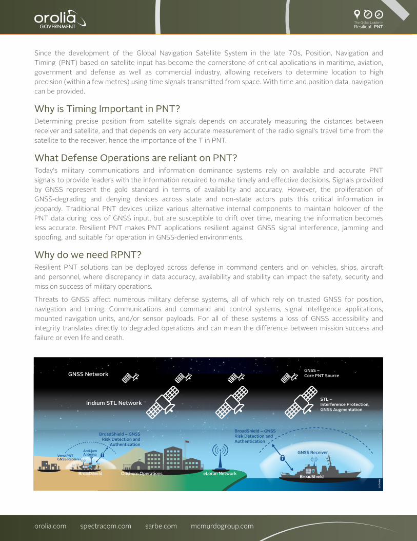
What Defense Operations are reliant on PNT?Today’s military communications and information dominance systems rely on available and accurate PNT signals to provide leaders with the information required to make timely and effective decisions. Signals provided by GNSS represent the gold standard in terms of availability and accuracy. However, the proliferation of GNSS-degrading and denying devices across state and non-state actors puts this critical information in jeopardy. Traditional PNT devices utilize various alternative internal components to maintain holdover of the PNT data during loss of GNSS input, but are susceptible to drift over time, meaning the information becomes less accurate. Resilient PNT makes PNT applications resilient against GNSS signal interference, jamming and spoofing, and suitable for operation in GNSS-denied environments.
Why do we need RPNT?Resilient PNT solutions can be deployed across defense in command centers and on vehicles, ships, aircraft and personnel, where discrepancy in data accuracy, availability and stability can impact the safety, security and mission success of military operations.
Threats to GNSS affect numerous military defense systems, all of which rely on trusted GNSS for position, navigation and timing: Communications and command and control systems, signal intelligence applications, mounted navigation units, and/or sensor payloads. For all of these systems a loss of GNSS accessibility and integrity translates directly to degraded operations and can mean the difference between mission success and failure or even life and death.
GNSS NetworkGNSS –Core PNT Source
Iridium STL NetworkSTL – Interference Protection, GNSS Augmentation
GNSS Receiver
BroadShield – GNSS Risk Detection and Authentication
BroadShield – GNSS Risk Detection and
Authentication
Onshore Operations eLoran NetworkBroadShield
BroadShield
VersaPNTGNSS Receiver
Anti-jam Antenna
© O
rolia
orolia.com spectracom.com sarbe.com mcmurdogroup.com

What Is GNSS?Global Navigation Satellite System or GNSS is the primary source of PNT information and is a satellite system that is used to provide location awareness through the geographic location of a user’s receiver anywhere in the world via a constellation of orbiting satellites working in conjunction with a network of ground stations. The USA’s GPS is the most widely known ‘brand’ of GNSS but there is also the Russian Federation’s Global Orbiting Navigation Satellite System (GLONASS), and Europe’s Galileo and China’s BeiDou Navigation Satellite System. Orolia is the provider of atomic clocks for satellites in the BeiDou and Galileo constellations.
UK Government research in 2017 identified that a five-day loss of GNSS would cost the UK economy over 12 billion pounds, highlighting the fundamental value of the signal and the growing realization that GNSS as a source of PNT needs to be both protected and irrefutable, hence the birth of Resilient PNT.
What are the most common threats to GNSS?Many digital military systems are reliant on GNSS to provide the trusted PNT data that allows defense forces to maneuver in, communicate across, understand and make decisions over the modern battlefield. GNSS signals are very weak when they arrive to Earth and as these signals are ubiquitous in how militaries operate, threats to the availability and integrity of GNSS signal are growing. Modern state and criminal threat actors have little difficulty gaining access to portable devices that can jam and spoof signals. As GNSS use spreads to more mobile applications farther afield, even natural and urban terrain must be accounted for when considering PNT availability.
Jamming and “interference” are frequently used synonymously. Jamming generally refers to intentional interference by means of a radio-frequency signal. Interference sometimes is used in the context of natural causes such as atmospheric phenomena. The effect is the same for both: The ability of the GNSS receiver to extract GNSS signal information from the background noise is impaired and rendered impossible.
Spoofing is the act of broadcasting false signals with the intent of deceiving a GNSS receiver into accepting the false signals as genuine. From a technical perspective, spoofing GNSS receivers is more challenging than jamming, however the consequences are more severe because the receiver actually uses the manipulated signals for PNT calculations, and neither the system nor the operator realize that the indicated PNT data has been corrupted. Spoofing can relocate the receiver, which is not possible with jamming. Spoofing is not an easy undertaking, especially if the spoofing target is moving fast. But it has been done, and the threat is considered real – and growing – by both government departments and private critical infrastructure operators.
What Technologies offer Resiliency to GNSS?Alternative signals such as Satellite Time and Location or STL, offer an encrypted signal, 1000x stronger than GNSS that resists spoofing. STL is available worldwide, operating on the Iridium satellites. Though not as accurate as GNSS, it provides 30-50 meter accuracy which can serve as a check to the GNSS indicated position. When combined with an Inertial Navigation System (INS), it can provide valuable range and Doppler updates to the inertial measurements, reducing drift and maintaining a proper PNT solution even during extended periods of GNSS denial.
eLoran, where available, provides a diverse alternative signal for PNT. It is literally at the other end of the spectrum from GNSS– low frequency instead of microwave; high-power pulse instead of low power spread spectrum; and terrestrial instead of space-based. The jammer required to block GNSS is very different from one designed to block eLoran, adding resiliency to military operations.
orolia.com spectracom.com sarbe.com mcmurdogroup.com

How does RPNT protect against GNSS Discrepancies?The tactics and technology used to combat jamming and spoofing are referred to as Interference Detection and Mitigation (IDM). Integrating a strong and well-coordinated IDM solution into a PNT systems makes it resilient against jamming and spoofing, assuring the continuity of critical PNT data even in GPS-denied environments.
How Can PNT Signal Interference Be Detected?The prompt and correct detection of an interference event involves the use of all available information to alert and notify the user(s) of a GNSS-based PNT system about the presence of a threat. GNSS receivers are increasingly equipped with jamming-detection functionality that will inform the user of a jamming/denial situation, offering at least the option of quicker diagnostics in the event of an unexpected signal loss. A relatively new approach to detecting jamming or spoofing attacks is a software solution that can be installed on GNSS-based systems, where it monitors the signal frequency band by applying error detection algorithms. The software can detect if a GNSS receiver is being spoofed or jammed and if the signal becomes too weak or is lost, the time server will emit an alarm and invalidate the PNT information before it can pollute the internal navigation solution or time base.
How can Signal Interference Be Mitigated?Mitigation in the context of PNT means that, after isolating the unwanted signal, it is quickly rejected and replaced, causing minimal system degradation. For military applications, the first mitigation measure is to use Anti-Jam Antennas, either Active CRPA (Controlled Radiation Pattern Antennas), or passive ones. The next mitigation measure is to use SAASM/M-Code (Selective Availability Anti-Spoofing Module) whenever possible, and/or to use multi-frequency receivers. Another approach is to use GNSS receivers that are capable of independently receiving and processing each constellation, comparing the live signals to detect suspicious changes. An additional well-established technical approach to deal with temporary loss of GNSS signals is hold-over solutions, such as oscillators for timing and Inertial Navigation Systems (INS) for navigation systems. Other technologies lend themselves to become augmentation systems to add resiliency to a PNT system. Some of these concepts are based on existing technology such as eLORAN; others have their origin in non-PNT applications such as vision-based system. A new technology that is available today is suitable to harden GNSS-based timing and frequency systems, and in some cases event to replace the GNSS reference. This system is called STL (Satellite Time and Location), and its signal is broadcast by the Iridium® satellites.
What is STL?STL service provides an alternate space-based PNT source to the GNSS constellation. It re-purposes the Iridium system’s pager channels to provide a PNT signal accessible by terrestrial receivers. This system is operational and available today. Because the satellites orbit Earth on a much closer orbit, the signal is 1,000 times stronger than GNSS signals. Because the signal is so strong, it can be received indoors and is more resistant to jamming and interference. In addition, the STL signal is encrypted.
What Else Is Needed for Resilient PNT?Another vital aspect of Resilient PNT is to test the PNT equipment for its actual vulnerability against jamming and spoofing. This involves the process of continuous improvement through threat replication in the lab to innovate and adopt new detection and mitigation strategies. Threats can be simulated with GNSS simulators in the test lab to understand how a receiver under test reacts in a spoofing or jamming situation, or to evaluate existing mitigation strategies. The test objective is to harden a PNT system by understanding how its GNSS receiver reacts to jamming or spoofing, implement a mitigation technique and then iteratively test and modify the improved system.
orolia.com spectracom.com sarbe.com mcmurdogroup.com

About Orolia Government:Operational Safety and Security is at the core of Orolia Government’s solutions for Aerospace, Defense and Government, with a long history of innovation and leveraging globally trusted timing, search and rescue, situational awareness solutions and regulatory expertise. Orolia Government’s leading edge Resilient Positioning, Navigation and Timing solutions protect and augment critical GNSS dependent infrastructure. Our brand portfolio includes Spectracom Assured Mounted and Dismounted PNT, Precision Time Servers, Simulation and Testing, Spectratime Master and Atomic clocks, and McMurdo and SARBE end-to-end satellite search and rescue systems. Orolia Government is Trusted Time and Location for a Safer World.
Is the threat to PNT real? There is a growing realization of the risks of unsecured PNT. Recent examples of vulnerabilities include an extended GPS outage in the north of Norway during a Russian military exercise in 2017, the widely known Black Sea spoofing of GNSS/AIS reported positions in around 20 ships in 2017, a van driver disrupting a GPS-enabled landing system being trialled at the international airport in New Jersey and jamming of fishing vessels attributed to N. Korea. Resilient PNT capabilities are critical for continuity of operations in ground, sea and air military forces operating in conditions with limited or denied GNSS.
orolia.com spectracom.com sarbe.com mcmurdogroup.com