under - nhp.mowr.gov.in
20
Satellite Data Based Operational Geo-spatial Services and Applications under National Hydrology Project 30 th July 2019 Dr. V. Venkateshwar Rao Project Director, NHP Group Director, WRG
Transcript of under - nhp.mowr.gov.in
Satellite Data Based
Operational Geo-spatial Services and Applications
under
National Hydrology Project
30th July 2019
Dr. V. Venkateshwar Rao
Project Director, NHP
Group Director, WRG

National Hydrology Project (NHP) is being executed by Ministry of Water Resources, Govt. of India
NRSC is signatory to NHP as one of the Implementing Agency
NRSC to support NHP through geo-spatial data products, services, customized applications development
RS. 79.437 Crore, 2017-18 to 2023-24
7 Major study components
Capacity building & Training to the stake holders
Satellite Data Based Geo-spatial Products, Services and Applications Under National Hydrology Project
Irrigation Management
Surface Runoff
Snowmelt Runoff
GLOF Risk Modeling
Flood Early Warning
Hydro-Informatics (Snowmelt, Evapotranspiration,
Soil Moisture, Surface Runoff, Reservoir Inflows,
Hydrological Drought)
Development of Spatial Flood Early Warning for Two
( Tapi & Godavari) river basins
GLOF Modelling for high risk lakes (15 No’s)
Real-time DSS for Irrigation Water Management (
Narayanpur Command Area)
Hydro-conditioned DTM (ALTM and Satellite) for
Flood and GLOF modelling
Capacity building for Central & State water resources
departments personnel (4 Trainings & 100
Officials/year)
Web services through NWIC & Bhuvan
Evapotranspiration
Salient Features Sriramsagar
Reservoir &
Surroundings
Surface Water Spread

1. Real-time Operational Spatial Flood Early Warning System Development
2. Development of Satellite-based Regional Evaporative Flux Monitoring System
for India
3. Glacial Lake Outburst Flood (GLOF) Risk Assessment
4. Development of spatial snowmelt runoff product in the
Indian Himalayas
5. Operational National Hydrological Modelling System for the entire Country
6. Satellite data based inputs for Irrigation Scheduling for a selected Irrigation
Project command area
7. Operational hydrological drought services using remote sensing data
8. Customized RS & GIS Training and Capacity Building
Proposed National Remote Sensing Centre Activities under
National Hydrology Project
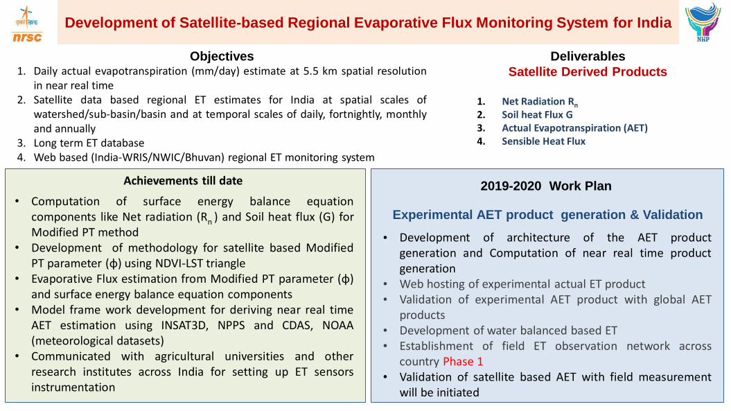
Development of Satellite-based Regional Evaporative Flux Monitoring System for India
Achievements till date 2019-2020 Work Plan
Experimental AET product generation & Validation
• Development of architecture of the AET product generation and Computation of near real time product generation
• Web hosting of experimental actual ET product • Validation of experimental AET product with global AET
products • Development of water balanced based ET • Establishment of field ET observation network across
country Phase 1 • Validation of satellite based AET with field measurement
will be initiated
Deliverables
Satellite Derived Products
1. Net Radiation Rn
2. Soil heat Flux G 3. Actual Evapotranspiration (AET) 4. Sensible Heat Flux
• Computation of surface energy balance equation components like Net radiation (Rn ) and Soil heat flux (G) for Modified PT method
• Development of methodology for satellite based Modified PT parameter (φ) using NDVI-LST triangle
• Evaporative Flux estimation from Modified PT parameter (φ) and surface energy balance equation components
• Model frame work development for deriving near real time AET estimation using INSAT3D, NPPS and CDAS, NOAA (meteorological datasets)
• Communicated with agricultural universities and other research institutes across India for setting up ET sensors instrumentation
Objectives 1. Daily actual evapotranspiration (mm/day) estimate at 5.5 km spatial resolution
in near real time 2. Satellite data based regional ET estimates for India at spatial scales of
watershed/sub-basin/basin and at temporal scales of daily, fortnightly, monthly and annually
3. Long term ET database 4. Web based (India-WRIS/NWIC/Bhuvan) regional ET monitoring system
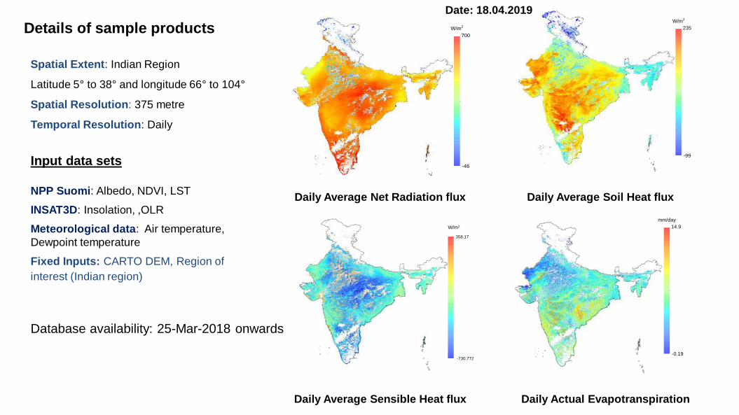
Details of sample products
Spatial Extent: Indian Region
Latitude 5° to 38° and longitude 66° to 104°
Spatial Resolution: 375 metre
Temporal Resolution: Daily
235
-99
W/m2
14.9
-0.19
mm/day
W/m2
358.17
-730.772
700
-46
W/m2
Daily Average Net Radiation flux Daily Average Soil Heat flux
Daily Average Sensible Heat flux Daily Actual Evapotranspiration
Input data sets
NPP Suomi: Albedo, NDVI, LST
INSAT3D: Insolation, ,OLR
Meteorological data: Air temperature,
Dewpoint temperature
Fixed Inputs: CARTO DEM, Region of
interest (Indian region)
Date: 18.04.2019
Database availability: 25-Mar-2018 onwards
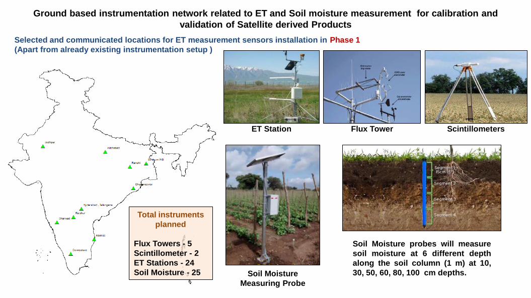
Ground based instrumentation network related to ET and Soil moisture measurement for calibration and
validation of Satellite derived Products
Selected and communicated locations for ET measurement sensors installation in Phase 1
(Apart from already existing instrumentation setup )
ET Station Flux Tower Scintillometers
Soil Moisture
Measuring Probe
Soil Moisture probes will measure
soil moisture at 6 different depth
along the soil column (1 m) at 10,
30, 50, 60, 80, 100 cm depths.
Total instruments
planned
Flux Towers - 5
Scintillometer - 2
ET Stations - 24
Soil Moisture - 25
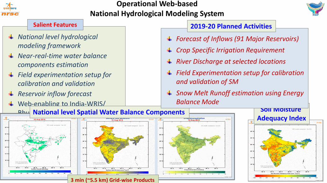
National level hydrological modeling framework
Near-real-time water balance components estimation
Field experimentation setup for calibration and validation
Reservoir inflow forecast
Web-enabling to India-WRIS/ Bhuvan/ NWIC
Operational Web-based National Hydrological Modeling System
Salient Features
National level Spatial Water Balance Components Soil Moisture Adequacy Index
Forecast of Inflows (91 Major Reservoirs)
Crop Specific Irrigation Requirement
River Discharge at selected locations
Field Experimentation setup for calibration and validation of SM
Snow Melt Runoff estimation using Energy Balance Mode
2019-20 Planned Activities
3 min (~5.5 km) Grid-wise Products
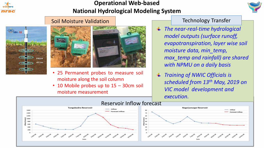
Operational Web-based National Hydrological Modeling System
The near-real-time hydrological model outputs (surface runoff, evapotranspiration, layer wise soil moisture data, min_temp, max_temp and rainfall) are shared with NPMU on a daily basis
Training of NWIC Officials is scheduled from 13th May, 2019 on VIC model development and execution.
Reservoir Inflow forecast
Soil Moisture Validation Technology Transfer
• 25 Permanent probes to measure soil moisture along the soil column
• 10 Mobile probes up to 15 – 30cm soil moisture measurement

Geo-spatial database
In-season cropping pattern
in-season irrigation water demand
at weekly/fortnightly time-step
Performance of irrigation system.
Decision Support System
Satellite data based inputs for Irrigation Scheduling for a
Selected Irrigation Project command area
Salient
Features Multi-date satellite data of
2018-19
Narayanpur Command area
Crop Map : Kharif 2018 Crop Map : Rabi 2018-19
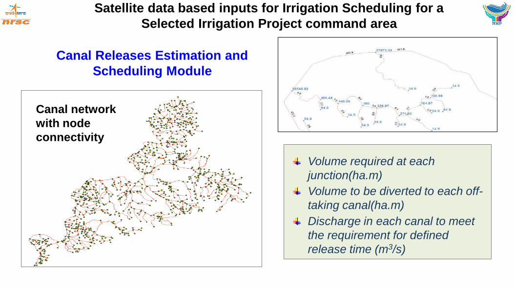
Volume required at each
junction(ha.m)
Volume to be diverted to each off-
taking canal(ha.m)
Discharge in each canal to meet
the requirement for defined
release time (m3/s)
Satellite data based inputs for Irrigation Scheduling for a
Selected Irrigation Project command area
Canal Releases Estimation and
Scheduling Module
Canal network
with node
connectivity
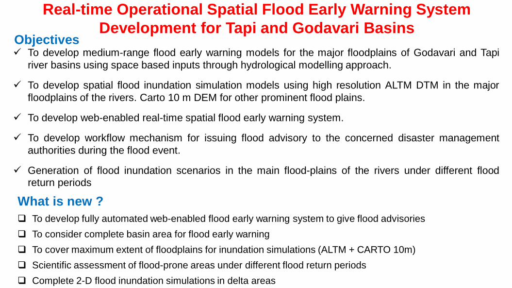
Real-time Operational Spatial Flood Early Warning System
Development for Tapi and Godavari Basins
To develop medium-range flood early warning models for the major floodplains of Godavari and Tapi
river basins using space based inputs through hydrological modelling approach.
To develop spatial flood inundation simulation models using high resolution ALTM DTM in the major
floodplains of the rivers. Carto 10 m DEM for other prominent flood plains.
To develop web-enabled real-time spatial flood early warning system.
To develop workflow mechanism for issuing flood advisory to the concerned disaster management
authorities during the flood event.
Generation of flood inundation scenarios in the main flood-plains of the rivers under different flood return periods
Objectives
What is new ?
To develop fully automated web-enabled flood early warning system to give flood advisories
To consider complete basin area for flood early warning
To cover maximum extent of floodplains for inundation simulations (ALTM + CARTO 10m)
Scientific assessment of flood-prone areas under different flood return periods
Complete 2-D flood inundation simulations in delta areas

S.No Activity Proposed Status (as on today)
1 Collection of field data and establishing gauge sites by CWC/IMD (if required) Mar 2019 In progress
2 Preparation of spatial and non-spatial database Mar 2019 In progress
3 Flood forecast model development June 2019 Completed
4 FF Model calibration and validation Dec 2019 In progress
5 Development of spatial Inundation simulation models Mar 2021 Initiated, ALTM DEM acquisition is in
progress
6 Inundation simulation models calibration and validation Sep 2021
7 Inundation simulations for different flood return periods Dec 2022
8 Development of web-enabled flood forecast system Mar 2023
9 Establishing linkages with user organisations Dec 2022
10 Implementation of the activity in real-time at NRSC June 2023
11 Transfer of technology and models to CWC Sep 2023
12 Compilation & report preparation Mar 2024
Milestones and Status (as on today)
S.No Activity 2019-20
(Apr-
Jun)
2019-20
(Jul-
Sep)
2019-20
(Oct-
Dec)
2019-20
(Jan-
Mar)
1. MIKE Hydro River HD Model
calibration and validation.
2. Development of spatial
Inundation simulation models
Activities Planned for 2019-2020
Tapi Basin Godavari Basin
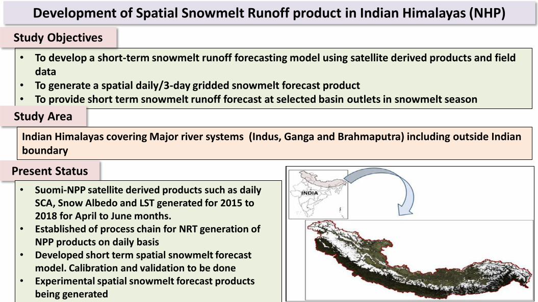
• To develop a short-term snowmelt runoff forecasting model using satellite derived products and field data
• To generate a spatial daily/3-day gridded snowmelt forecast product • To provide short term snowmelt runoff forecast at selected basin outlets in snowmelt season
Study Objectives
Development of Spatial Snowmelt Runoff product in Indian Himalayas (NHP)
Present Status
Study Area
Indian Himalayas covering Major river systems (Indus, Ganga and Brahmaputra) including outside Indian boundary
• Suomi-NPP satellite derived products such as daily SCA, Snow Albedo and LST generated for 2015 to 2018 for April to June months.
• Established of process chain for NRT generation of NPP products on daily basis
• Developed short term spatial snowmelt forecast model. Calibration and validation to be done
• Experimental spatial snowmelt forecast products being generated
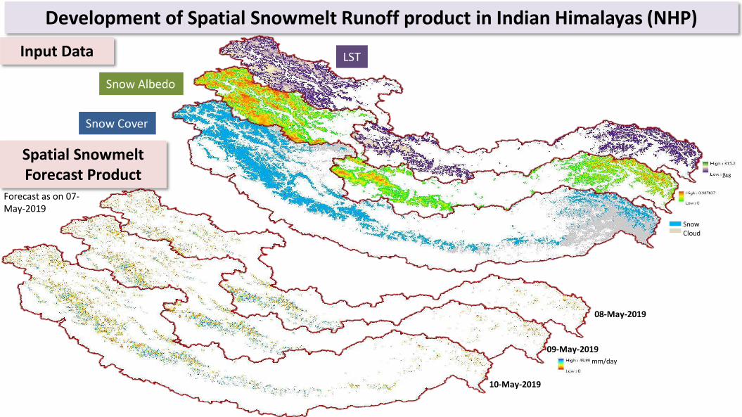
Input Data
Development of Spatial Snowmelt Runoff product in Indian Himalayas (NHP)
Snow Cloud
mm/day
Snow Cover
Snow Albedo
LST
Spatial Snowmelt Forecast Product
08-May-2019
09-May-2019
10-May-2019
Forecast as on 07-May-2019
248

• Inventory of Glacial lakes using high resolution satellite data • Selection and Prioritisation of critical glacial lakes • Generation of high resolution DEM for d/s of prioritized critical lakes (15) • Investigation of prioritized critical lakes and their surroundings based on high resolution DEM
and data • GLOF modelling and inundation mapping using high resolution DEM
Study Objectives
Study Area
Glacial Lake Outburst Flood Risk Assessment of Glacial Lakes in Indian Himalayas
Indian Himalayas covering Major river systems (Indus, Ganga and Brahmaputra) including outside Indian boundary
Present Status
• RS-2 LISS-IV data (450 Sub-scenes) were procured • Cartosat DEM of 10 m resolution for study area
procured • Inventory of Glacial lakes and water bodies (> 0.25
ha) along 21 attributes being generated • Methodology for ranking is finalised
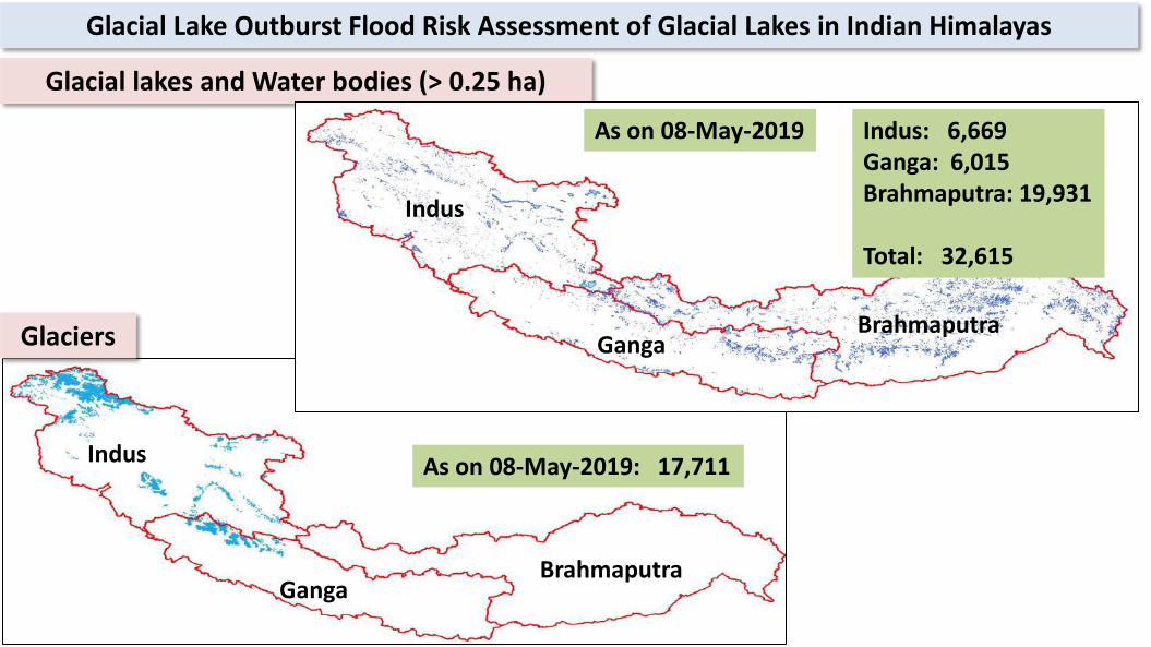
Glacial lakes and Water bodies (> 0.25 ha)
Glacial Lake Outburst Flood Risk Assessment of Glacial Lakes in Indian Himalayas
Indus: 6,669 Ganga: 6,015 Brahmaputra: 19,931 Total: 32,615
Indus
Ganga Brahmaputra Glaciers
Indus
Ganga Brahmaputra
As on 08-May-2019: 17,711
As on 08-May-2019

Customized RS & GIS Training and Capacity Building (NHP)
Objectives
• To conduct 2 training programs (one week) per year on RS & GIS fundamentals with 25 participants per batch (2017-18 to 2023-24)
• To conduct 2 customized training programs (two weeks) per year on “RS & GIS applications in water resources management” with 25 participants per batch (2017-18 to 2023-24).
Training Programmes conducted till date Year Training Programmes Duration No. of
Participants
No. of IAs
2017-18 2 training programs (1 week) per year on “RS & GIS fundamentals”
31-Jul-17 to 04-Aug-17 09-Oct-17 to 13-Oct-17
23 19
12 9
2 training programs (2weeks) per year on “RS & GIS applications in water resources management”
18-Sep-17 to 29-Sep-17 05-Feb-18 to 16-Feb-18
21 8
11 5
2018-19 2 training programs (1 week) per year on “RS & GIS fundamentals”
09-Apr-18 to 13-Apr-18 29-Oct-18 to 02-Nov-18
17 13
5 4
2 training programs (2weeks) per year on “RS & GIS applications in water resources management”
30-Jul-18 to 10-Aug-18 11-Feb-19 to 22-Feb-19
29 23
10 8
Total- 71
Total- 82

Timelines/Milestones of NRSC activities under NHP
Activity 2017-18 2018-19 2019-20 2020-21 2021-22 2022-23 2023-24
Flood Early
Warning FF Model Dev. Cal & Val of FF Model
& Dev. Of SISM’s
Dev. of web-
enabled FF system
Spatial Simulations
for different RI
Real-time
Implementati
on
Real-time
Implementation.
Transfer to CWC
ET Dev. of Net Radiation and
Soil Heat Flux Products.
Meth. Dev.for ET estimation
Dev. of A ET product
and
Est. field obser.
network
ET validation &
Long term database
generation and
analysis
Operational AET
product & web-
enabled ET
monitoring system
Near real time
AET, PET
Real-time
Implementation.
Transfer to CWC
GLOF Inv. of GL & glaciers
Prelim. selection and
Ranking of GL
Gen. of High res. DEM
& Hydr. Invest.
GLOF modelling Assessment of
GLOF Risk & Dev. of
visualizn.sys.
Snowmelt Parameter retrieval and
Model development
Experimental forecast R T forecast and
refinement
Real-time forecast and refinement of model
Hydrological
Fluxes
Model
Framework
Developed
Field Expn .
& Valid.
Forecast of inflows
into major reservoirs
Real-time run, dissemination, and Web hosting
Irrigation
GIS data
prep.& DSS
conceptualis
ation
FIR for in
season
Cropping
Pattern
Weekly canal –wise IR
estimates
Val. Of IR with
canal releases
Dev. Of DSS for
canal advisories
Exp. run Operationalisatio
n
Hydrological
Drought
Preparation
& collection
of GIS Hyd.
data
Meth. Dev. of
composite
HDI
Experimental
hydrological drought
map for a basin/study
area
Exper. real-time hydrological drought
map for entire India,
Validation and Web hosting
Real-time hydrological drought map for
entire India & and Web hosting

Significant Achievements under NHP Component Activities
Flood EW • Flood Forecasting model (Tapi and Godavari) set up is in progress
• ALTM DEM for Tapi is acquired and DEM generation is in progress
ET • Net radiation product & soil heat flux products are being generated
• Methodology for derivation of AET product is in progress
GLOF • RS-2 LISS-IV data (450 Sub-scenes) & 10 m Cartosat DEM procured
• Inventory of Glacial lakes and water bodies (> 0.25 ha)is in progress
• Methodology for prioritisation of ranking of critical glacial lakes is finalised
Snowmelt • Process chain for near-real-time generation of Suomi-NPP Daily maximum possible
snow cover data products
• Parameter retrieval and model development is in progress
Hydrological
Fluxes
• National level HM framework at 3’ grid resolution in VIC model established
• Runoff calibration is in progress & forecast of inflows into 48 major reservoirs completed
Irrigation
• Historical cropping pattern derived for Narayanpur command area
• VIC-CROPSYST frame work developed for estimation of FIR & Development of Hydraulic
model simulating uniform flow in an irrigation channel is under progress
Hydrological
Drought
• Developed methodology for composite Hydrological Drought Index
• Developed methodology and implemented standardised Runoff Index at grid level
• Index based on surface water bodies is under progress
Capacity
Building
• 4 training programs conducted for a total of 71 participants during 2017-2018
• 4 training programs conducted for a total of 82 participants during 2018-2019

THANK YOU