ular Ref No.: PNI1505 Sub nnounces rt · of IMO Resolution A.851 (20). 3.2 Content of report 3.2.1...
14
Circ Dat Dea Sub Rep (Th In o nav ann Sys Acc 50,0 dee rout poin Por the as safe outw effic In t the spe Ove Xia poin with may mea and cular Ref te: 14 July ar Sir or M bject: Chin porting Sy his circula order to re vigation sa nouncemen stem in Xia cording to 000 and ep-water ro te is the fa nt C (24 ° rt. The wid overall len the “highw ety of imp ward saili ciency and he meantim foreign sh eed, last c erall Lengt men VTS nt and Tuy h the repo y be subje asures by d regulation No.: PNI1 2015 adam, na MSA A ystem at X r is prepa egulate na afety in Xia nt on imple amen Wate the Ship R above, or oute to ent airway betw 19 ’42.16 th of the fa ngth of fair way” of Xia portant sh ng at Xia d improve t me, as per hips should calling port th and Gro at the So yu report p rting syste ect to adm maritime s ns. 505 nnounces Xiamen Po red by Hu avigation o amen wate ementation er Area, wh Routing Sy r ships of ter into an ween point 6”N, 118 ° airway is 4 rway is 9.5 amen Port ips, reduc amen Port the navigat r the Ship d report the t, destinati oss Tonna outheast re point respe em. Any sh ministrative safety adm s Ship Rou ort uatai Xiam order , prom er area, C n of Ship R hich has ta ystem in X f draft ov d depart f t A (24 ° 12 10’59.24”E 450 meters 56 miles. T t, which is ce the tim t, minimize tion order. Reporting eir name, c ion port, d age as wel eport line, ectively. A hips violati penalty o ministration uting Syst en office) mote traffic hina MSA Routing Sys aken effect Xiamen Wa ver 12.5 m rom Xiame 2 ’19.06”N, E) in the m s, depth da he deep-w s expected me needed e maritime System in call sign, IM draft, defec ll as other west repo ll the forei ng the rule or other ad n in accord tem and S c efficienc has recen stem and S since July ater Area, meters sh en port. Th , 118 ° 17’3 main chann atum is -15 water route d to increa d for ships e accident n Xiamen W MO No., loc cts and lim required ort line, Ji gn ships s es of the r dministrativ dance with Ship cy and ens ntly issued Ship Repor y 1, 2015. ships of D hould use he deep-w 38, 66” E) nel of Xiam 5.0 meters e is conside ase naviga s’ inward t, raise tr Water Area cation, cou mitations, informatio iujiejiao re should com routing sys ve compuls relevant l sure d an rting DWT the water and men and ered ation and affic a, all urse, DG, n to eport mply stem sory aws
Transcript of ular Ref No.: PNI1505 Sub nnounces rt · of IMO Resolution A.851 (20). 3.2 Content of report 3.2.1...

Circ Dat Dea SubRep(Th In onavannSys Acc50,0deeroutpoinPorthe as safeoutweffic In tthe speOveXiapoinwithmaymeaand
cular Ref
te: 14 July
ar Sir or M
bject: Chinporting Sy
his circula
order to revigation sanouncemenstem in Xia
cording to 000 and
ep-water rote is the fant C (24 ° rt. The widoverall lenthe “highwety of impward sailiciency and
he meantimforeign sh
eed, last cerall Lengtmen VTS nt and Tuyh the repoy be subjeasures by
d regulation
No.: PNI1
2015
adam,
na MSA Aystem at Xr is prepa
egulate naafety in Xiant on impleamen Wate
the Ship Rabove, or
oute to entairway betw
19 ’42.16th of the fangth of fairway” of Xiaportant shng at Xia
d improve t
me, as perhips shouldcalling portth and Groat the So
yu report prting systeect to admmaritime s
ns.
505
nnouncesXiamen Pored by Hu
avigation oamen wateementationer Area, wh
Routing Syr ships ofter into anween point6”N, 118 ° airway is 4rway is 9.5amen Portips, reduc
amen Portthe navigat
r the Ship d report thet, destinatioss Tonnaoutheast repoint respeem. Any shministrative safety adm
s Ship Rouort uatai Xiam
order, promer area, Cn of Ship Rhich has ta
ystem in Xf draft ovd depart ft A (24 ° 1210’59.24”E
450 meters56 miles. Tt, which isce the timt, minimizetion order.
Reporting eir name, cion port, d
age as weleport line, ectively. Ahips violati
penalty oministration
uting Syst
en office)
mote traffichina MSA
Routing Sysaken effect
Xiamen Waver 12.5 mrom Xiame2 ’19.06”N,E) in the ms, depth dahe deep-w
s expectedme needede maritime
System incall sign, IMdraft, defecll as otherwest repo
ll the foreing the rule
or other adn in accord
tem and S
c efficienchas recen
stem and Ssince July
ater Area, meters shen port. Th, 118 ° 17’3main channatum is -15water routed to incread for shipse accident
n Xiamen WMO No., loccts and limr required ort line, Jign ships ses of the rdministrativdance with
Ship
cy and ensntly issuedShip Repory 1, 2015.
ships of Dhould use he deep-w38, 66” E) nel of Xiam
5.0 meters e is considease navigas’ inward t, raise tr
Water Areacation, coumitations, informatioiujiejiao reshould comrouting sysve compuls relevant l
sure d an rting
DWT the
water and
men and
ered ation and affic
a, all urse, DG, n to
eport mply stem sory aws

ForAnn Youof aAttnTelFaxEmDut Hop Sin
ShaVice
r more infnounceme
u may alsoany further n: Ms. Tra: 86 592 2x: 86 592 2
mail: pni.xmty Mobile:
pe the abo
cerely you
an Hong e Presiden
formation, nt of China
o contact ouquery:
acy Zheng123223 2681235 m@huatai 86 150 60
ove is of as
rs,
nt
please sa MSA on t
ur Xiamen
/Ms. Lina
-serv.com077 2037
ssistance.
see our frthe subjec
office dire
Gao/Mr. D
m
ree translat matter fo
ectly at the
Dongyao H
ation of thr your refe
following d
Huang
he 2015-Nerence.
details in c
No.1
case

Free translation
Maritime Safety Administration of the People’s Republic of China
Announcement
(2015-No.1)
Re: Issuing Ship Routing System in Xiamen Water Area and Ship
Reporting System in Xiamen Water Area
This is announce that, in order to maintain the navigation sequence in
Xiamen water area, raise the traffic efficiency and ensure the navigation
safety, Ship Routing System in Xiamen Water Area and Ship Reporting
System in Xiamen Water Area now are approved and issued, put in force
in 01 July 2015. The relevant regulations on navigation safety will be
issued by Fujian Maritime Safety Administration separately.
All ships navigating in the applicable water area must strictly comply
with Ship Routing System in Xiamen Water Area and Ship Reporting
System in Xiamen Water, and follow the local maritime administration’s
supervision.

Attachments:
1. Ship Routing System in Xiamen Water Area
2. Ship Reporting System in Xiamen Water Area
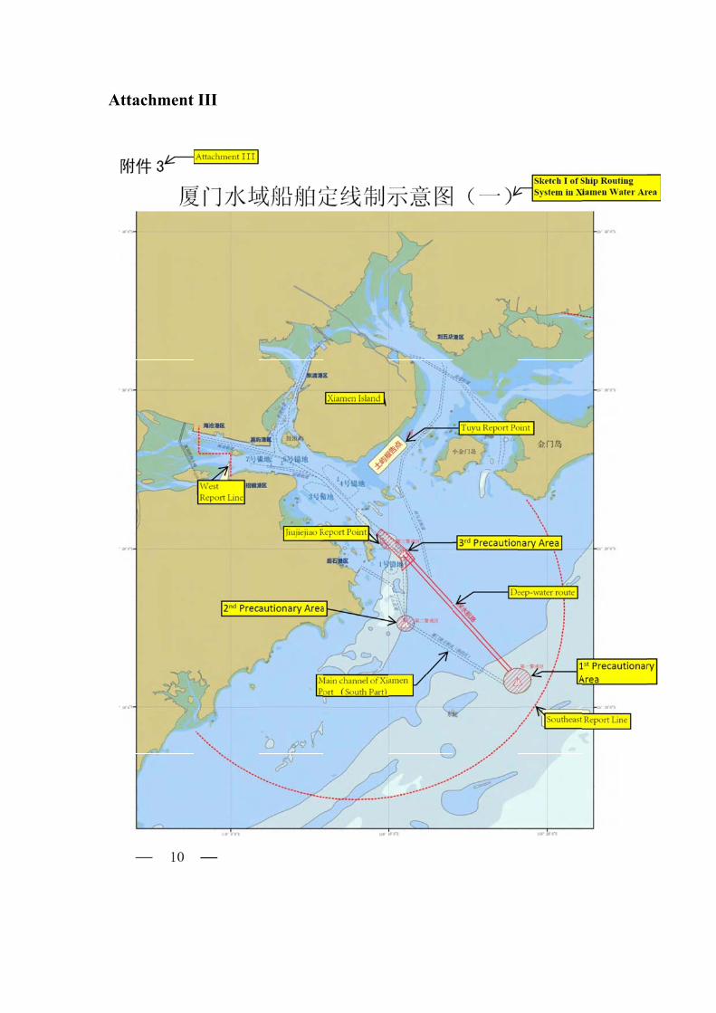
3. Sketch of Ship Routing System in Xiamen Water Area
Maritime Safety Administration of the People’s Republic of China
(Stamp)
29 April 2015

Attachment Ⅰ
Ship Routing System in Xiamen Water Area Referenced charts: Nautical Charts published by The Navigation Guarantee Department of Chinese Navy Headquarters: No. 14240, No. 14249 and No. 14291. Nautical Charts published by Maritime Safety Administration of the People’s Republic of China: No. 65001, No. 65112 and No. 65113. This routing system consists of deep-water route, precautionary area, etc.
1. Deep-water route The fairway between A′point to C point in the main channel of Xiamen Port composes of the line connecting two points: (1) A′point: 24 ° 12 ’19.06”N, 118 ° 17’38, 66” E (2) C point: 24 ° 19 ’42.16”N, 118 ° 10’59.24”E, the width of the fairway is 450 meters, depth datum is - 15.0 meters and the overall length of fairway is 9.56 miles. 2. Precautionary area 2.1 The first precautionary area is set in the entrance of the main channel of Xiamen Port, the water area of the circle with radius of 0.8 miles from geographical position 24 ° 11 ’40.12.00”N, 118 °18’06.41”E. 2.2 The second precautionary area is set at the B point of the main channel of Xiamen Port, the water area of the circle with radius of 0.5 miles from geographical position 24 ° 15 ’17.65”N, 118 °11’03.14”E. 2.3 The third precautionary area is set at the C point of the main channel

of Xiamen Port, composes of the area connecting the below six geographical positions: 24 ° 20 ’55.60”N, 118 ° 09’12.30”E 24 ° 19 ’20.63”N, 118 °10’45.56”E 24 ° 18 ’38.35”N, 118 °10’49.00”E 24 ° 19 ’21.35”N, 118 °11’37.30”E 24 ° 19 ’48.42”N, 118 °11’16.06”E 24 ° 21 ’14.77”N, 118 °09’29.50”E 3. Special regulation 3.1 The ship of DWT 50,000 or above, or the draft is more than 12.5 meters should use the deep-water route to inward or outward Xiamen Port area, the ship should exhibit the signals or shapes of draught-constrained ship according to the《Convention on the International Regulations for Preventing Collisions at Sea, 1972》. The other ships may use the deep-water route to inward or outward Xiamen Port area if they do not affect the foresaid ships which should only use the deep-water route, but these ships should also obey the Xiamen VTS Center’s traffic organization. 3.2 All the ships using the deep-water route and having one of the following situations, not only should report to Xiamen VTS Center according to the Detailed Rules of Safety Management of Fujian Maritime Safety Administration Ship Traffic Service System, but also should report the ship movement to Xiamen VTS Center: A. Intend to inward Xiamen Port via the deep-water route, while ship
arrives at the report line or weigh up anchor. B. Intend to outward Xiamen Port via the deep-water route, while ship
passes the Jiujiejiao Report Point. C. Intend to overtake others ships in the deep-water route.

3.3 A ship should try to avoid to cross the deep-water route, if the ship is forced to cross, the ship should report the ship movement to the surrounding ships, the ship should avoid to affect the safety of ships which should only use the deep-water route, the ship should try to cross the ships in the deep-water route by a right angle and should take substantial action to keep well clear from the ships in the deep-water route. 3.4 A ship sailing in the precautionary area, should navigate with particular caution, enforce the watching, clearly show ship movement or intention. A ship overtaking any other ship in the deep-water route should be agreed by the ship being overtaken, and overtake by the port side of the ship being overtaken. 3.5If a ship needs to drop anchor while the ship is not under command, to sink or encounter other emergencies, the ship should keep out of the channel and report it to Xiamen VTS Center immediately. 3.6 Fishing, sand excavation or anchoring, etc is prohibited in the water area of routing system. The ship should anchor at the published anchorage. 3.7 Ship is forbidden to have the stopping distance test, turning-circle test or other actions which might affect safety of other ships in the water area of deep-water route or within 2 miles from the route’s both sides. 3.8 A ship not to use the water area of routing system should be far away from this area. 3.9 Any ships violating the rules of the routing system shall accept the administrative penalty or other administrative compulsory measures by maritime administration in accordance with relevant laws.

Attachment Ⅱ
Ship Reporting System in Xiamen Water Area 1. Applicable ships The reporting system is compulsory reporting system, the applicable ships are the ship which use the routing system and have the one of the following situation: 1.1 Ships in foreign nationality.
1.2 Chinese ships of 300 GT or above. 1.3 Passenger Ships with capacity of 50 passengers or more (except
ferries). 1.4 Ships carrying dangerous cargo. 1.5 Ships engaging in towing operation. 1.6 Other ships volunteer to make position report. 2. Applicable geographical area and referenced charts 2.1 Applicable geographical area is Xiamen water area. 2.2 Referenced charts: Nautical Charts published by The Navigation Guarantee Department of Chinese Navy Headquarters: No. 14240, No. 14249 and No. 14291. Nautical Charts published by Maritime Safety Administration of the People’s Republic of China: No. 65001, No. 65112 and No. 65113. 3. Format of report, content of report and report line 3.1 Format of report

The format for report is in accordance with the requirements by the annex of IMO Resolution A.851 (20). 3.2 Content of report 3.2.1 General report A Ship’s name, Call Sign and IMO code (if applicable) C or D Position (latitude and longitude or position relative to the landmark) E Course F Speed G Last port of call I Port of destination O Draft Q Defects and limitations (towing ships shall report of the towing length and the name of the object being towed) DG Dangerous goods U Length Overall and Gross Tonnage 3.2.2 Ships equipped with AIS in normal working condition may only need to report the following contents: A Ship’s name, Call Sign G Last port of call I Port of destination O Draft Q Defects and limitations DG Dangerous goods 3.3 Report line and report point 3.3.1 Southeast report line:the part of the circle with radius of 12 miles and bearing 055° -230°from Zhenhaijiao lighthouse. 3.3.2 West report line:The line from north bank of Jiulongjiang River,

going southward along longitude 117°58′.0E to latitude 24°26′.0N,then turning eastward to longitude 118°00′.0E and then southward to connect with the south bank of Jiulongjiang River. 3.3.3 Jiujiejiao report point:Abeam of Jiujiejiao Light beacon. 3.3.4 Tuyu report point::Abeam of Tuyu Island. 4. Other requirement of reporting 4.1 All the ships using the deep-water route and having one of the following situations, not only should report to Xiamen VTS Center according to the Detailed Rules of Safety Management of Fujian Maritime Safety Administration Ship Traffic Service System, but also should report the ship movement to Xiamen VTS Center: A. Intend to inward Xiamen Port via the deep-water route, while ship
arrives at the report line or weigh up anchor. B. Intend to outward Xiamen Port via the deep-water route, while ship
passes the Jiujiejiao Report Point. C. Intend to overtake others ships in the deep-water route. 4.2 If a ship needs to drop anchor while the ship is not under command, to sink or other emergencies, the ship should keep out of the channel and report to Xiamen VTS Center immediately. 4.3 When a ship sail from the reporting water area, should report the ship name and port of next call. 4.4 When ship involves in a traffic incident or a pollution incident, the ship should immediately report the nature, time and position of the incident, extend of damage or pollution and whether assistance is needed to the Administration, and provide with other required related information of the incident.

5. The Administration and the report accepting authority 5.1 The administration is Xiamen Maritime Safety Administration of the People’s Republic of China. 5.2 The report accepting authority is Xiamen VTS Center. 6. Information provided to ship The Xiamen VTS Center provides the applicable ship with information such as ship traffic, adverse weather condition and maritime safety information as appropriate. 7. Radio communications channel required for the system and the languages for the Reporting. 7.1 Calling channel is: VHF 08, Working channels: VHF27 or VHF 28, the spare calling channel is: VHF 16. 7.2 The language used for reports in the system should be Mandarin Chinese or English. The radio communications should follow the format of Standard Marine Communication Phrases. 8. Shore-based facilities to support operation of the system 8.1 Xiamen VTS Center is consist of: radar surveillance system, ship management information system (MIS), VHF communication system (VHF), Automatic Identification System (AIS), CCTV system, microwave transmission system, recording and replaying system and aerograph system. The function including: data collection, data evaluation and processing, information service, traffic organization service, navigational assistance service and allied services. 8.2 Xiamen VTS Center maintains 24-hours listening watch.
9. Special regulations Any ship violating rules of the reporting system shall be punished by the maritime administration in accordance with relevant laws and regulations.
Att
tachment III