uigmek - Weather
8
uigmek One who watches river October 2010 Please Note. . . . Observers... Don’t forget to send in your Freeze-up Forms. Inside This Issue… I am Kuigmek So Long Jamie… Welcome New Observers Observer Milestones Larry Rundquist Retiring End of 2010 Open Water Season Glacier Dammed Lakes on the Kenai Peninsula ADP Measurements Across Alaska Flooding Shuts Down the Taylor Highway for Much of the Summer Start of Ice Thickness Measurements Alaska - Pacific River Forecast Center 6930 Sand Lake Road Anchorage, Alaska 99502-1845 http://aprfc.arh.noaa.gov 800-847-1739 Our last weekend staffing is scheduled to be 10/30 - 10/31. For those of you continuing to take measurements in November or beyond, please hold your weekend measurements and give them to us on Mondays. I am kuigmek From break-up to freeze-up We visit everyday (the river and I) And the bridge above the river Is my time machine Looking downstream, I see the past Flowing out of reach, out of touch Little floating mistakes Disappearing broken promises So I look upstream to the future The unknown racing to reach me Every precious moment bouncing Closer to the present I am kuigmek On the bridge above the water Living in the here and now Where life lives on the ridge Taking power from the river Learning lessons from the bridge I am Kuigmek I am Kuigmek was written by Mark Occhipinti. Mark takes daily river readings on both Montana Creek and the Susitna River at Sunshine on the Parks Hwy. Montana Creek on the Parks Hwy Jamie Montesi will be leaving the APRFC in the first week of Novem- ber. He has accepted a Hydrologist position with the National Marine Fisheries Service in Arcata, Califor- nia. He will be working on the Klamath Basin Restoration project, which involves the potential removal of the lower four dams on the Klamath River. The main goals of the project include restoring and sustaining natural fisheries, while establishing reliable water and power supplies for the sustainability of Klamath Basin communities. To quote Jamie, "it's basically my dream job". He is sad to leave Alaska after enjoying living in Anchorage for the last five years, although he is certain he will not miss Alaska weather after Anchorage set a new record of 31 consecutive days with measurable precipitation this summer. We wish Jamie, his wife Tam, and baby daughter Wren well as they head off for new adventures. So Long Jamie…. Jamie lands a steelhead on the Kenai Peninsula
Transcript of uigmek - Weather
uigmek One who watches river October 2010
Please Note. . . .
Observers... Don’t forget to send in your
Freeze-up Forms.
Inside This Issue…
I am Kuigmek
So Long Jamie…
Welcome New Observers
Observer Milestones
Larry Rundquist Retiring
End of 2010 Open Water Season
Glacier Dammed Lakes on the Kenai Peninsula
ADP Measurements Across Alaska
Flooding Shuts Down the Taylor
Highway for Much of the Summer
Start of Ice Thickness Measurements
Alaska - Pacific River Forecast Center 6930 Sand Lake Road
Anchorage, Alaska 99502-1845 http://aprfc.arh.noaa.gov
800-847-1739
Our last weekend staffing is scheduled to be 10/30 - 10/31. For those of you continuing to take measurements in November or beyond, please hold your weekend measurements and give them to us on Mondays.
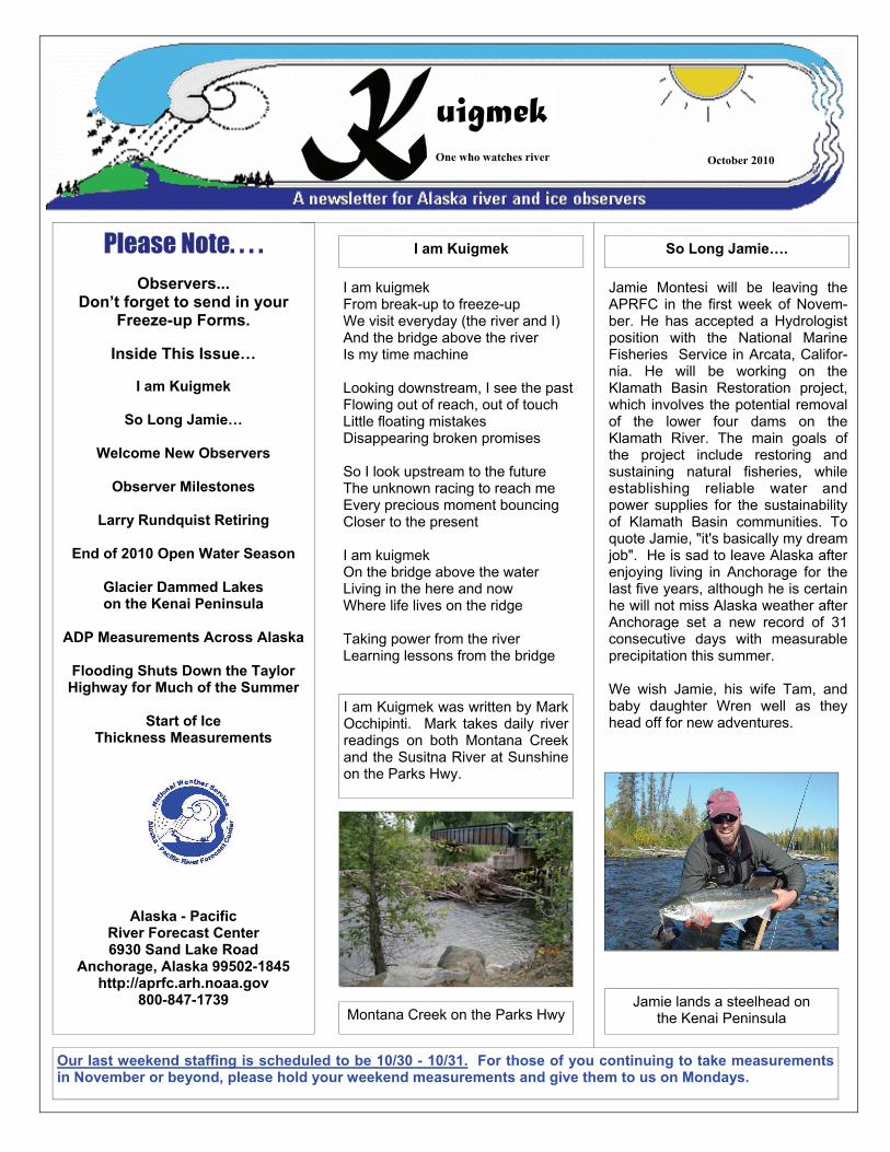
I am kuigmek From break-up to freeze-up We visit everyday (the river and I) And the bridge above the river Is my time machine Looking downstream, I see the past Flowing out of reach, out of touch Little floating mistakes Disappearing broken promises So I look upstream to the future The unknown racing to reach me Every precious moment bouncing Closer to the present I am kuigmek On the bridge above the water Living in the here and now Where life lives on the ridge Taking power from the river Learning lessons from the bridge
I am Kuigmek
I am Kuigmek was written by Mark Occhipinti. Mark takes daily river readings on both Montana Creek and the Susitna River at Sunshine on the Parks Hwy.
Montana Creek on the Parks Hwy
Jamie Montesi will be leaving the APRFC in the first week of Novem-ber. He has accepted a Hydrologist position with the National Marine Fisheries Service in Arcata, Califor-nia. He will be working on the Klamath Basin Restoration project, which involves the potential removal of the lower four dams on the Klamath River. The main goals of the project include restoring and sustaining natural fisheries, while establishing reliable water and power supplies for the sustainability of Klamath Basin communities. To quote Jamie, "it's basically my dream job". He is sad to leave Alaska after enjoying living in Anchorage for the last five years, although he is certain he will not miss Alaska weather after Anchorage set a new record of 31 consecutive days with measurable precipitation this summer. We wish Jamie, his wife Tam, and baby daughter Wren well as they head off for new adventures.
So Long Jamie….
Jamie lands a steelhead on the Kenai Peninsula
Page 2
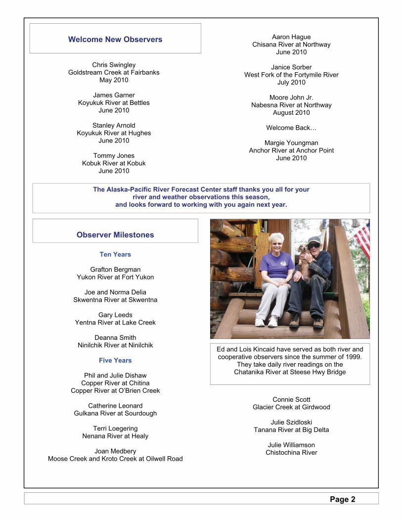
Welcome New Observers
Chris Swingley Goldstream Creek at Fairbanks
May 2010
James Garner Koyukuk River at Bettles
June 2010
Stanley Arnold Koyukuk River at Hughes
June 2010
Tommy Jones Kobuk River at Kobuk
June 2010
Aaron Hague
Chisana River at Northway June 2010
Janice Sorber
West Fork of the Fortymile River July 2010
Moore John Jr.
Nabesna River at Northway August 2010
Welcome Back…
Margie Youngman
Anchor River at Anchor Point June 2010
Ed and Lois Kincaid have served as both river and cooperative observers since the summer of 1999.
They take daily river readings on the Chatanika River at Steese Hwy Bridge
The Alaska-Pacific River Forecast Center staff thanks you all for your river and weather observations this season,
and looks forward to working with you again next year.
Observer Milestones
Ten Years
Grafton Bergman Yukon River at Fort Yukon
Joe and Norma Delia
Skwentna River at Skwentna
Gary Leeds Yentna River at Lake Creek
Deanna Smith
Ninilchik River at Ninilchik
Five Years
Phil and Julie Dishaw Copper River at Chitina
Copper River at O’Brien Creek
Catherine Leonard Gulkana River at Sourdough
Terri Loegering
Nenana River at Healy
Joan Medbery Moose Creek and Kroto Creek at Oilwell Road
Connie Scott Glacier Creek at Girdwood
Julie Szidloski
Tanana River at Big Delta
Julie Williamson Chistochina River
Page 3
Freezeup at the Salcha River Bridge
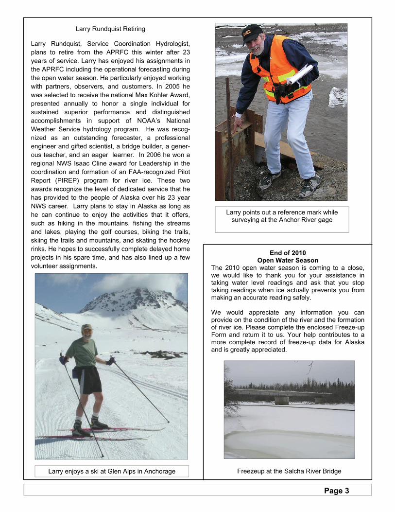
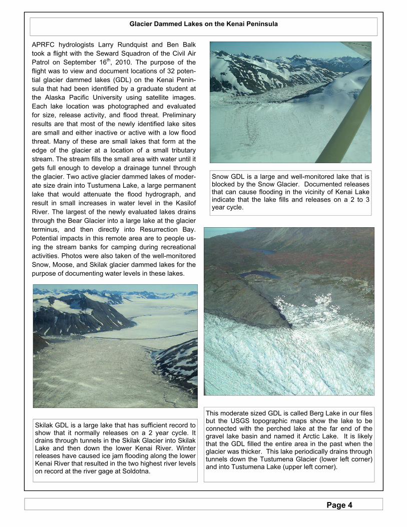
Larry Rundquist Retiring Larry Rundquist, Service Coordination Hydrologist, plans to retire from the APRFC this winter after 23 years of service. Larry has enjoyed his assignments in the APRFC including the operational forecasting during the open water season. He particularly enjoyed working with partners, observers, and customers. In 2005 he was selected to receive the national Max Kohler Award, presented annually to honor a single individual for sustained superior performance and distinguished accomplishments in support of NOAA’s National Weather Service hydrology program. He was recog-nized as an outstanding forecaster, a professional engineer and gifted scientist, a bridge builder, a gener-ous teacher, and an eager learner. In 2006 he won a regional NWS Isaac Cline award for Leadership in the coordination and formation of an FAA-recognized Pilot Report (PIREP) program for river ice. These two awards recognize the level of dedicated service that he has provided to the people of Alaska over his 23 year NWS career. Larry plans to stay in Alaska as long as he can continue to enjoy the activities that it offers, such as hiking in the mountains, fishing the streams and lakes, playing the golf courses, biking the trails, skiing the trails and mountains, and skating the hockey rinks. He hopes to successfully complete delayed home projects in his spare time, and has also lined up a few volunteer assignments.
Larry points out a reference mark while surveying at the Anchor River gage
Larry enjoys a ski at Glen Alps in Anchorage
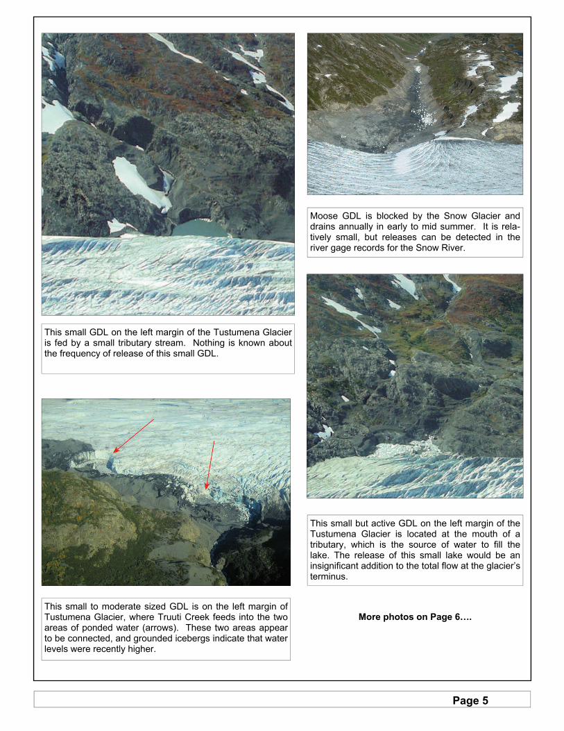
End of 2010 Open Water Season
The 2010 open water season is coming to a close, we would like to thank you for your assistance in taking water level readings and ask that you stop taking readings when ice actually prevents you from making an accurate reading safely. We would appreciate any information you can provide on the condition of the river and the formation of river ice. Please complete the enclosed Freeze-up Form and return it to us. Your help contributes to a more complete record of freeze-up data for Alaska and is greatly appreciated.
Page 4
Glacier Dammed Lakes on the Kenai Peninsula
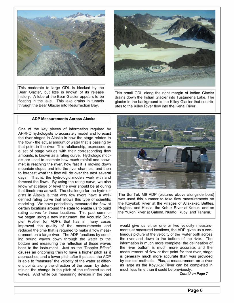
APRFC hydrologists Larry Rundquist and Ben Balk took a flight with the Seward Squadron of the Civil Air Patrol on September 16th, 2010. The purpose of the flight was to view and document locations of 32 poten-tial glacier dammed lakes (GDL) on the Kenai Penin-sula that had been identified by a graduate student at the Alaska Pacific University using satellite images. Each lake location was photographed and evaluated for size, release activity, and flood threat. Preliminary results are that most of the newly identified lake sites are small and either inactive or active with a low flood threat. Many of these are small lakes that form at the edge of the glacier at a location of a small tributary stream. The stream fills the small area with water until it gets full enough to develop a drainage tunnel through the glacier. Two active glacier dammed lakes of moder-ate size drain into Tustumena Lake, a large permanent lake that would attenuate the flood hydrograph, and result in small increases in water level in the Kasilof River. The largest of the newly evaluated lakes drains through the Bear Glacier into a large lake at the glacier terminus, and then directly into Resurrection Bay. Potential impacts in this remote area are to people us-ing the stream banks for camping during recreational activities. Photos were also taken of the well-monitored Snow, Moose, and Skilak glacier dammed lakes for the purpose of documenting water levels in these lakes.
Snow GDL is a large and well-monitored lake that is blocked by the Snow Glacier. Documented releases that can cause flooding in the vicinity of Kenai Lake indicate that the lake fills and releases on a 2 to 3 year cycle.
Skilak GDL is a large lake that has sufficient record to show that it normally releases on a 2 year cycle. It drains through tunnels in the Skilak Glacier into Skilak Lake and then down the lower Kenai River. Winter releases have caused ice jam flooding along the lower Kenai River that resulted in the two highest river levels on record at the river gage at Soldotna.
This moderate sized GDL is called Berg Lake in our files but the USGS topographic maps show the lake to be connected with the perched lake at the far end of the gravel lake basin and named it Arctic Lake. It is likely that the GDL filled the entire area in the past when the glacier was thicker. This lake periodically drains through tunnels down the Tustumena Glacier (lower left corner) and into Tustumena Lake (upper left corner).
Page 5
Moose GDL is blocked by the Snow Glacier and drains annually in early to mid summer. It is rela-tively small, but releases can be detected in the river gage records for the Snow River.
This small to moderate sized GDL is on the left margin of Tustumena Glacier, where Truuti Creek feeds into the two areas of ponded water (arrows). These two areas appear to be connected, and grounded icebergs indicate that water levels were recently higher.
This small but active GDL on the left margin of the Tustumena Glacier is located at the mouth of a tributary, which is the source of water to fill the lake. The release of this small lake would be an insignificant addition to the total flow at the glacier’s terminus.
This small GDL on the left margin of the Tustumena Glacier is fed by a small tributary stream. Nothing is known about the frequency of release of this small GDL.
More photos on Page 6….
Page 6
One of the key pieces of information required by APRFC hydrologists to accurately model and forecast the river stages in Alaska is how the stage relates to the flow - the actual amount of water that is passing by that point in the river. This relationship, expressed as a set of stage values with their corresponding flow amounts, is known as a rating curve. Hydrologic mod-els are used to estimate how much rainfall and snow-melt is reaching the river, how fast it is moving down mountain slopes and into the river channels, and then to forecast what the flow will do over the next several days. That is, the hydrologic models work with and forecast the flows. By using the rating curve, we also know what stage or level the river should be at during that timeframe as well. The challenge for the hydrolo-gists in Alaska is that very few rivers have a well-defined rating curve that allows this type of scientific modeling. We have periodically measured the flow at certain locations around the state to enable us to build rating curves for those locations. This past summer we began using a new instrument, the Acoustic Dop-pler Profiler (or ADP), that has in many cases improved the quality of the measurements and reduced the time that is required to make a flow meas-urement on a large river. The ADP functions by send-ing sound waves down through the water to the bottom and measuring the reflection of those waves back to the instrument. Just as the “Doppler Effect” causes an oncoming train to have a higher pitch as it approaches, and a lower pitch after it passes, the ADP is able to “measure” the velocity of the water at differ-ent points along the direction of the beam by deter-mining the change in the pitch of the reflected sound waves. And while our measuring devices in the past
would give us either one or two velocity measure-ments at measured locations, the ADP gives us a con-tinuous picture of the velocity of the water both across the river and down to the bottom of the river. The information is much more complete, the delineation of the river bottom is much more accurate, and the measurement of flow at that point for that river, stage is generally much more accurate than was provided by our old methods. Plus, a measurement on a river as large as the Koyukuk River can be completed in much less time than it could be previously. Cont’d on Page 7
ADP Measurements Across Alaska
The SonTek M9 ADP (pictured above alongside boat) was used this summer to take flow measurements on the Koyukuk River at the villages of Allakaket, Bettles, Hughes, and Huslia, the Kobuk River at Kobuk, and on the Yukon River at Galena, Nulato, Ruby, and Tanana.
This small GDL along the right margin of Indian Glacier drains down the Indian Glacier into Tustumena Lake. The glacier in the background is the Killey Glacier that contrib-utes to the Killey River flow into the Kenai River.
This moderate to large GDL is blocked by the Bear Glacier, but little is known of its release history. A lobe of the Bear Glacier appears to be floating in the lake. This lake drains in tunnels through the Bear Glacier into Resurrection Bay.
Page 7
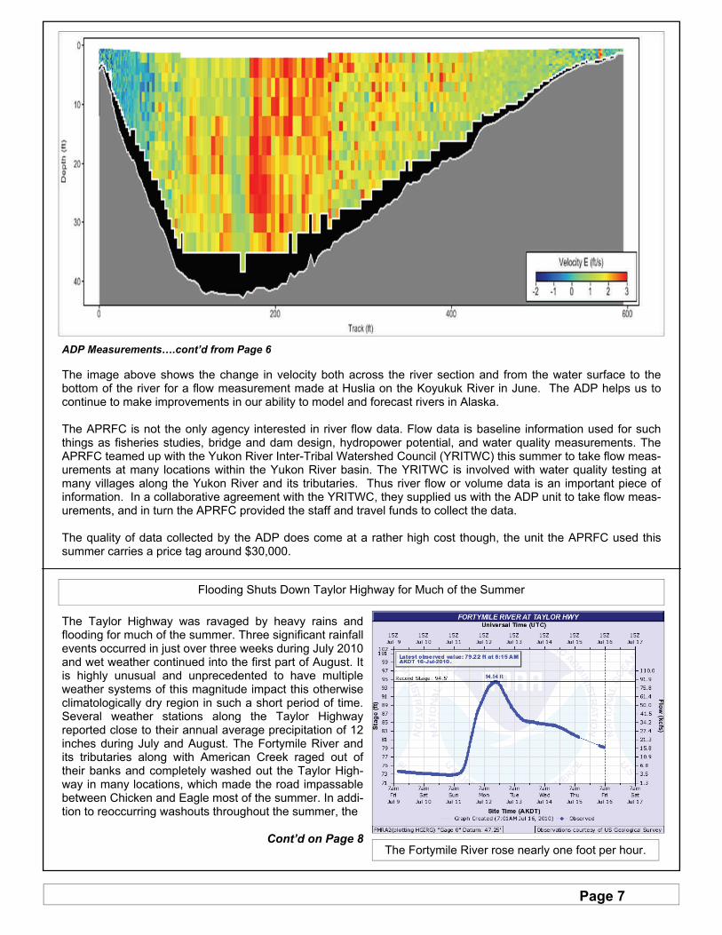
ADP Measurements….cont’d from Page 6 The image above shows the change in velocity both across the river section and from the water surface to the bottom of the river for a flow measurement made at Huslia on the Koyukuk River in June. The ADP helps us to continue to make improvements in our ability to model and forecast rivers in Alaska. The APRFC is not the only agency interested in river flow data. Flow data is baseline information used for such things as fisheries studies, bridge and dam design, hydropower potential, and water quality measurements. The APRFC teamed up with the Yukon River Inter-Tribal Watershed Council (YRITWC) this summer to take flow meas-urements at many locations within the Yukon River basin. The YRITWC is involved with water quality testing at many villages along the Yukon River and its tributaries. Thus river flow or volume data is an important piece of information. In a collaborative agreement with the YRITWC, they supplied us with the ADP unit to take flow meas-urements, and in turn the APRFC provided the staff and travel funds to collect the data. The quality of data collected by the ADP does come at a rather high cost though, the unit the APRFC used this summer carries a price tag around $30,000.
Flooding Shuts Down Taylor Highway for Much of the Summer
The Taylor Highway was ravaged by heavy rains and flooding for much of the summer. Three significant rainfall events occurred in just over three weeks during July 2010 and wet weather continued into the first part of August. It is highly unusual and unprecedented to have multiple weather systems of this magnitude impact this otherwise climatologically dry region in such a short period of time. Several weather stations along the Taylor Highway reported close to their annual average precipitation of 12 inches during July and August. The Fortymile River and its tributaries along with American Creek raged out of their banks and completely washed out the Taylor High-way in many locations, which made the road impassable between Chicken and Eagle most of the summer. In addi-tion to reoccurring washouts throughout the summer, the
Cont’d on Page 8
The Fortymile River rose nearly one foot per hour.

Page 8
Start of Ice Thickness Measurements Those of you who measured ice thickness last year are requested to do so again this year. Please let us know if you need more forms or envelopes for this season. For those of you who have measured in the past but do not intend to this year, please contact us to get instructions on sending the valuable equipment back to us so that we can use it at another location. We will enter your data into a database and use the data in a monthly analysis of snow and ice for fore-casting breakup characteristics next spring. We would like you to make the measurement as close to the last day of each month as possible and mail the results to us. Be sure to include the date and location on the form. A phone call to our 800 number would also aid in the analysis process.
The ice thickness measurements should be made in the same locations as in the past, preferably far enough from the shore line to prevent drilling in mud and not so far as to encounter strong currents. Before drilling the ice, measure the depth of the snow on top of the ice at that point and record the snow depth in inches. It is preferable to drill a new hole each time rather than use the previously drilled hole. Inaccura-cies due to differences in heat transfer can occur at previously drilled holes.
Taylor Highway near Milepost 115 and O’Brien Creek This landslide was approximately 750 feet long
and covered with debris 20 feet thick
Taylor Highway at Milepost 81, near Walker Fork Campground
A culvert washed out, leaving a hole approximately 20 feet deep and 60 feet wide
Taylor Highway at Milepost 152.8 and American Creek Between Mileposts 151 and 154 numerous sections of
the highway washed out. This photo shows a loss of approximately 15 feet of roadway.
Photos courtesy of Alaska State Department of Transportation
To see more Taylor Highway photos,
visit their website at:
http://dot.alaska.gov/nreg/taylor-repairs/
Flooding Shuts Down...cont’d from Page 7 increasingly saturated and unstable soils along the Taylor Highway began to collapse and landslides either blocked or destroyed the road in several locations. Due to the resultant flood damage and very high water levels recorded at many river gauges along the high-way, this suggests that this first event was likely one of the highest floods of record for the Fortymile River basin and its tributaries. The subsequent rainfall and flooding that followed would be considered significant events in any year.