TTT O S PPPP CCCC PPPP EEEEXX … · 9/7/2010 · September 2010 Public Participation STAR PRAIRIE...
113
T T O O W W N N O O F F S S T T A A R R P P R R A A I I R R I I E E 2 2 0 0 1 1 0 0 – – 2 2 0 0 3 3 0 0 C C O O M M P P R R E E H H E E N N S S I I V V E E P P L L A A N N E E X X E E C C U U T T I I V V E E S S U U M M M M A A R R Y Y
Transcript of TTT O S PPPP CCCC PPPP EEEEXX … · 9/7/2010 · September 2010 Public Participation STAR PRAIRIE...

TTTTTTTTOOOOOOOOWWWWWWWWNNNNNNNN OOOOOOOOFFFFFFFF SSSSSSSSTTTTTTTTAAAAAAAARRRRRRRR PPPPPPPPRRRRRRRRAAAAAAAAIIIIIIIIRRRRRRRRIIIIIIIIEEEEEEEE
22222222000000001111111100000000 –––––––– 22222222000000003333333300000000
CCCCCCCCOOOOOOOOMMMMMMMMPPPPPPPPRRRRRRRREEEEEEEEHHHHHHHHEEEEEEEENNNNNNNNSSSSSSSSIIIIIIIIVVVVVVVVEEEEEEEE PPPPPPPPLLLLLLLLAAAAAAAANNNNNNNN
EEEEEEEEXXXXXXXXEEEEEEEECCCCCCCCUUUUUUUUTTTTTTTTIIIIIIIIVVVVVVVVEEEEEEEE SSSSSSSSUUUUUUUUMMMMMMMMMMMMMMMMAAAAAAAARRRRRRRRYYYYYYYY


Adopted September 7, 2010
Star Prairie Town Board
Prepared by:
St. Croix County Planning & Zoning Department
University of Wisconsin-Extension
ACKNOWLEDGEMENTS
StStStStar Prairiear Prairiear Prairiear Prairie Town Board Town Board Town Board Town Board
Doug Rivard, Chair
Scott Counter, Supervisor
Tom Heinz, Supervisor
Steve “Spanky” Lewis, Supervisor
Patty Schachtner, Supervisor
Mike Burke, Clerk
MaryAnn Schachtner, Treasurer
Star PrairieStar PrairieStar PrairieStar Prairie Plan Commission Plan Commission Plan Commission Plan Commission
Scott Counter, Chair
Kathy Mlynarczyk, Secretary
Mike Burke
John Harrison
Jeff Levy
Jeff Peplau
Debbie Suennen Rickard
Special Thanks to the following individuals for their contributions to the Comprehensive Plan:
Al Campeau, Kathy Jacobson, Kathy Frederickson and Felicia Germain.
Photos, cover and this page, of Town of Star Prairie by Kathy Mlynarczyk.


September 2010 Table of Contents
STAR PRAIRIE COMPREHENSIVE PLAN ___________________________________ i
TTTTABLE OF ABLE OF ABLE OF ABLE OF CCCCONTENTSONTENTSONTENTSONTENTS
TTTTOWN OF OWN OF OWN OF OWN OF SSSSTAR TAR TAR TAR PPPPRAIRIE RAIRIE RAIRIE RAIRIE CCCCOMPREHENSIVE OMPREHENSIVE OMPREHENSIVE OMPREHENSIVE PPPPLANLANLANLAN
INTRODUCTION_________________________________________________ 1
PUBLIC PARTICIPATION _________________________________________ 1 Issues & Opportunities Workshop _________________________________________________ 1
Public Opinion Survey ___________________________________________________________ 2
Visioning Workshop_____________________________________________________________ 16
Open Houses __________________________________________________________________ 16
Interactive Land Use Workshop__________________________________________________ 17
Public Hearing and Adoption ___________________________________________________ 19
Adopting Ordinance ___________________________________________________________ 20
ISSUES & OPPORTUNITIES ______________________________________ 21 Community Background________________________________________________________ 21
Community Forecasts __________________________________________________________ 25
Population___________________________________________________________________ 25
Household ___________________________________________________________________ 26
Housing Units & Acreage _____________________________________________________ 28
Employment _________________________________________________________________ 31
STAR PRAIRIE VISION __________________________________________ 32 Element-Based Vision Statements _______________________________________________ 32
UTILITIES AND COMMUNITY FACILITIES___________________________ 34 Utilities & Community Facilities Goals, Objectives & Policies _______________________ 35
TRANSPORTATION_____________________________________________ 38 Local & County Transportation Services__________________________________________ 38
Transportation Goals, Objectives & Policies ______________________________________ 41
HOUSING _____________________________________________________ 43 Housing Growth Projections _____________________________________________________ 43
Housing Goals, Objectives & Policies ____________________________________________ 46
ECONOMIC DEVELOPMENT _____________________________________ 49 Types of Local Employment___________________________________________________ 49
Economic Development Goals, Objectives & Policies ____________________________ 50

Table of Contents September 2010
II ___________________________________ STAR PRAIRIE COMPREHENSIVE PLAN
AGRICULTURAL RESOURCES ___________________________________ 53 Agricultural Lands ______________________________________________________________ 53
Working Lands Initiative_________________________________________________________ 56
Farmland Preservation & Exclusive Ag Zoning ____________________________________ 57
Agriculture Goals, Objectives & Policies__________________________________________ 59
NATURAL RESOURCES _________________________________________ 62 Comprehensive Environmental Resource Protection______________________________ 62
Natural Resources Goals, Objectives & Policies___________________________________ 63
CULTURAL RESOURCES________________________________________ 66 Historic Resources ______________________________________________________________ 66
Scenic Resources_______________________________________________________________ 68
Cultural Resources Goals, Objectives & Policies __________________________________ 70
INTERGOVERNMENTAL COOPERATION___________________________ 72 Annexation __________________________________________________________________ 72
Boundary & Annexation Agreement___________________________________________ 72
Intergovernmental Cooperation Goals, Objectives & Policies _____________________ 73
LAND USE ____________________________________________________ 77 Existing Land Use Regulations ___________________________________________________ 77
Existing Land Uses ______________________________________________________________ 79
Future Land Use Projections _____________________________________________________ 81
Open Space Projections______________________________________________________ 81
Residential Projections________________________________________________________ 82
Agricultural Projections _______________________________________________________ 83
Commercial & Industrial Projections ___________________________________________ 84
Land Use Goals, Objectives & Policies ___________________________________________ 86
Future Land Use ________________________________________________________________ 94
IMPLEMENTATION _____________________________________________ 99 Plan Adoption _________________________________________________________________ 99
Consistency of Plan Elements _________________________________________________ 99
Implementation Recommendations _____________________________________________ 99
Plan Monitoring, Amendments and Update_____________________________________ 104
Procedures _________________________________________________________________ 104
APPENDIX ___________________________________________________ 105

September 2010 Public Participation
STAR PRAIRIE COMPREHENSIVE PLAN ___________________________________ 1
INTRODUCTION
The most complete planning legislation in Wisconsin’s history was enacted in 1999. The legislation provides communities with the framework to develop a comprehensive town plan as a
tool to guide future growth. By January 1, 2010, all communities that make land use decisions, including zoning and subdivision ordinances, will need to base those decisions on an adopted comprehensive plan. The Star Prairie Town Board decided to become part of the West Central
Wisconsin Collaborative Planning Project led by the West Central Regional Planning Commission (WCWRPC) out of Eau Claire. The WCWRPC along with four counties and 21 local communities applied for and received a comprehensive planning grant to complete local, county
and regional plans.
In addition to coordination from the Regional Planning Commission, St. Croix County assisted
the Town of Star Prairie in developing this plan. The town plan commission worked to develop the plan for four and a half years. The Town Board adopted the Plan on September 7, 2010.
PUBLIC PARTICIPATION
Wisconsin’s Comprehensive Planning statute recognizes the necessity of effective public participation and
requires the adoption of a written public participation plan as stated in Chapter 66.1001(4)(a).
“The governing body of a local governmental unit shall adopt written procedures that are designed to foster public participation, including open discussion, communication programs, information services, and public meetings for which advance notice has been provided, in every stage of the preparation of a comprehensive plan. The written procedures shall provide an opportunity for written comments on the plan to be submitted by members of the public to the governing body and for the governing body to respond to such written comments.”
The Town of Star Prairie adopted a written public participation plan as required by statute. Each of the
activities described and carried out in the public participation plan is summarized below. St. Croix County
created a webpage for Star Prairie’s comprehensive planning project on its website and has posted public
participation materials and plan documents to the page through out the project. The webpage is found on
the community section of the county webpage, www.sccwi.us, under Town of Star Prairie, Community
Planning. A copy of the public participation plan is found in the Appendix.
ISSUES & OPPORTUNITIES WORKSHOP
The town held an issues and opportunities workshop on November 8, 2005 at the Wisconsin Indianhead
Technical College in New Richmond to introduce the comprehensive planning project to the public and
identify issues and opportunities within the town. Approximately 55 citizens attended. The top issues
identified were: parks, trails & open space; agriculture preservation & the rural community; groundwater
protection; growth and development; property maintenance and junkyards; issues with the City of New
Richmond; and airport expansion and operation. The results were used to create questions for the public
opinion survey which gathered further input from citizens and property owners. The town’s complete
workshop results are available on the county webpage for the town, www.sccwi.us, under Town of Star
Prairie, Community Planning.

Public Participation September 2010
2 ___________________________________ STAR PRAIRIE COMPREHENSIVE PLAN
PUBLIC OPINION SURVEY
During January and February of 2006, the Survey Research Center at the University of Wisconsin at River
Falls sent a comprehensive planning questionnaire to all households in the Town of Star Prairie for which
there was a valid address. Of the 1,492 households receiving a questionnaire, a total of 755 (52 percent)
were returned, entered and analyzed. Based on the adult population in the Town, the results are expected
to be accurate to within plus or minus 3 percent, which is a very high level for this type of analysis. This
means that if all residents had responded to the survey, then 95 out of 100 times the results for each
question would be the same, plus or minus 3 percentage points.
Key conclusions from the survey include:
ISSUES AND OPPORTUNITIES
• The two most important factors that lead residents to choose the Town of Star Prairie as a place to
live are its small town/rural lifestyle and the natural beauty of the area.
• Residents feel that protecting all types of open space (lakes, wildlife habitat, woodlands, river
corridors, prairie-grasslands, and wetlands) is important.
HOUSING
• Residents are almost equally split on the question “Is future residential growth in the Town
desirable?”
• If residential growth is to occur, there is a relatively strong preference for single family homes and,
possibly, for housing that caters to the needs of seniors.
AGRICULTURE AND NATURAL RESOURCES
• Most residents would like to see productive farmland remain in agriculture.
• Most residents are not in favor of restricting agricultural operations near residences.
• Residents are not yet enthusiastic about creating compensation programs to compensate farmland
owners for not developing their property. Interestingly, however, they are willing to use public
funds to preserve open space.
LAND USE
• A solid majority (69 percent) agree that landowners should have some restrictions on the amount
of their land they will be allowed to develop.
• One land use regulation with widespread support is to protect environmentally sensitive areas.
• There is solid support for charging private developers impact fees to cover the cost of providing
them with public services (e.g. roads and emergency services).
• A solid majority of respondents said that they are in favor keeping a 2-acre minimum lot size
throughout the Town.
• However, an even bigger majority are in favor of conservation design developments in which the
individual lots would, generally, be less than 2 acres.
• Those willing to see deviations from the 2-acre minimum would do so in environmentally sensitive
areas, along wildlife corridors, in conservation design developments, and if small scale sewage
treatment systems are available.
TRANSPORTATION
• Residents are moderately satisfied with the current network of roads and their condition
UTILITIES & COMMUNITY FACILITIES
• Residents are moderately satisfied with public services (ambulance, fire, snow removal, etc) in the
Town.
• Residents are generally willing to expend public funds to expand parks and a few other recreational
amenities in the Town (boat landings, ball fields, hunting and fishing access and trails for biking
and hiking/skiing.

September 2010 Public Participation
STAR PRAIRIE COMPREHENSIVE PLAN ___________________________________ 3
ECONOMIC DEVELOPMENT
• The economic development preferred by residents builds on the Town’s traditional economic base
of agriculture (crop/livestock production, direct farm marketing, farm services), is small scale in
nature (home businesses, gas stations with convenience stores), and is environmentally conscious
(composting, wind energy generation).
OTHER FINAL COMMENTS
• People are willing to see the Town board expand from three to five members and to see a new
Town Hall built at the corner of Cook Drive and County Road C.
• People are almost evenly split with respect to the fate the old Town Hall and, based on the number
of written comments on this topic, tend to feel passionately about its fate. Some would like to see
the building sold or demolished and others would like to see it maintained and available to a
variety of community groups.
• Residents are very concerned about groundwater contamination, loss of productive farmland and
rural residential development.
Survey MethodsSurvey MethodsSurvey MethodsSurvey Methods
In January of 2006, the Survey Research Center (SRC) at the University of Wisconsin at River Falls, mailed
comprehensive planning questionnaires to 1,492 households in the Town of Star Prairie. After two weeks,
postcards were mailed to those from whom we had not received a completed questionnaire. Two weeks
after the post card, a second questionnaire was sent to remaining non-respondents. The SRC received a
total of 517 completed questionnaires from the first mailing and 238 from the second for a total of 755
completed questionnaires, which is a 52 percent response rate. Given an estimated Town population of
2,078 adults, the estimates included in this report should be accurate to within plus or minus three
percent with 95 percent confidence.
Any survey has to be concerned with “non-response bias”. Non-response bias refers to a situation in
which people who don’t return a questionnaire have opinions that are systematically different from the
opinions of those who return their surveys. Based on the statistical tests described in Appendix A, the the the the
Survey Research CenSurvey Research CenSurvey Research CenSurvey Research Center (SRC) concludes that nonter (SRC) concludes that nonter (SRC) concludes that nonter (SRC) concludes that non----response bias is not a concern for this sample with one response bias is not a concern for this sample with one response bias is not a concern for this sample with one response bias is not a concern for this sample with one
possible exception.possible exception.possible exception.possible exception. Those who responded to the second mailing displayed a pattern of greater willingness
to impose fees on developers, consider additional land use regulations and beef up enforcement of existing
land use regulations. Results for these issues have been weighted to better reflect the overall opinions of
the population as a whole.
In addition to the numeric responses, respondents provided a wealth of written comments. In fact, nearly
700 individual comments were compiled by the SRC from the residents’ surveys. As appropriate, a few,
select quotes were chosen by the SRC for some sections of the survey to illustrate these comments. A
complete compendium of comments is included in the Survey Appendix on the county webpage for the
town project.
Profile of RespondentsProfile of RespondentsProfile of RespondentsProfile of Respondents
Tables 1 and 1A provide a summary of the demographic profile of those who responded to this
questionnaire. We have also included, when comparable data are available, information from the 2000
Census of Population and Housing in Table 1.

Public Participation September 2010
4 ___________________________________ STAR PRAIRIE COMPREHENSIVE PLAN
TABLE 1: DEMOGRAPHIC PROFILE OF RESPONDENTS
GENDER COUNT MALE FEMALE
Sample 715 62% 38%
Census 2,944 53% 47%
AGE COUNT 18 – 24 25 - 34 35 - 44 45 - 54 55 - 64 65+
Sample 737 1% 13% 23% 28% 21% 15%
Census 2078 13% 23% 26% 20% 10% 8%
EMPLOYMENT STATUS
COUNT FULL PART SELF
EMPLOYED UNEMPLOYED RETIRED OTHER
Sample 733 58% 7% 12% 2% 19% 1%
Census 2273 72% 2% 28%
INCOME COUNT <$15,000 $15 -
$24,999 $25 –
$49,999 $50 –
$74,999 $75 –
$99,999 $100,000+
Sample 687 2% 6% 23% 33% 20% 16%
Census 1,030 7% 12% 27% 27% 17% 11%
TABLE 1A: DEMOGRAPHIC PROFILE OF RESPONDENTS
RESIDENCY COUNT NON-RESIDENT LAND-OWNER
RURAL, NON-FARM RESIDENT
RENTER FARMLAND OWNER
OTHER
Sample 740 11% 76% 1% 8% 5%
NUMBER
ADULTS COUNT 1 2 3 4 5 6+
Sample 735 18% 66% 12% 3% 1% 0%
NUMBER
KIDS COUNT 0 1 2 3 4 5+
Sample 676 60% 15% 17% 6% 1% 0%
YEARS RESIDENT
COUNT < 5 YEARS 5 – 10 YEARS
11 - 20 YEARS
21 – 30 YEARS
31 - 40 YEARS
41 - 50 YEARS
50+ YEARS
Sample 714 23% 22% 24% 14% 9% 4% 4%
One striking result from Tables 1 and 1A is that a disproportionate number of men are represented in the
sample. A divergence of this magnitude in the expected proportion of males and females raises concerns
about the representativeness of the sample. To test for “sample bias”, the SRC compared the responses of
men and women using a standard T-Test, as described in Appendix B. We found a widespread pattern of
gender differences with respect to how men and women in the Town of Star Prairie view land use issues.
The differences tend to be ones of degree rather than direction. For example, the questionnaire asked for
residents’ assessment of the quality of a variety of Town services (e.g. ambulance, fire, police) and men
tended to rate these more highly than did women. However, in no case did men, on average, say that the
quality of the service was good while women, on average, said it was poor. On a scale from 2 (= very
good) to – 2 (= very poor), men rated the ambulance service as 0.72 (rounding to “good”) and women
rated it as 0.59 (again, rounding to “good”). The data discussed in the balance of this report include, as
appropriate, the re-weighted results to better account for the under-representation of women in the
sample.
As is frequently the case in surveys such as this, young adults (those under 35 years of age) are under-
represented in this sample. Further, there are a substantial number of statistical differences in the opinions
of those under 35 compared to those over 35. In some instances, the opinions of younger residents align
with those of women (both groups rate Town services somewhat lower and are more supportive of
spending public funds to expand recreational activities than their respective counterparts). In other ways,
however, younger residents diverge in their opinions from those of women. Younger residents are less
supportive of additional land use policies (less opposed to allowing landowners to develop land in any way
they want, less supportive of fees on new developments to pay for public services, less convinced that
additional land use regulations are needed or that enforcement of current regulations should be stepped

September 2010 Public Participation
STAR PRAIRIE COMPREHENSIVE PLAN ___________________________________ 5
up) and less concerned about some issues (conflicts between farmers and their neighbors are a concern,
groundwater contamination, need for senior housing) than are women. Because women in the sample are
significantly younger than are men, a re-weighting based on age would result in women’s opinions gaining
excess influence over the results. Therefore, the SRC has not adjusted the results to account for the
skewed age structure. Significant differences of opinions related to age will be noted throughout the
report.
Table 1 indicates that unemployment remains a relatively insignificant problem in the Town of Star Prairie
since only 2 percent of the sample reported being out of work. There is a slightly higher percentage
reporting being employed in one fashion or another than was true in the Census and a slightly lower
percentage in the Retired or Other categories.
The final demographic variable for which comparable data from the Census are available is for household
income. Table 1 indicates that the household income is somewhat higher in the sample than as reported in
the census. In general, however, there is a relatively close match between the sample and Census given
that 5 years have passed since the latter was taken.
More than three-quarters of those in the sample report being rural, land-owning residents in the Town and
only 8 percent list themselves as farmland owners. Interestingly, there were more non-resident land-
owners than farmland owners in the sample.
While the average household in the sample reported having slightly more than two adults and slightly fewer
than two children, fully 60 percent of respondents had no children in the home. Only 18 percent of
respondents reported a single adult in the household and within no age category is the percentage of
single-adult households as high as one-quarter of the households and this peak is for those over 65. In
short, the nuclear family of mom, dad and two kids seems to be stronger in the Town of Star Prairie than in
most American communities.
Finally, similar percentages of those in the sample have lived in the Town for fewer than 5 years (23
percent), between 5 and 10 years (22 percent), between 11 and 20 years (24 percent), and more than 20
years (31 percent).
Quality of LifeQuality of LifeQuality of LifeQuality of Life
The first question of the questionnaire asked respondents to identify the three most important reasons they
chose to live in the Town of Star Prairie. Both in terms of the individual rankings and in terms of the
percentage of households ranking a given feature as one of their top three reasons for choosing to live in
Star Prairie, it is clear that residents value the atmospherics of the area. More than half of all households
said that the small town atmosphere/rural lifestyle and the natural beauty of the area were key factors in
their decision to live in Star Prairie.

Public Participation September 2010
6 ___________________________________ STAR PRAIRIE COMPREHENSIVE PLAN
TABLE 2 – WHY RESIDENTS CHOSE TO LIVE IN THE TOWN OF STAR PRAIRIE
Reasons Most Important 2nd Most Imp 3rd Most Imp Total Top 3
Count 722 716 709
Small town/rural lifestyle 21% 21% 19% 62%
Natural beauty 24% 18% 11% 53%
Near friends/family 11% 9% 7% 28%
Near job 7% 7% 9% 23%
Proximity to cities 2% 8% 13% 22%
Low crime rate 5% 8% 9% 22%
Property taxes 6% 10% 6% 22%
Cost of homes 7% 4% 5% 15%
Affordable housing 7% 4% 4% 15%
Quality of schools 4% 6% 6% 15%
Recreational opportunities 2% 3% 6% 11%
Appearance of homes 0% 2% 3% 5%
Other 3% 0% 1% 4%
Cultural/Community events 0% 0% 1% 1%
Roughly one-quarter of respondents identified the next 5 items as important in their choice of where to
live: being near family and friends (28 percent as one of their top three reasons), being near their job (23
percent), the proximity of the Town to the Twin Cities (22 percent), the low crime rate in the Town (22
percent), and property taxes (22 percent). Somewhat surprisingly, the quality of schools and housing
prices were relatively less important to this set of respondents.
Different demographic groups identify different aspects of the quality of life in Star Prairie Town as their
motivations for living there. In general, these statistical differences conform to our expectations. For
example, the probability that a respondent would identify being close to family and friends as a key reason
for living in the Town increases with the length of time the person has lived in Star Prairie. When children
are in the home, respondents are significantly more likely to identify the quality of schools and the low
crime rate as key reasons. Those with no children and with higher incomes identified the Town’s proximity
to the Twin Cities in significantly higher percentages than other groups. Those with lower incomes were
more likely to list proximity to their job as a reason for living in the Town. Finally, women are more likely
to list natural beauty and housing affordability while men identified property taxes in somewhat higher
proportions.
Selected Comments about Quality of LifeSelected Comments about Quality of LifeSelected Comments about Quality of LifeSelected Comments about Quality of Life
“The small town atmosphere is great. We should be concerned with keeping that . . .”
“Because of improvements made to Hwy 64 & the impending river bridge, our community needs to stay ahead of the game and be ready for the population explosion that will follow in the next few years-proactive not reactive! And we need to be able to meet the needs of urban population that is relocating to a rural area.”
“The challenge is to maintain the unique character of Star Prairie (mix of farmland, residential dev, etc.) while development occurs”
“Keep the rural setting and small town atmosphere, protect residents from hazards of water contamination, noise pollution (airport) and control growth in the community.”
“Please don't add so many services that young families get taxed out. There is (sic) enough parks and rec. facilities in the surrounding area that you can drive to.”

September 2010 Public Participation
STAR PRAIRIE COMPREHENSIVE PLAN ___________________________________ 7
Natural and Cultural ResourcesNatural and Cultural ResourcesNatural and Cultural ResourcesNatural and Cultural Resources
This section of the questionnaire asked residents to rate the importance of protecting several types of open
space in the Town. In Table 3 and most subsequent tables, the scale used for these ratings ranges from a
negative two (very unimportant) to a positive two (very important). Average values close to zero indicate
either that residents have no opinion or are closely divided between supporters and non-supporters. As
Table 3 indicates, there is very broad agreement that protecting open space of all varieties is important to
the Town. While protecting lakes is the type of open space with the highest average value, each of the six
items about which we asked had more than 80 percent of residents indicating that it was important or very
important to preserve it. Ten respondents added preservation of farmland as an open-space issue.
Because such large majorities of the population feel that it is important to protect all of these types of open
space, it is not surprising that there are few statistically significant demographic differences. Residents
who’ve lived in the Town for longer periods (40 or more years of residence in the Town) feel that
protecting lakes is less important than newer arrivals (though 90 percent or more feel this is important or
very important). Similarly, men feel less strongly than do women that it is important to protect prairie
land/grassland.
TABLE 3: IMPORTANCE OF PROTECTING OPEN SPACE IN THE TOWN OF STAR PRAIRIE
Type Average Count Very
Unimportant Unimportant No Opinion Important
Very Important
Lakes 1.61 741 1% 2% 1% 28% 68%
Wildlife Habitat 1.46 738 1% 4% 2% 35% 59%
Woodlands 1.44 736 1% 4% 2% 36% 57%
River Corridors 1.42 739 0% 5% 2% 38% 55%
Prairie - Grasslands
1.21 738 1% 9% 3% 43% 44%
Wetlands 1.18 737 2% 9% 3% 39% 46%
HousingHousingHousingHousing
The first question in the housing section of the questionnaire asked for opinions about future residential
growth in the Town. Residents are very evenly split on whether or not residential growth is desirable:
• 14 percent strongly disagree
• 29 percent disagree
• 7 percent have no opinion
• 43 percent agree
• 8 percent strongly agree
Thus, a slight majority of Town residents are favorably disposed to residential growth but those opposed
to growth appear to be a bit more vehement. There are no clear demographic distinctions between
supporters of additional residential growth and those opposed (younger respondents are no different than
older ones, men and women hold similar opinions, longer-term residents and newer arrivals are the same).
The only demographic distinction is with respect to income – lower income respondents were substantially
less supportive of residential growth than were the more affluent. The median household income in the
Town of Star Prairie, as reported in the 2000 Census, was $53,468. If we look at the responses of those
who reported household incomes of less than $50,000 compared to those reporting more than this
amount, we see that a higher percentage of those earning less than the median level of household income
“disagree” or “strongly disagree” (45 percent) with the statement that residential growth is desirable in
the Town of Star Prairie than are those earning more (40 percent). Likewise the less affluent are less likely
to “agree” or “strongly agree” (42 percent) that residential growth is desirable than are the more well-to-
do ((55 percent).
Table 4 summarizes the opinions of respondents to a series of questions about the need for additional
housing units of various types. Again, the average value reported is based on assigning values to responses

Public Participation September 2010
8 ___________________________________ STAR PRAIRIE COMPREHENSIVE PLAN
ranging from -2 for “strongly disagree” to +2 for “strongly agree.” So, any value above zero indicates
that the given option is favorable to a majority of respondents. The results in Table 4 are fairly clear – the
residents of the Town of Star Prairie are generally favorably disposed to additional single family homes (71
percent agreed or strongly agreed compared to only 21 percent who disagreed or strongly disagreed).
Respondents also seem to feel the need for more senior-oriented housing and housing that meet the needs
of a variety of income levels. None of the other options about which we inquired received close to a
majority of “favorable” votes and several (condominiums-apartments, freestanding mobile homes, and
mobile home parks), were strongly opposed by residents.
TABLE 4: ADDITIONAL HOUSING NEEDED
Type Average Count Strongly Disagree
Disagree No
Opinion Agree
Strongly Agree
Single Family Homes 0.64 727 7% 14% 7% 50% 21%
Senior Housing 0.40 721 10% 16% 11% 52% 12%
Housing for Variety Incomes
0.08 723 19% 18% 9% 46% 9%
Seasonal - Recreational Homes
(0.31) 715 20% 29% 13% 35% 3%
Subdivisions (0.60) 722 32% 28% 11% 26% 3%
Duplexes (0.72) 720 32% 35% 8% 23% 2%
Condos - Apartments (1.01) 719 41% 35% 9% 13% 1%
Mobile Homes (1.27) 725 57% 25% 8% 8% 2%
Mobile Home Parks (1.40) 723 60% 27% 7% 4% 1%
Household income is statistically associated with a number of preferences regarding additional housing
stock in the Town of Star Prairie. Respondents with less than $50,000 in household income are less less less less
pospospospositive aboutitive aboutitive aboutitive about additional single family homes (68 percent vs. 73 percent), duplexes (20 percent vs. 26
percent), or subdivisions (23 percent vs. 33 percent) than those with higher incomes. Lower income
households are less negative aboutless negative aboutless negative aboutless negative about condominiums or apartments (72 percent vs. 78 percent), mobile home
parks (79 percent vs. 91 percent), or mobile home parks (73 percent vs. 89 percent) than the more
affluent.
Respondents who have lived in the Town for longer periods of time are more negative about additional
seasonal and recreational housing and free-standing mobile homes, but more supportive of housing that fits
the needs of a variety of incomes and additional senior housing. Those under 35 years of age are
significantly less supportive of additional senior housing.
Agriculture and Land Use IssuesAgriculture and Land Use IssuesAgriculture and Land Use IssuesAgriculture and Land Use Issues
One set of questions in this segment of the questionnaire dealt with agriculture and farmland issues and a
second set with more general land use issues. The first agricultural question asked respondents how they
thought productive farmland should be used. Few residents are neutral on the issue of the uses for which
the Town should allow farmland to be used. By nearly unanimous consent, the residents of the Town of
Star Prairie agree that productive farmland should be used for agricultural purposes. A slight majority feel
that the Town should not allow productive agricultural land to be used for residential use (52 percent
opposed versus 42 percent in favor) and relatively few feel that any use should be allowed for productive
agricultural land (72 percent opposed versus 19 percent in favor). Respondents who don’t have children
are significantly less supportive of using productive farmland for residential or any (non-farming) use than
are those with children. Respondents with household incomes less than $50,000 are more likely to be in
favor of allowing productive farm to be used for residential purposes.

September 2010 Public Participation
STAR PRAIRIE COMPREHENSIVE PLAN ___________________________________ 9
TABLE 5: AGRICULTURE AND FARMLAND ISSUES
Issue Average Count Strongly Disagree
Disagree No
Opinion Agree
Strongly Agree
Use Productive Farmland For Ag Uses
1.66 730 0% 0% 2% 28% 69%
Use Productive Farmland For Residential Use
(0.24) 705 19% 33% 6% 36% 6%
Use Productive Farmland For Any Use
(0.82) 692 35% 37% 9% 14% 5%
Don't Restrict Ag Near Residences
0.71 742 4% 17% 6% 46% 27%
Compensation for Non-Development
0.03 745 11% 34% 10% 31% 14%
Public Funds Compensation for Non-Development
(0.18) 737 13% 39% 10% 28% 10%
Farm/Non-Farm Conflicts Are Concern
(0.29) 739 12% 42% 17% 23% 6%
The bottom portion of Table 5 looks at more general agricultural land use issues in the Town. Town
residents are, in general, not in favor of placing restrictions on the use of agricultural land because of its
proximity to residences (more than three times as many respondents agreed that no restrictions should be
enacted than disagreed with this proposition). Women and residents who’ve lived in the Town for shorter
periods of time are significantly more likely to disagree with the proposition that no restrictions should be
placed on agricultural uses near residences.
Town residents are, effectively, divided in half with respect to the proposition that owners of farmland
should be compensated for agreeing not to develop their land for purposes other than farming (45 percent
on either side of this issue). Further, it doesn’t make a great deal of difference if the source of
compensation is from public or unspecified sources (52 oppose public funding versus 45 who oppose any
sort of compensation program). Women are significantly more likely to be neutral on these questions than
are men.
Finally, a majority of respondents rejected the contention that conflicts caused by farm dust, noise, and
odors are a concern in the Town. However, nearly one-third of respondents felt that these conflicts were a
concern. Men and residents under 35 years of age were more likely to say that farm-nonfarm conflicts are
a problem in the Town.
In addition to the questions about farmland, respondents were asked to weigh in on a number of more
general land use policy questions. The first set of land use policy questions summarized in Table 6 focus
on the extent to which the Town should place restrictions on how land owners use their land.
Residents were asked if “landowners should have some restrictions on how much of their land they would
be allowed to develop”. As Table 6 indicates, a majority of respondents (69 percent) agreed or strongly
agreed with this statement. Higher income households are significantly more supportive of restricting the
amount of land an owner should be able to develop. A sizable proportion (29 percent), however, did not
agree with placing restrictions on how much land an owner should be allowed to develop. Those who have
resided in the Town for longer periods are significantly more opposed to such restrictions.
A fairly narrow majority (56 percent) are in favor of allowing landowners to subdivide their land into
housing lots. Men and those from higher income households are more supportive of this proposition than
women or lower income respondents.

Public Participation September 2010
10 ___________________________________ STAR PRAIRIE COMPREHENSIVE PLAN
TABLE 6: LAND USE POLICY
Opinions Average Count Strongly Disagree
Disagree No
Opinion Agree
Strongly Agree
Restrict Amount of Development
0.55 737 7% 22% 3% 50% 19%
Use Land Subdivisions 0.16 735 13% 24% 7% 48% 8%
Use Land Any Way (0.53) 742 23% 46% 2% 19% 10%
Land Use Regs for Environment
1.24 739 1% 3% 3% 54% 38%
Impact Fees 1.06 740 4% 10% 5% 40% 42%
Use Public Funds Preserve Open Space
0.60 737 5% 16% 12% 47% 20%
Additional Land Use Enforcement
0.41 726 4% 18% 27% 37% 15%
Additional Land Use Regulations
0.28 734 6% 20% 28% 29% 16%
Town residents are opposed to allowing land owners to develop their land in any way they choose. The
results (Table 6) for this question are virtually a mirror image of the question asking about restricting the
amount of land an owner should be allowed to develop:
• 69 percent either strongly disagreed (23 percent) or disagreed (46 percent) with the idea that
landowners should have unrestricted choice regarding how to develop their land (69 percent
agreed that landowners should have some restrictions on the amount of land they could develop)
• 29 percent felt land owners should be unrestricted in their land use decisions (29 percent
disagreed that some restrictions should be placed on how much land an owner could develop)
This question, should landowners be allowed to develop their land in any way they want, also brought
forth a number of significant demographic differences of opinion. Those who have lived in the Town for
longer periods, lower income households, respondents under 35 years of age, and households with
children were significantly more supportive of giving landowners unrestricted land use authority. It should
be noted that there is a strong negative correlation between length of residence and household income
level (longer-term residents tend to report lower household incomes) and between age and households
with children (respondents under 35 are significantly more likely to have children than are older
respondents).
The bottom portion of Table 6 summarizes the opinions of Town residents with respect to a number of
land use policies. As the average values reported in the Table suggest, residents tend to be supportive or
to have no opinion about all the land use policies about which we asked. There is overwhelming support
for using land use regulations to protect environmentally sensitive areas and for imposing impact fees on
new developments to cover the costs of additional public services (roads, emergency services, etc.). More
affluent households are more supportive of using land-use regulations to protect environmentally sensitive
areas. While generally supportive, respondents under 35 years of age and those with kids are significantly
more likely to disagree with a policy of impact fees on new developments.
Residents are also quite supportive of a policy that would use public funds to preserve open space in the
Town. More than three times as many agree or strongly agree with such a policy (67 percent) as disagree
or strongly disagree with it (21 percent). Respondents from households reporting more than $50,000 in
income are significantly more supportive of using public funds to preserve open space.
Perhaps the most notable feature of the final two policies about which we asked – the need for additional
land use regulations or for stepped-up enforcement of existing regulations – is that one-quarter of all
respondents had no opinion about them. A majority of those with opinions were in favor of both more
land use regulation and additional enforcement efforts but the large proportion that are sitting on the fence
suggests that additional public educational efforts are warranted.
Residents were asked if the current 2-acre minimum residential lot size should continue to be the standard
throughout the Town. Of the 724 people who answered this question, 65 percent said that the 2-acre

September 2010 Public Participation
STAR PRAIRIE COMPREHENSIVE PLAN ___________________________________ 11
minimum should be continued, 29 disagreed and 9 percent had no opinion. Women and respondents with
children in the home were more likely to support deviations from the 2-acre minimum than were their
counterparts.
Those who disagreed were asked to identify the instances when they would like to see a deviation from the
2-acre minimum lot requirement. Their opinions are summarized in Table 7.
TABLE 7: VARIATIONS FROM THE 2-ACRE MINIMUM LOT SIZE IF:
Condition Average Count Strongly Disagree
Disagree No
Opinion Agree
Strongly Agree
Environmentally Sensitive Area
1.36 227 1% 5% 2% 40% 52%
Wildlife Corridor 1.28 228 1% 7% 3% 40% 48%
Conservation Design Developments
1.22 217 2% 6% 6% 39% 47%
Small Scale Sewage Treatment Systems
1.03 223 4% 9% 6% 43% 39%
Near Higher Density Communities
0.73 230 9% 15% 3% 41% 32%
Remembering that only a bit more than one-third of all respondents are in favor of deviations from the 2-
acre standard minimum lot size, Table 7 indicates that all of the reasons for deviating from this requirement
about which we asked enjoyed considerable support. More than 90 percent suggest variations from the 2-
acre minimum in environmentally sensitive areas. More than 80 percent support deviations to preserve
wildlife corridors, in conservation design developments (see below), and if a small-scale sewage treatment
facility is available. Nearly three-quarters would like to see deviations in areas adjacent to existing high-
density communities such as New Richmond.
As noted in Table 7, there is considerable support among those willing to consider a deviation from the 2-
acre minimum lot size standard for conservation design development. Figure 1, which illustrates what a
conservation design might look like, suggests that support for this type of development is very widespread.
Of the 679 people who answered this question, 575 (85 percent) favored the conservation design.
Figure 1: OpinioFigure 1: OpinioFigure 1: OpinioFigure 1: Opinions about Conservation ns about Conservation ns about Conservation ns about Conservation vs.vs.vs.vs. Traditional Design Options Traditional Design Options Traditional Design Options Traditional Design Options
TransportationTransportationTransportationTransportation
The only transportation related questions asked if the overall net work of roads, streets and highways in
the Town meet the needs of its citizens and if the condition of that network is acceptable. Table 8
indicates there is general satisfaction with both the overall network of roads and their quality. However,
about one-quarter of all respondents are not satisfied with the quality.
15% 15% 15% 15% ---- Traditional Traditional Traditional Traditional 85% 85% 85% 85% ---- Conservation Conservation Conservation Conservation

Public Participation September 2010
12 ___________________________________ STAR PRAIRIE COMPREHENSIVE PLAN
TABLE 8 – TOWN ROAD NETWORK
OPINION Average Count Strongly Disagree
Disagree No
Opinion Agree
Strongly Agree
Network Meets Needs
0.79 742 3% 11% 4% 70% 13%
Conditions Acceptable
0.53 739 4% 20% 5% 62% 10%
Community Facilities and ServicesCommunity Facilities and ServicesCommunity Facilities and ServicesCommunity Facilities and Services
The questionnaire asked for input from citizens on the quality of services (ambulance, fire, etc.) in the
Town of Star Prairie, support for using public funds to expand a variety of recreational activities (parks,
trails, etc.), and some specific issues (preferred size for the Town board, a new town hall, and uses for the
old town hall.
With respect to public services, Table 9 indicates that residents are relatively satisfied with all of the
services listed – all have positive average ratings and a majority rate all services as “good” or “very good”.
Snow removal, which virtually everyone in the Town is likely to have had some personal experience, has the
highest percentage (72 percent) of “good” or “very good” ratings. Ratings for ambulance, fire, and police
are higher for those who’ve lived in the town for longer periods of time but this group gives lower ratings
to public facilities (Town Hall).
TABLE 9: RATING OF TOWN PUBLIC SERVICES
Service Average Count Very Poor Poor No Opinion Good Very Good
Ambulance 0.66 743 1% 3% 38% 44% 14%
Fire 0.66 740 1% 5% 33% 47% 14%
Snow Removal 0.63 740 5% 14% 9% 58% 14%
Police 0.49 742 3% 11% 27% 49% 9%
Recycling 0.44 740 5% 14% 23% 51% 8%
Parks – Recreation 0.43 738 4% 18% 19% 48% 11%
Public Facilities 0.38 742 4% 18% 21% 49% 8%
With the exception of snow removal, all of these services have relatively high percentages of the
respondents indicating that they have no opinion. In some instances (fire, ambulance) this probably means
that they have no direct experience with the service. In other instances (recycling, parks and recreation,
public facilities (Town Hall)), it may suggest that the service is, in their opinion, neither particularly good
nor particularly bad. Ambulance, fire, police and public facilities are services about which those under 35
years of age and those who have children are significantly more likely to say that they have no opinion.
Women were significantly more likely to have no opinion about fire, police, and park and recreational
facilities.
The results summarized in Table 10 indicate a willingness of residents to use public funds to expand
recreational activities in the Town. While it is not clear what the source of public funds is (federal, state,
county, town), majorities of 60 percent or more agreed with the suggestion to use public funds to expand
parks, boat landing, ballfields, hunting and fishing access, bicycle routes, and hiking trails. Only
snowmobile-ATV trails (49 percent), horse trails (38 percent), and publicly-owned campgrounds (38
percent), failed to garner the support of a majority of those responding. By a substantial margin, the top
choice of Town residents seems to be to use funds to expand parks in the Town.

September 2010 Public Participation
STAR PRAIRIE COMPREHENSIVE PLAN ___________________________________ 13
TABLE 10: USE PUBLIC FUNDS TO EXPAND RECREATIONAL ACTIVITIES
Activity Average Count Strongly Disagree
Disagree No
Opinion Agree
Strongly Agree
Parks 0.81 745 3% 11% 7% 62% 17%
Boat Landings 0.53 742 4% 18% 10% 56% 11%
Ballfields 0.53 740 5% 17% 10% 57% 11%
Hunting - Fishing Access
0.52 745 5% 19% 10% 52% 14%
Bicycle Routes 0.49 743 6% 22% 9% 50% 14%
Hiking - Ski Trails 0.40 743 5% 25% 10% 49% 11%
Snowmobile - ATV Trails
0.11 744 11% 29% 11% 36% 13%
Horse Trails (0.03) 739 8% 36% 18% 32% 6%
Publicly-Owned Campgrounds
(0.14) 740 9% 40% 13% 32% 6%
Those who’ve lived in the Town for more years are less supportive of using public funds to expand several
of these recreational activities (parks, hiking - skiing trails, publicly owned campgrounds, and horse trails).
Men are more supportive of expanding access to hunting and fishing in the Town but less supportive of
trails for hiking-skiing, bicycling or horseback riding. Those under 35 years of age are significantly more
supportive of biking-skiing and snowmobile trails. Respondents with children in the home support
expansion of snowmobile trails and those from higher income households favor hiking-skiing trails.
The questionnaire also asked for input from residents about the size of the Town Board and the Town Hall.
By a substantial majority, respondents favor a 5-person board (65 percent) over the current 3-person
board (35 percent). Women and respondents from households with above average incomes are more
supportive of the move to a 5-member board. Those who’ve lived in the Town for more than 20 years are
relatively less supportive.
A narrower majority favor building a new Town Hall at the corner of Cook Drive and County Road C (57
percent in favor vs. 43 percent opposed). Those in favor of building a new Town Hall were asked if they
would support putting a satellite facility for the Sheriff, meeting rooms and a community/senior center in it.
More than 90 percent of respondents were in favor of including all of these facilities in the new Hall. As
noted in Appendix D, respondents also noted a number of additional things that they would like to see in a
new Hall. Several suggested the hall be available for rental for receptions and other events (16x), that it
include ball fields (12x), and that it be available for youth groups such as Scouts or 4-H (11x).
Finally, residents were asked if the old Town Hall should be kept and maintained. Residents are closely
divided on this question. After rebalancing the data to reflect actual gender splits (see Appendix B), 42
percent of respondents are opposed to keeping and maintaining it, 38 percent are in favor, and 21 percent
have no opinion.
If kept and maintained, residents see the old Town Hall being used for meetings (52x), possibly as a
museum (33x), or as a community/senior center (30x). In fact, a total of nearly 250 uses (some of which
were far from serious) were suggested by respondents. Since they had to take the time and make the effort
to write these in, this is a very high number. Further, respondents were asked at the end of the
questionnaire if they had any additional comments about the Town and comprehensive planning and a
number of their comments referred to the old Town Hall. In short, keeping and maintaining the old Town
Hall is an issue about which people in the Town seem to hold strong and divergent opinions.
Economic DevelopmentEconomic DevelopmentEconomic DevelopmentEconomic Development
Table 11 summarizes the responses of Star Prairie residents with respect to the type of economic and
commercial development they would like to see in the Town. More than 90 percent of respondents find
agricultural production (crops and livestock) and direct farm marketing to be acceptable types of economic
development. The third most popular business development option is also agriculturally focused,
agricultural services (fertilizers, implement dealers, veterinarians, etc.). Interestingly, large scale farm

Public Participation September 2010
14 ___________________________________ STAR PRAIRIE COMPREHENSIVE PLAN
operations are clearly not seen as desirable by a solid majority (62 percent) of the Town’s population. So,
Town residents want to retain the traditional agricultural base of the Town’s economy.
The next two most acceptable business developments are home based businesses (0.83 average value) and
wind power generators (0.82 average value). Roughly three-quarters of all respondents said that they
would find these types of developments acceptable.
Composting (0.46 average value), convenience stores and gas stations (0.41) and retail or commercial
development (0.40) all have in excess of 60 percent support from respondents. Beyond these options, the
proportion of respondents who find given options unacceptable increases markedly. So, while a slight
majority (52 percent) would find the development dog kennels acceptable, 32 percent of Town residents
would disagree.
Based on the overall pattern of responses, it appears that Town residents are most interested in
development that builds on its traditional strengths (agricultural production, direct farm marketing,
agricultural services), is small in scale (home-based businesses, convenience stores), and has a “green” tint
to it (composting, wind power).
TABLE 11: ECONOMIC/BUSINESS DEVELOPMENT PREFERENCE
Business Average Count Strongly Disagree
Disagree No
Opinion Agree
Strongly Agree
Ag Production 1.20 738 1% 3% 5% 60% 32%
Direct Farms Sales 1.08 736 0% 3% 6% 69% 22%
Ag Services 0.97 732 1% 6% 8% 63% 21%
Home Based Businesses
0.83 736 1% 8% 11% 65% 15%
Wind Power 0.82 736 3% 10% 11% 52% 24%
Composting 0.46 731 4% 19% 12% 57% 8%
Convenience Stores 0.41 740 5% 22% 7% 58% 7%
Retail 0.40 734 8% 18% 9% 57% 8%
Dog Kennels 0.18 737 8% 24% 15% 48% 4%
Golf Courses 0.16 739 9% 26% 10% 47% 7%
Privately Owned Campgrounds
0.05 729 10% 30% 10% 44% 6%
Storage Businesses (0.04) 735 12% 29% 12% 44% 3%
Industrial – Manufacturing
(0.05) 732 14% 29% 9% 44% 5%
Gravel Pits (0.39) 734 13% 41% 15% 29% 2%
Large Scale Farms (0.51) 736 20% 42% 11% 24% 4%
Junk Yards (0.98) 736 36% 40% 9% 13% 1%
Specific Town IssuesSpecific Town IssuesSpecific Town IssuesSpecific Town Issues
Residents were asked to rate the importance of six specific issues facing the Town and their responses are
summarized in Table 12. There is nearly consensus that groundwater contamination is an important issue
facing the Town; 98 percent of all respondents said this is an important (15 percent) or very important
(83 percent) issue. More than 80 percent of the population feels that the inter-related issues of the loss
of productive farmland and residential development are important issues facing the town. Approximately
two-thirds of the respondents felt that New Richmond’s extraterritorial subdivision regulation and
additions to recreation and trail facilities are important issues. Somewhat surprisingly, respondents were
nearly equally split on the issue of the New Richmond airport expansion between those who see this as an
important issue and those who don’t.
Because there is a high level of agreement within Star Prairie Town that most of the items in Table 12 are
important issues, it is not surprising that there are relatively few significant demographic differences of
opinion. With respect to groundwater, while almost everyone recognizes this as an important issue, those
older than 35 are significantly more likely to rate this as a “very important” issue than are those younger

September 2010 Public Participation
STAR PRAIRIE COMPREHENSIVE PLAN ___________________________________ 15
than this. Lower income households are significantly more likely to rate rural residential development and
an addition to or expansion of trails and recreational facilities as “unimportant” or “very unimportant”
than are those with higher incomes. Respondents who report having children in the home are significantly
more likely to say that the city of New Richmond’s extraterritorial subdivision regulations are
“unimportant” or “very unimportant” and that expansion of trails and recreational facilities are
“important” or “very important.”
TABLE 12: SPECIFIC TOWN ISSUES
Issue Average Count Very
Unimportant Unimportant
No Opinion
Important Very
Important
Groundwater Contamination
1.81 745 0% 1% 1% 15% 83%
Loss Productive Farmland
1.16 740 1% 11% 4% 41% 44%
Residential Development
1.06 735 3% 12% 3% 41% 41%
New Richmond Subdivision Regulations
0.74 735 4% 12% 19% 34% 31%
Add/Expand Trail Facilities
0.70 734 3% 19% 8% 44% 26%
Airport Expansion 0.11 742 14% 30% 8% 25% 22%
ConclusionsConclusionsConclusionsConclusions
Every household living in Star Prairie was given the opportunity to provide input into the key planning
issues facing the Town. They responded in relatively high numbers; 755 responses out of 1,449 mailed
out for an overall response rate of 52 percent. As a result, there should be a high level of confidence in
these results.
The residents have told us that they value the rural lifestyle and natural beauty of the Town. Their
responses also tell us that they are very interested in taking action to preserve these characteristics. Their
desire to preserve their current way of life was manifested in the way they responded to a number of
questions:
• They are very supportive of protecting all forms of open space (lakes, woodlands, grassland, etc.)
and are willing to use public funds to preserve it.
• They are equivocal about the desirability of additional housing stock in the Town but if more is to
be built, they expressed a strong desire to see more conservation design developments
• They are willing to consider restrictions on the amount land an owner will be allowed to develop.
In particular, restrictions based on environmental concerns (environmental sensitivity of the parcel,
wildlife corridors, etc.)
• They are strongly opposed to permitting landowners to use their land in any way they choose.
• They are strongly in favor of keeping productive land in agricultural production. They are not yet,
however, persuaded that compensation for “transference of development rights” is a good idea.
• They don’t want to restrict agricultural production practices when residential development abuts
farmland. The type of agricultural production they favor tends to be “family farming” operations
rather than large-scale agriculture.
• The types of economic/business development preferred by the population in the Town tends to
build on its agricultural base, is small in scale, and often has environmental leanings.
• There is nearly universal concern about groundwater contamination and high levels of concern
about the loss of productive farmland and rural residential developments.
Different demographic subgroups in the Town have specific issues and perspectives that generally reflect
their current situation. Those who have lived in the Town the longest tend to prefer fewer land-use
restrictions. This may well be because they are expecting to retire soon and would like to sell their
property and recognize that fewer restrictions on how their land can be used might mean a higher selling
price. Respondents with children are much more concerned about the quality of the schools in the area,

Public Participation September 2010
16 ___________________________________ STAR PRAIRIE COMPREHENSIVE PLAN
the affordability of housing and the availability of recreational facilities than other groups. Respondents
from higher income households tend to rate the accessibility of the Town to the Twin Cities and its
environmental amenities as important to them. As a result, higher income households tend to be more
willing to use public policy to maintain the amenities they value (open space, farmland, environmental
quality).
In sum, the survey results reported here provide local officials with a wealth of information about the
preferences of the people they represent. In large measure, the picture painted is consistent across the
sections of the report and contains relatively few significant surprises.
VISIONING WORKSHOP
In October 2006 residents, plan commissioners and town board members participated in a two-part
visioning workshop. Visioning is a process by which a community envisions the future it wants and plans
how to achieve it. The workshop was held over two evenings. The second evening built on the results of
the first.
During the first evening a facilitator helped participants identify their core values, describe where they see
the future of the community and discuss how that future can be accomplished. Participants were
specifically asked to focus on the elements and describe what should be preserved, changed or created in
the Town of Star Prairie. The facilitator used these responses to develop and send out a draft vision
statement between the first and second parts of the workshop.
On the second evening, the participants refined and expanded the vision statement to include all the
elements of the plan and provide a framework for the community’s goals, objectives and policies. Results of
the visioning workshop are included in the Issues and Opportunities Vision Statement section.
OPEN HOUSES
The Town of Star Prairie held four open houses to review the sections of the plan with the public and
obtain comments, questions and feedback throughout the process. Every open house was noticed in the
town’s official newspaper, the New Richmond News, and through a direct mailing to every property owner
and resident in the town. The open house format provides an opportunity for direct dialogue between
citizens and plan commission and town board members.
The Town of Star Prairie’s first Informational Open House was held on June 26, 2006. It covered:
Kickoff Workshop Results, Public Opinion Survey Results, Issues and Opportunities, and Community
Forecasts. The information was well received.
The second Informational Open House was held May 15, 2007. It covered: Community Background,
Vision Statement and Workshop, Utilities and Community Facilities, Transportation, and Housing. There
were generally positive comments.
The third Informational Open House was held October 16, 2007. It covered: Housing, Economic
Development, Agricultural Resources, Natural Resources and Cultural Resources. The information was well
received and positive feedback resulted.
The fourth Informational Open House was held March 24, 2009. It covered Intergovernmental
Cooperation, Land Use and Implementation. There was a very good turn out, especially of larger land
owners. Some residents suggested changes to the Future Land Use Map and narrative which were reviewed
and acted on by the Plan Commission.

September 2010 Public Participation
STAR PRAIRIE COMPREHENSIVE PLAN ___________________________________ 17
INTERACTIVE LAND USE WORKSHOP
An Interactive Land Use Workshop to discuss future land uses for the Town of Star Prairie was held at the
new Town Hall, on Tuesday, April 29, 2008 and Thursday, May 1, 2008. The workshop was conducted
over two nights to allow participants sufficient time to review input information, develop mapping
scenarios and provide feedback on specific future land uses. Individual flyers were sent to all residents and
land owners in Star Prairie. Participants were encouraged to attend both evenings, but it was not required.
The first night of the workshop focused on an interactive slide show of land uses where participants
generated a list of land uses they think are appropriate in the town. The second evening was a land use
mapping exercise to identify potential locations for the list of identified land uses. Plan Commission and
Town Board members participated. Results of the second night of the workshop are included below.
Group 1 Report: Preferred Historical Growth Level
Residential Development: • Strong support for Conservation Design Development. Preferred conservation design and when ran
out, converted developments into conservation design. • Strongly protected farmland. Filled in poor land with housing and mostly near the city of New
Richmond. • Centralize development and stay away from agriculture. As town grows fill in on the poorest ground
and use conservation design development. • High density urban should be annexed. • Long-time residents acknowledged the natural problems with travelling through the town – divided by
the Apple River. • Recognized higher density urban within the city and along the waterline. Also south of the Village of
Star Prairie where it would be near sewer and water and probably annexed.
Open Space: • Protected open space in conservation design development and along the Apple River. • Left the U.S. Fish and Wildlife land and surrounding land alone. Felt USF&W would acquire and
protect more land if the development was kept away from it.
Commercial & Industrial: • Strip commercial and industrial along highway 65. • Some industrial at the railroad line. • Some commercial and industrial at the new highway interchange. • Some next to the city expect annexation.
Group 2 Report: No preferred growth level -- Growth will come regardless and should be directed as shown on their map
Residential Development: • Used conservation design development extensively, especially around wet or poorer lands. • Tried to avoid the best farmland. • Used a variety of lot sizes, felt larger lots more appropriate in some areas. • Infilled around the water line and existing development. • Generally, if parcel was largely environmental corridor used conservation design.

Public Participation September 2010
18 ___________________________________ STAR PRAIRIE COMPREHENSIVE PLAN
Open Space: • Protected open space along the Apple River. • Protected land around Strand Lake. • Protected land along Cedar Creek between the County property and the Star Prairie Land
Preservation Trust land. • Protected the wetlands and estuary on Cedar Lake. • Placed open space between all the higher density residential near the water line. • Added several hundred acres of additional open space as they felt there was not enough resource
protection and not enough open space for the developments.
Commercial & Industrial: • Commercial and industrial around the airport, but expected to be annexed. • Commercial at the new diamond interchange. • Industrial near rail line. • Commercial and industrial near Somerset and west of the City of New Richmond, expected much of it
to be annexed.
Group 3 Report: Preferred Historical Growth Level
Residential Development: • Good discussion of residential development. • Strong support for protecting farmland. Generally did not place any development on farmland if
possible. • Placed residential away from airport and corrections center and mostly south of the Apple River. Felt
there should be nothing north of the Apple River for as long as possible to protect agriculture and the US Fish and Wildlife service lands.
• Used conservation design development used extensively. But would have preferred examples of conservation design on 40 or 80 acres as would prefer not to have larger subdivisions developed or allowed.
• Converted conventional subdivisions to CDD when ran out. Used extensively around water and wetlands.
Open Space: • Protected open space along the Apple River and Strand Lake.
Commercial & Industrial: • Commercial and industrial around new diamond interchange. • Industrial around airport and expected to be annexed. • Industrial around Somerset concerts. • Created a small area of commercial around a town center at the town hall, maybe 50 acres. • Did not use all of the commercial and industrial for accelerated growth. Did not want that much in the
town. Will occur in the city/villages.
Group 4 Report: Preferred Historical Growth Level
Residential Development: • Recognition of conservation design development as preferred development type because of water
and topography of the town. Was a way to allow development around water. • Wanted more of it available and wanted to put more on the map. • Left the U.S. Fish and Wildlife land and surrounding land alone. Felt USF&W would acquire and
protect more land if the development was kept away from it. • Was spread out somewhat due to number in the group. Didn’t consolidate ideas as much as did for
commercial/industrial/open space.

September 2010 Public Participation
STAR PRAIRIE COMPREHENSIVE PLAN ___________________________________ 19
Open Space: • Open space protection focused on water resources, mostly the Apple River. Open space adjoining
the Apple River and north of River’s Edge. • Comments and clear focus on wanting better stewardship of the Apple River. • Protected 100 acres around Strand Lake. • Added to the conservancy land for Star Prairie Land Preservation Trust. • Protected the SW corner of Cedar Lake and its estuary and wetlands. • Protected the headwaters of Squaw Lake.
Commercial & Industrial: • Commercial around new diamond interchange and along Hwy. 64. • Industrial next to railroad line and around airport.
PUBLIC HEARING AND ADOPTION
The Plan Commission referred the a near final draft of the comprehensive plan to the Town Board for
review in June and July 2009. The plan was also sent to neighboring communities and key organizations
for review during the summer of 2009. On August 24, 2010 a public hearing was held. The public
hearing draft of the comprehensive plan was sent to the governing bodies, agencies and organizations listed
below for review and comment. The plan was made available at three local libraries and on the County and
Town websites for public review. The hearing was well attended and numerous questions and public
comments were aired. At a follow-up meeting on August 30, the Plan Commission adopted amendments
to the plan based on public hearing comments and approved a resolution recommending the amended plan
be approved by the town board.
Wisconsin Land Information Office
West Central Wisconsin Regional Planning
Commission
U.S. Fish and Wildlife Department
Wisconsin Department of Natural Resources
Wisconsin Department of Transportation
UW-Extension - Baldwin
St. Croix County
Polk County
City of New Richmond
Village of Somerset
Village of Star Prairie
Town of Alden
Town of Farmington
Town of Richmond
Town of Somerset
Town of Stanton
Cedar Lake Rehabilitation District
Squaw Lake Management District
Star Prairie Fish & Game Association
Star Prairie Land Trust
New Richmond Fire and Ambulance
Somerset Fire and Ambulance
New Richmond Multipurpose Pathways Committee
New Richmond Economic Development Corp.
St. Croix Economic Development Corp.
New Richmond Preservation Society
St. Croix County Historical Society
Wisconsin State Historical Society
New Richmond Airport Commission
Wisconsin Bureau of Aeronautics
New Richmond School District
Osceola School District
Somerset School District
St. Croix Valley Builder’s & Realtor’s Associations
New Richmond Library
Osceola Library
Somerset Library
The Star Prairie Town Board voted unanimously to adopt the Star Prairie Comprehensive Plan 2010-2030
by ordinance at its regular board meeting September 7, 2010. The adopted plan was also sent to the
above list of agencies and organizations. A certified copy of the adopting ordinance is included below.

Community Background Public Hearing Draft 8/24/2010
20 ___________________________________ STAR PRAIRIE COMPREHENSIVE PLAN
ADOPTING ORDINANCE

September 2010 Community Background
STAR PRAIRIE COMPREHENSIVE PLAN ___________________________________ 21
ISSUES & OPPORTUNITIES
COMMUNITY BACKGROUND
The Town of Star Prairie has a long history of settlement from the time of lumber and railroad barons to
the rich agricultural heritage and recreational opportunities offered by the town’s many water resources.
The following history is a compilation of historical resources, and personal accounts of local residents.
The Town of Star Prairie was created July 28, 1856. It was settled by German, Norwegian, Irish, French,
English and Polish immigrants. It is located at latitude 450945N and longitude 0923536W. The town
originally included the towns of Stanton and Erin Prairie. Stanton was divided off in 1870. The town has
three large water bodies, Cedar Lake and Squaw Lake and the Apple River, which crosses the town
diagonally from the northeast to the southwest.
At one time there were three dams on the Apple River within the town. There is only one remaining dam.
The two dams that have been removed were built by the New Richmond Roller Mills Company for
hydroelectric power generation. The Huntingdon Dam, located in Section 11, was built in 1903. The
McClure Dam, located 1.5 miles downstream of the Huntingdon Dam in Section 14, was built in 1913.
Both dams changed ownership a few times but eventually were abandoned in 1965 after a break in the dike
separating the canal and the main river channel below the Huntingdon Dam diverted the water flow away
from the powerhouse. The McClure Dam was removed in 1968 and the Huntingdon Dam was removed in
1969. The cost was $50,000 and $35,000 respectively. The Riverdale dam, located at the end of the
Riverdale Flowage in Section 31, is still in operation producing hydroelectric power for the Xcel Energy
Company. According to Xcel Energy, the Riverdale hydro plant is 0.6 megawatts. The plant is remote
controlled. There is a powerhouse and two generating units and a narrow overflow spillway. It is
interesting to note that despite having three hydro-electric dams in the Town of Star Prairie, not everyone
was able to get electricity. It was expensive, $25 per month, and sometimes people had to sign up for five
years before they would be hooked up. Local residents noted that it wasn’t until after World War II that
everyone in the Town had electricity. Wall Street is believed to be the last area to receive service.
Another important water body in the Town is Strand Lake. Originally named Rose Lake, it was changed to
Oakwood Lake and finally settled at Strand Lake. Numerous arrowheads have been found around the lake.
It is probable that there was an Indian campsite or settlement there for a time. There is a possible Indian
Mound in Section 23, very close to Strand Lake.
Within the Town of Star Prairie are two unincorporated hamlets Johannesburg and Huntingdon.
Johannesburg was historically referred to as New Johannesburg by local residents. It was named for
Johannes Johnson who settled there between 1870 and 1875. Johannesburg was generally located in
Section 15 and around the old Town Hall and Outpost Bar in Section 21. It originally consisted of a
school, icehouse, cheese factory, feed mill and combination grocery store and gas station. The school was
used as the Star Prairie Town Hall until February of 2007. The cheese factory was below the old town hall
along the Apple River. It is believed to have been built around 1919 and burned down around 1940. The
feed mill was operated by Alvin “Six” Olson. He was so called because he was fascinated by 6-cyclinder
vehicles. The grocery store and gas station is now the Outpost Bar and Grill. It was a popular spot for
locals to congregate to hear the latest news.
The original Town Hall was located in the parking lot of the old Town Hall. It was a popular location for
evening dances and plays. There was a wood stove right in the middle of the floor. The original Town Hall
is now a part of the Outpost Bar and Grill. Local residents told the story as follows: In the early 1970’s
the original Town Hall was moved one night to the Outpost Bar and Grill, it was the addition to the north
side of the existing building, nearest the river, according to local citizens. The DNR refused to let the bar
add on or expand because it was too close to the river, so local residents decided to take the matter into
their own hands. During the night the building was floated down the river then hauled out of the water
and connected to the existing structure to become the bar portion of the Bar and Grill.
Huntingdon was named for the Canadian town of Huntingdon, and settled in 1854. It was known first as
McClure’s Rock. The first settlers were Mr. White, his wife Lydia and their daughter Lydia. Mr. White

Community Background September 2010
22 ___________________________________ STAR PRAIRIE COMPREHENSIVE PLAN
died in 1855 and was the first white man to be buried in the Town of Star Prairie. In 1856, C.H. Burrows
and John McClure moved to Huntingdon. The community originally had a flour mill, built by the Bowron
brothers in 1854. The Bowron family was from Huntingdon, Canada. It must be noted that the spelling of
Huntingdon whether with a “t” or “d” has varied in various sources, however the plat of Huntingdon is the
official record. The mill was situated on the creek that flows out of Cedar Lake. The mill, which operated
until 1949, ground wheat for flour. During World War I it was the only source of flour for local residents.
An area merchant said that the “best buckwheat flour in the world came from Huntingdon.” People came
from all around, even as far as Canada, to get wheat flour from there.
In addition to the mill, Huntingdon also had several homes, picnic area, a ballfield, general store and two
churches that were built not even a block apart. One was the Swedish Mission Church and the other the
German Lutheran Church. Both were tall, white churches and the services were said in Swedish and
German. Both churches are gone, one burned down and the other was tore down.
Many of the original homes still stand. People picnicked around the falls and dam and the Annual Spring
School Picnic was held there. Huntingdon’s ball field was where the mobile home park is now located. It
had concession stands and vendors. Huntingdon’s general store was in what is now the Cedar Creek Inn.
There also used to be little cabins along the shoreline by the dam that were rented out to visitors. Boat
rental was also available and many people used to fish along the dam. There was a Chicken Hatchery
located between Huntingdon and the Village of Star Prairie.
In addition to the Outpost Bar & Grill and Cedar Creek Inn, there are two other local landmark restaurants
in the Town of Star Prairie. Meister’s on Cedar Lake has been around since the 1920’s. It was originally
called Cedar Lake Bar and it was built by Donnie Walsh. The top of the bar was very unusual. When it was
built, locals were allowed to glue down silver dollars and put their names under them. When finished the
whole top of the bar was covered in silver dollars. However, when the first owner, Walsh, died the next
owner removed the top of the bar and no one knows where it is today.
The second local landmark is the River’s Edge Restaurant. It was originally built in 1921. The original
name was Nig’s Shack, then it became River Dale. It has always been known for good food and fine dining.
For a short while in the early 1940’s, it also provided gambling with 40 slot machines and five blackjack
tables. Then in 1946, the Jack Raleigh family purchased the restaurant, changed the name to River’s Edge,
removed the slot machines and blackjack tables and added floating down the Apple River. It has been in
the same family ever since. The River’s Edge has had several famous visitors. There are rumors that John
Dillinger and his gang stopped one afternoon during the 1920’s or 1930’s. It is documented that Alice
Longworth Roosevelt, Fitzpatrick of “Voice of the Globe” and Charles Kuralt both visited. Additional
information about the restaurant is available from the present owners who have documented its extensive
history.
During the Prohibition Era, many Star Prairie residents needed to supplement their incomes. It became
very popular to supply the Twin Cities with illegal liquor. People never really questioned or wondered
about smoke coming out of a Chicken Coop – they knew people were making moonshine. There is a local
story about a moonshine run to Minnesota. A local resident had a Model T Ford auto that had a special
“tank” on the bottom of the Model T. This tank would be filled with moonshine for deliveries. One day
after crossing the Stillwater Bridge, the Model T got a flat tire. While stopped, a local cop stopped to help.
He commented several times about how heavy that Model T was but luckily never tried to figure out why it
was so heavy. The moonshine business died out when local residents “heard” that Al Capone was taking
over. Local operations very quickly “dried up.”
For many years, County Road CC from County Road C to Cedar Lake was known as “Swede Road”
because almost everyone who lived along the road was Swedish. Wall Street was named that because a
wealthy local doctor lived on the road. According to local residents, he was known as a “plaster” doctor
and while he would generally not be considered legitimate today, at that time people came from all over to
be treated by this famous doctor. He built a “fancy and expensive” farm and raised chester-white pigs
which were famous and sought-after. He is also rumored to have been one of the investors in the Foshay
Tower in Minneapolis. In the 1950’s the straight stretch of Wall Street was a popular spot for local boys
to race their cars.

September 2010 Community Background
STAR PRAIRIE COMPREHENSIVE PLAN ___________________________________ 23
According to local resident Vern Nelson, the worst storm in local memory occurred in 1952 when seven
barns were destroyed along County Road H, east of STH 35. The storm was thought to be a tornado, but
that was not confirmed.
On January 1, 1975, local Town resident Ron Engh started a newspaper, The Apple River Journal. The
newspaper was based out of the Village of Star Prairie, but covered parts of Polk and St. Croix County all
around the Village, including the Town of Star Prairie. It ran through 1976 and provides a great deal of
interesting information on life in the town during the 1970’s, plus it offered historical sketches of early
settlement days. Engh also started the Park Art Fair that now takes place each year in Mary Park in New
Richmond. When Engh started the fair it was called the Barn Art Fair and was held in the barn on his
property. Local artists displayed their arts and crafts and he also had a Children’s Theater to get the local
children involved and interested.
Star Prairie originally was served by several rural schools but only five were located within the Town’s
boundaries. All rural school were closed by 1961 when the state required country schools to attach to a
high school district or suffer the loss of state aid. District #4 School, called Squaw Lake School was
located in Section 9, in the southwest quarter. The building is now a single-family home. Old Mill Road
which gave access to the school now ends at CTH CC and does not cross Section 9. The District #8
School was known as the Wall Street School. It was located in Section 23 in the southeast quarter. The
school house is still there and it is now the Berget House, but it has been expanded and modified from the
original structure. Local resident Genevieve Francois, who still lives on her family’s original farm, indicated
that before the Wall Street school was built her family’s granary was the school house. It is believed to
have been the first school in Star Prairie and that it was in that location since 1868. The District #3
School was known as the Riverdale School and was located in the northwest quarter of Section 29. It is a
single-family home. The Riverview School, District #6, also known as Johannesburg, was located at the
old Town Hall, it was built in 1923. Residents remember attending school for only about 6 months of the
year. They were needed to help work at home and around the farm and also had no way to get to school
during the worst of the winter weather. The Huntington School, District #5, was west of the intersection
of County Roads C and H on the north side of the road. It has since been torn down.
The St. Croix County Health Center is also located in the Town. It was built before 1897 and was
originally known as the St. Croix County Asylum for Insane. It provided a place for those with mental
health problems and those who had no family or any place else to live. It also operated as an Old Folks
Home for a while. For many years the Health Center operated in conjunction with the County Farm. The
patients did all the work on the farm, gardening, butchering, dairy. They raised all their own food. The
farm was very renowned for its registered Holstein cattle. There are two cemetery plots on the Health
Center property. Residents with no family members were buried there. Also well-known Administrator
Sumner Bright is buried in the Cemetery that is on the hill. He served as the Administrator at the County
Health Center for over 35 years.
The Town’s agricultural heritage is also very strong. Two farms in the town, have received Century Farm
Awards through the Wisconsin State Fair award program. The Pamela and Bruce Emerson Farm, 2087
CTH CC, was established in 1889. The Lyle and Ruth Halvorson farm, 1987 93rd Street, was established
in 1881. There are also several other historic farmsites in the town, including: Gerald Backes farm, 110th
St.; Doug Rivard farm, Polk/St. Croix Road; and Jeff Levy & MaryEllen Stewart house and farm, CTH CC.
The Outpost Bar and Grill and owners Jim and Jan Jensen became famous recently for setting a new
Guinness World Record for the world’s longest hot dog. The Jensen’s along with Jesse Waidelich of
Deer’s Food Locker in Deer Park, decided to try to break the record as part of a fund raiser for playground
equipment for the new Star Prairie Town Hall. On September 2, 2006, the owners cooked and made the
hot dog, including the bun. They were notified on September 20, 2006 that they had broken the record.
The hot dog’s official length was 83 feet, nine inches. The old record was 57.5 feet.
Sources:
St. Croix County...1976 A Bicentennial Report on St. Croix County...Past and Present; Historical Map of
St. Croix County, published by the St. Croix County Historical Society, The Octagon House,
1004 Third Street, Hudson, WI October 1974.

Community Background September 2010
24 ___________________________________ STAR PRAIRIE COMPREHENSIVE PLAN
Heritage Areas of St. Croix County, UW-Extension 1976.
Natural Area Inventory, West Central Wisconsin 1976. Remembering Rural Schools of St. Croix County
St. Croix County Extension Homemakers Rural School Committee 1991.
Rivertowns.net website.
Oxcart Days, 1854-1940 by Wallace W. Silver, publication date unknown.
Life-long town residents, including: 21-year Town Board member Vern Nelson, Alice Talmage, Yvonne
Brotzler, John Raleigh, Mike McNamara and Bruce Emerson.
Members of the Star Prairie Plan Commission.

September 2010 Community Forecasts
STAR PRAIRIE COMPREHENSIVE PLAN ___________________________________ 25
COMMUNITY FORECASTS
POPULATION
St. Croix County Population 1930-2035
148,043
137,360
76,265
87,123
99,965
113,154
125,736
63,155
50,25143,262
34,35429,164
25,90524,84225,455
0
20,000
40,000
60,000
80,000
100,000
120,000
140,000
160,000
1930 Census
1940 Census
1950 Census
1960 Census
1970 Census
1980 Census
1990 Census
2000 Census
2005 Estimate
2010 Projection
2015 Projection
2020 Projection
2025 Projection
2030 Projection
2035 Projection
St. Croix County Historic and Projected Population
Source: U.S. Census Bureau and Wisconsin Department of Administration Population Projections - 2008

Community Forecasts September 2010
26 ___________________________________ STAR PRAIRIE COMPREHENSIVE PLAN
Population Projections Population Projections Population Projections Population Projections ---- 2000 to 2030 2000 to 2030 2000 to 2030 2000 to 2030 St. Croix CountySt. Croix CountySt. Croix CountySt. Croix County
MUNICIPALITY CENSUS EST. PROJECTIONS # CHG % CHG
TOWNS 2000 2005 2010 2015 2020 2025 2030 00-30 00-30
T Baldwin 903 958 999 1058 1116 1164 1202 299 33.1
T Cady 710 785 846 921 997 1064 1124 414 58.3
T Cylon 629 671 696 735 772 803 826 197 31.3
T Eau Galle 882 995 1100 1209 1318 1419 1507 625 70.9
T Emerald 691 781 851 939 1027 1109 1182 491 71.1
T Erin Prairie 658 672 691 723 754 777 793 135 20.5
T Forest 590 627 651 687 722 750 773 183 31.0
T Glenwood 755 856 931 1026 1121 1210 1287 532 70.5
T Hammond 947 1523 1871 2265 2675 3074 3453 2506 264.6
T Hudson 6213 7533 8941 10,533 12,178 13,767 15,259 9046 145.6
T Kinnickinnic 1400 1629 1829 2068 2312 2542 2752 1352 96.6
T Pleasant Valley 430 480 523 579 634 684 730 300 69.8
T Richmond 1556 2441 2974 3580 4210 4822 5401 3845 247.1
T Rush River 498 526 560 604 649 688 721 223 44.8
T St. Joseph 3436 3716 4095 4561 5035 5477 5873 2437 70.9
T Somerset 2644 3252 3750 4334 4936 5513 6048 3404 128.7
T Springfield 808 916 991 1085 1181 1268 1344 536 66.3
T Stanton 1003 1014 1033 1062 1087 1101 1105 102 10.2
T Star Prairie 2944 3495 3973 4539 5121 5675 6185 3241 110.1
T Troy 3661 4385 5011 5748 6503 7224 7889 4228 115.5
T Warren 1320 1540 1747 1990 2238 2474 2691 1371 103.9
Subtotal 32,678 38,795 44,063 50,246 56,586 62,605 68,145 35,467 108.5
VILLAGES/CITIES 2000 2005 2010 2015 2020 2025 2030 00-30 00-30
V Baldwin 2667 3441 4044 4746 5470 6170 6824 4157 155.9
V Deer Park 227 224 225 229 232 234 232 5 2.2
V Hammond 1153 1649 1951 2300 2661 3009 3337 2184 189.4
V North Hudson 3463 3693 3988 4374 4763 5120 5432 1969 56.9
V Roberts 969 1362 1585 1849 2123 2386 2631 1662 171.5
V Somerset 1556 2204 2681 3225 3790 4339 4860 3304 212.3
V Star Prairie 574 634 693 768 842 912 974 400 69.7
V Spring Valley 2 3 3 3 2 3 3 1 50.0
V Wilson 176 194 209 229 249 267 282 106 60.2
V Woodville 1104 1292 1436 1630 1830 2018 2191 1087 98.5
C Glenwood City 1183 1227 1303 1405 1506 1597 1672 489 41.3
C Hudson 8775 11,432 13,473 15,865 18,337 20,725 22,967 14,192 161.7
C New Richmond 6310 7566 8638 9917 11,230 12,485 13,643 7333 116.2
C River Falls 2318 2549 2831 3179 3533 3866 4167 1849 79.8
Subtotal 30,477 37,470 43,060 49,719 56,568 63,131 69,215 38,738 127.1
St. Croix County 63,155 76,265 87,123 99,965 113,154 125,736 137,360 74,205 117.5
Source: U.S. Census Bureau and Wisconsin Department of Administration 2008 Population Projections Project community is designated in bold type.
HOUSEHOLD
Persons Per Housing Unit Persons Per Housing Unit Persons Per Housing Unit Persons Per Housing Unit –––– 2000 2000 2000 2000 to to to to 2020202030303030

September 2010 Community Forecasts
STAR PRAIRIE COMPREHENSIVE PLAN ___________________________________ 27
TownTownTownTown of Star Prairie of Star Prairie of Star Prairie of Star Prairie &&&& Neighboring TownsNeighboring TownsNeighboring TownsNeighboring Towns
PROJECTIONS TOWN 2000
2010 2015 2020 2025 2030**
Star Prairie 2.82 2.74 2.68 2.64 2.61 2.58
Richmond 2.95 2.86 2.81 2.76 2.73 2.69
Somerset 2.85 2.76 2.71 2.67 2.64 2.60
Stanton 2.85 2.76 2.71 2.67 2.64 2.60
St. Croix County 2.66 2.58 2.53 2.49 2.46 2.43 Source: U.S. Census Bureau and Wisconsin Department of Administration ** Unofficial Numbers
2.25
2.50
2.75
3.00
2000 2010 2015 2020 2025 2030Year
Average Persons
Star Prairie Richmond Somerset/Stanton St. Croix County
Community Forecasts September 2010
28 ___________________________________ STAR PRAIRIE COMPREHENSIVE PLAN
HOUSING UNITS & ACREAGE
The following presumptions were used to create the growth projections for the town, which are found in
the charts on the next several pages.
• The Historic Trends projection is the official population projection for the town from the
Wisconsin Demographic Services Center. It is based on historic growth rates and assumes no
changes in land use policy.
• It should be noted that from 1960-2000 the Town of Star Prairie was usually just slightly above
the County growth rate.
• The Adjusted Rate Growth projection is based on the average population projection for the town
of Star Prairie and all of St. Croix County for the period 2000-2030 from the West Central
Wisconsin Regional Planning Commission. It is based on the average annual percentage change in
population for St. Croix County and each of the municipalities within the County.
• The Accelerated Growth projection is based on the historical population growth from 1980-2000
for the three fastest growing towns in St. Croix County. In 1980 and 1990, there was a similar
starting population in these towns and in Star Prairie. This projection assumes that Star Prairie
would have the same location, transportation infrastructure, amenities and shopping opportunities
as the fastest growing town in the county and that existing town land use policies will not change.
• The 3.0 acres per housing unit was used to estimate acreage used for residential development.
The three acres represents the residential housing site and the associated infrastructure needed. It
is not intended to represent lot size or to correspond to the actual acreage owned or taxed as
residential or agricultural building site property.
• In 2005, Star Prairie’s current population estimate was almost exactly at the Historic Trends
estimate – 3,471 and 3,454.
The following notes regarding calculations will make it easier to read the charts on the next pages.
• Each of the calculations is cumulative. The baseline 2000 numbers are the starting point and are
the 2000 Census official numbers.
• The number in the change column is the increase or decrease expected. The number for each time
period is based on the previous time period.
• The Persons Per Housing Unit (PPH) number is the official estimate from the Wisconsin
Demographic Services Center. This number was not adjusted; the official number was used for all
calculations.
• The Population is divided by the PPH to calculate Housing Units for all the projections.
• The Housing Units is multiplied by 3.0 acres per Housing Unit to calculate the Acreage.

September 2010 Community Forecasts
STAR PRAIRIE COMPREHENSIVE PLAN ___________________________________ 29
Growth ProjectioGrowth ProjectioGrowth ProjectioGrowth Projections ns ns ns -------- 2000 to 20 2000 to 20 2000 to 20 2000 to 2030303030 Town of Town of Town of Town of Star PrairieStar PrairieStar PrairieStar Prairie
PROJECTIONS
POPULATION PPH HOUSING UNITS ACREAGE INCREASE BASED ON
CHANGE TOTAL CHANGE TOTAL CHANGE TOTAL
Baseline 2000 2,944 2.82 1,079 3,237 2010
Historic Trends 981 3,925 2.74 353 1,432 1,060 4,297 Adjusted Growth 1,170 4,114 422 1,501 1,267 4,504 Accelerated Growth 1,582 4,526 573 1,652 1,719 4,956
2015 Historic Trends 410 4,335 2.68 185 1,618 555 4,853 Adjusted Growth 660 4,774 280 1,781 840 5,344 Accelerated Growth 1,041 5,567 425 2,077 1,276 6,232
2020 Historic Trends 412 4,747 2.64 181 1,798 542 5,394 Adjusted Growth 660 5,434 277 2,058 831 6,175 Accelerated Growth 1,281 6,848 517 2,594 1,550 7,782
2025 Historic Trends 328 5,075 2.61 146 1,944 439 5,833 Adjusted Growth 660 6,094 277 2,335 830 7,005 Accelerated Growth 1,575 8,423 633 3,227 1,900 9,682
2030** Historic Trends 330 5,405 2.58 151 2,095 452 6,285 Adjusted Growth 660 6,754 283 2,618 849 7,853 Accelerated Growth 1,937 10,360 788 4,016 2,365 12,047
PPH = Persons Per Housing Unit Source: U.S. Census Bureau, Wisconsin Department of Administration and St. Croix County Planning & Zoning Department. ** Unofficial Numbers
Star Prairie Population Projections
2000
3000
4000
5000
6000
7000
8000
9000
10000
11000
2000 2010 2015 2020 2025 2030Year
Population
Historic Adjusted Accelerated

Community Forecasts September 2010
30 ___________________________________ STAR PRAIRIE COMPREHENSIVE PLAN
Star Prairie Housing Unit Projections
500
1000
1500
2000
2500
3000
3500
4000
4500
2000 2010 2015 2020 2025 2030Year
Housing Units
Historic Adjusted Accelerated
Star Prairie Residential Acreage Projections
2000
4000
6000
8000
10000
12000
14000
2000 2010 2015 2020 2025 2030Year
Acreage
Historic Adjusted Accelerated

September 2010 Community Forecasts
STAR PRAIRIE COMPREHENSIVE PLAN ___________________________________ 31
EMPLOYMENT
Background information and analysis for the following employment forecasts are found in the section on
Economic Development.
• Area-wide economic development activities may contribute to the local employment options for
residents of the town.
• Most commercial and industrial activity is expected to occur in neighboring communities and
provide employment opportunities to town residents.
• Some commercial and other nonresidential land uses can be expected in the town especially at the
intersection of 110th Street and STH 64.
• However, extensive commercial or industrial development would not be consistent with the rural
character and community goals of the Town of Star Prairie.
• Home-based businesses will continue to be important to the economy of the Town and should be
encouraged where there will be little impact on surrounding properties.
• Alternative agriculture and nontraditional farming will be important to continuing agriculture’s
economic future in the Town of Star Prairie.
• The existing patterns for farm and nonfarm employment will likely to continue into the future.
• Many outside factors, which the Town of Star Prairie has little ability to influence or control, affect
expansion or contraction of the farm economy and employment.

Community Vision September 2010
32 ___________________________________ STAR PRAIRIE COMPREHENSIVE PLAN
STAR PRAIRIE VISION
In the year 2030, the Town of Star Prairie is rural, familyIn the year 2030, the Town of Star Prairie is rural, familyIn the year 2030, the Town of Star Prairie is rural, familyIn the year 2030, the Town of Star Prairie is rural, family----friendly and growing.friendly and growing.friendly and growing.friendly and growing.
The Town of Star Prairie is a rural, green community proud of its heritage and identity. The town
has retained its rural character as defined by its rustic nature and its sylvan spaces that are both quiet and peaceful. The town’s greenspaces are many and varied ranging from plenty of scenic beauty, quality lakes and rivers to bike and walking trails, and parks and playgrounds. Residents
have access to public hunting grounds and enjoy fishing on Cedar Lake, considered one of the top fishing lakes in the State of Wisconsin, and the many other lakes in the Town. The old health center has been redeveloped into a mixed use facility and all the original structures remain as part
of the community’s heritage. Part of the town’s rural charm is the small, architecturally pleasing businesses and the old town hall meeting place. The town has maintained its identity in part
through its rural character, but it also is an independent government with good communication and intergovernmental relations with neighboring communities.
The Town of Star Prairie is a family-friendly community. Town residents are proud that parents
can bring up their children in a safe and rural quality of life.
The Town of Star Prairie is a growing community. Despite a growing population, the town has retained the quality of its groundwater, in part by its investment in water and sewage treatment
systems. Its growth has allowed access to public transportation such as bus and light rail service along the highway to the Twin Cities, and the construction and maintenance of good roads.
ELEMENT-BASED VISION STATEMENTS
Utilities and Community FacilitiesUtilities and Community FacilitiesUtilities and Community FacilitiesUtilities and Community Facilities In the year 2030, the Town of Star Prairie cooperates with its municipal neighbors. With the City of New Richmond, the recycling center is jointly operated. The Town operates a community and senior center. In order to keep and better our water quality and to maintain water quantity,
our more developed lakes, such as Cedar Lake, have rural water systems and sewage treatment facilities. Access to our lakes is easy for all residents from boat landings. In addition, the town has worked with others to maintain the dam and power plant.
TransportatiTransportatiTransportatiTransportationononon In the year 2030, the Town of Star Prairie has preserved its rustic roads such as Old Mill and Brave Drive, and has maintained its road infrastructure. The town has planned and developed
additional roads as appropriate for current and future land uses. The town cooperates with the county and others to develop a light rail system to the Twin Cities and a bus system to area
communities. The town and the city of New Richmond have developed an agreement regarding airport joint planning and are good neighbors.
HousingHousingHousingHousing In the year 2030, the Town of Star Prairie has affordable housing for seniors and others. When subdivisions are built, natural features are preserved and parks are required within them.
Economic DevelopmentEconomic DevelopmentEconomic DevelopmentEconomic Development In the year 2030, the Town of Star Prairie has a number of healthy businesses, including small taverns and restaurants, and agriculture-related businesses. Business growth in the town has focused on rural-based businesses. The town has achieved this type of business growth through
an environmental review process that limits impacts on natural resources, and a design review process to maintain the rural character of the community. Retail businesses project a positive
image of the community.

September 2010 Community Vision
STAR PRAIRIE COMPREHENSIVE PLAN ___________________________________ 33
AgricultureAgricultureAgricultureAgriculture In the year 2030, the Town of Star Prairie has an active agricultural industry that especially
focuses on plant and tree nurseries, small dairies and other types of animal production, and vegetable production.
Natural ResourcesNatural ResourcesNatural ResourcesNatural Resources In the year 2030, the Town of Star Prairie has preserved and enhanced the quality of its lakes (especially Cedar Lake and Squaw Lakes), groundwater, wetlands, rivers and streams (especially
the Apple River and Cedar Creek), and forests and hills through various ordinances and other mechanisms. The Town has made efforts to recreate and maintain prairies. The residents recognize that the Town’s natural resources are important to their quality of life and must be
preserved and enhanced. In addition, the Town has worked with the County and other jurisdictions to maintain and create quality off- and on- road trails (for hiking, biking, horseback riding), parks (such as Apple River County Park), boat landings and hunting areas.
Cultural ResourcesCultural ResourcesCultural ResourcesCultural Resources In the year 2030, the Town of Star Prairie’s historical society maintains and preserves historical records and the old town hall. The town’s historic homes and other structures are maintained,
preserved or reused.
Land UseLand UseLand UseLand Use In the year 2030, the Town of Star Prairie has successfully managed the growth pressure from
the Twin Cities by allowing for a mix of housing, open space and recreation, agriculture (especially crop and pasture land) and commercial uses, and is still maintaining its rural character.
The Town regulates this variable land use mix to prevent conflicts and pollution.

Utilities & Community Facilities September 2010
34 ___________________________________ STAR PRAIRIE COMPREHENSIVE PLAN
UTILITIES AND COMMUNITY FACILITIES
Star Prairie is a small rural community and does not provide extensive services for residents.
��¾ ��¾
��¾ ��¾
��¾
��¾��¾
��¾
��¾
��¾ ��¾��¾
� �¾� �¾
� �¾� �¾
� �¾� �¾
��¾ ��¾ ��¾
I�
�� ��
ï
îî
î
ï
��
��
��
��
��
��
!P
!P
�
�
�
� �
� � � ��
Town Park Town
Park
Xcel EnergyPower Plant
GOOSE LAKE RD
118TH
ST
127TH ST
DEERE
DR
212TH AVE
1
04TH
ST
1 10TH
ST
82ND
ST
RIVER VIE
W LN
76TH
ST
210TH
ST
HID
D EN LN
1ST ST W
80TH
ST
90TH
ST
12 4
TH ST
B
RAV
E DR
214TH AVE
195TH AVE
129TH
ST 185TH
ST
93RD
ST
NIGHTHAWK
DR
COUNTY LINE AVE
SARATOGA
AVE
185TH AVE
220TH AVE
190TH AVE
214TH AVE
84TH ST
211TH AVE
189TH AVE
95TH ST
221ST AVE
HILLCREST
DR
117TH
ST
CABIN
LN
CITYLINE AVE
108TH
ST
122ND
ST
200TH AVE
107TH
ST
192ND AVE
SHORE DR
CARDI NAL DR
INDUSTRIALBLVD
THRUSH DR
210TH AVE
115TH
ST
81ST
ST
AIRPORT
RD
180TH AVE
135TH ST
OLD
HIGHWAY 64
205TH AVE
216
T H AVE
126TH ST
142ND ST
85TH ST
179TH
AVE
224THAVE
OLD MILL RD
94TH
ST
199TH
AVE
95TH
ST
STARDUSK
DR
220TH AVE
202ND AVE77TH ST
GRAND
AVE
RALEIGH
RD
114TH
ST
PEA
RL
AVE
198TH
AVE
2 18TH AVE
MARY AVE
MARC ST
AARON ST
SHARRON
AVE
FAIRFIELD RD85TH ST
PARK ST
4TH ST W
2ND
ST W
3RD ST W
MILL AVE
FAYE ST
210TH AVE
1 36TH ST
100TH
ST
3RD ST N
BRIDGE AVE
SOMERSET RD
BRIGETTA
DR
181ST
AVE
4TH ST N
3RD ST E
ASPEN DR
!(64
�)M
!(65�)KK
!(65
!(64
�)K
�)A
!(35
®SOURCE: St. Croix County
Utilities and Community Facilities:
Star Prairie
ïCemetery
ChurchîOld Town Hall��
New Town Hall��Emergency Siren!H
Canoe / Boat Landing��
��¾ Bike Route
� Transmission Line
� Communication Towers
I� County Park

September 2010 Utilities & Community Facilities
STAR PRAIRIE COMPREHENSIVE PLAN ___________________________________ 35
UTILITIES & COMMUNITY FACILITIES GOALS, OBJECTIVES & POLICIES
Goal:Goal:Goal:Goal: Coordinate utility and community facility systems planning with land use, natural resource and transportation systems planning. Community facilities, services and utilities should focus on preserving the quality of life and satisfying core needs for
public safety, health, education, social services, recycling, town facilities and recreation at reasonable cost. These facilities and services should support the town goals for land
use, growth management and natural resources.
Objectives:Objectives:Objectives:Objectives: 1. Provide the appropriate level of community services, facilities and practices within the
town, while striving for a low tax levy and maintaining the rural character of the town.
2. Promote the use of existing public facilities, and managed expansion to those facilities, to serve future development whenever possible.
3. Support quality and accessible parks and recreational facilities and services and maintain dedicated open space for all residents.
4. Protect the town’s public health, natural environment and groundwater and surface water
resources through proper siting and regulation of wells, water utility services, wastewater disposal systems, recycling and other waste disposal in accordance with town, county and
state laws and regulations.
5. Establish and maintain open communications with public utilities.
Policies:Policies:Policies:Policies:
1. Provide appropriate services for town residents, including public road maintenance and snow plowing on town roads, emergency services (fire, police, ambulance) and recycling.
2. Consider the objectives and policies of this plan, as well as the general welfare of all
residents, to determine whether new town services or expansions may be appropriate in the future.
3. Work with St. Croix County Emergency Management to identify emergency siren
coverage areas. If needed, provide an additional emergency warning siren to serve the western portion of the Town of Star Prairie.
4. As needed, identify storm shelters for residents, mobile home parks or campgrounds, execute formal agreements for shelter use and use local media and park or campground owners to help educate residents on availability.
5. Work with the villages of Star Prairie and Somerset, City of New Richmond, St. Croix County, state agencies and local organizations to develop, provide and support recreational facilities and opportunities within the town.
6. Adopt an ordinance to create a Town Park Committee to recommend park acquisitions, development activities and recreational facilities.
7. Explore various uses of the old town hall and develop an operational plan for it.
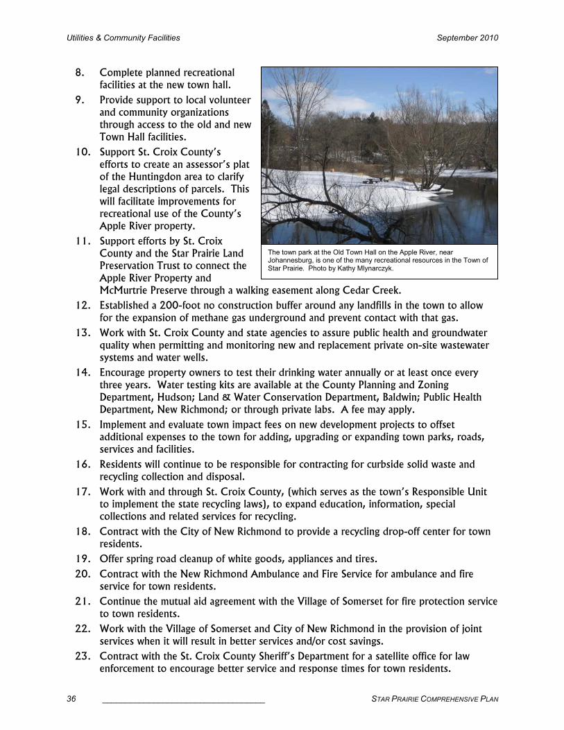
Utilities & Community Facilities September 2010
36 ___________________________________ STAR PRAIRIE COMPREHENSIVE PLAN
8. Complete planned recreational facilities at the new town hall.
9. Provide support to local volunteer and community organizations through access to the old and new
Town Hall facilities.
10. Support St. Croix County’s
efforts to create an assessor’s plat of the Huntingdon area to clarify legal descriptions of parcels. This
will facilitate improvements for recreational use of the County’s Apple River property.
11. Support efforts by St. Croix County and the Star Prairie Land Preservation Trust to connect the
Apple River Property and McMurtrie Preserve through a walking easement along Cedar Creek.
12. Established a 200-foot no construction buffer around any landfills in the town to allow
for the expansion of methane gas underground and prevent contact with that gas.
13. Work with St. Croix County and state agencies to assure public health and groundwater
quality when permitting and monitoring new and replacement private on-site wastewater systems and water wells.
14. Encourage property owners to test their drinking water annually or at least once every
three years. Water testing kits are available at the County Planning and Zoning Department, Hudson; Land & Water Conservation Department, Baldwin; Public Health Department, New Richmond; or through private labs. A fee may apply.
15. Implement and evaluate town impact fees on new development projects to offset additional expenses to the town for adding, upgrading or expanding town parks, roads, services and facilities.
16. Residents will continue to be responsible for contracting for curbside solid waste and recycling collection and disposal.
17. Work with and through St. Croix County, (which serves as the town’s Responsible Unit to implement the state recycling laws), to expand education, information, special collections and related services for recycling.
18. Contract with the City of New Richmond to provide a recycling drop-off center for town residents.
19. Offer spring road cleanup of white goods, appliances and tires.
20. Contract with the New Richmond Ambulance and Fire Service for ambulance and fire service for town residents.
21. Continue the mutual aid agreement with the Village of Somerset for fire protection service
to town residents.
22. Work with the Village of Somerset and City of New Richmond in the provision of joint
services when it will result in better services and/or cost savings.
23. Contract with the St. Croix County Sheriff’s Department for a satellite office for law enforcement to encourage better service and response times for town residents.
The town park at the Old Town Hall on the Apple River, near Johannesburg, is one of the many recreational resources in the Town of Star Prairie. Photo by Kathy Mlynarczyk.

September 2010 Utilities & Community Facilities
STAR PRAIRIE COMPREHENSIVE PLAN ___________________________________ 37
24. Provide public road maintenance, repair and replacement and snow plowing on town roads through contractual services.
25. Consider development, operation and maintenance costs associated with construction or provision of municipal improvements and services usually associated with urban development and manage the financial impact of public expenditures or municipal debt on
town residents from such improvements.
26. Work with the villages of Star Prairie and Somerset and the City of New Richmond to
encourage high density residential, commercial and industrial development requiring a higher level of services to locate in these municipalities. Encourage business types which will benefit all the communities.
27. Encourage conservation design development to provide community facilities and services (e.g., school bus routes, snow removal, police patrol) in a cost-effective manner.
Snowmobile trails provide winter recreational opportunities for Star Prairie residents. Photo by Kathy Mlynarczyk.
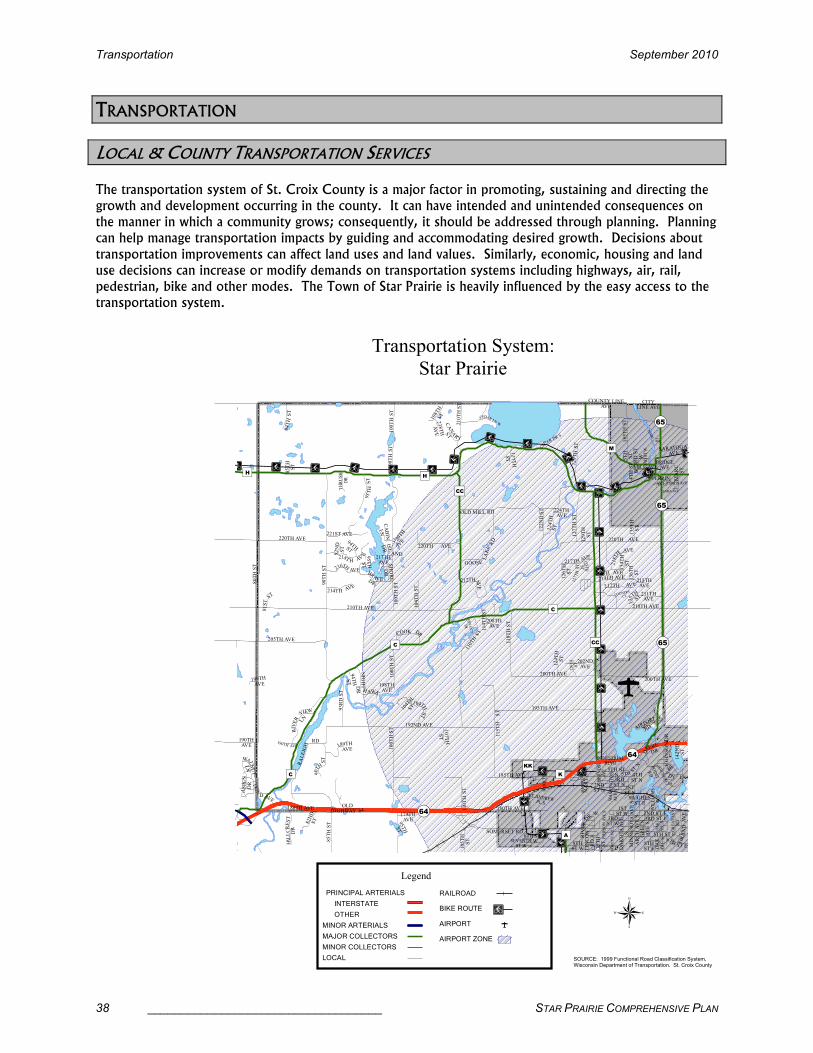
Transportation September 2010
38 ___________________________________ STAR PRAIRIE COMPREHENSIVE PLAN
TRANSPORTATION
LOCAL & COUNTY TRANSPORTATION SERVICES
The transportation system of St. Croix County is a major factor in promoting, sustaining and directing the
growth and development occurring in the county. It can have intended and unintended consequences on
the manner in which a community grows; consequently, it should be addressed through planning. Planning
can help manage transportation impacts by guiding and accommodating desired growth. Decisions about
transportation improvements can affect land uses and land values. Similarly, economic, housing and land
use decisions can increase or modify demands on transportation systems including highways, air, rail,
pedestrian, bike and other modes. The Town of Star Prairie is heavily influenced by the easy access to the
transportation system.
��¾ ��¾
��¾
��¾��¾
��¾
��¾ ��¾
��¾
��¾
��¾
��¾
��¾ ��¾
��¾
� �¾� �¾
� �¾� �¾
� �¾� �¾
� �¾
��¾ ��¾ ��¾ ��¾
100TH ST
GOOSE
LAKE RD
100TH ST
100TH ST
118TH ST
127TH ST
COOK DR
105TH
ST
D
EERE
DR
212TH AVE
1 04TH ST
110TH ST
82ND
ST
RIVER
VIEW
LN
210TH ST
90TH
ST
95TH ST
80TH ST
134TH
ST
90TH ST
124TH
ST
BR
AVE DR
214TH AVE
JOHNSON DR
195TH AVE
129TH ST
185TH ST
93RD ST
NIGHT
HAWK
DR
HILLCREST
DR
COUNTY LINEAVE
216TH
AVE
185TH AVE
214TH AVE
84TH ST
104TH ST
SARATOGA
AVE
211TH AVE
189TH AVE
95TH ST
221ST AVE
200TH AVE
117TH
ST
CABIN
LN
220TH AVE
182N
D AVE
CITYLINE AVE
108TH
ST
122ND ST
190THAVE
200TH AVE
107TH
ST
192ND AVE
SHORE
DR
INDUSTRIALBLVD
THRUSH
DR
210TH AVE
115TH ST
124TH
ST
180TH AVE
ST ANDREW PL S
81ST
ST
ISL
AND
DR
AIRPORT
RD
180TH AVE
135T
H
ST
CANA
RY
ST
CED
AR DR S
GREATON
RD
135TH
ST
CEDAR LN W
92ND
ST 220TH AVE
OLD HIGHWAY 64 W
ILLIAMS
AVE
216
T H AVE
128TH
ST
126TH
ST
142ND
ST
85TH
ST
179THAVE
2 20TH
AVE
224THAVE
210TH AVE
OLD MILL RD
5TH
ST N
94TH ST
199TH
AVE
6TH ST W
95TH ST
220TH AVE
104TH
ST
202NDAVE
127TH ST
PIERSON AVE S
RALEIGH
RD
114TH ST
238TH
AVE
PEARL
AVE
218T
H AVE
198THAVE
94TH
ST
208THAVE
218T H AV
E
MARY AVE
217THAVE
MARC
ST
SHARRON AVE
100TH ST
85TH ST
HUGHESST E
5THST
217TH AVE
2ND ST W
190TH AVE
3RDST W
DAKOTA AVE
S
212TH AV E
3RD ST
W
MILL AVE
4TH ST
W
129TH
ST
COUNTRY
CT
OAK
AVE S
BRA
DY LN
110TH ST
MINNESOTA AVE S
ASPLUND
DR
PERRIN AVE
WALNUT
LN
136TH
ST
PERRINAVE
126TH
ST
100TH ST
RIVER
DR W
3RDST N
ARCH AVE S
NORTH SHORE
DR
POINT
RD
2ND ST E
5TH STN
BRIDGEAVE
LINCON
RD E
8THST E
1STST W
2NDST N
213THAVE
SOMERSET RD
1STST N
SIDE ST
8THST W
BERNDS
AVE
BRIGETTA DR
6TH ST E
SARA AVE
GRAND AVE
4TH ST N
5TH ST E
SEVENTHST W
3RD ST E
OAK
AVE S
ASPEN
DR
GREEN
AVE S
MONETTE AVE
125TH
ST
WASHI NGTON
AVE N
205TH AVE
�)C
�)CC !(65
�)H
!(64
�)CC
!(65
�)K
!(64
�)H
�)M
�)A
�)KK�)C
�)C
!(65
®SOURCE: 1999 Functional Road Classification System, Wisconsin Department of Transportation. St. Croix County
Transportation System:
Star Prairie
Legend
PRINCIPAL ARTERIALS
INTERSTATE
OTHER
MAJOR COLLECTORS
MINOR COLLECTORS
LOCAL
MINOR ARTERIALS
RAILROAD
AIRPORT ZONE
AIRPORT
��¾BIKE ROUTE

September 2010 Transportation
STAR PRAIRIE COMPREHENSIVE PLAN ___________________________________ 39
��¾��¾
��¾��¾
��¾��¾
��¾��¾
��¾��¾
��¾��¾
��¾��¾ ��¾
��¾
��¾��¾
��¾��¾
��¾��¾
��¾
��¾
��¾
��¾
��¾ ��¾
��¾��¾��¾
��¾��¾
��¾
��¾��¾ ��¾
��¾��¾
��¾ ��¾ ��¾
��¾ ��¾��¾ ��¾ ��¾ ��¾ ��¾ ��¾ ��¾
��¾ ��¾ ��¾ ��¾��¾
��¾ ��¾��¾
��¾��¾
��¾��¾
��¾��¾
��¾��¾
��¾��¾
��¾��¾��¾��¾��¾��¾��¾��¾��¾
� �¾
��¾��¾
��¾ ��¾ ��¾ ��¾ ��¾ ��¾ ��¾
��¾
��¾
��¾
��¾��¾
��¾
��¾ ��¾
��¾��¾ ��¾ ��¾ ��¾ ��¾ ��¾
��¾��¾
��¾
��¾
��¾��¾
��¾��¾ ��¾ ��¾
��¾��¾
��¾
��¾ ��¾ ��¾ ��¾
��¾��¾
��¾��¾
��¾ ��¾
��¾ ��¾ ��¾
��¾ ��¾ ��¾
®SOURCE: 1999 Functional Road Classification System, Wisconsin Department of Transportation. St. Croix County
Future Bike System:
Star Prairie
Legend
RAILROAD
��¾BIKE ROUTE
AIRPORT
LOCAL
MINOR COLLECTORS
MAJOR COLLECTORS
MINOR ARTERIALS
PRINCIPAL ARTERIALS
OTHERINTERSTATE
��¾FUTURE OFF ROAD
OR PAVED SHOULDER
BIKE PATH
��¾EXISTING 4' PAVED
SHOULDER

Transportation September 2010
40 ___________________________________ STAR PRAIRIE COMPREHENSIVE PLAN
COOK DR
GOOSE
LAKE
RD
2 16TH
AVE
NIGHTHA
WK DR
127TH ST
HUNTINGTON
DR
212TH AVE
195TH AVEARCH AVE
RIVER'S EDGE DR
100TH
ST
3RD ST
R
IVER DR
N
ORTH
SHO
RE D R
RIVER
VIE
W LA
134TH ST
2ND ST
90TH ST
218TH AV
E
H
ID
DEN LNRALEIGH
RD
WINDIN
G
TRAIL R
D
80TH
ST
110TH
ST
SO
UTH
CED A
R DR
122ND ST
93RD ST
104TH
ST
118TH ST
100TH ST
WALL ST
K1ST ST
4TH ST
DAKOTA
AVE
100TH ST
85TH ST
PIERCE
AVE
PARK
RD
SHORE DR
3RD ST
129TH
ST
124T
H ST
138TH
ST
217T H AVE
PEARL
AVE
4TH ST
JERDEE AVE
5TH ST
214TH AVE
B
RADY LN
PARK AVE
HIGH ST
MARY AVE
JUNIPER DR
JEWELL ST
95TH ST
SARA AVE
1S
T ST
181ST AVE
218T
H
AVE
FAIRFIELD RD
217TH AVE
202ND AVE
GREATON
RD
198TH AVE
220TH AVE
210TH AVE
STARDU SK DR
199
TH
AVE
OLD MILL RD
224TH
AVE
126TH
ST
179TH
AVE
128TH
ST
85TH ST
216TH AVE
108TH
ST
135TH
ST
117TH
ST
SI CA R
D LA
CANAR
Y DR
AARON ST
81ST
ST
PIERSO
N
AVE
124TH ST
185TH AVE
190TH AVE
180TH AVE
205TH AVE
210TH AVE
COUNTY
ROA
D KK
AIRPO
RT
RD
220TH AVE
107TH ST
POL-SAINT CROIX RD
POLK SAINT CROIX RD
192ND AVE
BUSINESS HWY 64
CABIN LA
CARDINAL
DR
200TH AVE
108T
H ST
10
5TH
ST
SHORE DR
THRUSH DR
178TH AVE
HILLCREST
DR
POLK SAINT CROIX RD
211TH AVE
214TH AVE
5TH ST
82ND
ST
84TH ST
189T H AVE
132ND ST
COUNTY LINE AVE
SARATOGA
AVE
�)CC
�)K
�)C
�)H
�)CC
�)C
�)C
�)H
�)M
�)H
�64
�65
�64
�64
�65
®SOURCE: 1999 Functional Road Classification System, Wisconsin Department of Transportation. St. Croix County
Future Transportation System:
Star Prairie
Legend
PRINCIPAL ARTERIALS
INTERSTATE
OTHER
MAJOR COLLECTORS
MINOR COLLECTORS
LOCAL
MINOR ARTERIALS
RAILROAD
AIRPORT ZONE
AIRPORT
FUTURE ROAD

September 2010 Transportation
STAR PRAIRIE COMPREHENSIVE PLAN ___________________________________ 41
TRANSPORTATION GOALS, OBJECTIVES & POLICIES
Goal:Goal:Goal:Goal: Star Prairie’s transportation system should provide for the efficient and safe movement of people and goods; serve the planned land use pattern; minimize negative impacts such as congestion, noise and air pollution and meet the needs of multiple users and
transportation modes.
Objectives:Objectives:Objectives:Objectives:
1. Ensure that transportation system improvements are coordinated with land development desires.
2. Coordinate multi-jurisdictional (town, village, city, county, state) transportation system
improvements and maintenance in the Star Prairie area.
3. Provide for safe and adequate road capacities and road conditions.
4. Support and encourage the development of transportation system improvements for
biking, hiking, and other transportation modes.
5. Preserve the scenic value along certain roadways to protect and enhance the Town of Star Prairie’s rural character.
6. Maintain a cost effective level of service.
7. Continue to support agricultural use of the transportation system.
Policies:Policies:Policies:Policies: 1. Plan and implement an interconnected road system consisting of extensions to existing
roads and new roads to control highway access, provide for appropriate routes for trucks
and emergency vehicles, preserve rural character, serve planned development areas, minimize extensive road construction and decrease road maintenance costs, as shown on the Future Transportation System map above.
2. Work with St. Croix County, Wisconsin Department of Transportation, neighboring towns, landowners and private developers to plan for and limit development and access along State Trunk Highways 64 and 65 to preserve them as throughways and scenic
image corridors.
3. Adopt an official map for the Town of Star Prairie to protect future connecting road
corridors and access, especially for State Highway 64 which is an expressway and will be upgraded to freeway status over the life of this plan.
4. Work with St. Croix County to update and implement Town Road Improvement Programs
(TRIPs) and the Pavement Assessment Surface Evaluation Report (PASER) program to provide for the upgrading and maintenance of town roads.
5. Work, both as a town and with St. Croix County, to properly place and maintain road
signs in the town so that these signs are in compliance with the Federal Manual on Uniform Traffic Control Devices.
6. Implement and enforce the road and driveway ordinance to regulate any change to an
existing driveway or creation of a new driveway and implement town road construction standards
7. Work with the county, state and private landowners in ensuring that road right-of-ways
are clear of visual obstacles, particularly at road intersections. Road right-or-ways should be properly mowed and cleared.
8. Post weight restrictions on existing town roads as necessary and consider the weight limits on local roads when reviewing development proposals.

Transportation September 2010
42 ___________________________________ STAR PRAIRIE COMPREHENSIVE PLAN
9. Discourage large amounts of “side of the road” residential and commercial development on State and County highways and arterial town roads to prevent congestion and preserve
rural character and safety.
10. Encourage bicycle traffic to utilize less traveled town and county roadways.
11. Designate specific town and
county roadways for bicycle traffic and improve
designated bicycle routes with wide, signed shoulders or off-road bike paths,
based on the Future Bike System map shown above. These changes would
provide a coordinated system of bike routes to access the City of New
Richmond, villages of Somerset and Star Prairie and park and school system
serving town residents. It would provide better, safer
connections for residents northwest and southeast of the Apple River.
12. Pursue a bicycle/pedestrian crossing over the Apple River at 185th Street extended and
Raleigh Road and connecting to CTH C.
13. Work with the City of New Richmond and the Multi-Purpose Pathway Committee to coordinate and sign bicycle/pedestrian routes into and out of the City of New Richmond.
14. Notify property owners and developers that development located within three nautical miles of the airport will need to meet height limitations and building construction standards for insulation and sound reduction. These sites may be required to have deed
restrictions acknowledging the airport and its related noise impacts.
15. Require developers to enter into a developers’ agreement and provide a letter of credit to
repair damage to town roads caused by construction traffic.
16. Evaluate and implement town impact fees on new development projects to offset additional expenses to the town for adding, upgrading or expanding town parks, roads,
services and facilities.
17. As new development occurs, discourage new private roads and explore options to make existing private roads public to improve access for emergency services, improve
maintenance and decrease conflicts.
18. Work with St. Croix County to update, as necessary, standards for development of local and county roads to safely serve multiple functions while retaining rural character.
There are numerous scenic roadways in the Town of Star Prairie that are popular for bicyclists, pedestrians and scenic driving. Photo by Kathy Mlynarczyk.

September 2010 Housing
STAR PRAIRIE COMPREHENSIVE PLAN ___________________________________ 43
HOUSING
HOUSING GROWTH PROJECTIONS
Persons Per Housing Unit Persons Per Housing Unit Persons Per Housing Unit Persons Per Housing Unit –––– 2000 to 2030 2000 to 2030 2000 to 2030 2000 to 2030 Town of Star Prairie & Neighboring TownsTown of Star Prairie & Neighboring TownsTown of Star Prairie & Neighboring TownsTown of Star Prairie & Neighboring Towns
PROJECTIONS TOWN 2000
2010 2015 2020 2025 2030**
Star Prairie 2.82 2.74 2.68 2.64 2.61 2.58
Richmond 2.95 2.86 2.81 2.76 2.73 2.69
Somerset 2.85 2.76 2.71 2.67 2.64 2.60
Stanton 2.85 2.76 2.71 2.67 2.64 2.60
St. Croix County 2.66 2.58 2.53 2.49 2.46 2.43 Source: U.S. Census Bureau and Wisconsin Department of Administration ** Unofficial Numbers
2.25
2.50
2.75
3.00
2000 2010 2015 2020 2025 2030Year
Average Persons
Star Prairie Richmond Somerset/Stanton St. Croix County
• The number of persons per housing unit has been declining since the 1980s. That trend is
expected to continue and is reflected in the declining rates for Star Prairie and the surrounding
municipalities.
• The decline is a result of smaller families with fewer children, more households with no children,
more single households and elderly people living longer and remaining in their own homes longer.
• Star Prairie’s persons per housing unit rate is lower than the surrounding towns. This reflects the
greater variety of housing choices available in the town and the diversity of its population.
• As population per housing unit continues to decline the town should evaluate its affect on
provision of services such as road maintenance, school busing, access to health services, services
for the elderly, etc.

Housing September 2010
44 ___________________________________ STAR PRAIRIE COMPREHENSIVE PLAN
Housing Growth Estimates Housing Growth Estimates Housing Growth Estimates Housing Growth Estimates –––– 2000 to 2000 to 2000 to 2000 to 2002002002006666 Town of Town of Town of Town of Star Prairie & Neighboring TowStar Prairie & Neighboring TowStar Prairie & Neighboring TowStar Prairie & Neighboring Townsnsnsns
ESTIMATED ADDITIONAL UNITS TOWN 2000
01-02 03-04 05-06 TOTAL
10-YR AVERAGE
Star Prairie 1079 109 116 57 1361 47
Richmond 530 178 222 146 1076 63
Somerset 963 167 168 89 1387 61
Stanton 363 6 4 5 378 3
All Towns in St. Croix County 11,443 1280 1410 869 15,002 529 Source: U.S. Census Bureau 2000 Summary File 1 and St. Croix County Planning & Zoning Department
• Housing growth in Star Prairie remained fairly constant from 1998 through 2004, with about 50
new units each year. The highest number was around 65 units in 2003.
• However, housing growth in 2005 and 2006 dropped dramatically with about 40 new units in
2005 and about 20 in 2006. The recent downward trend reflects the slowing of the housing
market and the economy nationwide.
Housing Unit PHousing Unit PHousing Unit PHousing Unit Projections rojections rojections rojections –––– 2000 2000 2000 2000 to to to to 2025202520252025 Town of Town of Town of Town of StStStStar Prairie ar Prairie ar Prairie ar Prairie & Neighboring Communities& Neighboring Communities& Neighboring Communities& Neighboring Communities
CENSUS PROJECTIONS PERCENT CHANGE COMMUNITY
2000 2010 2015 2020 2025 00-10 10-15 15-20 20-25
Star Prairie 1079 1381 1555 1729 1863 28.0 12.6 11.2 7.8
Richmond 530 709 796 883 951 33.8 12.3 10.9 7.7
Somerset 963 1255 1408 1561 1683 30.3 12.2 10.9 7.8
Stanton 363 367 371 375 372 1.1 1.1 1.1 -0.8
C. New Richmond 2657 3225 3520 3817 4028 21.4 9.1 8.4 5.5
V. of Somerset 659 937 1081 1226 1346 42.2 15.4 13.4 9.8
V. of Star Prairie 215 278 308 339 363 29.3 10.8 10.1 7.1
St. Croix County 24,265 30,814 34,222 37,655 40,269 27.0 11.1 10.0 6.9
Source: U.S. Census Bureau 1970-2000 Summary File 1 and Wisconsin Department of Administration.
• The housing projections provided by the Wisconsin Department of Administration (WDOA) are
based on historic growth trends in each of the municipalities and are heavily weighted towards the
most recent decade.
• Despite the recent downturn in the housing market, the Town of Star Prairie’s estimated housing
units are almost at the WDOA’s estimate for 2010. Star Prairie’s growth is likely to exceed the
WDOA’s projections.
• The same is true for the towns of Richmond and Somerset, which have already exceeded the
WDOA’s projections.
• The towns of Star Prairie, Somerset and Richmond will likely experience similar rates of growth
regardless of how much numeric growth occurs.

September 2010 Housing
STAR PRAIRIE COMPREHENSIVE PLAN ___________________________________ 45
Housing Unit Projections
0
500
1000
1500
2000
2500
3000
3500
4000
4500
2000 2010 2015 2020 2025Year
Housing Units
Star Prairie Richmond Somerset Stanton
New Richmond V. Somerset V. Star Prairie

Housing September 2010
46 ___________________________________ STAR PRAIRIE COMPREHENSIVE PLAN
HOUSING GOALS, OBJECTIVES & POLICIES
Goal:Goal:Goal:Goal: Safe, quality housing for all Town of Star Prairie residents while maintaining a predominantly rural residential character.
Objectives: Objectives: Objectives: Objectives:
1. All housing should be located and sited to enhance and maintain rural character.
2. All housing should be well designed and properly maintained.
3. Encourage high quality construction standards for housing.
4. Encourage owners to maintain or rehabilitate the existing housing stock.
5. Encourage housing sites in the town that meet the needs of persons within a variety of
income levels, age groups, and special needs.
6. Support new developments that are primarily single-family homes or two-family homes.
7. Support a limited number of dwelling units with three or four units in a structure in
conjunction with conservation design development.
8. Multi-family or multi-unit dwelling housing and additional mobile home parks are not compatible with the rural character of the town, except in those areas identified as the
Boundary Agreement Area. Multi-family, multi-unit dwelling housing or a mobile home park is defined as five or more units in a structure or on a lot.
9. Ensure that home sites are safe from seasonal flooding or ponding.
Policies:Policies:Policies:Policies: 1. Plan for a sufficient supply of developable land for housing in areas consistent with town
policies and of densities and types consistent with this plan.
2. To ensure high quality construction, require all housing construction to comply with the State of Wisconsin Uniform Dwelling Code.
3. The town may participate in and support programs and funding sources such as the Community Development Block Grant (CDBG), that provide assistance to residents in maintaining and rehabilitating the housing stock.
4. Update land use regulations to guide the location of future residential development and protect important features of the natural environment without making existing houses
nonconforming whenever possible.
5. Work with St. Croix County to maintain property to ensure a high-quality living environment within all residential areas and to address violations of applicable land use
ordinances on residential, commercial or industrial properties.
6. Work with St. Croix County to update the County’s and the town’s land use regulations to require that relocated houses and new manufactured houses are sited on freestanding,
separate parcels; are placed on permanent foundations; and are brought into compliance with the Uniform Dwelling Code to provide safe, quality housing.

September 2010 Housing
STAR PRAIRIE COMPREHENSIVE PLAN ___________________________________ 47
7. Work to update county and/or town land use ordinances to require standards for manufactured or mobile homes such as: a minimum width and living space area for each
unit and/or a roof on each unit with at least a 3:12
pitch.
8. Encourage
residents and mobile home park owners to ensure
the safety of residents by anchoring mobile
home units to frost-free foundations.
9. Coordinate with St. Croix County to pursue grant
funding for anchoring older
mobile or manufactured homes.
10. Additional mobile home parks or multi-family or
multi-unit dwellings do not fit the rural
character of the Town of Star Prairie and should not be developed, except in the Boundary Agreement Area as designated on the Future Land Use Map. See Future Land
Use section, page 235.
11. Promote conservation design development to preserve the rural character of the community to enable rural residential development and provide services in a cost-effective
manner.
12. Encourage home site design that achieves rural character and farmland preservation objectives and ensures that home sites are safe from seasonal flooding or ponding.
13. Guide development away from hydric and alluvial soils, which are formed under conditions of saturation, flooding or ponding.
14. The maximum gross density for development shall depend on the location of the
development. The gross density may not be the minimum lot size in all cases. In conservation design development the minimum lot size shall be ½ acre per dwelling unit,
with a two-acre gross density. Two-acre density for conventional development and one-acre density for development in the Boundary Agreement Area as designated on the Future Land Use Map. See Future Land Use section, page 235.
15. Explore options to provide senior housing opportunities in the Boundary Agreement Area, as designated on the Future Land Use Map, at densities greater than one single-
Property maintenance issues are a high priority in the Town of Star Prairie. Photos by Kathy Mlynarczyk.

Housing September 2010
48 ___________________________________ STAR PRAIRIE COMPREHENSIVE PLAN
family unit per acre and more than four attached, single-family units. See Future Land Use section, page 235.
16. Notify property owners and developers that development located within three nautical miles of the airport will need to meet height limitations and building construction standards for insulation and sound reduction. These sites may be required to have deed
restrictions acknowledging the airport and its related noise impacts.
17. Work with St. Croix County
to improve or expand St. Croix County Zoning Ordinance regulations
regarding property maintenance and nuisance issues such as junk vehicles
and dilapidated buildings.
18. Work with St. Croix County to expand the St. Croix
County Animal Waste and the Zoning ordinances to regulate large-scale farms
near existing residences.
Junk vehicles are also an important issue in the Town of Star Prairie. Photos by Kathy Mlynarczyk.

September 2010 Economic Development
STAR PRAIRIE COMPREHENSIVE PLAN ___________________________________ 49
ECONOMIC DEVELOPMENT
The economy of a community can be an important determining factor driving land use and development.
The incomes of Town of Star Prairie residents are directly related to employment and other economic
opportunities, and employment is dependent on the local, county and regional economies. Property values
and taxation rates can reveal economic trends and relative differences between communities.
TYPES OF LOCAL EMPLOYMENT
Commercial/Industrial Operations & Employment Commercial/Industrial Operations & Employment Commercial/Industrial Operations & Employment Commercial/Industrial Operations & Employment -------- 2002002002007777 Town of Town of Town of Town of Star PrairieStar PrairieStar PrairieStar Prairie
BUSINESS ESTIMATED EMPLOYMENT PRODUCT
Apostle Septic Service 2 Septic Systems
B&E Welding 2-3 Welding Supply
Bristol Ridge Golf Course Recreation & Food Service
Cedar Creek Inn 3 full-time, 7 part-time Food Service
Cedar Lake Speedway 5 year-round, 50 seasonal Car Racing
Chuck Nutzmann & Sons 4 Excavation
Eagle Storage 1 Storage Units
Flandrick Tree Nursery 1-5 Nursery
Garden Expressions 1-2 Greenhouse
Gary’s Scrap Metal 1-4 Recycling Metals
Highway 65 Storage 1 Storage Units
Jackelen’s Landing 1-2 Private Boat Landing
Kirk’s Auto Body 3 Auto Body Repair
LaVigne Leather, 1502 CTH C 1-4 Leather & Leather Products
Meister’s 6-10 Restaurant & Bar
Mondor Excavation 4 Excavating & Septic
Outpost Bar & Grill 5 full-time, 15 part-time Restaurant & Bar
Oswald’s Tractor Repair 1-2 Tractor Repair
Power’s Septic 2 Septic Systems
Raboin’s Auto Repair 3 Auto Body Repair
Riverbend Picture & Framing 1 Custom Framing
River’s Edge 14-18 full-time,
35-40 full-time seasonal, 20-25 part-time seasonal
Restaurant, Campground & Tubing
Rosebud 1 Ceramics, Cakes
S&S Coating 55-99 Teflon finishing & Coating
Sandbox Inc. Indoor Motocross Racing
St. Croix Harley Davidson 20-30 Motorcycle Sales, Service & Retail
The Patch 2 full-time, 10-15 full-time seasonal Strawberries
Tom Kunz & Borgstrom 2-3 HVAC Services
T-N-T Metals 1-2 Welding
Valley Custom Oak 3 Cabinetry
Xcel Energy 1-2 part-time Power Dam
Total 220 full-time,
Source: Star Prairie Plan Commission Members

Economic Development September 2010
50 ___________________________________ STAR PRAIRIE COMPREHENSIVE PLAN
ECONOMIC DEVELOPMENT GOALS, OBJECTIVES & POLICIES
Goal:Goal:Goal:Goal: The Town of Star Prairie will support economic development activities appropriate to the resources, character and service levels of the town and that strengthen the local economy while maintaining its commitment to the town’s environmental needs. Large-
scale industrial and commercial development should be directed to St. Croix County’s urban centers. Rural economic development should promote alternative agricultural and
forestry-based opportunities and industrial and commercial development with minimal infrastructure needs.
Objectives:Objectives:Objectives:Objectives:
1. Identify locations for future environmentally-friendly businesses to locate within the Town.
2. Encourage the redevelopment and reuse of the town’s existing commercial sites.
3. Retain and help grow existing farms and businesses.
4. Support home-based businesses where there will be little impact on surrounding properties.
5. Plan for an adequate supply of developable land for commercial and industrial uses in logical areas consistent with the town’s plan elements.
6. Consider the conservation of non-renewable resources and the rural character when evaluating a commercial development request.
7. Support economic development efforts for farming and farm-related businesses.
8. Prevent unplanned commercial development along major roadways.
Policies:Policies:Policies:Policies: 1. Support the continued
operation and/or expansion of existing farms and businesses in Star
Prairie.
2. Support the economic
health of alternative agriculture in the Town of Star Prairie.
3. Support fruit, vegetable and tree farms and greenhouses in the town,
designed to supply food to local farmers markets and grocery stores in the area.
4. Discourage factory-type, large-scale farms such as confinement hog, poultry and others that have the potential to degrade the air quality, water quality and current character of the town.
5. Work with the villages of Star Prairie and Somerset and the City of New Richmond to encourage high density residential, commercial and industrial development requiring a
higher level of services to locate in these municipalities. Encourage business types which will benefit all the communities.
Star Prairie has many small businesses that serve the community. Photo by Kathy Mlynarczyk.

September 2010 Economic Development
STAR PRAIRIE COMPREHENSIVE PLAN ___________________________________ 51
6. Direct new commercial and industrial development to those areas identified in the land use section of this comprehensive plan.
7. New commercial activities should be located in a node at the intersection of 110th Street and STH 64 and along STH 65 near the New Richmond airport.
8. Work with St. Croix Economic Development Corporation to assist in locating potential
new businesses.
9. Promote higher quality development and minimize the negative impacts of commercial and
industrial development in the Town through the use of restrictive covenants, zoning restrictions and design standards.
10. The Town should consider developing a site plan review process to identify minimum
standards for commercial and industrial sites. These could include all commercial and industrial development in the Town but flexibility should be allowed to address the concerns of existing businesses. The Town should encourage St. Croix County to adopt
similar requirements/regulations.
11. Commercial and industrial site plans should include parking preferably behind buildings and parking lot landscaping standards, including landscaped islands or rain gardens within
large parking lots that break up the expanse of asphalt.
12. Business signage, landscaping, screening and
lighting should be compatible with the rural
character of Star Prairie.
13. Lighting should be shielded and downward directed
with no spillover onto neighboring properties and should have specific
illumination timeframes to maintain dark skies.
14. Landscaping and screening
should include visual screening standards and
setback buffers between residential and industrial or
commercial land uses.
15. Work with businesses to maintain and protect the air quality, water quality and rural character of Star Prairie.
16. Require the disclosure of any soil or groundwater contamination on sites before approving
development proposals.
17. Work together with private landowners and government agencies to clean up contaminated sites that threaten the public health, safety and welfare.
18. Ensure that commercial and industrial activities are not located within Environmentally Sensitive Areas by placing environmentally sensitive areas in conservancy zoning. When
necessary, environmentally sensitive features should be included in the design of business developments as integral amenities and maintained in common ownership.
19. Commercial and industrial development should be designed with consideration of the
parkways that this plan identifies along the Town’s primary drainage corridors, which
A site plan review process would improve the design and layout of commercial operations in the town. Photo by Kathy Mlynarczyk.

Economic Development September 2010
52 ___________________________________ STAR PRAIRIE COMPREHENSIVE PLAN
include the Apple River, Willow River, Cedar Creek, Squaw Lake, Cedar Lake, Strand Lake and Hatfield Lake. These parkways would allow the corridors to remain mostly
undeveloped as wildlife corridors, contribute to preserving the Town’s rural atmosphere, provide stormwater management areas and provide potential trail linkages to the rest of the Town. Where appropriate, the Town should require the dedication of land for trails
or parks before approving development proposals.
20. Work with St. Croix County to permit home-based businesses where there will be little
impact on surrounding properties.
Home-based businesses should not detract from the rural atmosphere of the Town. Photo by Kathy Mlynarczyk.

September 2010 Agriculture
STAR PRAIRIE COMPREHENSIVE PLAN ___________________________________ 53
AGRICULTURAL RESOURCES
There are many different aspects of agriculture which could be evaluated as part of a discussion of this
resource, farming practices, economic impacts, rural interaction, and aesthetics just to name a few.
However, in evaluating those which can be influenced by local decision-makers it becomes immediately
apparent that state and national policies have more impact on the future of agriculture than local land-use
decisions. In spite of state and national influences, agriculture is still very important at the local level,
whether as a “way of life,” due to job impact, as a tax base or because of the aesthetic values of the rural
scene.
AGRICULTURAL LANDS
Prime farmland is the land that is best suited to food, feed, forage, fiber and oilseed crops. It may be
cultivated land, pasture, woodland or other land, but it is not existing urban and built-up land, or water
areas. The soil qualities, growing season and moisture supply are factors needed for a well-managed soil to
produce a sustained high-yield of crops in an economic manner. Prime farmland produces the highest
yields with minimal inputs of energy and economic resources, and farming it results in the least damage to
the environment. Historically, soils that fall into classes I, II, and III of the Soil Conservation Service's
capability unit classification system are considered prime agricultural lands. The value of these lands for
agriculture is associated with not only their soil class, but also with their size, present use and any
regulatory framework for their protection.
SSSSUITABILITY FOR UITABILITY FOR UITABILITY FOR UITABILITY FOR AAAAGRICULTUREGRICULTUREGRICULTUREGRICULTURE
The United States Department of Agriculture (USDA) Natural Resource Conservation Service (NRCS) in
establishing a uniform, national identification of productive farmlands created a soil classification system
that categorizes soils by their relative agricultural productivity. There are two categories of highly
productive soils, national prime farmland and farmland of statewide significance. National prime farmland
is well suited for the production of food, feed, forage, fiber and oilseed crops, and has the soil qualities,
available moisture and growing season required to produce economically sustained high yields of crops
when properly managed. Farmland of statewide significance are those lands in addition to national prime
farmland which are of statewide importance for the production of food, feed, forage, fiber and oilseed
crops. Soils that fall into classes I, II, and III of the Natural Resources Conservation Service's capability unit
classification system are considered prime agricultural lands.
In 1981, NRCS developed a new system for evaluating agricultural lands, “Land Evaluation and Site
Assessment,” (LESA) which uses more detailed considerations of soil capability and potential yields, and
provides for the assessment of factors beyond soil productivity in the determination of agricultural
potential. The system is now widely used throughout the U.S. The LESA system presents the opportunity
to define agricultural lands that have the most productive potential.
LLLLAND AND AND AND EEEEVALUATION AND VALUATION AND VALUATION AND VALUATION AND SSSSITE ITE ITE ITE AAAASSESSMENT FOR SSESSMENT FOR SSESSMENT FOR SSESSMENT FOR AAAAGRICULTUREGRICULTUREGRICULTUREGRICULTURE
The Land Evaluation and Site Assessment (LESA) system is a point-based approach that is generally used
for rating the relative value of agricultural land resources. In basic terms, a given LESA model is created by
defining and measuring two separate sets of factors. The first set, Land EvaluationLand EvaluationLand EvaluationLand Evaluation, includes factors that
measure the inherent soil-based qualities of land as they relate to agricultural suitability. The second set,
Site AssessmentSite AssessmentSite AssessmentSite Assessment, includes factors that are intended to measure social, economic and geographic attributes
that also contribute to the overall value of agricultural land. While this dual rating approach is common to
all LESA models, the individual land evaluation and site assessment factors that are ultimately utilized and
measured can vary considerably, and can be selected to meet the local or regional needs and conditions a
LESA model is designed to address. The LESA methodology lends itself well to adaptation and
customization in individual states and localities. Also in addition to ranking soils for agricultural potential,
the LESA system can provide a systematic and objective way to evaluate and numerically rank soils for their
relative value for any specific use.

Agriculture September 2010
54 ___________________________________ STAR PRAIRIE COMPREHENSIVE PLAN
The Land Evaluation and Site Assessment (LESA) system is an analytical tool used to assist decision makers
in comparing agricultural sites based on their agricultural value. The LESA system provides an objective and
consistent tool to aid decision-makers in evaluating the relative importance of specific sites for continued
agricultural use. In this sense, it is a tool for determining the best use of a site. While in some cases the
best use may be some type of development, there are many other situations where the best use is to remain
in agriculture. Also, there may be instances where the land is not suitable for agriculture, but neither is it a
suitable location for development. In such situations the LESA system is a valuable tool for determining
the use with the least detrimental impact to the environment, economy and aesthetics.
As noted earlier, there are two components to the LESA system; the Land EvaluationLand EvaluationLand EvaluationLand Evaluation (LE) portion of the
system, which is based on soils and their characteristics, and the Site Assessment Site Assessment Site Assessment Site Assessment (SA) portion of the
system, which rates other attributes affecting a site's relative importance for agricultural use. The Land
Evaluation portion is stable and unchanging because the soils do not change and the data relative to those
soils takes a long time to accumulate. The Site Assessment is dynamic and changes on a continual basis
because there are regular changes in development, property ownership, roadway improvements, sewer
expansions, etc. happening throughout an area.
A LESA system was developed for St. Croix County by a committee consisting of members of the Land and
Water Conservation and Planning and Zoning committees; citizens; town officials; county staff from the
Land and Water Conservation, Zoning and Planning departments; and NRCS staff. A detailed manual
describing how the County’s LESA system works and how it was developed is available from the St. Croix
County Land Conservation Department. As an appropriate base of information for the agricultural
productivity of land in the Town of Star Prairie only the Land Evaluation component of LESA is discussed
here.
Many physical and chemical soil properties are considered in the LE rating, either directly or indirectly,
including soil texture and rock fragments, slope, wetness and flooding, soil erodibility, climate, available
water capacity, pH (alkalinity versus acidity), and permeability. Three soil property indexes are combined
to produce the LE soil component rating, Productivity Index for corn and alfalfa, Land Capability Class and
National Prime Farmland. This produces a rating that reflects the most important soil considerations for
agricultural use in St. Croix County. Higher numbers mean greater value for agriculture. LE ratings reflect
this productivity potential, as well as the economic and environmental costs of producing a crop. Possible
LE ratings range from 0 to 100.
The LESA Committee with assistance from the St. Croix County Land Conservation Department and the
District NRCS Soil Scientist selected soils with a score of 50 or more as the soils with agricultural
production potential. The Potentially Productive Agriculture Map of the Physical Features map series
depicts the LESA Agricultural Soils with a score of 50 or more. Please see the map below.
The LESA system is very flexible. It could be adapted to fit the needs of decision-makers at the local level.
Procedures, and information on developing entire LESA systems, are in guidebooks, manuals and other
literature, which are available from the NRCS. Local decision-makers can use the guidance to develop a
LESA system, which evaluates land, based on local objectives for preservation and management. The Town
of Star Prairie may want to address potential application of the LESA system in its goals, objectives and
policies and may want to explore and evaluate its potential use within the town as part of the
implementation section.

September 2010 Agriculture
STAR PRAIRIE COMPREHENSIVE PLAN ___________________________________ 55
GOOSE LAKE RD
118TH ST
127TH
ST
CO
OK DR
212
T H
AVE
1
04TH
ST
110TH
ST
RIVER
VIEW
LN
210TH
ST
90T
H
ST
80TH
ST
PLUM
TREE LN
124TH
ST
B
RAVE
DR
RIVER
DR E
214TH AVE
195TH AVE
129TH
ST 185TH
ST
93RD
ST
NIGHTHAWK
DR
COUNTY LINE AVE
185TH AVE
132ND
ST
214TH AVE
84TH
ST
211TH AVE
95TH
ST
117TH
ST
CABIN
LN
CITYLINE AVE
108TH ST
122ND
ST
200TH AVE
107TH
ST
192ND AVE
SHORE
DR
CAR DINAL
D R
INDUSTRIALBLVD
THRUSH
DR
115TH
ST
ST ANDREW PL S
81ST
ST
AIRPO
RT
RD
MICHAEL L
N
180TH AVE
SARATOGA
AVE
135T
H ST
210TH AVE
OLD HIGHWAY 64
85TH
ST
224THAVE
OLD MILL RD
82ND
ST
220TH AVE
210TH AVE
220TH AVE
205TH AVE
202ND AVE
RALEIGH
RD
114THST
238TH
AVE
PEA
R L
AVE
198THAVE
94TH ST
218 TH
AV
E
PARK ST
PARK AV
E S
217TH AVE
190TH AVE
2ND ST W
MILL AVE
FAYE ST
ASPLU
ND
DR
100TH
ST
3RD ST N
NORTH
SHORE DR
5TH ST N
1ST ST W
2ND ST N
213THAVE
9
5TH ST
4TH ST N
�)C
�)CC
�)H
!(64
�)CC
�)K
!(64
�)M
!(65�)KK
�)C
!(65
®0.5 0 0.5 1
MilesSOURCE: NRCS AND ST. CROIX COUNTY LESA
LESA
Score > 50
Potentially Productive Agriculture Land
TOWN OF STAR PRAIRIE

Agriculture September 2010
56 ___________________________________ STAR PRAIRIE COMPREHENSIVE PLAN
WORKING LANDS INITIATIVE
The Wisconsin Working Lands Initiative was passed as a part of the state’s 2009-2011 biennial budget
process. The initiative can be found primarily in Chapter 91 of the Wisconsin State Statutes. The goals of
the initiative is to achieve preservation of areas significant for current and future agricultural uses through
successful implementation of these components:
• Expand and modernize the state’s existing farmland preservation program.
• Establish agricultural enterprise areas (AEAs)
• Develop a purchase of agricultural conservation easement matching grant program (PACE).
Expand And Modernize The State’s Existing Farmland Preservation ProgramExpand And Modernize The State’s Existing Farmland Preservation ProgramExpand And Modernize The State’s Existing Farmland Preservation ProgramExpand And Modernize The State’s Existing Farmland Preservation Program
• Modernize county farmland preservation plans to meet current challenges
• Provide planning grants to reimburse counties for farmland preservation planning
• Establish new minimum zoning standards to increase local flexibility and reduce land use conflicts; local
governments may apply more stringent standards
• Increase income tax credits for program participants
• Improve consistency between local plans and ordinances
• Simplify the certification process and streamline state oversight
• Ensure compliance with state soil and water conservation standards
• Collect a flat per acre conversion fee when land under farmland preservation zoning is re-zoned for
other uses
Establish AgEstablish AgEstablish AgEstablish Agricultural Enterprise Areasricultural Enterprise Areasricultural Enterprise Areasricultural Enterprise Areas
• Maintain large areas of contiguous land primarily in agricultural use and reduce land use conflicts
• Encourage farmers and local governments to invest in agriculture
• Provide an opportunity to enter into farmland preservation agreements to claim income tax credits
• Encourage compliance with state soil and water conservation standards
Develop A Purchase Of Agricultural Conservation Easement (Pace) Grant ProgramDevelop A Purchase Of Agricultural Conservation Easement (Pace) Grant ProgramDevelop A Purchase Of Agricultural Conservation Easement (Pace) Grant ProgramDevelop A Purchase Of Agricultural Conservation Easement (Pace) Grant Program
• Protect farmland through voluntary programs to purchase agricultural conservation easements
• Provide up to $12 million in state grant funds in the form of matching grants to local governments and
non-profit conservation organizations to purchase agricultural conservation easements from willing
sellers
• Stretch state dollars by requiring grants to be matched by other funds such as federal grants, local
contributions and/or private donations
• Establish a council to advise the state on pending grants and proposed easement purchases
• Consider the value of the proposed easement for preservation of agricultural productivity, conservation
of agricultural resources, ability to protect or enhance waters of the state, and proximity to other
protected land
• Ensure consistency of state-funded easement purchases with local plans and ordinances
The Working Lands Initiative is still in the development stage. Up-to- date information is available from
the State’s website: http://www.datcp.state.wi.us/workinglands/index.jsp.

September 2010 Agriculture
STAR PRAIRIE COMPREHENSIVE PLAN ___________________________________ 57
FARMLAND PRESERVATION & EXCLUSIVE AG ZONING
This section would not be complete without a discussion of farmland preservation and exclusive agriculture
zoning in St. Croix County. In 1980 the St. Croix County Board of Supervisors adopted a Farmland
Preservation Plan. The Plan was intended to guide development away from the most valuable agricultural
resources in the County. The plan was written with extensive input from citizens and local officials,
especially towns. The Farmland Preservation plan identified several tools for farmland protection. The
only tool that was implemented was exclusive agriculture zoning. The other tools, identifying growth areas
and setting development density in conjunction with smaller lot sizes, were not accepted. The plan was
developed between 1978 and 1980 as a result of development pressures that had been accelerating since
1975. A Farmland Planning Advisory Committee was formed in September 1977. This committee met
monthly for two years to apply for a grant, and develop the farmland preservation plan.
It is interesting that 25 years ago citizens were concerned with the same issues that are discussed today.
The following are quotes from the Farmland Preservation Plan that illustrate some of the discussions and
conclusions.
“Alarmed by rapid changes in the landscape, residents have expressed concern for controlling
development.”
“The survey results confirm popular support for land use planning to preserve farmlands.”
“Development in rural areas has resulted in repeated conflicts between farm and nonfarm neighbors—
complaints by nonfarm residents about odor and noise, increased valuations on farmland which can’t be
offset by increased production, dogs running loose bothering livestock—to name a few.”
“A farming area can comfortably withstand a certain amount of development. However, when the
balance shifts away from agriculture, farmers left in the area often lose the alternative to continue farming.
Farm service businesses move out of local communities and farmers find themselves having to drive several
miles to replace parts, repair machinery and obtain supplies.”
“There are also social and environmental costs of rural nonfarm development.”
“From an environmental standpoint, land, once developed, is essentially lost forever to agriculture.
Land being a finite resource, wise stewardship would dictate that the most productive land be saved to
produce food for this and future generations.”
“In St. Croix County, there is still time to take measures to protect land and guarantee an agricultural
community for future generations.”
“Throughout the last five years (from 1975 to 1980) citizen interest has been the key moving force
behind the concern over loss of farmland, and the planning process.”
“The entire farmland preservation issue was initiated by citizens. Citizens have fostered measures to
preserve agricultural land through the Task Force and the Advisory Committee.”
“There are many hard questions to be answered. The public good must be weighed against the
presumed right of owners to use the land however they, as individuals, see fit.”
In a review of the community input from that time, it is clear that a substantial majority of rural residents
supported protection of agricultural resources. Prior to 1974, St. Croix County ordinances required
public sewer and water for all lots between one and five acres in size. In 1974, the County enacted a new
set of ordinances that allowed one acre unsewered lots and set distinct requirements for minor and major
subdivisions. As a result of these changes rural residential lot creation rose dramatically between 1975
and 1979. As a result, many towns took several steps to slow residential development.
The towns of Baldwin, Cylon, Kinnickinnic, Stanton and Warren adopted subdivision ordinances
prohibiting major subdivisions unless they were located on municipal sewer and water. The towns of
Cylon, Stanton, Baldwin and Pleasant Valley also adopted larger lot size provisions in their subdivision
ordinances. Finally, the towns of Cylon, Stanton, Star Prairie, Somerset, St. Joseph, Erin Prairie, Baldwin,
Troy, Pleasant Valley, Rush River and Eau Galle towns implemented exclusive agricultural zoning, in
conjunction with the County. In one case the adoption of exclusive agriculture zoning occurred even
before the Farmland Preservation Plan was adopted by St. Croix County. The Town of Star Prairie’s
exclusive agriculture zoning was adopted on November 12, 1986.

Agriculture September 2010
58 ___________________________________ STAR PRAIRIE COMPREHENSIVE PLAN
Historically there has been some confusion about the difference between exclusive agricultural zoning,
farmland preservation contracts and the income tax incentive associated with each. The farmland
preservation contracts are a contract between the farmer or landowner and the state, in return for agreeing
not to develop his land the owner gets tax rebates based on a formula. The tax rebates are increased if a
farmland preservation plan is adopted and certified by the state.
The farmland preservation
plan was certified by the
state for most of the towns
in St. Croix County,
including the Town of Star
Prairie. Under the
contract, the landowner can
not get 100 percent of the
formula, he can only get 50
or 70 percent.
Exclusive agriculture zoning
is also based on the
farmland preservation plan,
it is adopted by ordinance
enacted by both the town
and county. With exclusive
agriculture zoning a
landowner may receive tax
rebates at 100 percent of
the formula. The chart at
right shows the amount of
land in exclusive
agricultural zoning in Star
Prairie and the other towns
in St. Croix County.
Acres in Exclusive Ag Zoning Acres in Exclusive Ag Zoning Acres in Exclusive Ag Zoning Acres in Exclusive Ag Zoning -------- 2009 2009 2009 2009 St. Croix CountySt. Croix CountySt. Croix CountySt. Croix County
EXCLUSIVE AGRICULTURE AG RESIDENTIAL TOWN
ACRES % OF TOWN ACRES % OF TOWN
Baldwin 14,827 71.8% 5,257 25.5%
Cady 0 0.0% 0 0.0%
Cylon 14,641 63.1% 4,855 20.9%
Eau Galle 4,958 23.6% 15,687 74.8%
Emerald 0 0.0% 22,385 100.0%
Erin Prairie 19,806 86.9% 2,231 9.8%
Forest 0 0.0% 0 0.0%
Glenwood 0 0.0% 21,985 93.2%
Hammond 0 0.0% 20,943 98.9%
Hudson 0 0.0% 10,969 68.2%
Kinnickinnic 0 0.0% 22,070 98.2%
Pleasant Valley 8,718 75.6% 2,615 22.7%
Richmond 0 0.0% 19,249 93.2%
Rush River 9,254 81.3% 1,462 12.8%
Somerset 4,922 15.8% 25,270 81.4%
Springfield 0 0.0% 21,252 96.8%
Stanton 17,919 84.3% 1,196 5.6%
Star Prairie 3,547 17.5% 16,375 80.9%
St. Joseph 1,821 8.2% 18,405 83.3%
Troy 10,899 45.9% 12,598 53.1%
Warren 0 0.0% 21,332 96.2%
St. Croix County 111,782 25.0% 266,260 59.6%
Source: St. Croix County Planning & Zoning 2009

September 2010 Agriculture
STAR PRAIRIE COMPREHENSIVE PLAN ___________________________________ 59
AGRICULTURE GOALS, OBJECTIVES & POLICIES
Goal:Goal:Goal:Goal: Preserve the town’s agricultural character while allowing residential development. Protect high quality agricultural resources and farming as an occupation in the Town of Star Prairie.
Objectives:Objectives:Objectives:Objectives: 1. Allow development in locations, forms and densities, which supports the preservation of
agriculture and rural character.
2. Preserve highly productive farmlands for continued agricultural use.
3. Encourage land preservation programs.
4. Discourage land uses that conflict with agriculture.
5. Encourage traditional and nontraditional farming.
6. Manage the pace of growth to help limit conflicts between agriculture and non-agricultural
land uses.
7. Develop and support policies that strengthen and maintain a farm operator's right to farm with farm practices that do not threaten public health or safety.
8. Support preexisting farm operations in conflict with non-farm uses.
9. Protect surface and groundwater quality.
Policies:Policies:Policies:Policies: 1. Support the continued operation and/or expansion of existing farms in Star Prairie.
2. Support exclusive agriculture
zoning, agricultural enterprise area designation and other land use measures, which discourage
non-farm development in identified Agricultural Preservation Areas, specifically
the Star Prairie Flats in sections 4, 5, 6, & 7, the west half of
section 14 and the east half of section 15 up to the Apple River, and the west half of
section 1 and east half of section 2. Please see the proposed Squaw Lake
Agricultural Enterprise Area narrative and map on the Star Prairie Town website.
3. Support buffer zones around agriculture preservation areas and between these areas and
rural residential subdivisions consisting of gradually larger lot, lower density development. The variety in zones will increase compatibility with agricultural uses, provide a range of agriculture uses and greater choices in housing options in the town.
Work with St. Croix County to implement these buffer zones through amendments to the zoning ordinance.
4. Support farmland tax credits, use value assessments, and other programs that encourage the continued use of land for farming.
Traditional agricultural is still an important part of the economy and landscape in the Town of Star Prairie. Photo by Kathy Mlynarczyk.

Agriculture September 2010
60 ___________________________________ STAR PRAIRIE COMPREHENSIVE PLAN
5. Promote agricultural practices, which protect surface and ground water quality, including proper erosion control, manure management and storm water management strategies.
6. Support the economic health of alternative agriculture in the Town of Star Prairie.
7. Support fruit, vegetable and tree farms and greenhouses in the town, designed to supply food to local farmers markets and grocery stores in the area.
8. Discourage factory-type, large-scale farms such as confinement hog, poultry and others that have the potential to degrade the air quality, water quality and current character of
the town.
9. Develop and support policies that strengthen and maintain a farm operator's right to farm with farm practices that do not threaten public health or safety.
10. Notify all new building applicants about the Right to Farm Law and that this
is a farming area with associated smell, noise and dust.
11. Require that new residents receive a copy of St. Croix County’s Rural Living
Guide that outlines the traditional community
norms and expectations for rural residents.
12. Develop a Rural Living
Guide insert and provide copies to all new residents
as part of the building permit/inspection process.
13. Promote use of the forestry “best management practices” as minimum standards for logging and encourage forest landowners to enroll in the State’s Managed Forest Land Program.
14. Restrict residential and commercial development to areas least suited for agricultural purposes because it is unproductive soils, there is no history of farming or it is
inaccessible.
15. Direct development away from environmentally sensitive areas and productive farm and forest lands.
16. Promote conservation design development/clustering as a method to preserve open agricultural ground.
17. Protect the visual quality of scenic roadways through site planning, driveway location,
landscaping, signage, and other standards.
18. Prevent the layout of streets or driveways across and adjacent to agricultural land in order to reach non-farm development, unless no other alignment is possible. Place driveways
along property lines, fencerows or existing vegetation wherever possible. Avoid stubbing roads for future development to agricultural land, especially agricultural preservation
areas. Decrease conflicts between agricultural uses and non-farm uses by directing traffic to alternative routes.
Crop production is still viable in Star Prairie. Larger farm equipment and field sizes mean changes in the types and number of farms. Photo by Kathy Mlynarczyk.
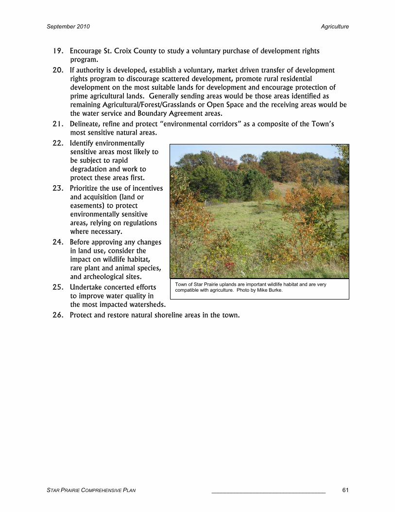
September 2010 Agriculture
STAR PRAIRIE COMPREHENSIVE PLAN ___________________________________ 61
19. Encourage St. Croix County to study a voluntary purchase of development rights program.
20. If authority is developed, establish a voluntary, market driven transfer of development rights program to discourage scattered development, promote rural residential development on the most suitable lands for development and encourage protection of
prime agricultural lands. Generally sending areas would be those areas identified as remaining Agricultural/Forest/Grasslands or Open Space and the receiving areas would be
the water service and Boundary Agreement areas.
21. Delineate, refine and protect “environmental corridors” as a composite of the Town’s most sensitive natural areas.
22. Identify environmentally sensitive areas most likely to be subject to rapid
degradation and work to protect these areas first.
23. Prioritize the use of incentives
and acquisition (land or easements) to protect environmentally sensitive
areas, relying on regulations where necessary.
24. Before approving any changes in land use, consider the impact on wildlife habitat,
rare plant and animal species, and archeological sites.
25. Undertake concerted efforts
to improve water quality in the most impacted watersheds.
26. Protect and restore natural shoreline areas in the town.
Town of Star Prairie uplands are important wildlife habitat and are very compatible with agriculture. Photo by Mike Burke.

Natural Resources September 2010
62 ___________________________________ STAR PRAIRIE COMPREHENSIVE PLAN
NATURAL RESOURCES
The Town of Star Prairie has a rich natural history, which is the basis for its present physical characteristics.
Over 100 years of immigrant settlement and resource use have altered the physical characteristics of the
landscape. The people who reside in it value the natural environment and the physical influences that make
up the rural landscape. Natural features are important to consider when planning for future uses. The
rural character of the Town of Star Prairie is an important consideration as well. This inventory of the
physical features of the town describes the impacts of development on those features, and provides an
analysis of systems that might be employed to mitigate the impacts of possible development on the
landscape.
COMPREHENSIVE ENVIRONMENTAL RESOURCE PROTECTION
Environmental corridors offer a mechanism to identify, evaluate and devise protection or management
strategies for the most apparent valued resources in the county. However, considering environmental
corridors does not address the overall natural resource base of the county including surface or ground
water quality, fisheries, wildlife, manageable forests and the diversity of plants and animals.
The environmental corridors mechanism does not address retaining agriculture and rural character,
managing stormwater better, preserving or creating a sense of place, and reducing infrastructure costs.
Rural residential development has the potential for creating the greatest impacts on the landscape of Town
of Star Prairie. There are development patterns which are sensitive to the environmental resources and
unique landscape contained in potential development sites which can address other issues, such as
retaining agriculture and rural character, preserving or creating a sense of place, and reducing infrastructure
costs.
Existing subdivision controls and zoning only provide for the distribution of roughly equal sized lots, which
consume virtually the entire site, leaving no open space. Conventional subdivisions developed under these
existing regulations are typically characterized by houses with mostly views of other houses.
Open Space or Conservation Design is an alternative site design technique which takes into account the
individual environmental and landscape characteristics of the site, provides the same number of housing
units built on smaller lots, and accommodates a variety of desirable objectives, including setting aside
substantial amounts of open space, protecting environmental features and wildlife habitat, preserving rural
character and scenic views, accommodating better stormwater management, preserving agricultural land,
allowing shared wells and on-site wastewater treatment, creating a sense of place, and reducing the amount
of roads and other infrastructure.
Through the management or, where necessary, prohibition of development in environmental corridors, and
the flexibility of open space or conservation site design, there is the potential to dramatically reduce the
negative impacts of development on the towns' natural resource base, scenic quality and rural character.

September 2010 Natural Resources
STAR PRAIRIE COMPREHENSIVE PLAN ___________________________________ 63
NATURAL RESOURCES GOALS, OBJECTIVES & POLICIES
Goal:Goal:Goal:Goal: To protect, preserve, conserve, enhance and carefully use the Town of Star Prairie’s precious natural resources.
Objectives:Objectives:Objectives:Objectives:
1. Recognize the environment as an integrated system of land, water and air resources, the destruction or disturbance of which can immediately affect the community by creating
hazards, destroying important public resources and habitat or damaging productive lands and property.
2. Preserve Star Prairie’s most important and sensitive natural resources and areas.
3. Protect and improve the quality of the surface water, groundwater and shoreline within the town.
4. Identify and protect unique natural resources such as floodplains, wetlands, steep slopes,
woodlands and prairies.
5. Encourage the use of soil conservation practices and the management of woodlands.
6. Direct development away from environmentally sensitive areas, natural resources and
productive forest lands.
7. Preserve the Town’s scenic beauty, heritage and archeological resources.
8. Engage in intergovernmental cooperation to protect natural resources.
Policies:Policies:Policies:Policies: 1. Guide the location and design of development to minimize any adverse impact on the
quality of surface waters, aquifers, wetlands, steep slopes, woodlands, prairie and agriculture.
2. Preserve and protect
natural landscape features such as wetlands, floodplains, streams, lakes,
steep slopes, woodlands, prairies and oak savannas as
essential components of the hydrologic system, valuable wildlife habitat, to restore
degraded resources where possible and to emphasize their value to the
community as potential focal points of natural beauty and recreation.
3. Discourage and where possible, prevent the altering of wetlands and
floodplains by filling or developing.
4. Encourage the management of woodlands in an effort to promote further value for timber and wildlife; the State’s Managed Forest Land Program is one option.
Preservation of unique natural resources such as the Apple River is a high priority in the Town of Star Prairie. Photo by Kathy Mlynarczyk.

Natural Resources September 2010
64 ___________________________________ STAR PRAIRIE COMPREHENSIVE PLAN
5. Before approving any changes in land use, consider the impacts on wildlife habitat, potential locations of rare plant and animal species and archeological sites.
6. Delineate, refine and protect “environmental corridors” as a composite of Star Prairie’s most sensitive natural areas.
7. Identify environmentally sensitive areas most likely to be subject to rapid degradation and
work to protect these areas first.
8. Prioritize the use of incentives and acquisition (land or easements) to protect
environmentally sensitive areas, relying on regulations where necessary.
9. Work with other local, state, county and federal agencies to improve water quality in the most impacted watersheds, especially Squaw Lake and the Apple River.
10. Protect and restore natural shoreline areas in the town.
11. Encourage natural landscaping, especially along shorelines, utilizing
native plant species and minimizing turf to protect and enhance surface and
groundwater quality.
12. Promote the proper
placement of new on-site wastewater systems and appropriate maintenance
and replacement of older systems as a means to protect ground-water
quality.
13. Consider protection and enhancement of sensitive natural resources, open and recreational space, large blocks of
forestland and scenic vistas when reviewing development proposals and making public expenditures.
14. Support the continued identification and protection of key natural resources in Star Prairie.
15. Encourage the County to study a voluntary purchase of development rights program.
16. Encourage and support a buffer zone around public lands to mitigate conflicts between property owners and citizens utilizing public lands for recreation. Such a zone could be created with a principal structure setback of 150 feet from the lot line on properties
adjacent to publicly-owned lands.
17. Coordinate and work with other governmental and private agencies such as the Squaw Lake Management District, Cedar Lake Rehabilitation District, Star Prairie Land
Preservation Trust, WDNR, Western Prairie Habitat Restoration Area and U.S. Fish & Wildlife Service to protect natural resources, especially those that cross political
boundaries such as rivers.
18. Support and work with the county on slope disturbance standards. Development should only be allowed on steep slopes with a grade from 12 to 20 percent where best
Cedar Lake is also an important natural resource the Town plans to preserve and restore. Photo by Kathy Mlynarczyk.

September 2010 Natural Resources
STAR PRAIRIE COMPREHENSIVE PLAN ___________________________________ 65
management practices for erosion and sediment control and storm water management can be implemented successfully.
19. Direct proposed development in areas where soil characteristics are compatible with the proposed development.
20. Promote development and agricultural practices, which protect surface and ground water
quality, including proper erosion control, manure management and storm water management strategies.
21. Encourage conservation design development for sites with unique or exceptional natural resources such as surface water, wetlands, steeps slopes or highly productive agricultural soils.
22. Support St. Croix County’s efforts to create an assessor’s plat of the Huntingdon area to clarify legal descriptions of parcels. This will facilitate improvements for recreational use of the County’s Apple River property.
23. Support efforts by St. Croix County and the Star Prairie Land Preservation Trust to connect the Apple River Property and McMurtrie Preserve through a walking easement along Cedar Creek.
Scenic countryside in Star Prairie. Photo by Kathy Mlynarczyk.

Cultural Resources September 2010
66 ___________________________________ STAR PRAIRIE COMPREHENSIVE PLAN
CULTURAL RESOURCES
Preservation of historic, archeological, cultural and scenic resources in the Town of Star Prairie will foster a
sense of pride in the community, improve quality of life, contribute to the preservation of rural character,
encourage low-impact tourism and provide an important feeling of social and cultural continuity between
the past, present and future.
HISTORIC RESOURCES
In 1983, the Wisconsin State Historical Society compiled a historic resources list of historic sites in
Wisconsin communities. The historic resources list for Star Prairie does not include any historic sites that
are listed on the State or National Register of Historic Places. It does include archeological sites that are
included in the Wisconsin Archeological Site Inventory database and many historic sites identified through
local historical groups, newspaper stories and other resources. Since the list was created, many resources
may have been moved, lost or changed.
Using the historic resources list as a starting point, the Star Prairie Plan Commission members identified
additional sites using local residents, historic documents and other state resources such as the Century
Farm and Home and Sesquicentennial programs. Much of the information was gathered during the
development of the Community Background section. A final listing of Star Prairie’s historic resources is
identified below. Please note that some sites are not specifically identified to provide protection for the
resource and property owners from trespassing, sight-seeing and looting.
• The old Town Hall, also known as the Riverview School, Johannesburg, built in 1923, CTHs C and
CC, Section 21.
• Oakland Cemetery, platted in 1893, CTH CC, Section 13.
• Cemetery at the St. Croix County Health Center, CTH K, Section 35.
• Unnamed Gravesite, Section 25.
• Phillips’ Graves, Section 36.
• Rivard Prehistoric Campsite/village, Section 31.
• Maitrejean Prehistoric Campsite/village, Section 30.
• SCA and other Unnamed Historic and Prehistoric Campsite/village, Section 25.
• Orville Mosher Collection Prehistoric Campsite/village, Sections 8, 9 & 36
• Riverdale Prehistoric Campsite/village, Section 30.
• Unnamed Site Prehistoric Campsite/village, Section 11.
• Unnamed Site Prehistoric and Woodland Campsite/village, Sections 2 & 3.
• Airport Fill, Prehistoric Campsite/village, Section 25.
• Hatfield Park, Prehistoric and historic Campsite/village, Section 36.
• Possible Indian Mound and Prehistoric Campsite/village around Strand Lake, Section 23.
• Riverdale Dam Powerhouse on Riverdale Flowage, CTH C, Section 31.
• Huntingdon dam structure footings & remnants located on the Apple River, St. Croix County’s
Apple River County Park Property, Section 11.
• McClure dam structure footings & remnants located on the Apple River, Harlan Vehrs & Leon Orr
properties, Section 14.
• Campbell’s Mill structure footings & remnants located near the flume and behind the Cedar Creek
Inn on Cedar Creek, Section 11.
• Pamela & Bruce Emerson Century Farm, 2087 CTH CC, established 1889, 118 years, Section 24.
• Lyle and Ruth Halvorson Century Farm, 1987 93rd Street, established 1881, 126 years, Section
29.

September 2010 Cultural Resources
STAR PRAIRIE COMPREHENSIVE PLAN ___________________________________ 67
• Ron Engh Barn, site of first Barn Art Fair.
• Squaw Lake School, now a single-family home, Section 9.
• First School in Star Prairie, now the Genevieve Francois Farm Granary, Section 23.
• Wall Street School, now a single-family home known as the Berget House, Section 23.
• Riverdale School, now a single-family home, Section 29.
• Gerald Backes Windmill & Farmstead, 110th St., Section 28.
• Doug Rivard Farmstead, Polk/St. Croix Road, Section 4.
• Jeff Levy & MaryEllen Stewart House & Farmstead, 110th St., Section 21.
• Genevieve Francois House & Farmstead, CTH CC, Section 23.
• Bob & Alice Talmage Windmill, 118th St., Section 18.
• Harlan Vehrs Windmill, CTH C, Section 14.
Mapped archeological sites are predominantly burial sites. Under Wisconsin law, Native American burial
mounds, unmarked burials and all marked and unmarked cemeteries are protected from intentional
disturbance.
The town should make a request to the State Historical Society for more detailed information when a
specific development proposal is offered on land in an area where a known historic or archeological site has
been mapped, if its location is not readily apparent.
The Town of Star Prairie should work with the developers, the county and the state to preserve the historic
farmsteads, barns and outbuildings that contribute to the town’s agricultural heritage, rural character and
aesthetic beauty and create a unique community.
Additional historic or archeological resources could be identified in the town through an individual or joint
effort to create a countywide survey of historic and archeological resources. The State Historical Society
provides survey funding on an annual basis, with applications due in November. There is presently no local
match requirement.

Cultural Resources September 2010
68 ___________________________________ STAR PRAIRIE COMPREHENSIVE PLAN
SCENIC RESOURCES
Scenic beauty is an important cultural resource in Star Prairie. There are numerous local areas that offer
stunning views of the landscape, landmarks (i.e. hills) and bodies of water. In the following list, various
resources and agencies have been consulted and the Town Plan Commission has identified areas of high
scenic value where there should be preservation efforts.
Scenic ResourcesScenic ResourcesScenic ResourcesScenic Resources Town of Star PrairieTown of Star PrairieTown of Star PrairieTown of Star Prairie
SITE DESCRIPTION LOCATION & SIZE
Apple River
The stream velocity of this short, steep river once powered as many as 70 mills, several of which became settlements. There are several very scenic sites. Canoeing from Huntingdon to the Riverdale Flowage is popular. Tubing also occurs on short stretches, especially below Huntingdon where there are short, fast waters. There are some wide wetlands below Johannesburg and several areas of the river are still very natural and undeveloped.
Sections 14, 15, 21 & 29
Louie Lake on the Apple River
Public land ownership and a public access to Louie Lake and its associated wetlands is very desirable for protection of the fishery and water resources.
Sections 15 & 22
Apple River Wetlands
Wetland complexes with broad grass wetlands provide water quality protection, fish habitat and open space.
Sections 21 & 22
Strand Lake Possible historic Indian mound, potentially a significant fishery, may need aeration. A valuable resource for public access and water resource protection.
Sections 22 & 23
Apple River Unnamed Tributary Creek
There are three unnamed tributary creeks that feed into the Apple River. They are all identified as trout streams and have native brook trout in them. Two are in the Village of Star Prairie. The third is about 200 feet long located at the north end of section 14.
Section 14
Prairie Flats North WPA
U.S. Fish & Wildlife Waterfowl Production Area managed for waterfowl habitat with ongoing wetland and prairie restoration. Open for hunting, fishing, environmental education and interpretation and wildlife observation and photography. Motorized vehicles and horseback riding are not allowed.
Sections 5, 6, & 8 220 Acres
Prairie Flats South WPA
U.S. Fish & Wildlife Waterfowl Production Area managed for waterfowl habitat with ongoing wetland and prairie restoration. Open for hunting, fishing, environmental education and interpretation and wildlife observation and photography. Motorized vehicles and horseback riding are not allowed.
Section 7 320 Acres
Squaw Lake Wetlands
Wetlands are largely depressional areas in woodlands and in some cropland and pastureland. Soils are generally very light and wetlands are widely scattered. They are quite picturesque with many areas of open water with aesthetically pleasing aquatic plants such as water lilies and other emergents. Waterfowl use is high. Some of these wetlands are marginal fish ponds and serve as focal points for many resident and migratory forms of wildlife.
Sections 5, 6, 7 & 8
South Cedar Bay Landing
Boardwalk to winter ice-fishing and summer canoe access, benches, picnic tables & parking lot. Owned and maintained by the Star Prairie Land Preservation Trust.
Section 3 1.3 Acres

September 2010 Cultural Resources
STAR PRAIRIE COMPREHENSIVE PLAN ___________________________________ 69
SITE DESCRIPTION LOCATION & SIZE
McMurtrie Preserve
Star Prairie Land Preservation Trust education property with access to Cedar Lake and Cedar Creek. Facilities being developed include improved road access, pavilion, toilet facilities, trails, pedestrian lake access and parking lot.
Section 2 65 Acres
Cedar Creek Easement or acquisition along Cedar Creek between the McMurtrie Preserve and St. Croix County’s Apple River Property to connect these two resources and protect the water quality.
Sections 2 & 11
Remnant Prairie Sites
There are two high-quality remnant prairie sites in the Town that would be a high priority for protection by the Western Prairie Habitat Restoration Area of the DNR.
Sections 22 & 28
Wetlands Wetlands along 110
th Street are valuable for waterfowl production and
wildlife areas. Section 27 80 Acres
New Richmond Archery Club
Star Prairie Land Preservation Trust is acquiring the land from the club for open space preservation.
Section 33 40 Acres
Star Prairie Flats High quality agricultural production area with high historic and agricultural resource significance to Star Prairie and St. Croix County. Identified as an agricultural heritage area in 1976.
Sections 4, 5, 6 & 7 1,000 acres
110th Street
This scenic road has wetlands, historic farmstead and native prairie along it and is an excellent candidate for the state’s rustic road designation.
Sections 21, 22, 27 & 28, from CTH C to 192
nd Ave.
Old Mill Road
This scenic road has wetlands, historic farmlands, native prairie, the Apple River County Park and the remnants of the McClure Dam structure along it. It is an excellent candidate for the state’s rustic road designation.
Sections 10 & 11, from CTH CC to CTH H
Sources: Heritage Areas of St. Croix County, UW-Extension 1976; Natural Area Inventory, West Central Wisconsin 1976; Wisconsin DNR, U.S. Fish & Wildlife, St. Croix County Parks Department and Town Plan Commission 2007

Cultural Resources September 2010
70 ___________________________________ STAR PRAIRIE COMPREHENSIVE PLAN
CULTURAL RESOURCES GOALS, OBJECTIVES & POLICIES
Goal:Goal:Goal:Goal: Enhance and maintain the Town of Star Prairie’s cultural and scenic resources and rural character.
Objectives:Objectives:Objectives:Objectives:
1. Identify and preserve the town’s agricultural, cultural, historic and archeological resources that recognize the community’s pre-settlement and early settlement periods.
2. Identify and protect cultural, historic, archeological and scenic resources.
3. Work with other units of government to develop and enforce appropriate land use regulations to maintain rural residential quality.
4. Prohibit incompatible land uses from locating within or next to residential areas.
5. Encourage the preservation of historically and architecturally significant structures and sites in the town.
6. Encourage the preservation of the town’s scenic resources.
7. Protect scenic roadways in the town.
Policies:Policies:Policies:Policies:
1. Explore various uses of the old town hall and develop an
operational plan for it.
2. Cooperate with the State Historical Society, St. Croix
County, surrounding communities and local agencies on a comprehensive
survey of historic and archeological resources in the town.
3. Maintain an inventory of historic, archaeological and
scenic resources.
4. Provide the inventory for reference and discussion
before and during consideration of land development proposals.
5. Encourage private landowners to protect and, if necessary, rehabilitate identified cultural, historic, archeological and scenic resources when specific sites are proposed for development.
6. Support zoning and subdivision regulations that are intended to prohibit incompatible land uses.
7. Work with the county to enforce property maintenance codes to maintain rural residential
quality and appearance.
8. Support local festivals, fairs, farm tours, farm breakfasts and markets that celebrate the
town’s farming heritage and rural way of life.
9. Encourage events that promote the town’s historical past and rural heritage.
Star Prairie’s Old Town Hall on the Apple River near Johannesburg is an important cultural resource for the town. Photo by Kathy Mlynarczyk.

September 2010 Cultural Resources
STAR PRAIRIE COMPREHENSIVE PLAN ___________________________________ 71
10. Support the New Richmond Preservation Society as a local repository for historical materials; also encourage residents to donate items to the historic materials repository
that the society maintains.
11. Support the designation of 110th Street and Old Mill Road as rustic roads to be added to the state’s rustic road system.
The local business, River’s Edge, has been in Star Prairie since 1921. Photo by Kathy Mlynarczyk.

Intergovernmental Cooperation September 2010
72 ___________________________________ STAR PRAIRIE COMPREHENSIVE PLAN
INTERGOVERNMENTAL COOPERATION
Intergovernmental communication, coordination and cooperation can make a significant difference in the
implementation and administration of a comprehensive plan. Intergovernmental cooperation can be
developed over time.
ANNEXATION
In Wisconsin, cities and villages cannot initiate annexations. Town landowners have to petition for
annexation; then cities and villages have to determine whether or not they are willing to annex those
parcels. Towns may object.
If towns are concerned about annexations, the towns should study why residents decide to petition for
annexation:
· Do residents want services the town is unable to provide?
· Does annexation increase the marketability and value of their property?
· Is the annexing municipality more willing than the town to address their concerns?
· What other issues are involved?
Once the issues have been identified, a town needs to determine what measures it can, and is willing, to
take to address them. Boundary agreements, shared tax revenue, or other forms of intergovernmental
agreement can be pursued by the towns to protect boundaries from annexation. Likewise, an effort must
be made to educate residents about the benefits and downfalls of annexation.
BOUNDARY & ANNEXATION AGREEMENT
Wisconsin Statute §66.0307 authorizes local municipalities to enter into an agreement that sets a mutual
boundary line between the two municipalities. The Town of Star Prairie and City of New Richmond are
drafting a boundary agreement that would allow specific areas of the town to be attached to the City of
New Richmond and the remainder of the town to remain within the town’s boundaries.
The agreement sets forth the timeframe, activities and terms under which land would be attached to the
City. It also recognizes a separate Water Service Agreement between the City of New Richmond and the
Town of Star Prairie which identifies the terms and conditions under which the City of New Richmond will
provide water service to certain residential properties within the Town of Star Prairie, whose water has
been contaminated from a closed New Richmond land fill. The boundary agreement will address land use
control and zoning, extension of water or sanitary sewer service, assessments, fees, highway construction,
revenue sharing, police and fire protection, a joint commission to oversee, and other administrative
provisions. The Boundary Agreement Area is shown on the Future Land Use Map.

September 2010 Intergovernmental Cooperation
STAR PRAIRIE COMPREHENSIVE PLAN ___________________________________ 73
INTERGOVERNMENTAL COOPERATION GOALS, OBJECTIVES & POLICIES
Goal:Goal:Goal:Goal: Establish mutually beneficial intergovernmental relations with surrounding jurisdictions and the Town of Star Prairie.
Objectives:Objectives:Objectives:Objectives:
1. Work with other local governments, state agencies, school districts, etc. on land use and community development issues of mutual concern.
2. Work with other units of government to develop and enforce appropriate land use regulations to maintain rural residential quality.
3. Engage in intergovernmental cooperation to protect natural resources.
4. Engage in and support processes to resolve conflicts between the plans of the town and other governments with overlapping jurisdiction.
5. Utilize, promote and enter into shared public service agreements where such agreements
will provide improved services at lower costs.
6. Work with neighboring municipalities to resolve boundary issues and other conflicts that exist or may develop.
7. Coordinate multi-jurisdictional (town, village, city, county, state) transportation system improvements and maintenance in the Star Prairie area.
Policies:Policies:Policies:Policies: 1. Work with St. Croix County, adjacent towns and the regional planning commission to
identify and resolve actual and potential conflicts between the Town Plan and other plans
through open dialog, cooperative initiatives and amendments to the Town of Star Prairie Plan where appropriate.
2. Provide a copy of this comprehensive plan to all surrounding local governments.
3. Encourage and support towns that have not yet adopted Town Land Use Plans to do so in consultation with adjoining local governments.
4. Encourage the City of New Richmond, villages of Star Prairie and Somerset and other
interested governmental units to consider this comprehensive plan and recommendations of the town officials in making future decisions about land use within or affecting the
town.
5. Work with surrounding communities to encourage an orderly, efficient land use pattern that preserves farming and natural resources and minimizes conflicts between urban and
rural uses.
6. Work with the City of New Richmond on an interconnected road system utilizing town and city official maps.
7. Develop and implement boundary and annexation agreements with the City of New Richmond and villages of Somerset and Star Prairie.
8. The town will stay aware of school building facility issues and encourage residents to use
school facilities for public meetings and recreation when appropriate.

Intergovernmental Cooperation September 2010
74 ___________________________________ STAR PRAIRIE COMPREHENSIVE PLAN
9. Coordinate and work with other governmental and private agencies such as the Squaw Lake Management District, Cedar Lake Rehabilitation District, Star Prairie Land
Preservation Trust, WDNR, Western Prairie Habitat Restoration Area and U.S. Fish & Wildlife Service to protect natural resources, especially those that cross political boundaries such as rivers.
10. Work with the Wisconsin Department of
Transportation (WisDOT) to ensure that the Town of Star Prairie’s transportation
system is coordinated with surrounding systems and that Star Prairie’s interests are
well served when major transportation facility improvements are proposed
and constructed.
11. Communicate and work with the WisDOT on STH 64 and
65 corridor preservation projects.
12. Work with St. Croix County, WisDOT, landowners and private developers to limit
development and access along State Trunk Highways 64 and 65 to help preserve them as throughways and scenic image corridors. Do not limit access over or under those highways.
13. Support the designation of 110th Street and Old Mill Road as rustic roads to be added to the state’s rustic road system.
14. Work with the County Highway Department for road maintenance and to implement the
Town Road Improvement Programs (TRIPs) for appropriate upgrading of town roads.
15. Work with the county, state and private landowners in ensuring that road right-of-ways
are clear of visual obstacles, particularly at road intersections. Road right-of-ways should be properly mowed and cleared.
16. Continue the cooperative understanding with adjoining towns for road maintenance.
17. Designate specific town and county roadways for bicycle traffic and improve designated bicycle routes with wide, signed shoulders or off-road bike paths, based on the Future Bike System map. These changes would provide a coordinated system of bike routes to
access the City of New Richmond, villages of Somerset and Star Prairie and park and school system serving town residents. It would provide better, safer connections for residents northwest and southeast of the Apple River.
18. Work with the City of New Richmond and the Multi-Purpose Pathway Committee to coordinate and sign bicycle/pedestrian routes into and out of the City of New Richmond.
19. Work with the villages of Star Prairie and Somerset, City of New Richmond, St. Croix County, state agencies and local organizations to develop, provide and support recreational facilities and opportunities within the town.
Star Prairie is a beautiful place to live. Photo by Kathy Mlynarczyk.

September 2010 Intergovernmental Cooperation
STAR PRAIRIE COMPREHENSIVE PLAN ___________________________________ 75
20. Support St. Croix County’s efforts to create an assessor’s plat of the Huntingdon area to clarify legal descriptions of parcels. This will facilitate improvements for recreational use
of the County’s Apple River property.
21. Support efforts by St. Croix County and the Star Prairie Land Preservation Trust to connect the Apple River Property and McMurtrie Preserve through a walking easement
along Cedar Creek.
22. Work with and through St. Croix County, (which serves as the town’s Responsible Unit
to implement the state recycling laws), to expand education, information, special collections and related services for recycling.
23. Contract with the City of New Richmond to provide a recycling drop-off center for town
residents
24. Contract with the New Richmond Ambulance and Fire Service for ambulance and fire service for town residents.
25. Continue the mutual aid agreement with the Village of Somerset for fire protection service to town residents.
26. Work with the Village
of Somerset and City of New Richmond in the provision of joint
services when it will result in better services
and/or cost savings.
27. Utilize St. Croix County Sheriff’s
Department for law enforcement.
28. Contract with the
Sheriff’s Department for a satellite office for law enforcement to
encourage better service and response times for town residents.
29. Work with St. Croix County and state agencies to assure public health and groundwater quality when permitting and monitoring new and replacement private on-site wastewater systems and water wells.
30. Work with St. Croix County to maintain property to ensure a high-quality living environment within all residential areas and to address violations of applicable land use ordinances on residential, commercial or industrial properties.
31. Work with St. Croix County to update the County’s and the town’s land use regulations to require that relocated houses and new manufactured houses are sited on freestanding, separate parcels; are placed on permanent foundations; and are brought into compliance
with the Uniform Dwelling Code to provide safe, quality housing.
32. Work with St. Croix County to improve or expand St. Croix County Zoning Ordinance
regulations regarding property maintenance and nuisance issues such as junk vehicles and dilapidated buildings.
33. Work with St. Croix County to expand the St. Croix County Animal Waste and the
Zoning ordinances to regulate large-scale farms near existing residences.
Dealing with the clean up of junk vehicles and other debris on property requires cooperation between property owners, the County and the Town. Photo by Kathy Mlynarczyk.

Intergovernmental Cooperation September 2010
76 ___________________________________ STAR PRAIRIE COMPREHENSIVE PLAN
34. Support buffer zones around agriculture preservation areas and between these areas and rural residential subdivisions consisting of gradually larger lot, lower density development.
The variety in zones will increase compatibility with agricultural uses, provide a range of agriculture uses and greater choices in housing options in the town. Work with St. Croix County to implement these buffer zones through amendments to the zoning ordinance.
35. Encourage St. Croix County to study a voluntary purchase of development rights program.
36. Cooperate with the State Historical Society, St. Croix County, surrounding communities and local agencies on a comprehensive survey of historic and archeological resources in the town.
37. Support the New Richmond Preservation Society as a local repository for historical materials; also encourage residents to donate items to the historic materials repository that the society maintains.
38. Work with the villages of Star Prairie and Somerset and the City of New Richmond to encourage high density residential, commercial and industrial development requiring a higher level of services to locate in these municipalities. Encourage business types which
will benefit all the communities.
39. Work with St. Croix Economic Development Corporation to assist in locating potential new businesses.
40. Work with St. Croix County to update land use regulations to improve site planning for commercial and industrial development.
41. Work with St. Croix County to permit home-based businesses where there will be little impact on surrounding properties.

September 2010 Land Use
STAR PRAIRIE COMPREHENSIVE PLAN ___________________________________ 77
LAND USE
EXISTING LAND USE REGULATIONS
The Town of Star Prairie has adopted a variety of regulations that effect land use in the town. The chart
below summarizes the regulations that the town has adopted, the year the regulation was adopted or last
updated and additional land use regulations available to the town. The chart also identifies the land use
regulations adopted by St. Croix County, many of which affect the town.
Regulation by Minor Civil Division Regulation by Minor Civil Division Regulation by Minor Civil Division Regulation by Minor Civil Division ---- 2002002002009999 Town of Star PrairieTown of Star PrairieTown of Star PrairieTown of Star Prairie & Neighboring Communities & Neighboring Communities & Neighboring Communities & Neighboring Communities
REGULATION STAR PRAIRIE RICHMOND SOMERSET STANTON ST. CROIX COUNTY
Village Powers Adopted Yes ‘72 Yes ‘08 Yes ‘98 Yes ‘77 N/A
Official Map Ordinance No No No No N/A
County Zoning Yes ‘75 Yes ‘76 Yes ‘68 Yes ‘75 Yes ‘74
Exclusive Ag Zoning Yes ‘86 No Yes ’ Yes ‘82 Yes
Standards to zone out of Exclusive Ag Yes No Yes Yes Yes
Shoreland/Wetland Zoning N/A N/A N/A N/A Yes ‘74
Floodplain Zoning N/A N/A N/A N/A Yes ‘05
Land Division/Subdivision Ordinance In Progress No Yes ‘09 Yes ‘96 Yes ’06
Minimum Lot Size N/A N/A Yes, 3 acre Yes, 2 acre Yes 1.5 acre
min., 2 acre avg.
Allow Majors w/ POWTS* N/A N/A Yes No Yes
Allow Minors w/ POWTS* N/A N/A Yes Yes, 2 lots in
5 years Yes
Monies in Lieu of Dedication N/A N/A No No No
Erosion Control/Stormwater Mngt. N/A N/A N/A N/A Yes ‘06
Sanitary Ordinance N/A N/A N/A N/A Yes ‘05
Animal Waste Ordinance N/A N/A N/A N/A Yes ‘85
Nonmetallic Mining Ordinance N/A N/A N/A N/A Yes ‘04
Tire Management Ordinance No No No No Yes ‘85
Agricultural Shoreland Mngt. Ordinance No No No No No
Historic Preservation Ordinance No No No No No
Town Mobile Home Park Ordinance Yes ‘70 Yes ‘70 No Yes ‘84 N/A
Development Impact Fees Yes ‘06 Yes No No N/A
Cooperative Boundary Agreement In Progress No No No N/A
Water Utility District In Progress No No No N/A
Reinvestment Neighborhoods No No No No N/A
Business Improvement District No No No No N/A
Architectural Conservancy Dist. No No No No N/A
Sanitary District No Yes No No N/A *POWTS-- Private Onsite Wastewater Treatment Systems
Sources: Town of Star Prairie, St. Croix County Development Management Plan, 2000, St. Croix County Planning and Zoning Department.
The Town of Star Prairie adopted exclusive agriculture zoning as one of the tools used to regulate land use.
The decision to adopt exclusive agriculture zoning generally came from information provided in the St.
Croix County Farmland Preservation Plan which was adopted in 1980 by the St. Croix County Board of
Supervisors.
What is not well known is that the 1980 Farmland Preservation Plan was a very thorough and well thought
out document. It covered farmland preservation, but it also looked at other land uses and the need for
growth in St. Croix County. The following quotes from the Farmland Preservation Plan provide insight

Land Use September 2010
78 ___________________________________ STAR PRAIRIE COMPREHENSIVE PLAN
into the thinking behind the plan, the justification for creating the plan, the concepts behind the land use
designations in the plan and the comprehensive approach to land use that was part of the plan:
“St. Croix County has grown considerably in the last 30 years and some population growth is expected to continue. Provisions must be made to accommodate this growth for residential commercial and industrial uses as well as agricultural.” “In order that good agricultural land remain in agriculture and sprawl development be discouraged the Farmland Preservation Plan identifies areas around incorporated centers where residential, industrial and commercial development should occur.” “Detailed land use planning decisions for incorporated and extraterritorial areas will remain the responsibility of the cities, villages and townships. The plan will further identify transitional areas where low-density development may be encouraged.” “By identifying prime agricultural lands and by delineating urban service areas and low density rural areas the plan should serve as a tool to guide growth and divert development from prime agricultural areas.” “St. Croix County has developed a rationale for farmland preservation based on three premises:
“The land at our disposal should be scrutinized to determine its capabilities and consideration should be given to its best use for present and future generations—whether it be development or preservation for farmland. “A certain degree of regional self-sufficiency is a wise goal for metropolitan areas. “Planning for growth is necessary and desirable for all sectors of society.”
The Farmland Preservation Plan took a comprehensive approach to land use regulation, however the actual
implementation of the plan was not comprehensive and much of what was in the plan was never used. St.
Croix County is in the process of updating the 1980 Farmland Preservation Plan to address changes in
agriculture and changes in the state laws regarding farmland preservation zoning and other programs to
protect farmland.

September 2010 Land Use
STAR PRAIRIE COMPREHENSIVE PLAN ___________________________________ 79
In addition to the regulations identified in the table above, the following County regulations are or can be
in effect in the Town of Star Prairie. These regulations are adopted by the County and are in effect in all
unincorporated areas of St. Croix County; no town adoption or action is required.
• St. Croix County Development Management Plan
• St. Croix County Outdoor Recreation Plan
• St. Croix County Agriculture Preservation Plan
• St. Croix County Erosion Control Plan
• St. Croix County Solid Waste Management Plan
• St. Croix County Land and Water Conservation Plan
• St. Croix County Sanitary Ordinance
• St. Croix County Subdivision Ordinance
• St. Croix County Shoreland/Wetland District Regulations
• St. Croix County Floodplain District Regulations
• St. Croix County Erosion Control/Stormwater Management Regulations
• St. Croix County Nonmetallic Mining Regulations
• St. Croix County Animal Waste Regulations
• St. Croix County Solid Waste and Recycling Regulations
EXISTING LAND USES
The existing land uses in the Town of Star Prairie are shown on the following map. This map was created
by combining the1993 land use and land cover maps from the St. Croix County Development Management
Plan with 2004 aerial photography, the 2007 data from the Real Property Lister’s office on parcel
assessment and the 2007 zoning maps for the town. Major subdivisions are categorized as residential
while isolated rural homes and minor subdivisions of four lots or less are categorized as rural residential.
Commercial and industrial land use is the land zoned commercial or industrial and/or used for commercial
or industrial activities according to the town assessor. Parks, recreation and open space land uses include
public, private and nonprofit parks, recreation and open space land uses.

Land Use September 2010
80 ___________________________________ STAR PRAIRIE COMPREHENSIVE PLAN
!
!
!
!
!
!
!!
!!!!
! !! !
!!! ! !
!
!
!
!
!
!!
!!
!
!!!!
!
!
!
!!
!
!
!
!
!
!
!
!
!
!
!!
!
!! !
!
!
!
!
!
!
!
!
!
!
!!
!
!
!
!!
!
!
! !
!
!
!
!!
!
!
!!
! !!
!
!
!
!
!!
!!!!
!
!
! ! !!
!
!
!!
!!
!
!
!
!
!
!
!
!
!
!
!
!!
!
!
!!
!
!
!
! !
!
!
!
!
!
! !!
!
!
!
!
!
!
!
!!
!!
!!
!
!!
! !!
!
!
!
!
!
!
!
!
!
!
!
!
!
!
!
!
!
!
!
!
!
!
!
!
!
!
!! ! !
! ! !
!!!
!
!! !
!
!!!
!
!
!
!
!
!
!
!
!
!!!!
!!
!
!
!
!
!
!
!
!
!
!!
!
!
!!
!
!
!
!
! !
!!
!!
!
!
!
!
!
!
!
!
! !
!
!
!
!
!
!
!!
!
! !
!
!
!
!
!!
!
!!! !!!!
!
!
! !
!
!!!
!!
!
!
!
!
! ! ! !
!
!
!
!
!
!
!
!!
!!!!
!
!!
!
!!!
!!
!
!
!!!
!
!
!
!
!
!
!
!
! !!
!
!
!
!
!
!
!
!
!
!
!
!
!!!
!!!
!
!!
!
!!
!
!
!
!!!
!
!!
!
!!
!!
!
!
!
! !
!
!
!!
!!
!
!
!
!!
!
!
!
!
!
!!
!
!
!
!
!!
!
!
!
!
!!
!
!!
!
!
!
!
!!
!
!!
!
!
!!
!
!
!
! !! !
!
!
!
!!
!
!
!
!
!
!
! !
!
!!
!
!!
!
!
!
!
!
!!
! !!
!!
!!
!!!
!!!
!
!!!!
! !
!
!!
!
! !
!
!!
!
! !!
!!
!!!
!!
!! !
!! !
!
!
!
!
!
!
!
!
!
!
!
!
!
!
!
!
!
! ! ! !
!
! !
!
!
!
!
! !
!
!!
!
!
!
!
!!
! ! !!!!! !!
!
!
!!
!!!!
!
!
!!
!
!
!
!!
!
!
!
!
!
!
!
!
! !
!!
!
!
!
!
!
!
!
!!
! !
!
!! !
! !!
! ! !
!!
!
!
!
!
!!
!
!! !
!
!!
!
!
!
!!
!!
!
!
!
!
!
!
!
!
!!
!
! !
!
!!
!
!
!
!
!
!
!
!
!
!
!
!
!
!!
!
!
!
!
!!
!
!!
!
!
!
!
!
!
!!
!
!
!
!!
!!
!
!!
!
!
!
!
!
!
!
!
!
!
!
!
!
Cedar Lake
Sqauw Lake
Town Hall
Town Hall
Existing Land Use / Land CoverTown of Star Prairie, St. Croix County, WI .
2640 0 2640 5280
Feet
Source: 2007 St. Croix County Assessment Records,
St. Croix County Spring 2004 Orthophotography,
St. Croix County Planning & Zoning Department.
Note: This map is for general reference and general planning
purposes only. It is not intended for detailed site planning.
Residential
Commercial
Utilities
Rural Residential
Wooded
Water Features
Parks, Recreation & Open Space
Grassland
Wetland
Agricultural/Other Open Ag Land
Industrial

September 2010 Future Land Use
STAR PRAIRIE COMPREHENSIVE PLAN ___________________________________ 81
FUTURE LAND USE PROJECTIONS
OPEN SPACE PROJECTIONS
The Town of Star Prairie anticipates that as residential growth occurs the demand for open space will also
occur. The Plan Commission felt that generally open space should be preserved at a rate of 10 percent of
residential growth. That ratio is used to estimate the open space that would be ideal for parks, recreation
and natural areas for the three land use scenarios through 2030. Please see the chart below.
Open Space Acreage Open Space Acreage Open Space Acreage Open Space Acreage ProjectionsProjectionsProjectionsProjections –––– 2000 2000 2000 2000 to to to to 2030203020302030 Town of Star PrairieTown of Star PrairieTown of Star PrairieTown of Star Prairie
HISTORIC TREND ADJUSTED GROWTH ACCELERATED GROWTH
Year Additional Acres
Needed Total
Acreage Additional Acres
Needed Total
Acreage Additional Acres
Needed Total
Acreage
2006 0 670 0 670 0 670
2010 106 776 127 797 172 842
2015 162 832 211 881 300 970
2020 216 886 294 964 455 1125
2025 260 930 377 1047 645 1315
2030 305 975 462 1132 881 1551 Source: Star Prairie Plan Commission & St. Croix County Planning & Zoning Department 2010, 2015, 2020, 2025 and 2030.
Star Prairie Open Space
Acreage Projections
600
800
1000
1200
1400
1600
2006 2010 2015 2020 2025 2030Year
Acreage
Historic Adjusted Accelerated

Future Land Use September 2010
82 ___________________________________ STAR PRAIRIE COMPREHENSIVE PLAN
RESIDENTIAL PROJECTIONS
The residential land use projections for the Town of Star Prairie were developed as part of the population
and housing projections in the Issues and Opportunities Element. They are provided here as a reference.
The Acreage Projections are based on an average of three acres per housing unit. The 3.0 acres per
housing unit was used to estimate acreage used for residential development. The three acres represents the
residential housing site and the associated infrastructure needed. It is not intended to represent lot size or
to correspond to the actual acreage owned or taxed as residential or agricultural building site property.
Residential Acreage Residential Acreage Residential Acreage Residential Acreage Projections Projections Projections Projections –––– 2000 2000 2000 2000 to to to to 2030203020302030 Town of Star PrairieTown of Star PrairieTown of Star PrairieTown of Star Prairie
HISTORIC TREND ADJUSTED GROWTH ACCELERATED GROWTH YEAR ADDITIONAL
ACRES NEEDED TOTAL
ACREAGE ADDITIONAL ACREAGE
TOTAL ACREAGE
ADDITIONAL ACREAGE
TOTAL ACREAGE
2000 0 3,237 0 3,237 0 3,237
2010 1060 4,297 1267 4,504 1719 4,956
2015 1616 4,853 2107 5,344 2995 6,232
2020 2157 5,394 2938 6,175 4545 7,782
2025 2596 5,833 3768 7,005 6445 9,682
2030 3048 6,285 4616 7,853 8810 12,047 Source: U.S. Census Bureau, Wisconsin Department of Administration & St. Croix County Planning & Zoning Department Projections
Star Prairie Residential Acreage Projections
2000
4000
6000
8000
10000
12000
14000
2000 2010 2015 2020 2025 2030Year
Acreage
Historic Adjusted Accelerated

September 2010 Future Land Use
STAR PRAIRIE COMPREHENSIVE PLAN ___________________________________ 83
AGRICULTURAL PROJECTIONS
The Town of Star Prairie generally expects the amount of agricultural land to continue to decline in the
town as land is converted to residential or other land uses. The amount of change will be directly related to
the amount of residential land use that occurs and somewhat related to the growth in recreational,
commercial and industrial land uses. The town has identified specific areas of agriculture that are on highly
productive soils and should continue in agriculture and/or compatible open space within the town. The
agricultural land use projections are a product of the residential land use projections and the existing
agricultural land use statistics. They were created by subtracting the Historic Trends, Adjusted Growth and
Accelerated Growth residential land use projections from the existing agricultural land use statistics.
Agricultural Acreage Agricultural Acreage Agricultural Acreage Agricultural Acreage Projections Projections Projections Projections –––– 2000 2000 2000 2000 to to to to 2030203020302030 Town of Star PrairieTown of Star PrairieTown of Star PrairieTown of Star Prairie
YEAR HISTORIC TREND ACREAGE
ADJUSTED GROWTH ACREAGE
ACCELERATED GROWTH ACREAGE
2000 12,542 12,542 12,542
2003 11,205 11,205 11,205
2006 11,398 11,398 11,398
2010 10,338 10,131 9,679
2015 9,782 9,291 8,403
2020 9,241 8,460 6,853
2025 8,802 7,630 4,953
2030 8,350 6,782 2,588 Source: St. Croix County Statistical Report of Property Values 2000, 2003 & 2006 Wisconsin Department of Revenue and St. Croix County Planning & Zoning Department 2010, 2015, 2020, 2025 and 2030.
Star Prairie Agricultural
Acreage Projections
1000
3000
5000
7000
9000
11000
13000
2006 2010 2015 2020 2025 2030Year
Acreage
Historic Adjusted Accelerated
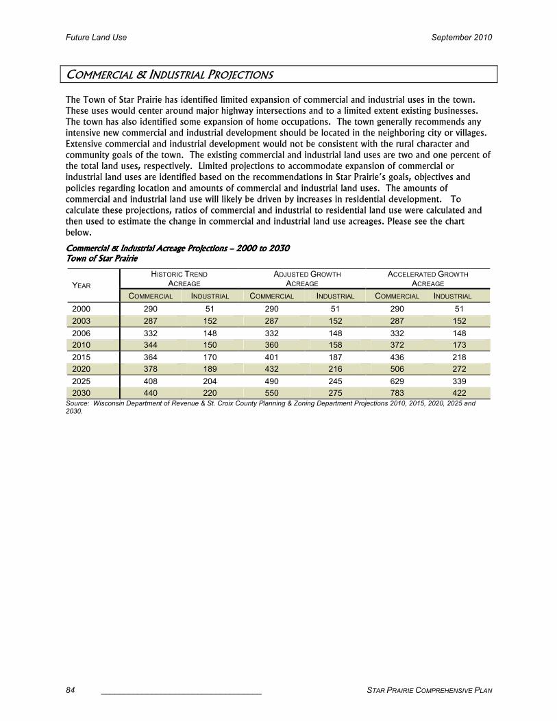
Future Land Use September 2010
84 ___________________________________ STAR PRAIRIE COMPREHENSIVE PLAN
COMMERCIAL & INDUSTRIAL PROJECTIONS
The Town of Star Prairie has identified limited expansion of commercial and industrial uses in the town.
These uses would center around major highway intersections and to a limited extent existing businesses.
The town has also identified some expansion of home occupations. The town generally recommends any
intensive new commercial and industrial development should be located in the neighboring city or villages.
Extensive commercial and industrial development would not be consistent with the rural character and
community goals of the town. The existing commercial and industrial land uses are two and one percent of
the total land uses, respectively. Limited projections to accommodate expansion of commercial or
industrial land uses are identified based on the recommendations in Star Prairie’s goals, objectives and
policies regarding location and amounts of commercial and industrial land uses. The amounts of
commercial and industrial land use will likely be driven by increases in residential development. To
calculate these projections, ratios of commercial and industrial to residential land use were calculated and
then used to estimate the change in commercial and industrial land use acreages. Please see the chart
below.
Commercial & Industrial Acreage Commercial & Industrial Acreage Commercial & Industrial Acreage Commercial & Industrial Acreage Projections Projections Projections Projections –––– 2000 2000 2000 2000 to to to to 2030203020302030 Town of Star PrairieTown of Star PrairieTown of Star PrairieTown of Star Prairie
HISTORIC TREND ACREAGE
ADJUSTED GROWTH ACREAGE
ACCELERATED GROWTH ACREAGE YEAR
COMMERCIAL INDUSTRIAL COMMERCIAL INDUSTRIAL COMMERCIAL INDUSTRIAL
2000 290 51 290 51 290 51
2003 287 152 287 152 287 152
2006 332 148 332 148 332 148
2010 344 150 360 158 372 173
2015 364 170 401 187 436 218
2020 378 189 432 216 506 272
2025 408 204 490 245 629 339
2030 440 220 550 275 783 422 Source: Wisconsin Department of Revenue & St. Croix County Planning & Zoning Department Projections 2010, 2015, 2020, 2025 and 2030.

September 2010 Future Land Use
STAR PRAIRIE COMPREHENSIVE PLAN ___________________________________ 85
Star Prairie Industrial
Acreage Projections
100
200
300
400
500
2006 2010 2015 2020 2025 2030Year
Acreage
Historic Adjusted Accelerated
Star Prairie Commercial
Acreage Projections
300
400
500
600
700
800
2006 2010 2015 2020 2025 2030Year
Acreage
Historic Adjusted Accelerated

Future Land Use September 2010
86 ___________________________________ STAR PRAIRIE COMPREHENSIVE PLAN
LAND USE GOALS, OBJECTIVES & POLICIES
The following goal statements were developed by the Plan Commission to refine alternative land use scenarios and policies. These were developed with a heavy emphasis on the results of the public opinion survey, the vision statements, the interactive land use
workshop results and the land use policies that have historically been followed in the Town. Based on all the public input activities, the Plan Commission members have concluded that the
majority of town residents feel the historic rate of development is acceptable in the town but that there needs to be some policy changes regarding the type and location of residential, commercial and industrial growth and the protection of open space areas. The Plan Commission has
identified changes that enhance and direct land use options that would best fit the future needs, growth and preferences of Star Prairie’s residents while preserving the town’s rural character.
Goals:Goals:Goals:Goals:
1. The Town of Star Prairie will encourage a desirable mix of land uses that will maintain the town’s rural character and preserve its agricultural heritage, while allowing moderate residential, commercial and industrial development.
2. Protect the town’s abundant and high quality natural and agricultural resources to maintain the town’s rural atmosphere and community character.
3. Promote the continuation of agriculture and farming as one of the primary land uses.
4. Maintain the integrity of zoning districts by considering distinct uses and separation.
5. Direct land uses to designated areas to improve compatibility and decrease conflicts.
6. Consider equity and fairness to landowners with comparable resource and location characteristics when developing land use policies and ordinances.
7. Encourage limited residential development that keeps housing affordable.
8. Coordinate land use planning with utility and community facility systems, natural resource and transportation systems planning.
9. Large-scale industrial and commercial development should be directed to St. Croix
County’s urban centers.
10. Support a limited number of dwelling units with three or four units in a structure in
conjunction with conservation design development.
Objectives:Objectives:Objectives:Objectives: 1. Manage and control the rate of development to maintain a distinctive rural community in
the Town of Star Prairie.
2. Retain rural features to protect rural character.
3. Minimize the visual impact of development to maintain rural, undeveloped character and
feeling.
4. Discourage residential, commercial or industrial development that is incompatible with the rural character and agricultural heritage of the Town of Star Prairie or would cause land
use conflicts and negative impacts to natural resources and agricultural.

September 2010 Future Land Use
STAR PRAIRIE COMPREHENSIVE PLAN ___________________________________ 87
5. Allow residential development in location,
forms and densities, which supports the preservation of open
space and prime agricultural soils.
6. Promote the use of existing public facilities, and managed expansion
to those facilities, to serve future development whenever possible.
7. Support quality and accessible parks and recreational facilities and services and maintain dedicated open space for all residents whether developed by the town or in conjunction with neighboring
communities.
8. All housing should be located and sited to enhance and maintain rural character.
9. Encourage housing sites in the town that meet the needs of persons within a variety of
income levels, age groups, and special needs.
10. Encourage the maintenance, rehabilitation and reuse of existing housing stock.
11. Support new developments that are primarily single-family homes or two-family homes.
12. Promote conservation design subdivisions as the preferred method for rural residential development.
13. Ensure that home sites are safe from seasonal flooding or ponding.
14. Encourage high density development and other more intense land uses to locate where public utilities are available.
15. Rural economic development should promote alternative agricultural and forestry-based opportunities and industrial and commercial development with minimal infrastructure needs that is compatible with neighboring land uses
16. Identify locations for future environmentally-friendly businesses to locate within the Town.
17. Encourage the commercial redevelopment and reuse of the town’s existing commercial sites.
18. Prevent unplanned commercial development along major roadways.
19. Encourage land preservation programs.
20. Preserve highly productive farmlands for continued agricultural use.
21. Manage the pace of growth to help limit conflicts between agriculture and non-farm land
use.
22. Discourage land uses that conflict with agriculture.
23. Use density and minimum lot size regulations to allow growth and development while
protecting productive farmlands on prime agricultural soils.
24. Discourage nonagricultural development on prime agricultural soils.
25. Preserve Star Prairie’s most important and sensitive natural resources and areas.
Rural residential development. Photo by Kathy Mlynarczyk.

Future Land Use September 2010
88 ___________________________________ STAR PRAIRIE COMPREHENSIVE PLAN
26. Direct development away from environmentally sensitive areas, natural resources and productive forest lands.
27. Preserve the Town’s scenic beauty, historical heritage and archeological resources.
28. Work with surrounding communities to encourage an orderly, efficient land use pattern that preserves farming and natural resources and minimizes conflicts between urban and
rural uses.
29. Work with neighboring municipalities to resolve boundary issues and other conflicts that
exist or may develop.
30. Work with other local governments, state agencies, school districts, etc. on land use and community development issues of mutual concern.
31. Work with other units of government to develop and enforce appropriate land use regulations to maintain rural residential quality.
Policies:Policies:Policies:Policies:
1. Direct new residential, open space, agricultural, institutional, commercial and industrial land uses to those areas that are designated in this comprehensive plan.
2. Work with the villages of Star Prairie and Somerset and the City of New Richmond to
encourage high density residential, commercial and industrial development requiring a higher level of services to locate in these municipalities.
3. Promote conservation design development in major subdivisions and common septic
systems to protect natural resources and highly productive agricultural soils and provide services in a cost-effective manner.
4. Require the low building opening (LBO) for each development site to be staked with a base elevation reference point for all ponding, elevations and driveways.
5. Work to change land division regulations to require new development to stub future
driveways to the right-of-way line. This will prevent conflicts with stormwater management ponds, LBOs and construction site erosion and sediment tracking.
6. As new development occurs, discourage new private roads and explore options to make
existing private roads public to improve access for emergency services, improve maintenance and decrease conflicts.
7. Review this plan prior to making a recommendation on a rezoning request.
8. When considering rezoning requests recommend rezoning only when there will be an immediate change in land use and only that portion of the parcel needed for development.
9. Encourage home site design that achieves rural character and farmland preservation objectives and ensures that home sites are safe from seasonal flooding or ponding.
10. Guide development away from hydric and alluvial soils, which are formed under
conditions of saturation, flooding or ponding.
11. Require the disclosure of any soil or groundwater contamination on sites before approving development proposals.
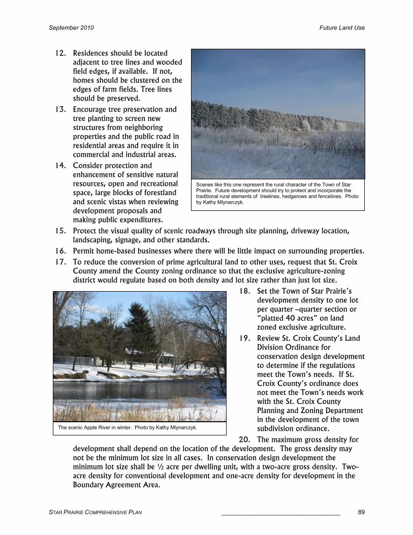
September 2010 Future Land Use
STAR PRAIRIE COMPREHENSIVE PLAN ___________________________________ 89
12. Residences should be located adjacent to tree lines and wooded
field edges, if available. If not, homes should be clustered on the edges of farm fields. Tree lines
should be preserved.
13. Encourage tree preservation and
tree planting to screen new structures from neighboring properties and the public road in
residential areas and require it in commercial and industrial areas.
14. Consider protection and
enhancement of sensitive natural resources, open and recreational space, large blocks of forestland
and scenic vistas when reviewing development proposals and making public expenditures.
15. Protect the visual quality of scenic roadways through site planning, driveway location, landscaping, signage, and other standards.
16. Permit home-based businesses where there will be little impact on surrounding properties.
17. To reduce the conversion of prime agricultural land to other uses, request that St. Croix County amend the County zoning ordinance so that the exclusive agriculture-zoning
district would regulate based on both density and lot size rather than just lot size.
18. Set the Town of Star Prairie’s development density to one lot
per quarter –quarter section or “platted 40 acres” on land zoned exclusive agriculture.
19. Review St. Croix County’s Land Division Ordinance for
conservation design development to determine if the regulations meet the Town’s needs. If St.
Croix County’s ordinance does not meet the Town’s needs work with the St. Croix County
Planning and Zoning Department in the development of the town subdivision ordinance.
20. The maximum gross density for development shall depend on the location of the development. The gross density may
not be the minimum lot size in all cases. In conservation design development the minimum lot size shall be ½ acre per dwelling unit, with a two-acre gross density. Two-acre density for conventional development and one-acre density for development in the
Boundary Agreement Area.
Scenes like this one represent the rural character of the Town of Star Prairie. Future development should try to protect and incorporate the traditional rural elements of treelines, hedgerows and fencelines. Photo by Kathy Mlynarczyk.
The scenic Apple River in winter. Photo by Kathy Mlynarczyk.
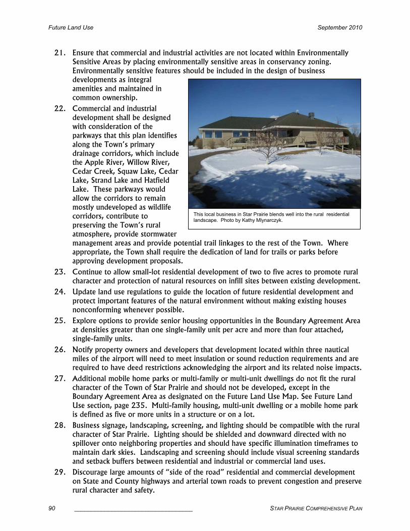
Future Land Use September 2010
90 ___________________________________ STAR PRAIRIE COMPREHENSIVE PLAN
21. Ensure that commercial and industrial activities are not located within Environmentally Sensitive Areas by placing environmentally sensitive areas in conservancy zoning.
Environmentally sensitive features should be included in the design of business developments as integral amenities and maintained in
common ownership.
22. Commercial and industrial
development shall be designed with consideration of the parkways that this plan identifies
along the Town’s primary drainage corridors, which include the Apple River, Willow River,
Cedar Creek, Squaw Lake, Cedar Lake, Strand Lake and Hatfield Lake. These parkways would
allow the corridors to remain mostly undeveloped as wildlife corridors, contribute to
preserving the Town’s rural atmosphere, provide stormwater
management areas and provide potential trail linkages to the rest of the Town. Where appropriate, the Town shall require the dedication of land for trails or parks before approving development proposals.
23. Continue to allow small-lot residential development of two to five acres to promote rural character and protection of natural resources on infill sites between existing development.
24. Update land use regulations to guide the location of future residential development and
protect important features of the natural environment without making existing houses nonconforming whenever possible.
25. Explore options to provide senior housing opportunities in the Boundary Agreement Area
at densities greater than one single-family unit per acre and more than four attached, single-family units.
26. Notify property owners and developers that development located within three nautical miles of the airport will need to meet insulation or sound reduction requirements and are required to have deed restrictions acknowledging the airport and its related noise impacts.
27. Additional mobile home parks or multi-family or multi-unit dwellings do not fit the rural character of the Town of Star Prairie and should not be developed, except in the Boundary Agreement Area as designated on the Future Land Use Map. See Future Land
Use section, page 235. Multi-family housing, multi-unit dwelling or a mobile home park is defined as five or more units in a structure or on a lot.
28. Business signage, landscaping, screening, and lighting should be compatible with the rural
character of Star Prairie. Lighting should be shielded and downward directed with no spillover onto neighboring properties and should have specific illumination timeframes to
maintain dark skies. Landscaping and screening should include visual screening standards and setback buffers between residential and industrial or commercial land uses.
29. Discourage large amounts of “side of the road” residential and commercial development
on State and County highways and arterial town roads to prevent congestion and preserve rural character and safety.
This local business in Star Prairie blends well into the rural residential landscape. Photo by Kathy Mlynarczyk.

September 2010 Future Land Use
STAR PRAIRIE COMPREHENSIVE PLAN ___________________________________ 91
30. New commercial activities should be located at the future diamond interchange at the intersection of 110th Street and STH 64 and along STH 65; coordinate with Wisconsin
Department of Transportation’s highway plans.
31. The Town shall develop a site plan review process to identify minimum standards for commercial and industrial sites. These could include all commercial and industrial
development in the Town but flexibility should be allowed to address the concerns of existing businesses.
32. Commercial and industrial site plans shall include sidewalks, parking preferably behind buildings and parking lot landscaping standards, including landscaped islands or rain gardens within large parking lots that break up the expanse of asphalt.
33. Implement and enforce the road and driveway ordinance to regulate any change to an existing driveway or creation of a new driveway and implement town road construction standards.
34. Prevent the layout of streets or driveways across agricultural land in order to reach non-farm development, unless no other alignment is possible. Place driveways along property lines, fence rows, or existing vegetation wherever possible.
35. Joint or shared driveways may be allowed where beneficial, but the shared amount should be the least amount necessary.
36. Support exclusive agriculture zoning, agriculture enterprise area designation and other
land use measures, which discourage non-farm development in identified Agricultural Preservation Areas, specifically the Star Prairie Flats in sections 4, 5, 6, & 7, the west half
of section 14 and the east half of section 15 up to the Apple River, and the west half of section 1 and east half of section 2. Please see the proposed Squaw Lake Agricultural Enterprise Area narrative and map on the Star Prairie Town website.
37. Support buffer zones around agriculture preservation areas and between these areas and rural residential subdivisions consisting of gradually larger lot, lower density development zones.
38. Require new non-farm residential lots to be located adjacent to existing development or grouped to preserve larger tracts of agricultural land, protect natural resources and improve the design, layout and functionality of development.
39. When possible, new homes should not be
placed in the middle of open farm fields.
40. Continue to use
Agriculture zoning to promote and protect agriculture for its
economic contribution to the economy and as one of the primary land
uses in the Town of Star Prairie.
41. Encourage St. Croix County to study a voluntary purchase of
development rights
Protection of rural landscapes like this are important in Star Prairie. Photo by Kathy Mlynarczyk.

Future Land Use September 2010
92 ___________________________________ STAR PRAIRIE COMPREHENSIVE PLAN
program. If authority is developed, establish a voluntary, market driven transfer of development rights program to discourage scattered development, promote rural
residential development on the most suitable lands for development and encourage protection of prime agricultural lands. Generally sending areas would be those areas identified as remaining Agricultural/Forest/Grasslands or Open Space and the receiving
areas would be the water service and Boundary Agreement areas.
42. Guide the location and design of development to minimize any adverse impact on the
quality of surface waters, aquifers, floodplains, wetlands, steep slopes, woodlands, prairie and agriculture.
43. Preserve and protect natural landscape features such as wetlands, floodplains, streams,
lakes, steep slopes, woodlands, prairies and oak savannas as essential components of the hydrologic system, valuable wildlife habitat, to restore degraded resources where possible and to emphasize their value to the community as potential focal points of natural beauty
and recreation.
44. Discourage and where possible, prevent the altering of wetlands and floodplains by filling or developing.
45. Before approving any changes in land use, consider the impacts on wildlife habitat, potential locations of rare plant and animal species and archeological sites.
46. Identify environmentally sensitive areas most likely to be subject to rapid degradation and
work to protect these areas first.
47. Prioritize the use of incentives and acquisition (land or easements) to protect
environmentally sensitive areas, relying on regulations where necessary.
48. Encourage and support a buffer zone around public lands to mitigate conflicts between property owners and citizens utilizing public lands for recreation. Such a zone could be
created with a principal structure setback of 150 feet from the lot line on properties adjacent to publicly-owned lands.
49. Encourage private landowners to protect and, if necessary, rehabilitate identified cultural,
historic, archeological and scenic resources when specific sites are proposed for development.

September 2010 Future Land Use
STAR PRAIRIE COMPREHENSIVE PLAN ___________________________________ 93
50. Develop and implement a boundary and annexation agreement with the City of New Richmond and the villages of Somerset and Star Prairie.
A Star Prairie sunset. Photo by Kathy Mlynarczyk.

Future Land Use September 2010
94 ___________________________________ STAR PRAIRIE COMPREHENSIVE PLAN
FUTURE LAND USE
The Town of Star Prairie’s future land use map shows general land uses over the life of the plan. The map does not show exact locations, rather general areas of possible land use changes. These areas are intended to accommodate the historic growth projections of the town through 2030
including: 3,000 additional acres of residential land, 300 additional acres of protected open space land, 8,000 acres remaining in productive agriculture land (this includes crop land, forest
land, grass or pasture land and alternative agriculture such as vegetables, flowers, llamas or organic), 100 additional acres of commercial land and 70 additional acres of industrial land.
There are eight future land use categories: Open Space; Agricultural/Forest/Grasslands; Limited
Hobby Farm; Mixed Rural; Rural Residential; Commercial; Industrial; and Government – Institutional and Utilities; and a Boundary Agreement Area with specific land uses identified. They are described as follows:
Open SpaceOpen SpaceOpen SpaceOpen Space (504 existing acres, 2,500 (504 existing acres, 2,500 (504 existing acres, 2,500 (504 existing acres, 2,500 future acres)future acres)future acres)future acres):::: These are lands which may be used for passive or active recreation, but
are more likely to be protected open space. The Apple River corridor is easily the most
clearly identified resource in the town and it is representative of the community. Residents identify strongly with the Apple
River as a resource enjoyed and utilized by most residents. It’s still considered “their” river. The majority of the land along the
river is undeveloped, about ¾ of the shoreline. The Apple River corridor encompasses a very large area, those
targeted as the most valuable to town residents and the most sensitive and in
need of resource protection included the wetlands downstream from the St. Croix County Apple River Property; the wetlands
upstream and downstream from the old town hall, especially the backwater known as Louie Lake; and the wetlands
downstream from the old town hall to 93rd Street. In addition to resource protection there are also historic Indian sites along the
Apple River and probably around Strand Lake too. Strand Lake, Cedar Lake, and Squaw Lake were also identified as very
special water and land resources that local residents want protected. Many of the areas
identified are unsuitable for construction, others are important for water quality protection. Hopefully all of these areas
would be protected as open space for passive recreation such as hiking, nature study, bird watching, etc. There are some existing residential uses in these areas and there would probably
Louie Lake on the Apple River and Strand Lake are two of the areas Star Prairie residents identified as very high priority to preserve. Photos by Kathy Mlynarczyk and Mike Burke.

September 2010 Future Land Use
STAR PRAIRIE COMPREHENSIVE PLAN ___________________________________ 95
be some limited new residential uses but residential density would be very low to protect the resources.
In addition to the need for resource protection, there are specific areas in the town where there is a need for some public and/or private parks to serve existing and future residential areas with either small playgrounds or other active recreation facilities that would not be met by the regional
park facilities in the City of New Richmond. These are also identified as open space on the future land use map.
The town, working in conjunction with state, federal and local non-profit agencies, will utilize a variety of techniques, including conservation design development, conservation easements, park dedication, and purchase to protect these environmentally sensitive and future park areas. If state
and county programs are established, the town may encourage purchase of development rights or transfer of development rights programs as resource protection techniques.
Agricultural/Forest/GrasslandsAgricultural/Forest/GrasslandsAgricultural/Forest/GrasslandsAgricultural/Forest/Grasslands (3,846 remaining future acres) (3,846 remaining future acres) (3,846 remaining future acres) (3,846 remaining future acres): The existing primary land use in
the Town of Star Prairie that will continue to occupy a significant part of the landscape. These areas include existing agricultural lands with soils classified by the Natural Resources Soil Conservation Service capability classifications as I, II or III, existing farms, and the majority of the
land zoned Exclusive Ag. It also includes publicly-owned waterfowl production areas and areas adjacent to these areas to allow for expansion. It is characterized by large scale agriculture operations, hobby/small-scale farms and
very low-density, small-lot rural residential development that is compatible
with the agricultural activity and that does not negatively impact prime farmland, environmental areas, drainage areas or
waterways. It will generally include the Star Prairie flats area, in the northwest portion of the town, the area north of the
Squaw Lake and near the Prairie Flats wildlife areas and those areas along the Apple River with excellent farmland and
which can buffer sensitive Open SpaceOpen SpaceOpen SpaceOpen Space lands along the Apple River. Most of this
land should be zoned Exclusive Ag, with a limited amount infilled with Ag Residential or Ag II.
Hobby/Hobby/Hobby/Hobby/SmallSmallSmallSmall----Scale AgriculturScale AgriculturScale AgriculturScale Agricultureeee (2,660 remaining future acres) (2,660 remaining future acres) (2,660 remaining future acres) (2,660 remaining future acres): : : : Very low-density, large-lot, farm-related development. These areas are compatible with existing agriculture and provide a buffer to existing residential subdivisions. They generally have excellent soils, are very good existing farms
lands and are in locations that provide a good buffer to residential and/or commercial areas. These are usually 10 to 20-acre small-scale farms but may be as low as five acres. They will buffer various agricultural and open space uses from the Mixed Rural Mixed Rural Mixed Rural Mixed Rural and Rural ResidentialRural ResidentialRural ResidentialRural Residential areas
and transition to the Agricultural/Forest/Grasslands Agricultural/Forest/Grasslands Agricultural/Forest/Grasslands Agricultural/Forest/Grasslands areas. The Hobby/SmallHobby/SmallHobby/SmallHobby/Small----Scale AgricultureScale AgricultureScale AgricultureScale Agriculture areas are generally in the eastern side of the town along STH 65 and south of CTH C between
the residential areas and the industrial land around the airport. It will also be used to buffer the Agricultural/Forest/Grasslands Agricultural/Forest/Grasslands Agricultural/Forest/Grasslands Agricultural/Forest/Grasslands of the Star Prairie flats from residential development and to buffer the CommercialCommercialCommercialCommercial area including the speedway on CTH CC. New residential subdivisions would
not be appropriate in this area unless they were small groups of three to five lots. Most of this land should be zoned Ag II, with some remaining Exclusive Ag or Ag Residential depending on
A Star Prairie farm in winter. Photo by Kathy Mlynarczyk.

Future Land Use September 2010
96 ___________________________________ STAR PRAIRIE COMPREHENSIVE PLAN
lot size. Tools such as a specific new zoning district, deed restrictions or conservation easements should be developed or utilized to limit further division of these sites.
Mixed RuralMixed RuralMixed RuralMixed Rural (2,188 future acres) (2,188 future acres) (2,188 future acres) (2,188 future acres):::: Medium-density, small-lot conservation design residential development that is compatible with agricultural activities and with sensitive environmental resources found throughout much of the town. This residential development does not negatively
impact prime farmland, environmental areas, drainage areas or waterways. For the amount of planned development in the Town, these are the locations where the development may occur but
also where some type of agriculture or open space is continuing. There is some existing traditional residential development in these areas also. All new residential subdivisions in this area should be conservation design to preserve open space and rural character. Higher density
development will be possible with the use of transfer of development rights from land zoned Exclusive Ag to the property in the Town Water Service Area. Based on the population projections and planned development in the Town, not all these areas will be needed for rural
residential development over the timeframe of this plan. These areas are generally lands presently zoned
Ag Residential.
Rural ResidentialRural ResidentialRural ResidentialRural Residential (2,940 existing (2,940 existing (2,940 existing (2,940 existing acres, 3,859 future acres)acres, 3,859 future acres)acres, 3,859 future acres)acres, 3,859 future acres):::: Medium
to high density, small-lot rural residential development that is
generally comprised of existing traditional residential subdivisions and new major subdivisions.
Conservation design may be used in these areas to preserve environmentally sensitive resources.
These areas are presently adjacent to existing residential subdivisions with existing infrastructure such as road connections and in locations where development concepts have been suggested. This development will occur through major subdivision creation. The area of the town south of
CTH C and 210th Avenue should be the first area developed and it is where the town should encourage development to locate.
Government Government Government Government –––– Institutional Institutional Institutional Institutional (77 existing acres, no change) (77 existing acres, no change) (77 existing acres, no change) (77 existing acres, no change):::: This land use area includes the new and old Town Halls, town boat landings, state, county and local parks and the federal lands that make up the Prairie Flats North and South Waterfowl Production Areas. Expansion of those
existing uses has been identified as the future land use.
CommercialCommercialCommercialCommercial (157 existing acres, 256 future acres) (157 existing acres, 256 future acres) (157 existing acres, 256 future acres) (157 existing acres, 256 future acres):::: Infill commercial development that is compatible with and supports the agricultural economy or rural character of the Town of Star
Prairie and that does not negatively impact prime farmland, environmental areas, drainage areas or waterways. Additional commercial development should generally be located at the new diamond interchange of STH 35/64 and 110th Street and along STH 65 north of New Richmond
to 210th Street. Existing commercial sites may show some expansion but only if it is not in conflict with other surrounding land uses. No other new areas of commercial development are
encouraged or planned. Generally large-scale or high-density commercial development should be located within or adjacent to the City of New Richmond or Villages of Somerset or Star Prairie where urban sewer and water services are present.
Rural residential development in the Town of Star Prairie. Photo by Kathy Mlynarczyk.

September 2010 Future Land Use
STAR PRAIRIE COMPREHENSIVE PLAN ___________________________________ 97
IndustrialIndustrialIndustrialIndustrial (3 (3 (3 (3 existing acres, 113 future acres) existing acres, 113 future acres) existing acres, 113 future acres) existing acres, 113 future acres):::: Industrial land use in the Town of Star Prairie is limited to the areas south of the railroad line and STH 64 in the southwest portion of the town
and infilling around the airport in the eastern portion of the town. It is expected that the area around the airport will be annexed to the City of New Richmond over time and industrial uses that should be on urban sewer and water services should locate in this area. The area around the
railroad line would be appropriate for smaller scale, less intense industrial uses. Existing industrial areas may show some expansions but only if it is not in conflict with other surrounding
land uses. It should be compatible with and support the agricultural economy of the Town and would not negatively impact prime farmland, environmental areas, drainage areas or waterways. No other new areas of industrial development are encouraged or planned. Generally large-scale,
dense or high impact industrial development should be located within or adjacent to the City of New Richmond or Villages of Somerset or Star Prairie where urban sewer and water services are present or readily available.
Boundary Agreement Area:Boundary Agreement Area:Boundary Agreement Area:Boundary Agreement Area: The Boundary Agreement Area includes lands that will eventually be annexed to the City of New Richmond and receive urban services. The timing of when annexation will occur may be somewhat different from when development occurs. The area is
bounded by the City of New Richmond and STH 65 to the east; 210th Avenue and CTH C to the north; 118th, 115th and 100 streets to the west, connected by 200th and 192nd avenues; and STH 64 and the City of New Richmond to the south. This area has specific land uses agreed to in
conjunction with the City of New Richmond. There is an independent governing board consisting of members from the New Richmond City Council, Star Prairie Town Board and citizen
members who live within the area will decide any land use changes. It is important to realize that while this area is still within the Town of Star Prairie geographically, it is under joint jurisdiction with the City of New Richmond. The projected development within this area is not calculated
into the land use projections for the town. The future land uses for this area are discussed as part of the other future land use categories. There is a mixture of open space, rural residential, commercial and industrial.

Future Land Use September 2010
98 ___________________________________ STAR PRAIRIE COMPREHENSIVE PLAN
Cedar Lake
Sqauw Lake
Town Hall
Town
Wate
r Serv
ice Area
Boun
dary Ag
reem
ent
A rea
Boun
dary Ag
reem
ent
A rea
Boun
dary Ag
reem
ent
A rea
Boundary A
greem
ent A
rea
GRAND
SOUT
H
CEDA
R
122ND
105TH
93RD
220TH
118TH
100TH
110TH
142ND
WALL
110TH
1ST
WASHINTON
3RD
126TH
100TH
85TH
J OHNSON
6TH
213TH
4TH
PIERCE
BRIDGE
B
RA
DY
NOR
TH
SHO
RE
SHORE
185TH
HILL
OA
K
124TH
FAYE
21 7TH
MAIN
4TH UTGAAD
MILL
5TH
MONTANA
214TH
PARK
DAKOTA
H
IGH
1 S
T
218TH
FAIRFIELD
238TH
8TH
INDUSTRIAL
220TH
ST ARDUSK
PARK
94TH
OLD MILL
210TH
224TH
179TH
12 8TH
WIN
D
ING
TRAIL
85TH
108TH
2
1 6TH
92ND
117TH
WEST
CEDAR
SICARD
6T
H
CAN
ARY
AARON
MARC
81S
T
PIER
SON
135TH
124TH
STARR
190TH
180TH
HOSPITAL
205TH
210TH
115TH
AIRPO
RT
220TH
107TH
POL-SAINT
CROIX
POLK SAINT CROIX
192ND
BUSINESS HWY 64
CABI N
MARS
HAL
L
CAR
DINAL
200TH
175T
H
180TH
SARATOGA
SHORE
THRUSH
COUNTY
LINE
178TH
POLK SAINT CROIX
211TH214TH
5TH
82ND
84TH
1 8 9T
H
132ND
COOK
DEER
E
GOOSE
LAKE
216TH
95TH
221ST
NIGHTH
AWK
127TH
HUNTINGTON
21
2 TH
195TH
KNOWLES
RIVER'S EDGE
100TH
RIVE
R
BRAVE
134TH
2ND
90TH
218TH
140TH
HIDDEN
95TH
RALEIGH
90TH
80TH
80TH
110TH
RIVER
VIEW
�)A
�)K
�)C
�)H
�)M
�)C
�)CC
�)H
�)CC
�64�64
�65
�65
Futur e
Road
Future Land UseTown of Star Prairie, St. Croix County, WI
Commercial
Industrial
UtilitiesFUTURE
Institutional
Open Space
Surface Water
Hobby / Small Scale Ag
Watermain
.2640 0 2640 5280
Feet
Source: 2007 St. Croix County Assessment Records,
St. Croix County Planning & Zoning Department.
Note: This map is for general reference and general planning
purposes only. It is not intended for detailed site planning.
Agriculture/Forestry
Boundary Agreement Area
Rural Residential
Mixed Rural / Conservation Design Residential
Water Service Area
September 2010 Implementation
STAR PRAIRIE COMPREHENSIVE PLAN ___________________________________ 99
IMPLEMENTATION
While some of the recommendations found in this plan will be automatically implemented, many others
require changes to existing regulations or proposed regulations. Specific follow-up actions will be required
for all the goals, objectives and policies to become reality. The Implementation section provides a roadmap
and timetable for the implementation actions that will require additional actions.
PLAN ADOPTION
The first step in implementing the plan is making sure it is adopted in a manner which supports its future
use for more detailed decision making. The second step is to provide copies of the adopted plan to
neighboring cities, villages, towns and counties, local libraries and to the Wisconsin Department of
Administration.
CONSISTENCY OF PLAN ELEMENTS
The state comprehensive planning statute requires that the implementation element describe how each of
the elements is integrated and made consistent with the other elements of the plan. Because the various
elements of the Town Plan were prepared simultaneously there are no known internal inconsistencies
between the different sections on the elements of this plan. Also all elements of the plan were given a final
review once the plan was completed to evaluate consistency between elements.
IMPLEMENTATION RECOMMENDATIONS
The following charts depict a listing and timeline of the implementation actions for the Town of Star Prairie.
The actions are divided up by each element and correlate to the sections in this plan. Each element
contains specific suggestions for implementation but not all those require changes to regulation. Those
that do will be identified below.
Implementation ScImplementation ScImplementation ScImplementation Schedulehedulehedulehedulessss –––– 20 20 20 2010101010 to 2025 to 2025 to 2025 to 2025
Town of Town of Town of Town of Star PrairieStar PrairieStar PrairieStar Prairie
UTILITIES & COMMUNITY FACILITIES ELEMENT RECOMMENDATIONS TIMEFRAME
1. Complete planned recreational facilities at the new town hall. 2010-2011 2. Adopt an ordinance to create a Town Park Committee to recommend park acquisitions,
development activities and recreational facilities. 2012
3. Work with St. Croix County Emergency Management to identify emergency siren coverage areas. As needed, provide an additional emergency warning siren to serve the western portion of the Town of Star Prairie.
2010-2012
4. Explore various uses at the old town hall and develop an operational plan for it. 2010-2012 5. Identify storm shelters for residents, mobile home parks or campgrounds, execute formal
agreements for shelter use and use local media and park or campground owners to help educate residents on availability.
2012
6. Provide appropriate services for town residents, including public road maintenance and snow plowing on town roads, emergency services (fire, police, ambulance), recycling, spring clean up and satellite law enforcement.
Ongoing
7. Consider the goals, objectives and policies of this plan, as well as the general welfare of all residents, to determine whether new town services or expansions may be appropriate in the future.
Ongoing
8. Work with the villages of Star Prairie and Somerset, City of New Richmond, St. Croix County, state agencies and local organizations to develop, provide and support recreational facilities and opportunities within the town.
Ongoing
9. Support St. Croix County’s efforts to create an assessor’s plat of the Huntingdon area to clarify legal descriptions of parcels. This will facilitate improvements for recreational use of the County’s Apple River property.
Ongoing
10. Established a 200-foot no construction buffer around any landfills in the town to allow for the expansion of methane gas underground and prevent contact with that gas.
Ongoing

Implementation September 2010
100 ___________________________________ STAR PRAIRIE COMPREHENSIVE PLAN
UTILITIES & COMMUNITY FACILITIES ELEMENT RECOMMENDATIONS TIMEFRAME
11. Support efforts by St. Croix County and the Star Prairie Land Preservation Trust to connect the Apple River Property and McMurtrie Preserve through a walking easement along Cedar Creek.
Ongoing
12. Encourage property owners to test their drinking water annually or at least once every three years. Water testing kits are available at the County Planning and Zoning Department, Hudson; Land & Water Conservation Department, Baldwin; Public Health Department, New Richmond; or through private labs. A fee may apply.
Ongoing
TRANSPORTATION ELEMENT RECOMMENDATIONS TIMEFRAME
1. Adopt an official map for the Town of Star Prairie to assist in planning for, designating and protecting roadway corridors for planned road extensions and to meet the goals, objectives and policies of this plan.
2010-2011
2. Regularly review, expand and revise the future road plan map for the town to meet the goals, objectives and policies of this plan.
2010-2020
3. Designate specific town and county roadways for bicycle traffic and improve designated bicycle routes with wide, signed shoulders or off-road bike paths, based on the Future Bike System map in this plan.
2010-2020
4. Work with St. Croix County, Wisconsin Department of Transportation, landowners and private developers to limit development and access along State Trunk Highways 64 and 65 to help preserve them as throughways and scenic image corridors. Do not limit access over or under those highways.
Ongoing
5. Pursue a bicycle/pedestrian crossing over the Apple River at 185th Street extended and
Raleigh Road and connecting to CTH C. Ongoing
6. Work with the City of New Richmond and the Multi-Purpose Pathway Committee to coordinate and sign bicycle/pedestrian routes into and out of the City of New Richmond.
Ongoing
7. Work with St. Croix County to update, as necessary, standards for development of local and county roads to safely serve multiple functions while retaining rural character.
Ongoing
8. Implement and enforce the road and driveway ordinance to regulate any change to an existing driveway or creation of a new driveway and implement town road construction standards.
Ongoing
HOUSING ELEMENT RECOMMENDATIONS TIMEFRAME
1. Develop information to notify property owners and developers that development located within three nautical miles of the airport will need to meet height limitations and building construction standards for insulation and sound reduction These sites may be required to have deed restrictions acknowledging the airport and its related noise impacts.
2010-2012
2. Develop a town land division ordinance to implement the goals, objectives and policies of this plan:
Guide the location of future residential development and protect important features of the natural environment without making existing houses nonconforming whenever possible.
2010-2012
Promote conservation design development to preserve the rural character of the community while continuing to enable rural residential development and provide services in a cost-effective manner.
2010-2012
Set standards for conservation design development, conventional development and development in the Boundary Agreement Area.
2010-2012
3. Develop town land use regulations regarding manufactured or mobile home development to bring it into compliance with the goals, objectives and policies of this plan.
2010-2012
4. Explore options to provide senior housing opportunities in the Boundary Agreement Area at densities greater than one single-family unit per acre and more than four attached, single-family units.
2010-2012
5. To ensure high quality construction, require all housing construction to comply with the State of Wisconsin Uniform Dwelling Code.
Ongoing
6. Work with St. Croix County to update the County’s land use regulations regarding manufactured or mobile home standards to meet the goals, objectives and policies of this plan.
Ongoing
7. Coordinate with St. Croix County to pursue grant funding for anchoring older mobile or manufactured homes.
Ongoing
8. Work with St. Croix County to maintain property to ensure a high-quality living environment within all residential areas and to address violations of applicable land use ordinances on residential, commercial or industrial properties.
Ongoing

September 2010 Implementation
STAR PRAIRIE COMPREHENSIVE PLAN ___________________________________ 101
HOUSING ELEMENT RECOMMENDATIONS TIMEFRAME
9. Review county land use regulations regarding lot size and density standards for multi-family housing, suggest changes if needed to meet the goals, objectives and policies of this plan.
Ongoing
10. Work with St. Croix County to improve or expand St. Croix County Zoning Ordinance regulations regarding property maintenance and nuisance issues such as junk vehicles and dilapidated buildings.
Ongoing
11. Work with St. Croix County to expand the St. Croix County Animal Waste and the Zoning ordinances to regulate large-scale farms near existing residences.
Ongoing
ECONOMIC DEVELOPMENT ELEMENT RECOMMENDATIONS TIMEFRAME
1. Research and develop a site plan review process to identify minimum standards for commercial and industrial sites. These could include all commercial and industrial development in the Town but flexibility should be allowed to address the concerns of existing businesses. Encourage St. Croix County to adopt the same requirements/regulations in the zoning ordinance.
2011-2012
Commercial and industrial site plans should include sidewalks, parking preferably behind buildings and parking lot landscaping standards, including landscaped islands or rain gardens within large parking lots that break up the expanse of asphalt.
2011-2012
Business signage, landscaping and lighting that is compatible with Star Prairie’s rural character.
Lighting should be shielded and downward directed with no spillover onto neighboring properties and should have specific illumination timeframes to maintain dark skies.
Landscaping and screening should include visual screening standards and setback buffers between residential and industrial or commercial land uses.
2010-2012
2. Work with the villages of Star Prairie and Somerset and the City of New Richmond to encourage high density residential, commercial and industrial development requiring a higher level of services to locate in these municipalities.
Ongoing
3. Work with St. Croix Economic Development Corporation to assist in locating potential new businesses.
Ongoing
4. Promote higher quality development and minimize the negative impacts of commercial and industrial development in the Town through the use of restrictive covenants, zoning restrictions and design standards.
Ongoing
5. Ensure that commercial and industrial activities are not located within Environmentally Sensitive Areas by placing environmentally sensitive areas in conservancy zoning. Environmentally sensitive features should be included in the design of business developments as integral amenities and maintained in common ownership.
Ongoing
6. Commercial and industrial development should be designed with consideration of the parkways that this plan identifies along the Town’s primary drainage corridors, which include the Apple River, Willow River, Cedar Creek, Squaw Lake, Cedar Lake, Strand Lake and Hatfield Lake. Where appropriate, the Town should require the dedication of land for trails or parks before approving development proposals.
Ongoing
AGRICULTURAL ELEMENT RECOMMENDATIONS TIMEFRAME
1. Require that new residents receive a copy of the ‘Rural Living Guide’ that outlines the traditional community norms and expectations for rural residents. Develop a Rural Living Guide insert and provide copies to all new residents as part of the building permit / inspection process.
2010-Ongoing
2. Work with St. Croix County to implement buffer zones around agriculture preservation areas through amendments to the county zoning ordinance.
2010-2012
3. Develop and support policies that strengthen and maintain a farm operator's right to farm with farm practices that do not threaten public health or safety.
2010-2012
4. Develop a land division ordinance to implement the goals, objectives and policies of this plan:
Restrict residential and commercial development to areas least suited for agricultural purposes because it is unproductive soils, there is no history of farming or it is inaccessible.
2010-2012
Direct development away from environmentally sensitive areas and productive farm and forest lands.
2010-2012
Promote conservation design development as a method to preserve open agricultural ground.
2010-2012

Implementation September 2010
102 ___________________________________ STAR PRAIRIE COMPREHENSIVE PLAN
AGRICULTURAL ELEMENT RECOMMENDATIONS TIMEFRAME
5. Implement and enforce the road and driveway ordinance to regulate any change to an existing driveway or creation of a new driveway and implement town road construction standards.
Ongoing
6. Support exclusive agriculture zoning, agricultural enterprise area designation and other land use measures, which discourage non-farm development in identified Agricultural Preservation Areas, specifically the Star Prairie Flats in sections 4, 5, 6, & 7, the west half of section 14 and the east half of section 15 up to the Apple River, and the west half of section 1 and east half of section 2.
Ongoing
7. Notify all new building applicants about the Right to Farm Law and that this is a farming area with associated smell, noise, and dust.
Ongoing
8. Encourage St. Croix County to study a voluntary purchase of development rights program. Ongoing
NATURAL RESOURCES ELEMENT RECOMMENDATIONS TIMEFRAME
1. Develop a land division ordinance to implement the goals, objectives and policies of this plan:
Guide the location and design of development to minimize any adverse impact on the quality of surface waters, aquifers, floodplains, wetlands, steep slopes, woodlands, prairie and agriculture.
2010-2012
Discourage and where possible, prevent the altering of wetlands and floodplains by filling or developing.
2010-2012
Delineate, refine and protect “environmental corridors” as a composite of Star Prairie’s most sensitive natural areas.
2010-2012
Protect and restore natural shoreline areas in the town. 2010-2012 Encourage conservation design development for sites with unique or exceptional natural
resources such as surface water, wetlands, steeps slopes, or highly productive agricultural soils.
2010-2012
2. Research and review options to develop incentives and/or acquire land or easements to protect environmentally sensitive areas.
2010-2012
3. Research and review options for implementing a buffer zone around public lands to mitigate conflicts between property owners and citizens utilizing public lands for recreation. Such a zone could be created with a principal structure setback of 150 feet from the lot line on properties adjacent to publicly-owned lands.
2010-2012
4. Work with other local, state, county and federal agencies to improve water quality in the most impacted watersheds, especially Squaw Lake and the Apple River.
Ongoing
5. Coordinate and work with other governmental and private agencies such as the Squaw Lake Management District, Cedar Lake Rehabilitation District, Star Prairie Land Preservation Trust, WDNR, Western Prairie Habitat Restoration Area and U.S. Fish & Wildlife Service to protect natural resources, especially those that cross political boundaries such as rivers.
Ongoing
6. Support and work with the county on slope disturbance standards. Development should only be allowed on steep slopes with a grade from 12 to 20 percent where best management practices for erosion and sediment control and storm water management can be implemented successfully.
Ongoing
CULTURAL RESOURCES ELEMENT RECOMMENDATIONS TIMEFRAME
1. Support the designation of 110th Street and Old Mill Road as rustic roads to be added to
the state’s rustic road system. 2010-2012
2. Maintain an inventory of historic, archaeological and scenic resources. Ongoing 3. Provide the inventory for reference and discussion before and during consideration of land
development proposals. Ongoing
4. Encourage private landowners to protect and, if necessary, rehabilitate identified cultural, historic, archeological and scenic resources when specific sites are proposed for development.
Ongoing
5. Support the New Richmond Preservation Society as a local repository for historical materials; also encourage residents to donate items to the historic materials repository that the society maintains.
Ongoing
INTERGOVERNMENTAL COOPERATION ELEMENT RECOMMENDATIONS TIMEFRAME
1. Provide a copy of this comprehensive plan to all surrounding local governments. 2010 2. Develop and implement boundary and annexation agreements with the City of New
Richmond and villages of Somerset and Star Prairie. 2010-2012

September 2010 Implementation
STAR PRAIRIE COMPREHENSIVE PLAN ___________________________________ 103
INTERGOVERNMENTAL COOPERATION ELEMENT RECOMMENDATIONS TIMEFRAME
3. Work with St. Croix County, adjacent towns and the regional planning commission to identify and resolve actual and potential conflicts between the Town Plan and other plans through open dialog, cooperative initiatives, and amendments to the Town of Star Prairie Plan where appropriate.
Ongoing
4. Coordinate, cooperate and communicate with surrounding municipalities, state and federal agencies and St. Croix County to implement the goals, objectives and policies of this plan.
Ongoing
5. Monitor changes to state and county regulations to ensure compliance with the goals, objectives and policies of this plan
Ongoing
LAND USE ELEMENT RECOMMENDATIONS TIMEFRAME
1. Direct new residential, open space, agricultural, institutional, commercial and industrial land uses to those areas that are designated in this comprehensive plan.
Ongoing
2. Work with the villages of Star Prairie and Somerset and the City of New Richmond to encourage high density residential, commercial and industrial development requiring a higher level of services to locate in these municipalities.
Ongoing
3. Develop a land division ordinance to implement the goals, objectives and policies of this plan:
Promote conservation design development in major subdivisions and common septic systems to protect natural resources and highly productive agricultural soils and provide services in a cost-effective manner.
2010-2012
The maximum gross density for development shall depend on the location of the development. The gross density may not be the minimum lot size in all cases. In conservation design development the minimum lot size shall be ½ acre per dwelling unit, with a two-acre gross density. Two-acre density for conventional development and one-acre density for development in the Boundary Agreement Area.
2010-2012
Encourage home site design that achieves rural character and farmland preservation objectives and ensures that home sites are safe from seasonal flooding or ponding.
2010-2012
Prevent development on hydric and alluvial soils. Encourage St. Croix County to adopt the same regulations
2010-2012
Require the disclosure and cleanup of any soil or groundwater contamination on sites before approving development proposals
2010-2012
Require new non-farm residential lots to be located adjacent to existing development or grouped to preserve larger tracts of agricultural land, protect natural resources and improve the design, layout and functionality of development.
2010-2012
Residences should be located adjacent to tree lines and wooded field edges, if available. If not, homes should be clustered on the edges of farm fields. Tree lines should be preserved.
2010-2012
Encourage tree preservation and tree planting to screen new structures from neighboring properties and the public road in residential areas and require it in commercial and industrial areas.
2010-2012
Consider protection and enhancement of sensitive natural resources, open and recreational space, large blocks of forestland and scenic vistas when reviewing development proposals and making public expenditures.
2010-2012
Protect the visual quality of scenic roadways through site planning, driveway location, landscaping, signage, and other standards.
2010-2012
4. Require the low building opening (LBO) for each development site to be staked with a base elevation reference point for all ponding, elevations and driveways.
2010-2012
5. Work to change land division regulations to require new development to stub future driveways to the right-of-way line. This will prevent conflicts with stormwater management ponds, LBOs and construction site erosion and sediment tracking.
2010-2012
6. As new development occurs, discourage new private roads and explore options to make existing private roads public to improve access for emergency services, improve maintenance and decrease conflicts.
Ongoing
7. Review this plan, prior to making a recommendation on a rezoning request. Ongoing 8. When considering rezoning requests, recommend rezoning only when there will be an
immediate change in land use and only that portion of the parcel needed for development. Ongoing
9. Work with St. Croix County to update county ordinances to implement the goals, objectives and policies of this plan:
Permit home-based businesses where there will be little impact on surrounding properties. 2011-2015
To reduce the conversion of prime agricultural land to other uses, request that St. Croix County amend the County zoning ordinance so that the exclusive agriculture-zoning district would regulate based on both density and lot size rather than just lot size.
2011-2015
Implementation September 2010
104 ___________________________________ STAR PRAIRIE COMPREHENSIVE PLAN
LAND USE ELEMENT RECOMMENDATIONS TIMEFRAME
Set the Town of Star Prairie’s development density to one lot per quarter –quarter section or “platted 40 acres” on land zoned exclusive agriculture.
2011-2015
10. Review St. Croix County’s Land Division Ordinance for conservation design development to determine if the regulations meet the Towns needs. If St. Croix County’s ordinance does not meet the Town’s needs work with the St. Croix County Planning and Zoning Department in the development of the town land division ordinance.
2011-2015
11. Ensure that commercial and industrial activities are not located within Environmentally Sensitive Areas by placing environmentally sensitive areas in conservancy zoning. Environmentally sensitive features should be included in the design of business developments as integral amenities and maintained in common ownership.
Ongoing
12. Commercial and industrial development shall be designed with consideration of the parkways that this plan identifies along the Town’s primary drainage corridors, which include the Apple River, Willow River, Cedar Creek, Squaw Lake, Cedar Lake, Strand Lake and Hatfield Lake. These parkways would allow the corridors to remain mostly undeveloped as wildlife corridors, contribute to preserving the Town’s rural atmosphere, provide stormwater management areas and provide potential trail linkages to the rest of the Town. Where appropriate, the Town shall require the dedication of land for trails or parks before approving development proposals.
Ongoing
13. Before approving any changes in land use, consider the impacts on wildlife habitat, potential locations of rare plant and animal species and archeological sites.
Ongoing
14. Identify environmentally sensitive areas most likely to be subject to rapid degradation and work to protect these areas first.
Ongoing
15. Prioritize the use of incentives and acquisition (land or easements) to protect environmentally sensitive areas, relying on regulations where necessary.
Ongoing
16. If authority is developed, establish a voluntary, market driven transfer of development rights program to discourage scattered development, promote rural residential development on the most suitable lands for development and encourage protection of prime agricultural lands. Generally sending areas would be those areas identified as remaining Agricultural/Forest/Grasslands or Open Space and the receiving areas would be the water service and Boundary Agreement areas.
Ongoing
17. Implement and enforce the road and driveway ordinance to regulate any change to an existing driveway or creation of a new driveway and implement town road construction standards.
Ongoing
PLAN MONITORING, AMENDMENTS AND UPDATE
The Town of Star Prairie should regularly evaluate its progress towards achieving the recommendations of
this plan and amend and update the plan as appropriate. This section suggests recommended criteria and
procedures for monitoring, amending and updating the plan.
PROCEDURES
The Town should continuously evaluate its decisions on private development proposals, public
investments, regulations, incentives and other actions against the recommendations of this plan.
Amendments may be appropriate in the years following initial plan adoption, particularly in instances where
the plan is becoming irrelevant or contradictory to emerging policy or trends. Amendments are generally
defined as minor changes to the plan maps or text. The plan will be specifically evaluated for potential
amendments at least every five years and at most in10 years. Frequent amendments to accommodate
specific development proposals should be avoided or else the plan will become meaningless.
The State comprehensive planning law requires that the town use the same basic process to amend the plan
as it used to initially adopt the plan. This does not mean that new surveys need to be conducted. It does
mean that the procedures defined under
§ 66.1001(4) Wis. Stats. need to be followed. The Town of Star Prairie should work with the County in
monitoring the new state law for any changes that may clarify the amendment process. Before town
adoption, any plan amendment must be forwarded to neighboring municipalities and the County for review
and comment.

September 2010 Appendix
STAR PRAIRIE COMPREHENSIVE PLAN ___________________________________ 105
APPENDIX
Town of Star Prairie Comprehensive Plan
Public Participation Plan
INTRODUCTION
Public participation is the process through which people who will be affected by or interested in a
decision by a governmental body have an opportunity to influence its content before the decision is made.
The concept of citizens participating in government decision-making is fundamental to the functioning of
a democratic system of government. While it is true that the United States is a democratic republic,
where government officials are elected to represent citizens, it is also true that elected officials need to
inform, be informed by, and interact with the public in an ongoing basis if their representation is to be
meaningful. Public involvement in government through electing government representatives every two or
four years clearly is insufficient to enable true representation. Successful public participation results in
higher quality decisions because it taps the energies, knowledge, special insights, and resources of
citizens in addition to reflecting their needs, values, and concerns.
Public participation goes beyond public information. The purpose of public participation is to inform the
public as well as to solicit input and responses on public needs, values, and evaluation of proposed
actions.
While public information is a key component to helping the citizenry become aware of background
information and alternatives being considered by the governmental body, effective public participation is
two-way communication. If the members of the public are to have the opportunity to influence the
content of a decision, they need to be able to have input into the process and to respond to proposed
actions.
Town governments in Wisconsin have a rich tradition of grassroots democracy based on the powers
granted to the citizenry through the Town Meetings of colonial America and reflected in the modern-day
Annual Meeting. In the preparation of the Comprehensive Plan for the Town of Star Prairie, the Town
Board is committed to the continuation of this tradition by providing on-going opportunities for public
participation throughout the planning process.
Wisconsin’s Comprehensive Planning statute recognizes the necessity of effective public participation
and requires the adoption of a written public participation plan as stated in Chapter 66.1001(4)(a).
“The governing body of a local governmental unit shall adopt written procedures that are designed to foster public
participation, including open discussion, communication programs, information services, and public meetings for
which advance notice has been provided, in every stage of the preparation of a comprehensive plan. The written
procedures shall provide an opportunity for written comments on the plan to be submitted by members of the public
to the governing body and for the governing body to respond to such written comments.”
Levels of public participation may be classified along a continuum as described below. The level of participation
increases from left to right.

Appendix September 2010
106 ___________________________________ STAR PRAIRIE COMPREHENSIVE PLAN
Public Awareness Public
Education Public
Input
Public
Interaction
Public Partnership
Objective: Increase
public awareness of
the comprehensive
planning process
Objective: Provide
public with balanced
and objective
information and to
assist them in
understanding the
problem, alternatives
and/or solutions
Objective: Obtain
public feedback on
issues, alternatives,
and/or decisions
Objective:
To work directly
with the public to
ensure that public
issues and concerns
are consistently
understood and
considered
Objective:
To place decision-
making
responsibilities in
the hands of the
public
Example:*
News releases
Direct mail
Example:*
Displays/exhibits
Public presentations
Example:*
Opinion surveys
Example:*
Public forums
Open houses
Example:*
Plan Commission
Adapted from the International Association for Public Participation
*Not all methods fall neatly into one category. News releases may be used to increase public awareness or be
written to emphasize a public educational objective. An open house may contain public education activities, public
input activities, and offer public interaction in the same session.
PUBLIC PARTICIPATION ACTIVITIES
Stage 1: Start-up
In order to create public partnership the Town will create a Plan Commission to develop a comprehensive
plan for recommendation to the Town Board.
Stage 2: Issues and Opportunities
The Town will organize an Issues and Opportunities Workshop to which the public will be invited
through a direct mailing to all town residents. This activity is an example of public interaction.
Participants will identify and prioritize those issues and opportunities that they believe ought be addressed
in the comprehensive planning process. The items will be listed by topics corresponding to the required
elements in a comprehensive plan. The direct mail flyer will contain a postage-paid mailer, which
residents unable to attend the workshop may use to return their list of items to be included in the
prioritization voting.
The Town will conduct a Public Opinion Survey of town residents regarding land use and development
issues. The data from this survey will reflect public views about various issues related to comprehensive
planning and will be incorporated as public input for consideration by the Plan Commission.
In order to further guide the development of goals for the nine elements of the plan, the Town will
organize a Visioning Workshop at which the residents of the town will be invited to participate in the
creation of a vision statement to reflect the desired future for the Town
Stage 3: Plan Elements
As the various elements of the comprehensive plan are drafted, three open houses will be scheduled for
public participation. The topics of each open house will depend on the actual sequence of completion of
the draft elements. That sequence will be dependent on the timing of relevant data availability, which is
not yet known. The open house format will be designed to feature opportunities for public education,
public input, and public interaction.
• Public education. County Planning Department staff and UW-Extension staff will present
information about the elements under consideration at each open house. Presentations will
include data, trends, maps, goals, objectives, policies, and programs. News releases to the local
media will be used for public awareness and education to provide updates on the planning process
and to communicate the content included in the above presentations. Materials will be posted on
the County’s Internet web site with an e-mail response form. Members of the Planning
September 2010 Appendix
STAR PRAIRIE COMPREHENSIVE PLAN ___________________________________ 107
Department and UW-Extension will be available upon request to give presentations to community
groups.
• Public input and public interaction. Citizens attending the open houses will be able to make
comments, ask questions, and engage in a dialogue with Town Plan Commissioners and Planning
Department staff. Written comments and questions will be accepted during the open house. In
addition, comments and questions may be submitted at any time during the planning process via
surface mail, electronic mail, telephone, and FAX. Direct responses will be made to those who
request it or where a response is appropriate. A record of all comments and questions will be
retained and analyzed for similar content; the analysis will be presented to the Plan Commission
for consideration.
Public partnership in Stage 3 will be accomplished through Plan Commission review and modification of
draft analyses and alternatives prepared by the Planning Department. If appropriate, the Plan
Commission may implement additional public participation activities following any of the open houses,
particularly if public input and interaction results in substantial modifications to earlier documents, maps,
proposals, or policies.
Stage 4: Plan Review and Adoption
News media will be used to inform and educate the public about the proposed comprehensive plan prior
to adoption. Copies of the proposed plan will be available for review in the local public libraries and on
the County’s Internet web site. Information will be provided to describe how to request additional
information or how to make comments.
Chapter 66.1001(4)(d) of the Wisconsin Statutes requires a public hearing prior to the Town Board vote
regarding adoption of the proposed comprehensive plan. A notice of the hearing must be published at
least 30 days before the hearing is held in a newspaper likely to give notice in the area. The notice must
contain the date, time and location of the hearing; a summary of the proposed plan, the name of a person
to contact for additional information; details relating to where or when the proposed plan may be
inspected; and how a copy may be obtained for review.
Planning is a continuous process that does not end with the adoption of the plan. As future planning issues
arise, the Plan Commission may organize additional public participation activities as it considers specific
planning issues and amendments to the comprehensive plan.