Tsunami warning in French Polynesia : development and...
25
Tsunami warning in French Polynesia : development and organization PSI-2009 2 March 2009 Dominique Reymond CEA/DASE/LDG_Pamatai
Transcript of Tsunami warning in French Polynesia : development and...
Tsunami warning in French Polynesia :
development and organization
PSI-2009
2 March 2009
Dominique ReymondCEA/DASE/LDG_Pamatai

Tsunami warning : What are the essential information for Civil Defense and the emergency plan ?
• The Tsunami Warning Centre (TWC) must be able to provide:
• 1) Information on the earthquake itself :– Location (routinely) – Focal depth (not trivial)– Magnitude (not trivial for slow and giant earthquakes)
•• 2) Information on the potential tsunami
– hour of tsunami arrival (routinely)– Importance of the tsunami (i.e estimation of amplitude of the
tsunami)
• 3) Seriousness of the warning– Evaluation of the danger : major, ocean wide, moderate, local effects
only, ..etc.

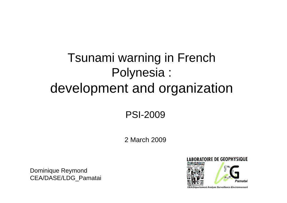
During the first tens of minutes …
• Only seismic data are generally available for the TWC in charge of warning.
• So, before receiving any tsunami data, what kind of information a TWC can extract from seismic data about a potential tsunami ? (then be able to push the red button to Civil Defense)
During the first tens of minutes …
Seismic data
Origin time
Lat, Lon (Epicenter)
Depth, H (Hypocenter)
Magnitudes (mB, ml, Md, Ms, MwP, Mm)
Scalar moment Mo ->Mw
Moment tensor : (φ, δ, λ, Mo, H)
Tsunami simulations : pre-computed amplitudes
Source duration τ, slowness Θ
Slip distribution (source function, Mo)

During the first tens of minutes …
The criteria of warning from seismic data:
If we get the 3 conditions:1. Epicenter is under-sea
2. Hypocenter is shallow (less than 60 km)3. Moment,Mo, is big : greater than # 1020 N.m
(i.e. large magnitude > 7.3 )
Definition: Mo = µ S D , whereS is fault areaD is displacement along the fault, µ is bulk modulus

Lack of warning system + lack of education
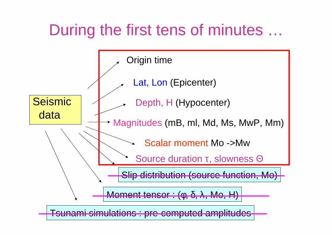
Tsunamis : Sumatera 26 dec. 2004

Tsunamis:Sumatera
Rupture zone of big Sumatra event (26 dec. 2004)
After-shocks distribution (CSEM): ~ surface of the rupture zone:~ 1000 km, ~ 200 km width, slip: ~ 20 m in the southern part~ 8 minutes of rupture duration (vr ~ 2.5 km/s)
Subduction of Indo-Australian plate under Indonesian plate.

Some statistics
Rate seismicity in the world :
• magnitude 6 : # 1 / 3 days• magnitude 7 : # 10 / year• magnitude 8 : # 1 / 2 year• magnitude 9 : # 3-4 / century
– (Sumatera 2004 was 9.3)

Dangerous earthquakes for Polynesia in XX cent.
May 1960, M 9.5,6 m, Mrq
30 Jul 1995, 8.0,3-4 m Mrq
Peru, 7.3Feb. 1996, 2-3 m Mrq
Mexico, 8.1Oct. 1995, 1m Mrq
Peru, 8.4jun. 2001, 0.9 m Mrq
Alaska, 9.2Mar 1964, 2 m Mrq
Aleutian, 8.51 avr 1946
Aleutian, 8.7Mar 1957, 2-4 m Mrq
Kamchatka, 8.3Nov 1952, 2-4 m .
Kuril, 8.2oct. 1994, 1 m Mrq
Tonga, 8.0apr 1919, 1 m Haw
Ecuador, Fev. 1996, 2-3 m Mrq
Chile, 11 nov 1922, 8.34 m Mrq
Chile, Aug 1906, 8.53.5 m Haw
undocumented Big in Marquesas Big in Polynesia and documented

Hiva Oa et Nuku Hiva: run-up for tsunami 1er April 1946
Tahiti : 4 – 6 m East shore< 1 m west shore
ISLV :# 0.70 mRurutu : 3 – 4 mTuamotu < 1 m

CEA/DASE/LDG_Tahiti
Some observations of tsunamis:Aleutian, 9 March 1957, et Aleutian 1er April 1946 in Hawaï
9 mars 1957 – Oahu - Hawaii 1 Avril 1946 – Hilo - Hawaii
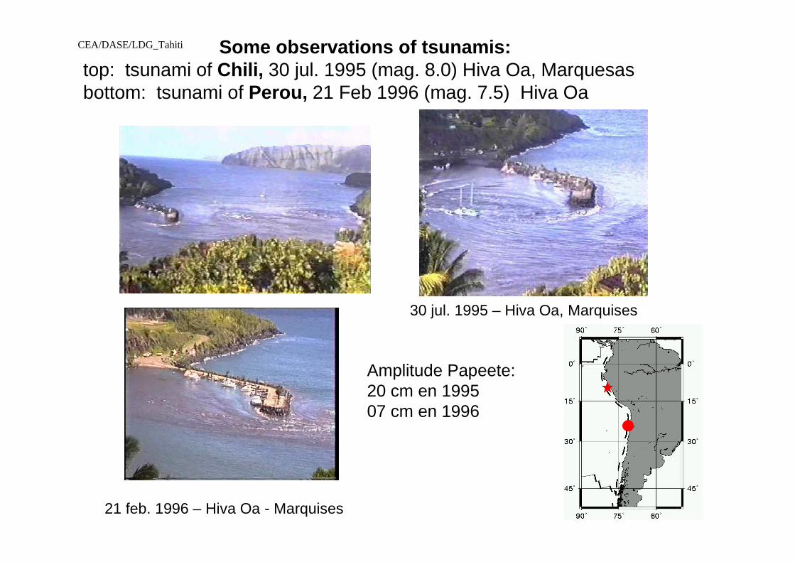
CEA/DASE/LDG_Tahiti Some observations of tsunamis:top: tsunami of Chili, 30 jul. 1995 (mag. 8.0) Hiva Oa, Marquesasbottom: tsunami of Perou, 21 Feb 1996 (mag. 7.5) Hiva Oa
21 feb. 1996 – Hiva Oa - Marquises
30 jul. 1995 – Hiva Oa, Marquises
Amplitude Papeete:20 cm en 199507 cm en 1996

Warning system in the Pacific:26 states members of ITSU
Australia,Canada,Chile,China,Colombia,Cook Islands,Costa Rica,Democratic People’s Republic of Korea,Ecuador, El Salvador,Fiji,France,Guatemala,Indonesia,Japan,Mexico,New Zealand,Nicaragua,Peru,Philippines,Republic of Korea,Samoa,Singapore,Thailand, Russian FederationUnited States of America.
PTWC
JMA
ATWC
CPPT
SHOA
IGNS
28
CATW

TSUNAMI WARNING IN THE PACIFIC
PTWC(Pacific Tsunami Warning Center)
Warning to Countries (TELEX, GTS, Emails,Fax)
WARNING in French Polynesia
+ TREMORS system
+ CIVIL DEFENSE Transmission to Civil Defense
PSS_Tsunami
High-Authorities
Geophysicist on duty
Evacuation of populations
TWC, Focal points

LEVEL 3
LEVEL 2
LEVEL 4
HC HC HC HC ---- DPCDPCDPCDPC
Flow-chart of present warning to populations
The warning could start at any level in function of available delays
LDGLaboGeo
Territorial administrator
TV, radio
Mayors
Populations

Polynesian geophysical network
CEA/DASE/LDG
Real-time link

# 35 seismic stations received in real time:via SEEDLINK protocol over Internet
TAOE
DZMG
PPT

TREMORS : Overview of the automatic seismic warning system
Data acquisition
3 components seismic dataof a single station
Realtime analysis of seismic databy a PC computer
LocationDetection Magnitude, Mo
Warning from a given threshold on magnitude 7.0
Seismologist24h/24h on duty
Warning to Civil Defense
CEA/DASE/LDG

IN CASE OF WARNING
• 1 - Evaluation of 3 tsunamigenic criteria:• location• Focal depth• Energy (Mo)
2- Exchanges of data with other organisms (PTWC, CSEM): • Magnitude, seismic moment, focal depth
3 - If the earthquake has a potential tsunami risk :• Call CIVIL DEFENSE• Waiting for the first tsunami measures : tide-gauge, sea_level
stations to confirm/cancel a warning
CEA/DASE/LDG_Tahiti

Sea-level stations received in near real-time via GTS
KAUM
HivaNuku
RIKIEAST
PAPE
PENR
NIUE
KANT
POHN
KAPI
NKFA
FONG
VITI
CABO
ACAP
SANT
ARICVANU
JUAN
SANF
CALD
ANTO
VALP, SANO
SPED
TALC
ANCUD
COQU
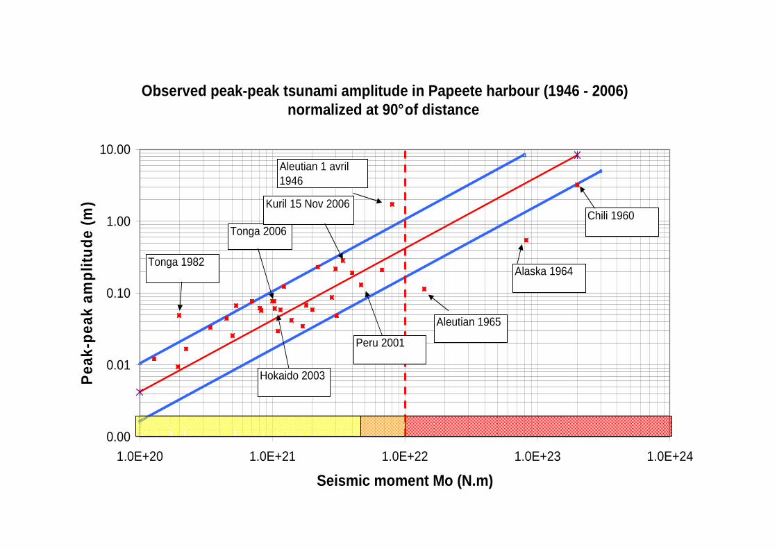
Observed peak-peak tsunami amplitude in Papeete har bour (1946 - 2006)normalized at 90° of distance
0.00
0.01
0.10
1.00
10.00
1.0E+20 1.0E+21 1.0E+22 1.0E+23 1.0E+24
Seismic moment Mo (N.m)
Pea
k-pe
ak a
mpl
itude
(m
)
Aleutian 1 avril 1946
Alaska 1964
Chili 1960
Aleutian 1965
Tonga 1982
Peru 2001
Hokaido 2003
Tonga 2006
Kuril 15 Nov 2006

Example of tsunami warning bulletin sent to Civil Defense , for Kuril 15 Nov 2006
TSUNAMI WARNING - bulletin 3
Preliminary information on big earthquake located in Kuril, on 15 Nov 2006 :origin time : 11h14 T.U.Lat 46.7 NLon 153 E Prof :30 kmRegion :Kuril isl.Magnitude : 8.3 MwLevel of risk : REDConcerned regions of Polynesia : MARQUESAS Islands ONLY• Estimated Tsunami height : [30 - 90 cm] in NUKU_HIVA• Estimated tsunami height : [05 - 30 cm] in Papeete harbour• Estimated tsunami height : [05 - 30 cm] for RIKITEA It is not a major tsunami, but taking into account large amplification
effects of some bays in Marquesas, strong currents and vortexes should be observed …..

END
Thank you for your attention

The case of slow earthquakes
• Nicaragua Sept. 1992: mB = 5.3, Mw = 7.6• Java 2 June 1994: mB =5.5, Mw = 7.8• Peru 21 Feb 1996 : mB = 5.8, Mw = 7.5• Java 17 Jul 2006: mB = 5.5, Mw = 7.7
•Must use Mo (or Mw) instead of classical magnitude mb, Ms; Why ?
•For slow and/or giant earthquake, classical magnitudes are largely underestimated:
•Large sources with long duration, act like a natural low-pass filter