TS01A farah 5250 - Kopi - International Federation of ... file•Development approaches in Africa...
27
AFREF AFRICAN GEODETIC REFERENCE FRAME A Modern and Unified Reference Frame for Africa AFREF AFRICAN GEODETIC REFERENCE FRAME A Modern and Unified Reference Frame for Africa Hussein.O.Farah Co-Chair AFREF Steering Commmittee Regional Centre for Mapping of Resources for Development P.O.Box 632-00618, Nairobi, Kenya 1
Transcript of TS01A farah 5250 - Kopi - International Federation of ... file•Development approaches in Africa...

AFREF
AFRICAN GEODETIC REFERENCE FRAME
A Modern and Unified Reference Frame for Africa
AFREF
AFRICAN GEODETIC REFERENCE FRAME
A Modern and Unified Reference Frame for Africa
Hussein.O.FarahCo-Chair AFREF Steering Commmittee
Regional Centre for Mapping of Resources for DevelopmentP.O.Box 632-00618, Nairobi, Kenya 1

• Development approaches in Africa are geared towards continental and regional economic and political integration
- AU-NEPAD-COMESA-SADC-EAC-ECOWAS
• This requires uniform geo-spatial information
IntroductionIntroduction
2

• Traditionally each country has its own geodetic reference system
• Maps in neighbouring countries do not match at the national boundaries
(system1 ) (system2)
Problem
3
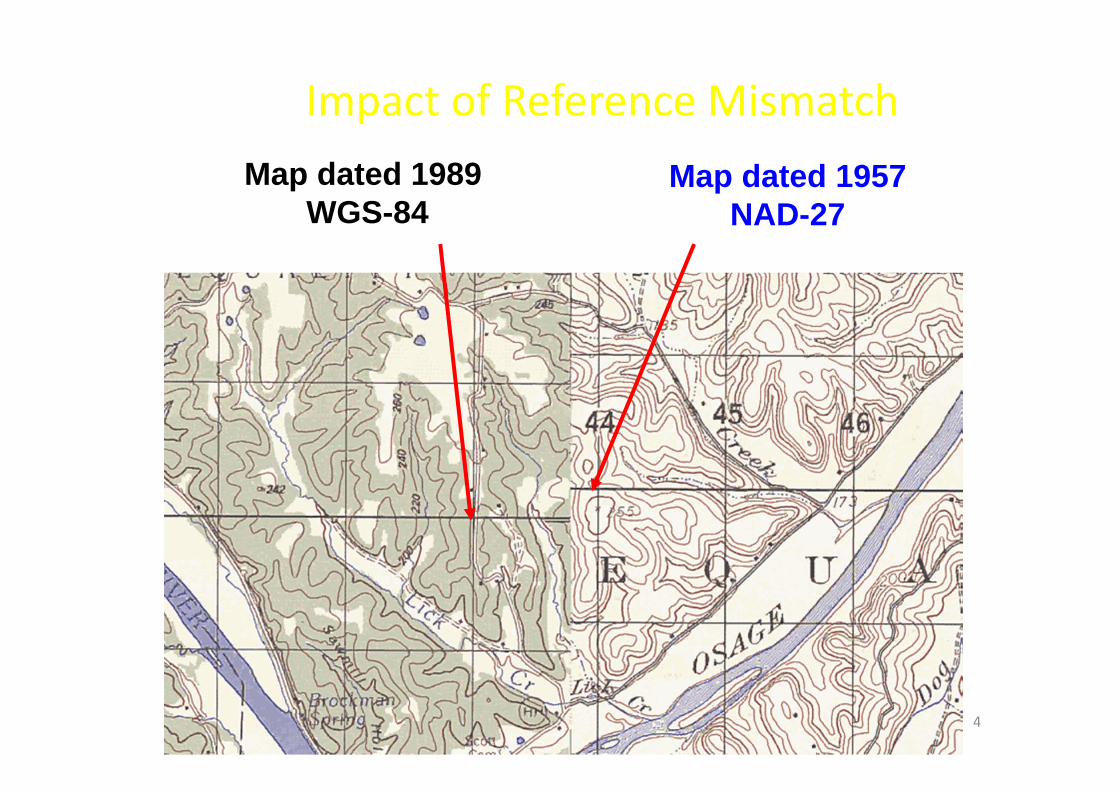
Impact of Reference Mismatch Map dated 1989
WGS-84Map dated 1957
NAD-27
4

Source: Zurich-American Insurance
Consequences of using reference systems that are not consistent !
5

PROBLEM ‐ CONSEQUENCES :
Confusion within countries as to appropriate datums,projections and transformations to use
Confusion and delays in cross‐border projects: ‐ transport corridors, mapping projects, conservation and environment, exploitation of mineral resources
Confusion and conflict regarding international borders
A multitude of different datums, different ellipsoids and different projections
6

National Systems Global Systems
SolutionSolution
•Move from National Reference Systems to Regional or Global Reference Systems
7

GNSS+
ITRF
Non-uniform systems Uniform system
SolutionSolution
8

Objectives of AFREFObjectives of AFREF
– To establish a continental reference system as a basis for national reference networks.
– To establish permanent GNSS base stations such that users will be within 500km of a base station and that data is freely available to all users.
– To realize a unified vertical datum and to support efforts to establish a precise African geoid.
9

The structure reflects the broad concepts of AFREF that:
– It is to be designed, managed and executed from within Africa;
– It is to be organized on a regional basis;
– It is to be executed at the national level
Organizational Principles
10

Organizational Structure
African Union
RECTAS RCMRD AOCRS
National Mapping Organisations & Other GNSS Stake Holders
AU Science & Technology Ministers
InternationalPartners
ECA CODIST
Steering Committee
Scientificadvisory Group
11
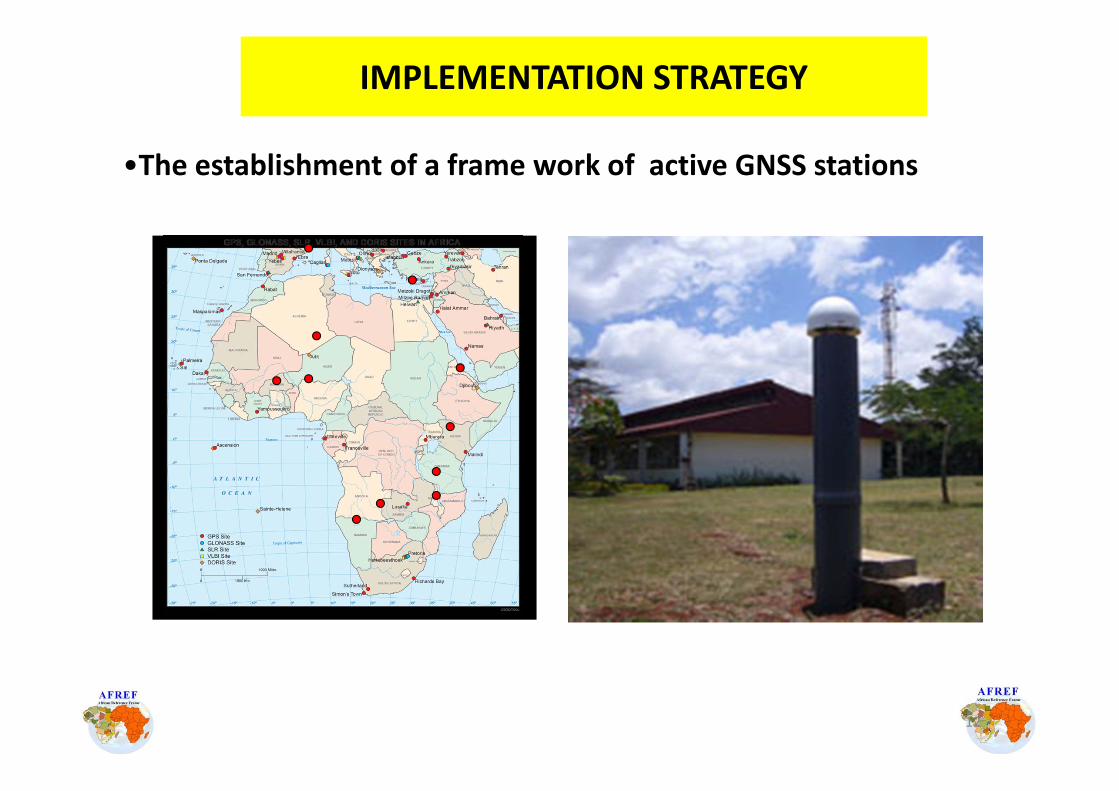
IMPLEMENTATION STRATEGY
•The establishment of a frame work of active GNSS stations
12

IMPLEMENTATION STRATEGY
• Computation of AFREF solution
GIPSY (PPP strategy)
Day 1Day 1
Station position Station position in an arbitrary in an arbitrary
reference frame 1reference frame 1
Unified system of Unified system of station position in station position in
an arbitrary an arbitrary reference framereference frame
GIPSY tools(dedicated mapping)
...... Day 7Day 7
AFREF positions AFREF positions w.r.t. ITRF2005w.r.t. ITRF2005
GIPSY tools
Positions of a Positions of a global set of IGS global set of IGS sites in ITRF2005sites in ITRF2005
AFREF + Global AFREF + Global IGS SitesIGS Sites
Station position Station position in an arbitrary in an arbitrary
reference frame 7reference frame 7
AFREF + Global AFREF + Global IGS SitesIGS Sites
Positions of a Positions of a global set of IGS global set of IGS sites in ITRF2005sites in ITRF2005
AFREF positions AFREF positions w.r.tw.r.t. ITRF2005. ITRF2005
GLORG
Unified system of Unified system of station position station position in an arbitrary in an arbitrary
reference framereference frame
GLOBK
GAMIT
......Day 1Day 1
Regional Regional Solution 1Solution 1
AFREF + AFREF + Fiducial Fiducial
IGS SitesIGS Sites
Global Global Solution 1Solution 1
Global IGS Global IGS + Fiducial + Fiducial IGS SitesIGS Sites
Day 7Day 7
Regional Regional Solution 7Solution 7
AFREF + AFREF + Fiducial Fiducial
IGS SitesIGS Sites
Global Global Solution 7Solution 7
Global IGS Global IGS + Fiducial + Fiducial IGS SitesIGS Sites
13

Ermelo
Middelburg
200 KM
NAMIBIA
BOTSWANA MOZAMBIQUE
Cape TownPort Elizabeth
EastLondon
Bloemfontein
LESOTHO
Ulundi
SWAZI
Durban
Pietersburg
Pretoria
KimberleySpringbok
De Aar
George
Thohoyandau
Calvinia Umtata
Ladysmith
Ellisras
Langebaanweg
Hermanus
BethlehemUpington
Kuruman
Mafikeng
Pietermaritzburg
Queenstown
Graaff-Reinet
AliwalNorth
Sutherland
Hartebeesthoek
Nelspruit
Phalborwa
Frame Relay continuousstream
ISDN Daily download
Prieska
Beaufort West
Int GPS Service Stations
IMPLEMENTATION STRATEGY
•The densification of the network at national level
•Computation of Transformation Parameters
14

IMPLEMENTATION STRATEGY
•The development of a refined geoid model for Africa
15

DGPS
Telecom Sat
GSMGPRS
internet etc
FTP/ Web Server
Post Processing Users
DGPS-RTK
GSM / GPRS
Field CORS
Network Control Centre
Real Time Users
AFREF STRUCTURE ON REALIZATION
16

Applications
17
340˚ 0˚ 20˚ 40˚ 60˚
-40˚
-20˚
0˚
20˚
SOMA PLATEAFRI PLATE
ARAB PLATE
SWIR
(19m
m/yr
)
Mid
Atl
anti
c R
idg
e(38
mm
/yr)
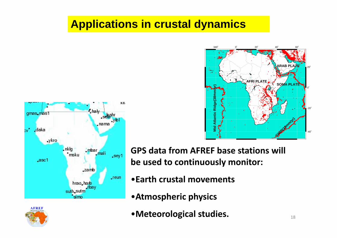
Applications in crustal dynamics
GPS data from AFREF base stations will be used to continuously monitor:
•Earth crustal movements
•Atmospheric physics
•Meteorological studies. 18

Required resources
• Trained technical staff – 2 per station.
• Positioning equipment – GNSS receivers – USD 20,000 per station.
• Reliable power supply.
• Computing facilities.
• Communication facilities –Internet, VSAT, telephone.
19

CALL FOR PARTICIPATIONin the
UNIFICATION OF AFRICAN REFERENCE FRAMESThe AFREF Project
2005‐2010Committee on Development Information, Geo‐
Information Subcommittee(CODI‐GEO)
United Nations Economic Commission for Africa (UNECA)http://geoinfo.uneca.org/afref/
Endorsed by:International Association of Geodesy (IAG) International
Global Navigation Satellite System Service (IGS)United Nations Office of Outer Space Affairs (UNOOSA)
Federation of International Surveyors (FIG)August 2005
•Call for Participation sent out (28 responses received)
Present status
•First technical Workshops
20
Present status
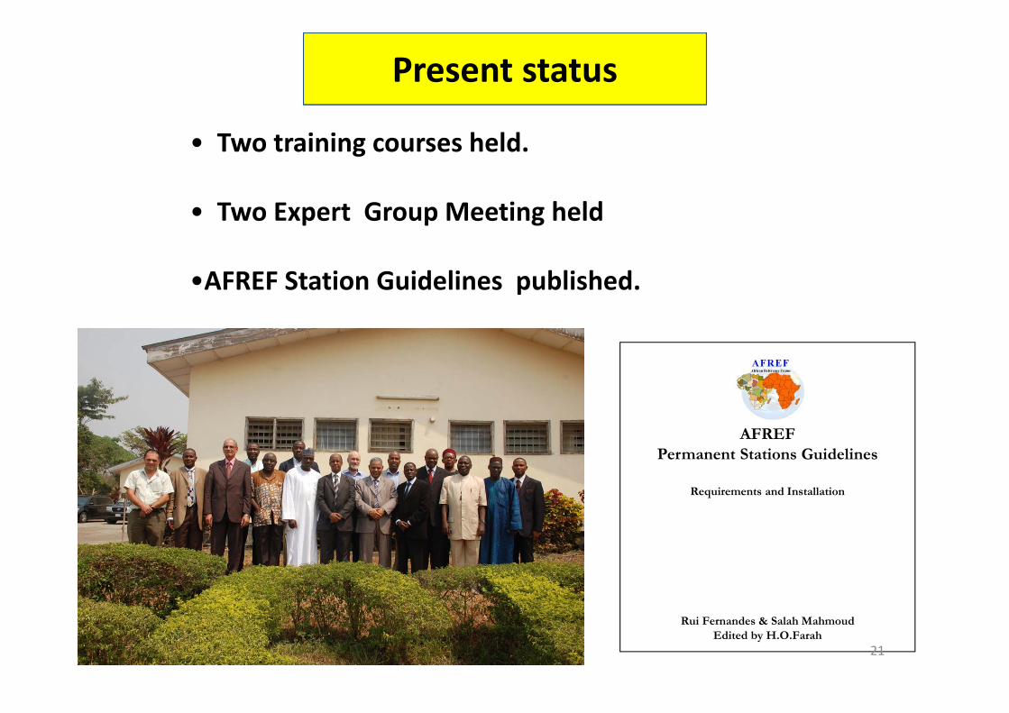
• Two training courses held.
• Two Expert Group Meeting held
•AFREF Station Guidelines published.
AFREFPermanent Stations Guidelines
Requirements and Installation
Rui Fernandes & Salah MahmoudEdited by H.O.Farah
21

Present status
http://geoinfo.uneca.org/afref
•AFREF Web site established
•AFREF quarterly Newsletter launched AFRICAN GEODETIC
REFERENCE FRAME (AFREF)-NEWSLETTER
Secretariat: Regional Centre for Mapping of Resources for Development (RCMRD)
P.O.Box 632‐00618, Ruaraka Nairobi, Kenya. Tel:+254‐20‐8560227/8561775Fax:254‐20‐8561673
AFREF News Letter No.8 e‐mail: [email protected] January 2009
22

Present status
•22 Countries have established GNSS permanent stations
•50 permanent station are sending data to AFREF ODC
23
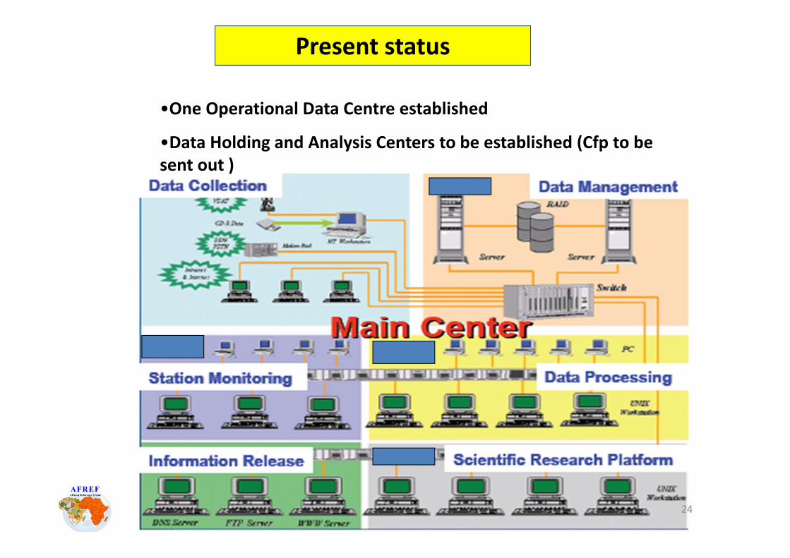
•One Operational Data Centre established
•Data Holding and Analysis Centers to be established (Cfp to be sent out )
Present status
24
• ECA and AUC proposed implementation Plan approved in 2009
• New Management Structures to be put in place
• Coordination between partners and stakeholders to be formalized
• Capacity building programmes to be undertaken
Present status
25

• More Publicity of AFREF initiative.
• commitment from Countries thro’ National Mapping Organizations .
• Capacity building – manpower and equipment at national level .
• Support from international partners.
• Build capacity in AFREF data holding & analysis centres.
• Compute first official AFREF Coordinates
Requirements to Move ForwardRequirements to Move Forward
26

GNSS+
ITRF
THANK YOUTHANK YOUhttp://geoinfo.uneca.org/afref
Non-uniform systems Uniform system
27


![[DPnF-RLnF-SnTF] Nickelodeon - Red Cap 2 Kopi Kopi Luwak](https://static.fdocuments.us/doc/165x107/577cc6d41a28aba7119f3b91/dpnf-rlnf-sntf-nickelodeon-red-cap-2-kopi-kopi-luwak.jpg)