Trip Kit Index Airport Information For EGKK Printed on 03 ...vau.aero/navdb/chart/EGKK.pdf ·...
44
List of pages in this Trip Kit Trip Kit Index Airport Information For EGKK Terminal Charts For EGKK Revision Letter For Cycle 12-2018 Change Notices Notebook Trip Kit Index Printed on 03 Jul 2018 Page 1 (c) JEPPESEN SANDERSON, INC., 2018, ALL RIGHTS RESERVED j e p JEPPESEN JeppView for Windows General Information Location: LONDON GBR ICAO/IATA: EGKK / LGW Lat/Long: N51° 08.9', W000° 11.4' Elevation: 203 ft Airport Use: Public Daylight Savings: Observed UTC Conversion: +0:00 = UTC Magnetic Variation: 0.0° E Fuel Types: Jet A-1 Repair Types: Major Airframe, Major Engine Customs: Yes Airport Type: IFR Landing Fee: Yes Control Tower: Yes Jet Start Unit: No LLWS Alert: No Beacon: No Sunrise: 0351 Z Sunset: 2019 Z Runway Information Runway: 08L Length x Width: 8415 ft x 148 ft Surface Type: asphalt TDZ-Elev: 195 ft Lighting: Edge, ALS, REIL Displaced Threshold: 1056 ft Runway: 08R Length x Width: 10879 ft x 148 ft Surface Type: asphalt TDZ-Elev: 196 ft Lighting: Edge, ALS, Centerline, TDZ Displaced Threshold: 1289 ft Stopway: 243 ft Runway: 26L Length x Width: 10879 ft x 148 ft Surface Type: asphalt TDZ-Elev: 196 ft Lighting: Edge, ALS, Centerline, TDZ Displaced Threshold: 1391 ft Stopway: 200 ft Runway: 26R Length x Width: 8415 ft x 148 ft Surface Type: asphalt TDZ-Elev: 195 ft Lighting: Edge, ALS, REIL Displaced Threshold: 1368 ft Communication Information ATIS: 136.525 At or below 20000 ft Out to 60 mi. Gatwick Tower: 134.225 At or below 15000 ft Out to 45 mi. Gatwick Tower: 124.225 At or below 10000 ft Out to 25 mi. Gatwick Ground: 121.800 Out to 5 mi. Airport Information For EGKK Printed on 03 Jul 2018 Page 1 (c) JEPPESEN SANDERSON, INC., 2018, ALL RIGHTS RESERVED j e p JEPPESEN JeppView for Windows
Transcript of Trip Kit Index Airport Information For EGKK Printed on 03 ...vau.aero/navdb/chart/EGKK.pdf ·...

List of pages in this Trip Kit
Trip Kit IndexAirport Information For EGKKTerminal Charts For EGKKRevision Letter For Cycle 12-2018Change NoticesNotebook
Trip Kit Index
Printed on 03 Jul 2018
Page 1(c) JEPPESEN SANDERSON, INC., 2018, ALL RIGHTS RESERVED
jep=JEPPESEN
JeppView for Windows
General Information
Location: LONDON GBRICAO/IATA: EGKK / LGWLat/Long: N51° 08.9', W000° 11.4'Elevation: 203 ft
Airport Use: PublicDaylight Savings: ObservedUTC Conversion: +0:00 = UTCMagnetic Variation: 0.0° E
Fuel Types: Jet A-1Repair Types: Major Airframe, Major EngineCustoms: YesAirport Type: IFRLanding Fee: YesControl Tower: YesJet Start Unit: NoLLWS Alert: NoBeacon: No
Sunrise: 0351 ZSunset: 2019 Z
Runway Information
Runway: 08LLength x Width: 8415 ft x 148 ftSurface Type: asphaltTDZ-Elev: 195 ftLighting: Edge, ALS, REILDisplaced Threshold: 1056 ft
Runway: 08RLength x Width: 10879 ft x 148 ftSurface Type: asphaltTDZ-Elev: 196 ftLighting: Edge, ALS, Centerline, TDZDisplaced Threshold: 1289 ftStopway: 243 ft
Runway: 26LLength x Width: 10879 ft x 148 ftSurface Type: asphaltTDZ-Elev: 196 ftLighting: Edge, ALS, Centerline, TDZDisplaced Threshold: 1391 ftStopway: 200 ft
Runway: 26RLength x Width: 8415 ft x 148 ftSurface Type: asphaltTDZ-Elev: 195 ftLighting: Edge, ALS, REILDisplaced Threshold: 1368 ft
Communication Information
ATIS: 136.525 At or below 20000 ft Out to 60 mi.Gatwick Tower: 134.225 At or below 15000 ft Out to 45 mi.Gatwick Tower: 124.225 At or below 10000 ft Out to 25 mi.Gatwick Ground: 121.800 Out to 5 mi.
Gatwick Clearance Delivery: 121.950 Out to 5 mi.Gatwick Direct (Approach Control Radar): 118.950 At or below 10000 ft Out to 25 mi.Gatwick Direct (Approach Control Radar): 126.825 At or below 24500 ft Out to 45 mi.Gatwick Direct (Approach Control Radar): 129.025 At or below 24500 ft Out to 45 mi.Gatwick Fire Emergency: 121.600London Control ACC: 120.525London Control ACC: 133.180London Control ACC: 134.125
General Information
Location: LONDON GBRICAO/IATA: EGKK / LGWLat/Long: N51° 08.9', W000° 11.4'Elevation: 203 ft
Airport Use: PublicDaylight Savings: ObservedUTC Conversion: +0:00 = UTCMagnetic Variation: 0.0° E
Fuel Types: Jet A-1Repair Types: Major Airframe, Major EngineCustoms: YesAirport Type: IFRLanding Fee: YesControl Tower: YesJet Start Unit: NoLLWS Alert: NoBeacon: No
Sunrise: 0351 ZSunset: 2019 Z
Runway Information
Runway: 08LLength x Width: 8415 ft x 148 ftSurface Type: asphaltTDZ-Elev: 195 ftLighting: Edge, ALS, REILDisplaced Threshold: 1056 ft
Runway: 08RLength x Width: 10879 ft x 148 ftSurface Type: asphaltTDZ-Elev: 196 ftLighting: Edge, ALS, Centerline, TDZDisplaced Threshold: 1289 ftStopway: 243 ft
Runway: 26LLength x Width: 10879 ft x 148 ftSurface Type: asphaltTDZ-Elev: 196 ftLighting: Edge, ALS, Centerline, TDZDisplaced Threshold: 1391 ftStopway: 200 ft
Runway: 26RLength x Width: 8415 ft x 148 ftSurface Type: asphaltTDZ-Elev: 195 ftLighting: Edge, ALS, REILDisplaced Threshold: 1368 ft
Communication Information
ATIS: 136.525 At or below 20000 ft Out to 60 mi.Gatwick Tower: 134.225 At or below 15000 ft Out to 45 mi.Gatwick Tower: 124.225 At or below 10000 ft Out to 25 mi.Gatwick Ground: 121.800 Out to 5 mi.
Airport Information For EGKK
Printed on 03 Jul 2018
Page 1(c) JEPPESEN SANDERSON, INC., 2018, ALL RIGHTS RESERVED
jep=JEPPESEN
JeppView for Windows

General Information
Location: LONDON GBRICAO/IATA: EGKK / LGWLat/Long: N51° 08.9', W000° 11.4'Elevation: 203 ft
Airport Use: PublicDaylight Savings: ObservedUTC Conversion: +0:00 = UTCMagnetic Variation: 0.0° E
Fuel Types: Jet A-1Repair Types: Major Airframe, Major EngineCustoms: YesAirport Type: IFRLanding Fee: YesControl Tower: YesJet Start Unit: NoLLWS Alert: NoBeacon: No
Sunrise: 0351 ZSunset: 2019 Z
Runway Information
Runway: 08LLength x Width: 8415 ft x 148 ftSurface Type: asphaltTDZ-Elev: 195 ftLighting: Edge, ALS, REILDisplaced Threshold: 1056 ft
Runway: 08RLength x Width: 10879 ft x 148 ftSurface Type: asphaltTDZ-Elev: 196 ftLighting: Edge, ALS, Centerline, TDZDisplaced Threshold: 1289 ftStopway: 243 ft
Runway: 26LLength x Width: 10879 ft x 148 ftSurface Type: asphaltTDZ-Elev: 196 ftLighting: Edge, ALS, Centerline, TDZDisplaced Threshold: 1391 ftStopway: 200 ft
Runway: 26RLength x Width: 8415 ft x 148 ftSurface Type: asphaltTDZ-Elev: 195 ftLighting: Edge, ALS, REILDisplaced Threshold: 1368 ft
Communication Information
ATIS: 136.525 At or below 20000 ft Out to 60 mi.Gatwick Tower: 134.225 At or below 15000 ft Out to 45 mi.Gatwick Tower: 124.225 At or below 10000 ft Out to 25 mi.Gatwick Ground: 121.800 Out to 5 mi.
Gatwick Clearance Delivery: 121.950 Out to 5 mi.Gatwick Direct (Approach Control Radar): 118.950 At or below 10000 ft Out to 25 mi.Gatwick Direct (Approach Control Radar): 126.825 At or below 24500 ft Out to 45 mi.Gatwick Direct (Approach Control Radar): 129.025 At or below 24500 ft Out to 45 mi.Gatwick Fire Emergency: 121.600London Control ACC: 120.525London Control ACC: 133.180London Control ACC: 134.125
Gatwick Clearance Delivery: 121.950 Out to 5 mi.Gatwick Direct (Approach Control Radar): 118.950 At or below 10000 ft Out to 25 mi.Gatwick Direct (Approach Control Radar): 126.825 At or below 24500 ft Out to 45 mi.Gatwick Direct (Approach Control Radar): 129.025 At or below 24500 ft Out to 45 mi.Gatwick Fire Emergency: 121.600London Control ACC: 120.525London Control ACC: 133.180London Control ACC: 134.125
Airport Information For EGKK
Printed on 03 Jul 2018
Page 2(c) JEPPESEN SANDERSON, INC., 2018, ALL RIGHTS RESERVED
jep=JEPPESEN
JeppView for Windows
LONDON, UKEGKK/LGWGATWICK .AIRPORT.BRIEFING.
+ JEPPESEN
1.1. ATISD-ATIS 136.525
1.2. NOISE ABATEMENT PROCEDURES1.2.1. GENERAL
The following procedures may at any time be departed from to the extent neces-
sary for avoiding immediate danger or for complying with ATC instructions.
Every operator of ACFT using the APT shall ensure at all times that ACFT are
operated in a manner calculated to cause the least disturbance practicable in
areas surrounding the APT.
1.2.2. REVERSE THRUSTAvoid use of reverse thrust after landing between 2330-0600LT except for safety
reasons.
1.2.3. USE OF APUFixed Electrical Ground Power must be used whenever available and serviceable.
Use of ACFT Auxiliary Power Units (APUs) and Ground Power Units (GPUs) are
strictly controlled to minimise environmental impact. APUs must be shut down
after arrival and only restarted before departure according to the timescales
described in detail in published Gatwick APT Instructions and Directives. Regular
audits take place to ensure compliance to the regulations. Dispensation to use
GPUs must be requested from GAL Airfield Operations +44(0)1293 503090.
1.2.4. RUN-UP TESTSRun-up tests are controlled in accordance with instructions issued by Gatwick
APT LTD.
1.2.5. NIGHTTIME RESTRICTIONSAny ACFT which has a noise classification greater than 95.9 EPNdB may not be
scheduled to take-off or land between 2300-0700LT.
Any ACFT which has a noise classification greater than 98.9 EPNdB may not take
off between 2300-0700LT, except between 2300-2330LT when
- It was scheduled to take-off prior to 2300LT;
- Take-off was delayed for reasons beyond control of the ACFT operator;
- APT authority has not given notice to the ACFT operator precluding take-off.
Any ACFT may not take off or be scheduled to land between 2300-0700LT where
the operator of that ACFT has not provided (prior to its take-off or prior to its
scheduled landing times as appropriate) sufficient information to enable the APT
authority to verify its noise classification.
None of the provisions of this notice shall apply to a take-off or landing which is
made in an emergency consisting of an immediate danger to life or health,
whether human or animal.
1.3. LOW VISIBILITY PROCEDURES (LVP)1.3.1. GENERAL
Pilots will be informed when RWY 08R/26L ATC LVP are in operation via ATIS or
RTF.
1.3.2. ARRIVALExits will be illuminated and pilots should select the first convenient exit. GMR
(Ground Movement Radar) is available to monitor pilot "RWY vacated" reports.
When GMR is not available to ATC, report of ACFT vacating RWY (LOC sensitive
area) will be assessed by receipt of pilot report that the ACFT has passed the last
of the alternate amber and green centerline lights. These lights denote the extent
of the ILS LOC sensitive area.
20-1P1 JUN 18
1. GENERAL
| JEPPESEN, 2006, 2015. ALL RIGHTS RESERVED.
Printed from JeppView for Windows 5.3.0.0 on 03 Jul 2018; Terminal chart data cycle 12-2018 (Expired); Notice: After 28 Jun 2018, 0000Z, this chart may no longer be valid

LONDON, UKEGKK/LGWGATWICK .AIRPORT.BRIEFING.
+ JEPPESEN
1.3.3. DEPARTURE
1.3.3.1. RWY 08REntry via CAT III holding point at G3, H3, J3, J4 or J7.
1.3.3.2. RWY 26LEntry via CAT III holding point at A3, C3 or M3.
Occasionally, it may be necessary for other departure points to be used due to
work in progress or at the discretion of ATC.
1.4. SURFACE MOVEMENT GUIDANCE AND CONTROL SYSTEMAPT is equipped with an advanced surface movement radar utilising Mode S.
ACFT operators should ensure that Mode S transponders are able to operate when
ACFT is on the ground.
Flight crew should select XPNDR or the equivalent according to specific installa-
tion, AUTO if available, not OFF or STANDBY, and the assigned Mode A code from
the request for push-back or taxiing, whichever is earlier or after landing, con-
tinuously until the ACFT is fully parked on stand.
After parking the Mode A code 2000 must be set before selecting OFF or
STANDBY.
Flight crew of ACFT equipped with Mode S having an ACFT identification feature
should also set the ACFT identification. This setting is the ACFT identification
specified in item 7 of the ICAO flight plan. The ACFT identification should be
entered from the request for push-back or taxiing, whichever is earlier, through
the FMS or the transponder control panel.
Pilots are to use the minimum power necessary when maneuvering on the TWY
system. This is of particular importance when maneuvering in the apron cul-de-
sacs, where jet blast can affect adjacent stands.
1.5. RWY OPERATIONSRWY 08L/26R will only be used when RWY 08R/26L is temporarily non-
operational.
1.6. TAXI PROCEDURESTWY M is available as an entry point to RWY 26L. TWY M can not be used as an
exit point from RWY 08R.
There is a positive but substandard obstacle clearance (minimum of 156'/48m) on
TWY J A380 routing. Pilots are to ensure that Cockpit over Centerline (COCL)
technique is used at all times when maneuvering.
1.7. PARKING INFORMATION1.7.1. GENERAL
All stands except 41 and 43 are nose-in/push-back.
20-1P11 JUN 18
1. GENERAL
| JEPPESEN, 2006, 2018. ALL RIGHTS RESERVED.
Printed from JeppView for Windows 5.3.0.0 on 03 Jul 2018; Terminal chart data cycle 12-2018 (Expired); Notice: After 28 Jun 2018, 0000Z, this chart may no longer be valid
LONDON, UKEGKK/LGWGATWICK .AIRPORT.BRIEFING.
+ JEPPESEN
1.7.2. STAND ENTRY GUIDANCE SYSTEMSActivation of stand entry guidance systems should indicate that a safety check of
the stand has been made by handling agent prior to ACFT arrival.
Pilots should not enter an ACFT stand unless system is illuminated or marshaller
has signalled clearance to proceed.
The stand entry guidance system is provided by 'Safedock' Advanced Visual Dock-
ing Guidance System (A-VDGS), except stands 33R, 110L, 110R, 130 thru 136,
150L, 150R, 152L and 152R where marshaller is required.
2.1. SPEED RESTRICTIONSPilots should typically expect the following speed restrictions to be enforced:
- 220 KT from the holding facility during the intermediate approach phase;
- 180 KT on base leg/closing heading to the ILS;
- Between 180 KT and 160 KT when first established on the ILS;
and thereafter 160 KT to D4.0.
These speeds are applied for ATC separation purposes and are mandatory.
In the event of a new (non-speed related) ATC clearance being issued (e.g. an
instruction to descend on ILS), pilots are not absolved from a requirement to
maintain a previously allocated speed. All speed restrictions are to be flown as
accurately as possible. ACFT unable to conform to these speeds should inform
ATC and state what speeds will be used. In the interests of accurate spacing,
pilots are requested to comply with speed adjustments as promptly as feasible
within their own operational constraints, advising ATC if circumstances necessi-
tate a change of speed for ACFT performance reasons.
2.2. NOISE ABATEMENT PROCEDURESThe following procedures may at any time be departed from to the extent neces-
sary for avoiding immediate danger or for complying with ATC instructions.
Every operator of ACFT using the APT shall ensure at all times that ACFT are
operated in a manner calculated to cause the least disturbance practicable in
areas surrounding the APT.
An ACFT approaching to land shall according to its ATC clearance minimise noise
disturbance by the use of continuous descent and low power, low drag operating
procedures.
Where the use is not practicable, ACFT shall maintain an altitude as high as
possible.
For monitoring purposes, a descent will be deemed to have been continuous pro-
vided that no segment of level flight longer than 2.5NM occurs below 7000' QNH
and 'level flight' is interpreted as any segment of flight having a height change
of not more than 50' over a track distance of 2NM or more, as recorded in the APT
noise and track-keeping system.
Maintain an altitude as high as practicable and avoid overflying Crawley, East
Grinstead, Horley and Horsham below 3000' (Gatwick QNH) and Lingfield below
2000' (Gatwick QNH).
ACFT using the ILS shall not descend below 2000' (Gatwick QNH) before inter-
cepting GS nor thereafter fly below it. ACFT approaching without ILS assistance
shall follow a descent path which will not result in its being at any time lower
than the height of the approach path normally indicated by the PAPI.
Do not join final approach at a height of less than 1710', except propeller driven
ACFT of not more than 5700 KGS MTWA which shall not join at a height of less
than 1210'.
2. ARRIVAL
20-1P28 DEC 17
1. GENERAL
| JEPPESEN, 2006, 2017. ALL RIGHTS RESERVED.
Printed from JeppView for Windows 5.3.0.0 on 03 Jul 2018; Terminal chart data cycle 12-2018 (Expired); Notice: After 28 Jun 2018, 0000Z, this chart may no longer be valid

LONDON, UKEGKK/LGWGATWICK .AIRPORT.BRIEFING.
+ JEPPESEN
Between 2330-0600LTACFT shall not join the centerline below 3000' (Gatwick QNH) closer than 10 NM
from touchdown.
An ACFT approaching to land shall according to its ATC clearance minimise noise
disturbance by the use of continuous descent and low power, low drag operating
procedures.
Where the use is not practicable, ACFT shall maintain an altitude as high as
possible.
2.3. CAT II/III OPERATIONSRWY 08R/26L is approved for CAT II/III operations, special aircrew and ACFT
certification required.
2.4. RWY OPERATIONS2.4.1. MINIMUM RWY OCCUPANCY TIME
High Intensity RWY Operation requires all ACFT to exit RWY at fastest speedcommensurate with safety. Extended RWY occupancy may result in followingACFT being sent around.
Pilots should pre-plan their landing and roll-out to target rapid exit TWYs that
provides for a safe and expeditious exit from RWY to reduce delays and maximiseutilisation at all times.
Landing ACFT are to vacate expeditiously.
Arrivals are to ensure fully vacated before stopping.
RWY 08R:TWY D distance from THR 4324’/1318m, design exit speed 38 KT.TWY CR distance from THR 5705’/1739m, design exit speed 49 KT.
TWY BR distance from THR 7198’/2194m, design exit speed 52 KT.
Traffic vacating at TWY CR have to await onward clearance before enteringTWY J due to conflicting ground traffic.
Traffic vacating at TWY BR have to route TWY P and hold before TWY J to ensure
tail clear of RWY.
Tactical requests to extend landing roll to reduce ground taxi/exit nearer to park-ing stand are not to be made to ATC.
TWY E not available for vacating RWY 08R.
RWY 26L:TWY E distance from THR 4341’/1323m, design exit speed 38 KT.
TWY FR distance from THR 5817’/1773m, design exit speed 52 KT.
TWY GR distance from THR 6788’/2069m, design exit speed 49 KT.
Traffic vacating at TWY E have to turn RIGHT onto RWY 08L without stopping on
RWY exit.
Traffic vacating TWY FR or GR have to cross RWY 26R onto TWY J. When exitingRWY 26L ACFT do not have to call for clearance to cross RWY 26R as RWYs cannot
be used simultaneously.
Pilots of A380 must not stop until the ACFT is established on, or North of
RWY 08L/26R.
TWY D is not available for vacating RWY 26L.
2.4.2. "LAND AFTER" PROCEDURENormally, only one ACFT is permitted to land or take-off on the RWY-in-use at
any one time. However, when the traffic sequence is two successive landing
ACFT, the second one may be allowed to land before the first one has cleared the
RWY-in-use, providing:
- RWY is long enough;
- It is during daylight hours;
- The second ACFT will be able to see the first ACFT clearly and continuously
until it is clear of the RWY;
- The second ACFT has been warned.
20-1P38 DEC 17
2. ARRIVAL
| JEPPESEN, 2006, 2017. ALL RIGHTS RESERVED.
Printed from JeppView for Windows 5.3.0.0 on 03 Jul 2018; Terminal chart data cycle 12-2018 (Expired); Notice: After 28 Jun 2018, 0000Z, this chart may no longer be valid
LONDON, UKEGKK/LGWGATWICK .AIRPORT.BRIEFING.
+ JEPPESEN
ATC will provide this warning by issuing the second ACFT with the instruction
"Land after ... (first ACFT type)" in place of the usual instruction "Cleared to
land". Responsibility for ensuring adequate separation between the two ACFT
rests with the pilot of the second ACFT.
2.5. OTHER INFORMATION2.5.1. GENERAL
Warning: In low visibility at NIGHT the apron and car park floodlighting may beseen before the APCH lights on RWY 26L and 26R approaches.Strong Southerly/South westerly winds can cause building induced tur-
bulence and windshear effects when landing on RWY 26L/R.
2.5.2. SPECIAL LANDING PROCEDURESSpecial landing procedures may be in force in conditions hereunder, when the use
will be as follows:
- When the RWY-in-use is temporarily occupied by other traffic, landing clear-
ance will be issued to an arriving ACFT provided that at the time the ACFT
crosses the THR of the RWY-in-use the following separation distances will
exist:
- Landing following landing - The preceding landing ACFT will be clear of
the RWY-in-use or will be at least 2500m/1.35NM from the THR of the
RWY-in-use.
- Landing following departure - The departing ACFT will be airborne and
at least 2000m/1.1NM from the THR of the RWY-in-use, or if not airborne,
will be at least 2500m/1.35NM from the THR of the RWY-in-use.
- Reduced separation distances as follows will be used where both the preceding
and succeeding landing ACFT or both the landing and departing ACFT are pro-
peller driven and have a maximum total weight authorized not exceeding
5700kg:
- Landing following landing - The preceding ACFT will be clear of the
RWY-in-use or will be at least 1500m/0.8NM from the THR of the RWY-in-
use.
- Landing following departure - The departing ACFT will be airborne or
will be at least 1500m/0.8NM from the THR of the RWY-in-use.
- Conditions of Use
The procedures will be used by DAY only under the following conditions:
- When 26L/08R is in use;
- When the controller is satisfied that the pilot of the next arriving ACFT
will be able to observe the relevant traffic clearly and continuously;
- When the pilot of the following ACFT is warned;
- When there is no evidence that the braking action may be adversely
affected;
- When the controller is able to assess separation visually or by radar
derived information.
When issuing a landing clearance following the application of these procedures
ATC will issue the second ACFT with the following instructions:
...... (call sign) after landing/departing
...... (ACFT Type) cleared to landRWY ..... (designator).
20-1P48 DEC 17
2. ARRIVAL
| JEPPESEN, 2006, 2017. ALL RIGHTS RESERVED.
Printed from JeppView for Windows 5.3.0.0 on 03 Jul 2018; Terminal chart data cycle 12-2018 (Expired); Notice: After 28 Jun 2018, 0000Z, this chart may no longer be valid

LONDON, UKEGKK/LGWGATWICK .AIRPORT.BRIEFING.
+ JEPPESEN
3.1. APT COLLABORATIVE DECISION MAKING (A-CDM)Flight Deck A-CDM Responsibilities:- You should ensure that your flight is ready to push at TOBT +/- 5 minutes.
- Maintain regular communication with the TCO/GHA. They are responsible for
updating your TOBT.
- If you identify a delay to TOBT +5 or believe you will be ready to depart ear-
lier than TOBT -5, notify the GHA right away.
- You must report ready with ATC (Gatwick Delivery) at TOBT +/- 5 minutes.
- You will either receive Start Approval or will be advised of your TSAT: '(Call-
sign) expect start at (TSAT time spoken in words)' and requested to call back
at TSAT +/- 5.
- ATC will inform you of any changes to TSAT in excess of 5 minutes.
- If you call ready, but are delayed by ATC, DO NOT update TOBT.
- If you have not reported ready for departure by TOBT +5, you will lose your
TSAT and you must update your TOBT with your TCO/GHA.
A-CDM Process During Winter Operations:- During freezing conditions, TSATs will be calculated by the Gatwick A-CDM
system on the basis of whether the individual ACFT has been planned to de-ice
on stand or on a remote de-icing pad.
- Planned de-icing activity is fed into the Gatwick A-CDM system by Ground
Handling Agent (GHA), who enters the intention to de-ice the ACFT and the
de-icing company, who allocate the flight with de-icing on stand or remote de-
icing pad together with the estimated time for de-icing completion.
Note: TOBT is the time that the ACFT will be ready to be de-iced on stand or
to leave the stand for remote de-icing. TOBT must NOT be adjusted to
incorporate de-icing activity as this may result in a delay to departure.
- Flight Crews shall contact ATC at TOBT (+/- 5 minutes) and report ready for
on-stand de-icing or push-back for remote de-icing (as advised to flight crew
by GHA).
- In the case of on-stand de-icing; ATC will provide TSAT information, calcu-
lated to include the estimated time for on-stand de-icing entered by the de-
icing company and any subsequent start delay.
- In the case of remote de-icing, ATC will provide start clearance and taxi
instructions to the remote de-icing pad.
3.2. REMOTE DE-ICING - ACFT ENGINES RUNNINGDA 43 is located on stand 43 and can accommodate Code C ACFT only. The holding
point for this pad is stand 41. ACFT will taxi to this location under NATS control.
DA S is located on TWY S abeam Stands 170/171 and can accommodate up to B747
size ACFT. The holding point for this pad is TWY L and the North of TWY S. ACFT
will taxi to this location under NATS control.
3.3. START-UP, PUSH-BACK AND TAXI PROCEDURES3.3.1. GENERAL
Call Delivery for clearance 15 minutes before start-up to allow for departure
data to be processed.
Pilots should only request push-back when they actually ready to do so. Ensure
that the tug driver is in the tug ready to push.
Pilots pushing from stands 11 and 12 are reminded not to start engines until the
ACFT has been pulled forward abeam stand 12, due to jet blast on the neighbour-
ing airside road.
20-1P58 DEC 17
3. DEPARTURE
| JEPPESEN, 2006, 2016. ALL RIGHTS RESERVED.
Printed from JeppView for Windows 5.3.0.0 on 03 Jul 2018; Terminal chart data cycle 12-2018 (Expired); Notice: After 28 Jun 2018, 0000Z, this chart may no longer be valid
LONDON, UKEGKK/LGWGATWICK .AIRPORT.BRIEFING.
+ JEPPESEN
3.3.2. REMOTE HOLDING PROCEDURES- Gatwick has remote holding capacity to maintain flow of ACFT by releasing
occupied stands and push-back crews. Pilots are encouraged to request remote
holding where departure restrictions, e.g. CTOT would result in push-back
delay.
- Holding capacity is provided by drive-through stands 41 and 43 (when availa-
ble), including the use of EAST and WEST centerlines dependant on ACFT size.
ACFT types max size 32B can use East and West centerlines on stands 41 and
43. Eastern centerlines are painted orange and western centerlines are painted
blue. When entering East and West remote hold from TWY Lima, ACFT should
enter 41 or 43 centerline and then follow the East or West centerline as
requested by ATC.
- Tactical holding is also available on stands 141R, 142R, 143L, 144L, 152R,
171L, 173L, 175L, 230L, 231L, 232L and 233L. ACFT will be marshalled onto
these tactical remote holding stands. Pilots must not enter the stands until a
marshaller is present. Stand 152R only will require a marshaller to exit. Pilots
should exit stands 141R, 142R, 143L, 144L, 171L, 173L, 175L, 230L, 231L, 232L
and 233L by turning directly towards the TWY centerline.
- Default positioning to remote hold is push and taxi, unless otherwise directed
by ATC (e.g. push-back or push and tow).
3.3.3. TWY GUIDANCE SYSTEM TO RWY 08L/26R- When the TWY lighting system is in use during RWYs 08L and 26R operations,
limited selective switching of green centerline lights is available in conjunc-
tion with red GUARD BARS at RWY holding points.
- The RWY holding points, in addition to red GUARD BARS are marked by manda-
tory signs and amber flashing RWY guard lights.
- Because only limited TWY centerline lights switching is available in conjunc-
tion with the use of RWYs 08L and 26R, pilots must exercise extreme caution
to remain on the correct TWY route when cleared to the RWY from a holding
position. In certain positions, amber flashing RWY guard lights, forward of
the holding positions, denote the proximity of the RWY itself.
3.4. SPEED RESTRICTIONSATC removes limitations by the phrase "No ATC speed restriction". This phrase
must not be interpreted as relieving the pilot of his responsibility for the observ-
ance of any speed-power limitations due to noise abatement procedures.
If unable to comply with speed restriction of 250 KT, advise ATC immediately and
state the minimum speed acceptable. If a pilot can anticipate before departure to
be unable to comply with speed restriction, state minimum speed acceptable
when requesting start-up.
20-1P68 DEC 17
3. DEPARTURE
| JEPPESEN, 2006, 2017. ALL RIGHTS RESERVED.
Printed from JeppView for Windows 5.3.0.0 on 03 Jul 2018; Terminal chart data cycle 12-2018 (Expired); Notice: After 28 Jun 2018, 0000Z, this chart may no longer be valid

LONDON, UKEGKK/LGWGATWICK .AIRPORT.BRIEFING.
+ JEPPESEN
3.5. NOISE ABATEMENT PROCEDURES3.5.1. GENERAL
The following procedures may at any time be departed from to the extent neces-
sary for avoiding immediate danger or for complying with ATC instructions.
Every operator of ACFT using the APT shall ensure at all times that ACFT are
operated in a manner calculated to cause the least disturbance practicable in
areas surrounding the APT.
After take-off operate ACFT so that it is at or above 1210' at 6.5km from start
of roll as measured along the departure track and so that it will not cause more
than:
- 94 dBA between 0700-2300LT;
- 89 dBA between 2300-2330LT and between 0600-0700LT;
- 87 dBA between 2330-0600LT
at any noise monitoring terminal. Jet ACFT maintain a minimum climb gradient of
243' per NM (4%) to at least 3000' to ensure progressively decreasing noise lev-
els at points on the ground under the flight path beyond the monitoring terminal.
Noise preferential routing procedures applicable for all jet ACFT and other ACFT
with MTWA of more than 5700kgs (between 0600-2330LT of more than 17000kgs
and except any Dash 7 ACFT) are depicted on London Gatwick SID charts, and on
page 20-4.
Do not overfly Horley and Crawley.
For monitoring purposes, a departure will be deemed to have complied with the
Noise Preferential Routing if, in the portion of flight below the appropriate vec-
toring altitude, it is properly recorded by the APT’s noise and track keeping (NTK)
system as having flown wholly within the Lateral Swathe (LS). The LS is defined
from the centreline of the relevant route coded in the NTK system, based upon a
map accredited for this purpose by the Department for Transport, by the closer to
the route centreline depicted on the map of (a) a pair of lines either side, each
diverging at an angle of 10^ from a point on the RWY centreline 2000m from
start-of-roll: and (b) a pair of parallel lines representing a distance of 1.5km
either side of the route centreline. For avoidance of doubt, the depicted route and
LS may include curved sections representing turns.
3.5.2. NOISE QUOTA SYSTEM DURING NIGHT (2300-0700LT)Main restrictions are as follows:
- Night Period (2300-0700LT);
- Night Quota Period (2330-0600LT).
ACFT movements will score against the quota as follows:
Noise Level Band (EPNdB) QUOTA Count
less than 84 0
84 - 86.9 0.25
87 - 89.9 0.5
90 - 92.9 1
93 - 95.9 2
96 - 98.9 4
99 - 101.9 8
more than 101.9 16
20-1P78 DEC 17
3. DEPARTURE
| JEPPESEN, 2006, 2017. ALL RIGHTS RESERVED.
Printed from JeppView for Windows 5.3.0.0 on 03 Jul 2018; Terminal chart data cycle 12-2018 (Expired); Notice: After 28 Jun 2018, 0000Z, this chart may no longer be valid
LONDON, UKEGKK/LGWGATWICK .AIRPORT.BRIEFING.
+ JEPPESEN
3.6. RWY OPERATIONS3.6.1. WAKE VORTEX SEPARATIONS
The following pairs of holding points for RWY 08R/26L are considered to be the
same point for the purposes of departure wake vortex separation:
RWY 08RHolding points J1/J3 and H1/H3;
Holding points J1/J3 and G1;
Holding points H1/H3 and G1.
RWY 26LHolding points M1/M3 and A2/A3;
Holding points M1/M3 and B1;
Holding points A2/A3 and B1;
Holding points B1 and C1;
Holding points B1 and Y1/Y2.
3.6.2. MINIMUM RWY OCCUPANCY TIMEOn receipt of line-up clearance pilots should ensure that they are able to taxi and
line-up on the RWY as soon as the preceding ACFT has commenced its take-off roll
or landing run.
On receipt of take-off clearance, pilots should ensure that they are able to com-
mence take-off without delay.
Pilots not able to comply with these requirements should notify ATC as soon as
possible once transferred to Tower frequency.
3.7. OTHER INFORMATIONACFT must not commence their take-off run from RWY 08L before reaching
"START OF TODA" sign located 1401’/427m West of THR.
ACFT must not commence their take-off run from RWY 26R before reaching
"START OF TODA" sign located 1368’/417m East of THR.
20-1P89 DEC 16
3. DEPARTURE
| JEPPESEN, 2016. ALL RIGHTS RESERVED.
Printed from JeppView for Windows 5.3.0.0 on 03 Jul 2018; Terminal chart data cycle 12-2018 (Expired); Notice: After 28 Jun 2018, 0000Z, this chart may no longer be valid

JEPPESEN
GATWICKIGG/IWW ILS DME
MAY VOR DMEMAYFIELD
OCK VOR DMEOCKHAM
EPSOM
EPM NDBBIG VOR DME
BIGGIN
MID VOR DMEMIDHURST
GWC VOR DMEGOODWOOD
D20
D10
D20
D10
D10
D20
Farnborough
London(Gatwick)
BigginHill
Fairoaks
360^
270^
180^
090^
- within 5 NM 12- within the sector 15 NM ahead of and within 20^ either side of the aircraft's track.
13 NM 2or 10 NM when the aircraft is within 15 NM of the radar antennae.
Apt Elev
203'
20-1R .RADAR.MINIMUM.ALTITUDES.
Alt Set: hPaTrans level: By ATC Trans alt: 6000'
LONDON, UK
126.82GATWICK Director(APP)
GATWICKEGKK/LGW
1087'
2000
2000
2200
2300
51-00
51-30
00-30 00-00
10
20
30
40
50
05
15
25
35
45
5
2000
2100
The minimum altitude to be allocated by the radar controller will be either the Minimum Sector Altitude or 1000' above any fixed obstacles:
Continue visually or by means of an appropriate approved final approach aid.If not possible proceed to MAY at 3000' or last assigned level if higher.
of the aircraft and
7 OCT 11 .Eff.20.Oct.
Sector established. | JEPPESEN, 2008, 2011. ALL RIGHTS RESERVED.
PROCEDURE LOSS OF COMMUNICATION PROCEDURE
INITIALAPPROACH
INTERMEDIATEAND FINALAPPROACH
OUTSIDE THE DESIGNATED RADAR MINIMUM ALTITUDE AREA
CHANGES:
Continue visually or by means of an appropriate approved final approach aid. If not possible follow the Missed Approach Procedure to MAY.
Printed from JeppView for Windows 5.3.0.0 on 03 Jul 2018; Terminal chart data cycle 12-2018 (Expired); Notice: After 28 Jun 2018, 0000Z, this chart may no longer be valid
SHOREHAMEGKA
BIGGIN HILLEGKB
LYDDEGMD
2300
180^
2000
270^
2100
360^
2200
RA
P
090^
FL70
EGKK/LGWGATWICK
LONDON, UKJEPPESEN
.RNAV.STAR.16 FEB 18 .Eff.1.Mar.
Alt Set: hPa
1. RNAV 1 (DME/DME or GNSS). Trans level: By ATC
203
Apt ElevD-ATIS
136.525
ARNUN
HASTY
AMDUT
WILLO
2. Acft may be instructed 'direct to' (wpt) following RADAR vectoring.
20-2
218^
282^
277^
319^
24.
9
15.8
18.0
26.2
ARN
UN 1
G
AMDUT 1G
MAX FL150MHA FL70
104^
284^
MHA 3000MAX 6000
090^
D5 270^
DMAYFIELD
117.9 MAYMAY
1305
FL 70 by WILLO,FL 70 by WILLO
117.0 SFDSFDDSEAFORD
R097R102
| JEPPESEN, 2017, 2018. ALL RIGHTS RESERVED.Approximate track mileage established.
010
20
30
40
50
10
22 35
2324
50-30
51-00
00-0000-30 00-30 01-00
UNLESS AUTHORIZED BY ATC.SPEED: MAX 250 KT BELOW FL100
MAX 220 KT
MAX 220 KT
CHANGES:
ROUTINGSTAR
DESCENT PLANNING
ACTUAL DESCENT CLEARANCEWILL BE AS DIRECTED BY ATC.
Pilots should plan for possible
descent clearance as follows:
ARNUN 1G:AMDUT 1G:
WARNINGDo not proceed beyond
WILLO
without ATC clearance.
AMDUT 1G [AMDU1G], ARNUN 1G [ARNU1G]RNAV ARRIVALS
AMDUT 1G
ARNUN 1G
AMDUT - SFD (K220-) - WILLO (K220-; FL70)
ARNUN - HASTY - SFD (K220-) - WILLO (K220-; FL70)
DURING PERIODS OF CONGESTION STARS AMDUT 1G AND ARNUN 1G MAY BE ISSUED TO FACILITATE THE TRANSFER OF TRAFFIC BETWEEN
HOLDINGS AS DIRECTED BY ATC N0T TO BE USED FOR FLIGHT PLANING PURPOSES
RWY 08:RWY 26:
29 NM after Terminal Hold.42 NM after Terminal Hold.
APPROXIMATE TRACK MILEAGE
Printed from JeppView for Windows 5.3.0.0 on 03 Jul 2018; Terminal chart data cycle 12-2018 (Expired); Notice: After 28 Jun 2018, 0000Z, this chart may no longer be valid

BOURNEMOUTH
EGHH
SOUTHAMPTON
EGHI
SHOREHAM
EGKA
2300
180^
2000
270^
2100
360^
2200
RPA
090^
FL2
70
FL1
30
FL2
10
FL7
0
EGKK/LGWGATWICK
LONDON, UKJEPPESEN
20-2A .RNAV.STAR.16 FEB 18 .Eff.1.Mar.
Alt
Set:
hPa
1.
RNA
V 1
(DM
E/DM
E o
r G
NSS).
Tra
ns l
evel:
By A
TC
2.
Acft
may b
e i
nstr
ucte
d '
dir
ect
to'
(wpt)
foll
ow
ing
RA
DA
R v
ecto
ring.
203
Apt E
lev
D-A
TIS
136.5
25
OTM
ET
SO
KDU
NEDUL
ELD
ER
TELT
U
HO
LLY
094^
18.7
089^
091^
068^
080^
18.3
8.0
23.9
25.5
BIL
NI
MA
X F
L150
MH
A F
L70
HO
LDIN
G O
VER
WIL
LO
WIL
LO
FL270 b
y O
TM
ET,
FL210 b
y N
ED
UL,
FL130 b
y T
ELTU,
FL70 b
y W
ILLO
HO
LDIN
G O
VER
287^
107^
MA
X F
L300
MH
A F
L200
By A
TC
117.9
MA
Y V
OR
090^
MA
X 6
000
MH
A 3
000
270^
D5
1291
010
20
30
40
50
10
| JEPPESEN, 2017, 2018. ALL RIGHTS RESERVED.Approximate track mileage established.
23
23
22
24
23
50-30
51-00
02-00
02-30
01-00
01-30
00-00
00-30
UNLE
SS A
UTHO
RIZ
ED B
Y A
TC
.SPE
ED:
MA
X 2
50 K
T B
ELO
W F
L100
MA
X 2
50 K
T
MA
X 2
20 K
T
MA
X 2
20 K
T
CHANGES:
OTM
ET 1
G [OTM
E1G]
RNAV A
RRIV
AL
RO
UTIN
G
WA
RNIN
GD
o n
ot
pro
ceed b
eyond
WIL
LO
wit
hout
ATC c
leara
nce.
284^
104^
DESCENT P
LANNIN
G
ACTUA
L DESCENT C
LEA
RA
NCE
WIL
L BE A
S D
IRECTED B
Y A
TC.
Pil
ots s
hould
pla
n f
or
possib
ledescent
cle
ara
nce a
s f
oll
ow
s:
OTM
ET (
FL270)
- SO
KD
U -
NED
UL (
FL210)
- ELD
ER -
TELTU (
K250-;
FL130)
- HO
LLY (
K220-)
- W
ILLO
(K220-;
FL70).
RW
Y 0
8:
RW
Y 2
6:
29 N
M a
fter
Term
inal
Hold
.42 N
M a
fter
Term
inal
Hold
.
APPRO
XIM
ATE T
RA
CK M
ILEA
GE
H
Printed from JeppView for Windows 5.3.0.0 on 03 Jul 2018; Terminal chart data cycle 12-2018 (Expired); Notice: After 28 Jun 2018, 0000Z, this chart may no longer be valid
SHOREHAMEGKA
BIGGIN HILLEGKB
FARNBOROUGHEGLF
ODIHAMEGVO
2300
180^
2000
270^
2100
360^
2200
RA
P
090^
FL70TELTU
TIMBA
EGKK/LGWGATWICK
LONDON, UKJEPPESEN
.RNAV.STAR.16 FEB 18 .Eff.1.Mar.
Alt Set: hPa
1. RNAV 1 (DME/DME or GNSS). Trans level: By ATC
2. Acft may be instructed 'direct to' (wpt) following RADAR vectoring.
33.5
12.3
095^ 026^
MAX FL150MHA FL70
129^
309^
203
Apt ElevD-ATIS
136.525
FL 70 by TIMBA
090^
D5 270^MHA 3000MAX 6000
MAYFIELD
117.9 MAYD MAY
010
20
30
40
50
10
1305
20-2B
117.0 SFDD
SEAFORD
SFD
R275
| JEPPESEN, 2017, 2018. ALL RIGHTS RESERVED.Approximate track mileage established.
22 35
23 24
50-30
51-00
00-0000-30 00-30
UNLESS AUTHORIZED BY ATC.SPEED: MAX 250 KT BELOW FL100
MAX 220 KT
MAX 220 KT
MAX 250 KT
CHANGES:
ROUTING
DESCENT PLANNING
ACTUAL DESCENT CLEARANCEWILL BE AS DIRECTED BY ATC.
Pilots should plan for possible
descent clearance as follows:
WARNINGDo not proceed beyond
TIMBA
without ATC clearance.
TELTU 1G [TELT1G]RNAV ARRIVAL
DURING PERIODS OF CONGESTION STAR TELTU 1GMAY BE ISSUED TO FACILITATE THE TRANSFER OF TRAFFIC BETWEEN
HOLDINGS AS DIRECTED BY ATC N0T TO BE USED FOR FLIGHT PLANING PURPOSES
TELTU (K250-) - SFD (K220-) - TIMBA (K220-; FL70)
RWY 08:RWY 26:
47 NM after Terminal Hold.
28 NM after Terminal Hold.
APPROXIMATE TRACK MILEAGE
Printed from JeppView for Windows 5.3.0.0 on 03 Jul 2018; Terminal chart data cycle 12-2018 (Expired); Notice: After 28 Jun 2018, 0000Z, this chart may no longer be valid

SHOREHAM
EGKA
BIG
GIN
HIL
LEGKB
SOUTHEND
EGMC
LYDD
EGMD
2300
180^
20002
70^
2100
360^
2200
090^
ARP
FL7
0
FL1
40
ERIN
G
ABTUM22
4^
12.9
TIMBA
1J
037^
ARNUN
217^
28.2
KKE63
245^
10.5
LARCK
9.9
TIM
BA
286^
7.3
TEBRA
250^
9.5
KO
NA
N
264^
40.7
TIM
BA
3F
117.9
MA
YM
AYFIE
LD
MAY
D
090^
D5
270^
TIM
BA 1
K
EGKK/LGWGATWICK
LONDON, UKJEPPESEN
.RNAV.STAR.
Alt
Set:
hPa
1.
RNA
V 5
(DM
E/DM
E o
r G
NSS).
Tra
ns l
evel:
By A
TC
2.
Acft
may b
e i
nstr
ucte
d '
dir
ect
to'
(wpt)
foll
ow
ing R
AD
AR v
ecto
ring.
203
Apt E
lev
D-A
TIS
136.5
25
HO
LDIN
G O
VER
TIM
BA 30
9^
129^
TIM
BA
1J:
TIM
BA
3F:
FL140 b
y A
BTUM
,
FL70 b
y T
IMBA
.
FL70 b
y T
IMBA
.
TIM
BA
1K:
FL140 b
y A
BTUM
,FL70 b
y T
IMBA
.
010
20
30
40
50
10
MH
A 3
000
MA
X 6
000
MA
X F
L150
MH
A F
L70
1305
MA
X F
L140
MH
A F
L100
16 FEB 18 .Eff.1.Mar.20-2C
| JEPPESEN, 2017, 2018. ALL RIGHTS RESERVED.Approximate track mileage established.
22
35
35
23
24
23
19
51-00
51-30
00-00
00-30
01-00
01-30
02-00
MA
X 2
50 K
T
MA
X 2
50 K
T
MA
X 2
50 K
T
UNLE
SS A
UTHO
RIZ
ED B
Y A
TC
MA
X 2
50 K
T B
ELO
W F
L100
.SPE
ED:
CHANGES:
TIMBA
3F [TIM
B3F]
TIMBA
1J [TIM
B1J]
TIMBA
1K [TIMB1
K]
RNAV A
RRIV
ALS
RO
UTIN
G
TIM
BA
3F
STA
R
TIM
BA
1J
TIM
BA
1K
KO
NA
N -
ARN
UN
- K
KE63 (
K250-)
- L
ARCK (
K250-)
- T
IMBA
(K250-;
FL70).
ERIN
G -
ABTUM
(FL140)
- A
RN
UN
- K
KE63 (
K250-)
- L
ARCK (
K250-)
- T
IMBA
(K250-;
FL70).
TEBRA
- A
BTUM
(FL140)
- A
RN
UN
- K
KE63 (
K250-)
- L
ARCK (
K250-)
- T
IMBA
(K250-;
FL70).
DESCENT P
LANNIN
G
ACTUA
L DESCENT C
LEA
RA
NCE
WIL
L BE A
S D
IRECTED B
Y A
TC.
Pil
ots s
hould
pla
n f
or
possib
ledescent
cle
ara
nce a
s f
oll
ow
s:
FL220 b
y O
DRO
B,
FL220 b
y S
UN
UP,
Do n
ot
pro
ceed b
eyond
TIM
BA
wit
hout
ATC c
leara
nce.
WA
RNIN
G
RW
Y 0
8:
RW
Y 2
6:
47 N
M a
fter
Term
inal
Hold
.28 N
M a
fter
Term
inal
Hold
.
APPRO
XIM
ATE T
RA
CK M
ILEA
GE
H
Printed from JeppView for Windows 5.3.0.0 on 03 Jul 2018; Terminal chart data cycle 12-2018 (Expired); Notice: After 28 Jun 2018, 0000Z, this chart may no longer be valid
SHOREHAM
EGKA
LYDD
EGMD
2300
180^
2000
270^
2100
360^
2200 R
PA
090^
FL7
0
FL1
60
KUNA
V
133^
313^
AM
DUT
14.1
KKE64
309^
14.1
TIM
BA
12.0
117.9
MA
YM
AYFIE
LD
MAY
D
090^
D5
270^
EGKK/LGWGATWICK
LONDON, UKJEPPESEN
20-2D .RNAV.STAR.
Alt
Set:
hPa
1. RNA
V 5
(DM
E/DM
E o
r G
NSS).
Tra
ns l
evel:
By A
TC
2.
Acft
may b
e i
nstr
ucte
d '
dir
ect
to'
(wpt)
foll
ow
ing
RA
DA
R v
ecto
ring.
203
Apt
Ele
vD
-ATIS
136.5
25
HO
LDIN
G O
VER
TIM
BA 30
9^
129^
FL160 b
y A
MD
UT,
FL70 b
y T
IMBA
.
10
20
30
40
50
05
15
25
35
45
5
MA
X 6
000
MHA
3000
MA
X F
L150
MHA
FL70
1007
MA
X F
L190
MHA
FL160
16 FEB 18 .Eff.1.Mar.
| JEPPESEN, 2017, 2018. ALL RIGHTS RESERVED.Approximate track mileage established.
22
35
35
23
24
50-30
51-00
00-00
00-30
00-30
01-00
MA
X 2
50 K
T
MA
X 2
50 K
TUNLE
SS A
UTHO
RIZ
ED B
Y A
TC
.SPE
ED:
MA
X 2
50 K
T B
ELO
W F
L100
CHANGES:
TIMBA
4B
[TIM
B4B]
RNAV A
RRIVAL
RO
UTIN
G
KUN
AV -
AM
DUT (
FL160)
- KKE64 (
K250-)
- T
IMBA
(K250-;
FL70).
DESCENT P
LANNIN
G
ACTUA
L DESCENT C
LEA
RA
NCE
WIL
L BE A
S D
IRECTED B
Y A
TC.
Pil
ots
should
pla
n f
or
possib
le
descent
cle
ara
nce a
s f
oll
ow
s:
Do n
ot
pro
ceed b
eyond
TIM
BA
wit
hout
ATC c
leara
nce.
WA
RNIN
G
RW
Y 0
8:
RW
Y 2
6:
47 N
M a
fter
Term
inal
Hold
.28 N
M a
fter
Term
inal
Hold
.
APPRO
XIM
ATE T
RA
CK M
ILEA
GE
H
Printed from JeppView for Windows 5.3.0.0 on 03 Jul 2018; Terminal chart data cycle 12-2018 (Expired); Notice: After 28 Jun 2018, 0000Z, this chart may no longer be valid

SHOREHAMEGKA
LYDDEGMD
2300
180^
2000
270^
2100
360^
2200
RPA
090^
FL140
FL70
FL220NEVIL
OSPOL
038^
11.4
NETVU
058^
30.1
ELDAX
056^
8.2
133^
313^
AMDUT025^
12.4
KKE64
309^
14.1
TIMBA
12.0
117.9 MAYMAYFIELD
MAYD
090^
D5 270^
EGKK/LGWGATWICK
LONDON, UKJEPPESEN
20-2E .RNAV.STAR.
203Apt Elev
Alt Set: hPaD-ATIS
2. Acft may be instructed 'direct to' (wpt) following RADAR vectoring.
1. RNAV 5 (DME/DME or GNSS). 136.525Trans level: By ATC
HOLDING OVERTIMBA
309^
129^
010
20
30
40
50
10
FL220 by NEVIL,FL140 by NETVU,
FL70 by TIMBA.
MAX 6000
MHA 3000
MAX FL150
MHA FL70
1007
MAX FL190
MHA FL160
16 FEB 18 .Eff.1.Mar.
| JEPPESEN, 2017, 2018. ALL RIGHTS RESERVED.Approximate track mileage established.
3535
22
35
23
24
50-00
50-30
51-00
00-0000-30
00-30
00-30
MAX 250 KT
MAX 250 KT
.SPEED: MAX 250 KT BELOW FL100UNLESS AUTHORIZED BY ATC
ROUTING
NEVIL (FL220) - OSPOL- NETVU (FL140) - ELDAX - AMDUT - KKE64 (K250-)- TIMBA (K250-; FL70).
CHANGES:
TIMBA 2G [TIMB2G]
Do not proceed beyond
TIMBAwithout ATC clearance.
WARNING
DESCENT PLANNING
ACTUAL DESCENT CLEARANCEWILL BE AS DIRECTED BY ATC.
Pilots should plan for possible
descent clearance as follows:
RNAV ARRIVAL
47 NM after Terminal Hold.RWY 08:RWY 26: 28 NM after Terminal Hold.
APPROXIMATE TRACK MILEAGE
H
Printed from JeppView for Windows 5.3.0.0 on 03 Jul 2018; Terminal chart data cycle 12-2018 (Expired); Notice: After 28 Jun 2018, 0000Z, this chart may no longer be valid
BOURNEMOUTH
EGHH
SHOREHAM
EGKA
2300
180^
2000
270^
2100
360^
2200
RP
A
090^
FL1
30
FL7
0
EGKK/LGWGATWICK
LONDON, UKJEPPESEN
20-2F .RNAV.STAR.11 MAY 18 .Eff.24.May.
Alt
Set:
hPa
1.
RNA
V 1
(DM
E/DM
E o
r G
NSS).
Tra
ns l
evel:
By A
TC
2.
Acft
may b
e i
nstr
ucte
d '
dir
ect
to'
(wpt)
foll
ow
ing
RA
DA
R v
ecto
ring.
203
Apt
Ele
vD
-ATIS
136.5
25
040^
220^
GO
KTU
MHA
FL230
TELT
U
HO
LLY
DO
MUT
KA
THY
080^
25.5
220^
040^
MA
X F
L190
MHA
FL160
MA
X F
L150
MHA
FL70
HO
LDIN
G O
VER
WIL
LO
WIL
LO
By A
TC
1
By A
TC
VA
SUXDIS
VO
12.2
14.5
040^
051^
MA
X 6
000
MHA
3000
090^
D5
270^
117.9
MA
YM
AYFIE
LD
MAY
D
1
010
20
30
40
50
10
1291
FL130 b
y T
ELTU,
FL70 b
y W
ILLO
GO
KTU
| JEPPESEN, 2017, 2018. ALL RIGHTS RESERVED.
DO
MUT
018^
198^
MA
X F
L300
By A
TC
MHA
FL200
HO
LDIN
GS O
VER
MAX holding level at GOKTU lowered.
23
23
22
35
23
24
50-30
51-00
02-00
01-00
01-30
00-00
00-30
UNLE
SS A
UTHO
RIZ
ED B
Y A
TC
.SPE
ED:
MA
X 2
50 K
T B
ELO
W F
L100
MA
X 2
50 K
T
MA
X 2
20 K
T
MA
X 2
20 K
T
CHANGES:
VASU
X 1
G [VASU
1G]
RNAV A
RRIVAL
RO
UTIN
G
WA
RNIN
GD
o n
ot
pro
ceed b
eyond
WIL
LO
wit
hout
ATC c
leara
nce.
284^
104^
DESCENT P
LANNIN
G
ACTUA
L DESCENT C
LEA
RA
NCE
WIL
L BE A
S D
IRECTED B
Y A
TC.
Pil
ots
should
pla
n f
or
possib
le
descent
cle
ara
nce a
s f
oll
ow
s:
VA
SUX -
DIS
VO
- T
ELTU (
K250-;
FL130)
- HO
LLY (
K220-)
- W
ILLO
(K220-;
FL70).
Rig
ht
hand p
att
ern
may
be i
nstr
ucte
d b
y A
TC.
RW
Y 0
8:
RW
Y 2
6:
29 N
M a
fter
Term
inal
Hold
.
42 N
M a
fter
Term
inal
Hold
.
APPRO
XIM
ATE T
RA
CK M
ILEA
GE
H
H
H
Printed from JeppView for Windows 5.3.0.0 on 03 Jul 2018; Terminal chart data cycle 12-2018 (Expired); Notice: After 28 Jun 2018, 0000Z, this chart may no longer be valid

DD
R303
D12.026
4^
BOURNEMOUTH
EGHH
SOUTHAMPTON
EGHI
LASHAM
EGHL
SHOREHAM
EGKA
FARNBOROUGH
EGLF
ODIH
AM
EGVO
2300
180^
2000
270^
2100
360^
2200
RP
A090^ ASTRA
4D:
ASTRA
4C:
FL130 b
y G
WC.
FL210 b
y K
UM
IL,
FL130 b
y G
WC.
220^
040^
DO
MUT
220^
KA
THY
040^
ASTRA
4C
AVA
NT
356^
176^
114.7
5 G
WC
GO
OD
WO
OD
GW
CD
074^
7.2
123^
ASTRA
089^
23.2
287^
107^ B
ILNI
KUM
IL
107^
ASTRA 4
D060^
By A
TC
MH
A F
L200
20
By A
TC
MH
A F
L160
FL2
00
MH
A F
L200
By A
TC
21
30
23
R254
SLP
117.0
SFD
SFD
DSEA
FO
RD
090^
D5
270^
MA
X 6
000
MH
A 3
000
117.9
MA
YM
AYFIE
LD
MAY
D
D17 S
FD
EGKK/LGWGATWICK
LONDON, UK.STAR.
JEPPESEN
20-2G
Alt
Set:
hPa
203
Apt E
lev
D-A
TIS
136.5
25
Tra
ns l
evel:
By A
TC
1291
010
20
30
40
50
10
MH
A F
L70
11 MAY 18 .Eff.24.May.
| JEPPESEN, 2017, 2018. ALL RIGHTS RESERVED.None.
UM
17
23
23
22
35
24
23
24
50-30
51-00
02-00
02-30
01-00
01-30
00-00
00-30
00-30
.SPE
ED:
CRO
SS S
LP A
T 2
50 K
T O
R L
ESS.
DESCENT P
LANNIN
G
ACTUA
L DESCENT C
LEA
RA
NCE
WIL
L BE A
S D
IRECTED B
Y A
TC.
Pil
ots s
hould
pla
n f
or
possib
le
descent
cle
ara
nce a
s f
oll
ow
s:
FL270 b
y 1
5N
Mbefo
re B
ILN
I,
WA
RNIN
GD
o n
ot
pro
ceed b
eyond
ASTRA
wit
hout
ATC c
leara
nce.
CHANGES:
TO B
E USED W
HEN
MID V
OR
UNSERV
ICEA
BLE
AST
RA 4
C [AST
R4C]
AST
RA 4
D [AST
R4D]
SLP
Speed L
imit
Poin
t
RO
UTIN
G
ASTRA
4C
STA
R
ASTRA
4D
At
DO
MUT o
n 0
40^ t
rack v
ia K
ATHY t
o A
VA
NT,
turn
RIG
HT,
inte
rcept
GW
C
R254 i
nbound t
o G
WC,
turn
RIG
HT,
GW
C R
089 t
o A
STRA
.
At
BIL
NI
on 1
07^ t
rack t
o K
UM
IL,
turn
LEFT,
060^ t
rack t
o A
VA
NT,
turn
RIG
HT,
inte
rcept
GW
C R
254 i
nbound t
o G
WC,
turn
RIG
HT,
GW
C R
089 t
o A
STRA
.
ARR
IVALS
RW
Y 0
8:
RW
Y 2
6:
45 N
M a
fter
Term
inal
Hold
.35 N
M a
fter
Term
inal
Hold
.
APPRO
XIM
ATE T
RA
CK M
ILEA
GE
Printed from JeppView for Windows 5.3.0.0 on 03 Jul 2018; Terminal chart data cycle 12-2018 (Expired); Notice: After 28 Jun 2018, 0000Z, this chart may no longer be valid
D
R303
D12.0
264^
BOSCOMBE D
OW
NEGDM
BOURNEMOUTH
EGHH
SOUTHAMPTON
EGHI
SHOREHAM
EGKA
BIG
GIN
HILL
EGKB
FARNBOROUGH
EGLF
BLACKBUSHE
EGLK
LONDON
Heath
row
EGLL
FAIR
OAKS
EGTF
MID
DLE W
ALLOP
EGVP
2300
180^
2000
270^
2100
360^
2200
RA
P
090^
113.3
5 S
AM
SO
UTHA
MPTO
N
SAM
D
106^
MA
A F
L190 M
AA FL1
00
123^
ASTRA
117.9
MA
YM
AYFIE
LD
MAY
D117.9
MA
YM
AYFIE
LD
MAY
D
23
R286
114.7
5 G
WC
GO
OD
WO
OD
GW
CD
356^
176^
089^
23.2
FL130 b
y G
WC.
117.0
SFD
SFD
DSEA
FO
RD
MHA
FL70
D17 S
FD
090^
D5
270^
MA
X 6
000
MHA
3000
010
20
30
40
50
10
203
Apt
Ele
vA
lt S
et:
hPa
D-A
TIS
136.5
25
Tra
ns l
evel:
By A
TC
EGKK/LGWGATWICK
LONDON, UK.STAR.20-2H
JEPPESEN
16 FEB 18 .Eff.1.Mar.
1305
Approximate track mileage established; track update. | JEPPESEN, 2017, 2018. ALL RIGHTS RESERVED.
L620
Q41
23
23
22
35
31
24
23
24
50-30
51-00
02-00
01-00
01-30
00-00
00-30
00-30
.SPE
ED:
CRO
SS S
LP A
T 2
50 K
T O
R L
ESS.
DESCENT P
LANNIN
G
ACTUA
L DESCENT C
LEA
RA
NCE
WIL
L BE A
S D
IRECTED B
Y A
TC.
Pil
ots
should
pla
n f
or
possib
le
descent
cle
ara
nce a
s f
oll
ow
s:
WA
RNIN
GD
o n
ot
pro
ceed b
eyond
ASTRA
wit
hout
ATC c
leara
nce.
CHANGES:
SLP
Speed L
imit
Poin
t
AST
RA 3
A [AST
R3A]
RO
UTIN
G
At
SA
M i
nte
rcept
GW
C R
286 i
nbound t
o G
WC,
turn
LEFT,
GW
C R
089 t
o A
STRA
.
SLP
ARR
IVAL RW
Y 0
8:
RW
Y 2
6:
45 N
M a
fter
Term
inal
Hold
.35 N
M a
fter
Term
inal
Hold
.
APPRO
XIM
ATE T
RA
CK M
ILEA
GE
Printed from JeppView for Windows 5.3.0.0 on 03 Jul 2018; Terminal chart data cycle 12-2018 (Expired); Notice: After 28 Jun 2018, 0000Z, this chart may no longer be valid

D12.0R303
D
264^
COVENTRYEGBE
BOSCOMBE DOWNEGDM
LONDONLutonEGGW
FARNBOROUGHEGLF
LONDONHeathrow
EGLL
CAMBRIDGEEGSC
LONDONStanstedEGSS
BRIZE NORTONEGVN
ODIHAMEGVO
2300
180^
2000
270^
2100
360^
2200
RA
P
090^
BEDEK
NIGIT
103^
124^
ASTRA
113.65 HONHONILEY
HOND
EGKK/LGWGATWICK
LONDON, UK.STAR.
JEPPESEN
20-2J
203
Apt Elev Alt Set: hPaD-ATIS
136.525 Trans level: By ATC
15
SLP
47
117.0 SFDSFDDSEAFORD
DISIT
DELBO
155^
130^
21
32.2
1Alternate
1
Alte
rnate
Alte
rnate
335^
090^
D5 270^MAX 6000MHA 3000
117.9 MAYMAYFIELD
D MAY
D17 SFD
N-859
Enroute holding at DELBO:
may berequired to route via HON to
DELBO.
L-151/UL-151
to route from DISIT to DELBO. Traffic via airway
may be required
During periods of congestion in
the London TMA traffic from the NORTH may be required to holdat DELBO. Traffic via airways
10
020
30
40
50
10
MHA FL70
1305
1
123^
D28 SFD
16 FEB 18 .Eff.1.Mar.
Approximate track mileage established; track update. | JEPPESEN, 2017,2018. ALL RIGHTS RESERVED.
23
22
35
24
23
24
25 25 19
51-00
51-30
52-00
01-0001-30 00-0000-30
.SPEED: CROSS SLP AT 250 KT OR LESS.
CHANGES:
TO BE USED WHEN MID VOR UNSERVICEABLE
ASTRA 2H [ASTR2H]
ROUTING
At BEDEK on 103^ track to NIGIT, turn RIGHT, 124^ track to ASTRA.
DESCENT PLANNINGPilots should plan for possible descent
ACTUAL DESCENT CLEARANCE WILLBE AS DIRECTED BY ATC.
clearance with FL140 by BEDEK.
1
WARNINGDo not proceed beyond
ASTRA
without ATC clearance.
SLP Speed Limit Point
ARRIVAL
45 NM after Terminal Hold.RWY 08:RWY 26: 35 NM after Terminal Hold.
APPROXIMATE TRACK MILEAGE
Printed from JeppView for Windows 5.3.0.0 on 03 Jul 2018; Terminal chart data cycle 12-2018 (Expired); Notice: After 28 Jun 2018, 0000Z, this chart may no longer be valid
D
264^
R303
D12.0
COVENTRYEGBE
BOSCOMBE DOWNEGDM
LONDONLutonEGGW
BOURNEMOUTHEGHH
FARNBOROUGHEGLF
LONDONHeathrow
EGLL
CAMBRIDGEEGSC
LONDONStanstedEGSS
FAIRFORDFairford Ab
EGVA
BRIZE NORTONEGVN
ODIHAMEGVO
2300
180^
2000
270^
2100
360^
2200
RA P
090^
KENET
101^ASTRA 1F
160^
123^
ASTRA
KIDLI137^ A
STRA 2B
113.65 HONHONILEY
HOND
DISIT
DELBO
155^
130^
21
32.2
1Alternate
1A
lterna
te
Alte
rnate
335^
26
22
352 WODWODWOODLEY
26
D33 SFD5
16
N-859
Enroute holding at DELBO:
may be
required to route via HON to DELBO.
L-151/UL-151
to route from DISIT to DELBO. Traffic via airway
may be required
During periods of congestion in
the London TMA traffic from the NORTH may be required to holdat DELBO. Traffic via airways
SLPD28 SFD 090^
D5 270^MAX 6000
MHA 3000
117.9 MAYMAYFIELD
MAY
D17 SFD
SFDDSEAFORD
117.0 SFD
10
020
30
40
50
10
EGKK/LGWGATWICK
LONDON, UK.STAR.
JEPPESEN
20-2K
203
Apt Elev Alt Set: hPaD-ATIS
136.525 Trans level: By ATC
1225
MHA FL70
1
16 FEB 18 .Eff.1.Mar.
Approximate track mileage established. | JEPPESEN, 2017, 2018. ALL RIGHTS RESERVED.
23
22
35
24
23 24
25
25
19
51-00
51-30
52-00
01-0001-30 00-0000-30
.SPEED: CROSS SLP AT 250 KT OR LESS.
DESCENT PLANNINGPilots should plan for possible descentclearance as follows:
ACTUAL DESCENT CLEARANCE WILLBE AS DIRECTED BY ATC.
ASTRA 1F:
ASTRA 2B: FL200 by DISIT,FL150 by KIDLI.
FL140 by KENET.
1
WARNINGDo not proceed beyond
ASTRAwithout ATC clearance.
ROUTING
ASTRA 2B
STAR
ASTRA 1F
At KIDLI on 137^ bearing to WOD, turn RIGHT, 160^ bearing to D33 SFD, turn
LEFT, intercept SFD R303 inbound to ASTRA.
At KENET on 101^ bearing to WOD, turn RIGHT, 160^ bearing to D33 SFD, turn
LEFT, intercept SFD R303 inbound to ASTRA.
ASTRA 2B [ASTR2B]ASTRA 1F [ASTR1F]
ARRIVALS
CHANGES:
SLP Speed Limit Point
TO BE USED WHEN MID VOR UNSERVICEABLE
45 NM after Terminal Hold.RWY 08:RWY 26: 35 NM after Terminal Hold.
APPROXIMATE TRACK MILEAGE
Printed from JeppView for Windows 5.3.0.0 on 03 Jul 2018; Terminal chart data cycle 12-2018 (Expired); Notice: After 28 Jun 2018, 0000Z, this chart may no longer be valid

R128D7
SHOREHAMEGKA
BIGGIN HILL
FARNBOROUGHEGLF
EGKB
2300180^
2000
270^
2100
360^
2200
090^
ARP
114.75 GWCGOODWOOD
GWCD
100^
308^
TIMBA
026^29
SLPD5 SFD
5R280
117.0 SFDSFDDSEAFORD
12 MHA FL70
117.9 MAYMAYFIELD
MAYD
270^
090^MAX 6000
MHA 3000
D5
EGKK/LGWGATWICK
LONDON, UK.STAR.20-2L
JEPPESEN
203
Apt Elev Alt Set: hPaD-ATIS
136.525 Trans level: By ATC
10
20
30
40
50
05
15
25
35
45
5
1305
16 FEB 18 .Eff.1.Mar.
When MAY VOR is u/s, the route
will be to LUMBA.
Approximate track mileage established. | JEPPESEN, 2017, 2018. ALL RIGHTS RESERVED.
22
35
23
24
50-30
51-00
00-0000-30
.SPEED: CROSS SLP AT 250 KT OR LESS.
CHANGES:
ROUTING
At GWC intercept GWC R100 to SFD, turn LEFT, SFD R026 to TIMBA.
DESCENT PLANNING
ACTUAL DESCENT CLEARANCEWILL BE AS DIRECTED BY ATC.
Pilots should plan for possible
descent clearance by ATC.
STAR MAY BE ISSUED TO FACILITATE THE TRANSFER OF TRAFFICBETWEEN TERMINAL HOLDINGS DURING PERIODS OF
CONGESTIONS IN LONDON TMA
BY ATCSTAR IS NOT TO BE USED FOR FLIGHT PLANNING PURPOSES
TIMBA 1C [TIMB1C]ARRIVAL
WARNINGDo not proceed beyond
TIMBAwithout ATC clearance.
SLP Speed Limit Point
47 NM after Terminal Hold.RWY 08:RWY 26: 28 NM after Terminal Hold.
APPROXIMATE TRACK MILEAGE
Printed from JeppView for Windows 5.3.0.0 on 03 Jul 2018; Terminal chart data cycle 12-2018 (Expired); Notice: After 28 Jun 2018, 0000Z, this chart may no longer be valid
R128 D7
SHOREHAMEGKA
BIGGIN HILLEGKB
FAIROAKSEGTF
LONDON
EGLC
LONDONHeathrow
EGLL-City
2300180^
2000
270^
2100
360^
2200
RPA
090^
095^
117.9 MAYMAYFIELD
MAYD
110^
308^
TIMBA114.0 MIDMIDD
MIDHURST
23
SLPD5 MAY
R275
090^
270^D5
MAX 6000
MHA 3000
MAYHOLDING OVER
D12 MAY12
MHA FL70
EGKK/LGWGATWICK
LONDON, UK.STAR.20-2M
JEPPESEN
203
Apt Elev Alt Set: hPaD-ATIS
136.525 Trans level: By ATC
10
20
30
40
50
05
15
25
35
45
5
1305
5
16 FEB 18 .Eff.1.Mar.
When MAY VOR is u/s, the route
will be to LUMBA.
Approximate track mileage established. | JEPPESEN, 2017, 2018. ALL RIGHTS RESERVED.
2235
23
24
51-00
51-30
00-00
00-30
00-30
.SPEED: CROSS SLP AT 250 KT OR LESS
CHANGES:
ROUTING
At MID intercept MID R095 to MAY, turn RIGHT, MAY R110 to D12 MAY, turn RIGHT, intercept
MAY R128 inbound to TIMBA.
DESCENT PLANNING
ACTUAL DESCENT CLEARANCEWILL BE AS DIRECTED BY ATC.
Pilots should plan for possibledescent clearance by ATC.
BY ATCSTAR IS NOT TO BE USED FOR FLIGHT PLANNING PURPOSES
WARNING
TIMBA 1D [TIMB1D]
Do not proceed beyondTIMBA
without ATC clearance.
ARRIVAL
SLP Speed Limit Point
47 NM after Terminal Hold.RWY 08:RWY 26: 28 NM after Terminal Hold.
APPROXIMATE TRACK MILEAGE
H
Printed from JeppView for Windows 5.3.0.0 on 03 Jul 2018; Terminal chart data cycle 12-2018 (Expired); Notice: After 28 Jun 2018, 0000Z, this chart may no longer be valid

SHOREHAMEGKA
BIGGIN HILL
FARNBOROUGHEGLF
EGKB
2300180^
2000
270^
2100
360^
2200
090^
ARP
114.75 GWCGOODWOOD
GWCD
100^
308^
LUMBA
026^29
SLPD5 SFD
5R280
117.0 SFDSFDDSEAFORD
12 MHA FL70
270^
090^MAX 6000
MHA 3000
EGKK/LGWGATWICK
LONDON, UK.STAR.20-2N
JEPPESEN
203
Apt Elev Alt Set: hPaD-ATIS
136.525 Trans level: By ATC
10
20
30
40
50
05
15
25
35
45
5
1305
MAY
115.3 OCKOCKHAM
OCKD
(OCK R129/ D34.4)
128^
16 FEB 18 .Eff.1.Mar.
Approximate track mileage established. | JEPPESEN, 2017, 2018. ALL RIGHTS RESERVED.
22 35
23
24
50-30
51-00
00-0000-30
.SPEED: CROSS SLP AT 250 KT OR LESS.
CHANGES:
ROUTING
At GWC intercept GWC R100 to SFD, turn LEFT, SFD R026 to LUMBA.
DESCENT PLANNING
ACTUAL DESCENT CLEARANCEWILL BE AS DIRECTED BY ATC.
Pilots should plan for possible
descent clearance by ATC.
BY ATC
LUMBA 1C [LUMB1C]ARRIVAL
WARNINGDo not proceed beyond
LUMBAwithout ATC clearance.
SLP Speed Limit Point
STAR IS NOT TO BE USED FOR FLIGHT PLANNING PURPOSESSTAR MAY BE ISSUED TO FACILITATE THE TRANSFER OF TRAFFIC BETWEENTERMINAL HOLDINGS DURING PERIODS OF CONGESTIONS IN LONDON TMA
TO BE USED WHEN MAY VOR OR DME IS UNSERVICEABLE
47 NM after Terminal Hold.RWY 08:RWY 26: 28 NM after Terminal Hold.
APPROXIMATE TRACK MILEAGE
Printed from JeppView for Windows 5.3.0.0 on 03 Jul 2018; Terminal chart data cycle 12-2018 (Expired); Notice: After 28 Jun 2018, 0000Z, this chart may no longer be valid
SHOREHAMEGKA
BIGGIN HILLEGKB
FAIROAKSEGTF
LONDON
EGLC
LONDONHeathrow
EGLL-City
2300
180^
2000
270^
2100
360^
2200
RPA
090^
095^
110^
308^
LUMBA114.0 MIDMIDD
MIDHURST
23
090^
270^
MAX 6000
MHA 3000
MAYHOLDING OVER
D39 OCK12
MHA FL70
EGKK/LGWGATWICK
LONDON, UK.STAR.20-2P
JEPPESEN
203
Apt Elev Alt Set: hPaD-ATIS
136.525 Trans level: By ATC
10
20
30
40
50
05
15
25
35
45
5
1305
5 MAY
(OCK R129/D34.4)
115.3 OCKOCKHAM
OCKD
SLP5NM before
MAY 128^
16 FEB 18 .Eff.1.Mar.
Approximate track mileage established. | JEPPESEN, 2017, 2018. ALL RIGHTS RESERVED.
2235
23 24
51-00
51-30
00-00
00-30
00-30
.SPEED: CROSS SLP AT 250 KT OR LESS
CHANGES:
ROUTING
DESCENT PLANNING
ACTUAL DESCENT CLEARANCEWILL BE AS DIRECTED BY ATC.
Pilots should plan for possibledescent clearance by ATC.
BY ATC
WARNING
LUMBA 1D [LUMB1D]
Do not proceed beyondLUMBA
without ATC clearance.
ARRIVAL
SLP Speed Limit Point
At MID intercept MID R095 to MAY, turn RIGHT, 110^ track to D39 OCK, turn RIGHT, 308^ track to
LUMBA.
STAR IS NOT TO BE USED FOR FLIGHT PLANNING PURPOSESTO BE USED WHEN MAY VOR OR DME IS UNSERVICEABLE
47 NM after Terminal Hold.RWY 08:RWY 26: 28 NM after Terminal Hold.
APPROXIMATE TRACK MILEAGE
H
Printed from JeppView for Windows 5.3.0.0 on 03 Jul 2018; Terminal chart data cycle 12-2018 (Expired); Notice: After 28 Jun 2018, 0000Z, this chart may no longer be valid

D62.1
D41.9
R221
D18.4 D
D
117^
D22.5
R105
D16.9
261^
D11.8203^
D22.5
191^D27.1
D16.9
BOURNEMOUTH
EGHH
FARNBOROUGH
EGLF
ODIH
AM
EGVO
R105
MID
2300
180^
2000
270^
2100
360^
2200
RP
A
090^
287^
107^ B
ILNI
KUM
IL
107^
WIL
LO 3
D
AVA
NT
060^
356^
176^
114.7
5 G
WC
GO
OD
WO
OD
GW
CD
074^
HO
LLY
087^
WIL
LO
220^
040^
DO
MUT
220^
KA
THY
041^W
ILLO
4C
EGKK/LGWGATWICK
LONDON, UK.STAR.20-2Q
JEPPESEN
203
Apt E
lev
D-A
TIS
136.5
25
Alt
Set:
hPa T
rans l
evel:
By A
TC
STA
R T
IMBA
1C m
ay b
e i
ssued t
o t
ransfer
the a
ircra
ft
fro
m W
ILLO
to T
IMBA
hold
ing.
WIL
LO 3
D:
WIL
LO 4
C:
FL130 b
y G
WC.
FL210 b
y K
UM
IL,
FL130 b
y G
WC.
When M
ID V
OR i
s u
/s,
the r
oute
wil
l be t
o A
STRA
.
FL2
00M
HA
FL200
By A
TC
21
30
117.9
MA
YM
AYFIE
LD
MAY
D
MH
A F
L200
By A
TC
20.2
040^
MH
A F
L160
By A
TC
23.5
090^
270^
R254
7.2
25.2
115.1
BIG
DBIG
GIN
285^
114.0
MID
BIG
DM
IDHURST
D5
MA
X 6
000
MH
A 3
000
SLP
HO
LDIN
GS O
VER
MA
YG
WC
HO
LDIN
G O
VER
WIL
LO
D22
BIG
010
20
30
40
50
10
1291
MH
A F
L70
285^
16 FEB 18 .Eff.1.Mar.
| JEPPESEN, 2017, 2018. ALL RIGHTS RESERVED.Approximate track mileage established.
UM
17
23
23
22
35
24
23
24
50-30
51-00
02-00
02-30
01-00
01-30
00-00
00-30
.SPE
ED:
CRO
SS S
LP A
T 2
50 K
T O
R L
ESS.
CHANGES:
WILLO
4C [WILO4C
]WILLO
3D [WILO3D
]ARR
IVALS
SLP
Speed L
imit
Poin
t
RO
UTIN
G
WIL
LO 4
C
STA
R
WIL
LO 3
D
DESCENT P
LANNIN
G
ACTUA
L DESCENT C
LEA
RA
NCE
WIL
L BE A
S D
IRECTED B
Y A
TC.
Pil
ots s
hould
pla
n f
or
possib
ledescent
cle
ara
nce a
s f
oll
ow
s:
FL270 b
y 1
5N
M
befo
re B
ILN
I,
WA
RNIN
GD
o n
ot
pro
ceed b
eyond
WIL
LO
wit
hout
ATC c
leara
nce.
At
DO
MUT o
n 0
41^ t
rack v
ia K
ATHY t
o A
VA
NT,
turn
RIG
HT,
inte
rcept
GW
C R
254 i
nbound t
o G
WC,
turn
RIG
HT,
GW
C R
087 t
o H
OLLY,
turn
LEFT,
interc
ept M
ID R
105 i
nbound t
o W
ILLO
.
At
BIL
NI
on 1
07^ t
rack t
o K
UM
IL,
turn
LEFT,
060^ t
rack t
o A
VA
NT,
turn
RIG
HT,
inte
rcept G
WC R
254 i
nbound t
o G
WC,
turn
RIG
HT,
GW
C R
087 t
o H
OLLY,
turn
LEFT,
interc
ept M
ID R
105 i
nbound t
o
WIL
LO
.
29 N
M a
fter
Term
inal
Hold
.RW
Y 0
8:
RW
Y 2
6:
42 N
M a
fter
Term
inal
Hold
.
APPRO
XIM
ATE T
RA
CK M
ILEA
GE
H
H
H
Printed from JeppView for Windows 5.3.0.0 on 03 Jul 2018; Terminal chart data cycle 12-2018 (Expired); Notice: After 28 Jun 2018, 0000Z, this chart may no longer be valid
D
117^
D22.5
191^
D27.1203^
D22.5
261^
D11.8
R105
D16.9
D16.9
BOURNEMOUTH
EGHH
SOUTHAMPTON
EGHI
SHOREHAM
EGKA
BIG
GIN
HILL
EGKB
FARNBOROUGH
EGLF
BLACKBUSHE
EGLK
FAIR
OAKS
EGTF
ODIH
AM
EGVO
R105
MID
2300
180^
2000
270^
2100
360^
2200
RPA
090^
113.3
5 S
AM
SO
UTHA
MPTO
N
SAM
D
356^
176^
114.7
5 G
WC
GO
OD
WO
OD
GW
CD
106^
HO
LLY
087^
WIL
LO
23
R286
SLP
25.2
MID
DM
IDHURST
114.0
MID
115.1
BIG
BIG
GIN
BIG
D
117.9
MA
YM
AYFIE
LD
MAY
D
090^
270^
D5
MA
X 6
000
MHA
3000
MA
Y
285^
D22
HO
LDIN
GS O
VER
WIL
LOW
hen M
ID V
OR is u
/s,
the r
oute
wil
l be t
o A
STRA
.
FL130 b
y G
WC.
MHA
FL70
MA
A F
L190 MAA F
L100
285^
010
20
30
40
50
10
LONDON, UK.STAR.
EGKK/LGWGATWICK 20-2S
JEPPESEN
203
Apt
Ele
vD
-ATIS
136.5
25
Alt
Set:
hPa T
rans l
evel:
By A
TC
STA
R T
IMBA
1C m
ay b
e i
ssued t
o
transfe
r th
e a
ircra
ft f
rom
WIL
LO
to T
IMBA
hold
ing.
16 FEB 18 .Eff.1.Mar.
1305
Approximate track mileage established; track update. | JEPPESEN, 2017, 2018. ALL RIGHTS RESERVED.
L620
Q41
23
23
22
35
31
24
23
24
50-30
51-00
02-00
01-00
01-30
00-00
00-30
.SPE
ED:
CRO
SS S
LP A
T 2
50 K
T O
R L
ESS
WA
RNIN
GD
o n
ot
pro
ceed b
eyond
WIL
LO
wit
hout
ATC c
leara
nce.
DESCENT P
LANNIN
G
ACTUA
L DESCENT C
LEA
RA
NCE
WIL
L BE A
S D
IRECTED B
Y A
TC.
Pil
ots
should
pla
n f
or
possib
le
descent
cle
ara
nce a
s f
oll
ow
s:
CHANGES:
RO
UTIN
G
ARR
IVAL
SLP
Speed L
imit
Poin
t
At
SA
M i
nte
rcept
GW
C R
286 in
bound t
o G
WC,
turn
LEFT,
GW
C R
087 t
o H
OLLY,
turn
LEFT,
inte
rcept
MID
R105 i
nbound t
o W
ILLO
.
[WILO3A
]WILLO
3A
29 N
M a
fter
Term
inal
Hold
.RW
Y 0
8:
RW
Y 2
6:
42 N
M a
fter
Term
inal
Hold
.
APPRO
XIM
ATE T
RA
CK M
ILEA
GE
HH
Printed from JeppView for Windows 5.3.0.0 on 03 Jul 2018; Terminal chart data cycle 12-2018 (Expired); Notice: After 28 Jun 2018, 0000Z, this chart may no longer be valid

D
D
D22.5
R105 D16.9261^
D11.8
203^
D22.5D16.9
COVENTRYEGBE
LONDONLutonEGGW
FARNBOROUGHEGLF
LONDONHeathrow
EGLL
CAMBRIDGEEGSC
LONDONStanstedEGSS
BRIZE NORTONEGVN
ODIHAMEGVO
R105
MID
2300
180^
2000
270^
2100
360^
2200
RA
P
090^
BEDEK
NIGIT
103^
113.65 HONHONILEY
HOND
EGKK/LGWGATWICK
LONDON, UK.STAR.
JEPPESEN
20-2T
15
DISIT
DELBO
155^
130^
21
32.2
1Alternate
1
Alte
rnate
Alte
rnate
335^
117.9 MAYMAYFIELD
D MAY
N-859
Enroute holding at DELBO:
may be
required to route via HON to DELBO.
L-151/UL-151to route from DISIT to DELBO.
Traffic via airway
may be required
During periods of congestion in
the London TMA traffic from the NORTH may be required to holdat DELBO. Traffic via airways
10
020
30
40
50
10
(MID R335/D55.1)
STAR TIMBA 1C may be issued to transfer the aircraft from WILLO
to TIMBA holding.
Alt Set: hPa Trans level: By ATC
203
Apt ElevD-ATIS
136.525
MIDDMIDHURST
114.0 MID
128^25.8
R308
5
117^SLPD5 MID
HOLLY
WILLO
115.1 BIGBIGGIN
BIGD
285^
17.5
090^
270^D5
MAY
285^
MAX 6000MHA 3000
D22
HOLDINGS OVER
WILLO
1305
MHA FL70
1
When MID VOR is u/s, the route
will be to ASTRA.
16 FEB 18 .Eff.1.Mar.
Approximate track mileage established; track update. | JEPPESEN, 2017, 2018. ALL RIGHTS RESERVED.
23
22 35
24
23
24
25
25 19
51-00
51-30
52-00
01-00
01-30
00-0000-30
.SPEED: CROSS SLP AT 250 KT OR LESS.
CHANGES:
WILLO 2H [WILO2H]
ROUTING
DESCENT PLANNINGPilots should plan for possible descent
ACTUAL DESCENT CLEARANCE WILLBE AS DIRECTED BY ATC.
clearance with FL140 by BEDEK.
1
WARNINGDo not proceed beyond
WILLO
without ATC clearance.
SLP Speed Limit Point
ARRIVAL
At BEDEK on 103^ track to NIGIT, turn RIGHT, intercept MID R308 inbound to MID, turn LEFT, MID R117
to HOLLY, turn LEFT, intercept MID R105 inbound to WILLO.
29 NM after Terminal Hold.RWY 08:RWY 26: 42 NM after Terminal Hold.
APPROXIMATE TRACK MILEAGE
H
H
Printed from JeppView for Windows 5.3.0.0 on 03 Jul 2018; Terminal chart data cycle 12-2018 (Expired); Notice: After 28 Jun 2018, 0000Z, this chart may no longer be valid
D16.9
R105
MID
D
D
D
D22.5
261^
D11.8
R105
D16.9
203^
D22.5
BIR
MIN
GHAM
EGBB
NORTHAMPTON
Sywell
EGBK
BOSCOMBE D
OWN
EGDM
LONDON
Luto
nEGGW
BOURNEMOUTH
EGHH
SOUTHAMPTON
EGHI
SHOREHAM
EGKA
BIG
GIN
HILL
EGKB
LONDON
EGLC
FARNBOROUGH
EGLF
LONDON
Heath
row
EGLL
SOUTHEND
EGMC LYDD
EGMD
CAMBRID
GE
EGSC
LONDON
Sta
nste
dEGSS
CRANFIE
LD
EGTC
OXFORD
EGTK
BENSON
EGUB
LAKENHEATH
Lakenheath
Ab
EGUL
MILDENHALL
Mildenhall A
bEGUN
FAIR
FORD
Fairfo
rd A
bEGVA
BRIZ
E N
ORTON
EGVN
ODIH
AM
EGVO
MID
DLE W
ALLOP
EGVP
NORTHOLT
EGWU
-City
2300
180^
2000
270^
2100
360^
2200
RA
P
090^
203
Apt
Ele
vD-A
TIS
136.5
25
Alt
Set:
hPa
Tra
ns l
evel:
By A
TC 09
0^
270^
D5 M
AX 6
000
MHA
3000
MA
Y
285^
D22H
OLD
ING
S O
VER
WIL
LO
MHA
FL70
EGKK/LGW
GA
TW
ICK
LONDON, UK
.STA
R.
JEPPESEN
STA
R T
IMBA
1C
may b
e i
ssued t
o t
ransfe
r t
he a
ircra
ftfr
om
WIL
LO
to T
IMBA
hold
ing.
N-8
59
Enroute
hold
ing a
t D
ELBO
:
may b
ere
quir
ed t
o r
oute
via
HO
N t
o
DELBO
.
to r
oute
fro
m D
ISIT
to D
ELBO
. Tra
ffic
via
air
waymay b
e r
equir
ed
L-1
51/UL-1
51
Duri
ng p
eri
ods o
f congesti
on i
n
the L
ondon T
MA
tra
ffic
fro
m t
he
NO
RTH m
ay b
e r
equir
ed t
o h
old
at
DELBO
. Tra
ffic
via
air
ways
When M
ID V
OR i
s u
/s,
the r
oute
will
be t
o A
STRA
.
16 F
EB 1
8.Eff.1.M
ar.
KID
LI
114.0
MID
MID
HURST
MID
D
HO
LLY
117.9
MA
YM
AYFIE
LD
MAY
D
113.6
5 H
ON
HO
NIL
EY
HO
ND
DIS
IT
DELB
O
KENET
115.1
BIG
BIG
GIN
BIG
D
WIL
LO
335^Alte
rnate
1
1Alter
nate
130^
21
155^
32.2
1
Altern
ate
(MID
R335/D
55.1
)
SLP
D5.0
MID
148^
133^
117^
285^
51.2
42.0
5.0
17.5
WILL
O 3B
WILLO
1F
R328
R313
1305
01020304050 10
23
23
22
35
31
24
23
24
31
25
25
19
51-00
51-30
52-00
02-00
01-00
01-30
00-00
00-30
00-30
OR L
ESS.
.SPE
ED:
CRO
SS S
LP A
T 2
50 K
TARR
IVALS
RO
UTIN
G
WIL
LO 3
B
STA
R
WIL
LO 1
F
CHA
NG
ES:
| J
EPPESEN
, 2018.
ALL R
IGHTS R
ESERVED.
20-2
U
WILLO
3B
[WILO3B
]WILLO
1F [W
ILO1F]
At
KID
LI
inte
rcept
MID
R328 i
nbound t
oM
ID,
turn
LEFT,
MID
R117 t
o H
OLLY,
turn
LEFT,
inte
rcept
MID
R105 i
nbound
to W
ILLO
.
At
KEN
ET i
nte
rcept
MID
R313 i
nbound t
o
MID
, tu
rn L
EFT,
MID
R117 t
o H
OLLY,
turn
LEFT,
inte
rcept
MID
R105 i
nbound
to W
ILLO
.
DESCENT P
LANNIN
GPil
ots
should
pla
n f
or p
ossib
le d
escent
cle
ara
nce a
s f
oll
ow
s:
ACTUA
L DESCENT C
LEA
RA
NCE W
ILL
BE A
S D
IRECTED B
Y A
TC.
WIL
LO 3
B:
WIL
LO 1
F:
FL200 b
y D
ISIT
,
FL150 b
y K
IDLI
FL140 b
y K
EN
ET
1
29 N
M a
fter
Term
inal
Hold
.RW
Y 0
8:
RW
Y 2
6:
42 N
M a
fter
Term
inal
Hold
.
APPRO
XIM
ATE T
RA
CK M
ILEA
GE
WA
RNIN
GD
o n
ot
pro
ceed b
eyond
WIL
LO
wit
hout
ATC c
leara
nce.
SLP
Speed L
imit
Poin
t
Appro
xim
ate
tra
ck m
ileage e
sta
bli
shed;
chart
redra
wn.
H
H
Printed from JeppView for Windows 5.3.0.0 on 03 Jul 2018; Terminal chart data cycle 12-2018 (Expired); Notice: After 28 Jun 2018, 0000Z, this chart may no longer be valid

REFER TO CHART
JEPPESEN LONDON, UKGATWICKEGKK/LGW
.RNAV.SID.
20-3B
20-3D20-3E20-3F20-3G20-3H20-3J20-3K20-3L20-3M20-3N20-3P20-3Q20-3S20-3T
BIG 2XBIG 2Z
BOGNA 1XCLN 4XCLN 2Z
DAGGA 1XHARDY 1XIMVUR 1Z
LAM 2XLAM 1Z
SFD 1XSFD 4ZTIGER 1XWIZAD 1X
RNAV SID DESIGNATION
20-3
FOR SID DESIGNATION REFER TO PAGE 20-3A
| JEPPESEN, 2013, 2018. ALL RIGHTS RESERVED.
20-3U
.Eff.24.May.11 MAY 18
20-3CADMAG 2X
NOVMA 1XODVIK 2Z
RNAV SIDs revised.CHANGES:
Printed from JeppView for Windows 5.3.0.0 on 03 Jul 2018; Terminal chart data cycle 12-2018 (Expired); Notice: After 28 Jun 2018, 0000Z, this chart may no longer be valid
REFER TO CHART
20-3V520-3V620-3V7
20-3W20-3X120-3X220-3X320-3X4
KENET 3P, 3W
20-3V320-3V4
20-3V8
WIZAD 4M, 4V
20-3A
JEPPESEN
BOGNA 1M, 1V
.SID.
LONDON, UKGATWICKEGKK/LGW
20-3X520-3X620-3X720-3X8
BIG 8M, 8VBIG 3P, 3W
CLN 9M, 9VCLN 5P, 5WDVR 9M, 9VDVR 2P, 2W
HARDY 5M, 5V
LAM 5M, 5VLAM 5P, 5W
SAM 3P, 3WSFD 5M, 5VSFD 9P, 9W
DAGGA 1M, 1V, TIGER 3M, 3V
SID DESIGNATION20-3V120-3V2
| JEPPESEN, 2013, 2018. ALL RIGHTS RESERVED.
11 MAY 18 .Eff.24.May.
NOVMA 1M, 1V
SIDs revised.CHANGES:
Printed from JeppView for Windows 5.3.0.0 on 03 Jul 2018; Terminal chart data cycle 12-2018 (Expired); Notice: After 28 Jun 2018, 0000Z, this chart may no longer be valid

.SPEED: MAX 250 KT BELOW FL100 UNLESS OTHERWISE AUTHORIZED
BIGGIN HILLEGKB
LONDON
EGLC-City
2300
180^
2000
270^
2100
360^
2200
RP
A
090^
40001500
40003200
40005000
6000
KKW~2
KKE~9
KKE11
KKE15
SUNAV
075^
2.0
258^
078^
2.03.2
10.5
ADMAG
098^11.4
6.8% V/V (fpm) 516 689 1033 1377 1722 2066
Gnd speed-KT 75 100 150 200 250 300
| JEPPESEN, 2017. ALL RIGHTS RESERVED.
Apt Elev
203
LONDON
Control
120.525
1. RNAV 1 (DME/DME or GNSS)
3. When instructed contact LONDON Control, report C/S, SID designator,
current altitude and initial cleared altitude.
4. SIDs include noise preferential routes (refer to 20-4).
5. Cruising levels will be issued after TAKE-OFF by LONDON Control.
6. EXPECT close-in obstacles.
7. Only available to approved ACFT which are equipped and operated in
accordance with the requirements of JAA TGL-10 or equivalent.
8. All RNAV flight planned aircraft shall be allocated the RNAV SID.
Crew must request ATC clearance via the SID version if required.
2. RNAV 1 SIDs are available only for approved aircraft that areeither GNSS equipped or that have DME/DME and INS/IRU withautomatic runway updating capability.
Trans alt: 6000
EGKK/LGWGATWICK
LONDON, UK20-3B .RNAV.SID.
JEPPESEN
1305
510
15
20
25
30
35
40
45
05
16 MAR 18 .Eff.29.Mar.
None.
22
35
23 24
51-00
51-30
00-00
00-30
MAX 220 KT
MAX 220 KT
MAX 250 KT
MAX 250 KT
MAX 250 KT
MAX 250 KT
Due to interaction with other routes pilots
must ensure strict compliance with the
specified climb profile unless cleared by ATC.
WARNING - STEPPED CLIMBWARNING
No turns below
ROUTING
Climb straight ahead to KKW02, turn RIGHT, 078^ track to KKE09 - KKE11 - KKE15 - SUNAV, turn RIGHT
to ADMAG.
This SID requires a minimum climb gradient
of
6.8% to 810.
CHANGES:
ADMAG 2X [ADMA2X]RWY 26L RNAV DEPARTURE
710.
Printed from JeppView for Windows 5.3.0.0 on 03 Jul 2018; Terminal chart data cycle 12-2018 (Expired); Notice: After 28 Jun 2018, 0000Z, this chart may no longer be valid
.SPEED: MAX 250 KT BELOW FL100 UNLESS OTHERWISE AUTHORIZED
BIGGIN HILLEGKB
LONDON
EGLC-City
2300
180^
2000
270^
2100 360^
2200
RA
P
090^
40001500
40003200
4000
5000
6000
6000
KKW~2
KKE~9
KKE11
KKE15SUNAV075^
KKE38
123^
115.1 BIGBIGGIN
BIGD
2.0
258^
078^
2.03.2
10.5
10.6
R111
24.0
291^
EGKK/LGWGATWICK
LONDON, UK20-3C .RNAV.SID.
JEPPESEN
1. RNAV 1 (DME/DME or GNSS)
3. When instructed contact LONDON Control, report C/S, SID designator,
current altitude and initial cleared altitude.
4. SIDs include noise preferential routes (refer to 20-4).
5. Cruising levels will be issued after TAKE-OFF by LONDON Control.
6. EXPECT close-in obstacles.
7. Only available to approved ACFT which are equipped and operated in
accordance with the requirements of JAA TGL-10 or equivalent.
8. All RNAV flight planned aircraft shall be allocated the RNAV SID.
Crew must request ATC clearance via the SID version if required.
2. RNAV 1 SIDs are available only for approved aircraft that areeither GNSS equipped or that have DME/DME and INS/IRU withautomatic runway updating capability.
Trans alt: 6000
LONDON
Control
120.525
Apt Elev
203
6.8% V/V (fpm) 516 689 1033 1377 1722 2066
Gnd speed-KT 75 100 150 200 250 300
510
15
20
25
30
35
40
45
05
1305
16 MAR 18 .Eff.29.Mar.
Track update. | JEPPESEN, 2017, 2018. ALL RIGHTS RESERVED.
22
35
23
24
51-00
51-30
00-00
00-30
MAX 220 KT
MAX 220 KT
MAX 230 KT
MAX 230 KTMAX 230 KT
MAX 230 KT
MAX 230 KT
Due to interaction with other routes pilots
must ensure strict compliance with the
specified climb profile unless cleared by ATC.
WARNING-STEPPED CLIMBWARNING
No turns below
CHANGES:
BIG 2X
TO EGLL & EGWU ONLY
RWY 26L RNAV DEPARTURE
710.
ROUTING
Climb straight ahead to KKW02, turn RIGHT, 078^ track to KKE09 - KKE11 - KKE15 - SUNAV, turn RIGHT
to KKE38, turn LEFT to BIG.
This SID requires a minimum climb gradientof
6.8% to 810.
Printed from JeppView for Windows 5.3.0.0 on 03 Jul 2018; Terminal chart data cycle 12-2018 (Expired); Notice: After 28 Jun 2018, 0000Z, this chart may no longer be valid

.SPEED: MAX 250 KT BELOW FL100 UNLESS OTHERWISE AUTHORIZED
BIGGIN HILLEGKB
LONDON
EGLC-City
2300
180^
2000
270^
2100
360^
2200
RA
P
090^
60002000
60003000
60005000
6000
6000
KKE~4
KKE1~092^
7.2
KKE17090^
6.6
KKE23
6.0
115.1 BIGBIGGIN
BIGD
4.9
078^
R111
24.7
291^
510
15
20
25
30
35
40
45
05
1305
EGKK/LGWGATWICK
LONDON, UK20-3D .RNAV.SID.
JEPPESEN
16 MAR 18
Apt Elev
203
LONDON
Control
120.525
3. When instructed contact LONDON Control, report C/S, SID designator,
current altitude and initial cleared altitude.4. SIDs include noise preferential routes (refer to 20-4).
5. Cruising levels will be issued after TAKE-OFF by LONDON Control.6. EXPECT close-in obstacles.
7. All RNAV flight planned aircraft shall be allocated the RNAV SID.
Crew must request ATC clearance via the SID version if required.
8. Only available to approved ACFT which are equipped and operated in accordance with the requirements of JAA TGL-10 or equivalent.
1. RNAV 1 (DME/DME or GNSS).2. RNAV 1 SIDs are available only for approved aircraft that are either GNSS equipped or that have DME/DME and INS/IRU with automatic runway updating capability.
Trans alt: 6000
.Eff.29.Mar.
Track update. | JEPPESEN, 2017, 2018. ALL RIGHTS RESERVED.
22 35
23
24
51-00
51-30
00-00 00-30
MAX 250 KT
MAX 250 KT MAX 250 KT MAX 210 KT
MAX 210 KT
Due to interaction with other routes pilotsmust ensure strict compliance with thespecified climb profile unless cleared by ATC.
WARNING-STEPPED CLIMBWARNING
No turns below
CHANGES:
RWY 08R RNAV DEPARTUREBIG 2Z
TO EGLL & EGWU ONLY
710.
ROUTING
Climb straight ahead to KKE04, turn RIGHT to KKE10 - KKE17 - KKE23, turn LEFT to BIG.
Printed from JeppView for Windows 5.3.0.0 on 03 Jul 2018; Terminal chart data cycle 12-2018 (Expired); Notice: After 28 Jun 2018, 0000Z, this chart may no longer be valid
.SPEED: MAX 250 KT BELOW FL100 UNLESS OTHERWISE AUTHORIZED
SHOREHAMEGKA
2300
180^
2000
270^
2100
360^
2200
RPA
090^
50002500
50004000
5000
6000
6000
6000
KKW~6
KKW~82.2
KKS11
2.2
KKS17
4.3
KKS2~
5.0
KKS25
5.5
BOGNA
9.4
147^
176^
5.9
258^
510
15
20
25
30
35
40
45
05
813
EGKK/LGWGATWICK
LONDON, UK20-3E .RNAV.SID.
JEPPESEN
16 MAR 18
Apt Elev
203
LONDON
Control
133.180
3. When instructed contact LONDON Control, report C/S, SID designator,
current altitude and initial cleared altitude
4. SIDs include noise preferential routes (refer to 20-4).
5. Cruising levels will be issued after TAKE-OFF by LONDON Control.
6. EXPECT close-in obstacles.
7. All RNAV flight planned aircraft shall be allocated the RNAV SID.
Crew must request ATC clearance via the SID version if required.
8. Only available to approved AFCT which are equipped and operated
in accordance with the the requirements of JAA TGL-10 or equivalent.
1. RNAV 1 (DME/DME or GNSS).2. RNAV 1 SIDs are available only for approved aircraft that are either GNSS equipped or that have DME/DME and INS/IRU with automatic runway updating capability.
Trans alt: 6000
.Eff.29.Mar.
| JEPPESEN, 2017, 2018. ALL RIGHTS RESERVED.None.
22
35
23
24
51-00
00-0000-30
MAX 220 KT
MAX 220 KT
MAX 220 KT
MAX 250 KT
MAX 250 KT
MAX 250 KT
MAX 250 KT
WARNING
No turns below 710.
CHANGES:
RWY 26L RNAV DEPARTUREONLY AVAILABLE BETWEEN 0600-2300LT AT OTHER TIMES SID SFD 1X WILL BE ISSUED
BOGNA 1X [BOGN1X]
Due to interaction with other routes pilots
must ensure strict compliance with the
specified climb profile unless cleared by ATC.
WARNING-STEPPED CLIMB
75 100 150 200 250 300
296 395 592 790 987 1185
Gnd speed-KT
3.9% V/V (fpm)
ROUTING
Climb straight ahead to KKW06 - KKW08, turn LEFT to KKS11 - KKS17 - KKS20 - KKS25,
turn LEFT to BOGNA.
This SID requires a minimum climb gradient of
3.9% to 510.
Printed from JeppView for Windows 5.3.0.0 on 03 Jul 2018; Terminal chart data cycle 12-2018 (Expired); Notice: After 28 Jun 2018, 0000Z, this chart may no longer be valid

.SPE
ED:
MA
X 2
50 K
T B
ELO
W F
L100 U
NLE
SS O
THERW
ISE A
UTHO
RIZ
ED
BIG
GIN
HIL
LEGKB
SOUTHEND
EGMC
FAIR
OAKS
EGTF
2300
180^
2000
270^
2100
360^
2200
RA
P090^
5000
6000
6000
6000
5000
5000
4000
4000
3200
4000
1500
117.3
DET
DETLIN
G
DET
D
013^
KKN52
DA
GG
A114.5
5 C
LNCLA
CTO
N
CL
ND
083^
R193
27.0
13.3
EGKK/LGWGATWICK
LONDON, UK20-3F .RNAV.SID.
JEPPESEN
Apt
Ele
v
203
LO
ND
ON
Contr
ol
120.5
25
1.
RNA
V 1
(DM
E/DM
E o
r G
NSS)
2.
RNA
V 1
SID
s a
re a
vailable
only
for
appro
ved
air
cra
ft t
hat
are
eit
her
GNSS e
quip
ped o
r th
at
have D
ME/DM
E a
nd INS/IR
U w
ith
auto
mati
c r
unw
ay u
pdati
ng c
apabil
ity.
3.
When i
nstr
ucted c
onta
ct L
ON
DO
N C
ontr
ol,
report
C/S,
SID
desig
nator,
curr
ent
alt
itude
and i
nit
ial
cle
are
d a
ltit
ude.
4.
SID
s i
nclu
de n
ois
e p
refe
renti
al
routes (
refe
r to
20-4
).
5.
Cru
isin
g l
evels
wil
l be i
ssued a
fte
r TA
KE-O
FF b
y L
ON
DO
N C
ontr
ol.
6.
EXPECT c
lose-i
n
obsta
cle
s.
7.
Only
avail
able
to a
ppro
ved A
CFT w
hic
h a
re e
quip
ped a
nd o
pera
ted i
n
accord
ance w
ith t
he r
equir
em
ents
of
JA
A T
GL-1
0 o
r equiv
ale
nt.
8.
All
RN
AV f
light p
lanned
air
cra
ft
shall
be a
llocate
d t
he R
NA
V S
ID.
Cre
w m
ust
request
ATC c
leara
nce v
ia t
he S
ID
vers
ion i
f re
quir
ed.
16 MAR 18
Tra
ns a
lt:
6000
6.8
% V
/V (
fpm
)516
689
1033
1377
1722
2066
Gnd s
peed-K
T75
100
150
200
250
300
KKE42
4.7
SUNA
V
KKE11
KKE15
KKW
~2
14.2
098^
10.5
075^
KKE~9
078^
258^
2.0
2.0
3.2
013^
5.0
10
20
30
40
50
05
15
25
35
45
5
1305
.Eff.29.Mar.
Track update. | JEPPESEN, 2017, 2018. ALL RIGHTS RESERVED.
R263
23
24
23
51-30
00-00
00-30
00-30
01-00
MA
X 2
50 K
T
MA
X 2
50 K
T
MA
X 2
50 K
T
MA
X 2
50 K
T
MA
X 2
50 K
TM
AX 2
50 K
T
MA
X 2
50 K
T
MA
X 2
50 K
TM
AX 2
20 K
T
MA
X 2
20 K
T
CLN
4X
CHANGES:
Due t
o i
nte
racti
on w
ith o
ther
routes p
ilots
must
ensure
str
ict
com
pli
ance w
ith t
he
specif
ied c
lim
b p
rofi
le u
nle
ss c
leare
d b
y A
TC.
WA
RNIN
G -
STEPPED C
LIM
B
WA
RNIN
G
No t
urn
s b
elo
w710.
RO
UTIN
G
This
SID
requir
es a
min
imum
cli
mb g
radie
nt
of
6.8
% t
o 8
10.
Cli
mb s
traig
ht
ahead t
o K
KW
02,
turn
RIG
HT,
078^ t
rack t
o K
KE09 -
KKE11 -
KKE15 -
SUN
AV,
turn
RIG
HT
to K
KE42,
turn
LEFT t
o D
ET -
KKN
52 -
DA
GG
A,
turn
RIG
HT t
o C
LN
.
RWY 2
6L R
NAV D
EPART
URE
Printed from JeppView for Windows 5.3.0.0 on 03 Jul 2018; Terminal chart data cycle 12-2018 (Expired); Notice: After 28 Jun 2018, 0000Z, this chart may no longer be valid
.SPEED: MAX 250 KT BELOW FL100 UNLESS OTHERWISE AUTHORIZED
BIGGIN HILLEGKB
LONDON
EGLC
SOUTHENDEGMC
LYDDEGMD
LONDONStanstedEGSS
-City
2300
180^
2000
270^
2100
360^
2200
RA
P
090^
50002000 5000
3000
5000
5000
5000
6000
6000
6000
KKE~4KKE1~
092^
KKE17
090^KKE25
117.3 DETDETLING
DETD
013^
KKN52
DAGGA
114.55 CLNCLACTON
CLND
083^
4.9
078^
7.2 6.6 8.3
8.5
R193
5.0
013^
27.0
13.3
EGKK/LGWGATWICK
LONDON, UK20-3G .RNAV.SID.
JEPPESEN
Apt Elev
203
LONDON
Control
120.525
1. RNAV 1 (DME/DME or GNSS) 2. RNAV 1 SIDs are available only for approvedaircraft that are either GNSS equipped or that have DME/DME and INS/IRU withautomatic runway updating capability.3. When instructed contact LONDON Control, report C/S, SID designator, current altitude
and initial cleared altitude. 4. SIDs include noise preferential routes (refer to 20-4).
5. Cruising levels will be issued after TAKE-OFF by LONDON Control. 6. EXPECT close-in obstacles. 7. Only available to approved ACFT which are equipped and operated in
accordance with the requirements of JAA TGL-10 or equivalent. 8. All RNAV flight planned
aircraft shall be allocated the RNAV SID. Crew must request ATC clearance via the SID
version if required.
16 MAR 18
Trans alt: 6000
010
20
30
40
50
10
1305
R263
.Eff.29.Mar.
Track update. | JEPPESEN, 2017, 2018. ALL RIGHTS RESERVED.
22 35 35
23 24 23
25 19 23
51-00
51-30
52-00
00-00 00-30 01-00
MAX 250 KTMAX 250 KT
MAX 250 KT
MAX 250 KT
MAX 250 KT
MAX 250 KT
MAX 250 KT
MAX 250 KT
CLN 2Z
ROUTING
CHANGES:
Due to interaction with other routes pilotsmust ensure strict compliance with the
specified climb profile unless cleared by ATC.
WARNING - STEPPED CLIMB
WARNING
No turns below 710.
Climb straight ahead to KKE04, turn RIGHT to KKE10 - KKE17 - KKE25, turn LEFT to DET - KKN52 -
DAGGA, turn RIGHT to CLN.
RWY 08R RNAV DEPARTURE
Printed from JeppView for Windows 5.3.0.0 on 03 Jul 2018; Terminal chart data cycle 12-2018 (Expired); Notice: After 28 Jun 2018, 0000Z, this chart may no longer be valid

MA
X 2
50 K
T B
ELO
W F
L100
UNLE
SS O
THERW
ISE A
UTHO
RIZ
ED
.SPE
ED:
2300
180^
2000
270^
2100
360^
2200
090^
ARP
5000
2000
5000
3000
5000
4000
5000
5000
5000
5000
5000
KKW
~4
KKS~6
168^
3.6
KKS~9
098^
4.5
KKS14
104^
2.5
117.9
MA
YM
AYFIE
LD
MAY
D
9.0
KKS36
15.6
117.3
DET
DETLIN
G
DET
D
013^13.6
DA
GG
A
32.0
114.5
5 C
LN
CLA
CTO
N
CL
ND
083^
13.3
258^
4.0
R284
075^
R193
013^
EGKK/LGWGATWICK
LONDON, UK20-3H .RNAV.SID.
JEPPESEN
3.
When i
nstr
ucted c
onta
ct L
ON
DO
N C
ontr
ol,
report
C/S,
SID
desig
nator,
curr
ent
alt
itude
a
nd i
nit
ial
cle
are
d a
ltit
ude.
4.
SID
s i
nclu
de n
ois
e p
refe
renti
al
route
s (
refe
r to
20-4
).5.
Cru
isin
g l
evels
wil
l be i
ssued a
fte
r TA
KE-O
FF b
y L
ON
DO
N C
ontr
ol.
6.
EXPECT c
lose-i
n o
bsta
cle
s.
7.
All
RN
AV f
light p
lanned a
ircra
ft s
hall
be a
llocated t
he R
NA
V S
ID.
Cre
w m
ust
request
A
TC c
leara
nce v
ia t
he S
ID v
ers
ion i
f r
equir
ed.
8.
Only
avail
able
to a
ppro
ved A
FCT w
hic
h a
re e
quip
ped a
nd o
pera
ted i
n a
ccord
ance
w
ith t
he r
equir
em
ents
of J
AA
TG
L-1
0 o
r equiv
ale
nt.
1.
RNA
V 1
(DM
E/DM
E O
R G
NSS).
2.
RNA
V 1
SID
s a
re a
vailable
only
for
appro
ved a
ircra
ft t
hat
are
eit
her
GNSS
e
quip
ped o
r th
at
have D
ME/DM
E a
nd INS/IR
U w
ith a
uto
mati
c r
unw
ay u
pdati
ng
c
apabil
ity.
Apt E
lev
203
LO
ND
ON
Contr
ol
120.5
25
Tra
ns a
lt:
6000
NO
T T
O S
CA
LE
10
20
30
40
50
05
15
25
35
45
5
R263
1305
16 MAR 18 .Eff.29.Mar.
Track update. | JEPPESEN, 2017, 2018. ALL RIGHTS RESERVED.
22
35
23
24
23
51-00
00-00
00-30
00-30
01-00
MA
X 2
20 K
T
MA
X 2
20 K
T
MA
X 2
50 K
TMA
X 2
50 K
TM
AX 2
50 K
T
MA
X 2
50 K
T
MA
X 2
50 K
T
MA
X 2
50 K
T
MA
X 2
50 K
T
CHANGES:
RWY 2
6L R
NAV D
EPART
URE
NOT
TO B
E USED FOR
FLIGHT
PLANNING P
URP
OSES
DAGGA 1
X [DAGA1X
]
RO
UTIN
G
Cli
mb s
traig
ht
ahead t
o K
KW
04,
turn
LEFT t
o K
KS06,
turn
LEFT t
o K
KS09,
turn
RIG
HT t
oKKS14 -
MA
Y,
turn
LEFT t
o K
KS36,
turn
LEFT t
o D
ET -
DA
GG
A,
turn
RIG
HT t
o C
LN
.
Due t
o i
nte
racti
on w
ith o
ther
routes d
o n
ot
cli
mb a
bove
75
100
150
200
250
300
562
749
1124
1499
1873
2248
Gnd s
peed-K
T
7.4
% V
/V (
fpm
)
WA
RNIN
G
No t
urn
s b
elo
w
WA
RNIN
G
unle
ss c
leare
d b
y A
TC.
This
SID
requir
es a
min
imum
cli
mb g
radie
nt
of
7.4
% t
o 8
10.
5000
710.
DA
GG
A S
ID i
s a
tacti
cal
routin
gall
ocate
d b
y A
TC t
o a
llevia
te a
ir-
space c
ongesti
on.
Pil
ots
unable
to
accept
DA
GG
A S
ID w
hen o
ffere
d
must
info
rm A
TC a
nd w
ill
be r
eal-
locate
d C
LN
SID
as a
ppro
pri
ate
.
Printed from JeppView for Windows 5.3.0.0 on 03 Jul 2018; Terminal chart data cycle 12-2018 (Expired); Notice: After 28 Jun 2018, 0000Z, this chart may no longer be valid
MAX 250 KT BELOW FL100 UNLESS OTHERWISE AUTHORIZED.SPEED:
SHOREHAMEGKA
2300
180^
2000
270^
2100
360^
2200
RP
A
090^
50002500
50004000
5000
6000
6000
6000
6000
KKW~6
KKW~8
258^2.2
KKS11
176^
2.2
KKS17
4.3
KKS2~
5.0
KKS25
5.5
BOGNA
9.4
HARDY31.6
116^
147^
5.9
EGKK/LGWGATWICK
LONDON, UK20-3J .RNAV.SID.
JEPPESEN
Apt Elev
203
LONDON
Control
133.180
3. When instructed contact LONDON Control, report C/S, SID designator, current altitude and initial cleared altitude. 4. SIDs include noise preferential routes (refer to 20-4).
5. Cruising levels will be issued after TAKE-OFF by LONDON Control.6. EXPECT close-in obstacles.
7. All RNAV flight planned aircraft shall be allocated the RNAV SID. Crew must request ATC clearance via the SID version if required.8. Only available to approved AFCT which are equipped and operated in accordance with the requirements of JAA TGL-10 or equivalent.
1. RNAV 1 (DME/DME OR GNSS).2. RNAV 1 SIDs are available only for approved aircraft that are either GNSS equipped or that have DME/DME and INS/IRU with automatic runway updating capability.
Trans alt: 6000
10
20
30
40
50
05
15
25
35
45
5
1007
16 MAR 18 .Eff.29.Mar.
| JEPPESEN, 2017, 2018. ALL RIGHTS RESERVED.None
22
35
23
24
50-30
51-00
00-00
00-30
00-30
MAX 220 KT
MAX 220 KT
MAX 220 KT
MAX 250 KT
MAX 250 KT
MAX 250 KT
MAX 250 KT
MAX 250 KT
WARNING
No turns below 710.
CHANGES:
ROUTING
Climb straight ahead to KKW06 - KKW08, turn LEFT to KKS11 - KKS17 - KKS20 - KKS25, turn
LEFT to BOGNA, turn LEFT to HARDY.
RWY 26L RNAV DEPARTUREONLY AVAILABLE BETWEEN 0600-2300LT AT OTHER TIMES SID SFD 1X WILL BE ISSUED
HARDY 1X [HARD1X]
Due to interaction with other routes pilotsmust ensure strict compliance with the
specified climb profile unless cleared by ATC.
WARNING-STEPPED CLIMB
75 100 150 200 250 300
296 395 592 790 987 1185
Gnd speed-KT
3.9% V/V (fpm)
This SID requires a minimum climb gradient of
3.9% to 510.
Printed from JeppView for Windows 5.3.0.0 on 03 Jul 2018; Terminal chart data cycle 12-2018 (Expired); Notice: After 28 Jun 2018, 0000Z, this chart may no longer be valid

UNLE
SS O
THERW
ISE A
UTHO
RIZ
ED
.SPE
ED:
MA
X 2
50 K
T B
ELO
W F
L100
SOUTHAMPTON
EGHI
BIG
GIN
HIL
LEGKB
LONDON
EGLC
FARNBOROUGH
EGLF
LONDON
Heath
row
EGLL
ODIH
AM
EGVO
MID
DLE W
ALLOP
EGVP
NORTHOLT
EGW
U
City 2300
180^
20002
70^
2100
360^
2200
RPA
090^
4000
3000
3000
3000
2500
KKE~5
KKN~9
348^
3.9
KKW
19
260^
10.6
IMVUR
258^
7.3
| JEPPESEN, 2018. ALL RIGHTS RESERVED.
4.7
078^
EGKK/LGWGATWICK
LONDON, UK20-3K .RNAV.SID.
JEPPESEN
Apt E
lev
203
LO
ND
ON
Contr
ol
134.1
25
Tra
ns a
lt:
6000
10
20
30
40
50
05
15
25
35
45
5
11 MAY 18 .Eff.24.May.
4.
When i
nstr
ucted c
onta
ct L
ON
DO
N C
ontr
ol,
report
C/S,
SID
desig
nator,
c
urr
ent
alt
itude a
nd i
nit
ial
cle
are
d a
ltit
ude.
5.
SID
s i
nclu
de n
ois
e p
refe
renti
al
route
s (
refe
r to
20-4
).
6.
Cru
isin
g l
evels
wil
l be i
ssued a
fte
r TA
KE-O
FF b
y L
ON
DO
N C
ontr
ol.
7.
EXPECT c
lose-i
n o
bsta
cle
s.
8.
All
RN
AV f
light p
lanned a
ircra
ft s
hall
be a
llocated t
he R
NA
V S
ID.
C
rew
must r
equest
ATC c
leara
nce v
ia t
he S
ID v
ers
ion i
f re
quir
ed.
9.
Only
avail
able
to a
ppro
ved A
CFT w
hic
h a
re e
quip
ped a
nd o
pera
ted
i
n a
ccord
ance w
ith t
he r
equir
em
ents
of
JA
A T
GL-1
0 o
r equiv
ale
nt.
10.
EXPECT f
irst
CPD
LC D
ata L
ink A
uthori
ty t
o b
e E
GTT.
RNAV SID KENET 1X withdrawn; IMVUR 1Z established.
1.
RNA
V 1
(DM
E/DM
E o
r G
NSS).
2.
RNA
V 1
SID
s a
re a
vail
able
only
for
appro
ved a
ircra
ft t
hat
are
e
ither
GNSS e
quip
ped o
r th
at
have D
ME/DM
E a
nd INS/IR
U w
ith
a
uto
mati
c r
unw
ay u
pdati
ng c
apabil
ity.
3.
DM
E/DM
E o
nly
pro
cedure
: no c
riti
cal
navaid
s.
1305
23
22
24
23
24
51-00
51-30
01-00
01-30
00-00
00-30
MA
X 2
50 K
T
MA
X 2
50 K
TM
AX 2
20 K
T
MA
X 2
20 K
T
CHANGES:
RWY 0
8R R
NAV D
EPART
URE
IMVUR
1Z [IM
VU1Z
]
Due t
o i
nte
racti
on w
ith o
ther
route
s p
ilots
must
ensure
str
ict
com
pli
ance w
ith t
he
specif
ied c
lim
b p
rofi
le u
nle
ss c
leare
d b
y A
TC.
WA
RNIN
G-S
TEPPED C
LIM
B
WA
RNIN
G
No t
urn
s b
elo
w710.
RO
UTIN
G
Cli
mb s
traig
ht
ahead t
o K
KE05,
turn
LEFT t
o K
KN
09,
turn
LEFT t
o K
KW
19 -
IM
VUR.
Printed from JeppView for Windows 5.3.0.0 on 03 Jul 2018; Terminal chart data cycle 12-2018 (Expired); Notice: After 28 Jun 2018, 0000Z, this chart may no longer be valid
.SPEED: MAX 250 KT BELOW FL100 UNLESS OTHERWISE AUTHORIZED
BIGGIN HILLEGKB
LONDON
EGLC
NORTHOLTEGWU
-City
2300
180^
2000
270^
2100
360^
2200
RA P
090^
40001500
40003200
4000
5000
5000
5000
6000
6000
KKW~2
KKE~9
KKE11
KKE15
SUNAV
075^KKE35
079^
KKN43
338^
KKN48
115.6 LAMLAMBOURNE
LAMD
EGKK/LGWGATWICK
LONDON, UK20-3L .RNAV.SID.
JEPPESEN
1. RNAV 1 (DME/DME or GNSS).Trans alt: 6000
6.8% V/V (fpm) 516 689 1033 1377 1722 2066
75 100 150 200 250 300Gnd speed-KT
2.0
258^
078^
2.03.2
10.5
7.4
8.5
5.0
10.0
R158
510
15
20
25
30
35
40
45
05
1305
11 MAY 18 .Eff.24.May.
4. When instructed contact LONDON Control, report C/S, SID designator,current altitude and initial cleared altitude.
5. SIDs include noise preferential routes (refer to 20-4).6. Cruising levels will be issued after TAKE-OFF by LONDON Control.
7. EXPECT close-in obstacles.8. All RNAV flight planned aircraft shall be allocated the RNAV SID.
Crew must request ATC clearance via the SID version if required.
9. Only available to approved ACFT which are equipped and operated in
accordance with the requirements of JAA TGL-10 or equivalent.
10. EXPECT first CPDLC Data Link Authority to be EGTT.
Apt Elev
203
LONDON
Control
120.525
| JEPPESEN, 2018. ALL RIGHTS RESERVED.Chart reindexed.
2. RNAV 1 SIDs are available only for approved aircraft that areeither GNSS equipped or that have DME/DME and INS/IRU withautomatic runway updating capability.3. DME/DME only procedure: no critical navaids.
23
24
51-30
00-00
MAX 220 KT
MAX 220 KT
MAX 250 KT
MAX 250 KT
MAX 250 KT
MAX 250 KT
MAX 250 KT
MAX 250 KT
MAX 250 KT
CHANGES:
ROUTING
Climb straight ahead to KKW02, turn RIGHT, 078^ track to KKE09 - KKE11 - KKE15 - SUNAV -
KKE35, turn LEFT to KKN43 - KKN48 - LAM.
This SID requires a minimum climb gradient
of6.8% to 810.
LAM 2XRWY 26L RNAV DEPARTURE
Due to interaction with other routes pilotsmust ensure strict compliance with the
specified climb profile unless cleared by ATC.
WARNING-STEPPED CLIMB
WARNING
No turns below 710.
Printed from JeppView for Windows 5.3.0.0 on 03 Jul 2018; Terminal chart data cycle 12-2018 (Expired); Notice: After 28 Jun 2018, 0000Z, this chart may no longer be valid

.SPEED: MAX 250 KT BELOW FL100 UNLESS OTHERWISE AUTHORIZED
BIGGIN HILLEGKB
LONDON
EGLC-City
2300
180^
2000
270^
2100
360^
2200
090^
ARP
50002000
50003000
5000
5000
5000
6000
6000
KKE~2
KKE12
053^
8.4
SUNAV
079^3.4
KKE357.4
KKN43
338^
8.5
KKN48
5.0
115.6 LAMLAMBOURNE
LAMD
10.0
1. RNAV 1 (DME/DME or GNSS).Trans alt: 6000Trans alt: 6000
EGKK/LGWGATWICK
LONDON, UK20-3M .RNAV.SID.
JEPPESEN
3.7
078^
R158
510
15
20
25
30
35
40
45
05
1305
11 MAY 18 .Eff.24.May.
4. When instructed contact LONDON Control, report C/S, SID designator,
current altitude and initial cleared altitude.
5. SIDs include noise preferential routes (refer to 20-4).
6. Cruising levels will be issued after TAKE-OFF by LONDON Control.
7. EXPECT close-in obstacles.
8. All RNAV flight planned aircraft shall be allocated the RNAV SID.
Crew must request ATC clearance via the SID version if required.
9. Only available to approved ACFT which are equipped and operated in
accordance with the requirements of JAA TGL-10 or equivalent.
10. EXPECT first CPDLC Data Link Authority to be EGTT.
Apt Elev
203
LONDON
Control
120.525
Chart reindexed. | JEPPESEN, 2018. ALL RIGHTS RESERVED.
2. RNAV 1 SIDs are available only for approved aircraft that areeither GNSS equipped or that have DME/DME and INS/IRU withautomatic runway updating capability.3. DME/DME only procedure: no critical navaids.
23
2451-30
00-00 00-30
MAX 250 KT
MAX 250 KT
MAX 250 KT
MAX 250 KT
MAX 250 KT
MAX 250 KT
MAX 250 KT
CHANGES:
LAM 1ZRWY 08R RNAV DEPARTURE
ROUTING
Climb straight ahead to KKE02, turn LEFT to KKE12, turn RIGHT to SUNAV - KKE35, turn LEFTto KKN43 - KKN48 - LAM.
Due to interaction with other routes pilots
must ensure strict compliance with thespecified climb profile unless cleared by ATC.
WARNING-STEPPED CLIMBWARNING
No turns below 710.
Printed from JeppView for Windows 5.3.0.0 on 03 Jul 2018; Terminal chart data cycle 12-2018 (Expired); Notice: After 28 Jun 2018, 0000Z, this chart may no longer be valid
UNLE
SS O
THERW
ISE A
UTHO
RIZ
ED
.SPE
ED:
MA
X 2
50 K
T B
ELO
W F
L100 BIG
GIN
HILL
EGKB
FARNBOROUGH
EGLF
ODIH
AM
EGVO
2300
180^
20002
70^
2100
360^
2200
R AP
090^
4000
2500
4000
3000
4000
4000
KKW
~7
KKW
~9
258^
114.0
MID
MID
HURST
MID
D
244^
NO
VM
A
258^
1.8
8.3
R064
5.0
EGKK/LGWGATWICK
LONDON, UK20-3N .RNAV.SID.
JEPPESEN
Tra
ns a
lt:
6000
510
15
20
25
30
35
40
45
05
6.6
11 MAY 18 .Eff.24.May.
4.
When i
nstr
ucte
d c
onta
ct
LO
ND
ON
Contr
ol,
report
C/S,
SID
desig
nato
r,
c
urr
ent
alt
itude a
nd i
nit
ial
cle
are
d a
ltit
ude.
5.
SID
s i
nclu
de n
ois
e p
refe
renti
al
route
s (
refe
r to
20-4
).6.
Cru
isin
g l
evels
wil
l be i
ssued a
fter
TA
KE-O
FF b
y L
ON
DO
N C
ontr
ol.
7.
EXPECT c
lose-i
n o
bsta
cle
s.
8.
All
RN
AV f
light
pla
nned a
ircra
ft s
hall
be a
llocate
d t
he R
NA
V S
ID.
C
rew
must
request
ATC c
leara
nce v
ia t
he S
ID v
ers
ion i
f re
quir
ed.
9.
Only
avail
able
to a
ppro
ved A
FCT w
hic
h a
re e
quip
ped a
nd o
pera
ted i
n
a
ccord
ance w
ith t
he r
equir
em
ents
of
JA
A T
GL-1
0 o
r equiv
ale
nt.
10.
EXPECT f
irst
CPD
LC D
ata
Lin
k A
uth
ori
ty t
o b
e E
GTT.
Apt
Ele
v
203
LO
ND
ON
Contr
ol
134.1
25
RNAV SID NOVMA 1X established; LAM 1Z transferred. | JEPPESEN, 2018. ALL RIGHTS RESERVED.
1020
1. RNA
V 1
(DM
E/DM
E o
r G
NSS).
2. RNA
V 1
SID
s a
re a
vail
able
only
for
appro
ved a
ircra
ft t
hat
are
e
ither
GNSS e
quip
ped o
r th
at
have D
ME/DM
E a
nd INS/IR
U w
ith
a
uto
mati
c r
unw
ay u
pdati
ng c
apabil
ity.
3. DM
E/DM
E o
nly
pro
cedure
: no c
riti
cal navaid
s.
23
22
24
23
24
51-00
01-00
00-00
00-30
MA
X 2
50 K
TM
AX 2
50 K
T
MA
X 2
50 K
T
MA
X 2
50 K
T
CHANGES:
RWY 2
6L R
NAV D
EPART
URE
NOVMA 1
X [NOVM1X
]
Due t
o i
nte
racti
on w
ith o
ther
route
s p
ilots
must
ensure
str
ict
com
pli
ance w
ith t
he
specif
ied c
lim
b p
rofi
le u
nle
ss c
leare
d b
y A
TC.
WA
RNIN
G-S
TEPPED C
LIM
B
WA
RNIN
G
No t
urn
s b
elo
w710.
75
100
150
200
250
300
296
395
592
790
987
1185
Gnd s
peed-K
T
3.9
% V
/V (
fpm
)
RO
UTIN
G
This
SID
requir
es a
min
imum
cli
mb g
radie
nt
of
3.9
% t
o 5
10.
Cli
mb s
traig
ht
ahead t
o K
KW
07 -
KKW
09,
turn
LEFT t
o M
ID,
turn
RIG
HT t
o N
OVM
A.
Printed from JeppView for Windows 5.3.0.0 on 03 Jul 2018; Terminal chart data cycle 12-2018 (Expired); Notice: After 28 Jun 2018, 0000Z, this chart may no longer be valid

UNLE
SS O
THERW
ISE A
UTHO
RIZ
ED
.SPE
ED:
MA
X 2
50 K
T B
ELO
W F
L100
00-00
00-30
23
24
2300
180^
2000
270^
2100
360^
2200
RAP
090^
6000
2000
6000
3000
6000
5000
6000
KKE~4
KKE1~
092^
7. 2
KKE17
090^
6.6
ODVIK
6.0
| JEPPESEN, 2017. ALL RIGHTS RESERVED.
EGKK/LGWGATWICK
LONDON, UK20-3P .RNAV.SID.
JEPPESEN
11 MAY 18
Apt E
lev
203
LO
ND
ON
Contr
ol
120.5
25
4.
When i
nstr
ucted c
onta
ct L
ON
DO
N C
ontr
ol,
report
C/S,
SID
desig
nator,
c
urr
ent
alt
itude a
nd i
nit
ial
cle
are
d a
ltit
ude.
5.
SID
s i
nclu
de n
ois
e p
refe
renti
al
route
s (
refe
r to
20-4
).
6.
Cru
isin
g l
evels
wil
l be i
ssued a
fte
r TA
KE-O
FF b
y L
ON
DO
N C
ontr
ol.
7.
EXPECT c
lose-i
n o
bsta
cle
s.
8.
All
RN
AV f
light p
lanned a
ircra
ft s
hall
be a
llocated t
he R
NA
V S
ID.
C
rew
must r
equest
ATC c
leara
nce v
ia t
he S
ID v
ers
ion i
f re
quir
ed.
9.
Only
avail
able
to a
ppro
ved A
CFT w
hic
h a
re e
quip
ped a
nd o
pera
ted
i
n a
ccord
ance w
ith t
he r
equir
em
ents
of
JA
A T
GL-1
0 o
r equiv
ale
nt.
Tra
ns a
lt:
6000
078^
4.9
05
10
15
20
525
1305
.Eff.24.May.
None.
1.
RNA
V 1
(DM
E/DM
E o
r G
NSS).
2.
RNA
V 1
SID
s a
re a
vail
able
only
for
appro
ved a
ircra
ft t
hat
are
e
ither
GNSS e
quip
ped o
r th
at
have D
ME/DM
E a
nd INS/IR
U w
ith
a
uto
mati
c r
unw
ay u
pdati
ng c
apabil
ity.
3.
DM
E/DM
E o
nly
pro
decure
: no c
riti
cal
navaid
s.
MA
X 2
50 K
TM
AX 2
50 K
TM
AX 2
50 K
TM
AX 2
50 K
T
CHANGES:
RWY 0
8R R
NAV D
EPART
URE
ODVIK 2
Z [ODVI2Z]
RO
UTIN
G
Cli
mb s
traig
ht
ahead t
o K
KE04,
turn
RIG
HT t
o K
KE10 -
KKE17 -
OD
VIK
.
WA
RNIN
G
No t
urn
s b
elo
w710.
Printed from JeppView for Windows 5.3.0.0 on 03 Jul 2018; Terminal chart data cycle 12-2018 (Expired); Notice: After 28 Jun 2018, 0000Z, this chart may no longer be valid
.SPEED: MAX 250 KT BELOW FL100 UNLESS OTHWISE AUTHORIZED
180^
270^360^
R PA
090^
2200 2300
2000
2100
40002500
60005000
6000
6000
4000
KKW~6
KKW1~
2.9
KKW11
168^
3.2
KKS13
131^
2.4
KKS19
7.0
KKS212.0
117.0 SFDSEAFORD
SFDD
16.0
Apt Elev
203
LONDON
Control
134.125
4. When instructed contact LONDON Control, report C/S, SID designator, current altitude and initial cleared altitude.
5. SIDs include noise preferential routes (refer to 20-4).6. Cruising levels will be issued after TAKE-OFF by LONDON Control.7. EXPECT close-in obstacles.
8. All RNAV flight planned aircraft shall be allocated the RNAV SID. Crew must request ATC clearance via the SID version if required.
9. Only available to approved ACFT which is equipped and operated in accordance with the requirements of JAA TGL-10 or equivalent.
Trans alt: 6000
5.9258^
R311
GATWICK
LONDON, UK.RNAV.SID.
EGKK/LGW JEPPESEN
20-3Q
05
10
15
20
525
645
11 MAY 18 .Eff.24.May.
Chart reindexed. | JEPPESEN, 2018. ALL RIGHTS RESERVED.
1. RNAV 1 (DME/DME or GNSS).2. RNAV 1 SIDs are available only for approved aircraft that are either GNSS equipped or that have DME/DME and INS/IRU with automatic runway updating capability.3. DME/DME only procedure: no critical navaid.
22
35
23 24
51-00
00-00
MAX 220 KT
MAX 220 KT
MAX 220 KT
MAX 250 KT
MAX 250 KTMAX 250 KT
MAX 250 KT
SFD 1XRWY 26L RNAV DEPARTURE
NORMALLY AVAILABLE BETWEEN 2300-0600LTAT OTHER TIMES SIDS BOGNA 1X OR HARDY 1X WILL BE ISSUED
CHANGES:
ROUTING
Climb straight ahead to KKW06 - KKW10, turn LEFT to KKW11, turn LEFT to KKS13 - KKS19 -KKS21 - SFD.
75 100 150 200 250 300
296 395 592 790 987 1185
Gnd speed-KT
3.9% V/V (fpm)
This SID requires a minimum climb gradient
of3.9% to 510.
WARNING
No turns below 710.
Due to interaction with other routes pilots
must ensure strict compliance with the
specified climb profile unless cleared by ATC.
WARNING - STEPPED CLIMB
Printed from JeppView for Windows 5.3.0.0 on 03 Jul 2018; Terminal chart data cycle 12-2018 (Expired); Notice: After 28 Jun 2018, 0000Z, this chart may no longer be valid

.SPEED: MAX 250 KT BELOW FL100 UNLESS OTHERWISE AUTHORIZED
SHOREHAMEGKA
2300
180^
2000
270^
2100
360^
2200
RP
A
090^
6000
6000
60005000
60003000
60002000
KKE~3
KKS~8
168^
4.3
KKS12
164^
4.0
KKS16
4.0
KKS22
6.0
117.0 SFDSEAFORD
SFDD
7.0
R344
Apt Elev
203Director
118.950
GATWICK4. When instructed contact LONDON Control, report C/S, SID designator,
current altitude and initial cleared altitude.
5. SIDs include noise preferential routes (refer to 20-4).
6. Cruising levels will be issued after TAKE-OFF by LONDON Control.
7. EXPECT close-in obstacles.
8. All RNAV flight planned aircraft shall be allocated the RNAV SID.
Crew must request ATC clearance via the SID version if required.
9. Only available to approved ACFT which are equipped and operated in
accordance with the requirements of JAA TGL-10 or equivalent.
Trans alt: 6000
GATWICK
LONDON, UK.RNAV.SID.
EGKK/LGW JEPPESEN
20-3S
4.1
078^
510
15
20
25
30
35
40
45
05
645
11 MAY 18 .Eff.24.May.
Chart reindexed. | JEPPESEN, 2018. ALL RIGHTS RESERVED.
1. RNAV 1 (DME/DME or GNSS).2. RNAV 1 SIDs are available only for approved aircraft that are either GNSS equipped or that have DME/DME and INS/IRU with automatic runway updating capability.3. DME/DME only procedure: no critical navaids.
2235
23 24
51-00
00-00
MAX 250 KT
MAX 250 KT
MAX 250 KT
MAX 250 KT
MAX 250 KT
MAX 220 KT
CHANGES:
SFD 4ZRWY 08R RNAV DEPARTURE
ROUTING
Climb straight ahead to KKE03, turn RIGHT to KKS08 - KKS12 -KKS16 - KKS22 - SFD.
WARNINGNo turns below 710.
Due to interaction with other routes pilots
must ensure strict compliance with the
specified climb profile unless cleared by ATC.
WARNING - STEPPED CLIMB
Printed from JeppView for Windows 5.3.0.0 on 03 Jul 2018; Terminal chart data cycle 12-2018 (Expired); Notice: After 28 Jun 2018, 0000Z, this chart may no longer be valid
.SPEED: MAX 250 KT BELOW FL100 UNLESS OTHERWISE AUTHORIZED
BIGGIN HILLEGKB
LONDON
EGLCLONDONHeathrow
EGLL
FAIROAKSEGTF
NORTHOLTEGWU
-City
2300
180^
2000
270^
2100
360^
2200
RAP
090^
50002000
50003000
50004000
5000
5000
5000
KKW~4
KKS~6
168^
KKS~9
098^
KKS14
104^
117.9 MAYMAYFIELD
MAYD
KKS36
075^
115.6 LAMLAMBOURNE
LAMD
338^
EGKK/LGWGATWICK
LONDON, UK.RNAV.SID.
JEPPESEN
20-3T
Apt Elev
203
LONDON
Control
120.525
4. When instructed contact LONDON Control, report C/S, SID designator,
current altitude and initial cleared altitude.
5. SIDs include noise preferential routes (refer to 20-4).
6. Cruising levels will be issued after TAKE-OFF by LONDON Control.
7. EXPECT close-in obstacles.
8. All RNAV flight planned aircraft shall be allocated the RNAV SID. Crew must request ATC clearance via the SID version if required.
9. Only available to approved ACFT which are equipped and operated in
accordance with the requirements of JAA TGL-10 or equivalent.
Trans alt: 6000
4.0
258^
3.6
4.52.5
9.0
R284
15.6
36.4
R158
10
20
30
40
50
05
15
25
35
45
5
1023
11 MAY 18 .Eff.24.May.
Chart reindexed. | JEPPESEN, 2018. ALL RIGHTS RESERVED.
1. RNAV 1 (DME/DME or GNSS).2. RNAV 1 SIDs are available only for approved aircraft that are either GNSS equipped or that have DME/DME and INS/IRU with automatic runway updating capability.3. DME/DME only procedure: no critical navaids.
22 35
23
24
51-00
51-30
00-0000-30 00-30
MAX 220 KT
MAX 220 KT
MAX 250 KT
MAX 250 KTMAX 250 KT
MAX 250 KT
MAX 250 KT
CHANGES:
RWY 26L RNAV DEPARTURENOT TO BE USED FOR FLIGHT PLANNING PURPOSES
TIGER 1X [TIGE1X]
ROUTING
Climb straight ahead to KKW04, turn LEFT to KKS06, turn LEFT to KKS09, turn RIGHT toKKS14 - MAY, turn LEFT to KKS36, turn LEFT to LAM.
75 100 150 200 250 300
562 749 1124 1499 1873 2248
Gnd speed-KT
7.4% V/V (fpm)
This SID requires a minimum climb gradient
of
7.4% to 810.
TIGER SID is a tactical routing
allocated by ATC to alleviate air-
space congestion. Pilots unable to
accept TIGER SID when offeredmust inform ATC and will be real-
located LAM SID as appropriate.
Due to interaction with other routes do not
climb above
WARNINGNo turns below
WARNING
unless cleared by ATC.
710.
5000
Printed from JeppView for Windows 5.3.0.0 on 03 Jul 2018; Terminal chart data cycle 12-2018 (Expired); Notice: After 28 Jun 2018, 0000Z, this chart may no longer be valid

UNLE
SS O
THERW
ISE A
UTHO
RIZ
ED
.SPE
ED:
MA
X 2
50 K
T B
ELO
W F
L100
BIG
GIN
HIL
LEGKB
2300
180^
2000
270^
2100
360^
2200
RPA
090^
6000
6000
6000
5000
6000
4000
6000
3000
6000
2000
KKW
~4
KKS~6
168^3.6
KKS~9
098^
4.5
KKS14
104^
2.5
117.9
MA
YM
AYFIE
LD
MAY
D
9.0
KKS33
079^
12.8
WIZ
AD
19.4
R284
4.0 258^
EGKK/LGWGATWICK
LONDON, UK.RNAV.SID.
JEPPESEN
20-3U
Apt E
lev
203
3.
When i
nstr
ucted c
onta
ct L
ON
DO
N C
ontr
ol,
report
C/S,
SID
desig
nator,
curr
ent
a
ltit
ude a
nd i
nit
ial
cle
are
d a
ltit
ude.
4.
SID
s i
nclu
de n
ois
e p
refe
renti
al
route
s (
refe
r to
20-4
).5.
Cru
isin
g l
evels
wil
l be i
ssued a
fte
r TA
KE-O
FF b
y L
ON
DO
N C
ontr
ol.
6.
EXPECT c
lose-i
n o
bsta
cle
s.
7.
All
RN
AV f
light p
lanned a
ircra
ft s
hall
be a
llocated t
he R
NA
V S
ID.
Cre
w m
ust
request
A
TC c
leara
nce v
ia t
he S
ID v
ers
ion i
f r
equir
ed.
8.
Only
avail
able
to a
ppro
ved A
CFT w
hic
h a
re e
quip
ped a
nd o
pera
ted i
n a
ccord
ance
w
ith t
he r
equir
em
ents
of J
AA
TG
L-1
0 o
r equiv
ale
nt.
1.
RNA
V 1
(DM
E/DM
E o
r G
NSS).
2.
RNA
V 1
SID
s a
re a
vail
able
only
for
appro
ved a
ircra
ft t
hat
are
eit
her
GNSS e
quip
ped
o
r th
at
have D
ME/DM
E a
nd INS/IR
U w
ith a
uto
mati
c r
unw
ay u
pdati
ng c
apabil
ity.
Tra
ns a
lt:
6000
510
15
20
25
30
35
40
45
05
645
16 MAR 18 .Eff.29.Mar.
Track update. | JEPPESEN, 2017, 2018. ALL RIGHTS RESERVED.
22
35
23
24
23
51-00
00-00
00-30
01-00
MA
X 2
50 K
T
MA
X 2
50 K
T
MA
X 2
50 K
T
MA
X 2
50 K
T
MA
X 2
50 K
T
MA
X 2
20 K
T
MA
X 2
20 K
T
CHANGES:
RWY 2
6L R
NAV D
EPART
URE
NOT
TO B
E USED FOR
FLIGHT
PLANNING P
URP
OSES
WIZAD 1
X [WIZA1X
]
RO
UTIN
G
Cli
mb s
traig
ht
ahead t
o K
KW
04,
turn
LEFT t
o K
KS06,
turn
LEFT t
o K
KS09,
turn
RIG
HT t
o K
KS14 -
MA
Y,
turn
LEFT t
o K
KS33 -
WIZ
AD
.
75
100
150
200
250
300
562
749
1124
1499
1873
2248
Gnd s
peed-K
T
7.4
% V
/V (
fpm
)
This
SID
requir
es a
min
imum
cli
mb g
radie
nt
of
7.4
% t
o 8
10.
WIZ
AD
SID
is a
tacti
cal
routi
ng
all
ocate
d b
y A
TC t
o a
llevia
te a
ir-
space c
ongesti
on.
Pil
ots u
nable
to
accept W
IZA
D S
ID w
hen o
ffere
dm
ust
info
rm A
TC a
nd w
ill
be r
eal-
located A
DM
AG
SID
as a
ppro
pri
ate.
Due t
o i
nte
racti
on w
ith o
ther
route
s d
o n
ot
cli
mb a
bove
WA
RNIN
G
No t
urn
s b
elo
w
WA
RNIN
G
unle
ss c
leare
d b
y A
TC.
6000
710.
Printed from JeppView for Windows 5.3.0.0 on 03 Jul 2018; Terminal chart data cycle 12-2018 (Expired); Notice: After 28 Jun 2018, 0000Z, this chart may no longer be valid
UNLESS OTHERWISE AUTHORIZED.SPEED: MAX 250 KT BELOW FL100
123^
218^
R259
DETTED
D15.5
129^D7.7
117.3
BIGGIN HILLEGKB
LONDON
EGLCCity
51-30
00-00 00-30
23
24
2300
180^
2000
270^
2100
360^
2200
RA
P
090^
40005000
6000
6000
3200
1500
4000
4000
NEXOX
115.1 BIGBIGGIN
BIGD
258^
D31 DET
2
D29 DET
D18 BIG
R110
290^
| JEPPESEN, 2017. ALL RIGHTS RESERVED.
EGKK/LGWGATWICK
LONDON, UK.SID.
JEPPESEN
20-3V1
WARNING
No turns below
DEPARTURES
Trans alt: 6000
710.
510
15
20
25
30
35
40
45
05
14 JUL 17
LOC DMEIWW110.9 IWW
.Eff.20.Jul.
079^
13.5
D
2.3
1. When instructed contact LONDON Control, report c/s, SID designator, current
altitude and initial cleared altitude.2. SIDs include noise preferential routes (refer to 20-4A).
3. Cruising levels will be issued after TAKE-OFF by LONDON Control.
4. Do not climb above SID level until instructed by ATC.
5. Crew shall request ATC clearance via SID when obtaining their clearance
from GATWICK Delivery. Aircraft which do not request clearance
to fly SID will be issued with an RNAV 1 SID.
6. EXPECT close-in obstacles.
Delivery
*GATWICK
121.95
Control
120.525
LONDON
Apt Elev
203
5.2% V/V (fpm) 395 527 790 1053 1316 1580
4.0% V/V (fpm) 304 405 608 810 1013 1215
Gnd speed-KT 75 100 150 200 250 300
1305
SIDs renumbered & revised.
MAX 220 KT MAX 230 KT
MAX 220 KT
MAX 230 KT
CHANGES:
TO EGLL & EGWU ONLY
Due to interaction with other routes pilots
must ensure strict compliance with the
specified climb profile unless cleared by ATC.
BIG 8M, BIG 8V
WARNING - STEPPED CLIMB
RWYSID
26L
26RBIG 8V
BIG 8M
ROUTING/ALTITUDE
thereafter maintain aminimum climb gradient of
4% to 3000 due to Noise Abatement.
AVERAGE TRACK MILEAGE61 NM to BIG.
These SIDs require minimum climb gradients
of5.2 % up to 803.
Cross Noise Monitoring Terminal (refer to 20-4A)
at a minimum of 1210
Straight ahead to D2.3 IWW cross at or above 1500 (MAX 4000), turn RIGHT, intercept
DET R259 inbound by D31 DET cross at or above 3200 (MAX 4000), cross D29 DET at or
below 4000, to NEXOX (D15.5 DET), cross at 5000, turn RIGHT, intercept BIG R123
to D18 BIG (DET R218), cross at 6000, turn LEFT, intercept BIG R110 inbound to BIG.
Printed from JeppView for Windows 5.3.0.0 on 03 Jul 2018; Terminal chart data cycle 12-2018 (Expired); Notice: After 28 Jun 2018, 0000Z, this chart may no longer be valid

UNLESS OTHERWISE AUTHORIZED.SPEED: MAX 250 KT BELOW FL100
132^D14.6
121^ D19
R270 DVRRVD114.95D39.1
BIGGIN HILLEGKB
LONDON
EGLC
SOUTHENDEGMC
City
51-00
51-30
00-00
00-30
35
23
24
2300
180^
2000
270^
2100 360^
2200
RA
P
090^
60005000
6000
6000
TUNBY
6.1
115.1 BIGBIGGIN
BIGD
078^ 090^
290^
R110
19
D33 DVR
| JEPPESEN, 2017. ALL RIGHTS RESERVED.
EGKK/LGWGATWICK
LONDON, UK.SID.
JEPPESEN
20-3V2
1. When instructed contact LONDON Control, report c/s, SID designator, current
altitude and initial cleared altitude.2. SIDs include noise preferential routes (refer to 20-4A).
3. Cruising levels will be issued after TAKE-OFF by LONDON Control.
4. Do not climb above SID level until instructed by ATC.5. Crew shall request ATC clearance via SID when obtaining their clear-
ance from GATWICK Delivery. Aircraft which do not request clearance
to fly SID will be issued with an RNAV 1 SID.
LONDON
Control
120.525
Delivery
*GATWICK
121.95Apt Elev
203
Trans alt: 6000
WARNINGNo turns below 710.
10
20
30
40
50
05
15
25
35
45
5
14 JUL 17 .Eff.20.Jul.
Speed restriction at BIG.
1305
MAX 230 KT
CHANGES:
TO EGLL & EGWU ONLY
BIG 3P, BIG 3WDEPARTURES
Due to interaction with other routes pilotsmust ensure strict compliance with thespecified climb profile unless cleared by ATC.
WARNING - STEPPED CLIMB
08R
08LBIG 3W
BIG 3P
RWYSID ROUTING/ALTITUDE
Straight ahead, maintain 078^ track, intercept DVR R270 inbound, cross
TUNBY (D39.1 DVR) at or above 5000 (MAX 6000), to D33 DVR (D19 BIG),
cross at 6000, turn LEFT, intercept BIG R110 inbound to BIG.
75 100 150 200 250 300
304 405 608 810 1013 1215
418 557 835 1114 1392 1671
Gnd speed-KT
4% V/V (fpm)
Additionally for runway 08L maintain a minimum
thereafter maintain a
Noise Abatement.minimum climb gradient of 4% to 3000' due to
5.5% V/V (fpm)
Cross Noise Monitoring Terminal (refer to 20-4A)
at a minimum of 1210
climb gradient of
5.5% to 410.
AVERAGE TRACK MILEAGE49 NM to BIG.
Printed from JeppView for Windows 5.3.0.0 on 03 Jul 2018; Terminal chart data cycle 12-2018 (Expired); Notice: After 28 Jun 2018, 0000Z, this chart may no longer be valid
.SPEED: MAX 250 KT BELOW FL100 UNLESS OTHERWISE AUTHORIZED166^1
76^
116^ D21.3
147^
D25.5
SHOREHAMEGKA
FARNBOROUGHEGLF
BLACKBUSHEEGLK
ODIHAMEGVO
51-00
00-30
22
23
2300
180^
2000
270^
2100
360^
2200
RP
A
090^
50002500
50003000
5000
6000
6000BOGNA
114.0 MIDMIDHURST
MIDD
114.75 GWCGOODWOOD
GWCD
115.3 OCKOCKHAM
OCKD
258^
D10.5 MID
D13 OCK
5
D18 OCK
5
D23 OCK
D28 OCK
EGKK/LGWGATWICK
LONDON, UK.SID.
JEPPESEN
20-3V3
1. When instructed contact LONDON Control, report c/s, SID designator, current
altitude and initial cleared altitude.
2. SIDs include noise preferential routes (refer to 20-4A).
3. Cruising levels will be issued after TAKE-OFF by LONDON Control.
4. Do not climb above SID level until instructed by ATC.
5. Crew shall request ATC clearance via SID when obtaining their clear-
ance from GATWICK Delivery. Aircraft which do not request clearance
to fly SID will be issued with an RNAV 1 SID.
LONDON
Control
133.180
Delivery
*GATWICK
121.95Apt Elev
203
Trans alt: 6000
510
15
20
25
30
35
40
45
05
983
5
26 JAN 18 .Eff.1.Feb.
Communication. | JEPPESEN, 2017, 2018. ALL RIGHTS RESERVED.CHANGES:
ONLY AVAILABLE BETWEEN 0600-2300LTAT OTHER TIMES SIDS SFD 5M & 5V WILL BE ISSUED
DEPARTURES
BOGNA 1M [BOGN1M]BOGNA 1V [BOGN1V]
RWYSID
26L
26R
BOGNA 1M
BOGNA 1V
ROUTING/ALTITUDE
75 100 150 200 250 300
304 405 608 810 1013 1215
Gnd speed-KT
thereafter maintain a
4% V/V (fpm)
Cross Noise Monitoring Terminal (refer to 20-4A)
at a minimum of 1210
minimum climb gradient of
4% to 3000 due to Noise Abatement.
Due to interaction with other routes pilots
must ensure strict compliance with the
specified climb profile unless cleared by ATC.
WARNING - STEPPED CLIMB
WARNING
No turns below
AVERAGE TRACK MILEAGE35 NM to BOGNA.
710.
Straight ahead, maintain 258^ track to D10.5 MID, cross above 2500
(MAX 5000), turn LEFT, intercept OCK R176, cross D13 OCK above
3000 (MAX 5000), D18 OCK at 5000, D23 OCK at 6000, to D28 OCK,
turn LEFT, intercept MID R147 to BOGNA.
Printed from JeppView for Windows 5.3.0.0 on 03 Jul 2018; Terminal chart data cycle 12-2018 (Expired); Notice: After 28 Jun 2018, 0000Z, this chart may no longer be valid

.SPE
ED:
MA
X 2
50 K
T B
ELO
W F
L100 U
NLE
SS O
THERW
ISE A
UTHO
RIZ
ED
D32.0
D
BIG
GIN
HIL
LEGKB
R259
D15.5
129^
D7.
7
R277
DVRRVD
114.95
D44.3
51-00
00-00
00-30
01-00
23
24
23
2300
180^
2000
270^
2100
360^
2200
RAP
090^
50006000
15003200
4000
4000
5000
6000
4000
117.3
DET
DETLIN
G
DET
D
DA
GG
A
114.5
5 C
LNCLA
CTO
N
CL
ND
083^
13.2
258^
117.3
DET
DETLIN
G
DET
D
R185
005^014^5
D5 D
ET
27
R263
NO
T T
O S
CA
LE
EGKK/LGWGATWICK
LONDON, UK.SID.
JEPPESEN
20-3V4
Tra
ns a
lt:
6000
| JEPPESEN, 2017. ALL RIGHTS RESERVED.
510
15
20
25
30
35
40
45
05
1305
26 JAN 18
LOC
DM
E
110.9
IW
WIW
W
.Eff.1.Feb.
D
2.3
D31 D
ET
D29 D
ET
079^
2
NEXO
X11.9
13.5
D32.4
DVR
097^
5.2
% V
/V (
fpm
)395
527
790
1053
1316
1580
4.0
% V
/V (
fpm
)304
405
608
810
1013
1215
Gnd s
peed-K
T75
100
150
200
250
300
1.
When i
nstr
ucte
d c
onta
ct
LO
ND
ON
Contro
l, r
eport
c/s,
SID
desig
nato
r, c
urr
ent
a
ltit
ude a
nd i
nit
ial
cle
are
d a
ltit
ude.
2.
SID
s i
nclu
de n
ois
e p
refe
renti
al
routes (
refe
r to
20-4
A).
3.
Cru
isin
g l
evels
wil
l be i
ssued a
fter
TA
KE-O
FF b
y L
ON
DO
N C
ontr
ol.
4.
Do n
ot
cli
mb a
bove S
ID l
evel
unti
l in
str
ucte
d b
y A
TC.
5.
Cre
w s
hall
request
ATC c
leara
nce v
ia S
ID w
hen o
bta
inin
g t
heir
cle
ara
nce
f
rom
GA
TW
ICK D
eli
very
. A
ircra
ft w
hic
h d
o n
ot
request
cle
ara
nce t
o f
ly S
ID
w
ill
be i
ssued w
ith a
n R
NA
V 1
SID
.
6.
EXPECT c
lose-i
n o
bsta
cle
s.
LO
ND
ON
Contr
ol
120.5
25
Deli
very
*G
ATW
ICK
121.9
5A
pt
Ele
v
203
115.1
BIG
BIG
DBIG
GIN
None.
MA
X 2
20 K
T
MA
X 2
20 K
TM
AX 2
50 K
T
there
aft
er
main
tain
am
inim
um
cli
mb g
radie
nt
of
4%
to 3
000 d
ue t
o N
ois
e A
bate
ment.
In o
rder
to a
llevia
te a
irspace c
ongesti
on p
ilots m
ay b
e o
ffere
d S
IDs D
AG
GA
1M
/1V a
t a l
ate
sta
ge o
f ta
xii
ng.
Pil
ots
unable
to a
ccept
must
info
rm A
TC a
nd w
ill
be a
llocate
d C
LN
9M
/9V.
26L
26R
CLN
9V
CLN
9M
SID
RW
YRO
UTIN
G/A
LTIT
UDE
Due t
o i
nte
racti
on w
ith o
ther
routes p
ilots
must
ensure
str
ict
com
pli
ance w
ith t
he
specif
ied c
lim
b p
rofi
le u
nle
ss c
leare
d b
y A
TC.
AVERA
GE T
RA
CK M
ILEA
GE
44 N
M t
o D
ET.
WA
RNIN
G -
STEPPED C
LIM
B
WA
RNIN
G
No t
urn
s b
elo
w710.
CHANGES:
CLN
9M, CLN
9V
DEP
ART
URE
SFO
R PO
SITIONING FLIGHTS
TO EGGW &
EGSS FOLLOW C
LN S
IDS TO D
ET,
THEN
JOIN S
TAR A
BBOT 1
E MAINTA
INING 5
000
These S
IDs r
equir
e m
inim
um
cli
mb g
radie
nts
of
5.2
% u
p t
o 8
03.
Cro
ss N
ois
e M
onit
ori
ng T
erm
inal
(refe
r to
20-4
A)
at a
min
imum
of
1210
Str
aig
ht
ahead t
o D
2.3
IW
W c
ross a
t or
above 1
500 (
MA
X 4
000),
turn
RIG
HT,
interc
ept
DET R
259 i
nbound
by D
31 D
ET a
t or
above 3
200 (
MA
X 4
000),
cro
ss D
29 D
ET a
t or
belo
w 4
000,
to N
EXO
X (
D15.5
DET),
cro
ss
at
5000,
turn
RIG
HT,
inte
rcept
DVR R
277 i
nbound t
o D
32.4
DVR,
turn
LEFT t
o D
ET,
cro
ss a
t 5000,
turn
RIG
HT,
DET R
014,
cro
ss D
5 D
ET a
t 6000,
to D
AG
GA
, turn
RIG
HT,
interc
ept
CLN
R263 i
nbound t
o C
LN
.
Printed from JeppView for Windows 5.3.0.0 on 03 Jul 2018; Terminal chart data cycle 12-2018 (Expired); Notice: After 28 Jun 2018, 0000Z, this chart may no longer be valid
.SPE
ED:
MA
X 2
50 K
T B
ELO
W F
L100 U
NLE
SS O
THERW
ISE A
UTHO
RIZ
ED
132^
D14
.6
233^
D13
.1
R270
D32
D
BIG
GIN
HILL
EGKB
SOUTHEND
EGMC
FAIR
OAKS
EGTF
D39. 1
51-30
00-00
00-30
00-30
01-00
01-00
23
24
23
2300
180^
2000
270^
2100
360^
2200
090^
ARP
5000
6000
5000
6000
TUNBY
8.1
117.3
DET
DETLIN
G
DET
D
014^DA
GG
A
114.5
5 C
LNCLA
CTO
N
CL
ND
083^
13.3
090^
078^
19
115.1
BIG
BIG
GIN
BIG
D
D31 D
VR
R185005^
| JEPPESEN, 2017. ALL RIGHTS RESERVED.
5
D5 D
ET
114.9
5 D
VR
DO
VER
DV
RD
27
R263
EGKK/LGWGATWICK
LONDON, UK.SID.
JEPPESEN
20-3V5
Tra
ns a
lt:
6000
Apt
Ele
v
203
LO
ND
ON
Contr
ol
120.5
25
Deli
very
*G
ATW
ICK
121.9
5
1.
When i
nstr
ucte
d c
onta
ct
LO
ND
ON
Contr
ol,
report
c/s,
SID
desig
nato
r,
curr
ent
alt
itude a
nd i
nit
ial
cle
are
d a
ltit
ude.
2.
SID
s i
nclu
de n
ois
e p
refe
renti
al
route
s (
refe
r to
20-4
A).
3.
Cru
isin
g l
evels
wil
l be i
ssued a
fter
TA
KE-O
FF b
y L
ON
DO
N C
ontr
ol.
4.
Do n
ot
cli
mb a
bove S
ID l
evel
unti
l in
str
ucte
d b
y A
TC.
5.
Cre
w s
hall
request
ATC c
leara
nce v
ia S
ID w
hen o
bta
inin
g t
heir
cle
ara
nce
from
GA
TW
ICK D
eli
very
. A
ircra
ft w
hic
h d
o n
ot
request
cle
ara
nce t
o f
ly S
ID
wil
l be i
ssued w
ith a
n R
NA
V 1
SID
.
WA
RNIN
G
No t
urn
s b
elo
w710.
10
20
30
40
50
05
15
25
35
45
5
14 JUL 17 .Eff.20.Jul.
Track update.
1305
CHANGES:
FOR
POSITIONING FLIGHTS
TO EGGW &
EGSS
CLN
5P, C
LN 5
WDEPART
URES
FOLLOW C
LN SIDS TO
DET
, TH
EN JOIN STA
R ABB
OT
1E M
AINTA
INING 5
000
RW
YSID
08R
08L
CLN
5W
CLN
5P
RO
UTIN
G/A
LTIT
UDE
Str
aig
ht
ahead,
main
tain
078^ t
rack,
inte
rcept
DVR R
270
inbound,
cro
ss T
UN
BY (
D39.1
DVR)
at
5000,
to D
31 D
VR,
turn
LEFT t
o D
ET,
cro
ss a
t 5000,
turn
RIG
HT,
DET R
014,
cro
ss D
5 D
ET a
t 6000,
to D
AG
GA
, tu
rn R
IGHT,
inte
rcept
CLN
R263 i
nbound t
o C
LN
.
75
100
150
200
250
300
304
405
608
810
1013
1215
418
557
835
1114
1392
1671
Gnd s
peed-K
T
4%
V/V (
fpm
)
Addit
ionall
y f
or
runw
ay 0
8L m
ain
tain
a m
inim
um
there
aft
er
main
tain
a
Nois
e A
bate
ment.
5.5
% V
/V (
fpm
)
Cro
ss N
ois
e M
onit
ori
ng T
erm
inal
(refe
r to
20-4
A)
at
a m
inim
um
of
1210
min
imum
cli
mb g
radie
nt
of
4%
to 3
000 d
ue t
o
cli
mb g
radie
nt
of
5.5
% t
o 4
10.
Due t
o i
nte
racti
on w
ith o
ther
route
s p
ilots
must
ensure
str
ict
com
pli
ance w
ith t
he
specif
ied c
lim
b p
rofi
le u
nle
ss c
leare
d b
y A
TC.
WA
RNIN
G -
STEPPED C
LIM
B
AVERA
GE T
RA
CK M
ILEA
GE
36 N
M t
o D
ET.
Printed from JeppView for Windows 5.3.0.0 on 03 Jul 2018; Terminal chart data cycle 12-2018 (Expired); Notice: After 28 Jun 2018, 0000Z, this chart may no longer be valid

.SPE
ED:
MA
X 2
50 K
T B
ELO
W F
L100 U
NLE
SS O
THERW
ISE A
UTHO
RIZ
ED
224^
D44.3
129^
D7.
7R259
D15.5
BIG
GIN
HIL
LEGKB
51-00
00-00
00-30
00-30
01-00
01-30
23
24
23
2300
180^
2000
270^
2100
360^
2200
RA
P
090^
5000
6000
6000
4000
4000
1500
4000
3200
NEXO
X
114.9
5 D
VR
DO
VER
DV
RD
258^
117.3
DET
DETLIN
G
DET
D
D31 D
ET
D29 D
ET
115.1
BIG
BIG
GIN
BIG
D
| JEPPESEN, 2017. ALL RIGHTS RESERVED.
D33 D
VR
R277
EGKK/LGWGATWICK
LONDON, UK.SID.
JEPPESEN
20-3V6
Tra
ns a
lt:
6000
WA
RNIN
G
No t
urn
s b
elo
w710.
10
20
30
40
50
05
15
25
35
45
5
14 JUL 17
IWW
LOC D
ME
110.9
IW
W
.Eff.20.Jul.
D2.3
2
097^
11.3
13.5
33
5.2
% V
/V (
fpm
)395
527
790
1053
1316
1580
4.0
% V
/V (
fpm
)304
405
608
810
1013
1215
Gnd s
peed-K
T75
100
150
200
250
300
1.
When i
nstr
ucted c
onta
ct L
ON
DO
N C
ontr
ol,
report
c/s,
SID
desig
nator,
curr
ent
a
ltit
ude a
nd i
nit
ial
cle
are
d a
ltit
ude.
2.
SID
s i
nclu
de n
ois
e p
refe
renti
al
route
s (
refe
r to
20-4
A).
3.
Cru
isin
g l
evels
wil
l be i
ssued a
fte
r TA
KE-O
FF b
y L
ON
DO
N C
ontr
ol.
4.
Do n
ot c
lim
b a
bove S
ID l
evel
until
instr
ucte
d b
y A
TC.
5.
Cre
w s
hall
request
ATC c
leara
nce v
ia S
ID w
hen o
bta
inin
g t
heir
cle
ar-
a
nce f
rom
GA
TW
ICK D
eli
very
. A
ircra
ft w
hic
h d
o n
ot
request
cle
ara
nce
t
o f
ly S
ID w
ill
be i
ssued w
ith a
n R
NA
V 1
SID
.6.
EXPECT c
lose-i
n o
bsta
cle
s.
LO
ND
ON
Contr
ol
120.5
25
Deli
very
*G
ATW
ICK
121.9
5A
pt E
lev
203
1305
SIDs renumbered & revised.
079^
MA
X 2
20 K
TM
AX 2
50 K
T
MA
X 2
20 K
T
CHANGES:
DVR
9M, DVR
9VDEP
ART
URE
S
PILO
TS U
NABLE TO
ACCEP
T MUST
INFO
RM A
TC A
ND W
ILL BE
ALLOCATE
D D
VR
9M/9
V
RW
YSID
26L
26R
DVR 9
V
DVR 9
M
RO
UTIN
G/A
LTIT
UDE
there
afte
r m
ain
tain
a
min
imum
cli
mb g
radie
nt
of
4%
to 3
000 d
ue t
o N
ois
e A
bate
ment.
Due t
o i
nte
racti
on w
ith o
ther
routes p
ilots
must
ensure
str
ict
com
pli
ance w
ith t
he
specif
ied c
lim
b p
rofi
le u
nle
ss c
leare
d b
y A
TC.
AVERA
GE T
RA
CK M
ILEA
GE
69 N
M t
o D
VR.
WA
RNIN
G -
STEPPED C
LIM
BIN O
RDER
TO A
LLEV
IATE
AIRSP
ACE CONGESTION A
ND IMPR
OVE ATC
FLEXIBILITY P
ILOTS
MAY B
E OFFER
ED SIDS WIZAD 4
M/4
V A
T A LATE
STA
GE PR
IOR
TO D
EPART
URE
These S
IDs r
equir
e m
inim
um
cli
mb g
radie
nts
of
5.2
% u
p t
o 8
03.
Cro
ss N
ois
e M
onit
ori
ng T
erm
inal
(refe
r to
20-4
A)
at a
min
imum
of
1210
Str
aig
ht
ahead t
o D
2.3
IW
W c
ross a
t o
r above 1
500 (
MA
X 4
000),
turn
RIG
HT,
inte
rcept
DET R
259 i
nbound b
y D
31 D
ET c
ross a
t o
r above 3
200 (
MA
X 4
000),
cro
ss D
29 D
ET a
t or
belo
w 4
000,
to N
EXO
X (
D15.5
DET),
cro
ss a
t 5
000,
turn
RIG
HT,
inte
rcept
DVR R
277 i
nbound,
cro
ss D
33 D
VR a
t 6000,
to D
VR.
Printed from JeppView for Windows 5.3.0.0 on 03 Jul 2018; Terminal chart data cycle 12-2018 (Expired); Notice: After 28 Jun 2018, 0000Z, this chart may no longer be valid
.SPE
ED:
MA
X 2
50 K
T B
ELO
W F
L100 U
NLE
SS O
THERW
ISE A
UTHO
RIZ
ED
132^
D14
.6
211^
BIG
GIN
HILL
EGKB
LONDON
Heath
row
EGLL
FAIR
OAKS
EGTF
D39.1
00-00
00-30
00-30
01-00
23
24
23
2300
180^
20002
70^
2100
360^
2200
090^
ARP
6000
5000
6000
6000
TUNBY
6.1
117.3
DET
DETLIN
G
DET
D
090^
078^
19
115.1
BIG
BIG
GIN
BIG
D
D33 D
VR
EGKK/LGWGATWICK
LONDON, UK.SID.
JEPPESEN
Apt
Ele
v
203
LO
ND
ON
Contr
ol
120.5
25
Deli
very
*G
ATW
ICK
121.9
5
WA
RNIN
G
No t
urn
s b
elo
w710.
10
20
30
40
50
05
15
25
35
45
5
33
R270
20-3V7
1.
When i
nstr
ucte
d c
onta
ct
LO
ND
ON
Contr
ol,
report
c/s,
SID
desig
nato
r, c
urr
ent
a
ltit
ude a
nd i
nit
ial
cle
are
d a
ltit
ude.
2.
SID
s i
nclu
de n
ois
e p
refe
renti
al
route
s (
refe
r to
20-4
A).
3.
Cru
isin
g l
evels
wil
l be i
ssued a
fter
TA
KE-O
FF b
y L
ON
DO
N C
ontr
ol.
4.
Do n
ot
cli
mb a
bove S
ID l
evel
unti
l in
str
ucte
d b
y A
TC.
5.
Cre
w s
hall
request
ATC c
leara
nce v
ia S
ID w
hen o
bta
inin
g t
heir
cle
ar-
a
nce f
rom
GA
TW
ICK D
eli
very
. A
ircra
ft w
hic
h d
o n
ot
request
cle
ara
nce
t
o f
ly S
ID w
ill
be i
ssued w
ith a
n R
NA
V 1
SID
.
Tra
ns a
lt:
6000
1240
26 JAN 18
114.9
5 D
VR
DV
RD
DO
VER
.Eff.1.Feb.
| JEPPESEN, 2017, 2018. ALL RIGHTS RESERVED.Track update.CHANGES:
Due t
o i
nte
racti
on w
ith o
ther
route
s p
ilots
must
ensure
str
ict
com
pli
ance w
ith t
he
specif
ied c
lim
b p
rofi
le u
nle
ss c
leare
d b
y A
TC.
WA
RNIN
G -
STEPPED C
LIM
B
AVERA
GE T
RA
CK M
ILEA
GE
58 N
M t
o D
VR.
75
100
150
200
250
300
304
405
608
810
1013
1215
418
557
835
1114
1392
1671
Gnd s
peed-K
T
4%
V/V (
fpm
)
Addit
ionall
y f
or
runw
ay 0
8L m
ain
tain
a m
inim
um
there
aft
er
main
tain
a
Nois
e A
bate
ment.
5.5
% V
/V (
fpm
)
Cro
ss N
ois
e M
onit
ori
ng T
erm
inal
(refe
r to
20-4
A)
at
a m
inim
um
of
1210
min
imum
cli
mb g
radie
nt
of
4%
to 3
000 d
ue t
o
cli
mb g
radie
nt
of
5.5
% t
o 4
10.
DVR 2
W
DVR 2
P
RW
YSID
08R
08L
RO
UTIN
G/A
LTIT
UDE
DVR
2P, DVR
2WDEP
ART
URE
S
Str
aig
ht
ahead,
main
tain
078^ t
rack,
inte
rcept
DVR R
270 i
nbound,
cro
ss T
UN
BY
(D39.1
DVR)
at
or
above 5
000 (
MA
X 6
000),
D33 D
VR a
t 6000,
to D
VR.
Printed from JeppView for Windows 5.3.0.0 on 03 Jul 2018; Terminal chart data cycle 12-2018 (Expired); Notice: After 28 Jun 2018, 0000Z, this chart may no longer be valid

.SPEED: MAX 250 KT BELOW FL100 UNLESS OTHERWISE AUTHORIZED
166^176^
147^
116^ D21.3
D25
.5
142^
D22.4
D52.9
SHOREHAMEGKA
BIGGIN HILLEGKB
FARNBOROUGHEGLF
BLACKBUSHEEGLK
FAIROAKSEGTF
ODIHAMEGVO
50-30
51-00
01-00
00-00
00-30
00-30
22
35
2324
2300180^
2000
270^
2100
360^
2200
090^
ARP
6000
50002500
50003000
5000
6000
6000
BOGNA
114.0 MIDMIDHURST
MIDD
114.75 GWCGOODWOOD
GWCD
115.3 OCKOCKHAM
OCKD
D28 OCK
HARDY
258^
D10.5 MID
D13 OCK
5
D18 OCK
5
D23 OCK
5
31.6
117.0 SFDSEAFORD
SFDD
EGKK/LGWGATWICK
LONDON, UK.SID.
JEPPESEN
20-3V8
1. When instructed contact LONDON Control, report c/s, SID designator, current
altitude and initial cleared altitude.
2. SIDs include noise preferential routes (refer to 20-4A).
3. Cruising levels will be issued after TAKE-OFF by LONDON Control.
4. Do not climb above SID level until instructed by ATC.
5. Crew shall request ATC clearance via SID when obtaining their clear-
ance from GATWICK Delivery. Aircraft which do not request clearance
to fly SID will be issued with an RNAV 1 SID.
LONDON
Control
133.180
Delivery
*GATWICK
121.95Apt Elev
203
Trans alt: 60000
10
20
30
40
50
10
983
26 JAN 18 .Eff.1.Feb.
| JEPPESEN, 2017, 2018. ALL RIGHTS RESERVED.Communication; track update.
Due to interaction with other routes pilots
must ensure strict compliance with thespecified climb profile unless cleared by ATC.
WARNING - STEPPED CLIMB
WARNINGNo turns below 710.
CHANGES:
ONLY AVAILABLE BETWEEN 0600-2300LTAT OTHER TIMES SIDS SFD 5M & 5V WILL BE ISSUED
HARDY 5M [HARD5M], HARDY 5V [HARD5V]DEPARTURES
AVERAGE TRACK MILEAGE67 NM to HARDY.
75 100 150 200 250 300
304 405 608 810 1013 1215
Gnd speed-KT
4% V/V (fpm)
Cross Noise Monitoring Terminal (refer to 20-4A)
at a minimum of 1210 thereafter maintain a
minimum climb gradient of
4% to 3000 due to Noise Abatement.
RWYSID
26L
26R
HARDY 5M
HARDY 5V
ROUTING/ALTITUDE
Straight ahead, maintain 258^ track to D10.5 MID, cross above 2500
(MAX 5000), turn LEFT, intercept OCK R176, cross D13 OCK above 3000
(MAX 5000), D18 OCK at 5000, D23 OCK at 6000, to D28 OCK, turn LEFT,
intercept MID R147 to BOGNA, intercept GWC R116 to HARDY.
Printed from JeppView for Windows 5.3.0.0 on 03 Jul 2018; Terminal chart data cycle 12-2018 (Expired); Notice: After 28 Jun 2018, 0000Z, this chart may no longer be valid
.SPE
ED:
UNLE
SS O
THERW
ISE A
UTHO
RIZ
ED
MA
X 2
50 K
T B
ELO
W F
L100
261^
DETTED
117.3
D33
R067
328^
D47.9
SOUTHAMPTON
EGHI
FARNBOROUGH
EGLF
BLACKBUSHE
EGLK
BENSON
EGUB
ODIH
AM
EGVO
275^
LO
NNOL
D37. 1
113. 6
2300
180^
2000
270^
2100
360^
2200
RPA
090^
3000
2500
3000
4000
4000
247^
KENET
WA
RNIN
G
No t
urn
s b
elo
w710.
114.7
5 G
WC
GO
OD
WO
OD
GW
CD
113.3
5 S
AM
SO
UTHA
MPTO
N
SAM
D
078^
D26 D
ET
10
D36 D
ET
7
D43 D
ET
13
D20 S
AM
D3.0
10
20
30
40
50
05
15
25
35
45
5
1225
EGKK/LGWGATWICK
LONDON, UK.SID.20-3W
JEPPESEN
Apt
Ele
v
203
Tra
ns a
lt:
6000
11 MAY 18
IGG
LO
C D
ME
110.9
IG
G
.Eff.24.May.
1.
When i
nstr
ucte
d c
onta
ct
LO
ND
ON
Contr
ol,
report
c/s,
SID
desig
nato
r, c
urr
ent
a
ltit
ude a
nd i
nit
ial
cle
are
d a
ltit
ude.
2.
SID
s i
nclu
de n
ois
e p
refe
renti
al
route
s (
refe
r to
20-4
A).
3.
Cru
isin
g l
evels
wil
l be i
ssued a
fter
TA
KE-O
FF b
y L
ON
DO
N C
ontr
ol.
4.
Do n
ot
cli
mb a
bove S
ID l
evel
unti
l in
str
ucte
d b
y A
TC.
5.
Cre
w s
hall
request
ATC c
leara
nce v
ia S
ID w
hen o
bta
inin
g t
heir
cle
ar-
a
nce f
rom
GA
TW
ICK D
eli
very
. A
ircra
ft w
hic
h d
o n
ot
request
cle
ara
nce
t
o f
ly S
ID w
ill
be i
ssued w
ith a
n R
NA
V 1
SID
.6.
EXPECT f
irst
CPD
LC D
ata
Lin
k A
uth
ori
ty t
o b
e E
GTT.
LO
ND
ON
Contr
ol
134.1
25
Deli
very
*G
ATW
ICK
121.9
5
Chart reindexed. | JEPPESEN, 2018. ALL RIGHTS RESERVED.
23
22
24
23
24
51-00
51-30
01-00
00-00
00-30
00-30
Due t
o i
nte
racti
on w
ith o
ther
route
s p
ilots
must
ensure
str
ict
com
pli
ance w
ith t
he
specif
ied c
lim
b p
rofi
le u
nle
ss c
leare
d b
y A
TC.
WA
RNIN
G -
STEPPED C
LIM
B
75
100
150
200
250
300
304
405
608
810
1013
1215
418
557
835
1114
1392
1671
Gnd s
peed-K
T
4%
V/V (
fpm
)
Addit
ionall
y f
or
runw
ay 0
8L m
ain
tain
a m
inim
um
there
aft
er
main
tain
a
Nois
e A
bate
ment.
5.5
% V
/V (
fpm
)
Cro
ss N
ois
e M
onit
ori
ng T
erm
inal
(refe
r to
20-4
A)
at
a m
inim
um
of
1210
min
imum
cli
mb g
radie
nt
of
4%
to 3
000 d
ue t
o
cli
mb g
radie
nt
of
5.5
% t
o 4
10.
RW
YSID
08R
08L
KENET 3
P
KENET 3
W
RO
UTIN
G/A
LTIT
UDE
Str
aig
ht
ahead t
o D
3.0
IG
G,
turn
LEFT,
inte
rcept
DET
R261,
cro
ss D
26 D
ETat
or
above 2
500 (
MA
X 3
000),
D36 D
ET a
t
3000,
D43 D
ET (
D33 S
AM
) at
4000,
inte
rcept
SA
M R
067
inbound t
o D
20 S
AM
, tu
rn R
IGHT,
inte
rcept
GW
C R
328 t
o K
EN
ET.
REST
RICTE
D T
O T
RAFFIC W
ITH D
ESTINATIONS IN U
K O
R EIRE
KEN
ET 3
P [KEN
E3P]
KEN
ET 3
W [KEN
E3W]
DEPART
URES
CHANGES:
AVERA
GE T
RA
CK M
ILEA
GE
71 N
M t
o K
EN
ET.
Printed from JeppView for Windows 5.3.0.0 on 03 Jul 2018; Terminal chart data cycle 12-2018 (Expired); Notice: After 28 Jun 2018, 0000Z, this chart may no longer be valid

UNLESS OTHERWISE AUTHORIZED.SPEED: MAX 250 KT BELOW FL100
177^
D23.8
BIGGIN HILLEGKB
LONDON
EGLC
SOUTHENDEGMC
NORTHOLTEGWU
D7.7
129^
D15.5
R259
City
2300
180^
2000
270^
2100
360^
2200
RA P
090^
6000
6000
5000
40003200 4000
5000
40001500
258^
117.3 DETDETLING
DETD
115.1 BIGBIGGIN
BIGD
R157
10
5
D10 LAM
D15 LAM
337^
Trans alt: 6000
EGKK/LGWGATWICK
LONDON, UK.SID.
JEPPESEN
20-3X1
10
20
30
40
50
05
15
25
35
45
5
LOC DME110.9 IWWIWW
115.6 LAMLAMDLAMBOURNE
.Eff.29.Mar.16 MAR 18
D31 DET
2
D29 DET
13.5NEXOX
D2.3
D11 DET
5.2% V/V (fpm) 395 527 790 1053 1316 1580
4.0% V/V (fpm) 304 405 608 810 1013 1215
Gnd speed-KT 75 100 150 200 250 300
1305
4.5
079^
1. When instructed contact LONDON Control, report c/s, SID designator, current
altitude and initial cleared altitude.
2. SIDs include noise preferential routes (refer to 20-4A).3. Cruising levels will be issued after TAKE-OFF by LONDON Control.
4. Do not climb above SID level until instructed by ATC.
5. Crew shall request ATC clearance via SID when obtaining their clear-
ance from GATWICK Delivery. Aircraft which do not request clearance
to fly SID will be issued with an RNAV 1 SID.
6. EXPECT close-in obstacles.
7. EXPECT first CPDLC Data Link Authority to be EGTT.
LONDON
Control
120.525
Delivery
*GATWICK
121.95Apt Elev
203
General instructions note 7 established. | JEPPESEN, 2017, 2018. ALL RIGHTS RESERVED.
2235
23
24
51-00
51-30
00-00
00-30
MAX 220 KTMAX 250 KT
MAX 220 KT
IN ORDER TO ALLEVIATE AIRSPACE CONGESTIONS PILOTS MAY BEOFFERED SIDS TIGER 3M/3V AT A LATE STAGE OF TAXIING
PILOTS UNABLE TO ACCEPT MUST INFORM ATCAND WILL BE ALLOCATED LAM 5M/5V
LAM 5M, LAM 5VDEPARTURES
LAM 5M
LAM 5V
26L
26R
RWYSID ROUTING/ALTITUDE
thereafter maintain a
minimum climb gradient of
4% to 3000 due to Noise Abatement.
WARNING
No turns below 710.
Due to interaction with other routes pilots
must ensure strict compliance with thespecified climb profile unless cleared by ATC.
WARNING - STEPPED CLIMB
AVERAGE TRACK MILEAGE55 NM to LAM.
CHANGES:
These SIDs require minimum climb gradients
of
5.2 % up to 803.
Cross Noise Monitoring Terminal (refer to 20-4A)at a minimum of 1210
Straight ahead to D2.3 IWW cross at or above 1500 (MAX 4000), turn RIGHT, intercept
DET R259 inbound by D31 DET cross at or above 3200 (MAX 4000), cross D29 DET at or
below 4000, NEXOX (D15.5 DET) at 5000, at D11 DET turn LEFT, intercept LAM
R157 inbound, cross D15 LAM at 5000, D10 LAM at 6000, to LAM, cross at 6000.
Printed from JeppView for Windows 5.3.0.0 on 03 Jul 2018; Terminal chart data cycle 12-2018 (Expired); Notice: After 28 Jun 2018, 0000Z, this chart may no longer be valid
.SPEED:UNLESS OTHERWISE AUTHORIZED
MAX 250 KT BELOW FL100
D15.4
127^D7.6
176^
D23.5
R260
BIGGIN HILLEGKB
LONDON
EGLCCity
2300
180^
2000
270^
2100 360^
2200
090^
ARP5000
6000
5000
6000
EGKK/LGWGATWICK
LONDON, UK.SID.
JEPPESEN
20-3X2
ACORN080^
4.6
5.4
115.6 LAMLAMBOURNE
LAMD
078^
D3.5
052^
117.3 DETDETLING
DETDD20 DET
115.1 BIGBIGGIN
BIGD
D10 DET
337^
D15 LAM
5
D10 LAM
10
R157
Trans alt: 6000
510
15
20
25
30
35
40
45
05
1023
16 MAR 18
LOC DME
110.9 IGGIGG
.Eff.29.Mar.
1. When instructed contact LONDON Control, report c/s, SID designator, current
altitude and initial cleared altitude.2. SIDs include noise preferential routes (refer to 20-4A).
3. Cruising levels will be issued after TAKE-OFF by LONDON Control.
4. Do not climb above SID level until instructed by ATC.5. Crew shall request ATC clearance via SID when obtaining their clear-
ance from GATWICK Delivery. Aircraft which do not request clearance
to fly SID will be issued with an RNAV 1 SID.6. EXPECT first CPDLC Data Link Authority to be EGTT.
LONDON
Control
120.525
Delivery
*GATWICK
121.95Apt Elev
203
Genral instruction note 6 established; track update. | JEPPESEN, 2017, 2018. ALL RIGHTS RESERVED.
23
2451-30
00-00
00-30
LAM 5P
LAM 5W
RWYSID
08R
08L
ROUTING/ALTITUDE
Straight ahead to D3.5 IGG, turn LEFT, 052^ track, intercept DET R260
inbound by D20 DET, cross ACORN (D15.4 DET) at 5000, at D10 DET turn
LEFT, intercept LAM R157 inbound, cross D15 LAM at 5000, D10 LAM at
6000, to LAM, cross at 6000.
AVERAGE TRACK MILEAGE47 NM to LAM.
WARNING
No turns below 710.
75 100 150 200 250 300
304 405 608 810 1013 1215
418 557 835 1114 1392 1671
Gnd speed-KT
4% V/V (fpm)
Additionally for runway 08L maintain a minimumNoise Abatement.
5.5% V/V (fpm)
minimum climb gradient of 4% to 3000 due to
climb gradient of 5.5% to 410.
Cross Noise Monitoring Terminal (refer to 20-4A)
at a minimum of 1210 thereafter maintain a
CHANGES:
LAM 5P, LAM 5WDEPARTURES
Due to interaction with other routes pilotsmust ensure strict compliance with the
specified climb profile unless cleared by ATC.
WARNING - STEPPED CLIMB
Printed from JeppView for Windows 5.3.0.0 on 03 Jul 2018; Terminal chart data cycle 12-2018 (Expired); Notice: After 28 Jun 2018, 0000Z, this chart may no longer be valid

.SPE
ED:
MA
X 2
50 K
T B
ELO
W F
L100 U
NLE
SS O
THERW
ISE A
UTHO
RIZ
ED
SOUTHAMPTON
EGHI
BIG
GIN
HIL
LEGKB
FAIR
OAKS
EGTF
D
2300
180^
2000
270^
2100
360^2200
090^
ARP
4000
4000
4000
2500
4000
3000
114.0
MID
MID
HURST
MID
D
259^
JEPPESEN
20-3X3 .SID.EGKK/LGWGATWICK
LONDON, UK
Tra
ns a
lt:
6000
WA
RNIN
G
No t
urn
s b
elo
w710.
258^
D10 M
ID
R064
8
244^
510
15
20
25
30
35
40
45
05
983
11 MAY 18
D8 M
ID
2
.Eff.24.May.
LO
ND
ON
Contr
ol
134.1
25
Deli
very
*G
ATW
ICK
121.9
5A
pt E
lev
203
1.
When i
nstr
ucted c
onta
ct L
ON
DO
N C
ontr
ol,
report
c/s,
SID
desig
nator,
curr
ent
a
ltit
ude a
nd i
nit
ial
cle
are
d a
ltit
ude.
2.
SID
s i
nclu
de n
ois
e p
refe
renti
al
route
s (
refe
r to
20-4
A).
3.
Cru
isin
g l
evels
wil
l be i
ssued a
fte
r TA
KE-O
FF b
y L
ON
DO
N C
ontr
ol.
4.
Do n
ot c
lim
b a
bove S
ID l
evel
until
instr
ucte
d b
y A
TC.
5.
Cre
w s
hall
request
ATC c
leara
nce v
ia S
ID w
hen o
bta
inin
g t
heir
cle
ar-
a
nce f
rom
GA
TW
ICK D
eli
very
. A
ircra
ft w
hic
h d
o n
ot
request
cle
ara
nce
t
o f
ly S
ID w
ill
be i
ssued w
ith a
n R
NA
V 1
SID
.
6.
EXPECT f
irst
CPD
LC D
ata L
ink A
uthori
ty t
o b
e E
GTT.
5.0
NO
VM
A
SIDs SAM 2M & 2V replaced by NOVMA 1M & 1V. | JEPPESEN, 2018. ALL RIGHTS RESERVED.
23
22
24
23
24
51-00
01-00
00-00
00-30
DEP
ART
URE
S
CHANGES:
Due t
o i
nte
racti
on w
ith o
ther
route
s p
ilots
must
ensure
str
ict
com
pli
ance w
ith t
he
specif
ied c
lim
b p
rofi
le u
nle
ss c
leare
d b
y A
TC.
WA
RNIN
G -
STEPPED C
LIM
B
26L
26R
RW
YSID
RO
UTIN
G/A
LTIT
UDE
75
100
150
200
250
300
304
405
608
810
1013
1215
Gnd s
peed-K
T
there
afte
r m
ain
tain
a
4%
V/V (
fpm
)
Cro
ss N
ois
e M
onit
ori
ng T
erm
inal
(refe
r to
20-4
A)
at a
min
imum
of
1210
min
imum
cli
mb g
radie
nt
of
4%
to 3
000 d
ue t
o N
ois
e A
bate
ment.
AVERA
GE T
RA
CK M
ILEA
GE
NOVMA 1
M [NOVM1M
], N
OVMA 1
V [NOVM1V
]
NO
VM
A 1
M
NO
VM
A 1
V
Str
aig
ht
ahead,
main
tain
258^ t
rack,
cro
ss D
10 M
ID a
bove 2
500
(MA
X 4
000),
inte
rcept
MID
R064 i
nbound a
t D
8 M
ID,
cro
ss a
bove 3
000
(MA
X 4
000),
to M
ID,
cro
ss a
t 4000,
MID
R259 t
o N
OVM
A.
21 N
M t
o N
OVM
A.
REST
RICTE
D T
O T
RAFFIC W
ITH D
ESTINATIONS IN U
K O
R EIRE
Printed from JeppView for Windows 5.3.0.0 on 03 Jul 2018; Terminal chart data cycle 12-2018 (Expired); Notice: After 28 Jun 2018, 0000Z, this chart may no longer be valid
.SPE
ED:
MA
X 2
50 K
T B
ELO
W F
L100 U
NLE
SS O
THERW
ISE A
UTHO
RIZ
ED
261^DETTED
117.3
D
SOUTHAMPTON
EGHI
BIG
GIN
HILL
EGKB
ODIH
AM
EGVO
2300
180^
2000
270^
2100
360^
2200
R PA
090^
3000
2500
3000
4000
4000
113.3
5 S
AM
SO
UTHA
MPTO
N
SAM
D
247^
D3.0
078^
D26 D
ET
10
D36 D
ET
D43 D
ET
7
33
R067
Tra
ns a
lt:
6000
EGKK/LGWGATWICK
LONDON, UK.SID.
JEPPESEN
20-3X4
WA
RNIN
G
No t
urn
s b
elo
w710.
983
510
15
20
25
30
35
40
45
05
11 MAY 18
LO
C D
ME
IGG
110.9
IG
G
.Eff.24.May.
1.
When i
nstr
ucte
d c
onta
ct
LO
ND
ON
Contr
ol,
report
c/s,
SID
desig
nato
r, c
urr
ent
a
ltit
ude a
nd i
nit
ial
cle
are
d a
ltit
ude.
2.
SID
s i
nclu
de n
ois
e p
refe
renti
al
route
s (
refe
r to
20-4
A).
3.
Cru
isin
g l
evels
wil
l be i
ssued a
fter
TA
KE-O
FF b
y L
ON
DO
N C
ontr
ol.
4.
Do n
ot
cli
mb a
bove S
ID l
evel
unti
l in
str
ucte
d b
y A
TC.
5.
Cre
w s
hall
request
ATC c
leara
nce v
ia S
ID w
hen o
bta
inin
g t
heir
cle
ar-
a
nce f
rom
GA
TW
ICK D
eli
very
. A
ircra
ft w
hic
h d
o n
ot
request
cle
ara
nce
t
o f
ly S
ID w
ill
be i
ssued w
ith a
n R
NA
V 1
SID
.6.
EXPECT f
irst
CPD
LC D
ata
Lin
k A
uth
ori
ty t
o b
e E
GTT.
LO
ND
ON
Contr
ol
134.1
25
Deli
very
*G
ATW
ICK
121.9
5A
pt
Ele
v
203
| JEPPESEN, 2017, 2018. ALL RIGHTS RESERVED.Availability.
23
22
24
23
24
51-00
01-00
00-00
00-30
75
100
150
200
250
300
304
405
608
810
1013
1215
418
557
835
1114
1392
1671
Gnd s
peed-K
T
4%
V/V (
fpm
)
Addit
ionall
y f
or
runw
ay 0
8L m
ain
tain
a m
inim
um
there
aft
er
main
tain
a
Nois
e A
bate
ment.
5.5
% V
/V (
fpm
)
Cro
ss N
ois
e M
onit
ori
ng T
erm
inal
(refe
r to
20-4
A)
at
a m
inim
um
of
1210
min
imum
cli
mb g
radie
nt
of
4%
to 3
000 d
ue t
o
cli
mb g
radie
nt
of
5.5
% t
o 4
10.
CHANGES:
SAM 3
P, SAM 3
WDEPART
URES
RW
YSID
SA
M 3
P08R
SA
M 3
W08L
RO
UTIN
G/A
LTIT
UDE
Str
aig
ht
ahead t
o D
3.0
IG
G,
turn
LEFT,
inte
rcept
DET R
261,
cro
ss D
26 D
ET
at
or
above 2
500 (
MA
X 3
000),
D36 D
ET a
t 3000,
D43 D
ET (
D33 S
AM
) at
4000,
inte
rcept
SA
M R
067 i
nbound t
o S
AM
.
Due t
o i
nte
racti
on w
ith o
ther
route
s p
ilots
must
ensure
str
ict
com
pli
ance w
ith t
he
specif
ied c
lim
b p
rofi
le u
nle
ss c
leare
d b
y A
TC.
WA
RNIN
G -
STEPPED C
LIM
B
AVERA
GE T
RA
CK M
ILEA
GE
56 N
M t
o S
AM
.
REST
RICTE
D T
O T
RAFFIC W
ITH D
ESTINATIONS IN U
K O
R EIRE
Printed from JeppView for Windows 5.3.0.0 on 03 Jul 2018; Terminal chart data cycle 12-2018 (Expired); Notice: After 28 Jun 2018, 0000Z, this chart may no longer be valid

.SPEED:UNLESS OTHERWISE AUTHORIZED
MAX 250 KT BELOW FL100
095^
319^
SHOREHAMEGKA
51-00
00-00
00-30
22
35
23
24
2300
180^
2000
270^
2100
360^
2200
RPA
090^
6000
600060005000
4000
40002500
132^
117.0 SFDSEAFORD
SFDD
R312
16
D16 SFDD18 SFD
2
7
| JEPPESEN, 2017. ALL RIGHTS RESERVED.
LONDON
Control
134.125
Apt Elev
203
Delivery
*GATWICK
121.95Director
GATWICK
118.950
1. When instructed contact LONDON Control or GATWICK Director, report c/s,
SID designator, current altitude and initial cleared altitude.
2. SIDs include noise preferential routes (refer to 20-4A).
3. Cruising levels will be issued after TAKE-OFF by LONDON Control.
4. Do not climb above SID level until instructed by ATC.5. Crew shall request ATC clearance via SID when obtaining their clear-
ance from GATWICK Delivery. Aircraft which do not request clearance
to fly SID will be issued with an RNAV 1 SID.
Trans alt: 6000
WARNING
No turns below 710.
D25 SFD
D6.8 IWW
258^
510
15
20
25
30
35
40
45
05
New format.
EGKK/LGWGATWICK
LONDON, UK.SID.
JEPPESEN
20-3X5
983
26 MAY 17
LOC DME
110.9 IWWIWW
114.0 MIDMIDHURST
MIDD
CHANGES:
SFD 5M, SFD 5V
NORMALLY AVAILABLE BETWEEN 2300-0600LTAT OTHER TIMES BOGNA OR HARDY SIDS WILL BE ISSUED
DEPARTURES
SFD 5M
SFD 5V
26L
26R
RWYSID ROUTING/ALTITUDE
Straight ahead, maintain 258^ track until passing SFD R319 (D6.8 IWW), cross
above 2500 (MAX 4000), turn LEFT, intercept SFD R312 inbound, cross D25 SFD
at 4000, D18 SFD above 5000 (MAX 6000), D16 SFD at 6000, to SFD.
75 100 150 200 250 300
4% V/V (fpm) 304 405 608 810 1013 1215
Gnd speed-KT
Cross Noise Monitoring Terminal (refer to 20-4A)
at a minimum of 1210 thereafter maintain a
minimum climb gradient of
4% to 3000 due to Noise Abatement.AVERAGE TRACK MILEAGE
38 NM to SFD.
Due to interaction with other routes pilots
must ensure strict compliance with the
specified climb profile unless cleared by ATC.
WARNING - STEPPED CLIMB
Printed from JeppView for Windows 5.3.0.0 on 03 Jul 2018; Terminal chart data cycle 12-2018 (Expired); Notice: After 28 Jun 2018, 0000Z, this chart may no longer be valid
UNLESS OTHERWISE AUTHORIZED.SPEED: MAX 250 KT BELOW FL100
285^
SHOREHAMEGKA
51-00
00-00
00-30
22
35
23
24
2300
180^
2000
270^
2100
360^
2200
RPA
090^
6000
6000
60005000
60003000
60002000
117.0 SFDSEAFORD
SFDD
7R344
D7 SFD
6
D13 SFD
D17 SFD
4
117.9 MAYMAYFIELD
MAYD
4
D21 SFD078^
D2.5
164^
| JEPPESEN, 2017. ALL RIGHTS RESERVED.New format.
1. When instructed contact GATWICK Director or LONDON Control, report c/s,
SID designator, current altitude and initial cleared altitude..
2. SIDs include noise preferential routes (refer to 20-4A).
3. Cruising levels will be issued after TAKE-OFF by LONDON Control.
4. Do not climb above SID level until instructed by ATC.
5. Crew shall request ATC clearance via SID when obtaining their clear-
ance from GATWICK Delivery. Aircraft which do not request clearance
to fly SID will be issued with an RNAV 1 SID.118.95
Director
GATWICK
Delivery
*GATWICK
121.95Apt Elev
203
Trans alt: 6000
EGKK/LGWGATWICK
LONDON, UK.SID.
JEPPESEN
20-3X6
WARNING
No turns below 710.
510
15
20
25
30
35
40
45
05
645
26 MAY 17
IGGLOC DME
110.9 IGG
CHANGES:
RWYSID
08R
08L
SFD 9P
SFD 9W
ROUTING/ALTITUDE
Straight ahead to D2.5 IGG, turn RIGHT, intercept SFD R344 inbound, cross
D21 SFD above 2000 (MAX 6000), D17 SFD above 3000 (MAX 6000), D13 SFD
above 5000 (MAX 6000), D7 SFD at 6000, to SFD.
75 100 150 200 250 300
4% V/V (fpm) 304 405 608 810 1013 1215
418 557 835 1114 1392 1671
Additionally for runway 08L maintain a minimum
Gnd speed-KT
thereafter maintain a
Noise Abatement.
5.5% V/V (fpm)
Cross Noise Monitoring Terminal (refer to 20-4A)
at a minimum of 1210
minimum climb gradient of 4% to 3000 due to
climb gradient of
5.5% to 410.
SFD 9P, SFD 9WDEPARTURES
Due to interaction with other routes pilots
must ensure strict compliance with the
specified climb profile unless cleared by ATC.
WARNING - STEPPED CLIMB
AVERAGE TRACK MILEAGE29 NM to SFD.
Printed from JeppView for Windows 5.3.0.0 on 03 Jul 2018; Terminal chart data cycle 12-2018 (Expired); Notice: After 28 Jun 2018, 0000Z, this chart may no longer be valid

UNLESS OTHERWISE AUTHORIZED.SPEED: MAX 250 KT BELOW FL100
D
D
D
SHOREHAMEGKA
BIGGIN HILLEGKB
LONDON
EGLC
SOUTHENDEGMC
-City
2300
180^
2000
270^
2100 360^
2200
090^
ARP
50003000
5000
5000
5000 5000
117.9 MAYMAYFIELD
MAYD
TIGER
077^12.6
117.3 DETDETLING
DETD
DAGGA
32.0
114.55 CLNCLACTON
CLND
083^13.2
115.6 LAMLAMBOURNE
LAMD
258^
104^
D2.34
D13 MAYD9 MAY
9
R284
R194
DA
GG
A1M
, 1V
014^
337^
39
TIG
ER 3
M, 3
V
R157
014^
R263
EGKK/LGWGATWICK
LONDON, UK.SID.
JEPPESEN
20-3X7
Trans alt: 60000
10
20
30
40
50
10
1023
16 MAR 18
LOC DMEIWW110.9 IWW
.Eff.29.Mar.
1. When instructed contact LONDON Control, report c/s, SID designator, current
altitude and initial cleared altitude.2. SIDs include noise preferential routes (refer to 20-4A).
3. Cruising levels will be issued after TAKE-OFF by LONDON Control.
4. Do not climb above SID level until instructed by ATC.5. Crew shall request ATC clearance via SID when obtaining their clear-
ance from GATWICK Delivery. Aircraft which do not request clearance
to fly SID will be issued with an RNAV 1 SID.6. TIGER 3M & 3V: EXPECT first CPDLC Data Link Authority to be EGTT.
LONDON
Control
120.525
Delivery
*GATWICK
121.95Apt Elev
203
General instruction note 6 established; track update. | JEPPESEN, 2017, 2018. ALL RIGHTS RESERVED.
2235
23
24
23
51-00
51-30
52-00
00-00
00-30 01-00
CHANGES:
NOT TO BE USED FOR FLIGHT PLANNING PURPOSES
DAGGA 1M [DAGA1M], DAGGA 1V [DAGA1V]TIGER 3M [TIGE3M], TIGER 3V [TIGE3V]
DEPARTURES
RWYSID
26L
26RTIGER 3V
ROUTING/ALTITUDE
DAGGA 1V 26R
DAGGA 1M
TIGER 3M 26L
Straight ahead to D2.3 IWW, turn LEFT, intercept MAY R284 inbound by D13 MAY,
cross D9 MAY at or above 3000 (MAX 5000), to MAY, cross at 5000, turn LEFT,
MAY R077 to TIGER, cross at 5000, turn LEFT, intercept DET R194 inbound to
DET, then to DAGGA, then to CLN.
Straight ahead to D2.3 IWW, turn LEFT, intercept MAY R284 inbound by D13 MAY,
cross D9 MAY at or above 3000 (MAX 5000), to MAY, cross at 5000, turn LEFT,
MAY R077 to TIGER, cross at 5000, turn LEFT, intercept LAM R157 inbound
to LAM.
75 100 150 200 250 300
304 405 608 810 1013 1215
Gnd speed-KT
4% V/V (fpm)
Cross Noise Monitoring Terminal (refer to 20-4A)
at a minimum of 1210 thereafter maintain a minimum climb gradient of 4% to 3000 dueto Noise Abatement.
AVERAGE TRACK MILEAGE
DAGGA/TIGER SIDs are tactical
routings allocated by ATC to
alleviate airspace congestion.Pilots unable to accept DAGGA/
TIGER SIDs when offered must
inform ATC and will be reallocated
CLN or LAM SIDs as appropriate.
35 NM to TIGER.
WARNING
No turns below
WARNING
unless cleared by ATC.
Due to interaction with other routes do not
climb above 5000
710.
Printed from JeppView for Windows 5.3.0.0 on 03 Jul 2018; Terminal chart data cycle 12-2018 (Expired); Notice: After 28 Jun 2018, 0000Z, this chart may no longer be valid
.SPE
ED:
MA
X 2
50 K
T B
ELO
W F
L100 U
NLE
SS O
THERW
ISE A
UTHO
RIZ
ED
R259
DVRRVD
D15.6
114.9
5
D32.2
2300
180^
2000
270^
2100
360^
2200
090^
ARP
6000
6000
6000
5000
6000
3000
117.9
MA
YM
AYFIE
LD
MAY
D
079^
12.8
WIZ
AD
19.4
.SID.EGKK/LGWGATWICK
LONDON, UKJEPPESEN
20-3X8
1.
When i
nstr
ucte
d c
onta
ct
GA
TW
ICK D
irecto
r, r
eport
c/s,
SID
desig
nato
r, c
urr
ent
a
ltit
ude a
nd i
nit
ial cle
are
d a
ltit
ude a
t fi
rst
conta
ct
wit
h L
ON
DO
N C
ontr
ol.
2.
SID
s i
nclu
de n
ois
e p
refe
renti
al
route
s (
refe
r to
20-4
A).
3.
Cru
isin
g levels
wil
l be i
ssued a
fter
TA
KE-O
FF b
y L
ON
DO
N C
ontr
ol.
4.
Do n
ot
cli
mb a
bove S
ID l
evel
unti
l in
str
ucte
d b
y A
TC.
5.
Cre
w s
hall
request
ATC c
leara
nce v
ia S
ID w
hen o
bta
inin
g t
heir
cle
ar-
a
nce f
rom
GA
TW
ICK D
eli
very
. A
ircra
ft w
hic
h d
o n
ot
request
cle
ara
nce
t
o f
ly S
ID w
ill
be i
ssued w
ith a
n R
NA
V 1
SID
.118.9
5
Dir
ecto
r
GA
TW
ICK
Deli
very
*G
ATW
ICK
121.9
5A
pt
Ele
v
203
Tra
ns a
lt:
6000
D35 D
VR
R284
9
D9 M
AY
D13 M
AY
4
258^
104^
645
D
2.3
16 MAR 18
LO
C D
ME
110.9
IW
WIW
W
510
15
20
25
30
35
40
45
05
.Eff.29.Mar.
Track update. | JEPPESEN, 2017, 2018. ALL RIGHTS RESERVED.CHANGES:
WIZAD 4
V [WIZA4V
]DEPART
URES
WIZAD SIDS ARE
TACTICAL RO
UTINGS ALLOCATE
D B
Y A
TC T
O A
LLEV
IATE
AIRSP
ACE CONGESTION
PILO
TS U
NABLE TO
ACCEP
T WIZAD SIDS WHEN
OFFER
ED M
UST
INFO
RM A
TC A
ND W
ILL
RW
YSID
26L
26R
WIZ
AD 4
M
WIZ
AD 4
V
RO
UTIN
G/A
LTIT
UDE
Str
aig
ht
ahead t
o D
2.3
IW
W,
turn
LEFT,
inte
rcept
MA
Y R
284 i
nbound b
y
D13 M
AY,
cro
ss D
9 M
AY a
t or
above 3
000 (
MA
X 6
000),
to M
AY,
cro
ss a
t
or
above 5
000 (
MA
X 6
000),
turn
LEFT,
inte
rcept
DVR R
259 i
nbound,
cro
ss
D35 D
VR a
t 6000,
to W
IZA
D,
cro
ss a
t 6000.
75
100
150
200
250
300
304
405
608
810
1013
1215
Gnd s
peed-K
T
4%
V/V (
fpm
)
Cro
ss N
ois
e M
onit
ori
ng T
erm
inal
(refe
r to
20-4
A)
at
a m
inim
um
of
1210 t
here
aft
er
main
tain
a
min
imum
cli
mb g
radie
nt
of
4%
to 3
000 d
ue
to N
ois
e A
bate
ment.
WA
RNIN
G
unle
ss c
leare
d b
y A
TC.
Due t
o i
nte
racti
on w
ith o
ther
route
s d
o n
ot
cli
mb a
bove
WA
RNIN
G
No t
urn
s b
elo
w710.
6000
AVERA
GE T
RA
CK M
ILEA
GE
55 N
M t
o W
IZA
D.
WIZAD 4
M [WIZA4M
],
BE R
EALLOCATE
D D
VR
SIDS
NOT
TO B
E USED FOR
FLIGHT
PLANNING P
URP
OSES
Printed from JeppView for Windows 5.3.0.0 on 03 Jul 2018; Terminal chart data cycle 12-2018 (Expired); Notice: After 28 Jun 2018, 0000Z, this chart may no longer be valid

LAM
1Z
DA
GG
A 1
X
TIG
ER 1
X
WIZ
AD
1X
ADJUSTMENTELEVATIONABOVE
AERODROMEdb(A)
54m + 5.0
57m + 1.9
52m + 1.9
- 0.2
Oaklands Park Farm
NOISE MONITORING TERMINAL/NAME/LOCATION
N51 08.4 W000 15.2
N51 08.1 W000 15.8
N51 09.4 W000 07.0
N51 08.5 W000 15.7
N51 09.6 W000 07.0
Russ Hill
Orltons
Moat House
Bellwood
4m
3m
0.0
Apt Elev
203'
EGKK/LGW LONDON, UKGATWICK .NOISE.
719'
KKW~4
KKW
~6
KKW19
KKE~5
KKN~9
348^
078^
258^
078^
KKE~3
KKS~8
KKS12
168^
164^
SFD 4
Z
51-05
51-10
00-1000-2005
5
20-4
KKS~6
KKE~4
KKE12
053^
168^
KKE1~
JEPPESEN
For AIRPORT BRIEFINGrefer to 20-1P pages
| JEPPESEN, 2013, 2018. ALL RIGHTS RESERVED.
11
BIG 2Z
CLN 2Z
ODVIK
2Z
ADMAG 2X, BIG 2X
CLN 4X, LAM 2X
092^KKW02
KKE~9
KKE11
KKE15
260^KKN~9
11 MAY 18 .Eff.24.May.
KKE~2
IMVUR 1Z IMVUR 1
Z
BOGNA 1XHARDY 1XNOVMA 1XSFD 1X
RNAV SIDs revised.
If the aircraft was required to take-off with a tailwind an amount of the noise recorded at
the noise monitor should be disregarded.
1
3
4
5
6
1
3
4
5
6
Amount to be disregarded
Tailwind component 1 KT
0.4 dB
2 KT
0.8 dB
3 KT
1.2 dB
4 KT
1.6 dB
4 KT
2.0 dB
CHANGES:
08L08R
26L
26R
NOISE ABATEMENT - RNAV SID
1Noise monitoring terminal
The operation limits as specified in para 3.5. (refer to Airport Briefing Page 20-1P7)
shall be adjusted in respect of any noise monitoring terminal to take account of thelocation and its ground elevation relative to the aerodrome elevation as follows:
Printed from JeppView for Windows 5.3.0.0 on 03 Jul 2018; Terminal chart data cycle 12-2018 (Expired); Notice: After 28 Jun 2018, 0000Z, this chart may no longer be valid
ADJUSTMENTELEVATIONABOVE
AERODROMEdb(A)
54m + 5.0
57m + 1.9
52m + 1.9
- 0.2
Oaklands Park Farm
NOISE MONITORING TERMINAL/NAME/LOCATION
N51 08.4 W000 15.2
N51 08.1 W000 15.8
N51 09.4 W000 07.0
N51 08.5 W000 15.7
N51 09.6 W000 07.0
Russ Hill
Orltons
Moat House
Bellwood
4m
3m
0.0
Apt Elev
203'
EGKK/LGW LONDON, UKGATWICK .NOISE.
JEPPESEN
05
5
For AIRPORT BRIEFINGrefer to 20-1P pages
079^
DET R-259
052^
090^
DET R-261
719'
51-10
00-1000-20
20-4A
D2 .3 IW
W
D2.5 IGGD3.0 IGG
D3.5 IGG
| JEPPESEN, 2013, 2018. ALL RIGHTS RESERVED.
11 MAY 18 .Eff.24.May.
SIDs revised.
1
3
4
5
6
1
3
4
5
6
Amount to be disregarded
Tailwind component 1 KT
0.4 dB
2 KT
0.8 dB
3 KT
1.2 dB
4 KT
1.6 dB
4 KT
2.0 dB
If the aircraft was required to take-off with a tailwind an amount of the noise recorded at
the noise monitor should be disregarded.
CHANGES:
NOISE ABATEMENT
08L08R
26L
26R
D43 D
ET
ACO
RN
R270^
164^
R344^
078^
258^
IGG/IWW
DVR
1Noise monitoring terminal
BIG 8M, 8V, CLN 9M, 9V
DVR 9M, 9V, LAM 5M, 5V
SFD 9
P, 9
W
SFD
LAM 5
P, 5
W
BIG 3P, 3W
CLN 5P, 5W
DVR 2P, 2W
KENET 3P, 3W, SAM 3P, 3W
D10.5
MID
BOGNA 1M, 1V
HARDY 5M, 5V
DAGGA 1M, 1VTIGER 3M, 3VWIZAD 4M, 4V
NOVMA 1M, 1V
SFD 5M, 5V
The operation limits as specified in para 3.5. (refer to Airport Briefing Page 20-1P7)shall be adjusted in respect of any noise monitoring terminal to take account of thelocation and its ground elevation relative to the aerodrome elevation as follows:
Printed from JeppView for Windows 5.3.0.0 on 03 Jul 2018; Terminal chart data cycle 12-2018 (Expired); Notice: After 28 Jun 2018, 0000Z, this chart may no longer be valid

TA
KE-O
FF R
UN
AV
AIL
ABLE
RW
Y 0
8R:
RW
Y 2
6L:
(15m
)
(15m
)
FO
R H
OLD
ING
PO
INTS
SEE INSET
Sto
pw
ay
8415
'
10,879
'
2565m
3316m
243'
74m
Stopw
ay
200'6
1m
C1
A1
B1
1000
400
200
00Feet
Meters
500
2000
1500
2500 800
600
Bla
st
fence
| J
EPPESEN
, 1998,
2018.
ALL R
IGHTS R
ESERVED.
Y3
Runw
ays g
rooved.
HA
NG
AR
6
Fro
m r
wy h
ead
int
hold
posn H
1in
t hold
posn G
1
10,3
64'(
3159m
)
9616'(
2931m
)9127'(
2782m
)
10,6
79'(
3255m
)
10,3
08'(
3142m
)9505'(
2897m
)8084'(
2464m
)
Fro
m r
wy h
ead
int
hold
posn A
1in
t hold
posn B
1in
t hold
posn C
1
C3
J4
J3 J
1
J2J7
08L 08R
TAXIW
AY H
OLD
ING P
OINTS
M1
M3
A3
A2
J8
01^W
H3
J6
G1
G2
H2
H1
J5
For
AIR
PO
RT B
RIE
FIN
G r
efe
r to
20-1
P p
ages
JEPPESEN
G3
FO
R
DETA
ILS
SEE 2
0-9
A
51-09
51-09
00-10
00-10
00-11
00-11
00-12
00-12
00-13
00-13
HO
T S
PO
TS
Hot
Spots
Sta
rter
exte
nsio
n o
f 492'
(150m
)is
avail
able
.
(60m
)HIR
L
1
TA
KE-O
FF
A B C D
(Day o
nly
)
Day:
RL o
r RCLM
Nig
ht:
RL o
r CL
1HIR
L,
CL &
rele
vant
RVR
RL,
CL &
rele
vant
RVR
RL &
CL
Day:
RL &
RCLM
Nig
ht:
RL o
r CL
Adequate
vis
ref
TD
Z,
MID
, RO
TD
Z,
MID
, RO
Low
Vis
ibil
ity T
ake-o
ff
.Standard.
RVR125m
150m
RVR
(60m
)
200m
300m
400m
500m
RVR
RVR
1 J
UN
18
All
Rw
ys
Rw
ys 0
8R/26L
All
Rw
ys
Low
Vis
ibil
ity
Take-o
ff
RVR 7
5m
wit
h a
ppro
ved g
uid
ance s
yste
m o
r HUD
/HUD
LS.
08R
078^
RVR
45m
148'
RVR
9075'
9288'
8042'
8255'
2766m
2831m
2451m
2516m
326L
08R
CHA
NG
ES:
2
Y1 Y2
08L
078^
ARP
T1
MA
INTENA
NCE
AREA
1
26R
258^
Ele
v
196'
Ele
v203'
Ele
v
196'
J
J
J
Thre
shold
LA
ND
ING
BEYO
ND
USA
BLE L
EN
GTHS
WID
TH
TA
KE-O
FF
Gli
de S
lope
RVR
7359'
7047'
2243m
2148m
148'
45m
AD
DIT
ION
AL R
UN
WA
Y I
NFO
RM
ATIO
N
E1
D1
RW
Y
08L
26R
Base
Com
pass
JH
GR
G
FR
E
D
CR
C
BBR
A26
L25
8^
PA
PI-
R (
3.0
^)
HSTIL
-D &
CR
Y
U1
1 1
1
Y
N51 0
8.9
W
000 1
1.4
203'
Apt
Ele
v
LONDON, UK
GA
TW
ICK
J
EGKK/LGW
W1
Q1
CA
RG
OBUIL
DIN
G
PIE
R 2
PIE
R 3
NO
RTH
TERM
INA
L
TERM
INA
LSO
UTH
MA
INTENA
NCE
AREA
2
PIE
R 4
Contr
ol
Tow
er
R1
T
J
Q
Q
Q
Q
R
LL
L
P
PK
N
K
Z
L
Ele
v192'
R
R
20-9
Tow
er
121.8
*G
ATW
ICK D
eli
very
(Cpt)
*G
round
S
M
K
KA
L S1
J
HG
RG
AN AS
RA
QA
NA
LEG
EN
D
P1
QB
FR
D-A
TIS
AC
ARS:
PIE
R 6
D-A
TIS
DC
L
R
WEST P
ARK
Hold
ing p
oin
t fo
r
RW
Y 0
8L/26R o
nly
Synchro
niz
ed f
lashin
g
whit
e l
ight
U
Q
M
Y
PIER 5
HA
NG
AR
7
PN
A
136.5
25
124.2
25
121.9
50
T
RQ
C
J
J
V
AN
Z
JW P
IER 1
HA
NG
AR
9
3
CL
H
IALS-I
I TD
Z P
API-
L (
3.0
^)
HSTIL
-E &
FR
CL
H
IALS-I
I TD
Z2 2H
IRL
H
IALS
REIL
PA
PI-
L (
3.0
^)
Min
imum
s.
P1
N1
(For
info
rmati
on o
nly
, not
to b
e c
onstr
ued a
s A
TC
instr
ucti
ons.)
Pil
ots
routi
ng E
astb
ound o
n T
wy J
should
exerc
ise
cauti
on a
t th
is j
uncti
on,
as t
he T
wy d
evia
tes t
o
the N
ort
h.
Tra
ffic
vacati
ng T
wy F
R t
o c
ross R
wy 2
6R o
nto
Tw
y J
. W
hen e
xit
ing R
wy 2
6L a
cft
do n
ot
have t
o
call
for
cle
ara
nce t
o c
ross R
wy 2
6R.
HS1
HS2
HS1
HS1
HS2
HS1
Printed from JeppView for Windows 5.3.0.0 on 03 Jul 2018; Terminal chart data cycle 12-2018 (Expired); Notice: After 28 Jun 2018, 0000Z, this chart may no longer be valid
L
L
LL
L
L
L
R
R
R
RR
R
R
S
L
J
J
J
R
R
R
RQ
Q
Q
Q
DCR
L
K
QA
RA
QB
C
2
34
5
L
LL
LL
LL
L
L
EW
E
R
R
R
R
R
RR
R
R
1
L
L
KA
K
K
BR
N
J
J
Z
AN
AS
M
A
Y
NA
B
ML
L
L
W
R
R
R
J
L
P
P
V
574 572
565
567
569
571
NO
T T
O S
CA
LE
AN
P
PN
NA
R
R
L
R
RL
LRL
LR
RQ
C
Z AN
JEPPESEN
| J
EPPESEN
, 1998,
2018.
ALL R
IGHTS R
ESERVED.
U
T
J
R
L
L
R
L
L
LR
R L
R
R
RW
Y 0
8L/26R
J
NO
T T
O S
CA
LE
V
W
1 J
UN
18
Win
gspan r
estr
icti
ons t
ransfe
rred f
rom
20-1
P1.
Tw
y L
beyond s
tand 3
6 t
o a
ccess s
tands 3
7 a
nd 3
8 M
AX w
ingspan 2
00'/
61m
.
Sub-s
tandard
win
g t
ip c
leara
nce f
or
Tw
y L
, betw
een i
nte
rsecti
ons w
ith T
wys R
and S
for A
CFT w
ith w
ingspan e
xceedin
g 1
71'/
52m
.
Tw
y J
, East
of
Tw
y N
and T
wy Z
MA
X w
ingspan l
ess t
han 1
71'/
52m
.
Tw
y Y
betw
een T
wy W
and A
BEA
M w
indsock M
AX w
ingspan l
ess t
han 2
13'/
65m
,
restr
icte
d t
o t
ow
ed A
CFT m
ovem
ents
only
wit
h w
ingspan l
ess t
han 2
00'/
61m
.
When R
wy 0
8L/26R i
s i
n u
se,
para
llel
Tw
y J
betw
een T
wy S
and H
P J
5 M
AX
win
gspan 1
64'/
50m
and b
etw
een T
wy S
and H
P J
8 M
AX w
ingspan 1
18'/
36m
.
WIN
GSPA
N R
ESTRIC
TIO
NS
NO
RTH
TERM
INA
L
SO
UTH
TERM
INA
L
PIE
R 1
RW
Y 0
8R/26L
54
106
107
109
11011
1
112
113
64
65
66
68
551
552
553
554
133
134
135
136
143
144
145
150
151
152
153
154
157
158
159
160
161
170
171
172
173
174
175
176
177
178
180
LEG
EN
D
Bla
st
fence
CA
RG
O
CA
RG
OA
REA
MA
INTENA
NCE
AREA
2Contr
ol
Tow
er
RW
Y 0
8L/26R
T
S1
T1
D1
R1
Q1
WEST P
ARK
PIE
R 3
1112
13
14
15
16
17
18
19 20
21
22
23
24
25
28
3132
33
34
3536
37
38
41
42
4647
48
4950
B1
M1
M3
A3
A1
A2
W1
J8
N1
43
5152
53
101
102
104
105
130
131
132
140
141
142
PIE
R 4
C1
P1
Hold
ing p
oin
t fo
rRw
y 0
8L/26R o
nly
N1
27
10
PIE
R 5
HA
NG
AR
7
C3
573
566
568
570
HO
T S
PO
T
See 2
0-9
for
descri
pti
on.
555
557
558
559560
561
562
563
564
LONDON, UK
GA
TW
ICK
20-9
AEG
KK/LGW
CHA
NG
ES:
U123
5 234 23
3 232 231 23
0
HA
NG
AR
9
67
PIE
R 6
PIE
R 2
HS1
HS2
Printed from JeppView for Windows 5.3.0.0 on 03 Jul 2018; Terminal chart data cycle 12-2018 (Expired); Notice: After 28 Jun 2018, 0000Z, this chart may no longer be valid

20-9A1
EGKK/LGW JEPPESEN
| JEPPESEN, 2008, 2017. ALL RIGHTS RESERVED.
15 SEP 17
Stand 67 added.CHANGES:
LONDON, UKGATWICK
COORDINATESSTAND No.
INS COORDINATES
STAND No. COORDINATES
112, 113130
131, 132133, 134135, 136
140, 141, 141R141L, 142, 142R
143R143, 143L144, 144R
144L, 145 150, 150L
150R151
152L thru 152R
153 154157
158, 159160, 160L, 160R
161170
171, 171R171L
172, 172L, 172R
173174
175, 175L, 175R176, 176L
176R
177178, 180
230 thru 231R 232, 232L, 232R233, 233L, 233R
234, 234L
234R235, 235L, 235R
551, 552553
554 thru 557558 thru 564565 thru 571572 thru 574
N51 09.3 W000 09.9N51 09.2 W000 09.9N51 09.2 W000 09.8N51 09.3 W000 09.9N51 09.3 W000 10.0 N51 09.4 W000 10.0N51 09.4 W000 09.9N51 09.4 W000 10.0N51 09.3 W000 10.0N51 09.4 W000 10.0 N51 09.3 W000 10.1N51 09.4 W000 10.1N51 09.3 W000 10.1N51 09.4 W000 10.1N51 09.3 W000 10.1 N51 09.4 W000 10.2N51 09.3 W000 10.2N51 09.4 W000 10.3N51 09.3 W000 10.2N51 09.3 W000 10.3 N51 09.3 W000 10.2N51 09.4 W000 10.0N51 09.4 W000 10.1N51 09.4 W000 10.0N51 09.4 W000 10.1 N51 09.4 W000 10.2N51 09.5 W000 10.2N51 09.4 W000 10.2N51 09.5 W000 10.2N51 09.6 W000 10.1 N51 09.6 W000 10.0N51 09.5 W000 10.0N51 09.4 W000 10.3N51 09.4 W000 10.4N51 09.6 W000 10.2 N51 09.6 W000 10.3N51 09.5 W000 10.3N51 09.6 W000 10.2N51 09.5 W000 10.3N51 09.5 W000 10.4 N51 09.5 W000 10.5N51 09.5 W000 10.4N51 09.5 W000 10.5N51 09.5 W000 10.6N51 09.5 W000 10.5 N51 09.5 W000 10.6N51 09.8 W000 11.0N51 09.7 W000 11.0N51 09.7 W000 10.9N51 09.6 W000 11.0 N51 09.4 W000 10.6N51 09.3 W000 10.6N51 09.3 W000 10.7N51 09.3 W000 10.8N51 09.4 W000 10.8
1 ,23
4, 510
11, 12
1313L13R1415
1617181920
21222324
25 thru 27
283131L31R
32, 32L, 32R
3333L33R
34 thru 35R36, 36L, 36R
3738
41, 41E, 41W42 thru 43W
46, 47
4848L48R
49, 49L, 49R50, 51
51L51R52
53, 53L53R
5464, 64L, 64R65 thru 66R
6768
101, 102104 thru 106
107, 109110, 110R110L, 111
N51 09.4 W000 10.7N51 09.3 W000 10.5N51 09.3 W000 10.6N51 09.3 W000 10.7N51 09.3 W000 10.8 N51 09.2 W000 10.5N51 09.2 W000 10.6N51 09.2 W000 10.6N51 09.2 W000 10.7N51 09.2 W000 10.7 N51 09.2 W000 10.8N51 09.4 W000 11.1N51 09.3 W000 11.1N51 09.3 W000 11.2N51 09.3 W000 11.2 N51 09.4 W000 11.0N51 09.4 W000 11.1N51 09.4 W000 11.2N51 09.4 W000 11.3N51 09.3 W000 11.0 N51 09.2 W000 11.0 N51 09.1 W000 11.3N51 09.1 W000 11.2N51 09.2 W000 11.2N51 09.2 W000 11.3 N51 09.2 W000 11.2N51 09.2 W000 11.3N51 09.2 W000 11.2N51 09.2 W000 11.3N51 09.3 W000 11.3 N51 09.3 W000 11.2N51 09.3 W000 11.3N51 09.1 W000 11.7 N51 09.2 W000 11.7N51 09.2 W000 11.8 N51 09.3 W000 11.8N51 09.2 W000 11.8N51 09.3 W000 11.8 N51 09.5 W000 10.7N51 09.4 W000 10.8 N51 09.5 W000 10.8N51 09.6 W000 10.8N51 09.7 W000 10.9 N51 09.8 W000 10.9
Printed from JeppView for Windows 5.3.0.0 on 03 Jul 2018; Terminal chart data cycle 12-2018 (Expired); Notice: After 28 Jun 2018, 0000Z, this chart may no longer be valid
20-9B
| JEPPESEN SANDERSON, INC., 2000, 2006. ALL RIGHTS RESERVED.
EGKK/LGW15 JUN 07
None.
SLOT
737F100
MD80
767B757
A320A321
STAND ENTRY GUIDANCE SYSTEM
A. CENTERLINE GUIDANCE SYSTEMAGNIS-AZIMUTH GUIDANCE FOR NOSE-IN STANDS
GENERAL
A red/green light system to guide along the stand centerline intended as a "back-up"to the stand centerline marking. It does not provide a stopping signal.
It consists of a unit emitting red and/or green light signals - mounted on the front ofthe piers at pilot eye level - aligned for interpretation by the pilot in the left hand
seat. The signals are to be interpreted as follows:
Turn towards GREEN.
RED GREEN
LEFT of centerline.
GREEN GREEN
Aircraft on
centerline.
GREEN RED
Turn towards GREEN.
RIGHT of centerline.
B. STOPPING GUIDANCEPAPA-PARALLAX AIRCRAFT PARKING AID
CHANGES:
JEPPESEN LONDON, UKGATWICK
Pilot interpreted guidance systems for aircraft parking consist of two separate elements:
CAUTION: The systems are aligned with the LEFT hand pilots seat only.
a) Centerline Guidance -AGNIS (AZIMUTH GUIDANCE FOR NOSE-IN STANDS)
b) Stopping Guidance -PAPA (PARALLAX AIRCRAFT PARKING AID),
FLUORESCENTTUBE
White "STOP" line
Mirror
-Stop arrow
-Mirror or
The acft should be aligned on the stand centerline with the aid of AGNIS. The pilot in the left
hand seat should then continue to taxi forward with the reference to mirror. The acft should
be brought to a halt with the nosewheel on the relevant stop mark.
Stop arrow
A yellow painted STOP arrow is provided on the ground as a stopping guidance on some of the
stands. The pilot in the left hand position must align his position with the yellow STOP arrow
to find the correct parking position.
It consists of a reference board with a horizontal slot running across its center. This board is
supported on a frame projecting from the face of the pier at pilot eye level. Behind it is a
weatherproof white fluorescent tube mounted vertically and slightly to the right.
Taxiing into the stand, the pilot in the left hand seat will see the fluorescent tube appear to
move along the slot towards the reference marks. Correct stopping position is reached, whenthe tubular light registers in line with the appropriate aircraft type "STOP" mark.
Accuracy of this system is very much dependent upon the accuracy of the alignment on thestand centerline. It has been set up for interpretation by the pilot occupying the left hand seat.
Viewed from the right hand pilot's seat the aircraft will overshoot by 3 to 10 feet/1 to 3m
depending upon acft type.
Printed from JeppView for Windows 5.3.0.0 on 03 Jul 2018; Terminal chart data cycle 12-2018 (Expired); Notice: After 28 Jun 2018, 0000Z, this chart may no longer be valid

EGKK/LGW15 JUN 07
| JEPPESEN SANDERSON, INC., 2007. ALL RIGHTS RESERVED.
START OF DOCKINGThe system is started by pressing one of the acft type buttons on
the operator panel. When the button has been pressed, WAIT
will be displayed.
CAPTURE
TRACKINGWhen the acft has been caught by the laser, the floating arrow is
replaced by the yellow centre line indicator. A flashing red arrow
indicates the direction to turn. The vertical yellow arrow shows
position in relation to the centre line. This indicator gives correct
position and azimuth guidance.
CLOSING RATE
ALIGNED TO CENTREThe acft is 26'/8m from the stop position. The absence of any
direction arrow indicates an acft on the centre line
SLOW DOWNIf the acft is approaching faster than the accepted speed, the
system will show SLOW DOWN as a warning to the pilot.
AZIMUTH GUIDANCEThe acft is 13'/4m from the stop-position. The yellow arrow
indicates an acft to the right of the centre line, and the red
flashing arrow indicates the direction to turn.
STOP POSITION REACHED
DOCKING COMPLETEDWhen the acft has parked, OK will be displayed.
OVERSHOOTIf the acft has overshot the stop-position, TOO FAR
will be displayed.
STOP SHORTIf the acft is found standing still but has not reached the intended
stop position, the message STOP OK will be shown after a while.
WAITIf some object is blocking the view toward the approaching acft or
the detected acft is lost during docking, before 39'/12m to STOP, the
display will show WAIT. The docking will continue as soon as the
blocking object has disappeared or the system detects the acft again.
Floatingarrows
Flashingred arrow
Yellowcentre line
Yellowarrow
Redlights
The floating arrows indicate that the system is activated and incapture mode, searching for an approaching acft. It shall be
checked that the correct acft type is displayed. The lead-in line
shall be followed.
Display of digital countdown will start when the acft is 49'/15m
from stop position. When the acft is less than 52'/16m from the stop
position, the closing rate is indicated by turning off one row of the
centre line symbol per 2'/0.7m covered by the acft. Thus, when
the last row is turned off, 2'/0.7m remains to stop.
When the correct stop-position is reached, the display will
show STOP and red lights will be lit.
20-9C
CHANGES:
JEPPESEN LONDON, UKGATWICK
VISUAL DOCKING GUIDANCE SYSTEM
Visual docking guidance system.
Printed from JeppView for Windows 5.3.0.0 on 03 Jul 2018; Terminal chart data cycle 12-2018 (Expired); Notice: After 28 Jun 2018, 0000Z, this chart may no longer be valid
EGKK/LGW25 JAN 13
JEPPESEN
GENERALThe displays on the Safedock Stand Entry Guidance System (SEGs) units will be used to show key
times during an aircraft turn. The times of Actual In Blocks Time (AIBT), Target Off Blocks Time
(TOBT) and Actual Off Blocks Time (AOBT) will be displayed.
The networking of SEGs will not change the process or display for the safe parking of aircraft onto
a stand. Once the aircraft has stopped on stand the following information will be projected onto
the SEG unit:
AIBTIn bound Flight Number (IATA) and AIBT (in Zulu) -
this will be displayed for 1 minute.
Display at 'Block In' as seen at 08:51.
Activated: when current flight (arrival) has occupied the stand.
Duration: from AIBT plus one minute.
TOBTOut bound Flight Number (IATA), TOBT (in Zulu) and countdown
clock to the TOBT.
Display during 'Turn'.
Countdown will start to flash at TOBT - 15 minutes.
AOBTAOBT (in Zulu) and a count of minutes over TOBT if this time
has been missed.
Display at 'Off Block' as seen at 09:27.
Activated: when current flight (departure) has left the stand.
Duration: from AOBT for two minutes.
| JEPPESEN, 2013. ALL RIGHTS RESERVED.
EZY5474
AIBT
08:51
EZY5477
EZY5477
AOBT
09:27
09:30
-014
EZY5477
09:30
-014
20-9D
CHANGES:
LONDON, UKGATWICK
VISUAL DOCKING GUIDANCE SYSTEM
New page.
Printed from JeppView for Windows 5.3.0.0 on 03 Jul 2018; Terminal chart data cycle 12-2018 (Expired); Notice: After 28 Jun 2018, 0000Z, this chart may no longer be valid

JEPPESEN
CHANGES:
STRAIGHT-IN RWY
20-9Y
.JAA.COPTER.MINIMUMS.
DA(H) / MDA(H) RVR (ALS/ALS out)
150m
RL, FATO
LTS, CL &
RVR info
200m 200m 800m
RL, FATO
LTS & RCLM
Unlit/unmarked
defined
RWY/FATO
LVP must be in Force2
250m3
2
3
1
Nil Facilities
DAY
Nil Facilities
NIGHT
1
EGKK/LGWLONDON, UK
GATWICK
08R
26L
SRA 830' (635') 1000m / 1000m
SRA 830' (635') 1000m / 1000m
| JEPPESEN, 2001, 2010. ALL RIGHTS RESERVED.
850' (655')08L 1000m / 1000m
850' (655')26R 1000m / 1000m
296' (100')
396' (200')
740' (544')
700' (504')
740' (544')
740' (544')
RA 96' - 300m
500m / 1000m
1000m / 1000m
1000m / 1000m
1000m / 1000m
1000m / 1000m
RNAV
CAT 2 ILS DME
ILS DME
LOC
RNAV (LNAV/VNAV)
RNAV (LNAV)
SRA
RNAV
2 APR 10 .Eff.8.Apr.
Minimums.
CAT 2 ILS DME
ILS DME
LOC
RNAV (LNAV/VNAV)
RNAV (LNAV)
SRA
296' (100')
396' (200')
560' (364')
580' (384')
590' (394')
680' (484')
RA 102' - 300m
500m / 1000m
800m / 1000m
800m / 1000m
800m / 1000m
1000m / 1000m
MDA(H)CIRCLE-TO-LAND VIS
1000m
Without LVP 400m are stipulated.
Or rejected take-off distance whichever is the greater.
800' (597')
TAKE-OFF RWY 08L/R, 26L/R
After RNAV 08L/26R: 850' (647').After SRA 08L/26R: 830' (627').
Printed from JeppView for Windows 5.3.0.0 on 03 Jul 2018; Terminal chart data cycle 12-2018 (Expired); Notice: After 28 Jun 2018, 0000Z, this chart may no longer be valid
SFDDFS
117.0
095^10
5^D27
130^
115.3
303^
SFDDFS
117.0
OCKOCK
Shore
ham
MIDHURS
T11
4.0
MID
D
M I
D
123^
303^
BRIE
FIN
G S
TRIP
TM
21-1LONDON, UK
GATWICK ILS DME Rwy 08RGATWICK Director (APP/R) GATWICK Tower
121.80
*Ground
LOC
IGG
110.9 078^
GS
Refer to
chart 21-1ARefer to
chart 21-1A
ILSDA(H) Apt Elev
Rwy
203'
196'
088^
268^
308^
128^
MAYFIELD
117.9
MAY
D M A
Y
285^
105^
50-50
51-00
51-10
00-10
00-00
00-10
00-20
00-30
D12.0
SFD
D16.9
MID
D12/17 S
FD
Alt Set: hPa Rwy Elev: 7 hPa Trans level: By ATC Trans alt: 6000'
EGKK/LGW
D-ATIS
D16.9
/22 M
ID
| JEPPESEN, 1999, 2016. ALL RIGHTS RESERVED.
259^
331^
Final
Apch Crs
05
510
JEPPESEN
677'
656'
639'
712'
700'
781'
813'
702'
790'
1030'
719'
853'
667'
689'
666'
787'
663'
136.525 126.825 124.225
11 NOV 16
1. ILS DME reads zero at rwy 08R threshold.
2. Procedure to be used, when radar control not available.
Bearings.
Leave M
AY h
old
ing v
ia t
rack 2
59^
at
3000'.
4000
7.0
4000
Leave a
t
4000'
2
WIL
LO
NO
T T
O S
CA
LE
VA
LID
FO
R 9
0 -
240 K
T T
AS
FO
R F
INA
L A
PPRO
ACH S
EE 2
1-1
A
INIT
IAL
APPRO
ACH
3000
5.9
6.0
3000
ASTRA
When M
ID V
OR u
/s
Leave a
t4000'
2
21
285^
Descend i
n h
old
ing t
o 4
000'.
ILS D
ME
078^
110.9
IG
GI
G G D8.6
IGG At3000'
D11.0
MID
MID
D5.0
CHANGES:
180^
2300'
270^
2200'
090^
2000'
D5.0
MA
Y
TIM
BA
LUM
BA
5.0
275
^
D10.0
MID
D18.0
MA
Y
3000'
At
18.0
3000
D23.0
MA
YD
5.0
MID
At4000'
1
MSAARP
078^
360^2100'
308^
PA
NS O
PS
Printed from JeppView for Windows 5.3.0.0 on 03 Jul 2018; Terminal chart data cycle 12-2018 (Expired); Notice: After 28 Jun 2018, 0000Z, this chart may no longer be valid

D4.0IGG
D1.0 IGG
D8.6IGG
D0.5 IGG
MISSED APCH:
BRIE
FIN
G S
TRIP
TM
21-1AGATWICK
LONDON, UK
GATWICK Director (APP/R) GATWICK Tower
121.80
*Ground
LOC
IGG
110.9
Final
Apch Crs
078^
GS
D4.0 IGG
1520'(1324')
ILS
DA(H)
396'(200')
Apt Elev
Rwy
203'
196'
D8.6 IGG
D4.0 IGG
D1.0 IGG
IGGD0.5
5
STRAIGHT-IN LANDING RWY 08R
DA(H) 296'(100')
CAT II ILS
RVR 300m
RA 96'ABCD
Gnd speed-Kts 70 90 100 120 140 160 2000'
05
1
1
51-10
00-1000-2000-30 00-00
51-05
Alt Set: hPa Rwy Elev: 7 hPa Trans level: By ATC Trans alt: 6000'
EGKK/LGW
D-ATIS
Operators applying U.S. Ops Specs: Autoland or HUD required below RVR 350m.
| JEPPESEN, 1999, 2016. ALL RIGHTS RESERVED.
MISSED APCH WITH LOST COMM:
179^
Proceed as missed apch above and continue on hdg 179^.
2 min after initiating missed apch or passing D7.0 IGG,
whichever is later, proceed to MAY VOR not above 3000'.
hdg
MAYFIELD117.9 MAY
DM A Y
JEPPESEN
3000'
3.00^
Climb to 3000' - STRAIGHT AHEAD until passing 2000' or D1.0 IGG
inbound whichever is later, then turn RIGHT onto hdg 179^, then as directed.
CAT I/II/III ILS DME Rwy 08R
Refer toMinimums
1. CAT II/III ILS: Special Aircrew & Acft Certification Required. 2. ILS DME reads zero
.Standard.
.Standard.
RVR 200m
50'
CAT IIIA ILS
DH
CAT II &
IIIA ILS
372 478 531 637 743 849
683'
1030'
719'
667'
666'
136.525 126.825 124.225
Bearings.
078^
11 NOV 16
at rwy 08R threshold. 3. Procedure to be used, when radar control not available.
FOR INITIAL APPROACH SEE 21-1
ILS DME
078^ 110.9 IGGI G G
090^270^
180^
2200' 2300'
2000'
CHANGES:
3.00.5
A
B
C
D
FULL ALS out ALS out MDA(H)MaxKts
100
135
180
205
STRAIGHT-IN LANDING RWY CIRCLE-TO-LAND
800'
800'
1120' 3600m
2400m
1600m
1500m
GS
GS 570'
4.6
078^ 1520'
08RILS
DA(H) 396'(200')
LOC (GS out)
740'(544')
0.5
MAP at D0.5 IGG
ALTITUDE
7.0
2480'
6.0
2160'
5.0
1840'
3.0
1200'
2.0
880'
IGG DMELOC(GS out)
(597')
(597')
(767')
(917')
VIS
1800mRVR CMV 2400m
RVR 1500m
RVR 1200mRVR 550m
ILS GS orPAPI
8.0
2800'
4.0
1520'
HIALS-II
Acft unable to receive DMEadvise ATC. Equivalent radarfix will be provided at
D8.6 IGG and D4.0 IGG.
MSA
ARP
078^
360^
2100'
LOC Descent Angle
970'
Limited
RVR 750m
DA/MDA(H)
CDFA
PA
NS O
PS
TCH 51'
Rwy 196'
Printed from JeppView for Windows 5.3.0.0 on 03 Jul 2018; Terminal chart data cycle 12-2018 (Expired); Notice: After 28 Jun 2018, 0000Z, this chart may no longer be valid
D27
130^
303^ SFDDS117.0F
OCK115.3CKO
Leave MAY holding viaD1.5 MAY at 3000', turn LEFT
to intercept R-003 MAY VOR.At D3.0 MAY descend to 2000'.
308^
128^
123^
303^
088^
268^
21-2LONDON, UK
GATWICK ILS DME Rwy 26LGATWICK Director (APP/R) GATWICK Tower
121.80
*Ground
LOC
IWW
110.9 258^
GS
Refer to
chart 21-2ARefer to
chart 21-2A
ILSDA(H) Apt Elev
Rwy
203'
196'
50-50
51-00
51-10
00-10 00-20
00-10 00-00
D12.0 SFD
D12/17 SFD
EGKK/LGW
Trans alt: 6000'Trans level: By ATCAlt Set: hPa Rwy Elev: 7 hPa
105^
285^
MIDHURST114.0 MIDMIDD
D-ATIS
| JEPPESEN, 1999, 2016. ALL RIGHTS RESERVED.
BRIE
FIN
G S
TRIP
TM
MAY VOR
MAYFIELD117.9 MAYDM A Y
Final
Apch Crs
05
510
JEPPESEN
136.525 126.825 124.225
11 NOV 16
1. ILS DME reads zero at rwy 26L threshold.
2. Procedure to be used, when radar control not available.
Bearings.
D5.0MAY
MSA
ARP
003^
2000
4000
7.0
4000
1
8.5
2
WILLO
308^
042^
TIMBALUMBA
D8.5 MAY
D1.5MAY
ILS DME
258^ 110.9 IWWI W W
040^
Leave at4000'
2
ASTRA
1
2 Descend in holding to 4000'.
D5.5IWW
Leave at4000'
2000'At
MIDD22.0
At 4000'
CHANGES:
Arrival from ASTRA if MID VOR u/s
VALID FOR 90 - 240 KT TAS
FOR FINAL APPROACH SEE 21-2A
INITIAL APPROACH
D3.0 MAY(only via MAY holding)
1
258^
090^270^
180^
2200' 2300'
2000'360^
2100'
PA
NS O
PS
677'
645'
630'
1007'
639'
712'
813'
790'
719'
853'
666'
787'
843'
1050'922'
663'
1014'
Printed from JeppView for Windows 5.3.0.0 on 03 Jul 2018; Terminal chart data cycle 12-2018 (Expired); Notice: After 28 Jun 2018, 0000Z, this chart may no longer be valid
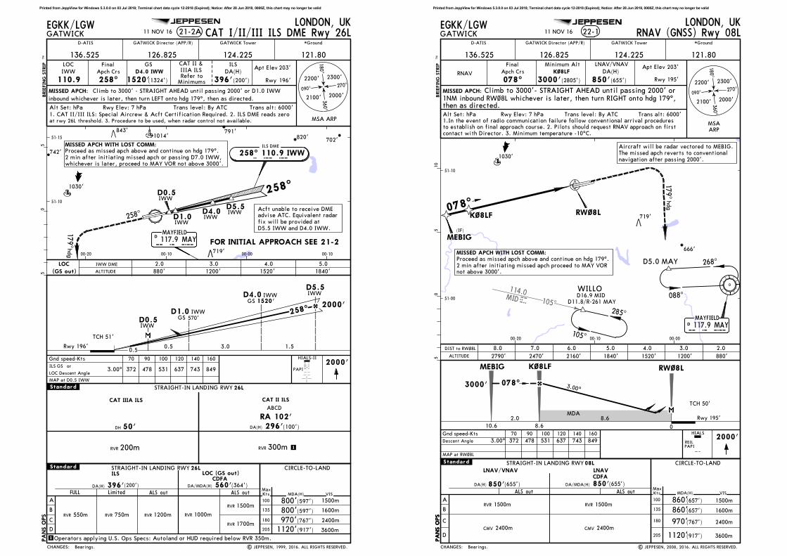
D5.5IWW
IWWD1.0
D0.5IWW
D1.0 IWW
D5.5 IWW
D0.5 IWW
MISSED APCH:
BRIE
FIN
G S
TRIP
TM
21-2AGATWICK
LONDON, UK
GATWICK Director (APP/R) GATWICK Tower
121.80
*Ground
LOC
IWW
110.9
Final
Apch Crs
258^
GS
1520'(1324')
ILS
DA(H)
396'(200')
Apt Elev
Rwy
203'
196'
A
B
C
D
FULL ALS out ALS out MDA(H)MaxKts
100
135
180
205
STRAIGHT-IN LANDING RWY CIRCLE-TO-LAND26LILS
DA(H) 396'(200')
LOC (GS out)
560'(364')
5
VIS
1000mRVR
RVR 1500m
RVR 1200mRVR 550m
STRAIGHT-IN LANDING RWY 26L
DA(H) 296'(100')
CAT II ILS
RVR 300m
ABCD
Gnd speed-Kts 70 90 100 120 140 1602000'
05
1
1
RA 102'
51-10
00-1000-20 00-00 00-10
51-15
Trans alt: 6000'Trans level: By ATCAlt Set: hPa Rwy Elev: 7 hPa
EGKK/LGW
D-ATIS
Operators applying U.S. Ops Specs: Autoland or HUD required below RVR 350m.
| JEPPESEN, 1999, 2016. ALL RIGHTS RESERVED.
D4.0 IWW
D4.0IWW
D4.0 IWW
179^
MAYFIELD117.9 MAY
DM A Y
hdg
MISSED APCH WITH LOST COMM:Proceed as missed apch above and continue on hdg 179^.
2 min after initiating missed apch or passing D7.0 IWW,whichever is later, proceed to MAY VOR not above 3000'.
Climb to 3000' - STRAIGHT AHEAD until passing 2000' or D1.0 IWW
JEPPESEN
2000'
3.00^
inbound whichever is later, then turn LEFT onto hdg 179^, then as directed.
CAT I/II/III ILS DME Rwy 26L
Refer toMinimums
1. CAT II/III ILS: Special Aircrew & Acft Certification Required. 2. ILS DME reads zero
RVR 750m
Limited
RVR 1700m
.Standard.
.Standard.
RVR 200m
50'
CAT IIIA ILS
DH
CAT II &
IIIA ILS
CDFADA/MDA(H)
372 478 531 637 743 849
136.525 126.825 124.225
Bearings.
11 NOV 16
at rwy 26L threshold. 3. Procedure to be used, when radar control not available.
258^
FOR INITIAL APPROACH SEE 21-2
258^
ILS DME
258^ 110.9 IWWI W W
1.53.00.5
570'GS258^
196'
1520'GS
0.5
CHANGES:
MAP at D0.5 IWW
ILS GS orPAPI
LOC
(GS out) ALTITUDE
3.0
1200'
4.0
1520'
5.0
1840'
2.0
880'
IWW DME
MSA ARP
HIALS-II
Acft unable to receive DMEadvise ATC. Equivalent radar
fix will be provided at
D5.5 IWW and D4.0 IWW.
090^270^
180^
2200' 2300'
2000'
360^
2100'
800'
800'
1120' 3600m
2400m
1600m
1500m(597')
(597')
(767')
(917')
970'
LOC Descent Angle
PA
NS O
PS
820'702'
791'
1030'
719'
742'
843'1014'
Rwy
TCH 51'
Printed from JeppView for Windows 5.3.0.0 on 03 Jul 2018; Terminal chart data cycle 12-2018 (Expired); Notice: After 28 Jun 2018, 0000Z, this chart may no longer be valid
105^
114.0MID
MID
078^
MISSED APCH:
BRIE
FIN
G S
TRIP
TM
GATWICK
LONDON, UK
GATWICK Director (APP/R) GATWICK Tower
121.80
*Ground
2470' 2160' 1840' 1520'
Gnd speed-Kts 70 90 100 120 140 160
PAPI
2790'
05
510
1200'
EGKK/LGW
RNAV
Final
Apch Crs
Minimum Alt
K~8LF
3000'(2805')
DA(H)
850'(655')
Alt Set: hPa Rwy Elev: 7 hPa Trans level: By ATC Trans alt: 6000'
Descent Angle 372 478 531 637 743 849
K~8LF RW~8L
880'
22-1
MAYFIELD117.9 MAYD
MEBIG
WILLO
(IF)
RW~8LK~8LF
088^
268^D5.0 MAY
285^
105^
51-00
51-10
00-1000-20 00-00
M A Y
MSAARP
MEBIG
D-ATIS
MAP at RW~8L
2000'
D16.9 MIDD11.8/R-261 MAY
RNAV (GNSS) Rwy 08L
LNAV/VNAV
ALS out MDA(H)
CIRCLE-TO-LAND
VIS
DA(H) 850'(655')
A
B
C
D
MaxKts
100
135
180
205
1500m
1600m
2400m
3600m
RVR 1500m
LNAV/VNAV
850'(655')
ALS out
LNAV
08LSTRAIGHT-IN LANDING RWY
179^
MISSED APCH WITH LOST COMM:Proceed as missed apch above and continue on hdg 179^.
2 min after initiating missed apch proceed to MAY VORnot above 3000'.
Climb to 3000'- STRAIGHT AHEAD until passing 2000' or
1.In the event of radio communication failure follow conventional arrival proceduresto establish on final approach course. 2. Pilots should request RNAV approach on firstcontact with Director. 3. Minimum temperature -10^C.
1NM inbound RW~8L whichever is later, then turn RIGHT onto hdg 179^,then as directed.
hdg
JEPPESEN
078^
| JEPPESEN, 2008, 2016. ALL RIGHTS RESERVED.
3.00^
3.00^
Aircraft will be radar vectored to MEBIG.The missed apch reverts to conventional
navigation after passing 2000'.
REIL
CMV 2400m
RVR 1500m
CMV 2400m
.Standard.
136.525 126.825 124.225
MDA
CDFA
DA/MDA(H)
Apt Elev 203'
Rwy 195'
TCH 50'
11 NOV 16
CHANGES:
8.6
3000'
Rwy 195'
ALTITUDE
7.0 6.0 5.0 4.0 3.08.0 2.0DIST to RW~8L
078^
2.0
HIALS
090^270^
180^
2200' 2300'
2000'
360^
2100'
860'
860'
1120'
(657')
(657')
(767')
(917')
970'
1030'
719'
666'
PA
NS O
PS
PA
NS O
PS
10.6 8.6 0
Bearings.
Printed from JeppView for Windows 5.3.0.0 on 03 Jul 2018; Terminal chart data cycle 12-2018 (Expired); Notice: After 28 Jun 2018, 0000Z, this chart may no longer be valid

105^
114.0MIDMID
078^
MISSED APCH:
BRIE
FIN
G S
TRIP
TM
GATWICK
LONDON, UK
GATWICK Director (APP/R) GATWICK Tower
121.80
*Ground
2480' 2160' 1840' 1520'
Gnd speed-Kts 70 90 100 120 140 160
PAPI
2800'
05
510
1200'
EGKK/LGW
RNAV
Final
Apch Crs
078^
Minimum Alt
K~8RF
3000'(2804')
DA(H)
700'(504')
Alt Set: hPa Rwy Elev: 7 hPa Trans level: By ATC Trans alt: 6000'
HIALS-II
Descent Angle 372 478 531 637 743 849
880'
22-2
MAYFIELD117.9 MAYD
ABIBI(IF)
RW~8RK~8RF
088^
268^D5.0 MAY
51-00
51-10
00-1000-20 00-00
M A Y
MSAARP
ALS out MDA(H)
STRAIGHT-IN LANDING RWY CIRCLE-TO-LAND08R
VIS
RVR 1600m
DA(H) 700'(504')
D-ATIS
MAP at RW~8R
2000'
A
B
C
D
MaxKts
100
135
180
205
1500m
1600m
2400m
3600m
RVR 1500m
| JEPPESEN, 2007, 2016. ALL RIGHTS RESERVED.
RNAV (GNSS) Rwy 08R
LNAV/VNAV
LNAV/VNAV
740'(544')
ALS out
RVR 1500m
RVR 1800m
LNAV
MISSED APCH WITH LOST COMM:
17 9^hdg
Proceed as missed apch above and continue on hdg 179^.2 min after initiating missed apch or passing D7.0 IGG,
whichever is later, proceed to MAY VOR not above 3000'.
1. In the event of radio communication failure follow conventional arrival proceduresto establish on final approach course. 2. Pilots should request RNAV approach on firstcontact with Director. 3. Minimum temperature -10^C.
Climb to 3000' - STRAIGHT AHEAD until passing 2000' or1NM inbound RW~8R whichever is later, then turn RIGHT ontohdg 179^, then as directed.
JEPPESEN
3.00^
Aircraft will be radar vectored to ABIBI.The missed apch reverts to conventional
navigation after passing 2000'.
WILLO
285^
D16.9 MID
D11.8/R-261 MAY
105^
.Standard.
CMV 2400m CMV 2400m
136.525 126.825 124.225
K~8RF RW~8RABIBI
3.00^
MDA
CDFA
DA/MDA(H)
Apt Elev 203'
Rwy 196'
TCH 53'
11 NOV 16
CHANGES:
ALTITUDE
7.0 6.0 5.0 4.0 3.08.0 2.0DIST to RW~8R
800'
800'
1120'
(597')
(597')
(767')
(917')
970'
090^270^
180^
2200' 2300'
2000'
360^
2100'
1030'
719'
666'
8.6
3000'
Rwy 196'
10.6
078^
2.0
8.6 0
PA
NS O
PS
Bearings.
Printed from JeppView for Windows 5.3.0.0 on 03 Jul 2018; Terminal chart data cycle 12-2018 (Expired); Notice: After 28 Jun 2018, 0000Z, this chart may no longer be valid
105^
MISSED APCH:
BRIE
FIN
G S
TRIP
TM
GATWICK
LONDON, UK
GATWICK Director (APP/R) GATWICK Tower
121.80
*Ground
STRAIGHT-IN LANDING RWY CIRCLE-TO-LAND26L
2480'2160'1840'1520'
Gnd speed-Kts 70 90 100 120 140 1602000'
2790'1200'
EGKK/LGW
RNAV
Final
Apch Crs
258^
Minimum Alt
K26LF
3000'(2804')
DA(H)
Alt Set: hPa Rwy Elev: 7 hPa Trans level: By ATC Trans alt: 6000'
Descent Angle 372 478 531 637 743 849
880'
22-3
DA(H) 580'(384')
OLEVI(IF)
088^
268^D5.0 MAY
K26LF
RW26L
258^
51-00
51-10
00-1000-2000-3000-40 00-00 00-10
MSA
ARP
05
510
15
20
MAYFIELD117.9 MAY
DM A Y
D-ATIS
MIDHURST114.0 MID
DM I D
MAP at RW26L
105^
285^
WILLO
ALS out MDA(H) VIS
A
B
C
MaxKts
100
135
180
205
1100mRVR
1500m
1600m
2400m
3600mD
580'(384')
D16.9 MIDD11.8/R-261 MAY
RVR 1500m
RVR 1800m
| JEPPESEN, 2007, 2016. ALL RIGHTS RESERVED.
RNAV (GNSS) Rwy 26L
LNAV/VNAV
ALS out
RVR 1500m
RVR 1800m
LNAV/VNAV
590'(394')
LNAV
179^
MISSED APCH WITH LOST COMM:
hdg
Proceed as missed apch above and continue on hdg 179^.2 min after initiating missed apch or passing D7.0 IWW,whichever is later, proceed to MAY VOR not above 3000'.
1. In the event of radio communication failure follow conventional arrival procedures
to establish on final approach course. 2. Pilots should request RNAV approach on firstcontact with Director. 3. Minimum temperature -10^C.
Climb to 3000' - STRAIGHT AHEAD until passing 2000' or
1NM inbound RW26L whichever is later, then turn LEFT onto hdg 179^,then as directed.
JEPPESEN
3.00^
Aircraft will be radar vectored to OLEVI.
The missed apch reverts to conventional navigation
after passing 2000'.
1100mRVR
.Standard.
136.525 126.825 124.225
K26LFRW26L OLEVI
3.00^
MDA
CDFA
DA/MDA(H)
TCH 53'
Rwy 196'
Apt Elev 203'
11 NOV 16
258^
CHANGES:
ALTITUDE
7.06.05.04.03.0
PAPI
8.0
HIALS-II
2.0DIST to RW26L
090^270^
180^
2200' 2300'
2000'
3 60^
2100'
800'
800'
1120'
(597')
(597')
(767')
(917')
970'
820'
702'
1007'
774'
700' 813'
1030'
719'
667'
840'
666' 787'
1050'
663'
837'
8.6
3000'
Rwy 196'
258^
2.0
10.68.60
PA
NS O
PS
Bearings.
Printed from JeppView for Windows 5.3.0.0 on 03 Jul 2018; Terminal chart data cycle 12-2018 (Expired); Notice: After 28 Jun 2018, 0000Z, this chart may no longer be valid

105^
MISSED APCH:
BRIE
FIN
G S
TRIP
TM
GATWICK
LONDON, UK
GATWICK Director (APP/R) GATWICK Tower
121.80
*Ground
2470'2160'1840'1520'
Gnd speed-Kts 70 90 100 120 140 1602000'
2790'1200'
EGKK/LGW
RNAV
Final
Apch Crs
258^
Minimum Alt
K26RF
3000'(2805')
DA(H)
Alt Set: hPa Rwy Elev: 7 hPa Trans level: By ATC Trans alt: 6000'
Descent Angle 372 478 531 637 743 849
880'
22-4
ARPIT(IF)
088^
268^D5.0 MAY
K26RF
RW26R
51-00
51-10
00-1000-2000-3000-40 00-00 00-10
05
510
15
20
MAYFIELD117.9 MAY
DM A Y
D-ATIS
MIDHURST114.0 MID
DM I D
MAP at RW26R
105^
285^
WILLO
850'(655')
D16.9 MIDD11.8/R-261 MAY
RNAV (GNSS) Rwy 26R
LNAV/VNAV
ALS out MDA(H)
STRAIGHT-IN LANDING RWY CIRCLE-TO-LAND26R
VIS
DA(H) 850'(655')
A
B
C
D
MaxKts
100
135
180
205
1500m
1600m
2400m
3600m
RVR 1500m
LNAV/VNAV
850'(655')
ALS out
RVR 1500m
LNAV
MSAARP
MISSED APCH WITH LOST COMM:Proceed as missed apch above and continue on hdg 179^.2 min after initiating missed apch proceed to MAY VORnot above 3000'.
17 9^hdg
1. In the event of radio communication failure follow conventional arrival procedures
to establish on final approach course. 2. Pilots should request RNAV approach on firstcontact with Director. 3. Minimum temperature -10^C.
Climb to 3000' - STRAIGHT AHEAD until passing 2000' or1NM inbound RW26R whichever is later, then turn LEFT onto hdg 179^,then as directed.
JEPPESEN
| JEPPESEN, 2008, 2016. ALL RIGHTS RESERVED.
3.00^
Aircraft will be radar
vectored to ARPIT.
The missed apch reverts to conventional navigation after passing 2000'.
CMV 2400m 2400mCMV
.Standard.
136.525 126.825 124.225
K26RFRW26R ARPIT
3.00^
MDA
CDFA
DA/MDA(H)
TCH 50'
Apt Elev 203'
Rwy 195'
11 NOV 16
258^
CHANGES:
ALTITUDE
7.06.05.04.03.0
PAPI
8.02.0DIST to RW26R
HIALS
090^270^
180^
2200' 2300'
2000'
360^
2100'
REIL
860'
860'
1120'
(657')
(657')
(767')
(917')
970'
820' 702'
1007'
700' 813'
1030'
719'
667'
840'
666' 787'
1050'
663'
837'
8.6
3000'
Rwy 195'
258^
2.0
10.68.60
PA
NS O
PS
Bearings.
Printed from JeppView for Windows 5.3.0.0 on 03 Jul 2018; Terminal chart data cycle 12-2018 (Expired); Notice: After 28 Jun 2018, 0000Z, this chart may no longer be valid
51-10
51-15
MISSED APCH:
RVR100
135
180
205
1
1
1
Lighting -
Refer to
Airport
Chart
2000'
| JEPPESEN, 1999, 2016. ALL RIGHTS RESERVED.
MISSED APCH WITH LOST COMM:
00-1000-20 00-0000-30
28-1
RADAR
BRIE
FIN
G S
TRIP
TM
*Ground
121.80
GATWICK
LONDON, UKSRA All Rwys
GATWICK Director (APP/R) GATWICK Tower
EGKK/LGW
Apch Crs
Final
By ATC
Minimum Alt
See
table below
Refer to
Minimums
D-ATIS
Missed apch - See below
05
5
Rwy 08L:
Rwy 08R:
Rwy 26L:
Rwy 26R:
Rwy 08L/R:
Rwy 26L/R:
Climb to 3000' - STRAIGHT AHEAD until passing 2000' or 1NM inbound THR
Climb to 3000' - STRAIGHT AHEAD until passing 2000' or MAP
Climb to 3000' - STRAIGHT AHEAD until passing 2000' or MAP
Climb to 3000' - STRAIGHT AHEAD until passing 2000' or 1NM inbound THR
Proceed as missed apch above and continue on hdg 179^. 2 min after initiating missed apch
or passing D7.0 IGG, whichever is later, proceed to MAY VOR not above 3000'.Proceed as missed apch above and continue on hdg 179^. 2 min after initiating missed apch
or passing D7.0 IWW, whichever is later, proceed to MAY VOR not above 3000'.
MAYFIELD117.9 MAYMAYD
JEPPESEN
372 478 531 637 743 849
CMV
.Standard.
11 NOV 16
136.525 126.825 124.225
whichever is later, then turn RIGHT onto hdg 179^, then as directed.
whichever is later, then turn RIGHT onto hdg 179^, then as directed.
whichever is later, then turn LEFT onto hdg 179^, then as directed.
whichever is later, then turn LEFT onto hdg 179^, then as directed.
After SRA 08L/26R apch: MDA(H) 840'(637').
CDFA CDFA CDFA
RVR RVR
PA
NS O
PS
CMVRVR RVR CMV
DA/MDA(H)
Bearings.
Apt Elev 203'
Rwy 08L/26R 195'
Rwy 08R/26L 196'
258^ 110.9 IWW
258^
078^
I W WILS DME RWY 26L
078^ 110.9 IGGI G GILS DME RWY 08R
CHANGES:
740'
A
B
C
D
(544')
ALS out
STRAIGHT-IN LANDING
1500m
Gnd speed-Kts 70 90 100 120 140 160
ALS outMaxKts MDA(H)
1120'
1500m
1600m
2400m
3600m
VIS
CIRCLE-TO-LAND
(767')
(917')
800'
800'(597')
(597')
SRA 08R SRA 26L
830'(635')
SRA 08L/26R
ALS out
SRA 08L/26R: MAP 2 NM from touchdown
TMN 2 to MAP
SRA 08R/26L: MAP 1 NM from touchdown or
1.0 0:51 0:40 0:36 0:30 0:26 0:23
680'(484')
Minimum Alt/NM 5.7 FAF
2000'
Alt Set: hPa Rwy Elev: 7 hPa Trans level: By ATC Trans alt: 6000'
MSA ARP
090^270^
180^2200' 2300'
2000'
360^
2100'
All rwys
ALTITUDE
RADAR FIX
1460'
4.0
1150'
3.0 2.05.0
1780'
SRA08R/26L 830'
ALTITUDE
RADAR FIX
1460'
4.0
1140'
3.0 2.05.0
1780'
SRA08L/26R 830'
Descent Angle 3.00^
970'2400m
820'
791'
683'
1030'
719'
785'
843'1014'
DA/MDA(H) DA/MDA(H) DA/MDA(H)
1500m 1500m
2400m1800m 1500m 2300m
ILS DME reads zero at threshold rwys 08L, 08R and 26L and at 0.5 NM beforethreshold rwy 26R.
Printed from JeppView for Windows 5.3.0.0 on 03 Jul 2018; Terminal chart data cycle 12-2018 (Expired); Notice: After 28 Jun 2018, 0000Z, this chart may no longer be valid

Chart changes since cycle 11-2018
ADD = added chart, REV = revised chart, DEL = deleted chart.ACT PROCEDURE IDENT INDEX REV DATE EFF DATE
LONDON, (GATWICK - EGKK)
Chart changes since cycle 11-2018
ADD = added chart, REV = revised chart, DEL = deleted chart.ACT PROCEDURE IDENT INDEX REV DATE EFF DATE
LONDON, (GATWICK - EGKK)
Revision Letter For Cycle 12-2018
Printed on 03 Jul 2018
Page 1(c) JEPPESEN SANDERSON, INC., 2018, ALL RIGHTS RESERVED
jep=JEPPESEN
JeppView for Windows
TERMINAL CHART CHANGE NOTICES
No Chart Change Notices for Airport EGKK
Chart Change Notices for Country GBR
Type: Gen TmnlEffectivity: PermanentBegin Date: ImmediatelyEnd Date: No end date
The following Take-off minima according to Commission Regulation No. 965/2012 (EASA Air Operations Regulation) are applicable for Low Visibility Take-off Operations within the UK FIR for CAT ABCD aircraft: 1. With RL and RCLM during day or with RL or CL during night: RVR 300m 2. With RL and CL: RVR 200m 3. With RL and CL and TDZ, MID and RO RVR: RVR 150m 4. With HIRL and CL and TDZ, MID and RO RVR: RVR 125m 5. On CAT III RWYs with approved guidance system or HUD/HUDLS: RVR 75m
Terminal Chart Change Notices
Page 1 - Printed on 03 Jul 2018Notice: After 28 Jun 2018, 0000Z, this data may no longer be valid
(c) JEPPESEN SANDERSON, INC., 2018, ALL RIGHTS RESERVED
jep=JEPPESEN
JeppView for Windows