Fall 2003 Conservation Almanac Newsletter, Trinity County Resource Conservation District

Trinity County Resource Conservation District Westside Watershed Restoration Project Initial Study/Mitigated Negative Declaration
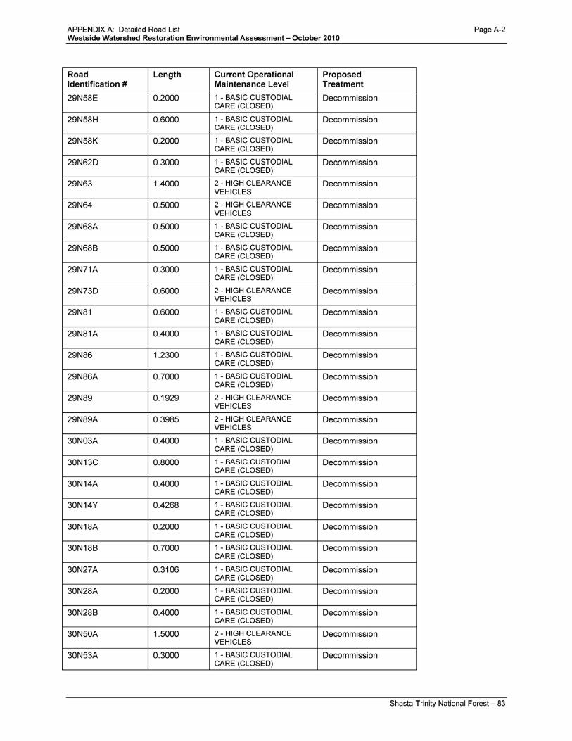
APPENDIX A: Detailed Road List


Trinity County Resource Conservation District Westside Watershed Restoration Project Initial Study/Mitigated Negative Declaration
APPENDIX B: Environmental Assessment, Westside Watershed Restoration Project

For Information Contact: Julie Nelson 3644 Avtech Parkway
Redding , CA 96002 530-226-2426
Environmental Assessment Westside Watershed Restoration Project
South Fork Management Unit and Trinity River Management Unit Shasta-Trinity National Forest
United States Department of Agriculture
Forest Service Pacific Southwest Region
January 2011
APPENDIX B: Environmental Assessment, Westside Watershed Restoration Project Page B-1

APPENDIX B: Environmental Assessment, Westside Watershed Restoration Project Page B-2

i – Shasta-Trinity National Forest
Westside Watershed Restoration
Environmental Assessment January 2011
Table of Contents SUMMARY .................................................................................................................................................. 1
INTRODUCTION ........................................................................................................................................ 1
Document Structure .................................................................................................................................. 1
Background ............................................................................................................................................... 2
Purpose and Need for Action .................................................................................................................... 3
Proposed Action ........................................................................................................................................ 5
Decision Framework ................................................................................................................................. 8
Public Involvement ................................................................................................................................... 8
ALTERNATIVES, INCLUDING THE PROPOSED ACTION ................................................................ 10
Alternatives ............................................................................................................................................. 10
Cumulative Effects Analysis ................................................................................................................... 12
Mitigation Common to All Alternatives ................................................................................................. 15
Comparison of Alternatives .................................................................................................................... 19
ENVIRONMENTAL CONSEQUENCES ................................................................................................. 23
Watersheds .............................................................................................................................................. 23
Fisheries .................................................................................................................................................. 35
Transportation ......................................................................................................................................... 41
Fire .......................................................................................................................................................... 44
Wildlife ................................................................................................................................................... 49
Botany ..................................................................................................................................................... 60
Cultural Resources .................................................................................................................................. 66
Economics ............................................................................................................................................... 67
Environmental Justice ............................................................................................................................. 68
CONSULTATION AND COORDINATION ............................................................................................ 69
ID TEAM MEMBERS............................................................................................................................ 69
FEDERAL, STATE, AND LOCAL AGENCIES ................................................................................... 70
APPENDIX B: Environmental Assessment, Westside Watershed Restoration Project Page B-3

ii – Shasta-Trinity National Forest
TRIBES ................................................................................................................................................... 70
Literature Cited ........................................................................................................................................... 71
Appendix A: Public Scoping Comment Analysis/Response ...................................................................... 73
Appendix B: Road List ............................................................................................................................... 83
Appendix C: Public Comments on the Preliminary EA.............................................................................. 88
Response to Comments ........................................................................................................................... 88
Appendix D: Implementation Guide ........................................................................................................... 99
Overview: .............................................................................................................................................. 100
Purpose: ................................................................................................................................................. 100
Resource Protection Measures .............................................................................................................. 101
Non Discrimination Statement The U.S. Department of Agriculture (USDA) prohibits discrimination in all its programs and activities on the basis of race, color,
national origin, age, disability, and where applicable, sex, marital status, familial status, parental status, religion, sexual
orientation, genetic information, political beliefs, reprisal, or because all or part of an individual’s income is derived from any
public assistance program. (Not all prohibited bases apply to all programs.) Persons with disabilities who require alternative
means for communication of program information (Braille, large print, audiotape, etc.) should contact USDA’s TARGET Center
at (202) 720-2600 (voice and TDD). To file a complaint of discrimination, write USDA, Director, Office of Civil Rights, 1400
Independence Avenue, S.W., Washington, D.C. 20250-9410, or call (800) 795-3272 (voice) or (202) 720-6382 (TDD). USDA is
an equal opportunity provider and employer.
APPENDIX B: Environmental Assessment, Westside Watershed Restoration Project Page B-4

Westside Watershed Restoration Environmental Assessment – January 2011
1 – Shasta-Trinity National Forest
SUMMARY The purpose of the project is to implement the Aquatic Conservation Strategy of the Northwest Forest Plan by improving water quality and reducing existing negative environmental conditions on the Shasta-Trinity National Forest. Activities are proposed on National Forest system lands west of Interstate 5 and include: 1) decommissioning some roads that currently pose risks to water quality and watershed resources and that are not necessary for public or administrative access; and 2) modifying other roads to improve environmental conditions while maintaining necessary access. The project includes upgrading five stream crossings. The proposed action is decommissioning forest roads on approximately 30 miles that are part of the National Forest Transportation System, and decommissioning approximately 17 miles of unauthorized routes. The other action alternative analyzed in detail proposes closing, not decommissioning, identified system roads and decommissioning unauthorized routes.
The project was developed from management needs and opportunities identified during roads analysis processes completed for the following watersheds: Rattlesmoke, Salt, Soldier, Middle Fork Cottonwood, Knob Peak, Pettijohn, Upper Dubakella, Big Creek and Gemmill.
The proposed action will provide overall benefits to water quality and watershed resources both directly and in the long term. Potential short term negative impacts from implementing the project have been considered and resource protection measures are included that reduce or eliminate potential negative effects to less than significant.
INTRODUCTION
Document Structure The Forest Service has prepared this Environmental Assessment in compliance with the National Environmental Policy Act (NEPA) and other relevant Federal and State laws and regulations. This Environmental Assessment discloses the direct, indirect, and cumulative environmental impacts that would result from the proposed action and alternatives. The document is organized into five parts:
• Introduction: The section includes information on the history of the project proposal, the purpose of and need for the project, and the agency’s proposal for achieving that purpose and need. This section also details how the Forest Service informed the public of the proposal and how the public responded.
• Comparison of Alternatives, including the Proposed Action: This section provides a more detailed description of the agency’s proposed action as well as alternative methods for achieving the stated purpose. These alternatives were developed based on significant issues raised by the public and other agencies. This discussion also includes possible mitigation measures. Finally, this section provides a summary table of the environmental consequences associated with each alternative.
APPENDIX B: Environmental Assessment, Westside Watershed Restoration Project Page B-5

Westside Watershed Restoration Environmental Assessment – January 2011
2 – Shasta-Trinity National Forest
• Environmental Consequences: This section describes the environmental effects of implementing the proposed action and other alternatives. This analysis is organized by resource area. Within each section, the affected environment is described first, followed by the effects of the No Action Alternative that provides a baseline for evaluation and comparison of the other alternatives that follow.
• Agencies and Persons Consulted: This section provides a list of preparers and agencies consulted during the development of the environmental assessment.
• Appendices: The appendices provide more detailed information to support the analyses presented in the environmental assessment.
Additional documentation, including more detailed analyses of project-area resources, may be found in the project planning record located at the Shasta-Trinity National Forest Headquarters in Redding, California.
Background The National Forest Transportation System is essential to the effective management of National Forest lands, for forest users/visitors and for management of the natural resources entrusted to the care of the agency. In January 2001, the Forest Service adopted a new national road management policy, which directs the agency to maintain a safe, environmentally sound road network that is responsive to public needs and affordable to manage. The policy includes a science-based roads analysis process designed to help managers make better decisions on roads.
In its approach to managing the transportation system, the Shasta-Trinity National Forest (Forest) seeks balance among these factors:
• the health of the environment; • the need for safe public and administrative access to Forest lands; and • the financial cost of effectively maintaining a safe transportation system
In this era of declining National Forest budgets, it is no longer possible to maintain to standard all the roads currently in the Forest road system. The Forest Service must focus on maintaining roads essential for public access and administrative needs that are also consistent with maintaining or improving ecosystem health. In particular, there is a need to reduce the road system’s controllable sediment discharge sources1
The science-based roads analysis process (RAP), instituted as part of the 2001 road management policy, has since then been part of interdisciplinary project planning and evaluation. The RAP occurs before implementing any project activity that would change the road system or affect public access to National Forest lands. This RAP process often brings to light little-used roads that are having negative effects on fish and water quality, or are disproportionately difficult to maintain. These roads are then
in areas with accelerated erosion and stream sedimentation.
1 Where watersheds have accelerated erosion and stream turbidity, roads are typically implicated as the major sediment source. Road and stream crossing removal are proven ways to reduce controllable sediment discharge.
APPENDIX B: Environmental Assessment, Westside Watershed Restoration Project Page B-6

Westside Watershed Restoration Environmental Assessment – January 2011
3 – Shasta-Trinity National Forest
targeted for improvement or for elimination through the process of decommissioning which is designed to improve water quality, fish habitat, and other watershed resources.
This proposed action was developed from the management needs and opportunities identified by the RAP for the following nine areas: Rattlesmoke, Salt, Soldier, Middle Fork Cottonwood, Knob Peak, Pettijohn, Upper Dubakella, Big Creek and Gemmill.2 The project is designed to implement the Aquatic Conservation Strategy (ACS)3 and other management direction given in the Forest’s Land and Resource Management Plan4 (Forest Plan) and the Forest System Roads Policy.5
Purpose and Need for Action
The Forest is implementing this project as part of the ACS outlined in the Forest Plan; the ACS specifies nine objectives, and activities that prevent attainment of these objectives are prohibited. The following three ACS objectives are particularly relevant to this project: 1) Maintain and restore the physical integrity of the aquatic system, including shorelines, banks, and bottom configurations; 2) Maintain and restore water quality necessary to support healthy riparian, aquatic, and wetland ecosystems; 3) Maintain and restore the sediment regime under which aquatic ecosystems evolved [Forest Plan, page 4-53]. The project would not prevent attainment of the other 6 ACS objectives. Project activities are proposed within eight Hydrologic Unit Code (HUC) 5 watersheds. Two of these HUC 5 watersheds, Upper South Fork of the Trinity River and Middle South Fork of the Trinity River, are key watersheds.
The purpose of the project is to implement the ACS, improving water quality and reducing existing negative environmental conditions by 1) decommissioning some roads that currently pose risks to water quality and watershed resources and that are not necessary for public or administrative access; and 2) modifying other roads to improve environmental conditions while maintaining necessary access.
2 RAP maps available on request 3 The Aquatic Conservation Strategy was developed as part of the Northwest Forest Plan and is incorporated into the Shasta-Trinity Forest Plan. See pages 4-53 through 4-60 of the Forest Plan. 4 The Forest Plan (USDA-FS 1995) is available online at http://fs.usda.gov/goto/stnf/planningdocs. 5 Available online at http://www.fs.fed.us/eng/road_mgt
APPENDIX B: Environmental Assessment, Westside Watershed Restoration Project Page B-7

Westside Watershed Restoration Environmental Assessment – January 2011
4 – Shasta-Trinity National Forest
Table 1. Comparison of existing and desired conditions associated with roads identified in this proposal on the Shasta-Trinity National Forest.
Road Management Factors
Existing Condition Desired Condition
Health of environment
• Existing roads and road maintenance lead to high levels of ongoing disturbance
• Roads contribute to high levels of erosion and sedimentation
• Roads cause adverse effects to water quality & aquatic habitat.
• Low levels of disturbance. • Recovery from past road impacts,
with stable soils and natural drainage patterns.
• Improvements to water quality and aquatic habitats
Access & safety • The Forest road network includes more roads than are needed for access; some roads are rarely or never used.
• Safety concerns exist because of limited maintenance: brush encroachment limited line of sight rougher road surface higher potential for stream crossing failures
and road stability problems hazard trees, down logs and/or boulders entrapment--fallen trees or boulders prohibit
safe entry & exit
• The road system matches access needs for the area.
• Safety concerns are addressed by appropriate maintenance of a right-sized road system for the forest.
Cost to maintain • Limited maintenance funds are inefficiently spent on low use/ high cost routes.
• Maintenance funds are efficiently spent on needed roads.
Existing conditions vary from desired conditions (Table 1). Specific transportation management objectives associated with the transportation policy goals and the purpose and need for this proposal include: Goal: Provide for safe public road access while allowing for economical and efficient management of the Forest transportation system
• Objective 1 - Minimize or reduce the amount of unnecessary classified and unauthorized routes, in order to use maintenance funds in areas that have greater resource protection needs and higher use demand. Accomplish this by decommissioning unneeded roads and by improving the condition of needed roads, both of which would alleviate risk to public safety and environmental health. Maintain the road system needed for reasonable and safe fire suppression access.
Goal: Reverse adverse ecological impacts associated with roads. • Objective 2 - Reduce runoff and controllable sediment discharge to improve watershed condition.
Minimize the potential for altered stream flows, accelerated sedimentation, and other water quality impairments by improving needed roads or eliminating unnecessary roads.
• Objective 3 - Protect and enhance conditions that provide habitat for wildlife and fish by increasing the connectivity of riparian corridors, improving the ability of the stream system to transport bedload and associated debris; and promoting passage for aquatic species. Minimize or reduce the impact of road/stream crossings through upgrades, rerouting crossings, or crossing removal.
APPENDIX B: Environmental Assessment, Westside Watershed Restoration Project Page B-8

Westside Watershed Restoration Environmental Assessment – January 2011
5 – Shasta-Trinity National Forest
Proposed Action The Forest proposes to reduce the risks to the environment associated with roads while addressing the need for a safe transportation network through the following actions:
1. decommission approximately 18 miles of existing unauthorized routes; 2. decommission approximately 21 miles of Maintenance Level 1 roads; 6
3. decommission approximately 9 miles of Maintenance Level 2 roads;
4. upgrade system roads including 5 stream crossings; 5. restore 93 stream crossings during decommissioning; and 6. convert 0.3 miles of Maintenance Level 3 to <50 inch wide motorized trail
Where modification (not decommissioning) is proposed, roads will be improved by (a) converting a road to a trail, and/or (b) upgrading stream crossings to improve surface conditions and decrease future potential for mass failure. Implementation of the proposed action is expected to take five to ten years. Implementation is scheduled to begin immediately following completion of the National Environmental Policy Act process.
The project area is defined by the boundaries of each watershed where activities are proposed. Each of these watersheds has been evaluated in the roads analysis process. Project watersheds are within the Klamath River Basin via the Trinity River, and the Lower Sacramento River Basin, as shown in Figure 2. Table 2 shows proposed treatment by watershed and operational maintenance levels and Figure 1 displays overlap of proposed treatments with Forest Plan land allocations.7
6 Definitions of road maintenance levels from the 2008 Travel Routes Data Dictionary Maintenance Level 1: Basic Custodial Care - Assigned to intermittent service roads during time they are closed to vehicular traffic for 1 year or more. Maintenance Level 2: High Clearance Vehicles - Assigned to roads operated for use by high clearance vehicles. Maintenance Level 3: Suitable for Passenger Cars - Assigned to roads operated and maintained for travel by a prudent driver in a standard passenger car. 7 Legal locations for each project watershed and roads proposed for treatment are indicated on project maps. These maps are too large to be included in this document. They are available on request or on the web at: http://www.fs.fed.us/nepa/project_content.php?project=25318
APPENDIX B: Environmental Assessment, Westside Watershed Restoration Project Page B-9

Westside Watershed Restoration Environmental Assessment – January 2011
6 – Shasta-Trinity National Forest
Figure 1. Location of proposed action in relation to Forest Plan land allocations. Riparian Reserve allocation cannot be shown at this scale. See Table 3 for further detail.
APPENDIX B: Environmental Assessment, Westside Watershed Restoration Project Page B-10

Westside Watershed Restoration Environmental Assessment – January 2011
Shasta-Trinity National Forest – 7
Table 2. Proposed Treatment by Watershed and Operational Maintenance Levels
Nested Watersheds (HUC 3-5)
Road Operational Maintenance Level
1 - Basic Custodial Care 2 - High
Clearance 3 - Passenger Car Suitable
Unauthorized Non-System
Routes Grand Total
HUC3 HUC4 HUC5_NAME Decom miles
Upgrade miles
Upgrade Xing #
Decom miles
Upgrade Xing #
Convert to trail miles
Upgrade Xing # Decom miles
Decom miles
Upgrade miles
Upgrade Xing #
Convert to trail miles
Klamath R Trinity R Stuart Fork 1.8 2.0 3.8 Trinity Reservoir 0.4 1 0.4 1 Canyon Cr 1.6 1.8 1 3.0 4.6 1.8 1
South Fork Trinity R
Upper South Fork Trinity R 2.4 0.4 0.3 3.1 Middle South Fork Trinity R 6.3 1.5 1.2 9.0 Upper Hayfork Cr 4.7 3.3 5.0 13.0 Lower Hayfork Cr 1.9 3 0.5 3.0 5.4 3
Lower Sacramento
Cottonwood Middle Fork Cottonwood Cr 1.9 1.4 0.3 5.0 8.4 0.3
Grand Total 21.0 1.8 3 9.1 1 0.3 1 17.5 47.7 1.8 5 0.3
APPENDIX B: Environmental Assessment, Westside Watershed Restoration Project Page B-11

Westside Watershed Restoration Environmental Assessment – January 2011
8 – Shasta-Trinity National Forest
Decision Framework The scope of the decision to be made is whether to implement the project, or an alternative to this proposed action that better resolves issues and meets the purpose and need described above, or to take no action at this time. The project does not include any amendment to the Forest Plan.
Management direction guiding the analysis includes: the Multiple-Use Sustained Yield Act of 1960; the National Forest Management Act of 1976; the National Environmental Policy Act of 1969; the National Historic Preservation Act of 1979; the Endangered Species Act of 1973; and the Forest Plan published in 1995. The Forest Plan provides programmatic management direction for the site-specific analyses completed and disclosed in this environmental assessment.
Forest Plan Direction - The Forest Plan allocates lands into several management categories, each with specific direction, for discrete areas of the Forest. The project area is located throughout the west side of the Forest on lands allocated to Commercial Wood Products, Roaded Recreation, Wildlife Habitat Management, Riparian Reserve and Late-Successional Reserve (see Table 3 and Figure 1).
Key Watersheds - Within the range of the Northern spotted owl, key watersheds are designated that contribute directly to conservation of at-risk anadromous salmonids, bull trout, and resident fish species, and/or are important sources of high-quality water. Forest Plan direction for key watersheds includes that the amount of existing system and nonsystem road should be reduced through decommissioning [Forest Plan, page 4-59]. This proposed action would decommission more than 12 miles of road in key watersheds (Table 3).
Forest Service Transportation System Policy - This national policy was used as a driver for this proposed watershed restoration project. A full description of the policy is included above in the Background section.
Table 3. Proposed Treatment Miles by Land Allocation
Land Allocation Watershed Restoration Treatment
Decommission Convert to Trail Upgrade Grand Total Key Watershed 12.3 12.3 Riparian Reserves 10.9 0.3 0.8 12.0 Unroaded Non Motorized Recreation 0.3 0.3 Late Successional Reserve 7.6 7.6 Wildlife Habitat Mgmt 6.3 1.4 7.7 Roaded Recreation 15.8 0.4 16.3 Commercial Wood Products 17.9 17.9
Total 47.7 0.3 1.8 49.8
Public Involvement A scoping/request for comment letter for the proposed project was mailed on December 30, 2008 to 243 individuals, community groups, Native American groups, and government agencies. A public notice of scoping was published in the Redding Record Searchlight on December 31, 2008, and in the Trinity Journal on January 7, 2009. The proposed action was first listed in the Shasta-Trinity National Forest Schedule of Proposed Actions in July, 2008.
APPENDIX B: Environmental Assessment, Westside Watershed Restoration Project Page B-12

Westside Watershed Restoration Environmental Assessment – January 2011
9 – Shasta-Trinity National Forest
Scoping comments were received from 12 individuals. All comments were reviewed by the interdisciplinary team and evaluated for significance, as defined by NEPA. The responsible official identified one significant issue, and Alternative 3 (road closure) was designed to address this issue. The interdisciplinary team developed responses to scoping comments in Appendix A.
Figure 2. Location of proposed action by watershed.
Issues
The Forest Service separated issues raised into two groups: significant and non-significant issues. Significant issues formed the basis for development of additional action alternatives. Non-significant issues were identified as those: 1) outside the scope of the proposed action; 2) already decided by law, regulation, Forest Plan, or other higher level decision; 3) irrelevant to the decision to be made; 4) general comment, opinion or position, or 5) conjectural and not supported by scientific or factual evidence.
The Forest Service identified one significant issue raised during scoping. The issue centered on concern over removing (decommissioning) roads that may be needed for future vegetation, fuels, or wildfire management needs. The commenter who raised this issue cited the public investment already made in the Forest Service road system.
APPENDIX B: Environmental Assessment, Westside Watershed Restoration Project Page B-13

Westside Watershed Restoration Environmental Assessment – January 2011
10 – Shasta-Trinity National Forest
ALTERNATIVES, INCLUDING THE PROPOSED ACTION This chapter describes and compares the alternatives considered for the Westside Watershed Restoration project. This section also presents the alternatives in comparative form, sharply defining the differences between each alternative and providing a clear basis for choice among options by the decision maker and the public. Some of the information used to compare the alternatives is based upon the design of the alternative (i.e., helicopter logging versus the use of skid trails) and some of the information is based upon the environmental, social and economic effects of implementing each alternative (i.e., the amount of erosion or cost of helicopter logging versus skidding).
Alternatives
Alternative 1 No Action Under the no action alternative, current management plans would continue to guide management of the project area. No decommissioning or improvement to roads would be implemented to accomplish project goals.
Alternative 2 The Proposed Action The proposed action was developed by an interdisciplinary team to improve watershed conditions on the west side of the Forest. Specifically, this alternative is designed to meet the purpose and need described in section 1 of this document.
Description of Treatment Types in Alternative 2, the Proposed Action
Decommission Roads proposed for decommissioning are no longer needed for administrative use. Several of these roads are overgrown with vegetation and/or are causing erosion and sedimentation problems. About 93 culverts are identified for permanent removal on 48 miles of road decommissioning (refer to Appendix B for detailed road list). Decommissioning a road meets multiple objectives that may involve one or more of the restorative actions described in Table 4.
Decommissioning consists of the following activities: removing culverts and fill from stream crossings, deep ripping the road surface, pulling road fill from the downhill side onto the road surface to fill inboard ditches and to modify the road surface so that it slopes outward towards the downhill side (approximately a 3 to 5 percent slope), pulling culverts and pipes (some pipes that drain inboard ditches will be crushed and left in place to minimize disturbance), installing rolling dips where appropriate, and placing a log or berm at the entrance to the road to prevent access. Only the road prism will be disturbed during decommissioning. Road fill that is pulled onto the surface of the road primarily comes from the first 10 to 15 feet of fill downhill of the road bed, but in some cases a greater amount of fill from a greater
APPENDIX B: Environmental Assessment, Westside Watershed Restoration Project Page B-14

Westside Watershed Restoration Environmental Assessment – January 2011
11 – Shasta-Trinity National Forest
distance downhill will be replaced onto the road surface. When pulling fill, no trees will be removed or disturbed greater than 10 inches in diameter at breast height (dbh). In areas where trees larger than 10 inches dbh occur on the road fill, no fill will be pulled from near the tree.
Table 4. Decommissioning Objectives and Actions
Need/Objective Action 1 Remove stream crossing failure potential.
Remove fill and pipes at all stream crossings.
2 Restore more natural stream flow characteristics. Match width and slope of fill removed to stream channel widths and slope.
3 Restore more natural hillslope hydrology while minimizing disturbance
• Reduce compaction, surface runoff, erosion and sedimentation.
• Promote infiltration • Provide a seed bed for future vegetation.
• Remove cross pipes when the benefits of removal exceed the disturbance associated with the removal. Pipes would be left in place only when/where overall objectives for watershed improvement can be met.
• Otherwise crush and leave in place cross drain pipes.
• Block inlet and prevent flow thru the pipe and /or down any remaining ditch.
• Pull roadside berms and as much road fill as feasible into the road cut, placing it along cut banks.
• Out-slope and compact the excavated material to a 3 to 5% slope.
• Subsoil road prism along outsloped, crowned or along sections where fill volume is insufficient to outslope the road. Avoid subsoiling in areas infested with non-native invasive plants, areas where tree root systems could be damaged and areas with rocky soils.
4 Reduce soil erosion by providing ground cover. Promote recovery of new vegetation.
Seed, and mulch (using materials selected through consultation with a botanist) all stream crossings and other areas where slopes are steep and soils are disturbed
6 Provide impediments to flow and sediment, discourage use of old road bed, and provide for enriched soil resources.
Stockpile large logs or hazard trees that are encountered along decommissioned routes to place on the contour in areas of disturbance. Logs impede sediment flow, provide for flow dispersal, and break down over time to enrich soil resources.
7 Prevent and discourage future vehicle traffic into restored areas.
Create an earthen berm at the start of the road or decommissioned road segment. Where needed, re-contour the start of the road to further reduce probability of access. Use of logs on contours will also discourage use.
Upgrade Five culverts will be upgraded on three roads that are needed for long-term use by the Forest Service, public, and private industry. The culverts will be upgraded to accommodate the Q100 (100 year return interval) flood event as well as potential debris loads. The five culverts identified for stream crossing upgrades are the 33N47 crossing at Soldier Creek, the 34N13 crossing of a tributary to the Trinity River below Trinity Reservoir, and three crossings on Road 29N72 between Dubakella and Hayfork Creeks. Culverts may need to be larger than the 100 year return interval in systems with high sediment loads. Crossing upgrade designs prevent stream capture by the road in the event of a failure by installing critical
APPENDIX B: Environmental Assessment, Westside Watershed Restoration Project Page B-15

Westside Watershed Restoration Environmental Assessment – January 2011
12 – Shasta-Trinity National Forest
dips. Ditch relief culverts are added where road grades may result in the stream being captured by the road.
In addition, the 33N31 road has been identified for upgrading. The road will be upgraded to reduce impacts to headwater swales that are exhibiting fill slope failure. The road upgrade may include grading and spot rocking the surface and installing rolling dips.
Convert to Motorized Trail <50” The lower 0.3 miles of 28N06 will be converted to a motorized trail <50” wide. This conversion to trail will eliminate car and truck access to the river while still providing motorized off-highway vehicle public access. Conversion of a road to a motorized trail <50” involves the same restorative actions described in Table 4, with a modification to action item 3. The extent and placement of the road fill back onto the roadbed requires leaving the outer edge of the roadbed intact to provide the width of the new trail surface. This action also reduces road density measures by decreasing the width of compacted surface.
Alternative 3 Road Closure Alternative The interdisciplinary team developed this alternative in response to scoping comments that expressed concern over reduced access for potential future needs (management and/or fire suppression). The road closure alternative would not decommission any Forest Service system roads. These segments would be storm proofed by installing rolling dips and removing berms that could cause drainage issues, and then closed using a gate, berm, or other effective means to eliminate public use. This would maintain the roads on the system at the lowest maintenance level (Level 1). The unauthorized routes identified in this proposal would be decommissioned under both Alternative 2 and 3. In order for these unauthorized routes to be maintained for potential future use they would need to be added to the Forest Service system. Adding routes to the system is not consistent with the purpose and need for this project.
Cumulative Effects Analysis This section includes a description of past, present, and foreseeable future actions in the project area vicinity and a summary of Westside Watershed Restoration Project cumulative effects analyses. The Council on Environmental Quality NEPA regulations describe a “cumulative impact” as the impact on the environment which results from the incremental impact of the action when added to other past, present, and reasonably foreseeable future actions regardless of what agency (Federal or non-Federal) or person undertakes such actions (4 CFR 1508.7). The Forest Service Handbook 1909.15 – Environmental Policy and Procedures, further clarifies the concept of cumulative impacts as resulting from “individually minor but collectively significant actions taking place over a period of time” (40 CFR 1508.7).
Spatial and Temporal Bounding
Table 5 summarizes the spatial and temporal cumulative effects analysis bounding for each resource. Each resource chooses an appropriate spatial boundary for cumulative effects analysis, that neither is so small
APPENDIX B: Environmental Assessment, Westside Watershed Restoration Project Page B-16

Westside Watershed Restoration Environmental Assessment – January 2011
13 – Shasta-Trinity National Forest
that it misses actions that could cause impacts that may be cumulative to this project’s impacts, nor is so large that it dilutes project effects so they cannot be meaningfully evaluated. The appropriate temporal bounding considers how long the effects of this project are likely to persist on the landscape. These boundaries will differ from resource to resource.
Table 5. Spatial and temporal cumulative effects analysis bounding for each resource. Resource Spatial Bounding Temporal Bounding
Soils Project road prisms 20 years
Hydrology Multiple scales from 5th field to 8th field watersheds 20 years
Geology Project roads with mass wasting features within 1 mile 20 years
Fisheries 7th field watersheds 20 years
Wildlife – Northern Spotted Owl No effect, so no cumulative effects N/A
Wildlife – Sensitive Species 15 feet outside of project road prism 5 – 10 years
Botany – Sensitive Species Range of each species 20 years
Cultural Heritage No effect, so no cumulative effects N/A
Past, Present, and Foreseeable Future Actions
This section summarizes the past, present, and foreseeable future actions that were included in the interdisciplinary effects analysis. A description of current conditions in the analysis area adequately takes into consideration past actions that may still be influencing on the ground conditions. Future projects include projects that are well enough defined to generally assess their impacts. Each resource analysis considers projects within the spatial and temporal bounding for that resource and evaluates the relationship between past/present/foreseeable project effects and the effects of this action. The past, present, ongoing and future actions considered in this interdisciplinary effects analysis are listed below.
APPENDIX B: Environmental Assessment, Westside Watershed Restoration Project Page B-17

Westside Watershed Restoration Environmental Assessment – January 2011
14 – Shasta-Trinity National Forest
1. Westside Plantation Thin
2. Jones Thin
3. Rattlesnake Fuel Reduction and Forest Health
4. Pettijohn LSR Project
5. Gemmill Thin/Fuelbreak
6. Browns Stewardship Project
7. East Fork II
8. Trough Fire Recovery
9. Wallow Fuel Reduction
10. Gemmill Fuels
11. Westside Fire Reforestation
12. Down River Community Protection Project
13. Salt Timber Harvest and Fuels Hazard Reduction
14. High Voltage Powerline Right-of-Way Vegetation Maintenance
15. Motorized Travel Management
16. Beegum Corral
17. Trinity Roadside Hazard
18. Middle Hayfork Creek Precommercial Thin
19. Post Mtn. Fuel Reduction
20. Musser Hill Handpile and Pruning
21. Hyampom Fuel Reduction
22. Hayfork Forest Health
23. Lower Hayfork Heli Reoffer
24. Upper Harrison Gulch Fuels
25. Westside Reforestation Release and Burn
26. Red Fir Restoration
27. Sunday Knob Fuel Management
28. Knob Peak Hazardous Fuel Reduction
29. Big Mountain Hazardous Tree Removal
30. Weaverville Community Forest – East Branch and Garden Gulch Fuel Reduction
31. China Gulch Fuels
32. Slate Thin
33. China Gulch Road Sediment Reduction
34. North Lake Roadside Fuels Reduction
35. Weaverville Community Forest Riparian and Stream Channel Improvements
36. Blue Bird Consolidated Mine
37. Forest Glen Recreation Residence Septic Tank Replacement Project and Special Use Permit Renewals
38. Homestake Consolidated Mine
39. Canyon Creek Mine Site Restoration
40. Loma Thin and Fire Salvage
41. Hayfork South and Hwy 3 Fuel Management Zone
42. Private Timber Harvest Plans
APPENDIX B: Environmental Assessment, Westside Watershed Restoration Project Page B-18

Westside Watershed Restoration Environmental Assessment – January 2011
15 – Shasta-Trinity National Forest
Mitigation Common to All Alternatives The interdisciplinary team developed mitigation measures, referred to as resource protection measures, to ease some of the potential impacts the various alternatives may cause. Resource protection measures apply to both action alternatives and are described in detail in Table 7.
Resource Protection Measures common to Alternatives 2 and 3 Pre Project Considerations and Consultations Consult with a geologist if any of the following is encountered
• Excessive sidecast • Incompetent bedrock • Tension cracks; potential for a large failure • The presence of seepage water through fill/sidecast • Organic debris incorporated in fill
Consult with a hydrologist or geologist if the following is encountered • If channel is vertically unstable (significantly aggraded above or downcut below) consult with
geologist or hydrologist to ensure adequate grade controls are in place to prevent excessive or chronic sediment introduction.
• Lack of adequate drainage Consult with a botanist for the following
• Survey all perennial streams for TES or noxious weed species or assume occupancy. • Survey for sensitive serpentine cutbank loving sensitive plants or assume occupancy in these
areas. Consult with an Archeologist for the following
• Flag any archeological resources that could be impacted by proposed restoration activities. • Determine where archeological site integrity is compromised if additional crossings or access is
needed in specific areas. If these areas occur, inform archeologist to provide onsite monitoring during activities.
Consult with a Wildlife Biologist for the following • Survey for northern spotted owls for roads within ¼ mile of suitable nesting habitat or historic
activity centers, or implement a limited operating period in these areas from February 1 through July 9 to prevent noise disturbance of nests.
• Survey for sensitive species within suitable habitat prior to disturbance.
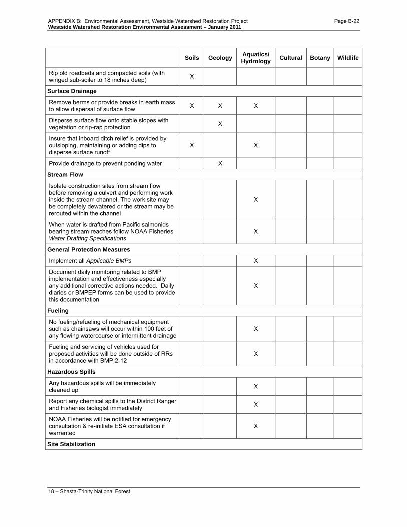
Table 7. Resource protection measures
Soils Geology Aquatics/ Hydrology Cultural Botany Wildlife
Timing
APPENDIX B: Environmental Assessment, Westside Watershed Restoration Project Page B-19

Westside Watershed Restoration Environmental Assessment – January 2011
16 – Shasta-Trinity National Forest
Soils Geology Aquatics/ Hydrology Cultural Botany Wildlife
Limited operating period (LOP) for soils with high compaction rating. Activities are restricted from October 15 to April 15th.. . Activities are permitted on soils with compaction hazard ratings of less than high with restrictions. Seek consultation with earth scientist for further clarification.
X X
Erosion control measures will be in place by October 1, or as COR allows on a case by case basis.
X X
Limited operating period from February 1 to July 9 for northern spotted owl in suitable habitat unless protocol surveys determine no owls to be in the area
X
Limited operating period from February 1 to August 15 within ½ mile from northern goshawk and peregrine falcon nests
X
Limited operating period from January 1 to August 15 within ½ mile from bald eagle nest X
Project design features will be used to reduce or eliminate impacts to Sensitive plant species are known to exist or have potential to exist in the proposed project area. These include deferring treatments on road segments that have known populations of Niles’ or Stebbins’ madia until after July 1 to allow seed set and dispersal.
X
In areas with possible naturally occuring asbestos (NOA), operations should be limited to calm, non-windy conditions to reduce exposure to airborne dust that could contain NOA.
X
Mechanized Ground Based Equipment Limitations
Brief equipment operators of the need to minimize disturbance to existing vegetation within the road clearing limits, at stream crossings, and approved disposal sites to the extent necessary to restore hydrologic function. (Minimize turns)
X X X X X X
Mechanical equipment is generally restricted to slopes less than 35% X X X X X
Limited operating period (LOP) from October 15 to April 15th. . Activities are permitted on soils with compaction hazard ratings of less than high with restrictions. Seek consultation with earth scientist for further clarification
X
Clean equipment to remove noxious weeds and petroleum residues:1) prior to all work and 2) again after working in any areas containing noxious weeds
X X X
APPENDIX B: Environmental Assessment, Westside Watershed Restoration Project Page B-20

Westside Watershed Restoration Environmental Assessment – January 2011
17 – Shasta-Trinity National Forest
Soils Geology Aquatics/ Hydrology Cultural Botany Wildlife
Areas of historic value that could be impacted by activities will be flagged and equipment restricted from these areas
X X
At sites with sensitive snail species, do not compact soil, disturb herbaceous vegetation, degrade water quality, reduce woody debris, reduce canopy cover or disturb ground cover
X
Do not remove trees greater than 10 inches dbh when pulling road fill onto road surface X X X X
Where known populations of sensitive plant species exist on proposed road segments, soil piling for the purposes of outsloping, subsoiling, spot-rocking, and any other activities that could bury plants or disrupt root structures significantly will be avoided
X
Where known populations of spotted or diffuse knapweed exist adjacent to project roads, roads will be individually evaluated to determine the least amount of soil disturbance that would still allow purpose and need to be met
X
The number of service vehicles used in monitoring or implementing treatments will be kept to a minimum to minimize spread of noxious weeds
X
When vehicles park on the side of the road, when possible sites will be chosen where little or no vegetation is present to minimize spread of noxious weed
X
Mechanical operations should operate on slightly moist or moist soils to reduce dust levels that could contain NOA in ultramafic soils.
X
Reduce operation speeds when soils are dry to reduce dust on roads in ultramafic soils to reduce possible exposure to NOA.
X
Cutbanks , Stream Crossing Fills and Berms
Stream crossings are removed and fill is generally placed along cutbanks to create outsloping roads
X X
Cutbank overhangs are removed X X
Culvert removal consists of excavation to pre-road construction level of channel; removal of culvert; and pulling fill back until natural channel width is reestablished
X
Remove organic debris from fill X X
Dispose of unsuitable slide and waste material in relatively flat stable areas away from stream courses
X X
Promote Infiltration / Minimize Surface Runoff
APPENDIX B: Environmental Assessment, Westside Watershed Restoration Project Page B-21
Westside Watershed Restoration Environmental Assessment – January 2011
18 – Shasta-Trinity National Forest
Soils Geology Aquatics/ Hydrology Cultural Botany Wildlife
Rip old roadbeds and compacted soils (with winged sub-soiler to 18 inches deep) X
Surface Drainage
Remove berms or provide breaks in earth mass to allow dispersal of surface flow X X X
Disperse surface flow onto stable slopes with vegetation or rip-rap protection X
Insure that inboard ditch relief is provided by outsloping, maintaining or adding dips to disperse surface runoff
X X
Provide drainage to prevent ponding water X
Stream Flow
Isolate construction sites from stream flow before removing a culvert and performing work inside the stream channel. The work site may be completely dewatered or the stream may be rerouted within the channel
X
When water is drafted from Pacific salmonids bearing stream reaches follow NOAA Fisheries Water Drafting Specifications
X
General Protection Measures
Implement all Applicable BMPs X
Document daily monitoring related to BMP implementation and effectiveness especially any additional corrective actions needed. Daily diaries or BMPEP forms can be used to provide this documentation
X
Fueling
No fueling/refueling of mechanical equipment such as chainsaws will occur within 100 feet of any flowing watercourse or intermittent drainage
X
Fueling and servicing of vehicles used for proposed activities will be done outside of RRs in accordance with BMP 2-12
X
Hazardous Spills
Any hazardous spills will be immediately cleaned up X
Report any chemical spills to the District Ranger and Fisheries biologist immediately X
NOAA Fisheries will be notified for emergency consultation & re-initiate ESA consultation if warranted
X
Site Stabilization
APPENDIX B: Environmental Assessment, Westside Watershed Restoration Project Page B-22

Westside Watershed Restoration Environmental Assessment – January 2011
19 – Shasta-Trinity National Forest
Soils Geology Aquatics/ Hydrology Cultural Botany Wildlife
Revegetate disturbed sites o Seed with grasses or forbs utilizing a
forest botanist approved mix. Plant tree seedlings where available
X X X X
Provide ground cover by mulching with weed-free rice straw, woodchips, or approved fine slash to achieve 1.5 -2 tons/acre of cover.
o Effective ground cover is between 50 and 70% except on granitic soils it should be greater than 90%.
50% of ground cover occurs as organic matter (duff, plant leaves/needles, <3 inch diameter fine slash, etc.)
X X X X
Energy dissipaters (rock rip rap, mulch, straw waddles, etc) are required where concentrated surface flow would otherwise result in sediment transport
X X
Stockpile and replace existing down coarse woody debris (CWD) on disturbed slopes whenever possible
X X
Retain 30-50% of existing surface duff mat (R5 SQS 2509.18-95-1) X X
Monitoring
Project implementation and effectiveness monitoring is used to determine how well objectives are being met, and to determine the effects of project implementation on the environment. The Forest Service would monitor this project during and after its implementation to ensure that objectives are being met and to gather information used to improve the effectiveness of future projects. Information gathered in the monitoring plan would also be used to gauge appropriateness and timing of any future entries and necessity of follow-up rehabilitation measures. Monitoring methods include Best Management Practice Evaluation Process, surveillance, sampling, and measurement of implementation check points and long-term project effectiveness.
Comparison of Alternatives This section provides a summary of the effects of implementing each alternative. Information in Table 8 is focused on activities and effects where different levels of effects or outputs can be distinguished quantitatively or qualitatively among alternatives. Table 9 further describes differences between the actions involved within alternatives 2 and 3.
APPENDIX B: Environmental Assessment, Westside Watershed Restoration Project Page B-23

Westside Watershed Restoration Environmental Assessment – January 2011
20 – Shasta-Trinity National Forest
Table 8. Comparison of road treatments by alternative.
Alternative 1
No Action Alternative 2
Proposed Action Alternative 3 Road Closure
Miles of unclassified road decom 0 17.5 17.5 Miles of level 1 road decom 0 21.1 0 Miles of level 1 road upgraded 0 1.8 1.8 Miles of level 2 road decom 0 9.1 0 Miles of level 2 road closed 0 0 9.1 Miles of level 3 road decom 0 0 0 Miles of level 3 road closed 0 0 0 Miles of level 3 road converted to trail 0 0.3 0.3 Ephemeral stream crossings restored 0 ~58 ~13 Intermittent stream crossings restored 0 ~22 ~8 Perennial stream crossings restored 0 ~13 ~2 Pipe upgrades on system roads 0 5 5
APPENDIX B: Environmental Assessment, Westside Watershed Restoration Project Page B-24

Westside Watershed Restoration Environmental Assessment – January 2011
21 – Shasta-Trinity National Forest
Table 9. Description of management attributes/actions accompanying closed roads, decommissioned roads and roads converted to trail.
Decommission Road conversion to trail Closure (Maintenance Level 1) Administrative outcome
Remove from FS transportation system.
Reclassify on FS transportation system; road to trail.
Reclassify on FS transportation system; classify as Maintenance Level 1 road.
Use outcome Not available for future vehicular use. Available for current use as trail: retain a 36-inch path where the road is decommissioned to trail.
Closed to public and administrative vehicular use, typically for periods exceeding 1 year. Available for non-motorized use.
Maintenance Generally, no long-termed planned work is required.
Typically, only work necessary to facilitate trail use and prevent environmental damage.
Basic custodial care: maintenance is done only to minimize resource impacts based upon condition surveys.
Crossings Remove all culverts and associated fill material. Cross-drains are typically disabled or removed.
Remove all culverts and typically most associated fill material. Cross-drains are typically disabled or removed.
Drainage facilities, including associated fill material are typically retained.
Drainage Drainage facilities are typically removed. To the extent possible, drainage patterns are restored to pre-road conditions. Dispersal of surface runoff is maximized where appropriate.
Drainage facilities are typically removed. To the extent possible, drainage patterns are restored and alterations of surface flows by the trail are minimized. Dispersal of surface runoff is maximized where appropriate.
Drainage facilities are typically retained. Emphasis is normally given to maintaining drainage facilities and runoff patterns. Closure to vehicular traffic typically minimizes surface runoff capture in wheel tracks. Concentration of surface runoff may still occur by drainage facilities.
Erosion control Rip, outslope, and/or install rolling dips on the road prism to restore a more natural route of drainage and accommodate dispersal/settling of sediment. Road fills exhibiting high risk of mass failure are removed.
Rip, outslope, and/or install rolling dips on the road prism to restore a more natural route of drainage and accommodate dispersal/settling of sediment. Road fills exhibiting high risk of mass failure are removed or stabilized.
Closure to vehicular traffic typically reduces sediment from road surfaces. Planned road deterioration may occur at this maintenance level. Road prism features are typically retained.
Revegetation Subsoil (or till), seed, and mulch road prism to accelerate revegetation of disturbed areas. This activity may not occur in areas prone to exotic weeds.
Subsoil (or till), seed, and mulch non-trail portions of road prism to accelerate revegetation. This activity may not occur in areas prone to exotic weeds.
Natural encroachment of brush and trees to the roadway typically occurs during longer periods of closure.
Vehicular Traffic Control
Road entrance is physically blocked and disguised. Vehicle use is permanently eliminated, typically though obliteration of a short segment of road.
Vehicle use is permanently eliminated, typically thru construction of an earthen barrier: access for OHV and/or non-motorized uses is facilitated. Road entrance may be physically blocked and disguised. The terminal end of the road (new trailhead) may be widened to accommodate turn-around needs for vehicles pulling horse trailers.
Vehicle use is temporarily eliminated, typically thru construction of an earthen barrier. Access for non-motorized uses may be facilitated. Road entrance may be physically blocked and disguised.
Administrative outcome
Remove from FS transportation system
Reclassify on FS transportation system; road to trail
Reclassify on FS transportation system; classify as Maintenance Level 1 road
Use outcome Not available for future vehicular use Available for current use as trail: retain a 36-inch path where the road is decommissioned to trail.
Closed to public and administrative vehicular use, typically for periods exceeding 1 year. Available for non-motorized use.
APPENDIX B: Environmental Assessment, Westside Watershed Restoration Project Page B-25

Westside Watershed Restoration Environmental Assessment – January 2011
22 – Shasta-Trinity National Forest
Decommission Road conversion to trail Closure (Maintenance Level 1) Maintenance Generally, no planned work is
required. Typically, only work necessary to facilitate trail use and prevent environmental damage.
Basic custodial care: maintenance is done only to minimize resource impacts based upon condition surveys.
Crossings Remove all culverts and associated fill material. Cross-drains are typically disabled or removed.
Remove all culverts and typically most associated fill material. Cross-drains are typically disabled or removed.
Drainage facilities, including associated fill material are typically retained.
Drainage Drainage facilities are typically removed. To the extent possible, drainage patterns are restored to pre-road conditions. Dispersal of surface runoff is maximized where appropriate.
Drainage facilities are typically removed. To the extent possible, drainage patterns are restored and alterations of surface flows by the trail are minimized. . Dispersal of surface runoff is maximized where appropriate.
Drainage facilities are typically retained. Emphasis is normally given to maintaining drainage facilities and runoff patterns. Closure to vehicular traffic typically minimizes surface runoff capture in wheel tracks. Concentration of surface runoff may still occur by drainage facilities.
Erosion control Rip, outslope, and/or install rolling dips on the road prism to restore a more natural route of drainage and accommodate dispersal/settling of sediment. Road fills exhibiting high risk of mass failure are removed.
Rip, outslope, and/or install rolling dips on the road prism to restore a more natural route of drainage and accommodate dispersal/settling of sediment. Road fills exhibiting high risk of mass failure are removed or stabilized.
Closure to vehicular traffic typically reduces sediment from road surfaces. Planned road deterioration may occur at this maintenance level. Road prism features are typically retained.
Revegetation Subsoil (or till), seed, and mulch road prism to accelerate revegetation of disturbed areas. This activity may not occur in areas prone to exotic weeds.
Subsoil (or till), seed, and mulch non-trail portions of road prism to accelerate revegetation. This activity may not occur in areas prone to exotic weeds.
Natural encroachment of brush and trees to the roadway typically occurs during longer periods of closure.
Vehicular Traffic Control
Road entrance is physically blocked and disguised. Vehicle use is permanently eliminated, typically though obliteration of a short segment of road.
Vehicle use is permanently eliminated, typically thru construction of an earthen barrier: access for OHV and/or non-motorized uses is facilitated. Road entrance may be physically blocked and disguised. The terminal end of the road (new trailhead) may be widened to accommodate turn-around needs for vehicles pulling horse trailers.
Vehicle use is temporarily eliminated, typically thru construction of an earthen barrier: access for non-motorized uses may be facilitated. Road entrance may be physically blocked and disguised.
APPENDIX B: Environmental Assessment, Westside Watershed Restoration Project Page B-26

Westside Watershed Restoration Environmental Assessment – January 2011
23 – Shasta-Trinity National Forest
ENVIRONMENTAL CONSEQUENCES This section summarizes the physical, biological, social and economic environments of the affected project area and the potential changes to those environments due to implementation of the alternatives. It also presents the scientific and analytical basis for comparison of alternatives presented in the chart above.
Watersheds This section summarizes the analysis of project effects to hydrology, geology, and soils. The comprehensive analysis of watershed characteristics is included in the following documents, available in the project record:
• Soils Report, Westside Watershed Restoration Project, Brad Rust, November 2009 • Hydrology Report, Westside Watershed Restoration Project, Christine Mai, September 2009 • Geology Report, Westside Watershed Restoration Project, Abel Jasso and Melanie Stevans, March
2010
Equivalent Roaded Acres and Cumulative Watershed Effects Analysis Scope and Definitions
Threshold levels of disturbance are defined in the Forest Plan for Planning Watersheds (comparable in size to HUC6 or HUC5) in terms of equivalent roaded acres (ERAs). When the disturbance in terms of ERAs exceeds the threshold this is a cautionary level of disturbance that calls for closer consideration of the potential for adverse cumulative watershed effects. The Forest Plan also defines a Cumulative Watershed Effects (CWE) analysis process that quantifies current and future disturbance levels within a watershed. CWE analysis evaluates the environmental consequences of alternatives and other known future foreseeable activities in the context of existing watershed condition based on soils, geology and hydrology. The disturbance factors considered are a combination of past, present and foreseeable fires, roads, vegetation management (timber harvest, and fuels treatments); and any activity that may influence rainfall-runoff, erosion, sediment delivery, and stream channel response. CWE are defined as the additive or compound effects of land management activities to water quantity and quality and beneficial uses, which are transmitted through the fluvial system. CWE is assessed as directed in the Forest Plan at multiple scales from HUC5 Watersheds (roughly 60,000 to 160,000 acres) down to HUC8 Subdrainages (1000-3000 acres). A CWE analysis was completed for this project. The Cumulative Watershed Effects analysis is a coarse level of analysis, and therefore did not detect any differences between alternatives.
This analysis considers the direct and indirect effects to soil, geology and watershed resources within the project area while attempting to account for the spatial and temporal variability of climate, land disturbance, runoff processes, and sediment yield. A risk analysis is used to predict the future condition of watershed resources as they relate to the magnitude, timing, duration and frequency of peak flood flows, surface erosion, and sedimentation.
APPENDIX B: Environmental Assessment, Westside Watershed Restoration Project Page B-27

Westside Watershed Restoration Environmental Assessment – January 2011
24 – Shasta-Trinity National Forest
Soil Quality Standards Evaluation Process
The effects of each alternative on the soil resource have been assessed using the Region 5 Soil Quality Standards and the Shasta-Trinity Forest Plan. Soil quality analysis standards provide threshold values that indicate when changes in soil properties and soil conditions would result in significant change or impairment of the productivity potential, hydrologic function, or buffering capacity of the soil [Forest Plan, page O-1 and O-2]. These standards apply to the soil project bounding area only (roads to be decommissioned).
Roads have been shown to be one of the biggest producers of sediment to watershed basins [Luce et al. 2001, Madej 2002]. Forest roads are significant sources of sediment along with abandoned and unmaintained roads once used for timber harvest which are common across the steep, forested landscape of the Pacific Northwest of the United States. Haul roads constructed across steep slopes frequently result in massive landslides and extensive gullying that contribute sediment directly into stream channels. Sidecast material from road construction can be mobilized when it becomes saturated, or gullies can form if road runoff is diverted onto previously unchanneled slopes.
Geologic Hazard Risk Rating System
An approximation of geologic risk was obtained by combining the probability of road-related mass wasting failures with the potential effects to the resource of interest (in this case roads and streams). The risk analysis was then used in determining which roads would receive treatment. Many roads may appear relatively stable under normal climatic conditions but may fail during high intensity precipitation events. This analysis was bounded by roads and active mass wasting features located within 1 mile of the project roads. This method was used to determine road segments that are at risk of mass wasting.
For this analysis the active mass wasting features are based on bedrock characteristics, location (e.g. adjacent to stream channels), degree of slope, and the potential for failure at stream-road crossings. These have the potential to contribute significant quantities of sediment directly to the fluvial system.
Alternative 1
The analysis of this alternative considers no new activities associated with this project, thus it describes the existing conditions and likely future impacts of no action.
Existing Conditions / Effects of No Action
Geology
This analysis indicates there are approximately 199 miles of roads within the project area that are at risk of a mass wasting event.8
8 For a complete list of at risk road segments, refer to the Westside Restoration Project Geology Specialist report.
APPENDIX B: Environmental Assessment, Westside Watershed Restoration Project Page B-28

Westside Watershed Restoration Environmental Assessment – January 2011
25 – Shasta-Trinity National Forest
Soils
Chronic erosion rates are 87 percent higher on routes with traffic as opposed to routes where traffic is reduced or eliminated, so chronic erosion is expected to be highest under Alternative 1. In addition, episodic erosion and sedimentation from roadside ditch and stream crossing failures would also be highest under Alternative 1.
Roads on sideslopes are more likely to fail and contribute to stream sedimentation than roads on ridge tops and flat areas. Roads on sideslopes intercept subsurface water flows and reroute hillslope water to unnatural flow channels. This diverted water causes more concentrated flows, which leads to erosion and an increase in the risk of mass wasting. Approximately 75 percent of the number of routes, and 63 percent of the miles of routes proposed for decommissioning under this project are located on sideslopes.
Three soil categories occur in the project roads: metasedimentary, serpentine, and granitic. Metasedimentary soils are moderately susceptible to erosion, serpentine soils are moderate to highly susceptible to erosion, and granitic soils are highly susceptible to erosion. The roads in the project area have had moderately low amounts of erosion in the past, with the exception of roads that are poorly maintained. About 70 percent of project roads occur in metasedimentary soils, 20 percent occur in serpentine soils, and 10 percent occur in granitic soils.
Poorly maintained roads tend to develop into poorly functioning roads. Roads identified as poorly functioning (during RAP analysis, watershed analysis for various watersheds, and past environmental analysis) would continue to contribute significant amounts of sediment to several key watersheds important for cold water fisheries and would have the possibility to create or accelerate hill slope instability. Poorly functioning roads affect water quality and fish.
Under the no action alternative, roads with soils that have the possibility of containing naturally occurring asbestos would continue to be open to unrestricted recreational use, which poses a health risk to recreationists.
Vegetation recovery would be delayed or prevented on road surfaces under this alternative due to compaction and associated loss of soil productivity. Existing conditions and sedimentation from roads would continue at equal or increasing levels.
Hydrology
Many of the watersheds within the project area are under a Total Maximum Daily Load (TMDL) sediment reduction plan.9
With no action, road systems would remain in their present condition until the next large flood and/or fire event. Storms with a 25-year recurrence interval may trigger massive failures, including road-stream
Current excessive sediment loads within the Trinity River and South Fork Trinity River Sub-basins have the potential to adversely affect anadromous fisheries habitat and other beneficial uses. Selecting this alternative could increase the likelihood of future failures of up to 93 stream-road crossings, which could lead to up to an additional 58,500 cubic yards of material entering the Trinity River system [see Cook and Dresser 2005 used as basis for calculations].
9 TMDL plans are developed by the Environmental Protection Agency pursuant to the Clean Water Act. Trinity River TMDLs are available at: http://epa.gov/region9/water/tmdl/final.html
APPENDIX B: Environmental Assessment, Westside Watershed Restoration Project Page B-29

Westside Watershed Restoration Environmental Assessment – January 2011
26 – Shasta-Trinity National Forest
crossing failures, debris flows, and other mass wasting events. These storm impacts have the potential for substantial long-term effects on local and downstream beneficial uses of water. Storms of relatively low magnitude, 2-10 year recurrence interval, may cause stream-road crossings to fail as culverts become plugged and/or deteriorate over time.
Selection of Alternative 1 would result in perpetuation of existing adverse effects from aging infrastructure, chronic and epidsodic failures at stream crossings, road related instability and mass wasting. Approximately 25 percent (29.3 cubic yards) of the predicted 117.5 cubic yards of existing erosion rates within the project area would be expected to reach stream channels due to road stream connectivity.
Cumulative Effects The no action alternative would have no direct project effects on watersheds, thus the project would have no cumulative effects.
Alternative 2 – Proposed Action
This analysis considers the potential impacts from stream-road crossing upgrades, road decommissioning (~48 miles), and road conversion to trail (0.3 miles) that are part of the Westside Watershed Restoration proposed action.
Direct Effects and Indirect Effects Alternative 2 treats approximately 48 miles of road with site appropriate decommissioning. Thirteen of these miles are identified as being at risk for a mass wasting event by the geology risk assessment. Decommissioning would occur on identified unauthorized routes, level 1 routes and level 2 routes, and would consist of some or all of the following methods depending on the site: removal of culverts, pulling back of fill slopes where available, ripping of road base, outsloping of roads, creation and placement of rolling dips, removal of roadside berms, and blockage of access. Detrimental compaction would be alleviated by subsoiling (deep tilling of the soil). Subsoiling would allow water infiltration and an increase in soil fertility. Fill that contains top soil would be pulled back onto the road surface where it is available, and this would also increase the fertility of the soil. This fill would increase the stability of the hillslope, and decrease the risk of a mass wasting event. Mulching to a soil cover of 50 to 70 percent would lower short term post project erosion to less than 0.1 ton per acre.
In addition to decommissioning, five stream crossings on other roads would be upgraded. Every stream crossing is designed to pass a storm of a particular magnitude. Upgrading consists of replacing the culvert with a larger culvert that would be large enough to handle 100 year storms and associated debris flows. Minor short term adverse direct effects would occur at perennial stream crossings due to the instream disturbance associated with crossing upgrades and decommissioning, including an increase in suspended sediment and turbidity. This would occur initially as cofferdams and pumps are set up to reroute stream flow around worksites. It would occur again as these protection measures are removed and the flow reenters the established stream channel. Channel adjustments are expected to begin immediately
APPENDIX B: Environmental Assessment, Westside Watershed Restoration Project Page B-30

Westside Watershed Restoration Environmental Assessment – January 2011
27 – Shasta-Trinity National Forest
as water is released back into the disturbed portion of the stream. Increased suspended sediment concentration is not expected to be measurable within ¼ mile downstream of any crossing [Cook and Dresser 2005], consistent with California State water quality objectives for suspended sediment or turbidity. No measurable drainage scale sediment increase is expected during excavation or after the first runoff generating storm event.
Table 10. Summary of road treatments under Alternative 2.
Road Type Number of Roads Miles of Roads Action Unauthorized routes 83 17.5 Decommission Level 1 62 21.1 Decommission Level 1 2 1.8 Upgrade Level 2 14 9.1 Decommission Level 3 1 0.3 Convert to trail
Totals 162 routes 49.8 miles
Alternative 2 would improve watershed condition by reducing road runoff, reducing stream diversion potential, removing or upgrading stream-road crossings, and ultimately, reducing controllable sediment discharges. Improved watershed conditions would improve long-term water quality and fisheries habitat in the watersheds. Alternative 2 would reduce road density in project watersheds. Some hydrologic units have more significant reductions than others. There is a measureable change at the 5th field watershed level, which averages 0.03 miles of reduction in road density per square mile. Greater reductions occur at smaller scales, with a 0.084 mile per square mile reduction at the HUC 6 level, a 0.18 mile per square mile reduction at the HUC 7 scale, and 18 subdrainages have at least 0.3 miles per square mile reductions at the HUC 8 level. Decommissioned roads would have reduced road drainage and surface flow, and watershed conditions would be improved by reducing the magnitude, duration, timing, and frequency of hillslope runoff diversion. Watershed improvements will be greatest in watersheds with the highest reductions in road density (Table 11).
Table 11. Watersheds with the greatest reductions in road density at each watershed level.
Watershed Watershed Level
Existing Road Density
(Mile/square mile)
Alternative 2 Road Density
(Mile/square mile)
Reduction in Road Density
(Mile/square mile) Upper Hayfork Creek HUC 5 2.83 2.75 0.079 Middle South Fork Trinity River HUC 5 3.56 3.52 0.045
Dubakella Creek HUC 6 3.33 3.08 0.250 Harrison Gulch HUC 6 2.81 2.62 0.193 Rattlesnake Creek HUC 6 5.01 4.83 0.180 Dubakella Creek HUC 7 2.82 2.12 0.70 Headwaters Hayfork Creek HUC 7 4.89 4.40 0.50
1801021203010103 HUC 8 3.75 2.41 1.34 1801021203010201 HUC 8 2.26 1.52 0.74 1801021202010203 HUC 8 5.88 5.18 0.70
APPENDIX B: Environmental Assessment, Westside Watershed Restoration Project Page B-31

Westside Watershed Restoration Environmental Assessment – January 2011
28 – Shasta-Trinity National Forest
Erosion and sedimentation associated with road-side ditch failure and stream diversion would be reduced as ditches are eliminated and as the grade of the road is reshaped, thus providing more natural hillslope drainage. Some erosion and sedimentation would occur for approximately one season until soils stabilize and revegetate. During this first season, erosion is likely to reach stream channels in locations where the routes are connected to stream channels. Of the predicted erosion that would occur in the first season after project implementation, no more than 25 percent (1.5 cubic yards over the entire project area) of that predicted erosion would reach stream channels. However, in the long term there would be approximately a 98.3 percent reduction in erosion with the selection of this alternative compared to Alternative 1. Once a more natural drainage and vegetation cover is established an increase in slope stability will occur, thus a decrease in road and stream-road crossing failures and associated episodic erosion and sedimentation.
Decommissioning will also decrease the possibility of road related mass wasting within the areas identified by the Geology Risk Assessment. The removal of road fill at stream crossings offers a high degree of success in regards to limiting the downstream effects of mass wasting. This is due to mass wasting occurring in steep terrain that becomes channelized in incised streams and valley inner gorges, thus funneling into stream crossings, and potentially causing road fill to fail. Decommissioning would eliminate costs associated with mass wasting events. The 0.3 miles of road that will be decommissioned to motorized trail may still be affected by mass wasting events because it occurs in a mass wasting hazard area identified in the geology risk assessment. Even though motorized trails are smaller than roads, they can still be a source for mass wasting at a smaller scale than road related mass wasting.
An estimated ninety-three (93) stream crossings would be removed under Alternative 2. Removal of stream crossings would provide significant benefits for associated aquatic species. Middle Fork Cottonwood Creek (HUC 5), Upper Hayfork Creek (HUC 5) and Harrison Gulch (HUC 6) are the watersheds that would have the greatest number of crossings removed under Alternative 2 (21, 23, and 18 stream crossings removed respectively). Properly designed and implemented road-stream crossing excavations have discountable short-term and small scale effects on beneficial uses and water quality. Road fill removed during these excavations would no longer be available to be washed downstream during a large storm debris flow event, thus in the long-term sedimentation would be significantly reduced. There would be a 95.5 percent reduction in potential sediment delivery due to stream-road crossing failure (approximately 2,900 cubic yards less sediment in the project area) [see Cook and Dresser 2005 for basis for calculations].
Five stream-road crossings would be upgraded by replacing small culverts with larger culverts. The episodic erosion and sediment that occur during stream crossing failure events would be reduced by reducing the occurrence of stream crossing failures by installing larger culverts that would allow larger debris and flow to pass through the crossing. Without the upgrading of stream-road crossings, the smaller culverts could become plugged, and eventually fail. The most common cause of crossing failure is debris plugged culverts.
Forest Best Management Practices (also referred to as project design features) monitoring results show that since 1993 the Forest is effectively implementing road-stream crossing BMPs 84 percent of the
APPENDIX B: Environmental Assessment, Westside Watershed Restoration Project Page B-32

Westside Watershed Restoration Environmental Assessment – January 2011
29 – Shasta-Trinity National Forest
time. That means that projects are implemented based on the project design features 84 percent of the time. The other 16 percent of the time, some project design features are skipped or implemented incorrectly. This rate of properly implementing projects has increased to 100 percent for the last 3 years.
Project design feature effectiveness has also been monitored. Effectiveness ratings are often dependent upon project and storm timing as well as high water years. If the winter after project implementation is a high water year, project design features are less likely to be effective. Project design features at stream crossings have been 75 percent effective since 1993, and 80 percent effective over the last 3 years. This may indicate that adjustments to project design features are resulting in greater effectiveness. Issues identified from past monitoring are corrected through the monitoring feedback loop and these issues are prevented in the future through adjusting project design features and improved oversight.
Soil Recovery Rates
Analysis factors for project effects on soil include erosion hazard, compaction, hydrologic function, and potential for exposure to naturally occurring asbestos. Project effects on soil analysis factors are summarized in Table 12. Direct effects of project implementation would have minor effects on erosion, compaction and hydrologic function, and there is a low risk of exposure to naturally occurring asbestos. Post project, erosion risk would be low, and there is no anticipated compaction or impedance of hydrologic function. Additionally, Alternative 2 would lower the risk of public exposure to naturally occurring asbestos compared to Alternative 1.
Table 12. Summary of soil impacts and other project effects for Alternative 2.
Soil Analysis Factor Pre-project Conditions Alternative 1
Direct & Indirect Effects Alternative 2
Conditions Immediately Following Implementation Alternative 2
Erosion Hazard Moderately high Low Low Compaction High Low None anticipated Hydrologic Function High impedance Low impedance No impedance Potential NOA* Exposure Moderate risk Low risk Low risk
*Naturally occurring asbestos
Decommissioning would decrease compaction by subsoiling the road surface. Soils that contain high amounts of clay or are fine-loamy soils (i.e. Holland soil types) suffer legacy compaction, which can last up to 40 years without decompaction treatments [Powers 2005, Rust 2004, Rust 2007, Young 2005]. In soils with less clay, sandy textures, and more rock fragments (Weitchpec and Chaix soil types) compaction can last up to 5 to 10 years without treatment. In soils with high rock content (>35%; Neuns soil types) compaction is negated due to the rock fragment network. Soil recovery rates for Alternative 2 are summarized in Table 13.
APPENDIX B: Environmental Assessment, Westside Watershed Restoration Project Page B-33

Westside Watershed Restoration Environmental Assessment – January 2011
30 – Shasta-Trinity National Forest
Table 13. Alternative 2 soil recovery rates (road decommissioning).
Soil Category Soil Type Erosion Reductions Compaction Recovery
Hydrologic Function Improvement
Granitic Chaix 3-5 years 2-5 years 2-5 years Metasedimentary Holland 3-5 years 5-10 years 5-10 years Metasedimentary Neuns 2-3 years 2-5 years 2-5 years Serpentine Weitchpec 2-3 years 2-5 years 5-10 years
There are some short-term increases in erosion with project implementation, but over a 2-5 year period these rates will drop to background levels due to mulch from falling leaves, branches, needles, and growth of grass and forbs (Table 13). Table 14 summarizes calculated surface erosion rates (WEPP erosion model10
Fertility and hydrologic function would be improved on decommissioned routes by subsoiling the road surface. Subsoiling would improve drainage, lessen surface runoff, and increase fertility. In addition, fill that contains topsoil would be pulled back onto the road surface where possible. Level of hydrologic function recovery is dependent on the type of decommissioning that is employed.
) for pre-project and post project roads. The WEPP model shows greater erosion rates for open (4.1 to 9.5 tons per acre) and closed roads (1.0 tons per acre) roads over decommissioned roads (0.10 tons per acre).
Some roads that cross areas where naturally occurring asbestos may occur will be decommissioned and/or closed to traffic. Road decommission/closure would prevent public access and reduce erosion and dust production, thus decreasing potential public exposure to asbestos dust.
Table 14. WEPP road surface erosion rates*
Type of Road Surface Texture Road Surface Road Condition Use Level Erosion Rate
(tons per acre) Inslope/bare ditch Holland loam Native Rutted High 8.6 Inslope/bare ditch Neuns loam Native Rutted High 9.5 Inslope/vegetated ditch Holland loam Native Unrutted High 4.1 Inslope/vegetated ditch Neuns loam Native Unrutted High 4.7 Inslope/vegetated ditch Holland loam Native Unrutted Closed 1.0 Inslope/vegetated ditch Neuns loam Native Unrutted Closed 1.0 Outslope/no ditch Holland loam Ripped/mulched Unrutted Decommissioned 0.1 Outslope/no ditch Neuns loam Ripped/mulched Unrutted Decommissioned 0.1
10 The Water Erosion Prediction Project (WEPP) soil erosion model was developed by an interagency group of
scientists including the USDA’s Agriculture Research Service (ARS), Natural Resources Conservation Service, and
Forest Service, the Department of Interior’s Bureau of Land Management, and the U.S. Geological Survey.
Scientists from these agencies have been working since 1985 to develop this erosion prediction model to replace the
Universal Soil Loss Equation (USLE) for various land management activities (timber harvesting, roads, grazing, fuel
reduction, prescribed fire and wildfire).
APPENDIX B: Environmental Assessment, Westside Watershed Restoration Project Page B-34

Westside Watershed Restoration Environmental Assessment – January 2011
31 – Shasta-Trinity National Forest
*Note: Analysis is based on a representative site. Sediment is eroding off this road section and being delivered to stream (ephemeral draw, intermittent creek, perennial stream). Site has 4% grade, 200’ long by 13’ wide section with a 15’ fill length, a 25% slope, and a buffer of 130’ to stream with 67” average annual precipitation.
Cumulative Effects Decommissioning would restore hydrologic functionality, reduce erosion, and increase soil fertility by improving infiltration and returning topsoil. In addition, sedimentation of streams would be reduced, and water quality and fish habitat would be improved in project watersheds. With project design features built into this alternative, direct effects on soils would be minimal. No other foreseeable projects are expected to occur in these road beds, thus there would be no cumulative effects on soils11
The Cumulative Watershed Effects analysis is a coarse level of analysis, and therefore did not detect any differences between alternatives within hydrologic units from watershed, sub-watershed drainage, or sub-drainage (HUC 3-8) scales with the the selection of any of the alternatives. No adverse cumulative effects are expected based on the CWE analysis
. For Alternative 2 there are no cumulative effects on mass wasting because project effects mass wasting are positive effects. Also, the potential risk of public exposure to naturally occurring asbestos is reduced, by reducing the number of roads that the public has access to with potential naturally occurring asbestos.
12
Alternative 3 – Route Closure
(see the cumulative effects analysis section above for a list of past, present, and reasonably foreseeable projects that were considered in cumulative effects analysis).
The analysis of this alternative considers the potential impacts from decommissioning of unauthorized routes (17.5 miles), closures of selected National Forest Transportation System routes (9.4 miles), and upgrades to 5 stream-road crossings.
Direct and Indirect Effects Alternative 3 treats 26.9 miles of roads with various levels of closures and decommissioning to restore soil functionality for watershed restoration. Storm proofing will occur on 21 miles of level 1 roads by placing rolling dips and removing berms. Road closures will occur on 9.4 miles of level 2 roads. These level 2 roads would go from high/moderate levels of traffic to no traffic, resulting in reduced erosion, dust and sediment. Table 15 summarizes road treatments under this alternative.
Table 15. Summary of road treatment for Alternative 3.
Road Type Number of Roads Miles of Roads Action Unauthorized routes 83 17.5 Decommission
Level 1 62 21 Stay level 1 Storm proof
Level 1 2 1.8 Upgrade
11 The soil analysis boundary is the road prisms. Because the roads would be decommissioned or closed, it is assumed that no further work would be done that would impact soils after implementation. Therefore there are no foreseeable projects that would affect the soils. 12 See CWE analysis table in the Westside Watershed Restoration Project Hydrology specialist report
APPENDIX B: Environmental Assessment, Westside Watershed Restoration Project Page B-35
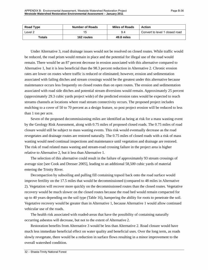
Westside Watershed Restoration Environmental Assessment – January 2011
32 – Shasta-Trinity National Forest
Road Type Number of Roads Miles of Roads Action Level 2 15 9.4 Convert to level 1 closed road
Totals 162 routes 49.8 miles
Under Alternative 3, road drainage issues would not be resolved on closed routes. While traffic would be reduced, the road prism would remain in place and the potential for illegal use of the road would remain. There would be an 87 percent decrease in erosion associated with this alternative compared to Alternative 1, but it is less beneficial than the 98.3 percent reduction in Alternative 2. Chronic erosion rates are lower on routes where traffic is reduced or eliminated; however, erosion and sedimentation associated with failing ditches and stream crossings would be the greatest under this alternative because maintenance occurs less frequently on closed routes than on open routes. The erosion and sedimentation associated with road side ditches and potential stream diversions would remain. Approximately 25 percent (approximately 29.3 cubic yards project wide) of the predicted erosion rates would be expected to reach streams channels at locations where road stream connectivity occurs. The proposed project includes mulching to a cover of 50 to 70 percent as a design feature, so post project erosion will be reduced to less than 1 ton per acre.
Seven of the proposed decommissioning miles are identified as being at risk for a mass wasting event by the Geology Risk Assessment, along with 0.75 miles of proposed closed roads. The 0.75 miles of road closure would still be subject to mass wasting events. This risk would eventually decrease as the road revegetates and drainage routes are restored naturally. The 0.75 miles of closed roads with a risk of mass wasting would need continual inspections and maintenance until vegetation and drainage are restored. The risk of road related mass wasting and stream-road crossing failure in the project area is higher relative to Alternative 2, but it less than Alternative 1.
The selection of this alternative could result in the failure of approximately 93 stream crossings of average size [see Cook and Dresser 2005], leading to an additional 58,500 cubic yards of material entering the Trinity River.
Decompaction by subsoiling and pulling fill containing topsoil back onto the road surface would improve fertility on the 17.5 miles that would be decommissioned (compared to 48 miles in Alternative 2). Vegetation will recover more quickly on the decommissioned routes than the closed routes. Vegetative recovery would be much slower on the closed routes because the road bed would remain compacted for up to 40 years depending on the soil type (Table 16), hampering the ability for roots to penetrate the soil. Vegetative recovery would be greater than in Alternative 1, because Alternative 1 would allow continued vehicular use of the roads.
The health risk associated with roaded-areas that have the possibility of containing naturally occurring asbestos will decrease, but not to the extent of Alternative 2.
Restoration benefits from Alternative 3 would be less than Alternative 2. Road closure would have much less immediate beneficial effect on water quality and beneficial uses. Over the long term, as roads slowly revegetate, there would be a reduction in surface flows resulting in a minor improvement to the overall watershed condition.
APPENDIX B: Environmental Assessment, Westside Watershed Restoration Project Page B-36

Westside Watershed Restoration Environmental Assessment – January 2011
33 – Shasta-Trinity National Forest
Soil Recovery Rates
There are some short-term increases in erosion with project implementation, but over a 3 to 5 year time span these rates will drop to background levels as seen in Alternative 2. Roads going through fine-loamy soils (Holland soil types) will stay compacted for the longest period of time (up to 40 years) on closed roads, while closed roads going through rockier soil types (Neuns soil types) will recover fairly quickly. The roads that would be decommissioned under this alternative would recover at the same rate as the decommissioned roads in Alternative 2. Hydrologic function and fertility recovery is dependent on whether the road is closed or decommissioned, and the level of decommissioning. Decommissioning will accelerate hydrologic function and fertility, but the time frame of recovery is dependent on the type of soil restored. While soil functionality will take longer to recover when roads are only closed, the recovery would be improved over Alternative 1. Recovery rates for Alternative 3 are summarized in Table 16.
Table 16. Alternative 3 soil recovery rates for the project area with some roads being decommissioned and some roads being closed.
Soil Category Soil Types Erosion Reductions Compaction Recovery
Hydrologic Function Improvement
Granitic Chaix 3-5 years 2-5 years 3-5 years Metasedimentary Holland 3-5 years 15-40 years 10-20 years Metasedimentary Neuns 2-3 years 3-5 years 3-5 years Serpentine Weitchpec 2-3 years 10-15 years 10-15 years
Onsite erosion rates (WEPP model) for open roads (4.1 to 9.5 tons per acre) are much higher than closed roads (1.0 tons per acre) and decommissioned roads (0.10 tons per acre; see Table 14 in Alternative 2). Alternative 3 would reduce erosion and improve soil functionality compared to Alternative 1, but the beneficial effects would be less than Alternative 2. All of the treated roads have generous forest buffers with appropriate project design features that limit sediment delivery into waterways (during decommissioning activities).
Alternative 3 would decrease soil compaction on the 17.5 miles of road that would be decommissioned (compared to approximately 48 miles of reduced compaction in Alternative 2). Fertility and hydrologic function would be improved in the short term on the decommissioned roads, and in the long term on the closed roads as they recover from compaction (see Table 16 for rates of natural compaction recovery rates).
Cumulative Effects The cumulative effects analysis section above summarizes all past, present and reasonably foreseeable actions that were considered for cumulative effects analysis. Under Alternative 3 some existing conditions (compaction and poor hydrologic function) would persist. With project design features built into this alternative, direct effects on soils would be minimal. No other foreseeable projects are expected to occur in these road beds, thus there would be no cumulative effects on soils.
APPENDIX B: Environmental Assessment, Westside Watershed Restoration Project Page B-37

Westside Watershed Restoration Environmental Assessment – January 2011
34 – Shasta-Trinity National Forest
As the roads become revegetated and drainage is restored mass wasting risk will be reduced by the project in the long term. In the short term, road related risk of mass wasting is slightly higher with this alternative compared to Alternative 2. However, this would occur as a result of existing conditions, not as a result of the project. No cumulative effects occur from Alternative 3 on mass wasting.
The potential risk of public exposure to naturally occurring asbestos is reduced overall by reducing the number of roads that the public has access to with potential naturally occurring asbestos. There would not be an increase in public exposure to naturally occurring asbestos, so there would not be an increase in cumulative effects from Alternative 3.
The Cumulative Watershed Effects analysis model does not detect any difference in cumulative effects between the three alternatives. Any cumulative effects for Alternative 3 that might occur that were not detected by the model would be the most similar to the no action alternative because the road density would not be considerably reduced over the existing conditions and there would be fewer road crossings removed under this alternative compared to Alternative 2.
Conclusions and Recommendations
Changes in road densities and stream crossing densities are evident under Alternative 2 at all scales (HUC 4-8). These beneficial road density reductions would not occur with the selection of alternatives 1 or 3. At a stream reach scale beneficial effects include a reduction in sediment, an increase in soil functionality and slope stability, and a decrease in stream-road crossing failures. These beneficial effects would be the greatest for Alternative 2, less for Alternative 3, and none for Alternative 1. Negligible negative effects of project implementation could be recognized at a subdrainage (HUC 8) site specific scale and potentially a stream reach scale. Table 17 compares the project effects for each alternative.
Table 17. Comparison of project effects for each alternative.
Physical Science Analysis Factor
Alternative 1 (No Action)
Alternative 2 (Proposed Action)
Alternative 3 (Closure Alternative)
Geologic Hazard Risk High Low Moderate Stream Sedimentation
Episodic – Extreme storm events with 94 potential crossing failures Return interval >25 year storm
Up to 58,500 cu yds total on project roads No reduction
Up to 995 cu yds total on project roads 98% reduction
Up to 7605 cu yds total on project roads 87% reduction
Chronic – Delivered from roads Return interval 2+ year storm
No reduction 98% reduction 75% reduction
Erosion
Sediment channel WEPP (tons per acre)
4.4 tons per acre No reduction
0.1 tons per acre 98% reduction
1.0 tons per acre 77% reduction
Erosion hazard rating High Low Moderate Compaction
APPENDIX B: Environmental Assessment, Westside Watershed Restoration Project Page B-38

Westside Watershed Restoration Environmental Assessment – January 2011
35 – Shasta-Trinity National Forest
Physical Science Analysis Factor
Alternative 1 (No Action)
Alternative 2 (Proposed Action)
Alternative 3 (Closure Alternative)
Geologic Hazard Risk High Low Moderate
Miles of decompacted roads
None Truncated
48 Miles Restored
17 miles Restored
Hydrologic function Truncated 48 miles restored 17 miles restored Fertility No change 48 miles restored 17 miles restored Possible public exposure to naturally occurring asbestos
29 miles 29 miles less 10 miles less
Road density reductions (mile per sq mile) HUC 5 No change 0.033 average reduction No measurable change HUC 6 No change 0.084 average reduction No measureable change
HUC 7 No change 9 HUCs with >0.18 reduction No measureable change
HUC 8 No change 18 HUCs with >0.3 reduction No measurable change
Stream Crossing Removal (Average) Total No change 94 crossings 1 crossing HUC 5 No change 13 crossings HUC 6 No change 8.4 crossings HUC 7 No change 4.6 crossings HUC 8 No change 2.7 crossings
Fisheries This section summarizes the analysis of potential project effects to fish species, including those listed under the federal Endangered Species Act (ESA), those designated by the Forest Service as Sensitive species, and Forest Plan fisheries management indicator species (MIS).13
• Fisheries MIS Report, Westside Watershed Restoration Project, William Brock, September 2010.
The comprehensive analysis of species occurrence, habitat, and effects are included in the following documents: Fisheries Specialist Report, Westside Watershed Restoration Project, William Brock, September 2010.
• Fisheries Biological Assessment / Biological Evaluation, Westside Watershed Restoration Environmental Analysis, Donnie Ratcliff, September 2010.
Listed fish species that occur on the Shasta-Trinity National Forest are anadromous salmonids that return to natal streams on the Forest to reproduce after living in the ocean for a variable amount of time, dependent upon the species. The following special status species and habitats occur within the assessment area:
Endangered: None Threatened: • Southern Oregon Northern California Coasts Evolutionarily
Significant Unit (SONCC) coho salmon (Oncorhynchus kisutch) 13 Identified in Forest Plan, page 3-11.
APPENDIX B: Environmental Assessment, Westside Watershed Restoration Project Page B-39

Westside Watershed Restoration Environmental Assessment – January 2011
36 – Shasta-Trinity National Forest
and their designated critical habitat. • California Central Valley steelhead (Oncorhynchus mykiss)
distinct population segment • Central Valley Spring-Run ESU Chinook salmon (O. tshawytscha)
Proposed: None Sensitive: • Upper Klamath-Trinity Rivers Spring-Run Chinook salmon (O.
tshawytscha); • Upper Trinity River Fall Run Chinook Salmon (O. tshawytscha) • Klamath Mountains Province steelhead trout (O. mykiss)
Essential Fish Habitat: Management Indicator Assemblage Fish Species Representatives:
• Coho salmon • Chinook salmon
• Winter-run steelhead • Rainbow trout
The Magnuson-Stevens Fishery Conservation Management Act (MSFCMA), as amended by the Sustainable Fisheries Act of 1996 (Public Law 104-297), requires all Federal agencies to consult with National Marine Fisheries Service (NMFS) on all actions or proposed actions (permitted, funded, or undertaken by the agency) that may adversely affect Essential Fish Habitat. Essential Fish Habitat (EFH) is defined as those waters and substrate necessary to commercially important fish, including Pacific salmon species, for spawning, breeding, feeding, and growth to maturity.
In addition to their listing under the ESA, coho salmon are also managed by NMFS under the MSFCMA, which prompts an EFH consultation in addition to an ESA consultation. EFH consultation was consolidated with ESA consultation based upon the NMFS finding that the ESA Section 7 consultation process used by the U.S. Department of Agriculture – Forest Service (FS) can be used to satisfy the EFH consultation.
EFH consultation is required for Chinook salmon even in cases where they are not listed under the ESA; for example, the Upper Klamath-Trinity Rivers Spring-Run Chinook salmon (O. tshawytscha) and Upper Trinity River Fall Run Chinook Salmon. Similarly, Chinook salmon (O. tshawytscha) habitat for the Beegum and Cottonwood Creek drainages must receive an EFH consultation.
In summary, coho salmon Critical Habitat (CH) and EFH in the Trinity River system is duplicative. In the Cottonwood/Beegum Creek area, EFH and CH extend up into the Beegum gorge area and the Cottonwood Creek drainage to a point ending approximately two stream miles downstream from the Forest boundary. The point at which the project area is nearest to the Forest boundary is approximately one mile. Therefore, the critical habitat is three miles distant from the project area. In addition, Central Valley Spring-Run ESU Chinook salmon rarely migrate to the upper ends of these Critical Habitat ranges due primarily to recent low numbers of returning spawners.
APPENDIX B: Environmental Assessment, Westside Watershed Restoration Project Page B-40

Westside Watershed Restoration Environmental Assessment – January 2011
37 – Shasta-Trinity National Forest
Unoccupied Critical Habitat for the SONCC coho salmon of the Trinity Basin does get near (within tenths of one mile) some of the proposed treatment sites in the preferred alternative. This potential for proximity-related proposed action effects also applies to the Forest Service Sensitive fish species (Upper Klamath/Trinity Chinook ESU spring-run, Upper Trinity River Chinook ESU fall-run, and Klamath Mountain Province Steelhead ESU), and the MIS species of winter-run steelhead and rainbow trout.
The fisheries analysis refers to the Cumulative Watershed Effects analysis and relies on the hydrology analysis results14
Alternative 1
indicating project effects to water quality. Fisheries habitat is integrally linked to watershed health and water quality, thus the analysis of these two resources is linked as well.
Alternative 1 is the no action alternative. This alternative is not associated with any direct, indirect, or cumulative effects because no action is proposed. Adoption of this alternative would allow the current condition to persist. Road segments proposed for decommissioning in the project action areas would remain open. The five sites on system roads proposed for culvert upgrading would remain unchanged. This alternative would not reduce the risk of mass wasting or surface erosion posed by current project area roads. In all likelihood, one or more of the road segments proposed for treatment would eventually cause one or more major erosional events, sending many cubic yards of fine-grained sediment downstream which would eventually impact anadromous fish habitat. This could eventually impact anadromous fish habitat including that of the species listed above. Depending upon future storm frequency and magnitude, large erosional events could occur numerous times, even in a single storm event. This outcome could seriously impact anadromous fish habitat downstream for an extended period of time.
The no action alternative would therefore likely result in either continued or worsening stream degradation over time, regardless of the continuation of routine road maintenance. Landslides originating from cut or fill slopes can occur independently of how the existing culverts, outsloped roads, or road surface critical dips are designed and constructed. This is in part why the Forest’s Cumulative Watershed Effects model compares all forms of watershed disturbance to its ‘Equivalent Roaded Acres’ level of impact.
The well-documented adverse effects caused by roads in forest lands are clearly expressed in the book Influences of Forest and Rangeland Management on Salmonid Fishes and their Habitats, [Meehan, 1991]:
“Forest and rangeland roads can cause serious degradation of salmonid habitats in streams. It should be recognized that only rarely can roads be built that have no negative effects on streams. Roads modify natural drainage networks and accelerate erosion processes. These changes can alter physical processes in streams… and can have important biological consequences… affecting all stream ecosystem components.”
14 Westside Watershed Restoration Project Physical Science Report, 2010.
APPENDIX B: Environmental Assessment, Westside Watershed Restoration Project Page B-41

Westside Watershed Restoration Environmental Assessment – January 2011
38 – Shasta-Trinity National Forest
Alternative 2
The proposed action addresses the threat that the existing Forest road network poses to salmonid fish habitat, including all of those with special listing status. The areas where the proposed action road treatment segments are located are typified by steep to very steep terrain, representative of the Trinity River and upper Beegum/Cottonwood Creeks watershed landscapes. In this type terrain, a high risk of sediment delivery to streams from roads exists [Swanston as cited by Meehan, 1991].
The proposed action would provide for more benefits to downstream water quality and fish habitat protection and improvement than the no action alternative or the road closure alternative.
Direct Effects Fish habitats within project watersheds that are occupied by ESA-listed SONCC coho salmon occur more than 500 meters downstream of culvert upgrade and decommissioning treatments, thereby eliminating the potential for direct effects to this ESA-listed fish. Forest Service Sensitive Upper Klamath-Trinity Rivers Spring-Run Chinook salmon and Upper Trinity River Fall Run Chinook Salmon (and their EFH) also do not get closer than 500 meters to any proposed project treatment site. Threatened Central Valley spring-run Chinook salmon and Central Valley steelhead do not migrate to a point closer than three stream miles from proposed actions, eliminating the potential for direct effects.
Indirect Effects SONCC coho salmon CH and EFH, Forest Service Sensitive Klamath Mountains Province steelhead and MIS listed winter-run steelhead and rainbow trout do have the potential to be adversely affected by proposed project activities; however, resource protection measures and Best Management Practices will prevent any possibility of adverse direct affects from occurring. Minor short-term effects resulting from low levels of turbidity would likely occur 1) as cofferdams and pumps are set up to reroute flow around pipe upgrade or removal sites; 2) during removal of such equipment, and then 3) as channel adjustments ensue immediately upon project completion. These three factors will yield minor quantities of turbidity and suspended sediment likely no further than 500 meters15
Any short-term increase in turbidity will not likely adversely affect salmonid habitat because resource protection measures will prevent significant amounts of sediment to be deposited on channel substrates, and minimize the length of channels experiencing turbidity. The potential for short-term and relatively minor levels of turbidity is likely to cease more than 500 meters downstream from treatment sites, which is well before the upper range of the nearest ESA-listed fish and Critical Habitats and Forest Service sensitive fish species. No adverse indirect effects to fish species of concern or their habitats are likely to occur due to implementation of resource protection measures. Important anadromous salmonid habitat
downstream from such sites, and therefore would not affect the fish species or habitat in any measurable adverse manner. When these short-term adjustments or perturbations are completed, all potentially affected fish and fish habitats would benefit directly to a significant extent.
15 Research conducted at nearby similarly steep sites where road decommissioning has occurred detected project-related turbidity extending downstream no more than 500 meters [Six Rivers National Forest; Cook and Dresser, 2005].
APPENDIX B: Environmental Assessment, Westside Watershed Restoration Project Page B-42

Westside Watershed Restoration Environmental Assessment – January 2011
39 – Shasta-Trinity National Forest
physical characteristics include food provision, shelter, spawning substrate, suitable water quality, and migration access up and downstream. These physical habitat characteristics are not likely to be adversely affected by project implementation.
Some positive indirect effects to fish and fish habitat may occur over time, although they are difficult to measure. Downstream fish habitat may improve after project implementation (road decommissioning and culvert upgrade). Chronically generated road surface sedimentation rates will decrease (see discussion below under Alternative 3). The number of catastrophic mass soil movement events will be fewer over an extended period of time than what would occur without implementation of the proposed project.
Alternative 3
Adoption of this alternative would attenuate the sediment delivered to streams through the direct and indirect effects of reduced vehicle traffic on road surfaces. The portion of sediment delivered from vehicle traffic can be measureable in some instances. Measureable amounts of sediment from roads would generally occur where erosion is increased from surface rutting caused by vehicle use during winter weather. These ruts can collect water and cause both sheet runoff and rills.
The majority of erosion contributed by roads and road surfaces, however, occurs regardless of vehicle use. Researchers in the Clearwater River system of Washington found that fine sediment began increasing within natural fish spawning gravels when more than 2.5% of the drainage basin was comprised of roadbed surfaces [Cedarholm et al. 1981 as cited by Meehan 1991].
Surface erosion from slow moving landslides or slumping surfaces can also prolong sediment delivery to streams after initial landslide events. These soil particles are usually finer in diameter than the sediment contributed initially during the landslide event (i.e., more deleterious to fish) and contribute material for many years after the initial event [Meehan 1991]. This source of surface erosion would not be alleviated from simple road closure (Alternative 3). It would be alleviated only through decommissioning (Alternative 2), which would reduce the landslide potential. Surface erosion originating from closed roads would gradually diminish as some vegetation becomes re-established on compacted road surfaces. The extent of revegetation on closed road surfaces is usually limited due to compacted road surfaces.
To summarize, pursuing this alternative would not ameliorate the landslide and mass wasting potential certain to originate from proposed project treatment road segments over time and would decrease only slightly the annual loads of fine-grained sediments originating from project road segments. Both of these fine-grained sediment contributions are harmful to fish downstream from proposed treatment areas because they can easily extend downstream into anadromous fish habitats. As mentioned above, landslide threats are greater on closed (Alternative 3) or open (Alternative 1) roads than either naturally forested landscapes or forested slopes after road decommissioning has taken place.
APPENDIX B: Environmental Assessment, Westside Watershed Restoration Project Page B-43

Westside Watershed Restoration Environmental Assessment – January 2011
40 – Shasta-Trinity National Forest
Cumulative Effects The cumulative effects analysis section above summarizes all past, present and reasonably foreseeable actions that were considered for cumulative effects analysis. Reasonably foreseeable future actions on private lands include rural residential development, road construction and maintenance, timber harvest and fuels reduction projects. These actions have the potential to increase sedimentation into project streams, possibly impacting fish habitat. However, activities would occur under County regulations, the State Forest Practice Rules, and other regulations that include measures to protect riparian and stream habitat. As stated in the hydrology report for this Project:
“The ERA cumulative effects analysis model does not show any difference in cumulative watershed effects (HUC 5) when including existing conditions, and future foreseeable activities including implementation of the 2 action alternatives associated with this project. Disturbance levels for sub-watersheds, drainages and sub-drainages (HUC 6-8) also remain unchanged”.
Because no measureable direct effects – short or long term - are expected to occur to fish as a result of implementing this project due to Best Management Practices and resource protection measures, the only cumulative effects that could conceivably affect fish are those that may indirectly adversely affect fish or fish habitat downstream from areas of project implementation. The analysis described above and accompanying project fish analysis documents confirm, however, that no indirect effects to fish and fish habitats are likely. Therefore, no cumulative effects will result that could otherwise harm salmonids, other fishes, or fish habitat as a result of implementing this project’s preferred alternative or Alternative 3.
Effects Determinations
Threatened Species and Critical Habitat Analysis of the effects of the project elements on the essential habitat types of freshwater habitat has found that negative effects to SONCC coho salmon or their critical habitat is insignificant (so small that they cannot be measured). Implementation of project alternative(s), therefore, may affect but is not likely to adversely affect SONCC coho salmon or critical habitat of SONCC coho salmon.
Analysis of the effects of project implementation on the Central Valley steelhead Distinct Population Segment or Central Valley Spring-Run ESU Chinook salmon or their Critical Habitats has found that negative effects to these species or their critical habitat would not occur due to the distance of habitat from the project area. Therefore, implementation of either project alternative would have no effect on the California Central Valley steelhead Distinct Population Segment or Central Valley Spring-Run ESU Chinook salmon or their critical habitats.
Sensitive Species Implementation of either project alternative would not likely result in a trend towards listing or loss of viability of Klamath Mountain Province steelhead, Upper Trinity River Fall Run Chinook salmon, or Upper Klamath-Trinity Rivers Spring-Run Chinook salmon. Implementation of Alternative 2 would
APPENDIX B: Environmental Assessment, Westside Watershed Restoration Project Page B-44

Westside Watershed Restoration Environmental Assessment – January 2011
41 – Shasta-Trinity National Forest
likely have beneficial effects on watershed conditions that support these species, thereby promoting a trend away from listing or loss of viability.
Essential Fish Habitat The effects analysis considers effects on Pacific salmonid habitat in general. Since habitat requirements and effects mechanisms for coho and Chinook salmon are similar, the effects of the project analyzed previously are identical for EFH. Therefore, it is my determination that the Westside Watershed Restoration Project will not adversely affect coho salmon and Chinook salmon EFH.
Transportation This section summarizes the analysis of project effects on the Shasta-Trinity National Forest transportation system. The comprehensive analysis of effects on access for fire suppression is included in the following documents (also addressed in Fire section below):
• The Westside Watershed Restoration Project Transportation Report (Ken Kellogg 2010) This document is part of the project administrative record, and is used by the decision-maker in the consideration of the alternatives.
Effects on human uses, the movement of goods and services across the NFTS, and management efforts to maintain the health of the environment were evaluated in this analysis in terms of safety, forest access, and economics. This transportation assessment is spatially bounded by using the HUC6 watersheds. HUC6 watersheds on the west side of the Forest generally range from 25,000 to 35,000 acres in size and approximate the assessment areas used during the Watershed Analysis process. This scale relates well to human uses and safety, the movement of goods and services across the transportation system, public access, management efforts to maintain the health of the environment, and the economics of road maintenance. The twelve HUC6 watersheds considered contain a total of 1460 miles of system roads. The timeframe used for this transportation analysis looks back to the dominant period of road construction in the 1970’s and 1980’s and forward for approximately 20 years in the future in concert with the timeframe bounding of the project specific roads analysis process report.
Alternative 1 Direct/Indirect Effects This alternative is not associated with any direct, indirect, or cumulative project related effects because it is the no action alternative. The roads will continue to pose sedimentation risks to streams. The transportation system and public access would not be altered. Limited road maintenance resources would continue to be spread too thinly on a large transportation system. Maintenance will continue to be minimal on low use, high risk roads. Public safety would continue to decline as road surfaces deteriorate, although this would be somewhat ameliorated by vegetation growth over time. Public and Forest Service administrative access would not change in the short term under this alternative, but over time access would become limited on little used roads due to vegetation encroachment.
APPENDIX B: Environmental Assessment, Westside Watershed Restoration Project Page B-45

Westside Watershed Restoration Environmental Assessment – January 2011
42 – Shasta-Trinity National Forest
Cumulative Effects No project related direct or indirect effects would occur from this alternative, so there would be no cumulative effects.
Alternative 2 Direct Effects Under Alternative 2, road related resource and safety issues would be eliminated on approximately 3% of roads in the assessment area. Public access to currently open roads would be eliminated on 1% of roads in the assessment area. Roaded recreation opportunities remain about the same. Routine and deferred road maintenance costs are reduced on the 47.7 miles of decommissioned roads.
Alternative 2 slightly decreases the miles of road in the Forest Road System by decommissioning nine miles of open level 2 roads, 21 miles of closed level 1 roads and 18 miles of unauthorized routes (currently closed). The roads proposed for decommissioning are mostly spur roads that were built in the 1970s and 80s primarily for the removal of timber. Of the 81 segments of level 1 & 2 roads, only eight are over 1 mile in length and none are over 2 miles. These roads are not used frequently, so they are a low priority for maintenance. Lack of maintenance can cause roads to degrade over time to a condition that does not meet Forest Service standards. Elimination of these roads will help resolve some of the maintenance backlog, eliminate safety concerns and free up maintenance funds for higher priority roads requiring maintenance. The upgrading of five existing stream crossings on system roads will protect the investment already made in the affected roads.
Indirect Effects Indirect safety and access issues would remain the same over time. Road decommissioning would
make the transportation system more economical to manage over time.
Alternative 3 Direct Effects Under Alternative 3, road related resource and safety issues would be eliminated on approximately 1% of roads in assessment area. Public access to currently open roads would be eliminated on 1% of roads in the assessment area. Roaded recreation opportunities would remain about the same. Routine and deferred road maintenance costs would be reduced.
Alternative 3 would have similar effects to Alternative 2 in the elimination of safety concerns due to road closure and benefits from upgrades to the five stream crossings; however, the cost savings through elimination of the 30 miles of level 1 and 2 roads under Alternative 2 would not be fully realized. A closed road bears a maintenance cost associated with maintaining the closure structure, signage and periodic inspection.
Indirect Effects Safety and access issues would remain the same over time. Road maintenance costs decrease slightly with road closures, but administrative costs increase (signing, maintenance of closures, enforcement) and
APPENDIX B: Environmental Assessment, Westside Watershed Restoration Project Page B-46

Westside Watershed Restoration Environmental Assessment – January 2011
43 – Shasta-Trinity National Forest
may outweigh benefits over time. With a reduction in accessible road density, focused efforts to manage safety on remaining roads will be more successful. Access to areas in the project area would not be significantly reduced under either alternative, so efficient access will continue to be available for management activities. Access would be rerouted onto existing roads in areas where road use is less damaging to sensitive resources.
Alternative 2 and 3 Cumulative Effects
Present and foreseeable actions will reduce road density slightly over time The cumulative effects analysis section above summarizes all past, present and reasonably foreseeable actions that were considered for cumulative effects analysis. Alternative 2 would further reduce road density, so the cumulative reduction in road density and public access would be greatest under this alternative. Alternative 3 would only slightly reduce road density, so the cumulative reduction in road density would be only slightly higher than Alternative 1. The overall cumulative effects of the project on the transportation system are minimal. Public accessible road density would be reduced by the effects of this proposed action, Motorized Travel Management directives, the East Fork/Sims Watershed Restoration Project and some of the integrated present/foreseeable vegetation management projects (some road decommissioning is included in these projects). Road management resources would be more effectively focused on a lesser number of road miles, allowing for more proactive preventative maintenance on the remaining roads. Table 18 identifies the subset of past, present, and foreseeable actions considered for cumulative effects analysis that are particularly relevant to transportation. Table 18 summarizes the combined effects of past, present and foreseeable action with the current proposed action.
Table 18. Past, present and foreseeable actions for the Westside Watershed Restoration project. The effects for each action are defined in terms of positive, negative, or neutral effects on the transportation system.
Elements MTM Road Maintenance
EF/ Sims WSR
Sum Integrated Veg.
Fish Passage Sites
Large Fire Suppression
Westside Plantation Thin
Safety Neu Pos Pos Pos Pos Neu Pos Access Neu Neu Neg Neg Neu Neu Pos Economics Neg Pos Pos Pos Pos Neg Neu
Pos = Positive, Neg = Negative, Neu= Neutral MTM = Motorized Travel Management (foreseeable action) EF/Sims WSR = East Fork/Sims Watershed Restoration EA (past, present, foreseeable) Sum Integrated Veg. = Summary of Integrated Vegetation Management Projects (past, present and foreseeable) Includes projects that have been or are currently being implemented and projects listed in the SOPA: East Fork II EA; Jones Stewardship Project; Salt EIS; Gemmill Thin EIS; Rattlesnake EIS; Post Mountain Stewardship; Brown’s EIS, Pettijohn EIS; Westside Reforestation, Trinity Roadside Hazard Tree; Downriver Community Protection Project, Tule Thin (Middle Hayfork PCT CE). Fish Passage Site = Westside Fish Passage EA (past, present, foreseeable) Large Fire Suppression = Large Fire Suppression Activities (past) Westside Plantation Thin = Westside Plantation Thinning project (foreseeable)
APPENDIX B: Environmental Assessment, Westside Watershed Restoration Project Page B-47

Westside Watershed Restoration Environmental Assessment – January 2011
44 – Shasta-Trinity National Forest
Table 19. Cumulative effect of past, present and reasonably foreseeable actions when added to the proposed action alternatives
Elements Direct/ Indirect Effects of Proposed Actions
Average Effects of Past Present & Foreseeable Actions - Road Mtce
Cumulative Effects
Alternative 1: No Action Safety Negative Positive Makes system safety worse Access Neutral Neutral No effect Economics Negative Positive Makes costs higher long term
Alternative 2: Proposed Action Safety Positive Positive Makes system safer Access Negative Neutral Less access
Economics Positive Positive Makes system more economical to manage
Alternative 3: Closure Safety Positive Positive Makes system safer Access Negative Neutral Less access Economics Neutral Positive Little change in cost to manage
Conclusion
With the implementation of this proposed project the publicly accessible open road density will be slightly reduced from 2.9 miles of road per square mile to 2.8 miles per square mile. The result will be a system that better meets current and future access needs. It will result in a system with more effective expenditure of road maintenance funds and reduced safety concerns.
Table 20. Comparison of Alternatives.
Alternatives Square miles
within assessment
area
Pre-project Post-project activities Total road density
reduction compared to Alt 1 (mi per sq mi)
Miles of open road
Open rd density
(mi per sq mi)
Miles of open road
Open rd density
(mi per sq mi)
Alt 1 No Action
501 1460 2.9 1460 2.9 N/A
Alt 2 Proposed Action
501 1460 2.9 1414 2.8 0.1
Alt 3 Closure
501 1460 2.9 1414 2.8 0.1
Fire This section summarizes the analysis of project effects on initial and extended attack fire suppression capability and access. The comprehensive analysis of effects on access for fire suppression is included in the following documents:
• The Westside Watershed Restoration Project Fire/Fuels Report (Shoemaker 2010)
APPENDIX B: Environmental Assessment, Westside Watershed Restoration Project Page B-48

Westside Watershed Restoration Environmental Assessment – January 2011
45 – Shasta-Trinity National Forest
This document is part of the project administrative record, and is used by the decision-maker in the consideration of the alternatives.
The Trinity portion of the Shasta-Trinity National Forest had 3,690 fire ignitions from 1913-2007 burning 376,960 acres of forest land. Nearly three quarters, 74%, of these fires were contained at less than one quarter acre and an additional 21% were held at less than ten acres. The remaining fires were responsible for 99% of the acres burned. Firefighters are most successful at suppressing fires when they are small.
Initial Attack
Ground based fire suppression equipment depends on the road system to find and engage in suppression of new ignitions. The farther an ignition is from an existing road the longer it takes for firefighters to engage the fire due to differences in the amount of time to drive to a fire versus hiking into a fire. Road closures and decommissioning can potentially reduce the amount of area accessible to ground based fire equipment, therefore increasing the area that must be hiked into. Fire line production rates decrease when mechanical equipment such as dozers and fire engines cannot be utilized.
Extended Attack
Once a fire exceeds the capacity of initial attack resources it moves into extended attack and additional resources are ordered. During this phase roads are used to provide access to the fireline, access to water sources, escape routes, fuel breaks, and containment lines. It is impossible to know exactly which roads would be utilized in these types of scenarios. Ridge top roads or roads that provide access to ridge tops can offer strategic areas for containing large fires. Dozers or other heavy machinery can be used during extended attack operations to open closed roads so they are available for a variety of suppression operations. For this analysis decommissioned roads are considered “not available” since the road bed is essentially removed and therefore should be considered part of the surrounding un-roaded landscape. However, it should be noted that dozers are often not limited to operating only on existing roadbeds when constructing fireline and may therefore utilize the path of a decommissioned road as well as areas that have never had a road during emergency operations.
This analysis utilized the suppression response model (SRM) generated by the Shasta-Trinity National Forest. SRM categorizes the initial attack response likelihood of success in containing a new ignition based on expected fire behavior and fireline production rates for roaded and un-roaded areas. This model assumes the types and number of resources pre-planned to respond to each area of the forest are ready and available. Further description of methods used in this analysis are included in the Westside Watershed Restoration Project Fire and Fuels Report. A summary of the results of this analysis are provided below.
APPENDIX B: Environmental Assessment, Westside Watershed Restoration Project Page B-49

Westside Watershed Restoration Environmental Assessment – January 2011
46 – Shasta-Trinity National Forest
Alternative 1 Direct/Indirect Effects This alternative is not associated with any project related direct or indirect effects because no action is proposed. The roads will continue to pose sedimentation risks to streams. Access for fire suppression would not be affected. Over time, little used roads will become vegetated and impassable, limiting use for fire initial attack.
Cumulative Effects No direct or indirect effects would occur from this alternative, so there would be no cumulative effects.
Alternative 2
Initial Attack This alternative would reduce the project area road system by 50 miles and the roaded area by 1,361 acres. The overall percentages in each containment category (can contain, may contain, cannot contain) by response level (Low, Medium, High, and 2nd Alarm dispatch levels16
Table 21. Alternative 2 suppression response model results for each response level.
) were identical to Alternative 1 results. This indicates that the removal of roads under this alternative would not affect the effectiveness of initial attack, and effects on initial attack of the removal of these roads would be discountable. At the pixel level there was a slight increase (approximately 3 acres) in the number of acres in the Cannot Contain category at all four response levels. Similar to the current condition the actual distribution of pixels in each containment category changed slightly at each response level. However, these movements were not enough to affect the percentage of the area in each category. Table 21 summarizes suppression response success for Alternative 2.
Dispatch Level Can Contain May Contain Cannot Contain
Low 3.1% 39.7% 36.6% Medium 36.6% 6.1% 36.6% High 36.6% 6.1% 36.6% 2nd Alarm 36.6% 6.1% 36.6% *Non-burnable fuel types represented 20.7% of the analysis area. There are minor differences in the number of acres in each category between dispatch levels and alternatives. However, these do not change the overall composition of the project area results. Only National Forest System lands (280,083 acres) within the project area were included.
Extended Attack Once a fire exceeds the capacity of initial attack resources it moves into extended attack and additional resources are ordered. During this phase roads are used to provide access to the fireline, access to water
16 Dispatch levels are based on the predicted Burning Index (BI) for the day. A BI of 0-30 is Low, 31-50 is Medium, and anything greater is High. The second alarm dispatch level does not have an associated BI range. Resources in this category are dispatched at the request of an incident commander when fire activity exceeds the capacity of high dispatch level initial attack resources. Low dispatch level usually consists of one or two people investigating a smoke report. If a resource (engine or crew) is required it is requested and dispatched after the initial investigation. Therefore, the model drastically under predicts containment at the low dispatch level.
APPENDIX B: Environmental Assessment, Westside Watershed Restoration Project Page B-50
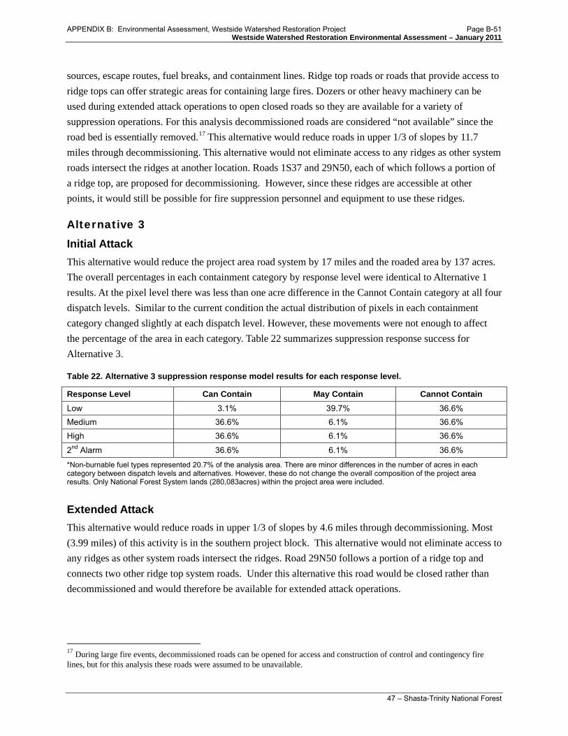
Westside Watershed Restoration Environmental Assessment – January 2011
47 – Shasta-Trinity National Forest
sources, escape routes, fuel breaks, and containment lines. Ridge top roads or roads that provide access to ridge tops can offer strategic areas for containing large fires. Dozers or other heavy machinery can be used during extended attack operations to open closed roads so they are available for a variety of suppression operations. For this analysis decommissioned roads are considered “not available” since the road bed is essentially removed.17
Alternative 3
This alternative would reduce roads in upper 1/3 of slopes by 11.7 miles through decommissioning. This alternative would not eliminate access to any ridges as other system roads intersect the ridges at another location. Roads 1S37 and 29N50, each of which follows a portion of a ridge top, are proposed for decommissioning. However, since these ridges are accessible at other points, it would still be possible for fire suppression personnel and equipment to use these ridges.
Initial Attack This alternative would reduce the project area road system by 17 miles and the roaded area by 137 acres. The overall percentages in each containment category by response level were identical to Alternative 1 results. At the pixel level there was less than one acre difference in the Cannot Contain category at all four dispatch levels. Similar to the current condition the actual distribution of pixels in each containment category changed slightly at each dispatch level. However, these movements were not enough to affect the percentage of the area in each category. Table 22 summarizes suppression response success for Alternative 3.
Table 22. Alternative 3 suppression response model results for each response level.
Response Level Can Contain May Contain Cannot Contain Low 3.1% 39.7% 36.6% Medium 36.6% 6.1% 36.6% High 36.6% 6.1% 36.6%
2nd Alarm 36.6% 6.1% 36.6%
*Non-burnable fuel types represented 20.7% of the analysis area. There are minor differences in the number of acres in each category between dispatch levels and alternatives. However, these do not change the overall composition of the project area results. Only National Forest System lands (280,083acres) within the project area were included.
Extended Attack This alternative would reduce roads in upper 1/3 of slopes by 4.6 miles through decommissioning. Most (3.99 miles) of this activity is in the southern project block. This alternative would not eliminate access to any ridges as other system roads intersect the ridges. Road 29N50 follows a portion of a ridge top and connects two other ridge top system roads. Under this alternative this road would be closed rather than decommissioned and would therefore be available for extended attack operations.
17 During large fire events, decommissioned roads can be opened for access and construction of control and contingency fire lines, but for this analysis these roads were assumed to be unavailable.
APPENDIX B: Environmental Assessment, Westside Watershed Restoration Project Page B-51

Westside Watershed Restoration Environmental Assessment – January 2011
48 – Shasta-Trinity National Forest
Cumulative Effects for Action Alternatives (2 and 3)
Effects of implementation of Alternatives 2 and 3 on access for fire suppression were negligible and discountable; therefore, there are no cumulative effects anticipated. In addition, no other foreseeable projects will remove roads that access the same ridges analyzed under this project. The cumulative effects analysis section above summarizes all past, present and reasonably foreseeable actions that were considered for cumulative effects analysis.
Conclusion
Both action alternatives reduce the amount of existing roads and roaded area in the project area. However, this reduction has minimal effects on the ability of ground based, initial attack, suppression resources to contain a new ignition. These results suggest that initial attack success in this area is being driven more by fire behavior than proximity to a road (based on the suppression response model).
Extended attack opportunities would be affected by both action alternatives. Alternative 2 would reduce available ridgetop roads by 11.7 miles and Alternative 3 would reduce them by 4.6 miles. However, all of the ridges accessed by these roads would still have access points at other locations along the ridge from the remaining road system. In Alternative 2 two roads proposed for decommissioning follow ridgelines, but do not cover the full lengths of the ridges. In Alternative 3 one of these roads is proposed for decommissioning and the other for closing. It is unknown which ridges would be the strategic locations for containment lines or fuel breaks during an actual future event. All alternatives would retain access to the same ridges.
Both action alternatives would have little effect on initial and extended attack suppression capability. Table 23 summarizes and compares the success of suppression activities for all alternatives.
APPENDIX B: Environmental Assessment, Westside Watershed Restoration Project Page B-52

Westside Watershed Restoration Environmental Assessment – January 2011
49 – Shasta-Trinity National Forest
Table 23. Suppression response model results for each response level for all alternatives.
Alternative Resource Level
Can Contain May Contain Cannot Contain Change in percentage
compared to Alternative 1
Acres Percent Acres Percent Acres Percent
Alternative 1
Low 8,726 3.1% 111,068 39.7% 102,371 36.6% N/A Medium 102,609 36.6% 17,185 6.1% 102,371 36.6% N/A High 102,637 36.6% 17,158 6.1% 102,371 36.6% N/A 2nd Alarm 102,640 36.6% 17,154 6.1% 102,371 36.6% N/A
Alternative 2
Low 8,726 3.1% 111,061 39.7% 102,378 36.6% 0 Medium 102,601 36.6% 17,185 6.1% 102,378 36.6% 0 High 102,629 36.6% 17,158 6.1% 102,378 36.6% 0 2nd Alarm 102,633 36.6% 17,154 6.1% 102,378 36.6% 0
Alternative 3
Low 8,726 3.1% 111,065 39.7% 102,374 36.6% 0 Medium 102,605 36.6% 17,186 6.1% 102,374 36.6% 0 High 102,633 36.6% 17,158 6.1% 102,374 36.6% 0 2nd Alarm 102,637 36.6% 17,155 6.1% 102,374 36.6% 0
*Non-burnable fuel types represented 20.7% of the analysis area. There are minor differences in the number of acres in each category between dispatch levels and alternatives. However, these do not change the overall composition of the project area results. Only National Forest System lands (280,083acres) within the project area were included.
Wildlife This section summarizes the analysis of project effects to wildlife species, including those listed under the Federal Endangered Species Act (ESA) and those designated by the Forest Service as Sensitive Species. The comprehensive analysis of species occurrence, habitat, and effects are included in the following documents:
• The Westside Watershed Restoration Project Biological Assessment (BA; Crumpton 2009) • The Westside Watershed Restoration Project Biological Evaluation (BE; Crumpton 2009)
These documents are part of the project administrative record, and are used by the decision-maker in the consideration of the alternatives.
Threatened and Endangered Species
To ensure current information, the Shasta-Trinity National Forest accessed recent lists of endangered, threatened, or proposed species that may occur in Trinity County and in the Platina USGS Quad from the USFWS web site on July 30, 2010. The only species listed under the Federal Endangered Species Act, and present in the project area is the northern spotted owl. The location of existing spotted owl habitat, and designated Critical Habitat, in the assessment area is on Appendix A maps of the Biological Assessment. Suitable spotted owl habitat in the assessment area was identified using Forest Service data (developed for the Forest Plan).
APPENDIX B: Environmental Assessment, Westside Watershed Restoration Project Page B-53

Westside Watershed Restoration Environmental Assessment – January 2011
50 – Shasta-Trinity National Forest
Sensitive Species
Sensitive species are managed under the authority of the National Forest Management Act (PL 94-588) and the USDA Forest Service Manual Direction (FSM 2600). Sensitive species are administratively designated by the Regional Forester (FSM 2670.5). Management goals for sensitive species in the Shasta-Trinity National Forests Land and Resource Management Plan [Forest Plan pages 3-27 and 3-28) will be directed toward maintaining or, if possible, increasing existing viable populations of sensitive species. Sensitive species that could potentially occur in the project area, and are analyzed here are:
• Northern goshawk • Willow flycatcher • Bald eagle • Pallid bat • Townsend’s big-eared bat • Western red bat • California wolverine • American marten
• Pacific fisher • Southern torrent salamander • Foothill yellow-legged frog • Cascades frog • Northwest pond turtle • Big Bar/Pressley hesperian snail (also a
survey and manage species)
Survey and Manage Species
On December 17, 2009, the U.S. District Court for the Western District of Washington issued an order in Conservation Northwest, et al. v. Rey, et al., No. 08-1067 (W.D. Wash.) ( Coughenour, J.), granting Plaintiffs’ motion for partial summary judgment and finding a variety of NEPA violations in the BLM and USFS 2007 Record of Decision eliminating the Survey and Manage mitigation measure. Previously, in 2006, the District Court (Judge Pechman) had invalidated the agencies’ 2004 RODs eliminating Survey and Manage due to NEPA violations. Following the District Court’s 2006 ruling, parties to the litigation had entered into a stipulation exempting certain categories of activities from the Survey and Manage standard (“Pechman exemptions”). Judge Pechman's Order from October 11, 2006 directs: "Defendants shall not authorize, allow, or permit to continue any logging or other ground-disturbing activities on projects to which the 2004 ROD applied unless such activities are in compliance with the Record of Decision and Standards and Guidelines for Amendments to the Survey and Manage, Protection Buffer, and other Mitigation Measures Standards and Guidelines (2001 ROD) (as the 2001 ROD was amended or modified as of March 21, 2004), except that this order will not apply to:
A. Thinning projects in stands younger than 80 years old:
B. Replacing culverts on roads that are in use and part of the road system, and removing culverts if the road is temporary or to be decommissioned;
C. Riparian and stream improvement projects where the riparian work is riparian planting, obtaining material for placing in-stream, and road or trail decommissioning; and where the stream
APPENDIX B: Environmental Assessment, Westside Watershed Restoration Project Page B-54

Westside Watershed Restoration Environmental Assessment – January 2011
51 – Shasta-Trinity National Forest
improvement work is the placement large wood, channel and floodplain reconstruction, or removal of channel diversions; and
D. The portions of project involving hazardous fuel treatments where prescribed fire is applied. Any portion of a hazardous fuel treatment project involving commercial logging will remain subject to the survey and management requirements except for thinning of stands younger than 80 years old under subparagraph a. of this paragraph.”
The Westside Watershed Restoration Project activities fall under Pechman exemption categories B. …removing culverts if the road is temporary or to be decommissioned; and C. Riparian and stream improvement projects where the riparian work is riparian planting, obtaining material for placing in-stream, and road or trail decommissioning…
Alternative 1
This alternative is not associated with any project related direct, indirect, or cumulative effects because no action is proposed. The roads will continue to pose sedimentation risks to streams. Wildlife habitat would continue to be highly fragmented by roads, no restoration of riparian or upland habitat function would occur, and vehicle related disturbance and associated wildlife mortality would continue on project roads.
Alternative 2 & 3 Threatened and Endangered Species Direct Effects Limiting operating periods (LOP) will be implemented as described above in chapter 2 (Resource Protection Measures common to Alternatives 2 and 3). The limited operating periods will minimize direct effects of the project to the spotted owl by avoiding noise disturbance during critical periods of the breeding season. This limited operating period extends from February 1 through July 9th. No northern spotted owl nesting, roosting, or foraging habitat will be removed by the project. Therefore the project will have no direct effect on northern spotted owls.
Table 24 shows all treatment roads that fall within ¼ mile of suitable nesting, roosting and foraging spotted owl habitat. The ¼ mile measure is the estimate at which noise disturbance could affect nesting owls. The ¼ mile measure is also significant because it indicates that the road could fall within a known or historic 100-acre core activity area. The core area is the area of the home range with the highest activity levels. An LOP and/or a protocol survey would be necessary for the project areas that fall within the ¼ mile distance.
One project road (U33N22C) occurs in an historic 100-acre spotted owl activity center (TRI 282). A LOP and/or new protocol surveys will be implemented to prevent disturbance of owls in the activity center.
Direct effects to Critical Habitat are those impacts that alter Primary Constituent Elements. Primary Constituent Elements for northern spotted owl Critical Habitat include: high canopy cover, large trees, multilayered-multispecies structure, and decadent trees/nesting platforms. Therefore, any impacts to vegetation and structure of an area may directly affect Critical Habitat. Habitat impacts are usually
APPENDIX B: Environmental Assessment, Westside Watershed Restoration Project Page B-55

Westside Watershed Restoration Environmental Assessment – January 2011
52 – Shasta-Trinity National Forest
discussed under indirect effects. Direct effects to Critical Habitat will be covered in more detail in the indirect effects section below.
Table 24. Proposed roads for Westside Watershed Restoration Project treatment within suitable northern spotted owl habitat. Limited operating periods and/or protocol surveys are necessary in these areas.
Road Identification Number 29N72 –culverts at mileposts 0.23, 0.61, 0.99 1S37 1S39A 28N31A 28N71A 29N12A 29N17B 29N42A 29N26B 29N46C 29N48A 29N54 29N54A 29N54B 29N56 29N56A 29N58E 29N58H 29N58K 29N62D 29N63 29N68A 29N68B 29N73D 30N03A 30N04A 30N13C 30N28A 30N50A 30N57A 33N04YA 33N31 33N47A 33N51C 43N17YA 34N34YA 34N36 34N80B 4N16B U1S29 U29N07C U29N07G U29N25C U29N25D U29N32B U29N33B U29N58HA U29N71B U29N73E U29N83C U29N86BA U29N86BB U32N25B U33N22BA U33N22C U33N22D U33N30 U33N30A U33N30D U33N41EA U33N41FA U33N48AA U33N48B U33N48C U33N48D U33N51BA U33N51F U33N51I
Threatened and Endangered Species Indirect Effects Indirect effects include activities that may impact spotted owl habitat. The estimated home range of spotted owls is approximately a 1.3-mile circle extending from an owl activity center (nest site). This 1.3-mile measure is the standard measure used to determine impacts to spotted owl habitat from a project. The amount of spotted owl habitat that occurs within the 1.3-mile zone around proposed project roads includes:
• 84,198 acres of suitable habitat, including dispersal habitat • 45,429 acres of nesting, roosting and foraging habitat • 28,413 acres of nesting and roosting habitat • 17,016 acres of foraging habitat • 7.9 miles of treatment roads near foraging habitat • 4.9 miles of treatment roads near nesting and roosting habitat
Several proposed project roads occur within 1992 and 2008 designated Critical Habitat for the northern spotted owl. The 2008 Critical Habitat units are: Western-Klamath/Siskiyou Mountains unit # 24, Shasta-Trinity Lakes unit #27, and South Fork Mountain Divide unit #21, for a total of 69,516 acres. The 1992 Critical Habitat units are: CA33, CA 34, CA 36 and CA 38, for a total of 77,725. A total of
APPENDIX B: Environmental Assessment, Westside Watershed Restoration Project Page B-56

Westside Watershed Restoration Environmental Assessment – January 2011
53 – Shasta-Trinity National Forest
approximately 9 miles (including both 1992 and 2008 designations) of project roads occur within these Critical Habitat units.
In addition to suitable habitat and Critical Habitat, two planning designations for northern spotted owls must be addressed: Managed Owl Conservation Areas (MOCAs) and Late Successional Reserves (LSRs). There are four MOCAs that occur within the project area, and these areas overlap with Late Successional Reserves. The MOCAs are: #46, #50, #52, and #53. The LSRs are: #334, #332, #330, and #331. Fifteen project roads are in these MOCAs and LSRs.
No indirect effects from project implementation are expected to occur to northern spotted owl habitat. This includes suitable habitat, Critical Habitat, MOCAs and LSRs. These habitats will not be impacted because canopy closure will remain intact, no large snags will be removed, and prey species habitat will be unaffected. Indirect effects on suitable habitat and direct effects on Critical Habitat are classified into three levels: degraded, downgraded, and removed. The project does not entail degradation, downgrading, or removal of any suitable habitat at or near owl activity centers or in critical habitat.
Threatened and Endangered Species Cumulative Effects No cumulative effects on the federally Threatened and Endangered species are anticipated because the restoration project would not affect northern spotted owls or northern spotted owl critical habitat. The project would not modify existing nesting, roosting, or foraging habitat for northern spotted owl. Any potential direct or indirect effects would be minimized or eliminated to a negligible level through the use of avoidance and minimization measures such as the limited operating periods and other resource protection measures.
Sensitive Species Direct and Indirect Effects Several sensitive wildlife species are known or assumed to occur in the project area, and the following summarizes how each may be affected by the project. Some species could be directly impacted by project vehicles, ground disturbance activities, or operation of mechanical equipment near streams. It is possible that vehicles could inadvertently crush them and they could also be harmed during some activities such as the removal of culverts. Project-related noise and vibration could cause them to disperse from the immediate area. However, these effects are expected to be minor because project activities are temporary and small-scale and most individuals would disperse into the surrounding area. Indirect impacts through sediment delivery to streams could occur, but are expected to be minimal due to the use of erosion control practices such as mulching, hydroseeding, and armoring of stream-road crossings (see resource protection measures).
Northern goshawk - Accipiter gentilis
No northern goshawk sightings or nests have been documented within ½ mile from project roads. Approximately 12,659 acres of high capability and 32,801 acres of moderate capability goshawk habitat occur within 1.3 miles of project roads [Forest Plan model]. Approximately 64 treatment roads (total of 12.8 miles) occur in high or moderate quality goshawk habitat.
APPENDIX B: Environmental Assessment, Westside Watershed Restoration Project Page B-57

Westside Watershed Restoration Environmental Assessment – January 2011
54 – Shasta-Trinity National Forest
Direct effects of the project include noise disturbance during implementation. To reduce noise disturbance effects, a limited operating period will be implemented during the nesting season if goshawk nests are found within ½ mile of the treatment road. Goshawk surveys will be completed before project implementation for roads that occur within goshawk habitat. Indirect effects would include disturbance and alteration of goshawk habitat. No indirect effects will occur due to project implementation. It is my determination that there will be no effect on Northern goshawk. Northern goshawk habitat will not be altered, and all habitat acreages will remain the same.
Willow flycatcher - Empidonax trailii
Willow flycatcher breeding range in California with is restricted primarily to the Sierra Nevada/ Cascade region, and Santa Barbara, Riverside, and San Diego Counties [Sedgwick, 2000]. The willow flycatcher has been documented in the Trinity River corridor within the project area. The willow flycatcher is a riparian associated species. Twelve miles of project roads occur within riparian reserves, with 13 perennial stream road crossings planned to be restored. These riparian areas are expected to be temporarily altered during project implementation through removal of shrubs, other understory vegetation and seedling or sapling trees during culvert installation or road decommissioning. This vegetation is expected to recover quickly. Aquatic and riparian areas will also be protected by Best Management Practices, resource protection measures, and Forest Plan standards. Individual willow flycatchers may be impacted by project implementation due to disturbance, but these impacts are not expected to lead to a trend toward federal listing. Aquatic and riparian habitat areas are expected to be stabilized by the project, leading to increased environmental and habitat health in the long run.
Bald eagle - Haliaeetus leucocephalus
Bald eagles require large trees protected from disturbance for nesting, and late-successional/old growth forests near large rivers or lakes for winter roosting sites. Trinity River and its tributaries provide suitable nesting and foraging habitat. Records indicate that bald eagles have been documented near the Trinity dam area within ½ mile from roads proposed to be treated. Documented nests include: nests near Stuart, Tannery, and Buckeye areas, and near roads 34N34YA, 34N36, and 34N80B. Project roads occur in Riparian Reserves and perennial stream crossings. These riparian areas are expected to be temporarily altered during project implementation through removal of shrubs, other understory vegetation and seedling or sapling trees during culvert installation or road decommissioning. This vegetation is expected to recover quickly. No large trees will be removed. Limited operating periods will be used near any nest sites from January 1 to August 15 within ½ mile the project roads (e.g. 34N34YA, 34N36, and 34N80B). Aquatic and riparian areas will also be protected by Best Management Practices, resource protection measures, and Forest Plan standards. Individual bald eagles may be impacted by project implementation, but these impacts are not expected to lead to a trend toward federal listing or a loss of viability. Aquatic and riparian habitat areas are expected to be stabilized by the project, leading to increased environmental and habitat health in the long run.
APPENDIX B: Environmental Assessment, Westside Watershed Restoration Project Page B-58

Westside Watershed Restoration Environmental Assessment – January 2011
55 – Shasta-Trinity National Forest
Pallid bat - Antrozous pallidus
In 1997, the Shasta-Trinity National Forest began bat surveys in areas where proposed activities could affect potential roost sites. During the course of a five year (1996-2000) bat mist net monitoring period at the nearby Pilot Creek watershed area, no pallid bats were found [Weller and Lee 2007]. Project implementation includes replacement of some culverts. Culverts may provide bat roosting structures. Four of these culverts will be replaced with larger culverts, which would likely provide more roosting habitat. Other roosting structures such as cliffs, caves, talus slopes and rock outcrops will not be affected by project activities. Roosting structures may be temporarily impacted by project activities, but larger roosting structures will be installed, so habitat will actually be improved through project implementation. Other potential bat-use structures, such as cliffs, caves, talus slopes and rock outcrops are not affected by treatments. Pallid bat foraging habitat includes grasslands, open pine forests, talus slopes, gravel roads, fruit orchards and vineyards. Some if its foraging habitat will not be affected or are not present (e.g. grasslands, talus slopes, fruit orchards and vineyards). Treatments are proposed on gravel roads, therefore individual pallid bats may be impacted by project activities due to disturbance, but these impacts are not expected to lead to a trend toward federal listing or a loss of viability.
Townsend’s big-eared bat - Corynorhinus townsendii
Townsend’s big-eared bats occur in limestone caves in Trinity County, as well as in caves in Shasta County [Pierson and Rainer 1998]. Males and female Townsend’s big-eared bats have been found to forage in riparian corridors along Douglas-fir forest edges in coastal California [Fellers and Pierson 2002]. There are no records in the forest data of this bat species being documented in the planning area, but occupancy is assumed. Individual Townsend’s big-eared bats may be impacted by project activities, but these impacts are not expected to lead to a trend toward federal listing or a loss of viability. Four culverts (potential bat-use structures) will be replaced by larger culverts which are expected to project more roosting habitat. Other potential bat-use structures, such as cliffs, caves, talus slopes, rock outcrops, bridges, buildings, or mine adits are not affected by treatments. Project roads are in Riparian Reserves and cross perennial stream where there is a possibility of suitable foraging habitat for Townsend’s big-eared bat. No mature overstory trees are affected in riparian habitats; only shrubs, other understory vegetation, and seedling or sapling trees may be removed during culvert installation or road decommissioning. This vegetation is expected to grow back quickly after treatments activities are completed.
Western red bat - Lasiurus blossevillii
In 1997, the Shasta-Trinity National Forest began surveys in areas where proposed activities could affect potential roost sites. Western red bats have been detected on the Shasta Forest in recent years at Trout Creek and in a McCloud / Pit River survey [Debbie Derby personal comment]. Additionally, during the course of a five year (1996-2000) bat mist net monitoring at the Pilot Creek watershed area, one western red bat was found [Weller and Lee 2007]. Western reds bats are associated with riparian areas for foraging and roosting. They tend to roost in trees and shrubs, especially near water. The proposed actions may impact individual western red bats but would not cause a trend towards federal listing or a loss of
APPENDIX B: Environmental Assessment, Westside Watershed Restoration Project Page B-59

Westside Watershed Restoration Environmental Assessment – January 2011
56 – Shasta-Trinity National Forest
viability. Some project roads are in Riparian Reserves and cross perennial streams. These riparian areas potentially provide suitable habitat for western red bats. No mature over story trees will be affected in riparian habitats, but shrubs, other understory vegetation, and seedling or sapling trees may be removed during culvert installation or road decommissioning. This vegetation is expected to grow back quickly after treatment activities are completed. Aquatic and riparian protection will be provided by Best Management Practices (BMP), resource protection measures, and Forest Plan standards. The purpose of the project is to improve the aquatics and associated habitat components in the project area.
California wolverine - Gulo gulo luteus
In the last 20 years in California, surveys using remote cameras and track plates have been unsuccessful in detecting wolverines except the February 2008 photo documentation at Tahoe National Forest. That individual was found to be related to the rocky mountain subspecies, not the California subspecies. There are unconfirmed wolverine sightings on the Shasta-Trinity National Forest over the past 20 years; however, none of those occur in the project area. The Trinity Alps and Yolla Bolly Wildernesses may provide the large secluded patch of habitat that this species requires. The proposed action will have no effect on the California wolverine. Suitable habitat for the wolverine will not be impacted by project activities.
American marten - Martes Americana
American marten is associated with high elevation (> 4,500 feet) old growth white fir and red fir stands [Buskirk et al. 1994 and Freel 1991], and to a lesser extent lower elevation conifer forest. There is one documented marten sighting in the northwest project area in the Forest record. The project area includes 12,659 acres of moderate capability habitat. Within the project, 2.6 miles of roads (along 14 different roads) to be treated are in moderate capability habitat for American marten; however, roads do not provide marten habitat, and treatments are restricted to the road prism. The proposed action will have no effect on martens. It is my determination that the proposed actions will have no effect on martens, because no marten habitat will be modified by project activities and all of its suitable habitat will remain post-project.
Pacific fisher - Martes pennanti pacifica
In the project area, suitable fisher habitat constitutes over 45,130 acres within a 1.3 mile buffer of roads to be treated. Over 12 miles of roads (along 64 different roads) are in high or moderate capability habitat for pacific fisher; however, roads do not provide fisher habitat, and treatments are restricted to road prisms. There are 155 records of fisher sightings within ½ mile of treatment areas. These documented fisher occurrences in the Forest record occur between 1968 to 2005, and include surveys, research trappings and incidental sightings. The West Coast distinct population segment of pacific fisher is warranted for federal listing, but precluded with a priority number of six in the listing process. No change in the trend toward federal listing is expected with this project. The proposed actions will have no effect on Pacific fisher, because no forested fisher habitat will be modified and all of its suitable habitat will remain post-project.
APPENDIX B: Environmental Assessment, Westside Watershed Restoration Project Page B-60

Westside Watershed Restoration Environmental Assessment – January 2011
57 – Shasta-Trinity National Forest
Southern torrent salamander - Rhyacotriton variegatus
There are no sightings in the Forest record of the southern torrent salamander occurring in the project area. They are associated with springs, seeps, small streams, and margins of larger streams where they avoid open water and seek the cover of moss, rocks, and organic debris in shallow cold, percolating water [Welsh and Lind 1996]. Some project roads occur in Riparian Reserves and cross perennial streams, where there is potentially suitable habitat for the southern torrent salamander. Impacts to riparian vegetation include removal of some shrubs, other understory vegetation, and sapling trees. This vegetation is expected to grow back quickly after treatments activities are completed. Aquatic and riparian protections will be provided by Best Management Practices (BMP), resource protection measures, and Forest Plan standards, and aquatics and associated habitat are expected to be improved by project implementation. Individual southern torrent salamanders may be directly impacted by project activities with the potential to be crushed by equipment and vehicles; however, the likelihood is low and few if any individuals would be impacted. In addition, habitat disturbance will be minimal due to BMPs and habitat is expected to recover quickly, thus the project would not lead to a trend toward federal listing or a loss of viability.
Foothill yellow-legged frog - Rana boylii
In a local natural history review along part of the main stem of Trinity River on the Forest [Aston et al 1997] from Lewiston Dan downstream to Helena (at the North Fork Trinity River confluence which is between Junction City and Big Bar), it was found that the adult frogs congregate in clusters at the limited suitable habitat of gravel bars and cobble area. Forest records include 7 sightings of foothill yellow-legged frogs within ¼ mile of treatments. Some project roads occur in Riparian Reserves and cross perennial stream, where there is a potentially suitable habitat for the foothill yellow-legged frog. Impacts to riparian areas include removal of shrubs, other understory vegetation, and seedling or sapling trees during culvert installation or road decommissioning. This vegetation is expected to grow back quickly after treatments activities are completed. Aquatic and riparian protections will be provided by Best Management Practices (BMP), resource protection measures, and Forest Plan standards. Habitat for aquatic and riparian species is expected to be improved by project implementation. Individual foothill yellow-legged frogs may be directly impacted by project activities with the potential to be crushed by equipment and vehicles; however, the likelihood is low and few if any individuals would be impacted. In addition, habitat disturbance will be minimal due to BMPs and resource protection measures and habitat is expected to recover quickly, thus the project would not lead to a trend toward federal listing or a loss of viability.
Cascade frog - Rana cascadae
Cascade frogs have been documented to be relatively abundant in the Trinity Alps Wilderness, primarily in lakes with no fish [Fellers et al. 2007]. There are no records of Cascade frog sightings in the project area. Project roads occur in riparian reserves and perennial stream crossings. These areas potentially provide habitat for Cascade frogs, and the species may be impacted by project activities. Shrubs, other
APPENDIX B: Environmental Assessment, Westside Watershed Restoration Project Page B-61

Westside Watershed Restoration Environmental Assessment – January 2011
58 – Shasta-Trinity National Forest
understory vegetation, and seedling or sapling trees may be removed during culvert installation or road decommissioning. This vegetation is expected to grow back quickly after treatment activities are completed. Aquatic and riparian protections will be provided by Best Management Practices (BMP), resource protection measures, and Forest Plan standards. Habitat for aquatic and riparian species is expected to be improved by project implementation. . Individual Cascade frogs may be directly impacted by project activities with the potential to be crushed by equipment and vehicles; however, the likelihood is low and few if any individuals would be impacted. In addition, habitat disturbance will be minimal due to BMPs and resource protection measures and habitat is expected to recover quickly, thus the project would not lead to a trend toward federal listing or a loss of viability.
Northwestern pond turtle - Clemmys marmorata marmorata
Forest records include seven western pond turtle sightings documented within ¼ mile of treatments. Pond turtles are dependent upon perennial streams and associated riparian and upland habitats. Riparian Reserves and perennial stream crossings will be impacted by project activities. The vegetation that will be impacted consists of understory vegetation, and is expected to recover quickly. Post-project stream and riparian conditions will be improved over current conditions, which will equate to improved pond turtle habitat. In addition, project impacts will be kept to a minimum through aquatic and riparian protections provided by Best Management Practices (BMP) and resource protection measures. Individual northwestern pond turtles may be directly impacted by the project activities with the potential to be crushed by equipment and vehicles; however, the likelihood is low and few if any individuals would be impacted. In addition, habitat disturbance will be minimal due to BMPs and resource protection measures and habitat is expected to recover quickly, thus the project would not lead to a trend toward federal listing or a loss of viability.
Big Bar hesperian snail - Vespericola pressleyi
Big Bar hesperian, is a riparian associated snail species and is only known in the vicinity of Big Bar, California [Burke et al. 1999]. It is a Survey and Manage species, as well as a Sensitive species. Big Bar is located in the Trinity River watershed, which is part of the project area. Forest Service surveys have resulted in 28 new detections of this snail, all within Trinity County. There are no documented records within the project area. The Big Bar hesperian requires damp areas within riparian zones and an abundance of ground cover such as decaying leaves, woody debris and loose rocks. These habitat elements may be impacted by project activities where they occur in Riparian Reserves and perennial stream crossings. The vegetation that will be impacted consists of understory vegetation, and is expected to recover quickly. Post-project stream and riparian conditions will be improved over current conditions, which will equate to improved snail habitat. In addition, project impacts will be kept to a minimum through aquatic and riparian protections provided by Best Management Practices (BMP) and resource protection measures. Protection measures have been included to protect areas where snails are found.18
18 Resource protection measures, Table 7
APPENDIX B: Environmental Assessment, Westside Watershed Restoration Project Page B-62

Westside Watershed Restoration Environmental Assessment – January 2011
59 – Shasta-Trinity National Forest
Individual snails may be directly impacted by the project activities with the potential to be crushed by equipment and vehicles; however, the likelihood is low and few if any individuals would be impacted. In addition, habitat disturbance will be minimal due to BMPs and resource protection measures and habitat is expected to recover quickly, thus the project would not lead to a trend toward federal listing or a loss of viability.
Sensitive Species Cumulative Effects The cumulative effects analysis is bound in space and time to properly evaluate if there would be any overlap of effects caused by this project with effects of other past, present, or future foreseeable actions. The cumulative effects analysis section above summarizes all past, present and reasonably foreseeable actions that were considered for cumulative effects analysis. The analysis is bounded by 15 feet along the treated road prism. Project-associated compaction and vegetative re-growth could persist for 5 to 10 years, though most vegetation growth and water quality improvement would recover immediately. Cumulative effects analysis considers the influence of past actions, the likely effects of future foreseeable actions during this time, and examines if impacts are likely to occur to any wildlife species when/if additive effects are identified.
This action, due to its localized and relatively low impact nature taken with the past, present, and foreseeable future actions, is not anticipated to contribute to any significant cumulative effects to any species listed herein.
Restoration is the goal of the project activities. Impacts of the Westside Watershed Restoration Project are for the most part benign or are beneficial to the majority of sensitive wildlife species analyzed. The only potential negative effects to sensitive species are the direct impacts to individuals of some species through incidental mortality, and this is not likely to impact many individuals. Dispersal of aquatic and riparian species would be improved by the stream crossing upgrades and culvert removal. With the removal of roads, restoration of riparian and upland habitat function will occur in the treatment areas. Fragmentation of habitat would be reduced, as well. The use of limited operating periods will protect against noise and vibration disturbance during spring and early summer breeding seasons.
Affected acres provides sensitive species habitat. This habitat is expected to recover over time to a condition that is improved over the current condition. Proposed actions include relatively intense, but very localized and short term entries into identified roads, culverts and stream crossings. Other projects are not expected to occur at these specific sites.
Although the extent of impacts to species habitat on the acres of privately owned lands within the assessment area is unknown, it is expected that important components of habitat have been removed. Reasonably foreseeable future actions within the project area include small scale timber harvest on private lands. Such harvests contribute to habitat loss and fragmentation within the area, and increase sediment deposit to streams within the area. The proposed action compensates for such activities, and does not contribute to such impacts. The relatively small scale of these current private land actions, and current timber harvest regulations, reduces the likelihood that they will contribute significantly to cumulative impacts within the watershed.
APPENDIX B: Environmental Assessment, Westside Watershed Restoration Project Page B-63

Westside Watershed Restoration Environmental Assessment – January 2011
60 – Shasta-Trinity National Forest
Federal projects or activities planned in the assessment area include ongoing pre-commercial thinning in existing plantations, timber harvest, grazing, and dispersed recreation. Previous timber harvest has likely impacted wildlife by reducing habitat for late-seral species, while increasing early-seral habitat. Previous road construction has increased fragmentation of habitat and the potential for discharges of sediment into streams within the analysis area.
Management Indicator Assemblages
All project activities are confined to the road prism. Roads do not fit the definition of any wildlife habitat assemblage, as defined in the Forest Plan (page 3-24). Some roadside vegetation and streamside vegetation would be disturbed during implementation, but trees larger than 10 inches dbh would be left undisturbed, and vegetation is expected to recover quickly. There would be no conversion from one assemblage to another due to this project. A slight increase in assemblage habitat may occur over time as road surfaces recover to a more natural state. The slight increase would mostly likely not be detectable at the Forest scale.
For this project, a full management indicator analysis is not needed because there would be no meaningful impact to the habitat components that define management indicator assemblages. The amount of assemblage habitat (in acres) is the quantitative habitat factor for management indicator analysis. Tree size class and canopy cover are the qualitative habitat factors for management indicator analysis. This project would not affect the amount of management indicator assemblage habitat available, and would not affect the CWHR tree size class or canopy cover of the assemblage habitat in the project area.
Botany The botanical analysis for the project considered the following categories of plants: Sensitive plant and fungi species, Forest Plan Endemics, Survey and Manage species, and noxious weeds. The comprehensive analysis of species occurrence, habitat, and effects are included in the following documents:
• The Westside Watershed Restoration Project Sensitive Botanical Species Biological Evaluation (Kierstead Nelson 2010)
• The Addendum to Westside Watershed Restoration Project Sensitive Botanical Species Biological Evaluation (Kierstead Nelson 2010)
The comprehensive botany analysis is in the project administrative record, and is used by the decision-maker in the consideration of the alternatives.
Alternative 1
No action is proposed under Alternative 1, so no impacts will occur to known sensitive plant populations. There is a greater chance of stream crossing failure under this alternative compared to Alternative 2. Stream crossing failure would affect potential habitat and potential undocumented occurrences of Brownie and mountain lady’s slipper orchids, and English Peak greenbriar.
APPENDIX B: Environmental Assessment, Westside Watershed Restoration Project Page B-64

Westside Watershed Restoration Environmental Assessment – January 2011
61 – Shasta-Trinity National Forest
Alternative 2 Sensitive Species - Direct and Indirect Effects Impacts to individual Sensitive botanical species are discussed below. In general, active soil erosion would be reversed over time, stabilizing soils and reducing habitat for noxious weed introduction and spread. Decommissioned and closed roads would reduce or eliminate vehicle travel, the most common method of weed introduction and spread and encroachment on sensitive species. Short term impacts may occur to documented and potentially present Sensitive botanical species, but incorporated mitigation measures and resource protection measures would reduce or eliminate those impacts. Over the long-term, improvement in ecosystem health and stability would be seen with subsequent improvement in sensitive species and native plant community health, especially in riparian areas crossed by roads. Table 25 lists the sensitive species with the potential to occur in the project area.
Table 25. Sensitive species with potential to occur within close proximity to project roads and stream crossing upgrades.
Scientific Name Common Name Number of Known Populations in Proposed Project Area
Chaenactis suffrutescens Shasta pincushion none
Cypripedium fasciculatum Brownie lady’s-slipper none
Cypripedium montanum Mountain lady’s-slipper none
Harmonia doris-nilesiae Niles’ madia 1 (Road 29N31C)
Madia stebbinsii Stebbins’ madia 1 (Road U29N33B)
Menuartia rosei Peanut sandwort 1 (Road 29N63)
Smilax jamesii English Peak greenbriar none
Ericameria ophitidis Serpentine goldenbush 12 roads*
Eriogonum libertini Dubakella Mtn. buckwheat 1 (Road 29N50)
Mielichhoferia elongata Copper moss none
*See project botanical report for list of roads
Serpentine Associated Sensitive Plants
Serpentine goldenbush, Niles’ and Stebbins’ madias are known to occupy roadcuts in the South Fork Management Unit and have been found in roadbeds that have been undisturbed for a period of time. Niles’ and Stebbins’ madias are annual species whose numbers fluctuate annually with seasonal rainfall amounts and degree of disturbance. These species are endemic to the Rattlesnake Creek Terrane on the South Fork Management Unit and are not expected to occur in the Junction City or Trinity Lake areas of the proposed project area.
Dubakella Mountain buckwheat and Peanut sandwort do not occupy road beds, and while they seem to prefer heavy soils on high-quality serpentine outcrops, they do not tolerate unnaturally compacted soils found in roadbeds. Both species are endemic to the Rattlesnake Creek Terrane and known only from the South Fork Management Unit portion of the project area.
APPENDIX B: Environmental Assessment, Westside Watershed Restoration Project Page B-65

Westside Watershed Restoration Environmental Assessment – January 2011
62 – Shasta-Trinity National Forest
Shasta pincushion most often occupies stabilized stream terraces along the Trinity River north of Trinity Lake, but there is a single, documented population on a steep road cut on the South Fork Management Area. Outside of occupation on serpentine soils, the common habitat characteristics between the single population and the populations known from the Trinity Lake area are unknown. This species is not thought to occur in the Junction City or Trinity Lake portions of the project area.
Where localized populations exist and treatments are necessary to eliminate or reduce active erosion, treatments will likely occur and some impacts may be sustained to individuals. Since this project is expected to be implemented over a period of ten years, field surveys will be completed before implementation of specific route treatments to determine the extent of known populations within affected areas. Each assessment will result in implementation of appropriate protection measures that would contribute to maintaining species viability and the urgency of treatment needs to reduce natural resource degradation such as soil erosion, sediment delivery to streams, and potential for continued noxious weed introduction and spread.
Sensitive Plants Not Associated with Serpentine
Mountain and Brownie lady’s-slipper almost always occupy shaded, moist, undisturbed forest and have been documented from several populations within close proximity to drainage pipe inlets or outlets on perennial streams. No populations are known from any of the proposed roads for treatments, but many populations are known from all three of the proposed action treatment areas. There is potential for some impacts at the stream crossing upgrade or culvert removal sites.
English Peak greenbriar occupies similar habitat to Mountain and Brownie lady’s-slipper and could be impacted by stream crossing upgrades and culvert removal as well. This species is only known from Trinity Lake and north in Trinity, Shasta, Siskiyou, and Del Norte counties. Potential populations can’t be ruled out for the Junction City portion of the proposed action, but it is not expected to be present in the South Fork Management Unit portion of the project area.
Little is known about the habitat requirements of copper moss, but all known populations on the Shasta-Trinity National Forest occupy steep, vertical roadcuts on Hwy 299 between Helena and Big Bar. Suitable roadcuts have a high component of bedrock material overlain with silty soil that seeps water until late in the season. Bedrock in these sites contains heavy minerals, primarily copper that provide the necessary substrate for bryophyte growth. Surveys will be completed for copper moss prior to implementation, populations will be avoided during treatments, so no impacts to populations are expected.
Undocumented sites of lady’s slipper and English Peak greenbrier may be affected by pipe upgrades, culvert removal, or road upgrade in Hocker Meadow. These potential rare plant sites are also at risk from stream crossing failure in the no action alternative. Following upgrade of the road into Hocker Meadow the meadow can begin to naturally restore and trend toward providing suitable habitat for these three species. The stream upgrade sites will be surveyed in 2010 and 2011 to determine if individuals of mountain or Brownie lady’s-slipper, or English Peak greenbriar are present.
APPENDIX B: Environmental Assessment, Westside Watershed Restoration Project Page B-66

Westside Watershed Restoration Environmental Assessment – January 2011
63 – Shasta-Trinity National Forest
Potential Impacts
Very few, if any, documented populations of Sensitive species or their habitat are found within the bed of any road surface, including those that have revegetated to lesser or greater degree, because of the highly compacted nature of the soils. A greater amount of habitat and number of documented populations can be found on road cut and fill slopes directly adjacent to road beds (within the road prism), and the riparian habitat associated with drainage pipes.
Within roadbeds that traverse serpentine habitat, in most cases no individuals of Sensitive species that could occupy these sites are present, but are found in the areas adjacent to existing roads. There is slight potential for individuals of some species to be present in road segments proposed for ripping or subsoiling, road realignment, and movement of soil for outsloping. Potential impacts include damage to above or belowground plant parts, loss of reproductive potential for a short (seed production) or extended (loss of reproductive roots) time, and possible death of individuals. Where known populations exist on proposed road segments, soil piling for the purposes of outsloping, subsoiling, spot-rocking, and any other activities that could bury plants or disrupt root structures significantly will be avoided in the area of known populations. Where populations exist and treatments necessary to eliminate or reduce active erosion are localized within those populations, treatments may occur and some impacts may be sustained.
Within perennial riparian zones where the stream crossings are proposed for upgrading, or culvert removal as part of decommissioning, impacts to Sensitive species potentially occupying these sites could occur within the area needed to implement the culvert work (typically 20-30 upstream of the road). Potential impacts include damage to aboveground plant parts, uprooting or death of underground root structures and loss of reproductive potential for short or extended periods of time.
Project resource protection measures will be used to reduce or eliminate impacts to Sensitive plant species are known to exist or have potential to exist in the proposed project area. These include deferring treatments on road segments that have known populations of Niles’ or Stebbins’ madia until after July 1 to allow seed set and dispersal.
Sensitive Botanical Species Cumulative Effects Potential foreseeable actions that occur within these species’ ranges include private timber harvest, Forest Service timber harvest, road decommissioning associated with vegetation management projects on National Forest land, high intensity wild fire and Travel Management administrative changes to the National Forest Transportation System. Also, climate change could potentially affect sensitive species, as well as invasive plant species encroachment. The cumulative effects analysis section above summarizes all past, present and reasonably foreseeable actions that were considered for cumulative effects analysis.
The Forest Service has predisturbance “flag and avoid” mitigations in place for Sensitive species that do not respond positively to disturbance, and limited operating periods for disturbance dependent Sensitive species to allow successful reproduction before onset of disturbance; so Forest Service actions are not likely to affect Sensitive species. Varying levels of mitigations are in place and enforced by CalFire and the California Department of Fish and Game for private timber harvest activities for each of
APPENDIX B: Environmental Assessment, Westside Watershed Restoration Project Page B-67

Westside Watershed Restoration Environmental Assessment – January 2011
64 – Shasta-Trinity National Forest
the sensitive species. These mitigations will reduce impacts to Sensitive plant species, but will not eliminate all impacts. The mitigations are designed to allow the species to persist after disturbance.
Climate change is a particularly concerning issue for plants because their dispersal capability is limited. Serpentine endemic species and restricted geographic range species are of particular concern. For this project, these species include: serpentine goldenbush, Dubakella Mountain buckwheat, Niles’ madia, Stebbin’s madia, and peanut sandwort). These species will be limited in their ability to respond to warmer temperatures by moving upwards in elevation because of their habitat restrictions. The amount of suitable habitat is reduced as elevational range moves upward.
The ranges and numbers of all of the Sensitive plant species potentially affected by this project are not likely to change in the next two decades as a result of activities or climate change. Cumulative impacts from this project are expected to be minimal and discountable.
Sensitive Species Determinations The Westside Watershed Restoration Project will have no effect on copper moss.
The Westside Watershed Restoration Project may affect individuals, but is not likely to result in a trend toward Federal listing or loss of viability for Shasta pincushion, Brownie lady’s-slipper, mountain lady’s-slipper, Niles’ madia, Stebbins’ madia, Peanut sandwort, English Peak greenbriar, serpentine goldenbush, or Dubakella Mtn. buckwheat.
Survey and Manage Botanical Species On December 17, 2009, the U.S. District Court for the Western District of Washington issued an order in Conservation Northwest, et al. v. Rey, et al., No. 08-1067 (W.D. Wash.) ( Coughenour, J.), granting Plaintiffs’ motion for partial summary judgment and finding a variety of NEPA violations in the BLM and USFS 2007 Record of Decision eliminating the Survey and Manage mitigation measure. Previously, in 2006, the District Court (Judge Pechman) had invalidated the agencies’ 2004 RODs eliminating Survey and Manage due to NEPA violations. Following the District Court’s 2006 ruling, parties to the litigation had entered into a stipulation exempting certain categories of activities from the Survey and Manage standard (“Pechman exemptions”).
Judge Pechman's Order from October 11, 2006 directs: "Defendants shall not authorize, allow, or permit to continue any logging or other ground-disturbing activities on projects to which the 2004 ROD applied unless such activities are in compliance with the Record of Decision and Standards and Guidelines for Amendments to the Survey and Manage, Protection Buffer, and other Mitigation Measures Standards and Guidelines (2001 ROD) (as the 2001 ROD was amended or modified as of March 21, 2004), except that this order will not apply to:
A. Thinning projects in stands younger than 80 years old:
B. Replacing culverts on roads that are in use and part of the road system, and removing culverts if the road is temporary or to be decommissioned;
C. Riparian and stream improvement projects where the riparian work is riparian planting, obtaining material for placing in-stream, and road or trail decommissioning; and where the stream
APPENDIX B: Environmental Assessment, Westside Watershed Restoration Project Page B-68

Westside Watershed Restoration Environmental Assessment – January 2011
65 – Shasta-Trinity National Forest
improvement work is the placement large wood, channel and floodplain reconstruction, or removal of channel diversions; and
D. The portions of project involving hazardous fuel treatments where prescribed fire is applied. Any portion of a hazardous fuel treatment project involving commercial logging will remain subject to the survey and management requirements except for thinning of stands younger than 80 years old under subparagraph a. of this paragraph.”
The Westside Watershed Restoration Project activities fall under Pechman exemption categories B. …removing culverts if the road is temporary or to be decommissioned; and C. Riparian and stream improvement projects where the riparian work is riparian planting, obtaining material for placing in-stream, and road or trail decommissioning…
Noxious Weeds Invasive species are found in varying degrees throughout the Trinity Lake, Junction City, and South Fork Management Unit project areas. Highest concentrations are along roadsides close to residential areas such as Chapman Ranch and Soldier Creek Road near Junction City and proposed roads that are within a mile of Hwy. 36. Motor vehicles are the most common means of introducing weeds into new areas, but subsequent soil disturbance creates the exposed seed bed for establishment of weeds. Herbicides are not currently an available tool for weed management on the west side of the Shasta-Trinity National Forest and will not be used under this project.
Broom species (Spartium junceum, Cytisus scoparius, Genista monspessulanum) are found most commonly in the Junction City and Trinity Lake project areas. Because of their absence in agricultural settings, these brooms have low or no CDFA19
Spotted (Centaurea maculosa) and diffuse (C. diffusa) knapweed are the highest priority weed species for containment and eradication within the South Fork Management Unit. Diffuse and spotted knapweeds are CDFA List A and California Invasive Plant Council High/Moderate rated noxious weeds; they are the highest priority for management in Trinity County and on the west side of the Shasta-Trinity National Forest. They are aggressive competitors and can degrade habitat for Sensitive plant species.
noxious weed rating, but all three have the highest California Invasive Plant Council Rating and are of great ecological concern in California. Brooms grow slowly, but over time distribute abundant seed and displace large areas of space for native plant occupation.
Weed Protection Measures If heavy equipment and vehicles involved with implementing treatments are not cleaned before leaving proposed decommissioning roads, there is good potential for spreading seeds and plant parts of diffuse or spotted knapweed. Road decommissioning will cause soil disturbance and increase habitat for knapweed. Mulching and seeding after decommissioning treatments, as well as monitoring for new knapweed plants for several years after treatments is essential.
Soil disturbance during decommissioning treatments would increase the chance of spreading noxious weed seed, and would provide habitat for knapweed. Where decommissioning is needed to reduce
19 California Department of Food and Agriculture.
APPENDIX B: Environmental Assessment, Westside Watershed Restoration Project Page B-69

Westside Watershed Restoration Environmental Assessment – January 2011
66 – Shasta-Trinity National Forest
sediment delivery into streams, the following resource protection measures would minimize knapweed problems:
1. Where known populations of spotted or diffuse knapweed exist adjacent to project roads, roads will be individually evaluated to determine the least amount of soil disturbance that would still allow purpose and need to be met
2. Keeping the number of service vehicles used in monitoring or implementing treatments to a minimum; pull off on the side of the road only where little or no vegetation is present.
3. Cleaning all heavy equipment with high-pressure water before leaving each work site, and inspecting the equipment by Forest Service personnel to insure no weed-containing dirt is being transported away from each site;
4. Mulching the soil disturbed on these roads, and seeding with native grass (and forbs where available), and monitoring for a minimum of three years after treatments.
Restoration Seeding Certified weed-free straw is recommended for mulching purposes. Disturbed areas will be seeded where warranted with native grass (locally-collected if available) and forb seed to reduce potential introduction and establishment of noxious weeds. Seeding recommendations are provided by the Westside botanist, who is consulted for final determinations on seeding mixes and rates. Where locally-collected native seed is not available, cereal wheat, barley, or oats can be substituted at a rate no higher than 5 pounds cereal grain per acre so as to hold the soil in place but not suppress recovery of native plants.
Alternative 3
Because resource protection measures would greatly reduce the most intensive short-term impacts caused by road decommissioning under Alternative 2, there would be very little short-term difference to Sensitive botanical species between the two action alternatives. Gates and berms will reduce vehicle travel on closed roads, but decommissioning the road would be more effective at preventing unauthorized vehicle use. This alternative would be less effective at controlling weed spread because there would be a greater chance of introducing noxious weeds by unauthorized vehicle use on roads that are only closed and not decommissioned. Over the long-term, restoration of native plant communities would not occur or would occur at a much slower pace on closed roads, providing fewer increased ecosystem health benefits.
Cultural Resources The heritage analysis for the project considered the impacts to cultural resources. The comprehensive analysis of effects on cultural resources is included in the following document:
• The Westside Watershed Restoration Project Heritage Report (Chilcott 2009) The comprehensive heritage analysis is in the project administrative record, and is used by the decision-maker in the consideration of the alternatives.
APPENDIX B: Environmental Assessment, Westside Watershed Restoration Project Page B-70

Westside Watershed Restoration Environmental Assessment – January 2011
67 – Shasta-Trinity National Forest
Alternative 1
No cultural resources would be affected by this alternative.
Alternative 2 and 3 Direct/Indirect Effects No cultural resources would be affected by either action alternative; therefore no direct or indirect effects will occur. Archaeological sites have been identified and excluded from treatment. Proposed activities within the assessment area would result in no effect to heritage properties. Under the Programmatic Agreement, the State Historic Preservation Officer would not be consulted for this project. A report has been completed documenting findings, which has been reviewed in Redding and concurred with, by the Forest Archaeologist. Copies of the report have been filed at the Hayfork Ranger District Office and the Supervisor’s Office in Redding, CA.
Cumulative Effects No environmental consequences from proposed activities would occur to cultural resources; therefore, there will be no cumulative effects.
Economics This section summarizes the analysis of Socio-economics. The comprehensive analysis of socio-economics is included in the following document:
• The Westside Watershed Restoration Project Socio-Economic Report (Bryant 2010) This document is part of the project administrative record, and is used by the decision-maker in the consideration of the alternatives.
Implementation of this project would help support businesses in Trinity County and surrounding communities and contribute to a diverse mix of businesses both in size and industry sector. A diverse mix of businesses allows an economy to weather economic downturns more easily than one that is dependent on a few types of businesses.
The project will provide opportunities for direct and indirect jobs throughout all of Trinity County with the opportunity to maintain stable companies. Because the project is scattered over 136 jobsites throughout Trinity and the southwestern portion of Shasta County, contractors hired to implement the project are likely to use nearby services and accommodations in Trinity County.
Additionally, the project is likely to provide seasonal employment opportunities for local residents. The contractors from Trinity County or surrounding counties, which are selected to implement the project, will need services from fuel distributors, part suppliers, manufacturers, plus legal and professional services from communities throughout northern California.
APPENDIX B: Environmental Assessment, Westside Watershed Restoration Project Page B-71

Westside Watershed Restoration Environmental Assessment – January 2011
68 – Shasta-Trinity National Forest
Direct and Indirect Effects Alternative 1 Alternative 1 has no costs. There would be no activities in the assessment area that would generate costs. No direct or indirect employment would result from this alternative.
Alternative 2 Implementation of Alternative 2 would require an expenditure of approximately $290,400 for a contract or contracts to decommission 47.7 miles of road, convert 0.3 miles of road into a trail, and upgrade 5 stream crossings. With implementation of Alternative 2, it is estimated that 11.3 person years of direct employment would be induced.
Alternative 3 Implementation of Alternative 3 would require an expenditure of approximately $148,500 for a contract to decommission 17.5 miles of road, close 30.2 miles of road, convert 0.3 miles of road into a trail, and upgrade 5 stream crossings. With implementation of Alternative 3, it is estimated that 5.1 person years of direct employment would be induced.
Environmental Justice This section summarizes the analysis of environmental justice. The comprehensive analysis of environmental justice is included in the following document:
• The Westside Watershed Restoration Project Socio-Economic Report (Bryant 2010) This document is part of the project administrative record, and is used by the decision-maker in the consideration of the alternatives.
Environmental justice refers to social equity in bearing the burdens of adverse environmental effects that may result from a proposed action. Some ethnic minorities, elderly, and low income populations have historically experienced a disproportionate share of adverse affects resulting from large infrastructure projects. According to EO 12898, Federal Actions to Address Environmental Justice in Minority Populations and on Low Income Populations, dated February 11, 1994, minority and low-income populations must not be disproportionately adversely affected by transportation or other such projects. In addition, and in light of the fact, that Trinity County has an aging population, the effect of the project on individuals over 65 will be analyzed. The Westside Watershed Restoration Project Socio-Economic Report discussed the presence of minority, low-income families, and elderly persons. Table 26 illustrates criteria that were used to determine the presence of a high proportion of minorities, low-income residents, or elderly persons. As screening criteria, Trinity County is compared with the State of California to determine whether there is a high presence of minorities, low income, or elderly persons.
Table 26. Defining Minority, Low-Income and Elderly Populations and Evaluation Criteria
Population Criteria* Minorities, Low Income and Elderly Persons
Greater than or equal to the state average of the population within the Census Tract/Block OR percentage of affected area is meaningfully greater than the minority population percentage of the general population.
APPENDIX B: Environmental Assessment, Westside Watershed Restoration Project Page B-72
Westside Watershed Restoration Environmental Assessment – January 2011
69 – Shasta-Trinity National Forest
*EPA’s Region 8 Environmental Justice Program
While it is questionable if decommissioning and or closing a total of 48 miles of unclassified and maintenance level one forest roads would qualify as a major federal transportation infrastructure project, this project could have a disproportionately negative impact on the elderly persons living and recreating in Trinity County. This project proposes to either close or decommission 85 road segments that are currently open to public for vehicular traffic. The longest road segment proposed for closure or decommissioning is 1.76 miles. Implementation of this project would require elderly persons to walk rather than drive or ride to enjoy the landscape adjacent to the 85 road segments.
The direct and induced employment caused by the action alternatives in the Westside Restoration Project will have a positive impact on the employment and the median household income for the residents of Trinity County. This project will have a positive impact on the employment and a corresponding positive impact on the median income of Trinity County residents.
The Forest contacted tribal groups about this project and the tribes did not express an interest or concern about this particular project. This project does not appear to disproportionately affect minority, or tribal groups within Trinity County.
CONSULTATION AND COORDINATION The Forest Service consulted the following individuals, Federal, State, and local agencies, tribes and non-Forest Service persons during the development of this environmental assessment:
ID TEAM MEMBERS Julie K. Nelson, Interdisciplinary Team Leader, Forest Botanist Donna Harmon, former District Ranger Bobbie DiMonte Miller, Environmental Coordinator Talitha F. Derksen, Writer/Editor, Wildlife Biologist Christine Mai, Hydrologist Brad Rust, Soil Scientist Abel Jasso, Geologist Melanie Stevens, Geologist William Brock, Fisheries Biologist Kenneth Kellog, Transportation Planner, Engineer Lois Shoemaker, Forest Fire Ecologist Paula Crumpton, Forest Wildlife Biologist Susan Erwin, Botanist Sherry Chilcott, Archaeologist Jeff Bryant, Forester, Economic and Environmental Justice Analysis
APPENDIX B: Environmental Assessment, Westside Watershed Restoration Project Page B-73

Westside Watershed Restoration Environmental Assessment – January 2011
70 – Shasta-Trinity National Forest
FEDERAL, STATE, AND LOCAL AGENCIES The U.S. Fish and Wildlife Service, National Marine Fisheries Service (NMFS) and the North Coast Regional Water Quality Control Board were mailed letters during the scoping process. As part of the interdisciplinary process, the Forest Service has prepared biological assessments, which examine the potential effects of proposed management activities upon listed species and habitats compliant with the federal Endangered Species Act (ESA).
13
Project compliance and consultation requirements under the ESA utilize the Alternative Consultation Agreement (ACA). The ACA was prepared pursuant to the Joint Counterpart ESA Section 7 Consultation Regulations issued on December 8, 2003 (Federal Register, pages 6825468265), to support implementation of the ESA. The counterpart regulations complement the general consultation regulations at 50 CFR 402 by providing an alternative process for completing ESA section 7 consultations for federal agency actions that authorize, fund, or carry out projects that support the National Fire Plan (NFP). The purpose of the counterpart regulations is to enhance the efficiency and effectiveness of the consultation process under section 7 of the ESA for NFP projects by providing an optional alternative to the procedures found in § 402.13 and 402.14(b) when the Forest Service determines a project is “not likely to adversely affect” (NLAA) any listed species or designated critical habitat. Implementation of the counterpart regulations and this ACA is expected to maintain the same level of protection for Threatened and Endangered species and designated critical habitat as under 50 CFR Part 402, Subpart B. It is expected that projects with NLAA determinations by the Forest Service would have been considered to be NLAA determinations by U.S. Fish and Wildlife and NMFS.
TRIBES There are no federally recognized tribes in the South Fork Management area requiring direct consultation. However, in this area there is one Native American group the Nor-Rel-Muk Wintu. They were contacted as part of normal section 106 consultations for this project as an interested party.
No comment has been received from the interested parties concerning any potential adverse effects to recorded archaeological sites. No response has been received expressing concern for how this project may affect areas of spiritual or traditional use.
APPENDIX B: Environmental Assessment, Westside Watershed Restoration Project Page B-74

Westside Watershed Restoration Environmental Assessment – January 2011
71 – Shasta-Trinity National Forest
Literature Cited Ashton, D.T., A.J. Lind, and K.E. Schlick. 1997. Foothill yellow-legged frog (Rana boylii) natural
history. USDA Forest Service, Pacific Southwest Research Station, Redwood Sciences Laboratory, CA. 19 pp.
Burke, T.E., J.S. Applegarth, and T.R. Weasma. 1999. Management Recommendations for Survey and Manage Terrestrial Mollusks, Version 2.0, Section No. 11 pages 1-10. USDA Forest Service and USDI Bureau of Land Management.
Buskirk, S.W. and L.P Ruggiero. 1994. American Marten. In: The scientific basis of conserving forest carnivores, American marten, fisher, lynx, and wolverine in the Western United States. Gen. Tech. Rep. RM-254. Ft. Collins, CO. USDA, Forest Service, Rocky Mountain Forest and Range Experimental Station. pp: 7-37.
Cook, C. and A. Dresser. 2005. Erosion and Channel Adjustments Following Forest Road Decommissioning, Six Rivers National Forest. Six Rivers National Forest, Eureka, California
Fellers, G.M. and E.D. Pierson. 2002. Habitat use and foraging behavior of Townsend’s big-eared bat (Corynorhinus townsendii) in coastal California. Journal of Mammalogy Vol. 83(1):167-177.
Fellers, G.M., K.L. Pope, J.E. Stead, M.S. Koo, and H.H. Welsh, Jr. 2007. Turning Population Trend Monitoring Into Active Conservation: Can We Save the Cascades Frog (Rana cascadae) in the Lassen Region of California? Herpetological Conservation and Biology 3(1):28-39.
Freel, M. 1991. A literature Review for the Management of the Marten and Fisher on National Forests in California. Unpublished document. USDA Forest Service, San Francisco, CA.
Luce, C.H. and B. Wemple. 2001. Introduction to the Special Issue on Hydrologic and Geomorphic Effects of Forest Roads. Earth Surface Processes and Landforms. 26(2): 111-113.
Madej, M. A. 2002. Erosion and Sediment Delivery Following Removal of Forest Roads. Ph.D. dissertation. Oregon State University. Corvallis, Oregon.
Meehan, William R. Editor. 1991. Influences of Forest and Rangeland Management on Salmonid Fishes and Their Habitats. American Fisheries Society Special Publication 19. U.S. Department of Agriculture. Forest Service.
Pierson, E.D. and W.E. Rainey. 1998. Distribution, status, and management of Townsend’s Big-eared bat (Corynorhinus townsendii) in California. California Department of Fish and Game report, updated May 1998. BMCP Technical Report Number 96-7.
Powers, R.F., D.A. Scott, F.G. Sanchez, R.A. Voldseth, D.P. Dumroese, and J.D. Elioff. 2005. The North American Long-Term Soil Productivity Experiment Findings for the First Decade of Research. pp. 13-20. Pacific Southwest Experimental Station, Redding, California.
APPENDIX B: Environmental Assessment, Westside Watershed Restoration Project Page B-75

Westside Watershed Restoration Environmental Assessment – January 2011
72 – Shasta-Trinity National Forest
Rust, B. 2004. Soil Compaction Monitoring on Professor Thin Timber Sale. On file at Shasta-Trinity National Forest, Redding, California. 5p.
Rust, B. L. 2007. Soil Compaction Monitoring on Reynolds Basin Timber Sale. On file at Shasta-Trinity National Forest, Redding, California. 12p.
Sedgwick, J.A. 2000. Willow Flycatcher (Empidonax traillii). In The Birds of North America. No. 533. The Birds of North America, Inc., Philadelphia, Pennsylvania.
Weller, T.J. and D.C. Lee. 2007. Mist Net Effort Required to Inventory a Forest Bat Species Assemblage. Journal of Wildlife Management 71(1):251–257.
Welsh, H.H., and A.J. Lind. 1996. Habitat correlates of the Southern torrent salamander in Northwestern California. Journal of Herpetology. Vol. 30(3): 385-398.
Young D.H., R. F. Powers, and B. L. Rust. 2005. Monitoring Impacts of Ground-Based Thinning on Soil Quality in a Late Seral Reserve. Pacific Southwest Research Station and Shasta Trinity National Forest.
APPENDIX B: Environmental Assessment, Westside Watershed Restoration Project Page B-76

Westside Watershed Restoration Environmental Assessment – January 2011
Shasta-Trinity National Forest – 73
Appendix A: Public Scoping Comment Analysis/Response
West side Watershed Restoration Proposed Action The Forest received comment letters from the following individuals and groups:
• Ryan Hadley of Sierra Pacific Industries (SPI), • Fred Blatt of California Regional Water Quality Control Board, North Coast Region (NCRWB), • Denise Boggs of Conservation Congress (CC), • George Sexton of Klamath Siskiyou Wildlands Center (KS Wild), • Cynthia Tarwater of Trinity County Resource Conservation District (TCRCD) • Mary Lee Steffenson (MLS), • Luke Dodson (LD), • Mary Lou Weidlich (MLW), • Susan Andrews (SA), • Anastasia Dodson (AD), • Terry and Winke Sanderson (TWS), • Karen Wilson (KW).
Italics are used to denote direct quotes from letters.
Comment # 1: SPI
Reducing the access to forests will in the long run have more of a negative impact on resources by limiting access for fire suppression and fuels management. When catastrophic fires burn through watersheds that are inaccessible and do not have defendable structures such as road systems the negative impacts on the environment are much greater. Please consider whether or not the roads proposed for decommission will cut off access to areas of the forest that will need to be managed in the future and ensure that they are left open or have alternative routes.
Response: Reduced access is an effect of road decommissioning that has been examined by the interdisciplinary team. The project fuels analysis included use of a spatial model to evaluate reduced access for fire suppression. The effects of proposed decommissioning on future wildfire suppression access are described in the chapter 3 fuels section of the environmental assessment. Also, the roads analysis process (RAP) was completed for areas that would be affected by decommissioning, and the proposed decommissioning was determined to be consistent with multiple-use objectives and Forest Plan management direction.
NEPA significance: The potential for proposed road decommissioning to restrict future access for needed management is considered a significant issue. Another action alternative (Alternative 3) was designed to respond to this issue. For all Forest Service system roads proposed for decommissioning in the proposed action, Alternative 3 would only close the road to public access using a gate or other
APPENDIX B: Environmental Assessment, Westside Watershed Restoration Project Page B-77

Westside Watershed Restoration Environmental Assessment – January 2011
74 – Shasta-Trinity National Forest
effective means. The unauthorized routes proposed for decommissioning under the proposed action would still be decommissioned with Alternative 3 (see description of alternatives in section 2). System roads proposed for decommissioning under the proposed action would stay on the system with Alternative 3 and receive the lowest level of maintenance (Level 1). The interdisciplinary team fully evaluated the effects of Alternative 3 to determine if the purpose and need for the project can be substantially achieved while retaining roads so they can be utilized if needed in the future.
Comment # 2: NCRWB
The Basin Plan contains water quality objectives, implementation plans for meeting those objectives, and other policies and prohibitions. The Project must be designed and implemented to meet the water quality standards outlined in the Basin Plan.
Response: The project has been designed to be consistent with the Basin Plan. NEPA significance: None, already decided by law, regulation, or Forest Plan.
Comment # 3: NCRWB
The Trinity River and its tributaries, including the South Fork Trinity River contain coho salmon, Chinook salmon, and steelhead trout. Additionally, coho salmon within the Trinity River Watershed are part of an Evolutionary Significant Unit (ESU) that has been listed as threatened under the Federal Endangered Species Act. The Project should be designed and implemented in a manner that will provide protection and recovery for these species.
Response: The project will be consistent with the recovery of coho salmon and will provide protection for this species, as well as for Chinook salmon and steelhead trout. The project is not likely to adversely affect SONCC coho salmon, Chinook salmon, or steelhead trout. The proposed action would result in substantial long-term beneficial watershed effects by reducing erosion from roads and the risk of stream sedimentation due to road/crossing failure.
NEPA significance: None, already decided by law, regulation, or Forest Plan.
Comment # 4: NCRWB
The Trinity River is Federal EPA 303(d) listed as being impaired due to excessive sediment. The Trinity River Total Maximum Daily Load (TMDL) for Sediment was established December 20, 2001 in accordance with Section 303(d) of the Clean Water Act as a result of the impairment listing. Chapter 6 of the TMDL, Implementation and Monitoring Recommendations, lists U.S. Forest Service land as comprising approximately 70% of the basin. The TMDL recommendations for improving effectiveness in meeting the TMDLs and protecting beneficial uses are contained in Table 6-1. They are as follows:
• Complete Watershed Analysis, particularly in the Upper Assessment area, and implement recommendations;
• Complete roads analysis (USDA 1999) and implement findings with focus in TMDL hillslope targets;
• Continue cooperative watershed restoration with local watershed groups, TCRCD, and TMC;
APPENDIX B: Environmental Assessment, Westside Watershed Restoration Project Page B-78

Westside Watershed Restoration Environmental Assessment – January 2011
75 – Shasta-Trinity National Forest
• Evaluate and limit effects of section dredge operations in stream reaches that overlap spawning sites; and,
• Development [sic] and implement a Comprehensive Aquatic Monitoring Plan for the Basin including: habitat, fish populations, management effectiveness.
Response: The proposed action is consistent with achievement of TMDL objectives and protection of beneficial uses. See project hydrology report for more discussion of TMDLs.
NEPA significance: None, already decided by law, regulation, or Forest Plan.
Comment # 5: NCRWB
The South Fork Trinity River is Federal EPA 303(d) listed as being impaired due to excessive temperatures. Therefore, to ensure compliance with the Basin Plan temperature objective and the temperature TMDL, the Project should be implemented in a manner than does not reduce shading of any streams.
Response: The project is not likely to have any meaningful effect on shading along stream channels. Vegetation impacts are expected to be minimal and removal would be limited to immature vegetation growing on fill slopes; the project will retain larger shade producing vegetation.
NEPA significance: None, part of environmental consequences/effects analysis
Comment # 6: NCRWB
The EA for this proposed project should contain a cumulative watershed effects analysis. When there are watersheds that are above, or proposed to be elevated above, established thresholds of concern there should be a thorough discussion of the cumulative impacts. In general project mitigation measures should be designed to minimize and/or reduce cumulative impacts to below the threshold of concern upon completion of the project. Additionally, the EA should take into consideration the Trinity River TMDL and South Fork Trinity River and Hayfork Creek TMDL recommendations and targets, as well as the Basin Plan temperature objectives and staff recommendations for meeting those objectives.
Response: The EA discusses the interdisciplinary effects analysis (including cumulative watershed effects analysis) that was completed for the project. The project is designed to reduce cumulative impacts, and will not have any negative effects that would be additive with the effects of past, ongoing, or foreseeable actions.
NEPA significance: None, part of environmental consequences/effects analysis
Comment # 7: NCWRB
Measures to mitigate water quality impacts should be considered in the design of the Project. These measures might include further abandonment of existing roads, installation of critical dips and replacement of undersized culverts at existing watercourse crossings, and application of erosion control measures at actively eroding or unstable areas. Additionally, if not already addressed, the project should be implemented so that any temporary stream crossings are removed prior to the winter period so as to
APPENDIX B: Environmental Assessment, Westside Watershed Restoration Project Page B-79

Westside Watershed Restoration Environmental Assessment – January 2011
76 – Shasta-Trinity National Forest
eliminate the possibility of crossing failures during high flowers. Descriptions outlining the work needed to be done to implement these measures should be included.
Response: The action alternatives include measures to mitigate water quality impacts, including those recommended in this comment. Best Management Practices (BMPs) describe the work needed to implement standard protection measures, and all appropriate BMPs are included in contracts and agreements to implement the project.
NEPA significance: None, part of environmental consequences/effects analysis and resource protection measures.
Comment # 8: NCRWB
The EA and any contract(s) associated with this project should list the BMPs to be employed and include a discussion of the following:
• Wet weather operation standards; • The width of the streamside management zones along riparian areas; • Erosion control measures to be implemented on areas disturbed by project activities covering
both summer and winter periods; and, • Evaluation and delineation of unstable areas including prescriptions for harvesting activities on
or near unstable areas. Response: These are standard items that would be within any contracts to implement the project. The
project does not involve any harvesting. NEPA significance: None, part of environmental consequences/effects analysis and resource
protection measures.
Comment # 9: NCRWB
The RWB is concerned that water quality protection measures proposed by project planning staff and described in the EA be understood and implemented by Contract Administrator(s) responsible for overseeing activities proposed under [the] Project. We trust the planning staff and the Contract Administrator(s) will work closely throughout the course of the project, especially when specific project mitigation measures for controlling erosion are being implemented or considered for modification.
Response: Forest Service planning staff and resource specialists will work closely together with contract administrators to implement the project, especially regarding implementation of erosion control measures.
NEPA significance: None, part of environmental consequences/effects analysis and resource protection measures.
Comment # 10: NCRWB
The Project should incorporate pre- and post-winter implementation monitoring for at least 2 years to assure project effectiveness and provide a means to correct project specific failures that may arise.
APPENDIX B: Environmental Assessment, Westside Watershed Restoration Project Page B-80

Westside Watershed Restoration Environmental Assessment – January 2011
77 – Shasta-Trinity National Forest
Response: As part of Best Management Practices Evaluation Program, the Forest Service will inspect all decommissioning that is implemented. Forest Service watershed specialists will revisit randomly-selected sites post winter for monitoring. If an extreme winter storm event or other signs of degraded water quality are reported, the Forest Service will investigate potential areas of concern and would attempt visits during the winter, or as soon as access is possible, to correct any potential deficiencies.
NEPA significance: None, part of environmental consequences/effects analysis and resource protection measures.
Comment # 11: CC
Are any of the roads proposed for modification, upgrading or realignment within a roadless area or LSR? Response: The project proposes 6.3 miles of decommissioning in LSR and 1.8 miles in roadless area.
The project does not propose road upgrading or realignment within LSR or roadless area, but one culvert upgrade does occur within LSR.
NEPA significance: None, general question about the proposed action.
Comment # 12: CC
We are concerned about potential impacts from road activities to T&E wildlife species. Response: Project effects to T&E wildlife species are discussed in chapter 3, wildlife and the project
wildlife biological assessment (available in project record). The project was designed to avoid or eliminate any potential adverse effects to T&E species.
NEPA significance: None, general comment, opinion or position.
Comment # 13: CC
Are any of the roads proposed for modification, upgrading or realignment part of a planned or future timber project?
Response: There are no road realignments proposed. This project is not proposing road work that would be interrelated or interdependent to any other project.
NEPA significance: None, general comment, opinion or position.
Comment # 14: CC
What is the current open road density in the Northeast, Northwest and South project areas and what will they be after the proposed restoration project?
Response: Pre and post project road density is evaluated by watershed, and are discussed in the chapter 3 watersheds section and the project hydrology report (available in project record).
NEPA significance: None, general comment, opinion or position.
APPENDIX B: Environmental Assessment, Westside Watershed Restoration Project Page B-81

Westside Watershed Restoration Environmental Assessment – January 2011
78 – Shasta-Trinity National Forest
Comment # 15: CC
Please include a more detailed map(s) of the project areas. Response: A more detailed map has been sent to the commenter. NEPA significance: None, general comment, opinion or position.
Comment # 16: CC
Will the 0.3 miles of road proposed for conversion to a trail be used primarily by motorized recreationists and will this motorized trail be included in the travel plan?
Response: The route referred to is a system road (28N06), and therefore would be presented as part of the transportation system in the travel management plan.
NEPA significance: None, general comment, opinion or position.
Comment # 17: CC
We are concerned about the short-term impacts to water quality and fish habitat. Are any T&E aquatic species affected by this project?
Response: Project effects to T&E aquatic species are addressed in chapter 3, fisheries and the project fisheries biological assessment (available in project record). The project was designed to avoid or eliminate any potential adverse effects to T&E species. See also response to comment #3 above.
NEPA significance: None, part of environmental consequences/effects analysis.
Comment # 18: CC
We would like to see on a map where the ‘seasonally wet meadow’ is located and are concerned about short-term impacts to this riparian area.
Response: The Forest Service received more information regarding the area commenter is referring to (see comment #20 below). Proposed activities are not likely to affect riparian vegetation in this area. Project effects to riparian vegetation and habitat are addressed in chapter 3, wildlife and botany sections.
NEPA significance: None, part of environmental consequences/effects analysis.
Comment # 19: KS Wild
Please emphasize road decommissioning in areas where it will do the most good. We would especially support reducing road density in the following areas: -Within riparian areas; -Where there are multiple road/stream crossings; -In areas with granitic soils; -In meadows and wetlands; -In Key Watersheds; -In LSRs; -In botanical areas;
APPENDIX B: Environmental Assessment, Westside Watershed Restoration Project Page B-82

Westside Watershed Restoration Environmental Assessment – January 2011
79 – Shasta-Trinity National Forest
-In watersheds containing Port Orford Cedar stands. Response: The items listed by commenter were considered during development of the proposed
action. The proposed action is designed to reduce road density in many of these areas, when the decommissioning would still provide reasonable access for wildfire suppression or other needed management.
NEPA significance: None, part of affected environment.
Comment # 20: TCRCD
In the Conner Creek area regarding a proposed re-alignment. I spent several weeks before and then after the fire in the Conner Creek area conducting a road inventory and implementing post fire stream crossing protection and I don’t believe a road re-alignment is necessary. The proposal states that the 33N41 road goes through a meadow, however on the ground there is no meadow. First, there is only one culverted stream crossing on the 33N31 road, that being at Mile 0.07. At that location last fall we cut a bevel on the 30” pipe, rocked the inlet and then the outlet of Critical dip, there is virtually no risk of crossing failure there, even if pipe plugs. The rest of the 33N41 road has no pipes but does cross some headwater swales that exhibited some fill slopes failure due to log burnout during the 2008 fire, but generally this road has very little aquatic risk, but could use some future improvements due to fire damage. The 33N31A spur sits directly downslope of the main 33N31 road and has larger and riskier stream crossings (2); the TCRCD implemented some post fire stream crossing improvements on this road as well in fall of 2008. In my opinion instead of realigning the 33N41 road, a better proposal may be to decommission the A spur and leave the 33N41 as system road or leave both roads with improvements. The TCRCD has funding from the USFS and the Trinity River Restoration Program available to implement work that is decided upon. [see map #1 in comment letter, ctarwater CommenttoJuliewithmaps 021109.pdf]
Response: Thank you for providing this detailed information. The interdisciplinary team reviewed this area again and agrees with the commenter’s suggestion. The proposed action has been modified to include this recommendation.
NEPA significance: None, part of affected environment and design of proposed action.
Comment # 21: TCRCD
Do you have any treatment proposed for “unauthorized routes (inventoried)” that are not identified for decommission? Many unauthorized routes, two such examples, U33N41A and U33N41AD, are grown over or impassable to vehicle traffic, is the plan to drop a blade and open those up to M1 status or to leave them as they are? [see map #2 in comment letter, ctarwater CommenttoJuliewithmaps 021109.pdf]
Response: The project proposes decommissioning of approximately 18 miles of unauthorized routes. Some unauthorized routes are being added to the Forest Service transportation system in the travel management project, and others are likely to be decommissioned by future actions. The two unauthorized routes mentioned will be considered for potential inclusion in future projects.
NEPA significance: None, part of affected environment and design of proposed action.
APPENDIX B: Environmental Assessment, Westside Watershed Restoration Project Page B-83

Westside Watershed Restoration Environmental Assessment – January 2011
80 – Shasta-Trinity National Forest
Comment # 22: TCRCD
One other road listed for decomm, just north of Hwy 36, in Rattlesnake Creek, the U1S29, has a stream purposefully diverted by the USFS (ERFO). However, upon recent evaluation I believe there is no issue in decommissioning that road, so I withdraw my earlier concerns regarding Hwy 36 drainage structures. Also in this same area, the beginning of the U1S29 would need to stay in system in order to have access to the U1S29CA and powerline, right? [see map #3 in attachment, ctarwater CommenttoJuliewithmaps 021109.pdf]
Response: Thank you for your input. The U1S29 road has been removed from the project, and will not be decommissioned in order to retain needed powerline access.
NEPA significance: None, part of affected environment and design of proposed action.
Comment # 23: TCRCD
Another road listed in Little Rattlesnake Creek for decomm is the U29N58HA; this is not a road but a huge slide. The 29N58H and 58L used to be one continuous road. Easy to mistake it as a road, I’ve been there and it’s a huge slide. [see map #4 in attachment, ctarwater CommenttoJuliewithmaps 021109.pdf]
Response: Thank you for your input. The proposed action has been modified to remove U29N58HA. NEPA significance: None, part of affected environment and design of proposed action.
Comment # 24: MLS
Seeds from trees drop into the duff close to each parent tree. That means keeping soil intact, especially around the oldest in the species…May more attention be paid to keeping duff in place?
Response: The project includes measures to minimize disturbance of soil and duff (see EA chapter 2, resource protection measures).
NEPA significance: None, part of resource protection measures and environmental consequences (effects).
Comment # 25: LD
Generally supportive of project, no specific comment
Comment # 26: MLW
Generally supportive of project, no specific comment
Comment # 27: SA
Generally supportive of project, no specific comment
APPENDIX B: Environmental Assessment, Westside Watershed Restoration Project Page B-84

Westside Watershed Restoration Environmental Assessment – January 2011
81 – Shasta-Trinity National Forest
Comment # 28: AD
Apparently road 28N66 is listed on the South Project Area map as a “NFS Road – High Clearance (Level 2),” but should actually be listed as “NFS Road – Closed (Level 1).” Decommissioning this road would help ensure the water quality of the headwaters of Prospect Creek, one of the major contributors to South Fork Trinity River… Although the Environmental Assessment for the East Fork – 2004 project erroneously asserted that 1.2 miles of the road would not be decommissioned (page 29), the Forest Service did not have the authority or proper justification to change the status of this road. This erroneous assertion was restated in 2008, in the Forest Service response to comment #1 on page B-3 the East Fork II Environmental Assessment. Note that no units in East Fork II are near road 28N66, so the road is not in fact needed for the East Fork II project. In sum, please add road 28N66 to be treated for decommissioning in the Westside Restoration Project.
Response: To clarify the current status of road 28N66, this route has been partially decommissioned. The 1998 East Fork/Smoky Watershed Analysis (WA) recommended 28N66 for decommissioning. However, the WA only identifies 1.29 miles for decommissioning and the full length of road 28N66 is approximately 2.5 miles. Watershed analysis is not a decision making process, it sets the stage and provides background information for project-specific environmental analysis. In 2002 the Forest completed the East Fork Roads Analysis Process (RAP) document, which further evaluated environmental impacts and benefits for each road segment in the assessment area. As recommended in the WA, the last 1.3 miles of 28N66 has been decommissioned. As described in the East Fork RAP document, the first 1.2 miles of the road are needed for current and future foreseeable management in the area (fuels reduction, forest health management, and reasonable wildfire management access).
NEPA significance: None, part of affected environment.
Comment # 29: TWS
While we agree that road closures can often help protect water quality and fisheries habitat, we think that some of the small jeep roads near us can close themselves over the years as the vegetation grows in…we wonder if the money couldn’t be better used to maintain the existing roads that will remain open…
Response: The Forest must balance the economic cost of road decommissioning. Alternative 3 was developed to disclose the environmental impacts of closing roads, without implementing decommissioning activities.
NEPA significance: None, part of environmental consequences.
Comment # 30: TWS
Re closure of 29N73, Red Mountain Motorway, near its Highway 36 end. We were not informed about the removal of the culvert in 2007 prior to removal, and so did not comment at that time. Red Mountain Motorway was our main access to the highway. In summer we used it because Bramlet Road is so rocky, as did many other people. In the winter, we used Red Mountain Motorway to ski out because it is a
APPENDIX B: Environmental Assessment, Westside Watershed Restoration Project Page B-85

Westside Watershed Restoration Environmental Assessment – January 2011
82 – Shasta-Trinity National Forest
shorter route and more sunny. Since we now have to use Bramlet, our winter trips on foot are longer by 2 miles roundtrip, and much colder and more icy. On the short days in the dead of winter, those conditions can have a huge impact. So, we’re wondering if the FS has plans to reopen Red Mountain Motorway. It was a much-used access road for everyone and a good alternative in case of any emergency. We urge you to consider reopening it.
Response: The Forest Service is considering reopening this road although currently no funding source is identified, nor has the road crossing at Rattlesnake Creek been designed. Construction of a new stream crossing and reopening Red Mountain Motorway falls outside the purpose and need of this watershed restoration proposed action.
NEPA significance: None, outside of the scope of the proposed action.
Comment # 31: KW
One specific road needs to be added to those that are not necessary for public or administrative access but pose risks to water quality and watershed resources. It is road 28N66. In summer, 2008, I observed and photographed a channel of water crossing the road. Now it is winter with rain and snow causing more sediment to flow off that road into Prospect Creek. At various places along the road, culverts were almost plugged. It is clear that maintaining this road is beyond the priorities already budgeted, with the area already “thinned,” with roads 28N27, 30N29, 29N30, and 28N26 already serving the area on suitable slopes, so please add road 28N66 and its unauthorized extension to treat for decommissioning. Much time and effort has gone into planning and analysis in preparing the WA for East Fork and Smokey Creek including the participation of many agencies and individuals. One specific requirement of the WA is to completely decommission road 28N66.
Response: The first 1.1 miles of road 28N66 have been reconstructed recently to provide access to 3 incomplete treatment units of the East Fork project, and also to provide access to two less-than-twenty-year-old plantations that will need future maintenance. As part of the reconstruction, brush and debris were removed from the culvert at milepost 0.26, and a rocked ford constructed in the wet spring area at milepost 0.69. A turnaround was created at the end of the 1.1 mile reconstructed road. The remainder of 28N66 has been decommissioned. See also response to comment #28.
NEPA significance: None, outside of the scope of the proposed action.
Comment # 32: KW
How is this project related to Westside Plantation Project? Response: The interdisciplinary team considered the proposed Westside plantation project during
design and effects analysis for this project. This project does not propose any activities that are interrelated or interdependent to the plantation project. This project does not propose to decommission or close any roads needed to implement the plantation project. The interdisciplinary cumulative effects analysis completed for this project includes the plantation project as a future foreseeable action.
NEPA significance: None, part of environmental consequences.
APPENDIX B: Environmental Assessment, Westside Watershed Restoration Project Page B-86

Westside Watershed Restoration Environmental Assessment – January 2011
83 – Shasta-Trinity National Forest
Appendix B: Road List Table 27. Detailed road list and proposed treatments under both action alternatives.
Road Identification #
Length Current Operational Maintenance Level
Proposed Alternative Treatment
Closure Alternative Treatment
1S28C 0.6000 1 - BASIC CUSTODIAL CARE (CLOSED)
Decommission
1S37 0.9000 1 - BASIC CUSTODIAL CARE (CLOSED)
Decommission
1S39A 0.4000 1 - BASIC CUSTODIAL CARE (CLOSED)
Decommission
28N06 0.3000 3 - SUITABLE FOR PASSENGER CARS
Decommission to motorized trail
Close
28N31A 0.7000 1 - BASIC CUSTODIAL CARE (CLOSED)
Decommission
28N71A 0.4000 2 - HIGH CLEARANCE VEHICLES)
Decommission Close
29N12A 0.2000 1 - BASIC CUSTODIAL CARE (CLOSED)
Decommission
29N17B 0.2380 1 - BASIC CUSTODIAL CARE (CLOSED)
Decommission
29N22A 0.5000 1 - BASIC CUSTODIAL CARE (CLOSED)
Decommission
29N30P 0.1000 1 - BASIC CUSTODIAL CARE (CLOSED)
Decommission
29N31C 0.2000 1 - BASIC CUSTODIAL CARE (CLOSED)
Decommission
29N31D 0.3000 1 - BASIC CUSTODIAL CARE (CLOSED)
Decommission
29N35A 0.0434 2 - HIGH CLEARANCE VEHICLES
Decommission Close
29N42A 0.3000 1 - BASIC CUSTODIAL CARE (CLOSED)
Decommission
29N46A 0.2039 1 - BASIC CUSTODIAL CARE (CLOSED)
Decommission
29N46B 0.1830 1 - BASIC CUSTODIAL CARE (CLOSED)
Decommission
29N46C 0.2850 1 - BASIC CUSTODIAL CARE (CLOSED)
Decommission
29N48A 0.6000 1 - BASIC CUSTODIAL CARE (CLOSED)
Decommission
29N50 0.7000 2 - HIGH CLEARANCE VEHICLES
Decommission Close
29N54 1.3930 2 - HIGH CLEARANCE VEHICLES
Decommission Close
29N54A 0.1000 1 - BASIC CUSTODIAL CARE (CLOSED)
Decommission
29N54B 0.1000 1 - BASIC CUSTODIAL CARE (CLOSED)
Decommission
29N56 0.3000 1 - BASIC CUSTODIAL CARE (CLOSED)
Decommission
29N56A 0.3000 1 - BASIC CUSTODIAL CARE (CLOSED)
Decommission
APPENDIX B: Environmental Assessment, Westside Watershed Restoration Project Page B-87

Westside Watershed Restoration Environmental Assessment – January 2011
84 – Shasta-Trinity National Forest
Road Identification #
Length Current Operational Maintenance Level
Proposed Alternative Treatment
Closure Alternative Treatment
29N58E 0.2000 1 - BASIC CUSTODIAL CARE (CLOSED)
Decommission
29N58H 0.6000 1 - BASIC CUSTODIAL CARE (CLOSED)
Decommission
29N58K 0.2000 1 - BASIC CUSTODIAL CARE (CLOSED)
Decommission
29N62D 0.3000 1 - BASIC CUSTODIAL CARE (CLOSED)
Decommission
29N63 1.4000 2 - HIGH CLEARANCE VEHICLES
Decommission Close
29N64 0.5000 2 - HIGH CLEARANCE VEHICLES
Decommission Close
29N68A 0.5000 1 - BASIC CUSTODIAL CARE (CLOSED)
Decommission
29N68B 0.5000 1 - BASIC CUSTODIAL CARE (CLOSED)
Decommission
29N71A 0.3000 1 - BASIC CUSTODIAL CARE (CLOSED)
Decommission
29N73D 0.6000 2 - HIGH CLEARANCE VEHICLES
Decommission Close
29N81 0.6000 1 - BASIC CUSTODIAL CARE (CLOSED)
Decommission
29N81A 0.4000 1 - BASIC CUSTODIAL CARE (CLOSED)
Decommission
29N86 1.2300 1 - BASIC CUSTODIAL CARE (CLOSED)
Decommission
29N86A 0.7000 1 - BASIC CUSTODIAL CARE (CLOSED)
Decommission
29N89 0.1929 2 - HIGH CLEARANCE VEHICLES
Decommission Close
29N89A 0.3985 2 - HIGH CLEARANCE VEHICLES
Decommission Close
30N03A 0.4000 1 - BASIC CUSTODIAL CARE (CLOSED)
Decommission
30N13C 0.8000 1 - BASIC CUSTODIAL CARE (CLOSED)
Decommission
30N14A 0.4000 1 - BASIC CUSTODIAL CARE (CLOSED)
Decommission
30N14Y 0.4268 1 - BASIC CUSTODIAL CARE (CLOSED)
Decommission
30N18A 0.2000 1 - BASIC CUSTODIAL CARE (CLOSED)
Decommission
30N18B 0.7000 1 - BASIC CUSTODIAL CARE (CLOSED)
Decommission
30N27A 0.3106 1 - BASIC CUSTODIAL CARE (CLOSED)
Decommission
30N28A 0.2000 1 - BASIC CUSTODIAL CARE (CLOSED)
Decommission
30N28B 0.4000 1 - BASIC CUSTODIAL CARE (CLOSED)
Decommission
30N50A 1.5000 2 - HIGH CLEARANCE VEHICLES
Decommission Close
30N53A 0.3000 1 - BASIC CUSTODIAL CARE (CLOSED)
Decommission
APPENDIX B: Environmental Assessment, Westside Watershed Restoration Project Page B-88

Westside Watershed Restoration Environmental Assessment – January 2011
85 – Shasta-Trinity National Forest
Road Identification #
Length Current Operational Maintenance Level
Proposed Alternative Treatment
Closure Alternative Treatment
30N53B 0.5000 1 - BASIC CUSTODIAL CARE (CLOSED)
Decommission
30N57A 0.2000 1 - BASIC CUSTODIAL CARE (CLOSED)
Decommission
33N04YA 0.4200 1 - BASIC CUSTODIAL CARE (CLOSED)
Decommission
33N31 1.8000 1 - BASIC CUSTODIAL CARE (CLOSED)
Upgrade Upgrade
33N31A 1.3000 1 - BASIC CUSTODIAL CARE (CLOSED)
Decommission
33N47A 0.2000 1 - BASIC CUSTODIAL CARE (CLOSED)
Decommission
33N51C 0.1000 1 - BASIC CUSTODIAL CARE (CLOSED)
Decommission
34N17YA 0.1816 2 - HIGH CLEARANCE VEHICLES
Decommission Close
34N34YA 0.6000 1 - BASIC CUSTODIAL CARE (CLOSED)
Decommission
34N36 1.3000 2 - HIGH CLEARANCE VEHICLES
Decommission Close
34N36 0.8000 1 - BASIC CUSTODIAL CARE (CLOSED)
Decommission
34N80B 0.5000 2 - HIGH CLEARANCE VEHICLES
Decommission Close
34N80B 0.3747 1 - BASIC CUSTODIAL CARE (CLOSED)
Decommission
4N16B 0.4000 1 - BASIC CUSTODIAL CARE (CLOSED)
Decommission
U1S29 1.1430 Decommission Decommission U28N10A 0.3204 Decommission Decommission U29N02C 0.1870 Decommission Decommission U29N05AB 1.2538 Decommission Decommission U29N05D 0.2069 Decommission Decommission U29N07C 0.2800 Decommission Decommission U29N07G 0.1350 Decommission Decommission U29N21X 0.3930 Decommission Decommission U29N22A 1.0200 Decommission Decommission U29N22E 0.4380 Decommission Decommission U29N22I 0.1821 Decommission Decommission U29N25C 0.0370 Decommission Decommission U29N25D 0.0370 Decommission Decommission U29N31EAA 0.2735 Decommission Decommission U29N31EB 0.3341 Decommission Decommission U29N32B 1.7650 Decommission Decommission U29N33B 0.9155 Decommission Decommission U29N41W 0.6535 Decommission Decommission U29N41X 0.3860 Decommission Decommission U29N46D 0.3839 Decommission Decommission
APPENDIX B: Environmental Assessment, Westside Watershed Restoration Project Page B-89

Westside Watershed Restoration Environmental Assessment – January 2011
86 – Shasta-Trinity National Forest
Road Identification #
Length Current Operational Maintenance Level
Proposed Alternative Treatment
Closure Alternative Treatment
U29N51A 0.3207 Decommission Decommission U29N71B 0.0699 Decommission Decommission U29N73E 0.1446 Decommission Decommission U29N83C 0.0820 Decommission Decommission U29N86B 0.5841 Decommission Decommission U29N86BA 0.4387 Decommission Decommission U29N86BB 0.1370 Decommission Decommission U30N14A 0.0789 Decommission Decommission U30N14AA 0.1995 Decommission Decommission U30N14B 0.0559 Decommission Decommission U30N27A 0.1030 Decommission Decommission U30N27AB 0.1004 Decommission Decommission U30N27B 0.0749 Decommission Decommission U30N27D 0.0541 Decommission Decommission U30N27F 0.0627 Decommission Decommission U30N27G 0.1550 Decommission Decommission U30N27K 0.0382 Decommission Decommission U30N27W 0.1360 Decommission Decommission U30N27X 0.1726 Decommission Decommission U30N27Z 0.0283 Decommission Decommission U30N28C 0.0678 Decommission Decommission U30N28D 0.0514 Decommission Decommission U30N28FA 0.1982 Decommission Decommission U30N45A 0.0476 Decommission Decommission U30N45B 0.1850 Decommission Decommission U32N25B 0.0757 Decommission Decommission U33N22BA 0.0721 Decommission Decommission U33N22C 0.1027 Decommission Decommission U33N22D 0.2681 Decommission Decommission U33N30 0.1558 Decommission Decommission U33N30A 0.1238 Decommission Decommission U33N30D 0.0763 Decommission Decommission U33N41AA 0.0219 Decommission Decommission U33N41AC 0.0697 Decommission Decommission U33N41EA 0.0345 Decommission Decommission U33N41FA 0.1635 Decommission Decommission U33N41M 0.2263 Decommission Decommission U33N48AA 0.1021 Decommission Decommission U33N48B 0.0774 Decommission Decommission U33N48C 0.1842 Decommission Decommission U33N48D 0.0389 Decommission Decommission
APPENDIX B: Environmental Assessment, Westside Watershed Restoration Project Page B-90

Westside Watershed Restoration Environmental Assessment – January 2011
87 – Shasta-Trinity National Forest
Road Identification #
Length Current Operational Maintenance Level
Proposed Alternative Treatment
Closure Alternative Treatment
U33N51BA 0.1625 Decommission Decommission U33N51E 0.0897 Decommission Decommission U33N51F 0.3210 Decommission Decommission U33N51G 0.1255 Decommission Decommission U33N51H 0.1267 Decommission Decommission U33N51I 0.0509 Decommission Decommission U33N51J 0.2198 Decommission Decommission U36TRI03 0.4609 Decommission Decommission U36TRI05 0.1175 Decommission Decommission U414B 0.0963 Decommission Decommission
APPENDIX B: Environmental Assessment, Westside Watershed Restoration Project Page B-91

Westside Watershed Restoration Environmental Assessment – January 2011
Shasta-Trinity National Forest – 88
Appendix C: Public Comments on the Preliminary EA Agencies have a responsibility under the National Environmental Policy Act (NEPA) to first “assess and consider comments both individually and collectively” and then to “respond… stating its response in the final statement.” The content analysis process, considered comments received individually and collectively and considered them equally, not weighting them by the number received or by organizational affiliation or by any other status of the respondent. The Forest reviewed all public comments received, extracted comments relating to specific issues about the project and environmental assessment, integrated public input on the issues, and developed a response. Issues are points of concern or debate over the environmental effects of a project.
Response to Comments Public comments are summarized below and exact quotes from public comment letters are used wherever possible to most accurately capture public input. In most cases, general statements of support or disapproval that do not provide sufficient project-specific information from which to respond, are not included here. All information presented in public letters was considered, although every item may not appear in this summary. Original full-text comment letters are available in the project record. The Forest received comment letters from the following individuals and groups: Name and Association Date Summary of Comment
Stan Van Velsor-
The Wildness Society
10-18-10 Support of the proposed action (Alternative 2)
George Sexton of the Klamath
Siskiyou Wildlands Center,
Kimberly Baker of the Klamath
Forest Alliance,
Scott Greacen of the
Environmental Protection
Information Center (EPIC)
10-13-10 Support of Alternative 2 to help achieve road maintenance
objectives, help reduce sediment loading, and it will not impede
fire management.
Alex Cousins of the Trinity
County Resource Conservation
District
10-28-10 Support of Alternative 2
Dick Artley 10-28-10 Support of road decommissioning
John Bullock 10-27-10 Support of road decommissioning for watershed health
Jim Steitz 10-28-10 Support of road decommissioning, especially the restoration of
stream crossings
Mary Lou Weidlich 10-27-10 Support of alternative 2
APPENDIX B: Environmental Assessment, Westside Watershed Restoration Project Page B-92

Westside Watershed Restoration Environmental Assessment – January 2011
89 – Shasta-Trinity National Forest
Anastasia Dodson 10-27-10 Support of Alternative 2
Liz Robinson 11-2-10 Support of road decommissioning and stream crossing
restoration
Susan Andrews 10-29-10 Support of Alternative 2
Karen Wilson 11-1-10 Support of Alternative 2
Erin Barca 10-18-10 Support of road decommissioning, especially restoration of
stream crossings, and the effort to “right size” the Forest road
system
Mac Sutherlin 10-19-10 Support of road decommissioning, especially restoration of
stream crossings, and the effort to “right size” the Forest road
system
Barbara Bobes,
Kathleen Brown,
Paul Sotos,
John Holloway,
Kristy Wiedner,
Janice Greathouse,
Shaun Moran,
Valerie Tyler,
Teresa Montgomery,
David Kennedy,
Carol Wilder,
Paul Larson,
Jeanne P. Shubat,
Michael Servant,
Stephanie Pollard,
Justin McKenzie,
Jerri G. Barton,
Steven Wells,
Terry Mitchell
10-29-10 Support of road decommissioning, especially restoration of
stream crossings, and the effort to “right size” the Forest road
system
Hermine “Helena” L. Sohl,
E. Sue Harmon,
Robin Heald,
Kathi Stitt,
Donna Klermin,
Justin McCoy,
Joan L. Brown,
Rebecca L. Kay,
Denise Hutter,
11-1-10 Support of road decommissioning, especially restoration of
stream crossings, and the effort to “right size” the Forest road
system
APPENDIX B: Environmental Assessment, Westside Watershed Restoration Project Page B-93

Westside Watershed Restoration Environmental Assessment – January 2011
90 – Shasta-Trinity National Forest
Jeff Yockers
Margaret N. Rubin,
Catherine Welsh,
Don Buckingham,
Michael Gibson,
Ellen Downes,
Morton I. Smith,
Scott Gibbs,
Pamala Joy,
Rikki Pritzlaff
11-9-10 Support of road decommissioning, especially restoration of
stream crossings, and the effort to “right size” the Forest road
system
Mac Sutherlin,
Bruce Barton,
John Baxter,
Thomas Marks,
Butch McKinney,
Glyn Deputy,
Diane Erickson
11-12-10 Support of road decommissioning, especially restoration of
stream crossings, and the effort to “right size” the Forest road
system
Beth Spears,
Karin Volpert,
D. Thusius,
Tom Dimitag,
11-15-10 Support of road decommissioning, especially restoration of
stream crossings, and the effort to “right size” the Forest road
system
Jack LeRoy (JL) 10-27-10 Support of Forest and watershed restoration. Request an OHV
component to project.
Rex Wilson (RW) 10-29-10 Requests a reconsideration of decommissioning roads in favor
of access for fire suppression.
Denise Boggs of Conservation
Congress (CC),
Joseph Bower of Citizens for
Better Forestry
10-31-10 Against project implementation as the EA is written. A further
summary of comments is included below.
The Forest received 251 additional supportive comment letters. These letters are in the project record and are available upon request.
Comment # 1: CC
Please send us copies of the completed roads analysis processes for all the watersheds listed on page 1 of the EA or post them on the STNF website.
Response: The requested documents are being provided to the commenter.
APPENDIX B: Environmental Assessment, Westside Watershed Restoration Project Page B-94

Westside Watershed Restoration Environmental Assessment – January 2011
91 – Shasta-Trinity National Forest
Comment #2: CC
The EA states ACS Objectives are particularly relevant to this project yet they will not be met. In general, the Hydrology Report confirms this project will not reduce TMDL levels; and all the alternatives including the No Action result in the same cumulative effects. When combined with the proposed and current timber sales planned in the watershed, sediment will actually continue to increase and water quality will worsen in violation of CA Water Quality Standards, EPA recovery plan, the NWFP including ACSO, and the LRMP.
Response: Moving toward the attainment of ACS Objectives is a key component of the Westside Restoration Project. In EA section 3, watershed analysis, it states that Alternative 2 would improve watershed condition by reducing road runoff, reducing stream diversion potential, removing or upgrading stream-road crossings, and reducing controllable sediment discharges. These beneficial effects would improve long-term water quality and fisheries habitat in the project watersheds.
The hydrology report and the EA acknowledge that the Forest Service cumulative effects model is not sensitive enough to demonstrate a difference in cumulative watershed. Other analysis measures such as the differences in sediment loads, reductions in overall road densities, and reduced potential for mass wasting, all demonstrate substantial benefits to adopting an action alternative.
TMDL is a “Total Maximum Daily Load” that is set by regulatory agencies; the Forest Service has no authority to lower an established TMDL. The Forest Service is responsible for moving toward the attainment of a 20% reduction in sediment loads and the hydrology report demonstrates that the proposed action would result in a 90% reduction in sediment from treated areas, and a 75% reduction under Alternative 3 (Closure only). The hydrology report also states that the proposed action could eliminate as much as 58,500 cubic yards of undesirable sediment from being introduced into the Trinity River Basin compared with no action, as well as a 98.3% reduction in chronic erosion rates from treated areas with the proposed action. A significant reduction in potential future sediment loads is the goal of this project.
Comment #3: CC
The STNF failed to consult with the USFWS or the NMFS and relied on the ACA process for this project despite the fact that threatened fish and bird species and their habitat will be affected by this project.
Response: Project effects to threatened fish species are disclosed in the fisheries biological assessment (BA), and effects to threatened bird species are disclosed in the wildlife BA. The project is not likely to adversely affect threatened fish species (coho salmon), and there will be no effect to threatened bird species (northern spotted owl). These determinations take into consideration both individuals and habitat. Because there would be no effect to threatened or endangered wildlife species, consultation with USFWS is not required; however, technical assistance discussions did occur with FWS through meetings on July 14, July 23, August 11 and August 18, 2009. Page 2 of the wildlife BA summarizes the results of this discussion, and shows that the FWS was in agreement with the no effect determination.
APPENDIX B: Environmental Assessment, Westside Watershed Restoration Project Page B-95

Westside Watershed Restoration Environmental Assessment – January 2011
92 – Shasta-Trinity National Forest
For fisheries, because the project meets the criteria established under the Alternative Consultation Agreement (ACA), the Forest appropriately utilized the ACA process for Endangered Species Act compliance. Proper utilization of the ACA for a qualifying project such as this one does not require the Forest to consult with the NMFS.
Comment #4: CC
Since the specialist reports confirm that water quality will be degraded by this project in the short term and will not improve water quality beyond its currently impaired status in the long term; the project will not achieve any of the standards, goals and objectives in various state and federal regulations cited; an EIS should have been conducted for the project and it is impossible to support a FONSI as currently designed.
Response: The specialist reports do acknowledge a short-term impact to water quality from the disturbance associated with the proposed action. These short term impacts are not significant because they are short-lived (only during implementation) and localized (small in geographic scale), and likely to have only minor or discountable effects to water quality and other beneficial uses.20
There is no need to prepare an environmental impact statement since the most significant impacts resulting from this project are beneficial.
The EA (section 3 watershed) describes expected reductions in erosion and sedimentation and an expected 98% reduction in sediment loads with the implementation of the proposed action as compared to the no action alternative.
Comment #5: CC
Considering the poor state of owl habitat on the forest and that the majority of the routes proposed for work are in LSR/CHU, the loss of any vegetation (dispersal habitat) should have been considered. And considering goshawk and owl habitat is very similar it makes no sense that the project would negatively affect one and not the other.
Response: The determinations for both the northern spotted owl and the northern goshawk were no effect; the project would not negatively affect habitat for either species. No habitat is removed by the project; no habitat for NSO or goshawk is removed, downgraded nor degraded.
Comment #6: CC
There are 2 survey and manage species in the project area and surveys have not been conducted for them yet they likely occur. These surveys should have been conducted prior to any release of a draft analysis.
Response: The Westside Watershed Restoration Project activities fall under survey and manage “Pechman exemption” categories B. …removing culverts if the road is temporary or to be decommissioned; and C. Riparian and stream improvement projects where the riparian work is riparian planting, obtaining material for placing in-stream, and road or trail decommissionin; therefore, the survey provision of the Northwest Forest Plan Survey and Manage does not apply to this project.
20 For further discussion of short and long term impacts see the project finding of no significant impact in the Decision Notice.
APPENDIX B: Environmental Assessment, Westside Watershed Restoration Project Page B-96

Westside Watershed Restoration Environmental Assessment – January 2011
93 – Shasta-Trinity National Forest
Comment #7: CC
Surveys have not been conducted for TES. NEPA requires that information be obtained before a decision is made.
Response: This project is planned for implementation over time (up to 10 years). Each route proposed for treatment will be surveyed 1-3 years prior to implementation if suitable habitat is present. This will prevent the surveys from being stale when the project is implemented.
For this project, effects on TES species, as well as suitable habitat for TES species was analyzed. In particular, serpentine habitats and perennial stream crossings were identified for each route. The implementation guide clearly identifies which routes need TES surveys prior to ground disturbance. Survey results only determine where limited operating periods to avoid disturbance will be imposed; they do not alter the effects analysis or conclusions presented in the NEPA document.
Comment #8: CC
The only mitigation for NSO is LOPs that are only suggested for the owl and are entirely inadequate. Barred owls are now on the STNF and NSO will not respond to calls if Barreds are present – so this mitigation is not based on the best available science and the Forest can’t demonstrate it will be successful.
Response: The Forest will either conduct surveys to the protocol that is currently approved at the time of implementation by the USFWS (and implement the project LOP according to the results) or will implement the LOP based upon the assumption that all suitable habitat is occupied (see resource protection measures in EA section 2).
Comment #9: CC
The BA states that since owl habitat does not exist in the road bed, there will be no effects to owl or habitat. This pathetic ‘analysis’ is simply based on owls not sitting in roads or their habitat being on roads; it fully discounts the disturbances of noise, dust, and human intrusion. The BA is fatally flawed in numerous ways and does not meet the Section 7 consultation standards that are required.
Response: The BA considers the effects of noise, dust, and human intrusion to northern spotted owls; these effects will be avoided through use of surveys and/or limited operating periods (LOP). The LOP is designed to prevent the disturbance of noise, dust, and human intrusion during critical periods of the breeding season or when young-of-the-year are not mobile enough to readily move from the disturbance. Because roads do not provide habitat for northern spotted owls, the project does not impact habitat for the spotted owl. The FWS was consulted (via technical assistance) and concurred with the determination.
APPENDIX B: Environmental Assessment, Westside Watershed Restoration Project Page B-97

Westside Watershed Restoration Environmental Assessment – January 2011
94 – Shasta-Trinity National Forest
Comment #10: CC
For MIS there is no analysis because the claim is made that all activities are confined to the road prism and therefore an analysis is not required. Why is a BE and BA required but not an MIS Analysis?
Response: The treatment of management indicator assemblages in this project is consistent with Forest Plan guidelines. The Forest Plan permits the use of habitat components to represent the management indicator assemblages; therefore, habitat impacts are the focus of management indicator assemblage analysis. The road prisms do not provide management indicator assemblage habitat; therefore, this project will have no impacts on management indicator assemblage habitat and a full analysis is not required. The wildlife BE and BA were prepared to analyze impacts to TES individuals and habitat.
Comment #11: CC
For Botany, there are several sensitive plant species known and suspected to occur throughout the project area. Surveys have yet to be conducted (they should have been prior to release of a draft) and there is potential to destroy plants that are currently growing in road beds slated for decommissioning. If these roads are so overgrown that they are now providing habitat for sensitive plant species, we question the ‘need’ to decommission them.
Response: This project is planned for implementation over time (up to 10 years). TES surveys will be done prior to project implementation. TES surveys are best done not too far in advance of implementation for any given road decommissioning or other treatment, for reasons described in the response to Comment #7. Survey results only determine where mitigation measures for sensitive plants will be employed; they do not alter the effects analysis or conclusions presented in the NEPA document.
Three sensitive plant species that are known to occur in the project area occasionally grow in abandoned roadbeds: serpentine goldenbush, Niles' madia and Stebbins' madia (see EA botanical analysis in section 3). These three species occur in serpentine openings on dry upland soils. Where they occur on old roadbeds the road beds would not be considered 'overgrown.' If trees or other vegetation had encroached on the roadbed, the cover would eliminate habitat suitability for these species. Rather, abandoned roadbeds with serpentine gravel surfaces simulate natural openings allowing the serpentine species to colonize the gravelly roadbed. These road beds are not sufficiently stabilized by the sparse vegetation provided by the serpentine species. In road beds where the species are found during surveys, resource protection measures (listed in section 2 of the EA) would reduce or eliminate impacts to the species. Decommissioning activities focus on restoring hydrologic function and reducing the risk of fill failure resulting in sediment delivery to streams. Portions of the routes proposed for decommissioning that do not need treatment to meet project objectives (i.e. they are heavily vegetated) will be left untreated.
Comment #12: CC
The lower 0.3 miles of 28N06 will be converted to a motorized trail <50” wide. This road is in an LSR and has the highest rating for mass wasting potential. It absolutely should not be made into a motorized
APPENDIX B: Environmental Assessment, Westside Watershed Restoration Project Page B-98

Westside Watershed Restoration Environmental Assessment – January 2011
95 – Shasta-Trinity National Forest
trail for ATV use that will cause further disturbance, soil impairment, water quality degradation, and harassment to late-successional species reliant on LSR habitat.
Response: This road is currently being further analyzed in the Beegum RAP; therefore the Decision Notice for this project clarifies that any treatment on this road is being deferred to a later time.
Comment #13: CC
Was this project considered and analyzed in the Travel Management Plan that was released two months ago?
Response: This project was included as a reasonably foreseeable future action in the Motorized Travel Management Final Environmental Impact Statement cumulative effects analysis (Appendix B, page 3).
Comment #14: CC
Page 14 lists 42 projects that are past, present or foreseeable actions in the project area. Only 19 of these projects are included in the CEA in the Hydrology Report. Only 18 are considered in the Transportation analysis. There is no analysis anywhere of the projected impacts of these 42 projects to the watershed showing current conditions and foreseeable conditions. There are maps showing impairment but there is no empirical data showing quantitative numbers.
Response: Each resource chose an appropriate temporal and spatial boundary for cumulative effects analysis based on the extent and duration of potential project effects to that resource. Because each resource chose bounding appropriate for that resource, not all projects listed in section 2 of the EA occurred within each resource analysis boundary.
The watershed analysis took into consideration many disturbances (see Figures 1.6-1.8 in the Hydrology Report). The EA provides a summary of recent past and known future foreseeable activities. The hydrological assessment extends beyond the boundaries of this proposal to watershed boundaries (HUC 5) to capture all known ground disturbing activities that could result in a change in off-site runoff potential. This included 19 future foreseeable or recent activities on public lands as well as numerous timber harvest plans on private lands. The project record contains copies of the spreadsheets used to track all of these individual disturbances. Cumulative watershed effects modeling updates were completed and included in the final EA and supporting documents.
The transportation cumulative effects analysis considered projects that would have an effect on the transportation system. These effects are detailed in section 3 of the EA.
Comment #15: CC
The Hydrology Report contains a CWE risk matrix (Table 5) but fails to state what the current and foreseeable risk is to each watershed at any of the various levels of analysis (HUC 4, 5, 6, 7, 8).
Response: The CWE risk matrix table (Table 5 in Appendix D of the hydrology report) provides context to the risk levels displayed visually in the body of the report (Figures 1.9-1.12). Figures 1.9-1.12
APPENDIX B: Environmental Assessment, Westside Watershed Restoration Project Page B-99

Westside Watershed Restoration Environmental Assessment – January 2011
96 – Shasta-Trinity National Forest
visually summarize cumulative effect disturbances at four different scales (HUC 5, 6, 7 8). As directed by the Forest Plan, the project level hydrology analysis evaluates impacts at a larger scale (HUC 5 or 6) and at a small scale (HUC 7, 8 and site level).
Comment #16: CC
The measures for wildlife and fish are all optional and permitted to be lifted. Considering the Forest failed to consult with either NMFS or FWS this is unacceptable. For sensitive plant species the mitigation only involves “known” populations. What about unknown populations where surveys have never occurred but species likely exist?
Response: Resource protection measures are described in section 2 of the EA. The resource protection measures are not optional; however, the resource protection measures include LOPs, which are permitted to be lifted if protocol level surveys determine that the species is not present in the area at the time of implementation.
Sensitive plant surveys will be completed prior to project implementation. TES surveys are best done not too far in advance of implementation for any given road decommissioning or other treatment, for reasons described in the response to Comment #7. These surveys will be completed in areas where suitable habitat exists for sensitive plant species, but where the species is not previously known to exist; and where TES populations are known to occur, in order to map them accurately.
Comment #17: CC
The EA states NOAA will be contacted immediately if spawning channels are accidently dewatered and emergency consultation will be re-initiated and incidental take will be determined. Considering this is a possibility, this confirms that NMFS should have been consulted in the first place and the ACA process should not have been used.
Response: NMFS would need to be contacted only if coho salmon spawning channels are accidentally dewatered and individual coho salmon were harmed or killed. Proposed work will not occur where this scenario is possible. This resource protection measure has been removed from the EA because it is not relevant for this particular project.
Comment #18: CC
Table 12 is a summary of soil and hydrologic function conditions and effects that is NOT supported by the information in the Hydrology and Soils reports. In fact it is contradictory.
Response: The alternatives are numbered differently in the soils report (2009) that was completed before the planning document EA was finalized (2010). Alternative 1 in the soils report is the proposed action, Alternative 2 is closure and Alternative 3 is No action. Table 12 in the EA is a duplicate of Table 6 in the soils report (2009) with a couple of minor changes. The EA and soils report are in agreement concerning the effects to soil and hydrologic function conditions.
APPENDIX B: Environmental Assessment, Westside Watershed Restoration Project Page B-100

Westside Watershed Restoration Environmental Assessment – January 2011
97 – Shasta-Trinity National Forest
Comment #19: CC
The Aquatic Conservation Strategy is to “maintain and restore the ecological health of watersheds and aquatic ecosystems contained within them on public lands” and to “prevent further degradation and restore habitat over broad landscapes as opposed to individual projects or small watersheds”(USDA FS & BLM 1994).” Clearly ACSO will not be met as disclosed in the Hydrology Report. While there may be some small benefits at the site scale, there is no benefit at the watershed scale. There is also no mention of any TMDL reduction to any stream reach with implementation of this project.
Response: The hydrology report states “This project is designed to meet the goals and objectives set forth in the Aquatic Conservation Strategy of the Northwest Forest Plan” (section 3 hydrology analysis of the EA) and includes descriptions of how specific water quality objectives will be met (Hydrology Report Appendix A and B).
TMDL is a “Total Maximum Daily Load” that is set by regulatory agencies; the Forest Service has no authority to lower an established TMDL. The Forest Service is responsible for moving toward the attainment of a 20% reduction in sediment loads and the hydrology report demonstrates that this project will move towards that goal. See response to comment #2 above for more information.
Comment #20: CC
The EA attempts to make draconian predictions if these roads are not decommissioned, yet the specialist reports infer more damage may be caused by implementing the project than just allowing them to grow in. The entire project will only result in a reduction of 0.1 mi/sq. mi of open road density compared to the no action alternative.
Response: The commenter is not clear about which specialist reports infer that more damage may be caused by implementing the project. The fisheries and hydrology report and the EA state that Alternative 3 (the closure only alternative) would have fewer beneficial effects than Alternative 2 (the proposed action) on water quality and fish habitat.
Table 17 of the EA states “Changes in road densities and stream crossing densities are evident under Alternative 2 at all scales (HUC 4-8).” The road density reductions described vary by the scale of the assessment. Smaller sub-drainages (HUC 8) have the greatest density reductions which are as high as 1.3 miles per square mile. The highest reduction for a watershed (HUC 5) is 0.08 miles per square mile. Table 1.2 of the hydrology report displays the changes in road densities for the associated hydrologic units.
Comment #21: JL
I highly value the multiple use concept for our forests. Please consider an OHV component in your plan. OHV recreation is very important and can be managed to exist within our forests.
Response: Increasing access for OHV use is not within the purpose and need for this project of improving watershed condition and managing the Forest transportation system efficiently and economically. Reduced public access is an effect of road decommissioning that has been examined within
APPENDIX B: Environmental Assessment, Westside Watershed Restoration Project Page B-101

Westside Watershed Restoration Environmental Assessment – January 2011
98 – Shasta-Trinity National Forest
this EA. The effects of proposed decommissioning on public access were low and are described in the chapter 3 transportation section of this EA. Also, the roads analysis process (RAP) was completed for areas that would be affected by decommissioning, and the proposed decommissioning was determined to be consistent with multiple-use objectives.
Comment #22: RW
Please reconsider your proposal. We need the roads for firebreaks, as well as for transportation to the forest fires that occur. We do NOT want the forest to continue to burn because no road breaks, nor lack of access. The air quality and the carbon emitted from these fires is a serious threat to our health and well being. Maintain the roads, and consider even building more for the above reasons.
Response: Reduced access is an effect of road decommissioning that has been examined within this EA. The project fuels analysis included use of a spatial model to evaluate reduced access for fire suppression. The results of this analysis showed that the effects of proposed decommissioning on future wildfire suppression access were negligible. These results are further described in the chapter 3 fuels section of this EA.
APPENDIX B: Environmental Assessment, Westside Watershed Restoration Project Page B-102

Westside Watershed Restoration Environmental Assessment – January 2011
Shasta-Trinity National Forest – 99
Appendix D: Implementation Guide Prepared by: Date:
Talitha Derksen December 20, 2010
APPENDIX B: Environmental Assessment, Westside Watershed Restoration Project Page B-103

Westside Watershed Restoration Environmental Assessment – January 2011
100 – Shasta-Trinity National Forest
Overview: This implementation guide will:
• Provide information for where further pre-implementation surveys and/or limited operating periods will be necessary for threatened, endangered, sensitive plant and wildlife species.
• Provide information for location of all other spatially explicit resource protection measures.
Purpose: Because this project will be implemented over time, wildlife and plant surveys will need to be completed in specific areas as the project progresses so that the surveys will not be stale when the project is implemented. Where TES species are located or assumed to be present (in the absence of surveys), limited operating periods would be implemented for some species. This document describes locations for survey and/or limited operating period implementation.
Other resources also have location specific resource protection measures. This document describes locations for implementation for all location specific resource protection measures.
APPENDIX B: Environmental Assessment, Westside Watershed Restoration Project Page B-104

Westside Watershed Restoration Environmental Assessment – January 2011
101 – Shasta-Trinity National Forest
Resource Protection Measures Table 1. Westside Watershed Restoration project resource protection measures.
Resource Protection Measure Soils Geology Aquatics/ Hydrology Cultural Botany Wildlife
Timing
1 Limited operating period (LOP) for soils with high compaction rating. Activities are restricted from October 15 to April 15th. Activities are permitted on soils with compaction hazard ratings of less than high with restrictions. Seek consultation with earth scientist for further clarification.
X X
2 Erosion control measures will be in place by October 1, or as COR allows on a case by case basis.
X X
3 Limited operating period from February 1 to July 9 for northern spotted owl in suitable habitat unless protocol surveys determine no owls to be in the area
X
4 Limited operating period from February 1 to August 15 within ½ mile from northern goshawk21 and peregrine falcon22
nests
X
5 Limited operating period from January 1 to August 15 within ½ mile from bald eagle nest
X
6 Project design features will be used to reduce or eliminate impacts to Sensitive plant species that are known to exist or have potential to exist in the proposed project area. These include deferring treatments on road segments that have known populations of Niles’ or Stebbins’ madia until after July 1 to allow seed set and dispersal.23
X
7 In areas with possible naturally occuring asbestos (NOA), operations should be limited to calm, non-windy conditions to reduce exposure to airborne dust that could contain NOA.
X
Mechanized Ground Based Equipment Limitations
21 Surveys will be performed in moderately to highly suitable northern goshawk nesting habitat before implementation of the project where project roads fall within ½ mile of the habitat, or LOPs will be implemented. Roads that fall within ½ miles of suitable northern goshawk nesting habitat are listed in following table. 22 Peregrine falcon nesting habitat is limited to cliffs. All suitable peregrine falcon nesting habitat is known on each Forest district. Any roads proposed for treatment that fall within ¼ mile of suitable peregrine falcon nesting habitat will be surveyed prior to implementation or LOPs will be implemented. 23 Riparian associated sensitive plant species must be surveyed for at all perennial stream crossings proposed for treatment 1-3 years prior to treatment. Serpentine sensitive plant species must be surveyed for on all roads within ultramafic soils proposed for treatment. Table 2 below indicates which roads occur in ultramafic soils and will require these serpentine plant surveys.
APPENDIX B: Environmental Assessment, Westside Watershed Restoration Project Page B-105

Westside Watershed Restoration Environmental Assessment – January 2011
102 – Shasta-Trinity National Forest
Resource Protection Measure Soils Geology Aquatics/ Hydrology Cultural Botany Wildlife
8 Brief equipment operators of the need to minimize disturbance to existing vegetation within the road clearing limits, at stream crossings, and approved disposal sites to the extent necessary to restore hydrologic function. (Minimize turns)
X X X X X X
9 Mechanical equipment is generally restricted to slopes less than 35% X X X X X
10 Clean equipment to remove noxious weeds and petroleum residues:1) prior to all work and 2) again after working in any areas containing noxious weeds24
X
X X
11 Areas of historic value that could be impacted by activities will be flagged and equipment restricted from these areas25
X X
12 In areas with sensitive snail species, do not compact soil, disturb herbaceous vegetation, degrade water quality, reduce woody debris, reduce canopy cover or disturb ground cover26
X
13 Do not remove trees greater than 14 inches dbh when pulling road fill onto road surface
X X X X
14 Where known populations of sensitive plant species exist on proposed road segments, soil piling for the purposes of outsloping, subsoiling, spot-rocking, and any other activities that could bury plants or disrupt root structures significantly will be avoided27
X
15 Where known populations of spotted or diffuse knapweed exist adjacent to project roads, roads will be individually evaluated to determine the least amount of soil disturbance that would still allow purpose and need to be met
X
16 The number of service vehicles used in monitoring or implementing treatments will be kept to a minimum to minimize spread of noxious weeds
X
24 All areas with known noxious weed occurrences are listed in Table 2 below. 25 No known sites exist near project roads 26 Surveys are required for Big Bar/Pressely Hesperian snails (Vespericola pressleyi) prior to ground disturbing activities within the following habitat: conifer or hardwood forests in permanently damp areas, within 660 feet of seeps, springs and streams. Where snails are found, the resource protection measure applies. 27 Surveys must be conducted for riparian associated sensitive plant species at all perennial stream crossings proposed for treatment 1-3 years prior to treatment. Serpentine sensitive plant species must be surveyed for 1-3 years prior to treatment for all roads on ultramafic soils proposed for treatment. Table 2 below indicates which roads occur in ultramafic soils and will require these serpentine plant surveys.
APPENDIX B: Environmental Assessment, Westside Watershed Restoration Project Page B-106

Westside Watershed Restoration Environmental Assessment – January 2011
103 – Shasta-Trinity National Forest
Resource Protection Measure Soils Geology Aquatics/ Hydrology Cultural Botany Wildlife
17 When vehicles park on the side of the road, when possible sites will be chosen where little or no vegetation is present to minimize spread of noxious weed
X
18 Mechanical operations should operate on slightly moist or moist soils to reduce dust levels that could contain NOA in ultramafic soils.
X
19 Reduce operation speeds when soils are dry to reduce dust on roads in ultramafic soils to reduce possible exposure to NOA.
X
Cutbanks , Stream Crossing Fills and Berms
20 Stream crossings are removed and fill is generally placed along cutbanks to create outsloping roads
X X
21 Cutbank overhangs are removed X X
22 Culvert removal consists of excavation to pre-road construction level of channel; removal of culvert; and pulling fill back until natural channel width is reestablished
X
23 Remove organic debris from fill X X
24 Dispose of unsuitable slide and waste material in relatively flat stable areas away from stream courses
X X
Promote Infiltration / Minimize Surface Runoff
25 Rip old roadbeds and compacted soils (with winged sub-soiler to 18 inches deep)
X
Surface Drainage
26 Remove berms or provide breaks in earth mass to allow dispersal of surface flow
X X X
27 Disperse surface flow onto stable slopes with vegetation or rip-rap protection X
28 Insure that inboard ditch relief is provided by outsloping, maintaining or adding dips to disperse surface runoff
X X
29 Provide drainage to prevent ponding water X
Stream Flow
30 Isolate construction sites from stream flow before removing a culvert and performing work inside the stream channel. The work site may be completely dewatered or the stream may be rerouted within the channel
X
APPENDIX B: Environmental Assessment, Westside Watershed Restoration Project Page B-107

Westside Watershed Restoration Environmental Assessment – January 2011
104 – Shasta-Trinity National Forest
Resource Protection Measure Soils Geology Aquatics/ Hydrology Cultural Botany Wildlife
31 When water is drafted from Pacific salmonids bearing stream reaches follow NOAA Fisheries Water Drafting Specifications
X
General Protection Measures
32 Implement all Applicable BMPs X
33 Document daily monitoring related to BMP implementation and effectiveness especially any additional corrective actions needed. Daily diaries or BMPEP forms can be used to provide this documentation
X
Fueling
34 No fueling/refueling of mechanical equipment such as chainsaws will occur within 100 feet of any flowing watercourse or intermittent drainage
X
35 Fueling and servicing of vehicles used for proposed activities will be done outside of RRs in accordance with BMP 2-12
X
Hazardous Spills
36 Any hazardous spills will be immediately cleaned up X
37 Report any chemical spills to the District Ranger and Fisheries biologist immediately
X
38 NOAA Fisheries will be notified for emergency consultation & re-initiate ESA consultation if warranted
X
Site Stabilization
39 Revegetate disturbed sites o Seed with grasses or forbs
utilizing a forest botanist approved mix.
Plant tree seedlings where available
X X X X
40 Provide ground cover by mulching with weed-free rice straw, woodchips, or approved fine slash to achieve 1.5 -2 tons/acre of cover.
o Effective ground cover is between 50 and 70% except on granitic soils it should be greater than 90%.
50% of ground cover occurs as organic matter (duff, plant leaves/needles, <3 inch diameter fine slash, etc.)
X X X X
APPENDIX B: Environmental Assessment, Westside Watershed Restoration Project Page B-108
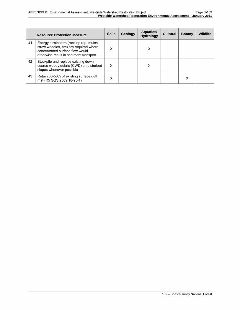
Westside Watershed Restoration Environmental Assessment – January 2011
105 – Shasta-Trinity National Forest
Resource Protection Measure Soils Geology Aquatics/ Hydrology Cultural Botany Wildlife
41 Energy dissipaters (rock rip rap, mulch, straw waddles, etc) are required where concentrated surface flow would otherwise result in sediment transport
X X
42 Stockpile and replace existing down coarse woody debris (CWD) on disturbed slopes whenever possible
X X
43 Retain 30-50% of existing surface duff mat (R5 SQS 2509.18-95-1) X X
APPENDIX B: Environmental Assessment, Westside Watershed Restoration Project Page B-109

Westside Watershed Restoration Environmental Assessment – January 2011
106 – Shasta-Trinity National Forest
Table 2. Roads proposed for treatment and the spatially specific resource protection measures that are relevant to each. The numbers correspond to the numbers assigned to each resource protection measure in Table 1. This table only includes those resource protection measures that are spatially specific: 1, 3, 4, 5, 6 (serpentine sensitive plants only), 7, 10, 14 (serpentine sensitive plant species only), 15, 18 and 19. All other resource protection measures apply in all locations where work will be performed.
Route # Length of action
Operational Maintenance Level
Proposed Action (Alternative 2)
Resource Protection Measures
1S28C 0.6000 1 - BASIC CUSTODIAL CARE (CLOSED) Decommission 1
1S37 0.9000 1 - BASIC CUSTODIAL CARE (CLOSED) Decommission 1, 3, 4
1S39A 0.4000 1 - BASIC CUSTODIAL CARE (CLOSED) Decommission 1, 3, 10, 15
28N31A 0.7000 1 - BASIC CUSTODIAL CARE (CLOSED) Decommission 3, 4
28N71A 0.4000 2 - HIGH CLEARANCE VEHICLES Decommission 3, 4
29N12A 0.2000 1 - BASIC CUSTODIAL CARE (CLOSED) Decommission 3, 6, 7, 14, 18, 19
29N17B 0.2380 1 - BASIC CUSTODIAL CARE (CLOSED) Decommission 3
29N22A 0.5000 1 - BASIC CUSTODIAL CARE (CLOSED) Decommission 1, 4
29N30P 0.9070 1 - BASIC CUSTODIAL CARE (CLOSED) Decommission 10, 15
29N31C 0.2000 1 - BASIC CUSTODIAL CARE (CLOSED) Decommission
29N31D 0.3000 1 - BASIC CUSTODIAL CARE (CLOSED) Decommission
29N35A 0.0434 2 - HIGH CLEARANCE VEHICLES Decommission
29N42A 0.3000 1 - BASIC CUSTODIAL CARE (CLOSED) Decommission 3, 4
29N46A 0.2039 1 - BASIC CUSTODIAL CARE (CLOSED) Decommission
29N46B 0.1830 1 - BASIC CUSTODIAL CARE (CLOSED) Decommission 3
29N46C 0.2850 1 - BASIC CUSTODIAL CARE (CLOSED) Decommission 3
29N48A 0.6000 1 - BASIC CUSTODIAL CARE (CLOSED) Decommission 3
29N50 0.7000 2 - HIGH CLEARANCE VEHICLES Decommission 6, 7, 10, 14, 18, 19
29N54 1.3930 2 - HIGH CLEARANCE VEHICLES Decommission 3, 4
29N54A 0.1000 1 - BASIC CUSTODIAL CARE (CLOSED) Decommission 3, 4
29N54B 0.1000 1 - BASIC CUSTODIAL CARE (CLOSED) Decommission 3,
29N56 0.3000 1 - BASIC CUSTODIAL CARE (CLOSED) Decommission 1, 3, 4, 10, 15
APPENDIX B: Environmental Assessment, Westside Watershed Restoration Project Page B-110

Westside Watershed Restoration Environmental Assessment – January 2011
107 – Shasta-Trinity National Forest
Route # Length of action
Operational Maintenance Level
Proposed Action (Alternative 2)
Resource Protection Measures
29N56A 0.3000 1 - BASIC CUSTODIAL CARE (CLOSED) Decommission 1, 3, 10, 15
29N58E 0.7049 1 - BASIC CUSTODIAL CARE (CLOSED) Decommission 3, 4, 10, 15
29N58H 0.6000 1 - BASIC CUSTODIAL CARE (CLOSED) Decommission 1, 3, 4, 10, 15
29N58K 0.2000 1 - BASIC CUSTODIAL CARE (CLOSED) Decommission 1, 3, 4, 10, 15
29N62D 0.3000 1 - BASIC CUSTODIAL CARE (CLOSED) Decommission 1, 3, 4, 10, 15
29N63 1.4000 2 - HIGH CLEARANCE VEHICLES Decommission 3, 6, 7, 10, 14, 15, 18,
19
29N64 0.5000 2 - HIGH CLEARANCE VEHICLES Decommission 1
29N68A 0.5000 1 - BASIC CUSTODIAL CARE (CLOSED) Decommission 3, 4, 6, 7, 14, 18, 19
29N68B 0.5000 1 - BASIC CUSTODIAL CARE (CLOSED) Decommission 3
29N71A 0.3000 1 - BASIC CUSTODIAL CARE (CLOSED) Decommission
29N73D 0.6001 2 - HIGH CLEARANCE VEHICLES Decommission 3, 4,
29N81 0.6001 1 - BASIC CUSTODIAL CARE (CLOSED) Decommission 4
29N81A 0.4000 1 - BASIC CUSTODIAL CARE (CLOSED) Decommission 4, 6, 7, 14, 18, 19
29N86 1.2300 1 - BASIC CUSTODIAL CARE (CLOSED) Decommission 6, 7, 10, 14, 15, 18, 19
29N86A 0.7000 1 - BASIC CUSTODIAL CARE (CLOSED) Decommission 6, 7, 10, 14, 15, 18, 19
29N89 0.1929 2 - HIGH CLEARANCE VEHICLES Decommission 6, 7, 10, 14, 15, 18, 19
29N89A 0.3985 2 - HIGH CLEARANCE VEHICLES Decommission 6, 7, 10, 14, 15, 18, 19
30N03A 0.4000 1 - BASIC CUSTODIAL CARE (CLOSED) Decommission 3, 4
30N13C 0.8000 1 - BASIC CUSTODIAL CARE (CLOSED) Decommission 3, 4
30N14A 0.4000 1 - BASIC CUSTODIAL CARE (CLOSED) Decommission 1
30N14Y 0.4268 1 - BASIC CUSTODIAL CARE (CLOSED) Decommission 4
30N18A 0.2000 1 - BASIC CUSTODIAL CARE (CLOSED) Decommission 1
30N18B 0.7000 1 - BASIC CUSTODIAL CARE (CLOSED) Decommission
30N27A 0.3106 1 - BASIC CUSTODIAL CARE (CLOSED) Decommission
30N28A 0.2000 1 - BASIC CUSTODIAL CARE (CLOSED) Decommission 3, 4, 6, 7, 14, 18, 19
30N28B 0.4000 1 - BASIC CUSTODIAL CARE (CLOSED) Decommission 4, 6, 7, 14, 18, 19
APPENDIX B: Environmental Assessment, Westside Watershed Restoration Project Page B-111

Westside Watershed Restoration Environmental Assessment – January 2011
108 – Shasta-Trinity National Forest
Route # Length of action
Operational Maintenance Level
Proposed Action (Alternative 2)
Resource Protection Measures
30N50A 1.5000 2 - HIGH CLEARANCE VEHICLES Decommission 1, 3, 4
30N53A 0.3000 1 - BASIC CUSTODIAL CARE (CLOSED) Decommission
30N53B 0.5000 1 - BASIC CUSTODIAL CARE (CLOSED) Decommission 4
30N57A 0.200 1 - BASIC CUSTODIAL CARE (CLOSED) Decommission 1, 3, 4, 15
33N04YA 0.4200 1 - BASIC CUSTODIAL CARE (CLOSED) Decommission 1, 3, 4
33N31 1.8000 1 - BASIC CUSTODIAL CARE (CLOSED) Upgrade 1, 3, 4
33N31A 1.3000 1 - BASIC CUSTODIAL CARE (CLOSED) Decommission 4
33N47A 0.2000 1 - BASIC CUSTODIAL CARE (CLOSED) Decommission 1, 3, 4, 6, 7, 14, 18, 19
33N51C 0.1000 1 - BASIC CUSTODIAL CARE (CLOSED) Decommission 1, 3
34N17YA 0.1816 2 - HIGH CLEARANCE VEHICLES Decommission 1, 3
34N34YA 0.6000 1 - BASIC CUSTODIAL CARE (CLOSED) Decommission 1, 3, 4, 5
34N36 1.3000 2 - HIGH CLEARANCE VEHICLES Decommission 1, 3, 4, 5
34N36 0.8000 1 - BASIC CUSTODIAL CARE (CLOSED) Decommission 1, 3, 4, 5
34N80B 0.5000 2 - HIGH CLEARANCE VEHICLES Decommission 1, 3, 4, 5
34N80B 0.3747 1 - BASIC CUSTODIAL CARE (CLOSED) Decommission 1, 3, 4, 5
4N16B 0.4000 1 - BASIC CUSTODIAL CARE (CLOSED) Decommission 1, 3
U1S29 1.1430 Decommission 3, 4, 15 U28N10A 0.3204 Decommission 1, 4 U29N02C 0.1870 Decommission 1, 4 U29N05AB 1.2539 Decommission U29N05D 0.2069 Decommission U29N07C 0.2800 Decommission 1, 3 U29N07G 0.1350 Decommission 1, 3, 4 U29N21X 0.3922 Decommission 1 U29N22A 1.0200 Decommission 4 U29N22E 0.4380 Decommission 1, 4 U29N22I 0.1821 Decommission 1 U29N25C 0.0370 Decommission 1, 3 U29N25D 0.0370 Decommission 1, 3, 4 U29N31EAA 0.2735 Decommission 1, 4 U29N31EB 0.3341 Decommission 1, 6, 7, 14, 18, 19
APPENDIX B: Environmental Assessment, Westside Watershed Restoration Project Page B-112

Westside Watershed Restoration Environmental Assessment – January 2011
109 – Shasta-Trinity National Forest
Route # Length of action
Operational Maintenance Level
Proposed Action (Alternative 2)
Resource Protection Measures
U29N32B 1.7650 Decommission 3, 4, 6, 7, 10, 14, 15, 18, 19
U29N33B 0.9155 Decommission 3, 6, 7, 10, 14, 15, 18, 19
U29N41W 0.6535 Decommission 1, 4 U29N41X 0.3860 Decommission 1, 4 U29N46D 0.3839 Decommission 6, 7, 14, 18, 19 U29N51A 0.3207 Decommission U29N71B 0.0699 Decommission 3 U29N73E 0.1370 Decommission 3 U29N83C 0.0820 Decommission 3, 4, 15
U29N86B 0.5841 Decommission 3, 4, 6, 7, 10, 14, 15, 18, 19
U29N86BA 0.4387 Decommission 3, 4, 6, 7, 10, 14, 15, 18, 19
U29N86BB 0.1370 Decommission 3, 4 U30N14A 0.0789 Decommission 1, 6, 7, 14, 18, 19 U30N14AA 0.1995 Decommission 1 U30N14B 0.0559 Decommission 1 U30N27A 0.1030 Decommission 1, 6, 7, 14, 18, 19 U30N27AB 0.1004 Decommission 1, 6, 7, 14, 18, 19 U30N27B 0.0749 Decommission 1 U30N27D 0.0541 Decommission 1 U30N27F 0.0627 Decommission 1 U30N27G 0.1550 Decommission U30N27K 0.0382 Decommission 4 U30N27W 0.1360 Decommission 1, 6, 7, 14, 18, 19 U30N27X 0.1726 Decommission 1, 6, 7, 14, 18, 19 U30N27Z 0.0283 Decommission 1 U30N28C 0.0678 Decommission 6, 7, 14, 18, 19 U30N28D 0.0514 Decommission 4, 6, 7, 14, 18, 19 U30N28FA 0.1982 Decommission 6, 7, 14, 18, 19 U30N45A 0.0476 Decommission 6, 7, 14, 18, 19 U30N45B 0.1850 Decommission U32N25B 0.0757 Decommission 3, 4 U33N22BA 0.0721 Decommission 3 U33N22C 0.1027 Decommission 3, 4 U33N22D 0.2681 Decommission 1, 3 U33N30 0.1558 Decommission 3 U33N30A 0.1238 Decommission 3 U33N30D 0.0763 Decommission 3 U33N41AA 0.0219 Decommission 4
APPENDIX B: Environmental Assessment, Westside Watershed Restoration Project Page B-113

Westside Watershed Restoration Environmental Assessment – January 2011
110 – Shasta-Trinity National Forest
Route # Length of action
Operational Maintenance Level
Proposed Action (Alternative 2)
Resource Protection Measures
U33N41AC 0.0697 Decommission U33N41EA 0.0345 Decommission 3 U33N41FA 0.1635 Decommission 3, 4 U33N41M 0.2263 Decommission 1, 4 U33N48AA 0.1021 Decommission 1, 3, 4 U33N48B 0.0774 Decommission 1, 3 U33N48C 0.1842 Decommission 3, 6, 7, 14, 18, 19 U33N48D 0.0389 Decommission 3, 6, 7, 14, 18, 19 U33N51BA 0.1625 Decommission 1, 3 U33N51E 0.0897 Decommission 7, 18, 19 U33N51F 0.3210 Decommission 3, 4, 6, 7, 14, 18, 19 U33N51G 0.1255 Decommission 4 U33N51H 0.1267 Decommission 4, 6, 7, 14, 18, 19 U33N51I 0.0509 Decommission 3, 4, 6, 7, 14, 18, 19 U33N51J 0.2197 Decommission 4, 6, 7, 14, 18, 19 U36TRI03 0.4609 Decommission 10 U36TRI05 0.1175 Decommission U414B 0.0963 Decommission
34N13 N/A 2 - HIGH CLEARANCE VEHICLES
1 culvert replacement 4
29N72 N/A 1 - BASIC CUSTODIAL CARE (CLOSED)
3 culvert replacements 3, 4
33N47 N/A 3 – SUITABLE FOR PASSENGER CARS
1 culvert replacement 4
APPENDIX B: Environmental Assessment, Westside Watershed Restoration Project Page B-114

Trinity County Resource Conservation District Westside Watershed Restoration Project Initial Study/Mitigated Negative Declaration
APPENDIX C: Decision Notice, Westside Watershed Restoration Project

APPENDIX C: Decision Notice, Westside Watershed Restoration Project Page C-1

Trinity County Resource Conservation District Westside Watershed Restoration Project Initial Study/Mitigated Negative Declaration
APPENDIX D: FONSI, Westside Watershed Restoration Project

APPENDIX D: FONSI, Westside Watershed Restoration Project Page D-1

APPENDIX D: FONSI, Westside Watershed Restoration Project Page D-2

APPENDIX D: FONSI, Westside Watershed Restoration Project Page D-3

APPENDIX D: FONSI, Westside Watershed Restoration Project Page D-4

APPENDIX D: FONSI, Westside Watershed Restoration Project Page D-5

APPENDIX D: FONSI, Westside Watershed Restoration Project Page D-6

APPENDIX D: FONSI, Westside Watershed Restoration Project Page D-7

APPENDIX D: FONSI, Westside Watershed Restoration Project Page D-8