Triggers and Processes Of Desertification In The Dry Lands ... · the triggers and processes of...
9
Page | 86 Vol.10 Issue 3(Ver1.0)September2010 Global Journal of Human Social Science GJHSS Classification – C (FOR) 040306,040314,040601 Triggers and Processes Of Desertification In The Dry Lands Of North Cameroon Ndenecho Emmanuel Neba Abstract-Desertification is officially defined as: “land degradation in arid, semi-arid and dry sub-humid areas resulting from various factors including climatic variations and human activities (Seely, 2002). The definition clearly supports the basis for a vigorous research programme to combat desertification which now affects many developing countries. This paper seeks to enhance an understanding of the triggers and processes of desertification as a link between research on the one hand and implementation of programmes to combat desertification on the other hand. It uses a combination of primary and secondary data to distinguish between the impacts of rainfall variability and desertification on reduced biomass productivity. The study posits that anthropic factors have had an overwhelming role to play in the desertification of the region even though the climatic factor remains the important trigger. Finally, it concludes that in combating desertification, the interplay of the various environmental aspects must be considered side-by-side: that is, the effects of climate change, the destruction of biodiversity and the mounting scarcity of water resources. Synergies need to be developed to produce more integrated and holistic approaches which will lend the measures being implemented additional success and breadth of effect. Keywords-Desertification, trigger factors, dry lands, sustainable development, appropriate measures. I. INTRODUCTION esertification – meaning land degradation and resource destruction is a worldwide problem. Arid regions constitute 40 percent of the Earth‘s land surface. Currently, an area three times the size of Europe is affected (Ingrid-Gabriela, 2002). Many developing countries are suffering from advancing desertification, in particular the least developed countries. According to Ingrid-Gabriela (2002) the survival of around one billion people is at substantial risk from processes of soil erosion. The economic losses in the form of forfeited incomes in the affected areas are extremely high. For example, in Cameroon the droughts of 1972, 1984, and 2005 in North Cameroon caused livestock to die and grain crop failure. On a global scale annual losses resulting from desertification are put at some USD 42 billion. It is the poorest and most vulnerable members of the society who bear the costs: poverty, poor health, malnutritional status and lack of secure food supplies. These initiate migration flows of the population, and environmental refugees. The central role of research should revolve around enhanced understanding of the processes of desertification and its reversal. The paper therefore seeks to _______________________________ About- 1 Lecturer in Geography at the University of Yaounde I ENS Annex Bambili, P.O Bamenda North West Region Cameroon ([email protected]) And desertification on reduced productivity. enhance an understanding of these processes by distinguishing betweenthe impacts of rainfall variability and desertification on reduced productivity. II. THE STUDY AREA From a broad perspective, the areas which can be considered as Cameroon‘s arid lands in transition are situated between latitudes 10o and 11o30‘N and longitudes 13o45‘ and 15o5E in the savannah-steppe or sudano- sahelian climate. It lies to the south of the Sahel zones which is the southern ecological zone bordering the Sahara Desert. The region has three broad morphological units, namely, the Alluvial Flood Plains (Years), the Diamare Plain and Mandara Highlands. The vegetation is dry savannah type. The climate of Cameroon like that of Africa is affected by two air masses emanating from anticyclones situated on both sides of the equator. These winds are generally easterly: northeast and southeast trade winds due to the earth‘s rotation. The variations in African climate result from the north-south shift of these zones as the earth revolves around the sun. During the northern winter, when the zones shift south, all of Cameroon and Africa north of the equator is under the influence of the northeast trade winds. Cameroon and most of West Africa is subjected during this period to the harmattan, a dry wind coming from the Sahara Desert. The dry harmattan invades and the dry season is experienced. The zones shift north in northern summer, since the convergence zone lies generally north of the equator the system moves northwards causing an inflow of moist air over the whole country and this is the wet season. The amount and duration of rainfall decreases northwards. Most of the areas rainfall comes from monsoons with line squalls occurring mainly at the beginning and end of the wet season. By analysing daily rainfall amounts for areas exceeding 200 mm of rain in the Sudano-Sahelian zone, Ledger (1964) has found that the increase in rainfall southwards from the Lake Chad shores to the Diamare Plain is due to an increase in the number rather than the size of storms. Extreme variability of annual rainfall amounts is also typical. Dresch (1973) reports that the ―Shorter the rainy season, the more irregular the rainfall is in space, in time over the year and from one year to another. The rains may start earlier or later, and may last longer or a shorter time. The population density on the average is about 56 inhabitants/km2 with an annual population growth rate of D
Transcript of Triggers and Processes Of Desertification In The Dry Lands ... · the triggers and processes of...

P a g e | 86 Vol.10 Issue 3(Ver1.0)September2010 Global Journal of Human Social Science
GJHSS Classification – C (FOR) 040306,040314,040601
Triggers and Processes Of Desertification In The
Dry Lands Of North Cameroon
Ndenecho Emmanuel Neba
Abstract-Desertification is officially defined as: “land
degradation in arid, semi-arid and dry sub-humid areas
resulting from various factors including climatic variations
and human activities (Seely, 2002). The definition clearly
supports the basis for a vigorous research programme to
combat desertification which now affects many developing
countries. This paper seeks to enhance an understanding of
the triggers and processes of desertification as a link between
research on the one hand and implementation of programmes
to combat desertification on the other hand. It uses a
combination of primary and secondary data to distinguish
between the impacts of rainfall variability and desertification
on reduced biomass productivity. The study posits that
anthropic factors have had an overwhelming role to play in
the desertification of the region even though the climatic
factor remains the important trigger. Finally, it concludes that
in combating desertification, the interplay of the various
environmental aspects must be considered side-by-side: that
is, the effects of climate change, the destruction of biodiversity
and the mounting scarcity of water resources. Synergies need
to be developed to produce more integrated and holistic
approaches which will lend the measures being implemented
additional success and breadth of effect.
Keywords-Desertification, trigger factors, dry lands,
sustainable development, appropriate measures.
I. INTRODUCTION
esertification – meaning land degradation and
resource destruction is a worldwide problem. Arid
regions constitute 40 percent of the Earth‘s land surface.
Currently, an area three times the size of Europe is affected
(Ingrid-Gabriela, 2002). Many developing countries are
suffering from advancing desertification, in particular the
least developed countries. According to Ingrid-Gabriela
(2002) the survival of around one billion people is at
substantial risk from processes of soil erosion. The
economic losses in the form of forfeited incomes in the
affected areas are extremely high. For example, in
Cameroon the droughts of 1972, 1984, and 2005 in North
Cameroon caused livestock to die and grain crop failure.
On a global scale annual losses resulting from
desertification are put at some USD 42 billion. It is the
poorest and most vulnerable members of the society who
bear the costs: poverty, poor health, malnutritional status
and lack of secure food supplies. These initiate migration
flows of the population, and environmental refugees. The
central role of research should revolve around enhanced
understanding of the processes of desertification and its
reversal. The paper therefore seeks to _______________________________ About-1Lecturer in Geography at the University of Yaounde I ENS Annex
Bambili, P.O Bamenda North West Region Cameroon
And desertification on reduced productivity. enhance an
understanding of these processes by distinguishing
betweenthe impacts of rainfall variability and desertification on reduced productivity.
II. THE STUDY AREA
From a broad perspective, the areas which can be
considered as Cameroon‘s arid lands in transition are
situated between latitudes 10o and 11o30‘N and longitudes
13o45‘ and 15o5E in the savannah-steppe or sudano-
sahelian climate. It lies to the south of the Sahel zones
which is the southern ecological zone bordering the Sahara
Desert. The region has three broad morphological units,
namely, the Alluvial Flood Plains (Years), the Diamare
Plain and Mandara Highlands. The vegetation is dry
savannah type.
The climate of Cameroon like that of Africa is affected by
two air masses emanating from anticyclones situated on
both sides of the equator. These winds are generally
easterly: northeast and southeast trade winds due to the
earth‘s rotation. The variations in African climate result
from the north-south shift of these zones as the earth
revolves around the sun. During the northern winter, when
the zones shift south, all of Cameroon and Africa north of
the equator is under the influence of the northeast trade
winds. Cameroon and most of West Africa is subjected
during this period to the harmattan, a dry wind coming
from the Sahara Desert. The dry harmattan invades and the
dry season is experienced. The zones shift north in northern
summer, since the convergence zone lies generally north of
the equator the system moves northwards causing an inflow
of moist air over the whole country and this is the wet
season. The amount and duration of rainfall decreases
northwards.
Most of the areas rainfall comes from monsoons with line
squalls occurring mainly at the beginning and end of the
wet season. By analysing daily rainfall amounts for areas
exceeding 200 mm of rain in the Sudano-Sahelian zone,
Ledger (1964) has found that the increase in rainfall
southwards from the Lake Chad shores to the Diamare
Plain is due to an increase in the number rather than the
size of storms. Extreme variability of annual rainfall
amounts is also typical. Dresch (1973) reports that the
―Shorter the rainy season, the more irregular the rainfall is
in space, in time over the year and from one year to
another. The rains may start earlier or later, and may last
longer or a shorter time.
The population density on the average is about 56
inhabitants/km2 with an annual population growth rate of
D
Global Journal of Human Social Science Vol.10 Issue 3(Ver1.0)September 2010 P a g e |87
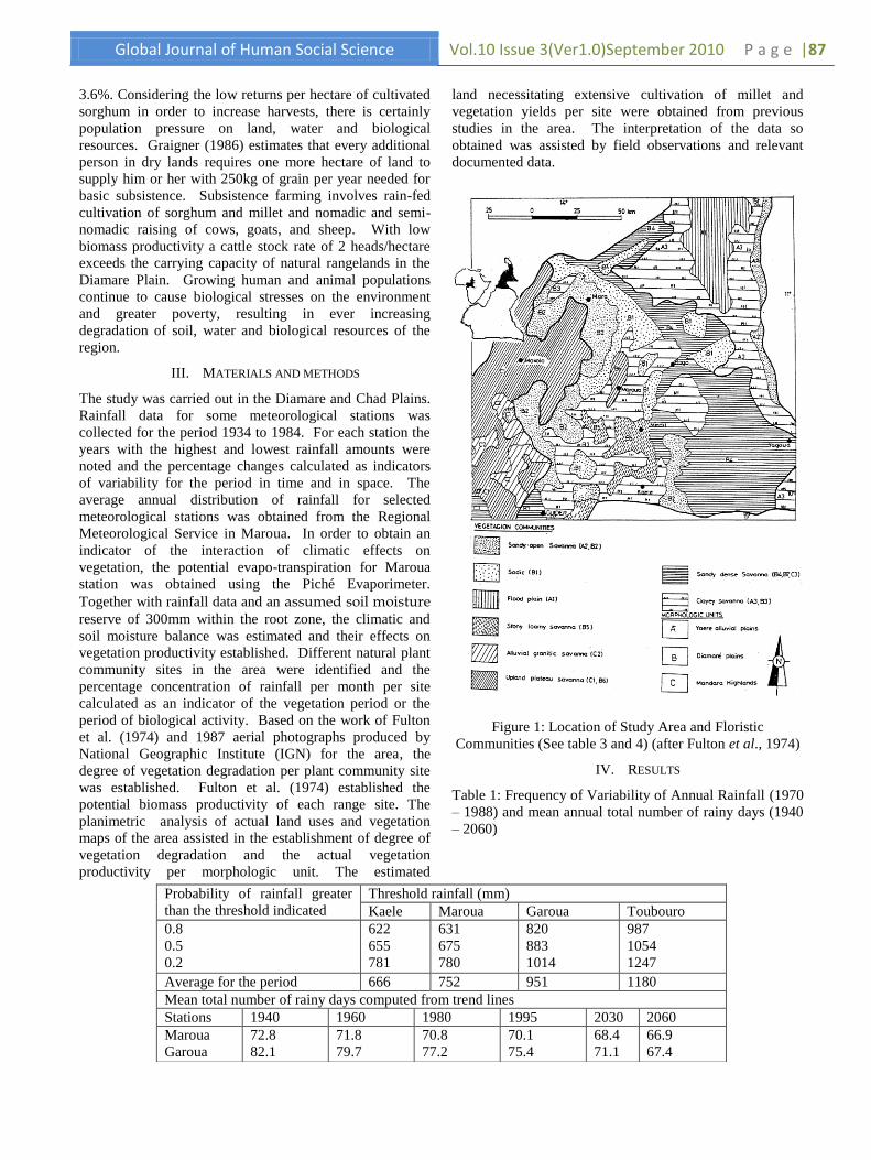
3.6%. Considering the low returns per hectare of cultivated land necessitating extensive cultivation of millet and
sorghum in order to increase harvests, there is certainly
population pressure on land, water and biological
resources. Graigner (1986) estimates that every additional
person in dry lands requires one more hectare of land to
supply him or her with 250kg of grain per year needed for
basic subsistence. Subsistence farming involves rain-fed
cultivation of sorghum and millet and nomadic and semi-
nomadic raising of cows, goats, and sheep. With low
biomass productivity a cattle stock rate of 2 heads/hectare
exceeds the carrying capacity of natural rangelands in the
Diamare Plain. Growing human and animal populations
continue to cause biological stresses on the environment
and greater poverty, resulting in ever increasing
degradation of soil, water and biological resources of the
region.
III. MATERIALS AND METHODS
The study was carried out in the Diamare and Chad Plains.
Rainfall data for some meteorological stations was
collected for the period 1934 to 1984. For each station the
years with the highest and lowest rainfall amounts were
noted and the percentage changes calculated as indicators
of variability for the period in time and in space. The
average annual distribution of rainfall for selected
meteorological stations was obtained from the Regional
Meteorological Service in Maroua. In order to obtain an
indicator of the interaction of climatic effects on
vegetation, the potential evapo-transpiration for Maroua
station was obtained using the Piché Evaporimeter.
Together with rainfall data and an assumed soil moisture reserve of 300mm within the root zone, the climatic and
soil moisture balance was estimated and their effects on
vegetation productivity established. Different natural plant
community sites in the area were identified and the
percentage concentration of rainfall per month per site
calculated as an indicator of the vegetation period or the
period of biological activity. Based on the work of Fulton
et al. (1974) and 1987 aerial photographs produced by
National Geographic Institute (IGN) for the area, the
degree of vegetation degradation per plant community site
was established. Fulton et al. (1974) established the
potential biomass productivity of each range site. The
planimetric analysis of actual land uses and vegetation
maps of the area assisted in the establishment of degree of
vegetation degradation and the actual vegetation
productivity per morphologic unit. The estimated
vegetation yields per site were obtained from previous
studies in the area. The interpretation of the data so
obtained was assisted by field observations and relevant
documented data.
Figure 1: Location of Study Area and Floristic
Communities (See table 3 and 4) (after Fulton et al., 1974)
IV. RESULTS
Table 1: Frequency of Variability of Annual Rainfall (1970
– 1988) and mean annual total number of rainy days (1940
– 2060)
Probability of rainfall greater
than the threshold indicated
Threshold rainfall (mm)
Kaele Maroua Garoua Toubouro
0.8
0.5
0.2
622
655
781
631
675
780
820
883
1014
987
1054
1247
Average for the period 666 752 951 1180
Mean total number of rainy days computed from trend lines
Stations 1940 1960 1980 1995 2030 2060
Maroua
Garoua
72.8
82.1
71.8
79.7
70.8
77.2
70.1
75.4
68.4
71.1
66.9
67.4

P a g e | 88 Vol.10 Issue 3(Ver1.0)September2010 Global Journal of Human Social Science
Table 1 presents the frequency of rainfall variability for the
period 1970 to 1988 and the mean number of rainy days
computed from trend lines (Ayonghe, 2001) for the period
1940 to 2060. According to Ayonghe (2001) high rainfall
was evident from 1951 to 1967, 1977 to 1980, and 1989 to
1995, while low rainfall was observed from 1930 to 1950,
1968 to 1976 and 1981 to 1988. In general the mean total
number of rainy days for the period 1940 to 2060 is on the
decline. The rainy season lasts three to six months
depending on the location and it is characterized by inter-
annual variability of rainfall. Figure 3 presents the
frequency of the total annual rainfall with a probability of 8
out of 10 years for the period 1952 to 1969 and 1970 to
1989. It again depicts inter-annual variability.
Figure 2: Evolution of annual rainfall in some stations: A = Garoua from 1950 to 1995 and B = Maroua from 1950 to 1995
(after Donfack, Boukar and M‘Biandoun, 1996)
Figure 3: Frequency of total annual rainfall (mm): 8/10 (after Donfack, Boukar and M‘Biandoun, 1996)

Global Journal of Human Social Science Vol.10 Issue 3(Ver1.0)September 2010 P a g e |89
Source: Maroua: Provincial Meteorological Station
Figure 2 presents the inter-annual variability of rainfall in
Maroua and Garoua. Table 2 presents the evaporation rates
for some stations in the area. Evaporation rates are high and
large water deficits occur (Figure 4). The moisture
available to plants is related to the capacity of the soil to
absorb and retain water. Data from the Maroua weather
station was used to estimate the moisture balance in well
drained upland soils (Figure 4). In figure 4 the average
monthly rainfall (R), potential evapotranspiration (PE) and
actual evapotranspiration (AE) were estimated using the
Piche Evaporimeter. The annual values of PE, AE and
rainfall are 1744mm, 969mm and 968mm respectively.
zThe moisture in the soil at the end of each month was
calculated by adding the amount of available moisture at
the end of the previous month. For example, at the end of
June about 25mm of moisture available to plants was stored
in the soil. During July rainfall was about 250mm and
plants utilized about 140mm of moisture. At the end of July
approximately 135mm of moisture were stored in the soil
[(25mm + 250) – 140mm]. This then was the amount of
available moisture for use by plants in August. The shaded
part shows the amount of moisture in the soil that is
available in plants. For about 110days from July through
October, the available moisture in the soil exceeds PE, and
plant growth is rapid. The unshaded part below the PE
graph shows that growth is restricted by lack of moisture
until the next period of high rainfall. For soils that retain
less than the maximum available moisture for plants (about
260mm at Maroua) this period is shorter because excess
water moves through the soil to replenish the ground water.
The rainfall is concentrated in a very short time of the year.
Evaporation rates are equally very high: Maroua has 2396
mm/year while its rainfall is only 804mm. within this
climatic context the possibilities of reconstituting ground
water reserves and the availability of water to plants are
very limited. The area experiences deficits between
evapotranspiration and rainfall, which is practically
concentrated in 3 to 4 months of the year.
Figure 4: Climatic balance and soil moisture balance in
Maroua for the dry lands of Cameroon. (Elevation: 421m)
The consequences of this climatic situation are a biological
rhythm with two phases:
An active vegetative phase of very intense growth
of about 5 months. The reconstitution of ground
water reserves is essentially achieved from July to
August when rainfall exceeds evapotranspiration.
This reserve is rapidly depleted as soon as the dry
season sets in (November to May)
The wet season is followed by a dry and hot
season during which ground water reserves are
exhausted by high rates of evaporation. The
physiological activities of plants are very
restricted and much of the vegetation dries out.
Streams and rivers are characterized by irregular flow rates.
The plains consists of numerous small elongated, sub-water
sheds that are parallel to the broad alluvial plain of the
Logone River. These discharge runoff water and deposit
sediments in a network of outwash splays. flood plain
pastures during the dry season degrades the two-
transhumance sites. Livestock raisers tend to follow
rainfall events in space as a result of spatial variations of
rainfall. They practice opportunistic grazing – following
rainfall and floods events in space and time. Surface
streams dry up during the dry season. The growing season
Station Evaporation (mm/month)
J F M A M J J A S O N D Total
Poli 236 279 323 225 127 66 55 56 51 81 149 202 1850
Maroua 228 296 365 304 203 199 81 60 83 143 229 213 2396
Kousseri 345 389 506 451 362 265 149 74 96 206 353 341 3519

P a g e | 90 Vol.10 Issue 3(Ver1.0)September2010 Global Journal of Human Social Science
The limited growing seasons imposes extensive agricultural
land use systems which degrade the vegetation. Land
clearance for agriculture interrupts this fragile ecology.
Overgrazing of upland pastures during the wet season and
is limited and the risk of famine high, especially when a
drought offsets the fragile balance (Beauvilain, 1981).
Sustaining man, plants and animals becomes difficult.
Under these circumstances low vegetation productivity is
typical.
Natural plant communities in the area were studied with
respect to the rainfall distribution in time, soil
characteristics, the vegetation period and anthropogenic
impacts. These natural plant communities are presented in
Figure 1. For each plant community the rainfall
concentration during the wet season is as follows:
Sandy open savannah: 85% of total rainfall occurs in July
and August.
Sodic zones: 75% of rainfall occurs in July,
August and September.
Flood plain: 90% of rainfall occurs in the period
from June to September.
Stony loamy savannah: 85% of the rainfall occurs
in June to September.
Alluvial granitic savannah: 85% of annual
rainfall occurs in July to September.
Upland plateau: 85% rain occurs in June to
September.
Sandy dense savannah: 80% of rain occurs in June
to September.
Clayey savannah: 80% of rain occurs in July and
August.
The vegetative period is therefore very restricted.
Consequently, the vegetation is restricted to
ephemerals. These are herbs, forbs and grasses.
Perennial trees must be drought resistant. These
are fragile environments that degrade rapidly once
the natural ecological balance has been disturbed
by farming, grazing and deforestation
.
Table 3: Degree of Vegetation Degradation (See Figure 1
Community site Map code Degree of Degradation of the Potential Vegetation
Sodic B1 75 to 100 percent of the potential plant community has
been degraded and replaced by annuals.
Sandy open savannah A2, B2 50 to 75 percent of the potential plant community has
been degraded and replaced by annuals or other species Alluvial/granitic savannah C2
Clayey savannah A3, B3 25 to 50 percent of the potential plant community has
been degraded and replaced by annuals and other
species Stony loamy savannah A5
Sandy dense savannah B4, B7, C3
Flood plain A1 The present plant community is almost the same as the
potential plant community. Degradation has been
minimal. This because of remoteness from man. Upland plateau C1, C6
Source: Established after potential plant communities and vegetation productivity by Fulton et al. (1974).
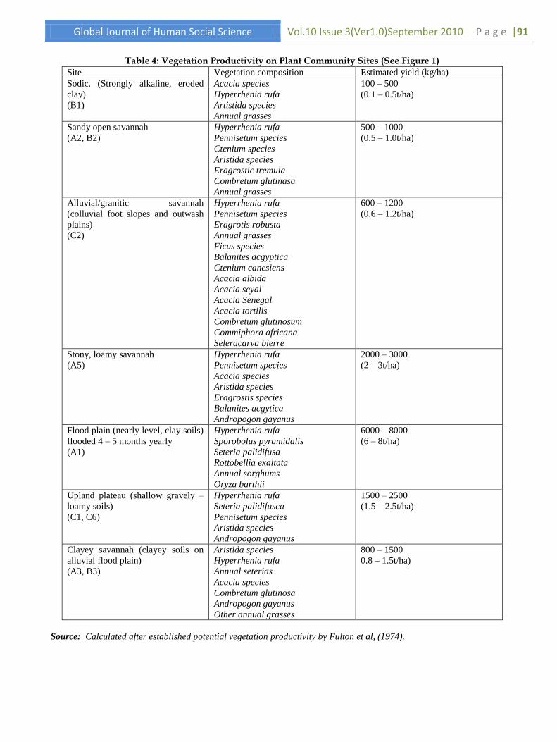
Table 3 presents the degree of vegetation degradation for each of the plant community sites. The anthropogenic impacts on
the plant communities were assessed. The results are (Table 4):
Global Journal of Human Social Science Vol.10 Issue 3(Ver1.0)September 2010 P a g e |91
Table 4: Vegetation Productivity on Plant Community Sites (See Figure 1)
Site Vegetation composition Estimated yield (kg/ha)
Sodic. (Strongly alkaline, eroded
clay)
(B1)
Acacia species
Hyperrhenia rufa
Artistida species
Annual grasses
100 – 500
(0.1 – 0.5t/ha)
Sandy open savannah
(A2, B2)
Hyperrhenia rufa
Pennisetum species
Ctenium species
Aristida species
Eragrostic tremula
Combretum glutinasa
Annual grasses
500 – 1000
(0.5 – 1.0t/ha)
Alluvial/granitic savannah
(colluvial foot slopes and outwash
plains)
(C2)
Hyperrhenia rufa
Pennisetum species
Eragrotis robusta
Annual grasses
Ficus species
Balanites acgyptica
Ctenium canesiens
Acacia albida
Acacia seyal
Acacia Senegal
Acacia tortilis
Combretum glutinosum
Commiphora africana
Seleracarva bierre
600 – 1200
(0.6 – 1.2t/ha)
Stony, loamy savannah
(A5)
Hyperrhenia rufa
Pennisetum species
Acacia species
Aristida species
Eragrostis species
Balanites acgytica
Andropogon gayanus
2000 – 3000
(2 – 3t/ha)
Flood plain (nearly level, clay soils)
flooded 4 – 5 months yearly
(A1)
Hyperrhenia rufa
Sporobolus pyramidalis
Seteria palidifusa
Rottobellia exaltata
Annual sorghums
Oryza barthii
6000 – 8000
(6 – 8t/ha)
Upland plateau (shallow gravely –
loamy soils)
(C1, C6)
Hyperrhenia rufa
Seteria palidifusca
Pennisetum species
Aristida species
Andropogon gayanus
1500 – 2500
(1.5 – 2.5t/ha)
Clayey savannah (clayey soils on
alluvial flood plain)
(A3, B3)
Aristida species
Hyperrhenia rufa
Annual seterias
Acacia species
Combretum glutinosa
Andropogon gayanus
Other annual grasses
800 – 1500
0.8 – 1.5t/ha)
Source: Calculated after established potential vegetation productivity by Fulton et al, (1974).

P a g e | 92 Vol.10 Issue 3(Ver1.0)September2010 Global Journal of Human Social Science
Sodic Zone (B1): It has a low tree population and
thus has a low potential as a source of fuelwood
and poles for building. Overgrazing by domestic
livestock has altered the plant community. Herds
from the neighbouring countries also use this area
while in transit. Much of the area requires
reseeding. See Tables 3 and 4.
Sandy Open Savannah (A2, B2): Because the
soils are droughty, excessive grazing alters the
plant community. Annual grasses replace the
perennial species, shortening the period during
which green grass grows thus reducing vegetation
production on the site. The site has a low
potential as a source of fuelwood and poles for
small dwellings. Trees are intensely degraded.
Alluvial Granitic Savannah (C2): The site has a
moderate potential as a source of firewood and
poles for small dwellings. Excessive grazing by
domestic livestock is common on these alluvial
granitic savannas. Droughty soils and a high
population density prevent rapid vegetation
productivity and recovery.
Clayey Savannah (A3, B3): These are seasonally
grazed by cattle. It is predominantly grazed by
sheep and goats for most of the year. Trees are
degraded for fuelwood and building. This Sahel
zone has few trees thus presenting a park savannah
landscape.
Stony Loamy Savannah (A5): The site has a
moderate potential as a source of fuelwood and
poles for small buildings. It has not been seriously
degraded.
Flood Plain Zone (A1): Flooding and repeated
burning by hunters and herders have prevented
woody vegetation from growing on the site (dry
season grazing lands). Isolated patches of trees
and shrubs grow on humps or raised hillocks on
the plain.
Upland Plateau (C1, C6): The upland plateau
site remains in grassland. Most trees are in
clusters and near streams where the soils are
deeper. The potential of the site as a source of
firewood and poles for small dwellings is high.
Due to the low availability of water for livestock,
this site has not been seriously grazed and
degraded. Most of the settled zone is a
domesticated landscape, due to a high human
population density (Park Savannah landscape).
The consequences of the climatic and anthropic factors on
the quantity and quality of the environment include:
A decline in annual production of pasture
vegetation;
A decline in the palatable grass species,
particularly perennials which are also good at
holding the soil together (soil aggregation);
An increase in ephemeral plants, which spring up
with the onset of the rains rather than having a
permanent presence, thus decreasing the durability
of pastures;
Soil compaction as a result of sealing and
trampling by stock near water holes and
overgrazing of wet-season pastures;
Damage to vegetation on crests and stable sand
dunes resulting in erosion. These provoke a
desertification process; and
These processes result in high soil erosion rates (Figure 3).
Drought triggers a crisis, but does not cause it. One effect of extremely variable climate is that during wet periods marginal areas are cultivated and herds expand. Then, when a major drought occurs, these marginal areas are unfit for cultivation, and over-expanded herds are critically affected. As there is no vegetation to hold the soil, non-marginal cultivated areas also deteriorate, and erosion occurs. Another climatic problem is that the sudden line squalls occurring north of 11o north cause a great deal of soil erosion. While the adjacent land is depleted, organic and mineral nutrients are deposited in depressions, where they become so excessive that they are inimical to flora growth. Cultivation leads to environmental problems which include:
Declining soil fertility and falling crop yields;
Crusting of exposed topsoil by rain and sun.
Rainfall intensities in Maroua are averaged at
81mm/hr and the hours of sunshine are long
throughout the year;
Increased surface runoff, sheet erosion and
gullying; and
General desertification of the land.
V. DISCUSSIONS
A combination of climatic and anthropic factors cause desertification. Desertification is a man-induced process. Climate variability is simply the trigger factor. In these dry lands precipitation is low and losses via evapotranspiration are high, to the point that soil
moisture limits production. Current land use is involved in
the transformation of rangelands to croplands and
investments in water resources for the development of
irrigation infrastructure. This presents the risk of soil and
ground water salanization. The degradation of vegetal
resources has reached a crisis situation. In combating
desertification the interplay of various environmental
aspects must be considered side-by-side, that is, the effects
of climate change, the destruction of biodiversity and the
mounting scarcity of water resources. Synergies must be
developed to produce more integrated and holistic
approaches which lend the measures taken additional
successes and breadth of effect. Sustainable development of
dry lands implies a development that has no associated
desertification risk. This requires the following strategic
recommendations (Safriel, 2002):

Global Journal of Human Social Science Vol.10 Issue 3(Ver1.0)September 2010 P a g e |93
Identify those dry land attributes that can be
harnessed to provide local people with an
economic competitive advantage, compared to
inhabitants in non-dry land regions. For example,
the curses of intense solar radiation and high
temperatures, low quality water and the desolation
and wilderness can be converted into the blessings
of solar energy production, precious aquaculture
and tourism industry assets.
Match specific aspects of development with dry
land attributes and assess the feasibility of their
sustainability.
Maintain the natural integrity of dry lands. Do not
convert drylands in order to make them function
as non-drylands. The risk here is that this strategy
will diversify the dry land ecosystems and
perpetuate the poverty of dryland inhabitants and
collapse of fragile ecological niches.
Research should seek to enhance an understanding
of the processes of desertification and mitigation
measures. Indigenous knowledge and local
practices should be researched and further
elaborated and developed, such that they can be
improved and exchanged between regions.
Exploit the global concern of the detrimental effects of
global climate change and biodiversity degradation by
implementing and demonstrating appropriate technologies
for combating desertification and the sustainable
development of agro-pastoral enterprises in a holistic
manner, that is, technologies that also mitigate climate
change, and conserve biodiversity, and hence benefit local
populations as well as regional and global interests
VI. CONCLUSIONS
Some decades ago, some scholars took the 1968 – 1972
drought in the Sahel as an indication of a long-term trend
towards greater aridity in the arid and semi-arid zones of
West Africa. The Sahara, it was said, was spreading
southwards because the various rainfall belts were moving
south. The drought problem did not come to the forefront
because it did not produce the same human suffering as in
1972 – 1973 and 1982 – 1984 period. Drought triggers a
crisis, but does not cause it. Over-cultivation and
overgrazing weaken the land, allowing no margin when
drought arrives. When rainfall returns to more ―normal‖
levels as it did in 1974 and in 1986, there is a natural
tendency to intensify farming again. Afforestation, agro-
silvopastoral programmes, agroforestry and water
harvesting technologies are urgently required to combat the
desertification process and to sustain rural livelihoods in
the region. In 1977 United Nation‘s Conference on
Desertification (UNCOD) adopted a detailed plan for
national, regional and international action. Transnational
projects were to revolutionalise stock rearing in the Sahel,
establish green belts north and south of the Sahara and
manage regional aquifers. Little of that plan called for has
yet been accomplished. There are few visible signs of
progress against desertification. The fourth session of the
conference of the parties to the United Nations Convention
to combat desertification (UNCCD), held in Bonn,
Germany in 2000. Despite the known conflicts of interest
between industrialized and developing countries was able
to give new impetus to the necessary intensification of
cooperation between the countries of the North and South.
Financing issues have been a difficult compromise between
North and South. The implementation of the convention
must be more strongly dovetailed with other areas of
national policy such as the issues of poverty reduction and
climate change.
VII. REFERENCES
1. Ayonghe, S. (2001) A quantitative evaluation of
global warning and precipitation in Cameroon
from 1930 to 1995 and projections to 2060:
Effects on environment and water resources. In:
C.M. Lambi and E.B. Eze (eds.) Readings in
Geography. Unique Printers, Bamenda p. 142-
155.
2. Beauvilain, A. (1985) Remarques Sur la situation
pluviométrique actuelle au Nord Cameroun. In ;
Cameroon Geographical Review, Vol. 5, No. 1
Yaounde University. p. 47 – 62.
3. Beauvilain, (1981) Elevage et eleveurs dans le
Grand Yaeré – Nord Cameroun. In : Cameroon
Geographical Review Vol. 2, No.2, p. 163 - 176
4. Donfack, P; Boukar, S. and M‘Biandoun, M
(1996) Les grandes caractéristiques du milieu
physique In: Agricultures des savannes du
Nord Cameroun. Boukar et al (eds), Actes de
l‟atelier d‟échange. CIRAD/CA p. 29 – 40
5. Dresch, J. (1973) : Drought Over Africa. The
United Nations Economic, Social and Cultural
Courier, U.N. New York.
6. Fulton, D ; Brower, j ; Boulet, J. et al (1974)
Resources inventory of North Cameroon – Africa.
USAIS-FAC (France) p. 64 -67
7. Grainger, A. (1986) Desertification. Earthscan
Publication, International Institute for
Environment and Development, Washington D. C.
p. 25 26.
8. Ingrid – Gabriela, H. (2002) The convention to
combat desertification – aims and implementation.
Agriculture and Development Vol. 9, No. 1, GTZ,
DSE, CTA, DLG, p. 49 – 53
9. Ledger, M. (1964) Some hydrological
characteristics of West African rivers.
Transactions of the Institute of British
Geographers.
10. Mahamat, S. (1983) : L‘Exploitation des resources
végétales dans le logone-Chari. In : Cameroun,
Geographical Review Vol. 4, No. 2, p. 16-24
11. Mahe, G. and Olivry, J. (1991) Changements
climatiques et variations des écoulements en
Afrique Occidentale et Central, du mensuel a
l‘international. In: Proceedings of Vienna
Symposium. IASH No. 201.

P a g e | 94 Vol.10 Issue 3(Ver1.0)September2010 Global Journal of Human Social Science
12. Molinier, M; Sighomnou, D. and Sigha, K. (2000)
Pertubation du milieu naturel du Yaere dan le
Nord Cameroun: changement climatiques ou
action anthropiques? In: F. Kengne and G.
Courade (eds) Societés et environnement au
Cameroun. NGCC, The University of Yaounde I.
p 155 -170.
13. Naah, E. (1990) Hydrologie du grand Yaere du
Nord Cameroun. Unpublished Doctorate Thesis.
Faculty of Science, University of Yaounde.
14. Olivry, J.C. (1978) Supended solid transport load
in Cameroon. In: ONAREST scientific papers, vol.
No. 1. Yaounde. p. 47 -60.
15. Olivry, J.C. (1986) Fleuves et rivières du
Cameroun MESRES – Yaounde / ORSTOM. Coll.
Monographies hydrologiques, No. 9. 733p.
16. Olivry, J.C. (1993) Vers un appauvrissement
durable des resource actuelle sur l‘écoulement du
fleuve sénégal et l‘hypersalinité de la Basse-
Casamance. In: Proceedings of the Vancouver
Symposium, August 1987, IAHS, publication No.
168.
17. Olivry J.C.; Briquet, J. and Mahe, G. (1994) De
l‘evolution de la puissance des
18. crues des grands cours d‘eau intertropicaux
d‘Afrique depuis
19. Safriel, U. N. (2002) Options for sustainable
development of dry lands.
20. Agriculture and Development Vol. 9, No. 1, GTZ,
DSE, CTA, DLG, p. 54 – 56
21. Seely, M. (2002) Research Competence in
combating desertification.
22. Agriculture and Development, Vol. 9, No. 1, GTZ,
DSE, CTA, DLG, p. 57 – 61 décennies. Dossier
de la Revue Geographie Alpine, No. 12.
23. Sighomnou, D. (1996) Restauration
hydrotechnique de plaine de Logone dans
Extreme-Nord du Cameroun. Prévision des
Inondation, Yaounde.
24. Roupsard, M. (1985) la riziculture irrigué dans les
plaines de l‘Extreme-Nord du Cameroun: La
SEMRY. Cameroon Geographical Review.
University of Yaounde I.