Transportation Improvement Program - COB Home · · 2015-11-04Transportation Improvement Program...
31
DRAFT Six-Year (2016-2021) Transportation Improvement Program (TIP) Kelli Linville, Mayor Ted Carlson, Public Works Director City Council Members Gene Knutson - 2nd Ward, 2015 Council President Pinky Vargas - 4th Ward, 2015 Council President Pro Tempore Roxanne Murphy - At Large, 2015 Mayor Pro Tempore Jack Weiss – 1st Ward Dan Hammill - 3rd Ward Terry Bornemann - 5th Ward Michael Lilliquist – 6th Ward Public Review Process Posted on City Web site for Public Review: April 28, 2015 Transportation Commission Discussion: May 5, 2015 Public Works Advisory Board Discussion: May 5, 2015 City Council Public Hearing: June 1, 2015 City Council Work Session to adopt: June 15, 2015 Submittal to Washington State: June 30, 2015 To be Adopted no later than June 15, 2015 Prepared by Chris Comeau, AICP-CTP Transportation Planner Public Works Engineering
Transcript of Transportation Improvement Program - COB Home · · 2015-11-04Transportation Improvement Program...

DRAFTSix-Year (2016-2021)
Transportation Improvement Program
(TIP)
Kelli Linville, MayorTed Carlson, Public Works Director
City Council MembersGene Knutson - 2nd Ward, 2015 Council PresidentPinky Vargas - 4th Ward, 2015 Council President Pro TemporeRoxanne Murphy - At Large, 2015 Mayor Pro TemporeJack Weiss – 1st WardDan Hammill - 3rd WardTerry Bornemann - 5th WardMichael Lilliquist – 6th Ward
Public Review ProcessPosted on City Web site for Public Review: April 28, 2015
Transportation Commission Discussion: May 5, 2015Public Works Advisory Board Discussion: May 5, 2015
City Council Public Hearing: June 1, 2015City Council Work Session to adopt: June 15, 2015
Submittal to Washington State: June 30, 2015
To be Adopted no later than June 15, 2015
Prepared by Chris Comeau, AICP-CTPTransportation Planner
Public Works Engineering

Transportation Planning Documents
The 2016-2021 Transportation Improvement Program (TIP)
is informed by all of the following documents
available on the City of Bellingham web site at:
2006 Bellingham Comprehensive Plan Chapter 3 - Transportation Element
http://www.cob.org/documents/planning/comprehensive-plan/2006-chapter3.pdf
2012 Pedestrian Master Plan
http://www.cob.org/services/planning/transportation/pedestrian-master-planning.aspx
2014 Bicycle Master Plan
http://www.cob.org/services/planning/transportation/bike-master-planning.aspx
2015-2016 Transportation Benefit District Approved Projects (Nov. 24, 2014)
http://www.cob.org/documents/tbd/approved-tbd-projects-2015-2016.pdf
2015 Transportation Report on Annual Mobility (TRAM)
http://www.cob.org/documents/pw/transportation/2015-tram.pdf
Please contact Public Works staff listed below if you have questions about the TIP or any other transportation planning information.
Chris Comeau, AICP-CTP, Transportation Planner ............... [email protected]
Bellingham Public Works Engineering (360) 778-7946

State Law Requirements for Six-Year Transportation
Improvement Program (TIP)
RCW 35.77.010Perpetual advanced six-year plans for coordinated transportation program expenditures -- Nonmotorized transportation -- Railroad right-of-way.
(1) The legislative body of each city and town, pursuant to one or more public hearings thereon, shall prepare and adopt a comprehensive transportation program for the ensuing six calendar years. If the city or town has adopted a comprehensive plan pursuant to chapter 35.63 or 35A.63 RCW, the inherent authority of a first-class city derived from its charter, or chapter 36.70A RCW, the program shall be consistent with this comprehensive plan. The program shall include any new or enhanced bicycle or pedestrian facilities identified pursuant to RCW 36.70A.070(6) or other applicable changes that promote nonmotorizedtransit.
The program shall be filed with the secretary of transportation not more than thirty days after its adoption. Annually thereafter the legislative body of each city and town shall review the work accomplished under the program and determine current city transportation needs. Based on these findings each such legislative body shall prepare and after public hearings thereon adopt a revised and extended comprehensive transportation program before July 1st of each year, and each one-year extension and revision shall be filed with the secretary of transportation not more than thirty days after its adoption. The purpose of this section is to assure that each city and town shall perpetually have available advanced plans looking to the future for not less than six years as a guide in carrying out a coordinated transportation program. The program may at any time be revised by a majority of the legislative body of a city or town, but only after a public hearing.
The six-year plan for each city or town shall specifically set forth those projects and programs of regional significance for inclusion in the transportation improvement program within that region.
(2) Each six-year transportation program forwarded to the secretary in compliance with subsection (1) of this section shall contain information as to how a city or town will expend its moneys, including funds made available pursuant to chapter 47.30 RCW, for nonmotorized transportation purposes.
(3) Each six-year transportation program forwarded to the secretary in compliance with subsection (1) of this section shall contain information as to how a city or town shall act to preserve railroad right-of-way in the event the railroad ceases to operate in the city's or town's jurisdiction.
Funding Source DefinitionsNOTE: All funding sources listed below are affected by frequent changes in economic
conditions, funding levels, and eligibility and funding criteria.
Local Funding Sources
• Bellingham Street Fund: Public Works Street Fund comprised of motor vehicle gas tax and 42.5%of the total sales tax collected by the City of Bellingham.
• Bellingham Real Estate Excise Tax (REET): Comprised of 1/2 of 1% of the total real estate revenue for a given year. REET funding is divided into first quarter (¼) and second quarter (¼) and can be used for limited types of transportation projects.
• Bellingham Transportation Benefit District (TBD): Comprised of 0.2 cents of the total 8.7 cents per dollar annual sales tax receipts collected within City limits to fund the following specific transportation needs: arterial resurfacing, WTA bus service, and non-motorized transportation infrastructure. The Bellingham TBD was approved by voters, is governed by the TBD Board of Directors, and is effective January 1, 2011 to December 31, 2020.
• Bellingham Transportation Impact Fees (TIF): The proportional share contribution from private developments for annual transportation investments citywide per BMC 19.06.
Washington State Funding Sources
• Transportation Improvement Board (TIB): State grant funding for urban arterials and sidewalks. TIB is one of Bellingham’s primary grant funding sources.
• State: State administered grant funding programs, such as WSDOT Bicycle and Pedestrian grants or State-funded Safe Routes to School (SR2S) grants. Also includes State-funded educational institutions such as Western Washington University (WWU), Whatcom Community College (WCC), and Bellingham Technical College (BTC).
• WSDOT: Washington State Department of Transportation biennium budget - State Funding administered through WSDOT.
Federal Funding Sources
• Federal: Federal Highway Administration (FHWA), Federal Transit Administration (FTA), or U.S. Department of Transportation (USDOT) administered grant funding programs, including federal Safe Routes to School (SR2S) and Highway Safety Improvement Program (HSIP) funding.
• Highway Bridge Program (HBP): Provides federal funds for structural repair or replacement administered by Washington State Bridge Replacement Advisory Committee (BRAC).
• Surface Transportation Program (STP): Provides federal funds to construct, maintain, and expand eligible regionally important arterial street systems.
• Transportation Alternatives Program (TAP): Provides federal funds to construct and enhance facilities for non-motorized transportation modes.
Private and Other Partnerships
• Transportation Impact Fees (TIF), Whatcom County, Economic Development Investment (EDI), Whatcom Transportation Authority (WTA), private business investment, private mitigation, etc.

Projects in Design/Construction during 2015
(Not included in 2016-2021 TIP)
FUNDING PROJECT 2015
2015 CONSTRUCTION PROJECTS SOURCE BUDGET ACTIVITY
Street 790,000
Various Streets 2015 Overlay TBD Resurfacing 1,580,000
a.) Alabama Street: Cornwall Ave to St. Clair St. Resurface Summer 2015
b.) Eliza Avenue: Westerly Rd. to Kellogg Rd. Resurface Summer 2015
c.) Kellogg Road: Eliza Ave. to Cordata Pkwy. Resurface Summer 2015
Project Total 2,397,000
Chestnut-Bay Bridge Rehabilitation & Repair Federal BRAC 2,647,000
Remove weight restrictions, add bike lanes Project Total 2,647,000 Construct Summer 2015
Alabama Corridor Multimodal Safety Improvement Street 1,900,000
5 pedestrian signals, bike lanes, access management TBD Resurfacing 500,000
Federal HSIP 1,461,824
Project Total 3,861,824 Construct Summer 2015
TBD Non-Motorized 27,000
Federal SRTS 237,000
Project Total 264,000 Construct Summer 2015
Lincoln Street Park-N-Ride Improvement TBD Non-Motorized 15,000
WWU, City, WTA, TIB funding partnership WWU 50,000
Lincoln sidewalk: Maple to Byron WTA 15,000
State TIB 270,000
Project Total 350,000 Construct Summer 2015
State/Laurel Pedestrian Safety TBD Non-Motorized 105,000
Curb extensions, crosswalks at State/Laurel Federal HSIP 350,000
Laurel sidewalk: State - trail; Bike Blvd - State - Railroad 455,000 Construct Summer 2015
Yew Street Sidewalk Improvement TBD Non-Motorized 16,300
Reconstruct east sidewalk - Alabama to Texas State TIB 60,000
76,300
TBDTransit Contract 1,580,000
Sunday & Supplemental Transit Service in Bham Contract 2011-2016
TBD Non-Motorized 1,580,000
Non-Motor Reserve 158,000
200,000 Construct summer 2015
260,000 Construct summer 2015
257,700 Construct summer 2015
d.) Grant Street Bike Boulevard: Illinois to N. State 10,000 Construct summer 2015
e.) Ellis Street Bike Boulevard: Squalicum to Ohio 25,000 Construct summer 2015
f.) Birchwood Avenue sidewalk: Northwest to Cedarwood 475,000 Construct summer 2015
g.) Nevada-Kentucky Bike Boulevard: Moore to Halleck 211,800 Construct summer 2015
h.) Illinois Street Bike Boulevard: Valencia to Sunset 225,000 Construct summer 2015
i.) Michigan Street Bike Boulevard: Illinois to Texas 12,000 Construct summer 2015
j.) Lincoln-Meador Climbing Bike Lane + Shared Lane 165,000 Construct summer 2015
k.) Mill/12th Intersection Improvements 525,000 Construct summer 2015
40,000
Various Pedestrian and Bicycle Facility Projects
Whatcom Transit Authority
l.) Holly Street Bicycle Facility Feasibility Study
c.) Ohio Corridor: Bike lanes + Ellis & Grant curb extensions & crosswalks
a.) South bay Trail Crossing of BNSF Tracks
Arterial Resurfacing Program
Non-Motorized Transportation Projects
Carl Cozier Safe School Routes
Lincoln/Potter intersection and crosswalk
b.) Eliza Avenue sidewalk & bike lanes: Westerly-Kellogg
Gladstone sidewalk: Puget to St. Paul

DRAFT Transportation Improvement Projects 2016-2021 (Fund Page 1)
FUNDING Previous PROJECT
No. PROJECT DESCRIPTION SOURCE Budget 2016 2017 2018 2019 2020 2021 TOTALS
Annual Arterial Street Street 665 980 2,300 2,370 2,440 2,515 2,565
1 Pavement Resurfacing1 TBD Resurface 1,580 633 1,667 1,700 1,733 1,767 1,800
1) Increase annual sales tax 1.5 - 2.0% Subtotal 2,245 1,613 3,967 4,070 4,173 4,282 4,365 24,715
Whatcom Transit Authority1 TBD Contract 1,000 1,000 0 0 0 0 0
2 Contract Supplemental Transit Transit Reserve 580 633 1,667 1,700 1,733 1,767 1,800
Service In Bellingham (Expires 3/14/16) Subtotal 1,580 1,633 1,667 1,700 1,733 1,767 1,800 11,880
Non-Motorized Transportation1 TBD Non-Motor 1,422 1,473 1,502 1,530 1,563 1,592 1,620
3 Various Pedestrian and Bicycle 10% Reserve 158 160 165 170 170 175 180
Infrastructure Improvements Subtotal 1,580 1,633 1,667 1,700 1,733 1,767 1,800 11,880
4 Granary-Bloedel Ave, Phase 1 Federal 6,700 Build
(Roeder to Bloedel to Commercial) Subtotal 6,700 6,700
5 Bloedel Avenue, Phase 2 Street 1,500 Build
(Commercial to Cornw all) Subtotal 1,500 1,500
6 James/Woodstock Intersection Federal STP-R 1,850 Build
Safety Improvements (ES-318) Subtotal 1,850 1,850
7 Arctic Avenue Multimodal Arterial Private Mitigation 2,100 Build
W. Bakerview Rd to Mahogany Ave Subtotal 2,100 2,100
Mahogany Avenue Street 500 1,250
Multimodal Arterial Federal STP 1,250
8 East-West arterial access betw een State TIB 2,250 Build
Northw est Ave and Pacif ic Highw ay Private Mitigation 850
Subtotal 4,000 2,100 6,100
West Maplewood Avenue TBD Resurface 790
9 Multimodal Improvements Federal SRTS
Unknow n 895
Subtotal 1,685 1,685
James/Bakerview Intersection Street 120
Safety Improvements Federal STP-R 385
10 (Expandable roundabout) State TIB 1,400
Unknow n 1,900
Subtotal 1,905 1,900 3,805
Orchard Drive Extension Street 864
and Bay to Baker Trail Federal STP-R 1,250
11 Multimodal Grade-Separated Greenw ays 3 2,390 1,000 500
Crossing of Interstate 5 from Unknow n 8,500
Birchw ood/Squalicum to James St Subtotal 4,504 1,000 9,000 14,504
West Horton Road Multimodal Street
Corridor Improvements-Phase 1 Private Mitigation 812
12 (Current terminus to Aldrich Road) Federal STP-R 500
Unknow n 4,000
Subtotal 1,312 4,000 5,312
Cordata/Stuart Roundabout Street
13 Public-Private Partnership Unknow n 2,000
Private Mitigation
Subtotal 2,000 2,000
Cost Estimates (000's) 2015 Dollars
FUNDED UNFUNDED

DRAFT Transportation Improvement Projects 2016-2021 (Fund Page 2)
FUNDING Previous PROJECT
No. PROJECT DESCRIPTION SOURCE Budget 2016 2017 2018 2019 2020 2021 TOTALS
Boulevard Park to Cornwall Park 1st 1/4 REET 150
Overwater Pedestrian Walkway Federal STP-E 2,319
14 (Boulevard Park to Waterfront) Greenw ays & PIF 100 4,500
Parks Department Unknow n 2,500
Subtotal 2,389 4,500 2,500 9,389
West Bakerview/Interstate 5 Street
15 New Northbound On-Ramp WSDOT
(east side of freew ay) Unknow n 10,000
Subtotal 10,000 10,000
Northwest Ave / Bakerview Rd. Street
16 Intersection Safety Improvement Pvt Mitigation
(North leg- W. Bakerview to Aldrrich) Unknow n 500
Subtotal 500 500
Aldrich Road Phased Street
17 Multimodal Arterial Improvement Pvt Mitigation
(Mahogany to W. Horton) Unknow n 4,000
Subtotal 4,000 2,200
James Street Street
18 Multimodal Improvements Pvt Mitigation
(East Orchard to Bakerview ) Unknow n 7,500
Subtotal 7,500 7,500
North James Street Pvt Mitigation
19 Multimodal Arterial Connection Unknow n 3,000
(Gooding to Van Wyck) Subtotal 3,000 3,000
Commercial Green Loop Street
20 (Bloedel Ave to Shoreline) Unknow n 2,200
Subtotal 2,200 2,200
Bellingham Railroad Quiet Zones Street
21 Upgrading at-grade street crossings Unknow n 1,500
Subtotal 1,500 1,500
Northshore Drive TBD Non-Motor
22 Non-motorized Improvements Unknow n 7,000
(Britton Road to City limits) Subtotal 7,000 7,000
3,649 2,230 2,300 2,370 2,440 2,515 2,565 18,069
4,821 4,690 5,000 5,100 5,200 5,300 5,400 35,511
150 0 0 0 0 0 0 150
0 0 0 0 0 0 0 0
3,650 0 0 0 0 0 0 3,650
14,254 0 0 0 0 0 0 14,254
2,912 850 0 0 0 0 0 3,762
2,490 5,500 0 0 500 0 0 8,490
0 0 0 0 19,795 14,500 14,200 48,495
31,926 13,270 7,300 7,470 27,935 22,315 22,165 132,381
OTHER (Parks, Port, EDI, WTA, etc)
UNKNOWN FUNDS
TOTAL 2016-2021 TIP FUNDS
STREET FUNDS
TRANSPORTATION BENEFIT DISTRICT
1st 1/4 REET FUNDS
2nd 1/4 REET FUNDS
STATE FUNDS
FEDERAL FUNDS
Cost Estimates (000's) 2015 Dollars
FUNDED UNFUNDED
2016-2021 TIP PROJECT FUNDING SOURCE SUMMARIES
PRIVATE FUNDS

I
I I
. ......_ ~--··-···- - _, I
I
I ir - r - -• I
I
'·,
Bellingham Bay
Legend
-- PRINCIPAL ROUTE
- - - • PROPOSED PRINOPAL ROUTE
-- SECONDARY ROUTE
- - - PROPOSED SECONDARY ROUTE
-- COLLECTOR ROUTE
- - - • PROPOSED COLLECTOR ROUTE
' NOTE: "Proposed" Routes in UGA ~ & County are dependent upon future development.
0 1,600 3,200 4,800 6,400
Feet NORTH
-, j
I I
I
Qtyof
Bellingham WASHINGTON
2016 - 2021 TIP Project Locations
1. Arterial Resurfacing =Varies 2. WTA Transit Enhancements= Varies 3. TBD Non-motorized= Va ries
l SllldY ~a_fl;I' -.i.--~i.:;br•
I '
: ~ i r·· W I : ;_ ____ J
,_
I !:· ! ' ·~ i i
U!>!;! BlV~r-·-·-··-r--·' -- I I
! I
-
4
} i i ~ -.J I - - 11
•: 1,..,..J --• I
'~1.. , -
! ',Ll' r • i : " I
\!, .. 11.sr L..~ ------.....
Date: 4/27 /2015 Name: Arterial Routes_ TIP _2016

Project #1: Annual Arterial
Pavement Resurfacing Program(Goal: 5% of Arterial Street Network Per Year)
PROJECT NARRATIVE: Annual maintenance of existing arterial streets and bicycle lanes to protect
the City’s investment in these facilities and to ensure an adequate quality driving and riding surface at
an optimized life-cycle cost. Presuming a 20-year life cycle, approximately 5% of the City’s arterial
streets require resurfacing each year, but that goal has not been achieved due to funding shortfalls. In
November 2010, Proposition 1 was approved by Bellingham voters to establish a Transportation Benefit
District (TBD) with the specific purpose of using TBD revenue to supplement the City Street Fund for
arterial resurfacing through the year 2020.
TRANSPORTATION IMPACT FEES COLLECTED Arterial Street Maintenance – Not Eligible
RIGHT-OF-WAY ACQUISITION NECESSARY No
MULTIMODAL TRANSPORTATION BENEFITS: Automobiles represent the dominant mode
choice of travelers on the multimodal transportation network, but adding bicycle lanes, curb extensions,
and crosswalks (where possible) when arterial pavement resurfacing occurs, also helps to expand the
citywide bicycle and pedestrian networks and increases safety for all users.
PROJECT STATUS: Annual program, 2016 - 2021; Goal 5% of arterial street network per year
FUNDING Previous PROJECT
No. PROJECT DESCRIPTION SOURCE Budget 2016 2017 2018 2019 2020 2021 TOTALS
Annual Arterial Street Street 665 980 2,300 2,370 2,440 2,515 2,565
1 Pavement Resurfacing1 TBD Resurface 1,580 633 1,667 1,700 1,733 1,767 1,800
1) Increase annual sales tax 1.5 - 2.0% Subtotal 2,245 1,613 3,967 4,070 4,173 4,282 4,365 24,715
Cost Estimates (000's) 2015 Dollars
FUNDED UNFUNDED

Project #2: Transit Service Enhancements
PROJECT NARRATIVE: In November 2010, Proposition 1 was approved by Bellingham voters to
establish a Transportation Benefit District (TBD) with the specific purpose of funding the restoration of
Sunday public transit service in Bellingham. The City of Bellingham has contracted WTA to
provide Sunday service, as well as some additional transit routes, through 2015. The TBD
Board will need to decide how, or whether, to fund transit with TBD funding beyond 2015.
WTA is currently in the process of updating the agency Strategic Plan with completion
expected by the end of 2016.
PROJECT STATUS: The TBD revenue for transit is available through the year 2020.
TRANSPORTATION IMPACT FEES COLLECTED Transit not eligible
RIGHT-OF-WAY ACQUISITION NECESSARY No
MULTIMODAL TRANSPORTATION BENEFITS: Restoration of Sunday bus service has added
transit capacity, which may reduce traffic congestion to benefit the city-wide transportation network.
FUNDING Previous PROJECT
No. PROJECT DESCRIPTION SOURCE Budget 2016 2017 2018 2019 2020 2021 TOTALS
Cost Estimates (000's) 2015 Dollars
FUNDED UNFUNDED
Whatcom Transit Authority1 TBD Contract 1,000 1,000 0 0 0 0 0
2 Contract Supplemental Transit Transit Reserve 580 633 1,667 1,700 1,733 1,767 1,800
Service In Bellingham (Expires 3/14/16) Subtotal 1,580 1,633 1,667 1,700 1,733 1,767 1,800 11,880

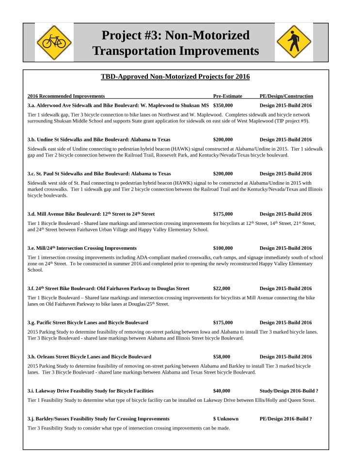
Project #3: Non-Motorized
Transportation Improvements
PROJECT NARRATIVE: In November 2010, Proposition 1 was approved by Bellingham
voters to establish a Transportation Benefit District (TBD) with the specific purpose of
funding arterial resurfacing, transit, and non-motorized improvements in Bellingham. Non-
motorized improvements are primarily prioritized through the Pedestrian and Bicycle Master
Plans, but also through grant funding opportunities and other capital improvement needs. Non-
motorized funding is provided by revenue from the TBD through the year 2020.
PROJECT STATUS: The TBD Board meets quarterly to discuss the status of TBD funds, projects in
construction and/or design/engineering, and possible future projects.
TRANSPORTATION IMPACT FEES COLLECTED Yes, Transportation System
RIGHT-OF-WAY ACQUISITION NECESSARY Undetermined
MULTIMODAL TRANSPORTATION BENEFITS: Additional sidewalk connections, crosswalks,
and various bicycle facilities will help to complete the citywide non-motorized transportation network.
TBD Board Approved Non-Motorized Projects for 2016 – Details on next page
2016 Recommended Improvements Pre-Estimate1 PE/Design/Construction
3.a. Alderwood Ave Sidewalk and Bike Boulevard: W. Maplewood to
end of existing sidewalk at Shuksan Middle School driveway $350,000 Design 2015-Build 2016
3.b. Undine St Sidewalks and Bike Boulevard: Alabama to Texas $200,000 Design 2015-Build 2016
3.c. St. Paul St Sidewalks and Bike Boulevard: Alabama to Texas $200,000 Design 2015-Build 2016
3.d. Mill Avenue Bike Boulevard: 12th Street to 24th Street $175,000 Design 2015-Build 2016
3.e. Mill/24th Intersection Crossing Improvements $100,000 Design 2015-Build 2016
3.f. 24th Street Bike Boulevard: Old Fairhaven Parkway to Douglas Street $22,000 Design 2015-Build 2016
3.g. Pacific Street Bicycle Lanes and Bicycle Boulevard $175,000 Design 2015-Build 2016
3.h. Orleans Street Bicycle Lanes and Bicycle Boulevard $58,000 Design 2015-Build 2016
3.i. Lakeway Drive Feasibility Study for Bicycle Facilities $40,000 PE/Design 2016-Build ?
3.j. Barkley/Sussex Feasibility Study for Crossing Improvements $Unknown PE/Design 2016-Build ?
10% Non-motorized Reserve – Local Match for Grants $160,000 2015 Grant Applications
Notes:
1.) Preliminary estimates of project costs are primarily from Pedestrian and Bicycle Master Plans, although
Alderwood, Undine, and St. Paul sidewalk cost estimates are based on preliminary engineering estimates.
FUNDING Previous PROJECT
No. PROJECT DESCRIPTION SOURCE Budget 2016 2017 2018 2019 2020 2021 TOTALS
Cost Estimates (000's) 2015 Dollars
FUNDED UNFUNDED
Non-Motorized Transportation1 TBD Non-Motor 1,422 1,473 1,502 1,530 1,563 1,592 1,620
3 Various Pedestrian and Bicycle 10% Reserve 158 160 165 170 170 175 180
Infrastructure Improvements Subtotal 1,580 1,633 1,667 1,700 1,733 1,767 1,800 11,880
Project #3: Non-Motorized
Transportation Improvements
TBD-Approved Non-Motorized Projects for 2016
2016 Recommended Improvements Pre-Estimate PE/Design/Construction
3.a. Alderwood Ave Sidewalk and Bike Boulevard: W. Maplewood to Shuksan MS $350,000 Design 2015-Build 2016
Tier 1 sidewalk gap, Tier 3 bicycle connection to bike lanes on Northwest and W. Maplewood. Completes sidewalk and bicycle network
surrounding Shuksan Middle School and supports State grant application for sidewalk on east side of West Maplewood (TIP project #9).
3.b. Undine St Sidewalks and Bike Boulevard: Alabama to Texas $200,000 Design 2015-Build 2016
Sidewalk east side of Undine connecting to pedestrian hybrid beacon (HAWK) signal constructed at Alabama/Undine in 2015. Tier 1 sidewalk
gap and Tier 2 bicycle connection between the Railroad Trail, Roosevelt Park, and Kentucky/Nevada/Texas bicycle boulevard.
3.c. St. Paul St Sidewalks and Bike Boulevard: Alabama to Texas $200,000 Design 2015-Build 2016
Sidewalk west side of St. Paul connecting to pedestrian hybrid beacon (HAWK) signal to be constructed at Alabama/Undine in 2015 with
marked crosswalks. Tier 1 sidewalk gap and Tier 2 bicycle connection between the Railroad Trail and the Kentucky/Nevada/Texas and Illinois
bicycle boulevards.
3.d. Mill Avenue Bike Boulevard: 12th Street to 24th Street $175,000 Design 2015-Build 2016
Tier 1 Bicycle Boulevard - Shared lane markings and intersection crossing improvements for bicyclists at 12th Street, 14th Street, 21st Street,
and 24th Street between Fairhaven Urban Village and Happy Valley Elementary School.
3.e. Mill/24th Intersection Crossing Improvements $100,000 Design 2015-Build 2016
Tier 1 intersection crossing improvements including ADA-compliant marked crosswalks, curb ramps, and signage immediately south of school
zone on 24th Street. To be constructed in summer 2016 and completed prior to opening the newly reconstructed Happy Valley Elementary
School.
3.f. 24th Street Bike Boulevard: Old Fairhaven Parkway to Douglas Street $22,000 Design 2015-Build 2016
Tier 1 Bicycle Boulevard – Shared lane markings and intersection crossing improvements for bicyclists at Mill Avenue connecting the bike
lanes on Old Fairhaven Parkway to bike lanes at Douglas/25th Street.
3.g. Pacific Street Bicycle Lanes and Bicycle Boulevard $175,000 Design 2015-Build 2016
2015 Parking Study to determine feasibility of removing on-street parking between Iowa and Alabama to install Tier 3 marked bicycle lanes.
Tier 3 Bicycle Boulevard - shared lane markings between Alabama and Illinois Street bicycle Boulevard.
3.h. Orleans Street Bicycle Lanes and Bicycle Boulevard $58,000 Design 2015-Build 2016
2015 Parking Study to determine feasibility of removing on-street parking between Alabama and Barkley to install Tier 3 marked bicycle
lanes. Tier 3 Bicycle Boulevard - shared lane markings between Alabama and Texas Street bicycle Boulevard.
3.i. Lakeway Drive Feasibility Study for Bicycle Facilities $40,000 Study/Design 2016-Build ?
Tier 1 Feasibility Study to determine what type of bicycle facility can be installed on Lakeway Drive between Ellis/Holly and Queen Street.
3.j. Barkley/Sussex Feasibility Study for Crossing Improvements $ Unknown PE/Design 2016-Build ?
Tier 3 Feasibility Study to consider what type of intersection crossing improvements can be made.

Project #4: Granary Ave - Bloedel Ave (Phase 1)
Multimodal Arterial Improvements(Roeder Avenue to Commercial Street)
PROJECT NARRATIVE: A new full standard arterial with sidewalks and bike lanes will be
constructed on the southeast side of the Granary building and will serve as the primary multimodal
access corridor to the northern portion of the redeveloped Waterfront District when Central Avenue is
closed to vehicle traffic. Granary Avenue will be constructed from Roeder Avenue to Bloedel Avenue
and then as close to Commercial Street as possible to allow the required transition down to existing
waterfront grade. A new traffic signal with left-turn lanes will be constructed at the Granary/Roeder
intersection. Actual alignment of this new arterial is subject to decisions made about the Granary
building through the public process for the Waterfront District Master Plan.
PROJECT STATUS: Funded. In engineering & design. Construction scheduled 2015-2016.
TRANSPORTATION IMPACT FEES COLLECTED No, 100% federal funds
RIGHT-OF-WAY ACQUISITION NECESSARY Yes, Port of Bellingham to dedicate ROW
MULTIMODAL TRANSPORTATION BENEFITS: Sidewalks, crosswalks, bicycle lanes, traffic
signal, turn lanes, increased access, safety, & efficiency.
FUNDING Previous PROJECT
No. PROJECT DESCRIPTION SOURCE Budget 2016 2017 2018 2019 2020 2021 TOTALS
Cost Estimates (000's) 2015 Dollars
FUNDED UNFUNDED
4 Granary-Bloedel Ave, Phase 1 Federal 6,700 Build
(Roeder to Bloedel to Commercial) Subtotal 6,700 6,700

Project #5: Bloedel Avenue, Phase 2
Multimodal Arterial Improvements(Commercial Street to Cornwall Avenue)
PROJECT NARRATIVE: A new minimum standard arterial connection will be constructed from the
terminus of Granary-Bloedel south to Laurel Street and then to Cornwall Avenue. This interim
connection will provide connectivity until a full-fledged arterial can be justified with new development
in the redeveloped Waterfront District. A new railroad crossing will be necessary on interim Laurel and
a traffic signal with left-turn lanes will be constructed at the Bloedel/Cornwall intersection.
PROJECT STATUS: Funded. In engineering & design. Construction scheduled 2015-2016.
MULTIMODAL TRANSPORTATION BENEFITS
Crosswalks, traffic signal, turn lanes, increased access, safety, & efficiency.
TRANSPORTATION IMPACT FEES COLLECTED Yes, local funds
RIGHT-OF-WAY ACQUISITION NECESSARY Yes, Port of Bellingham to dedicate ROW
FUNDING Previous PROJECT
No. PROJECT DESCRIPTION SOURCE Budget 2016 2017 2018 2019 2020 2021 TOTALS
Cost Estimates (000's) 2015 Dollars
FUNDED UNFUNDED
5 Bloedel Avenue, Phase 2 Street 1,500 Build
(Commercial to Cornw all) Subtotal 1,500 1,500

Project #6: James/Woodstock
Intersection Safety Improvements (Woodstock/James)
PROJECT NARRATIVE: James Street was reconstructed in 2014-15 as an urban multimodal corridor
between East Orchard Drive and Sunset Pond Park. In 2015, Squalicum Creek will be re-routed from
its current outlet at the Woodstock/James intersection to a new stream channel flowing beneath the new
bridge on James Street. Once the stream re-route is complete, the existing outlet from Sunset Pond can
be blocked off and reconstruction of the James/Woodstock intersection will improve sight distance and
safety by allowing through traffic to flow to Woodstock with stop-control installed at northbound James
from Sunset Square.
PROJECT STATUS (ES-318): PE & Design Complete. Construction scheduled 2016. This project
must be purposely delayed until completion of both the 2014 James Street bridge and road
reconstruction, as well as the 2015 Sqaulicum Creek re-route between Sunset Pond and Bug Lake,
which will mitigate impacts from James/Woodstock.
TRANSPORTATION IMPACT FEES COLLECTED No, 100% federal funds
RIGHT-OF-WAY ACQUISITION NECESSARY Yes
MULTIMODAL TRANSPORTATION BENEFITS: Sidewalks, bicycle lanes, center turn lane,
intersection safety and efficiency, improvements to Sunset Pond Park access and parking lot.
FUNDING Previous PROJECT
No. PROJECT DESCRIPTION SOURCE Budget 2016 2017 2018 2019 2020 2021 TOTALS
Cost Estimates (000's) 2015 Dollars
FUNDED UNFUNDED
6 James/Woodstock Intersection Federal STP-R 1,850 Build
Safety Improvements (ES-318) Subtotal 1,850 1,850

Project #7: Arctic Avenue Multimodal Arterial
Connection (W. Bakerview to Mahogany)
PROJECT NARRATIVE: Arctic Avenue will create needed multimodal arterial access to serve land
that has been zoned for commercial and industrial development since West Bakerview was constructed
in the mid-1990’s. Arctic Avenue will connect West Bakerview Road to Mohogany Avenue and will
include sidewalks and bike lanes on both sides. This project complements improvements that the City
constructed in 2013 on the West Bakerview overpass of Interstate 5 and will support significant
economic development in the northwestern portion of Bellingham and the Urban Growth Area.
PROJECT STATUS: To be funded and constructed by private development in 2015-2016.
TRANSPORTATION IMPACT FEES COLLECTED No, privately funded and constructed
RIGHT-OF-WAY ACQUISITION NECESSARY? Yes, to be dedicated by private development
MULTIMODAL TRANSPORTATION BENEFITS
Sidewalks, marked bicycle lanes, vehicle travel lanes, turn lanes, and possible future WTA transit route
if ridership demand warrants.
FUNDING Previous PROJECT
No. PROJECT DESCRIPTION SOURCE Budget 2016 2017 2018 2019 2020 2021 TOTALS
Cost Estimates (000's) 2015 Dollars
FUNDED UNFUNDED
7 Arctic Avenue Multimodal Arterial Private Mitigation 2,100 Build
W. Bakerview Rd to Mahogany Ave Subtotal 2,100 2,100

Project #8: Mahogany Avenue Multimodal Arterial
Connection (Northwest Avenue to Pacific Highway)
PROJECT NARRATIVE: Mahogany Avenue will create needed multimodal arterial access to serve
land that has been zoned for commercial and industrial development since West Bakerview was
constructed in the mid-1990’s as well as land zoned for residential development annexed to the City in
2013. This project creates east-west connectivity between Northwest Avenue and Pacific Highway and
will support significant economic development in the northwestern portion of Bellingham.
PROJECT STATUS: Partially funded. Possible mitigation funding from private development.
TRANSPORTATION IMPACT FEES COLLECTED Yes, for local funds expended
RIGHT-OF-WAY ACQUISITION NECESSARY Yes
MULTIMODAL TRANSPORTATION BENEFITS
Sidewalks, marked bicycle lanes, vehicle travel lanes, turn lanes at intersections, service and freight
delivery, and possible future WTA transit route if ridership demand warrants.
FUNDING Previous PROJECT
No. PROJECT DESCRIPTION SOURCE Budget 2016 2017 2018 2019 2020 2021 TOTALS
Cost Estimates (000's) 2015 Dollars
FUNDED UNFUNDED
Mahogany Avenue Street 500 1,250
Multimodal Arterial Federal STP 1,250
8 East-West arterial access betw een State TIB 2,250 Build
Northw est Ave and Pacific Highw ay Private Mitigation 850
Subtotal 4,000 2,100 6,100

Project #9: West Maplewood Avenue
Multimodal Corridor Improvements(Northwest Avenue to Alderwood Avenue)
PROJECT NARRATIVE: West Maplewood Avenue is an old concrete section of the former Pacific
Highway through Bellingham that is in need of arterial resurfacing, marked bicycle lanes on both sides,
and construction of new concrete curb, gutter, storm drains, and sidewalk that is missing along the east
side from Northwest Avenue to Alderwood Avenue. Shuksan Middle School abuts West Maplewood
and Birchwood Elementary School is less than ¼-mile away, which means that hundreds of school
children walk along West Maplewood. WTA runs three individual transit routes (3, 4, and 55) along
West Maplewood, all of which connect downtown to Cordata Station in north Bellingham. A major
shopping center is located at the south end of West Maplewood at Northwest Avenue.
PROJECT STATUS: Unfunded; Design & engineering 2015; State bicycle and pedestrian grant
application pending; Construction scheduled July-August 2016 (Sidewalks depend on grant funding).
TRANSPORTATION IMPACT FEES COLLECTED? Resurfacing not eligible, Yes for sidewalks
RIGHT-OF-WAY ACQUISITION NECESSARY No
MULTIMODAL TRANSPORTATION BENEFITS
Sidewalk (east side), ADA curb ramps, crosswalks, marked bicycle lanes, and arterial resurfacing.
FUNDING Previous PROJECT
No. PROJECT DESCRIPTION SOURCE Budget 2016 2017 2018 2019 2020 2021 TOTALS
Cost Estimates (000's) 2015 Dollars
FUNDED UNFUNDED
West Maplewood Avenue TBD Resurface 790
9 Multimodal Improvements Federal SRTS
Unknow n 895
Subtotal 1,685 1,685

Project #10: James/Bakerview
Intersection Safety Improvements
PROJECT NARRATIVE: East Bakerview Road is a principal arterial and major trucking route
between the Irongate industrial area to I-5. James Street is the only north-south secondary arterial
between Sunset Drive and Kellogg Road. Increasing traffic volumes and lack of north-south left-turn
lanes on James have contributed to an increase in speeding and collisions at the James/Bakerview
intersection. Constructing an expandable multimodal roundabout will slow speeding vehicles, reduce
collisions, and improve safety for all transportation users, including trucks and recreational trail users,
while also providing long-term transportation capacity, as the King Mountain area develops over time.
PROJECT STATUS: 60% engineering and design 2013-2015; State and federal safety grant
applications pending; If grants awarded, construction possible in 2017.
TRANSPORTATION IMPACT FEES COLLECTED Yes, for local funds
RIGHT-OF-WAY ACQUISITION NECESSARY Yes
MULTIMODAL TRANSPORTATION BENEFITS: Sidewalks, crosswalk with pedestrian refuges,
bicycle lanes, vehicle collision reduction, increased safety & efficiency of freight and goods movement.
FUNDING Previous PROJECT
No. PROJECT DESCRIPTION SOURCE Budget 2016 2017 2018 2019 2020 2021 TOTALS
Cost Estimates (000's) 2015 Dollars
FUNDED UNFUNDED
James/Bakerview Intersection Street 120
Safety Improvements Federal STP-R 385
10 (Expandable roundabout) State TIB 1,400
Unknow n 1,900
Subtotal 1,905 1,900 3,805

Project #11: Orchard Drive Multimodal Arterial
& Bay to Baker Trail Connection Beneath I-5 PROJECT NARRATIVE: Construct a multimodal arterial and trail connection from the corner of
Birchwood Avenue/Squalicum Parkway generally along the former railroad bed (north of Bug Lake),
through the railroad tunnel beneath Interstate 5, to James/Orchard north of Sunset Pond Park These new
east-west arterial and trail connections will enhance regional transportation circulation for all modes
between rapidly-growing northern Bellingham, St Joseph’s Hospital, and central Bellingham.
Construction of this arterial street will ease pressure on the Interstate interchanges at Meridian and
Sunset and is the last opportunity for a grade-separated crossing of Interstate 5 in Bellingham.
PROJECT STATUS: 60% design engineering 2014; Squalicum Re-route scheduled 2015; Additional
funding being sought and public-private partnerships being explored.
TRANSPORTATION IMPACT FEES COLLECTED Yes, if local public funds are used
RIGHT-OF-WAY ACQUISITION NECESSARY Yes, for both trail and street
MULTIMODAL TRANSPORTATION BENEFITS: Sidewalk north side, on-street bicycle lanes
both sides, off-street multi-use Bay-to-Baker trail, improved access and emergency response time to St
Joseph hospital, potential transit route, grade-separated multimodal crossing of Interstate 5 barrier.
FUNDING Previous PROJECT
No. PROJECT DESCRIPTION SOURCE Budget 2016 2017 2018 2019 2020 2021 TOTALS
Cost Estimates (000's) 2015 Dollars
FUNDED UNFUNDED
Orchard Drive Extension Street 864
and Bay to Baker Trail Federal STP-R 1,250
11 Multimodal Grade-Separated Greenw ays 3 2,390 1,000 500
Crossing of Interstate 5 from Unknow n 8,500
Birchw ood/Squalicum to James St Subtotal 4,504 1,000 9,000 14,504

Project #12: West Horton Road
Multimodal Corridor Extension, Phase 1; (Horton terminus to Aldrich Road)
PROJECT NARRATIVE: Regional growth and development, including the development of a 30-acre
Cordata Park with parking access from Horton requires that West Horton Road be extended as a
secondary arterial street with sidewalks and bicycle lanes on both sides from the current terminus to
Aldrich Road. Environmental impacts require land acquisition, off-site mitigation, and attempts to
minimize the road prism footprint. Dedicated left-turn lanes will be needed at the intersection of W.
Horton/Aldrich.
PROJECT STATUS: Feasibility studies, wetland delineations, & survey completed 2009-2011; land
acquisition & mitigation planning 2012-2015; 60% PE & Design 2015; additional funding being sought.
TRANSPORTATION IMPACT FEES COLLECTED Yes, if local public funds are used
RIGHT-OF-WAY ACQUISITION NECESSARY No
MULTIMODAL TRANSPORTATION BENEFITS: Increased access, safety, and connectivity for
school children, pedestrians, park and trail users, bicyclists, transit riders, vehicles, and freight trucks.
FUNDING Previous PROJECT
No. PROJECT DESCRIPTION SOURCE Budget 2016 2017 2018 2019 2020 2021 TOTALS
Cost Estimates (000's) 2015 Dollars
FUNDED UNFUNDED
West Horton Road Multimodal Street
Corridor Improvements-Phase 1 Private Mitigation 812
12 (Current terminus to Aldrich Road) Federal STP-R 500
Unknow n 4,000
Subtotal 1,312 4,000 5,312

Project #13: Cordata/Stuart
Intersection Safety Improvements
PROJECT NARRATIVE: Cordata Parkway is the major north-south secondary arterial through the
Cordata Neighborhood and Stuart Road provides east-west access to Whatcom Community College
(WCC). Development is proposed on all four corners and the Parks Department purchased 27 acres for
a regional park on the northeast side of this intersection. Increasing traffic volumes will make
northbound left-turns difficult, create vehicle queues, and block access to WCC and residential
driveways. A multimodal roundabout will slow vehicles, reduce collisions, and improve safety for all
transportation users, while also providing long-term transportation capacity, as the Cordata
Neighborhood continues to develop over time.
PROJECT STATUS: Unfunded, excellent grant funding candidate, private mitigation contribution
TRANSPORTATION IMPACT FEES COLLECTED Yes, for local funds
RIGHT-OF-WAY ACQUISITION NECESSARY Yes
MULTIMODAL TRANSPORTATION BENEFITS: Crosswalks with pedestrian refuges, bicycle
lanes, vehicle collision reduction, increased safety & efficiency of freight and goods movement.
FUNDING Previous PROJECT
No. PROJECT DESCRIPTION SOURCE Budget 2016 2017 2018 2019 2020 2021 TOTALS
Cost Estimates (000's) 2015 Dollars
FUNDED UNFUNDED
Cordata/Stuart Roundabout Street
13 Public-Private Partnership Unknow n 2,000
Private Mitigation
Subtotal 2,000 2,000

Project #14: Boulevard Park to Cornwall Avenue
Overwater Pedestrian Walkway
PROJECT NARRATIVE: This Parks Department project will construct a 2,360 linear foot overwater
pedestrian and bicycle boardwalk extension of the South Bay Trail at Boulevard Park to the new
Cornwall Beach Park as part of the Bellingham Waterfront District redevelopment. An additional
$2,500,000 in funding will be required before construction can occur.
PROJECT STATUS – Parks Department. PE, Design, and Permitting. Construction pending
additional funding.
TRANSPORTATION IMPACT FEES COLLECTED Parks Project, Not Eligible
RIGHT-OF-WAY ACQUISITION NECESSARY No
MULTIMODAL TRANSPORTATION BENEFITS
Pedestrian and bicycle connection between Fairhaven and Waterfront District.
FUNDING Previous PROJECT
No. PROJECT DESCRIPTION SOURCE Budget 2016 2017 2018 2019 2020 2021 TOTALS
Boulevard Park to Cornwall Park 1st 1/4 REET 150
Overwater Pedestrian Walkway Federal STP-E 2,319
14 (Boulevard Park to Waterfront) Greenw ays & PIF 100 4,500
Parks Department Unknow n 2,500
Subtotal 2,389 4,500 2,500 9,389
Cost Estimates (000's) 2015 Dollars
FUNDED UNFUNDED

Project #15: West Bakerview/Interstate 5
New Northbound On-Ramp (Eastside of freeway: Pacific Highway to mainline Interstate 5)
PROJECT NARRATIVE: The 2011 WSDOT Value Planning Study (VPS) for the West Bakerview/I-
5 Interchange identified alternatives to the recommended $45 million Single Point Urban Interchange
(SPUI) in recognition that it is unlikely to ever be funded. The VPS identified $3.5 million in low-cost
improvements, which were constructed by Bellingham in 2013 with funding contributions from
Whatcom County, Economic Development Investment Board, Port of Bellingham, Fred Meyer, TIF
assessments from private developers, and Washington TIB. The VPS also identified a new northbound
on-ramp on the east side of I-5 as a viable alternative that would improve multimodal safety and
mobility, reduce significant traffic congestion across the I-5 overpass, enhance regional multimodal
transportation circulation, and would continue to support economic development in northwestern
Bellingham.
PROJECT STATUS: Unfunded. Work with WSDOT to complete Interchange Justification Report.
TRANSPORTATION IMPACT FEES COLLECTED Yes, for local funding
RIGHT-OF-WAY ACQUISITION NECESSARY Yes
MULTIMODAL TRANSPORTATION BENEFITS: Reduced traffic congestion on I-5 overpass,
maintain freight and goods movement and on-time WTA transit service.
FUNDING Previous PROJECT
No. PROJECT DESCRIPTION SOURCE Budget 2016 2017 2018 2019 2020 2021 TOTALS
Cost Estimates (000's) 2015 Dollars
FUNDED UNFUNDED
West Bakerview/Interstate 5 Street
15 New Northbound On-Ramp WSDOT
(east side of freew ay) Unknow n 10,000
Subtotal 10,000 10,000
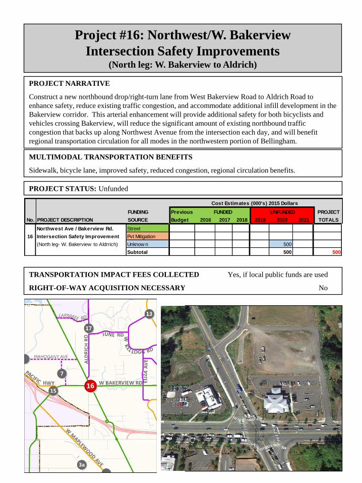
Project #16: Northwest/W. Bakerview
Intersection Safety Improvements (North leg: W. Bakerview to Aldrich)
PROJECT NARRATIVE
Construct a new northbound drop/right-turn lane from West Bakerview Road to Aldrich Road to
enhance safety, reduce existing traffic congestion, and accommodate additional infill development in the
Bakerview corridor. This arterial enhancement will provide additional safety for both bicyclists and
vehicles crossing Bakerview, will reduce the significant amount of existing northbound traffic
congestion that backs up along Northwest Avenue from the intersection each day, and will benefit
regional transportation circulation for all modes in the northwestern portion of Bellingham.
PROJECT STATUS: Unfunded
TRANSPORTATION IMPACT FEES COLLECTED Yes, if local public funds are used
RIGHT-OF-WAY ACQUISITION NECESSARY No
MULTIMODAL TRANSPORTATION BENEFITS
Sidewalk, bicycle lane, improved safety, reduced congestion, regional circulation benefits.
FUNDING Previous PROJECT
No. PROJECT DESCRIPTION SOURCE Budget 2016 2017 2018 2019 2020 2021 TOTALS
Cost Estimates (000's) 2015 Dollars
FUNDED UNFUNDED
Northwest Ave / Bakerview Rd. Street
16 Intersection Safety Improvement Pvt Mitigation
(North leg- W. Bakerview to Aldrrich) Unknow n 500
Subtotal 500 500

Project #17: Aldrich Road
Multimodal Safety Improvements (Mahogany Avenue to West Horton Road)
PROJECT NARRATIVE: Aldrich Road is an old rural standard County road that was added to the
City in a 2009 annexation. Several improvements are needed to bring this road up to urban arterial
standards, including reconstruction of the roadbed, new asphalt overlay to replace chip seal surface,
bicycle lanes, curb, gutter, and sidewalk on both sides of the road, as well as adequate street lighting.
These improvements will take time and will be very expensive due to requirements to mitigate impacts
to environmental features (wetlands, streams) and are likely to be completed in distinct phases
depending on the availability of State and federal grants.
PROJECT STATUS: PE, Design beginning 2015-2016. Additional funding will be sought.
TRANSPORTATION IMPACT FEES COLLECTED Yes, for local funds
RIGHT-OF-WAY ACQUISITION NECESSARY Unknown
MULTIMODAL TRANSPORTATION BENEFITS: Road reconstruction, sidewalks, bicycle lanes,
street lighting.
FUNDING Previous PROJECT
No. PROJECT DESCRIPTION SOURCE Budget 2016 2017 2018 2019 2020 2021 TOTALS
Cost Estimates (000's) 2015 Dollars
FUNDED UNFUNDED
Aldrich Road Phased Street
17 Multimodal Arterial Improvement Pvt Mitigation
(Mahogany to W. Horton) Unknow n 4,000
Subtotal 4,000 2,200

Project #18: James Street
Multimodal Safety Improvements (East Orchard Drive to East Bakerview Road)
PROJECT NARRATIVE: James Street is the only north- south transportation corridor serving north-
central Bellingham between Meridian (SR 539) and Hannegan, which is already zoned for up to 2,000
new housing units. James Street also provides access to Sunset Pond Park between Sunset and East
Bakerview. Resurfacing, elimination of a sight distance issue on a hill, and improvement to urban
secondary arterial street standards with sidewalks, bicycle lanes, turn lanes, enclosed drainage, and
street lighting from East Orchard Drive north to Kellogg Road.
PROJECT STATUS: PE, Design beginning 2014. Additional funding will be sought.
TRANSPORTATION IMPACT FEES COLLECTED Yes, for local funds
RIGHT-OF-WAY ACQUISITION NECESSARY Unknown
MULTIMODAL TRANSPORTATION BENEFITS: Sidewalks, bicycle lanes, turn lanes, increased
access, safety, sight distance, and efficiency.
FUNDING Previous PROJECT
No. PROJECT DESCRIPTION SOURCE Budget 2016 2017 2018 2019 2020 2021 TOTALS
Cost Estimates (000's) 2015 Dollars
FUNDED UNFUNDED
James Street Street
18 Multimodal Improvements Pvt Mitigation
(East Orchard to Bakerview ) Unknow n 7,500
Subtotal 7,500 7,500

Project #19: North James Street
Multimodal Arterial Connection (Gooding Avenue to Van Wyck Road)
PROJECT NARRATIVE: James Street currently terminates at Gooding Avenue, but the
Transportation Element of the Bellingham Comprehensive Plan identifies the need for James to be
extended north to Van Wyck Road as a full standard secondary arterial. James Street is the only north-
south transportation corridor serving north-central Bellingham between Meridian (SR 539) and
Hannegan, which is already zoned for up to 2,000 new housing units. In addition to supporting the
development planned for the King Mountain Neighborhood, this northern extension of James Street will
provide another north-south corridor parallel to Meridian (SR 539), which will help to ease some of the
northbound evening and weekend traffic congestion.
PROJECT STATUS: Private developer constructed first phase 2014 with King Mountain subdivision
TRANSPORTATION IMPACT FEES COLLECTED Yes, if local public funds are used
RIGHT-OF-WAY ACQUISITION NECESSARY? Yes, private development to dedicate
MULTIMODAL TRANSPORTATION BENEFITS: Pedestrian sidewalks, bike lanes, center turn
lanes at intersections, regional multimodal transportation connectivity, and potential future transit route.
FUNDING Previous PROJECT
No. PROJECT DESCRIPTION SOURCE Budget 2016 2017 2018 2019 2020 2021 TOTALS
Cost Estimates (000's) 2015 Dollars
FUNDED UNFUNDED
North James Street Pvt Mitigation
19 Multimodal Arterial Connection Unknow n 3,000
(Gooding to Van Wyck) Subtotal 3,000 3,000

Project #20: Commercial Green Loop
Multimodal Improvements(Bloedel Avenue to Shoreline)
PROJECT NARRATIVE: A new arterial loop connection will be constructed west of Bloedel Avenue
with park greens in the center of the loop. The Commercial Green Loop will serve as the primary
western multimodal access in the early phases of the long-term redevelopment of the Waterfront
District.
PROJECT STATUS:
Construction schedule is uncertain pending a master plan, additional funding, and actual development.
TRANSPORTATION IMPACT FEES COLLECTED Yes, if local public funds are used
RIGHT-OF-WAY ACQUISITION NECESSARY Yes, Port of Bellingham to dedicate
MULTIMODAL TRANSPORTATION BENEFITS: Sidewalks, crosswalks, bicycle lanes, bus
pullouts where possible, turn lanes, increased access, safety, & efficiency.
FUNDING Previous PROJECT
No. PROJECT DESCRIPTION SOURCE Budget 2016 2017 2018 2019 2020 2021 TOTALS
Cost Estimates (000's) 2015 Dollars
FUNDED UNFUNDED
Commercial Green Loop Street
20 (Bloedel Ave to Shoreline) Unknow n 2,200
Subtotal 2,200 2,200
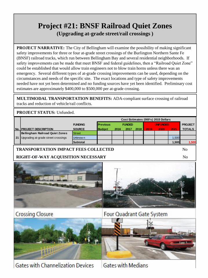
Project #21: BNSF Railroad Quiet Zones (Upgrading at-grade street/rail crossings )
PROJECT NARRATIVE: The City of Bellingham will examine the possibility of making significant
safety improvements for three or four at-grade street crossings of the Burlington Northern Sante Fe
(BNSF) railroad tracks, which run between Bellingham Bay and several residential neighborhoods. If
safety improvements can be made that meet BNSF and federal guidelines, then a “Railroad Quiet Zone”
could be established that would allow train engineers not to blow train horns unless there was an
emergency. Several different types of at-grade crossing improvements can be used, depending on the
circumstances and needs of the specific site. The exact locations and type of safety improvements
needed have not yet been determined and no funding sources have yet been identified. Preliminary cost
estimates are approximately $400,000 to $500,000 per at-grade crossing.
PROJECT STATUS: Unfunded.
TRANSPORTATION IMPACT FEES COLLECTED No
RIGHT-OF-WAY ACQUISITION NECESSARY No
MULTIMODAL TRANSPORTATION BENEFITS: ADA-compliant surface crossing of railroad
tracks and reduction of vehicle/rail conflicts.
FUNDING Previous PROJECT
No. PROJECT DESCRIPTION SOURCE Budget 2016 2017 2018 2019 2020 2021 TOTALS
Cost Estimates (000's) 2015 Dollars
FUNDED UNFUNDED
Bellingham Railroad Quiet Zones Street
21 Upgrading at-grade street crossings Unknow n 1,500
Subtotal 1,500 1,500

Project #22: Northshore Drive Non-Motorized
Improvements (Britton Road to City limits)
PROJECT NARRATIVE: A 5-foot sidewalk currently exists on the north side of Northshore Drive
from Britton Road to Academy Street 1,580 linear feet (0.3 mile). This project would add a pervious
concrete sidewalk and bike lane to the east side of Northshore Drive from Academy to the City limits
3,800 linear feet ( 0.72 mile) and a pervious bike lane to the west side of Northshore Drive from Britton
Road to the City limits 5,460 linear feet ( 1.03 mile). This would result in the same cross section that
exists on Northshore Drive between Alabama and Poplar. Storm water treatment, landscaping impacts,
driveway slopes, topography and utility pole relocation are expected to be challenging and expensive
along this section of Northshore Drive.
PROJECT STATUS: Unfunded.
TRANSPORTATION IMPACT FEES COLLECTED Yes, if local transportation funds used
RIGHT-OF-WAY ACQUISITION NECESSARY Unknown
MULTIMODAL TRANSPORTATION BENEFITS
Pervious concrete sidewalk and bike lanes in addition to existing vehicle travel lanes.
FUNDING Previous PROJECT
No. PROJECT DESCRIPTION SOURCE Budget 2016 2017 2018 2019 2020 2021 TOTALS
Cost Estimates (000's) 2015 Dollars
FUNDED UNFUNDED
Northshore Drive TBD Non-Motor
22 Non-motorized Improvements Unknow n 7,000
(Britton Road to City limits) Subtotal 7,000 7,000