Transportation Corridor Study
91
Transportation Corridor Study rt McMurray Volume 5 Appendix Effect Upon Human Settlement Patterns prepared for ENVIRONMENT october, 1973 by k.c. mackenzie associates limited commissioned by stewart weir stewart watson & hei nrichs edmonton, alberta
Transcript of Transportation Corridor Study
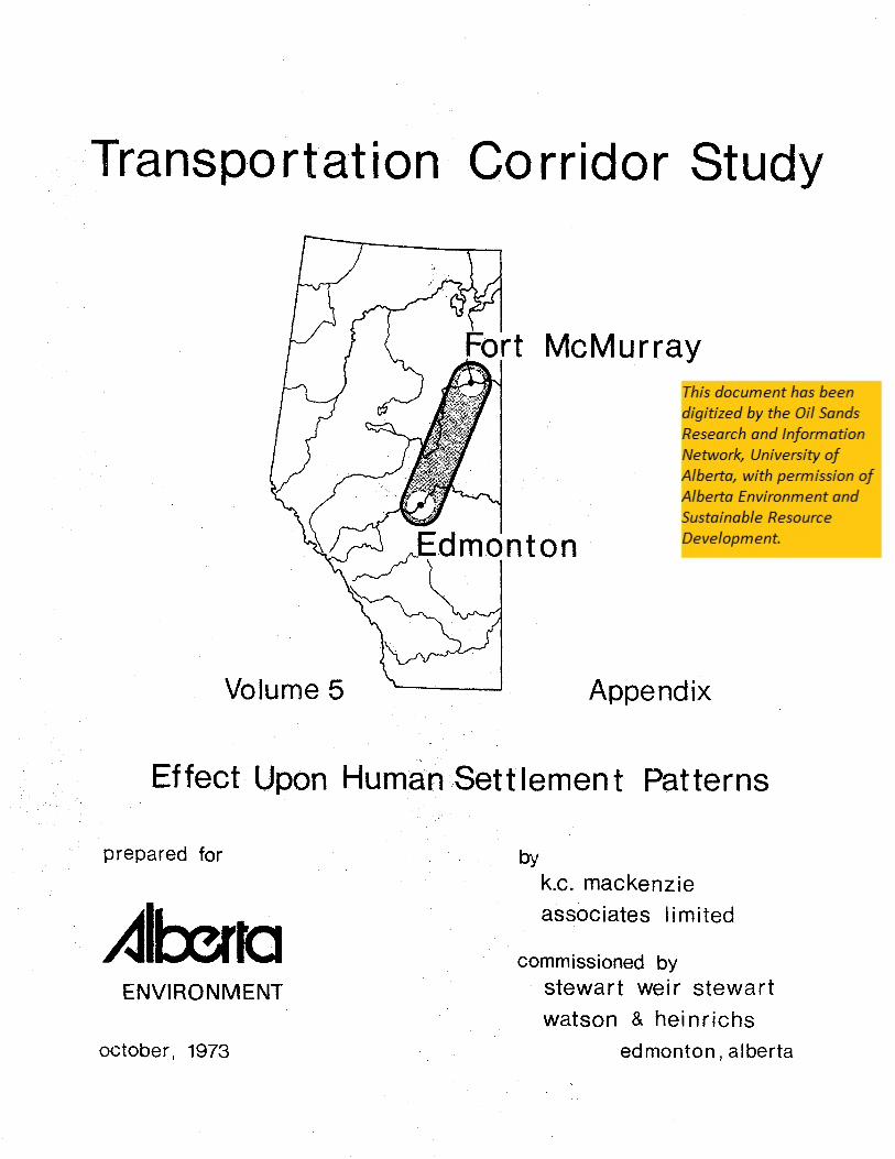
Transportation Corridor Study
rt McMurray
Volume 5 Appendix
Effect Upon Human Settlement Patterns
prepared for
ENVIRONMENT
october, 1973
by k.c. mackenzie
associates limited
commissioned by stewart weir stewart
watson & hei nrichs
edmonton, alberta
Reviewer
OSRIN Stamp
------------- ~~ C!L <:!a!ta:dumzie J\~H.'iodates 1fiimHeu ------------------''--
TRANSPORTATION CORRIDOR STUDY
FORT McMURRAY TO EDMONTON
VOLUME 5 - APPENDIX
lIEFFECT UPON HUMAN SETTLEMENT PATTERNStI
Prepared For:
Alberta Environment
The Honourable William Yurko
By:
K.C. Mackenzie Associates Limited, Edmonton, Alberta October, 1973
Commissioned By:
Stewart, Weir, Stewart, Watson & Heinrichs
PROVIDING CONSULTING SERVICES IN URBAN PLANNING AND DEVELOPMEN'T -----------

--------------- ~. (11. Jlitatkeuzie J\sMdates 1Gimiteu ---------------
TABLE OF CONTENTS
SECTION ONE - THE PURPOSE AND APPROACH OF THE REPORT 1
I. II.
III.
INTRODUCTION PURPOSE OF THE REPORT THE APPROACH
1 3 4
SECTION TWO - THE CORRIDOR AS A USE OF LAND 5
I. II.
III. IV.
THE NATURE OF THE CORRIDOR THE PHILOSOPHY OF CORRIDOR LOCATION THE APPLICATION OF THE MULTI-USE CONCEPT BASIC FEATURES OF THE PIPELINE CORRIDOR
5 6 7 8
SECTION THREE - THE REGIONS OF THE STUDY AREA 11
Ie THE FORT McMURRAY REGION 11 A. The Settlement Pattern 11
1. The Geographic Setting: 11 2. The Economic Base and Future Growth: 12 3. Population Analysis: 13
B. Specific Corridor Considerations 22 1. Existing Pipelines: 22 2. The Tar Sands Gathering System: 24 3. The Multi-Use Concept: 24
c. Recommendations - Fort McMurray Region 26
II. THE WILDERNESS REGION A. The Settlement Pattern
1. The Geographic Setting: 2. Highway Service Communities: 3. Native and Railway Settlements:
B. Specific Corridor Considerations 1. Orientation of Corridor: 2. Settlement Bypasses: 3. Multiple Use Potential:
c. Recommendations - Wilderness Region
28 28 28 28 30
31 31 32 33
34
---"---------- PROVIDING CONSULTING SERVICES IN URBAN PLANNING AND DEVELOPMENT -----------

-------------- tJR. Qt 2ffi{tttkeuzie ~$$odttte$ 1Uimitelk ---------------
III. THE SETTLED AGRICULTURAL REGION A. The Settlement Pattern
1. The Geographic Setting: 2. The Rural Settlement Pattern: 3. Urban Settlements:
B. Specific Corridor Considerations 1. Rural Areas: 2. Urban Settlements: 3. The Multi-Use Concept:
c. Recommendations - Settled Agricultural Region
IV 0 THE REGION OF METROPOLITAN INFLUENCE A. The Settlement Pattern
1. The Geographic Setting: 2. Minor Settlements: 3. The Town of Fort Saskatchewan:
Page
35 35 35 36 41
50 50 54 58
58
60 60 60 60 62
Bo Specific Corridor Considerations 63 1. Hiscellaneous Factors: 63 2. Settlement Bypass Distances: 65 3. Multiple Use Potential: 66
C. Recommendations - Region of Metropolitan Influence 67
v. THE EDMONTON METROPOLITAN REGION Ao The Settlement Pattern
1. The Existing Land Use Pattern: 2. Areas of Planned Development: 3. The Future Land Use Pattern:
68 68 68 68 69
B. Specific Corridor Considerations 70 1. The Sherwood Park Proposal: 70 2. Industrial Land and the Corridor: 72 3. Multiple Use Potential: 72
C. Recommendations - Edmonton Metropolitan Region 73
----------- PROVIDING CONSULTING SERVICES IN URBAN PLANNING AND DEVELOPMENT ------------
-------------- !ftL ((t ~a:tkelUie ~5sodate5 1Jlintiteb: --------------
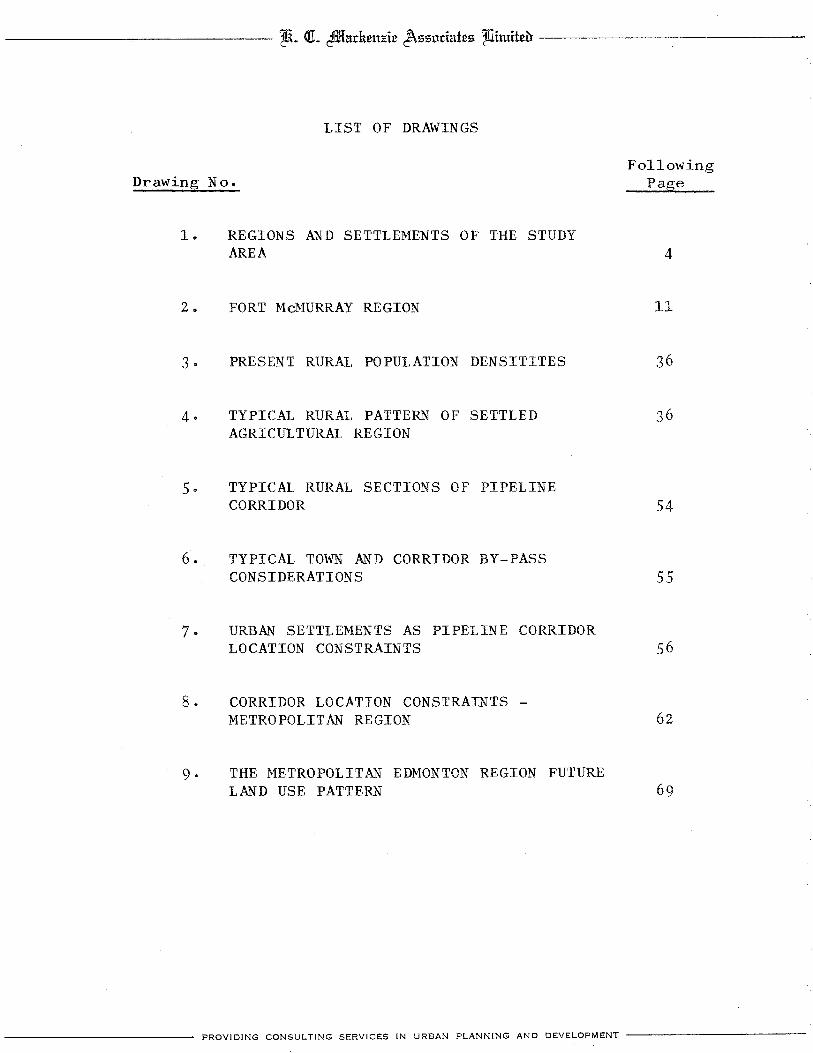
LIST OF DRAWINGS
Drawing No.
1.
2 •
3·
4·
REGIONS AND SETTLEMENTS OF THE STUDY AREA
FORT McMURRAY REGION
PRESENT RURAL POPULATION DENSITITES
TYPICAL RURAL PATTERN OF SETTLED AGRICULTURAL REGION
5. TYPICAL RURAL SECTIONS OF PIPELINE CORRIDOR
6. TYPICAL TOWN AND CORRIDOR BY-PASS CONSIDERATIONS
7· URBAN SETTLEMENTS AS PIPELINE CORRIDOR LOCATION CONSTRAINTS
8. CORRIDOR LOCATION CONSTRAINTS -METROPOLITAN REGION
9· THE METROPOLITAN EDMONTON REGION FUTURE LAND USE PATTERN
Following Page
4
11
36
54
55
56
62
69
---------- PROVIDING CONSULTING SERVICES IN URBAN PLANNING AND DEVELOPMENT ----------

-------------- ~~ (11. 2Jlltadu~mde J\550date5 'Ifiintiteu ---------------
LIST OF TABLES
Table No.
I FORT McMURRAY POPULATION CHARACTERISTICS 15
II FORT McMURRAY POPULATION PROJECTIONS 19
III FORT McMURRAY POPULATION PROJECTIONS 20
IV RURAL DEPOPULATION TREND 38
V PROJECTED RURAL POPULATION DENSITY 40
VI URBAN SETTLEMENTS DATA MATRIX 42
VII EXAMPLE CALCULATION OF POTENTIAL GROWTH INDEX FOR HYPOTHETICAL SETTLEMENT
VIII
IX
X
RURAL LOCATION ALTERNATIVES
URBAN SETTLEMENT BYPASS DISTANCES
LIST OF SETTLEMENTS IN THE STUDY AREA ACCORDING TO REGION
45
52
59
75
---------- PROVIDING CONSULTING SERVICES IN URBAN PLANNING AND DEVELOPMENT ----------

-------------- ti~ Qt 4IDlu.ckeuzie J\sslldutes 1Jlitttitea --------------
SECTION ONE
THE PURPOSE AND APPROACH OF THE REPORT
I. INTRODUCTION
The following report represents the preliminary input
of K.C. Mackenzie Associates Limited to the Athabasca
Tar Sands Corridor Study being prepared by Stewart,
Weir, Stewart Watson & Heinrichs for the Honourable
W.J. Yurko, Minister of the Environment of the
Government of the Province of Alberta. The objective
of the Corridor Study is to determine the most desirable
corridor route for a series of pipelines carrying
synthetic crude oil from the Athabasca Tar Sands to
the Edmonton area. The study is also required to
examine the possibility of multiple use of the future
corridor and the fundamental purpose of the study is
to minimize the environmental impact of pipelines in
particular and, where feasible, other transportation
and communications facilities.
The general responsibility of K.C. Mackenzie Associates
Limited is to examine various aspects of the corridor
from the standpoint of human settlement patterns within
the study area. This report therefore consists of the
gathering and analysis of relevant information that will
contribute to the understanding, by the Study Group,
of the inter-relationship between the proposed corridor
and the human settlement pattern.
PROVIDING CONSULTING SERVICES IN URBAN PLANNING AND DEVELOPMENT ------------

---------------- ~. QL 2fl!ladum;;:ic J\ssodatcs 1liimitca ---------------
- 2 -
This report has been prepared by Mr. K.C. Mackenzie,
M.T.P.I.C., and Mr. John Andrew, Research Assistant.
The information and opinions contained herein are
intended primarily for the use of various members
of the multi-disciplinary Study Group, including
representatives of various governmental agencies and
departments, representatives of firms and agencies
who have contributed personnel to the Corridor Study,
and other consultants retained to contribute specialized
input to the Corridor Study. The authors gratefully
acknowledge the assistance provided by innumerable officials
of public agencies and departments of the Provincial
Government, representatives of municipal authorities
and personnel working with private firms from whom
input and advice was obtained.
PROVIDING CONSULTING SERVICES IN URBAN PLANNING AND DEVELOPMENT ------------

--------------- Z&~ at ctffi{&.citeu;;ie J\sso.cl&ies ']Uintiieu --------------
- 3 -
II. PURPOSE OF THE REPORT
The general purpose of this report is to examine
various constraints, resulting from human settlement
patterns, which will affect the selection of a route
for the proposed pipeline corridor. In addition to
the definition of constraints, the report will also
identify factors which, unlike constraints which are
primarily negative in nature, would attract or
encourage a proposed corridor route.
The report will ultimately become an appendix to the
first volume of the Corridor Study which will contain
the recommended route for the pipeline corridor. The
report contains, therefore, not only information and
opinions relating to human settlement patterns, but
recommendations regarding locational factors which
the Study Group should consider in selecting the
recommended corridor routes or alternative routes.
PROVIDING CONSULTING SERVICES IN URBAN PLANNING AND DEVELOPMENT ------------

-------------- tltL at cffiNdmtzie J\szntiNtes 1JIimitcu ---------------
- 4 -
III. THE APPROACH
The selection of a recommended route for the proposed
pipeline corridor is, in its broad context, an exercise
in applied geography. The sophistication of the
exercise is indicated by the diverse talents represented
within the multi-disciplinary consulting group and the
various public agencies upon which the consultants depend
for much of their resource material. On the basis of the
fact, however, that the exercise is primarily geographic
in nature, this report approaches the analysis of
probable corridor location constraints on the basis
of the various geographic regions which constitute the
study area.
The study area, which consists of that general area
covered on Drawing 1., features five relatively distinct
sub-areas or regions from the standpoint of their
human settlement patterns. The rationale for the
dilineation of these regions will become obvious in
Section Three where the human settlement patterns
are analyzed and discussed. It is sufficient to
appreciate at this point that the settlement pattern
of···each region is based upon a complex of physical,
economic and social factors which differ significantly
enough from those of other regions to justify the
regional approach adopted by this report.
The regions within the study area include:
1. THE FORT MCMURRAY REGION
2. THE WILDERNESS REGION
3· THE SETTLED AGRICULTURAL REGION
4· THE REGION OF METROPOLIT&~ INFLUENCE
5· THE EDMONTON METROPOJ~ITAN REGION
-----------.- PROVIDING CONSULTING SERVICE;;; IN URBAN PLANNING AND DEVELOPMENT ------------

<)0 ;;,'
,<39
88 ~ ']"
87
86 N I 85
84
78
77
76 ~
'" ~
75 g p 7
74, 26 25 24 23 22 21 20 14
, , , 72
''." .. 90
89 McMU8RAY
'" \ ,~.l:" .
1.
88
87 [.
86
85
o.J ~4
MARIANNA LAKE -~ -, c
13 1211
",."
CHARD
, .. --'
10 8 7 ~
WI DERNESS
'" ,
MILLS
5
REGION
ATHABASCA TAR SANDS to EDMONTON CORRIDOR STUDY
,
REGIONS 8c SETTLEMENTS
OF THE
STUDY AREA
, 83
82 .... !
81
80
0 79 c '" -; 78 I
77 ,;
'" " ~I 76 p 7
, 75
74
73
:72 ,
'-171 \ 70 I
~ 69
68
49
48

--------------- ~. dt cftlliru:neuJ!tc J\zznciatcz 1fiimitcb --------------
- 5 -
SECTION TWO
THE CORRIDOR AS A USE OF LAND
I. THE NATURE OF THE CORRIDOR
The proposed pipeline corridor is, ln its most basic
form, a transportation facility intended to accommodate
a variety of pipelines which will convey synthetic
crude oil from their point of production near Fort
McMurray to their initial destination ln or near
Edmonton. As a pipeline corridor, it manifests
itself in spatial terms as a strip of land which
must be kept free of permanent structures and which,
to a certain extent,will have to be cleared of its
natural vegetation. As a transportation facility
with essentially one origin and one destination, its
most economical alignment, subject to the constraints
to be defined by the Study Group, will be as direct a
line between origin and destination as is possible.
The Study Group is, by its terms of reference,required
to examine in addition to recommending a route for the pro
posed pipeline corridor, the possibilities of multiple
use of the corridor concep~ wherever feasible.
The relatively simple primary objective of
the corridor study is therefore broadened and
complicated by the necessity of examining potential
multiple use. This requirement presents the Study
Group with a significant challenge and, from the
standpoint of the human settlement pattern,necessitates
the adoption of a particular philosophy in isolating
PROVIDING CONSULTING SERVICES IN URBAN PLANNING AND DEVELOPMENT ------------
--------------- tiiL ot 2ffiTndtcuzic J\55otintc5 Ifiimitdt --------------_
- 6 -
corridor location constraints.
II. THE PHILOSOPHY OF CORRIDOR LOCATION
Faced with the responsibility of recommending a
corridor route, the Study Group will assess alternative
routes within the context of minimizing corridor
implementation and pipeline construction costs while, at the
same time, minimizing the environmental impact of
the corridor. The environment in this case includes
both the physical and the cultural or man-made
environments as they now exist,and it is within the
context of the cultur& environment that human settlement
patterns must be examined.
At first glance, the task of locating a pipeline
corridor with regard to the human settlement pattern
would appear to involve only the avoidance of areas
which are already intensively developed and, in cases
where the human settlement pattern is less intensively
developed, avoiding such obvious obstacles as economically
viable farmsteads and building complexes. The requirement,
however, of examining potential multiple uses adds to
the responsibilities of the Study Group a new dimension
and, from the standpoint of human settlements, demands
a significant redefinition of traditional planning
procedures.
The added dimension of potential multiple use requires
that in addition to the rather fundamental definition
------------ PROVIDING CONSULTING SERVICES IN URBAN PLANNING AND DEVELOPMENT ------------

--------------- t&~ QL cmaarkeu7!ie J\zzodatez Ifiimiteb ---------------
- 7 -
of constraints (those negative factors which confine
and restrain corridor location), positive factors
or features of corridor location will also have to be
considered. This report will therefore attempt to
isolate, in instances where multiple corridor use
appears feasible, positive factors which will attract
the corridor route to a particular location. This
added dimension creates the potential for using the
pipeline corridor as a planning tool- a positive force
in shaping the land use pattern, rather than regarding
it as a mere utility that must be accommodated within
the pattern of land use.
III. THE APPLICATION OF THE MULTI-USE CONCEPT
This report does not examine in detail the functional
inter-relationships between potential multi-use
corridor components. This responsibility lies with
the Study Group as a whole and will be examined at
an appropriate point in the corridor study. This
report will consider the concept of multiple use
only from the standpoint of the land use pattern 1n
a particular area,and will do so on the basis of apparent
compatibility within the context of the overall patterns
of land use and human activity.
Multiple use of the proposed pipeline corridor will
therefore be considered in general terms and the specific
application of multiple use concepts to various portions
of the corridor will not be relevant until a final
recommended route is being selected by the Study Group.
PROVIDING CONSULTING SERVICES IN URBAN PLANNING AND DEVELOPMENT ------------

--------------- ti. <!L 2IDIadum1!ie ~l;'il;'iodatel;'i 1fiimi±eu ---------------
- 8 -
Exceptions to this principle may include the suggested
application of multiple use as an example or, ln
certain instances where the corridor location alter
natives are already significantly limited, multiple
use may be recommended.
IV. BASIC FEATURES OF THE PIPELINE CORRIDOR
The pipeline corridor as a use of land generates
remarkably few demands upon other elements of the
human settlement pattern. Discussions conducted to
date with representatives of the pipeline industry
indicate that pipelines located within the corridor
require no particular location with respect to urban
settlements for the provision of services to the pipeline.
The personnel needed to provide the minimal maintenance
services required by pipelines can be accommodated in
existing urban settlements and will probably be located
in the urban centers of Fort McMurray or Edmonton.
No demand of any significance for housing space or the
provision of technical services is anticipated for the
maintenance requirements of the pipeline within the
area through which the corridor will pass.
Even the construction phases of pipeline development are
expected to have a minimal impact upon the small commun
ities located near the corridor. The rate at which the
pipelines are constructed, often reaching several
miles per day, means that construction crews would be
within the market area of existing settlements for periods
of a few days only. The impact of these migratory crews
PROVIDING CONSULTING SERVICES IN URBAN PLANNING AND DEVELOPMENT ------------'--
--------------- ZLiL (CL 2ffiTadu.m:zi~ J\ssodat~s 1fiimit~a -------------~
- 9 -
upon existing communities and their services,would be
of a very temporary nature and would occur very
infrequently. Although the provision of housing accomm
odation for construction crews does present a significant,
if short term, problem, the solution may involve the
recommendation of several semi-permanent construction
campsites along the corridor route which could be
used by various construction crews as required. Should
subsequent discussion with pipeline contractors reveal
that this approach is realistic, the final recommendation
of the Study Group will include some suggested locations
for such campsites. It would be desirable to locate these
campsites near a community which is capable of rendering
a certain level of commercial service, is reasonably
access able to the transportation system, and is capable
of providing basic municipal utilities to service the
campsite. In the event that specific campsite locations
are recommended, the possible additional use of these
facilities for tourist and recreational purposes will
be examined.
Another basic feature of the pipeline corridor which
has yet to be determined is the actual width of the
corridor right-of-way which will be required. Although
its width will depend upon the number of pipelines
installed within the corridor and the multiple uses
envisioned for the corridor at various points, one
principle which should be considered strongly by the
Study Group is that the width of corridor selected
should not only accommodate all forseeabl~ requirements,
but should also include a generous allowance for
PROVIDING CONSULTING SERVICES IN URBAN PLANNiNG AND DEVELOPMENT --------... ---
li. Qt ~adumJ!ic J\ssodates 1Uimitco: ---------------
- 10 -
unforseen requirements. Since one of the fundamental
advantages of, and justifications for, the acquisition
of a single corridor is the fact that the acquisition
procedure is necessary on one occasion only, it would
be prudent to over-compensate for foreseeable width
requirements. Results of the Farm Resident Survey
conducted by Stewart, Weir, Stewart Watson & Heinrichs
appear to indicate that the advantages of a single
acquisition are favoured not only by the pipeline
users upon whom the responsibility of acquisition lies,
but also the land owners from whom the rights-of-way
are acquired. The establishment of a corridor of
substantial width provides a degree of certainty to
all parties affected thereby. The corridor user
benefits from the certainty of knowing the right-of
way is available and acquired, and the owner of land
adjacent to the corridor benefits from the certainty
that he may use the balance of his land for his own
purposes without the fear of further infringement
of his rights to use his land by the expansion of the
corridor.
PROVIDING CONSULTING SERViCES IN URBAN PLANNING AND DEVELOPMENT ------------
--------------- ~q (11. 21iarkeuJ!i.e J\$$odat.e$ lllimit.eu ---------------
- 11 -
SECTION THREE
THE REGIONS OF THE STUDY AREA
I. THE FORT McMURRAY REGION
A. The Settlement Pattern
1. The Geographic Setting:
Reference to Drawing 2. will reveal that the existing
developed area of Fort McMurray lies in the floodplain
at the confluence of the Athabasca and Clearwater
Rivers. The developable portions of this floodplain
are virtually completely developed and any expansion
of the Town will therefore take place outside the
well defined valleys of the two major rivers on the
highland areas which are so indicated on Drawing 2 .•
The region surrounding Fort McMurray is geographically
characterized by a well defined system of tributary
waterways which drain into the Athabasca and Clearwater
Rivers. These watercourses tend to fragment the
highland areas surrounding the Town in terms of the
creation of large areas for urban expansion and give
rise to the rather scattered pattern of areas which
are available for future urban expansion. These water
courses also represent a significant constraint from
the standpoint of locating a major pipeline corridor.
The areas outlined on Drawing 2. as possible areas of
urban expansion were provided by the Provincial Planning
Branch responsible for development in the Fort McMurray
area. It is significant that development is already
taking place in area 5 as outlined on Drawing 2. ,where
subdivisions for single family housing have been
------------ PROVIDING CONSULTING SERVICES IN URBAN PLANNING AND DEVELOPMENT ------------

LEGEND
EXISTI NG DEVELOPED AREAS
POSSIBLE AREAS OF URBAN EXPANSION
EXISTING ALBERSUN AND G.C.O.S. PIPELINE ROUTES
-~,> ):' <:::;.
SCHEMATIC ALTERNATIVE PIPELINE ROUTES
"-
SUBJECT: FORT McMURRAY REGION
DATE: SCALE: SEPT/73
DWN. BY: DWG.No 2
/
r (
\ I
-------------- tIlL 01. ~arkeu%ie J\ss.odates 1llimitea --------------
- 12 -
registered and are in the process of being provided
with municipal services. Plans are also in the process
of formulation in areas of potential expansion to the
south of the existing Town. Information received to
date indicates that Areas 1, 2 and 6 on Drawing 2.
are the subject of planning studies by the firm
Cohos Delesalle and Evamy which were commissioned
by the Department of Municipal Affairs.
It is noteworthy that three potential expansion areas
are already bisected by the existing Great Canadian
Oil Sands and Albersun Pipelines and that, in the
case of Area 5, development is already taking place
on both sides of the existing pipeline rights-of-way.
2. The Economic Base and Future Growth:
The economic base of Fort McMurray as it now exists
may be characterized as being dependent entirely
upon the oil sands extraction process being operated
by Great Canadian Oil Sands Limited. The economic
function of the Town is to provide living areas for
the personnel and families directly employed by
G.e.o.s., and the derivitive public and commercial
services generated by this basic industry. A small
proportion of the population may be regarded as
dependent upon the original transportation and trading
functions of the Fort McMurray settlement and, more
recently, a small proportion of the population depends
upon welfare for its economic sustenance, however the
over-riding economic life-blood of the community depends
upon the oil extraction industry. The future physical
growth of Fort McMurray will depend entirely upon the
PROVIDING CONSULTING SERVICES IN URBAN PLANNING AND DEVELOPMENT ------------

-------------- ti. Qt ~adtcu7!ic J\sslldatcs 11limitcu ---------------"--
- 13 -
extent to which additional extraction operations are
developed in the Athabasca Tar Sands. Although the
following section will attempt to outline the implica
tions of growth from the populations standpoint and
illustrate the magnitude of potential growth, it is
assumed within the context of this study that growth
will occur, and it will occur in some or all of those
areas outlined as possible areas of urban expansion
on Drawing 2 .• The task of this study is to ensure
that this growth is coordinated with, and made compat
ible with, the requirements of pipeline transmission
facilities.
3. Population Analysis:
The population of Fort McMurray is characterized by
a predominance of young people, a high birth rate,
a low death rate, and high rates of in-and-out-migration.
Natural increase therefore plays a surprisingly large
role in population growth and may be explained by the
fact that a large proportion of the in-migrating
population falls within the age range in which the
formation of families is predominant.
Population statistics reveal a marked increase in, the
rate of growth during the construction, and early oper
ation, of the G.C.O.S. extraction plant. The rate
of population increase declined between 1968 and 1970
to a low of approximately 180 persons per year in
1969 indicating a stablization of population which
was related to the completion of the GeC.O.S. plant.
Preliminary indications of a second period of rapid
PROVIDING CONSULTING SERVICES IN URBAN PLANNING AND DEVELOPMENT ------------

--------------- lllt ot cffi1tctttteu7£ie J\ssncicttes 1LIimite~ --------------
- 14 -
increase are apparent by reference to the graph
included in Table I. which shows annual population
increases for Fort McMurray. The increase indicated
for 1970-71 may be attributed, at least partially,
to activity and speculation surrounding the experimental
phases of the proposed Syncrude development near the
Town.
It can be expected that any growth experienced by
Fort McMurray will be of a cyclical nature with
rapid periods of expansion during the construction
and initial operation of each new extraction plant,
with periods of stab1ization or partial decline in
population in periods between construction. Despite
the widespread knowledge of this future growth trend,
a number of population forecasts have been made which
warrant consideration in this study. The significance
of the probable future growth rate of Fort McMurray
relates to the time period during which the relevant
authorities may act in establishing a pipeline corridor
prior to development occurring which might impede or
obstruct such a corridor.
Population projections for Fort McMurray were made by
Reid Crowther Consultants Ltd. on behalf of Syncrude
Canada Ltd. in 1973. This population projection yields
a curve projected to 1986 which suggests periods of
rapid growth alternating with periods of relative
stability. In the latter part of the curve, these
cycles overlap and a more stable rate of increase
results. The Reid Crowther projections assume the
construction of three new extraction plants other than
PROVIDING CONSULTING SERVICES IN URBAN PLANNING AND DEVELOPMENT ------------
!JJ (f)
<{ !JJ a:: o z
z o I<{ -I :::> a.. o
2000
1500
1000
a.. 500
- 15 -FORT McMURRAY AGE-SEX STRUCTURE
% of Total Population
Age Male Female Range 1966 1971 1966 1971
0-4 8·76% 8.18% 7·42% 7·96% 5-9 6·35 7·38 6.20 8.03
10-14 5·74 6.21 4.48 5·40 15-19 4·02 4·53 3·44 4·01 20-24 4·44 4·75 5·59 5·11 25-34 9·69 9·93 6.16 9·05 35-44 7·04 5·84 4·78 4·60 45-54 4·86 3·14 3·21 2·34 55-64 3·40 1.60 1·49 0.88 65-69 0.88 0.23 0.61 0·37 70+ 1.11 0·44 0·34 0.29
FORT McMURRAY
ANNUAL POPULATION INCREASES
AVERAGED
1961 62 63
1961 - 1971
64 65 66
YEAR
67 68 69
1971 POPULATION 6,847 1966 POPULATION 2,6!4
70 71
r-------------------------------~
SUBJECT:
DATE: SEPT/73
FORT McMURRAY POPULATION CHARACTERISTICS SCALE: DWN. BY: TABLE FILE No.
nil J.G. I

-------------- ttL Qt 2f1ffartteuJ!ie J\550date5 %imiteb: ---------------
- 16 -
the Syncrude plant. The last of these would begin
construction before 1986. This prediction corresponds
with one made by Mr. Harold Page of Hydrocarb Consultants
Ltd., who suggests a new plant development interval of
three years, beginning in 1978. The prevailing opinion
is that by 1986 there will be five extraction plants
in the Fort McMurray area, either operating or under
construction. Reid Crowther has projected, assuming
that the employees of the extraction plants live in
Fort McMurray, that population will be between 23,000
and 24,000 by 1981 and will reach 33,000 or 34,000 by
1986.
By way of comparison, the Fort McMurray General Plan
which was prepared by the Provincial Planning Branch
in 1972, indicates a population of over 15,000 for
Fort McMurray by 1980, although planning staff with
the PeP.B. have suggested this may be slightly
conservative. The General Plan makes no population
projection beyond 1980.
For further comparison, an additona1 population pro
jection was prepared by the staff of K.C. Mackenzie
Associates Limited. This projection was developed
using a modified cohort/component method and the factors
employed include yearly natural increase, net migration,
and an allowance for the addition of local men to the
work force each year. The projection also assumes
the following:
a. That each plant will employ approximately 1,000
persons on a permanent basis. (Syncrude's plant,
it is assumed,wi11 employ 1,100)
PROVIDING CONSULTING SERVICES IN URBAN PLANNING AND DEVELOPMENT ------------

--------------- tliL Qt 2f1ffarkeuzte J\sMdates 'lfiimitdt ---------------
- 17 -
b. That each plant will be constructed over a period
of five years.
c. That each plant will generate approximately the
same in-migration pattern.
d. That no large new industries will locate in the
area such as secondary processing plants.
e. That all permanent employees will live in Fort
McMurray.
Birth rates were determined using vital statistics
provided by the Alberta Department of Health and
Social Welfare. It is assumed that the birth rate
will decline (approaching the Alberta average of
24.4 births per thousand total population in 1969)
as the predominance of young people becomes less
pronounced. It should also be noted that Alberta
is experiencing a general decline in birth rates.
The mortality rate was obtained from the same source
and it is assumed that any variation experienced
will lie between the high and low estimates used.
Net migration, which in this case is in-migration,
was predicted to be 1,400 persons per year. This
prediction was based on estimates given in the Reid
Crowther studyocpermanent basic employment generated
by the new extraction plants, and the experience of
G.C.O.S. in Fort McMurray in relation to population
and economic multipliers. For purposes of contrast,
and for purposes of indicating the range of variation
depending upon different rates of in-migration, results
are also shown where yearly averages of in-migration of
PROVIDING CONSULTING SERVICES IN URBAN PLANNING AND DEVELOPMENT -------------

--------------- tilL at cftllbdumz:ie J\zzlldnfez 14imitev ---------------
- 18 -
1,300 and 1,500 per year are employed.
The allowance for the addition of local men to the
work force each year was based upon a percentage
of males between the ages of 15 and 19 who either
join the work force, and thereby reduced the
employment opportunities which induce in-migration,
or leave Fort McMurray, reducing net migration.
The percentage was obtained using Canada Census
Age-Sex breakdowns for 1966 and 1971.
The various factors which were included ln this
projection are itemized on Table II and it will
be noted that the middle range projection, that
is based upon an average net migration of 1,400
persons per year, yields a 1980 population range
of between 19,274 and 19,756, and a 1986 range
of between 30,431 and 31,715. Reference to
Table III will indicate graphically the various
projections and their yearly ranges.
Table II also reveals the lowest and highest
predictions for 1980 and 1986, which vary in accord
ance with the assumed rate of net migration. It
will be noted that for 1980 this range varies between
18,638 and 20,396, and for 1986 varies between 29,085
and 33,106.
Table III also indicates the Reid Crowther population
projection for the same period which, it will be
noted, predicts a slightly greater population increase.
This slightly higher figure may be attributable to the
PROVIDING CONSULTING SERVICES IN URBAN PLANNING AND DEVELOPMENT ------------

"U :u o < o Z Q
o o z Ul c !:; Z Q
Ul tTl :u < o tTl Ul
Z
C :u OJ » z "U r » z z Z Q
» z o o tTl < tTl r o "U 3: tTl Z -I
Average Annual Net Migration
Birth Rate,; 1979 changes to; 1985 changes to;
Mort ali ty Rate
% of Previous Total Population 15-19 Entering Labour Force
1980 Projection
1986 Proj ection
TABLE II
FORT McMURRAY - POPULATION PROJECTIONS
High Low High Low
1500 1500 1400 1400
33·5 32.0 33·5 32.0 32·5 31.0 32·5 31.0 31.0 29·5 31.0 29·5
3·5 4·5 3·5 4·5
0.5% 0·75% 0.5% 0.75%
20,396 19,898 19,756 19,274
33,106 31,759 31,715 30,431
Highest
---
High Low -
1300 1300
~ , 33·5 32.0 ~ 32·5 31.0 31.0 29·5 ~
$lf t'l :xr (':)
~ III ;;).
3·5 4·5 I-' ~ '" til
til ~ !:l. $lf ..... (':) til
1...;\ :::"i
ff _. ..... (':)
0.5% 0.75% t)'
19,090 18,638
30,260 29,085
Lowest

(f)
Z
0 I-u W
-, 0 ct: 0
-
Z
0 -I-« S
.J
::> 0
-W
0
.J
0-
W
« I-
>-« ct: ct: ::> ::?E (.)
~
l-Ll:: 0 IL
o o o <D r<')
I I I I I I \ o o o r<')
r<')
"""
o o o o r<')
'" "
o o o r-. (\j
.... .... ..... ..... ..... ..... o o o <t (\j
..... ..... , PO
PU
LA
TIO
N
\ \ \ I , I o o o (\j
\ \ \ \ \
o o o to
, -
10 ',I _ , .... .... .... .... o o o 10
" , ,
o o o (\j
"" .... """
o o o en , ,
-2
0
-
\
o o o <D
\ \ \ \ I I I , I \ \ \
~
II
(!), II
I ,
a: \
W
\ I
\
I-'
o o o r<')
3: \
o \
a: \
(.) \
o w
a:
\ \ \ \ I I I
o
19
86
19
85
19
80
a:: 1
97
5
<{
w
>-
19
70
19
65
19
63
1k.~. Jiarkrn;tr ~SSOttatrs l.tmttrb
SU
BJE
CT
: P
OP
UL
AT
ION
P
RO
JE
CT
ION
S
DA
TE
: S
CA
LE
: S
EP
T/7
3
nil
OW
N. B
Y:
J.G.
TA
BL
E N
o. FIL
E N
o.
m
--------------- t&~ OJ. 2fll{ndunt;;ie J\ssodntes 1fiimite!t ---------------
- 21 -
assumption of a higher annual net migration figure.
It appears that the Reid Crowther projection assumes
an annual net migration figure of approximately 1,800,
which is rather more than the figure of 1,000 indicated
by the experience of G.C.O.Se. The assumption, however,
of this higher figure may be justified on the basis
that future growth in Fort McMurray will manifest a
trend toward the increasing of its non-bas,is to basic
employment ratio, which has been the experience in
many parts of urban Canada. In any event, the popula
tion projection included herein, in combination with
that calculated by Reid Crowther, provides a range
of future populations for the Town of Fort McMurray
which indicate, assuming that extraction plants are
constructed periodically, a significant amount of
future growth for the Town. The announcement on
September 18, 1973 by Premier Lougheed that the
Government of Alberta has reached an agreement with
Syncrude Canada Ltd. to permit that Company to construct
its maj or oil extraction plant near Fort McMurray
would appear to be a major event in the future growth
of the Town.
The significance of the magnitude of Fort McMurrayls
potential growth within the context of this study
lies in the fact that a significant portion, if not
all, of the possible areas of urban expansion outlined
on Drawing 2. would be required to accommodate such
a population increase. In view of the fact that three
of the larger potential expansion areas are presently
traversed by existing pipelines emphasizes the
necessity of establishing a future pipeline corridor,
in advance of actual expansion, that will be compatible
PROVIDING CONSULTING SERVICES IN URBAN PLANNING AND DEVELOPMENT ------------

---------------- ~+ at ~a.ckcuzie J\sso.ciaics 'IJlimitca -----------------
- 22 -
with the Town's future pattern of physical development.
B. Specific Corridor Considerations
1. Existing Pipelines:
The location of the existing G.C.O.S. pipeline ln the
Fort McMurray region is illustrated on Drawing 2 .•
As mentioned previously, actual subdivions and
development of single family residential land is
taking place in Area 5 as outlined on Drawing 2. in
the residential area known as Thickwood Heights. It
is noteworthy that in this area the G.C.O.S. oil
pipeline lies within a 50 foot right-of-way, immediately
parallel to which is another 50 foot right-of-way
utilized by the Albersun Gas Pipeline. A one hundred
foot pipeline right-of-way therefore traverses this
area of residential expansion and imposes significant
constraints to the development and use of land in
its vicinity.
The real significance of these existing pipeline rights
of-way is not that they constrain the development and
use of the land across which they run, but that urban
development which is now taking place severely constrains
additional use of the existing rights-of-way. Although
there exists within these rights-of-way the physical
space to accommodate some additional pipelines, assuming
agreement of the present right-of-way owners was
obtainable, the presence of residential development
immediately adjacent to these rights-of-way renders
construction more difficult and more objectionable.
Moreover, even if some future transmission pipelines
could be constructed within this 100 foot right-of-way,
the right-of-way would almost certainly not accommodate
PROVIDING CONSULTiNG SERVICES !N URBAN PLANNi""'.' AND CE"v"ELOPi';Er-.,T "---------------

--------------- ti* Qt c:ftlffadum7!i.e J\z$otiat.ez 'lfiimit.ea -----------------'--
- 23 -
all of the transmission lines which future development
of the Tar Sands might require.
The responsibility of the Corridor Study Group must
therefore include consideration of a corridor route
around the present development area in Thickwood
Heights. Not only must the adequacy of the existing
100 foot corridor be examined from the standpoint
of physical capacity and potential intrusion upon
adjacent urban land uses, the alternative of
skirting the entire area of development which is
already planned must be considered.
In other areas of potential urban expansion which
are bisected by the existing pipeline rights-of-way,
but not yet developed for urban uses, eX2mination
of the addition to the existing corridor should be
made on the basis of integrating the existing rights
of-way, plus any forseeable expansion, into the
plans of development for such areas. The constraint
of existing development does not affect the corridor
location decision in such areas, but the prospect of
future development and its relationship to the proposed
corridor will require detailed study. As with the
case of Thickwood Heights, the possibility of skirting
presently undeveloped areas of future expansion should
also be considered.
Reference to Drawing 2. will indicate some schematic
alternatives to expansion of the existing pipeline
corridor as they relate to areas of present and future
expansion. One alternative in Thickwood Heights is
to skirt existing development with the new corridor
without bypassing entirely the area of future development.
PROVIDING CONSULTING SERVICES IN URBAN PLANNING AND DEVELOPMENT ------------

---------------- lLiL erL c:illffadteuJ!ie J\ssodates 'lJIimi±eu ------------------
- 24 -
The adequacy of this solution would depend upon the
width of the proposed corridor and its multi-use
potential within the area of residential development.
Another alternative is the total bypassing of future
development areas. The implications of multi-use
are discussed in Sub-section 3. below.
2. The Tar Sands Gathering System:
In conjunction with the corridor study, the Department
of the Environment has commissioned a consortium to
study in a general sense a desirable gathering system
for pipelines, and transportation facilities, in
the Tar Sands area north of Fort McMurray in which
extraction plants will be constructed. Although the
results of the gathering system study have not been
finalized, it is assumed for the puposes of the
corridor study at this time that the gathering system
will focus on a terminal located on the west side of
the Athabasca River, north of those areas outlined on
Drawing 2. as possible future expansion areas. In the
event that a different terminal is recommended by the
Tar Sands Gathering System Study, modifications to the
actual recommendation of the Corridor Study will have to
be altered accordingly. Nevertheless, where the corridor
is required to pass through or near areas of future
urban expansion, similar location principles will apply.
3. The Multi-Use Concept:
The examination of multi-use of the future corridor
right-of-way should be examined in the context of the
Fort McMurray region from the standpoint of the compatibility
PROVIDING CONSULTING SERVICES IN URBAN PLANNING AND DEVELOPMENT -------------

---------------- tilL (II. cma~d~c1tj!ie J\l?il?iod~h~s 'lfiimitch ----------------~
- 25 -
of adjacent urban land uses to the use of the space
required for the corridor. Reference to the Thickwood
Heights situation, which is similar to many portions
of urban Alberta, indicates that the only real use to
which the corridor right-of-way may be put is as a
recreational open space of limited utility which can
only function as a major walkway. Its limited width
precludes any intensive recreational use of the space
and minimizes its impact as a passive green space within
the urban environment. Additionally, the fact that
the pipeline alignment was determined in advance of,
and independently of, the open-space system of the
residential area through which it passes, minimizes the
likelihood that the right-of-way could serve any
pedestrian circulation function within the residential
subdivision.
Assuming that a generous width of the proposed pipeline
corridor is adopted, the corridor becomes in an urban,
or suburban, setting such as Fort McMurray's
expansion areas, a wide tract of land which must be
kept free of intensive development. To the extent
that such a right-of-way, which could vary in width
between 250 and 500 feet, can be integrated in some
meaningful way with the planned system of open spaces
within a neighborhood, it could emerge as a positive
element in the planning of expansion areas through
which the corridor must pass. In the event that such
a green belt was necessary, the corridor should be so
located as to create on each side of the corridor areas
which are viable for the creation of logical housing
groupings and, groupings which are capable of economical
municipal servicing. Additionally, where possible,
the corridor should pass through the planned school
PROVIDING CONSULTING SERVICES IN URBAN PLANNING AND DEVELOPMENT -------------

---------------- tEL at 211~at.keu;;:ic J\ssoc:iaics lllilttit.e~ -----------------
- 26 -
and park site for whatever neighborhoods it must
cross. Although the corridor itself must remain free
of structures, the possibility of using corridor
space for playgrounds, outdoor skating rinks and
playfields represents a compatible combination of
corridor and neighborhood land use requirements.
In cases where the topography, watercourse crossi~gs
and similar geographic constraints permit, it would
be logical to locate the pipeline corridor around the
periphery of future areas of expansion. In cases
where this is feasible, urban expansion may take
place up to the right-of-way without the constraint
of an internally located pipeline corridor. A
pipeline corridor located around the perimeter of
a residential expansion area would, in the cases of
most potential expansion areas around Fort McMurray,
present an unusual opportunity to create a wide
green space at the edge of residential areas separating
those residential areas from the ravines and watercourses
which actually define the expansion areas. The corridor
space could be used for active or passive recreation
and, in so doing, act as a green belt in the real sense
of the term. The feasibility of such total bypasses
will, however, be limited not only by the region's
topography but also by the necessity of maintaining
a relatively straight alignment for the corridor itself.
c. Recommendations - Fort McMurray Region
1. A pipeline corridor location which traverses areas
of future urban expansion should be avoided wherever
possible. The objective should be to bypass those areas
PROVIDING CONSULTING SERVICES IN URBAN PLANNING AND DEVELOPMENT -------------

--------------- tliL Qt cffi!t~.c:keuj!i.e J\551.1d~t.el;'i 14imii.eu ----------------
- 27 -
which have been determined as future urban growth
areas.
2. In Thickwood Heights, and any other areas where
urban development surrounds the present pipeline rights
of-way, a new corridor for future pipelines should be
established which, according to recommendation one
above, should bypass future development areas.
3. In cases where external geographic constraints
make it necessary for the pipeline corridor to traverse
areas of future urban expansion, the corridor right
of-way should be so located as to form a functional
component of the open-space system of the area through
which it passes. Special consideration of such uses
as school playgrounds, recreational areas, walkways
and. bikeways should be a factor in locating the
corridor. Additionally, the corridor should be so
located that it does not create fragments of developable
land upon which logical development groupings cannot
be constructed.
PROVIDING CONSULTING SERVICES IN URBAN PLANNING AND DEVELOPMENT -------------

-------------- tli'L QL cffladu~ttzie ~ssociates 14imitea ---------------
- 28 -
II. THE WILDERNESS REGION
A. The Settlement Pattern
1. The Geographic Setting:
The wilderness region which is generally outlined on
Drawing 1. as that area lying betwe,en Fort McMurray
and Wandering River may be characterized in terms
of its human settlement pattern as being largely uninhabited.
It is generally forested and void of significant
economic activities and the pipeline corridor location
constraints generated by this region will relate
primarily to such physical geographical features as
the natural drainage pattern and the general topography
of the region.
The principal features of the settlement pattern of
the region include those communities located along
the two major transportation facilities, Provincial
Highway #63 and the Northern Alberta Railway, and
those communities inhabited by natives of the area.
2. Highway Service Communities:
Two small settlements have been generated by the
service demands of Highway #63 within the wilderness
region. These settlements, Wandering River and Marianna
Lake, owe their existence to the Highway and provide
basic convenience services to users of that Highway
in the form of service stations, restaurants and
overnight accommodation. The quality of the services
provided may be characterized as typically frontier
PROViDiNG CONSULTING SERVICES IN iJRBAN PLAi··,JNH....iG Ar":D DEVELOPMENT

--------------- tEL Qt ~aJ:kelt~te J\$sodates 1J.Iimiteu
- 29 -
and would indicate that the economic viability of
these services is marginal.
The community of Wandering River consists of a
combined service station and restaurant, a small
motel with approximately six units, a small school
and a scattering of homes of varying description.
A bulk oil service facility that was originally
included in the service station operation is
apparently no longer in use. The prospect of
future expansion of these facilities is directly
related to the amount of traffic using Highway #63
which is, in turn, directly related to the growth
of Fort McMurray. Wandering River is conveniently
located as a rest stop for travellers on Highway #63
and increases in traffic on the Highway should
contribute to the viability of its modest service
function.
Marianna Lake consists of a campsite near which is
located a very basic combined service station and
restaurant. One permanent cabin houses the operator
of the service station and his family, and the staff
is housed in temporary quarters which, at the time
of survey, consisted of a one room dwelling and a
tent. A site is presently available at Marianna
Lake for lease as a motel site but, to date, no
development proposals have been received. Although
Marianna Lake is not as conveniently located as
a rest stop as is Wandering River by virtue of its
proximity to Fort McMurray, future increases in traffic
on Highway #63 should contribute to the viability of
this service center.
PROVIDING CONSULTING SERVICES IN URBAN PLANNING AND DEVELOPMENT -------------

----------------- tt'L Qt cftll{adteu7!ie J\zzodatez IUimiteu ----------------
- 30 -
3. Native and Railway Settlements:
A second type of small settlement found in the
wilderness region is the railway oriented community
which characterizes the settlement pattern along the
Northern Alberta Railway from Fort McMurray to
Lac La Biche. These communities also manifest a
high percentage of native and Metis population, and
their economic bases may be characterized as being
dependent upon intermittent employment on the railway,
part time trapping and government welfare.
Only four settlements along the railway in the
wilderness region warrant mention_ by virtue of their
relative size. Anzac and Imperial Mills are served
by roads which connect these communities to the
Provincial Highway network, while Conkin and Chard
are totally dependent for access upon the railway.
There appears to be no prospect of any of these
communities experiencing substantial growth in the
foreseeable future due to the nature of the settlements
and the absence of economically useful resources in
their vicinity.
Other settlements located along the railway consist
only of intermitently located trappersf cabins, often
in groupings of two or three, and a few dwelling units
occupied by regular railway personnel. The presence
of these trappers! cabins would indicate that perhaps
the most important basic economic activity exclusive
of the railway is trapping and, to the extent that
any significant concentration of trap lines in any
PROVIDING CONSULTING SERVICES IN URBAN PLANNING AND DEVELOPMENT ------------

--------------- ~. C!L cffi'adum;;:ic J\$$lldatc$ I1limitco -----------------'--
- 31 -
particular area may be observed, it might be regarded
as a location constraint for the pipeline corridor.
The extent to which any of these settlements might be
regarded as pipeline location constraints will depend
upon their degree of permanence and the disruption
that might accrue as a result of pipeline construction.
Many of the smaller settlements which are inhabited
only by trappers on an intermittent basis would not
emerge as corridor location constraints. However,
those communities, in particular the four mentioned
above, will likely remain permanent settlements for
the foreseeable future and should therefore be bypassed
by any corridor in their vicinity. Since the growth
of these communities does not appear likely, the
bypass distance of the corridor could be relatively
flexible.
An additional aspect to consider in locating a pipeline
corridor adjacent to such communities is the potential
social disruption that would be caused, albeit over a
short period, by the movement of itinerant construction
crews through such areas. These communities, dependent
on welfare to a large degree and characterized by a
highly unstable social structure, would perhaps suffer
more permanent damage fr·om exposure to itinerant
construction crews than would more stable communities.
B. Specific Corridor Considerations
1. Orientation of Corridor:
The relatively wide separation of the three major
lineal features of the wilderness region toward which
----------- PROVIDING CONSULTING SERVICES IN URBAN PLANNING AND DEVELOPMENT -------------

---------------- li~ Qt c~!l!htl:keuzie J'ssndates 1UimHeh ----------------
- 32 -
the future corridor might be oriented will force the
Study Group to make a definite choice between the
present pipeline right-of-way, Highway #63 or the
Northern Alberta Railway. From the standpoint of
human settlements, the railway features the most
intensive pattern of settlement and the parallelling
of the railway by the proposed pipeline corridor
would therefore probably result in the highest degree
of disruption of the settlement pattern. Highway #63
is less intensively developed and the existing pipeline
right-of-way, as it passes through the wilderness
region, is virtually unrelated to the human settlement
pattern.
2. Settlement Bypasses:
In the event that the proposed pipeline corridor is
required to pass near an existing settlement, it will
be necessary to bypass such settlements in order to
minimize physical and social disruption and minimize
land acquisition costs. The bypass should, wherever
possible, bypass the settlement in such a manner that
it does not restrict foreseeable growth of that settle
ment and does not inhibit whatever relationship is enjoyed
by that settlement with the transportation facility
adjacent to which it lies.
In the case of settlements along Highway #63, a corridor
bypass should allow for foreseeable expansion of
the existing service facilities to ensure that sufficient
area is reserved for development of a viable combination of
service facilities and related accommodation. Two alternative
bypass methods would be available, depending upon the detailed
PROVIDING CONSULTING SERVICES IN URBAN PLANNING AND DEVELOPMENT ------------
---------------- tftL (!L c$£adum;;ie J\zzodatez %imiteu ----------------
- 33 -
requirements of particular sites. The corridor
could bypass the settlement on the same side of the
Highway as the settlement, in which case careful
study of future space requirements of the settlement
should be undertaken. Alternatively, the corridor
could be located on the opposite side of the Highway
and would probably represent no development constraint
to the service function of the settlement.
A similar approach should be adopted for communities
lying adjacent to the N.A.R •• In view of the
unpredictable nature of growth of such communities,
it would be preferable to bypass these communities
where necessary upon the opposite side of the
railway from the majority of the developed portion
of the settlement. Such a location, however, would
have to be evaluated in terms of the potential multiple
use it might generate, and the extent to which it might
restrict use or expansion of the railway in the direction
of the corridor.
3. Multiple Use Potential:
In view of the relatively uninhabited nature of the
wilderness region, the question of multiple use of
the corridor relates largely to those multiple
transportation uses which could be made of a corridor.
The combination of a highway and pipeline corridor,
or a railway and pipeline corridor are obvious examples.
The major consideration in evaluating multiple use in
this region should be based upon the esthetics of
combining such facilities, since the spatial constraints
affecting corridor location are virtually non-existent.
PROVIDING CONSULTING SERVICES IN URBAN PLANNING AND DEVELOPMENT ------------

--------------- tilL QL 2flffadmtzt.c J\$$otiai.c$ 14imit.cu ---------------
- 34 -
The esthetic considerations should include an evaluation
of the desirability of creating, in an area which is
naturally forested, a cleared strip of land for pipelines
and whatever other transportation facilities such as
highways or power lines might be included. In the event
that such combinations appear to be desirable or
feasible in certain locations, consideration should be
given to the creation of lineal buffer strips between
different components of the corridor which would be
left in their natural forested state.
Additionally, insofar as the possible combination of a
highway right-of-way in proximity to a major power
line, consideration should be given to the esthetic
impact of an overhead power transmission line near,
or in sight of, a major highway. In cases where it is
necessary that these two facilities run parallel to
one another, the buffer strip concept may result ln
a satisfactory resolution of the esthetic problem.
c. Recommendations - Wilderness Region
1. From the standpoint of human settlements, and
the potential physical and soc~al disruption relating
thereto, a corridor route should be selected which
avoids all settlements and, in particular, those
located along the Northern Alberta Railway.
2. The pipeline corridor, by itself or ln combination
with other transportation components, should be designed
in the wilderness-region in such a manner that broad
strips of the natural forest are not removed. The
creation of lineal strips of natural forestation within
the corridor should be a design criterion for the corridor
within this region. ------------ PROVIDING CONSULTING SERVICES IN URBAN PLANNING AND DEVELOPMENT ------------
---------------- tftL at 2HffarlumJ!ie J\lZIlZIl.1dat.elZl 'lfiimit.eu -----------------
- 35 -
III. THE SETTLED AGRICULTURAL REGION
A. The Settlement Pattern
1. The Geographic Setting:
The area dilineated on Drawing 1. as the settled
agriculturalre~on may be characterized as generally
flat and cleared land which is settled and used for
agricultural purposes. The landscape is not dominated
by any major topographical or geographical features
which affect the settlement pattern with the exception
of such large water bodies as Lac La Biche.
The rural pattern of settlement may generally be
characterized as being based entirely upon the economy
of private agriculture with an emphasis,along the
northern margins of the agricultural area, upon
economically marginal farming of a frontier nature.
The agricultural pattern, in turn, supports a pattern
of towns and villages which provide services to the
agricultural population. The economic base of these
communities, with some exceptions which will be
described below, depends upon the agricultural service
function.
The following paragraphs will discuss in more detail
specific aspects of the settlement pattern and will
analyze those trends which will affect these settlement
patterns over the period of years during which the
implementation of a pipeline corridor will likely take
place.
PROVIDING CONSULTING SERVICES IN URBAN PLANNING AND DEVELOPMENT -------------

tJiL (lJ_ c®tctdttuzit J\z5Udct±tZ 1/limittu ----------------'-
- 36 -
2. The Rural Settlement Pattern:
Reference to Drawing 3. will reveal the pattern of
rural population densities in the study area. The
relative intensity of agricultural activity, and
agricultural population, increases from the northern
edge of the settled agricultural region in a
continuum southward toward Edmonton. Despite the
variation in rural population density, the locational
constraints exerted by the agricultural settlement
pattern upon the corridor will be very similar
throughout the region. The basic unit of subdivision
in the region is the quarter section although many
farming operations cover two or more quarter sections.
Larger farms, of course, tend to be found ln the less
intensively developed and less productive agricultural
areas. A typical pattern of rural agricultural
settlement is indicated on Drawing 4. and the location
of farm buildings within the pattern of subdivision
does emerge as a possible factor affecting corridor
location. This will be discussed in more detail under
Specific Corridor Considerations.
In order to determine the extent to which farming
operations might represent a corridor location constraint,
some rural population density projections were undertaken.
In general terms, a major trend in rural depopulation
is evident in the province of Alberta and,to the extent
that this phenomonon is a feature of agricultural
portions of the study area, it would become a factor
in choosing a corridor route.
The projections made for rural population density herein
PROVIDING CONSULTING SERVICES IN URBAN PLANNING AND DEVELOPMENT -------------

N I
: :so: " " ····.,:'i·····
: '8S: . : : : : : :.: : f . . : ... :~; : : :,,: ! .":: "." • :<.: : : : : ;': : : : :.: : : : :.: : : $~ . . : : : :. ~i:: : : : : : : : : : : : :
: ~1: :i.: : ::~ ~~ ~:;~ ~~ ~ ~ ~ ~ ~ ~ ~ ~ > . " ... ' ....... ~ ..... , ........ . :86: j >:: : ;:.:: :: : : : : : : :.: : : : : .......... , ..............•.. 1......;'----..;..
.... J:~J~ ......................... .
.................... ~ ·~'1.· . '.~ . :' : : : : : ~ : : ~ : : : : : : : :": ": :: . '" ......... '." ..
: ,; :' ~ : : : : : : : : : :: : : : : .. : : : : : : : : .: : : : ; : : :~.: : .. '. ................................ ":".
87
86
•••••••••••••• t •• " 83
.~: : : : : : : : : : : ~' ~ ::. : : : : • :: : :~. : : : : : ; : : : : :.: : : , 82 · .' .... " ..... -. ......... . .................... '
81
" • '" ' ••••••• 1 :,~."' •••••••• T1' 79 ...............••.. '0 • ••••••••••••••••• ~ ·G' ~~~' :~\ f1Wr~l.:';.:~, l ..• :
•.•••....•.•••••..••.•••••••.. ~ ~ ~ ~ ~ ~ ~ ~ ~ ~ ~ ~ ~.~ ~': ~ ~ ~ ~.'~ ~~. 78
:IJ:i·!~) j): ).< A')~~!)) )T! ).) ~!!!:': .......... . • • • • J:l. ••••••••••••••••••••••• ; • • • • •••••••••••• ~ ••••••••••• . . . ·6 .. -: .. ' ....... '. . . . . . . . . . . .. .
: ~5: :~ : : : :~: : : : : : : :::: : :: : : : : : : r . :)~:,{~~: :?S:: :2:1:: i~:: ii: :~:: :20:: ici:
A THABASCA TAR SANDS to EDMONTON CORRIDOR STUDY
PRESENT RURAL POPULATION
DENSITIES
67
66
65
64
46

z o 1=0 u<l: wo (1)0::
PREFERRED CORRIDOR
ZONE~
1'1 _____ + __ 1/4 SEC. LINE
I _____ --+- __ SECTION
I LINE
1k. <!E. ;$a(ktn~tt ~55oriatt5 1Limittb SUBJECT: TYPi CAL RURAL PATTERN OF
SETTLED AGRICULTURAL REGION DATE: SCALE: OWN. BY: SEPT 173 N.T.S. J.G.
DWG.No. 4
FILE No. I

--------------- tkL QL ~~dumj!ie J\sso.ciates 'lllimiteo- ----------------
- 37 -
are based upon census subdivisions and are the result
of a linear process. The adoption of such a process is
necessitated by the fact th2t alternative processes
would be very difficult to apply under the circumstances.
The fact that only pronounced changes in population
density are significant within the context of this
study means that the determination of trends, rather
than actual finite densities, is most important.
Moreover, the fact that the declines projected are
subject to certain limitations further modifies the
result of the linear process.
Two major factors which will tend to limit the decline
in rural population include the following: Firstly,
a certain minimum number of persons are required, under
a given state of agricultural technology, to carry out
agricultural operations. Agricultural land, therefore,
will always sustain and require a certain level of
population. Secondly, we assume thpt a certain number
of people would, within the context of the urban life
style alternative, prefer the rural way of life.
It is therefore assumed that a rural depopulation trend
will take the form of that which is graphically illustrated
on Table IV. and, that any decline in rural population,
no matter how pronounced it may be at the outset, can be
expected to level off at a certain equilibrium level.
It is this equilibrium level which a strictly linear
process of population projection would not establish and
which is adopted herein as a limitation on that linear
process.
The rural population densitites projected to the years
1980 and 1990 by this linear process are outlined on
PROVIDING CONSULTING SERVICES IN URBAN PLANNING AND DEVELOPMENT ------------

>-I--(f) z iLl 0
Z 0 -I-« ....J ::::> a.. 0 a.. ....J « a: ::::> a:
- 38 -
TABLE IV
A
B
c
TIME
A. Pronounced decline in rural population density.
B. Leveling off as balance between those who wish to stay and those who emmigrate is approached.
C. Equilibrium is reached at minimum population necessary to work land available plus population which prefers rural way of life.
1!. <!E. jf-Jlatktn;it ~~so(iatt~ lLimittb SUBJECT:
RURAL DEPOPULATION TREND OWN. BY:
J.G. TABLE No. FiLE No. I
IV I DATE: SCALE:
SEPT/73 nil

---------------- ti. O:L 2l1ffncheuzie J\zzocintes 1Ghniteb ----------------
- 39 -
Table V. and the densities shown thereon may be related
to the present rural population density pattern indicated
on Drawing 3 •• The general trend is one of pronounced
rural population decline with the exception of those
rural municipalities lying near the City of Edmonton.
These exceptions, the Municipal District of Sturgeon
and the County of Strathcona,feature a significant
amount of country acreage residential development which
dramatically increases the population densities of these
otherwise rural municipalities. Population statistics
for the M.D. of Sturgeon were complicated by the fact
that a significant amount of population was lost from
the municipality by virtue of annexation of densely
populated areas to neighboring urban municipalities.
Estimates were therefore made for increases in rural
population by extrapolation cf the trend which was
evident from analysis of trends in the County of
Strathcona.
Population projected for the Elk Island Improvement
District #13 according to the linear process proved
to be unrealistic in that population densitites became
negative within the projection period. Since this
district is not similar in terms of its agricultural
settlement pattern and population pattern to any other
areas, we assume that its population density will remain
similar to its present level. Population within this
district depends largely upon the number of resident
staff required to maintain and operate the national
park.
The linear projections outlined on Table V. are
therefore assumed to be low. The significance of these
PROVIDING COtlSUl.TING SERVICES IN URBAN PLANNING AND DEVELOPMENT ------------

--------------- ~L (!L ~ad{cu;;ie J\z5ociatc5 1UimitcD -----------------
- 40 -TABLE V
PROJECTED RURAL POPULATION DENSITY
IN PERSONS PER SQUARE MILE
Census Subdivision Rural Population Density
I Projected to:
1980 1990
Athabasca County #12 2·50 1·91
Beaver County #9 2.21 1.66
Lamont County #30 3·27 1·36
Smoky Lake County #13 2.07 1.05
Strathcona County #20 17·11 19·57
Thorhi1d County #7 3·32 2.26
Sturgeon Municipal District #90 18 GOO~Ht 23 . OO~Ht
West lock Municipal District #92 4·16 3·45
Elk Island Improvement District #13 -3( ~t
Improvement District #17 0.16 0.09
Improvement District #18 0.16 0.14
* Projections become negative
~Ht Estimates
PROVIDING CONSULTING SERVICES IN URBAN PLANNING AND DEVELOPMENT ------------

--------------- ZftL ilL 2f1ff~dH;nz:ic J\ssndatez 1Uimiteo ---------------~-
- 41 -
projections is that a decline in population of
significant magnitude can be anticipated for rural
portions of the settled agricultural region. The
conclusion which may be drawn from these declines
in relation to the corridor study is that they constitute
an advantage in terms of corridor location. As rural
population declines, the establishment of a pipeline
corridor through the agricultural portion of the region
would result in less social and physical disruption.
3. Urban Settlements:
The general pattern of urban settlements within the
region is one of agricultural service centers which
are oriented to one or more components of the regional
transportation network. Although all settlements,
including hamlets, villages and towns will represent
significant constraints on corridor location, only
those settlements with a 1971 population in excess of
three hundred are analyzed in detail. To the extent
that a growing urban settlement represents a greater
constraint on pipeline location, it is assumed that
urban settlements with a 1971 population below 300
do not have the potential to serve as future nuclei
for growth. In fact, it will be observed from the
following analyses that many settlements with a 1971
population ln excess of 300 are projected to lose
population ln the foreseeable future.
In order to determine the growth potential for urban
settlements, a combination of two methods was used to
obtain an insight into the future of these settlements.
The settlements considered are listed on Table VI. and
include settlements in both the settled agricultural
PROVIDING CONSULTING SERVICES IN URBAN PLANNING AND DEVELOPMENT -------------

- 42 -
TABLE VI AGE NUMBER OF EMPLOYEES IN: RESOURCES -: STRUCTURE
ATHABASCA CORRIDOR f.< ~ '" URBAN SETTl,EMENTS
(j.J Z .0 - ,-,.f.<
~ 0 +J
DATA MATRIX S ,r::...., (j.J ...., (j.J "'d H (/)
::l ()(X) +J G :> (j.J H (j.J
Z c:o- ('ij 0-< :» < (.,
('ij...., ~ ...., 0 ~
U 0 g X (., ........ l"i ...., ~ H Ik. (j.J i::Ll ,r:: 0.. ~ ~ SOURCES: w "'d I::: +J ;j S ~ H (j) +J
~ c: Q£O :s: '-0 I::: w H (/) 0 ~ :> "'d (f)
Alberta Bureau of H ~ 'M 0 '-0 c: "'d (j.J (j) 0 U: (/) (j) H (f) 'M ~ ....,
;: 'M +J (., 0-< (j.J ~ (j) (j.J () (/) (., H
~~ (j.J () 0 W +J (j) (j.J
St atis·tics and ,r:: ~ ('ij 0 ....,,- b.() (j) () b.c 'M (j) ('ij c: c: W UH () 'M 'M c: ~ ~ +J C:...., '-").. < 0.. (., (., ('ij :> () CH W 'M ('ij U "'H ;j ,r:: ~ CH 'M
Department of 0 ~ :; g ...., :;:J H 0 f.< (., 'M ,....j U H~ (/) f.< H ZH "'d (/) (., ,....j
Municipal Affairs :> 'r-! 0 ('ij.,- c: ('ij Qf, Ik. 0 (j.J :> (j.J H b.()
~~ ::l ::l :>- O....:l ~ 0 'r-! ~ 'r-! (.,
+J (., p.. 0 ::l;;: o ~ (/) ~ "'d (/) -I-l rjJ (f) (., ::s: :>- I::: I::: i::Ll (/) ~ HH f.< Ik. 15 <: 'r-! ('ij 0 p.. § (; 'r-! (., 'r-! ~ (j.J (., (f) eli '-.... (J) ~ 'r-! 0 I::: (J) W E-iH "'d 'M p.. <:
...., ...., -I-l'- ('ij f.< ('ij ...., ::l ...., [fJ (f) '"d +J W (., 'r-! ~
0 H..j.J (f) <::;:J ~ S'-.... ,....j I::: 'r-! ,....j
::! ...., ('ij'"d <:...., ~ § (j.J ('ij ('ij 0 (j.J (J) ('ij (j) I::: I::: I::: (f) ::l +J ..j.J ('ij H ~ (.,,....j ('ij 0 :::r:: ('ij "'d 0.. ('ij 'r-! (j.J i:H (j.J (/) (f) .0 S
...., (f) ...., ,....j ('ij 0 (j.J +J () t '-'..j.J (f) ~ .... () ('ij ('ij 'r-! 'M (/) 'r-! (j.J
0 'M U-I-l (j.J I b.() ~ .0 f.< ('ij 'r-! ('ij ('ij ('ij 'r-! S ....:l U ::l (j.J (j.J (/) (f) 0 o Ik. 'M U +J ...., t :» U rl
p.. +J c: U Qf, 'r-! V") I ('ij ...., ....:l+J (/) ...., (f) I::: ,r:: ..j.J I::: <: ('ij (., <: () Ui:L:I i:L:I p..
~ ..j.J +J (., ('ij ('ij ('ij f.< ::l
I::: 'r-! (j.J ('ij'-O ~ ~ ...., '"d (j.J 'r-! I <i) 'r-! 0 +J ('ij H cc: CH +J IJ:.. 'r-! I::i Z (f) (/)"'d I::i (j.J (j.J H ('ij :s: (j.J '"d
rl (j.J :> 'r:-: ~~ ...., i:H ('ij CHrl
...., ('ij 0 (/) ...., U (j.J E-i ::! (/) :;:J :> ('ijrl H ~ ~ (j.J (j.J (j.J § Hrl (j) S ...., § ~
G +J o 0 ~ ): I 'r-! +J 0...., 0 +J +J f.< ('ij ::! :> Z I::i I::: ~ f.< I::i ('ij (f) :;- X +J U ('ij (/) ...., I::: 'r-! 'r-!
0- 0 f.< f.< :;-...., ,r:: V") (j.J ::l ,r:: (j.J ::l (j.J (j.J '"d 0 i:L:I ('ij 0 (j.J 'r-! (j.J :;:J cc: ~ 'r-! 'r-! 0 0 (j.J 0 ('ij 'r-! 'r-! f.< ('ij 0 U
SETTLEMENT rl p.. p..p.. <:-- Z'r-! 0 U -.::t ~ ~IJ:.. ::s: cc: < p.. :::r:: w 0 U ~ U ~ (f) IJ:..CC: (::Q H ....:l ~ p.. U cc: U 0 0 ~ p.. cc: U (f)
SETTLED AGRICULTURAL REGION
Andrew 466 -7,4 357 -2,2'% -10,8 17% .. 18% 49% DOWN 15.20/, 28 II I 5 0 25 4 54 6 0 6 5 9 14 2 v' v' v' v' v' v' v'
-- -
Athabasca 1,765 30,9 2,119 2.8°/0 43.6 30°10 36% 35% STABLE 30.3,% 34 62 28 16 87 84 101 412 13 52 65 I 23 24 34 1/ 1/ 1/ 1/ v' 1/ 1/ 1/
--
Boyle 460 2.1 540 I. 0°;' 6.4 26% 35% 41% UP 23.39l 7 18 9 6 33 21 3 97 I 0 I 0 6 6 :3 v' v' v' v' v' 1/ v' v'
Lac La Biche 1,791 23.0 2,348 4.0°;' 51.4 40% 41% 20% DOWN 26.40/, 7 53 35 29 96 101 96 417 0 13 13 I 14 15 28 1/ 1/ 1/ 1/ v' v' v' v' v'
-----
Lamont 889 2.9 1,058 1.6% 13.0 19% 32°/0 39% UP 21.1% 20 8 4 17 87 33 7 176 3 0 3 0 7 7 2 1/ 1/ 1/ 1/ v'
.- - - -
Smoky LaJ.ce 881 8.9 1,020 0.2°;' 3.4 21°/0 28°/0 42°/0 UP 22.60/, 8 15 30 9 38 35 18 153 26 2 28 0 6 6 12 1/ 1/ 1/ 1/ 1/
-- - ----
Thorhild 509 1.7 668 3.7 % 16.0 25°10 32% 40% UP 18.5°;' 12 4 21 1 0 38 7 83 0 0 0 I 10 II 0 v' v' v' v' 1/ 1/
-- I--- 1--' .- 1----- 1--. - --f--
Vilna 303 -11.0 234 -2.4% -7.6 13% 23% 60% DOWN 18.1% 5 12 6 2 14 26 2 67 0 0 0 I 5 6 0 v' v' v' 1/ v'
,~,-~ --\--_.- f..--- . _- ._- 1------[----- ._- ---. -- ---1-.. - 1--_.-.• 1-------- - . t---- ---t- r-- --I--1----
Willingdon 325 -10.8 201 -4.5 % -18 19'% 19°/" 30% UP 18.1 <>fe, 5 '7 1 0 24 16 0 53 0 1 I 0 I 4 4 I v' II v' 1/ 1/ I
[---_._._------------_.- 1----1------ -- f--- '----_. -.¥~~~-,_~u_
>-,~--> 1-----' 1------ -_ .. _--1--------[--._- .---- -~~~ --_._- --.-1--- ~.~~~ -
REGION OF METROPOLITAN INFLUENCE
- -
Bruderheim 350 -1.7 425 4.1% 10.8 31% 36% 30% DOWN 6.0°;' 2 3 5 0 0 5 0 15 5 0 5 0 I I 0 v' v' v' v' 1/ v' v'
- -. --f-. 1-----
Redwater 1,287 21.0 1,579 4.7% 46.8 33% 40% 28 % UP 15.9% 37 18 :3 9 0 27 14 78 II 42 53 2 16 18 56 v' v' 1/ V v'

--------------- ~L at ~adu>u;;i.e !,-ssodates 14imHeu -----------------
- 43 -
region and the region of metropolitan influence. This
Table indicates not only the populations which are
projected for these settlements, and their potential
growth indeces, but describes in statistical form
the age structure and employment structure of the
communitiesfpopulations, and outlines in general
form the resources of the settlements that might
contribute to future growth.
In the case of each settlement,two calculations were
made to indicate growth potential. Firstly a linear
population projection was undertaken and the results
are subject to the usual limitations of these project
ions. Secondly, for purposes of comparison, an Index
of Potential Growth was devised to include consideration
of some of the more important factors which will affect
the growth of settlements.
The linear population projections were based upon the
Provincial Planning Branch1s formula as follows.
Let PI be the 1951 population
Let P2 be the 1956 population
Let P3 be the 1961 population
Let P4 be the 1966 population
and P5 be the projected 1971 population
Let X be the long term (5 year) average
and Y be the more recent (5 year) average
Then P5 = P4 + (X + Y) 2
P4 + CP4 Pl + P4 - P3) 1 3 2
P4 + 4P4 3P3_.:- PI 6
P4 PI 3
P4 - P3.
PROVIDING CONSULTING SERVICES IN URBAN PLANNING AND DEVELOPMENT ------------

-------------- l!iL Qt ~ttd{eltzie J\zMdtt±ez lllintiten --------------'---
- 44 -
The potential growth index consists of a calculation,
resulting in a unitless number, which indicates each
settlement's growth potential in relation to the other
settlements studied. Basic data was assembled under
the items suggested as growth variables which are listed
in the data matrix outlined on Table VI •• The variables
were chosen on the basis of their significance as
indicators of urban growth potential and on the basis
of the availability of relevant data. The variables
included provide a sufficiently complete picture of
each settlement's economic base and population trends
to establish which communities should be regarded as
growth centers to be avoided in considering corridor
location.
In determining the potential growth index, each variable
was weighted according to its subjectively assessed
significance as an indicator of urban growth potential.
The weighted factors thus obtained were tota~d for
each settlement to yield a potential growth index number
which is indicated on Table VI •• This index number is
employed, in the followingomsideration of individual
settlements, to modify in a subjective manner the
population projections calculated according to the linear
process.
As an example of the determination of the potential
growth index a calculation is shown on Table VII. for
a hypothetical settlement. It should be emphasized that
the result obtained from the potential growth index
calculation is purely subjective and is re1-E~vant only
as a means of comparison with other settlements within
the study area.
PROVIDING CONSULTING SERVICES IN URBAN PLANNING AND DEVELOPMENT -------------

--------------- tEL Qt cfffilacltcmdc ~55nciatc5 1fiimitcu ---------------
- 45 -
TABLE VII
CALCULATION OF POTENTIAL GROWTH INDEX
FOR HYPOTHETICAL SETTLEMENT
Variable Raw Data Weighting Factor (Hypothetical)
Factor Score
1. Presence of Commercial Airport
2. % childbearing population
3· Diversidication of Industry
o - 1 airport
o - 100% 0/0
o - 4 types of industry
Total for hypothetical settlement
x 5
x .1
x 3
0-5
o - 10
o - 12
o - 27 Potential Growth
Index
PROVIDING CONSULTING SERVICES IN URBAN PLANNING AND DEVELOPMENT -----------

----------------- ~L Q,L ~n.dtclt;;:ic J\s£}otinics 1liimitco -----------------
- 46 -
Urban settlements within the settled agricultural
region are described in relation to the data matrix
on Table VI. below in the order of their present
magnitude of population. The location of these
settlements is shown on Drawing 1 ••
a. Lac La Biche: The 1981 population projected by
the linear process indicates a population increase
of 557 to a population of 2,348. The Town also
has a high potential growth index which would
indicate, in relation to other settlements in
the area, that it would have some expectation of
reaching its projected population. However, there
appears to be little evidence to justify the
expectation that the economic base of the community
will be substantially expanded,and the fact that
the community presently has a very high birth
rate might mean that when the present baby boom
reaches the age of employment, a significant out
migration might be expected if no increase in
employment opportunities takes place. In view of
the uncertainty of the expansion of employment
opportunities, it would be realistic to expect a
somewhat more modest increase in population by 1981
than is indicated by the linear projection.
b. Athabasca: A 1981 population of 2,119 is predicted
according to the linear projection and the Town
manifests the highest potential growth index number
of the settlements considered. This results from
a healthy past growth rate and net migration, a
relatively even age-sex distribution, and a fairly
high degree of diversification in its economic base.
This Town would appear to possess the best opportunity
PROVIDING CONSULTING SERVICES IN URBAN PLANNING AND DEVELOPMENT ------------
-------------- ~~ (It ~a.cke1t;;ie J\ssociates IUimiteu
- 47 -
of achieving its projected population increase
by 1981 and should be regarded, like Lac La Biche,
as a potential growth center.
c. Smoky Lake: The 1981 population is pr0jected to
become 1,020 by the linear process and the more
modest potential growth index number suggests that
the Town has some prospect of achieving this
increase in population. Manufacturing plays a
large role in employment and the economic base
is reasonably diversified. It is noteworthy,
however, that the age-sex structure of the community
is not well balanced with approximately 25% of the
population being over 70 years of age. It would
appear that the Town could expect a modest rate
of population increase.
d. Lamont: The 1981 population is projected to
become 1,058 by the linear process. The potential
growth index number, however, indicates relatively
little potential for growth. The Town is almost
exclusively an agricultural service center and
shows a higher than average proportion of persons
45 years of age and over, and deaths have exceeded
births between 1966 and 1971. This would suggest
that any foreseeable population increase would be
modest.
e. Thorhild: The 1981 population is projected to become
668 by the linear process and the potential growth
index number does not indicate a substantial amount
of growth potential. The population is also older
than average and the death rate exceeds the birth
rate. It is, and shall probably remain, a reasonably
PROVIDING CONSULTING SERVICES IN URBAN PLANNING AND DEVELOPMENT -------------

--------------- tliL QL ~a:ckeJ;tJ!h~ t\z51l:ctai£5 ~imif£~ ---------------
- 48 -
viable agricultural service center but its expansion
prospects are not significant.
f. Boyle: The population projected to 1980 is 540
according to the linear process and the potential
growth index number does not suggest this community
has significant growth potential. Although it serves
as an agricultural service center, its location with
respect to the Highway network and the railway would
suggest it has somewhat more potential than other
agricultural service centers. We predict that, to
the extent that any of the communities below 1,000
population in the settled agricultural region will
benefit from the processes of centralization in rail
service, grain collection, and education, Boyle
would be theurban settlement most likely to experience
growth.
g. Andrew: The projected 1981 population of 357 represents
a significant decline from the Town's present population
of 466. This decline is characteristic of small service
centers on the Canadian prairies. The Town has a
high percentage of persons over 45 with more than
15% over 70 years of age. Out-migration over the
5 years prior to 1971 has averaged 11 persons annually
which is the second highest rate of out-migration of
the settlements studied. Retail sales have a downward
trend and the economic base is not diversified,
although there is some employment in manufacturing.
The potential growth index number is negative and
would appear to substantiate the projected decline
in population.
PROVIDING CONSULTING SERVICES IN URBAN PLANNING AND DEVELOPMENT -------------

-------------- t1R~ dL ct1lffctdumj!i~ J\ssodct±es 1lIimiteh ---------------
- 49 -
h. Willingdon: This community is similarly projected
to lose population. It is an agricultural service
center with a present population of 325 and this
is projected to decline to 201 by 1981. This is
substantiated by the potential growth index number
which is negative. Over 20% of the population is
over the age of 70.
1. Vilna: A population decline is also predicted by
the linear projection and by the potential growth
index number. The present population of 303 is
anticipated to become 234 by 1981. Like Willingdon,
it is an agricultural service center with a
disproportionately large segment of the population
over the age of 70. Like Willingdon, a pronounced
decline in population is probable.
The foregoing descriptions of various settlements within
the region indicate that relatively little urban growth
may be anticipated around these settlements and, that
in most cases, no growth or a decline in population is
probable. This is characteristic of such settlements
in the province as a whole and relates directly in many
cases to the rural depopulation trend discussed previously~
In fact, a further decline in population of those
settlements which are already projected to decline may
be expected when it is considered that many communities
which are presently merely maintaining their population
level are doing so by replacing younger persons, who
have migrated to large centers, with retiring farmers
who have given up their farms in the surrounding area.
This retirement trend, which has contributed to the decline
1n rural population densities, has also tended to increase
at an abnormal rate, the large proportions of older
----------- PROVIDING CONSULTING SERVICES IN URBAN PLANNING AND DEVELOPMENT -------------

--------------- ttL QL 2fl!ladteu;;:te Jltssuciates 14imiten -----------------
- 50 -
people which characterize the population of Albertafs
agricultural service centers.
Another factor which may accentuate the decline in
population of these settlements is the fact that, in
1975, the moratorium now in effect on railway abandonment
will expire and it is probable that some settlements
in the region will lose their rail service, a significant
component in their economic base.
For those communities which do manifest some growth
potential, the absence of any foreseeable addition to
their economic bases suggests that any expansion in
their populations will depend upon expansion of their
transportation functions, centralization of grain
handling and educational facilities, and in-migration
from surrounding agricultural areas. The implications
of this growth potential are discussed below under
specific corridor considerations as they relate to
urban settlements.
B. Specific Corridor Considerations
1. Rural Areas:
A typical pattern of rural settlement within the region
is outlined on Drawing 4 .. The universal pattern of
subdivision ln these areas is the quarter section and
the most repetitive feature is the roads which are
constructed along section lines in a grid pattern
throughout the region. The groupings of agricultural
buildings or farmsteads on each farm constitute the
major pipeline corridor location constraint within
agricultural areas. The disruptive impact, and the
actual cost of corridor acquisition, will be minimized
PROVIDING CONSULTING SERVICES IN URBAN PLANNING AND DEVELOPMENT -------------

tlfL at 4illia.ckeu~ic J\5sndaic5 1Uimitcu -----------------'
- 51 -
to the extent that the corridor avoids alignments which
necessitate the removal of actively used farmsteads.
In order to determine the path of least resistance
for a pipeline corridor a series of three sample
surveys was undertaken to determine the frequency of
farmsteads located with respect to the basic components
in the settlement pattern - lines of subdivision and
portions of the roadway grid. Three sample areas were
selected within the settled agricultural region one
mile in width and ten miles in length. Within the
one mile width, four possible pipeline corridor
locations were tested with an assumed corridor width
of 500 feet. These locations were: immediately
adjacent to roadway or highway; straddling a section
line with no road; staddling a quarter section line;
and, exactly between quarter section lines.
The results of this sample survey are tabulated on
Table VIII. entitled Rural Location Alternatives. It
will be observed that the greatest frequency of farmsteads
occurs adjacent to highways or roadways and the
next most frequent location is adjacent to section lines.
A dramatic diminuition of the frequency of occurence of
farmsteads is evident along quarter section lines or
between quarter section lines. It is therefore
concluded that a pipeline corridor location in an
alignment along or between quarter section lines would
result in the least disruption or relocation of
existing farm buildings.
An additional consideration in optimizing corridor
alignment arises if it is necessary to include overhead
power or telephone lines within the corridor at certain
PROVIDING CONSULTING SERVICES IN URBAN PLANNING AND DEVELOPMENT -------------

--------------- t&L Qt ctmtn.ck~ltj!i~ J\550dnt~5 'l1Iimit~o --'---------------1
Sample 1
Sample 2
Sample 3
TOTAL
- 52 -
TABLE VIII
RURAL LOCATION ALTERNATIVES
Length of Sample Distance - 10 Miles
Assumed Corridor Width - 500 Feet
Number of Buildings Encountered if Corridor Located
Adjacent to Straddling Straddling Between Highway Section Quarter Quarter Section
or Roadway Line Section Line Lines
10 6 2 2
13 3 3 o
12 13 1 2
35 22 6 4
PROVIDING CONSULTING SERVICES IN URBAN PLANNING AND DEVELOPMENT ------------

----------------- tEL Clt ~,lclum7!ic J\ssodaics 'lfiimtteu ------------------
- 53 -
locations. It has been determined ln the farm resident
survey conducted by Stewart, Weir, Stewart, Watson &
Heinrichs that farmers object to power poles
being installed across land which is being cultivated.
These poles make for inefficient cultivation patterns
and represent an inconvenience to the farmer.
In the event that it is necessary to include overhead
power or telephone lines within the corridor,
it would be logical to place such lines at the edge
of cultivated areas along existing lineal features
such as quarter section lines, wind breaks or roadways.
An additional factor to be considered in selecting a
corridor route relates to the desirability of retaining
existing rows of trees along quarter section lines
and section lines as wind breaks. The farm resident
survey also revealed a strong preference on the part
of farmers to retain existing tree cover where possible
as a wind break to prevent wind erosion. Finally, one
further factor which should be considered is the
desirability of maximizing whatever economic benefit
might accrue to farmers to the selling of a portion
of their land for pipeline corridor purposes. In the
event that a quarter section line becomes a logical
feature to which the corridor is oriented, the benefits
of acquisition could be broadened if the pipeline
corridor straddled a quarter section line, rather
than running on one or other side of the quarter section
line. Although this will tend to increase the number
of owners who must initially be dealt with, it will
spread the economic benefit accruing to acquisition
among more farmers.
PROVIDING CONSULTING SERVICES IN URBAN PLANNING AND DEVELOPMENT -------------

--------------- l&. (It 2J.llfackem:ie J'\zzotiatez 1£iimifcu ---------------
- 54 -
The composite effect of these location factors is
schematically indicated on Drawing 5. where a proposed
pipeline corridor straddles an existing quarter section
line. The wind break created by existing trees is
retained, power lines if required lie adjacent to the
quarter section line, and the existing trees are
preserved as a wind break a safe distance from the power
lines.
2. Urban Settlements:
All urban settlements, whether hamlets, villages or
towns, are assumed to be significant pipeline corridor
location constraints. The physical and social
disruption devclving from the placement of a pipeline
corridor through such settlements, and the costs of
land acquisition, render these settlements significant
location constraints. In addition to existing built
up areas, a further constraint upon pipeline corridor
location is urban growth which can be foreseen or
anticipated to any extent.
In determining the nature of this constraint, the
growth prospectsof settlements within the study
area were considered and, within the settled agricul
tural region, the communities of Athabasca, Lac La
Biche, Boyle, Thorhild, Smoky Lake, Andrew and Lamont
were selected as communities that had any foreseeable
potential for growth.
The pipeline corridor located within the expansion area
of a community could represent a significant constraint
to that community1s growth. In the cases, therefore,
of urban settlements with any prospect of growth it
becomes desirable to establish zones of protection
PROVIDING CONSULTING SERVICES IN URBAN PLANNING AND DEVELOPMENT -------------

LEGEND
w z o N
l1...0:: 00
..... e -0:: ~o:: -0 ...JU
EXISTING WIND BREAK
-0- OVERHEAD POWER OR TELEPHONE LI NES
z o ..... U W W (f) Z 0:: -W ...J ..... 0::1 « ::::> C
700'
w z o N
l1...0:: 00
o ....._0:: ~o:: -0 ...JU
1&. <!E. iflarketl}it ~550(tatt5 l.imittb SUBJECT: TYPI CAL RURAL SECTION
OF PIPEU NE CORRiDOR DATE: SCALE: OWN. BY: DWG. No. FILE No.
5 SEPT/73 N.T.S. J.G.

-------------- tilL Qt ~a:dumj!ie J\l?il?i.oda:tel?i 14imiten ----------------"-
- 55 -
near settlements with growth potential inside of
which a pipeline corridor route should not be
considered. In determining the magnitude of this
protection zone or bypass area, the nature of future
growth must be considered. Since the growth prospects
of settlements in the region are modest at best,
the necessary corridor bypass areas would not need
to be large in area. However, in providing space
for future growth, the amount of area set aside
should be based upon the creation of space in which
logical growth units could be developed. The standard
unit of growth in urban areas is the neighborhood unit,
a school-centered unit which can vary from 150 to 400
acres in area and 2,000 to 6,000 in population. Even
if the foreseeable growth prospects of most settlements
ln the region do not include enough population for one
neighborhood unit, it would still be sensible to allow
space for the development of such unitsif any space
at all is to be set aside.
Reference to Drawing 6. will reveal in diagramatic
form the implications of pipeline corridor location and
space for future growth. The diagram represents an
existing built up area adjacent to a highway and railway.
Development is confined to one side of both of these
transportation facilities and it is therefore assumed
that the settlementB direction of growth is away from
the highway and railway, contiguous to the existing
built up area. Potential units of expansion covering
areas ln which neighborhoods could be develo~ed are
indicated and it is beyond these expansion areas that a
pipeline corridor should be located. It will also be
noted in the schematic example rendered that a highway
bypass of the community, which would also encompass
PROVIDING CONSULTING SERVICES IN URBAN PLANNING AND DEVELOPMENT -------------
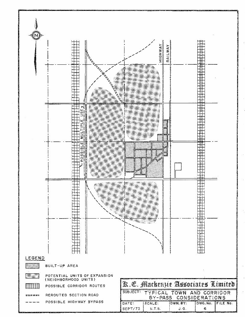
I I
I I
I'--I
I i
I ,
I ,
I ,
·t--·~-I
I I
I
I . I . I I 1'--' I
I I
I LEGEND Irr:::)()J B U I L T - U PAR E A
\ \ \
" " " " .'
" ..... ..... ,
POTENTIAL UNITS OF EXPANSION (NEIGHBORHOOD UNITS)
IIIIIIII POSSIBLE CORRIDOR ROUTES
====== REROUTED SECTION ROAD
---- POSSIBLE HIGHWAY BYPASS
1k. (!E. ft\arkrn;ir ~~~oriatr~ I-imittb SUBJECT: TYPI CAL TOWN AND CORRIDOR
BY-PASS CONSI DERATION S DATE: SCALE:
SEPT /73 N,T,S,
DWN. BY:
J.G.
DWG. No. FILE No.
6
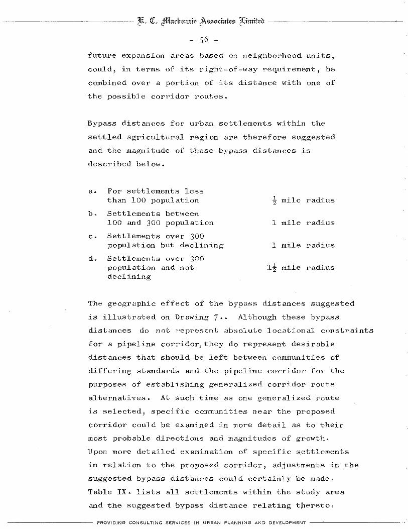
---------------- tltt~ (It 2ffi{zttkcuzic J\ssodzttcs 1fiimiteo --------------------
- 56 -
future expansion areas based on neighborhood units,
could, in terms of its right-of-way requirement, be
combined over a portion of its distance with one of
the possible corridor routes.
Bypass distances for urban settlements within the
settled agricultural region are therefore suggested
and the magnitude of these bypass distances is
described below.
a. For settlements less than 100 population 1 mile radius "2
b. Settlements between 100 and 300 population I mile radius
c. Settlements over 300 population but declining 1 mile radius
d. Settlements over 300 population and not I! mile radius declining
The geographic effect of the bypass distances suggested
is illustrated on Drawing 7 .. Although these bypass
distances do not represent absolute locational constraints
for a pipeline corridor,they do represent desirable
distances that should be left between communities of
differing standards and the pipeline corridor for the
purposes of establishing generalized corridor route
alternatives. At such time as one generalized route
is selected, specific communities near the proposed
corridor could be examined in more detail as to their
most probable directions and magnitudes of growth.
Upon more detailed examination of specific s.ettlements
in relation to the proposed corridor, adjustments in the
suggested bypass distances could certainly be made.
Table IX. lists all settlements within the study area
and the suggested bypass distance relating thereto.
PROVIDING CONSULTING SERVICES IN URBAN PLANNING AND DEVELOPMENT ---'-----------
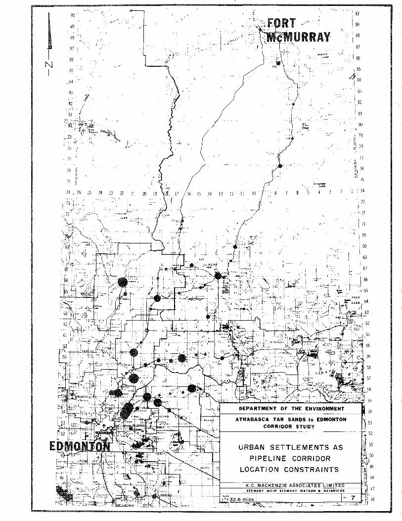
'90
{l9
88
87
86 N I 85
84
113
82 , . ,--'
75 ~ z
74 ,,26 25 24 23 22 21 20
, ,
E
T \,-\,t.i'
1 ) ,;,:i '\ 1~'\ II \ OR,RAY
... ~ .. ,
,>"./1.
,1t;: " ,
/ ,
15 14 13 12 ,11 10
/",-
.,::- I·'
. :~.'" i I ... • .. ...,.~ ~ ,
"IIllllfllllr""""""~:~:'~. t'~ ~ .,1, '", I', I, '0, l
, "I' "1)" ~\.q~y-:it·· [,""
,;,,~/~,,:~~t~',~·';:~:.;;: :'~:' .. i :~1,~1:'~
., J ·':ITPi!.~ ,;A.';J~~
ATHABASCA TAR SANDS to EDMONTON CORRIDOR STUDY
URBAN SETTLEMENTS AS
PIPELINE CORRIDOR
LOCATION CONSTRAINTS
90
89
88
87
86
,l~5 .''..,( 84
83
82
r 81
80
o 79 C'
" -; 78 I
77 ;;: m ", '21 76 >-2
75
74
73
, !' 72
71
70
69
68
67 ,. 'I 66 \'
\ "'j " 65

--------------- tJR~ Qt 4f1ffatkeuzie J\55otiates 'lfiimiteh -----------------
- 57 -
TABLE IX
URBAN SETTLEMENT BYPASS DISTANCES
Radius ! Mile
Abee
Atmore
Bellis
Breynat
Caslan
Chard
Donatville
Edward
Egremont
Ellscott
Grassland
Hilliard
Hylo
McRae
Opal
Quigley
Rich Lake
Spedden
St. Michael
Star
Tweekie
Venice
Wandering River
Whitford
Wostok
Radius 1 Mile
Anzac
Ardrossan
Chipman
Colinton
Conklin
Imperial Mills
Josephburg
Kikino
Newbrook
North Cooking Lake
Plamondon
Radway
Vilna
Warspite
Waskatenau
Radius 11.. Miles 2
Andrew
Athabasca
Bon Accord
Boyle
Bruderheim
Fort Saskatchewan
Gibbons
Lac La Biche
Lamont
Redwater
Smoky Lake
Thorhild
PROVIDING CONSULTING SERVICES IN URBAN PLANNING AND DEVELOPMENT ------------

--------------- l&~ (It cfficu:keltJ!ie J\z5ociate5 1liimiteb: ----------------
- 58 -
3. The Multi-Use Concept:
The results of the farm resident survey suggest that,
1n rural areas, no urban forms of use should be contemplated
in conjunction with the pipeline corridor where it
traverses agricultural land. The most basic form of
multiple use of the actual pipeline corridor space
relates to its agricultural potential once pipelines
have been installed. It is therefore assumed that through
out the agricultural area, the pipeline corridor would
remain, under a lease or similar instrument, as
agricultural land for the use of the abutting farm
owner.
In cases where the pipeline corridor bypasses an urban
settlement with any prospect of growth, the possibility
should be examined of placing the pipeline corridor in
an alignment that would encourage such multiple use as
a highway which might also be required in future to
bypass the settlement. This concept is illustrated on
Drawing 6. which was discussed previously. An
additional use of the pipeline corridor in such instances
would be as a green belt defining a settlement's future
expansion area and ultimate form. The rate of growth
of most communities in the settled agricultural region,
however, will tend to postpone the likelihood of this
possibility arising within the near future.
C. Recommendations - Settled Agricultural Region
1. In this region, the generalized pipeline corridor
route or route alternatives should be selected on
the basis of avoiding all existing urban settlements
PROVIDING CONSULTING SERVICES IN URBAN PLANNING AND DEVELOPMENT -------------

-------------- ~~ Qt 2ffilarkcuzic J\ssodates Ifiimiteh ----------------
- 59 -
and their suggested bypass areas.
2. In rural areas, pipeline corridor locations adjacent
to, or straddling, quarter section lines should be
considered to minimize dislocation and acquisition
cost, and to preserve effecient units of cultivation.
3. In instances where the pipeline corridor passes near
an existing urban settlement such multiple uses of
the right-of-way for transportation and green belt
purposes should be examined.
PROVIDING CONSULTING SERVICES IN URBAN PLANNING AND DEVELOPMENT -------------

-------------- tEL at ~Ctdumj£ic J\550datcs IUimitcc ----------------'--
- 60 -
IV. THE REGION OF METROPOLITAN INFLUENCE
A. The Settlement Pattern
1. The Geographic Setting:
This region is characterized by a terrain very similar to
that of tre settled agricultural area with the exception
of the presence of the valley of the North Saskatchewan
River as a major topographic feature. Otherwise, the
pattern of rural settlement and development is very
similar to that of the region previously discussed.
The major differentiating factor in this region relates
to its proximity to the City of Edmonton and the influence
which will be exerted by the City of Edmonton upon
surrounding urban settlements by virtue of that proximity.
2. Minor Settlements:
Four relatively small settlements lie within the region
of metropolitan influence which could emerge as pipeline
corridor location constraints. These include Bon Accord,
Gibbons, Redwater and Bruderheim. Of these, Bruderheim
and Redwater were subjected to the same analysis as
settlements within the settled agricultural region and
the results of this analysis appear on Table VI ••
Bon Accord and Gibbons, on the other hand, were regarded
as settlements whose future growth would not be related
in any meaningful sense to their present economic and
demographic composition.
a. Redwater: The projected 1981 population is 1,579
by the linear process,and a relatively high potential
growth index number suggests this is a reaonable
prospect for population increase by virtue of the
PROVIDING CONSULTING sERVICES IN URBAN PLANNING AND DEVELOPMENT ------------

-------------- ~L at cffiffadum;;:ic J\ssodatcs 'lfiimttco ---------------'---
- 61 -
Town's economy and population characteristics.
Past rates of growth have been high and employment
is high as a result of the proximity of the nearby
Imperial Oil Plant and industries located in
Fort Saskatchewan. Redwater also manifests a
relatively high birth rate, and it has high levels
of employment in transportation, communication,
manufacturing and construction which would suggest
a diversified economic base. Additionally, it
can expect some growth pressure by virtue
proximity to Edmonton.
of its
b. Bruderheim; A 1981 popUlation of 425 is calculated
by the linear process, an increase of approximately
75 over its present popUlation. It isnoteworthy
that the potential growth index number is negative
but, since this index does not take into account
the Town I s dormitory function within the
metropolitan area, it really indicates that the
Town would probably not grow by virtue of its own
economic base. Bruderheim serves as a dormitory
community for workers in the industries in both
Fort Saskatchewan and Redwater and, to a small
extent, the City of Edmonton. Its central-place
functions are declining like most other small
agricultural service centers but the Town's growth
can be expected to result from the expansion of
its dormitory function to serve industries within
the region. As a dormitory community, the Town! s
growth potential is somewhat volatile an1 difficult
to predict.
PROVIDING CONSULTING SERVICES IN URBAN PLANNING AND DEVELOPMENT -------------

-------------- tEL at ~adum7!ie J\£I£loriate£l 1Uimifev ---------------
- 62 -
c. Bon Accord: This settlement is expected to have
a population of approximately 1,000 by 1981
according to the Edmonton Regional Planning
Commission. Although no specific projections
of population were possible, this prediction 1S
apparently based on development plans which are
known for the Town.
d. Gibbons: This Town has a more established central-
place function than Bon Accord but, by virtue of
the unpredictability of the expansion of its
dormitory function,its growth cannot accurately
be foreseen. The E.R.P.C. suggests a 1981 population
of 3,300. The fact, however, that Gibbons is a
well established Town with a broad range of
established services could cause it to become a
nucleus for more substantial growth as the
metropolitan Edmonton region develops.
3. The Town of Fort Saskatchewan:
The Town of Fort Saskatchewan is regarded as a special
case within the region by virtue of its size and future
growth prospects. Its location within the region is
indicated on Drawing 8. in relation to the City of
Edmonton and the previously discussed settlements.
The Town possesses a reasonably well balanced economic
base which includes pBtrochemical industries, the
provincial correctional institute and an established
retail core with a broad range of outlets and services.
The Town is now experiencing a significant growth in
its population like many other towns in the vicinity
of Edmonton and significant expansion proposals are
PROVIDING CONSULTING SERVICES IN URBAN PLANNING AND DEVELOPMENT -------------

#: J~ I
"
Duagh lIft'
20' 15' la' 05' 113°l
<'/'b 1
"
Tp.58
Vol Sou,:y
Tp.57
~ '...;.
/'.-- <-cc::!J
Tp.56
'.' /1
Tp.55
1jP
11r:fJ
Tp.54 ]250
. " . rn
U: 1(' I~" ,:> .'. 2 ~
\·1 t 0 ~ O:_fT! l> 0 ~ 0 X::o 1"'1::-0-'-(J) ::0 lJfT! <
)!: ~ ::0 l>l> rn _ 0 2(J) • r
r==~~' . ~ g ~:g, ~ -I . ~. + ,. .... .. ~ 20 0
: - ~CMC ~cl '1: 11' ~ ~,,~ ~ ,,.- ~ ';. --1.:'---\ l>~111 ), ~ __ < 2 ~ 0
. . TIl . (J) N ~
- .~
~,"" .
I'"
Rg.23 Rg.22
C':O , ,/ j
c.J Hi
..
<'~Gb
o 2 111 (J)
Rg.21
I Tp.53
:1
CD Tp.52

--------------- thL (It ~admt~ie J\550Chth~5 1Jlimiteu -----------------
- 63 -
underway or ln the course of preparation.
A population of 13,000 is predicted by the E.R.P.C. by
1981 which represents a spectacular increase from the
1971 population of 5,726. It is significant, however,
from the standpoint of the proposed pipeline corridor
that virtually all of the proposed residential expansion
of the Town will take place directly south of the
existing built up area. To the extent that the built
up area already represents a major constraint to any
pipeline corridor located in a north-south alignment,
the expansion area would appear to lie largely within
an area that would not be affected by a pipeline
corridor.
Reference to Drawing 8. will indicate that the proposed
area of future expansion approaches an existing pipeline
corridor which lies in a northeast to southwest alignment.
This present corridor represents a potential constraint
to future expansion but, were it to be combined with a
major corridor, could become an impermeable limitation
on the Town's future growth.
Highway #55,in its north-south alignment, represents
the western edge of the Town1s proposed expansion area.
To the extent that this Highway could be regarded as
a boundary of development, the area west of the Highway
might be considered as a potential corridor route.
B. Specific Corridor Considerations
1. Miscellaneous Factors:
Reference to Drawing 8. will reveal certain other factors
which will affect the location of a pipeline corridor
within the metropolitan Edmonton area.
PROVIDING CONSULTING SERVICES IN URBAN PLANNING AND DEVELOPMENT -------------

--------------- ttL a1. cffil1N:ckcuzic 8SS11:ctNtcS 14imitcb -----------------
- 64 -
The rural pattern of settlement in agricultural areas
is essentially the same as that which was discussed
for the settled agricultural region. Drawing 8. reveals
the pattern of farmstead location with respect to the
grid of rural section roads and the recommendations
made ln respect of rural portions of the settled
agricultural region would also be applicable in this
region.
Drawing 8. also reveals a scattering of hamlets such
as Ardrossan, Josephburg and Opal which are historically
nothing more than grain collection points adjacent
to railways which serve surrounding agricultural
areas. Although the prospect of these centers
serving as nuclei for expanded settlements is remote,
the settlements as they exist do represent a location
constraint for the pipeline corridor.
Another settlement phenomenon which occurs to some
degree within that portion of the metropolitan area
which is the subject of this study is acreage sub
divisions. Although relatively few such subdivisions
have been developed in the northeast sector of the
metropolitan region, they do represent fixed constraints
for pipeline corridor location. An example of such a
subdivision is that which has been developed immediately
north of Ardrossan, adjacent to Highway #16.
Drawing 8. also reveals the haphazard network of
existing pipelines which traverse the metropolitan
portion of the study area. It should be noted that
very few of these pipelines have been located with
respect to any other lineal feature or transportation
facility. An exception to this is the pipeline which
----------- PROVIDING CONSULTING SERVICES IN URBAN PLANNING AND DEVELOPMENT -------------

--------------- tEL 01. 2W£a.ckcu1!ic J\zsociatcs 1Jlimitco -----------------
- 65 -
lies parallel to and north of Highway #16. This pipeline
is separated from the adjacent Highway by a number of
farmsteads and, it will be noted, lies so close to
the Highway that interchanges developed along the
Highway must be constructed over the pipeline.
2. Settlement Bypass Distances:
Urban Settlements within the region of metropolitan
influence are more likely to experience unforeseen
growth by virtue of their proximity to the City of
Edmonton. The concept of bypass distances which was
applied to settlements within the settled agricultural
region may be applied somewhat differently within the
region of metropolitan influence.
Reference to Drawing 8. will indicate the suggested
corridor bypass zones which were determined according
to the same standards applied in the settled agricultural
region. However, since the overall pipeline location
constraints which will affect corridor location near
metropolitan Edmonton tend to restrict the number of
alternative locations available, these bypass distances
should be regarded as being desirable, but flexible.
If it is necessary to place the pipeline corridor within
these zones, special study should be given to the effect
such a corridor would have upon a particular community's
growth, and the manner in which the corridor right-of-way
could be integrated into the land use pattern of the
settlement. The corridor bypass zones should therefore
be regarded as special study areas rather than fixed
pipeline location constraints.
PROVIDING CONSULTING SERVICES IN URBAN PLANNING AND DEVELOPMENT -------------
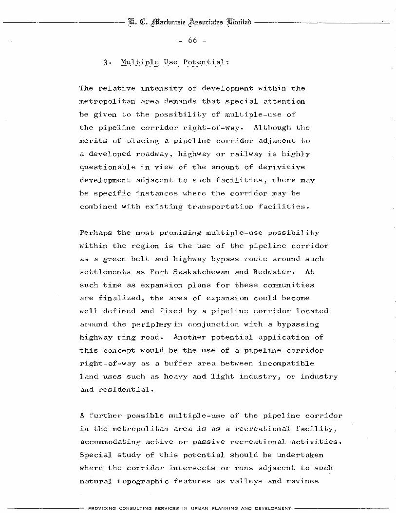
-------------- tftL at ~Ctdumzie J\ssudCttes 'lfiimiteu ----------------'--
- 66 -
3. Multiple Use Potential:
The relative intensity of development within the
metropolitan area demands that special attention
be given to the possibility of multiple-use of
the pipeline corridor right-of-way. Although the
merits of placing a pipeline corridor adjacent to
a developed roadway, highway or railway is highly
questionable in view of the amount of derivitive
development adjacent to such facilities, there may
be specific instances where the corridor may be
combined with existing transportation facilities.
Perhaps the most promising multiple-use possibility
within the region is the use of the pipeline corridor
as a green belt and highway bypass route around such
settlements as Fort Saskatchewan and Redwater. At
such time as expansion plans for these communities
are finalized, the area of expansion could become
well defined and fixed by a pipeline corridor located
around the periprery in conjunction with a bypassing
highway ring road. Another potential application of
this concept would be the use of a pipeline corridor
right-of-way as a buffer area between incompatible
land uses such as heavy and light industry, or industry
and residential.
A further possible mUltiple-use of the pipeline corridor
in the metropolitan area is as a recreational facility,
accommodating active or passive recreational 'activities.
Special study of this potential should be undertaken
where the corridor intersects or runs adjacent to such
natural topographic features as valleys and ravines
PROVIDING CONSULTING SERVICES IN URBAN PLANNING AND DEVELOPMENT -------------

-------------- tliL Qt 2illfarkeu;::ie J\zzodatez 1Uimiteb-
- 67 -
which themselves possess recreational potential.
c. Recommendations - Metropolitan Influence Region
1. Existing built up settlement areas should be
r~rded as absolute pipeline location constraints.
2. Expansion areas for urban settlements in this
region, such as Fort Saskatchewan's expansion
area, which do not constrict pipeline location
to any major extent,should be regarded as flexible
pipeline location constraints.
3. The multiple-use concept should be examined when
specific route alternatives are considered from
the standpoint of combining the pipeline corridor
with existing transportation facilities and, where
possible, using the corridor as a planning tool in
shaping the land-use pattern of the settlements
in the region, with particular reference to
recreational and green belt uses.
PROVIDING CONSULT-lNG SERVICES INtJR8AN PLANNING AND DEVELOPMENT -------------
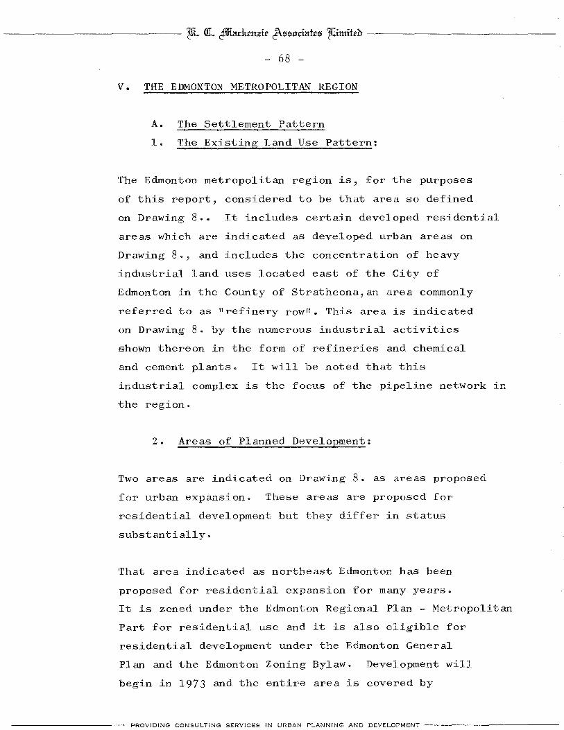
---------------- ~L C!L ~ctl:k£ltJ!te J\s13ociate13 14imitea -----------------
- 68 -
v. THE EDMONTON METROPOLITAN REGION
A. The Settlement Pattern
1. The Existing Land Use Pattern:
The Edmonton metropolitan region is, for the purposes
of this report, considered to be that area so defined
on Drawing 8 .• It includes certain developed residential
areas which are indicated as developed urban areas on
Drawing 8., and includes the concentration of heavy
industrial land uses located east of the City of
Edmonton in the County of Strathcona,an area commonly
referred to as Itrefinery rowll. This area is indicated
on Drawing 8. by the numerous industrial activities
shown thereon in the form of refineries and chemical
and cement plants. It will be noted that this
industrial complex is the focus of the pipeline network in
the region.
2. Areas of Planned Development:
Two areas are indicated on Drawing 8. as areas proposed
for urban expansion. These areas are proposed for
residential development but they differ in status
substantially.
That area indicated as northeast Edmonton has been
proposed for residential expansion for many years.
It is zoned under the Edmonton Regional Plan - Metropolitan
Part for residential use and it is also eligible for
residential development under the Edmonton General
Plan and the Edmonton Zoning Bylaw. Development will
begin in 1973 and the entire area is covered by
PROVIDING CONSULTING SERVICES IN URBAN PLANNING AND DEVELOPMENT -------------

-------------- tEt. at 2ffiladum;!tt J\zzociattz 1fiimittb: ----------------
- 69 -
approved development plans of significant detail. The
area has been planned as a unit and it should therefore
be regarded as a fixed constraint upon pipeline corridor
location and unavailable for corridor purposes.
The area indicated on Drawing 8. as the future expansion
area of Sherwood Park is of a totally different status.
The area which encompasses approximately 8.5 square miles
is, at this point in time, a proposal for development
made by land developers. The area proposed for expansion
is classified under the regional plan as low density
agriculture and any change that would permit such
development would represent a major change in the
regional plan. The County of Strathcona has not
adopted a policy with respect to this particular proposal.
This expansion proposal should not, in view of its
present status, be regarded as a fixed constraint for
purposes of the pipeline corridor.
3. The Future Land Use Pattern:
The principal influence in shaping the land use
pattern of the metropolitan region will be the pre
liminary Regional Plan - Metropolitan Part. The
major land use categories presently proposed by
this plan are outlined on Drawing 9. and no distinction
is made on Drawing 9. between areas which are zoned for
a particular use, or designated as reserve zones. It
should be noted that significant portions of the area
outlined as industrial land are not presently developed
and designated as industrial reserve land. In any
event, Drawing 9. should indicate reasonably accurately
the future land use pattern in this area.
PROVIDING CONSULTING SERVICES IN URBAN PLANNING AND DEVELOPMENT -------------
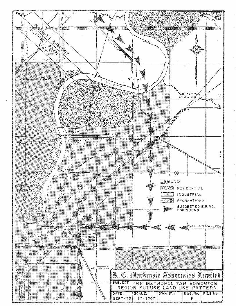
LEGEND f; I RESIDENTIAL
I>;:;;>:] I N D U S T R I A L
K~f,*~:1 RECREATIONAL
SUGGESTED E.R.P.C. CORRIDORS
THE ETROPOLITAN ED TON REGiON FUTURE LAND USE PATTERN
DATE: SCALE: DWN. BY:
SEPT/73 1"=2000'
DWG. No. FILE No.
9
-------------- Zi. QL 2HKn.ckttt;.;it J\ssodntts 'lfiimiren ----------------'--- 70 -
Superimposed on Drawing 9. is a pipeline corridor
route that was proposed by the Edmonton Regional
Planning Commission when it studied the need for
pipeline corridors within the metropolitan Edmonton
region. Although this route was suggested previous
to any significant activity in the Athabasca Tar
Sands, it does reveal what might be considered a
desirable relationship between such a corridor and
the regional land use pattern. It is also significant
that the Planning Commission had no specific powers
with respect to pipeline location and acted only as
an advisory body on these matters.
Drawing 9. also indicates another feature which will
shape Edmontonts regional land use pattern. This
feature, the flight path for the Namao Airport,
repFPsents a constraint upon residential ,development.
Although industrial uses can be considered in the
flight path, such an area might also be reserved as
a green belt and, as such, become a logical route for
a pipeline corridor. The alignment of this flight
path, however, would not appear to lend itself for
use as a corridor route for the Athabasca pipeline
corridor although this will depend upon the corridor
route alternatives which emerge from this study.
B. Specific Corridor Considerations
1. The Sherwood Park Proposal:
The uncertain status of the major expansion proposal
for the area north of Sherwood Park makes it possible
to consider this area as being available for a pipeline
corridor right-of-way if necessary. This becomes
significant when the future land use pattern of the
PROVIDING CONSULTfNG SERVICES IN URBAN PLANNING AND DEVELOPMENT -------------

-------------- lJiL QL 2ffiladteuJ!ie J\ssotiates 1fiimifdr -----------------
- 71 -
area is considered in conjunction with the existing
alignments of pipelines in the area with respect to
the familiar grid pattern of legal subdivision. The
existing pipelines have been installed in an alignment
which represented the shortest route for the pipeline
companies and little regard was paid to the fragmentation
of the pattern of land subdivision. The fragmentation
could have been minimized had the corridor concept been
applied but the mUltiplicity of independent diagonal
pipeline rights-of-way has resulted in a significantly
fragmented pattern of land subdivision, especially in
the eastern portion of the future industrial land area
of Metropolitan Edmonton.
The alternative to a diagonal alignment for the pipeline
corridor is an alignment which follows the direct east
west, or north-south pattern of legal subdivision.
A corridor following such an alignment would not create
awkward triangular portions of land which will present
future problems in the achievement of orderly and
efficient development, but will ensure that the large
scale grid of unsubdivided land is maintained. Assuming
that the c.orridor would follow the pattern of grid
subdivision ln one direction or other, the alternatives
are reduced to a corridor directly from the pipeline
terminal area within the industrial complex to the
east; or the the north. Reference to Drawing 9. will
reveal that either of these alternatives would follow
ln general fashion the recommended route of the E.R.P.C.
as' shown on Drawing 9.. The fact that both of these
routes traverse that area proposed for expansion of
Sherwood Park would mean that the corridor would become
a sigrdficant constraint upon any de"Ielopment taking
place in t,hat area.
----------- PROVID,NG CONSULTING SERVICES IN URBAN FLANNiNG AND DEVELOPMENT ---.•. ----------

---------------- tIlL at 2.fl1tntkcttztc J\550ctnic5 1J.Iintit.cv ------------------
- 72 -
A corridor in the Sherwood Park expansion area
might render residential development ,impossible or,
alternatively, necessitate that the corridor be integrated
into the proposed pattern of development in a meaningful
manner.
2. Industrial Land and the Corridor:
Industrial land uses, ln particular heavy industrial
uses which characterizeHrefinery row lt , are not as
adversely affected by pipelines as are more intensive
uses of urban space. This relates to the fact that
heavier industries require large sites with a substantial
amount of open-space for buffering and storage purposes.
The future pattern of industrial land use should there
fore not be regarded as a fixed constraint to pipeline
corridor location.
The extent to which industries might benefit from a
nearby pipeline corridor is not easy to determine.
Although it is customary for pipelines to distribute
their product from a terminal, rather than directly
from the pipeline, it is possible that some direct
connection between a pipeline and an industry could
be made. Although it is not anticipated that the
pipeline corridor will directly generate industrial
land uses adjacent to it, the possibility does exist.
3. Multiple Use Potential:
The multiple use potential of a corridor right-of-way
within metropolitan Edmonton is substantial by virtue
of the intensity of development within the area.
The combination of the pipeline corridor with existing
PROVIDING CONSULTING SERVICES IN URBAN PLANNING AND DEVELOPMENT -------------
--------------- ~_ Clt !1ftatkem:ie J\SMtintes Ifiimit.eo -----------------
- 73 -
or proposed transportation routes, ln particular
major roadways, is one obvious form of multi-use.
Other multiple use possibilities lie in the use of
the pipeline corridor as a buffer or green belt
between different land uses, or between transportation
facilities and adjacent residential land uses.
The compatibility of major roadways running parallel to
and in the same right-of-way with pipeline corridors
will depend entirely upon the width of the total
right-of-way. The fact that major roadways require,
at interchange points, wide areas for the construction
of approach roads and turning ramps, means that the
total right-of-way must be wide enough to ensure that
any portions of the interchange do not cover the
pipelines themselves and require, as a result, more
elaborate crossings of those pipelines. In the event
that a portion of the pipeline corridor is proposed
to run adjacent to a major roadway, a total corridor
width approaching one-half mile would appear to be
required. A corridor of this width could also serve
as a buffer between the roadway and adjacent residential
development if the necessity exists.
c. Recommendations - Metropolitan Edmonton Region
1. The existing built up urban areas, industrial and
residential, and those residential areas for which
specific plans have been approved, should be
regarded as fixed locational constraints for pipeline
corridor purposes.
2. The pipeline corridor should follow direct east-west
or north-south alignments throughout the metropolitan
PROVIDING CONSULTING SERVICES IN URBAN PLANNING AND DEVELOPMENT -------------
---------------- tEL aL 2f1ffm::lum;£ie ~550cil:tte5 1G:imitea ------------------
- 74 -
region and the region of metropolitan influence
in order to avoid fragmentation of land.
3. In cases where the combination of the pipeline
corridor with existing transportation facilities
is being considered, the width of the right-of-way
should be sufficient to ensure the compatible
joint use of the right-of-way by both facilities.
4. The possibility of utilizing the pipeline corridor
right-of-way as a green belt or buffer between
incompatible land uses or transportation facilities
should be considered.
5. In the event that the pipeline corridor is required
to traverse an area being proposed for residential
development, and the implementation of that
residential development is still being contemplated,
the corridor right-of-way should be integrated to
the maximumidegree possible, both functionally and
aesthetically, with the proposed pattern of development
with emphasis on the use of pipeline corridor.space
for recreational purposes within the area.
PROVIDING CONSULTING SERVICES IN URBAN PLANNING AND DEVELOPMENT -------------

-------------- ~- C!t 21Rnd\cuzic J\5sodatcs J4intitcb
- 75 -
TABLE X
LIST OF SETTLEMENTS IN THE STUDY AREA
ACCORDING TO REGION
Corridor Settlements Listed By Study Area
1. Fort McMurray Region a) Fort McMurray - waterways
2. Wilderness Region
3 •
a) Marianna Lake b) Wandering River
Settled Agricultural Region a) b) c) d) e) f) g) h) i)
The a) b) c) d) e)
Andrew Athabasca Boyle Lac La Biche Lamont Smoky Lake Thorhild Vilna Willingdon
Region of Metropolitan Influence Bon Accord Bruder'beim Fort Saskatchewan Gibbons Redwater
5. Edmonton Metropolitan Region a) Edmonton b) Sherwood Park c) St. Albert
6. Special Settlements - Tar Sands Area a) Fort Chipweyan b) Fort McKay
PROVIDING CONSULTING SERVICES IN UR8AN PLANNING AND DEVELOPMENT -----------
This material is provided under educational reproduction permissions included in Alberta Environment and Sustainable Resource Development's Copyright and Disclosure Statement, see terms at http://www.environment.alberta.ca/copyright.html. This Statement requires the following identification: "The source of the materials is Alberta Environment and Sustainable Resource Development http://www.environment.gov.ab.ca/. The use of these materials by the end user is done without any affiliation with or endorsement by the Government of Alberta. Reliance upon the end user's use of these materials is at the risk of the end user.