Transportation & Streets and Highways Element
122
Transcript of Transportation & Streets and Highways Element


Transportation_Streets_Hwys Elem;Plans-MPlan;indd;rs04/15/09
Tra
nsp
ort
atio
n &
Str
ee
ts a
nd
Hig
hw
ays
Ele
me
nt
The City of Las Vegas
Transportation & Streets and Highways Element
of the Las Vegas 2020 Master Plan
was adopted by City Council
on April 15, 2009
(Ordinance #6038).

page i Transportation_Streets_Hwys Elem;Plans-MPlan;indd;rs04/15/09
CITY OF LAS VEGASTRANSPORTATION & STREETS AND HIGHWAYS ELEMENTTABLE OF CONTENTS
EXECUTIVE SUMMARY ................................................................................................................... 1
INTRODUCTION ............................................................................................................................. 5
PURPOSE ................................................................................................................ 5
ENABLING LEGISLATION ................................................................................ 6
PLANNING CONTEXT ..................................................................................... 7
RELATIONSHIP TO THE LAS VEGAS 2020 MASTER PLAN ..................... 8
GOALS, OBJECTIVES AND POLICIES ............................................................ 8
Neighborhood Revitalization .............................................................. 8
Newly Developing Areas ..................................................................... 9
Regional Coordination .......................................................................... 9
BACKGROUND ................................................................................................................................11
HISTORY OF TRANSPORTATION AND STREETS AND HIGHWAYS IN LAS VEGAS ................................................ 11
CURRENT TRANSPORTATION PLANNING DOCUMENTS ............... 12
Circulation Plan, 1992 ......................................................................... 13
Municipal Code ..................................................................................... 16
Regional Transportation Plan, 2009-2030 ..................................... 16
Transportation Improvement Program FY 2009-2012 ............... 18
Unifi ed Planning Work Program FY 2008-2009 .......................... 23
FUNDING FOR TRANSPORTATION PROJECTS ................................................................. 25
HIGHWAY TRUST FUND ............................................................................................... 25
FTA ........................................................................................................................................ 25
CMAQ .................................................................................................................................. 25
STP ........................................................................................................................................ 25
STATE GAS TAX ................................................................................................................. 26
RTC (CLARK COUNTY) GAS TAX ............................................................................. 26
QUESTION 10 ................................................................................................................... 26
ASSEMBLY BILL 595 .......................................................................................................... 28
EXISTING CONDITIONS............................................................................................................. 29
TRANSPORTATION .......................................................................................... 29
Location Of Rights-of-Way (Master Plan of Streets and Highways) ....................................................................................... 29
TERMINALS ......................................................................................................... 30
Downtown Transportation Center ................................................. 30
Greyhound Bus Terminal ................................................................... 30
VIADUCTS ........................................................................................................... 30

page ii Transportation_Streets_Hwys Elem;Plans-MPlan;indd;rs04/15/09
GRADE SEPARATIONS..................................................................................... 30
AVIATION ............................................................................................................ 31
Airport Overlay District .................................................................... 33
STREETS AND HIGHWAYS ............................................................................. 33
Functional Classifi cation ..................................................................... 33
STREET WIDTHS AND CROSS-SECTIONS ............................................... 36
Rights-of-Way ....................................................................................... 36
Standard Roadway Cross-Sections .................................................. 38
Freeways ................................................................................................ 44
High Occupancy Vehicle Lanes (HOV) .......................................... 44
Bicycle Transportation ....................................................................... 44
STREET TREATMENT (CURRENT LANDSCAPE BUFFERING) ............ 46
BUILDING SETBACKS ...................................................................................... 50
STREET NAMING AND NUMBERING ........................................................ 51
Street Naming ....................................................................................... 51
Address Numbering ............................................................................ 52
Multi-Family Residential Addressing ................................................ 52
Non-Residential Addressing .............................................................. 52
Street and Address Changes ............................................................. 53
TRAFFIC MEASUREMENT AND MANAGEMENT .................................... 53
Annual Average Daily Traffi c (AADT) ............................................ 53
Vehicle Miles Traveled (VMT) and Capacity ................................. 54
Intelligent Transportation Systems (ITS)........................................ 57
EXISTING MASS TRANSIT AND FREIGHT MOVEMENT ....................... 59
Fixed-Route Transit ............................................................................. 59
Rail Transport ....................................................................................... 59
ANALYSIS ........................................................................................................................................... 61
LINK BETWEEN TRANSPORTATION AND LAND USE ........................ 61
TRANSPORTATION PLANNING AND EMPLOYMENT ......................... 64
A MULTI-MODAL APPROACH TO TRANSPORTATION PLANNING .................................................................. 67
AIR QUALITY ...................................................................................................... 68
STREETSCAPING ............................................................................................... 71
IMPLEMENTATION ......................................................................................................................... 73
CONCLUSION ................................................................................................................................ 79
LIST OF ABBREVIATIONS ..........................................................................................................105
APPENDICES .................................................................................................................................. 107

page iii Transportation_Streets_Hwys Elem;Plans-MPlan;indd;rs04/15/09
TABLES, FIGURES AND MAPS
TABLES
Table 1: Regional Transportation Plan Compliance with Federal Requirements ................................................................................ 17
Table 2: Regionally Signifi cant, Non-Locally Funded Projects in 2009-2012 TIP, City of Las Vegas .............................................................. 20
Table 3: Transit Projects in 2009-2012 TIP in or Affecting the City of Las Vegas .......................................................................................... 22
Table 4: City of Las Vegas Question 10 Project Funding Summary Report ......................................................................................... 27
Table 5: Functional Classifi cation ............................................................................ 34
Table 6: Current Perimeter Landscape Buffer Widths ....................................... 46
Table 7: Current Minimum Size, Amount and Spacing of Perimeter Landscape Materials .................................................................................... 47
Table 8: Single Family Residential District Setback Standards .......................... 50
Table 9: Residential District Standards Other Than Single Family ................... 50
Table 10: Commercial and Industrial Setback Standards ..................................... 50
FIGURES
Figure 1A: Primary Thoroughfares, with Detached Sidewalk (114’ Width) ................................................................................................. 39
Figure 1B: Primary Thoroughfares, without Detached Sidewalk (100’ Width) ................................................................................................. 40
Figure 1C: Secondary Thoroughfares, with Detached Sidewalk (90’ Width) .................................................................................................... 41
Figure 1D: Secondary Thoroughfares, without Detached Sidewalk (80’ Width) .................................................................................................... 41
Figure 1E: Secondary Thoroughfares, without Detached Sidewalk (60’ Width) .................................................................................................... 42
Figure 1F: Local Streets ................................................................................................. 43
Figure 1G: Private Streets .............................................................................................. 43
Figure 2: Arterial Streetscape (Adjacent Commercial Use Shown) ................. 48
Figure 3: Commercial/Industrial Streetscape ......................................................... 48
Figure 4: Residential Multi-Family Streetscape ...................................................... 49
Figure 5: Residential Single Family Streetscape (Collector or Larger) ............. 49
MAPS
Map 1: Bureau of Land Management Disposal Boundary ................................ 81
Map 2A: Master Plan of Streets and Highways, Southeast Sector .................... 83
Map 2B: Master Plan of Streets and Highways, Southwest Sector ................... 85
Map 2C: Master Plan of Streets and Highways, Centennial Hills Sector ......... 87
Map 3: Lane Miles by Functional Class ................................................................. 89
Map 4: Terminals within the City of Las Vegas.................................................... 91
Map 5: Grade Separation ........................................................................................ 93

page iv Transportation_Streets_Hwys Elem;Plans-MPlan;indd;rs04/15/09
MAPS, CONTINUED
Map 6: Freeways in the City of Las Vegas ............................................................ 95
Map 7A: Traffi c Counts and Signals, Southeast Sector ........................................ 97
Map 7B: Traffi c Counts and Signals, Southwest Sector ....................................... 99
Map 7C: Traffi c Counts and Signals, Centennial Hills Sector ...........................101
Map 8: Sheep Mountain Parkway Preliminary Alignment Alternatives ........103

Transportation_Streets_Hwys Elem;Plans-MPlan;indd;rs04/15/09 page 1
Ex
ecu
tive
Su
mm
ary
EXECUTIVE SUMMARYThe Transportation and Streets and Highways Element provides a com-
prehensive analysis of the transportation infrastructure system within the city, and acts as a guide for decision makers to use when determining, prioritizing, and allocating resources for future projects.
The recommendations below are part of the strategy to meet present and future transportation, streets and highways needs of the city’s residents, workers and visitors.
RECOMMENDATION 1: Improve consistency between transpor-tation and land use decisions in order to reduce the number of vehicle trips and vehicle miles traveled.
New development affects transportation patterns; likewise, the circula-tion system is planned to facilitate new development. Roadway improve-ments also have an effect on existing development. An ideal level of consis-tency between land use and circulation is manifested in the achievement of the efficient movement of persons within areas where they live and work. Large commercial development projects make nearby residents uneasy because of the amount of traffic they produce in their area. A balance must be struck between planning for future traffic volumes while advocating the reduction of vehicles on the roads.
ACTIONS:
• Prepare a prioritized plan to construct full street improvements where sawtooth patterns exist and identify funding sources to implement this plan.
• Amend Title 18 to create standards that support the Neighborhood Traffic Management Program. Improvements could include speed bumps, dips, and street narrowing, all designed to ensure the safety and livability of local residential streets.
• Amend Title 19 to require traffic impact analyses as part of Site Development Plan Review application requirements for new con-struction activities generating more than 100 peak hour vehicle trips.
• Coordinate with FAST (Freeway and Arterial System of Transportation) the efficient movement of vehicle traffic through implementation of Intelligent Transportation Systems.
• Amend the land use plan to incorporate high-density residential developments along major arterial roads having transit.
• Create incentives for developers to locate high-density residential developments along major arterial roads having transit.
• Create incentives for developers to create walkable, transit-oriented mixed-use developments with complete streets that are sensitive to multiple modes of transportation and emphasize safety for non-motorized travel.
• Create incentives for investment in the transformation of existing decaying commercial-oriented suburban arterials into walkable, mixed-use, multi-modal corridors with station nodes.

Transportation_Streets_Hwys Elem;Plans-MPlan;indd;rs04/15/09page 2
Ex
ecu
tive
Su
mm
ary
RECOMMENDATION 2: Comply with existing transportation-relat-ed legislation and actively support proposed State and/or Federal legislation which generates funding, with growth potential for transportation infrastructure.
Federal SAFETEA-LU legislation mandates the maintenance of a continu-ing, cooperative and comprehensive transportation planning process on a regional scale. Through Clark County’s metropolitan planning organization the city contributes statistical information and recommendations for imple-mentation in addition to the list of projects proposed for inclusion in the periodic Regional Transportation Plan. The Nevada Revised Statutes contain specific transportation-related planning requirements, such as Chapter 408, that require local compliance. It is also important to proactively suggest ways in which circulation and air quality can be improved, whether through legis-lation or educational campaigns.
ACTIONS:
• Conduct a staff-level (Planning & Development and Public Works Departments) compliance review of all federal, state and local legal transportation-related requirements.
• Actively participate in crafting legislation that will address transporta-tion issues affecting the city of Las Vegas by closely monitoring state assembly sessions in Carson City.
• Continue to support Question 10 taxes as sources of funding for transportation-related projects in the city through implementation of an educational program that informs the constituency of how Question 10 dollars are being spent.
RECOMMENDATION 3: Coordinate local actions with regional agencies, and undertake active efforts for transportation improve-ments.
Transportation issues do not stop at municipal boundaries. The issues raised by transportation in one jurisdiction can affect the quality of life in another. To maintain continuity between points within the greater Las Vegas area, regional entities must hold to similar policies and agree on actions to be taken that will mitigate these issues. To this end, the RTC and SNRPC serve this function.
ACTIONS:
• Continue to ensure interdepartmental and interagency coordination of various city planning efforts related to growth, infrastructure, and service provision.
• Continue to support the efforts of the RTC (Regional Transportation Commission of Southern Nevada) and SNRPC (Southern Nevada Regional Planning Coalition) to plan for transportation projects that affect other communities and rural areas outside the city limits.
• Continue to support and participate in regional transportation plan-ning through working groups and committee membership.

Transportation_Streets_Hwys Elem;Plans-MPlan;indd;rs04/15/09 page 3
Ex
ecu
tive
Su
mm
ary
RECOMMENDATION 4: Pursue sources that will fund the construc-tion and maintenance of needed improvements to the city’s street system.
The city’s capital improvements program contains funding based on a five-year horizon, updated annually. Projects approved through the CIP pro-cess represent the approved priority list for spending capital funds. The CIP provides a link between necessary transportation improvements and the city’s budget. The city must seek sources external to the General Fund to keep up with projected growth and maintain current infrastructure.
ACTIONS:
• Work to secure federal, state and local funding for all feasible capital projects and incorporate into the CIP.
• Coordinate with RTC for funding sources and/or funding allocation for proposed infrastructure needs.
RECOMMENDATION 5: Implement streetscape enhancements by coordinating with the Department of Public Works to improve the visual appearance of city streets.
Streetscaping can have a significant effect on how people perceive and interact within their community. If streetscapes appear safe and inviting for pedestrians, people are more likely to walk. This can help reduce automobile traffic, improve public health, and attract visitors to Las Vegas.
ACTIONS:
• Adopt more specific street tree requirements, such as type and placement, to supplement those in LVMC Title 19.12.040 (G).
• Monitor and replace street trees lost due to disease or vandalism. • Require amenities such as benches, trash receptacles, decorative
street lighting, and decorative pavement alternatives along all public streets.
• Continue to install underground utilities consistent with City guide-lines and regulations.
• Amend Title 19 to require streetscape widths to coincide with street classifications.
• Ensure landscape areas conform to best management practices for storm water runoff.
• Provide additional safety features in the right-of-way for pedestrians such as curb extensions and center refuge islands where applicable.
• Require utility boxes and other visual impediments to be located underground or outside of the landscape buffer zone.
• Consider whenever feasible the conversion of four-lane streets to two-lane streets to allow for additional streetscaping and alternative modes of transportation.
• Determine the feasibility of reducing street widths to reduce the amount of impervious surface and allow for a buffer between the sidewalk and roadway.
• Amend the Las Vegas Municipal Code to require landscape main-tenance associations/agreements where landscaping is within the public right-of-way.

Transportation_Streets_Hwys Elem;Plans-MPlan;indd;rs04/15/09page 4
Ex
ecu
tive
Su
mm
ary
RECOMMENDATION 6: Coordinate with regional entities to fund and implement programs that aim to improve air quality in the Las Vegas Valley.
Las Vegas has made significant strides in improving air quality, but there is still more to accomplish. The region is experiencing tremendous popula-tion growth, leading to increased construction, a greater volume of automo-bile traffic, and heightened power demands. Such growth will negatively affect the air in and around Las Vegas. Las Vegas must achieve and maintain “attainment status” for carbon monoxide, particulate matter and ozone for the general health, safety, and welfare of its citizens.
ACTIONS:
• Create a trip reduction plan to develop, implement, and report an-nually on plans to reduce single occupant vehicle ridership for city employees.
• Maintain compliance with Clean Air Act standards and keep levels of mobile and stationary pollution below federal limits.
• Support RTC Ride Share, Park-and-Ride and other travel demand management programs that aim to reduce the volume of single-occupancy vehicles on city roadways.
• Continue to augment the city’s fleet of non-gasoline powered ve-hicles for use in municipal-related activities.
• Continue to seek funding from CMAQ for transportation projects in the city that reduce emissions.

Transportation_Streets_Hwys Elem;Plans-MPlan;indd;rs04/15/09page 5
Intr
od
uct
ion
INTRODUCTIONAn efficient and effective transportation system is a
fundamental need of the city of Las Vegas and its residents, businesses and visitors. The Transportation and Streets and Highways Element is more than a description of a transporta-tion system. It is a plan that addresses infrastructure needs to facilitate the mobility of people, goods and services. The loca-tion and design of roadways, as well as modal choices (auto-mobile, bus, bicycle, walking), have significant consequences on land use patterns, air quality, plant and animal habitats, and community appearance. Streets and highways not only move people and goods, but also affect the community’s economic and social environments. Ever-increasing congestion on streets and highways increases commuting time, driver frustration, business inefficiency, and pressure on neighborhoods. The Transportation and Streets and Highways Element addresses how roadway, transit, rail, freight, bicycle, and trail systems can be planned to achieve modal choice and maximum mobility in a manner consistent with community character and environ-mental protection.
PURPOSE
The purpose of the Transportation and Streets and Highways Element is twofold. First, this document is intended to address the requirements of state law, as set forth in the Nevada Revised Statutes (NRS) Sections 278.150 through 278.160; and second, to recommend strategies and actions to facilitate implementation of the goals, objectives, and policies contained in the Las Vegas 2020 Master Plan (“Master Plan”) related to transportation issues.
The Transportation and Streets and Highways Element must accomplish the following:
• State goals, objectives and policies to guide imple-mentation of transportation planning measures;
• Compile a comprehensive listing and description of the street network, grade separations, and terminals;
• Describe building line setbacks, the functional classifi-cation system, and street addressing and numbering used within the city of Las Vegas;
• Support the city’s Sustainability Initiative; • Analyze short and long term goals and priorities for
transportation planning; • Describe the city’s role in facilitating the development
of streets and highways; • Evaluate the effectiveness and potential benefit of
land-use tools in transportation planning;
View of the city looking east towards the downtown area.

Transportation_Streets_Hwys Elem;Plans-MPlan;indd;rs04/15/09page 6
Intr
od
uct
ion
• Identify strategies/actions to enhance the city’s role in coordinating transportation planning and implemen-tation with the Regional Transportation Commission of Southern Nevada and other governmental entities.
ENABLING LEGISLATION
The Nevada Revised Statutes, Sections 278.150 through 278.230, contain legislation enabling the development and adoption of a master plan. Subsection 4 of NRS Section 278.150 states:
In counties whose population is 400,000 or more, the governing body of the city or county shall adopt a master plan for all of the city or county that must address each of the subjects set forth in subsection 1 of NRS 278.160.
Subsection 3 of NRS 278.170 states:
In counties whose population is 400,000 or more, the commission shall prepare and adopt a master plan for all of the city or county that must address each of the sub-jects set forth in subsection 1 of NRS 278.160.
The subject matter of the master plan is stated in NRS 278.160:
Except as otherwise provided in Subsection 4 of NRS 278.150 and Subsection 3 of NRS 278.170, the master plan, with the accompanying charts, drawings, diagrams, schedules and reports, may include such of the following subject matter or portions thereof as are appropriate to the city, county or region, and as may be made the basis for the physical development thereof:
The Nevada Revised Statutes has required a Transportation Plan and a Streets and Highways Plan as components of master plans since the approval of master plan language by the state legislature in 1941 (Senate Bill 30).
NRS 278.160, Subsections (p) and (r) state that the master plan must include the following elements:
(p) Streets and highways plan. Showing the general locations and widths of a comprehensive system of major traffic thoroughfares and other traffic ways and of streets and the recommended treatment thereof, building line setbacks, and a system of naming or numbering streets and numbering houses, with recommendations concern-ing proposed changes.
Median area at intersection of Las Vegas Boulevard and Fourth Street.

Transportation_Streets_Hwys Elem;Plans-MPlan;indd;rs04/15/09page 7
Intr
od
uct
ion
(r) Transportation plan. Showing a comprehensive trans-portation system, including, without limitation, locations of rights-of-way, terminals, viaducts and grade separa-tions. The plan may also include port, harbor, aviation and related facilities.
A circulation plan was included as part of the city’s 1992 General Plan. The circulation plan, however, did not include that which was mandated by the adoption of Assembly Bill 182 on June 5, 2001 during the 71st Session of the Nevada Legislature that requires the inclusion of these two elements within master plans for cities within a county population greater than 400,000.
PLANNING CONTEXT
The Transportation and Streets and Highways element will replace the circulation plan in the 1992 Las Vegas General Plan. After experiencing a 73 percent increase in population during the 1990s1 and having concerns about the negative impacts associated with rapid growth, the city embarked on a new two-phased master plan project. The Master Plan, adopted by the City Council on September 6, 2000, represents Phase I of the Master Plan project, forming the framework for the con-tents of Phase II: a series of elements intended to comply with applicable state laws concerning the physical development of the city. The Transportation and Streets and Highways Element is among the elements identified for completion during Phase II of the Master Plan project.
1 Las Vegas 2020 Master Plan Policy Document (Sept. 6, 2000), p. 5.
The “Rainbow Curve” section of US 95.

Transportation_Streets_Hwys Elem;Plans-MPlan;indd;rs04/15/09page 8
Intr
od
uct
ion
RELATIONSHIP TO THE LAS VEGAS 2020 MASTER PLAN
The Master Plan contains numerous goals, objectives, and policies pertaining directly and indirectly to transportation plan-ning. As a component of the Master Plan, the Transportation and Streets and Highways Element is intended not only to satisfy NRS requirements, but also to provide a comprehensive document that will assist with the long-range planning of the future expansion of and improvements to the public transpor-tation system to meet the needs of the city as it continues to grow. This element provides a baseline of detailed information that will aid in the decision-making processes that determine the city’s funding priorities with respect to transportation, streets and highways. The Transportation and Streets and Highways Element links the broad policies of the Master Plan with capital improvement programming, and will assist city decision makers and relevant agencies vested with developing public transportation infrastructure.
GOALS, OBJECTIVES AND POLICIES
The Master Plan consists of a series of goals, objectives and policies and a collection of plans, or elements. The policy document, adopted by the City Council in September 2000, contains a broad policy structure intended to direct the actions of the City regarding land use and develop-ment over the period from 2000 to 2020. The individual elements are intended to provide more specific direction, through detailed analysis and recommended actions, as to how the City should react to certain issues.
The Master Plan policies are organized into seven themes developed by the Master Plan Steering Committee. Realization of these policies requires long-term planning commitments inte-grated with the strategic plan and Capital Improvement Plan. Some of the themes follow geo-graphic boundaries: Reurbanization (Downtown), Neighborhood Revitalization (central city areas), and Newly Developing Areas (Centennial Hills). Others are broad topic areas that apply to the entire city. Each theme contains goals, objectives and policies that provide broad policy context for that area.
The following goals, objectives, and policies from the Las Vegas 2020 Master Plan provide the policy framework and direction for this element:
NEIGHBORHOOD REVITALIZATION
GOAL 2: Mature neighborhoods will be sustained and improved through appropriate and selective high quality redevelopment and preservation.
OBJECTIVE 2.1: To focus residential reinvestment on transitional sites within the central city area at densities that support mass transit usage.
POLICY 2.1.3: That urban hubs at the intersections of primary roads, containing a mix of residential, commercial and office uses, be supported.
Traffi c on Alta Boulevard, west of Rancho Drive.

Transportation_Streets_Hwys Elem;Plans-MPlan;indd;rs04/15/09page 9
Intr
od
uct
ion
NEWLY DEVELOPING AREAS
GOAL 3: Newly developing areas of the city will contain adequate educational facilities, and rec-reational and open space and be linked to major employment centers by mass transit, including buses, and by trails.
OBJECTIVE 3.1: To ensure that new residential subdivisions, with the exception of areas currently designated as rural preservation neighborhoods by Nevada statute, are developed into walkable communities, where reliance on auto trips for convenience shopping and access to education and recreation is minimized, and where development densi-ties support transit.
POLICY 3.1.1: That residential developers be encouraged to provide traffic calming measures in new residential neighborhoods, and where appropriate, nar-rower local streets. Standards for narrower local streets shall provide adequate access for emergency vehicles and the disabled. Where possible, sidewalks should be separated from the curb by a landscaped amenity zone within the dedicated right-of-way, with a tree canopy along the sidewalk.
POLICY 3.1.5: That urban hubs at the intersections of primary roads, containing a mix of high density residential, commercial and office uses, and containing pedestrian linkages, be supported.
REGIONAL COORDINATION
GOAL 7: Issues of regional significance, requiring the city of Las Vegas to coordinate with other gov-ernment entities and agencies within the Valley, will be addressed in a timely fashion.
OBJECTIVE 7.1: To ensure that the natural resources of the city, particularly those that directly support an enhanced quality of life for its residents, are protected.
POLICY 7.1.1: That air quality throughout the city be improved through the reduction of carbon monoxide from automotive emissions and through the reduction of dust particulates.
OBJECTIVE 7.3: To ensure that public safety problems are fully and adequately identified and that long-term solutions are identified and implemented by the respective local gov-ernment departments and agencies vested with those responsibilities.
POLICY 7.3.5: That the city work with the Clark County Regional Transportation Commission, the Nevada Department of Transportation and local governments in the Las Vegas Valley to ensure that the roadway network is planned and developed to meet the needs of the anticipated population growth in the Valley, and provides for multi-modal transportation opportunities.
POLICY 7.3.6: That the city, in conjunction with the Clark County Regional Transportation Commission and local governments in the Las Vegas Valley, work to achieve a shift towards greater reliance on mass transit for home-to-work trips and to make transit usage a more attractive daily travel alternative. In particular, that the affected parties pursue options for a fixed guideway system where appropriate.

Transportation_Streets_Hwys Elem;Plans-MPlan;indd;rs04/15/09page 10
Intr
od
uct
ion

Transportation_Streets_Hwys Elem;Plans-MPlan;indd;rs04/15/09 page 11
Bac
kgr
ou
nd
BACKGROUND
HISTORY OF TRANSPORTATION AND STREETS AND HIGHWAYS IN LAS VEGAS
The first streets to be platted in the city of Las Vegas were part of the Las Vegas Original Townsite, owned by John T. McWilliams. Grading for the railroad tracks passing through the area commenced in the summer of 1904, shortly before the plat was filed. The site was located to the west of the existing Union Pacific rail line paralleling present-day Main Street.
Fremont Street, which was included in William A. Clark’s competing town site, became the first paved road in the city of Las Vegas in 1925.2 It also became the first street with a traffic signal.3 It was the only east-west street on Clark’s plat intended for commercial uses, and it provided a route to the train depot on its western end. In 1995, five blocks of Fremont Street were closed to vehicular traffic after the establishment of the Fremont Street Experience, a pedestrian mall covered by a vaulted roof.
The federal government was instrumental in the growth and modernization of Las Vegas. Hoover Dam (then Boulder Dam) began construction in 1931. The railroads were expand-ed to meet the demand for transportation of persons, goods and services. Federal highways connected other destinations to the city, as people came for employment or entertainment. Federal money funded public works projects such as street paving, bridges and expansion of the city’s infrastructure.4 With assistance from Congress, funds were secured for the construction of what became Nellis Air Force Base and also of the terminal for the present-day McCarran Airport.
Passenger rail service was the predominant mode of trans-portation to points outside Las Vegas. Due to the harshness of the desert climate and lack of adequate facilities, road travel through the 1930s was often treacherous.5 Passenger rail ser-vice severely declined in the 1960s as the automobile became the dominant mode of transportation, and the rails became exclusively freight routes.
From 1926, when it was commissioned, until 1974, US Route 91 was the major highway route linking Las Vegas and Los Angeles. US Route 93 running through the city to Hoover
2 Joan Burkhart Whitely and A. D. Hopkins, Young Las Vegas: 1905-1931: Before the Future Found Us (Las Vegas: Stephens, 2005), p. 196.
3 Frank Wright, Nevada Yesterdays: Short Looks at Las Vegas History (Las Vegas: Stephens, 2005), p. 30.
4 City of Las Vegas, Historic Properties Preservation Plan Element, Las Vegas 2020 Master Plan (City of Las Vegas: Sept. 5, 2007), p. 17.
5 See Wright, p. 29 for examples of rough travel in the Las Vegas area.
View of US 95 from the north looking south towards the city.

Transportation_Streets_Hwys Elem;Plans-MPlan;indd;rs04/15/09page 12
Bac
kgr
ou
nd
Dam was completed by 1936, and US Route 95 entered south-ern Nevada from the north in the mid 1940s in an eventual path to the Mexican border. Route 91 was decommissioned in 1974 after I-15 was constructed parallel to the route, which had followed Las Vegas Boulevard.6 As traffic demand increased within the greater metropolitan area, US 95 was shifted to a newly completed freeway, the Oran K. Gragson Expressway, in 1982. This freeway carried traffic from Henderson north and west to newer neighborhoods within the city of Las Vegas and connected them to what had been called the Tonopah Highway on present-day Rancho Drive. Although not entirely located within the city limits, the first portions of the Bruce Woodbury Beltway began construction in 1993 to encircle the urbanized area. Work continues on the 53-mile stretch that be-gins in Henderson at the intersection of US 95 signed as I-215 and known as CC 215 west of the freeway’s south intersection with I-15. The Beltway proceeds from there through the north-west neighborhoods of Las Vegas to North Las Vegas and its terminus at I-15 near the Las Vegas Motor Speedway. Once the entire length of the Beltway achieves freeway status, which is expected by 2013, it will be signed as I-215.7
CURRENT TRANSPORTATION PLANNING DOCUMENTS
The city of Las Vegas’ rapid growth in the last two de-cades has created new challenges in the area of transporta-tion. From July 1, 2000 to July 1, 2008, population in the Las Vegas Valley increased 45 percent, even accounting for slowed growth in 2007 and 2008.8 As is common in many areas of the western United States, where density is relatively low and land plentiful, the automobile is the mode of choice for resi-dents of the city. According to recent figures, there are 2.076 vehicles per household in the city, a five percent increase from 2000. Between 2000 and 2007, approximately 22,000 addi-tional vehicles were added to the city’s roadways.9 There have been recent efforts to reduce dependency on the automobile and increase ridership of mass transit; however, use of alterna-tive modes of transportation has not had a large impact on energy conservation, air quality, or efficiency of travel within the city. Transportation is a regional issue; therefore, the issues concerning transportation are not just limited to the city of Las Vegas or any other single jurisdiction. Many of the issues the city faces are similar to those experienced by Clark County, Boulder City, Henderson, and North Las Vegas.
6 Eugene P. Moehring and Michael S. Green, Las Vegas: A Centennial History (Reno: University of Nevada Press, 2005), p. 74.
7 Clark County, Nevada Department of Public Works, retrieved from www.accessclarkcounty.com/depts/public_works/pages/beltway.aspx
8 Clark County, Nevada Comprehensive Planning Department, Southern Nevada Annual Consensus Population Estimates, 2000-2008.
9 U.S. Census Bureau, 2000 Census and July 1, 2007 Population Estimate.
Charleston Boulevard looking west towards I-15.

Transportation_Streets_Hwys Elem;Plans-MPlan;indd;rs04/15/09 page 13
Bac
kgr
ou
nd
The circulation system is the basic framework upon which the urban and regional form is shaped. Streets and highways not only move people and goods throughout the region, but also affect the community’s social and economic environment. The location and design of roadways have significant conse-quences on land use patterns, air quality, plant and animal habitats, and community appearance. Therefore, a plan is needed to describe the existing conditions of Las Vegas’ circula-tion system, the issues that have arisen out of these conditions, and the policies to address the issues and direct the future course of transportation planning in the city.
CIRCULATION PLAN, 1992The Las Vegas 2020 Master Plan currently does not con-
tain a document to address transportation and streets and highways issues and policies. A Circulation Plan was adopted by the City Council as part of the General Plan update on April 1, 1992 for the purpose of providing a general, comprehensive and forward-looking transportation system plan to meet the various needs of residents, visitors, and businesses in the city of Las Vegas. The Circulation Plan combined traffic circulation, mass transit, paratransit, bicycle, pedestrian, equestrian, air, and rail considerations into a single document. Fundamentally, the Circulation Plan described the city’s street network and functional classification. It listed the various modes of transpor-tation in the city of Las Vegas and evaluated levels of service for automobile traffic. Most projects and policies were planned to be implemented between 1992 and 1994, or were ongoing. This document has not been updated since its adoption.
The stated goal of the Circulation Plan, in accordance with NRS 278.160, was to “develop a comprehensive circulation sys-tem serving local as well as regional needs for existing and fu-ture developments.” Five issues were identified and addressed within the Plan concerning circulation within the city:
• The need for a balance between the circulation sys-tem and the development of land;
• The need for provision of a safe and efficient roadway system that addresses increased congestion;
• The need to provide alternative modes of transporta-tion to the private automobile;
• The need for cooperation between municipal and regional governments and entities; and
• The need to improve air quality.
Taking into account that new development impacts transportation patterns and also that the circulation system is planned to facilitate new development, the 1992 Circulation Plan recommended that the zoning ordinance be amended to require a traffic impact analysis early in the development
Intersection of Cheyenne Avenue at Rancho Drive.

Transportation_Streets_Hwys Elem;Plans-MPlan;indd;rs04/15/09page 14
Bac
kgr
ou
nd
review process for all development projects that generate more than 100 vehicle trips during peak hours. The zoning ordi-nance was never amended to include this requirement. The Public Works Department regularly places a condition of ap-proval on development applications to require a traffic impact analysis after project approval for developments that gener-ate more than 100 vehicle trips during peak hours. Currently, these studies are usually required prior to the issuance of any building or grading permits, submittal of any construc-tion drawings or the recordation of a map subdividing a site. Compliance with the recommendations of the analysis must occur prior to occupancy of a structure.
It was recognized that roadway planning would need to be sensitive to a wide range of land uses. For example, plan-ning wide arterials within an area of low-density residential land uses could have unintended consequences such as more frequent accidents and the isolation of entire neighborhoods within the boundaries of the arterials. A later circulation study for the Centennial Hills Sector recommended alternatives of a more rural development character.10 By 1993, amendments were proposed to the subdivision ordinance to allow for more flexibility in street improvement requirements, namely for roads in low traffic areas, to fit the rural character of some areas. According to the Public Works Department, the city has allowed roll curbs on residential streets classified as minor collector (60-foot right-of-way) or local (51-foot right-of-way) since 1984, and since 2001 has allowed the requirements for streetlights to be deferred through City Council approval and a covenant running with the land.
A safe, efficient street network is the product of efficient traffic flow. Problems occur when the free movement of traf-fic is interrupted, whether due to an accident, street design, sudden changes in speed, or unsynchronized traffic signals. Although the city had implemented a policy prior to the 1992 document to require property owners to improve adjacent rights-of-way in conformance with the goals and objectives of the General Plan, subsequent development continued to con-tain zigzags where only half of the roadway had been dedicat-ed and improved. To reduce the number of these “sawtooth” alignments, a task force was planned that would investigate whether it would be possible to make roadway improvements earlier in the development process. This task force was never created. However, the Department of Public Works currently requires developers to construct tapers where legally able to safely divert traffic around sawtooth road segments. The problem persists because it is not possible to require adjacent owners who have not improved their properties to pay for half-street offsite improvements. In most cases, the right-of-way that is needed to expand the roadway does not exist and the
10 City of Las Vegas Department of Public Works, Northwest Consensus Study (Mar. 3, 2003).

Transportation_Streets_Hwys Elem;Plans-MPlan;indd;rs04/15/09 page 15
Bac
kgr
ou
nd
city does not have any legal mechanism to require developers of adjacent properties to extend pavement beyond their own property lines. Conditions of approval for some newer city developments require developers to construct improvements to mitigate disconnected streets or sawtooths adjacent to their property.
Another program engendered by the Circulation Plan that addressed safety issues was the Neighborhood Traffic Management Program (NTMP). This program, adopted by the City Council in 1995, was intended to reduce cut-through traffic on local streets by using traffic management devices such as speed humps, traffic circles and road closures. The Department of Public Works is responsible for the implementa-tion of this program. In September 2001, an updated manual was added to the NTMP that explains the program and the procedures citizens must follow to request traffic calming mea-sures.11 If calming is needed, City Council approval is required and the devices are constructed as funds become available.12 According to Department of Public Works records, there have been 538 requests for neighborhood traffic calming devices since the program’s implementation. Traffic calming measures were constructed following 122 of the 538 requests.
The 1992 Circulation Plan did not directly discuss grade separations as directed by NRS. However, an upgrade of the “Spaghetti Bowl” (the intersection of Routes I-15 and US 95) was planned, and alternatives were to be discussed regard-ing the upgrade of the I-15/Charleston Boulevard interchange. The Nevada Department of Transportation (NDOT) and The Regional Planning Commission of Southern Nevada (RTC) col-laborated with the city of Las Vegas, the city of Henderson, the city of North Las Vegas and Clark County to plan the Bruce Woodbury Beltway to serve outlying areas of the urban area and to provide a bypass alternative from I-15 to US 95. A major widening of US 95 within the city limits was completed in the first quarter of 2008 and contains HOV (High Occupancy Vehicle) lanes as well as ramp meters to more efficiently man-age traffic. Single-point urban interchanges (SPUIs), which allow traffic to proceed through one intersection as it enters or exits the freeway (as opposed to two), were built after this plan was adopted to reduce congestion and to use less right-of-way.
Another objective of the Circulation Plan was to reduce air pollution by improving levels of service on freeways and surface roadways, thereby relieving congestion. Proposed programs centered on travel demand management strate-gies that included reducing the number of single-occupancy vehicles and promoting alternative modes of transportation. The city of Las Vegas participates in the RTC Club Ride carpool-ing program. Participation in Club Ride has increased from an
11 City of Las Vegas, Streets: A Users’ Manual (Las Vegas: 2001).12 City of Las Vegas Department of Public Works, Policy 30.33, Dec.
12, 2002.

Transportation_Streets_Hwys Elem;Plans-MPlan;indd;rs04/15/09page 16
Bac
kgr
ou
nd
average of 250.16 commutes per month in 2005 to 379.5 commutes per month in 2008 and is up significantly from its lowest point of 174.5 commutes per month in 2006. Per data provided by the RTC, the city of Las Vegas has reduced employees’ total automobile vehicle miles traveled (VMT) through the Club Ride program by 162,434 miles since 2005.13 The city also has allowed an alternative work schedule program where some employees may be permitted to work a four-day work week, a nine-day, 80-hour work schedule, or some other form of alternate work sched-ule. Currently, 1,691 of the city’s 2,912 employees (58 percent) use an alternate work schedule.
Appendix A evaluates the progress made on the specific goals of the circula-tion plan outlined above. Many of the short-term objectives were achieved. Please refer to this document for a more detailed analysis.
MUNICIPAL CODEMinimum design and construction standards for roadways that are part of
land divisions created through the subdivision mapping process are contained within the city of Las Vegas Subdivision Ordinance, re-codified and adopted as Title 18 of the Las Vegas Municipal Code on December 15, 1982 and most recently amended November 5, 2008.14 Title 18 includes standards for streets, both pub-lic and private; sidewalks, alleys, driveways, block sizes, street terminations, and the provision of water and sewer infrastructure. Title 18 ensures compliance with NRS Chapter 278, Sections 320 to 4965, pertaining to the subdivision of land; the 2020 Master Plan; and all regulatory documents under the city’s jurisdiction. The Planning & Development Department is responsible for administering and enforc-ing the provisions of Title 18, except where noted within the document.
Subdivision maps may be platted for commercial as well as residential develop-ments. Additionally, right-of-way and public easement abandonment procedures are governed by Title 18, which covers any petition for the city to relinquish its interest in government patent easements, public streets, alleys, or other rights-of-way.
Standards within Title 18 may be waived through a hearing process, except where indicated. The hearing may be public or non-public. An ordinance15 ad-opted in 2007 allows the City Traffic Engineer to administratively approve minimum intersection offsets if the safe accommodation of traffic circulation can be demon-strated. A developer may also be granted a deviation from technical design stan-dards of infrastructure improvements not included in Title 18 through an adminis-trative process, if acceptable to the City Traffic Engineer.
REGIONAL TRANSPORTATION PLAN, 2009-2030The Las Vegas metropolitan area is a collection of incorporated cities and
unincorporated areas with interrelated employment, housing, educational, and recreational services. These communities and services are linked to each other by a network of roads and streets that enable vehicular access. Federal transpor-tation legislation requires urbanized areas of over 50,000 persons to establish a Metropolitan Planning Organization (MPO) to implement federal transportation
13 Regional Transportation Commission of Southern Nevada (RTC), July 2008.14 City of Las Vegas Ord. 6010, Nov. 5, 2008.15 City of Las Vegas Ord. 5934, Sept. 19, 2007.

Transportation_Streets_Hwys Elem;Plans-MPlan;indd;rs04/15/09 page 17
Bac
kgr
ou
nd
planning policy.16 One function of the MPO is to develop and regularly update a long-range transportation plan for the area it covers for at least a 20-year period.17 To this end, the designated MPO for Clark County (the Regional Transportation Commission of Southern Nevada) produces the Regional Transportation Plan (RTP).
The most recent comprehensive plan was adopted November 13, 2008 by the RTC in accordance with the federal requirements. The RTP, which analyzes ex-isting transportation issues, identifies goals for improvement of the roadway system and the measures to implement them, and helps to achieve the MPO’s responsibil-ity to maintain a continuing, cooperative and comprehensive (“3-C”) transportation planning process. The RTP is the result of a transportation planning process that considers input and recommendations from local governments, their technical staffs and citizens. Another RTP feature lists all projects sponsored by the various entities in the metropolitan area with their expected cost schedules and comple-tion dates. The area covered by the RTP corresponds to the area contained within the current Bureau of Land Management Disposal Boundary, shown in Map 1.
The current RTP, which covers the years 2009 to 2030, by law, must consider projects and planning strategies that will increase the safety and efficiency of the metropolitan transportation system.18 The following table lists the minimum federal requirements for the metropolitan planning process and the corresponding goals of the Plan:
16 Federal Highway Administration (FHWA), 23 USC §134(d); Federal Transit Administration (FTA), 49 USC §5303(d).
17 FHWA, 23 USC §134(i)(2)(A); FTA, 49 USC §5303(i)(2)(A). 18 FHWA, 23 USC §134(a); FTA, 49 USC §5303(a).
Table 1: Regional Transportation Plan Compliance with Federal Requirements
Federal Requirements for Metropolitan Planning RTP Goals
Protect and enhance the environment, promote energy conservation, improve quality of life, and promote consistency between transportation improvements and state and local planned growth and economic patterns.
Implement transportation systems that improve air quality and protect the environment.
Enhance the integration and connectivity of the transportation system for people and freight across all types of modes.
Develop fully integrated modal options.
Support the economic vitality of the metropolitan area, by enabling global competitiveness, produc-tivity and efficiency.
Secure funding for expansion, operation and main-tenance of transportation systems and routes.
Enhance the efficiency of existing transportation facilities.
Emphasize the preservation of the existing transpor-tation system.
Enhance public awareness and support of the regional transportation system.
Promote efficient transportation system manage-ment and operation.
Improve access to mass transportation facilities and services.
Increase the safety and security of the transporta-tion system for motorized and non-motorized users.
Improve safety and security for all travelers.
Increase the accessibility and mobility of people and freight.
Support more efficient freight movement.
Source: Regional Transportation Commission of Southern Nevada, Regional Transportation Plan 2009-2030, p. ES-3; Federal Transit Administration, 49 U.S.C. Sec. 5303(h)(1), “Metropolitan Transportation Planning.”

Transportation_Streets_Hwys Elem;Plans-MPlan;indd;rs04/15/09page 18
Bac
kgr
ou
nd
In addition to meeting these goals, federal law requires that the RTP contain at least the following:
• Identification of transportation facilities• Mitigation activities• Financial plan• Operational and management strategies• Capital investment and other strategies• Transportation and transit enhancement activities• Public participation plan
The 2009-2030 RTP contains multiple sections demon-strating compliance with the policy objectives aligned with the goals of the Plan. The most recent federal transportation funding bill, entitled the Safe, Accountable, Flexible, Efficient Transportation Equity Act: A Legacy for Users (SAFETEA-LU), enacted in August 2005, requires the topics of safety, security and environmental mitigation to be addressed.
Federal and state funding for all listed projects proposed for the region is $13.30 billion over the 21 years that the Regional Transportation Plan covers.19 Federal approval of the RTP is expected in early 2009.
TRANSPORTATION IMPROVEMENT PROGRAM FY 2009-2012
Analysis of the first four years covered by the Regional Transportation Plan is compiled into a separate document called the Transportation Improvement Program (TIP). SAFETEA-LU requires that the TIP be updated at least once ev-ery four years;20 however, in Southern Nevada, this plan is up-dated more frequently, allowing for changes in the functional classification of roadways, changes in expected project comple-tion dates, more recent data and upgraded projections. The legislation requires that reasonable proof of funding be shown for any project included in the document and that projects show compliance with current air quality standards.
SAFETEA-LU mandates a review period that allows the public an opportunity to comment on all projects included in the TIP.21 Projects are adopted through advisory committees, which are open to public participation.
According to the 2009 TIP, about $3.29 billion from all funding sources is scheduled for all regional projects through FY 2012,22 with about $505.8 million earmarked for significant projects within or affecting the city of Las Vegas, including transit projects.23 Another $180 million in local funds had been
19 RTC, Regional Transportation Plan, Fiscal Year 2009-2030, p. ES-13.20 Federal Highway Administration (FHWA), 23 USC §134(j)(1)(D); FTA,
49 USC §5303(j)(1)(D).21 FTA, 49 USC §5303(i)(5).22 RTC, Transportation Improvement Plan Fiscal Year 2007-2012, p. 13.23 Ibid., pp. T1-23 – T1-43. Also see FHWA, 23 USC §134(j)(3)(B) and
FTA, 49 USC §5303(j)(3)(B).

Transportation_Streets_Hwys Elem;Plans-MPlan;indd;rs04/15/09 page 19
Bac
kgr
ou
nd
scheduled for non-regionally significant and locally funded projects in the city through Fiscal Year 2010.24 The list of proj-ects ranges from roadway improvements and bridge repairs to dust mitigation and identification of transit needs for all trans-portation modes. Table 2 summarizes the regionally significant projects in the most recent TIP that are both wholly and par-tially within the city limits. Table 3, which summarizes transit projects, is a subset of Table 2.
24 RTC, Transportation Improvement Plan Fiscal Year 2007-2010, Appendix II, pp. 9-12.
US 95 at Jones Boulevard looking east towards downtown Las Vegas.

Transportation_Streets_Hwys Elem;Plans-MPlan;indd;rs04/15/09page 20
Bac
kgr
ou
nd
Table 2: Regionally Signifi cant, Non-Locally Funded Projects in 2009-2012 TIP, City of Las Vegas
Location Project Projected Funding Date
Scheduled Cost($ Millions) Funding Sources
US 95 Acquisition of ROW and widening to 8 lanes, addition of HOV and auxiliary lanes from Washington Ave to Ann Rd
FY 2009-11 156.463 AB 595, SAFETEA-LU High Priority Projects
Horse Drive at US 95
Acquisition of ROW and construction of 6-lane overpass with US 95 interchange
FY 2009-10 42.345 Q10, RTC Gas Tax, SAFETEA-LU High Priority Projects
I-15 to US 95 Preliminary engineer-ing for construction of system-to-system ramps (Project Neon)
FY 2009 15.000 AB 595
Sheep Mountain Pkwy
Preliminary engineering and ROW for interchang-es at US 95 and CC215
FY 2009 14.999 RTC Gas Tax
Martin L. King Blvd
Acquisition of ROW and construction of 6-lane overpass and grade separation at Oakey Blvd as part of connector to Industrial Rd. (Project Neon)
FY 2009-11 14.344 AB 595, SAFETEA-LU High Priority Projects
Bonneville Ave and Clark Ave from Casino Center Blvd to Las Vegas Blvd
Preliminary engineer-ing and construction of one-way couplet and landscaping
FY 2009-10 13.114 STP Enhancements, RTC Gas Tax
US 95 Preliminary engineering and construction of land-scaping improvements from Martin L. King Blvd west to Rainbow Blvd.
FY 2009 10.000 NDOT Bonded Funds
Sheep Mountain Pkwy
Preliminary engineering and NEPA process for new roadway between CC215 and I-15
FY 2009-10 9.356 Q10, RTC Gas Tax, FY08 Appropriations Act
Rainbow Blvd from Desert Inn Rd to U.S. 95
Construction of intersec-tion improvements at DI, Oakey, Charleston and Alta
FY 2009-10 7.350 CMAQ, Q10
I-15 Construction/widening from the Spaghetti Bowl north to Craig Road
FY 2009 7.000 Public Lands Highways

Transportation_Streets_Hwys Elem;Plans-MPlan;indd;rs04/15/09 page 21
Bac
kgr
ou
nd
Location Project Projected Funding Date
Scheduled Cost($ Millions) Funding Sources
Kyle Canyon Rd
Preliminary engineer-ing for interchange at US 95
FY 2008-10 6.00 Private Developers, STP Statewide
Rancho Dr Preliminary engineering for signal interconnects and timing infrastruc-ture from Sahara Ave to Rainbow Blvd
FY 2009 5.480 CMAQ
Rainbow Blvd at Sahara Ave
Acquisition of ROW and construction of intersec-tion improvements
FY 2010-11 5.300 CMAQ, Q10
I-15 Preliminary engineering and acquisition of ROW for widening/HOV lanes from Sahara Ave to the Spaghetti Bowl
FY 2009 5.000 NHS
US 95 Preliminary engineering for widening to 8 lanes from Ann Rd to Kyle Canyon Rd
FY 2012 4.000 AB 595
Summerlin Pkwy Acquisition of ROW and widening to 8 lanes from CC215 to US95
FY 2009-12 3.560 Q10
Union Pacific RR at Union Park
Preliminary engineer-ing and construction of pedestrian bridge across UPRR to Main Street
FY 2009 3.500 FY04 Appropriations Act, Local Funds
Stewart Ave Landscaping and road-way rehabilitation from Main St to Maryland Pkwy
FY 2009-10 3.424 RTC Gas Tax, STP Enhancements
Craig Rd Preliminary engineering and construction of ITS and signal infrastructure improvements from Tenaya Way to Decatur Blvd
FY 2009 0.511 Q10
TOTAL 327.60
Source: Transportation Improvement Plan Fiscal Year 2009-2012. Regionally significant projects are those roadways classified as principal arterials or higher in the Las Vegas Urbanized Area Roadway Functional Classification System; all federally funded projects; all transit projects; and all bicycle and pedestrian projects.

Transportation_Streets_Hwys Elem;Plans-MPlan;indd;rs04/15/09page 22
Bac
kgr
ou
nd
Table 3: Transit Projects in 2009-2012 TIP in or affecting the City of Las Vegas
Project Projected Funding Date
Scheduled Cost($ Millions) Funding Sources Sponsor
BRT fleet expansion FY2009-10 60.000 RTC Sales Tax RTC
Bus fleet replacement program FY2009-12 47.351 FTA, RTC Sales Tax RTC
Paratransit fleet replacement FY2009-12 26.775 FTA, RTC Sales Tax RTC
Central City Intermodal Transportation Terminal
FY2009 6.418 FTA, RTC Sales Tax RTC
Park and Ride Lots FY2010-12 6.000 FTA, RTC Sales Tax RTC
Paratransit fleet expansion FY2009-12 7.374 FTA, RTC Sales Tax RTC
RTC Coordinated Public Transit-Human Services Transportation Plan Projects
FY2010-12 4.908 FTA, Local Funds RTC
Park and Ride Lot – US 95/Durango FY2009 4.000 FTA, RTC Sales Tax RTC
Park and Ride Lot – Durango/Westcliff FY2009 3.978 FTA, RTC Sales Tax RTC
US 95 Express Transit Service – Durango to Downtown
FY2009-12 2.950 CMAQ RTC
RTC Coordinated Public Transit-Human Services Transportation Plan Projects
FY2010-12 1.979 FTA, Local Funds RTC
Regional Paratransit service FY2009 1.512 FTA, Local Funds RTC
Regional transit bus stop and shelter program
FY2009-12 1.140 FTA, RTC Sales Tax RTC
Regional transit security systems FY2009-12 1.500 FTA, RTC Sales Tax RTC
Summerlin Transit Center shelters FY2010 0.600 FTA, RTC Sales Tax RTC
Upgrade transit shelters – Las Vegas Blvd
FY2009 0.600 FTA, RTC Sales Tax RTC
Regional express transit system development
FY2012 0.400 CMAQ RTC
TOTAL 177.48
Source: Transportation Improvement Plan Fiscal Year 2009-2012. Regionally significant projects are those roadways classified as principal arterials or higher in the Las Vegas Urbanized Area Roadway Functional Classification System; all federally funded projects; all transit projects; and all bicycle and pedestrian projects.

Transportation_Streets_Hwys Elem;Plans-MPlan;indd;rs04/15/09 page 23
Bac
kgr
ou
nd
UNIFIED PLANNING WORK PROGRAMFY 2008-2009
The Unified Planning Work Program document is also prepared under the authority of the RTC. It lists projects and studies related to transportation planning and the reduction of transportation-related air pollution by all metropolitan entities undertaking projects within a specific time period. Each task is briefly described, along with objectives, progress to date, and projected completion dates. The budget and source of funding are also listed in the Unified Planning Work Program document.25
25 RTC, Unified Planning Work Program Fiscal Year 2008-2009, p. 3-1.

Transportation_Streets_Hwys Elem;Plans-MPlan;indd;rs04/15/09page 24
Bac
kgr
ou
nd

Transportation_Streets_Hwys Elem;Plans-MPlan;indd;rs04/15/09 page 25
Fu
nd
ing
for
Tra
nsp
ort
atio
n P
roje
cts
FUNDING FOR TRANSPORTATION PROJECTS
HIGHWAY TRUST FUND
The Highway Revenue Act of 1956 established this fund to ensure a reliable source of assets for highway construction. It represents the largest share of federal aid money for eligible transportation projects in southern Nevada. The fund is currently recharged through an 18.4-cent federal gas-oline tax and a 24.3-cent federal diesel tax. SAFETEA-LU authorizes expen-ditures from the trust fund. In addition to providing highway aid, a portion of the revenues finance transit projects. Recent increases in fuel prices have effectively reduced vehicle use, thereby reducing the amount of tax revenue available to the fund. On September 15, 2008 Congress agreed to provide an additional $8 billion in revenue until a new transportation reau-thorization bill is signed, which is expected to occur in September 2009.
FTA
As authorized by SAFETEA-LU, the Federal Transit Administration (FTA) supports locally planned and operated public mass transit systems through-out the United States. The FTA requested $9.42 billion in Fiscal Year 2008 to help fund myriad programs for grants including bus and bus-related capital projects, metropolitan and statewide planning, fixed guideway modern-ization (including all rail, cable car and bus rapid transit projects), major capital investments, and research and technology. Recently available grant programs include the National Fuel Cell Technology Development Program and Flexible Funding Program.26
CMAQ
The Congestion Management and Air Quality Mitigation Program (CMAQ) is a program funded by the federal government and made avail-able specifically for transportation projects in areas like Southern Nevada that are National Ambient Air Quality Standards (NAAQS) non-attainment areas. Transportation projects that demonstrate the ability to reduce motor vehicle emissions in a cost effective manner are awarded CMAQ funding. Under the CMAQ program, it is estimated that $15 million will be allocated each year for use in the Las Vegas non-attainment area.27 CMAQ funding cannot be used for projects that result in new capacity for single-occupant vehicles.
STP
The federal Surface Transportation Program (STP) is intended to ac-commodate a wide range of projects. This highly flexible fund can be used for new construction, maintenance, transit, trip reduction, traffic control
26 FTA, “FY 2008 Budget Submission,” retrieved from www.fta.dot.gov/about/about_FTA_5321.html.
27 RTC, Regional Transportation Plan, Fiscal Year 2009-2030, p. ES8.

Transportation_Streets_Hwys Elem;Plans-MPlan;indd;rs04/15/09page 26
Fu
nd
ing
for
Tra
nsp
ort
atio
n P
roje
cts
systems, and traffic management programs. Like CMAQ, STP funds can-not be used to build new higher capacity projects for single occupant vehicles. This funding is subdivided into several subcategories: statewide, enhancement and urban. Statewide funding is available for major routes. Enhancement funds are available for distribution according to priorities determined by the Statewide Transportation Technical Advisory Committee (STTAC). Urban funding provides about $21 million per year.28
STATE GAS TAX
The bulk of revenues for construction, maintenance and repair of the state’s public roadways is raised from the gas tax. The state gasoline tax is currently levied at 24.75 cents per gallon. Of this, 17.65 cents goes to the State Highway fund, 6.35 cents to cities and counties and 0.75 cents to the State Petroleum Clean-Up Trust Fund.29 The gasoline tax currently gener-ates approximately $210 million per year.30
RTC (CLARK COUNTY) GAS TAX
The RTC administers the distribution of state-collected fuel taxes. The use of gas tax is legislatively limited to local roadway construction and main-tenance only. Currently the Clark County gas tax, levied at a maximum of $0.09 per gallon, generates approximately $70 million per year. Projects undertaken with Gas Tax funds are divided into two elements, the main Capital Improvement Plan (CIP) and the Area-Wide Project Program.
QUESTION 10
In 1991 the Nevada state legislature adopted the Question 10 trans-portation funding referendum. A portion of this voter-approved revenue helped launch construction of the Bruce Woodbury Beltway and the Citizens Area Transit system. A separate voter-approved initiative also called Question 10 was designed in 2002 to augment the local monies that came from the 1991 funding package.31 Question 10 generates revenue from taxes on developers, aviation fuel and retail sales to fund improvements for streets and highways.
The 2002 Question 10 initiative increased the development tax rate levied to support transportation infrastructure, increased the jet aviation fuel tax rate levied to support transportation improvements related to the local airports, and increased the sales tax rate to apply the additional revenues to highway, intermodal, and transit expenditures. Sales tax funds from the Question 10 package were allocated to a wider range of programs that include: operations of the Freeway and Arterial System of Transportation (FAST), described in detail in a later section; a new high-speed lane miles program; continuation of the Beltway program; and various intermodal programs to support on-street bicycle facilities and
28 Ibid.29 RTC, Regional Transportation Plan, Fiscal Year 2006-2030, p. 7-11.30 Ibid., p. 7-12.31 Ibid., p. 7-14.

Transportation_Streets_Hwys Elem;Plans-MPlan;indd;rs04/15/09 page 27
Fu
nd
ing
for
Tra
nsp
ort
atio
n P
roje
cts
Intelligent Transportation Systems (ITS) activities.32 The initiative is expected to generate approxi-mately $2.7 billion over 25 years.33 Per the terms of the initiative, half of the quarter-cent sales tax will sunset once $1.7 billion is raised from the sales tax or on June 30, 2028, whichever occurs first, unless extended by a new initiative.34 According to the ballot question, it is estimated that only about 20 percent of the taxes will be shouldered by citizens, while about half of the funding will be provided through a return on federal and state tax dollars.35
Table 4 below details city projects that utilize Question 10 funding and their implementation progress. The Project Type describes the specific funding program used. The Prioritized Amount is the full dollar amount approved by the RTC for individual projects, which were ranked among those from other entities. The Contract Amount is for the initial phases of project implementation. The remainder of the funding will appear in a separate contract in a later phase of development.
Table 4: City of Las Vegas Question 10 Project Funding Summary Report
Project Name Project TypeProject
ApprovalDate
Prioritized Amount
($ millions)
Contract Amount
($ millions)
Status($ Millions)
Alta Dr, Main St/Hualapai Wy
Bicycle Lane 08/11/2005 $0.700 $0.700 Completed May 2007
Tenaya Wy & Gowan Rd
Bicycle Lane 03/13/2008 $0.064 $0.064 Under construction since Oct. 2008
Sheep Mtn Pkwy Corridor Study
High-Speed Lane Miles
02/12/2004 $3.100 $3.100 50% Complete
Sheep Mtn Pkwy ROW Acquisition, US 95 and CC215 Interchanges
High-Speed Lane Miles
09/13/2007 $4.550 $4.550 Pending Sheep Mtn Pkwy EIS
Summerlin Pkwy: I-215 to U.S. 95
High-Speed Lane Miles
05/20/2004 $40.730 $13.200 15% Design
MLK: Palomino Ln to Carey Ave
High-Speed Lane Miles
06/10/2004 $30.125 $30.125 Under construction 30% Complete
ITS Communication Infrastructure
ITS 03/11/2004 $6.500 $6.500 Under construction 40% Complete
FY05 Arterial Interconnect Conduit Program
ITS 06/10/2004 $0.963 $0.963 Under construction 80% Complete
FY05 Bus Turnout Transit 08/12/2004 $3.500 $3.500 90% Design
FY06 Bus Turnout Transit 11/10/2005 $2.600 $2.600 100% Design; Construction expected Feb. 2009
Total Total
$92.832 $65.302
Source: City of Las Vegas Department of Public Works, Nov. 4, 2008
32 RTC Ibid., p. 7-15.33 Jerry Werner, “Las Vegas’ Integrated Freeway/Arterial Control System Prepares to Move to New
and Larger Facility,” National Transportation Operations Coalition (NTOC) News Archive, retrieved from www.ntoctalks.com/icdn/fast_rtc.php.
34 Clark County, Nevada Election Department, “Clark County Advisory Question No. 10,” 2002.35 Ibid.

Transportation_Streets_Hwys Elem;Plans-MPlan;indd;rs04/15/09page 28
Fu
nd
ing
for
Tra
nsp
ort
atio
n P
roje
cts
ASSEMBLY BILL 595
On June 3, 2007, the Nevada State Legislature passed a bill into law generating over $1 billion in funding for statewide transportation projects.36 Funds will be allocated from the diversion of revenue from the room tax in an annual commit-ment from the Las Vegas Convention and Visitors Authority (the County’s “fair and recreation board”)37, a portion of the car rental tax (currently four percent of the rental amount) and reallocation of a portion of property taxes to be used for other capital projects in Clark and Washoe Counties.38
36 State of Nevada Press Release, retrieved from www.gov.state.nv.us/PressReleases/2007/2007-06-06AB595signing.htm.
37 Nevada Motor Transport Association, retrieved from www.nmta.com/content/gaffairs/lupdates/final.pdf.
38 Nevada State Legislature, 74th Session, Assembly Bill 595, Sections 47 and 49.

Transportation_Streets_Hwys Elem;Plans-MPlan;indd;rs04/15/09 page 29
Ex
isti
ng
Co
nd
itio
ns
EXISTING CONDITIONS
TRANSPORTATION
LOCATION OF RIGHTS-OF-WAY (MASTER PLAN OF STREETS AND HIGHWAYS)
The Master Plan of Streets and Highways was originally adopted as the “Major Street Plan Map” by the Board of City Commissioners on October 6, 197139 for the purpose of eliminat-ing existing congestion and facilitating rapid traffic movement, while making provisions for anticipated future traffic needs. It provides the “locations and widths of a comprehensive system of major traffic thoroughfares and other traffic ways,” as required by NRS 278.160. Changes to the Master Plan of Streets and Highways are made through a General Plan Amendment applica-tion and approved by the City Council in ordinance form in accor-dance with Title 13.12.180 of the Las Vegas Municipal Code. The most recent amendment to this plan was on February 4, 2009.40
The Master Plan of Streets and Highways prescribes the loca-tion and classification of present and future primary roads within the city of Las Vegas. (A detailed examination of the functional classification appears below.) It determines right-of-way widths and major right-of way alignments. Excluding private master-planned areas of Las Vegas, circulation in the city is facilitated by a grid pattern to effectively move vehicular and bicycle traffic in the shortest amount of time. Major streets typically occur in half-mile intervals, with primary (100-foot wide) arterials on section lines and secondary (80-foot wide) collectors on quarter section lines. Specially designed roads are also identified, which are document-ed in a separate set of drawings. Freeways are also an integral part of the circulation system, as they are designed to carry the most vehicles, connect to other points of the system and have high impact on the arrangement of land uses. The Master Plan of Streets and Highways is shown on Map 2.
Today, the city of Las Vegas contains 1,661 lane-miles of roadway within functional classes shown on Map 3.41 (A mile-long, two-lane street equals two lane-miles; a mile-long, four-lane street equals four lane-miles.) Of major streets, arterials make up approximately 52 percent of the total lane-miles classified within city boundaries. Roads classified as freeways, expressways, front-age streets or ramps make up about 23 percent of the total,42 according to the classification system used by the city.
39 City of Las Vegas Ord. 1537 (Oct. 6, 1971).40 City of Las Vegas City Council Agenda Items 77-78 (MSH-29429 and
MSH-29859).41 Data supplied by City of Las Vegas Public Works Department Traffic
Engineering Division, Feb. 26, 2008. Lane miles are calculated only for those streets classified as major streets on the official Master Plan of Streets and Highways.
42 Ibid.

Transportation_Streets_Hwys Elem;Plans-MPlan;indd;rs04/15/09page 30
Ex
isti
ng
Co
nd
itio
ns
TERMINALS
The city of Las Vegas no longer has a train terminal for passenger service or freight distribution. The Union Pacific depot that had been in place at Fremont and Main Streets since 1940 was replaced by the Plaza Hotel in 1971. Passenger service continued inside the hotel until 1997. Current city termi-nals are shown on Map 4 within a valley-wide context.
DOWNTOWN TRANSPORTATION CENTERCurrently, this 10,000 square-foot bus depot is the main
transfer point for all of the City Ride bus routes and is the main transfer point for many Citizens Area Transit (CAT) bus routes. A new terminal that will handle the anticipated in-creased demand for bus service has been approved for down-town Las Vegas and will be located on First Street, between Garces Avenue and Bonneville Avenue. The Downtown Transportation Center is scheduled for completion in 2010. According to the approved site plan (SDR-27948, approved August 6, 2008), the new facility will have 16 vehicle bays, an air conditioned terminal with administrative offices, and a bicycle facility with a repair station and showers for commuters.
GREYHOUND BUS TERMINALLocated at 200 South Main Street, this depot provides
Amtrak Thruway bus service to the city. The terminal is open 24 hours a day, seven days a week, including holidays. Greyhound provides non-stop service from Las Vegas to Barstow, California and St. George, Utah.43
VIADUCTS
A viaduct, for the purposes of this element, is defined as an elevated roadway or bridge extending over a valley, rail-road, or another roadway that consists of multiple short spans. There is one existing viaduct located within the city of Las Vegas. The Downtown Las Vegas Viaduct is a 24-span bridge along I-515/US 95 extending from the Union Pacific Railroad tracks near Main Street east to 21st Street.
GRADE SEPARATIONS
Roads, rails or trails are grade separated when they cross one another at different heights such that the flow of traffic is not disrupted on at least one of the roads. A fully grade-sepa-rated road can accommodate a higher capacity than intersec-tions at grade. Grade separations most frequently occur at freeway interchanges, although they may also include pedes-
43 Retrieved from www.greyhound.com/home/ticketcenter.

Transportation_Streets_Hwys Elem;Plans-MPlan;indd;rs04/15/09 page 31
Ex
isti
ng
Co
nd
itio
ns
trian walkways over existing streets and railroad overpasses. Existing grade separations and those either proposed or under construction within the city may be found on Map 5.
While grade separations facilitate railroad and freeway operation without interrupting traffic on surface streets, the de-sign of grade separations may create an impediment to bicycle lanes, sidewalks and especially future transit options. Where a surface street is below the grade of a freeway or railroad bridge, the establishment of a light-rail transit route under the bridge could be impeded due to a lack of clearance under the bridge for the transit vehicle. Likewise, the weight of a light-rail vehicle may not be able to be supported by an existing grade separation over a freeway or railroad. NDOT’s proposed con-nection of Martin Luther King (MLK) Boulevard with Industrial Road via Project Neon will create a massive grade separa-tion (viaduct) over I-15 and the Union Pacific Railroad tracks. Including a light-rail route in the design of the MLK-Industrial Road connector could eliminate problems associated with older existing grade separations.
AVIATION
There are nine public airports located within the Las Vegas area, five of which are owned and operated by the Clark County Department of Aviation. There is one commer-cial airport (McCarran International Airport) and four general aviation airports (Henderson Executive Airport, North Las Vegas Airport, Jean Sport Aviation Center, and Overton-Perkins Field). Overton-Perkins Field is not covered in this document. Additionally, the Department of Aviation is preparing an Environmental Impact Statement for a proposed new com-mercial airport in the Ivanpah Valley, which is located 30 miles south of Las Vegas. The three public airports that are not operated by the Clark County Department of Aviation are the Boulder City Municipal Airport, Mesquite Municipal Airport and the Searchlight Airport; these also are not covered in this docu-ment.
• McCarran International Airport – McCarran is the Las Vegas Valley’s principal commercial airport. McCarran consists of two terminals with a total of 103 gates and is a major hub for several airlines. McCarran International Airport is bounded by Las Vegas Boulevard, Eastern Avenue, Russell Road and Sunset Road and consists of 2,800 acres and four runways. A third terminal is planned to open in 2011. The new terminal will provide 14 additional gates, bringing the total to 118 gates. In 2008, about 44.1 million passengers44 passed through McCarran’s terminals.

Transportation_Streets_Hwys Elem;Plans-MPlan;indd;rs04/15/09page 32
Ex
isti
ng
Co
nd
itio
ns
McCarran is the sixth busiest airport in the United States in terms of the number of takeoffs and landings by air carriers, air taxis, general aviation and military.45
• Henderson Executive Airport – Clark County pur-chased the 760-acre Sky Harbor Airport in March 1996 to be used as a reliever airport to handle general aviation and smaller commercial (tour op-erator) traffic using McCarran International Airport. The airport’s name was subsequently changed to Henderson Executive Airport. This general aviation airport is home to a Grand Canyon tour company, two flight schools, and a fully operational Air Traffic Control Tower, which is manned daily. In July 2006, the Department of Aviation opened a new 24,000 square-foot terminal building as part of a $30 mil-lion renovation to the airport, which also included reorienting the existing runway and adding a parallel runway to increase capacity.46
• North Las Vegas Airport – This 920-acre general aviation airport opened on December 7, 1941 as Sky Haven Airport. The airport remained under a series of private owners until the City of North Las Vegas purchased it in 1966. In 1967, Howard Hughes purchased the facility from the City of North Las Vegas. The airport again changed ownership when Clark County purchased it in 1987 to be designated as the general aviation reliever airport for McCarran International Airport. North Las Vegas Airport, which has a 15,600 square-foot terminal, is the second busi-est airport in Nevada and logs more than 230,000 operations annually.47
• Jean Sport Aviation Center – Located 20 miles south of Las Vegas on I-15, the 232-acre Jean Sport Aviation Center is utilized for fly-ins and recreational aviation. The Jean Sports Aviation Center can accommodate up to 36 aircraft on its paved ramp and more on a compacted dirt surface. Additionally, this facility has a 6,000 square-foot special events center available at no cost for aviation-related activities.48
44 News Release, Jan. 23, 2009. Retrieved from http://cms.mccarran.com/dsweb/Get/Document-253383.pdf.
45 Federal Aviation Administration, “Top Busiest U.S. Airports 2007,” retrieved from www.faa.gov/news/updates/busiest_airports/.
46 Retrieved from www.hnd.aero/history.asp.47 Retrieved from www.vgt.aero.48 Retrieved from www.mccarran.com.

Transportation_Streets_Hwys Elem;Plans-MPlan;indd;rs04/15/09 page 33
Ex
isti
ng
Co
nd
itio
ns
• Ivanpah Airport (Proposed) – The 6,000-acre Ivanpah Airport will be located approximately 30 miles south of Las Vegas. The project is now the subject of an Environmental Impact Statement study conducted by the Federal Aviation Administration and the Bureau of Land Management. Potential construction could be completed by 2017 if all schedules are met.
AIRPORT OVERLAY DISTRICTWithin the city of Las Vegas, two Airport Overlay Districts
exist that limit the height of structures within the vicinity of the McCarran and North Las Vegas airports. These areas are identified by their respective airspace zoning maps as prepared in 1990 by the Clark County Airport Engineering Department. Municipal Code (Title 19) describes the instances in which a Special Use Permit may be required for land uses or develop-ments within an Airport Overlay District.
STREETS AND HIGHWAYS
FUNCTIONAL CLASSIFICATIONA functional classification system is the hierarchical group-
ing of roads, streets, and highways based on the types of highway service they provide as required by the Federal-Aid Highway Act of 1973.49 This system assumes that streets and highways do not operate independently; they are part of an interconnected network in which each performs a service moving traffic throughout the system in a logical and efficient manner. Functional classification defines the part that any particular road should play in facilitating the flow of traffic through a roadway network. Generally, streets and highways perform two types of service: traffic mobility and land access. Street type can be ranked in terms of the proportion of service it performs, as shown in the following diagram.
49 FHWA, “FHWA Functional Classification Guidelines,” Revised 1989. Retrieved from www.fhwa.dot.gov/planning/fcsec1_1.htm.

Transportation_Streets_Hwys Elem;Plans-MPlan;indd;rs04/15/09page 34
Ex
isti
ng
Co
nd
itio
ns
Table 5: Functional Classifi cation
Title 13.12.04050 identifies what are considered major streets in the city of Las Vegas. Title 13.12.040 states:
Major streets or highways shall denote streets or highways of primary and secondary importance to the City and on which prefer-ence is given to the through movement of traffic. Major streets and highways shall consist of the following as designated on the official Master Plan of Streets and Highways Map:
(A) All highways designated as Federal highways; (B) All highways designated as State highways; (C) Section line roads designated by the Planning Commission; (D) Other streets and highways, existing or proposed, which
the Planning Commission has designated as major streets or highways in order to carry out the purpose of this Plan.
Title 13.12.05051 of the Las Vegas Municipal Code is the Functional Classification System for major streets in the city of Las Vegas. Title 13.12.050 states:
For the purposes of function, major streets or highways shall be classified and are designated on the official Master Plan of Streets and Highways as follows:
Source: A Guide for Functional Highway Classification (1964), prepared by a joint subcommittee of the American Association of State Highway Officials, the National Association of Counties, and the National Association of County Engineers.
50 Citations of Municipal Code standards are for reference only and are subject to change. Please refer to Municipal Code for the most current standards and definitions.
51 See Note 50.

Transportation_Streets_Hwys Elem;Plans-MPlan;indd;rs04/15/09 page 35
Ex
isti
ng
Co
nd
itio
ns
(A) Major thoroughfare:
1. Freeway: A divided highway with one hundred fifty foot wide minimum right-of-way and classified as “con-trolled access”; a high-speed road with grade-separated interchanges.
2. Expressway: A divided highway with a one hundred fifty foot wide minimum right-of-way and classified as “limited access”; a high-speed road with at-grade, cross-traffic, intersections.
3. Primary thoroughfare: A street or highway which has a minimum right-of-way width of one hundred feet and an existing or potential design capacity of two or more travel lanes of traffic in each direction, divided when possible.
(B) Secondary thoroughfare: A street or highway which has a minimum right-of-way width of eighty feet and an existing or potential design capacity of two travel lanes of traffic in each direction.
Title 13.12.06052 identifies what are considered minor streets in the city of Las Vegas. Title 13.12.060 states:
Minor streets shall include all streets not designated as major streets or highways on the official Master Plan of Streets and Highways Map and which facilitate the movement and distribu-tion of vehicular traffic to and from the major street system.
Title 13.12.07053 of the Las Vegas Municipal Code is the Functional Classification System for minor streets in the city of Las Vegas. Title 13.12.070 states:
(A) For the purposes of function, minor streets are classified as follows:
1. Collector street: A minor street with a minimum right-of way width of sixty feet which connects major streets in a more or less direct line, or which has or will obtain, through future projection, a potential use capacity of more than three hundred vehicles per hour.
2. Local street: A street with a minimum right-of-way width of fifty-one feet which is designed to carry residential traffic between collector or other streets or highways and abutting properties.
52 See Note 50.53 See Note 50.

Transportation_Streets_Hwys Elem;Plans-MPlan;indd;rs04/15/09page 36
Ex
isti
ng
Co
nd
itio
ns
3. Street service road: That portion of a major or secondary thoroughfare lying outside of the prin-cipal roadway thereof, separated therefrom by a dividing island and providing ingress and egress from abutting property.
(B) The locations of minor streets are not shown on the official Map of the Master Plan of Streets and Highways, but it is the intent of this Plan that, when-ever a street functions as a minor street as defined in this Chapter, all the provisions of the Master Plan pertaining to minor streets shall apply.
STREET WIDTHS ANDCROSS-SECTIONS
RIGHTS-OF-WAYThe right-of-way is the total width of the lineal segment
of land required for the road paving and for the placement of future utilities and infrastructure (gas, water, sewer, telephone, and electric facilities). The right-of-way may also include land-scaping, sidewalks, and curb and gutter. The subdivision and site plan review process provides for the dedication by property owners of rights-of-way for all street system improvements. The property owner is responsible for “half-street” improve-ments of planned arterial streets that are located immediately adjacent to new subdivisions and developments. This includes the construction of travel lanes, parking lanes, sidewalks, curbs, gutters, and streetlights.
From an engineering perspective, the design of rights-of-way according to their place in the functional classifica-tion pays greater attention to the movement of vehicles and roadway capacity than to the social aspect of the streetscape, where people are part of an interactive environment. Planners have begun to work with traffic engineers to design streets that meet the needs of pedestrians, bicyclists, transit users and motorists alike. These “complete streets” provide a safe and ac-cessible environment for a variety of transportation modes and users. In some cases, new policies must be adopted to allow for street designs that accommodate other modes. Figures 1A and 1C show standard complete street drawings; roadways may be designed to contain bicycle lanes.
A complete street does not necessarily require large rights-of-way. Narrow streets are appropriate for areas of high pedestrian traffic and in residential areas. While they still allow motorized access, they also are striped for bicycle lanes, have sidewalks on both sides of the roadway and allow easier ac-cess to those with disabilities. The narrower width discourages

Transportation_Streets_Hwys Elem;Plans-MPlan;indd;rs04/15/09 page 37
Ex
isti
ng
Co
nd
itio
ns
high-speed auto traffic and encourages only those drivers seeking access to residences.
A road diet is one way to accommodate alternative modes without expanding the right-of-way. By reducing the number of travel lanes on a four-lane, two-way street to two and adding a center turn lane, for example, traffic can move more efficiently and predictably. Restriping can make the pedestrian experience safer, as there are fewer lanes to cross and only one lane of traffic to watch for before crossing. Alternatively, bike lanes or emergen-cy lanes can be added on the edges of the roadway for safety. Medians and streetscaping can be added to beautify the road-way. According to the Pedestrian and Bicycle Information Center at the University of North Carolina Highway Safety Research Center, street designs using raised medians and left-turn bays may be preferable to unimpeded center turn lanes, since head-to head conflicts are possible and motorists tend to use center turn lanes as acceleration lanes,54 which is illegal in Nevada.
The Institute of Traffic Engineers (ITE) published a recom-mended best practices manual in 2006 for designing roadways that are compatible with their physical surroundings. This publica-tion recommended reducing lane widths as a means of increas-ing space for on-street parking, landscaped medians and bicycle lanes:
Wider travel lanes only marginally increase traffic capacity. . . . An 11-ft. wide lane reduces the saturation flow rate by 3 percent when compared to a 12-ft. lane, while a 10-ft. wide lane reduces the saturation flow rate by about 7 percent. Consider other means of capacity enhancement such as access management or signal synchronization before using wider lanes.55
Because streets provide access to commercial uses, the American Planning Association says that complete streets can “in-crease the economic viability of a city district by improving access for more people, thus increasing the potential number of custom-ers to businesses.”56
54 Pedestrian and Bicycle Information Center, “Roadway and Pedestrian Facility Design: Lane Reduction,” retrieved Dec. 8, 2008 from www.walkinginfo.org.
55 Transportation Research Board. Highway Capacity Manual (Washington, DC: TRB, 2000). Quoted in Institute of Traffic Engineers (ITE), Context Sensitive Solutions in Designing Major Urban Thoroughfares for Walkable Communities (Washington, DC: ITE, 2006), p. 119.
56 American Planning Association Planning Advisory Service (PAS), “Complete Streets,” PAS Quicknotes No. 5 (2006).

Transportation_Streets_Hwys Elem;Plans-MPlan;indd;rs04/15/09page 38
Ex
isti
ng
Co
nd
itio
ns
Viewing the street as part of the social landscape by reducing street widths while at the same time maintaining ef-ficient capacity is an important aspect of making streetscapes more inviting for social interaction, walkability and ultimately sustainability. Further discussion about making streets more inviting can be found in the Street Treatment and Streetscaping sections of this element.
STANDARD ROADWAY CROSS-SECTIONSThe following city of Las Vegas cross-sections are adapted
from the Uniform Standard Specifications for Public Works Construction of Off-Site Improvements, maintained by the RTC. According to the most recent version of the RTC Policies and Procedures, projects are designed to the following standards:57
• Local standards set by the Public Works Departments of public entities such as city of the Las Vegas, Clark County, and the city of Henderson.
• Standards adopted by the RTC • RTP Bicycle and Pedestrian standards • State of Nevada standards • American Association of State Highway and
Transportation Officials (AASHTO) standards • Regional Intelligent Transportation Systems
Architecture adopted by the RTC • Generally accepted engineering practices
57 RTC Policies and Procedures, September 19, 1980. Revised December 13, 2007, p.13.
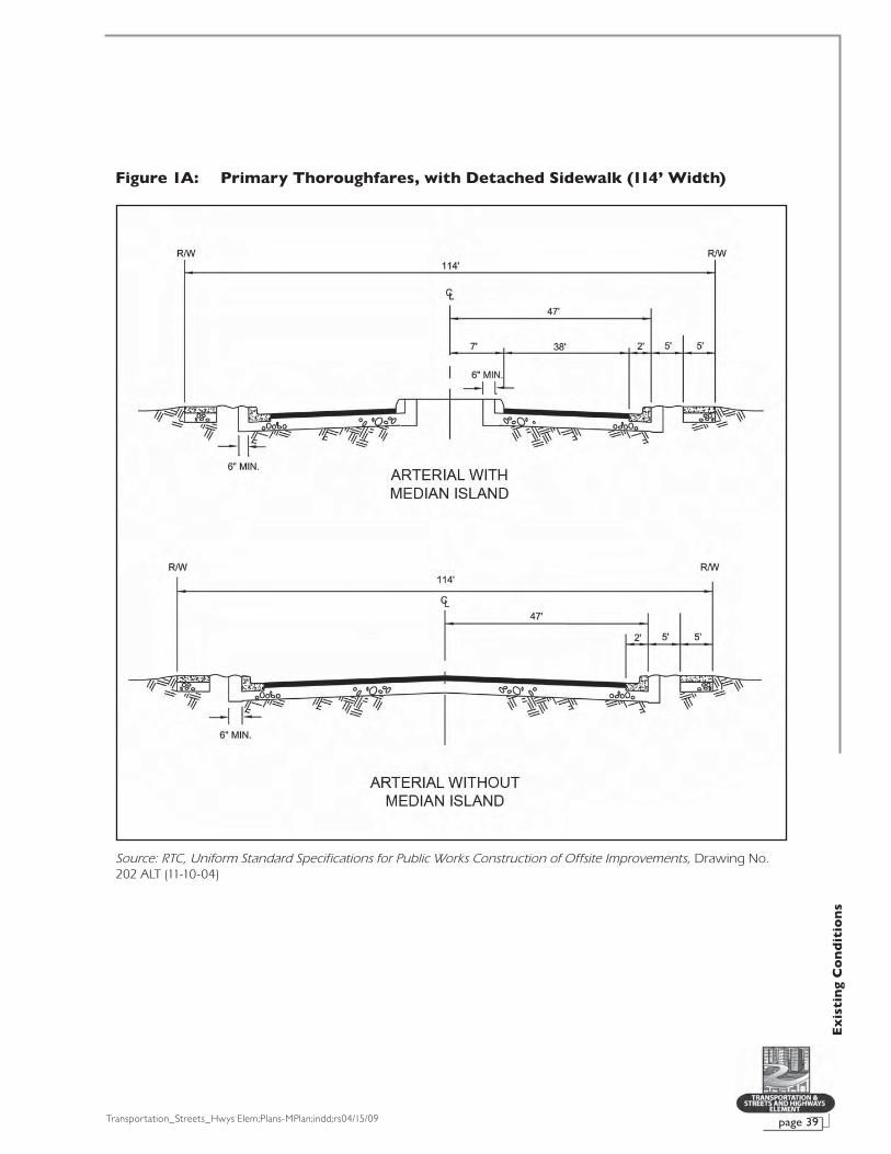
Transportation_Streets_Hwys Elem;Plans-MPlan;indd;rs04/15/09 page 39
Ex
isti
ng
Co
nd
itio
ns
Figure 1A: Primary Thoroughfares, with Detached Sidewalk (114’ Width)
Source: RTC, Uniform Standard Specifications for Public Works Construction of Offsite Improvements, Drawing No. 202 ALT (11-10-04)

Transportation_Streets_Hwys Elem;Plans-MPlan;indd;rs04/15/09page 40
Ex
isti
ng
Co
nd
itio
ns
Figure 1B: Primary Thoroughfares, without Detached Sidewalk (100’ Width)
Source: RTC, Uniform Standard Specifications for Public Works Construction of Offsite Improvements, Drawing No. 202 (11-10-04)

Transportation_Streets_Hwys Elem;Plans-MPlan;indd;rs04/15/09 page 41
Ex
isti
ng
Co
nd
itio
ns
Figure 1C: Secondary Thoroughfares, with Detached Sidewalk (90’ Width)
Source: RTC, Uniform Standard Specifications for Public Works Construction of Offsite Improvements, Drawing No. 205 ALT (11-10-04)
Source: RTC, Uniform Standard Specifications for Public Works Construction of Offsite Improvements, Drawing No. 205 ALT (11-10-04)
Figure 1D: Secondary Thoroughfares, without Detached Sidewalk (80’ Width)

Transportation_Streets_Hwys Elem;Plans-MPlan;indd;rs04/15/09page 42
Ex
isti
ng
Co
nd
itio
ns
Figure 1E: Secondary Thoroughfares, without Detached Sidewalk (60’ Width)
Source: RTC, Uniform Standard Specifications for Public Works Construction of Offsite Improvements, Drawing No. 205 (11-10-04)

Transportation_Streets_Hwys Elem;Plans-MPlan;indd;rs04/15/09 page 43
Ex
isti
ng
Co
nd
itio
ns
Figure 1F: Local Streets
Figure 1G: Private Streets
Source: RTC, Uniform Standard Specifications for Public Works Construction of Offsite Improvements, Drawing No. 207 (11-10-04)
Source: RTC, Uniform Standard Specifications for Public Works Construction of Offsite Improvements, Drawing No. 210 (12-14-00)

Transportation_Streets_Hwys Elem;Plans-MPlan;indd;rs04/15/09page 44
Ex
isti
ng
Co
nd
itio
ns
FREEWAYSAs defined by the Las Vegas Municipal Code above, a
freeway is a divided controlled-access highway with 150-foot wide minimum right-of-way and grade-separated interchanges. Four freeways exist within the city limits. The Bruce Woodbury Beltway (I-215 and CC215), which is located intermittently in the city, contains portions that are grade-separated; however, it will not be considered a freeway until construction is complete.
• I-15: Runs through the heart of the Las Vegas Valley connecting the city of Las Vegas with the rest of the nation. I-15 North connects Las Vegas to Salt Lake City and I-15 South leads to Los Angeles. The “Spaghetti Bowl” is a locally coined name for the I-15 and US 95/I-515 interchange located near downtown in the heart of the Las Vegas Valley.
• US 95: Provides connectivity with Reno northbound and joins with I-15 and US 93 at the center of the Valley. It proceeds south to Laughlin, Nevada and on to Bullhead City, Arizona.
• I-515: Originates at the Spaghetti Bowl and continues south to I-215 in Henderson. A circumferential route of the Interstate System, it is co-signed with US 95 throughout its reach.
• US 93: Is coincidental with US 95 and I-515 from the Spaghetti Bowl to Henderson. It proceeds south to Laughlin, Nevada.
Map 6 shows the extent of freeways in the city of Las Vegas and their connectivity to points outside of the city.
HIGH OCCUPANCY VEHICLE LANES (HOV)High occupancy vehicle (HOV) lanes encourage carpool-
ing by enabling drivers with passengers to travel in separate lanes, usually at higher speeds than mixed-flow traffic. The Nevada Department of Transportation has added carpool lanes to the recently widened sections of US 95. The lanes extend north and south from approximately Lake Mead Boulevard to the Spaghetti Bowl. Additional lanes are currently being added to I-15, and NDOT anticipates that more HOV lanes will be added to other Las Vegas Valley freeways in the future.
BICYCLE TRANSPORTATIONCurrently, there are more than 82 miles of bicycle routes,
192 miles of bicycle lanes and 107 miles of shared use bicycle travel lanes within the Las Vegas Valley.58 The RTC’s Regional
58 RTC, Regional Transportation Plan, Fiscal Year 2009-2030, Bicycle and Pedestrian Plan, (Oct. 2008), p. 19.

Transportation_Streets_Hwys Elem;Plans-MPlan;indd;rs04/15/09 page 45
Ex
isti
ng
Co
nd
itio
ns
Bicycle Map recognizes the following Federal Highway Administration (FHWA) definitions for a bicycle route, a bicycle lane and a shared-use path:
• Bicycle Route – A signed shared roadway is desig-nated by placing signs along the roadway, indicating it is a preferred route for bicycle use. Bicycle routes are designated on roadways that have a wide curb lane of at least 14 feet or greater between the lane line and the lip of the curb, plus a 1.5-foot wide gutter pan.
• Bicycle Lane – A bicycle lane is a portion of a road-way that has been assigned using striping, signing, and pavement markings for the use of bicyclists. The width of the bicycle lane is set at a four-foot minimum from the bicycle lane strip to the edge of the pave-ment, plus a 1.5-foot wide gutter pan.
• Shared-Use Path – A shared-use path is a bikeway physically separated from motorized vehicular traf-fic by an open space or barrier and either within the highway right-of-way or within an independent right-of-way. Pedestrians, skaters, wheelchair users, jog-gers, and other non-motorized users also may use the shared-use paths. The minimum width for a shared-use path is 12 feet of paving for bidirectional travel, with a minimum two-foot shoulder on both sides of the path.
Following the recommendations of a 2004 study, the 2006-2030 Regional Transportation Plan proposed 690 miles of bicycle lanes, 390 miles of routes and 760 miles of shared use paths over 20 years at a cost of $50 million.59 The projects will extend alternative modes of travel by linking bicycle facili-ties to the farthest reaching points of transit service, locating new routes within a quarter mile of transit, and, when possible, providing routes within transit corridors, including Boulder Highway from Henderson to Downtown Las Vegas.
For analysis and recommendations pertaining to bikeways within the city of Las Vegas, please refer to the Transportation Trails Element of the Las Vegas 2020 Master Plan.
59 RTC, Regional Transportation Plan, Fiscal Year 2006-2030, p. 4-33.

Transportation_Streets_Hwys Elem;Plans-MPlan;indd;rs04/15/09page 46
Ex
isti
ng
Co
nd
itio
ns
STREET TREATMENT (CURRENT LANDSCAPE BUFFERING)
Perimeter buffer zones on private property that is adja-cent to all street rights-of-way are currently regulated by the “Perimeter Landscape Buffering” requirements found in Title 19.12.040 of the Las Vegas Municipal Code. These regulations include the minimum “buffer zone depth,” or width, which is determined by the use of the property. The landscape buffer width requirements shown in 19.12.040(A), Table 1 are as fol-lows:
Table 6: Current Perimeter Landscape Buffer Widths
Standard Residential(Multi-Family) Commercial Industrial Residential
(Single Family)
Minimum Zone Depth – Adjacent to Right-of-Way
10 feet* 15 feet 15 feet 6 feet**
*When adjacent to or across the street from an existing single family residential use or zoning district, the buffer shall be increased to 15 feet.**Only when adjacent to streets classified as collector or larger.
Source: Las Vegas Municipal Code Title 19.12.040(A), Table 1. See Note 50.
Three types of encroachments are currently allowed within the landscape buffer zone:60
1. Driveways (curb cuts) that are located perpendicular or approximately perpendicular to the street right-of-way.
2. Sidewalks that are located perpendicular or approxi-mately perpendicular to the street right-of-way.
3. Pedestrian plazas that are located adjacent to the public right-of-way and in accordance with LVMC 19.08.050(E)(3).
Sidewalks and trails parallel to the street are not includ-ed in the measurement of the perimeter landscape buffer. Similarly, when the sidewalk has landscaping on both sides, as is required on arterial streets, the landscaping adjacent to the street right-of-way does not count towards the landscape buf-fer width requirements. This method of calculating landscape buffer width provides no incentive for the developer to provide a landscape buffer between the sidewalk and the roadway on streets less than 100 feet in width. All sidewalks are required to be a minimum of five feet in width and conform to the Uniform Standard Drawings, Clark County area, as adopted by the city. Sidewalks located along arterial streets one hundred feet and wider are required to be separated from the back of the street curb by a minimum five-foot landscape buffer, per Title 19.12.040F (See Figure 2).61
60 Las Vegas Municipal Code, Chapter 19.12.040.D.61 See Note 50.

Transportation_Streets_Hwys Elem;Plans-MPlan;indd;rs04/15/09 page 47
Ex
isti
ng
Co
nd
itio
ns
Landscaping is required within the buffer area adjacent to public right-of-way. Plant material and landscape design are regulated through Title 19.12.040, where the number and size of trees and plants are specified. There are currently two alternatives to the standard tree arrangement within buffer zones. See Table 7 below. Design illustrations are located in Title 19.12.080.
Table 7: Current Minimum Size, Amount and Spacing of Perimeter Landscape Materials
ResidentialSingle Family Residential
Multi-Family Commercial/
Industrial
Trees
1 – 24-inch box per 30 linear feet on center
1 – 24-inch box per 20 linear feet on center
1 – 24-inch box per 20 linear feet†
1 – 24”-inch box per 30 linear feet‡
1 – 24-inch box tree or 1 – 15-foot palm per 35 linear feet on center plus one on each end of planter, plus2 – 15-gallon box trees or palm trees per 35 linear feet to be located between the 24-inch trees
Same as for residential single family
Same as for residential single family
Tree clus ters: Shal l exceed the minimum number of trees as calculated above by at least one tree; spacing shall not exceed 45 linear feet on center
Tree clus ters: Shal l exceed the minimum number of trees as calculated above by at least one tree; spacing shall not exceed 45 linear feet on center
Tree clus ters: Shal l exceed the minimum number of trees as calculated above by at least one tree; spacing shall not exceed 35 linear feet on center
Shrubs 4 – 5-gallon shrubs per each required tree
Same as for residential single family
Same as for residential single family
Groundcover* Min. 2-inch depth Same as for residential single family
Same as for residential single family
†Where adjacent to any residential use
‡Where adjacent to any commercial or industrial use
*Non-vegetative groundcovers shall include, without limitation, rocks and small stones, crushed rock and bark
NOTE: Standards are for all areas of the city not in planned developments or special plan areas.
Source: LVMC Title 19.12.040(B). See Note 50.
Figures 2 through 5 depict graphic illustrations of the cur-rent landscape buffer requirements in Title 19.62
62 See Note 50.

Transportation_Streets_Hwys Elem;Plans-MPlan;indd;rs04/15/09page 48
Ex
isti
ng
Co
nd
itio
ns
Figure 2: Arterial Streetscape (Adjacent Commercial Use Shown)
Figure 3: Commercial/Industrial Streetscape
NOTE: Drawings are representative of current landscape buffering requirements and may not reflect actual streetscape design.
NOTE: Drawings are representative of current landscape buffering requirements and may not reflect actual streetscape design.
PL
PL

Transportation_Streets_Hwys Elem;Plans-MPlan;indd;rs04/15/09 page 49
Ex
isti
ng
Co
nd
itio
ns
Figure 5: Residential Single Family Streetscape (Collector or Greater)
Figure 4: Residential Multi-Family Streetscape
NOTE: Drawings are representative of current landscape buffering requirements and may not reflect actual streetscape design.
NOTE: Drawings are representative of current landscape buffering requirements and may not reflect actual streetscape design.
PL
PL

Transportation_Streets_Hwys Elem;Plans-MPlan;indd;rs04/15/09page 50
Ex
isti
ng
Co
nd
itio
ns
BUILDING SETBACKS
Building line setbacks within the city of Las Vegas are primarily determined by zoning district or by the Master Developer of a planned community within a development agreement. Title 19 of the Las Vegas Municipal Code defines a setback as “the required separation distance between the nearest portion of a structure and the property line.”63 Standardized zoning districts, such as those for rural single-family residential or commercial developments, have specific minimum distances behind which a structure must be built from the public right-of-way. In some cases, the front yard setback varies depending on whether the street is public or private, and whether a turnaround exists in front of the property. The front yard setback along collector streets may also vary de-pending on the height of adjacent buildings, as described in Title 19.08.030(C) of the Las Vegas Municipal Code.64 These districts are listed below, with explanatory notes:
Table 8: Single Family Residential District Setback Standards
Standard U R-A R-E R-D R-1 R-CL† R-MH R-MHP
Min. Front Yard Setback (feet) 50* 50* 50* 25 20 14 20 5
Min. Corner Side Yard Setback (feet)
15 15 15 15 15 10 10 5
*The table denotes the front yard setback from a public street. In the case of a lot fronting on a private street or pri-vate access easement, the front yard setback is 30 feet from the edge of the private street or private access easement. Where such lots are located on a cul-de-sac or street knuckle, the front yard setback shall be 20 feet from the edge of the private street or private access easement. Structures having an attached, open porte cochere shall be set back a minimum of 30 feet from the front property line or the edge of the private street or private access easement, except where the setback is less restrictive.
†Single Family Residential Compact-Lot (R-CL) District. The minimum front yard setback is 14 feet. However, the minimum front yard setback for attached front entry garage and carport structures is 16 feet for any lot located on a cul-de-sac bulb or street knuckle, and 18 feet in all other cases. The minimum side yard setback for a side yard along a street is 10 feet. The minimum combined width of both side yards for each lot is 10 feet.
Source: Las Vegas Municipal Code Title 19.08.040 Table 1. See Note 50.
Table 9: Residential District Standards Other Than Single Family
Standard R-2 R-3 R-4 R-5
Min. Front Yard Setback (feet) 20 20 10 10
Min. Corner Side Yard Setback (feet) 5 5 5 5
Source: Las Vegas Municipal Code Title 19.08.040 Table 2. See Note 50.
Table 10: Commercial and Industrial Setback Standards
Standard P-R N-S O C-D C-1 C-2 C-PB C-M M†
Min. Front Yard Setback (feet) 20 25 25 25 20 20 20 10 10
Min. Corner Side Yard Setback (feet)
15 15 15 15 15 15 20 10 10
†Where a property in an Industrial (M) District is adjacent to, or across the street from, a residential district, the mini-mum setback from the property line or street right-of-way line shall be 50 feet.
Source: Las Vegas Municipal Code Title 19.08.050 Table 1. See Note 50.
63 Las Vegas Municipal Code, Chapter 19.20.020. See Note 50.64 See Note 50.

Transportation_Streets_Hwys Elem;Plans-MPlan;indd;rs04/15/09 page 51
Ex
isti
ng
Co
nd
itio
ns
Some special planning areas of the city contain separate setback requirements, or may leave those requirements to the discretion of the City Council. Although lots are located within general zoning districts, all structures in the Downtown Centennial Plan District are exempt from the automatic applica-tion of required setbacks.65
Setback standards for residential planned developments are suggested by the developer and approved by the City Council as part of a Site Development Plan Review. They con-sider whether a vehicle will be parked full-time within a garage or part-time in a driveway, the narrowness of the street, or the particular feel of the neighborhood. For example, a neotradi-tional neighborhood may contain staggered setbacks or nar-row setbacks to give visual interest to the street.
STREET NAMING AND NUMBERING
City of Las Vegas Ordinance 3744, adopted on October 20, 1993, amended Title 13.28 of the Municipal Code to re-adopt guidelines and requirements concerning the naming of streets and assignment of addresses within the city limits. The regulations were developed through the combined ef-forts of the city of Las Vegas, Clark County, Henderson, North Las Vegas, Boulder City, the U.S. Postal Service, and others. A separate document titled City of Las Vegas Street Naming and Address Assignment Regulations, 1993 Edition was adopted as part of Ordinance 3744. A properly standardized, maintained, accurate, and consistent address system is an essential tool that is vital to the operations of fire, police, and other service enti-ties. It is critical for the addressing of parcels and buildings to be done methodically, sequentially, and follow a set of stan-dards. In 2007, each of these agencies reviewed the current addressing policy and suggested revisions to the document to eliminate inconsistencies that had developed since the last update. Adoption of the city’s revised addressing policy is ex-pected in 2009.
STREET NAMINGStreet names are used to identify all public and private
streets. The city reviews and takes action regarding proposed street names and actively works with other government enti-ties in the Las Vegas Valley to coordinate street names. Specific requirements for street naming are contained within the City of Las Vegas Street Naming and Address Assignment Regulations, 1993 Edition, referenced by Title 13.28.06066 of the Municipal Code.
65 Las Vegas Municipal Code, Chapter 19.06.060(C). See Note 50.66 See Note 50.

Transportation_Streets_Hwys Elem;Plans-MPlan;indd;rs04/15/09page 52
Ex
isti
ng
Co
nd
itio
ns
ADDRESS NUMBERINGThe intersection of Main and Fremont Streets is the ini-
tial point of prefix/suffix and address number assignment to all blocks, lots, and buildings in the city. This intersection is called the point of origin. All east-west streets that intersect Main Street are given a prefix/affix of “east” or “west” accord-ingly. The same applies to all north-south streets which inter-sect Fremont Street, with each given a prefix/affix of “north” or “south.” All other streets that do not cross either Main or Fremont Streets or the zero lines do not obtain a prefix/affix before the street name.
The street numbering system is conducted by block ranges and counted progressively by one hundred. The first block on either side of Main and Fremont Streets has an ad-dress range of 0-99. The second block has a range of 100-199, and so on. Individual addresses will fall within their respective block ranges so that the further away from the point of origin, the higher the block range and addresses. Also, addresses on east-west streets are to be issued an even address number if located on the north side of the street and an odd number if located on the south side of the street. Likewise, addresses on north-south streets are to be issued an even number if located on the east side of the street and an odd number if located on the west side of the street. Exceptions are considered in parts of the city where historical addresses were assigned that con-tradict the adopted address numbering system, in accordance with the ordinance. The Planning & Development Department is responsible for assignment of all addresses in the city.
In order to maintain a consistent numbering grid through-out the city the zero line must shift to alignments other than Main and Fremont Streets. The city’s Municipal Code specifies the alignments along which the zero line shall be located.
MULTI-FAMILY RESIDENTIAL ADDRESSINGAll multi-family residential developments are assigned
a single address corresponding to the appropriate hundred blocks as described above. This address is considered the mas-ter site address. In general, a multi-family residential address will contain the master site address, building number, and unit number to create a unique address. The City of Las Vegas Street Naming and Address Assignment Regulations, 1993 Edition contains the specific address requirements for multi-family developments.
NON-RESIDENTIAL ADDRESSINGAll non-residential developments are assigned a single ad-
dress corresponding to the appropriate hundred blocks as de-scribed above. This address is the master site address if there is only one building on the site. For developments with multiple

Transportation_Streets_Hwys Elem;Plans-MPlan;indd;rs04/15/09 page 53
Ex
isti
ng
Co
nd
itio
ns
buildings, the primary entrance of the site receives a master site address and each building within the development receives a unique building address. The City of Las Vegas Street Naming and Address Assignment Regulations, 1993 Edition contains the specific address requirements for non-residential developments.
STREET AND ADDRESS CHANGESThe procedure by which a petitioner may change the
name of any street is detailed in Title 19.18.13067 of the Las Vegas Municipal Code. The City Council may approve a name change if the change is in the best interest of the public and no person will be materially injured.
At the request of the property owner or developer, the city may grant the approval of an address change. However, the proposed address change must not conflict with the addressing system, unless a waiver is approved by the City Council.
Property owners do not have vested rights to street names and numbers, even if the address has been used for many years. When the city finds inconsistencies, and the Director of Planning or designee determines a correction is needed, the property owner will be notified that a change may occur.
TRAFFIC MEASUREMENT AND MANAGEMENT
ANNUAL AVERAGE DAILY TRAFFIC (AADT)One statistic used by transportation engineers and plan-
ners to measure the volume of traffic on area roadways is known as Annual Average Daily Traffic, or AADT. This measure-ment is found by calculating the total volume of traffic in both directions of a street or highway for a year, divided by 365 days. AADT is commonly used to calculate the design traffic load for roads as well as uses in pavement design. As a road network management tool, AADT can help road authorities assess the current usage of a particular street road and assign a street to its proper functional classification. This measurement also allows authorities to assess whether the majority of the vehicular traffic is using the intended route through a particular area or whether motorists are cutting through local streets to avoid congestion on major roads. Area-Wide Major Projects, which, according to the RTC, are those that have an existing AADT of at least 40,000 and a 10-year projected AADT volume of at least 60,000, or are part of I-15, US 95, I-515, Summerlin Parkway, Super Arterials or the Las Vegas Beltway/I-215, includ-ing interchanges and grade separations on roadways with at
67 See Note 50.

Transportation_Streets_Hwys Elem;Plans-MPlan;indd;rs04/15/09page 54
Ex
isti
ng
Co
nd
itio
ns
least 100-foot rights-of-way, qualify for special funding through the yearly TIP.68
Maps 7A through 7C show the volume of major arterial streets within the city limits. The maps show two kinds of traffic data. The “24-hour counts” refer to the number of vehicles that pass a given point in a 24-hour period. “Turning Movement Counts” uses a mathematical formula to scale the number of vehicles turning onto the cross street at a given intersection during peak traffic hours. The turning movements indicate where volumes are increasing and the origin of congestion. The Traffic Engineering Division’s traffic count program obtains traffic counts within the city as part of traffic signal warrant studies, stop sign warrant studies, intersection studies, and similar traffic projects that are carried out throughout a given year. The goal of the program is to keep count data that is less than three years old for all major intersections so that staff can monitor, plan for, and deploy traffic improvements as neces-sary. At some high growth locations, counts are obtained even more frequently. Analysis of the data indicates that the most consistently heavy volumes are along Charleston Boulevard and Sahara Avenue. Rainbow Boulevard has an especially high volume between Sahara Avenue and US 95.
The Department of Public Works, Traffic Engineering Division has recently prepared the Intersections Program Master Plan, which evaluates the level of service at each of the city’s top 200 highest traffic volume intersections. By monitor-ing traffic activity, engineers can determine which intersections need the most urgent improvements and budget accordingly. These improvements aim to reduce congestion, reduce vehicle and pedestrian conflicts, improve traffic flow and reduce air pollution related to vehicle emissions.
VEHICLE MILES TRAVELED (VMT) AND CAPACITY
Another data type used in traffic analysis is Vehicle Miles Traveled (VMT), which measures the number of miles traveled on a given roadway for a given period of time. It is a principal indicator of travel demand and is essential in the analysis of roadway improvements.
An important goal of transportation planning is to reduce overall VMT. Problems caused by automobile traffic increases include worsening air quality, congestion, higher accident risk, and expenditures for increasing roadway capacity in the circulatory network. The local solution to this problem in the short term has been to increase roadway capacity, since traffic demand is steadily growing and efforts to encourage voluntary reduction of vehicle travel have not sufficiently reduced con-
68 RTC Policies and Procedures, September 19, 1980, Revised December 13, 2007, p.66.

Transportation_Streets_Hwys Elem;Plans-MPlan;indd;rs04/15/09 page 55
Ex
isti
ng
Co
nd
itio
ns
gestion. Capacity is defined as the maximum number of vehicles that can pass over a given segment of a road in a given time period under current conditions. Increasing capacity is achieved by constructing additional lanes.
A study commissioned by the RTC to evaluate options for decreasing congestion on Rainbow Boulevard between US 95 and Desert Inn Road, and on Desert Inn Road from Rainbow Boulevard east to Valley View Boulevard was completed in April 2008. Public comment on the study closed on January 18, 2008. The study examined both short-term and long-term solutions to the traffic congestion in both corridors. Short-term improve-ments proposed included the installation of an additional lane on Rainbow Boulevard between Sahara Avenue and Desert Inn Road, installation and or lengthening of existing turn lanes at the major intersections, and the addition of turn-out areas for buses to reduce traffic obstruction. On Rainbow Boulevard within the city limits, long-term improvements could include overpasses at Sahara Avenue and Charleston Boulevard that would allow drivers to bypass those intersections. Access to businesses and residential areas would be maintained by keeping at-grade travel lanes open at those intersections. Also, bicycle and pedestrian bridges could be developed to preserve neighborhood connectivity. The study was heard by the RTC’s Executive Advisory Committee and was rejected due to strong public opposition.69
NDOT’s I-15 North Design-Build Project, scheduled to con-clude by February 2010, also aims to reduce congestion and improve traffic flow between the Spaghetti Bowl and Craig Road interchanges by increasing capacity. Improvements include expanding the freeway from six to ten lanes and reconstructing the ramps at each interchange, with new overpasses planned at Bonanza Road, D Street and Washington Avenue. An Intelligent Transportation System (ITS) will be implemented along this stretch to monitor the flow of traffic. Ramp meters, closed-circuit cameras and message signs will be used.70
NDOT commissioned another study to improve circulation on I-515/US 95 between I-15 and I-215. The entire project, projected to cost more than $1 billion, includes adding new lanes, new connections between I-515/US 95 and I-15, new interchanges at F Street and Sahara Avenue, and surface street widening.71
Another NDOT project, Project Neon, has been proposed as a response to the increasing congestion on I-15 near down-town Las Vegas. Improvements will span the segment of I-15 between the US 95 and Sahara Avenue interchanges and include reconstruction of the Charleston Boulevard interchange, a new access to Alta Drive, and a flyover connecting Martin Luther King
69 RTC, Rainbow Boulevard-Desert Inn Road Corridors Study, retrieved from www.rtcsouthernnevada.com/mpo/plansstudies/rainbow/index.cfm.
70 NDOT, I-15 North Design-Build Project, retrieved from www.i15project.com/.
71 Retrieved from www.i515study.com/recommendedalternatives.htm.

Transportation_Streets_Hwys Elem;Plans-MPlan;indd;rs04/15/09page 56
Ex
isti
ng
Co
nd
itio
ns
Boulevard with Industrial Road.72 According to NDOT’s Project Neon project manager, funding is secured to move the project forward to the 35 percent design phase.
The I-15 Resort Corridor Study is an extensive review of the freeways and major east-west arterial roads, as well as roads within the resort corridor between US 95 and I-215. Two of the ideas to increase capacity that have surfaced from the I-15 Resort Corridor Study Technical Advisory Group meetings are the use of HOV and/or managed (toll) lanes and improving Dean Martin Drive and Frank Sinatra Drive to function as frontage roads within the Resort Corridor. Additionally, improving modal choice via rapid transit bus routes with minimal stops has been identified as a way to help increase capacity. The study began in September 2007 and is expected to be completed by March 2009.
The study partners expect that the following goals will be achieved:
• “[Development of] a phased implementation strategy for future improvements to I-15 in the resort corridor area in addition to currently planned improvements.
• [Preparation of] an early action plan for near-term im-provements to enhance mobility and operations.
• [Development of] additional measures to enhance access and mobility within the resort corridor.”73
Another long-term transportation study, the Sheep Mountain Parkway Environmental Impact Statement Coordination Plan and Feasibility Study, is underway in the northern reaches of the Las Vegas Valley. The city of Las Vegas, in cooperation with the Federal Highway Administration, city of North Las Vegas, Clark County, the RTC, BLM, United States Department of Defense, and NDOT, is proposing the acquisition and preservation of a right-of-way corridor north of the Bruce Woodbury Beltway and west of I-15 that would connect the Beltway to both I-15 and US 95. The northern portion of the Las Vegas Valley is expected to have significant population growth, and future development stemming from the expected sale of federal lands will generate considerable transportation demands. One element of the Sheep Mountain Parkway project will be the feasibility study of a multi-modal transportation corridor that would include HOV lanes, light rail and bicycle/pedestrian facilities with landscaped buffer zones and frontage roads. The scoping process that began in May 2008 will culminate with the completion of an environmental impact statement (EIS) by February 2010 and the anticipated approval of the EIS by May 2010.74 Construction may not occur for many more years into the future.
72 NDOT, “Major Current and Future NDOT Projects in Southern Nevada,” Press Release of April 13, 2005, retrieved from www.nevadadot.com/news/Press_Release/releases.
73 Retrieved from www.i15resortcorridorstudy.com.74 Parsons Brinckerhoff, Sheep Mountain Parkway Environmental Impact
Statement Draft Coordination Plan and Feasibility Study, April 1, 2008.

Transportation_Streets_Hwys Elem;Plans-MPlan;indd;rs04/15/09 page 57
Ex
isti
ng
Co
nd
itio
ns
75 Kimley-Horn and Associates, Downtown Traffic Capacity, Transit, and Parking Needs Study, p. iii. The overlays include a Traffic Emphasis, Transit Emphasis, Pedestrian and Streetscape Emphasis, and a Multi-Modal Emphasis.
76 City of Las Vegas City Council Agenda Item 96 (DIR-29999).
While increasing capacity is a necessary short-term solution to traffic congestion, taking steps to reduce the growth of VMT will be required over a period of many years to prevent congestion from worsening, beginning now.
In July 2007, the RTC approved the Downtown Traffic Capacity, Transit, and Parking Needs Study as a ten-year strategy to develop a more balanced multi-modal transportation system in downtown Las Vegas. This document develops a “street hierarchy” overlay on top of the traditional functional classification that emphasizes improve-ments such as bike lanes, transit lanes and pedestrian corridors typically associated with an urban core, while preserving or expand-ing capacity on certain arterial streets in and around downtown.75
The study concludes that a certain level of congestion is acceptable for the sake of creating a more “livable” Downtown. This study was advisory only and was not adopted or accepted by the city.
Following on the heels of this study, the Las Vegas Downtown Pedestrian Circulation Study was accepted by the RTC on May 29, 2008. The goal of the study was to recommend ways to improve walkability downtown and attract pedestrians to the area. The study recommended that the city continue to implement Las Vegas Downtown Centennial Plan streetscape requirements, which mandate widened sidewalks, planters and landscaping themes for new projects. Pedestrian bridges were proposed as a way to reduce conflicts between vehicles and pedestrians and to increase the level of service at intersections where they are constructed. The study also recognized that major downtown transportation cor-ridors, namely I-15, I-515/US 95 and the Union Pacific Railroad, are major barriers to pedestrian mobility to and from the study area, and recommended that planners coordinate with NDOT to address undercrossings and entry points so as to increase pedestrian access to the downtown. This study was accepted by the City Council on December 3, 2008.76
INTELLIGENT TRANSPORTATION SYSTEMS (ITS)Traffic congestion has been increasing in the Las Vegas Valley
as a result of increased motorization, population growth and chang-es in population density. Congestion reduces efficiency of transpor-tation infrastructure and increases travel time, air pollution and fuel consumption. Intelligent Transportation Systems (ITS) make use of advanced detection communications and computing technology to improve the safety and efficiency of our surface transportation net-work. ITS vary in technologies applied, from basic management sys-tems such as traffic signal control systems, variable message signs, or speed cameras to more advanced applications such as parking guidance or weather information.

Transportation_Streets_Hwys Elem;Plans-MPlan;indd;rs04/15/09page 58
Ex
isti
ng
Co
nd
itio
ns
The Freeway and Arterial System of Transportation (FAST) is an integrated Intelligent Transportation System in Southern Nevada. FAST has been under the jurisdiction of the RTC elected board since July 3, 2004. Transportation strategies are set by the Operations Management Committee (OMC), consist-ing of the RTC, city of Las Vegas, Clark County, NDOT, City of Henderson and City of North Las Vegas.
There are two major areas that make up the FAST system: the Arterial Management Section, which includes all arterial streets and roadways; and the Freeway Management System, which includes the freeway network. Currently, the Las Vegas Valley uses dynamic message signs, traffic cameras, ramp meters, and traffic signal timing plans to help reduce conges-tion, air pollution, and fuel consumption. As of April 2008, the Las Vegas Valley has 20 dynamic message signs. Dynamic message signs are electronic sign boards used to display information. These signs are connected to the FAST Traffic Management System through a fiber optic communication network. The signs are able to place messages to alert drivers of an accident ahead, ramp or lane restrictions, and upcom-ing construction. Another method of managing traffic utilized by FAST is through ramp meters. Ramp meters are important traffic management techniques designed to keep traffic flow-ing on the freeways and help to reduce accidents. If cars enter the freeway in a spaced, controlled manner, they merge more easily and with less disruption to mainline traffic.
Incident Management Cameras (IMCs) were installed to assist in responding to reported incidents more effectively and efficiently, while modifying traffic signal timing. The cameras produce images to monitor and view traffic at signalized loca-tions, freeway facilities, and high volume mid-block settings. There are a total of 49 IMCs throughout the Las Vegas Valley. Of those, 12 are for freeway assistance and the remaining 37 are for arterial assistance. Traffic signal timing adjustments have been completed for early mornings, mid-days, evenings and weekends for nearly 40 corridors in the region, including the Downtown Las Vegas grid. Retiming in several corridors has resulted in improvements in delay time and travel speed. The city of Las Vegas is responsible for maintaining the equip-ment and power for traffic signals, while FAST is responsible for timing and traffic synchronization. There are about 1,200 traffic signals throughout the Las Vegas Valley that are on the network and able to be remotely controlled. More are coming online regularly as FAST works with area agencies to install fi-ber optics and upgraded signal controllers across the Las Vegas Valley.77
77 RTC, retrieved from www.nvfast.org.

Transportation_Streets_Hwys Elem;Plans-MPlan;indd;rs04/15/09 page 59
Ex
isti
ng
Co
nd
itio
ns
EXISTING MASS TRANSIT AND FREIGHT MOVEMENT
FIXED-ROUTE TRANSITThe fixed route transit services currently available in the
City include the Citizens Area Transit (CAT), Metropolitan Area Express (MAX), Las Vegas Deuce, and the Las Vegas Strip Trolley. Please refer to the Las Vegas Transit Element for a more detailed description of each transit service. The RTC is cur-rently constructing a new higher speed transit service called ACE. This system will feature dedicated lanes for bus transit and fewer stops. ACE will connect downtown Las Vegas to the Las Vegas Convention Center, the Strip, Henderson and North Las Vegas. The Downtown Connector line, which includes a route along Paradise Road, St. Louis Avenue, Main Street, Imperial Avenue, Third Street, Casino Center Boulevard, Odgen Avenue and Grand Central Parkway, is currently under con-struction. The project is expected to be completed in the fall of 2009.78 Center-running transit lanes and mid-street stations are planned so as to allow for potential conversion to rail service.79
With fewer stops, amenities such as wireless internet availabil-ity, and a route that parallels Las Vegas’ world-class attractions, the RTC expects ACE to define the future of transit in Las Vegas.
RAIL TRANSPORTThere are two kinds of rail transport to and from Las
Vegas: passenger and freight. Currently rail services are lim-ited; however, the potential for future expansion is good, given the population base and demand for products.
The Nevada Department of Transportation’s 2002 state-wide transportation plan (NevPLAN) identifies the “Desert Wind” passenger rail route as defunct. This route, which ran between Los Angeles and Chicago with a stop at Las Vegas, was discontinued in 1996 as a result of budget cuts by the National Railroad Passenger Corporation (Amtrak).80 Currently, the only rail service available to Las Vegas passengers is the Las Vegas Monorail.
Rail freight service in the Las Vegas area is provided by Union Pacific. The Union Pacific Railroad is Nevada’s dominant Class I railroad, with annual revenues exceeding $250 million.81
Freight generally consists of transcontinental shipments passing through Nevada, locally manufactured goods, raw materials for local consumption, and goods that are unloaded in Las Vegas to be trucked to nearby locations.82
78 RTC, ACE Project Update, retrieved from www.rtcsouthernnevada.com.
79 Las Vegas 2020 Master Plan, Transit Element (Feb. 20, 2008), p. 42.80 Nevada Department of Transportation, Statewide Transportation
Plan (NevPLAN) (Nov. 14, 2002), p. 43.81 NevPLAN, p. 41.82 RTC, Regional Transportation Plan Fiscal Year 2006-2030, p. 2-47.

Transportation_Streets_Hwys Elem;Plans-MPlan;indd;rs04/15/09page 60
Ex
isti
ng
Co
nd
itio
ns
The Burlington Northern and Santa Fe Railway is the only other Class I hauling railroad in Nevada. According to the BNSF rail map published in November 2007 on the BNSF web-site, the Burlington Northern and Santa Fe does not operate a route within the Las Vegas Valley.
Short line (Class III) railroads are not located in the Las Vegas area but do exist elsewhere in the state. These include local short-haul freight operators and switching and terminal companies.

Transportation_Streets_Hwys Elem;Plans-MPlan;indd;rs04/15/09 page 61
An
aly
sis
83 Southern Nevada Regional Planning Coalition, Infill Development Plan (Nov. 21, 2002), p. 17.
84 Ibid., p. 46.
ANALYSIS
LINK BETWEEN TRANSPORTATION AND LAND USE
Transportation and land use planning are interrelated. They have many direct and indirect effects on each other within the community. Given this relationship, it is sound prac-tice to approach transportation and land use planning efforts complementarily rather than independently. This ensures that transportation systems do not contradict current and future land use planning efforts, and that land use planning does not impede implementation of the transportation system.
Transportation planning should provide for a circulation system that reflects both existing and proposed land use pat-terns within the city. Generally, those in urbanized areas are more likely to use alternative modes of transportation such as bikes and mass transit, while those living in suburban and rural areas are more automobile dependent, due to a lack of travel options and longer travel distances. Land use is often signifi-cantly influenced by the degree of accessibility to adjacent transportation systems, which can dictate the future develop-ment of a particular area. For example, industrial and intense commercial uses typically require vehicular access to highways and/or arterials, and dense, mixed-use developments located in the urban core are best suited for mass transit and other multi-modal transportation options. Higher density residen-tial land uses should therefore be located on major arterial roads in order to facilitate transit. In older areas of the city, the presence of transportation alternatives can spur redevelop-ment. The Southern Nevada Regional Planning Coalition’s Infill Development Plan recognized that the areas where pedestrian activity and transit ridership are concentrated are where infill development is most likely to be successful.83 Therefore, that plan recommended that individual entities adopt flexible land use, parking and other zoning standards in some areas to pro-mote compatible infill development.84
In addition to high-density residential uses, a greater con-centration of professional offices with higher floor area ratios should also be located along arterial roads. This will provide more transportation options for those living in denser develop-ments. A sustainable development pattern along major streets might include clusters of retail uses in proximity to available transit, integrated with high density residential uses or located within a short walking distance of existing residences.

Transportation_Streets_Hwys Elem;Plans-MPlan;indd;rs04/15/09page 62
An
aly
sis
As a matter of policy, the city’s Master Plan strives to support both “urban hubs at the intersections of primary roads, con-taining a mix of residential, commercial and office uses”85 for redeveloping areas, and “urban hubs at the intersections of pri-mary roads, containing a mix of high density residential, com-mercial and office uses, and containing pedestrian linkages”86 for newly developing areas. The city has a number of tools it can use to create incentives for developers to build these hubs: form-based code, relaxation of zoning code requirements and standards, fee waivers and expediting of permits, subsidies for infrastructure financing, tax abatement strategies (including tax-increment financing) and the establishment of a formal set of mixed-use development standards.
Providing for today while ensuring that tomorrow’s needs will be met is becoming an economic, social and environmen-tal reality. There is a growing concern that greenhouse gases from pollution sources will lead to climate change on a global scale, affecting natural resources and quality of life. The auto-mobile contributes a significant portion of human-generated pollutants to the atmosphere. In 2007 ULI published Growing Cooler, which uses extensive data to hypothesize that Smart Growth policies will lead to a reduction in the growth rate of VMT. This rate reduction will have the most significant impact on meeting target CO
2 emission levels. The authors liken trans-
portation U.S. emissions reduction efforts to a three-legged stool. The legs consist of vehicle fuel economy, fuel hydrocar-bon content, and VMT.87 In order for the stool to stand upright and for the emissions policies to work, efforts to reduce VMT must be commensurate with the efforts to increase fuel ef-ficiency and use alternative fuels. However, a combination of the projected increase in population, decrease in raw land and urban sprawl development patterns means that the U.S. will see sharp, unsustainable growth in VMT over time unless more citizens adopt alternative modes of transportation and drive less. Unless these changes are implemented in the short run, the benefits of more efficient, less polluting vehicles will be off-set by the increase in the amount of driving in the long run.88
Locating land uses that better serve the needs of the population closer to where they work and live may reduce the number and the distance of vehicle trips, resulting in conges-tion relief and a decrease in pollution from mobile sources. Multiple sources have suggested various ways to reduce VMT, including increasing fuel taxes, charging user fees for driving and parking, and establishing no-drive zones; however, the most palatable solution for many, with supporting statistics, appears to be the creation of more compact, walkable mixed-
85 Las Vegas 2020 Master Plan Policy Document (Sept. 6, 2000), pg. 42.86 Ibid., p. 48.87 Urban Land Institute, Growing Cooler (ULI, 2007), p. 2.88 Ibid., p. 4.

Transportation_Streets_Hwys Elem;Plans-MPlan;indd;rs04/15/09 page 63
An
aly
sis
use developments that are located within walking distance to services and mass transit hubs. The benefits of such devel-opments include preservation of farm land and open space; protection of the amount and quality of water; greater oppor-tunities for physical activity; reduction in infrastructure costs; and greater energy security as it relates to foreign trading of traditional fuels.89
In order to contribute to VMT reduction, street design must consider and accommodate alternative modes of trans-portation. The design must be sensitive to the neighborhood where the street is located. For example, a high-speed, six-lane arterial should not be located within an urban context where foot traffic is desirable. Street design may also encourage alternative modes of transportation. In areas where compact developments are proposed, the Institute of Transportation Engineers recommends that streets should be designed with aesthetic and safety concerns in mind to accommodate and attract pedestrians and cyclists. Within rights-of-way, sidewalks and bike lanes should be provided. Sidewalk width should be appropriate to the function of adjacent land uses. Pedestrian amenities such as trash receptacles, decorative lighting, bench-es and plazas should be provided. Crosswalks at intersections should be highly visible, using alternative paving or eye-catching striping patterns, and they should extend from ADA-compliant ramps. Crossings in the middle of shorter blocks should be available to pedestrians; ideally, these crossings will be signed, contain a median, and bridge curb extensions on both sides of the street.90 Roundabouts and traffic mini-circles are other design features friendly to pedestrians and cyclists that are especially effective on local streets, while helping to keep automobile traffic flowing efficiently.
The American Association of State Highway and Transportation Officials has published a guide to assist planners and engineers in designing and developing bicycle facilities. Roadway design affects the level of use, skill level and the level of access and mobility of the cyclist; therefore, the design of bicycle facilities has significant implications for the rate of reduc-tion of VMT. In general, bicycle facilities should be planned to provide continuity with the transportation system and consis-tency across all user groups.91 Paved shoulders, increased lane widths, smooth paving surfaces, and dedicated bicycle lanes are all recommended during the roadway design phase.
89 Ibid., p. 10.90 See ITE, Context Sensitive Solutions in Designing Major Urban
Thoroughfares for Walkable Communities (Washington, DC: ITE, 2006), p. 56, pp. 103-108, and pp. 118-124 for specific principles and considerations for proper design and placement of amenities and crossings.
91 American Association of State Highway and Transportation Officials (AASHTO), Guide For the Development of Bicycle Facilities (Washington, DC: AASHTO, 1999), pp. 6-7.

Transportation_Streets_Hwys Elem;Plans-MPlan;indd;rs04/15/09page 64
An
aly
sis
Since land use and transportation are interrelated, land use planners should know what planning solutions are be-ing developed to counter transportation issues. In the same way, traffic engineers should be aware of land use solutions to complement engineering solutions. The various regional working groups that monitor and establish solutions for wors-ening transportation conditions in the Las Vegas Valley allow both sides to work on continuing transportation issues and maintain working relationships across jurisdictional boundaries. Involving the Planning & Development Department in these working groups is important because the land use component of transportation planning is brought to the table.
The city participates on the RTC’s Executive Advisory and Utility Coordination Committees; Metropolitan Planning, Operations and Specifications Subcommittees; and the Alternative Mode Work Group. In addition, the Planning & Development Department participates on the I-15 Corridor Study and Sheep Mountain Parkway Study committees.
TRANSPORTATION PLANNING AND EMPLOYMENT
Once the center of gaming and commerce for the city, downtown Las Vegas now functions primarily as a governmen-tal, office and financial area. In recent years, several develop-ers have planned and built high-rise, mixed-use centers with ground floor retail and hundreds of condominium units above. These developments reduce dependence on the automobile, which in turn could mean fewer vehicle miles traveled, less air pollution and a shorter commuting time. It may also help to restore a sense of attachment to the history and uniqueness of the Downtown.
However, not everyone can afford housing Downtown, nor is it every citizen’s preference to live in a dense, urban set-ting. Persons must travel varying distances to work each day. As the Las Vegas metropolitan area spread ever further into the desert, commute times increased, congestion increased, air pollution increased, and the capital budget for new roads increased. In theory, the closer the number of jobs a particular area is to the amount of housing for employees, the more opti-mal the transportation condition will be. A “jobs-housing ratio” compares the labor market statistics for a particular area to the available housing stock in that area and is one indicator of the frequency of automobile usage.
Once the jobs-housing ratio moves away from the equi-librium of one job per housing unit, balance is once again achieved either by means of the free markets or through gov-

Transportation_Streets_Hwys Elem;Plans-MPlan;indd;rs04/15/09 page 65
An
aly
sis
ernment action. Housing is usually constructed on the cheap-est available land, which is located away from city centers. Either the jobs must migrate to the periphery or more housing must be built in the urban core.
There are other considerations. The American Planning Association’s Policy Guide on Housing recognizes:
The location of housing determines the public schools your children can attend. Education continues to be the primary vehicle for upward socioeconomic mobility and for escaping the growing, permanent underclass that drains so many resources from our economy. The loca-tion of housing determines access to jobs. People who cannot live within a reasonable commuting distance of where jobs are become candidates for under-employment or unemployment. The location of housing determines the safety of the family and the security of the home. The location of housing determines how much it will appreci-ate in value.92
The jobs-housing calculation does not take into account the type of occupation, only the number of jobs. For example, there may be plentiful industrial jobs in one part of the city, but the housing in that area may be full of non-skilled work-ers. A mix of job types in the area would remedy this prob-lem. According to the 2006-2030 Regional Transportation Plan, there was an average of 0.78 dwelling units for every one job in the Las Vegas Valley in 2005.93 An average closer to one would indicate the approach of an absolute balance of jobs and housing. The data indicate that significant portions of the Valley contain more housing stock than jobs, implying that more vehicle miles are logged in commuting to and from work. The few areas of balance in the city included portions of Summerlin, the Town Center area, and east of US 95 near the Charleston Curve.94 A more recent regional study was com-pleted in May 2008 showing an average of 0.90 dwelling units per job in the city of Las Vegas as compared to a 1.2:1 ratio for all of Clark County.95 Since the ratio for Clark County is con-sidered to be in the range of jobs-housing balance, the figure suggests that the city is moving closer to the target. The study speculated that an increase in mixed use developments and strategies to provide workforce housing may be responsible for equalizing the number of housing units per job.
From a purely economic perspective, transportation by personal vehicle incurs numerous costs such as delay due to
92 American Planning Association, Policy Guide on Housing, April 25, 1999.
93 RTC, Regional Transportation Plan, Fiscal Year 2006-2030, p. 2-6. Job and housing data were collected from Las Vegas Valley traffic analysis zones.
94 Ibid.95 Restrepo Consulting Group, Southern Nevada Jobs-Housing
Balance Study (May 26, 2008), p. I-2.

Transportation_Streets_Hwys Elem;Plans-MPlan;indd;rs04/15/09page 66
An
aly
sis
congestion, fuel consumption, air pollution, and the need for additional roadway capacity, all of which are not immediately borne by the driver of the vehicle. It has been theorized that the demand for transportation outstrips the supply of roads (thereby causing congestion) because people do not have to pay for these costs. “Value pricing” or “congestion pricing” has been suggested as a way to reduce this congestion. By levying fees upon the driver up to what the driver would be willing to pay, the driver would only use roads if the benefit of doing so outweighs or is commensurate with the costs. Pricing is an option for the Valley’s public sector to consider for future implementation; however, the culture of Las Vegas traditionally has not accepted paying for services that have been previously perceived as “free.” The reticence to pay for the costs associ-ated with parking is an example of this culture.
Future development policies should be sensitive to chang-es in economic health and public opinion, rather than impos-ing a rigid vision to implement detailed outcomes. In addition to this flexibility, they should be sufficiently forward-looking to project how development will affect not just growth and circu-lation in the city, but also that of the region.
There are no easy solutions that will create a balance between where people live and where they work. What is known, however, is the fact that any development that re-quires less infrastructure as a result of balance is to the benefit of both the public and private sectors. Creating a more bal-anced jobs-housing mix with high-density, mixed-use develop-ments in close proximity to higher floor area ratio office build-ings and retail nodes is important because it will provide for a more vibrant and interactive community in which people can support locally owned businesses, thereby benefiting the local economy. Adding residential units on top of a retail strip may not be a guarantee of improving the urban setting or creat-ing real value. Creating an “omni-use”96 such as Union Park that integrates theaters, residential, office, retail, hotels, open space and similar development may be a more stable approach because these developments are not single-asset dependent. This strengthens their ability to weather a struggling economic climate.
Creating these “omni-use” developments could be impor-tant for the city of Las Vegas in implementing its sustainability initiative. By creating developments supported by transit lines that provide a greater jobs-housing balance, the city may be able to meet its goals of reducing VMT.
96 See Keith Ray, “Mixed-Use Isn’t Enough: ‘Omni-Use’ Cores Enliven the Metropolis,” Planetizen (June 16, 2008), Retrieved from www.planetizen.com/node/33476.

Transportation_Streets_Hwys Elem;Plans-MPlan;indd;rs04/15/09 page 67
An
aly
sis
A MULTI-MODAL APPROACH TO TRANSPORTATION PLANNING
One of the greatest threats to the sustainability of urban and suburban municipalities is an automobile-dominated land-use. Multi-modal transportation planning seeks to counteract this threat by utilizing a non-mode-specific approach to trans-portation planning that integrates and balances all means of mobility. It is a hybrid form of planning that synthesizes com-ponents of transportation, social, land-use and environmental planning within the decision making process. All modes of mobility are given consideration in this form of transportation planning.
A multi-modal approach offers several choices ranging from a variety of transit alternatives to pedestrian walkways. Currently the private automobile is the preferred mode of trans-portation in Las Vegas. A focus on alternatives to the automo-bile is needed in order to sustain quality of life and economic stability into the future. Appropriate areas of interest include:
Linking Transit to affordable housing. Transit and af-fordable housing share many of the same users; combining the two makes each more successful. If transit ridership rises, then more people can reach the workplace, earn a salary, and afford housing.
Implementing the city’s Bicycle and Pedestrian Program. The city of Las Vegas’ bicycle and pedestrian pro-grams are part of a comprehensive network for commuters and recreational bicyclists. The city of Las Vegas recognizes the benefits of bicycling and recommends its use for commuting to work, errands, and recreation. Bicycling and walking provide many benefits such as improved health, less stress, and reduc-tions in air pollution, traffic congestion and energy consump-tion. In addition, walking is free, bicycles are affordable and inexpensive to maintain, and riding a bicycle or walking may be preferred to sitting in traffic on a congested roadway.
Implementing the city’s multi-use trail system. The Las Vegas Multi-Use Trail System accommodates a variety of recre-ation and fitness-related activities while enhancing opportuni-ties for non-motorized travel. The trail system serves as the ba-sis for a pedestrian, cycling or equestrian oriented network of interconnecting trails that link parks, neighborhoods, schools, government centers, community facilities, and workplaces. The trail system is a valuable outdoor recreation resource aimed at creating, enhancing, and sustaining the health and vitality of the Las Vegas community. Currently, more than 76 miles of

Transportation_Streets_Hwys Elem;Plans-MPlan;indd;rs04/15/09page 68
An
aly
sis
trails are complete and an additional 137 miles are proposed.97 Please refer to the Transportation Trails Element and the Recreation Trails Element for more details on the Las Vegas trail system.
Congestion will continue to increase unless more empha-sis is placed on alternative modes of transportation. However, as previously stated, transportation planning and land use planning do not exist in a vacuum; rather, they are interrelated and require coordination. The city of Las Vegas has increasing-ly been involved in efforts to integrate land use and transporta-tion planning. The city’s efforts in this area include planning for transit-oriented development (TOD), creating dedicated bicycle lanes, development of the ACE rapid transit system and making Downtown more pedestrian-friendly. Coordinating land uses and multi-modal transportation options is essential in order to reduce congestion on roads and create a more sus-tainable environment. Two conclusions can be drawn if land uses and multi-modal transportation are not coordinated. First, infrastructure costs will continue to increase, due to the high costs of extending infrastructure to newly developing areas. Second, traffic congestion will continue to increase unless cre-ating a viable multi-modal transportation system is developed with land uses that support it.
AIR QUALITY
The air quality of an area is affected by the emission of pollutants and their interaction with sunlight, topography, and weather patterns. Pollutants are emitted by motor vehicle op-eration and a variety of other activities, including manufactur-ing, use of petroleum-based products like gasoline, and even small business activities such as dry cleaning. Sources of air pollutant emissions can be classified as stationary, area, or mo-bile sources. Stationary sources include relatively large, fixed facilities such as power plants, chemical process industries, and petroleum refineries. Area sources are small, stationary, non-transportation sources that collectively contribute to air pol-lution such as dry cleaners, gas stations, landfills, wastewater treatment plants, and others. Mobile sources include on-road vehicles such as cars, trucks, and buses; and off-road sources such as trains, ships, airplanes, boats, lawnmowers, and con-struction equipment.
The Clean Air Act (CAA), Title 23 and Title 49 of the United States Code require all transportation plans and programs to be evaluated for their conformity with the State Implementation Plan (SIP), the program for attainment of air quality standards. The CAA, adopted into federal law as Title 42 Section 7410 of the U.S. Code, details the different roles of the federal and state
97 City of Las Vegas, Planning and Development Department and Public Works Department data (Aug. 2007).

Transportation_Streets_Hwys Elem;Plans-MPlan;indd;rs04/15/09 page 69
An
aly
sis
governments. In general, the federal government develops the regulations and the states carry them out. The CAA identifies air pollutants and sets primary and secondary standards for each. The primary standard protects human health, and the second-ary standard is based on potential environmental and property damage. An area that meets or exceeds the primary standard is called an attainment area; an area that does not meet the primary standard is called a non-attainment area. The main air pollut-ants covered by the CAA are ozone (O
3), sulfur dioxide (SO
2),
particulate matter (dust), lead, nitrogen oxides (NOx), and carbon
monoxide (CO). The CAA includes specific limits, timelines, and procedures to reduce these pollutants. These limits are known as the National Ambient Air Quality Standards (NAAQS).
The main sources of air pollution in the Las Vegas Valley are particulate matter (from disturbed vacant land, unpaved roads, and construction activities), carbon monoxide (from mo-bile sources, stationary sources, and area sources) and ozone.98 Further information on the city’s role in controlling these sources, including maps, may be found in the Conservation Element of the Las Vegas 2020 Master Plan.
The Environmental Protection Agency classified the Las Vegas Valley as a serious nonattainment area for particulate mat-ter (PM
10) in 1993 and for CO
2 in 1997.99 However, the amount of
CO2 has not exceeded EPA standards from 1999 to the present.
The number of exceedences decreased from over 40 per year in the 1980s to less than three per year in the late 1990s. The sever-ity of violations has also decreased. SIPs are being implemented for reduction of both CO
2 and particulate matter in the Valley.
The EPA also declared the Las Vegas Valley a basic nonattainment area for ozone in 2004, based on more stringent standards.100 The rule classifying Clark County as a nonattainment area for ozone was vacated in December 2006 and remanded back to the EPA; a new rule is expected in 2009. At this time the 1997 standard, for which the Valley has now met, applies, and a maintenance plan may be required in 2010 for this standard.
Many types of federal-aid funding may be used to improve air quality. One type of funding, the Congestion Mitigation and Air Quality Improvement (CMAQ) program fund, is designated specifically for this purpose. Under the CMAQ program, NDOT re-ceives funding based on the severity of pollution and their popu-lation in ozone and carbon monoxide nonattainment. NDOT can use CMAQ funds for transportation projects that reduce emissions in nonattainment and maintenance areas.
98 Clark County, Nevada Department of Air Quality and Environmental Management (DAQEM), retrieved from www.accessclarkcounty.com/depts/daqem/aq/Pages/dust.aspx.
99 Ibid.100 DAQEM, Eight-Hour Ozone Early Progress Plan For Clark County,
Nevada (June 2008), p. 1-1.

Transportation_Streets_Hwys Elem;Plans-MPlan;indd;rs04/15/09page 70
An
aly
sis
Improved air quality in the Las Vegas Valley is the direct result of the State of Nevada and Clark County’s implementa-tion of controls to reduce emissions, as well as tighten federal motor vehicle emission standards. Key controls implemented by the state and county include wintertime gasoline rules, the vehicle inspection and maintenance program, an alternative fuel vehicle program, and voluntary rideshare programs.101
Continuing to implement transportation system manage-ment techniques to improve street capacity, alternate methods of circulation and an active program to reduce the number of single occupant vehicles on the roadway are important measures for Las Vegas’ goal of clean air. The implementa-tion of transportation demand management strategies in new development could have a significant impact on this reduc-tion. Vehicle emissions reduction programs such as the use of reformulated gasoline or implementation of inspection and maintenance programs are helping the reduction in emissions. Ride sharing or use of transit, or transportation projects that re-duce congestion, such as signal synchronization programs, can help Las Vegas meet emission reduction targets for on-road mobile sources. Currently, Clark County recognizes individuals or organizations for exemplary community behavior through adoption or continued use of state-of-the-art air quality man-agement techniques, called the Crystal Air Award. Winners are recognized from four categories: construction; stationary sources; service and support industries; and vacant land man-agement.102
The city of Las Vegas Public Works Department contin-ues to implement its Intersections Program Master Plan, which ranks congested intersections as a method of prioritizing fund-ing for infrastructure improvements. Reduced air pollution related to vehicle emissions is one of the stated goals of this program.
One aspect of the air quality-transportation link that the city of Las Vegas can influence is the ability to create an urban forest. As part of the city’s sustainability initiative, the Planning & Development Department has secured a $40,000 grant from the Nevada Division of Forestry that is being matched with $10,000 each from the city of Las Vegas and the SNWA, as well as SNWA sharing its $150,000 high-resolution aerial photogra-phy to assist with an urban tree inventory within the city of Las Vegas.
An outgrowth of the sustainability initiative and the urban tree inventory will be an urban forestry program as identi-
101 Ibid.102 Clark County, Nevada Press Release (Feb. 5, 2007), retrieved from
www.accessclarkcounty.com/depts/daqem/aq/Pages/press.aspx.

Transportation_Streets_Hwys Elem;Plans-MPlan;indd;rs04/15/09 page 71
An
aly
sis
fied in the Conservation Element.103 On October 4, 2007, the City Council approved the establishment of a tree planting program. The City Council also adopted an urban forestry initiative with the goal of doubling the average tree canopy coverage to 18 percent by 2035 and the creation of an urban forestry management plan. Creating an urban forestry initia-tive with the goal of doubling the average tree canopy cover-age will help mitigate pollutants from vehicles.
Another area by which the city of Las Vegas is mitigating air pollution is through conversion of its vehicle fleet. Currently, 90 percent of the city’s vehicle fleet uses some form of alterna-tive fuel or hybrid technology.
The city of Las Vegas, through its sustainability initiative, has started to implement strategies designed to reduce air pol-lution. While the efforts of the city are beneficial, an equally important aspect of making the city of Las Vegas more sustain-able is developing land use patterns that support a wider vari-ety of transportation options that will reduce single-occupant vehicle trips and encourage walking and transit use.
STREETSCAPING
Streetscapes are an important element of the design of an area, as they thematically tie together development in a way that is aesthetically pleasing and quickly identifiable. They are the public face to a neighborhood. Streetscapes place em-phasis on the character of a street; therefore, a street in a rural residential area should have a much different look than a high-profile arterial. Streetscapes are practical as well – they serve to reduce traffic noise from adjacent buildings and lessen the effect of large expanses of pavement by breaking the public right-of-way down into smaller usable components.
Streetscapes in Las Vegas should be sensitive to the desert environment, utilizing drought-tolerant plantings and earth-tone colors. In addition to their aesthetic appeal, trees should provide shade for pedestrians on the adjacent paths. The city’s urban forest initiative, in addition to providing a beneficial aspect to air pollution, will provide a more inviting atmosphere where the streetscape becomes an area of social interaction rather than simply a place for vehicles to gain entrance to a property.
A significant aspect to a well designed and aesthetically pleasing streetscape is the inclusion of street amenities such as benches and architecturally designed trash receptacles and the removal of utility boxes from the streetscape. To increase pe-destrian safety, it is important to make the pedestrian visible to
103 Las Vegas 2020 Master Plan Conservation Element (Nov. 6, 2002), p. 92-96.

Transportation_Streets_Hwys Elem;Plans-MPlan;indd;rs04/15/09page 72
An
aly
sis
motorists by eliminating or minimizing obstacles such as utility poles, signage, utility boxes or newspaper racks. Streetscape elements such as sidewalks, landscaping and amenities should all function together to create a pedestrian-friendly environment. Additionally, utility poles, signage, utility boxes, and newspaper racks detract from the visual character of a streetscape when they are not integrated into the streetscape with respect to the architecture of these appurtenances.
A safe route for pedestrians to access their destina-tions is important in the creation of an effective and inviting streetscape. In order to enhance the safety of Las Vegas streets for pedestrians, street crossings should be taken into consider-ation. Street crossing types such as crossing islands or center is-lands can be placed within the center of the street at midblock to help protect crossing pedestrians from motor vehicles. Curb extensions or bulb-outs that extend from the curb line out into the roadway are another form of street crossing that effectively narrow the street width. By narrowing the street width, curb extensions minimize pedestrians’ crossing distance, increasing the visibility of the pedestrian and decreasing the speed of the motorist.104
Generally, the current streetscape within the city of Las Vegas is not inviting for pedestrians because it does not create an interactive environment where social activities take place. Narrowing streets, the inclusion of mid-block crossings and sep-arating the sidewalk from the curb with a landscape barrier are all necessary for creating an environment in which people will interact. In the Downtown area, the city is implementing these practices by requiring a streetscape that is walkable and invit-ing. The city is also creating a form-based zoning code in order to help create a more inviting streetscape. The city’s urban forest initiative and the recommendations and action items in this plan will create an inviting streetscape throughout the city of Las Vegas. Once the recommendations and action items in this plan are implemented, the city of Las Vegas will have a streetscape that allows people to walk safely and comfortably.
104 Pedestrian and Bicycle Information Center, retrieved from www.walkinginfo.org.

Transportation_Streets_Hwys Elem;Plans-MPlan;indd;rs04/15/09 page 73
Imp
lem
en
tati
on
IMPLEMENTATIONThe Master Plan outlines a vision for the city’s future that can only be
implemented incrementally over time. The challenge of any long-range municipal plan is to remain relevant and useful throughout its life cycle. One of the main implementation tools for the master plan is the Capital Improvement Plan (CIP). The CIP is a fiscal and management tool the city uses to allocate its resources. A concentrated effort to coordinate capital improvement projects is necessary to ensure that long-range planning and budgeting are linked cohesively and efficiently. The city’s capital improve-ments program contains funding based on a five-year horizon, which is updated annually. Projects approved through the CIP process represent the approved priority list for spending capital funds.
The recommendations below were developed from multiple levels of analysis detailed in previous sections of this element and are intended to be comprehensive. As a vision for the future, it is acknowledged that the Master Plan must be flexible and adjustments made periodically to adapt to changing political, economic, and social conditions. This element provides a comprehensive analysis of the transportation infrastructure and associat-ed amenities within the city, and acts as a guide for decision makers to use when determining, prioritizing, and allocating resources for future projects. Recommendations and corresponding actions are provided below.
Action Item: List the action necessary to carry out the policies of Transportation and Streets and Highway Element.
Responsible Party: Identify the agency or department responsible for implementing the particular item.
Schedule: Identify the targeted time frame for the initiation of the Implementation Item.
RECOMMENDATION 1: Improve consistency between transpor-tation and land use decisions in order to reduce the number of vehicle trips and vehicle miles traveled.
New development affects transportation patterns; likewise, the cir-culation system is planned to facilitate new development. Roadway improvements also have an effect on existing development. An ideal level of consistency between land use and circulation is manifested in the achievement of the efficient movement of persons within areas where they live and work. Large commercial development projects make nearby residents uneasy because of the amount of traffic they produce in their area. A balance must be struck between planning for future traffic volumes while advocating the reduction of vehicles on the roads.

Transportation_Streets_Hwys Elem;Plans-MPlan;indd;rs04/15/09page 74
Imp
lem
en
tati
on
ACTIONS:
• Prepare a prioritized plan to construct full street improvements where sawtooth patterns exist and identify funding sources to implement this plan.
• Amend Title 18 to create standards that support the Neighborhood Traffic Management Program. Improvements could include speed bumps, dips, and street narrowing, all de-signed to ensure the safety and livability of local residential streets.
• Amend Title 19 to require traffic impact analyses as part of Site Development Plan Review application requirements for new con-struction activities generating more than 100 peak hour vehicle trips.
• Coordinate with FAST (Freeway and Arterial System of Transportation) the efficient movement of vehicle traffic through implementation of Intelligent Transportation Systems.
• Amend the land use plan to incorporate high-density residential developments along major arterial roads having transit.
• Create incentives for developers to locate high-density residential developments along major arterial roads having transit.
• Create incentives for developers to create walkable, transit-orient-ed mixed-use developments with complete streets that are sensi-tive to multiple modes of transportation and emphasize safety for non-motorized travel.
• Create incentives for investment in the transformation of existing decaying commercial-oriented suburban arterials into walkable, mixed-use, multi-modal corridors with station nodes.
Schedule: Ongoing Responsible: Department of Public Works, Planning &
Development Department, City Manager’s Office
RECOMMENDATION 2: Comply with existing transportation-related legislation and actively support proposed State and/or Federal legislation which generates funding, with growth poten-tial for transportation infrastructure.
Federal SAFETEA-LU legislation mandates the maintenance of a continuing, cooperative and comprehensive transportation planning process on a regional scale. Through Clark County’s metropolitan planning organization the city contributes statistical information and recommendations for implementation in addition to the list of projects proposed for inclusion in the periodic Regional Transportation Plan. The Nevada Revised Statutes contain specific transportation-related planning requirements, such as Chapter 408, that require local compli-ance. It is also important to proactively suggest ways in which circula-tion and air quality can be improved, whether through legislation or educational campaigns.

Transportation_Streets_Hwys Elem;Plans-MPlan;indd;rs04/15/09 page 75
Imp
lem
en
tati
on
ACTIONS:
• Conduct a staff-level (Planning & Development and Public Works Departments) compliance review of all federal, state and local legal transportation-related requirements.
• Actively participate in crafting legislation that will address transpor-tation issues affecting the city of Las Vegas by closely monitoring state assembly sessions in Carson City.
• Continue to support Question 10 taxes as sources of funding for transportation-related projects in the city through implementation of an educational program that informs the constituency of how Question 10 dollars are being spent.
Schedule: Ongoing Responsible: City Manager’s Office, Regional Transportation
Commission of Southern Nevada, Planning & Development Department, Department of Public Works, Department of Building and Safety, NDOT
RECOMMENDATION 3: Coordinate local actions with regional agencies, and undertake active efforts for transportation im-provements.
Transportation issues do not stop at municipal boundaries. The issues raised by transportation in one jurisdiction can affect the quality of life in another. To maintain continuity between points within the greater Las Vegas area, regional entities must hold to similar policies and agree on actions to be taken that will mitigate these issues. To this end, the RTC and SNRPC serve this function.
ACTIONS:
• Continue to ensure interdepartmental and interagency coordina-tion of various city planning efforts related to growth, infrastruc-ture, and service provision.
• Continue to support the efforts of the RTC (Regional Transportation Commission of Southern Nevada) and SNRPC (Southern Nevada Regional Planning Coalition) to plan for trans-portation projects that affect other communities and rural areas outside the city limits.
• Continue to support and participate in regional transportation planning through working groups and committee membership.
Schedule: Ongoing Responsible: Planning & Development Department, Department
of Public Works, and Regional Transportation Commission.

Transportation_Streets_Hwys Elem;Plans-MPlan;indd;rs04/15/09page 76
Imp
lem
en
tati
on
RECOMMENDATION 4: Pursue sources that will fund the con-struction and maintenance of needed improvements to the city’s street system.
The city’s capital improvements program contains funding based on a five-year horizon, updated annually. Projects approved through the CIP process represent the approved priority list for spending capital funds. The CIP provides a link between necessary transportation im-provements and the city’s budget. The city must seek sources external to the General Fund to keep up with projected growth and maintain current infrastructure.
ACTIONS:
• Work to secure federal, state and local funding for all feasible capi-tal projects and incorporate into the CIP.
• Coordinate with RTC for funding sources and/or funding alloca-tion for proposed infrastructure needs.
Schedule: Ongoing Responsible: City Manager’s Office, Department of Public Works
RECOMMENDATION 5: Implement streetscape enhancements by coordinating with the Department of Public Works to improve the visual appearance of city streets.
Streetscaping can have a significant effect on how people perceive and interact within their community. If streetscapes appear safe and inviting for pedestrians, people are more likely to walk. This can help reduce automobile traffic, improve public health, and attract visitors to Las Vegas.
ACTIONS:
• Adopt more specific street tree requirements, such as type and placement, to supplement those in LVMC Title 19.12.040 (G).
• Monitor and replace street trees lost due to disease or vandalism. • Require amenities such as benches, trash receptacles, decorative
street lighting, and decorative pavement alternatives along all public streets.
• Continue to install underground utilities consistent with City guide-lines and regulations.
• Amend Title 19 to require streetscape widths to coincide with street classifications.
• Ensure landscape areas conform to best management practices for storm water runoff.
• Provide additional safety features in the right-of-way for pedes-trians such as curb extensions and center refuge islands where applicable.
• Require utility boxes and other visual impediments to be located underground or outside of the landscape buffer zone.

Transportation_Streets_Hwys Elem;Plans-MPlan;indd;rs04/15/09 page 77
Imp
lem
en
tati
on
• Determine the feasibility of reducing street widths to reduce the amount of impervious surface and allow for a buffer between the sidewalk and roadway.
• Consider whenever feasible the conversion of four-lane streets to two-lane streets to allow for additional streetscaping and alterna-tive modes of transportation.
• Amend the Las Vegas Municipal Code to require landscape main-tenance associations/agreements where landscaping is within the public right-of-way.
Schedule: Ongoing Responsible: Departments of Planning & Development, Public
Works, and NDOT
RECOMMENDATION 6: Coordinate with regional entities to fund and implement programs that aim to improve air quality in the Las Vegas Valley.
Las Vegas has made significant strides in improving air quality, but there is still more to accomplish. The region is experiencing tremen-dous population growth, leading to increased construction, a greater volume of automobile traffic, and heightened power demands. Such growth will negatively affect the air in and around Las Vegas. Las Vegas must achieve and maintain “attainment status” for carbon mon-oxide, particulate matter and ozone for the general health, safety, and welfare of its citizens.
ACTIONS:
• Create a trip reduction plan to develop, implement, and report an-nually on plans to reduce single occupant vehicle ridership for city employees.
• Maintain compliance with Clean Air Act standards and keep levels of mobile and stationary pollution below federal limits.
• Support RTC Ride Share, Park-and-Ride and other travel demand management programs that aim to reduce the volume of single-occupancy vehicles on city roadways.
• Continue to augment the city’s fleet of non-gasoline powered vehicles for use in municipal-related activities.
• Continue to seek funding from CMAQ for transportation projects in the city that reduce emissions.
Schedule: Ongoing Responsible: Departments of Planning & Development, Public
Works, and NDOT

Transportation_Streets_Hwys Elem;Plans-MPlan;indd;rs04/15/09page 78
Imp
lem
en
tati
on

Transportation_Streets_Hwys Elem;Plans-MPlan;indd;rs04/15/09 page 79
Co
ncl
usi
on
CONCLUSIONAs Las Vegas continues to grow in population the overall
quality of life must maintain pace. The city must maximize the efficiency of existing and proposed transportation infrastruc-ture through innovative transportation technology, reduction of vehicle trips, and focusing growth in proximity to public transit.
As is common in many areas of the West, where density is relatively low and land plentiful, the automobile is the trans-portation mode of choice for residents of the city. One of the greatest threats to sustainable living is an automobile-oriented land use. While current projects to expand roadway capacity will address the immediate issue of congestion, new approach-es should include reorientation of travel from single-occupant auto to transit and ridesharing, encouragement of mixed uses and transit-oriented development, and implementation of street designs that include alternative modes of transportation, added safety features and amenities.
In addition to traffic congestion problems, an automobile-oriented infrastructure creates air pollution. Emissions from mobile sources represent roughly 70 percent of today’s total emissions. Any effective measures to improve our transporta-tion network should take into account clean air standards. A “Trip Reduction Plan” to develop, implement, and report annu-ally on plans to reduce single occupant vehicle ridership for city employees would assist in obtaining air quality goals.
The city’s Strategic Plan identifies the most important commitments that will help achieve the community’s vision. Growth, traffic congestion, the quality of our road systems, and balancing land uses were all identified as important chal-lenges in the 2005 Las Vegas Strategic Plan. To address these challenges, the Transportation and Streets and Highways ele-ment has recommended the pursuit of funding sources for the construction and maintenance of our roadway system through the continued support of Question 10 and gasoline taxes. It has also recommended the use of incentives to promote mixed-use development and ways to enhance the safety and appear-ance of our streets.

Transportation_Streets_Hwys Elem;Plans-MPlan;indd;rs04/15/09page 80
Co
ncl
usi
on

Ma
ps
Transportation_Streets_Hwys Elem;Plans-MPlan;indd;rs04/15/09 page 81
Map 1: Bureau of Land Management Disposal Boundary
Adopted October 1, 2002, effective January 31, 2003 – U.S. Congress HR 5200

Ma
ps
page 82 Transportation_Streets_Hwys Elem;Plans-MPlan;indd;rs04/15/09

Ma
ps
Transportation_Streets_Hwys Elem;Plans-MPlan;indd;rs04/15/09 page 83
Map 2A: Master Plan of Streets and Highways,Southeast Sector
Source: City of Las Vegas Department of Public Works, Revised Feb. 6, 2008.

Ma
ps
page 84 Transportation_Streets_Hwys Elem;Plans-MPlan;indd;rs04/15/09

Ma
ps
Transportation_Streets_Hwys Elem;Plans-MPlan;indd;rs04/15/09 page 85
Map 2B: Master Plan of Streets and Highways,Southwest Sector
Source: City of Las Vegas Department of Public Works, Revised Feb. 6, 2008.

Ma
ps
page 86 Transportation_Streets_Hwys Elem;Plans-MPlan;indd;rs04/15/09

Ma
ps
Transportation_Streets_Hwys Elem;Plans-MPlan;indd;rs04/15/09 page 87
Map 2C: Master Plan of Streets and Highways,Centennial Hills Sector
Source: City of Las Vegas Department of Public Works, Revised Feb. 6, 2008.

Ma
ps
page 88 Transportation_Streets_Hwys Elem;Plans-MPlan;indd;rs04/15/09

Ma
ps
Transportation_Streets_Hwys Elem;Plans-MPlan;indd;rs04/15/09 page 89
Map 3: Lane Miles by Functional Class

Ma
ps
page 90 Transportation_Streets_Hwys Elem;Plans-MPlan;indd;rs04/15/09

Ma
ps
Transportation_Streets_Hwys Elem;Plans-MPlan;indd;rs04/15/09 page 91
Map 4: Terminals within the city of Las Vegas
Source: Regional Transportation Commission of Southern Nevada, Dec. 23, 2008.

Ma
ps
page 92 Transportation_Streets_Hwys Elem;Plans-MPlan;indd;rs04/15/09

Ma
ps
Transportation_Streets_Hwys Elem;Plans-MPlan;indd;rs04/15/09 page 93
Map 5: Grade Separation
Source: City of Las Vegas Public Works Department, Traffic Engineering Division, Mar. 4, 2008.

Ma
ps
page 94 Transportation_Streets_Hwys Elem;Plans-MPlan;indd;rs04/15/09

Ma
ps
Transportation_Streets_Hwys Elem;Plans-MPlan;indd;rs04/15/09 page 95
Map 6: Freeways in the city of Las Vegas
Source: Clark County, Nevada, Dec. 23, 2008.
Ma
ps
page 96 Transportation_Streets_Hwys Elem;Plans-MPlan;indd;rs04/15/09

Ma
ps
Transportation_Streets_Hwys Elem;Plans-MPlan;indd;rs04/15/09 page 97
Map 7A: Traffi c Counts and Signals,Southeast Sector
Source: City of Las Vegas Public Works Department, Traffic Engineering Division, Dec. 23, 2008.

Ma
ps
page 98 Transportation_Streets_Hwys Elem;Plans-MPlan;indd;rs04/15/09

Ma
ps
Transportation_Streets_Hwys Elem;Plans-MPlan;indd;rs04/15/09 page 99
Map 7B: Traffi c Counts and Signals,Southwest Sector
Source: City of Las Vegas Public Works Department, Traffic Engineering Division, Dec. 23, 2008.

Ma
ps
page 100 Transportation_Streets_Hwys Elem;Plans-MPlan;indd;rs04/15/09

Ma
ps
Transportation_Streets_Hwys Elem;Plans-MPlan;indd;rs04/15/09 page 101
Map 7C: Traffi c Counts and Signals,Centennial Hills
Source: City of Las Vegas Public Works Department, Traffic Engineering Division, Dec. 23, 2008.

Ma
ps
page 102 Transportation_Streets_Hwys Elem;Plans-MPlan;indd;rs04/15/09

Ma
ps
Transportation_Streets_Hwys Elem;Plans-MPlan;indd;rs04/15/09 page 103
Map 8: Sheep Mountain Parkway Preliminary Alignment Alternatives
Source: Parsons Brinckerhoff. Used with permission.NOTE: The alignments shown are the preliminary draft alternatives to be considered in the Sheep Mountain Parkway Draft Environmental Impact Statement and are subject to change.
Date: December 18, 2008

Ma
ps
page 104 Transportation_Streets_Hwys Elem;Plans-MPlan;indd;rs04/15/09

Transportation_Streets_Hwys Elem;Plans-MPlan;indd;rs04/15/09 page 105
Lis
t o
f A
bb
rev
iati
on
s
LIST OF ABBREVIATIONSAADT Annual Average Daily Traffic
AASHTO American Association of State Highway and Transportation Officials
BLM Bureau of Land Management
BNSF Burlington Northern and Santa Fe Railroad
CAA Clean Air Act
CAT Citizens Area Transit
CC Clark County
CCRFCD Clark County Regional Flood Control District
CIP Capital Improvement Plan
CLV City of Las Vegas
CMAQ Congestion Mitigation and Air Quality Improvement
CMO City Manager’s Office
CO2
Carbon Dioxide
CO Carbon Monoxide
DPW Department of Public Works
EIS Environmental Impact Statement
EPA Environmental Protection Agency
FAA Federal Aviation Administration
FAST Freeway and Arterial System of Transportation
FHWA Federal Highway Administration
FTA Federal Transportation Administration
FY Fiscal Year
HOV High Occupancy Vehicle
IMC Incident Management Camera
ITE Institute of Traffic Engineers
ITS Intelligent Transportation Systems
MAX Metropolitan Area Express
MLK Martin Luther King Boulevard
MPO Metropolitan Planning Organization
NAAQS National Ambient Air Quality Standards
NDOT Nevada Department of Transportation
NHS National Highway System
NLV North Las Vegas
NOX
Nitrogen Oxide
NRS Nevada Revised Statutes
NTMP Neighborhood Traffic Management Program

Transportation_Streets_Hwys Elem;Plans-MPlan;indd;rs04/15/09page 106
Lis
t o
f A
bb
rev
iati
on
sLIST OF ABBREVIATIONS, CONTINUED
O3
Ozone
OMC Operations Management Committee
P&D Planning and Development Department
PM10
Particulate Matter
RTC Regional Transportation Commission of Southern Nevada
RTP Regional Transportation Plan
SAFETEA-LU Safe, Accountable, Flexible, Efficient Transportation Equity Act: A Legacy for Users
SIP State Implementation Plan
SNRPC Southern Nevada Regional Planning Coalition
SNWA Southern Nevada Water Authority
SO2
Sulfur Dioxide
SPUI Single-Point Urban Interchange
TIP Transportation Improvement Program
TOD Transit-Oriented Development
VMT Vehicle Miles Traveled

Transportation_Streets_Hwys Elem;Plans-MPlan;indd;rs04/15/09 page 107
Ap
pe
nd
ice
s
APPENDIX A: 1992 GENERAL PLAN CIRCULATION ELEMENT IMPLEMENTATION UPDATE
Policy# Policy Description Status
Policy Or Program
A1
Evaluate roadways near all new development for capacity and safety to determine necessary improvements.
Evaluation is made for all roads and intersections adjacent to new development for which traffic impact analyses are required by the Planning Commission. The city of Las Vegas Intersections Program Master Plan evaluates roadway intersections for capacity and safety to determined needed improvements. Additionally, where applicable, site plans and civil plans are reviewed and determinations are made based on capacity and safety for developments where no traffic studies are required.
A1.1
Revise zoning ordinance to require a traffic impact analysis for all proj-ects generating more than 100 vehicle trips during peak periods.
The zoning ordinance was not revised. The Planning Commission determines if traffic studies are required on a case-by-case basis. Traffic Engineering provides the Commission with initial trip generation estimates to assist in making this determination. Generally, 100 trips per day is the threshold beyond which a TIA would be required.
A1.2
Evaluate integration of transporta-tion demand management mea-sures into the development review process.
Traffic Engineering’s input into TDM is minimal, as follow-up on the success of such strategies cannot be legally required at this time. Traffic Engineering has recently had internal discussions regarding reviving efforts to require TDM plans to be included in traffic studies. Conditioning of a review hearing in front of a public body to report on status is recommended.
A2Continue to require right-of-way and frontage improvements by property owners.
Staff requires all property owners adjacent to rights-of-way to construct right-of-way improvements. These requirements are waivable.
A2.1
Form task force to look at two problems: lack of adequate roads installed by developers of “leap frog” development; and sawtooth alignments resulting from devel-oper phasing techniques.
No task force was formed. The Department of Public Works (DPW) routinely requests overpavement on half-streets. DPW attempts to require developers to con-struct tapers beyond property boundaries to safely di-vert traffic around sawtooth road segments. However, if adjacent owners have not improved their properties, even this is not possible. A standard note on civil plans has recently been added to require that contractors contact Traffic Engineering during the construction process to verify how roadway signing and striping will be modified to transition to adjacent road segments.

Transportation_Streets_Hwys Elem;Plans-MPlan;indd;rs04/15/09page 108
Ap
pe
nd
ice
s
Policy# Policy Description Status
Policy Or Program
A3.1Annual review and update of Master Plan of Streets and Highways.
The MPSH is reviewed by DPW periodically (not annu-ally) to ensure the plan is consistent with other planned roadway projects. The MPSH is also updated as private development occurs throughout the city.
A3.2Revise Subdivision Ordinance to allow flexibility in street improve-ment standards in rural areas.
No formal ordinance has been drafted or adopted. However, DPW has developed a map identifying rural (60’ or less) rights-of-way and a typical cross section that is used primarily in Ward 6. On these ROWs, side-walks and streetlights may be waived.
A3.3
Initiate reevaluation of plan to construct frontage roads along Rancho Road, north of its con-vergence with Oran Gragson Freeway.
No frontage roads along Rancho exist, nor are there any future plans to build them.
A3.4Initiate a circulation study of the Northwest sector to explore circulation alternatives.
No formal studies were done in this regard. In March 2003, DPW staff conducted a Roadway Planning Charrette to plan for future roadways in the Northwest, resulting in a Consensus Map showing the locations and widths of major cor-ridors in this area. In March 2008, a study was published considering the feasibility of a northern beltway (Sheep Mountain Parkway).
B1
Evaluate priorities for traffic control and street improvements through the analysis of current traffic op-erations data.
Traffic control needs are prioritized when there are funding shortfalls, based on accidents and other factors. There is no formal ranking for road projects; however, any projects in the CIP are thoroughly ana-lyzed. The CLV Intersections Program Master Plan does prioritize roadway intersection improvement projects through collection of traffic count data.
B1.1Biannual review of warrants for traffic control devices.
Conducting warrants at all potential signal and stop sign locations is not feasible due to the large number of intersections. All intersections identified due to public requests, police requests, development traffic studies, or high accident patterns receive warrant analysis. The intersections that are close to meeting warrants are reviewed thereafter annually.
B1.2Implementation of the TRANPLAN travel demand model.
TRANPLAN is no longer used; the RTC has switched to TransCAD. RTC approved update Package 2A to the 2004 Regional Travel Demand Model on January 31, 2008.

Transportation_Streets_Hwys Elem;Plans-MPlan;indd;rs04/15/09 page 109
Ap
pe
nd
ice
s
Policy# Policy Description Status
Policy Or Program
B1.3Develop a Transportation Criteria Model
No such model has been created by staff.
B2Seek improvement of regional ac-cess to and from the Downtown area as well as within.
Increased vehicular capacity to and from I-15 has been planned as part of NDOT’s I-515 widening project, which will increase the capacity of the Las Vegas Boulevard interchange. Planning for improved ca-pacity to the north along Main Street and Las Vegas Boulevard has occurred. MPSH changes are likely in the near future, in response to NLV’s Fifth Street corri-dor improvements. Improvements for transit access are being accomplished through the City’s project to ac-commodate BRT along Casino Center and Ogden, and the City’s involvement in regional RTC projects for ad-ditional BRT routes along Fremont/Boulder and Sahara. The city has also planned for improved east-west capacity with the newly designed Clark/Bonneville one-way couplet project. Regarding pedestrian access, the City is pursuing a master plan for future down-town pedestrian bridges through a current RTC UPWP project.
B2.1
Pursue solution of access to Union Pacific property in conjunction with the upgrading of the I-15/U.S. 95 interchange.
Improved transit access is being accomplished through the Grand Central Parkway BRT (ACE) proj-ect. Improved access from MLK is being accomplished along Discovery Drive by previous city projects and the current MLK project. Increased capacity of the Charleston interchange and additional access through construction of an interchange at Alta are planned as part of NDOT’s project Neon. Increased connections to I-515 have been planned as part of NDOT’s I-515 widening Project, which will include an interchange at City Parkway and through the D/F Street Connector ty-ing City Parkway into I-15. Additionally, OBD is pursu-ing pedestrian bridges over the railroad as part of the Union Park development.
B2.2
Develop a work plan to increase through capacity on roadways in Downtown experiencing severe congestion.
Other than the Bonneville/Clark Couplet as discussed in B2, there are no improvements planned to increase through capacity in Downtown. The priorities of the city are now to trade vehicle capacity for wider side-walks and landscaping to improve pedestrian access, and to convert travel lanes to BRT lanes to improve transit access. Portions of Las Vegas Boulevard and Charleston are possible candidates for widening to improve vehicle, transit and pedestrian capacity in the future.

Transportation_Streets_Hwys Elem;Plans-MPlan;indd;rs04/15/09page 110
Ap
pe
nd
ice
s
Policy# Policy Description Status
Policy Or Program
B2.3
Pursue alternatives for the up-grade of the Charleston/I-15 inter-change to improve access to and from I-15 and improve through traffic on Charleston Boulevard.
Increased capacity of the Charleston interchange and additional access through construction of an inter-change at Alta are planned as part of NDOT’s project Neon.
B3.1
Identify the appropriate cor-ridor for the expressway in the Northwest, west of Rancho Drive and the termination point of a bypass route along Rancho Drive.
Las Vegas has expanded well beyond these limits and U.S. 95 has been extended well beyond Rancho Drive. Additionally, the Bruce Woodbury Beltway has been built and an outer beltway (Sheep Mountain Parkway) is now in the planning stages.
B4.1
Continue implementation of left turn signals and lanes as well as protected/permissive left turn signals.
Signals are continually re-evaluated for left turn phas-ing based on safety and capacity criteria.
B4.2Completion of expansion and enhancement of LVACTS.
LVACTS has been renamed as FAST, which continues to expand with RTC and NDOT funding and oversight. The city no longer has a responsible funding share for this system, but continues to hold a seat on the Operations Management Committee that provides ex-ternal input to FAST and supports FAST expansion and enhancement.
B4.3Develop Access Management Guidelines.
Other than City codes that specify a minimum sepa-ration distance between intersections, there are no formal access management guidelines. Site plans and new roadways are evaluated on a case-by-case-basis. DPW would recommend not pursuing this objective.
B4.4Prohibit parking on all primary thoroughfares.
Parking has been prohibited on all major thorough-fares to the extent practical. However, there are a few grandfathered locations where on-street parking exists on major thoroughfares. Future on-street parking could be addressed on a case-by-case basis.
B4.5Develop procedure for evaluation of implementation of one-way couplets.
Evaluation is accomplished through traffic modeling. Implementation is more difficult politically, as there is concern that one-way streets might interfere with redevelopment.
B4.6Inventory at-grade railroad cross-ings. Analyze for cost, benefit and timing of removal.
There are only two at-grade railroad crossings in the city: Oakey/Wyoming and City Parkway/Mesquite. The Wyoming crossing is scheduled to be grade separated in project Neon. The City Parkway crossing is a minor spur that only serves a single building and sees very little train traffic. NDOT analysis has determined that due to the low volume of trains, this crossing doesn’t merit grade separation, and it is not being grade sepa-rated in either the I-515 or D/F Connector projects.

Transportation_Streets_Hwys Elem;Plans-MPlan;indd;rs04/15/09 page 111
Ap
pe
nd
ice
s
Policy# Policy Description Status
Policy Or Program
B5Continue to maintain streets to ensure maximum useful life.
Field Operations has a rigorous pavement maintenance program which overlays primary and secondary arterial roadways and also slurry seals residential streets on a seven-year cycle.
B5.1Identify other funding sources for roadway maintenance.
Roadway maintenance is currently funded through State Gasoline Tax revenues, which are given to local jurisdictions based on roadway centerline miles. The RTC also provides gas tax funding for maintaining arte-rial roadways within the Las Vegas Valley.
B6.1
Determine feasibility of seeking a change to state law regard-ing 1,320-foot limit for Special Improvement Districts.
The state law was changed to 2,640 feet in 1993 (AB 254).
B7Evaluate transportation facilities and services compliance with American Disabilities Act.
All new construction is checked for ADA compliance according to the most recent available guidance.
B8.1Evaluate the street network for determination of truck routes.
Traffic Engineering works with Clark County and NDOT to maintain a truck route map that ties in with other agencies. This is periodically reviewed and modified as necessary.
B8.2Continue installation of truck route signs.
DPW prefers to use the truck route map and not sign all routes. Of more importance are “No Trucks” signs for non-truck routes where problems occur. Traffic Engineering recommends discontinuing this objective.
C1
Support expansion of transit ser-vice to serve all areas, particularly areas of transit dependent popula-tions.
DPW has extensively worked with RTC to expand transit services within the city. There are several BRT projects in various phases of planning, design or con-struction. The city also works with RTC regarding bus stops and turn-outs, and together they are developing a park-and-ride at Oso Blanca/Grand Montecito. DPW is in the process of constructing numerous bus turn-outs.
C2Support express bus routes and HOV corridors to improve transit service.
DPW has worked with the RTC and other agencies in planning the major freeway upgrades to plan, design and construct HOV lanes.

Transportation_Streets_Hwys Elem;Plans-MPlan;indd;rs04/15/09page 112
Ap
pe
nd
ice
s
Policy# Policy Description Status
Policy Or Program
C3Support the implementation of traffic design features to improve operation of transit vehicles.
Traffic Engineering supports traffic design features, and is constructing many of them on the current BRT projects.
C4Continue to operate the DTC (Downtown Transportation Center).
The city will continue to operate the DTC until a new downtown transit facility planned for the block at First Street and Bonneville Avenue is operational; this is es-timated to be by 2010. This facility will be operated by the RTC; however, the city will continue to run its City Ride service through the new facility.
C5Support public and private organi-zations which provide paratransit services.
The city supports the RTC’s Paratransit Service.
C6.1Conduct an annual bicycle path network meeting to develop a metropolitan bicycle network.
The formation of the RTC’s Non-Motorized Alternative Transportation Mode (Alt Mode) Working Group was generated by the Clark County Advisory Question 10 (2002) Fair Share Transportation Funding Program. The Working Group currently meets bi-monthly as a fa-cilitator of the Alternative Mode Master Plan, a compo-nent of the Bicycle and Pedestrian Element of the RTP.
C6.2 Biennial review of Bicycle Plan.The Alternative Mode Master Plan is owned and main-tained annually by the RTC as part of the Bicycle and Pedestrian Element of the RTP.
C6.3Continue to install bicycle racks at public facilities.
The Department of Leisure Services requests bike racks at all public parks and recreational facilities during the design process; however, there is no formal policy for requiring the racks.
C6.4
Revise zoning ordinances to re-quire bicycle storage facilities in all new multi-family and commercial developments.
The zoning ordinance was not revised. The developer has the option not to provide these facilities.
C7.1Develop a comprehensive City pedestrian plan.
A pedestrian plan was not drafted. Many of the rec-ommendations in such a plan may be found in other Master Plan elements.

Transportation_Streets_Hwys Elem;Plans-MPlan;indd;rs04/15/09 page 113
Ap
pe
nd
ice
s
Policy# Policy Description Status
Policy Or Program
C8.1 Develop a multi-use trail system.
The Transportation Trails and Recreation Trails Elements of the Las Vegas 2020 Master Plan were adopted January 16, 2002. An update was adopted January 20, 2005. DPW is currently field-verifying and logging the pedestrian paths and multi-use trails for accurate data.
C9Pursue development of a super speed train.
The city assists private efforts in the planning of a super speed train from Las Vegas to Southern California.
D1Continued city participation on RTC committees.
The city participates on the Executive Advisory and Utility Coordination Committees; Metropolitan Planning, Operations and Specifications Subcommittees; and the Alt Mode Work Group.
D2Require circulation improvements to be in conformance with local and regional circulation plans.
Improvements are generally required to conform to the Master Plan of Streets and Highways.
D3Coordinate with RTC in develop-ment of an intermodal circulation system.
DPW, in conjunction with RTC, continues to extensively support programs to encourage development of pe-destrian, bicycle, and bus systems.
D4Coordinate with Clark County regarding the Nuclear Waste Repository Program.
The Planning and Development Department does not currently coordinate with Clark County regarding the Nuclear Waste Repository Program.
D5.1Continue the Safe Route to School Program.
The program has been renamed “Suggested Routes to School,” and is reevaluated annually.
D5.2Develop standards for installation of school speed zones and speed limit flashers.
Speed zone and signal standards have been developed by RTC per NRS. The city conforms with these stan-dards.

Transportation_Streets_Hwys Elem;Plans-MPlan;indd;rs04/15/09page 114
Ap
pe
nd
ice
s
Policy# Policy Description Status
Policy Or Program
E1
Utilize system management tech-niques to aid in improving road-way level of service to help reduce air pollution.
These techniques are implemented by FAST.
E2.1
Cooperate with RTC in developing and promoting TDM techniques for city of Las Vegas employers and developers.
The city participates in the RTC’s Club Ride program, offering benefits to those who carpool.
E2.2Continue to offer Share-A-Ride program to city employees.
RTC’s Club Ride enlists private companies and public entities, including the city, in a program that encour-ages carpooling, biking, walking and public transit. Participants are enrolled through the city’s designated Transportation Coordinator.
E2.3Evaluate impact of four-day work week for City employees on traffic during peak hours.
It is not known whether a study was conducted. Some departments have already implemented a four-day work week.

Transportation_Streets_Hwys Elem;Plans-MPlan;indd;rs04/15/09 page 115
Ap
pe
nd
ice
s
APPENDIX B: PUBLIC PARTICIPATION
The Planning and Development Department facili-tated the following neighborhood meetings to present the Transportation and Streets and Highways Element:
Monday, March 24, 20086:30 p.m.Mirabelli Community Center (Special Events Room)6200 Hargrove AvenueLas Vegas, Nevada 89107
Tuesday, March 25, 20086:30 p.m.Centennial Hills Community Center (Classroom #4)6601 North Buffalo DriveLas Vegas, NV 89131
Wednesday, March 26, 20086:30 p.m.Rafael Rivera Community Center (Classroom A)2900 Stewart AvenueLas Vegas, NV 89101
Presentation of the draft Transportation and Streets and Highways Element to the Planning Commission was made on February 12, 2009.
Presentation of the draft Transportation and Streets and Highways Element was made to the City Council on March 18, 2009.
The City Council adopted the element on April 15, 2009.

Transportation_Streets_Hwys Elem;Plans-MPlan;indd;rs04/15/09page 116
Ap
pe
nd
ice
s