Transformation Logic of Public Space in Rural Settlement Dr. and Associate Prof. Li Li, Tongji...
71
Transformation Logic of Public Space in Rural Settlement Dr. and Associate Prof. Li Li , Tongji University Dr. Xiaoling Dai, Zhejiang University of Technology —Case Study Kaihsienkung, China Jan.6.2012 Chile, SSS Acknowledgement: This paper is supported by National Natural Science Foundation of China (50808131), Doctoral Fund of Ministry of Education of China (200802471063), and Scientific Creativity fund of Shanghai Education Council of China (10ZZ22).
-
Upload
teresa-hiatt -
Category
Documents
-
view
213 -
download
0
Transcript of Transformation Logic of Public Space in Rural Settlement Dr. and Associate Prof. Li Li, Tongji...

Transformation Logic of Public Space in Rural Settlement
Dr. and Associate Prof. Li Li , Tongji UniversityDr. Xiaoling Dai, Zhejiang University of Technology
—Case Study Kaihsienkung, China
Jan.6.2012 Chile, SSS8
Acknowledgement: This paper is supported by National Natural Science Foundation of China (50808131), Doctoral Fund of Ministry of Education of China (200802471063), and Scientific Creativity fund of Shanghai Education Council of China (10ZZ22).

█ Introduction3 years ago, we applied research projects, aiming at study morphological evolution of Chinese rural settlements with the help of “space syntax” method.
What is the speciality of Tai Lake Area?
Introduction Researcher Process Results Discussion

In the history, there was a “Town and Village continuum” connected by water channels. There was a 5 km radius's network of Towns.
Flow of Laborers and farm produces
Flow of goods
Town
Village
Introduction Researcher Process Results Discussion

From 1980’s, there was a decline of waterborne traffic
Introduction Researcher Process Results Discussion

The decline of waterborne traffic
Previously, every household has more than one boat. After the construction of roads, bicycle and motorcycle become the main means of traffic. From village to town is about half hours’ journey.
per 100 household
bicycle
Motor Car
1980-2004 the ownership of transportation tools in Jiangsu Province
2 family one motor car
Introduction Researcher Process Results Discussion

Motor Cars
Introduction Researcher Process Results Discussion

█ Introduction
The main problem for a study of the evolution process of rural settlement is the available of historical maps and other documents.
Fei, H.-T. (1939). Peasant life in China - a field study of country life in the Yangtze valley Published by Kegan Paul, Trench, Trubner.
Introduction Researcher Process Results Discussion
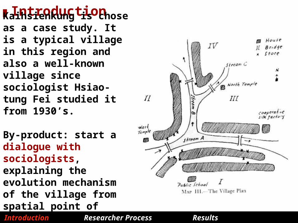
█ Introduction
Kaihsienkung is chose as a case study. It is a typical village in this region and also a well-known village since sociologist Hsiao-tung Fei studied it from 1930’s.
By-product: start a dialogue with sociologists, explaining the evolution mechanism of the village from spatial point of view.
Introduction Researcher Process Results Discussion


█ Research Question & Methodology
what are the main factors responsible for the evolution process of public space and different impacts of these factors. This research is constituted by three parts.
•Depict: physical & social transformation of the settlement ( its expansion, the shift location of shops, movement flows).
•Syntactic analysis: uncover spatial structures of this village in 1930’s & now quantitatively (impacts of water, vehicle & pedestrian lane) .
•Explore the two fold relationship between the spatial network and social phenomenon.
Introduction Researcher Process Results Discussion

Research team: Lihong Ni, Junjun Zhang, Lingjiao Jiang, Li Liang, Li Li and other two students Yan Zhang and Ruiwen Zhang
Methods :archival research, site survey, behavior investigation, morphological and syntactic analysis.
Introduction Researcher Process Results Discussion

Depict 1 : physical transformation In the history (1930’s)
Introduction Researcher Process Results Discussion

Scenery in 1950’s
Introduction Researcher Process Results Discussion
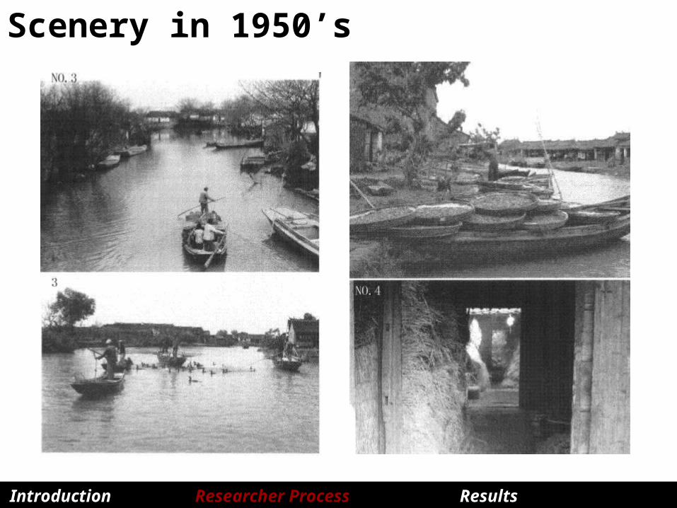
Scenery in 1950’s
Introduction Researcher Process Results Discussion
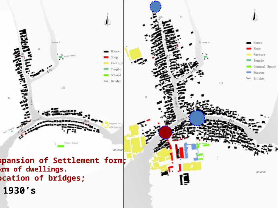
Depict 1 : physical transformation
Introduction Methodology Results Discussion
1930’s 2010
Expansion of Settlement form;Form of dwellings. location of bridges;

Infill of the settlement formBecause of the continuing renovation and extension of the houses, there are many places have the problem of visual obstruction, which means that in the narrow and zigzag paths, you know you can go though, but you can’t see through.
Introduction Researcher Process Results Discussion

Depict 2: social transformation
Change of population: from 1977 to 2006, the population conduct farm work is decreased from 77% to 16.2%. Adults go to nearby towns for work; children also go to the towns for study. There are only elderly in village in the day time.
Introduction Researcher Process Results Discussion

Change of live centre - in 1930’s
The most frequently used public spaces are banks of the streams, especially the shops near the bridges.
Introduction Researcher Process Results Discussion

Change of live centre – in 2010
Land-use mapping
Difficult for behavior observation: frequency of residents activities in countryside is much fewer comparing to the one of the urban dwellers.
Introduction Researcher Process Results Discussion

A combined method of ‘interview + unstructured observation + tracing +gate
count’ Hypothesis : if we know the main types of everyday
activities in this village, and tracing these activities in a random manner, the overlapping of these tracings can show us a picture of the spatial distribution of the main activities in this village.
Introduction Researcher Process Results Discussion

main activities:(1) morning, people go to work from home; go to the school from
bus station, go to the market(2)daytime, go to nearby stream for washing clothes and food;
just talk to each other in front of their courtyards. (3) late afternoon, people come back to home; chat in front of
their house.
Interview + unstructured observation
Introduction Researcher Process Results Discussion

TracingStart points:- from the market in the morning, - from the bus station in the morning and afternoon, - from the bridges in the daytime.
Principle: distribute the starting points of tracing evenly in the whole village.
Introduction Researcher Process Results Discussion

Explanation of tracing from bridgeReal operation, there were few people passing certain bridge even in peak hour.
Whether this is a regular phenomenon?
Gate count check: a half hour’s gate count on seven bridges simultaneously at 9 o’ clock in the morning.
Introduction Researcher Process Results Discussion
pedestrian

Introduction Researcher Process Results Discussion
bicycle, motorbike and carsConstitution of Movements
441 in total

Introduction Researcher Process Results Discussion
overlapped the 43 tracing drawings

Dramatic change of social usage of Bridge 4?
What is the main reason account for the change of B4?
Introduction Researcher Process Results Discussion

Syntactic analysis1.comparison of street network (1936 & 2011);
2.comparison of the “Vehicles Road System” and “Only for Walk System” in the current village;
3.comparison of spatial cores in three systems (water & road & combined network of both)
These quantitative analysis will showed us the different degree of impact from the street, water and highway network respectively.
Introduction Researcher Process Results Discussion

Street network 1936
Segment : Road System 1936-Choice Axial : Road System 1936-Rn
B1
B4
B3
B2
Introduction Researcher Process Results Discussion
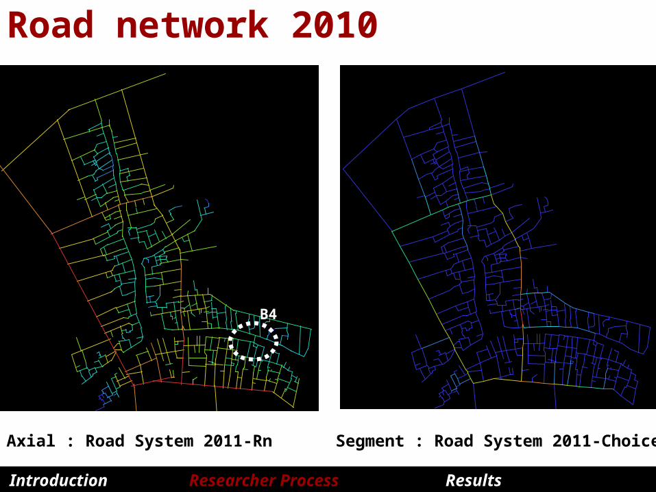
Road network 2010
Axial : Road System 2011-Rn Segment : Road System 2011-Choice
B4
Introduction Researcher Process Results Discussion

Do the conditions of streets matter?
Cement road, for car + pedestrian
Narrow cement lanes, for pedestrian only
Narrow muddy lanes, for pedestrian only
surface condition of a particular path ? width ?
Introduction Researcher Process Results Discussion
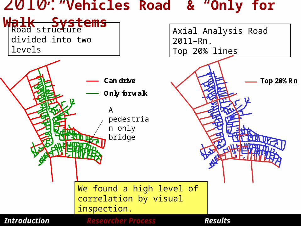
2010:“Vehicles Road” & “Only for Walk” Systems
Axial Analysis Road 2011–Rn. Top 20% lines
Can drive
Only for walk
Top 20%RnCan drive
Only for walk
Top 20%RnCan drive
Only for walk
Top 20%RnCan drive
Only for walk
Top 20%Rn
Road structure divided into two levels
A pedestrian only bridge
We found a high level of correlation by visual inspection.
Introduction Researcher Process Results Discussion
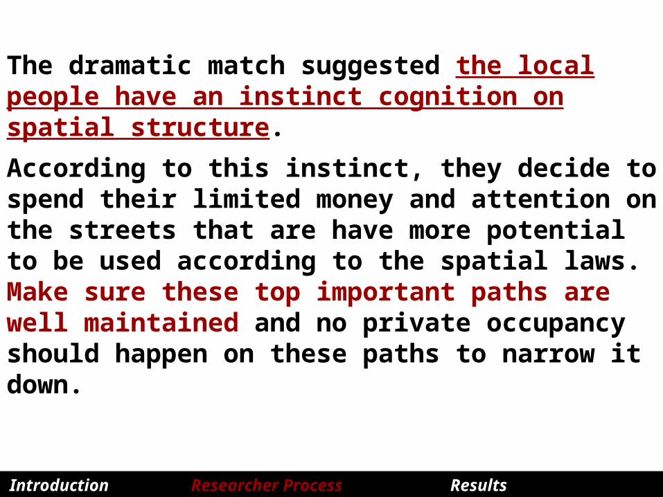
The dramatic match suggested the local people have an instinct cognition on spatial structure.
According to this instinct, they decide to spend their limited money and attention on the streets that are have more potential to be used according to the spatial laws. Make sure these top important paths are well maintained and no private occupancy should happen on these paths to narrow it down.
Introduction Researcher Process Results Discussion
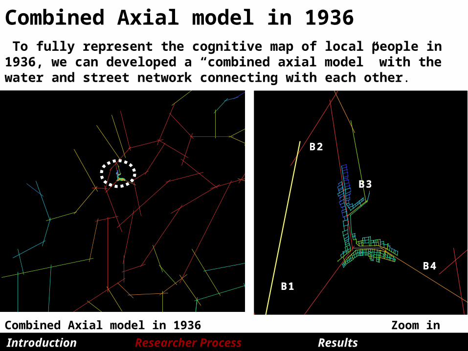
Combined Axial model in 1936
Combined Axial model in 1936 Zoom in
B1
B4
B3
B2
B1
B4
B3
B2
B1
B4
B3
B2
To fully represent the cognitive map of local people in 1936, we can developed a “combined axial model” with the water and street network connecting with each other.
Introduction Researcher Process Results Discussion

Combined Axial model in 1936
Combined Axial model in 1936
B1
B4
B3
B2
B1
B4
B3
B2
B1
B4
B3
B2
It shows that the integration core of the road system is consistent with the core of the water system in 1930s.
Introduction Researcher Process Results Discussion
Segment : Road System 1936-Choice

Combined Axial model in 1936
Combined Axial model in 1936 Axial : Road System 2011-Rn
But not the same case in 2010.
Introduction Researcher Process Results Discussion
B1
B4
B3
B2
B1
B4
B3
B2
B1
B4
B3
B2

Explanation of the “reversed spatial logic”There is a continue weaken of importance of water system:
In 1930’ water network is - only connecting passage of this village to outside, - main public space within the village (regular boat system)
In 1980s, tap water pipe network was provided, which lead to a further weakening of the dependence to the water.
In 1990’s, due to the completion of road network, people tent to travel by motorcycles or trucks instead of boats; boats of many family became out of maintenance.
Therefore, the reversed spatial logic is actually a spatial consequence of the declined dependence to the water system in this village .
Introduction Researcher Process Results Discussion

█Result 1This case study again illustrated the classical argument in space syntax theory on the relationship among spatial configuration, movement flow and land-use.
Segment : Road System 2011-Choice Axial : Rn - top 20% lines are in red
Introduction Researcher Process Results Discussion

█Result 1
Segment : Road System 2011-Choice Shop locations
Introduction Researcher Process Results Discussion

█Result 2By syntactic analysis, we provided objective evidence for the common believe that the spatial logic of the village and towns in Tai Lake valley has undergone a dramatic shift from “attracted by water” in the early 20th century to “attracted by road” now.
Segment : Road System 1936-Choice Segment : Road System 2011-Choice
Introduction Researcher Process Results Discussion

█ DiscussionWe found in many aspects, Angular Segment analysis can better describing the spatial structure of Kaihsienkung. Whether Angular Segment model can better depict the spatial structure of a settlement with curving waterfront than the traditional Axial model need further study’s examination.
Introduction Researcher Process Results Discussion
Segment : Road System 1936-Choice R1200
Segment : Road System 2011-Choice
Axial : Road System 1936-Rn
Axial : Road System 2011-Rn


MANY THANKS FOR YOUR ATTENTION