Why Harrogate? Play Area Shops and Cafés Places for picnics!

Trails, parks and picnics guide 1
Trails, parks and picnics guide
1 City of Swan
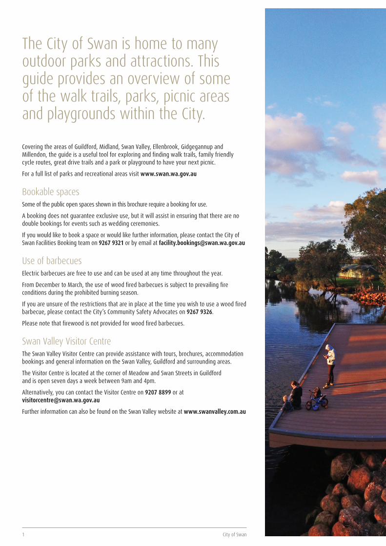
The City of Swan is home to many outdoor parks and attractions. This guide provides an overview of some of the walk trails, parks, picnic areas and playgrounds within the City.
Covering the areas of Guildford, Midland, Swan Valley, Ellenbrook, Gidgegannup and Millendon, the guide is a useful tool for exploring and finding walk trails, family friendly cycle routes, great drive trails and a park or playground to have your next picnic.
For a full list of parks and recreational areas visit www.swan.wa.gov.au
Bookable spacesSome of the public open spaces shown in this brochure require a booking for use.
A booking does not guarantee exclusive use, but it will assist in ensuring that there are no double bookings for events such as wedding ceremonies.
If you would like to book a space or would like further information, please contact the City of Swan Facilities Booking team on 9267 9321 or by email at [email protected]
Use of barbecuesElectric barbecues are free to use and can be used at any time throughout the year.
From December to March, the use of wood fired barbecues is subject to prevailing fire conditions during the prohibited burning season.
If you are unsure of the restrictions that are in place at the time you wish to use a wood fired barbecue, please contact the City’s Community Safety Advocates on 9267 9326.
Please note that firewood is not provided for wood fired barbecues.
Swan Valley Visitor CentreThe Swan Valley Visitor Centre can provide assistance with tours, brochures, accommodation bookings and general information on the Swan Valley, Guildford and surrounding areas.
The Visitor Centre is located at the corner of Meadow and Swan Streets in Guildford and is open seven days a week between 9am and 4pm.
Alternatively, you can contact the Visitor Centre on 9207 8899 or at [email protected]
Further information can also be found on the Swan Valley website at www.swanvalley.com.au
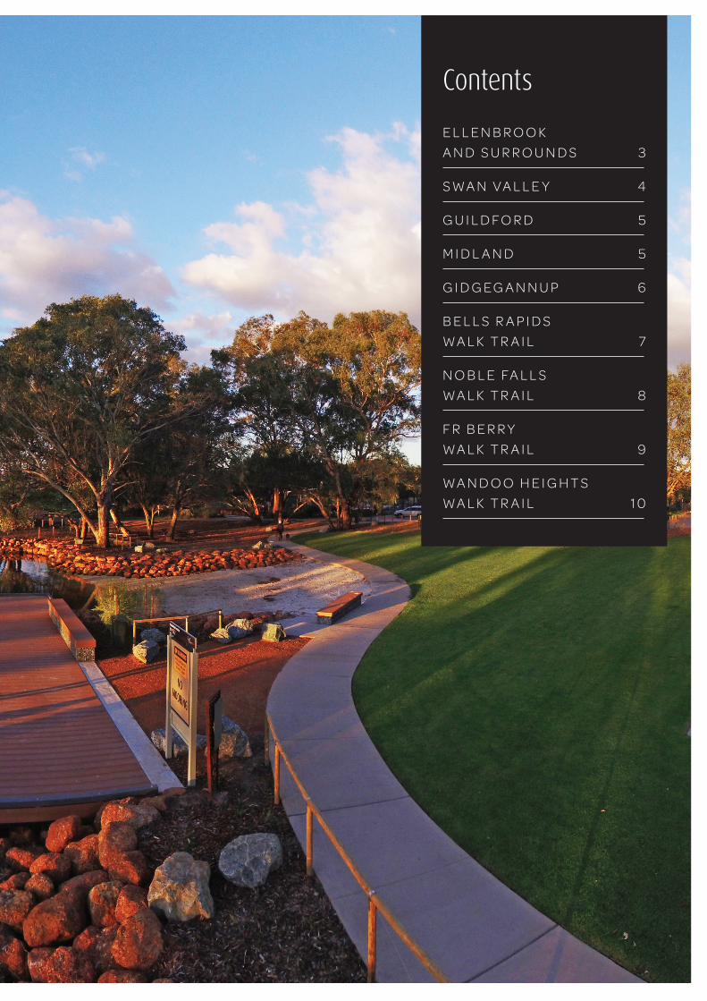
ContentsE L L E N B R O O K A N D S U R R O U N D S 3
S W A N V A L L E Y 4
G U I L D F O R D 5
M I D L A N D 5
G I D G E G A N N U P 6
B E L L S R A P I D S W A L K T R A I L 7
N O B L E FA L L S W A L K T R A I L 8
F R B E R R Y W A L K T R A I L 9
W A N D O O H E I G H T S W A L K T R A I L 1 0
3 City of Swan
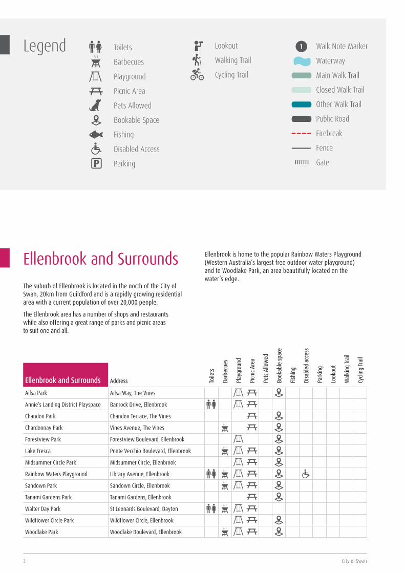
Ellenbrook and SurroundsThe suburb of Ellenbrook is located in the north of the City of Swan, 20km from Guildford and is a rapidly growing residential area with a current population of over 20,000 people.
The Ellenbrook area has a number of shops and restaurants while also offering a great range of parks and picnic areas to suit one and all.
Ellenbrook is home to the popular Rainbow Waters Playground (Western Australia’s largest free outdoor water playground) and to Woodlake Park, an area beautifully located on the water’s edge.
Toile
ts
Barb
ecue
s
Play
grou
nd
Picn
ic Ar
ea
Pets
Allo
wed
Book
able
spac
e
Fishi
ng
Disa
bled
acc
ess
Park
ing
Look
out
Wal
king
Trail
Cycli
ng Tr
ail
Ellenbrook and Surrounds Address
Ailsa Park Ailsa Way, The Vines
Annie’s Landing District Playspace Banrock Drive, Ellenbrook
Chandon Park Chandon Terrace, The Vines
Chardonnay Park Vines Avenue, The Vines
Forestview Park Forestview Boulevard, Ellenbrook
Lake Fresca Ponte Vecchio Boulevard, Ellenbrook
Midsummer Circle Park Midsummer Circle, Ellenbrook
Rainbow Waters Playground Library Avenue, Ellenbrook
Sandown Park Sandown Circle, Ellenbrook
Tanami Gardens Park Tanami Gardens, Ellenbrook
Walter Day Park St Leonards Boulevard, Dayton
Wildflower Circle Park Wildflower Circle, Ellenbrook
Woodlake Park Woodlake Boulevard, Ellenbrook
Legend Toilets
Barbecues
Playground
Picnic Area
Pets Allowed
Bookable Space
Fishing
Disabled Access
P Parking
Lookout
Walking Trail
Cycling Trail
Walk Note Marker
Waterway
Main Walk Trail
Closed Walk Trail
Other Walk Trail
Public Road
Firebreak
Fence
Gate
Trails, parks and picnics guide 4
Swan ValleyWorld-class wineries, breweries, distilleries, countless gourmet artisan goods, handcrafted wares, bustling markets, vibrant studios, top-notch eateries and of course parks, picnic spots and trails, just 25 minutes from Perth. This is the Swan Valley.
Swan Valley Food & Wine TrailHere’s a little fact that may surprise you: the Swan Valley is deceptively compact, requiring just an hour to circumnavigate it. But those embarking on the 32km scenic loop, known as the Swan Valley Food and Wine Trail, usually prefer to take their merry time, meandering over an entire day.
After all, who wants to rush when there are over 150 amazing attractions to discover, including some of the finest restaurants and wineries in the state, breweries, distilleries, art galleries and wildlife parks?
Swan Valley Heritage Cycling TrailWith its wide open spaces, vineyard vistas and plenty of fresh country air, the Swan Valley is the perfect place for a cycle. Load up your bikes, or hire one if you prefer, and take a leisurely peddle around this charming corner of the world.
The Swan Valley Cycle Trail takes in the rich history, interesting characters and natural elements of the Swan Valley. A stunning showcase of fresh produce stalls, pretty picnic spots, exciting galleries, and a host of world class wineries and restaurants, there are countless opportunities to enjoy an abundance of experiences.
The trail has four different routes, each signposted to depict the rich history, interesting characters and natural elements of the areas. There are plenty of scenic rest spots along the way, so visitors can pack a picnic and make a day of it. Bike Hire is available, ask for details at the Swan Valley Visitor Centre.
Cider and Ale TrailYour cup is set to runneth over with a series of sparkling ciders and boutique ales just waiting to be explored on a ground-breaking new trail.
The Swan Valley may be renowned for the third and fourth generation family-owned wineries in the region, but talented brewers are also flocking to the area to set up shop.
Swan Valley’s Cider and Ale trail quenches the thirst of even the fussiest connoisseur, with nine breweries and cideries earmarked, including Elmar’s in the Valley, Duckstein Brewery, Funk Cider, Oakover Estate, Mash Brewery, Ironbark Brewery, Feral Brewing Company, Figtree Estate and the Homestead Brewery.
The Great Valley Rally and the Amazing Valley ChaseGet on board The Great Valley Rally with Stirling Swan or chase down an amazing adventure with Taylor Tortoise, two thrilling treasure hunts where you and your fellow savvy explorers can follow the cryptic clues along specific routes in the Valley.
Designed for families with children aged 5-12 years old, the trail begins at the Swan Valley Visitor Centre and takes around three hours to complete. Don’t forget to take your completed clue sheet into the Swan Valley Visitor Centre to claim your certificate after your adventure.
Whiteman ParkWhiteman Park is ten times the size of Kings Park and home to a heap of incredible facilities, events and attractions for the whole family. Explore the beautiful banksia bushland and catch a glimpse of grey kangaroos or a black-gloved wallaby on one of three bush trails or the extensive bike paths. You can also enjoy other attractions such as the Children’s Forest and Caversham Wildlife Park (entry fee applies for the Wildlife Park). Picnic areas are open seven days a week from 8.30am until 6pm and admission is free.
* For a full list of facilities, trails and attractions within Whiteman Park visit the website at www.whitemanpark.com.au or visit the Swan Valley Visitor Centre to pick up a guide.
Toile
ts
Barb
ecue
s
Play
grou
nd
Picn
ic Ar
ea
Pets
Allo
wed
Book
able
spac
e
Fishi
ng
Disa
bled
acc
ess
Park
ing
Look
out
Wal
king
Trail
Cycli
ng Tr
ail
Swan Valley Address
Lilac Hill Park West Swan Road, Caversham
Maali Bridge Park Barrett Street, Herne Hill
Whiteman Park* Lord Street, West Swan
Yagan Memorial Park Cnr Great Northern Highway and West Swan Road, Swan Valley
5 City of Swan
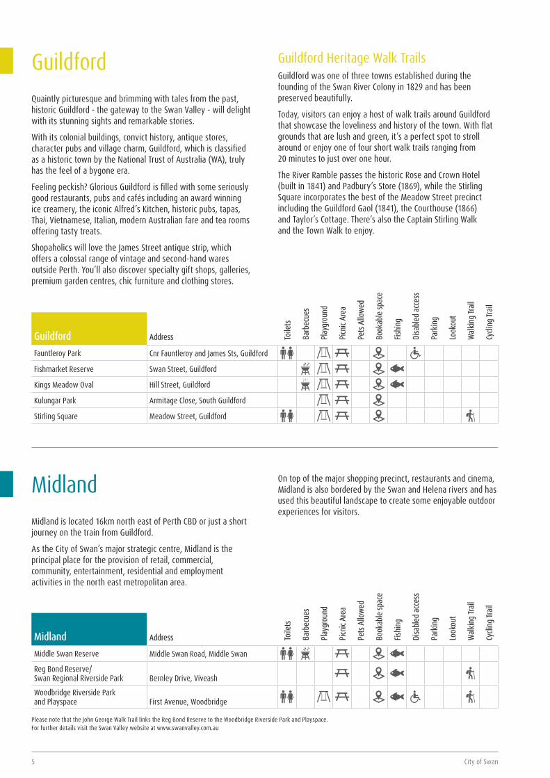
MidlandMidland is located 16km north east of Perth CBD or just a short journey on the train from Guildford.
As the City of Swan’s major strategic centre, Midland is the principal place for the provision of retail, commercial, community, entertainment, residential and employment activities in the north east metropolitan area.
On top of the major shopping precinct, restaurants and cinema, Midland is also bordered by the Swan and Helena rivers and has used this beautiful landscape to create some enjoyable outdoor experiences for visitors.
Toile
ts
Barb
ecue
s
Play
grou
nd
Picn
ic Ar
ea
Pets
Allo
wed
Book
able
spac
e
Fishi
ng
Disa
bled
acc
ess
Park
ing
Look
out
Wal
king
Trail
Cycli
ng Tr
ail
Midland Address
Middle Swan Reserve Middle Swan Road, Middle Swan
Reg Bond Reserve/ Swan Regional Riverside Park
Bernley Drive, Viveash
Woodbridge Riverside Park and Playspace
First Avenue, Woodbridge
Please note that the John George Walk Trail links the Reg Bond Reserve to the Woodbridge Riverside Park and Playspace. For further details visit the Swan Valley website at www.swanvalley.com.au
City of Swan
GuildfordQuaintly picturesque and brimming with tales from the past, historic Guildford - the gateway to the Swan Valley - will delight with its stunning sights and remarkable stories.
With its colonial buildings, convict history, antique stores, character pubs and village charm, Guildford, which is classified as a historic town by the National Trust of Australia (WA), truly has the feel of a bygone era.
Feeling peckish? Glorious Guildford is filled with some seriously good restaurants, pubs and cafés including an award winning ice creamery, the iconic Alfred’s Kitchen, historic pubs, tapas, Thai, Vietnamese, Italian, modern Australian fare and tea rooms offering tasty treats.
Shopaholics will love the James Street antique strip, which offers a colossal range of vintage and second-hand wares outside Perth. You’ll also discover specialty gift shops, galleries, premium garden centres, chic furniture and clothing stores.
Guildford Heritage Walk TrailsGuildford was one of three towns established during the founding of the Swan River Colony in 1829 and has been preserved beautifully.
Today, visitors can enjoy a host of walk trails around Guildford that showcase the loveliness and history of the town. With flat grounds that are lush and green, it’s a perfect spot to stroll around or enjoy one of four short walk trails ranging from 20 minutes to just over one hour.
The River Ramble passes the historic Rose and Crown Hotel (built in 1841) and Padbury’s Store (1869), while the Stirling Square incorporates the best of the Meadow Street precinct including the Guildford Gaol (1841), the Courthouse (1866) and Taylor’s Cottage. There’s also the Captain Stirling Walk and the Town Walk to enjoy.
Toile
ts
Barb
ecue
s
Play
grou
nd
Picn
ic Ar
ea
Pets
Allo
wed
Book
able
spac
e
Fishi
ng
Disa
bled
acc
ess
Park
ing
Look
out
Wal
king
Trail
Cycli
ng Tr
ail
Guildford Address
Fauntleroy Park Cnr Fauntleroy and James Sts, Guildford
Fishmarket Reserve Swan Street, Guildford
Kings Meadow Oval Hill Street, Guildford
Kulungar Park Armitage Close, South Guildford
Stirling Square Meadow Street, Guildford
Trails, parks and picnics guide 6
O’BRIEN ROAD
CLENTON ROAD
BERRY ROAD
RESERVE ROAD
REEN ROAD
TOODYAY ROAD
TOODYAY
ROAD
Noble FallsPicnic Area
WalyungaLookout
F R BerryReserve
Paruna WildlifeSanctuary (Private)
GidgegannupTownsite
GidgegannupShowgrounds
4Km
2.6Km
12Km
7Km1.75Km3.75Km
8.5Km 6.3Km
11.3Km
16Km
L ILYDALE ROAD
Distances indicatedbetween markers
3Km
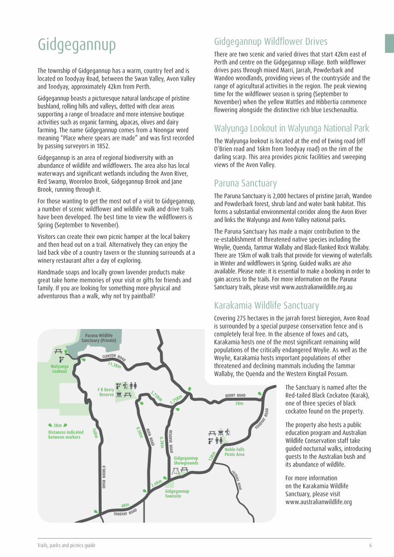
GidgegannupThe township of Gidgegannup has a warm, country feel and is located on Toodyay Road, between the Swan Valley, Avon Valley and Toodyay, approximately 42km from Perth.
Gidgegannup boasts a picturesque natural landscape of pristine bushland, rolling hills and valleys, dotted with clear areas supporting a range of broadacre and more intensive boutique activities such as organic farming, alpacas, olives and dairy farming. The name Gidgegannup comes from a Noongar word meaning “Place where spears are made” and was first recorded by passing surveyors in 1852.
Gidgegannup is an area of regional biodiversity with an abundance of wildlife and wildflowers. The area also has local waterways and significant wetlands including the Avon River, Red Swamp, Wooroloo Brook, Gidgegannup Brook and Jane Brook, running through it.
For those wanting to get the most out of a visit to Gidgegannup, a number of scenic wildflower and wildlife walk and drive trails have been developed. The best time to view the wildflowers is Spring (September to November).
Visitors can create their own picnic hamper at the local bakery and then head out on a trail. Alternatively they can enjoy the laid back vibe of a country tavern or the stunning surrounds at a winery restaurant after a day of exploring.
Handmade soaps and locally grown lavender products make great take home memories of your visit or gifts for friends and family. If you are looking for something more physical and adventurous than a walk, why not try paintball?
Gidgegannup Wildflower DrivesThere are two scenic and varied drives that start 42km east of Perth and centre on the Gidgegannup village. Both wildflower drives pass through mixed Marri, Jarrah, Powderbark and Wandoo woodlands, providing views of the countryside and the range of agricultural activities in the region. The peak viewing time for the wildflower season is spring (September to November) when the yellow Wattles and Hibbertia commence flowering alongside the distinctive rich blue Leschenaultia.
Walyunga Lookout in Walyunga National ParkThe Walyunga lookout is located at the end of Ewing road (off O’Brien road and 16km from Toodyay road) on the rim of the darling scarp. This area provides picnic facilities and sweeping views of the Avon Valley.
Paruna SanctuaryThe Paruna Sanctuary is 2,000 hectares of pristine Jarrah, Wandoo and Powderbark forest, shrub land and water bank habitat. This forms a substantial environmental corridor along the Avon River and links the Walyunga and Avon Valley national parks.
The Paruna Sanctuary has made a major contribution to the re-establishment of threatened native species including the Woylie, Quenda, Tammar Wallaby and Black-flanked Rock Wallaby. There are 15km of walk trails that provide for viewing of waterfalls in Winter and wildflowers in Spring. Guided walks are also available. Please note: it is essential to make a booking in order to gain access to the trails. For more information on the Paruna Sanctuary trails, please visit www.australianwildlife.org.au
Karakamia Wildlife SanctuaryCovering 275 hectares in the jarrah forest bioregion, Avon Road is surrounded by a special purpose conservation fence and is completely feral free. In the absence of foxes and cats, Karakamia hosts one of the most significant remaining wild populations of the critically endangered Woylie. As well as the Woylie, Karakamia hosts important populations of other threatened and declining mammals including the Tammar Wallaby, the Quenda and the Western Ringtail Possum.
The Sanctuary is named after the Red-tailed Black Cockatoo (Karak), one of three species of black cockatoo found on the property.
The property also hosts a public education program and Australian Wildlife Conservation staff take guided nocturnal walks, introducing guests to the Australian bush and its abundance of wildlife.
For more information on the Karakamia Wildlife Sanctuary, please visit www.australianwildlife.org
7 City of Swan
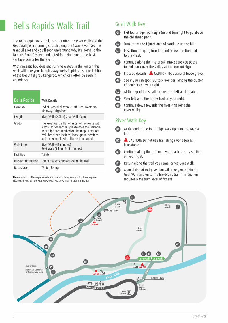
Bells Rapids Walk Details
Location End of Cathedral Avenue, off Great Northern Highway, Brigadoon.
Length River Walk (2.5km) Goat Walk (3km)
Grade The River Walk is flat on most of the route with a small rocky section (please note the unstable river edge area marked on the map). The Goat Walk has steep inclines, loose gravel sections and a medium level of fitness is required.
Walk time River Walk (45 minutes) Goat Walk (1 hour & 15 minutes)
Facilities Toilets
On site information Totem markers are located on the trail
Best season Winter/Spring
Please note: It is the responsibility of individuals to be aware of fire bans in place. Please call 9267 9326 or visit www.swan.wa.gov.au for further information.
Bells Rapids Walk TrailThe Bells Rapid Walk Trail, incorporating the River Walk and the Goat Walk, is a stunning stretch along the Swan River. See this tranquil spot and you’ll soon understand why it’s home to the famous Avon Descent and noted for being one of the best vantage points for the event.
With majestic boulders and rushing waters in the winter, this walk will take your breath away. Bells Rapid is also the habitat of the beautiful grey kangaroo, which can often be seen in abundance.
Goat Walk KeyG1 Exit footbridge, walk up 50m and turn right to go above
the old sheep pens.
G2 Turn left at the T-junction and continue up the hill.
G3 Pass through gate, turn left and follow the firebreak to the west.
G4 Continue along the fire-break; make sure you pause to look back over the valley at the lookout sign.
G5 Proceed downhill CAUTION: Be aware of loose gravel.
G6 See if you can spot ‘Buttock Boulder’ among the cluster of boulders on your right.
G7 At the top of the small incline, turn left at the gate.
G8 Veer left with the Bridle Trail on your right.
G9 Continue down towards the river (this joins the River Walk).
River Walk KeyR1 At the end of the footbridge walk up 50m and take a
left turn.
R2 CAUTION: Do not use trail along river edge as it is unstable.
R3 Continue along the trail until you reach a rocky section on your right.
R4 Return along the trail you came, or via Goat Walk.
R5 A small rise of rocky section will take you to join the Goat Walk and on to the fire-break trail. This section requires a medium level of fitness.
SWAN RIVER
River Walk
UPPERCARPARK
Steep descent to bridge
Steep descent
REST STOP
Steep ascent
Steep descent
Steep ascent
CAUTION
START OF TRAILS
Return via Goat Trail or the way you came
Goat Walk
BRIDLE TRAIL
END OF TRAIL
BRID
GE
CATHEDRAL AVENUE
G1R1R2
G2
R3
R4
R5
G9
G8
G7
G6
G5
CAUTION
G4
G3
CAUTION
Trails, parks and picnics guide 8
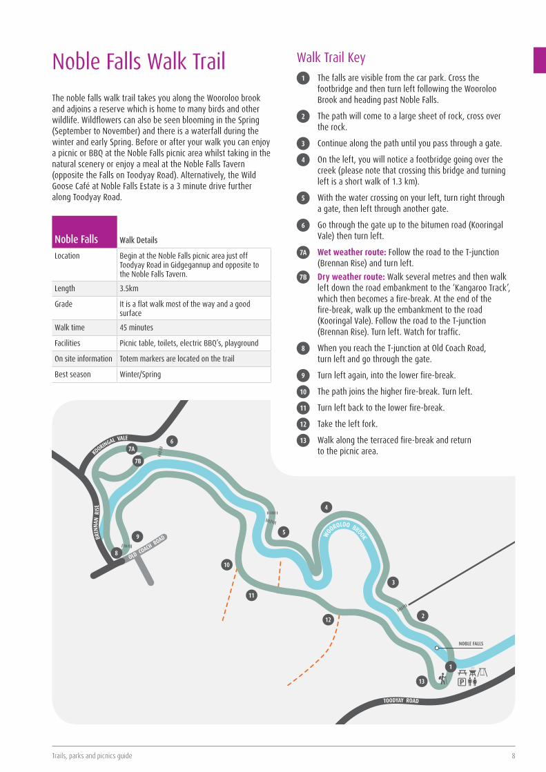
Noble Falls Walk TrailThe noble falls walk trail takes you along the Wooroloo brook and adjoins a reserve which is home to many birds and other wildlife. Wildflowers can also be seen blooming in the Spring (September to November) and there is a waterfall during the winter and early Spring. Before or after your walk you can enjoy a picnic or BBQ at the Noble Falls picnic area whilst taking in the natural scenery or enjoy a meal at the Noble Falls Tavern (opposite the Falls on Toodyay Road). Alternatively, the Wild Goose Café at Noble Falls Estate is a 3 minute drive further along Toodyay Road.
Noble Falls Walk Details
Location Begin at the Noble Falls picnic area just off Toodyay Road in Gidgegannup and opposite to the Noble Falls Tavern.
Length 3.5km
Grade It is a flat walk most of the way and a good surface
Walk time 45 minutes
Facilities Picnic table, toilets, electric BBQ’s, playground
On site information Totem markers are located on the trail
Best season Winter/Spring
TOODYAY ROAD
BREN
NAN
RIS
E
OLD COACH ROAD WO
OROLOO BROOK
1
NOBLE FALLS
13
2
3
4
5
67A
7B
8
9
10
11
12
KOORINGAL VALE
Walk Trail Key1 The falls are visible from the car park. Cross the
footbridge and then turn left following the Wooroloo Brook and heading past Noble Falls.
2 The path will come to a large sheet of rock, cross over the rock.
3 Continue along the path until you pass through a gate.
4 On the left, you will notice a footbridge going over the creek (please note that crossing this bridge and turning left is a short walk of 1.3 km).
5 With the water crossing on your left, turn right through a gate, then left through another gate.
6 Go through the gate up to the bitumen road (Kooringal Vale) then turn left.
7A Wet weather route: Follow the road to the T-junction (Brennan Rise) and turn left.
7B Dry weather route: Walk several metres and then walk left down the road embankment to the ‘Kangaroo Track’, which then becomes a fire-break. At the end of the fire-break, walk up the embankment to the road (Kooringal Vale). Follow the road to the T-junction (Brennan Rise). Turn left. Watch for traffic.
8 When you reach the T-junction at Old Coach Road, turn left and go through the gate.
9 Turn left again, into the lower fire-break.
10 The path joins the higher fire-break. Turn left.
11 Turn left back to the lower fire-break.
12 Take the left fork.
13 Walk along the terraced fire-break and return to the picnic area.
9 City of Swan
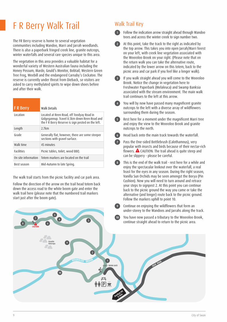
F R Berry Walk Details
Location Located at Reen Road, off Toodyay Road in Gidgegannup. Travel 8.5km down Reen Road and the F R Berry Reserve is sign posted on the left.
Length 2.7km
Grade Generally flat, however, there are some steeper sections with gravel surface.
Walk time 45 minutes
Facilities Picnic tables, toilet, wood BBQ.
On site information Totem markers are located on the trail
Best season Mid-Autumn to late Spring.
F R Berry Walk TrailThe FR Berry reserve is home to several vegetation communities including Wandoo, Marri and Jarrah woodlands. There is also a paperbark fringed creek line, granite outcrops, winter waterfalls and several rare species unique to this area.
The vegetation in this area provides a valuable habitat for a wonderful variety of Western Australian fauna including the Honey Possum, Mardo, Gould’s Monitor, Bobtail, Western Green Tree Frog, Weebill and the endangered Carnaby’s Cockatoo. The reserve is currently under threat from Dieback, so visitors are asked to carry methylated spirits to wipe down shoes before and after their walk.
P
GraniteOutcrops
BOOM GATE
2
1
34
5
6
7
8
9
CAUTION
10
WOOROLOO BROOK
REEN ROAD
Toodyay Rd
8.5km
The walk trail starts from the picnic facility and car park area.
Follow the direction of the arrow on the trail head totem back down the access road to the white boom gate and enter the walk trail here (please note that the numbered trail markers start just after the boom gate).
Walk Trail Key1 Follow the indication arrow straight ahead through Wandoo
trees and across the winter creek to sign number two.
2 At this point, take the track to the right as indicated by the top arrow. This takes you into open Jarrah/Marri forest on your left, with creek line vegetation associated with the Wooroloo Brook on your right. (Please note that on the return walk you can take the alternative route, indicated by the lower arrow on this totem, back to the picnic area and car park if you feel like a longer walk).
3 If you walk straight ahead you will come to the Wooroloo Brook. Notice the change in vegetation here to Freshwater Paperbark (Melaleuca) and Swamp Banksia associated with the stream environment. The main walk trail continues to the left at this arrow.
4 You will by now have passed many magnificent granite outcrops to the left with a diverse array of wildflowers surrounding them during the season.
5 Rest here for a moment under the magnificent Marri tree and enjoy the view to the Wooroloo Brook and granite outcrops to the north.
6 Head back onto the main track towards the waterfall.
7 Pass the One-sided Bottlebrush (Calothamnus), very popular with insects and birds because of their nectar-rich flowers. CAUTION: The trail ahead is quite steep and can be slippery - please be careful.
8 This is the end of the walk trail - rest here for a while and enjoy the spectacular lookout over the waterfall, a real feast for the eyes in any season. During the right season, Vanilla Sun Orchids may be seen amongst the Borya (Pin Cushion). Now you will need to turn around and retrace your steps to signpost 2. At this point you can continue back to the picnic ground the way you came or take the alternative (and longer) route back to the picnic ground. Follow the markers uphill to point 10.
9 Continue on enjoying the wildflowers that form an under-storey to the Wandoos and Jarrahs along the track.
10 You have now passed a tributary to the Wooroloo Brook, continue straight ahead to return to the picnic area.

Trails, parks and picnics guide 10
Please note: This is a controlled access walk trail. Permission is required through the City of Swan, contact 9267 9267.
No dogs permitted
Wandoo Heights Walk Details
Location Corner of Range and Loton Roads, Millendon.
Length Short Walk - 2km Long Walk - 3.5km
Grade Moderate, with a short steep section on east boundary. Good surface. Note: There is a slippery section in winter on the long walk.
Walk time Short Walk - 45 minutes Long Walk - 1½ hours
Facilities Cottage and toilet
On site information Totem markers are located on the trail as well as wildflower and native vegetation signage.
Best season Mid Autumn to late Spring
Plant life Eucalyptus wandoo - Wandoo Corymba callophylla – Marri/Red GumAllocasuarina huegliana – Rock/Granite Sheoak Casuarina humilus – Dwarf SheoakHakea trifurcata – Two-leaf HakeaBanksia grandis - Bull BanksiaCalothamnus quadrifidus – One-sided Bottlebrush
Wildflowers Conostylis species - Cat’s PawsDrosera species - SundewsVarious Orchids
A Pocket History of Wandoo HeightsThis property is a unique bush landscape on the Darling Escarpment and is situated 13km from Midland.
Comprising of two lots totalling 22 hectares, Wandoo Heights is part of an original block of 4,000 hectares on the Upper Swan, granted in 1830 to George Fletcher Moore, the Advocate General for the Swan Colony.
Because of its general unsuitability for farming, Wandoo Heights was not cleared in the early days and is still in its virgin state (as would have been observed by the early botanists in the 1820’s).
In 1960, the property was acquired by Miss Olive Gear and Mr Harry and Miss Adela Hyde. Unfortunately, Mr Hyde drowned two years after the purchase of the property. Undaunted and with the help of volunteers, the ladies maintained the property in excellent condition, while at the same time improving access to enable the extensive range of wildflowers to be observed without damaging the environment.
In 1988, the property was entrusted to the City of Swan as it was becoming too difficult for the ladies to manage effectively. The deed charges the City with maintaining Wandoo Heights as a flora and fauna reserve for present and future generations.
Dieback has recently been identified in Wandoo Heights. Prior to entry, ensure all vehicles and footwear are free of soil. Please keep to the paths, take only photographs, and leave only footprints.
Wandoo Heights Walk TrailEnjoy breathing the fresh rural air of natural bushland while you marvel at the exquisite unspoiled beauty and native flora and fauna. The Wandoo Heights Wildflower Walk Trail is best visited when the spring blooms burst into colour but please note, this is a controlled access walk trail and permission/access from the City of Swan is required. Please phone 9267 9267 for more info.
Wandoo
LONG WALK
SH ORT WALK
SHORT WALK
LONG
WALK
RANGE ROAD
Banksia
Banksia
Marri
Wandoo
Sheoaks
Wandoo
Sheoaks
START OF TRAILS
SUNDIAL
Wandoo
LONG WALK
11 City of Swan
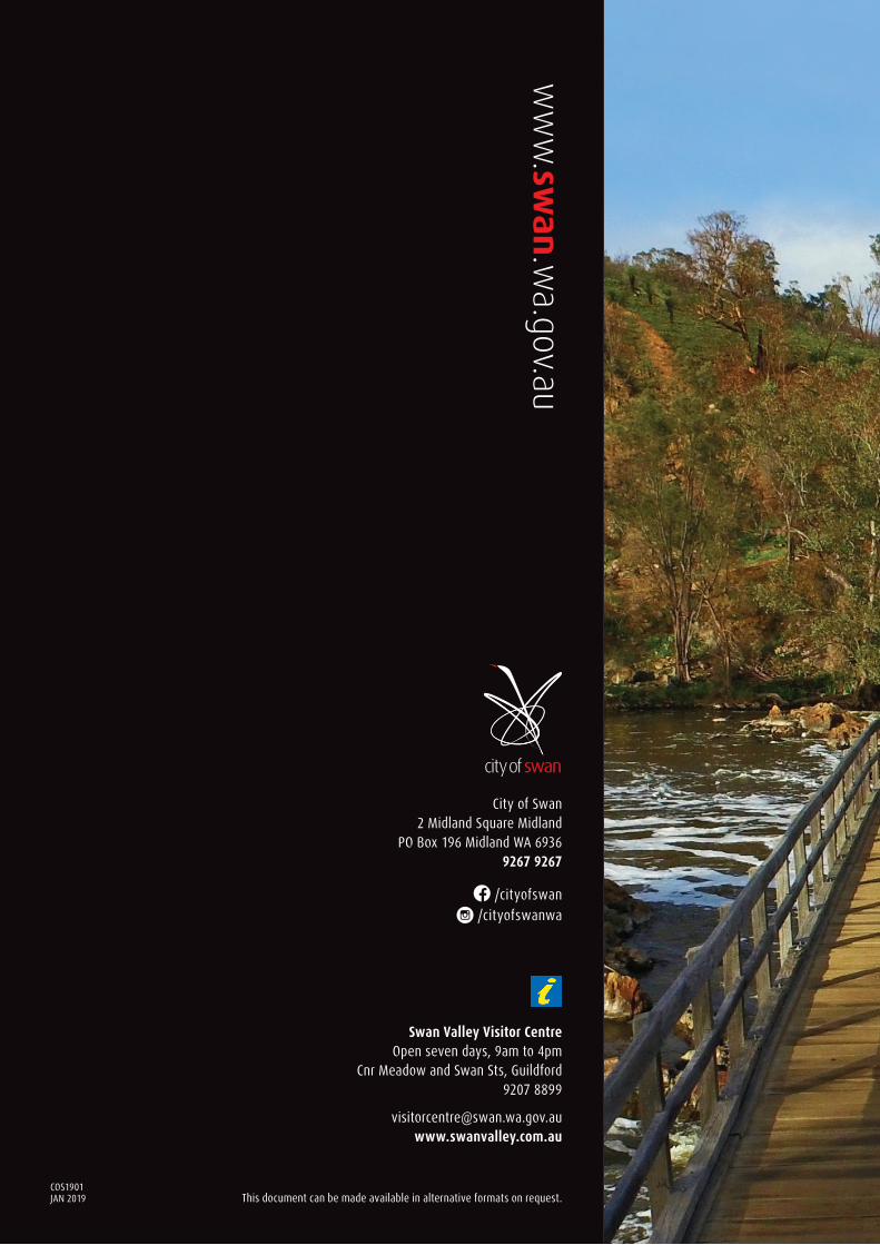
JAN 2019COS1901
www.sw
an.wa.gov.au
City of Swan 2 Midland Square Midland
PO Box 196 Midland WA 6936 9267 9267
This document can be made available in alternative formats on request.
/cityofswan /cityofswanwa
Swan Valley Visitor Centre Open seven days, 9am to 4pm
Cnr Meadow and Swan Sts, Guildford 9207 8899
[email protected] www.swanvalley.com.au