TRAFFIC SIGNALS PROGRAM/media/Corporate/Files/... · 2014-09-19 · TRAFFIC SIGNALS PROGRAM...
13
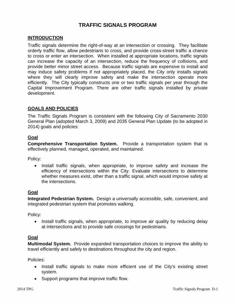
2014 TPG Traffic Signals Program D-1 TRAFFIC SIGNALS PROGRAM INTRODUCTION Traffic signals determine the right-of-way at an intersection or crossing. They facilitate orderly traffic flow, allow pedestrians to cross, and provide cross-street traffic a chance to cross or enter an intersection. When installed at appropriate locations, traffic signals can increase the capacity of an intersection, reduce the frequency of collisions, and provide better minor street access. Because traffic signals are expensive to install and may induce safety problems if not appropriately placed, the City only installs signals where they will clearly improve safety and make the intersection operate more efficiently. The City typically constructs one or two traffic signals per year through the Capital Improvement Program. There are other traffic signals installed by private development. GOALS AND POLICIES The Traffic Signals Program is consistent with the following City of Sacramento 2030 General Plan (adopted March 3, 2009) and 2035 General Plan Update (to be adopted in 2014) goals and policies: Goal Comprehensive Transportation System. Provide a transportation system that is effectively planned, managed, operated, and maintained. Policy: Install traffic signals, when appropriate, to improve safety and increase the efficiency of intersections within the City. Evaluate intersections to determine whether measures exist, other than a traffic signal, which would improve safety at the intersections. Goal Integrated Pedestrian System. Design a universally accessible, safe, convenient, and integrated pedestrian system that promotes walking. Policy: Install traffic signals, when appropriate, to improve air quality by reducing delay at intersections and to provide safe crossings for pedestrians. Goal Multimodal System. Provide expanded transportation choices to improve the ability to travel efficiently and safely to destinations throughout the city and region. Policies: Install traffic signals to make more efficient use of the City's existing street system. Support programs that improve traffic flow.
Transcript of TRAFFIC SIGNALS PROGRAM/media/Corporate/Files/... · 2014-09-19 · TRAFFIC SIGNALS PROGRAM...
2014 TPG Traffic Signals Program D-1
TRAFFIC SIGNALS PROGRAM
INTRODUCTION
Traffic signals determine the right-of-way at an intersection or crossing. They facilitate orderly traffic flow, allow pedestrians to cross, and provide cross-street traffic a chance to cross or enter an intersection. When installed at appropriate locations, traffic signals can increase the capacity of an intersection, reduce the frequency of collisions, and provide better minor street access. Because traffic signals are expensive to install and may induce safety problems if not appropriately placed, the City only installs signals where they will clearly improve safety and make the intersection operate more efficiently. The City typically constructs one or two traffic signals per year through the Capital Improvement Program. There are other traffic signals installed by private development.
GOALS AND POLICIES
The Traffic Signals Program is consistent with the following City of Sacramento 2030 General Plan (adopted March 3, 2009) and 2035 General Plan Update (to be adopted in 2014) goals and policies: Goal
Comprehensive Transportation System. Provide a transportation system that is effectively planned, managed, operated, and maintained. Policy:
Install traffic signals, when appropriate, to improve safety and increase the efficiency of intersections within the City. Evaluate intersections to determine whether measures exist, other than a traffic signal, which would improve safety at the intersections.
Goal
Integrated Pedestrian System. Design a universally accessible, safe, convenient, and integrated pedestrian system that promotes walking. Policy:
Install traffic signals, when appropriate, to improve air quality by reducing delay at intersections and to provide safe crossings for pedestrians.
Goal Multimodal System. Provide expanded transportation choices to improve the ability to travel efficiently and safely to destinations throughout the city and region. Policies:
Install traffic signals to make more efficient use of the City's existing street system.
Support programs that improve traffic flow.
Traffic Signals Program D-2 2014 TPG
The Traffic Signals Program is consistent with the following City of Sacramento Strategic Plan goals: 1. Improve and expand public safety.
Policy:
The Traffic Signals Program supports Public safety by improving the operation and safety of street intersections for vehicles, bicycles, and pedestrians.
2. Achieve Sustainability and Enhance Livability.
Policy:
The Traffic Signals Program project ranking process supports sustainability and enhanced livability by giving points to projects based on potential pedestrian and bicycle access at intersection.
PROJECT LIST DEVELOPMENT
The City evaluates approximately 10-15 new intersections each year for traffic signals. Locations are solicited through traffic investigations, resident requests, development projects, Councilmember requests, etc. The City also reviews the top ten high collision intersections on an annual basis for potential measures, including a traffic signal, which may mitigate for collisions. Eligibility Criteria The Traffic Signal Program involves three phases. Project eligibility is determined during Phases I and II, as presented below: Phase I - Investigation Review
In Phase I, the following data is collected for locations which have been suggested as candidates for a traffic signal: Collisions: A recent three-year compilation of reported collision history
differentiating collision types and correctability is developed. Traffic Volumes: Twenty-four hour volume counts with an hourly listing of
each approach direction are obtained for the combined minor street volumes, the combined major street approach volumes, and a total for the entire intersection.
Facilities/Activity Centers: Information about nearby facilities and activity centers that
serve the young, elderly, and/or persons with disabilities, including requests from persons with disabilities for accessible crossing improvements is collected at the location under study. These persons might not be adequately reflected in the pedestrian volume if the absence of a signal restrains their mobility.
2014 TPG Traffic Signals Program D-3
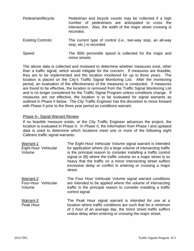
Pedestrian/Bicycle: Pedestrian and bicycle counts may be collected if a high number of pedestrians are anticipated to cross the intersection. Also, the width of the major street crossing is recorded.
Existing Controls: The current type of control (i.e., two-way stop, an all-way
stop, etc.) is recorded. Speed: The 85th percentile speed is collected for the major and
minor streets. The above data is collected and reviewed to determine whether measures exist, other than a traffic signal, which would mitigate for the concern. If measures are feasible, they are to be implemented and the location monitored for up to three years. The location is placed on the City’s Traffic Signal Monitoring List. After the monitoring period, an evaluation of the effectiveness of the measures is conducted. If measures are found to be effective, the location is removed from the Traffic Signal Monitoring List and is no longer considered for the Traffic Signal Program unless conditions change. If measures are not effective, the location is to be evaluated for signal warrants as outlined in Phase II below. The City Traffic Engineer has the discretion to move forward with Phase II prior to the three year period as conditions warrant.
Phase II– Signal Warrant Review
If no feasible measure exists, or the City Traffic Engineer advances the project, the location is evaluated in Phase II. In Phase II, the information from Phase I and updated data is used to determine which locations meet one or more of the following eight Caltrans traffic signal warrants:
Warrant-1 Eight-Hour Vehicular Volume
The Eight Hour Vehicular Volume signal warrant is intendedfor application where (A) a large volume of intersecting trafficis the principal reason to consider installing a traffic controlsignal or (B) where the traffic volume on a major street is soheavy that the traffic on a minor intersecting street suffersexcessive delay or conflict in entering or crossing a majorstreet.
Warrant-2 Four-Hour Vehicular Volume
The Four Hour Vehicular Volume signal warrant conditionsare intended to be applied where the volume of intersectingtraffic is the principal reason to consider installing a traffic control signal.
Warrant-3 Peak Hour
The Peak Hour signal warrant is intended for use at alocation where traffic conditions are such that for a minimumof 1 hour of an average day, the minor street traffic suffersundue delay when entering or crossing the major street.

Traffic Signals Program D-4 2014 TPG
Warrant-4 Pedestrian Volume
The Pedestrian Volume signal warrant is intended forapplication where the traffic volume on a major street is soheavy that pedestrians experience excessive delay incrossing the major street.
Warrant-5 School Crossing
The School Crossing signal warrant is intended forapplication where the fact that school children cross themajor street is the principal reason to consider installing atraffic signal.
Warrant-6 Crash Experience
The Crash Experience Signal warrant conditions areintended for application where the severity and frequency ofcrashers are the principal reasons to consider installing atraffic control signal.
Warrant-7 Coordinated Signal System
The Coordinated Signal System warrant is intended toprovide traffic control signals at intersections where theywould not otherwise be needed in order to maintain properplatooning of vehicles, thus providing progressive movementthrough the corridor
Warrant-8 Roadway Network
The Roadway Network warrant conditions are intended toprovide a traffic control signal to encourage concentrationand organization of traffic flow on a roadway network.
If the location meets traffic signal warrants, the location is evaluated to determine the preliminary feasibility of a traffic signal at this location. Some examples of infeasibility include impacts to hollow sidewalks, requires major roadway widening, insufficient right of way, etc. A roundabout evaluation is conducted concurrently to determine whether a roundabout can be installed at the location in lieu of a traffic signal. If found to be infeasible, the location is no longer considered in the Traffic Signal Program. It should be noted that the satisfaction of a traffic signal warrant does not in itself require the installation of a traffic signal. Candidate locations will be reevaluated for signal warrants every three years, or when conditions warrant, and may be removed from the Traffic Signal Program list if the location no longer meet warrants.
PROJECT RANKING PROCESS
Phase III
Once a location is determined to be feasible, the following criteria are applied to rank the eligible locations. The maximum possible score is 100 points. 1. Collisions…………………………………………………………………(Max. Points: 55)
The collision rate of the intersection is compared to the single highest collision rate of all the intersections being evaluated. The collision rate per million vehicle miles is calculated using the following equation:

2014 TPG Traffic Signals Program D-5
Collision Rate = Total weighted correctable collisions in a 3 year period x 1,000,000 3 x 365 x total volume of entering vehicles per day Collisions used to calculate the collision rate are those that occurred within 100 feet of the intersection which are susceptible to correction by signalization. Correctable collision types are violations for traffic signals and signs, vehicle, pedestrian and bicycle right of way violations, etc. The collision rate also factors in the severity of the collision by using an Equivalent Property Damage Only (EPDO) weighting. It attaches greater importance, or weight, to collisions resulting in an injury or fatality, and less importance to property damage only collisions. The weighting of collision types are as follows:
Type of Collision Equivalent Weight Fatal 9.5 Injury 3.5 Property Damage Only 1
Collision points are assigned as follows: 3 Yr Average Correctable Collision Rate of Project X 55 = __________ Single Highest 3 Yr Average Correctable Collision Rate of Projects Considered
2. Pedestrians ..................................................................................... (Max. Points: 12)
(A) Pedestrian Crossing (Points: 10) Points are assigned based on the average daily traffic (ADT) volumes of the major street and the crossing distance of the major street, as presented below:
MAJOR STREET WIDTH (FEET)
MAJOR STREET
ADT <40 41-50 51-60 61-70 71-80 >81
<4,000 0 1 2 3
4
5
4,001-7,000 1 2 3 4
5
6
7,001-14,000 2 3 4 5
6
7
14,001-21,000 3 4 5 6
7
8
21,001-27,000 4 5 6 7
8
9
>27,001 5 6 7 8
9
10
Traffic Signals Program D-6 2014 TPG
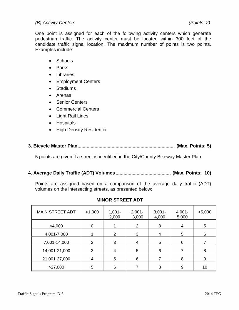
(B) Activity Centers (Points: 2)
One point is assigned for each of the following activity centers which generate pedestrian traffic. The activity center must be located within 300 feet of the candidate traffic signal location. The maximum number of points is two points. Examples include:
Schools
Parks
Libraries
Employment Centers
Stadiums
Arenas
Senior Centers
Commercial Centers
Light Rail Lines
Hospitals
High Density Residential 3. Bicycle Master Plan .......................................................................... (Max. Points: 5)
5 points are given if a street is identified in the City/County Bikeway Master Plan.
4. Average Daily Traffic (ADT) Volumes .......................................... (Max. Points: 10)
Points are assigned based on a comparison of the average daily traffic (ADT) volumes on the intersecting streets, as presented below:
MINOR STREET ADT
MAIN STREET ADT
<1,000 1,001-
2,000 2,001- 3,000
3,001- 4,000
4,001- 5,000
>5,000
<4,000
0 1 2 3
4 5
4,001-7,000
1 2 3 4
5 6
7,001-14,000
2 3 4 5
6 7
14,001-21,000
3 4 5 6
7 8
21,001-27,000
4 5 6 7
8 9
>27,000
5 6 7 8
9 10

2014 TPG Traffic Signals Program D-7
5. Peak Hour Traffic Volumes ........................................................... (Max. Points: 10)
Points are assigned based on a comparison of side street traffic volume to main street traffic volume during the peak hour, as presented below:
MINOR STREET PEAK HOUR VOLUME
MAJOR STREET PEAK HOUR VOLUME
<100
101-200
201-300
301-400
>400
<400 0 0 1
2 3
400-600 0 1 2
3 4
601-800 1 2 3
4 5
801-1,000 2 3 4
5 6
1,001-1,200 3 4 5
6 7
1,201-1,400 4 5 6
7 8
1,401-1,600 5 6 7
8 9
>1,601 6 7 8
9 10
6. Speed ............................................................................................... (Max. Points: 5)
Points are assigned in this category to account for the difficulty that motorists, bicyclists, and pedestrians may have judging gaps in traffic on high-speed streets. More points are assigned for the higher-speed streets, as presented below:
85th Percentile Posted Speed (mph) Points 50+ 5 40-49 4 35-39 3 30-34 2 25-29 1 <25 0
Zero points are assigned if the intersection has an all way stop.
7. Special Conditions ........................................................................... (Max. Points: 3)
Points are assigned based on special or unique conditions related to the benefits or drawbacks of signalizing a particular intersection. Some considerations include distance to a heavy rail crossing, proximity to fire stations, beneficial coordination with adjacent signals, restricted sight distance, etc. The number of points is determined by the City Traffic Engineer.

Traffic Signals Program D-8 2014 TPG
SUMMARY
Table D-1 presents the final point total and ranking of the traffic signal projects. Table D-2 presents intersections where mitigating measures have been implemented and the intersection is being monitored. Figure D-1 shows the approximate locations of the projects. There were four new intersections added to the traffic signal list:
65th Street/11th Avenue El Camino Avenue/Albatross Way El Camino Avenue/Clay Street Florin Road/25th Street
There was one intersection that was moved from the 2010 monitoring list to the traffic signal list. The intersection is:
J Street/18th Street There was one intersection removed from the traffic signal list because the location is an intersection between a City street and a private driveway. The City is not responsible for installing a traffic signal at this location. The intersection is:
Center Parkway/CRC Driveway There were eight intersections from the 2010 list that received funding. They are:
Center Parkway/Arroyo Vista Drive El Camino Avenue/Boxwood Street Franklin Boulevard/Boyce Drive Freeport Boulevard/Claudia Drive Fruitridge Road/58th Street Norwood Avenue/Fairbanks Avenue Rio Linda Boulevard/Acacia Drive Riverside Boulevard/Park Riviera Drive (N)
There were seven intersections from the 2010 list that were removed from the traffic signal list. These locations no longer meet traffic signal warrants. They are:
24th Street/53rd Avenue 29th Street/R Street Azevedo Drive/Bannon Creek Drive Broadway/53rd Street Campus Commons Drive/University Avenue Capitol Avenue/24th Street South Land Park Drive/35th Avenue
2014 TPG Traffic Signals Program D-9
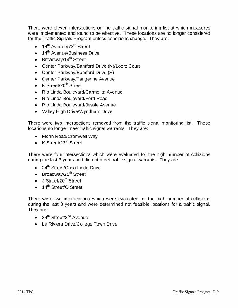
There were eleven intersections on the traffic signal monitoring list at which measures were implemented and found to be effective. These locations are no longer considered for the Traffic Signals Program unless conditions change. They are:
14th Avenue/73rd Street 14th Avenue/Business Drive Broadway/14th Street Center Parkway/Bamford Drive (N)/Loorz Court Center Parkway/Bamford Drive (S) Center Parkway/Tangerine Avenue K Street/20th Street Rio Linda Boulevard/Carmelita Avenue Rio Linda Boulevard/Ford Road Rio Linda Boulevard/Jessie Avenue Valley High Drive/Wyndham Drive
There were two intersections removed from the traffic signal monitoring list. These locations no longer meet traffic signal warrants. They are:
Florin Road/Cromwell Way K Street/23rd Street
There were four intersections which were evaluated for the high number of collisions during the last 3 years and did not meet traffic signal warrants. They are:
24th Street/Casa Linda Drive Broadway/25th Street J Street/20th Street 14th Street/O Street
There were two intersections which were evaluated for the high number of collisions during the last 3 years and were determined not feasible locations for a traffic signal. They are:
34th Street/2nd Avenue La Riviera Drive/College Town Drive

Traffic Signals Program D-10 2014 TPG
Seven additional intersections were evaluated and did not meet warrants for a traffic signal. These intersections were the result of a survey conducted as part of the community outreach performed for the program. They are:
14th Avenue/62nd Street 35th Street/4th Avenue Capitol Avenue/18th Street Capitol Avenue/20th Street Gateway Oaks Drive/Venture Oaks Way L Street/18th Street P Street/17th Street
One additional intersection was evaluated and was determined not feasible for a traffic signal. This intersection was the result of a survey conducted as part of the community outreach performed for the program.
Broadway/58th Street
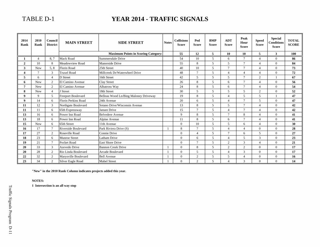
TABLE D-1 YEAR 2014 - TRAFFIC SIGNALS
2014 Rank
2010 Rank
Council District MAIN STREET SIDE STREET Notes Collisions
ScorePed
ScoreBMP Score
ADTScore
Peak Hour Score
Speed Score
Special Conditions
Score
TOTAL SCORE
55 12 5 10 10 5 3 1001 4 8, 7 Mack Road Summersdale Drive 54 10 5 6 7 4 0 862 10 8 Meadowview Road Manorside Drive 55 8 5 5 7 4 0 843 New 5, 8 Florin Road 25th Street 40 10 5 7 7 4 0 734 7 3 Truxel Road Millcreek Dr/Waterwheel Drive 48 7 5 4 4 4 0 725 6 4 D Street 16th Street 42 5 5 5 7 2 1 676 New 2 El Camino Avenue Clay Street 26 8 5 6 7 4 0 567 New 2 El Camino Avenue Albatross Way 24 8 5 6 7 4 0 548 New 4 J Street 18th Street 30 5 5 5 5 2 0 529 9 5 Freeport Boulevard Belleau Wood Ln/Bing Maloney Driveway 19 8 5 4 5 5 1 479 14 6 Florin Perkins Road 24th Avenue 20 6 5 4 7 5 0 47
11 12 3 Northgate Boulevard Sotano Drive/Wisconsin Avenue 13 8 5 5 7 4 0 4211 11 6 65th Expressway Jansen Drive 15 7 5 4 7 4 0 4213 16 6 Power Inn Road Belvedere Avenue 9 8 5 7 8 4 0 4113 18 6 Power Inn Road Alpine Avenue 11 8 5 6 7 4 0 4115 New 6 65th Street 11th Avenue 0 10 5 5 6 4 0 3016 17 7 Riverside Boulevard Park Riviera Drive (S) 1 8 7 5 4 4 0 0 2817 27 2 Roseville Road Connie Drive 0 4 5 7 6 5 0 2718 23 6 Munroe Street Latham Drive 0 6 5 4 5 3 0 2319 21 7 Pocket Road East Shore Drive 0 7 5 2 3 4 0 2120 33 3 Azevedo Drive Bannon Creek Drive 1 0 8 5 2 2 0 0 1720 28 2 Rio Linda Boulevard Arcade Boulevard 1 0 5 5 4 3 0 0 1722 32 2 Marysville Boulevard Bell Avenue 1 0 2 5 5 4 0 0 1623 34 2 Silver Eagle Road Mabel Street 1 0 2 5 4 3 0 0 14
"New" in the 2010 Rank Column indicates projects added this year.
NOTES:1 Intersection is an all way stop
Maximum Points in Scoring Category:
Traffic Signals Program D
-11

TABLE D-2 YEAR 2014 - INTERSECTION MONITORING LIST
2010 TPG Status
Council District Main Street Side Street Mitigation
8 2 Norwood Avenue Ford RoadNew signal installation at Norwood Avenue and Fairbanks Avenue; monitor impacts.
New 5, 8 Florin Road Munson Way Paint median tip and install object markers; monitor impacts.
Traffic Signals Program D
-12