Trade and Political Fragmentation on the Silk Roads: The ...
38
Trade and Political Fragmentation on the Silk Roads: The Economic and Cultural Effects of Historical Exchange between China and the Muslim East Lisa Blaydes * Christopher Paik † May 1 2019 Abstract The Silk Roads stretched across Eurasia, connecting East and West for centuries. At its height, the network of trade routes enabled merchants to travel from China to the Mediterranean Sea, carrying with them high-value commercial goods, the exchange of which encouraged urban growth and prosperity. In this paper, we examine the extent to which urban centers thrived or withered as a function of political shocks to trade routes, particularly the fragmentation of state and im- perial control along natural travel paths. We find that political fragmentation along the roads to Aleppo and historic Chang’an — major terminus locations for cross-regional trade — damaged city growth. Alongside inter-regional trade, the Silk Roads also connected China to the Muslim East by facilitating forms of religious and cultural exchange, including the transmission of ideas, values and aesthetic traditions. We trace one effect of historical Silk Roads trade on the contemporary period — cultural affinity as measured through commonality of basic values. Our findings suggest that pre-modern patterns of economic and cultural exchange have implications for the success of contemporary Chinese soft power projection in Western Asia. * Department of Political Science, Stanford University † Division of Social Science, New York University Abu Dhabi 1
Transcript of Trade and Political Fragmentation on the Silk Roads: The ...

Trade and Political Fragmentation on the Silk Roads:
The Economic and Cultural Effects of Historical
Exchange between China and the Muslim East
Lisa Blaydes∗ Christopher Paik†
May 1 2019
Abstract
The Silk Roads stretched across Eurasia, connecting East and West for centuries. At its height,the network of trade routes enabled merchants to travel from China to the Mediterranean Sea,carrying with them high-value commercial goods, the exchange of which encouraged urban growthand prosperity. In this paper, we examine the extent to which urban centers thrived or witheredas a function of political shocks to trade routes, particularly the fragmentation of state and im-perial control along natural travel paths. We find that political fragmentation along the roads toAleppo and historic Chang’an — major terminus locations for cross-regional trade — damaged citygrowth. Alongside inter-regional trade, the Silk Roads also connected China to the Muslim Eastby facilitating forms of religious and cultural exchange, including the transmission of ideas, valuesand aesthetic traditions. We trace one effect of historical Silk Roads trade on the contemporaryperiod — cultural affinity as measured through commonality of basic values. Our findings suggestthat pre-modern patterns of economic and cultural exchange have implications for the success ofcontemporary Chinese soft power projection in Western Asia.
∗Department of Political Science, Stanford University†Division of Social Science, New York University Abu Dhabi
1
In 2013, Chinese President Xi Jinping officially launched the “One Belt, One Road” Initiativelater re-branded as the “Belt and Road” Initiative. Hailed as a new Silk Road, the project investsbillions of dollars in infrastructure development to promote economic integration of China with WesternAsia, particularly countries of Central Asia and the Middle East. The desire to recreate aspects ofcommercial integration of China and the Middle East raises a series of important empirical questions— what impact has historical overland trade had on the economic development trajectories of Chinaand Muslim East? And do those historical economic ties have legacy effects today?
Merchants long sought to connect major urban centers across East and West Asia through luxurygoods trade in silk, porcelain and spices. Scholars focused on historical Silk Roads trade emphasizethe dangers associated with overland exchange (e.g., Millward 2007; Frankopan 2016). Scholarship inthis vein suggests that political fragmentation may have been a hindrance to gains from cross-culturaltrade. We home in on historical overland trade between China and the Middle East to show theeconomic effects of political shocks on city size. We find that greater political fragmentation on theroads to Aleppo and historic Chang’an (contemporary Xi’an) — major Silk Road terminus points— damaged gains from trade since merchants had to contend with uncertainty on their route. Theseresults persist even after controlling for both city and time fixed effects, among other control variables,as well as the Chinese tribute-system, which created commercial, diplomatic and security ties betweenimperial China and smaller, surrounding polities.
Next, we consider the long-term cultural legacy effects associated with these historical trade routes.We find that countries along the Silk Roads enjoy a higher degree of cultural affinity today, even aftertaking into account a variety of geographic and other variables. These results suggest that thereare important legacies associated with historical exchange that have the potential to impact forms ofpolitical conflict and cooperation in the contemporary period. Existing scholarship has argued thatthere is an ideational mismatch between China and major world powers, limiting China’s ability toproject power globally (e.g., Allan et al. 2018). Our results suggest that China may enjoy an outsizedability to project power in countries located along the historical Silk Roads as a result of shared culturalvalues transmitted via past exchange. And because these countries are important investment targets ofthe Belt and Road Initiative, growing trade integration within Asia raises important questions aboutthe political implications of Chinese soft power projection efforts.
Our findings speak to key debates about the political and cultural determinants of economiccooperation and prosperity. Although scholars have debated the extent to which the prevailing liberaleconomic order relies on shared values versus raw military and material power, few would arguewith the contention that shared values among Western powers have facilitated cooperation. If culture‘greases the wheels’ of alliance, our findings suggest that Chinese efforts at a counter-hegemonic projectbased on economic cooperation with Western Asia may present unique opportunities for Chinese effortsat global influence.
The empirical results we present also speak to the question of how jurisdictional uncertainty impactsthe gains from cooperation. Scholars have long argued that a well-ordered world is conducive totrade and communication. For example, territorial disputes can hinder economic exchange; empiricalevidence suggests that conflict disrupts trade (Anderton and Carter 2001) and that there are large andpersistent negative impacts of war on economic welfare (Glick and Taylor 2010). Beyond that, Simmons(2005, 843) argues that the question of “who is formally sovereign over what geographical space”is a first-order concern where ambiguity regarding rules and legal protections leads to fewer cross-border transactions. Epstein (2000, 8) finds that jurisdictional fragmentation increased “negotiation,enforcement and exaction costs” associated with historical trade. For example, fragmentation createdpotential for extraction by actors like the medieval “robber barons” (or “robber knights”) who imposed
2
high taxes and tolls on rivers and roads that were located in their territory. Cox (2017, 726) definesthe phenomenon more generally as intra-route fragmentation — the split in governing authority alonga single shipping route, a situation which leads to over-taxation of the common pool of merchants.Our analysis provides an empirical assessment of how barriers to trade hindered pre-modern economicdevelopment.
The Global Economic Order before Western Hegemony
Europe’s Age of Exploration and, later, the Industrial Revolution ushered into existence new globalpatterns that disrupted long-standing trade and cultural ties. Existing scholarly work, however, sug-gests the lack of a global economic hegemony before the 18th century.1 Frank (1998, 324) writes thatuntil at least 1700, there was nothing “exceptional” about Europe other than its relative marginalityand “correspondingly minor role in the world economy.” On the other hand, areas like Xinjiang —the current-day westernmost province in China — were locationally important as “roughly equidis-tant from population cores of China, India and the Mediterranean basin” (Millward 2010, 4). Indeed,historical commercial routes, like the Silk Road and Indian Ocean trade, connected economic interestsin prosperous areas, like China and the Middle East, for centuries. At its height, the network of traderoutes enabled merchants to exchange high-value goods across great distances, economic interactionsthat were crucial for urban growth and development.
Eurasia’s Economic Distribution of Power
One key challenge associated with identifying the historical global distribution of economic powerrelates to measurement. Economists have long argued that city size is a good proxy for economicdevelopment in the pre-industrial period. For example, De Long and Shleifer (1993, 675) suggest thatthe population of pre-industrial European cities serves as the best available indicator of economicprosperity, contending that urban areas were key nodes of information and economic exchange thatrelied on high levels of agricultural productivity and economic specialization. Acemoglu et al. (2002)present both cross-sectional and time-series evidence suggesting a close empirical association betweenurbanization and income per capita for cities around the world in the pre-industrial period. Stasavage(2014) uses city size as a proxy for economic flourishing in his examination of comparative economicdevelopment in pre-modern Europe.
City population estimates from Africa, Europe and Asia suggest that between 1100 and 1800 CE,the largest cities in the world were located primarily in China and the Middle East.2 Indeed, Eurasia’surban ‘center of gravity’ for much of the last millennium was located contemporary Iran.3 Between1500 and 1700, however, a more diverse set of urban centers emerged, including in Europe, South Asia,the Middle East and East Asia and by 1800 the cities of Northwestern Europe increasingly becameamong the world’s largest, alongside Asian cities. After that point, the cities of Western Asia, longfavored as a result of their position as a “commercial and migratory turntable” (Frank 1998, 75),became less prominent than in previous periods; areas of Central Asia which used to be important
1Abu-Lughod (1989, 364-365) argues that the world economic system in the medieval period lacked a single hegemonbut instead there existed multiple core powers in a non-hierarchical, interdependent world economic system.
2See Figure 1 of the Supplemental Appendix.3The mean longitude hovers between 60 and 62 degrees and shows no discernible shift over the course of 700 years
analyzed. The mean latitude is also highly stable between 1100 and 1500, although we do observe a mean which is abouttwo degrees further north when comparing 1500 to 1800. This likely reflects the growing population centers of northernEurope. See Table 1 in the Supplemental Appendix for more details.
3
crossroads “ceased to be so central to world history” as the “world historical center of gravity shiftedoutward, seaward, and westward” (Frank 1992, 44). Kupchan (2012, 3) argues that the world’s centerof power shifted from Asia and the Mediterranean to Europe by the 18th century with importantimplications for the ability of the West to use “its power and purpose to anchor a globalized world.”
Trade, Fragmentation and Political Order
One reason that the Middle East and Central Asia thrived for so long relates to the central locationof the region with regard to trade routes. Among the most prominent of these routes were the SilkRoads. The term “Silk Road” refers to “all the different overland routes leading west out of Chinathrough Central Asia to Syria and beyond” (Hansen 2012, 235).4 Christian (2000, 3) defines theSilk Roads as “the long- and middle-distance land routes by which goods, ideas, and people wereexchanged” between major regions of Eurasia. Commodities included on these trans-Eurasian traderoutes included raw silk or yarn; finished silk fabrics; and other luxury goods like coral, pearls, glass,jade, gems, perfumes and incense (von Glahn 2016, 197). During the medieval and early modernperiods, Chinese-Middle Eastern trade was both a reflection and driver of economic prosperity forboth regions.
Yet, trade ties could be disrupted. How did shocks to trade impact the growth of cities in Chinaand the Muslim East? And how did the rise of the Western international order damage these historicaltrade ties? Blaydes and Paik (forthcoming) find that proximity to historical Muslim trade routes waspositively associated with urbanization in 1200 but not in 1800. In other words, Middle Eastern andCentral Asian cities — long beneficiaries of locational centrality between Europe and Asia — declinedas Europeans found alternative routes to the East and opened new trade opportunities in the NewWorld.5
In this paper, we focus on another disruption to trade — political fragmentation — that likelydamaged economic growth along major land routes connecting Western to Eastern Asia. Why focuson Asia? Beyond the need to de-center world historical studies away from a focus on Europe, there aretheoretical and empirical benefits from such an approach. First, as discussed in the previous sectionthe Eurasian urban of center of gravity was located in Asia. The Middle East and China — despiteimportant differences of religion and philosophy — shared historical parallels, including their vulnera-bility to external actors, like nomadic tribesmen (Harris 1993, 23).6 Park (2012, 191) writes that, “thehistory of contact and exchange between China and the Islamic world offers one of the most remark-able cases of pre-European encounter because it involves tremendous wealth, transformative ideas, andgreat power.” While exchange continued, largely without interruption for eight centuries, changingpolitical dynamics did create different phases and conditions associated with these interconnections(Park 2012, 191).
Second, we pick up on threads within the existing literature which suggest that China served asthe global economic heavyweight with which other cultures sought to trade. Andre Gunder Frank isone of the most prominent proponents of this perspective. According to Frank (1998, 111), China was“unrivaled” in its production of luxury consumer goods like porcelain ceramics and silks. As parts
4The term “Silk Road” did not exist before 1877 (Hansen 2012, 235).5This is not to say that mastery of long-distance seafaring was an accident. European navigational triumphs were
“the result of deliberate processes of purposeful exploration” (Paine 2013).6In addition, within Asia — despite its tremendous diversity — these exists an “underlying unity” associated with
technologies, cultures and disease patterns (Christian 2000, 1). Eurasian merchants, including those from Safavid Iranand Uzbek Turan, were seen as coming from a “broadly similar commercial and linguistic environment” which meantthat they had the ability to carry out trade within a shared and understood legal and cultural circumstance (Dale 1994,10).
4
of the Middle East and Europe become wealthier, there was a strong interest in acquiring Chineseproducts. China has been described as exhibiting “outstanding absolute and relative productivity inmanufactures” (Frank 1998, 127).7 Frank (1998, 116-117) goes as far as to argue that “the entireworld economic order was — literally — Sinocentric” until the 18th century.
Even if we take Frank’s position on these issues to be extreme, relatively little scholarship hassought to understand the effects of political fragmentation outside of Europe. Much has been writtenabout the benefits of political fragmentation in Europe where fragmentation is thought to have createdconditions ripe for limited government and, eventually, economic development.8 While an influentialliterature has suggested that forms of political fragmentation has been directly or indirectly goodfor economic development (e.g., Tilly 1990; Blaydes and Chaney 2013; Cox 2017), fragmentationalso damaged the gains to trade (e.g., Epstein 2000; Simmons 2005).9 In Eastern and Western Asia,growth-promoting institutions, like parliaments, were slow to develop; we consider the conditions whichencouraged or discouraged economic exchange and development outside of the European experience.In this paper, we argue that political fragmentation hindered the exchange of goods, hurting economicprosperity — and that the most appropriate place to test this argument is in pre-modern Asia wherethe effects of fragmentation were not confounded by growth-promoting institutions, as were found inEurope.
The movement of merchants might be disrupted for a variety of reasons, many of which were relatedto political fragmentation. In particular, periods of incomplete or uncertain political control could behighly disruptive to trade. For example, tribal warfare posed a security threat (Abu-Lughod 1989,158). According to Curtin (1984, 93-94), “to take a caravan through uncontrolled nomad countrywould have been dangerous in the best of circumstances.” According to Harris (1993, 22), “theemergence of small warring kingdoms...made the East-West highway more dangerous and difficultand populations along the route began to decline.” Beyond that, traversing a number of differentpolities might also lead merchants to incur multiple tolls as a result of the political fragmentation.Political fragmentation may have also increased jurisdictional uncertainty, increasing transaction costsassociated with trade (Epstein 2000; Simmons 2005).10 As a result, the importance and profitabilityof the Silk Roads “waxed and waned,” at least in part, as a function of the political stability on theedges of agrarian civilizations of China, India, Iran and Mesopotamia” (Christian 2000, 6). Christian(2000, 6) argues that “when the agrarian civilizations or pastoralists empires dominated large sectionsof the Silk Roads, merchants traveled more freely, protection costs were lower, and traffic was brisk.”
7India also produced important and valued goods. But given the predominance of sea trade opportunities — andour interest in overland trade — we are focused primarily on trade with China. Europe was considered economically andgeographically marginal (Frank 1998, 324).
8Fragmentation is thought to have been a common feature of European history, to the point that scholars have arguedthat the emergence of the Roman Empire — Europe’s longest experience with imperial rule — was a historical anomaly(Schiedel 2019).
9At least three sets of arguments seek to link political fragmentation with European institutional development. Tilly(1990) focuses on the impact of competition between small, war-prone polities on the development of national states.Blaydes and Chaney (2013) argue that the decentralized forms of political control associated with feudal institutionshad positive impacts on the emergence of executive constraint. Cox (2017) argues that political fragmentation — whichprovided exit options for merchants — combined with self-governing cities and parliaments to facilitate forms of executiveliberty.
10One less direct factor involved the creation of forms of cultural continuity. Rogers (2007, 263) suggests thatpolitical stability and the expansion of imperial powers encouraged the “bridging of ethnic and linguistic diversity in theconstruction of order” (Rogers 2007, 263). There were also significant gains to be enjoyed from this trade. Christian(2000) describes the benefits of trans-ecological exchange as including gains from the tremendous diversity of itemsexchanged.
5
The causes of political fragmentation are many and complex. At some times, large imperial unitswould take control of vast swaths of territory. The process by which this emerged often involved“initially consolidating groups into a single confederation” which might spread across the steppe toinclude new territories and peoples (Rogers 2007, 258). Rogers (2012, 206) argues that there is noobvious explanation for when and why these successful polities emerge; polities “emerged, existed, andcollapsed in ways that often defy conventional understandings.” State formation and collapse, then,can be thought of as caused by a complex set of factors, with a large number of contingencies and,potentially, tied to cyclical patterns (Rogers 2007, 265). Indeed, part of our approach to causal iden-tification relies an increasing preponderance of archaeological and historical climate science evidencewhich suggests that state formation on the Eurasian steppe was a function of exogenous environmentalfactors.
One factor that might have worked against the negative effects of fragmentation was the Chinesesystem of tribute. Zhang (2013) describes the tribute system (chaogong tizhi) as embodying institu-tions and diplomatic norms that dominated China’s relations with the non-Chinese world until the late19th century. Kang (2010, 591) write that the East Asian tributary order was an “enduring, stable,and hierarchic system, with China clearly the hegemon” and a “viable and recognized internationalsystem with military, cultural, and economic dimensions that all intersected to create a...stable secu-rity system.”11 By providing stability and security, Chinese regional hegemony may have operated in away consistent with hegemonic stability theory which suggests that a hegemonic distribution of powercan have positive effects on trade openness (e.g., Krasner 1976; Gilpin 1981; Gilpin 1987).12 Otherscholars, however, have suggested that pre-modern China was not able to create an open trade order(Shu 2012) and that the application of a tributary-system model to historical international relations isdeeply problematic (Van Lieu 2017).13 For example, Perdue (2015) suggests that arguments suggestinga systematic Chinese tributary system are misleading given the multiple and complex relationships oftrade, diplomacy and ritual between China and other Asian polities. Our empirical analysis providesevidence testing the effects of changes in tribute status on urban growth.
Trade Shocks and Economic Prosperity on the Silk Roads
Between 200 BCE and the beginning of the Common Era, overland trade between China and theeastern Mediterranean polities of the Middle East became a regular occurrence (Curtin 1984, 90). Theemergence of long-distance Eurasian trade was temporally linked to the Han Dynasty’s unification ofChina as well as Han extension of political control into the Xinjiang region. In Western Asia, theRoman Empire extended political control across the Mediterranean. The timing associated with theconsolidation of these trade routes suggests a linkage between consolidation of political control in China
11Kang (2010, 594) writes that “Chinese civilization provided a common intellectual, linguistic, and normative frame-work in which to interact and resolve differences.” Arguments by Kang (2010) and Wang (2013) about the ways thatConfucianism may have mitigated conflicts are not intended to extend to non-Confucian tribute states, however.
12In return for recognizing the legitimacy of Chinese preeminence in regional affairs, “China, as the economic, military,and cultural leader, was responsible for maintaining the political and security order in the region” (Wang 2013, 213).In this setting, Confucianism served as a shared culture that helped to resolve conflicts between China and tributarystates (Wang 2013, 213). Not all Asian polities were tributes of the Chinese state. Indeed, Kang (2010) writes thatthe semi-nomadic peoples on China’s periphery were often reluctant to accept Chinese authority. And states that didmaintain tributary relations with China were still able to handle their own domestic and foreign policies, separate fromChina (Kang 2010). That said, Kang (2010) has argued that systemic stability was good for the political regimes inthese Sinicized East Asian countries.
13In particular, Shu (2012) argues that the regional economic order under tributary trade was never open to all statesand that tributary relations were unstable because of dynastic changes in China.
6
and the Mediterranean basin. Thus while the location of the Silk Roads may have been determined bygeographic features, like “mountain passes, valleys, and springs of water in the desert” (Hansen 2012,235), the robustness of trade connecting urban areas may have been a function of political factors.In this section, we review some of the existing qualitative evidence regarding how forms of politicalstability and imperial consolidation impacted cross-cultural exchange in the pre-modern period.
Cross-cultural Trade from Late Antiquity to the Middle Ages
The Tang Dynasty (618-907 CE) coincided with the Arab conquests and the first two centuries of Islam.Scholars of the early Islamic period have suggested that the advent of Islam was an important force forbreaking the control of the agrarian gentry from “Nile to Oxus” as well as the growth in importanceof interregional trade (Hodgsen 1974, 65). According to Hodgsen (1974, 65), it was during this periodthat trade became “increasingly determinative of the fate of any given region” and mercantile andbourgeoisie interests strengthened relative to agrarian classes. The Tang Dynasty maintained militaryand commercial connections with Central Asian polities as far west as Persia (Benite 2011).
During this time, trade linking the Middle East and China was economically significant withimplications for the growth and development of major urban centers. Caravans of horses and Batriancamels traveled from Mesopotamia to the Iranian plateau and then eastward toward the Oxus afterwhich point there were multiple routes including those which passed through Kashgar and alternativeroutes that went through Kabul (Lombard 1975, 218). These trade routes not only provided the meansby which goods were transmitted across huge distances but also involved the transmission of ideas,technologies and artistic practices (Christian 2000, 1; Hansen 2012, 5).
Political stability associated with large empires created the security zones under which trade mightprosper. Curtin (1984, 91) argues that the “Tang Dynasty in China and the Abbasid Caliphate ofBaghdad...provided imperial umbrellas over most of the trade routes between China and Mediter-ranean.” These favorable conditions, associated with the power of contemporaneously large empires,made it relatively easy for long-distance traders to move across vast areas (Curtin 1984, 105). Underthe “long reach of Tang control to the west,” many Middle Eastern and European travelers wereable to visit China (Curtin 1984, 105). Foreign merchants transformed small, oasis settlements acrossCentral Asia into larger towns and cities (von Glahn 2016, 197). Merchants and agents, under theprotection of local rulers, traveled with relative safety.
China’s Song Dynasty (960-1279 CE) was characterized by extensive development of trade, en-terprise and finance as well as specialization of production and growth of markets (von Glahn 2016,265). According to scholars, China was “significantly transformed by market development during theeleventh century” and a growing overall economy (Liu 2015, 8). Von Glahn (2016, 293) argues thatthe “commercial efflorescence” of the Song period “touched virtually all quarters of Chinese society.”14
Economic growth in the Song was robust and associated with major population expansion, supportiveof a robust urban culture (Chaffee 2015).15 The Song Dynasty in China was temporally concurrentwith the Islamic Golden Age, a period of economic and cultural flourishing. The dissolution of theAbbasid Caliphate introduced increasing political fragmentation of the Muslim world during this time,however.
14During the 13th century China had very sophisticated agriculture (Abu-Lughod 1989, 319). While family farmsproduced stable food products, many other items of daily consumption were acquired through market exchange (vonGlahn 2016, 293).
15During the Song Dynasty, taxes were relatively light and there was a relatively efficacious bureaucracy and a stablecurrency (Golas 2015).
7

The Mongol Empire and its Effects on Trade
The Yuan Dynasty (1279-1368 CE), which followed the Song Dynasty, was founded by the Mongols,whose land conquests were a common shock to both the Eastern and Western parts of Asia. For theMongols, the rich societies of China, Iran, Iraq and Anatolia were particularly appealing targets ofattack while “little-known, fragmented Europe” was relatively peripheral (Sinor 1999, 40). While muchhas been written about the destructive aspects of Mongol rule, historians are increasingly painting amore complex picture of the overall economic impact of the Mongol invasions. While some cities neverrecovered from the destruction of their populations during the conquests, others saw relatively rapidrebounds in their population (Soucek 2000, 114). Manz (2011) describes both the destructive elementsof the Mongol conquests as well as the new opportunities introduced for artisans and merchants.
One of the most important positive externalities associated with the creation of the Mongol Empirewas the establishment of political order over regions that supported overland trade. Curtin (1984,120) writes that “the new rulers united so much of Asia that travelers could move securely under asingle authority from the shores of the Black Sea to China.” Anatolia became more connected tolong-distance commercial relations coming from Central and East Asia (Meloy 2011). According toAbu-Lughod (1989, 154), the Mongols created “an environment that facilitated land transit with lessrisk and lower protective rent.” Benite (2011) argues that during this time period, larger numbers ofmerchants were coming to China compared to ever before, many of them from the Islamic world. Oneresult of this increase in overland trade was that Chinese porcelain began to show up, to a greaterextent, in the Middle East as well as in Europe (Meloy 2011).
Although the Mongols were a nomadic people, scholars have argued that Mongol rulers “orderedand patronized” economic exchange (Allsen 2001, 191). Manz (2011) suggests that trade was ofmajor interest to the Mongols and that Mongol leaders directly engaged in international trade throughcommercial partnerships. Caravaners were “prime beneficiaries of the Pax Mongolica” as the formationof a pan-Asian Mongol Empire strongly supported overland, East-West trade (von Glahn 2016, 283).Frankopan (2016, 176) goes as far as to claim that Mongol territorial successes of the 13th centuryreshaped the monetary system of Eurasia.
The break-up of the Mongol Empire may have also hindered forms of economic exchange. GenghisKhan’s efforts to divide the empire into parts to pass on to his sons planted the seeds of political insta-bility (Millward 2007, 61). Subsequent internecine conflict among rival Mongol khanates encourageda greater interest in maritime trade (von Glahn 2016, 283). This reflected a more generalized patternthat during times of political instability in Central Asia, merchants tended to turn to sea routes in-stead of overland trade (Schottenhammer 2015). This is not to say that the Mongol conquests werenot long-term impactful; in the years after the Mongol invasions, China was able to project politicalpower into Central Asia more effectively (Liu 2015, 99). That said, the lack of a large, overarchingland empire covering the Silk Roads may have increased the cost of trade even if the Mongol conquestshad important other legacies.
Cross-Regional Trade in Post-Mongol Asia
The Ming Dynasty (1368-1644), which followed the Yuan, was more conservative about foreign contactsthan its predecessor; but when economic benefits could be gained from trade, merchants engaged incross-cultural commerce, even if this required evasion of existing regulations (Rossabi 1998). Duringthe 15th century, cross-regional trade in exotic foods, aromatics, medicines, precious metals and jewelsdrove long-distance commerce (Reid 2011).
8
By the late 15th century, China was arguably the greatest economic power in the world with apopulation of more than 100 million, a productive agricultural sector and craft sectors superior toother parts of Eurasia (Atwell 1998). As European markets grew in importance, demand increasedfor Asian perfumes, spices and silks. Many of these luxury goods traveled through Persia and theLevant, eventually arriving in Aleppo. Extensive collections of Ming Dynasty porcelain, for example,are found in the Topkapi Museum in Istanbul, Tehran’s Archaeological Museum and across the MiddleEast and even East Africa (Atwell 1998).
Scholars disagree about how much the rise of seafaring damaged overland, Silk Roads trade (Mill-ward 2007, 76). Millward (2007, 76-77) reflects on this disagreement, arguing that some see the early16th century as a turning point for the Silk Roads while others not observing a decline until the late16th century or later. Levi (2011) argues that while there were temporary traumas to long-distancetrade, these disruptions were often followed by recoveries in commercial exchange. Central Asian traderoutes continued to be active into the 17th century but city prosperity was impacted by economic andpolitical transitions (Levi 2011). Samarkand, for example, suffered deurbanization during this period;these declines were not universal, however, with other cities enjoying a vibrant commercial economy(Levi 2011).
Empirical Analysis
Thus far, we have discussed a number of factors which might impact the gains from cross-cultural,overland trade. While some of these determinants are specific to particular locations, others may bevary over time; additional factors may reflect an interaction of geographic factors with time. Someof the most significant of these disruptions involved the rise and fall of land empires in Central Asia.Frank (1992, 44) describes Central Asia as the location where diverse peoples and their civilizations“connected and interacted with each other.” Yet the factors that could influence the political stabilityof Central Asia may be difficult to predict. In this section, our goal is to understand how factorsthat were disruptive to trade — beyond city-specific or time-specific effects — may have impactedprosperity along the Silk Roads.16
One challenge associated with measuring the economic impact of trade and shocks to trade is thatsources describe the location of the Silk Roads in different ways.17 In this paper we do not attemptto introduce a set of definitive Silk Road corridors or claim to add specific route locations that havehitherto not been described in the existing literature.18 Our aim is, instead, to establish a link betweenSilk Roads access and economic prosperity, as a function of opportunities and hindrances to trade. Forthis purpose, we find it useful to look for evidence of how natural travel paths may have been carved,and whether these paths correlate with subsequent development changes in the region. Building onexisting work on geography (Frachetti et al. 2017), we suggest that these paths were not endogenousto the Silk Road trade; that is, the path of travel was not chosen with trade or commerce in mind.
16While a number of studies have looked at commerce in historical China, little work has sought to measure long-termchanges in the impact of long-distance trade (Liu 2015, 20).
17For example, a UNESCO report published in 2008 claims that there are over 70,000 extant manuscripts for theChinese section of the Eastern Silk Roads alone, in historical written records from Buddhist monks, Persians and Turkictravellers, Marco Polo, and other 13th century European visitors.
18Despite the abundance of documents, however, information on the specific locations of travel paths connecting majorcities remains underdeveloped and primarily descriptive. See Park (2012, 31) for example about depictions of the routefrom Guangzhou to foreign countries as envisioned by Jia Dan c. 800, in which places of importance are simply markedas dots, and the travel paths as lines connecting them with some information on coastline locations and duration ofjourney, but little else.
9
Rather, we rely on natural geographic features to determine the least-cost route using the strategiesdescribed in Frachetti et al. (2017). In doing so, we extend their original study of a particular zonewithin Inner Asia to a broader Asian sample.
In particular, Frachetti et al. (2017) design a GIS algorithm to simulate and identify routes takenby nomads for seasonal travel. This exercise in identifying nomadic travel paths is focused on highlandareas, at elevations between 750 to 4000 meters.19 According to Frachetti et al. (2017), high elevationpathways were an essential part of Silk Road networks, but developed differently from those in lowlandregions, the latter being predicted by terrain-based “least cost” travel algorithms on the basis of “easeof travel” and “connecting dots” between known Silk Road locations. This contrasts with the nomadicadaptive strategies that predict the Silk Road corridors in the highlands.
In higher-elevation regions, pastoralists migrated with their animals to highland pastures in thesummer and travelled back to the lowlands during the winter to maximize food available for their herds.Using seasonal pasture quality and annual herding “flow accumulation” across highlands in Asia,Frachetti et al. (2017) create an empirical link between nomadic mobility and Silk Road pathways.Importantly, when generating the flow model, the authors do not include Silk Road routes or locationsas part of the algorithmic input. As a result, the herding paths that predict subsequent Silk Roadroutes plausibly circumvent endogeneity concerns since existing patterns of urbanization did not impactpastoralists as they sought the best available land for animal grazing.20 In other words, herding routeswere not intended to connect population settlements, at least initially. Rather, they were pathwaysto secluded, rich grasslands that subsequently became corridors of commerce and travel.21 Frachettiet al. (2017) use this flow accumulation model to create a network of short-distance herding corridorsthat are highly correlated with Silk Road travel routes.22 The top panel of Figure 1 shows differentcharacterizations of historical Silk Roads; the bottom panel shows an extension of the Frachetti et al.(2017) strategy for identifying nomadic corridors for all of Asia, when we use the same approach andextend the simulation scope to all of the highlands (750-4,000 meter range) in Asia.23
Our empirical analysis seeks to assess whether the Silk Roads, proxied by the nomadic migrationcorridors in the highlands and least-cost routes in low-lying areas, can explain changes in economicdevelopment. Our proxy for economic development is urban population size for eighty-five East, Westand Central Asian cities for the years 1100 to 1800 CE, on the fifty-year interval. Our panel dataset excludes South and Southeast Asia since trade in those regions was more likely to occur via searoutes rather than the overland routes that are the focus of this analysis.24 Our data come fromChandler and Fox (1974) and contain all the cities which appear at least once on any of the lists
19Frachetti et al. (2017) describe this range of elevation to categorize the highlands as different from the lowlands(below 750 meters), which have productive pasture lands that are destroyed by summer heat and aridity, and the upperhighlands (above 4,000 meters) that have limited pasture due to permafrost and poor soil quality.
20If anything, each herder had an incentive to seek untouched, uninhabited spots away from other groups of herders.21The pastoralist model in Frachetti et al. (2017) employs the same flow accumulation algorithm used to simulate
flow of water sources through a watershed. Just as water is pulled to a lower elevation by gravity, the model replacesthe grass quality for gravity and animal herds for water, and uses the flow accumulation algorithm to calculate how thepasture quality directs flows of seasonally nomadic herders across the highlands.
22This result gives us confidence that the nomadic migration corridors are good proxies for the historical Silk Roadpassages. For further details, see Frachetti et al. (2017).
23Specifically, the geographical extent of this exercise spans from 25 to 135 degrees in longitude, and 5 to 56 degreesin latitude. Frachetti et al. (2017) focuses on the inner Asian mountain corridors of Central Asia, those areas mainlyconnecting present-day Tajikistan, Kyrgyzstan, Kazakhstan and China.
24In particular, we restrict our sample to those located above the 25-degree latitude. Furthermore, the highlandsof the nomadic people in Central Asia, characterized as grasslands in Frachetti et al. (2017), are different from thetropic and quasi-tropic forest highlands in Southeast Asia, in which rice cultivation rather than herding would have beencommon. Given our empirical approach to simulating nomadic migration corridors, it would make little sense to extend
10
for the world’s largest cities across these time periods.25 Why operationalize economic growth andtrade-related prosperity with city size? Beyond the existing literature in economics endorsing such anapproach (De Long and Shleifer 1993; Acemoglu et al. 2002; Stasavage 2014), qualitative historicalanalysis also draws links between overland Eurasian trade and city growth. For example, Lary (2012,51) argues that trade supported merchants who settled in the cities of Central Asia. Commercialmarkets created dense networks of exchange which reflected forms of product specialization (Wong1997, 20). Christian (2000, 9) writes that “the urban geography of the Silk Roads...points to theimportance of the trans-ecological routes,” with important cities, like Kashgar and Bukhara, locatedon major trade paths.26
For our empirical analysis, we simulate Silk Road pathways between each city in our sample and thetwo Silk Road end points: Aleppo and historic Chang’an.27 Chang’an represented a major terminusof overland trade routes in the East (Allsen 2001, 13); Aleppo was an “emporium” for Asian goods inthe West (Inalcik 1994, 57) and a long-standing destination of overland caravans. In Figure 2 we showthe nomadic migration corridors which form the basis of our Silk Road proxies, and the cities in oursample. The simulated pathways connecting each city with Aleppo and Chang’an are also representedon the map.
In order to assess whether traders encountered different states and non-state territories along theirtravel paths, we utilize a set of maps from GeaCron, which provides state boundaries around theglobe across different time periods.28 Based on these maps we obtain our main explanatory variable ofinterest: the number of times that each path crosses different states to Chang’an and to Aleppo. Thisvariable measures the extent of political fragmentation that one would have observed when travellingon the Silk Roads towards the East and the West. We also gather information on whether the departurecity was part of a polity identified in GeaCron (as opposed to be located in a state-less area) as well aswhether it served as a capital city.29 Finally, we code for whether the polities traversed were tributarystates of imperial China; this variable changes over time as states moved in or out of the Chinesetribute system.
One particular advantage of focusing on East, Central and West Asian cities is that state formationon the Eurasian steppe has come to increasingly be understood as a function of exogenous climaticfactors, at least in part because nomadic statecraft has been shown to be sensitive to environmentalconditions.30 This may particularly be the case since there are important links between forms ofpolitical authority in Central Asia and transport technologies that support pastoral cultures, especially
our analysis to those south of the 25-degree line. At the same time, this benchmark does allow us to keep all the relevantcities along the Silk Roads west of the Tibetan plateau and east of Aleppo.
25While actual population figures are often missing for cities on these lists, Chandler and Fox (1974) do providerankings of cities in the order of their size. Blaydes and Paik (forthcoming) provide further discussion of this data,discuss previous works that have utilized Chandler and Fox (1974) for their studies, and advantages of using a singlesource for city populations over multiple continents.
26Existing research also suggests that merchants, particularly those focused on long-distance trade, were often amongthe wealthiest in pre-modern cities. For example, court records from 15th century Anatolia suggest that the wealthiestmerchants in the city were those involved in either the spice or silk trade (Inalcik 1994, 344-345).
27The calculation is based on a combination of both the paths along the nomadic migration corridors, as well as theleast-cost path calculated from the city location to the nearest corridor. We confine cities in our sample to those west ofChang’an and east of Aleppo.
28See geacron.com for details on how these data were collected.29For coding whether the cities in our data were capital cities or not, we utilize city data from Pierskall et al. (2017)
and match our city-year observations to theirs. We also check the coding on Chinese cities with a number of sourceswritten in Chinese.
30Honeychurch and Makarewicz (2016) find that over the past two decades new field and laboratory methods havemeant that archaeological research on traditionally pastoral nomadic regions has increased tremendously.
11
reliance on horses (Honeychurch 2014). For example, the sudden rise of Genghis Khan was totallyunexpected according to historians (Soucek 2000, 103). Scientists specializing in climate change,however, have found that the timing of the Mongol rise was closely linked to climate anomalies sinceunusually wet weather was associated with a proliferation of grasses to feed horses as the Mongolsmoved across the Eurasian steppe (Pederson et al. 2014). Additional studies in climate science suggestthat the Mongol withdrawal from Hungary in 1242 may also have been a function of unanticipatedclimactic conditions (Buntgen and Di Cosmo 2016). This perspective is consistent with scholars whohave suggested that the process by which Eurasian land empires have formed is relatively unpredictable(Rogers 2007; Rogers 2012), suggesting the importance of exogenous conditions.
Figure 3 provides a stylized illustration of our argument and empirical strategy. Merchants fromCity A seek trade opportunities that allow them to deliver goods to Aleppo and Chang’an. In orderfor those merchants to engage in commerce, they may need to traverse a number of polities in orderto arrive at their destination. They may also traverse non-state territories, as well as tributary statesunder the Chinese rule. In this illustration, the solid lines represent independent polities while dottedlines represent independent polities that fall under the Chinese imperial tribute system. Using theinterval data with population estimates for each city, we then utilize a generalized maximum loglikelihood interval model to obtain coefficient value estimates.31 The following equation follows apanel regression approach, and can be specified as follows:
Popit = β0 + β1Path2Changani + β2Path2Aleppoi + (1)
+XiΦ +
j=1800∑j=1150
Z′iIjtΘj +
∑c
γIci +
j=1800∑j=1150
ρjIjt + εit
where Popit is the natural log of city population of city i in year t, Path2Changani and Path2Aleppoiare our political fragmentation variables, and X is a vector of time-varying control variables includingthe number of non-state territories crossed en route to Chang’an and Aleppo, the capital statusand state rule existence of city i as well as tributary states crossed and tributary status of cityi.
∑j=1800j=1150 Z′iI
jtΘj are the city-specific geographic characteristics interacted with time-period fixed
effects. Given that city location and their surroundings are paramount to trade and city sizes, theseare meant to capture any time-differential effects of geographic variables that determine both the city’saccess to the Silk Roads and urbanization. They include the distance to the nearest natural migrationcorridor in the highlands (as simulated in our analysis described above), distance to the nearest coast,longitude and latitude as well as the elevation mean and standard deviation. Finally,
∑c γIci and∑j=1800
j=1150 ρjIjt are the city and time-period fixed effects, respectively.
On average, a merchant’s path intersects with five polities to get to Aleppo and five on the path toChang’an.32 There exists a great deal of variation across cities, however. For example, in this samplethe maximum number of polities crossed is 16 on the path to Aleppo and 17 to Chang’an. Our mainfindings in Table 1 shows that both the number of polities crossed to get to Aleppo and Chang’an(i.e., political fragmentation in both directions) has consistently negative effects on city size. This istrue after controlling for city and time fixed effects as well as the time-varying impacts of geography.Both variables are also statistically significant when we control for the number of non-state territorieson the paths (Columns 4 to 9). From a substantive perspective, every additional polity crossed to get
31The coefficient estimates from the interval model can be interpreted in the same way as the OLS estimation; seeBlaydes and Paik (forthcoming) for more details on specifying the log likelihood function.
32See Table 2 in the Supplemental Appendix for summary statistics of all variables included in this regression analyses.
12

to Aleppo is associated with about a 9 to 15 percent decrease in city population, while for the politiescrossed to get to Chang’an, the effect is about a 5 to 9 percent decrease in city population, dependingon the regression specification.
The number of non-states territories crossed to Aleppo and Chang’an have negative impact on citysize, although the statistical significance of this variable diminishes when we include control variablesfor whether the city was a polity capital and whether the city was located inside a non-state territory(Columns 6 to 9). We also find that while being a capital city consistently has a positive associationwith city size (an increase by 117 to 123 percent, depending on the specification), being located in anon-state territory has the opposite effect on city population (a decrease in size by 49 to 60 percent).33
We further test the impact of crossing Chinese tributary states, by including the number of polities onthe paths classified as tributary states as additional control variables (Column 7). We also include anindicator for whether the city is inside a tributary state or not (Column 8). While scholars have arguedthat tributary practice and exchanges may have facilitated trade in a number of ways (Hamashita 1994;Kim 2016), we find that crossing tributary states was also negatively associated with city size. Withall the control variables included (Column 9), we find that crossing tributary states when heading toAleppo to be more damaging than when heading to Chang’an; this suggests that the tribute systemmay have spurred less damaging effects for those travelling towards Chang’an and, thus, closer toChina.
As a further test, Table 2 presents an alternative way to test the idea that political fragmentationreduced the gains from cross-regional trade. Rather than considering the number of politics crossedto either Aleppo or Chang’an, the economic prospects for a particular city may be a function offragmentation on the entire East-West trade artery. In other words, the health of the entire routemay matter for garnering trade-related gains and, as a result, fragmentation on the two segmentsshould not be considered to be independent from one another. In this set of specifications the mainexplanatory variable of interest is the total number of polities crossed. We find that a larger numberof polities crossed on the combined trade path is associated with lower city population. This is trueeven after controlling for capital city status, the number of non-state territories crossed as well astributary state status and tributary states crossed. In other words, the results we report are similarto those found in Table 1.
Our empirical strategy rests on the assumption that deviations from the travel paths that we haveidentified (i.e., the combination of highland “nomadic corridors” and lowland “least-cost paths”) arecostly to merchants who view these paths as preferred travel routes. The topography of Central Asia— with large natural barriers like the Taklamakan and Gobi Deserts — make large deviations unlikelyyet, nonetheless, we also validate our main findings using the travel paths identified in Hansen (2012)instead of the paths we have simulated.34 Using the routes identified in Hansen’s routes to generateour key independent variable — rather than our simulated Silk Road routes — we find the results tobe similar to our main findings as reported in Table 1.35 We also replicate our findings from Table 2and, again, find consistent empirical results.36
33Our goal here is not to make a causal argument regarding the effect of capital city status on city size. Although itis possible that capital status may have been determined by unforeseen factors, rather than endogenously driven by citysize, we mainly include capital status to control for alternative channels associated with city size.
34See Figure 2 in the Supplemental Appendix.35See Table 3 of the Supplemental Appendix for these results.36See Table 4 of the Supplemental Appendix for these results.
13
Measuring Cultural Affinity on the Historic Silk Roads
Thus far, we have argued that access to trade via the Silk Roads positively impacted economic prosper-ity in pre-modern Asia. In particular, we find that the benefits of trade were enjoyed, to the greatestextent, when levels of political fragmentation in Central Asia were relatively low, encouraging cross-regional exchange between China and the Middle East. The effects of cross-regional trade extendedfar beyond economic benefits, however. Trade routes existed to move goods across huge distancesbut “ideas, technologies, and artistic motifs” were also exchanged in addition to commercial products(Hansen 2012, 5). Findlay and O’Rourke (2007, 26) describe Central Asia as “a crossroads traversedby the flow of goods, technical inventions, art forms, and religions between the widely separated set-tled regions.” For example, Indo-European languages diffused “from somewhere north of the Ponticsteppes to Xinjiang” (Christian 2000, 11). Historians have argued that political, commercial andcultural contacts between China and Iran represent the “longest sustained example of interculturalcommunication in world history” (Allsen 2001, 8).
One empirical implication of historical trade and exchange is that cultural affinity should be higherfor societies along the Silk Roads relative to other regions, even those located closer geographically.And in the contemporary period, these affinities could matter for policy initiatives related to trendsin globalization. China’s economic growth over the last forty years has positioned it to project poweracross the world.37 In 2013, China introduced a set of new initiatives to increase trade ties andeconomic cooperation between Eurasian countries. While the “Silk Road Economic Belt” will linkChina to Central Asia, Iran, Turkey, and the Balkans, the “21st Century Maritime Silk Road” willconnect China with South and Southeast Asia as well as the Persian Gulf. Together, these projectshave come to be known as the “Belt and Road” Initiative (BRI). According to one report, the Chinesegovernment has already spent $250 billion on these projects and will spend up to $1 trillion more onout-of-state projects in the next decade. Many of these prospective economic partners are Muslimsocieties of the Middle East. Indeed, existing and planned BRI projects parallel historical Silk Roadtrade routes to a great extent.38
Yet the economic influence of China on the Middle East is not well understood. While existingscholarship suggests that China’s economic rise provides conditions conducive to the emergence ofChina as a new global hegemon, Allan et al. (2018) argue that there is an ideational identity mismatchbetween China and the world’s great powers, blocking the ability of China to challenge the currentWestern neoliberal order. In their account, hegemonic orders rely on legitimating ideologies that needto be consistent with the identity preferences of major world powers, both at the mass and elitelevels (Allan et al. 2018).39 Because counterhegemonic coalitions are only likely to be successfulif other states find that alternative order ideologically appealing, Allan et al. (2018) argue thatChina’s “national identity” is inconsistent with the identities of nine great powers — Brazil, China,France, Germany, India, Japan, Russia, the United Kingdom and the United States. They conclude,as a result, that these identity differences constitute a “system-level barrier to a Chinese hegemonicsuccession” (Allan et al. 2018). While countries that share China’s Confucian cultural values may bewell-positioned to enjoy stable and cooperative relations with China (Johnston 1995), it is less clearhow a Chinese worldview would be accepted more broadly, particularly to world regions not stronglyinfluenced by Confucianism.
37Indeed, China’s impact on economic growth in Africa is well documented in a series of influential studies (e.g.,Brautigam 2011; French 2015).
38See our map of current BRI routes in Figure 3 of the Supplemental Appendix39This perspective echoes Kupchan (2012) who argues that Chinese efforts to cultivate support for its hegemonic
project rely on the distribution of ideas among the other world powers.
14
Allan et al. (2018) measure national identity using discourse analysis of texts including politicalspeeches, newspapers, high school history textbooks, novels and movies. This constitutes only one ofa number of strategies for examining ideational affinity and perhaps not the most effective approachfor measuring the core concept of interest. Blaydes and Grimmer (forthcoming), for example, measurevariation in political cultures both within and across societies around the world, operationalizing polit-ical culture as a constellation of shared societal values as expressed in response to survey questions.40
Which countries around the world tend to share China’s basic cultural values based on the Blaydesand Grimmer (forthcoming) metric of political culture? About 40 percent of China’s population holdsa set of cultural values which predominate in countries like Iran, Indonesia and Turkey, with a strongsense of nationalism, believing that work and technology are important and caring a great deal aboutmaintaining order and being relatively intolerant toward groups that do not conform with societalexpectations, including religious minorities, homosexuals and unmarried couples. Countries like Iran,Indonesia and Turkey are all key players in the BRI.
In addition to identifying the distribution of cultural types, Blaydes and Grimmer (forthcoming)also empirically estimate the distance between the cultural groups they identify. Using the Blaydes andGrimmer (forthcoming) metric of the distribution of cultural types along with the distances betweentypes, we calculate the cultural “distance” between China and other countries in the world based ondata from the World Values Survey.41 In addition, we calculate a weighted cultural distance measureas we take into account different cultural types as well as how “far” those types are from one another.42
The weighted cultural distance between country X and China (dwpc) is
dwpc =
7∑i=1
7∑j=1
(sXi × sChinaj × dij) (2)
where the sXi is the share of type i in country X, sChinaj is the share of type j in China, and dij isthe cultural distance between groups i and j.
Table 3 provides details about the cultural distance between China and countries around the world— both those associated with the BRI and the major world powers identified in Allan et al. (2018).Given that China has welcomed all countries to participate in the BRI, there is no official list of “BRIcountries,” and different versions of unofficial lists exist (Boffa 2018). Recent policy reports from theWorld Bank list 66 countries as BRI participants (Boffa 2018; Bastos 2018), while the Hong KongTrade Development Council (HKTDC) has 79 countries on its list.43 Since we expect BRI countries tochange over time, we note the group of participants as tentative and varying across different sources.
40Another reason why values consensus may be a better measure of ideational affinity is that it is unclear how tothink about the significance and interpretation of discourse in authoritarian regimes, like China. Authoritarian regimestend to be highly propagandistic and citizens in such regimes often realize that available media content is censored, oftenreflecting the doctrine of the regime.
41To calculate the distance between types, Blaydes and Grimmer (forthcoming) compare the question-specific expecteddistributions for each type.
42In doing so, we follow closely existing scholarship that has created similar measures of cultural distance but whichuse alternative measures of culture, including linguistic (Laitin 2000), ethnic and religious (Alesina et al. 2002; Fearon2003) and genetic composition (Spolaore and Wacziarg 2009).
43The additional group of countries included are extensive in their geographic scope and economy. They includecountries in the Caribbean and South America (Antigua and Barbuda, Panama, Trinidad and Tobago, Bolivia), Africa(Ethiopia, Libya, Madagascar, Morocco, Senegal, South Africa), Asia-Pacific (South Korea, New Zealand, Papua NewGuinea) and Europe (Austria). The only country listed in the World Bank reports that is missing from HKTDC isGreece. Both appear to discount ongoing regional tensions that likely jeopardize the BRI and question the positionsof some of the countries that are currently listed as BRI participants (i.e., India’s concern with the China-PakistanEconomic Corridor, which passes through Pakistan-occupied Kashmir).
15
For countries that might be thought of as major world powers today, the cultural distance is large.For example, China’s weighted distance to Britian is 0.568; to France it is 0.543; and to the US it is0.553.
China’s cultural distance to important BRI countries is much lower, however. For example,weighted distance to Turkey is 0.447; Vietnam is 0.433; Indonesia is 0.434; and Iran is 0.419. In-deed, China’s weighted cultural distance is closer to Iran’s than any other country included in thesample.44 This analysis suggests that China’s national identity may not be as idiosyncratic as it firstappears; rather, the counterhegemonic bloc of relevance may be a different set than that exploredby Allan et al. (2018). In addition, by using the Blaydes and Grimmer (forthcoming) measurementstrategy for political culture, it is possible to extend analysis to cases not considered in the Allan etal. (2018) study.45
Next, in order to see whether cultural distance can be explained by the legacy of the Silk Roads,we regress weighted cultural distance between each country in our sample and China on the country’sdistance to the nearest Silk Roads as documented in Hansen (2012).46 Table 4 presents our findingsassociated with the bilateral weighted cultural distance between China and other countries in oursample. The results reported in Table 4 include a variety of control variables. We find that a country’sdistance to the historic Silk Roads is positively associated with its cultural distance to China; putanother way, countries close to the historical Eurasian trade routes enjoy more cultural affinity withChina today. Each column adds additional control variables, including ones related to geographyas well as genetic, linguistic and religious difference. While genetic, linguistic and religious distanceare likely correlated with distance to historical Silk Roads, we gain some reassurance that our maincoefficient of interest is fairly stable across different specifications. For example, in Table 4 Column 6,the coefficient estimate shows 0.86, suggesting that a one-standard deviation increase in distance tothe Silk Roads (4.08) is associated with an increase of 3.5 units, about 0.6 standard deviations in theweighted cultural distance, or a 7 percent increase from mean weighted cultural distance.
We next include longitude and latitude as locational control variables, since geography has beenassociated with a country’s level of development (e.g., Diamond 1997; Sachs et al. 2001). The finaltwo column of Table 4 includes variables that are likely implicated in a more complicated causalrelationship with cultural distance — per capita GDP and a country’s “stock” of democracy overthe course of the 20th century. A country’s proximity to the Silk Roads continues to be positivelyassociated with its cultural distance to China, although at just below conventional levels of statisticalsignificance. Both are significant at the 0.15 level or better, however.47 Overall we find that even aftercontrolling for a variety of dyad-level characteristics, including ones that are likely endogenous, SilkRoad connections appear to have a lasting cultural legacy which could magnify Chinese soft powerprojection in Western Asia.
44Examining the plurality group distance measure, which is the distance between the plurality types of each countryin a pair, suggests a similar pattern. The countries which share a plurality cultural group with China include Ghana,Indonesia, Iran, Morocco, Romania, Turkey and Vietnam. A number of these countries are associated with the Belt andRoad Initiative.
45It is also worth pointing out that it is not inconsistent for countries to share basic values with China but to stillhave negative attitudes toward China. It is very possible that citizens do not have good information about the extent towhich they share values with other societies.
46The top panel of Figure 1 includes Hansen (2012)’s Silk Road routes. Summary statistics associated with thisanalysis are reported in Table 4 of the Supplemental Appendix.
47In Column 8 (“GDP”), the p-value for the distance to the nearest silk road is 0.105, and in Column 9 (“Dem”), thep-value is 0.141. Both outputs show that the positive association persists in the same direction as reported in the otherspecifications.
16
How does the distance between China and other countries compare to the countries which haveformed the core of the current liberal international order? There is no single obvious way to oper-ationalize the prevailing alliance structure so we provide results with alternative operationalizations.Out of 56 countries in our sample, 10 countries that are directly connected by overland Silk Roads otherthan China (Georgia, India, Iran, Iraq, Russia, South Korea, Thailand, Turkey, Ukraine, Vietnam)have the mean weighted cultural distance of 0.46 to China, compared to 0.51 on average between Chinaand the countries in our sample. The mean weighted cultural distance between the United States andthe founding members of NATO is 0.35; and 0.33 for the distance between Britain and those samecountries.48 The mean weighted cultural distance between current NATO members represented in ourdata and USA is 0.41. The mean weighted cultural distance between US and the G-8 countries is 0.39.To provide a benchmark measure, the mean cultural distance between the US and 56 other countriesin our sample is 0.46.
These measures indicate several things: countries in our sample have, on average, greater culturaldistance to China (0.51) than the USA (0.46). While, on average, the countries connected by the over-land Silk Roads have closer distances to China (0.46) than the others, the distance is still significantlylarger than between USA and NATO founding countries (0.35), current NATO members (0.41), andG-8 countries (0.39). Overall these results suggest that China may be closer to those connected bythe Silk Roads than other countries, but it is still culturally further away from them than the US andits partners associated with the current liberal economic order.49
Conclusions
While some of the most prominent works on historical development have focused on the origins of statesand state institutions, scholars have increasingly drawn attention to the importance of transnationaland global dynamics (Go and Lawson 2017, 8), including forms of pre-modern, proto-globalization.Historical global encounters offered opportunities to build channels of understanding across spaceand often involved the movement of people, goods, ideas and diseases as well as values, ethics, andaesthetic traditions. Cross-regional trade routes, like the Silk Roads, connected economic interestsbetween prosperous regions of the world for centuries. In this paper, we take a long view with regardto the global economic order in the spirit of international relations scholars who are focused on longueduree trends in power and influence (e.g., Kupchan 2012; Acharya 2014). Our results draw attention totrade and exchange between West and East Asia, the most prosperous regions of the world before therise of Western hegemony.50 Our focus on prosperity in pre-modern Asia does not tackle the questionof why Europe pulled ahead of other world regions economically but does allow us to understand moreabout variation in development in a world of “natural states” rather than “open access orders” (Northet al. 2012). Epstein (2000, 39) points out that while scholars have commonly viewed all pre-industrialeconomies as equally stagnant, “regional diversity has became the central question of recent research.”
Our empirical results suggest that the benefits of cross-cultural exchange are diminished as a resultof shocks to political stability on cross-regional trade routes. We find that intra-route fragmentationmakes trade difficult, suggesting the costs of jurisdictional uncertainty (Simmons 2005), formal and
48The founding nations included in our sample data are Britain, Canada, France, Netherlands, Norway, USA; Belgium,Denmark, Iceland, Luxembourg, and Portugal — the other five original founders — are missing in our data.
49These results are very similar if we replace the US with Britain in our analyses.50Scholars have already suggested that the Indian Ocean region requires study as an integrated economic, social and
political system and are increasing focused on “Mediterreanization” (Morris 2005) as an object of understanding, in thispaper we are providing empirical evidence for the relevance of trans-regional study across Asia through connectednessvia land routes of trade.
17

informal barriers to trade (Epstein 2000) and taxation on the common pool of merchants (Cox 2017).Analysis of trade along the Silk Roads is particularly amenable to a study of this type. Recentinterdisciplinary work in archeology and historical climate science has suggested that pre-modernstate formation on the Central Asian steppe — a key location of Silk Road corridors — has beensubject to exogenous weather-related shocks that impacted pastoral communities in ways that maynot have been the case in other world regions.51 We also extend recent scientific work that identifieslikely Silk Road routes along naturally-occurring migration corridors that formed across the highlandsof Asia. Political fragmentation along likely routes is associated with smaller city size, even aftercontrolling for city and time fixed effects and the inclusion of a variety of control variables, includingChinese imperial tributary state status.
Beyond the effects on historical economic development, we also find that there are longer-termimplications of Silk Roads trade. In particular, cultural distance today is lower for countries along thehistoric Silk Roads, even after controlling for a variety of first-order geographic and other variables.These findings have important implications for China’s ability to project political power in WesternAsia. China is already the top trading partner for most Asian countries and it has introduced theBelt and Road Initiative to reduce the cost of trade between China and the countries of Western Asia.Foreign trade has long been viewed as a tool of power politics since the ability to interrupt commercialrelations can be a major avenue of influence (e.g., Hirschman 1969); China’s size and economic powerhave potentially created the conditions for a restructuring of trade patterns.
What is at stake with the revival of Chinese-Middle Eastern trade? China’s vision of a neweconomic order does not rely on a particular set of Western liberal values. According to Schwellerand Pu (2011, 57), “China’s flexible economic diplomacy attracts many developing countries” sinceits “aid, in contrast to that of Western donors, is typically offered without political preconditions.”52
China’s growth and investment model may lead developing countries to be sceptical about the benefitsof democratizing reforms and the associated role of advanced industrial democracies as leaders of aWestern-dominated, liberal economic order.53 While China may face difficulties in attempts to createcounter-hegemonic coalitions with the “great powers” of the current liberal economic order (Allan etal. 2018), cultural affinity based on shared values may create new opportunities for Chinese soft powerin the Muslim East. There is intense scholarly debate regarding whether the era of liberal, Westernhegemony is actually over; whether it is robust to the changes in the global material capabilities;and if the liberal, Western order actually carries the meaning often attributed to it,54 but if materialcapabilities are shifting in a way that favors China, the liberal, Western order may be replaced by amore pluralistic world order that involves a diversity of ideas, actors and leaders (Acharya 2014) andnew claims for cultural recognition (Reus-Smit 2017).
51In particular, the growing preponderance of climate science shows that even climatic fluctuations combined withparticular environmental conditions can have important historical implications for the creation of nomadic empires.
52They also argue that China’s economic success — including its political authoritarianism and gradualist reformapproach — provides “an attractive developmental model for many poor, nondemocratic countries” (Schweller and Pu2011, 57).
53It is also not clear if there is a short-term pay off in terms of investment. Li and Resnick (2003) find that newdemocracies often struggle to attract foreign direct investment, particularly if their property rights regimes remainunderdeveloped in the face of efforts to stabilize their political institutions.
54See Paul Staniland, “Misreading the ‘Liberal Order:’ Why We Need New Thinking in American Foreign Policy,”www.lawfareblog.com, July 29 2018 for more on this debate.
18
References
Abu-Lughod, Janet. 1989. Before European Hegemony: The World System A.D. 1250-1350. Oxford:Oxford University Press.
Acharya, Amitav. 2014. The End of American World Order. Boston, MA: Polity Press.
Allan, Bentley, Srdjan Vucetic and Ted Hopf. 2018. “The Distribution of Identity and the Future ofInternational Order: China’s Hegemonic Prospects.” International Organization.
Allsen, Thomas. 2001. Culture and Conquest in Mongol Eurasia. New York, NY: Cambridge Univer-sity Press.
Allsen, Thomas. 1994. “The Rise of the Mongolian Empire and Mongolian Rule in North China.”In Alien Regimes and Border States, 9071368. Editors, Herbert Franke and Denis C. Twitchett.Cambridge History of China.
Anderton, Charles and John Carter. 2001. “The Impact of War on Trade: An Interrupted Times-Series Study.” Journal of Peace Research. 38(4): 445-457.
Attman, Arthur. 1991. “The Flow of Precious Metals Along the Trade Routes between Europe andAsia up to 1800.” Asian Trade Routes. Editor, Karl Haellquist. London: Curzon Press.
Atwell, William. 1998. “Ming China and the Emerging World Economy.” The Ming Dynasty, Part2: 13681644. Editors, Denis Twitchett and Frederick Mote. Cambridge History of China.
Benite, Zvi. 2011. “Follow the White Camel: Islam in China to 1800.” New Cambridge History ofIslam. New York, NY: Cambridge University Press.
Blaydes, Lisa and Justin Grimmer. forthcoming. “Political Cultures: Measuring Values Heterogene-ity.” Political Science Research and Methods.
Blaydes, Lisa and Christopher Paik. forthcoming. “Muslim Trade and City Growth before the 19thCentury: Comparative Urbanization in Europe, the Middle East and Central Asia.” British Jour-nal of Political Science.
Blusse, Leonard, Jan Oosterhoff and Ton Vermeulen. 1991. “Chinese Trade with Batavia in the17th and 18th Centuries: A Preliminary Report.” Asian Trade Routes. Editor, Karl Haellquist.London: Curzon Press.
Buntgen, Ulf and Nicola Di Cosmo. 2016. “Climatic and Environmental Aspects of the MongolWithdrawal from Hungary in 1242 CE.” Scientific Reports. 6.
Chaffee, John. 2015. “Reflections on the Sung.” In Sung China, 9601279 AD, Part 2. Editors, JohnW. Chaffee and Denis Twitchett. Cambridge History of China.
Chandler, Tertius and Gerald Fox. 1974. 3000 Year of Urban Growth. New York, NY: AcademicPress.
Chandler, Tertius. 1987. Four Thousand Years of Urban Growth: An Historical Census. EdwinMellen Press.
Ciolek, T. Matthew. 1999-present. OWTRAD Notation System: a method for standardising andcomputerising geographical and logistical data about long-distance transportation/communication
19
routes. Old World Trade Routes (OWTRAD) Project. Canberra: www.ciolek.com - Asia PacificResearch Online. Version 5.4 (Oct 2006). www.ciolek.com/OWTRAD/notation.html
Christian, David. 2000. “Silk Roads or Steppe Roads: The Silk Roads in World History.” Journal ofWorld History. 11(1): 1-26.
Clarence-Smith, William. 2011. “The Onset of Western Domination, 1800 to 1919.” New CambridgeHistory of Islam. New York, NY: Cambridge University Press.
Cox, Gary. 2017. “Political Institutions, Economic Liberty, and the Great Divergence.” Journal ofEconomic History. 77(3): 724-755
Curtin, Philip. 1984. Cross-cultural Trade in World History. New York, NY: Cambridge UniversityPress.
Dale, Stephen. 1994. Indian Merchants and Eurasian Trade, 1600-1750. New York, NY: CambridgeUniversity Press.
Daniel, Elton. 2011. “The Islamic East.” New Cambridge History of Islam. New York, NY: CambridgeUniversity Press.
De Long, Bradford and Andrei Shleifer. 1993. “Princes and Merchants: European City Growth beforethe Industrial Revolution.” Journal of Law and Economics. 36(2): 671-702.
Diamond, Jared. 1997. Guns, Germs, and Steel: The Fates of Human Societies. New York, NY:W.W. Norton & Company.
Epstein, S.R. 2000. Freedom and Growth: The Rise of States and Markets in Europe, 1300-1750.London: Routledge.
Fearon, James. 2003. “Ethnic and Cultural Diversity by Country.” Journal of Economic Growth. 8,195222.
Frachetti, Michael, C. Evan Smith, Cynthia M. Traub amd Tim Williams. 2017. “Nomadic EcologyShaped the Highland Geography of Asias Silk Roads.” Nature. 543(7644): 193198.
Frank, Andre Gunder. 1992. “The Centrality of Central Asia.” Studies in History. 8(1).
Frank, Andre Gunder. 1998. ReORIENT: Global Economy in the Asian Age. Berkeley, CA: Universityof California Press.
Frankopan, Peter. 2016. The Silk Roads: A New History of the World. New York, NY: Alfred Knopf.
Gerring, John et al. 2005. “Democracy and Economic Growth: A Historical Perspective.” WorldPolitics. 57: 32364.
Glick, Reuven and Alan Taylor. 2010. “Collateral Damage: Trade Disruption and the EconomicImpact of War.” Review of Economics and Statistics. 92(1): 102-127.
Go, Julian and George Lawson. 2017. “For a Global Historical Sociology.” Global Historical Sociology.Editors, Julian Go and George Lawson. New York, NY: Cambridge University Press.
Hansen, Valerie. 2012. The Silk Road: A New History. New York, NY: Oxford University Press.
Harris, Lillian. 1993. China Considers the Middle East. London: I.B. Tauris.
Hartman, Charles. 2015. “Sung Government and Politics.” In Sung China, 9601279 AD, Part 2.Editors, John W. Chaffee and Denis Twitchett. Cambridge History of China.
20
Hill, J. E. 2009. Through the Jade Gate to Rome: A Study of the Silk Routes during the Later HanDynasty, 1st to 2nd Centuries CE. Charleston, South Carolina: Booksurge.
Hofstede, G. and G.J. Hofstede and M. Minkov. 2010. Cultures and Organizations: Software ofthe Mind: Intercultural Cooperation and Its Importance for Survival (Third Edition). New York:McGraw Hill.
Honeychurch, William. 2014. Inner Asia and the Spatial Politics of Empire: Archaeology, Mobility,and Culture Contact. New York, NY: Springer.
Honeychurch, William and Cheryl Makarewicz. 2016. “The Archeology of Pastoral Nomadism.”Annual Review of Anthropology. 45: 341-359.
Inalcik, Halil. 1994. An Economic and Social History of the Ottoman Empire, Volume 1. New York,NY: Cambridge University Press.
Johnston, Alastair Iain. Cultural Realism: Strategic Culture and Grand Strategy in Chinese History.Princeton, NJ: Princeton University Press.
Kang, David. 2010. “Hierarchy and Legitimacy in International Systems: The Tribute System inEarly Modern East Asia.” Security Studies. 19:4, 591-622.
Kim, Kwangmin. 2016. Borderland Capitalism: Turkestan Produce, Qing Silver, and the Birth of anEastern Market. Palo Alto, CA: Stanford University Press.
Krasner, Stephen. 1976. “State Power and the Structure of International Trade.” World Politics.28(3): 317-347.
Kupchan, Charles. 2012. No One’s World: The West, the Rising Rest, and the Coming Global Turn.New York, NY: Oxford University Press.
Lary, Diana. 2012. Chinese Migrations: The Movement of People, Goods, and Ideas over FourMillennia. New York, NY: Rowman & Littlefield Publishers.
Levi, Scott. 2011. “Commercial Structures.” New Cambridge History of Islam. New York, NY:Cambridge University Press.
Lind, Jennifer. 2018. “Life in China’s Asia: What Regional Hegemony Would Look Like.” ForeignAffairs. March/April.
Liu, William Guanglin. 2015. The Chinese Market Economy, 10001500. Albany, NY: State Universityof New York Press.
Lombard, Maurice. 1975. The Golden Age of Islam. New York, NY: Elsevier.
Manz, Beatrice. 2011. “The Rule of the Infidels: The Mongols and the Islamic World.” New Cam-bridge History of Islam. New York, NY: Cambridge University Press.
Meloy, John. 2011. “Overland Trade in the Western Islamic World.” New Cambridge History ofIslam. New York, NY: Cambridge University Press.
Millward, James. 2007. Eurasian Crossroads: A History of Xinjiang. New York, NY: ColumbiaUniversity Press.
Morris, Ian. 2005. “Mediterreanization.” Mediterranean Paradigms and Classical Antiquity. Editor,Irad Malkin. London: Routledge.
21
North, Douglass, John Joseph Wallis and Barry Weingast. 2012. Violence and Social Orders: AConceptual Framework for Interpreting Recorded Human History. New York, NY: CambridgeUniversity Press.
Park, Hyunhee. 2012. Mapping the Chinese and the Islamic Worlds: Cross-Cultural Exchange inPre-Modern Asia. New York, NY: Cambridge University Press.
Perdue, Peter. 2015. “The Tenacious Tributary System.” Journal of Contemporary China. 24(96):1002-1014.
Phillips, Andrew. 2017. “Asian Incorporation and the Collusive Dynamics of Western ‘Expansion’ inthe Early Modern World.” Global Historical Sociology. Editors, Julian Go and George Lawson.New York, NY: Cambridge University Press.
Reid, Anthony. 2011. “Islam in South-East Asia and the Indian Ocean littoral, 15001800.” NewCambridge History of Islam. New York, NY: Cambridge University Press.
Rogers, J. Daniel. 2007. “The Contingencies of State Formation in Eastern Inner Asia.” AsianPerspectives. 46(2): 249-274.
Rogers, J. Daniel. 2012. “Inner Asian States and Empires: Theories and Synthesis.” Journal ofArchaeological Research. 20: 205-256.
Rossabi, Morris. 1998. “The Ming and Inner Asia.” The Ming Dynasty, Part 2: 13681644. Editors,Denis Twitchett and Frederick Mote. Cambridge History of China.
Sachs, Jeffrey, Andrew Mellinger and John Gallup. 2001. “ The Geography of Poverty and Wealth.”Scientific American. 70.
Scheidel, Walter. 2019. Escape from Rome: The Failure of Empire and the Road to Prosperity.Princeton, NJ: Princeton University Press.
Schottenhammer, Angela. 2015. “China’s Emergence as a Maritime Power.” In Sung China, 9601279AD, Part 2. Editors, John W. Chaffee and Denis Twitchett. Cambridge History of China.
Shu, Min. 2012. “Hegemon and Instability: Pre-Colonial Southeast Asia under the Tribute System.”Waseda Institute for Advanced Study Research Bulletin. 4: 45-62.
Simmons, Beth. 2005. “Rules over Real Estate: Trade, Territorial Conflict and International Bordersas Institution.” Journal of Conflict Resolution. 49(6): 823-848.
Stasavage, David. 2014. “Was Weber Right? The Role of Urban Autonomy in Europe’s Rise.”American Political Science Review. 108(2): 337-354.
Soucek, Svat. 2000. A History of Inner Asia. New York, NY: Cambridge University Press.
von Glahn, Richard. 2016. The Economic History of China: From Antiquity to the NineteenthCentury. New York, NY: Cambridge University Press.
Wong, R. Bin. 1997. China Transformed: Historical Change and the Limits of European Experience.Ithaca, NY: Cornell University Press.
Yuan-kang, Wang. 2012. “Managing Regional Hegemony in Historical Asia: The Case of Early MingChina.” Chinese Journal of International Politics. 5: 129-153.
Zhang, Yongjin. 2013. “The Tribute System.” Oxford Bibliographies.
22
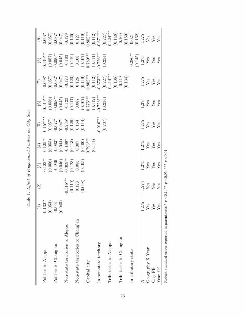
Tab
le1:
Eff
ect
of
Fra
gmen
ted
Poli
ties
on
Cit
yS
ize
(1)
(2)
(3)
(4)
(5)
(6)
(7)
(8)
(9)
Pol
itie
sto
Ale
pp
o-0
.132∗∗
-0.1
23∗∗
-0.1
25∗∗
-0.1
57∗∗∗
-0.1
49∗∗∗
-0.0
98∗
-0.1
49∗∗∗
-0.0
97∗
(0.0
53)
(0.0
56)
(0.0
55)
(0.0
57)
(0.0
56)
(0.0
57)
(0.0
57)
(0.0
57)
Pol
itie
sto
Ch
ang’
an-0
.051
-0.0
49-0
.082∗
-0.0
77∗
-0.0
98∗∗
-0.0
82∗
-0.0
90∗∗
-0.0
82∗
(0.0
45)
(0.0
46)
(0.0
44)
(0.0
47)
(0.0
45)
(0.0
47)
(0.0
45)
(0.0
47)
Non
-sta
tete
rrit
orie
sto
Ale
pp
o-0
.316∗∗∗
-0.3
09∗∗
-0.1
89∗
-0.2
36∗
-0.1
23-0
.128
-0.1
03
-0.1
29
(0.1
19)
(0.1
23)
(0.1
13)
(0.1
26)
(0.1
17)
(0.1
20)
(0.1
19)
(0.1
20)
Non
-sta
tete
rrit
orie
sto
Ch
ang’
an0.
123
0.05
50.
007
0.16
40.
087
0.1
26
0.1
08
0.1
27
(0.0
98)
(0.1
05)
(0.1
00)
(0.1
14)
(0.1
07)
(0.1
19)
(0.1
07)
(0.1
19)
Cap
ital
city
0.79
3∗∗∗
0.77
5∗∗∗
0.8
02∗∗∗
0.7
89∗∗∗
0.8
02∗∗∗
(0.1
11)
(0.1
12)
(0.1
12)
(0.1
11)
(0.1
12)
Inn
on-s
tate
terr
itor
y-0
.916∗∗∗
-0.7
23∗∗∗
-0.6
73∗∗∗
-0.7
26∗∗∗
-0.6
71∗∗∗
(0.2
37)
(0.2
34)
(0.2
27)
(0.2
34)
(0.2
27)
Tri
bu
tari
esto
Ale
pp
o-0
.414∗∗∗
-0.4
24∗∗∗
(0.1
36)
(0.1
48)
Tri
bu
tari
esto
Ch
ang’
an-0
.149
-0.1
60
(0.1
34)
(0.1
50)
Intr
ibu
tary
stat
e-0
.286∗∗
0.0
21
(0.1
45)
(0.1
62)
N1,
275
1,27
51,
275
1,27
51,
275
1,27
51,2
75
1,2
75
1,2
75
Geo
grap
hy
XY
ear
Yes
Yes
Yes
Yes
Yes
Yes
Yes
Yes
Yes
Cit
yF
EY
esY
esY
esY
esY
esY
esY
esY
esY
esY
ear
FE
Yes
Yes
Yes
Yes
Yes
Yes
Yes
Yes
Yes
Robust
standard
erro
rsre
port
edin
pare
nth
eses
.*p<
0.1
,**p<
0.0
5,
***p<
0.0
1.
23
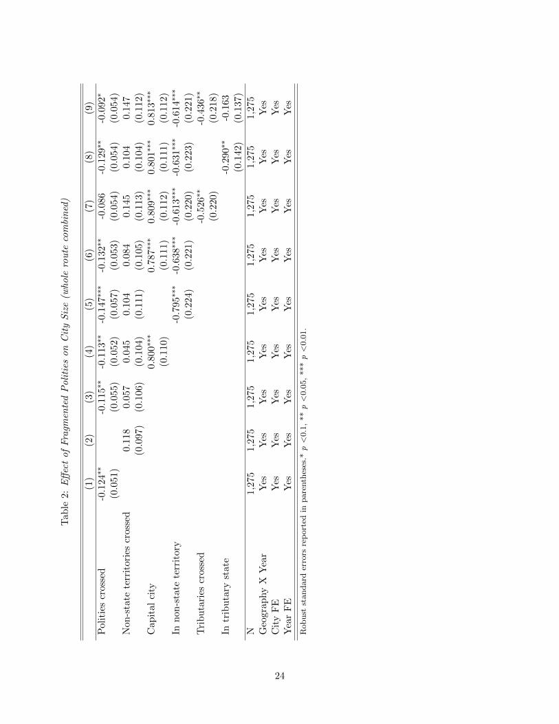
Tab
le2:
Eff
ect
of
Fra
gmen
ted
Poli
ties
on
Cit
yS
ize
(whole
rou
teco
mbi
ned
)
(1)
(2)
(3)
(4)
(5)
(6)
(7)
(8)
(9)
Pol
itie
scr
osse
d-0
.124∗∗
-0.1
15∗∗
-0.1
13∗∗
-0.1
47∗∗∗
-0.1
32∗∗
-0.0
86
-0.1
29∗∗
-0.0
92∗
(0.0
51)
(0.0
55)
(0.0
52)
(0.0
57)
(0.0
53)
(0.0
54)
(0.0
54)
(0.0
54)
Non
-sta
tete
rrit
orie
scr
osse
d0.
118
0.05
70.
045
0.10
40.
084
0.1
45
0.1
04
0.1
47
(0.0
97)
(0.1
06)
(0.1
04)
(0.1
11)
(0.1
05)
(0.1
13)
(0.1
04)
(0.1
12)
Cap
ital
city
0.80
0∗∗∗
0.78
7∗∗∗
0.80
9∗∗∗
0.8
01∗∗∗
0.8
13∗∗∗
(0.1
10)
(0.1
11)
(0.1
12)
(0.1
11)
(0.1
12)
Inn
on-s
tate
terr
itor
y-0
.795∗∗∗
-0.6
38∗∗∗
-0.6
13∗∗∗
-0.6
31∗∗∗
-0.6
14∗∗∗
(0.2
24)
(0.2
21)
(0.2
20)
(0.2
23)
(0.2
21)
Tri
bu
tari
escr
osse
d-0
.526∗∗
-0.4
36∗∗
(0.2
20)
(0.2
18)
Intr
ibu
tary
stat
e-0
.290∗∗
-0.1
63
(0.1
42)
(0.1
37)
N1,
275
1,27
51,
275
1,27
51,
275
1,27
51,2
75
1,2
75
1,2
75
Geo
grap
hy
XY
ear
Yes
Yes
Yes
Yes
Yes
Yes
Yes
Yes
Yes
Cit
yF
EY
esY
esY
esY
esY
esY
esY
esY
esY
esY
ear
FE
Yes
Yes
Yes
Yes
Yes
Yes
Yes
Yes
Yes
Robust
standard
erro
rsre
port
edin
pare
nth
eses
.*p<
0.1
,**p<
0.0
5,
***p<
0.0
1.
24
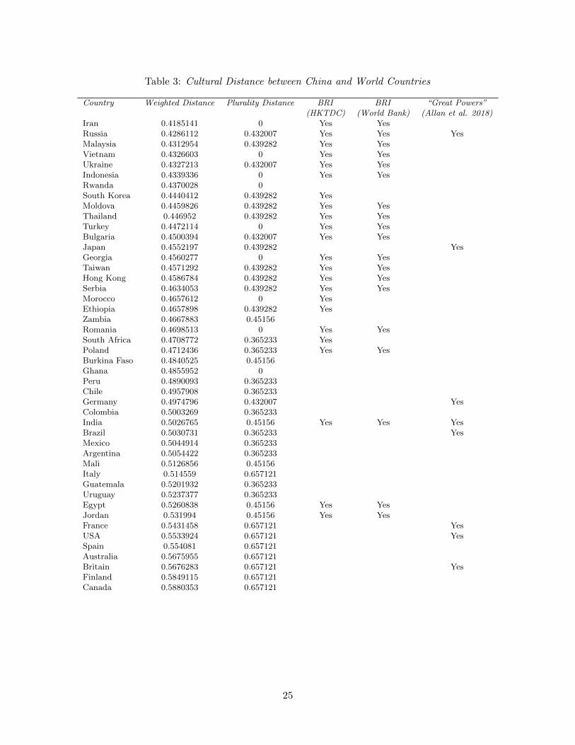
Table 3: Cultural Distance between China and World Countries
Country Weighted Distance Plurality Distance BRI BRI “Great Powers”(HKTDC) (World Bank) (Allan et al. 2018)
Iran 0.4185141 0 Yes YesRussia 0.4286112 0.432007 Yes Yes YesMalaysia 0.4312954 0.439282 Yes YesVietnam 0.4326603 0 Yes YesUkraine 0.4327213 0.432007 Yes YesIndonesia 0.4339336 0 Yes YesRwanda 0.4370028 0South Korea 0.4440412 0.439282 YesMoldova 0.4459826 0.439282 Yes YesThailand 0.446952 0.439282 Yes YesTurkey 0.4472114 0 Yes YesBulgaria 0.4500394 0.432007 Yes YesJapan 0.4552197 0.439282 YesGeorgia 0.4560277 0 Yes YesTaiwan 0.4571292 0.439282 Yes YesHong Kong 0.4586784 0.439282 Yes YesSerbia 0.4634053 0.439282 Yes YesMorocco 0.4657612 0 YesEthiopia 0.4657898 0.439282 YesZambia 0.4667883 0.45156Romania 0.4698513 0 Yes YesSouth Africa 0.4708772 0.365233 YesPoland 0.4712436 0.365233 Yes YesBurkina Faso 0.4840525 0.45156Ghana 0.4855952 0Peru 0.4890093 0.365233Chile 0.4957908 0.365233Germany 0.4974796 0.432007 YesColombia 0.5003269 0.365233India 0.5026765 0.45156 Yes Yes YesBrazil 0.5030731 0.365233 YesMexico 0.5044914 0.365233Argentina 0.5054422 0.365233Mali 0.5126856 0.45156Italy 0.514559 0.657121Guatemala 0.5201932 0.365233Uruguay 0.5237377 0.365233Egypt 0.5260838 0.45156 Yes YesJordan 0.531994 0.45156 Yes YesFrance 0.5431458 0.657121 YesUSA 0.5533924 0.657121 YesSpain 0.554081 0.657121Australia 0.5675955 0.657121Britain 0.5676283 0.657121 YesFinland 0.5849115 0.657121Canada 0.5880353 0.657121
25
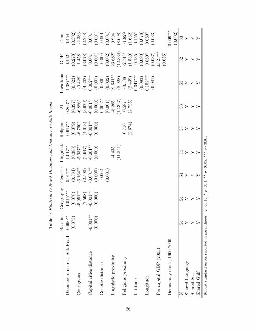
Tab
le4:
Bil
ate
ral
Cu
ltu
ral
Dis
tan
cean
dD
ista
nce
toS
ilk
Roa
ds
Bas
elin
eG
eogr
aphy
Gen
etic
Lin
guis
tic
Rel
igio
us
All
Loca
tion
al
GD
PD
em
Dis
tan
ceto
nea
rest
Sil
kR
oad
0.99
0∗∗
1.01
5∗∗∗
0.91
7∗∗
1.01
7∗∗
0.97
7∗∗
0.86
3∗∗
1.3
87∗∗∗
0.4
62†
0.4
54†
(0.3
73)
(0.3
78)
(0.3
84)
(0.3
83)
(0.3
79)
(0.3
97)
(0.3
23)
(0.2
78)
(0.3
02)
Con
tigu
ous
-5.9
51∗∗
-6.1
64∗∗
-5.9
37∗∗
-6.7
60∗
-6.8
86∗
-0.4
28
1.4
58
-2.3
83
(2.5
98)
(2.5
90)
(2.6
47)
(4.0
13)
(3.9
79)
(4.2
02)
(3.0
78)
(2.2
48)
Cap
ital
citi
esd
ista
nce
-0.0
01∗∗
-0.0
01∗∗
-0.0
01∗∗
-0.0
01∗∗
-0.0
01∗∗
-0.0
01∗∗
0.0
02∗∗∗
0.0
01
0.0
01
(0.0
00)
(0.0
00)
(0.0
00)
(0.0
00)
(0.0
00)
(0.0
00)
(0.0
01)
(0.0
01)
(0.0
01)
Gen
etic
dis
tan
ce-0
.002
-0.0
02∗∗
0.0
00
-0.0
00
-0.0
01
(0.0
01)
(0.0
01)
(0.0
02)
(0.0
02)
(0.0
01)
Lin
guis
tic
pro
xim
ity
-4.4
35-8
.265
19.6
41∗∗
23.6
82∗
9.9
94
(11.
541)
(12.
327)
(8.9
28)
(12.3
34)
(8.6
98)
Rel
igio
us
pro
xim
ity
0.71
60.
587
-3.5
38
-2.7
43∗
-1.8
29
(2.6
74)
(2.7
25)
(2.4
39)
(1.5
39)
(1.6
32)
Lat
itu
de
0.3
47∗∗∗
0.1
35
0.1
55∗
(0.0
93)
(0.0
90)
(0.0
78)
Lon
gitu
de
0.1
52∗∗∗
0.0
69∗
0.0
60∗
(0.0
41)
(0.0
37)
(0.0
33)
Per
cap
ital
GD
P(2
005)
0.3
21∗∗∗
(0.0
56)
Dem
ocr
acy
stock
,19
00-2
000
0.0
09∗∗∗
(0.0
02)
N54
5454
5453
5353
52
53
Sh
ared
Lan
guag
eY
YY
YY
YY
YY
Sh
ared
Sea
YY
YY
YY
YY
YS
har
edG
ulf
YY
YY
YY
YY
Y
Robust
standard
erro
rsre
port
edin
pare
nth
eses
.†p
<0.1
5,
*p<
0.1
,**p<
0.0
5,
***p<
0.0
1.
26
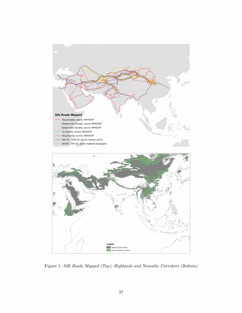
Silk Roads MappedTang Dynasty; source: SRHGIOPWestern Han Dynasty; source: SRHGIOPEastern Han Dynasty; source: SRHGIOPJin Dynasty; source: SRHGIOPQing Dynasty; source: SRHGIOP200 CE - 1200 CE; source: Hansen (2012)300 BC - 100 CE; source: National Geographic
Legend
Nomadic Migration CorridorsHighland (750m-4000m)
Figure 1: Silk Roads Mapped (Top); Highlands and Nomadic Corridors (Bottom)
27
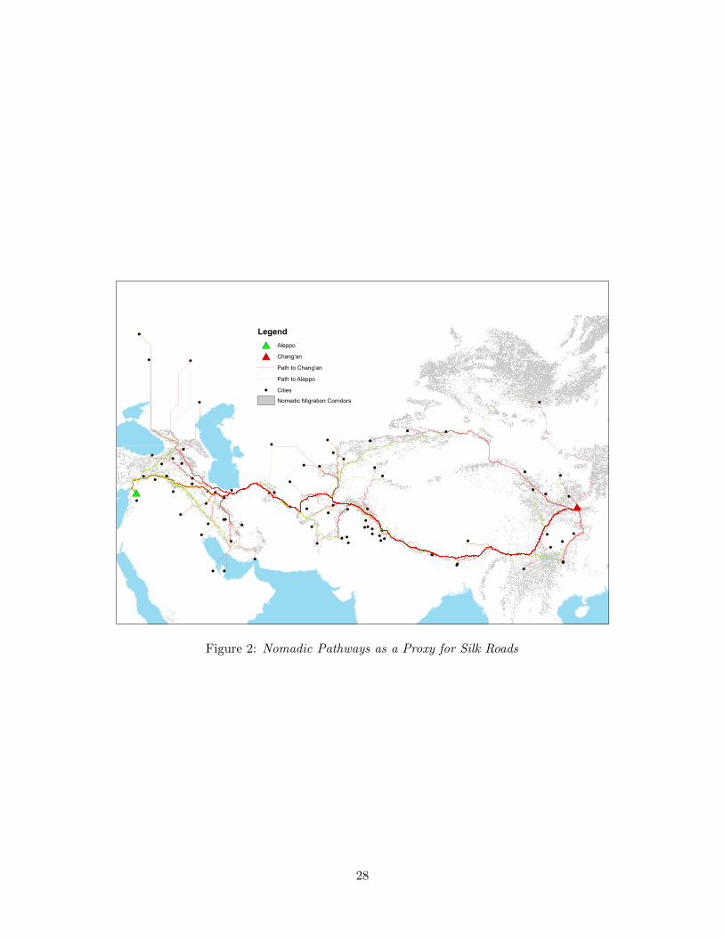
! !!
!!!!!
!
!!
! ! !! !!!! ! !! !! !
!!!! !!!
!!!
!!
! !!! !
!!
!!!! ! !!! ! ! !
!!
! !! ! ! !
!!!! !
!!!
!!
!!!
!
! !
!!
!
!
!
!
!
#
#*
Legend#* Aleppo# Chang'an
Path to Chang'anPath to Aleppo
! CitiesNomadic Migration Corridors
Figure 2: Nomadic Pathways as a Proxy for Silk Roads
28
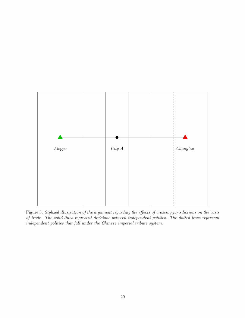
Aleppo City A Chang’an
Figure 3: Stylized illustration of the argument regarding the effects of crossing jurisdictions on the costsof trade. The solid lines represent divisions between independent polities. The dotted lines representindependent polities that fall under the Chinese imperial tribute system.
29

Supplemental Appendix“Trade and Political Fragmentation on the Silk Roads:
The Economic and Cultural Effects of HistoricalExchange between China and the Muslim East”
May 2019
1

Figure 1: Largest Eurasian Cities, 1100-1800; “X” indicates Eurasia’s urban “center of gravity”
D D
D D Mean population(1000s)
25 - 100101 - 200201 - 400401 - 800801 - 1200
1100
1400
1200
1300
D Gravity center
D D
D D Mean population(1000s)
25 - 100101 - 200201 - 400401 - 800801 - 1200
1500
1800
1600
1700
D Gravity center
2
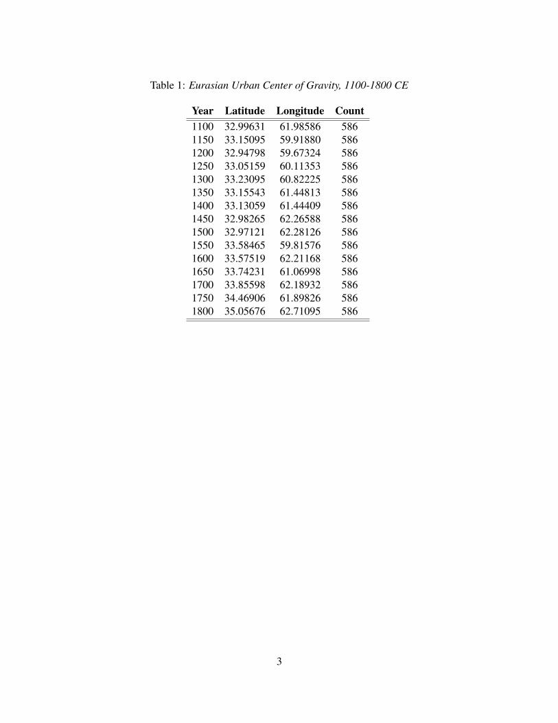
Table 1: Eurasian Urban Center of Gravity, 1100-1800 CE
Year Latitude Longitude Count1100 32.99631 61.98586 5861150 33.15095 59.91880 5861200 32.94798 59.67324 5861250 33.05159 60.11353 5861300 33.23095 60.82225 5861350 33.15543 61.44813 5861400 33.13059 61.44409 5861450 32.98265 62.26588 5861500 32.97121 62.28126 5861550 33.58465 59.81576 5861600 33.57519 62.21168 5861650 33.74231 61.06998 5861700 33.85598 62.18932 5861750 34.46906 61.89826 5861800 35.05676 62.71095 586
3
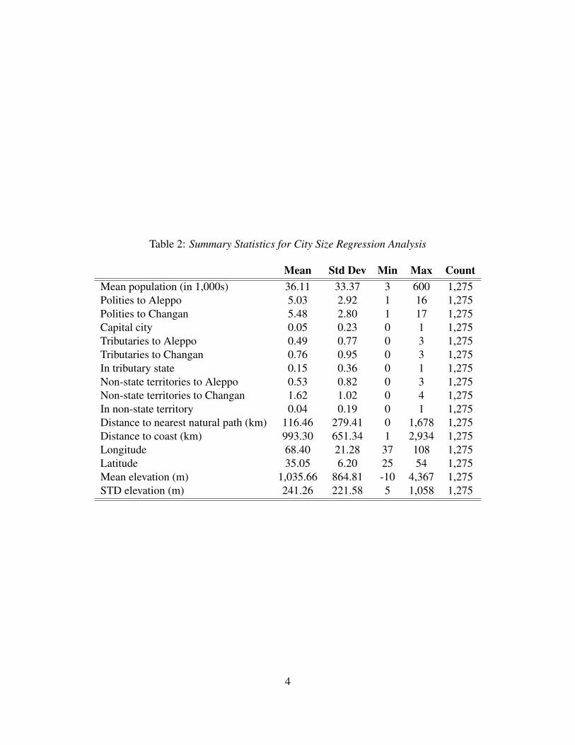
Table 2: Summary Statistics for City Size Regression Analysis
Mean Std Dev Min Max CountMean population (in 1,000s) 36.11 33.37 3 600 1,275Polities to Aleppo 5.03 2.92 1 16 1,275Polities to Changan 5.48 2.80 1 17 1,275Capital city 0.05 0.23 0 1 1,275Tributaries to Aleppo 0.49 0.77 0 3 1,275Tributaries to Changan 0.76 0.95 0 3 1,275In tributary state 0.15 0.36 0 1 1,275Non-state territories to Aleppo 0.53 0.82 0 3 1,275Non-state territories to Changan 1.62 1.02 0 4 1,275In non-state territory 0.04 0.19 0 1 1,275Distance to nearest natural path (km) 116.46 279.41 0 1,678 1,275Distance to coast (km) 993.30 651.34 1 2,934 1,275Longitude 68.40 21.28 37 108 1,275Latitude 35.05 6.20 25 54 1,275Mean elevation (m) 1,035.66 864.81 -10 4,367 1,275STD elevation (m) 241.26 221.58 5 1,058 1,275
4
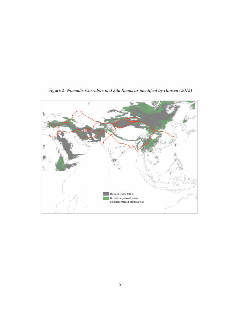
Figure 2: Nomadic Corridors and Silk Roads as identified by Hansen (2012)
Nomadic Migration CorridorsHighland (750m-4000m)
Silk Roads Mapped (Hansen 2012)
5
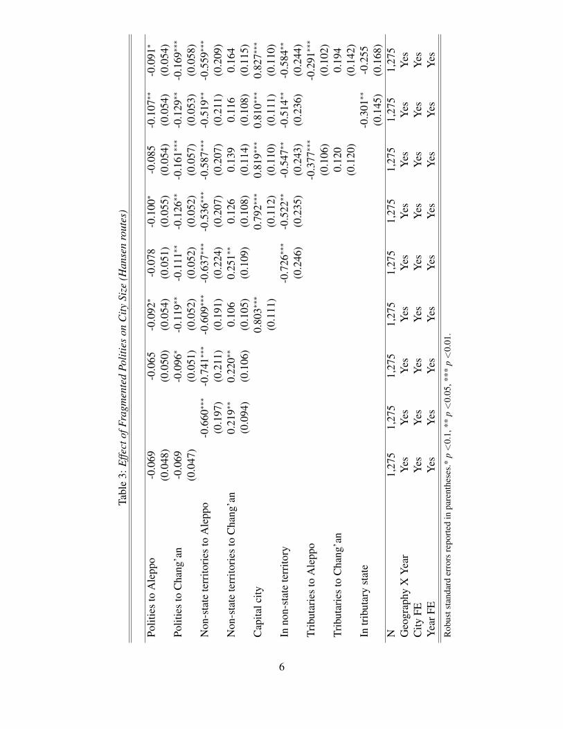
Tabl
e3:
Effe
ctof
Frag
men
ted
Polit
ies
onC
itySi
ze(H
anse
nro
utes
)
Polit
ies
toA
lepp
o-0
.069
-0.0
65-0
.092
∗-0
.078
-0.1
00∗
-0.0
85-0
.107
∗∗-0
.091
∗
(0.0
48)
(0.0
50)
(0.0
54)
(0.0
51)
(0.0
55)
(0.0
54)
(0.0
54)
(0.0
54)
Polit
ies
toC
hang
’an
-0.0
69-0
.096
∗-0
.119
∗∗-0
.111
∗∗-0
.126
∗∗-0
.161
∗∗∗
-0.1
29∗∗
-0.1
69∗∗
∗
(0.0
47)
(0.0
51)
(0.0
52)
(0.0
52)
(0.0
52)
(0.0
57)
(0.0
53)
(0.0
58)
Non
-sta
tete
rrito
ries
toA
lepp
o-0
.660
∗∗∗
-0.7
41∗∗
∗-0
.609
∗∗∗
-0.6
37∗∗
∗-0
.536
∗∗∗
-0.5
87∗∗
∗-0
.519
∗∗-0
.559
∗∗∗
(0.1
97)
(0.2
11)
(0.1
91)
(0.2
24)
(0.2
07)
(0.2
07)
(0.2
11)
(0.2
09)
Non
-sta
tete
rrito
ries
toC
hang
’an
0.21
9∗∗
0.22
0∗∗
0.10
60.
251∗
∗0.
126
0.13
90.
116
0.16
4(0
.094
)(0
.106
)(0
.105
)(0
.109
)(0
.108
)(0
.114
)(0
.108
)(0
.115
)C
apita
lcity
0.80
3∗∗∗
0.79
2∗∗∗
0.81
9∗∗∗
0.81
0∗∗∗
0.82
7∗∗∗
(0.1
11)
(0.1
12)
(0.1
10)
(0.1
11)
(0.1
10)
Inno
n-st
ate
terr
itory
-0.7
26∗∗
∗-0
.522
∗∗-0
.547
∗∗-0
.514
∗∗-0
.584
∗∗
(0.2
46)
(0.2
35)
(0.2
43)
(0.2
36)
(0.2
44)
Trib
utar
ies
toA
lepp
o-0
.377
∗∗∗
-0.2
91∗∗
∗
(0.1
06)
(0.1
02)
Trib
utar
ies
toC
hang
’an
0.12
00.
194
(0.1
20)
(0.1
42)
Intr
ibut
ary
stat
e-0
.301
∗∗-0
.255
(0.1
45)
(0.1
68)
N1,
275
1,27
51,
275
1,27
51,
275
1,27
51,
275
1,27
51,
275
Geo
grap
hyX
Yea
rY
esY
esY
esY
esY
esY
esY
esY
esY
esC
ityFE
Yes
Yes
Yes
Yes
Yes
Yes
Yes
Yes
Yes
Yea
rFE
Yes
Yes
Yes
Yes
Yes
Yes
Yes
Yes
Yes
Rob
usts
tand
ard
erro
rsre
port
edin
pare
nthe
ses.
*p<
0.1,
**p<
0.05
,***
p<
0.01
.
6

Tabl
e4:
Effe
ctof
Frag
men
ted
Polit
ies
onC
itySi
ze(w
hole
rout
e,H
anse
nro
utes
)
Polit
ies
cros
sed
-0.0
79∗
-0.0
78∗
-0.1
08∗∗
-0.0
84∗
-0.1
11∗∗
-0.1
10∗∗
-0.1
14∗∗
-0.1
15∗∗
(0.0
43)
(0.0
44)
(0.0
47)
(0.0
44)
(0.0
47)
(0.0
46)
(0.0
46)
(0.0
46)
Non
-sta
tete
rrito
ries
cros
sed
0.05
00.
040
-0.0
100.
044
-0.0
06-0
.011
-0.0
12-0
.005
(0.0
93)
(0.0
93)
(0.0
91)
(0.0
92)
(0.0
90)
(0.0
93)
(0.0
90)
(0.0
93)
Cap
italc
ity0.
831∗
∗∗0.
821∗
∗∗0.
821∗
∗∗0.
839∗
∗∗0.
839∗
∗∗
(0.1
11)
(0.1
12)
(0.1
12)
(0.1
12)
(0.1
12)
Inno
n-st
ate
terr
itory
-0.6
84∗∗
∗-0
.520
∗∗-0
.516
∗∗-0
.502
∗∗-0
.507
∗∗
(0.2
35)
(0.2
20)
(0.2
22)
(0.2
21)
(0.2
23)
Trib
utar
ies
cros
sed
-0.0
160.
021
(0.1
07)
(0.1
09)
Intr
ibut
ary
stat
e-0
.304
∗∗-0
.308
∗∗
(0.1
44)
(0.1
49)
N1,
275
1,27
51,
275
1,27
51,
275
1,27
51,
275
1,27
51,
275
Geo
grap
hyX
Yea
rY
esY
esY
esY
esY
esY
esY
esY
esY
esC
ityFE
Yes
Yes
Yes
Yes
Yes
Yes
Yes
Yes
Yes
Yea
rFE
Yes
Yes
Yes
Yes
Yes
Yes
Yes
Yes
Yes
Rob
usts
tand
ard
erro
rsre
port
edin
pare
nthe
ses.
*p<
0.1,
**p<
0.05
,***
p<
0.01
.
7
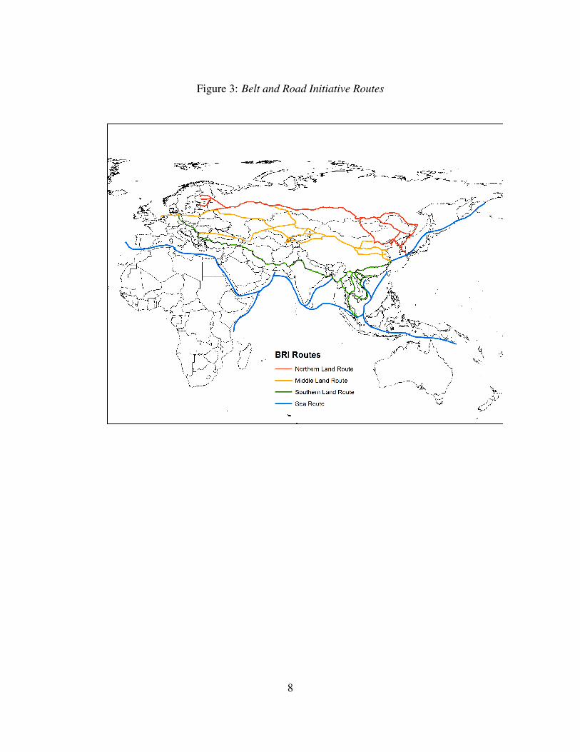
Figure 3: Belt and Road Initiative Routes
8
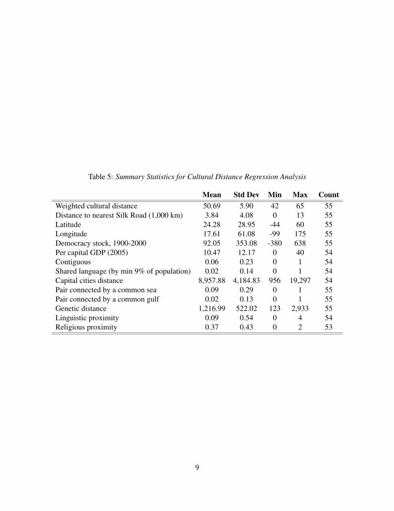
Table 5: Summary Statistics for Cultural Distance Regression Analysis
Mean Std Dev Min Max CountWeighted cultural distance 50.69 5.90 42 65 55Distance to nearest Silk Road (1,000 km) 3.84 4.08 0 13 55Latitude 24.28 28.95 -44 60 55Longitude 17.61 61.08 -99 175 55Democracy stock, 1900-2000 92.05 353.08 -380 638 55Per capital GDP (2005) 10.47 12.17 0 40 54Contiguous 0.06 0.23 0 1 54Shared language (by min 9% of population) 0.02 0.14 0 1 54Capital cities distance 8,957.88 4,184.83 956 19,297 54Pair connected by a common sea 0.09 0.29 0 1 55Pair connected by a common gulf 0.02 0.13 0 1 55Genetic distance 1,216.99 522.02 123 2,933 55Linguistic proximity 0.09 0.54 0 4 54Religious proximity 0.37 0.43 0 2 53
9