TOWNSHIP OF BRADFORD SUBDIVISION AND LAND...
148
TOWNSHIP OF BRADFORD SUBDIVISION AND LAND DEVELOPMENT ORDINANCE
Transcript of TOWNSHIP OF BRADFORD SUBDIVISION AND LAND...
TOWNSHIP OF BRADFORD
SUBDIVISION AND LAND DEVELOPMENT ORDINANCE

MOLLICA & MURRAY ATTORNEYS AT LAW
450 TRIMONT PLAZA 1305 GRANDVIEW AVENUE
PITTSBURGH, PENNSYLVANIA 1521 1-1205
TELEPHONE (412) 381-7000
I
I I VIA CERTIFIED MAIL
FACSIMILE (412) 381-7111 BLAINE A. LUCAS
DIRECT DIAL (412) 390-7004
July 24, 1996
Alex Graziani, Director Clearfield County Planning Commission P.O. Box 868 Clearfield, PA 16830
Re: Bradford Township Subdivision and Land Development Ordinance (Ordinance No. 96-3)
Dear Mr. Graziani:
Enclosed please find a certified copy of the Bradford Township Subdivision and Land Development Ordinance (Ordinance No. 96-3). This Ordinance was unanimously adopted by the Bradford Township Board of Supervisors at its special meeting held on July 22, 1996.
p70- laine . Lucas, Solicitor
Brad ford Towns hip
BALkcm
Enclosure
cc: Linda Wooster, Township Secretary (w/o encl.)

101 102 103 104 105 106 107 108
201 202
301 302 303 304 305 306 307 308 309
BRADFORD TOWNSHIP SUBDIVISION AND LAND DEVELOPMENT ORDINANCE
TABLE OF CONTENTS
Preamble Statement
ARTICLE I General Provisions
Short Title Purpose Authority Jurisdiction Approval Required Municipal Responsibility and Liability Effective Date and Repealer Copies
1
ARTICLE I1 Definitions
General Interpretations 10 Meaning of Words 10
ARTICLE I11 Procedures - Major Subdivisions and Land Development
Pre-Application Investigation Preliminary Plan Application Approval of Preliminary Plan Final Plan Application Approval of Final Plan Performance Security Development Agreement Approval by Other Agencies Recording of Plan
26 26 27 28 29 30 31 31 31
d 1
I 1 I I I E D
1
I I
m
e
e
t I c 1
401
501 502 503 504 505 506 507
601
701 702 703
801 802 803 804 805 806 807
808 809 810 81 1 812
ARTICLE IV Procedures - Minor Subdivision and Replats
Simultaneous Approval
ARTICLE V Inspection and Acceptance of Improvements
Progress Inspections Notice of Completion Filing of Plan Final Inspection and Approval Acceptance of Public Improvements Maintenance Security Remedies to Effect Completion of Public and
Private Improvements
ARTICLE VI Development Standards
General Standards
ARTICLE VI1 Plan Requirements
Sketch Plan Preliminary Plan Final Plan
ARTICLE VI11 Design Standards
General streets Curbs and Sidewalks Blocks Lots and Building Lines Lot Grading for Subdivisions and Land Developments Open Space, Lot Siting, Planting and Beautification
Easements Street Names Stormwater Drainage Floodplain Area Regulations Fire Hydrants
for Subdivision and Land Developments
33
34 34 34 34 35 36
36
37
38 38 40
44 45 47 47 48 49
50 51 52 52 55 59

1 1
1 I I 1 I C I d B
I h
i
i
901 902
1001 1002 1003 1004 1005 1006
1007 1008 1009 1010 101 1
1101 1102 1103 1104 1105 1106
1201 1202 1203 1204
ARTICLE IX Required Improvements
General Improvements
ARTICLE X Construction Requirements
General Monuments & Markers Water Supply Sanitary Sewage Conveyance Storm Sewers Streets, Subgrade, Subdrains, Pavement,
Utilities Street Trees Street Lighting Existing Natural Areas Erosion Control
Curbs & Sidewalks
ARTICLE XI Mobile Home Park Regulations
Applicability Plan Requirements Preliminary Plan Approval Final Plan Approval Design Requirements Utility and Fire Requirements
ARTICLE XI1 Recreational Vehicle Park Regulations
Applicability Permits Plan Requirements Design Requirements
60 60
62 62 63 63 64
65 66 66 66 66 66
68 68 68 69 69 71
74 74 74 77
1 t
1301 1302 1303
1304
1305
1401 1402 1403 1404 1405 1406 1407 1408 1409 1410 141 1 1412 1413 1414
1501 1502 1503 1504 1505 1506 1507 1508 1509
ARTICLE XI11 Land Development Standards and Requirements
Jurisdiction 82 Procedures 82 Assurance for Completion and Maintenance of
Improvements 82 Design Standards for Apartment Complexes and
Shopping Centers 83 Signs 84
ARTICLE XIV Stormwater Management
Purposes Applicability Applicability Exemptions Review Costs Application Requirements Stormwater Management Standards Sinkhole Protection Erosion and Sediment Control Ownership/Maintenance Responsibility General Criteria Modifications Nuisance Definitions
ARTICLE XV Administration and Modification
Amendments Filing Fee Records
Validity Preventive Remedies Enforcement Remedies Modification of Regulations Conflict
Appeals
87 87 88 88 89 89 92 99 100 100 101 102 103 103
109 109 109 109 109 109 110 111 111

Appendix 1 Design Standards Appendix 2 Intersection Design Specifications Appendix 3 Road Construction Criteria Appendix 4 Appendix 5
Specific Stormwater Management Design Criteria Supplemental Standards and Criteria
BRADFORD TOWNSHIP SUBDIVISION AND LAND DEVELOPMENT ORDINANCE
ORDINANCE NUMBER 96-3
AN ORDINANCE OF THE TOWNSHIP OF BRADFORD, CLEARFIELD COUNTY, PENNSYLVANIA, DEFINING AND REGULATING THE SUBDIVISION OF LAND AND THE DEVELOPMENT THEREOF; ESTABLISHING PROCEDURES FOR THE CONSIDERATION OF MINOR AND MAJOR SUBDIVISIONS AND LAND DEVELOPMENTS; REQUIRING THE PREPARATION OF SKETCH, PRELIMINARY,
MADE OR GUARANTEED TO BE MADE BY THE SUBDIVIDER OR DEVELOPER AND ESTABLISHING DESIGN STANDARDS FOR IMPROVEMENTS; REGULATING SALE OF LOTS, ERECTION OF BUILDINGS, LAYING OUT, CONSTRUCTION, OPENING AND DEDICATION OF STREETS, SEWERS, OTHER FACILITIES AND PUBLIC IMPROVEMENTS; PROVIDING FOR THE ADMINISTRATION OF THIS ORDINANCE; AND PRESCRIBING PENALTIES FOR VIOLATION.
FINAL AND AS-BUILT PLANS; REQUIRING CERTAIN IMPROVEMENTS TO BE
PREAMBLE STATEMENT PURPOSE. OVERALL GOAL. POLICIES. RECOMMENDATIONS AND BENEFITS
WHEREAS, the Board of Supervisors of Bradford Township, Clearfield County,
Pennsylvania desires to adopt rules and regulations establishing minimum standards for the
subdivision and development of land in the Township; and
WHEREAS, the County of Clearfield has, through a comprehensive planning
process, including the official adoption of the Clearfield County Comprehensive Plan (1991)
Udate*, recognized certain land use Policies and Recommendations which are more fully
described as the following:
*The Clearfield County Comprehensive Plan (1991) Update was accepted and endorsed by the Clearfield County Planning Commission on October 15, 1991. The Comprehensive Plan was subsequently adopted by the Clearfield County Commissioners on December 10, 1991
A. The Clearfield Countv Comprehensive Plan (1991) Update*, recognizes as its First
Goal of the Clearfield County Planning I?rogm is: “TO ENSURE THE ORDERLY AND
EFFICIENT DEVELOPMENT OF CLE:ARFIELD ClOUNTY THROUGH CAREFUL
LAND USE PLANNING”.
B.
Comprehensive Plan (1991) UDdate* recognized certain land use policies which are as
follows:
The Clearfeld Coucty Commissioners, as part of the adopted Clearfield County
A Policv for Development
The majority of future residential, commercial, industrial, transportation, and public
facilities development in Clearfield County should be encouraged to occur within
our existing urban communities. These communities are the major growth areas of
the future and are now providing a level of services that make them attractive for
people and are capable, in varying degrees, of absorbing growth. Expansion of
additional services can be done in an efficient and planned manner without great
capital outlays and at the same time will not overburden, or put excessive pressure
on, lands which should remain in a less developed state; e.g., agricultural lands. At
the same time, rural communities md villages could accept a limited amount of
growth compatible with their local environments.
C.
that there are certain features of Clearfield County that must be considered which either pose
developmental limitations or are sensitive areas. These policies related to development
limitations and the sensitive areas are as follows:
The adopted Clearfield Countv Comprehensive Plan (1991) Update also recognized
2

I I 8 s I
i a
1. DeveloDment Limitations
a. Recommendations for Floodplains
Floodplains should be either maintained in their developed state or be put to
uses compatible with floodplain environment. Such uses include agriculture,
parks and other non-structural recreational uses, and wildlife areas. The
development which already exists in the floodplains should be encouraged to
take the necessary precautions against damage and loss through floodproofing
and participation in the Federal Flood Insurance Program.
b. Recommendation for Soil Resources
The limitations of the soil are a major factor in determining the use of the land.
Development should not take place in areas where the soils present severe
engineering or environmental restrictions: likewise, areas that have soils suitable
for non-development uses such as agricultural, forested, floodplains, should
remain as non-developed areas.
c. Recommendation for Sloping Land
Lands with slopes of seventeen (17) percent or greater have had limited develop-
ment in the past. Future uses, such as sensitively designed residential develop-
ment, should maintain the sloping lands for their scenic, watershed, recreational,
forested and mineral repository roles.
d.
Due to the potential severity of mine subsidence, development should not
be encouraged in those areas where known abandoned deep mines exist.
Recommendation for Mine Subsidence Areas
However, as an alternative to prohibiting all development in areas of under-
ground mines or requiring extensive engineering tests, another approach to this
3

problem is the recognition of this development limitation by local government
agencies, landowners, developers, md prospective lot purchasers.
2. Sensitive Areas
a. Recommendation for Agricultural land
The best protection for keeping agricultural land is to preserve and enhance the
agricultural economy. Development to accommodate population, commercial
and industrial growth should take place on non-agricultural lands (not on prime
agricultural Class I & I1 soils) whenever and wherever possible. Alternate uses
of agricuItural land could be recreational, forested or vacant; other uses could
destroy this irreplaceable resource.
WHEREAS, it is the intent of thle Bradford Township Board of Supervisors that in
addition to the above, it is further the purpose of this Ordiiiance that the adoption of rules and
regulations which establish minimum standards for subdividing and development of land
within the Township will be of benefit to the lessee or purchaser of land, to the subdivider or
developer, and to the Township. These benefits include the following:
A. Benefits to the Lessee or Purchaser
1.
2.
3.
4.
Accurate descriptions of the land to be leased or sold;
Assurances that soils are satisfactory for homesites and sewage disposal,
and that adequate steps will be taken to prevent soil erosion and sedimen-
tation;
Assurances that lots will either abut a public road or have access via a right-
of-way agreement which also sets forth responsibility for maintenance;
Assurances that the sources of public water are identified and that suitable
easements are provided to reach the land;
4

I
8 I I I I 1
5 . Assurances that roads will be adequate to provide fire and ambulance
protection, and that fire hydrants will be provided in large developments;
A minimum of hidden expenses by placing the burden of providing necessary
facilities on the developer, or by clearly stating on the plan who is responsible
for such facilities; and
6.
B. Benefits to the Subdivider or DeveloDer
1.
2.
3.
4.
5 .
6 .
Accurate description of the soils and the limitations of the soil on the land to
be subdivided;
Assistance in the design of the development in the form of recommendations
by experienced staff;
For the transfer of all costs of the development to the purchaser through the
purchase price;
For the establishment of clear responsibility for right-of-way maintenance,
easements and ease of permit issuance, thereby reducing the potential for
expensive and lengthy litigation when such issues are not considered;
For reduction of disputes over land ownership by requiring accurate survey;
For compliance by all landowners to protect the value of property; and
C. Benefits to the Township
1. Informing the Township of the needs of proposed future developments;
2. Assuring that the road construction criteria are clearly established and obtain-
ing the acknowledgment of the developer of his responsibility;
3.
4.
Assuring adequate rights-of-ways and setbacks;
Preventing the imposition of major development costs upon the Township;
5. Assuring that emergency equipment can reach all lots;
5
6. Reducing or eliminating the possibility of floods, mine subsidence, erosion,
pollution, lack of adequate water and water pressure;
Protecting remaining resources from destruction;
Planning developments in a coordinated manner to avoid the creation of
future problems.
7.
8.
WHEREAS, the Board of Supervisors of Bradford Township concurs with and
supports the official position of the Clearfield County Cornprehensive (1991) Plan as set
forth herein as the overall goal; policies; recommendations; and further concur with the
benefits to the lessee or purchaser, the benefits to the subdivider or developer and the
benefits to the Township, as the same relate to the Township; and
WHEREAS, the Bradford Township Subdivision and Land Development Ordinance
is intended to cause subdivisions and land developments to conform with or to provide
for such goals, policies, recommendations and benefits*;
NOW, THEREFORE, BE IT ENACTED AND ORDAINED, by the Board of
Supervisors of Bradford Township, Clearfield County, Pennsylvania, as follows:
%e above referenced goals, policies, recommendations and benefits, as well as the various standards and requirements found elsewhere in this Ordinance, are not intended to be interpreted as a development or consumer guarantee, However, they are intended to serve as guidelines and minimum requirements for use by the Township, other government agencies and other interested groups and individuals.
6

Section 101
Section 102
102.1
102.2
102.3
102.4
102.5
102.6
102.7
102.8
102.9
ARTICLE I
GENERAL PROVISIONS
Short Title
This Ordinance shall be known as the "Bradford Township Subdivision and Land Development Ordinance".
Purpose
This Ordinance is adopted for the following purposes:
To assure sites suitable for building purposes and human habitation.
To provide for the harmonious, orderly, efficient and integrated development of the Township.
To assure new development will be coordinated with existing Township development.
To provide for adequate easements and rights-of-way for drainage and utilities.
To make provisions, as needed, for the reservation of land as it may be needed for public grounds.
To accommodate prospective traffic, facilitate fire protection and make such provisions as are necessary for public safety and convenience.
To make provisions for appropriate standards for streets, storm drainage, sanitary sewers, water facilities, curbs, gutters and such other improvements as shall be considered needed by the Township.
To promote the sound layout and design for subdivisions and land developments.
To allow for new and flexible standards of design, where appropriate.
102.10 To secure equitable handling of all subdivision and land development plans by providing uniform procedures and standards.
Section 103 Authority
The Township of Bradford is vested by law with jurisdiction and control of the subdivision and development of land located within the Township limits in accordance with Article V, of the Pennsylvania Municipalities Planning Code, Act 247 of 1968, as amended. The power to regulate and approve subdivisions and land developments is conferred on the
7

I Boardl of Supervisors, after review and recommendation by the Township Planning I
Section 104 Jurisdiction 8 Comrnission.
1 1
104.3 Land Development Control 1 I
104.1
104.2
This Ordinance shall apply to all1 land situatedl in the Township.
Plans for subdivisions and land developments within the Township shall be submitted to, and approved by, the Township before they are recorded. Such approval is in addition to, and does not siipersede, those required by other ordinances, resolutions, or regulations of the Township or Clearfreld County.
A. Land development, as herein defined, must comply with the regulations contained herein. Such compliance shall include, but not be limited to: the filing of preliminary and final plats, the dedication and improvement of rights-of-way, streets and roads, and the payment of fiees and charges as established by Resolution I of the Board of Bradford Township.
Land development plans shall indicatr: the location of each structure and clearly 1 define each unit and shall indicate: public easements, common areas, and improvements, all easements appurtenant to each unit, and improvements to public rights-of-way.
B.
8 I I 1 1 I I 1
Section 105 Approval Required
No person shall undertake any activity constituting a subdivision or land development without first submitting or obtaining approval from the Township of Bradford of a subdivision or land development plan in accordance with the terms of this Ordinance and all other applicable Township ordinances and regulations. Any application for a Subdivision or Land Development in Bradford Township, upon receipt, shall be forwarded to the: Clearfield County Planning Commission for review and report. The Board of Supervisors will not approve any application until at least the date on which the County Planning Commission report is received or until the expiration of 30 days from the date the application was forwarded to the County Planning Commission, whichever occurs first.
Section 106 Municipal Responsibility and Liability
The provisions within this Ordinance are designed to fulfill the purposes cited in Section 102. The degree of protection sought by the conditions and requirements of this Ordinance for thie present and future residents and land owners in the Township is considered reasoriable for regulatory purposes. This Ordinance does not imply that compliance with minimum requirements for subdivisions 01- land developments will be free from inconveniences, conflicts danger or damages. Therefore, this Ordinance shall not create liability on the part of the individual members of the Board of Supervisors of Bradford
8
Township, the Township Planning Commission or any officer, appointee or employee of the Township for any damages that may result from reliance on this Ordinance or any administrative decision lawfully made thereunder.
Section 107 Effective Date and Repealer
This Ordinance shall become effective in accordance with the Second Class Township Code and the Municipalities Planning Code and shall remain in effect until modified or rescinded by the Board of Supervisors. This Ordinance shall supersede and replace all other conflicting ordinances.
Section 108 Copies
Copies of the Bradford Township Subdivision and Land Development Ordinance shall be made available to the general public at the Township office at a fee adequate to compensate the Township for the cost of reproduction.
9

1 ARTICLE 11
DElmTIONS
I 8
Section 201 General Interpretations
Unless otherwise expressly stated, the following terms shall, for the purpose of this I I 1 1 I
ordinamce, have the meaning indicated: words in the singular include the plural, and the words in the plural include the singular. The niale includes the female and neuter genders. The word "person" includes a corporation, unincorporated association and a partnership as well as an individual or any other legal entity. The words "shall" and "will" are mandatory; the word "may" is permissive. An "agency" shall be construed to include its successors or assigns. Words not defined in this Article or the Municipalities Planning Code shall have their normal meanings.
Section 202 Meaning of Words
ADT. Average daily traffic volumes on a road.
I Accessory Building. A subordinate building, the use of which is customarily incidental 1
I
Access Drive. A private drive providing pedestrian and vehicular access between a public or private street and a parking area within a land development and any driveway servicing two or more units of occupancy on a single lot or contiguous lots. See also Street.
to that of the principal building on the same lot.
Acre. A measure of land area containing 43,560 square feet.
I s 1 I 1 I
Agricultural. Land used exclusively for the cultivation of the soil, the production of crops or livestock, or the science of forestry; also, land diverted from agricultural use by an active ]Federal farm program, provided the divei3ed land has a conservation cover of grass, legume:, trees, or wildlife shrubs. Agricultural land may include, to a minor degree, farmsteads inhabited by the cultivator of the laid, housing for farm employees, and land, used for preparatiorr of agricultural products by the cultivator of the land. A minor right- of-way, primarily for service access to the back and sides of properties.
Applicant. A landowner or developer, as hereinafter defined, who has filed an application for development including his heirs, successors and assigns.
Appliciation for Development. Every application, whether preliminary, tentative or final, required to be filed and approved prior to the start of construction or development including, but not limited to, an application foir a building permit, for the approval of a subdivision plat or plan or for the approval of ii land development plan.
Assemblage. The merger of separate properties into a single tract of land. Not considered a subdivision or land development. See Consolidation.
10

I 1 1 I 1 1 8 1 I 1 1
I I a
Block. A unit of land bounded by streets or by a combination of streets and public land, railroad rights-of-ray , waterways, or any other barrier to the continuity of development.
Building or Setback Line. The line within a property defining the required minimum distance between any building and the adjacent right-of-way and/or property lines.
Cartway or Roadway. The improved surface of a street or alley designed for vehicular traffic including travel lanes and parking areas but not including shoulders, curbs, sidewalks, or swales.
Clear Sight Triangle. An area of unobstructed vision at street intersections defined by lines of sight between points at a given distance from the intersection of street center lines.
Clearfield County Comprehensive Plan. The Clearfield County Comprehensive Plan of (1991) Update, and any amendments or updates thereto.
Common Open Space. A parcel or parcels of land or any area of water, or a combination of land and water within a development site and designed and intended for the use or enjoyment of residents of a development site, not including streets, off-street parking area, and area set aside for public facilities. Also see Open Spaces.
Community Water Supply. A utility operated by the Township, Municipal Authority or a company, regulated by the Public Utility Commission, which supplies potable, domestic water for use by more than one household, business, or institution.
Condominium. Ownership in common with others of a parcel of land and certain parts of a building thereon which would normally be used by all the occupants, together with individual ownership in fee of a particular unit or apartment in such building or on such parcel of land and may include dwellings, offices and other types of space in commercial and industrial buildings or on real property.
Consolidation. The removal of lot lines between contiguous parcels. See Assemblage.
Corner Lot. A lot, located at the intersection of two (2) or more existing or proposed street rights-of way. See Lot, Comer.
County. The County of Clearfield, Commonwealth of Pennsylvania
County Engineer. appointed as the Engineer of the County of Clearfield.
A professional engineer licensed as such in Pennsylvania, duly
County Planning Commission: The Planning Commission of the County of Clearfield.
County Planning Staff. The staff of the Clearfield County Planning Commission.
11
County Solicitor. A professional attorney licensed as such in Pennsylvania, duly appointed as such in Pennsylvania, duly appointed as the Solicitor of the County of Clearfield.
Cul-de-sac. A street intersecting; another street at one end and terminating at the other in 8 Cut: An excavation. The difference between a point on the original ground and a 1 a vehicular turn-around.
designated point of lower elevation on the filial grade. Also, the materid removed in excavation. I Dedication. The deliberate appropriation of land by its owner for general public use.
Deed. A written instrument whe:reby an estatr: in real property is conveyed.
Deed Restriction. A restriction upon the use of a property placed in a deed.
Department of Environmental Protection (PEP). The Pennsylvania Department of Environmental Protection, its bureaus, divisions, departments and/or agencies, as may from 1 time to time be established, or such Department or Departments as may in the future succeed it.
Designated Floodplain Areas. A relatively flat or low land area adjoining a river, stream, or watercourse which is subject to partial or complete inundation in a 100-year flood. Also see Floodplain and Floodway.
Detention Basin (Pond). An area in which surface water runoff is temporarily stored pending its release at a controlled rate.
8 Development. Any man-made change to improved or unimproved real estate, including 1
Developer. Any landowner, agent of such landowner or tenant with the permission of such landowner, who makes or causes to be made a subdivision of land or a land development. See Applicant.
but not limited to, buildings or other structures, the placement of mobile homes, streets and other paving, utilities, mining, dredging, filing, grading, excavation, or drilling operations, and the subdivision of land.
I I
Development Plan. The provisions for development, including a planned residential development, a plat of subdivision and land dlevelopment, all covenants relating to use, location and bulk of buildings and other structures, intensity of use or density of development, streets, ways and parking facilities, common open space and public facilities. The phrase "provisions of the development plan" when used in this Ordinance shall mean the written and graphic materials referred to in this definition.
Double-Frontage Lot. See Lot, Double Frontage.
12

I 1 I I I 1 I I I
Drainage. The removal of surface water or groundwater from land by drains, grading or other means, and includes control of runoff to minimize erosion and sedimentation during and after construction or development.
Drainage Facility. Any ditch, gutter, culvert, storm sewer or other structure designed, intended or constructed for the purpose of carrying, diverting or controlling surface water or groundwater.
Drainage Right-of-way. The lands required for the installation of storm water sewers or drainage ditches, or required along a natural stream or watercourse for preserving the channel and providing for the flow of water therein to safeguard the public against flood damage.
Driveway. A private vehicular passageway providing access between a street and a private parking area or private garage.
Dwelling Unit. Any structure, or part thereof, designed to be occupied as living quarters as a single housekeeping unit.
Dwelling Unit Density. The number of dwelling units or units of occupancy per acre, exclusive of street rights-of-way.
Easement. A right granted for limited use of private land for public and quasi- public purposes including such things as utilities and drainage.
Egress. An exit.
Elevation. (1) A vertical distance above or below a fixed reference level; (2) a fully dimensioned drawing of the front, rear, or side of a building showing features such as windows, doors, and relationship of grade to floor level.
A. Floor Elevation. The elevation of the lowest level of a particular building, including the basement.
B. Road Grade. The rate of rise and fall of a road’s surface, measured along the profile of the centerline of the cartway.
Engineer. A registered professional engineer licensed as such in the Commonwealth of Pennsylvania.
Engineer, Civil. A registered professional engineer licensed as such in the Commonwealth of Pennsylvania.
Erosion. The removal of soil, stone and other surface materials by the action of natural elements .
13

Erosion and Sedimentation Control Plan. A plan showing all present and proposed I t 1
grades and facilities for storm water, drainage:, erosion and sediment controls, and which is in accordance with Section 1011 of this Ordinance.
Excavation. Any act by which earth, sand, gravel, rock or any other similar material is dug into, cut, quarried, uncovered, removed, displaced, relocated or bulldozed and shall includ!e the conditions resulting therefrom.
I 1
Exception. Permission to depart from the design standards in this Ordinance. See Modification of Regulation.
Existing Grade or Elevation. The vertical location above some elevation point of the ground surface prior to excavating or filling.
Exit Ramp, Entrance Ramp. Access lanes leading to and from a limited access highway.
I
m 1 I 1
Extended Property Lot Line. A line, radial or perpendicular to the street centerline, at each end of the frontage, extending from the right-of-way line to the curb line.
F a d a n d . See Agriculture Land.
Fill. pushed, dumped, pulled, transported or moved to a new location above the natural surface of the ground or on top of the stripped surface and shall include the conditions resulting therefrom. The difference in elevation between a point on the loriginal ground and a designated p in t of higher elevation on the final grade. The material used to make a fill.
Final Plan. See Plan, Final
Financial Security. Financial security shall be in the form of a bond from a
Any act by which earth, sand, gravel, rock or any other material is placed,
bonding institution authorized to conduct business in the Commonwealth of Pennsylvania. Federal or Corn monwealth chartered institution irrevocable letters of credit and restrictive or escrow accounts :in such lending institutions shall be
I deemed acceptable financial security. Also see PerformanceGuarantee and Maintenance Guarantee.
I Fire Lane. A way cleared of obstacles and vegetation at all times so as to allow ingress and egress for vehicles during a fire emergency.
14 1 I

1 1 I 8 I E I
Flag Lot. A lot that has an L-shaped or flag configuration with one side abutting a public road. Such configuration typically has a large lot width along the rear property line.
Floodplain. The area of inundation which functions as a storage or holding area for floodwater to a width required to contain a base flood of which there is a one percent (1 %) chance of occurring in any given year. The floodplain also contains both the floodway and the flood fringe. The floodway is the channel of a water course and the adjoining land area which are required to carry and discharge the base flood. The flood fringe is the adjoining area which may be covered by water of the base flood. The location of a floodplain shall be established in accordance with Section 8 11, and may include an area of greater magnitude than the base flood if a greater flood hazard area is designated by Township ordinance.
Flood-proofing. Any combination of structural and/or nonstructural provisions, additions, changes, or adjustments to structures or contents which are designed or adapted primarily to reduce or eliminate flood damage to those structures or contents.
Floodway. The channel of a river or other watercourse and the adjacent land areas required to carry and discharge a flood of the one hundred (100) year magnitude.
Frontage. That side of a lot abutting on a street; the front lot line.
Future Access Strip. A right-of-way reserved for the future improvement of a street.
Grading and Drainage Plan. A plan showing all existing ground features and proposed grading, including existing and proposed surface and subsurface drainage facilities, described by grades, contours, and topography.
Half Street. A street of less than the required right-of-way and/or cartway width, such as a street built from the shoulder edge to the eventual centerline. See also Street.
Historic. Any building, site, structure, object, district or area that:
A. Is listed on the National Register of Historical Places; or
B. Has received a Determination of Eligibility for the National Register from the National Park Service; or
C. Which is listed on any officially adopted municipal register or inventory of historic features.
15
Hawizon Year. The anticipated opening year of a development, assuming full buildout and occupancy.
Immediate Family Member .- A parent, spouse, child, brother, sister, grandparent, grandchild or stepchild.
Impoundment. A body of water, such as a pond, confined by a dam, dike, flood- gate, or other barrier.
Improvements. Those physical additions and changes to the land that may be necessary to produce usable and desirable lots.
Inspector - The Township Engineer or his authorized representative assigned by the Board of Supervisors to make any or all necessary inspections of the work performed and materials furnished by the developer or the developer’s contractors selected to install the improvements required by this Ordinance.
Ingress. Access or entry.
Interior Lot. See Lot, Interior.
Intersection. The location where two or more roadways cross at grade without a bridge.
Land Development. Any of the following activities:
A. The improvement of one (I) lot or two (2) or more contiguous lots, tracts or parcels of land for any p u p s e involving:
1. A group of two (2) or more residential or non-residential buildings, whether proposed initially or cumulatively, or a single nonresidential building on a lot or lots regardless of the number of occupants or tenure; or
2. The division or allocation ad land or space, whether initially or cumulatively, between or among two (2) or more existing or prospective occupants by means of, or for the purpose of streets, common areas, leaseholds, condominium, building groups or other features;
B. A subdivision of land.
C. Land development does not include development which involves:
1. The conversion of an existing single-family detached dwelling or single- family semi-detached dwelling into not more than three (3) residential units, unless such units are intended to be a condominium;
16

2. The addition of any accessory building, including farm building, on a lot or subordinate to any existing principal building; or
3. The addition or conversion of buildings or rides within the confines of an enterprise which would be considered an amusement park. For the purposes of this subsection, amusement park is defined as a tract or area used principally as a location for permanent amusement structure or rides. This exclusion shall not apply to newly acquired acreage by an amusement park-until initial plans for the expanded area have been approved by the proper authorities.
Landlocked. A lot or parcel of land without direct access to a public road.
Landowner or Owner. The legal or beneficial owner or owners of land including the holder of an option or contract to purchase (whether or not such option or contract is subject to any condition), a lessee, if he is authorized under the lease to exercise the rights of the landowner, or other person having a proprietary interest in land.
Landscape Architect. A landscape architect registered by the Commonwealth of Pennsylvania.
Lease. A contractual agreement for the use of lands, structures, buildings, or parts thereof for a fixed time and consideration.
Lot. A designated parcel, tract or area of land established by a plat or otherwise as permitted by law and to be used, developed or built upon as a unit.
Lot Area. The total area contained within the property lines of the individual parcels of land as shown on a subdivision plan, excluding space within any street right-of-ways, but including the area of any easement.
Lot, Corner. A lot abutting upon two (2) or more streets at their intersection, the front of which shall be considered to be the frontage of least dimension on a street, except that where any two (2) frontages shall each exceed one hundred fifty (150) feet in length, either frontage may be designed as the "front" of the lot.
Lot Depth. The average distance measured from the front lot line to the rear lot line.
Lot, Double Frontage. An interior lot which abuts streets in both the front and rear.
Lot Frontage. The length of the front lot line measured at the street right-of- way line.
Lot, Interior. A lot having side lot lines which do not abut on a street.
17

Lot, IMinimum Width. The disltaxice between the side lot lines measured at the building set-back line.
]Lot of Record. A lot described in a deed or shown on a plan of lots which has been 1 Lot, ]Reverse Frontage. A lot extending between and having frontage on an arterial street I Lot VVidth. The horizontal distance between the side lines of a lot measured at right angles I
recorded in the office of the Recorder of Deeds of Clearfield County, Pennsylvania.
and a local access street, and with vehicular iiccess solely from the latter.
to its depth along a straight line parallel to the front lot at the minimum required building setback line.
Maintenance Guarantee. Any security, other than cash, which may be accepted by the Township of Bradford for the. maintenance of any improvements required by this 1 Ordinance.
Major Subdivision. Any subdivision not classified as a minor subdivision. 1 Marker. A wood or metal stake placed to designate the boundary and comers of lots in the subdivision of land for the purpose of reference in land and property survey and 1 facilitate the sale of lots. See Section 1002.11B.
Mile. A linear measure equal to 5,280 feet, 1,760 yards, or 1.6 kilometers.
I I
Mobile Home. A transportable, single-family dwelling intended for permanent anpq, 1 1 1 I I
Minor Subdivision. The subdivision of land into not more than ten (10) parcels, including the residual located on an existing improved street that does not involve: installation of improvements as required by this Ordinance; extension of utilities; frontage on any arterial or collector street; adverse effect to adjoining properties and conflict with the Clearfield County Comprehensive Plan, any portion of this ordinance or other State, Township or County ordinances, laws or regulations.
contained in one (1) unit or in two (2) or more units designed to be joined into one (1) integrirl unit capable of again being separated for repeated towing, which arrives at a site complete and ready for occupancy except for minor and incidental unpacking and assembly operations, and constructed so that it may be used without a permanent foundation.
Mobile Home Lot. A parcel of land in a mobile home park, improved with the necessary utility connections and other appurtenances nexssary for the erection thereon of a single mobile home.
Mobile Home Pad or Stand. The part of a mobile home lot which is being reserved for the placement of mobile homes.
18

I I I
I
1 i 1 I 1 I
m
I I 8 I
Mobile Home Park. A parcel or contiguous parcels of land which has been so designated and improved that it contains two (2) or more mobile home lots for the placement thereon of mobile homes. See Article XI.
Modification. Permission to depart from the requirements of an ordinance with respect to the submission of required documents. Approved by the Township Board of Supervisors. See Section 1407.
Monument. A concrete, stone, or other permanent object places to designate boundary lines, comers of property, and rights-of-ways of streets and utilities, for the purpose of reference in land and property survey. See Section 1002.1A.
Municipal Authority. A body politic and corporate created pursuant to the Act of May 2, 1945 (P.L. 382, No. 164), known as the “Municipality Authorities Act of 1945”.
Municipalities Planning Code. Act of Assembly of July 31, 1968, P.L. 805, as amended. Commonly referred to as the “MPC” or Act 247.
One Hundred Year Flood. A flood that, on the average, is likely to occur once every one hundred (100) years. See Floodplain.
Open Space. Any parcel or area of land or water essentially unimproved and set aside, dedicated, designated, or reserved for public or private use or enjoyment or for the use and enjoyment of owners, occupants, and their guests of land adjoining or neighboring such open space. AZso see Common Open Space.
Parcel. A contiguous lot or tract of land owned and recorded as the property of the same persons or controlled by a single entity.
Pedestrian Way. movement by walking.
A right-of-way, publicly or privately owned, intended for human
Percolation Test. See Soil Percolation Test.
Performance Guarantee. Any security which may be in lieu of a requirement that certain improvements be made before the Township approves a final subdivision or land development plan, including cash, performance bonds, escrow agreements, letters of credit and other similar collateral or surety agreements. See Financial Security.
Person. An individual, partnership, corporation, or other legally recognized entity.
Plan. A drawing, together with supplementary data, that describes property.
A. Plan, Final. A complete and exact subdivision and land development plan prepared for official recording as required by statute and this Ordinance.
19

B. Plan, Prelinninary. The preliminary drawing indicating the proposed layout of the subdivision or land development to be submitted to the Township of Bradford for consideration, as required by this Ordinance.
C. Plan, Record. A Final :Plan which contains the original endorsement of the Township, which is intendled to be recorded with the Clearfield County Recorder of Deeds.
D. Plan, Sketch. An informal plan not necessarily to scale indicating salient existing features of a tract and its surrolundings and general layout of the proposed subdivision.
Plan, Soil Erosion and Sedimentation Control. A plan for controlling erosion andl sediment during construction which shall provide all steps, including scheduling, to assure erosion and sediment control during all phases of construction, including final stabilization. See Section 101 1.
Planning Commission. The Planning Commission of the Township of Bradford, Clearfield County, Pennsylvania.
Plat. The map or plan of a subdivision or land development, whether preliminary or final.
Public Grounds. Parks, playgrounds, trails, paths and other recreation areas and other public sites for schools, sewage treatment, .refuse disposal and other publicly owned or operated facilities, and publicly owned or operated scenic and historic sites.
Public Meeting. A forum held pursuant to notice under the Act of July 3, 1986 (P.L. 388, No. 84), known as the "Sunshine Act", 53 P.S. 5 271 et seq.
Public Notice. Notice as required under th.e provisions of the Pennsylvania Municipalities Planning Code.
Regulatory Flood Elevation. The 100-year flood elevation plus a freeboard safety factor or one-on-one-half (1 1/2) feet.
Renewable Energy Source. Any method, process or substance whose supply is rejuvenated through natural processes and, subject to those natural processes, remains relatively constant, including, but not limited to, biomass conversion, geothermal energy, solar and wind energy and hydroelectric energy and excluding those sources of energy used in the fission and fusion processes.
Reverse Frontage Lot. A lot extending between, and having frontage on an arterial street and a minor street, and with vehicular access solely from the latter.
20

I I I I I 1 I I 1 I I 1 I I
Reserve Strip. A narrow parcel of ground having inadequate area for building purposes separating a street or a proposed street from other adjacent properties.
Restrictive Covenant. See Deed Restriction.
Re-Subdivision. Any subdivision or transfer of land, laid out on a plan which has been approved by the Township of Bradford which changes or proposes to change property lines and/or public right-of-way not in strict accordance with the approved plan. See Subdivision Replat.
Right-of-way. Land dedicated for use as a public street, alley or crosswalk, which may also be used by sewer, water, storm sewer, electric, gas, telephone and cable system@).
Runoff. The surface water discharge or rate of discharge of a given watershed after a fall of rain or snow that does not enter the soil but runs off the surface of the land.
Secretary. The Secretary of Bradford Township.
Sedimentation. The process by which mineral or organic matter is accumulated or deposited by moving wind, water, or gravity. Once this matter is deposited (or remains suspended in water), it is usually referred to as "sediment".
Septic Tank. A watertight tank in which raw sewage is broken down into solid, liquid, and gaseous phases to facilitate further treatment and final disposal.
Setback (Building Setback Line). The line within a property defining the required minimum distance between any structure and the ultimate adjacent right- of-way, and the line defining side and rear yards where required. See Section 805.
Sewage Disposal System, On-Site. A system of piping tanks or other facilities serving a lot and collecting and disposing of sewage in whole or in part into the soil.
Sewage Disposal System, Public. A sanitary sewage collection method in which sewage is Wried from the site by a system of pipes to a central treatment and disposal plant.
Shoulder. The portion of a roadway (cartway) between the curb or gutter and the travelway intended for emergency and parking use. I
Sight Distance. The length of road visible to the driver of a vehicle at any given point in the road when viewing is unobstructed by traffic.
21

Slope. The face of an embankment or cut section; any ground whose surface makes an angle with the plane of the horizon.
Soil Percolation Test. A field test conducted to determine the absorption capacity of soil to a specified depth in a given location for the purpose of determining suitability of soil for on-site sewage disposal.
Soii Survey Report. The most recent edition of the Soil Survey of Clearfield County, Pennsylvania, published by the U. S. Department of Agriculture, Soil Co:nservation Service.
Storm Water Management Facilities. Those controls and measures (e.g., storm sewers, berms, terraces, bridges, dams, basins, infiltration systems, swales, watercourses, and floodplains) used to implement a stormwater management program.
Street. Includes street, avenue, boulevard, road, highway, freeway, parkway, lane, alley, viaduct and any other ways or strips of land used or intended to be used by veh,icular traffic or pedestrians whether publlic or private, and including the entire right-of-way. Particular types of streets are further defined as follows:
A.
B.
C.
D.
E.
Principal Arterial or Expressway. ‘This class of highway facility is devoted entirely to the task of moving large volumes of traffic and performs little or not land service function. It is generally characterized by some degree of access control. Normally, classification should be reserved for multi-lane, divided roads with few, if any, grade intersections.
Minor Arterial. Arterials bring traffic to and from the expressway and serve major movements of traffic within or through the areas not served by express- ways. They serve primarily to move traffic, but also perform a secondary function of land service.
Collector. This class of road serves the internal traffic movement within the Township and connects developed areas with the arkrial system. They do not accommodate long, through trips imd are not continuous for any appreciable length. The collector systcm is intended to simultaneously supply abutting property with the same degree of land service as a minor street and accommodate local intenial traffic movements.
Commercial. Commercial roads service areas whose predominate use is commercial. In function, design and specification, they will be considered as a collector street.
Local and m o r . The minor streets’ sole function is to provide access to immediately adjacent land.
22
I I I I I I I I 1 I I 1 1 I
I1
F. Industrial. Industrial roads are primarily designed to serve industrial and manufacturing development. These roads will be designed to accommodate extensive truck traffic of all types.
G . Rural Residential Lane. A street serving a very low-density area. The maximum ADT level limits the number of single-family homes on this road to twenty (20). Lanes shall be designed as a two lane street.
Street Centerline. An imaginary line which passes through the middle of the right- of-way and the cartway simultaneously, or which is in the center of the right-of- way in cases where the cartway is not centered in the right-of-way.
Street Line. The right-of-way of any given street.
Structure. Anything constructed or erected, the use of which requires a fixed location on the ground or an attachment to something having a fixed location on the ground, including, in addition to buildings, billboards, carports, porches, swimming pools, and other building features but not including sidewalks, drives, fences and porches without a roof or enclosed sides.
Subdivision. The division or redivision of a lot, tract or parcel of land by any means into two (2) or more lots, tracts, parcels or other division of land including changes in existing lot lines for the purpose, whether immediate or future, of lease, partition by the court for distribution to heirs or devisees, transfer of ownership or building or lot development: Provided, however, that the subdivision by lease of land for agricultural purposes into parcels of more than ten (10) acres, not involving any new street or easement of access or any residential dwelling, shall be exempted.
Subdivision, Consolidation. The combining of individual recorded lots to form a single tract in single ownership. Assemblage; Consolidation.
Not considered a subdivision or land development. See
Subdivision - Major. See Major Subdivision.
Subdivision - Minor. See Minor Subdivision.
Subdivision - Replat. The change of a lot line between two (2) abutting existing parcels not intended to create a new parcel and where such lot line change is in full compliance with this Ordinance and related ordinances, rules and regulations of the Township. A replat which involves the creation of new lots or involves more than two (2) lots shall be treated as a major or minor subdivision.
Substantially Completed. Where, in the judgment of the Township Engineer at least ninety percent (90%) (based on the cost of the required improvements for which financial security was posted) of those improvements required as a condition for final approval have
23
been completed in accordance ?with the approved plan, so that the project will be able to be used, occupied or operated for its intended use.
Surface Drainage Plan. A plan showing all present and proposed grades and facilities for storm water drains.
Surveyor. A professional surveyor, licensed as such in the Commonwealth of Penin s y lvania .
Swale. A low-lying stretch of land characterized as a depression used to carry surface water runoff.
Temporary Turn-around. A temporary ciircular turn-around at the end of a road which terminates at or near the subdivision boundary bordering undeveloped land.
Top Soil. Surface soils and subsurface soils which normally are fertile soils and soil material, ordinarily rich in organic matter of humus debris. Top soil is usually found in the uppermost soil layer called the A Horizon.
Township. Township of Bradford, Clearfield County.
Township Engineer. A professional engineer licensed as such in Pennsylvania, duly approved as the Engineer of the Township of Bradford.
Township Sewage Enforcement Officer. The sewage enforcement officer duly approved by the Board of Supervisors of Bradford Township.
Township Solicitor. A professional attorney licensed as such in Pennsylvania, duly appointed as the Solicitor of the Township o:f Bradford.
Tract. See Lot.
Trip. A single or one-directional vehicle movement.
Undeveloped Land. Any lot, tract, or parcel of land which has not been graded or in any other manner prepared for the construction of a building or other improve- ment.
Unit. A part of the property, structure or building designed or intended for any type of independent use, which has direct exit to a public street or way, or to an easement or right-of-way leading to a public street or way, and includes a proportionate undivided interest in the common elements, which is assigned to the property, structure or building.
24
1 I I I
I 1 I
1 I 1 I II I
Unit of Occupancy. An allocation of space within a building or structure that is independent of other such space and that constitutes a separate use. This shall include both fee simple ownership and leaseholds.
Utility Lateral. A utility line between a main line, located in a utility easement or street right-of-way, and the building which the line serves.
Utility Plan. A plan to show all existing and proposed fire hydrants, water and sewer lines, storm sewer lines, gas and electric lines, and street lighting.
Water Facility. Any water works, water supply works, water distribution system or part thereof, designed, intended or constructed to provide or distribute potable water.
Water Survey. An inventory of the source, quantity, yield, and use of ground- water and surface-water resources within the Township.
Watercourse. A permanent stream, river, brook, creek, or a channel, drain, or ditch for water, whether natural or man-made.
Watershed. All land and water within the confines of a drainage basin.
Waiver. Permission to depart from the requirements of an ordinance with respect to the submission of required documents. See Modification.
Wetlands. Areas that are inundated or saturated by surface or groundwater at a frequency and duration sufficient to support, and that under normal circumstances to support, a prevalence of vegetation typically adapted for life in saturate soil conditions, including swamps, marshes, bogs, and similar areas.
25

AR'I'ICLE XII I
Seetion 301
301.1
301.2
301.3
Section 302
302.1
302.2
302.3
1 PROCEDURES - MAJOR SUBDTVISIONS AND LAND DEVELOPMENT
Pre-Application Investigation
Developers are urged to discuss ]possible development sites with the Township Secretary, I Township Engineer and Township Sewage EnSorcement Officer prior to submission of the Preliminary Plan. The purpose of the pre-application meeting is to afford the developer an opportunity to avail himself of the advice and assistance of these offices. A second purpo~e is to determine if the proposed development is in general accordance with this Ordinance. The developer is encouraged to further discuss his proposal with the County Planning Commission, the County Planning Staff, the County Engineer, the Pennsylvania Department of Transportation (PennDOT), the Pennsylvania Department of Environmental Protection, Municipal Authorities and utility ciompanies as may be appropriate.
I I I
A sketch plan may be prepared and presented for review and discussion at the same time. Sketch plans should generally include those items listed under Plan Requirements Article I VII, Section 701 of this Ordinance.
Such discussion and/or sketch plim review will be considered as confidential between the I develcpr and the Township. Submission of a sketch plan shall not constitute formal filing of a plan.
Preliminary Plan Application
The Preliminary Plan and all information and procedures relating thereto shall, in all I I
Fifteen (15) copies of the Preliminary Plan and all required exhibits shall be filed with the 1 1 I I I
respects, be in compliance with the applicable provisions of this Ordinance when submitted to the Township. It is the responsibility of the: developer to coordinate his plans pursuant to the provisions of this Ordinance with all private and public service agencies and utility companies.
Township during regular office hiours at least thirty (30) days prior to the next regular Planning Commission meeting in order to be placed on the agenda for that meeting. The form of required exhibits shall be prepared by the Township Solicitor and approved by resolution of the Township Board of Supervisors.
Information to be filed with Preliminary Plans shall generally include those items listed under Plan Requirements, Article VII, Section '702 of this Ordinance, and shall be prepared in accordance with, and submitted with the number of copied as specified herein. The Preliminary Plan shall not be considered to be complete and properly fded unless and until all items required by Section 702 of this Ordinance, and any required application fees, have been received by the Township.
26
302.4
302.5
302.6
Section 303
303.1
303.2
303.3
In cases where the subdivision or land development fronts on an existing or proposed State Highway or has proposed streets entering on such highways, the developer shall submit the plans to the Pennsylvania Department of Transportation for review and permit(s) if required.
At the time of the filing with the Township, the developer shall also deliver a copy of the Preliminary Plan, with all attachments, to the County Planning Commission for its formal, written review and comments in accordance with Section 502 of the Municipalities Planning Code.
Upon receipt, copies of the Preliminary Plan shall be distributed to each member of the Planning Commission, the Township Engineer, the Township Sewage Enforcement Officer and the Township Solicitor. Copies may also be referred to any other appropriate review agency at the request of the Planning Commission.
Approval of Preliminary Plan
At the first regular public meeting of the Planning Commission occurring at least thirty (30) days after the date of filing of the Preliminary Plan, the Planning Commission shall consider the Preliminary Plan. Prior to the Planning Commission public meeting, the Township Engineer and Township Sewage Enforcement Officer each shall submit a report to the Planning Commission stating whether the Preliminary Plan complies with the requirements of this Ordinance and these reports shall be made a part of the record at the Planning Commission public meeting.
Within forty five (45) days of the date of filing of the Preliminary Plan with the Township, the Planning Commission shall make a written recommendation to the Township Board of Supervisors to approve, approve with conditions, or disapprove of the Preliminary Plan. The recommendation of the Planning Commission shall provide reasons for the recommendation, and, in the case of a recommendation for disapproval or approval with conditions shall cite the specific requirements of this Ordinance or other applicable ordinances, laws or regulations, providing the basis for the same, in accordance with applicable provisions of the Municipalities Planning Code.
Within ninety (90) days of the first regularly scheduled meeting of the Township Planning Commission occurring after the Preliminary Plan Application is filed with the Township, the Township Board of Supervisors shall either approve, approve with conditions, or disapprove of the Preliminary Plan at a public meeting. The recommendation of the Planning Commission and the reports of the Township Engineer, and Township Sewage Enforcement Officer and County Planning Commission shall be made a part of the record at that meeting.
27
303.4 A letter indicating approval or (disapproval of the Preliminary Plan shall be sent to the I I I
applicant by regular mail within fifteen (15) days of the date of the Township Board of Supeivisors’ decision. If the Preliminary Plan is not approved or approved with conditions the Township Board of Supervisors shall specify the defects found in the Preliminary Plan and slhall cite the requirements of this Ordinance, or other applicable ordinances, laws and regulations, providing the basis :For the same, in accordance with applicable provisions of the Municipalities Planning Code.
I I
I
Section 304 Final Plan Application
304.1 After the developer has received official notification that the Preliminary Plan has been approved and what changes, if any, must be made or conditions, if any, must be met, if the Plan is to proceed to consideration as a Final Plan, the developer has five (5) years in which to submit a Final Plan. If the developer does not do so within the five (5) year periai, the approval of the Preliminary Plan shall become null and void unless an extension 1 of time is requested by the developer in writing and is granted in writing by the Township Board of Supervisors before the expiration date.
304.2 The information and number of plans to be filed with the Final Plan application shall include those items listed under Plan Requirements, Article VII, Section 703 of this Ordinance, and the submission shall be prepared in accordance with that Article and in the number of copies specified therein. The Final Plan shall not be considered to be complete and properly filed unless and urrtil all items I-equired by Section 703 of this Ordinance, including any required application fees, have lbeen received by the Township.
I I 1 1 I I
304.3 Assurance of completion where required shall be submitted in accordance with Article V.
304.4 The original and fifteen (15) copies of the Final Plan and all required exhibits shall be filed with the Township during regular business hours at least thirty (30) days prior to the regula1 Planning Commission public meeting in order to be placed on the agenda for that meeting. The form of required exhibits shall be prepared by the Township Solicitor and approved by resolution of the Township Board of Supervisors.
304.5 When an extension of time is granted for the submission of a Final Plan, the Board of Supervisors, upon recommendation of the Planning Commission, shall do one (1) of two (2) things when the Final Plan is submitted: (1) make a finding that the conditions on which its approval of the Preliminary Plan were based have not changed substantially, or (2) require changes in the Plan, prior to final approval, that will reflect any substantial changes on the site of the subdivision or land development or in its surroundings, that have taken place since the grant of preliminary approval.
304.6 It is not necessary for the whole Plan that received preliminary approval to be submitted as a Final Plan. The Final Plan may be submitted in sections, each covering a portion of the entire proposed subdivision or land develclpment shown on the Preliminary Plan. In I the case where development is projected over a period of years, the Board of Supervisors, upon recommendation of the Planning Commission, may authorize submission of final plats
28

I I I I I I I 1 I I I I I I I I I i
304.7
304.8
304.9
304.10
Section 305
305.1
305.2
by section or stages of development subject to such requirements or guarantees as to improvements in future sections or stages of development as it finds essential for the protection of any finally approved section of the development.
All sections or phases must conform with the Preliminary Plan as previously approved by the Township. Any phase that contains substantive changes in the number of lots or buildings proposed or in the layout of the lots, buildings or streets previously approved in the Preliminary Plan will require complete resubmission of the Preliminary Plan in accordance with Sections 302 and 303 of this Ordinance.
The developer must provide sewerage and water system plans for the entire development site of the Preliminary Plan regardless of the number of sections or stages to be initially developed. In addition to the sewerage plan the developer must submit the appropriate sewage facilities planning modules, components and waivers.
The developer shall investigate the existence of wetlands and floodplains and shall cause such existence to be shown on the plan. When necessary, the developer will be responsible to provide a wetland delineation by a qualified Engineer.
At the time of the filing with the Township, the developer shall also deliver a copy of the Final Plan, with all attachments, to the County Planning Commission for its formal, written review and comments in accordance with Section 502 of the Municipalities Planning Code.
Upon receipt, copies of the Final Plan shall be distributed to each member of the Planning Commission, the Township Engineer, the Township Sewage Enforcement Officer and the Township Solicitor. Copies may also be referred to any other appropriate review agency at the request of the Planning Commission.
Approval of Final Plan
At the first regular public meeting of the Planning Commission occurring at least thirty (30) days after the date of filing of the Final Plan, the Planning Commission shall consider the Final Plan. Prior to the Planning Commission public meeting, the Township Engineer and Township Sewage Enforcement Officer each shall submit a report to the Planning Commission stating whether the Final Plan complies with the requirements of this Ordinance and these reports shall be made a part of the record at the Planning Commission public meeting.
Within forty five (45) days of the date of filing of the Final Plan with the Township, the Planning Commission shall make a written recommendation to the Township Board of Supervisors to either approve, approve with conditions, or disapprove of the Final Plan. The recommendation of the Planning Commission shall provide reasons for the recommendation, and, in the case of a recommendation for disapproval or approval with conditions, shall cite the specific requirements of this Ordinance or other applicable ordinances, laws or regulations, providing the basis for the same in accordance with applicable provisions of the Municipalities Planning Code.
29

305.3 Within ninety (90) days of the first regularly scheduled meeting of the Township Planning I I I
Commission occurring after the ]Preliminary Plan Application is filed with the Township, the Township Board of Supervisors shall either approve, approve with conditions, or disapprove of the Final Plan at a public meeting. The recommendation of the Planning Commission and the reports of the Township Engineer, Township Sewage Enforcement Officer, and County Planning Commissioner shall be made a part of the record at that meeting.
I I I I
385.4 A letter indicating approval or disapproval of the Final Plan shall be sent to the applicant by regular mail within fifteen (15) days of the (date of the Township Board of Supervisors' decision. If the Final Plan is not approved or approved with conditions, the Township Board of Supervisors shall specify the defects; found in the Final Plan and shall cite the requirements of this Ordinance, or other applicable ordinances, laws and regulations, providing the basis for the same, in accordance with applicable provisions of the Municipalities Planning Code.
305.5 The developer shall provide copies of the Department of Environmental Protection approved modules, components and waivers fo r proposed sewage facilities and permits or letters of approval. From the Pennsylvania Department of Transportation, the developer
I shall provide driveway openings or highway (rights-of-way) occupancy permits or let& of approval.
I I I 1 1
Section 306 Performance Security
306.1 Prior to the granting of final approval, the devel.oper shall either complete all improvements required by this Ordinance or deliver to the Township performance security in the amount of One Hundred Ten Percent (1 10%) of the cost to complete all improvements required by this Ordinance estimated as a ninety (90) days jfollowing the date scheduled for completion by the developer. Annually, the Township rnay adjust the amount of the performance security by comparing the actual cost of the improvements which have been completed and the estimated cost for completion of the remaining improvements as of the expiration of the ninetieth (90th) day after either the original date scheduled for completion or a rescheduled date of completion. Subsequent to said adjustment, the Township may require the developer to post additional security in order to assure that the performance security equal lone Hundred Ten Percent (110%). Any additional security shall be posted by the develo'per in accordance with this Section.
306.2 The amount of performance security required shall be based upon an estimate of the cost of completion of the required imprirvements, submitted by the developer and prepared by a professional Engineer and certifid by such Engineer to be a fair and reasonable estimate of such cost. The Township, upon recommendation of the Township Engineer, may refuse to accept such estimate for good cause shown. If the developer and the Township are unable to agree upon the estimate, then the estimate shall be recalculated and recertified by another professional Engineer chosen mutually the Township and the developer. The estimate certified by the third Engineer shall be: presumed fair and reasonable and shall be
I I
30

I I I I I I I I I I I I I I I I I I I
306.3
Section 307
307.1
307.2
Section 308
308.1
Section 309
309.1
309.2
the final estimate. In the event that a third Engineer is so chosen, fees for the services of said Engineer shall be paid equally by the Township and the developer.
If the developer requires more than one (1) year from the date of posting of the performance security to complete the required improvements, the amount of the performance security may be increased by an additional ten percent (10%) for each one- year period beyond the first anniversary date from posting of the performance security or to an amount not to exceed one hundred ten percent (1 10%) of the cost of completing the required improvements as reestablished on or about the expiration of the preceding one- year period by using the above procedure.
Development Agreement
Before granting final approval, the Township Board of Supervisors shall require that the developer execute a Development Agreement with the Township in a form acceptable to the Township Solicitor, containing provisions that are reasonably required to guarantee the proper installation of on-site and off-site improvements related to the subdivision or land development and any performance or maintenance security to be provided in connection therewith.
Said agreement shall be executed, the required performance security shall be posted and all required fees shall be paid before the Township Board of Supervisors and Planning Commission shall affix their signatures and the Township seal to the Final Plan for recording purposes.
Approval by Other Agencies
Approval of the Final Plan by the Township Board of Supervisors shall not be binding if County, Sate or Federal agencies find just cause to disapprove the development. It shall be the developer’s responsibility to obtain all necessary approvals from County, State or Federal agencies.
Recording of Plan
After completion of all procedures and upon approval of the Final Plan, the Final Plan shall then be immediately recorded with the Clearfield County Recorder of Deeds. In no case shall the Final Plan be recorded after ninety (90) days from the date of the Final Plan approval by the Township Board of Supervisors. For plans that have not been recorded within (90) days, the Township Board of Supervisors and Planning Commission may reinstate their names provided that no major changes have been made. Reapproval thereafter may be granted by the Board of Supervisors, after recommendation from the Planning Commission, provided no changes have been made to the Final Plan.
The Final Plan shall be recorded with the Township Recorder of Deeds before proceeding with the sale of lots, issuance of building permits or the construction of buildings.
31

309.3 Upon recording of the Final Plan with the Clearfield County Recorder of Deeds, the Developer shall deliver to the Township one (1) reproducible mylar and four (4) paper prints of the Final Plan as recorded.
I ~
I
I I
32
1 I I I I I I I I I I

ARTICLE IV
PROCEDURES - MINOR SUBDIVISION AND REPLATS
Section 401 Simultaneous Approval
401.1 The developer of a minor subdivision or replat may proceed simultaneously for Preliminary and Final Plan approval, following the procedures set forth in Article I11 and Article VI1 for Final Plan approval. A Sketch Plan is not required for a minor subdivision. The Township, through its Engineer, may waive, where appropriate, any of the requirements of Section 703 of this Ordinance for a minor subdivision.
33

ARTICLE V I INSPECTION AND ACCEPTANCE OF IWIPROVEMENTS
Section 501 Progress Inspections
501.1 The developer shall notify the Inspector at least seventy-two (72) hours prior to beginning I I I e 1
any installation of public or private improvements in an approved plan. While work is in progress, the developer shall notify the Inspector at least seventy-two (72) hours prior to the time that the following required progress irispections are desired:
(A)
(B)
(C)
Inspection of sub-grade of streets prior to laying of base;
Inspection of base prior to final paving of streets; and
Inspection of installation of water lines, sanitary sewer lines, storm sewers and drainage facilities before they are covered.
501.2 The Inspector shall prepare a written report of all inspections in duplicate on forms provided by the Township. One (1) copy shall be retained by the Township and one (1) copy shall be retained by the Engineer.
I L
503.1 Upon completion of the public and private improvements in a Plan, "as-built" plans of the I I
504-1 Township Engineer's Report When a developer has completed all of the necessary and I a 1 1 1
Section 502 Notice of Completion
502.1 When the developer has competed the required public and private improvements in a Plan, the developer shall notify the Township, in writing, by certified or registered mail.
Section 503 Filing of Plan
improvements shall be filed with the Township by the developer within fifteen (15) days of the mailing of the Notice of Completion.
Final Ihspection and Approval Section 504
appropriate public and private improvements, the developer shall notify the Township Secretary in writing, by certified or registered mail, of the completion of the aforesaid improvements and shall send a copy thereof to the Township Engineer. Within fifteen (15) days after receipt of such notice, the Township Engineer shall inspect all of the aforesaid improvements. The Township Engineer shall, thereupon, file a report, in writing, with the Board of Supervisors and shall promptly mail a copy of the same to the developer by certified e: registered mail. The report shall be made and mailed within thirty (30) days after rexeiyt by the Township of notice from the developer , said report shall be detailed and shdl indicate approval or rejection of said improvements, either in whole or in part, and if said improvements, or any portion thereof, shall not be approved or shall be rejected
34

504-2
504.3
504.4
504.5
by the Township Engineer, said report shall contain a statement of reasons for such nonapproval or rejection.
Notification of Developer by Township The Township shall notify the developer within fifteen (15) days of receipt of the Township Engineer’s report, in writing, by certified or registered mail, of the action of the Township with relation thereto. The developer shall reimburse the Township for the reasonable and necessary expenses incurred for inspection of public and private improvements as set forth in a schedule adopted by resolution by the Township Board of Supervisors. Any dispute with respect to the amount of said charges shall be resolved in accordance with provisions of the Municipalities Planning Code.
Completion of Rejected Public Improvements If any portion of the public or private improvements shall not be approved or shall be rejected by the Township the developer shall proceed to make the required corrections or additions and, upon completion, the same procedure of notification, inspection and approval, as outlined in this Article shall be followed.
Release of Financial Security As the work of installing the required public and private improvements proceeds, the developer may request the Township to release or authorize the release, from time to time, of such portions of the performance security necessary for payment to the contractor(s) performing the work. Any such request shall be in writing addressed to the Township and the Township shall have forth-five (45) days from receipt of such request within which to allow the Township Engineer to certify, in writing, to the Township that such portion of the work upon the improvements has been completed in accordance with the approved Final Plan. Upon such certification, the Township Board of Supervisors shall authorize release by the bonding company or lending institution of an amount as estimated by the Township Engineer fairly representing the value of the improvements completed. The Township Board of Supervisors may, prior to final release at the time of completion and certification by its Engineer, require retention of ten percent (10%) of the estimated cost of the aforesaid improvements.
All improvements shall be completed within the period stated in the approved Final Plan, which period shall not exceed two (2) years. Upon written application signed by all parties to the performance security device and in a form approved by the Township Solicitor, the Board of Supervisors may, at its discretion, extend said period by nor more than two additional years.
SECTION 505 Acceptance of Public Improvements
505.1 Upon completion of the inspection and approval of proposed public improvements, the developer shall submit a request to Township, in writing, to accept the dedication of the public improvements. The Township may, at its discretion, accept said public improvements in the manner specified in the Second Class Township Code, 53 P.S. 0 65101 m., and the Municipalities Planning Code, subject to the posting of the maintenance security required by Section 506 of this Ordinance.
35
505.2 No property or public improvement shown on a. Final Plan shall be considered to have been 1 B
finally accepted by the Township until the dedication thereof has been officially accepted in the manner specified in the Second Class Township Code, 53 P.S. $65101 et seq., and the Municipalities Pllanning Code:.
SECTION 506 Maintenance Security
506.1 As a prerequisite to release of the performance security for completion of public and private improvements pursuant to this Ordinance, or as a condition to Final Plan approval, the developer shall provide maintenance security guaranteeing the maintenance of the improvements in the amount of fifteen percenit (15%) of the actual cost of installation of said irnprovements for a term of eighteen (18) months from the date of acceptance of the improvements by the Township’s Engineer, i:o secure both the structural integrity and functioning of said improvements in accordance with the design and specifications as depicted on the approved Final Plan.
SECTION 507 Remedies to Effect Completion of Public and Private Improvements
507.1 In the event that the public andl private improvements required to be installed by the provisions of this Ordinance are not installed in accordance with the requirements of this Ordinance or the approved Final Plan, the Township shall have the power to enforce the performance security by appropriate legal and equitable remedies provided by the laws of the Commonwealth of Pennsylvania. If proceeds from the performance security are insufficient to pay the cost of installing or making repairs or corrections to all the improvements guaranteed by such performance security, the Township may, at its option, install part of such improvements in all or part of the subdivision or land development and may institute appropriate legal or equitable action to recover the money necessary to complete the remainder of the improvements. All of the proceeds, whether resulting from the performance security or from any legal or equitable action brought against the developer, or both, shall be used solely for the installation of the improvements guaranteed by such performance security and not for any other municipal purpose.
36
I I I 1 I 1

ARTICLE VI
DEVELOPMENT STANDARDS Section 601 General Standards:
601.1 It is the policy of the Township that these regulations shall state minimum standards for development.
601.2 The following requirements and guiding principles for land subdivision and land development shall be observed by all developers, and the Township Planning Commission and Township Board of Supervisors shall consider the suitability as to location of any proposed subdivision or land development with respect to the following.
A. Any development in areas considered by the Planning Commission and Board of Supervisors as habitable yet subject to periodic or occasional inundation shall comply with the regulations and standards as established under Section 811 of this Ordinance and any other Federal, State or local municipal law, rule and regulation, including, but not limited to, the Floodplain Management Act.
B. No subdivision or land development showing reserve strips controlling the access of public ways will be approved.
C. The development must also comply with the following regulations and/or legislation:
1. Pennsylvania Sewage Facilities Act.
2. Pennsylvania Stormwater Management Act.
3. Regulations of the Pennsylvania Department of Transportation relating, but not limited, to driveway and street openings.
4. Wetland regulations and restrictions.
5 . Fire protection.
D. Land which is subject to flooding, subsidence or underground fires either shall be made safe for the purpose for which such land is proposed to be used, or that such land shall be set aside for uses which shall not endanger life or property or further aggravate or increase the existing menace.
37

ARTICLE VII
PLAN WCQ-RS
i Section 701 Sketch Plan
701.1 A sketch plan may be submitted by the developer or property owner as a basis for informal and confidential discussion with the Township.
701.2 Data furnished in a sketch plan skiall be at the discretion of the developer. The sketch plan need riot be to scale and the precise dimensiorrs are not required. It is suggested that the following items be included in the sketch plan presentation:
I I I I 1 I I
-
-
- - - Proposed general street layout - Proposed general lot layout - Proposed easements -
- -
Proposed subdivision or land development name, identifying title and the words “Sketch Plan” Subdivision and land development boundary
Streets on and adjacent to the tract General topographical and physical feaiures
- Northmow
Information relative to and the location of water and sanitary sewer lines in and adjacent to the proposed subdivision or land development Surrounding property and the names of owners Name, address and telephone number of the Surveyor, and, if needed, Engineer
Section 702 Preliminary Plan
702.1 A Preliminary Plan is required for major subdivisions and land developments. Copies may be either black on white or blue on white diazo prints. Fifteen (15) copies shall be submitted to the Township. (Original need not be submitted.)
702.2 The Preliminary Plan shall be drawn at a scale of one (1) inch equals fifty (50) feet. In unusud circumstances, other scales may be acceptable, if approved in advance by the Township Engineer. If the Preliminary Plan is drawn in two or more sections, it shall be accompanied by a key map showing the location of the various sections.
702.3 Sheet site for Preliminary Plans shall be twenty-four (24) by thirty-six (36) inches in size. In unusual circumstances other sheet sizes may be acceptable, if approved in advance by the Township Engineer.
702.4 The following information shall be shown on, oir included with, all Preliminary Plans when they are submitted to the Township:
I 1
38

A.
B.
C.
D.
E.
F.
G.
H.
I.
J.
K.
L.
Proposed subdivision or land development name, identifying title and the word “Preliminary Plan”.
Name and address of the owner of the tract or of his agent, if any, and of the developer.
Date, north arrow, and graphic scale.
Total acreage of the tract, number of lots, proposed land use, remaining acreage of any unsubdivided or undeveloped land. Subdivisions or land developments of land up to twenty-five (25) acres in size must include survey of entire parcel on plot plan, in accordance with the laws of the Commonwealth of Pennsylvania.
Tract boundaries which shall show distances and bearings.
A key map, for the purpose of locating the site in the Township, showing the relation of the tract to adjoining property and streets, roads, bodies of water, and municipal boundaries within two thousand (2,000) feet of said property.
Contours at vertical intervals of two (2) feet. Location of Bench Marks.
The names of all owners of any immediately adjacent unplatted land; the names of all platted subdivisions or land developments immediately adjacent to the development, and the locations and dimensions of any streets or easements terminating adjacent to the development.
The location and dimensions of all existing streets, roads, railroads, public sewers, aqueducts, water mains, and feeder lines, on-lot sewage systems, private and public wells, fire hydrants, gas, electric, communications and oil transmission lines, streams intermittent drainage ways, swales, floodplains, and wetlands and other significant features within the property proposed to be subdivided or developed, or within one hundred (100) feet of said property.
The location of all buildings and approximate location of all tree masses within the property - A description of the existing vegetative cover.
A full plan of the development, showing the location of all proposed streets, roads, alleys, utility easements, parks, playgrounds, pedestrian ways, and other public areas, sewer and water facilities; proposed lot lines and approximate dimensions of lots; lot numbers and/or block numbers in consecutive order; and all streets and other areas designed for appurtenant facilities, public use, or future public use, together with the conditions of such dedications or reservations.
39

M,,
N.
0.
P.
Q.
R.
S.
Planning Module Components, waivers or other appropriate Department of I I
Environmental Protection and Township forms or documents for Act 537 on-lot sewage disposal system, if applicable. Status of any required DER or Township sewer system or water system permits (as applicable), including permits or approvals for sewage system or water line extensions.
Preliminary designs of sewage and water plans. These designs may be submitted ii Typical cross-sections arid centerline profiles for each proposed street shall be I on separate sheets.
shown on the Preliminary Plan (see Article VIII). These profiles may be submitted as separate sheets.
Preliminary designs of any bridges or culverts which may be required. These designs may be submitted as separate sheets.
Name, address and telephone number of Engineer/Surveyor.
Reference to the Township Tax Map and parcel number.
I r
Pennsylvania Act 38 One Call System "Stop, call before you dig" logo. m holding, a sketch plan of the prospective future street system of the unsubmitted part I ,
Where the Preliminary Plan submitted covers only a part of the Developer's entire
shall be furnished; the street system of the submitted part will be considered in the light of adjustments and connections with future streets in the part not submitted.
702.5
Section 703 Final Pilan
703.1
703.2
703.3
703.4
A Final Plan is required for all subdivisions and land developments. Fifteen (15) prints and the original shall be submitted.
Sheet size for Final Plans shall be twenty-four (24) by thirty-six (36) inches in size. In I
1 I
unusual circumstances, other sheet sizes may by acceptable, if approved in advance by the Township Engineer.
If the Final Plan is drawn in two (2) or more sections, it shall be accompanied by a key map showing the location of the several sections.
The Final Plan shall be drawn at the scale ~ L S required of the Preliminary Plan unless otherwise approved in advance by the Township Engineer.
i
40

II
I I I
E 8 I I
i
I I I I 8
703.5 The following information shall be included on Final Plans where applicable:
A.
B.
C.
D.
E.
F.
G .
H.
I.
J.
K.
L.
M.
Block and lot numbers (in consecutive order).
Lot lines and tract boundaries with accurate bearings and distances. Distances to be to the nearest hundredth of a foot; bearings to the nearest minute. Survey closure shall be 1:10,000 or better.
Exact acreage of entire subdivision or land development and each individual lot. Acreage to be to the nearest hundredth acre exclusive of rights-of-way, or other public area. Subdivisions and land developments of land up to twenty-five (25) acres in size must include survey of entire parcel on plot plan.
Accurate bearings and distances to the nearest established street comers or official monuments where practicable. Reference comers shall be accurately described on the Plan.
Accurate locations of all existing and recorded streets intersecting the boundaries of the tract.
Complete curve data for all curves included in the Plan, including radius, delta angle, tangent and arc length.
Street centerlines with accurate dimensions in feet and hundredths of feet, with bearings of such street centerlines.
Street names, cartway widths and right-of-way widths.
Location and material of all permanent existing and proposed monuments and lot markers.
Easements for utilities and any limitations on such easements.
Accurate dimensions of existing public land and of any property proposed to be dedicated or reserved for public, semi-public or community use; and all areas to which title is reserved by owner.
Source of title to the land of the subdivision or land development and to and to adjoining lots, as shown by the books of the Clearfield County Recorder of Deeds and names of the owners of all adjoining unsubdivided or undeveloped land. Include dates when outake parcels were recorded.
Any other information required by these regulations. The locations and dimensions of all existing streets, roads, railroads, public sewers, aqueducts, water mains, and feeder lines, fire hydrants, gas, electric, communication and
41
oil transmission lines, streams, intermittent drainage ways, swales and other significant features within the property proposed to be development or within ten (10) feet of said property.
N. Location of all buildings and approximate location of tree masses within property
0. Culverts.
P. A key map for the ~ x ~ p o s e of locating the site in the Township, showing the I -
I I I
relation of the tract to adjoining property and streets, roads, bodies of water, and municipal boundaries within two thousand (2,000) feet of said property.
Names and addresses of owners and developers shall be put on the plan.
Pennsylvania One Clall System Inc. “Stop, call before you dig” logo.
Q. R.
783.6 The following certificates, where applicable, shall be shown on the Final Plan:
m A. Certification, with .seal, by a registered land Surveyor to the effect that the survey and plan are correct.
i
i
E. A certificate to advise of the date by which the plan must be recorded. e i
B. A statement, duly acknowledged before a Notary Public, with seal, and signed by owner or owners of the property, to the effect that the subdivision or land development shown on the Final Plan is the act and deed of the owner, that he/she is the owner of the property shown on the survey and plan, and that he/she desires the same to be subdivided or developed and recorded as shown. Said statement to include an offer of any proposed dedication of public roads, easements or other improvements as needed.
A certificate to provide for the recording of the Final Plan.
8
A highway occupancy permit notice when so required by Section 508 (6) of 1 C.
D. the Pennsylvania Municipalities Planning Code.
F. Certification, with seal, by a registered Professional Engineer stating that the stormwater management plan is in accordance with the Pennsylvania Stormwater Managernent Act, County ordinances, and Township ordinances.
1
42

I I I I
703.7 The following information, in addition to that shown on the Final Plans, shall be submitted to the Township for Final Plan review, when applicable:
A. Approval of sanitary sewerage service and water service by the Township Engineer and Township Sewage Enforcement Officer. Include DEP Sewage Facilities Planning Modules, components and waivers where applicable.
B. Draft of any proposed covenants to run with land. (Original and Fifteen (15) copies.)
C. Tentative timetable for the proposed sequence of development for the subdivision, if required. (Two (2) copies.)
D. A letter from the appropriate postmaster and the Coordinator of the Clearfield County Emergency Operation Center stating that the proposed names (except in the case of the extension of existing or proposed streets) do not duplicate the names of streets now in use. If a “91 1 ” system is in use in the Township the administering body of that system will also be asked, by the developer, to comment upon the proposed street names.
E. When wetlands exist on property proposed to be subdivided the following note shall be recorded on the plan. . .”NOTE” Wetlands exist on Lo@) No.- Wetlands are protected under Pennsylvania Code Chapter 105. Caution should be exercised to ensure that any development proposed for Lot No.- does not disturb the wetlands”.
F. Final profiles, cross sections, and specifications for street improvements, and sanitary and storm sewerage, and water distribution systems shall be shown on one (1) or more separate sheets. (Two (2) copies.)
G . Letter from the appropriate utility companies or Municipal Authorities stating that they will provide the subdivision and land development with service.
H. Letter for the County Planning Commission stating that it has received and reviewed the Plan.
I. A letter should be included from the Clearfield County Conservation District approving the Erosion and Sedimentation Control Plan.
43

801.1
881.2
801.3
801.4
ARTICLE VIIP
DESIGN STANDARDS
Section 801 General
The design standards set forth by these regulations are intended to insure proper development in the Township.
The: following principles, standards and requirements shall be applied by the Planning Cornmission and Board of Supervisors in evaluating the plans for proposed subdivisions and land developments and shall be considered minimum requirements, except as provided for above.
In reviewing subdivision and land development plans, the Planning Commission and Board of Supervisors may consider the adequacy of existing or proposed community facilities to serve the additiorial dwelling units proposed by the subdivision or land development. A reservation of land for community facilities may be requested when appropriate and authorized by law.
The: subdividing or development of land shall be done in a manner that will not have the effect of debarring adjacent property owners from access to the streets and ways of the devlelopment.
Land which is unsuitable for development because of hazards of life, safety, health, or property, shall not be subdivided or developed until such hazards have been elirninated or unless adequate safeguards against such hazards are provided for in the Plan. Land included as having unsuitable characteristics would be the following:
A.
B.
C.
D.
E.
F.
G .
Land subject to flooding or which has; a high ground water table.
Land which, if developed, will create or aggravate a flooding condition upon other land.
Land subject to subsidence.
Land subject to underground fires.
Land containing significant areas of slopes greater than seventeen percent (17 %).
Land which, because of physical environment or means of access, is considered hazardous by the Township.
Land which is/or subject to ground pollution or contamination.
44
801.5 Proposed subdivisions or land developments shall be coordinated with existing nearby neighborhoods so that the community as a whole may develop harmoniously.
Section 802 Streets
802.1
802.2
802.3
802.4
802.5
802.6
802.7
Minimum street design standards shall be as set forth in Appendix 1 hereto.
In cases where a-new subdivision or land development is planned to join the street system on an existing subdivision or land development, the above minimum requirements shall apply except where the existing streets and rights-of-way are larger than required. In this event, the Township may require that the new streets and right-of-ways be as large as those in the existing subdivision or land development. Any street or way that is planned, though not already established, shall be continued at not less than its width as planned.
Provisions for additional street width (right-of-way) may be required by the Township in specific cases, as recommended by the Township Engineer, for:
A. Public safety and convenience.
B. Parking in commercial and industrial areas and in areas of high density residential development.
C. Widening existing streets (rights-of-way) where the width does not meet with requirements of these regulations..
Minimum intersection design standards shall be as set forth in Appendix 2 hereto.
All streets shall be paved, designed and constructed in accordance with the minimum standards set forth in Appendix 3.
Dead end streets (cul-de-sacs) may be permitted when it is clear that through traffic is not essential to the street system in that district, and under existing conditions. The maximum cul-de-sac length is one thousand (1OOO) feet. A dead end street must be constructed in accordance with minimum standards as outlined in the Pennsylvania Department of Transportation Publication 70 (Latest issue.)
Street intersections shall comply with the following requirements:
A. All curbs at intersections shall be rounded by a minimum radius as defined in the Pennsylvania Department of Transportation Publication 70. (Latest issue.)
B. When fences, hedges or other plantings, structures, or walls on any lot corner would create a traffic hazard by limiting clear vision across a comer lot from a height of three (3) feet above the finished paved area, at the centerline of the
45

802.8
802.9
802.10
802.11
802.12
C.
D.
E.
F.
right-of-way, such structure and/or vegetation shall be removed in conjunction with grading the right-of-way to provide a sight line of one hundred fifty (150) feet along the centerline of a collector, commercial, arterial or industrial street from the centerline intersections and one hundred twenty 120) feet at minor street intersections. When an arterial, commercial, industrial or collector and a minor street intersect, each shall retain its respective footage requirements along the centerline to form the sight triangle. No building or structure shall be permitted in this sight triangle. Sight triangles shall be shown on the plan.
Where the grade of any street at the approach to an intersection exceeds two percent (2%), a leveling area shall be provided, if possible, with a transitional grade not to exceed one percent (1 %) for a minimum distance of fifty (50) feet from the nearest right-of-way line of the intersection.
Intersections of more than two (2) streets shall be avoided.
Minimum street intersection angles slmall be sixty (60) degrees. Right angle intersections shall be used whenever possible.
Intersecting streets shall be separated by three hundred fifty (350) feet or more, measured between centenlines along the centerline of the intersected street.
Horizontal curves shall be in accordance with Pennsylvania Department of Transportation Publication 70. (Latest issue.)
Vertical curves shall be in accordance with :Pennsylvania Department of Transportation Publication 70. (Latest issue.)l
In general, minor and collector streets shall1 not adjoin into the same side of arterial streets at intervals of less than five hundred (500) feet.
Half streets shall be prohibited. If circumstances render this impractical, adequate provisions for the concurrent opening or dedication of the remaining half of the street must be furnished by the developer. Where there exists a half street in an adjoining subdivision or land development, the remaining half shall be provided in the proposed development. The use of reserve strips is prohibited.
The provisions for the extension and continuation of major streets into and from adjoining areas is required. Where a subdivision or land development abuts or contains an existing or proposed major street, the Township may require reverse frontage lot or such treatments as will provide protection for abutting properties, reduction in the number of intersections with the major traffic streets, and separation of local and through traffic.
46
802.13
802.14
802.15
802.16
Section 803
803.1
Section 804
804.1
804.2
804.3
804.4
When the subdivision or land development adjoins unsubdivided acreage, new streets or reserved right-of-ways shall be provided through to the boundary lines of the development.
Proposed streets shall be logically related to the topography so as to produce usable lots and reasonable grades.
Where a subdivision or land development borders on, or contains a railroad right-of- way, an arterial highway right-of-way or a stream, ravine, steep hill, or swamp, the Township may require a street approximately parallel to and on each side of such nght- of-way or other obstruction at a distance suitable for the appropriate use of the intervening land. Such distances shall also be determined with due regard for the requirements of approach grades and future grade separations, and for non-residential uses of land, where permitted.
If the lots in a development are large enough for resubdivision, or if a portion of the tract is not subdivided or developed, suitable access and street openings for such resubdivision shall be provided. The width of such access and/or street opening shall be determined by the Township Engineer.
Curbs and Sidewalks
Curbs and sidewalks shall be provided and designed as set forth in Appendix 3 hereto.
Blocks
Blocks shall be designed to insure proper fire safety.
In general all blocks in a subdivision or land development shall have a maximum length of fifteen hundred (1,500) feet. Blocks subdivided into lots shall be approximately two (2) lot depths in width, except lots along a major thoroughfare which front on an interior street. Block lengths shall not be less than five hundred thirty (530) feet.
In commercial areas, the block layout shall conform, with due consideration to site conditions, to the best possible layout to serve the buying public, to permit good traffic circulation and the parking of cars, to make delivery and pickup efficient, and to reinforce the best design of the units in the commercial areas.
The block layout in industrial areas shall be governed by most efficient arrangement of space for present use and future expansion, with due regard for worker and customer access parking. Of special interest will be in accommodation of truck traffic.
47

Section 805 Lots and Building Lines 1 8Q5.1 The depth-to-width ratio of usable lot length shall be a maximum of two (2) to one
(I). Lots greater than one (1) acre and less than 4 acres in size may increase their depth to width ratio to three (.3) to one (1). Lots greater than four (4) acres may increase their depth-to-width ratio to four (4) to one (1). In unusual circumstances other lot configuration may be considered.
Double frontage and reverse frontage lots should be avoided except where essential to provide separation of residential development from traffic arteries or to overcome specific disadvantages of topography and orientation. A planting screen easement across which there shall be no right of access may be required by the Township along the line of lots abutting such a traffic artery or other disadvantageous
t I 8
805.2
use: .
Side lines of lots, so far as practical, shall be at right angles or radial to street lines. 805.3
805.4 Lots abutting local streets shall front upon the streets which parallel the long I All lots shall abut by their frontage on a publicly dedicated street. Lots abutting on a I
1. Unless and until the Township adopts a zoning ordinance, lot size and width shall be I
B I 1 I
dimension of the block, if possible.
805.5 private street or easement shall not be approved unless specifically permitted by the Township. If permitted, the use of private streets must be approved, in writing, by the Township Board of Supervisors. All streets, public or private, must meet the design and construction standards set forth by this Ordinance.
805.6 controlled by the following minimums, which are designed to prevent unsanitary conditions and hazards to public health.
A. Central Water and Sewer - Seven tholusand two hundred (7.200) Sauare Feet- lo. 165 acres) - Where central water supply and sewage disposal facilities are available or will be installed, the lot iueas shall not be less than seven thousand two hundred (‘7,200) square feet and the lot width not less than sixty (60) feet for interior lots and eighty (80) feet for comer lots, and such minimum size lot shall riot be used tal accommodate more than one (1) family dwelling unit. For lots intended for more than one (1) family (within a sinele structure) the minimum lot area shall be increased by one thousand five hundred (1,500) square feet for each family dwelling unit.
Water on the Lot - Ten thousand (1O.OOO) Sauare Feet (0.230 acres) - Where the water supply is handled on the lor, and central sewage disposal facilities are available or are to be installed, the lot area for single-family dwellings shall not be less than ten thousand (l0,OOO) square feet and the lot width not less than seventy-five (75) feet for interior lots and one hundred (100) feet for comer lots, and such minimum size lot shall not be used to accommodate
B. 1 1 8
48

805.7
805.8
Section 806
806.1
806.2
806.3
C.
more than one (1) family dwelling unit. More than one (1) family dwelling unit (within a single structure) may be accommodated on a lot if the minimum size of the lot is increased by three thousand (3,000) square feet for each family dwelling unit.
Water and Sewer on the Lot - One (1) acre Where both water supply and sanitary sewage disposal or sanitary sewage disposal only are provided on the lot by a well and/or septic tank with tile field respectively or by similar facilities, the lot area shall not be less than one (1) acre and the lot width not less than one hundred (100) feet for interior lots and one hundred twenty (120) feet for comer lots and such minimum size lot shall not be used to accommodate more than one (1) family dwelling unit. All isolation distances between the water well and on-lot sanitary sewage facilities are to be maintained.
The lot size, width, depth, shape, orientation and the minimum building setback lines shall be appropriate for the location of the subdivision or land development and for the type of development and use contemplated.
Flag Lots. Flag lots will only be permitted to lots in excess of one (1) acre in an area served by municipal water and sewage service; and five (5) acres or more in areas without water and sewage service. Such lots shall have a minimum width on existing roads of at least twenty five (25) feet. Resubdivision of flag lots shall not be permitted and must be marked on the plat as such.
Lot Grading for Subdivisions and Land Developments
Blocks and lots shall be graded to provide proper drainage away from buildings and to prevent the collection of storm water in pools. Minimum two percent (2%) slopes away from structures shall be required.
Lot grading shall be of such design as to cany surface water to the nearest practical street, storm drain, or natural water course. Where drainage swales are used to deliver surface waters away from buildings, their grade shall not be less than one percent (1 %) nor more than four percent (4%). The swales shall be sodded, planted or lined as required. A Grading and Draining Plan shall be required for all subdivisions and land developments, except minor subdivisions.
No final grading shall be permitted with a cut face steeper in slope than two (2) horizontal to one (1) vertical except under one or more of the following conditions.
A. The material in which the excavation is made is sufficiently stable to sustain a slope of steeper than (2) horizontal to one (1) vertical, and a written statement of a civil Engineer, experienced in erosion control, to that effect is submitted to and approved by the Township Engineer. The statement shall state that the site has
49
been inspected and that the deviation from the slope specified herein before will not result in injury to persons or damage to property.
B. A concrete or stone masonry wall constructed according to sound engineering 1 1
standards for which plans are submitted to the Township Engineer for review and written approval is provided.
806.4 No final grading shall be permitted which creates any exposed surface steeper in slope than two (2) horizontal to one (1) vertical except under one or more of the following conditions:
a 1 I
A. The fill is located so that settlement, sliding, or erosion will not result in property damage or be hazardous to adjoining property, streets, alley, or buildings.
B. A written statement from a civil Engineer, experienced in erosion control, certifying that he has inspected the site and that the proposed deviation from the slope specified above will not endanger. any property or result in property damage, is submitted to and approved by the Township Engineer.
C.
The top or bottom edge of slopes shall be a minimum of three (3) feet from property or right-of-way lines of street or alleys in order to permit the normal rounding of the edge without encroaching o:n the abutting property. All property lines, where walls or slopes are steeper than one (1) horizontal to one (1) vertical and five (5) feet or more in height shall be ,protected by a protective fence no less than three (3) feet in height approved by the Township Engineer.
A wall is constructed to support the face of the fill.
806.5
C I
Section 807 Open Space, Lot Siting, Planting and Beautification for Subdivision and Land Developments I.
I 1 E s I
807.1 In order to promote the highest. environmental quality possible, the degree to which the applicant of a subdivision or land development plan has preserved existing salient natural features and land forms intrinsic to the site, shall be assessed. Terms of approval of a plat may be subject to the manner in which the layout or design of the plan has preserved existing natural features, such as, but not limited to, trees, wooded areas, and watercourse.
Open Space - Where the applicant is offering for dedication, or is required by ordinance to establish a reservation of open space or preserve an area of scenic or historic importance, a “limit of work”, which will confine excavation, earth moving procedures and other changes to the landscape, may be required to ensure preservation and prevent despoliation of the character of the area in open space.
Tree Preservation - Whenever possible, trees shall not be removed unless they are located within the proposed street right-of-way, within the proposed building area,
807.2
807.3
50
807.4
807.5
807.6
807.7
807.8
well area, sewage facility area, or within utility locations and equipment access areas. In areas where trees are retained, the original grade level shall be maintained, if possible, so as not to disturb the trees.
Topsoil Preservation - All of the topsoil from areas where cuts and fills have been made should be stockpiled and redistributed uniformly after grading. All area of the site shall be stabilized by seeding or planting on slopes of less than ten percent (10%) and shall be stabilized by sodding on slopes ten percent (10%) of more and planted in ground cover on slopes twenty percent (20%) or greater.
Landscaping - For all multi-family, apartment, office, commercial, and industrial subdivisions or land developments, a landscaping plan shall be provided and shall include sufficient plantings for the required open space, planting strips, screenings, formal gardens, shade trees, and natural barriers.
Buffer Planting Requirements - Buffer yard as may be required by the Township Engineer.
Preserved Landscaping - When there is a conscientious effort to preserve the existing natural integrity and character of a site and where such preservation effectuates areas of woodland and trees comparable to required planting improvements, Le., landscaping and buffer screening, the plan may be received in lieu of additional landscaping requirements.
Trees - The planting of trees within the street right-of-way line shall not be permitted, except as permitted by Section 1008. The planting of any trees within the private property of each residential lot shall be at the discretion of the property owner or developer.
Section 808 Easements
808.1 Where a subdivision or land development is traversed by a watercourse, drainage way, channel, or stream, a drainage easement may be required that conforms substantially with the water line of such watercourse, drainage way, channel, or stream and of such width as will be adequate to preserve the unimpeded flow of natural drainage, or for the purpose of widening, deepening, relocating, improving or protecting such drainage facilities.
808.2 Where desirable or necessary, adequate easements or dedications for public Service utilities shall be provided for sewer, water, electric power, gas lines, storm drainage and similar services; and no structure or obstruction of any kind shall be placed or allowed to be placed where it will interfere in any way with such easements.
51
808.3 Utility easements, where required, shall have a minimum width of fifteen (15) feet andl be placed at the side or rear of lots whenever possible.
Aerial easements, if required, shall cornmenice at a point fifteen (15) feet or more above ground.
808.4
Section 809 Street Names
I R I I
809.1 The: developer may choose his street names subject to the review by the Township, the Post Office, and the 9-1-1 system. No slreet, other than an extension, may be given a name identical or similar to (another street in the Township nearby areas.
Section 810 Stormwater Drainage
810.1
810.2
810.3
810.4
810.5
All drainage facilities and planis shall comply with the Pennsylvania Stormwater Management Act and such County and Township ordinances or regulations that may be applicable.
Lots shall be laid out and graded to provide positive drainage away from buildings. The Township may require a Grading and 13rainage Plan for individual lots indicating a buildable area within each lot, complying with the setback requirements, for which positive drainage is assured.
No person, corporation, or other entity shall block, impede the flow of, alter, I I rn I 1
I I
construct any structure, or deposit any matt:rial or thing, or commit any act which will affect normal or flood flow in any communal stream or watercourse without having obtained prior approval from the Township or Department of Environmental Protection, whichever is applicable.
Where a subdivision or land development is, traversed by a natural watercourse, there shall be provided a drainage easemenit or right-of-way conforming substantially with the line of such watercourse and of such width as will be adequate to safely convey runoff from a one hundred (100) year design storm. (See also Section 808.)
The: subdivider or developer, and each person, corporation, or other entity which makes any surface changes shall be required to:
A. Design all storm drainage facilities and plan to be in conformity with the I Pennsylvania Stormwater Managemerit Act.
Collect on-site surface runoff and dispose of it to the point of discharge into the common natural watercourse of the drainage areas.
Design drainage facilities to handle irunoff from upstream areas, assuming full development of those areas.
B.
C.
52
I
1
I I I 1 I I iI I
810.6
810.7
810.8
810.9
810.10
810.11
810.12
D. Design, construct, and/or install such drainage structures and facilities as are necessary to prevent erosion damage to the subdivision or land development, adjacent property and downstream property. Such structures and facilities shall satisfactorily convey such surface waters to the nearest practical street, storm drain, detention pond, or natural watercourse.
Storm sewers, culverts, and related installations shall be provided to permit unimpeded flow of natural watercourses, to drain all low points along streets, and to intercept storm water runoff along streets at intervals reasonably related to the extent and grade of the area drained.
Storm sewers, as required, shall be placed in front of the curb or curb line when located in a street right-of-way. When located in undedicated land, they shall be placed within a construction easement not less than sixty (60) feet wide and a permanent easement not less than thirty (30) feet wide, as approved by the Township Engineer, who may require additional width of easement as circumstances warrant.
Street drainage will not be permitted to cross intersections or the crown of the road.
A. Maximum spacing of street inlets shall not exceed six hundred (600) feet.
B. All street inlets shall be PennDOT Type C or M. Inlet tops shall be cast in place reinforced concrete or precast concrete.
C. All culvert ends shall be provided with either reinforced concrete headwalls or pipe end sections.
Minimum pipe size shall be fifteen (15) inch diameter. D.
E. When material for storm drain systems is not specified, PennDOT specifications will govern.
All springs and sump pump discharges shall be collected so as not to flow in the streets.
Stormwater roof drains shall not discharge water directly over a sidewalk.
Stabilized outlets shall be provided for footer drains, floor drains, and downspouts.
The Soils Cover Complex Method of the Soil Conservation Service of the U.S. Department of Agriculture shall be used as the primary means of estimating stormwater runoff.
53
810.13
81Q.14
810.15
818.16
810.17
The Rational Method may be used for analysis of storm sewer systems and for stormwater management facilities in minor subdivisions.
Where the estimated runoff based upon the above methods is doubtful, several recognized methods should be studied and compared.
The minimum design criteria shall be a one hundred (100) year storm. Calculations shall also be submitted for ten (10) ;and twenty-five (25) year storms. Higher frequency conditions shall be used in sensitive areas where an overflow would endanger public or private property.
Runoff calculations must include complete hydrologic and hydraulic design and analysis of all control facilities.
Control Facilities
A. Permanent control measures/facilities shall be designed to assure that the maximum rate of stormwater runoff is not greater after development than prior to development for a ten (10) year storm frequency. More stringent criteria may be required, in sensitive ;area where stormwater problems presently exist.
B. Control Facilities shall be designed to meet, as a minimum, the design standards and specifications of the "Erosion and Sedimentation Control Handbook for Counties".
1. Detention ponds may be waived by the Township on the recommendations of the Township Engineer at sites in close proximity to the major streams. This is to facilitate drainage prior to stream flooding.
2. In areas underlain with limestone geology, ponds shall be limited to the detention (dry) type unless the developer can show a special need for a retention pond, in which case it shall have a lining. Detention ponds shall be prohibited in areas of known sinkholes unless the pond is lined. If a sinkhole develops in a pond or channel before acceptance by the Township, a lining shall be required.
3. Any ponds with slcJpes steeper than three (3) to one (1) shall be fenced with a six (6) foot ]Fence with a type subject to the approval of the Township.
C. A maintenance program for control facilities must be included as part of the Grading and Drainage F'lan.
1. Maintenance during; development activities of a project shall be the responsibility of the contractor, developer, and owner.
I I 1
54

I 1 I I B 8 I I I I I I 1 I 1 I I 8 I
2. Arrangement for maintenance of permanent control facilities after completion of development activities shall be made before approval of final plans is given by the Township.
In cases where permanent control facilities are owned by an entity, it shall be the responsibility of that entity to maintain control facilities (e.g., homeowner’s association). In such cases a legally binding agreement between the owner and the Township shall be made providing for m&ntenance of all permanent erosion control facilities, including the inspection by the Township.
Section 811 Floodplain Area Regulations
811.1
811.2
811.3
811.4
Purpose - The specific purposes of those special provisions are:
A. To regulate the subdivision or development of land within any Designated Floodplain Area in order to promote the general health, welfare, and safety of the community.
B. To require that each subdivision lot or land development in flood-prone areas be provided with a safe building site with adequate access; and that public facilities which serve such uses to designed and installed to preclude flood damage at the time of initial construction.
C. To prevent individuals from buying lands which are unsuitable for use because of flooding by prohibiting the improper subdivision or land development of unprotected lands within the designated floodplain districts.
Abrogation and Greater Restrictions - To the extent that this Section imposes greater requirements or more complete disclosure than any other provisions of this Ordinance, in any respect, or to the extent that the provisions of this Section are more restrictive than such other provisions, it shall control such other provisions of this Ordinance.
Disclaimer of Township Liability - The grant of a permit or approval of a plan for any proposed subdivision or land development to be located within any Designated Floodplain Area shall not constitute a representation, guarantee, or warranty of any kind by the Township or by any official or employee thereof of the practicability or safety of the proposed use, and shall create no liability upon the Township, its Board of Supervisors, Planning Commission, other officials, employees, or agents.
Application Procedures and Requirements

A. Pre-Application Procedures., i I I 1 1
1. Prior to the preparation of any plans, it is suggested that prospective developers consult with the Peniisylvania Department of Environmental Protection and/or the Township Sewage Enforcement Officer concerning soil suitability when ori-site sewage disposal facilities are proposed.
Prospective developers shall consult the County Conservation District representative concerning erosion and sediment control and the effect of geologic conditions on the proposed development. At the same time, a determination should be made a,s to whether or not any flood hazards either exist or will be created as a result of the subdivision or land development.
2.
B. Preliminary Plan Requirements - The following information shall be required as part of the Preliminary Plan and shall be prepared by a registered Engineer
8 or Surveyor:
1. Name of Engineer, surveyor, or other qualified person responsible for providing the information required in this Section.
A map showing the: location of the proposed subdivision or land development with respect to any Designated Floodplain Area, including information on, but not limited to, the one hundred (100) year flood elevations, boundaries of the Floodplain Area or areas, proposed lots and sites, fills, flood or erosion protective facilities, and areas subject to special deed restrictions.
2.
I
3. Where the subdivision or land development lies partially or completely within any Designated Floodplain Area, or where the subdivision or land development borders on a Floodlplain Area, the Preliminary Plan map shall include detailed information giving the location and elevation of proposed roads, public utilities, and building sites. All such maps shall also show contours, at intervals of five (5) feet or less (as required), and shall identify accurately the boundaries of the Floodplain Area.
Such information as is required by this Ordinance. 4.
C. Final Plan Requirements - The following information shall be required as part of the Final Plan and shall be prepared by a registered Engineer or surveyor.
1 . All information required for the submission of the Preliminary Plan incorporating any clhanges requested by the Township.
I I 1 I I 1 1 1
56

I I 4 I I I I 1 'U 1 I I 1
2. A map showing the exact location and elevation of all proposed buildings, structures, roads and public utilities to be constructed within any Designated Floodplain Area. All such maps show contours at intervals of five (5) feet or less (as required) within the Floodplain Area and shall identify accurately the boundaries of the flood-prone areas.
3. Submission of the Final Plan shall also be accompanied by all required permits and related documentation from the Department of Environmental Protection, any other Commonwealth agency and the County, where any alteration or relocation of a stream or watercourse is proposed. In addition, documentation shall be submitted indicating that all affected adjacent municipalities have been notified in advance of the proposed alteration or relocation. The Department Community Affairs, and the Federal Insurance Administration shall also be notified in advance of any such proposed activity, and proof of such notification shall be submitted in advance of the Planning Commission meeting at which such Plan is to be considered.
81 1.5 Design Standards and Improvements in Designated Floodplain Areas.
A. General
1.
2.
3.
Where not prohibited by this or any other laws and ordinances, land located in any Designated Floodplain Area may be platted for development with the provision that the developer construct all buildings and structures to preclude flood damage in accordance with this and any other laws and ordinances regulating such development.
No subdivision or land development, or part thereof, shall be approved if the proposed development or improvements will individually or collectively, increase the one hundred (100) year flood elevation more than one (1) foot at any point.
Building sites for residences or any other type of dwelling or accommodation shall not be permitted in any floodway area. Sites for these uses may be permitted outside the floodway area in a Floodplain Area if the lowest (including basement) is elevated to the Regulatory Flood Elevation. If fill is used to raise the elevation of a site, the fill area shall extend laterally for a distance of at least fifteen (15) feet beyond the limits of the proposed structures and access shall meet the requirements of Section 811.5 (C) herein below.
57
I 4. Building sites for structures or other buildings other than for I
I 1 1 1 II
residential uses shall not be permitted in any floodway area. Sites for such structures or buildings outside the floodway in a Floodplain Area shall be: protected as provided in Section 811.5 (A) 3 above. However, the: Township may allow the subdivision or land development of areas or sites for commercial and industrial uses at any elevation below the Regulatory Fload Elevation if the developer otherwise protects the area to that height or assumes that the buildings or structures will be floodproofed to the Regulatory Flood Elevation.
If the Township determines that only a part of a proposed plat can be safely developed, it shall limit development to that part and shall require that development proceed consistent with this determination.
When a developer does not intend to develop the plat himself and the Township determines that additional controls are required to insure safe development, they may require the developer to improve appropriate deed restriction on the land. Such deed restrictions shall be inserted 1 in every deed and noted 011 every recorded plant.
5.
6 .
B. Drainage Facilities
I I I 1 1 I I I
1. Storm drainage facilities shall be designed to convey the flow of surface waters without dam4age to persons or property. The system shall insure drainage at all points along streets, and provide positive drainage away from buildings and on-site waste disposal sites.
Plans shall be subject to the approval of the Township. The Township may require a surface systeim to accommodate larger, less frequent floods. Drainage plans shalil be consistent with local, county, and regional drainage plans. The facilities shall be designed to prevent the discharge of excess runoff onto adjacent properties.
2.
C. Streets and Driveways - The finished elevation of proposed streets and driveways shall not be more than one (1) foot below the Regulatory Flood Elevation. Profiles and elevations of streets and driveways to determine compliance with this requirement iind as required by other provisions of this Subdivision Ordinance shall be submitted with the Final Plan. Drainage openings shall be sufficient to discharge flood flows without unduly increasing flood heights.
Sewer Facilities - All sanitary sewer systems located in any Designated Floodplain Area, whether public or private, shall be floodproofed up to the Regulatory Flood Elevation.
D.
58 I 8

E. Water Facilities - All water systems located in any Designated Floodplain Area, whether public or private, shall be floodproofed up to the Regulatory Flood Elevation.
F. Other Utilities and Facilities - All other public or private utilities and facilities, including gas and electric, shall be elevated or floodproofed up to the Regulatory Flood Elevation.
811.6 Conflict - In the event of any conflict between the provisions of Section 811 and the Township’s Floodplain Ordinance, Ordinance No. 14A, as amended from time to time, the highest standard shall govern.
Section 812 Fire Hydrants
812.1 In major subdivisions serviced by public water, there shall be fire hydrants on each street, spaced no more than one thousand (10o0) feet apart. If public water is not available, a major subdivision shall have a pond or ponds of size and location acceptable to the Township Engineer.
59

AR.TI[CLE IX
REQUIRED IMIPROVEMIWTS
Section 901 General
901.1
901.2
901.3
901.4
The construction of subdivision and land development improvements is the responsibility of the developer insomuch as it is his property which is being developed. Adequate streets, utilities and other imlprovements iue essential elements in the creation and preservation of stable residential, commercial and industrial areas, and must be completed by the developer.
All of the following improvements, as required by the Township pursuant to the authority granted in the Municipalities Planning Code, shall be completed in accordance with the requirements established by this Ordinance prior to final approval of the Plan, except as otherwise provided herein.
Final Plan approval, except for minor subdivisions and replats, shall not be given prior to the completion and acceptance of all improvements or the posting of financial security for such imprcwements.
All the requirements in this Ordinance concerning street paving, curbing, and sidewalks shall be followed.
Section 902 Improvements
902.1 Utility and street improvements shall be provided in each new subdivision or land development as follows, except that improvements are not required in existing public streets which may be incorporated into, or by adjacent to, the subdivision and land development .
A.
B.
C.
D.
E.
F.
G.
Survey monumentation.
Water supply.
Sanitary sewage conveyance.
Storm sewers outside of public streets.
Streets, including required grading, subgrade, preparation underdrains, base and paving.
Subgrade drains where necessary.
Curbing on streets.
60

H. Sidewalks.
I.
J.
K. Erosion control, as needed.
Seeding between the sidewalk and curb.
Required utilities, street lighting, street name signs and required grading.
61

AR’IL’ICLE X
CONSTRUCTIO~N REQUDWMENTS
Section 1001 Generral
1001.1 The construction of improvements shall be in accordance with the requirements of this Article. It is the intent of those iregulations that these construction requirements shall be for the purpose of establishing a standard of quality and durability.
Section 1002 Monuiments & Markers
1002.1 Survey monuments and markers shall be placed prior to final inspection at all points as determined by the following criteria:
A. Monuments shall be set at the intersection of all lines forming angles in the boundaries of major subdivisions and land developments and at all street angle points, and at the intersection of all street centerlines.
1. Monuments shall be concrete with a 3/8” metal dowel in the center at the top. Monument size shall be no less than 6” x 6” x 30”. Where double monuments are used, the top monument shall be as described in the preceding sentence, the bottom monument shall be concrete with a 3/8” metal dowel in the center at the top. A bottom monument shall be no less than 6” x 6” x 6” in, size.
2. Monuments shall be placed so that the center point shall coincide exactly with the: intersection (of lines to be marked.
3. Monuments shall be placed so that they protrude approximately two (2) inches above grade in areas which are not paved, at grade if in a paved area not subject to vehicle traffic, and four (4) inches to eight (8) inches below grade if in a paved area subject to vehicle traffic. I&numents set in areas subject to traffic shall be protected with a cast iron frame and access cover of adequate design for truck traffic, or may have double monuments, one above the other, with the top monument flush with the pavement.
B. Markers shall be set at all lot angles and comers, and at the beginning and end of all curves in lat and street lines. Curves for comer radii at inter- section need not be marked if the intersection is monumented.
1. Markers shall be ferrous metal pipe or rods, one-half (1/2) inch minimum diameter by eighteen (18) inches minimum length or may be standard manufactured steel survey markers of a similar length.
62
Section 1003
1003.1
1003.2
1003.3
1003.4
1003.5
2. Markers shall be driven into the ground so as to be approximately flush with the final grade.
Water Supply
The developer shall contact the Township, Municipal Authority and/or public utility for the specifications of a water supply system. Prior to the approval of the Preliminary Plan, the developer shall provide documentation to the Township that arrangements for the provision of the water system are proceeding satisfactorily.
Fire hydrants shall be provided concurrently with the water supply with locations and frequency as required the Township, Municipality Authority or other water service provider.
If a development requires such additional water supply as to require changes to the Township’s or Municipal Authority’s water distribution system, the developer will be requested to pay a share of the costs consistent with the provisions of Act 203 of 1990. It is the purpose of these regulations that developments which occur under this Ordinance shall pay their fair share toward needed improvements a set forth by Act 203 of 1990.
Notwithstanding any mandatory connection ordinances, when a Township Municipal Authority, public utility or other public water supply system is available within five hundred (500) feet each lot within the subdivision or land development shall be served by such system.
When the subdivision or land development is proposed to be served by individual water supply (on-lot well), a statement must accompany the application for final plan that adequate quantity and quality water is available to support the development. Such statement shall be made by a registered professional Engineer with experience in such hydrological assessments. Such statements must consider the minimum standards of the Pennsylvania Department of Environmental Protection.
Section 1004 Sanitary Sewage Conveyance
1004.1 Where required, the developer shall construct a sanitary sewer system and provide lateral connections for each lot in accordance with the specifications and ordinances of the Township.
1004.2 The developer shall secure from the owner and operator of the sewer collection system prior to approval of the Preliminary Plan, a letter indicating the general design, location and preliminary approval of the proposed sanitary sewer collection system. Prior to the approval of the Final Plan, the developer shall supply documentation attesting to the installation of the sanitary sewer collection system and its approval/acceptance by the owner and operator of the sewer collection system. The developer may also offer an acceptable financial surety in lieu of this arrangement.
63
1004.3
1004.4
1004.5
1004.6
If a development generates such additional rmitary sewer flows as to require changes I I 1 I 1 1
to the Township’s or Municipal Authority’s sanitary sewer collection system, the developer will be requested to pay a share of the costs consistent with the provisions of Act 203 of 1990. It is the purpose of these regulations that delopments which occur under this Ordinance shall pay their fair share toward needed improvements as set forth by Act 203 of 1990.
Private Sewer Systems - Whlen a complete private sanitary sewer system using a treatment plant or other facilit!, is to be provided, a statement shall be submitted to to the ‘Township from the Pennsylvania Department of Environmental Protection certifying that a permit has been issued by the appropriate agency approving the proposed facilities. Adequate security for the maintenance of such plant shall be furnished to the Township. The developer must show compliance with Act 537, and other state, county and Township laws, ordinances anti regulations governing private sewer systems.
On-Lot Sewage Disposal - In subdivisions where public sewers are not available and a complete private sanitary sewer system is not required, on-lot sewage disposal systems shall be provided. In such instances, the developer shall provide evidence that the I planning module required for on-lot disposal by the Pennsylvania Department of Environmental Protection has been approved. The developer must show compliance with Act 537, and other state, county and Township laws, ordinances and regulations 1 governing on-lot sewage dispoxd.
Capped Sewer System - Where the sanitary sewer system is not yet accessible, but is I 1 I
planned for extension to the subdivision or land development, the developer shall install sewer lines, including lateral connections, in order to provide service to each lot. The sewer mains shall be suitable capped at the limits of the subdivision or land development and laterals shall be capped at the street right-of-way line when not extended to houses or other structures. When laterals are extended to houses or other structures, the internal plumbing system shall be construcled to accommodate them as well as any septic system required.
Section 1005 Storm Sewers 1 I I I
1005.1 A drainage system adequate to serve the needs of the proposed natural waterways, and overland flow will be required in new subdivisions and land developments. The developer shall construct a storm sewer system and connect the drainage system with the Township’s storm sewer system if one exist!;.
If a development generates such additional storm drainage sewer flows as to require changes to the Township’s storm sewer collection system, the developer will be requested to pay a share of the costs consistemt with the provisions of Act 203 of 1990. It is the purpose of these regulations that development which occur under this Ordinance shall pay their fair share toward needed improvements as set forth by Act 203 of 1990.
1005.2
64 I I

1 1 I I I I I I i I I 1 I I 1 I I I I
1005.3
1005.4
1005.5
1005.6
1005.7
1005.8
Bridges or culverts shall be designed to support and carry loads in accordance with Publication 70 of the Pennsylvania Department of Transportation.
Where open watercourses are planned, adequate safety, erosion control, drainage, protection of capacity and appearance measures shall be taken by the developer to insure proper, safe, healthful disposal of storm water. All open watercourses must be approved by the Township Engineer.
Minimum grade of drainage courses shall be designed to create a minimum cleaning effect (velocity of two (2) feet per second). Lesser grades may be permitted by the Township Engineer where such required grades cannot be achieved.
Storm sewers shall have a minimum diameter of fifteen (15) inches and a minimum grade of one-half (1/2) of one percent (1%). Lesser grades may be permitted by the Township Engineer when substantiated with calculations which prove that cleaning velocities will be maintained.
Manholes shall normally be spaced at three hundred (300) feet maximum spacing where pipe sized of twenty-four (24) inches or less are used, and not over four hundred (400) feet where larger sizes are installed. Inlets may, if approved by the Township Engineer, be substituted for manholes.
All phases of construction of open ditches, gutters, or storm sewers including width, depth, shapes, erosion control, minimum grade, size and area shall be in accordance with the requirements of these regulations and all storm drainage facilities shall be inspected and certified by the Township Engineer.
Section 1006 Streets, Subgrade, Subdrains, Pavement, Curbs & Sidewalks
1006.1
1006.2
1006.3
1006.4
Streets shall be graded, surfaced, curbed (if required), and improved to the grades and dimensions shown on plans, with profiles and typical cross-sections submitted by the developer and approved by the Township Engineer.
Side slopes shall be graded to blend with the natural lay of the land, or in accordance with cross sections approved by the Township Engineer. Where fill material is necessary to establish uniform grades, compacting shall be required in accordance with Pennsylvania Department of Publication 70 Specifications for embankments. A slope of two (2) horizontal feet to one (1) vertical foot beyond the right-of-way line in cut or fill, shall ordinarily be required.
Subgrade and drainage shall be provided, shaped and compacted in accordance with Publication 70 of the Pennsylvania Department of Transportation.
Subdrains shall be designed and installed per Publication 70 of the Pennsylvania Department of Transportation.
65
1006.5 All pavement, base, subbase (where required), and sidewalk shall conform to requirements of Publication 70 of the Pennsylvania Department of Transportation.
1006.6 Areas between the sidewalk and curb (if required) shall be seeded as required by
Section 1007
Section 1008
Section 1009
Section 1010
Section 1811
Township Engineer.
Utilities
Gas, electric and telephone utilities shall be located in subdivisions and land development in accordance with utility company practice and in accordance with agreements with, or as approved by, the Township Engineer.
Street Trees
Street trees of a deciduous hardwood type with a minimum caliper of one-and- onehalf (1-1/2) inches shall, when provided, be planted between the curb and the sidewalk (if required), provided the planting strip is a minimum of six (6) feet wide and located as near the center of the planting strip as possible, but at no instance shall a tree be planted closer than three (3) feet to the curve, sidewalk or any other utility above or below the grade. The tree species shall be subject to the approval of the Township.
Street Lighting
Street lighting shall be required in all major subdivisions, and shall be per PA DOT Publication 408, Sections 1101.01, 1101.02 and 1101.06 (Cobra Head Luminaires).
Existing Natural Areas
In wooded areas, floodplains, wetlands, areas having slopes of seventeen percent (17%) or greater or where other natural conditions exist in such a manner that devdopment would be hazardous to the safety of life and property or would cause permanent ecologic instability, the Township may require that the developer preserve as much of the original natural conditions as is economically feasible and ecologically practicable and may limit the amount of grading and exmvating to the minimum improvement stamdards included herein.
Erosion Control
I the I the I
A. It shall be a requirement of all major subdivisions and land development that the developer shall have a Soil Ekosion and Iledimentation Control Plan and/or permit, prepared in accordance with current state law (Erosion and Sedimentation Control,
I I I I I I I 1 I I I I I
- -
I I
Chapter 102, Pennsylvania Rules and Regulations, as amended), reviewed by the Cledield County Conservation District. The Township Engineer may also require a like plan for any minor subdivision. The IPlan shall be fully implemented during the construction of the development.
66
I I I I I I I I I I 1 I I I I I
11 I I
B. The Clearfield County Conservation District, under a delegation agreement with the Department of Environmental Protection, requires any construction activity to have an Erosion & Sedimentation Control plan on site. If the construction activity is five (5) acres or greater, an NPDES (National Pollutant Discharge Elimination System) Permit along with an Erosion & Sedimentation control plan and a filing fee must be submitted to the Bradford Township Conservation District before construction begins. If the Construction Activity is greater than five (5) acres but less then twenty-five (25) acres, the Bradford Township Conservation District will issue the NPDES permit when the E&S control plan is approved. If the construction activity is greater than twenty-five (25) acres, the DEP Williamsport Regional Office will issue the NPDES permit when the E&S control plan is approved.
67

I
I ' AR.TI(CLE XI
I
I
I I
MOBILE HOME: PARK REGWLATIONS
Section 1101 Applicability
Mobile Home Parks shall be permitted in the Township.
A. The standards sets forth under this section are intended for those Mobile Home Parks where lots within the park are for rental or lease only.
B. Where it is intended by the owner or developer to offer Mobile Home lots for I sale, the development shall be treated as a regular subdivision and land development and subject to the regulations concerning same.
Section 1102 Plan Requirements
A. No person, firm or corporation proposing to open a Mobile Home Park in the Township shall proceed with any construction work on the proposed park until they until they have obtained from the Township approval of I the Preliminary Plan of the proposed park, according to procedures herein outlined.
B. Preliminary and Final Plans as required, shall comply in form and content to Article VI1 of these regulations, to the extent deemed necessary by the Townshp Engineer. I
C. I I I
Storm Water Management Plan - The owner shall prepare and submit for review and approval to the Township a storm water management plari. Such plan shall indicate the proposed storm water handling system, proposed water retention and release schedule to eliminate the effects of uncontrolled water runoff on adjacent properties. Such plan shall conform with any locally adopted storm water management plan and any other applicable regulations. The plan shall be referred to the Clearfield County Conservation District for review and comment prior to Plan amroval. 1 1
Section 1103 Prelhninary Plan Approval
I The prcxedures set forth in Sections 302 and 303 of this Ordinance shall apply to any Preliminary Plans for a Mobile Home Park.
1 68
I
Section 1104 Final Plan Approval
The procedures set forth in Sections 304 - 309 of this Ordinance shall apply to any Final Plans for a Mobile Home Park.
Section 1105 Design Requirements
A.
B.
C.
Minimum Area of Tract or Park - There are no minimum area requirements for the Park; however, the Park shall be so located that soil conditions, groundwater level, drainage and topography shall not create hazards to the property, health or safety of the occupants or adjacent property owners, and all other requirements of this Article, including, but not limited to, minimum lot size, shall apply.
Length of Residential Occupancy - Parks shall be designed to serve the long-term placement of Mobile Homes.
Individual Lots - The planning and location of individual lots shall be guided by the following requirements:
1. Access - Each lot shall be directly accessible from an approved internal street without the necessity of crossing any other space.
2. Size - Each Mobile Home lot shall have a minimum lot width of fifty (50) feet and a minimum of five thousand (5,000) square feet (0.115 acres) in area.
3. Yard Requirements -
a.
b.
C.
d.
e.
Mobile Homes shall be parked on each lot so that there will be a minimum of ten (10) feet between the Mobile Homes, appurtenant structures, and any adjacent side or rear lot line.
There shall be a minimum of twenty (20) feet between an individual Mobile Home attached structure, and accessory structure, and the pavement of a part street or common parking area.
The setback from the right-of-way of any public street or highway shall be thirty-five (35) feet.
Mobile Homes shall be located a minimum of twenty (20) feet from any common building or structure.
Secondary entrance ways may utilize stoops, landings, patios, or awnings, which may extend a width of five (5) feet within the ten (10) foot yard requirements.
69
4. Identification - Each lot shall have a number placed on the lot in the form of a sign cir directly on the Mobile Home. It shall be arranged in such a way so that it is visible from the road on which the MoQile Home or lot is fronting. Such lot numbering shall be approved by the Clearfield Clounty Emergency Management Department.
1 5. Skirting - The plans shall specify that skirting shall be provided on all 1 6. Drainage - Drainage plans shall be submitted with the preliminary plan. 1
Mobile Homes.
I D. Mobile Home Stands
1. The location of each Mobile Home Stand shall be at a such elevation, distance and angle in relation to the access street so that the removal of the Mobile Home is practical.
The size of each Mobile Home Stand shall be suitable for the general a market to be served by the: individual park, be sufficient to fit the dimensions of the Mobile Home anticipated, and sufficient to handle any appurtenant structures and appendages, including prefabricated “Florida rooms”, car ports and storage: structures.
2.
1 A one percent (1 %) to five percent (5%) gradient longitudinal crown or 1
1 5. Each Mobile Home Stand shall provide adequate tie downs, able to s
1 0
3. cross gradient for surface drainage shall be provided.
4. Mobile Home Stands shall be concrete pads with subsurface drainage base and pad thickness as approved by the Township Engineer.
withstand a wind pressure of fifteen (15) pounds per square foot on any exposed vertical surface. Eklth “over-the-top” and “frame tie downs” shall be required. The strapping for any “over-the-top” tie down shall be of four thousand seven hundred (4,700) tensile strength.
E. Internal Street System - The inte1na.l street system in privately owned Mobile Home Parks shall be privately owned, constructed and maintained maintained in accordance with the applicable sections set forth in Articles 111, VIII and X of this Ordinance.
70

F.
G.
H.
Street Widths at Access Points - At points where general traffic enters or leaves the park, streets shall be thirty-five (35) feet in width within twenty (20) feet of the existing public street to permit free movement from or to the stream of traffic on the public street, and no parking shall be permitted which in any way interferes with such free movement.
Parking Spaces - Car parking spaces, at a minimum size of ten (10) by twenty (20) feet, shall be provided in sufficient number to meet the needs of the occupants of the property and their guests, without interference with normal movement of traffic. Such facilities shall be provided at the rate of at least two (2) parking spaces for each Mobile Home lot, located in adjacent parking bays. If no on-street parking is permitted, then one (1) parking space for each four (4) lots shall be provided. Required car parking spaces shall be located for convenient access to the Mobile Home Stands.
Recreation - For a proposed park of fifteen (15) acres or more, at least five percent (5%) shall be reserved for recreation purposes with appropriate location, dimensions and topographic characteristics which, in the judgment of the Township, lend them selves to recreational uses
Section 1106 Utility and Fire Requirements
A.
B.
C.
General - In accordance with the Rules and Regulations, Commonwealth of Pennsylvania, Department of Environmental Protection, provisions for all sewerage disposal and treatment of water supply and such other information required by the Department of Environmental Protection shall be shown on plans and submitted to and approved by the Department of Environmental Protection.
Electric - All electrical facilities shall be installed and inspected according to the standards set forth in the latest edition of the National Electrical Code and the local Power Company regulations. All electrical facilities shall be inspected as required by the Commonwealth Electric Inspection, Middle Department Inspection Agency, Atlantic-Inland Inc., or other inspection companies acceptable and approved by the Commonwealth of Pennsylvania.
Fire
1. General - For the safety and welfare of the residents and future residents of the Mobile Home Park, the following fire regulations shall be incorporated into the park. All fire safety plans shall be approved by the fire chief of the fire department serving the subject property.
71

2. Fire hydrants shall hereafter by required on any new Mobile Home Park 'of ten (10) lots or more, wihere the extension of central water lines, whether public or private, are proposed for the Mobile Home Park development.
a.
b.
C.
d.
Hydrant size and type of all hydrants installed shall be of a standard size and tylpe as specified by the Township Engineer and the designated fire chief of the fire department serving the property in
I I. s 8
- which the Mobile Home Park is proposr:ai to be located.
Spacing - Hydrant spacing shall be adequate to serve all lots within the Mobile Home Park. Hydrants shall be arranged not more than one thousanid (1,000) fee{ apart from one another. Where an existing hydrant is less than one thousand (1,000) feet from the park, the existing hydrant shall be deemed satisfactory and spacing and spacing can be determined and shown, taking the existing hydrant into consideration.
Location - ]Hydrants shall be located within dedicated easements.
Design. The proposed locations of fire hydrants shall be shown on the submitted plans. Amy existing fire hydrants less than one thousand (1,000) feet from the proposed park, shall be shown in the vicinity sketch with an exact distance in feet from the hydrant to the nearest lot line of the Mobile Home Park.
3. In areas where there are no central water line extensions proposed, the following standards for fire safety shall be incorporated into the park. The developer retains the option of installing either the tank or pond system.
a. The Tank System - An alpproved underground, static water tank of not less than three thousand (3,000) gallons suitably arranged for fire departrnent drafting at a spacing of five hundred (500) feet. In addition::
The Tank shall be (designed to permit a discharge of no less than five hundred (500) gallons per minute.
Each tank shall have two (2) combination vent pipe and dump valve openings above ground. The openings shall be twenty- four (2.4) inch square covered by either a removable type lid or a hinged type lid.
Each kmk shall have: an approved outlet above ground, no less than four and one-half 4-1/2) inches in diameter. This outlet
I 1 I 1 b I' I 1 I
72

I 8 I
shall be encased in a hydrant for drafting, with at lease two- two and one-half (2, 2-1/2) inch outlets or equal.
b. The Pond System - A water pond shall be located in such a way as to serve all park lots. The pond shall be utilized by a "dry hydrant" type of outlet. The volume of water within the pond shall be sufficient, as determined by the fire chief of the department serving the subject property, to adequately serve all park lots.
In addition, a cyclone fence at a minimum height of six (6) feet with single strand barbed wire shall enclose the pond.
D. Exterior Lighting - Adequate lights shall be provided to illuminate streets, driveways and walkways for the safe movement of vehicles and pedestrians at night. Lighting fixtures shall be no less than two-tenths (2/10) of a foot candle power per pole. All exterior lighting shall be designed and installed in accordance with the standards of the Illuminating Engineering Society of America.
73

ARTICLE XII
RECREATIONAL VEHICLE PARK REGULATIONS
Section 1201 Applicability
For the purpose of this Article, recreation vehicles and recreational vehicle parks shall be defined as follows:
Recreational Vehicle. A vehicular type unit primarily designed as temporary living quarters for recreational, camping or travel use, which either has its own motive power or is mounted on or drawn by another vehicle. The basic entities are: travel trailer, camping trailer, truck camper and motor home.
Recreational Vehicle Park. A plot of land upon which (2) or more recreational vehicle sites are located, established or maintained for occupancy by recreational vehicles of the general public as temporary living quarters for recreation or vacation purposes. No residential uses shall be permitted and mobile units shall notexceed three hundred fifty (350) square feet in floor area. Recreational Vehicle (RV) Parks shall be designed to serve the placement of Recreational Vehicles. No Recreation Vehicle shall be used as a permanent place of abode, dwelling or business.
The standards set fortlh under this section are intended for those Recreational Vehicle Parks where llots within the park are for rental, sale or lease and are to sexve the short-term placement of Recreational Vehicles as outlined above.
Section 1202 Permits
In conjunction with the rules and regulations as herein specified, the Recreational Vehicle Park developer shall submit propeal y prepared plans and speculations to the Department of Environmental Protection. Such submission shall be in accordance with Title 25, Rules and Regulations Park I; Department of Environmental Protection - Subpart ID Environmental Health and Safety, Article 111 - Recreational Facilities - Chapter 191 - Organized Camps and Campgrounds, as amended. Prior to final approval of development plans by the Township, the developer shall forward a copy of such permit or evidence of same to the Township.
Section 1203 Plan Requirements
A. Persons, firms, or corporations proposing to open a Recreational Vehicle Park in the Township shall not proceed with any construction work on the proposed park until they have obtained from the Township written approval of the Preliminary Plan of the proposed park, according 1.0 procedures herein outlined, and have
74

I a I I I 1 I
1 II U
B.
C.
received the necessary approval of the plans from the Pennsylvania Department of Environmental Protection as indicated in Section 1202.
Pre-Application Procedure - The Recreational Vehicle Park developer shall meet with the Township, prior to formal application, to discuss his plans and shall prepare a suitable sketch and plans sufficient to give a general understanding of this proposal. The Township ineer shall inform the developer as to the general suitability of the plans and of any modifications required by these regulations, if deemed advisable.
Preliminary Plan - The developer shall then prepare and submit a preliminary plan, together with improvement plans and other supplementary material, as required.
Where a Recreational Vehicle Park is proposed for construction in a series of stages, a Preliminary Plan for the development of the entire tract of land shall be submitted along with the detailed plans and specifications for the initial stage, as well as any subsequent stages.
Preliminary plans as required, shall comply in form and content as follows, insofar as applicable and the standard set forth herein.
Plan Preparation Requirements - All applications to the Township shall contain the following:
1.
2.
3.
4.
Name, mailing address, legal address and telephone number of applicant.
Interest of the applicant in the proposed travel park.
Location, address and legal description of the entire proposed travel park site.
Complete engineering plans and specifications of the proposed travel park showing:
a.
b.
C.
d.
The area and dimensions of the entire tract of land;
The land uses occupying the adjacent properties;
The number, size and location of the proposed vehicle sites and other parking areas;
The location, right-of-way, and surfaced roadway width, roadway design data and walkways;
75

I).
E.
e.
f.
g.
h.
1.
j .
k.
1.
The propo,secl interior vehicular and pedestrian circulation patterns;
The location of service buildings, sanitary stations and any other existing or proposed structures;
The location of water and sewer lines and riser pipes;
Plans and specifications of the water supply, sewage disposal and refuse facilities;
Plans and specificationis of all buildings constructed or to be constructed within the travel park; and
The location and details of area lighting, electric and gas systems as related to all applicable codes and sound engineering practice.
The location of all drainage easements to comply with Township drainage plans.
The location of prominent existing landscape features and proposed landscape features.
5. Soil Erosion and Sedimentation Control Plan - The owner shall submit to the Clearfield County Conservation District a Soil Erosion and Sedimentation Control Plan. Such plan shall be prepared by a registered professional Engineer and shall be as per Soil Conservation Service guidelines as maly be applicable. Such plan shall be approved prior to commencement of site preparation and construction.
6. Storm Water Management Plan - The owner shall prepare and submit for review and approval to the Township a Stormwater Management Plan. Such plan shall indicate the proposed stormwater handling system, proposed water retention and release schedule to eliminate the effects of uncontrolled water runoff on adjacent properties. Such plan shall conform with any locally adopted stormwater management plan and any other applicable regulations. The PliW shall be referred to the Clearfield County Conservation District for review and comment prior to plan approval.
Preliminary Plan Approval - The procedures set forth in Sections 302 and 303 of this Ordinance shall apply to any Preliminary Plans for a Recreational Vehicle Park.
Nature of Approval - A.pproval of a Preliminary Plan by the Township shall not constitute approval of the final plan or of roads or other improvements therein but it is rather an expression of approval of layout submitted on the preliminary plan
76
as a guide to the preparation of the Final Plan, which Final Plan shall be submitted for approval by the Township
F. Final Plan Approval - The procedures set forth in Sections 304 - 309 of this Ordinance shall apply to any Final Plans for a Recreational Vehicle Park.
Section 1204 Design Requirements
A.
B.
C.
Lot Area Requirements - The planning and location of individual recreational vehicle lots shall be governed by the following minimum requirements.
1. Lot Area - Recreational Vehicle lots shall have a minimum width of thirty (30) feet and shall not be less than one thousand five hundred (1,500) square feet (0.034 acres) in total area. Such size is considered to accommodate parking for one (1) Recreational Vehicle, one (1) automobile parking space, an accessory structure and related outdoor facilities (grill, picnic tables, benches, etc.). Maximum density per acre, however, shall not exceed eighteen (18) units/gross acre.
2. Setback Requirements - Front setback for Recreational Vehicle units shall be fifteen (15) feet from the front and side lot line of any internal road or street. However, structures, such as bathhouses, administra- tion offices, recreation centers and other ancillary facilities of a permanent nature shall be set back from adjacent or access streets seventy-five (75) feet as measured from the centerline of such street
. In no case shall a Recreational Vehicle be closer than fifteen (15) feet from another Recreational Vehicle.
Perimeter Requirements
1. When abutting residential property, a setback buffer area shall be fifty (50) feet as measured from the park property line.
2. When abutting an existing dedicated public right-of-way, the setback shall be seventy-five (75) feet as measured from the street centerline, or twenty-five (25) feet from the existing right-of-way whichever results in the greater setback.
3. In no case shall a Recreational Vehicle be closer than fifteen (15) feet from another Recreational Vehicle.
Roadway Design Standards - Recreational Vehicle Park roads shall be designed for the safe and convenient movement of recreational vehicles minimizing disturbance of the natural environment.
77

The internal street system shdl be generally as outlined in Article VIn, of this E ordinance and specifically as follows:
1.
2.
3.
4.
Collector Street - Design as per Article VI11 of this Ordinance. All requirements for a public street shall be applicable. Such street shall Serve as collector internal to the development and provide access to park lots, administralive and ancillary facilities. Such collector streets shall be improved as oul3ined - Articles VI11 and X of this Ordinance.
m o r Streets Design as per Article VIII of this Ordinance.
Minor street shdl be constructed of select material surfacing as per Section 677 Publication 70 PennDot Highway Specifications or approved equal. Materials shall be identified as no. 2 R. C. aggregate. It shall be made from stone, slag or gravel and meet the following gradation:
Passing #P - 1/2 sieve - 100% Passing #4 - sieve - 1560% Passing #lo0 - sieve - 0-20%
Construction Requirements I- The aggregate shall be uniformly spread upon the graded areas, without segregation of coarse and fine material, in loose layers not exceeding five (5) inches in depth, and compacted with a 10-ton roller meeting the requirements of Section 108.05 (c).a or 3.b, Publication 70 - Commonwealth of Pennsylvania Department of Transportation.
The surfacing shall be crowned or sloped as indicated, and the final compacted depth shall comply with the depth shown on the drawings.
Satisfactory compaction will be determined by the stability of the material under the specified compaction equipment; if the material used does not contain sufficient fines to properly lock under the roller, additional fines of the same material or limestone fines shall be added as necessary to secure the desired compaction and stability.
Cul-de-sac Streetts - Shall be provided with a turnaround having an outside roadway diameter in accordance with PennDot Publication 70.
'7 8

I
n
i 8
8 1 I
I I I
5 .
6.
7.
8.
Parking Spaces - Car parking spaces, at a minimum size of ten (10) by twenty (20) feet, shall be provided in sufficient number to meet the needs of the occupants of the property and their guests, without interference with normal movement of traffic. Such facilities shall be provided at the rate of at least one and one-half (1-1/2) parking spaces for each recreational vehicle lot, and shall be on the recreational vehicle lot or in designated parking areas - no on-street parking shall be permitted for safety reasons.
Recreation - At lest ten percent (10%) of the park area shall be reserved for active and passive recreation purposes with appropriate location, dimensions and topographic characteristics which lend themselves to recreational use. Such area shall exclude required buffer and setbacks.
Ancillary Services - The developer may include certain ancillary services such as laundromat, camp store, grocery store, office, bathhouse, caretaker’s residence, etc., provided that such uses shall be strictly for the use and convenience of those persons utilizing the recreational vehicle park and does not violate local zoning regulations.
Plans and Compliance - No person shall construct, open or dedicate any road, or any drainage facilities in connection therewith, for public use or travel in Bradford Township, for its approval. Such plans shall be prepared in accordance with Article VI11 of this Ordinance. Plans submitted for review and approval by the Township shall be accompanied by a certified report as prescribed in Article 111.
Said plans shall show the profiles, course, structure of such roads, the capacity of any drainage facilities and the method of drainage of the adjacent or contiguous territory. Also, said plans shall show any other details that may be required by the Township Engineer Township Planning Commission. Construction shall be in strict accordance with street specifications and the final plans approved.
Subsequent to final plan approval where new streets are to be constructed, the streets shall be installed and a certified report, prepared by a registered professional engineer as outlined in Section 1203 shall be submitted. Such street shall also be inspected by the Township and notice of approval forwarded to the Township.
79

I ' 9. Excavation and Grading - Streets shall be excavated and graded as I
1
1
indicated on the approved plans. This shall include excavation of the street to the linles, grades anti limits indicated on the drawings or as may be revised by the Township to meet conditions encountered during construction, the excavation for intersecting roadways, streani channels and culverts within the approved right-of-way limits:; and shall also include the widening of cuts, flattening and rounding of slopes outside the right-of-way as called for on approved plans,, removal of the top soil and excavating of 1 ditches and the construction of fill. Inspection shall be performed and approval granted by the Township prior to further work.
10. Frre
a. General - ]For the safety and welfare of the occupants of the Recreatiorial Vehicle Ruk, the following fire regulations shall be incorporated into the park. All fire safety plans shall be approved by the fire chief for the fike department in whose jurisdiction the park is located.
I b. Fire hydrants shall hereafter be required in any new Recreational
Vehicle Ruk where the extension of central water lines, whether public or private, are piroposed for the Recreational Vehicle Park development.
(1) Hydrant size and type of all hydrants installed shall be of a t standard size and type as specified by the Township Engineer and the designated fire chief for the fire department in whose jurisdiction the Recreational Vehicle Park is proposed to be located.
(2) Spacing - Hydrant :spacing shall be adequate to serve all lots within -the Recreational Vehicle Park. - Hydrants shall be arranged not more Ihan one thousand (1,OOO) feet apart from one another. Where an existing hydrant is less than one thouand (1 ,OOO) feet from the park, the existing hydrant shall be deemed satisfactory and spacing can be determined and 8 shown,, taking the existing hydrant into consideration.
(3) Location - Hydmits shall be located within dedicated @
(4) Design - The proposed locations of fire hydrants shall be I shown on the submitted plans. Any existing fire hydrants less than one thousand (1,OOO) feet from the proposed park shall be
I
easements.
80
I 1 I 8 1 I I 1 I I I
11 I 8 I
shown in the vicinity sketch with an exact distance in feet from the hydrant to the nearest lot line of the Recreational Vehicle Park.
c. In areas where there are no central water line extensions proposed, the following standards for fire safety shall be incorporated into the park. The developer retains the option of installing either the tank or pond system.
(1) The Tank System - An approved underground, static water tank of not less than three thousand (3,000) gallons suitably arranged 'for fire department drafting at a spacing of five hundred (500) feet. In addition:
(a) The tank shall be designed to permit a discharge of no less than five hundred (500) gallons per minute.
(b) Each tank shall have two combination vent pipe and dump valve openings above ground. The openings shall be twenty-four (24) inch square covered by either a removable type lid or a hinged type lid.
(c) Each tank shall have an approved outlet above ground, no less than four and one-half (4-1/2) inches in diameter. This outlet shall be encased in a hydrant for drafting, with at least two - two and one-half (1,2-1/2) inch outlets.
(2) The Pond System - A water pond shall be located in such a way as to service all park lots. The pond shall be utilized by a "dry hydrant" type of outlet. The volume of water within the pond shall be sufficient, as determined by the fire chief of the fire department on whose jurisdiction the Recreational Vehicle Park is located, to adequately serve all park lots. In addition, a cyclone fence at a minimum height of six (6) feet with single strand barbed wire shall enclose the pond.
81
Section 301
1301.1
1301.2
1301.3
1301.4
ARTICLE XHII
~ m m DEVELOPMENT s i r m m s AND REQUIREMENTS
,&diction
Certain physical developments are classil5ed as land developments in the Pennsylvania Municipalities Planning Code, Act 247 and as such are subject to regulation. Land developments include, but are not limited to, mobile home parks, recreational vehicle parks, apartmient complexes, and shopping centers. Of these examples, both mobile home parks and recreational vehicle. parks are covered elsewhere in this Ordinance. Other types of land development will be governed by this Article. Land development is characterized by the fact that the development site is in a single ownership and the buildings and/or use areas are rented or leased to prospective users. There is no division of land typical of subdivision actions, although buildings and/or use areas may be sold at the time of development or at some future time. I k shall be unlawful for an applicant to construct land developments as defined herein until:
The Final Plan has been appmved by the Planning Commission and recorded as required by this Ordinance.
A valid permit from the Pennsylvania Department of Environmental Protection, where applicable, has been approved for issue to the applicant.
A Valid Occupancy Permit has been secured from the Township or from the Pennsylvania Department of Tmsporiation for highway right-of-way occupancy for the purpose of constructing access facilities.
The requirements of this Article XIII are in addition to and not in lieu of other applicable requirements of this Ordinance, except where specifically authorized to the contrary in this Article.
Section 1302 Procedures
In processing a land development, the three-stage procedure established in this Ordinance for land subdivisions shall be u r d : Sketch Plan (not mandatory), Preliminary Site Plan, and Find Site Plan stages. The land development shall be processed, and submission requirements shall be the same as that required for subdivisions. The Final Site Plan shall be recorded in the Clearfield County Recorder’s Office.
Section 1303 Assurance for Completion and ndaintelnaace of Improvements
Insofar as the land development involves thie lease or rental of buildings andlor space on the site and site improvements (such as roads, parking areas and
82

I I 1 B
1 I I
i.
)I ;I I 1 I I I
Section 1304
1304.1
1304.2
1304.3
1304.4
1304.5
1304.6
1304.7
1304.8
stormwater drainage devices), which are to be privately maintained or maintained by a private (non-public) organization created by the developer - there is no need for municipal acceptance of the site improvements (roads, stormwater drainage devices). In these instances roads and stormwater drainage shall be designed and build to the standards established in this Ordinance, and the Township shall asceftain that these improvements are, in fact, built to such standards as otherwise required by this Ordinance. Where the developer does not intend to maintain the improvement and where a homeowner’s association or similar organization will not be organized for these responsibilities, the developer will submit a plan for maintenance of such facilities. This document will be legally enforceable, one clearly establishing maintenance responsibility. It must be approved by the Township.
Design Standards for Apartment Complexes and Shopping Centem
Vehicular access connections to the surrounding existing road network shall be safe, shall have adequate site distances, and shall have the capacity to handle the projected traffic.
For apartment complexes for the elderly there shall be a minimum of one parking space per dwelling unit. For all other apartment complexes there shall be minimum of 2.0 parking spaces per dwelling unit.
For shopping centers there shall be a minimum of two thousand five hundred (2,500) square feet of off-street parking space for each one thousand (1,OOO) square feet of building area or portion thereof including storage areas but excluding basement areas.
For apartment complexes the maximum density in dwelling units per gross acre shall be 12.0.
Service areas for the land development shall be planned and constructed such that they are not visible from adjacent uses.
The plan shall demonstrate building locations and areas for vehicular circulation.
A parking and access plan, prepared by a Civil Engineer, shall be submitted along with estimated traffic flows. The developer shall demonstrate that the proposed parking/access layout is adequate for the proposed development. For retail developments of seventy thousand (70,OOO) square feet of building area or more, such plan must be prepared by an engineer.
For all developments in excess of 2,500 square feet in building size and five thousand (5000) square feet in parking lot size a storm drainage plan shall be submitted. It shall follow the criteria for such plans set forth by this Ordinance and shall be reviewed by the Clearfield County Conservation District.
83
1304.9
8 I I
A complete landscapinig plan shall he submitted by all developers that includes a complete interior landscape plan in addition to a landscaped transition to adjoining properties. Landscape treatment shall be provided to enhance architectural features, strengthen vi,stas and important axis, or provide shades.
A complete interior pedestrian CirculiUion plan shall be submitted by all developers indicating the safe and efficient movement of people within and through the site.
Exterior lighting, when used, shall be of a design and size compatible with
1304.10
1304.11
I adjacent areas.
The Township shall be provided with information on the availability of water that 1304.12
I Section 1305 Signs I
is in conformance with-Section 1003, Water Supply.
Parking stalls shall be ;a minimum of (10) feet wide by twenty (20) feet long. 1304.13
1305.1 Signs may advertise a business, office or other legitimate use. Such signs shall be on-premises signs and shall be erected on the site where such use is located.
M For projecting or freestanding double faced signs, only one (1) display face I
I 8 1 B 1
A. The computation of the area of a sign shall include incidental decorative trim and the framework in addition to the portion devoted to the message and lettering.
€8. shall be measured in computing the total sign area where the sign faces are parallel or where the interior angle: formed by the faces is forty-five (45) degrees or less. Sigris with sides iorming an interior angle of more than forty-five (45) degrees shall not exceed the maximum area permitted for such signs for all sides combined.
The area measure of (each freestanding sign shall include all separate components, which shall not exceed three (3) in number. Freestanding signs shall not exceed a height of seven (7) feet from the ground level to the top of the sign and shall not exceed a height of nine (9) feet to the top of the sign support.
Wall signs which are part of the architectural design of a building shall be restricted to an area not more than fifteen (15) percent of the wall area, including windows and doors, of thle wall upon which such sign is affixed or attached, and such signs shall not protrude above the structural wall of which it is a part. Were such sign consists of individual lettering or symbols attached to a building, wall or window, the area of the sign shall
C.
D.
84

I I
I
be considered to be that of the smallest rectangle or other regular geometric shape which encompasses all of the letters and symbols.
1305.2 For all office, commercial, and consumer service uses, a sign or signs may be erected in accordance with one (1) of the following:
A. One (1) freestanding sign up to ten (10) square feet, plus one (1) of the following:
(1) One (1) wall sign mounted flush on wall up to eight (8) square feet, feet; or
(2) One (1) wall sign (when part of the architectural design of the building) consisting of individual letters or symbols not to exceed fifteen (15) percent of wall areas; or
(3) One (1) window sign consisting of individual letters or symbol is not to exceed thirty (30) percent of the total glass area of the building front; or
B. One (1) projecting sign not more than five (5) feet from the wall up to ten (10) square feet in size, plus one (1) of the following:
(1) One (1) wall sign mounted flush on wall up to eight (8) square feet, or (2) One (1) wall sign (when part of the architectural design of the building) consisting of individual letters or symbols not to exceed fifteen (15) percent of wall area; or (3) One (1) window sign consisting of individual letters or symbols not to exceed thirty (30) percent of the total glass area of the building front.
If a building fronts upon more than one (1) street, one (1) additional sign in conformity with either subsection (l), (2) or (3) above may be permitted on each street frontage.
1305.3 Directional Signs. Directional signs of three (3) square feet or less are permitted for traffic control purposes, provided such signs do not contain advertising copy.
1305.4 Temporary Signs. Exterior temporary signs, including all movable sings such as those advertising a commercial sale, when located on the site where such use is conducted, may be permitted for a period not to exceed thirty (30) days in any one calendar year for any premises or commercial use.
I I
A. The size of such sign may not exceed twelve (12) square feet per side.
85
13. Application for a temporary sign permit shall be made to the Township accompanied by the required permit fee and an escrow deposit to be set from time to time by resolution of the Township Board of Supervisors, as a guarantee that the temporary signs be promptly and completely removed at the end of the authorized period. If such signs are not promptly removed at the end of the authorized period, the Township will then have them removed and forfeit the sum deposit to reimburse the expense incurred in removal.
I 1
1305.5 Prohibited Signs
I A.
€3. Roof signs.
Flashing, rotating or revolving signs, with the exception of barberpoles.
1 C. Any sign suspended between poles and illuminated by a series of lights.
I I). Any sign erected on a. tree or utility pole, or painted or drawn on a rock or other natural feature.
E. Any banner sign or sign of any other type across a public street or on any private property, except for such signs which are approved by the Township Board of Supervisors to be of general benefit to the Township or for public convenience, necessity or welfare.
Any sign suspended between poles -which is either a pennant which blows in the wind or a spinner which spins in the wind.
Signs which contain, include or are illuminated by any flashing, intermittent, or moving light or light, except those giving public service information such as time, date, temperature, weather or similar information.
8 I I
I?.
C;.
86

ARTICLE XIV
STORMWATER MANAGEMENT
Section 1401 Purposes
1401.1 This Article is enacted for the following purposes:
A.
B.
C.
D.
To control accelerated runoff and erosion and sedimentation problems at their source by regulating activities which cause such problems; to utilize and preserve desirable existing natural drainage systems; to encourage recharge of groundwater; to protect the watercourses in the Township; to preserve and restore the flood carrying capacity of streams;
To provide for the design, installation, and proper maintenance of all permanent stormwater management structures which are constructed in the Township;
To assure that the peak rate of stormwater runoff (peak discharge) is no greater after development than prior to development within any pre-development drainage subarea.
To minimize danger to public health and safety and damages to property by providing for management of stormwater runoff.
Section 1402 Applicability
1402.1
1402.2
1402.3
This Article shall apply to all land and watercourses within the Township in conjunction with the following activities: land development; land disturbance and alteration; construction of additional impervious surfaces, new structures, and additions to existing structures; changes or alterations of any watercourse or drainageway; diversion or piping of any natural or man-made stream channel; installation of stormwater systems or appurtenances thereto; and, logging or mining operations.
Permits and approvals issued pursuant to this Article do not relieve the applicant of the responsibility to secure required permits or approvals for activities regulated by any other applicable code, rule, act, or ordinance. If more stringent requirements concerning regulation of stormwater, erosion and sediment pollution control, and flood plain management are contained in the other code, rule, act, or ordinance, the more stringent regulation shall apply.
Specific methods and publications indicated in this Article shall, in all cases, refer to the latest available edition and include revisions or amendments thereto. (List in Appendix 5 )
87

Section 1403 Applicability i 1403.1 A stormwater management plan and other information specified herein shall be submitted
to the Township for all lands subdivided or for which land development plans are prepared after the enactment of this Article. A stormwater management plan and other information specified herein shall be submitted at the same time and together with submission of a preliminary subdivision or land development plan, along with a I completed checklist supplied-bly the Township indicating the items contained within the submission.
I I
A. Such plans and information shall be considered part of said application documents and shall be reviewed in accordance with procedures established thereunder. Preliminary approval or final approval of a subdivision or land development plan shall be contingent upon the submission of a stormwater management plan and other materials specified herein, and approval of the stormwater management plan in accordance with provisions of this Article.
All stormwater manageiment plans shall be submitted to the Township Engineer 1 for review and comment. Such review shall include a statement by the Township Engineer specifying the provisions of this Article which have not been met by the plan as submitted.
B.
C. Once a stormwater management plan has been approved together with a subdivision or land development plan approval, said stormwater management plan shall be valid only for thie subdivision or land development approved. Any further development on the lot or lots requiring a revision of the approved plan or other construction shall require the subrnission of a new, amended, or revised stormwater management plan and othler information specified herein.
a Section 1404 ExemDtions *
1404.1 The following activities are specifically exempt from the plan preparation and submission provisions of this Article, hut remain subiect to the design standards and criteria swified - in Article I11 of this Article (which include soil erosion requirements).
A.
B.
C.
Land disturbances affecting less than 5,000 square feet.
Land disturbance associated with the: construction or alteration of one and two family dwellings, provided that the disturbance does not alter any stomwater conditions beyond the boundaries of the lot or alter provisions of a previously approved stormwater management plim for the lot or encompassing subdivision.
Use of land for gardening for home consumption.
I I
88 I I
I I I 1 I I I I I
D. Agriculture.
E. Forest management operations.
Section 1405 Review Costs
1405.1 Owner is responsible to bear all monetary costs for plan review, including engineering and staff reviews.
Section 1406 Application Requirements
1406.1 The content of the plans shall consist of annotated maps, drawings, engineering plans, and construction details. Said plan shall be prepared by a Professional Engineer, with said preparer's seal and registration number affixed to the plan. Plans for tracts of less than 20 acres shall be drawn at a scale of one inch equals no more than 50 feet; for tracts of 20 acres or more, plans shall be drawn at a scale of one inch equals no more than 100 feet. Plans shall be submitted on the following sheet size: 24" x 36". All lettering shall be drawn to a size to be legible if the plans are reduced to half size. All sheets comprising a submission shall be on one size.
1406.2 The following information, unless specifically exempted in writing by the Township Engineer, must be provided for stormwater management plan submission:
A.
B.
C.
D.
E.
F.
The name of the proposed development and the name and address of the owner of the property and the individual or firm preparing the plan.
Date of submission and revision.
Graphic and written scale.
North point.
Total tract boundary with distances marked to the nearest foot and bearings to the nearest degree and total acreage of the tract.
Key map showing all existing natural and man-made features beyond the property boundary affected by the project and the extent of the watershed or sub-basin which drains through the project site.
89
I G.
H.
I.
J.
K.
L.
M.
N.
0.
P.
Q.
R.
Topographic conditions of both exisring and proposed elevations at intervals of I I
two (2) feet. for land with an average natural slope of four (4) percent or less, and at intervals of five (5) feet for land with an average natural slope exceeding four (4) percent.
Drainage areas and sulb-areas affecting the site, including areas necessary to determine downstream impacts analysis, where required, for proposed stormwater management facility.
Existing and proposed I J S ~ , including the total area of impervious surfaces after construction.
Existing soil types, Karst formations, flood plain boundaries, sinkholes, undrained depressions, rock outcrops, streams, tirainage courses, wetlands based on existing sources and references, and vegetation. I Complete drainage systems for the site, including details for construction. All existing drainage features which are to be incorporated in the design shall be so 1 identified. If the site is to be developed in stages, a general drainage plan for the entire site shall be presented with the first stage and appropriate development stages for the drainage system indicated.
I 1
Location and selected pllant material iised for vegetative filter paths to sinkholes.
If stormwater management facilities ,are off-site, a note on the plan referring to location and agreements indicating responsibility for conveyance to and maintenance of the facilities; all such off-site facilities shall meet the design standards and criteria specified in this Article and details of the facilities shall be included with the plan. Details of the off-site facilities shall be included with the plan.
Propwxl easement locations, including drainage, maintenance, and access ease*-w;nts in conformance with this Article.
I A h+ *:mnt, signed by the landowner, acknowledging the stormwater management system is to be maintained in accordance with the approved Ownership and Maintenance Program and remain a permanent fixture which can be altered or removed only after approval of a reviised plan.
1 The location of the permanent watercourse to which stormwater from the site will drain.
The location of all erosion and sedimentation control facilities.
Hydraulic capacity of all conveyance systems.
90
S. The following signature block for the Registered Professional preparing the Stormwater Management Plan:
"I, , hereby certify that the stormwater management plan meets all design standards and criteria of the Bradford Township Subdivision and Land Development Ordinance, S tormwater Management. I'
T. The following signature block for the Township Engineer reviewing the S tormwater Management Plan:
"I, , have reviewed this Stormwater Management Plan in accordance with the Design Standards and Criteria of the Bradford Township Subdivision and Land Development Ordinance, Stormwater Management. It
U. The following signature block for the Technician from the Clearfield County Conservation District reviewing the Soil Erosion and Sediment Pollution Control Plan:
"This plan appears adequate to meet State requirements on erosion and sediment pollution control and appears to adequately satisfy the requirements of Title 25, Chapter 102, the Erosion Control Regulations of the Pennsylvania Clean Streams Law.
Erosion & Sediment Pollution Date Control Technician
1406.3 In addition to the plan information enumerated above, the following information shall be submitted:
A. A written description of
1. The overall project concept;
2. Stormwater runoff computations as specified in this Article, and in accordance with criteria contained in Appendix 4:
a. Capacities of all existing and proposed conveyance systems.
b. Hydraulic, hydrologic, and structural computations for all proposed stormwater management facilities and measures.
3. Stormwater controls both during and after development; and,
4. Expected project time schedule.
91
B.
C.
D.
E.
F.
G .
H.
The effect of the project on runoff volume, time to peak flow, and rate of flow on adjacent: property anti upon an existing Township stormwater drainage system when such will be utilized.
Description of all watercourses, impoundments, and wetlands on or adjacent to the site or into which stormwater flows.
Soils investigation report, including boring logs, compaction requirements, and recommendations for construction of detention basins.
Karst Features 1dentifica.tion and Analysis Reports and a hydrogeologic assessment of the effects of runoff on sinkholes iis specified in this Article.
A soil erosion and sediment pollution control plan, including all reviews and approvals, by the Pennsylvania Department of Environmental Protection and/or C l d i e l d County Constmation District.
All easements, deed restrictions, covenants, and maintenance measures of the system shall be outlined in an Ownership and Maintenance Program in accordance with this Article. For stormwater management systems to be dedicated to the Township, a maintenance guarantee, as specified by the Municipalities Planning Code, and this Ordinance will be required by the Township. The Township has the explicit right to reject any Offer of Dedication.
All permits required by the Pennsylvania Department of Environmental Protection, Pennsylvania Department of Transportation, and Army Corps of Engineers and other regulatory agencies.
Section 1407 Stormwater Management Standards
All subdivision and land development activities involving an increase in impervious cover (i. e. reduction in permeability) shall be conducted in conformance with the following standards:
1407.1 After installation of impervious cover, peak discharges for the 1, 10, and 100-year frequency storms from the site shall not exceed the respective peak discharge rates before development for all drainage areas and subareas.
Stormwater runoff shall be conltrolled so that no downstream increases in flood damages or impairment of streets and other public facilities occur. The Township Engineer may require that downstream impacts be evaluated at critical locations such as dams, tributaries, existing developments, undersized culverts, and flood prone areas. The appli- cant shall evaluate the effects of the proposed plan on such critical locations by providing computed water surface elevalions (WSEL) for the 10 and 100-year storms. Methods of computation shall have prior approval of the Township Engineer. At such downstream critical locations, stormwater control may be exercised by:
92
I I I 1 1 I I I I I I 8 1 I i I 1 I I
1407.2
1407.3
1407.4
A. Providing off-site improvements to downstream conveyances in order to contain flow increases.
B. Providing downstream drainage easements with sufficient widths to contain the flood limits.
The Township shall make the final determination with respect to the degree of control required for any site.
The Township may impose water quality control measures in accordance with Appendix 4, Section IV to protect against ground or surface water pollution where the type of business or the nature of the runoff and soils underlying stormwater control facilities would constitute a substantial risk of contamination.
In establishing the watershed conditions for calculating runoff prior to development, the following assumptions shall apply:
A. Woodland or meadow in good condition shall be used for all undeveloped areas.
B. Average antecedent moisture conditions as defined by the Soil Conservation Service.
C. Drainage area reductions equal to the area of undrained depressions or pond factor adjustments in accordance with the SCS TR 55 procedure shall be applied in determining pre-development peak discharges from Karst geologic areas as approved by the Township.
Plans for facilities other than storm sewers should determine stormwater peak discharge and runoff by the use of the Soil Cover Complex Method. The Township Engineer may permit the use of the Modified Rational Method or other methods for calculation of the storage capacity of a stormwater control facility from drainage areas of fifty (50) acres or less.
A.
B.
C.
Acceptable runoff coefficient values for use in the Rational Method, and permissible curve numbers for TR 55, maximum velocities, and suggested roughness coefficients and permissible velocities for channels are identified in Tables A-2 through A-5 of Appendix 4.
The Rational Method may be used in lieu of the Soil Cover Complex Method to compute design flows for the sizing of storm sewers, inlets, and swales. Methods approved by the Pennsylvania Department of Transportation and/or Environmental Protection may be used to design the waterway areas of bridges.
Rainfall amounts for the return periods specified shall be determined using the Pennsylvania Department of Transportation Intensity Duration Frequency Curves presented in Appendix 4 as Figure A-1.
93

D. In order to reduce runoff volumes from developed areas and encourage groundwater recharge, underground storage methods are permitted in those areas where soils, geologic, imd water table conditions permit. Performance criteria which govern the location, design., construction, and maintenance of these infiltration facilities are contained in Appendix 4.
I 1407.5 Stormwater management facilities and related installations are provided: I
A.
B.
C.
D.
E.
To permit unimpeded flow of natural watercourses. Such flow may be redirected only if there are no practicable alteirnatives and subject to the approval of the Pennsylvania Departmeint of Environmental Protection and the Township.
To ensure adequate drainage of all low points along the curb line of streets.
To intercept stormwater runoff along streets at intervals reasonably related to the 1 extent and grade of the: area drained, and to prevent substantial flow of water across intersections or flooded intersections during storms, in accordance with the procedures contained iin Design Mamual Part 2 (DM-2), Chapter 10, of the 1 Pennsylvania Department of Transportation.
To ensure adequate and unimpeded flow of stormwater under driveways in, near, or across natural water courses or drainage swales. Suitable swales or other waterways shall be provided as neceslsary.
To properly drain stormiwater runoff from all land development projects. All lot and open areas shall be designed to drain to the nearest practical street or drainage system, existing or proposed, as defined by the Township Engineer, with no impact on adjoining properties, unless an area specifically designed for stormwater detention is provided.
1
I 1
1407.6 Storm sewers and related installations:
A. Storm sewers, where required by applicable ordinances, shall be placed under or 1 1 1
immediately adjacent to the roadwqy side of the curb, or as directed by the Township, when parallel to the street within the right-of-way.
When located in undedicated land, they shall be placed within a drainage easement not less than twenty (20) feet wide as approved by the Township Engineer.
Storm sewers constructed in areas susceptible to sinkhole formation shall have watertight joints to prevent exfiltration of stormwater into the surrounding soil.
The use of properly designed, graded, and turfed drainage swales is encouraged in lieu of storm sewers in commercial and industrial areas and, where approved I by the Township Engineer, in residential areas. Such swales are to be stabilized through the use of erosion control fatlrics and vegetation.
94

I I I I I I i
I I ' I i
iI I I I
B.
C.
D.
The design capacity of storm sewer and drainage swales shall be determined in accordance with the ten (10) year frequency storm of the duration equal to the time of concentration. More stringent criteria may be required where a ten (10) year storm will aggravate existing problems or create new problems. Storm drainage systems shall be designed without surcharging inlets to provide controlled conveyance of the ten (10) year storm into a detention basin or similar facility utilized to control the rate of runoff. Conveyance of storms to the stormwater pond, up to and including the one hundred (100) year frequency, shall be provided so as not to endanger life or seriously damage property.
Inlet types and inlet assemblies shall conform to the Pennsylvania Department of Transportation Standards for Roadway Construction as approved by the Township Engineer. Inlet tops shall be precast concrete top units with a 10" hood or equivalent in order to place the inlet in a 2" sump condition and they shall be compatible with the type of curb installed.
1.
2.
3.
4.
Inlets shall, at a minimum, be located at the lowest point of street intersections to intercept the stormwater before it reaches pedestrian crossings; or at sag points of vertical curves in the street alignment which provide a natural point of ponding of surface stormwater. On curbed sections, a double inlet shall be placed at a low point on sag vertical curves.
Where the Township deems it necessary because of special land requirements, special inlets may be approved.
The interval between inlets collecting stormwater runoff shall be determined in accordance with DM-2, Chapter 10, Section 5, "Capacity of Waterway Areas".
In curbed sections, the maximum encroachment of water on the roadway pavement shall not exceed half of a through traffic lane or one (1) inch less than the depth of curb during the 10-year design storm of five (5) minute duration. Inlets shall be provided to control the encroachment of water on the pavement. When inlets are used in a storm system within the right-of-way limits of a street in lieu of manholes, the spacing of such inlets shall not exceed the maximum distance of four hundred fifty (450) feet.
Accessible drainage structures shall be located on a continuous storm sewer system at all vertical dislocations, at all locations where a transition in storm sewer pipe sizing is required, at all vertical and horizontal angle points exceeding five (5) degrees, and at all points of convergence of two or more influent storm sewer mains. The construction locations of accessible drainage structures shall be as indicated on the subdivision drainage plan or area drainage plan approved by the Township.
95

I E. When evidence available to the Township indicates that existing storm sewers have
sufficient capacity as determined by hydrograph summation and are accessible, the subdivider may connect their stormwater facilities to the existing storm sewers so long as the peak rate of discharge da:s not exceed the amount. I
8 I 1
1407.7 Bridges and culvcrts shall have ample wakrway to carry expected flows, based on a minimum storm frequency of ten (10) years for driveways; twenty-five (25) years for locad streets; fifty (50) years for collector streets; and one hundred (100) years for arterials; or as required by the Township Engineer.
A. The design criteria contained in this article are intended for use in conjunction with the Chapter 1O!i Regulations of the Pennsylvania Department of Environmental Protection entitled "W,ater Obstructions and Encroachments". All information and regulations contained in Chapter 105 shall be considered to be incorporated into this Airticle as if reproduced in full.
A DEP permit in accordance with Chapter 105 shall be required for any obstruction or encroachment in the regulated waters of the Commonwealth, prior I to the approval of the Stormwater Pllan. In the event any question or conflict arises between this article and the IIEP Chapter 105 Regulations, the design criteria contained in the DlEP regulations shall govern. I
I B.
Detention or retention basins for the control of stormwater peak discharges shall meet the following requirements:
Refer to Appendix 4 for additional design criteria.
1407.8
A.
B.
C.
D.
Basins shall be installed prior to or concurrent with any earthmoving OB land disturbances which they will serve. The phasing of their construction shall be noted in the narrative and on the plan.
The design of all facilities over limestone formations shall include measures to prevent groundwater contamination and, where required, sinkhole formation.
Energy dissipators and/or level spreaders shall be installed at points where pipes or drainageways discharge to or from basins. Generally, outlet pipes designed to carry the pre-development, one (1) yew storm flow will be permitted to discharge to a stream with only an energy dissipator; discharges to drainage swales shall be spread with a level spreader or piped to an acceptable point of discharge
1 I I
downstream.
Outlet structures within detentionhetention basins shall be constructed of reinforced concrete or an approved alternate. With the exception of those openings designed to carry perennial stream flows, design openings shall have childproof, non-clogging trash racks over all openings twelve inches (12") or larger in any dimension, Outlet protection shall extend at a minimum to the toe I
96
I I 1 I 1 I 1 I I I I I I 1 I 1
E.
F.
G.
H.
of the basin slope. Where spillways will be used to control peak discharges in excess of the ten (10) year storm, the control weirs shall be constructed to with- stand the pressures of impounded waters and convey flows at computed outlet velocities without erosion.
1. Detention facilities shall be designed to release their total volumes detained within the following maximum time periods:
Roofs, Parking Lots 24 hours Detention Basins 48 hours Infiltration Facilities 72 hours
When the Pennsylvania Department of Environmental Protection (DEP) requires facilities to be permitted, the designer shall submit all information to the DEP and obtain all necessary approvals and permits.
Downstream Analysis:
1.
2.
Where deemed necessary by the Township Engineer, the applicant shall submit an analysis of the impacts of detained stormwater flows on downstream areas within the watershed, established with the concurrence of the Township Engineer. The analysis shall include hydrologic and hydraulic calculations necessary to determine the impact of peak discharge modifications of the proposed development on critical locations such as dams, tributaries, existing developments, undersized culverts, and flood prone areas.
Review and comment of the analysis by the Township Engineer of a downstream Township shall be obtained when stormwater management facilities are proposed within one thousand (1,OOO) feet of the affected downstream Township.
Detention basins may be waived by the Township, upon recommendation of the Township Engineer, at sites in close proximity to larger receiving streams, depending on the hydrology of the watershed. This is to facilitate drainage prior to main stream flooding. It shall be incumbent upon the applicant to demonstrate that no downstream increase in stream flooding or channel erosion will result in accordance with Section 1407.8F above, and that no increases in peak discharge within the receiving stream will occur as outlined under Section 1407~1. All conveyance facilities between the project and the stream must have adequate capacity to safely pass the proposed ten (10) year storm, or greater if required by the Township, or they must be improved.
The design and construction of multiple use stormwater detention facilities are strongly encouraged. In addition to stormwater management, facilities should where appropriate allow for recreational uses including: ballfields, play areas, picnic grounds, etc. Provision for parking facilities within basins and permanent
97

1407.9
1407.10
wet ponds with stormwater management capabilities may also be appropriate. Prior approval and consultation with the Township are required before design.
Stormwater management facilities designed to serve more than one property or 1.
J.
I - - -
development in the same watershed &e encouraged. Staged construction of existing or proposed multiple-use dletention facilities by several developers in conjunction with watershed development is encouraged. Each developer shall be responsible for the incremental increase in runoff generated by the respective development and incremental construction improvements necessary for the overall detention facility. Prior approval and consultation with the Township is required before design of such facilities.
I Alternative stormwater detention facillities including rooftop, subsurface basins or 1 knks and in-pipe detention storage, or other approved alternative designs are permitted as determinedl by the Township Engineer.
I K. Specific criteria related to the design {of detention basins is contained in Appendix 4.
I Nalural drainageways shall be utilized to the maximum extent possible in carrying stormwater runoff, provided such use remains consistent with the purpose of this Article.
Stormwater management facilities located outside of existing or proposed right-of-ways shall be located within and accessible by easements as follows:
A.
B.
C.
Where a tract is traversedl by a watwcourse, drainageway, channel or stream, there shall be provided a drainage easement paralleling the line of such watercourse, drainageway, channel or stream. The width of the drainage easement will be adequa.te to preserve: the unimpeded flow of natural drainage in the 100-year flood plain. I Drainage easements shall provide for occasional maintenance and for the purpose of widening, deepening, improving o:r protecting such drainage facilities.
I I 1
Where proposed 'stormwater management facilities are not adjacent to proposed or existing public right-of-ways 9r arc not accessible due to physical constraints, as determined by the Township Engineer, a thirty (30) ft. wide passable access easement specifying riglhts of entry shall be provided. Access easements shall provide for vehicle ingress and egress.
A maintenance easement shall be provided which encompasses the stomwater facility and appurtenances and provides for access for maintenance purposes. The maintenance easement must be located at least twenty (20) feet outside of the one hundred (100) year surface elevation and the stormwater facility and n appurtenances.
98
I I I II I I I I I I 1 I I
D.
E.
F.
Easements shall stipulate that no trees, shrubs, structures, excavation, or fill be placed, and no re-grading be performed within the area of the easement without written approval from the Township upon review by the Township Engineer. Upon approval of the Township Engineer, such landscaping may be placed in maintenance easements, provided it does not impede access.
Whenever practicable, easements shall be parallel with and conjunctive to property lines of the subdivision.
All easement agreements shall be recorded with a reference to the recorded easement indicated on the site plan.
Section 1408 Sinkhole Protection
1408.1 Stormwater from roadways, parking lots, storm sewers, roof drains, or other concentrated runoff paths shall not be discharged directly into sinkholes without Township approval and without prior filtration in accordance with Section 1408.2 below.
1408.2 Sinkholes capable of absorbing substantial amounts of stormwater shall be protected by diverting such runoff around the sinkhole or, upon recommended approval of the Township Engineer, by planting and maintaining a dense filter path of suitable vegetative material (refer to Appendix 4) in such manner and location to disperse and slow the runoff to a sheet flow condition to promote the maximum possible filtration and sedimentation of impurities.
The filter path must be at least one hundred (100) ft. in length and twenty (20) feet in width. Ten (10) ft. wide filter paths are acceptable if land slope is less than two (2) percent.
Filter paths shall be designed and installed so that they filter sheet flow rather than concentrated flow. If concentrated flow occurs, grading and shaping or the use of best management practices such as grass waterways or drop structures may be required.
Sedimentation basins designed to DEP Chapter 102 Standards or permanent stormwater storage criteria, whichever is larger, and proposed vegetative filter paths, in conjunction with temporary stone filter check dams, shall be installed prior to subdivision or land development construction activities, where sinkholes are used to accept stormwater discharges.
1408.3 If increased runoff is to be discharged into a sinkhole, even in filtered condition, a hydrogeologic assessment of the effects of such runoff on the increased risk of land subsidence and adverse impacts to existing sinkhole flood plains and groundwater quality shall be made by a qualified Professional and submitted with the stormwater management plan. Such discharge shall be prohibited if the Township Engineer determines that such poses a hazard to life, property, or groundwater resources.
99

1408.4 To protect sensitive Karst areas, the Townslhip Engineer may require basins to contain an impervious liner. The liner may be of the impervious membrane type, placed in accordance with the manufacturer's recommendations, or consist of soils with suitable clay content, or may be constructed by mixing Bentonite, or an approved alternative, with existing soil available at the site as approved by the Township Engineer. I
I Section 1409 Erosion and Sediment Control
I 1409.1 All plans for erosion and sediment pollution control (E&SPC) shall meet the requirements of The Clean Streams Law, Act of June 22, 1937, P.L. 1987 as amended, 35 1P.S. 691.1, et. & 25 PA Code 102.1 et. seq, Erosion Control. The Department of Environmentan Protection, Bureau of Soil and Water Conservation Erosion and Sedimentation Control Manual shall be used as the basis for E & S design.
I I
The: Clearfield County Conservation District has been delegated the authority by the PA Department of Environmental ]Protection to administer the Erosion & Sediment Pollution Control Program in Clearfield County. It shall1 be the responsibility of the land developer to submit the E&SPC Plan, Application, and other necessary material to the Coriservation District. A copy of the tnnsmittal letter shall be provided to the
I Township.
"Comments shall be received and E&SPC Plan approval obtained from the Conservation District prior to issuance of any building permits for construction within the area covered by the stormwater managemenit plan."
I I
Section 1410 Ownership/Maintenance Respousibility
1410.1 Each stormwater management plan shall contain provisions which clearly set forth the ownership and maintenance responsibility of' all permanent stormwater management and erosion and sediment control iacilities including:
I I I
Facilities may be incorporated within individual lots so that the respective lot I I
A. Description of Maintenance Requirements.
B. Establishment of suitable easements for access to all facilities by Public Officials, in accordance with Section 1407.10 of this Article.
Identification of the responsible party or entity for ownership and maintenance of both temporary and pennanent stormwater management erosion control facilities. In meeting this requirement, the following options are hereby provided for upon approval by the Township Engineer:
C.
owners will own and be responsible $or maintenance in accordance with recorded deed restriction. A description of the facility or system and the terms of the required maintenance shall be incorpcmted as part of the deed to the property.
100

u I I I I I I 1 I I I I I I I I I I I
Ownership and maintenance may be the responsibility of a Property Owners Association. The stated responsibilities of the Property Owners Association in terms of owning and maintaining the stormwater management facilities shall be submitted with final plans for determination of their adequacy, and upon their approval shall be recorded with the approved subdivision plan among the deed records of Clearfield County, Pennsylvania. In addition, the approved subdivision plan and any deed written from said plan for a lot or lots shown herein shall contain a condition that it shall be mandatory for the owner or owners of said lot to be members of said Property Owners Association.
It shall be the Township’s responsibility to maintain any facilities that are dedicated to the Township. Upon completion of the facilities which the developer or owner wishes to dedicate ownership to the Township and before their acceptance by the Township, the applicant shall provide to the Township an amount determined by the Township which at a rate of 6% per annum, will provide sufficient interest income per year to cover the annual maintenance of such facilities, which the developer or owner wishes the Township to accept for future maintenance.
Example: . Maintenance $250.00 per year = $4,166.67 deposit Maintenance $500.00 per year = $8,333.33 deposit
Prior to the Township approving the final D/SWM Plan upon which the facilities are shown for dedication to the Township, the developer or owner shall provide to the Township satisfactory surety as approved by the Township Solicitor to ensure the payment of the said required maintenance amount at the completion of construction and prior to acceptance by the Township Engineer/Consultant.
Section 1411 General Criteria
141 1.1 Compliance with the provisions of this Article shall be in accordance with the following additional general criteria:
A. All materials, workmanship, and methods of work shall comply with the Pennsylvania Department of Transportation Form 408 Specifications, as accepted and commonly used by the Township, and shall be considered to be incorporated into this Article as if copied in full. In the event a conflict arises between the requirements of this article and the Form 408 Specifications, the Township Engineer shall resolve the difference, and his opinion shall be binding.
B. At the completion of the project, and as a prerequisite for the release of the guarantee or issuance of an occupancy permit, the owner or his representative shall:
101

1. Provide a certification of completion from a Registered Professional verifying I I I
that all permanent facilities have been constructed according to the plans and specifications and alpproved revisions thereto; and
2. Provide a set of approved stormwater management plan drawings showing all approved revisions, and elevations and inverts to all manholes, inlets, pipes, and stormwater control facilities.
m C. Maintenance inspections, may be performed by the Township to ensure proper functioning of all stormwater management facilities.
I I
D. If the Township determines at any time that any permanent stormwater management control facility has been eliminated, altered, or improperly maintained, the owner of the property shall be advised of corrective measures required and given a reasonable period of time to take necessary action. If such action is not taken by the property owner, the Township may cause the work to be done and back charge all costs to the property owners in accordance with this Article.
Supplemental standards and criteria technical reference materials incorporated into these controls for information and to govern the design and hydrologic control I provisions of this Article are contained in Appendix 5 .
E.
Section 1412 Modifications
I I
1412.1 The: purpose of this section is to "cut red tape" and provide a procedure to permit the modification of specific technical requirements of the Article where the effect of the modification is 1) to propose an alternative technical solution which, in the circumstances, is as practical imd effective as the technical requirement in the Article, or 2) to propose the waiver 04 a requirement which, because of circumstances, is of negligible importance (i.e., de minimis) in meeting the specific requirement of the Article. I A. A landowner may request a waiver of one or more specific technical requirements
of the Article applicable to the plan submitted. Such request for waiver shall be made in writing by the landowner or his agent to the Township Engineer. Such request shall specify each specific requirement of the Article, identifying the section of the Article, and stating the reasons that waiver is requested.
The Township Engineer shall review the request for waiver, and shall report thereon in writing to the: landowner his recommendations.
Upon consideration of final approval of a stormwater management plan, the Board of Supervisors may waive specific technical requirements of this Article upon receipt of the written recommendation of the Township Engineer. In order to qualify for waiver, the Township Engineer shall certify in writing that the
I I I I I
B.
C.
102

I I I I I I I I I I c I I 1 I 0 I I I
proposed item recommended for waiver meets the requirements for waiver specified above.
D. In the event of a dispute between the landowner and Township Engineer regarding the Township Engineer's recommendation as to a waiver, the Board of Supervisors shall consider the waiver at the time of final approval and may grant or deny the waiver after hearing both parties. It shall be presumed in all events that the requirements specified are valid, reasonable and binding upon all developments, and the only grounds of a granting of a waiver shall be: 1) uniqueness where, in the circumstances, an alternative technical solution is as practical and effective as the technical requirement in the Article; and 2) uniqueness, where because of the circumstances, meeting the specific requirement would be of negligible importance (Le., de minimis) in meeting the specific requirement of the Article.
Section 1413 Nuisance
1413.1 Any activity conducted in violation of this Article is declared by State Law [Section 15 of the Pennsylvania Stormwater Management Act, 32 P.S. 680.15(a)] and by this Article, to be a public nuisance.
A. .
In the event that the owner, developer, occupant, applicant, property manager or other person responsible fails to comply with terms of the enforcement notice in the time specified therein by the designated Township representative, the Township may take actions necessary to remove the public nuisance. The costs of removal of the public nuisance shall be in addition to any civil penalties for violation or other actions.
B. In addition to the penalties for violation and actions to remove public nuisances provided for by this ordinance, the Township may institute proceedings in Courts of Equity to require owners and/or persons responsible to comply with the provisions of this Article.
C. The cost of removal, penalty, attorneys fees and costs herein above mentioned may be entered by the Township as a lien against such property in accordance with existing provisions of law.
Section 1414 Definitions
For the purposes of this Article, certain terms and words used herein shall be interpreted as follows:
1414.1 Words used in the present tense include the future tense; the singular number includes the plural, and the plural number includes the singular; words of masculine gender include feminine gender, and words of feminine gender include masculine gender.
1414.2 The word "includes" or "including" shall not limit the term to the specific example, but is intended to extend its meaning to all other instances of like kind and character.
103
1414.3 The word "persori" includes an individual, jirm, association, organization, partnership, I The words "shall" and "must" are mandahory; the words ''may" and "should" are I The: words "used" or "occupied" include the words "intended, designed, maintained, or 1 For purposes of the Article, the following terms shall have the meaning given to them I
m
trust, company, corporation, or any other sLmilar entity.
1414.4 per missive.
1414.5 arranged to be used or wcupitd".
1414.6 in this Section. To the extent of my conflict with definitions contained elsewhere within this Ordinance, the definitions contained in this Section shall apply with respect to Article XIV.
ALLUVIAL S O U : Those areas delineated pursuant to the Clearfeld County, 1 Pennsylvania, Soil Survey, August 1981, aid subsequent revisions.
ALI'ERATION: as applied to land, a change in topography as a result of the moving I of soil and rock from one 1oca.tion or position to another; also the changing of surface conditions by causing the surface to be morle or less impervious; land disturbance.
CARBONATE: a sediment formed by the organic or inorganic precipitation of mineral compounds characterized by the fundamental chemical ion CO,,, the principle element in limestone and dolomite strata.
I
a a
CHANNEL: a perceptible natural or artificial waterway which periodically or continuously contains moving water having a definite bed and banks which confine the water.
C0:NSERVATION DISTRICT: the Clearfield County Conservation District.
I I I R
CLOSED OR UNDRAINED ]DEPRESSION: in a Karst geologic area, a distimt bowl- shaped depression in the land surface; size and amplitude are variable; drainage is inteimal. It differs from a sinkhole in that the ground surface is unbroken and usually Occurs in greater density per unit area.
DBII: Diameter at Breast Height - the diameter of a tree at a height of four and one-half (4-1/2) feet above the ground, on the uphill side.
DESIGN STORM: the magnitude of prec,ipitation from a storm event measured in probability of Occurrence (e.g. 10-yr. storm) and duration (e.g. 24-hr.), and used in designing stormwater management control systems.
DEl~ENTION BASIN: a pond or basin designed to retard stormwater runoff by 1 temporarily storing the runoff and releasing it at a predetermined rate. A detention pond
104
I I I 1 I 1 I 1 1 IE I II I
~E i
may be designed to drain completely after a storm event (dry pond), or it may be designed to contain a permanent pool of water (wet pond).
EASEMENT: a recorded agreement of right-of-way granted, but not dedicated, for limited use of private land for a public or quasi-public purpose, identified on the final plan, and within which the owner of the property shall not erect any permanent structures, but shall have the right to make any other use of the land which is not inconsistent with the rights of the grantee.
FLOOD PLAIN: a flood plain or flood hazard area is that land, within the Township, adjoining any watercourse subject to a one hundred (100) year recurrence interval flood as delineated by: a study prepared by any Federal, State, or County agency; a Registered Professional Engineer experienced in the preparation of hydrological and hydraulic studies and the determination of flood boundary lines; or the area denoted as having alluvial soils on the most recent soil survey of the Soil Conservation Service, United States Department of Agriculture.
GABION: a large rectangular box of heavy gage wire mesh which holds large cobbles and boulders. Used in streams and ponds to change flow patterns, stabilize banks, or prevent erosion.
GEOLOGIC FORMATION: the basic or fundamental rock stratigraphic unit in the local classification of rocks, consisting of a body of rock (usually a sedimentary stratum or strata but also igneous or metamorphic) generally characterized by some degree of internal lithologic homogeneity or distinctive lithologic features (such as chemical composition, structures, textures, gross aspect of fossils or time of deposition). Typically used for mapping the geology of an area.
GEOLOGIC MEMBER: a rock stratigraphic unit which is subordinate (a subject) of a formation. This unit is not necessarily mappable and is usually a unified subdivision of local extent that may or may not be contained in more than one formation.
GHOST LAKE: a body of standing water occurring in a sinkhole or closed depression of a Karst region that is usually visible after sufficient precipitation has occurred. They may form from slow permeability of soils, rises in the water table or the development of a natural liner of slow permeable clays or soils.
GRADING: the act the excavating and/or filling land for the purpose of changing natural slope.
GROUNDWATER RECHARGE: replenishment of existing natural underground water supplies.
IMPERVIOUS AREA: impermeable surfaces, such as pavement or rooftops, which limits the infiltration of water into the soil, as outlined in Table A-2 of Appendix A.
105

IMPERVIOUS SURFACE: ;a surface which limits the penetration of water into the ground.
INI;lLTRATION STRUCTUW: a structure designed to direct runoff into the ground, I KARST: a type of topography that is formed over limestone, dolomite, or gypsum by 1
1
such as french drains, seepage pits, or seepage trenches.
bedrock solution, and that is characterized by closed depressions or sinkholes, caves, and underground drainage (from A,GI, Glossary of Geology, 1972).
LAND D I S m A N C E : any activity involving grading, tilling, digging, or filling of ground or stripping of vegetation or any other activity which causes land to be exposed to e:rosion.
LEVEL SPREADER: a devicle used to spread out stormwater runoff uniformly over the ground surface as sheet flow (Le., not through channels). The purpose of level sprmders are to prevent concentrated, erosive flows from occurring, and to enhance infiltration. I LINEAMENTS: straight or gently curved, lengthy features frequently expressed topographically as depressions or lines on thle earth's surface. They can be more easily 1 observed at a height of 100 meters or more and are usually found by researching aerial photographs or satellite photography. They are usually located in areas of faulting or in dense jointing along some ruck stratigraphy.
LOW FLOW CHANNEL: an incised or paved channel from inlet to outlet in a dry basin which is designed to carry low runoff flows and/or base flow directly to the outlet without detention.
PEAK DISCHARGE: the maximum rate of flow of water at a given point and time II REGISTERED PROFESSIONAL: an individual registered in and licensed by the State I
I 1 a
resulting from a storm event.
of Pennsylvania including, for the pultposes~ of this Article, land surveyors, landscape architects, architects and engineers.
RETENTION BASIN: a basin in which the runoff from a given flood event is stored and is not discharged into the downstream drainage system during the flood event.
RIPRAP a combination of large stone, cobbles, and boulders used to line channels, stabilize banks, and reduce runoff velocities.
RUIVOFF: that part of precipitation which flows over the land.
SCS: Soil Conservation Service, U.S. Department of Agriculture. I I
106

SEDIMENTATION: the process by which mineral or organic matter is accumulated or deposited by the movement of water.
SEDIMENT BASIN: a barrier, dam, retention or detention basin located and designed to retain rock, sand, gravel, silt, or other water transported material.
SHEET FLOW: runoff which flows over the ground surface as a thin, even layer, not concentrated in a channel. Flow depth is generally 0.1 ft. or less.
SINKHOLE: a localized, gradual or rapid sinking of the land surface to a variable depth, occurring in areas of carbonate bedrock; generally characterized by a roughly circular outline, a distant breaking of the ground surface and downward movement of soil into bedrock voids.
SINKHOLE FLOOD PLAIN: the area inundated by the 100-year, twenty-four hour storm, assuming no drainage from the sinkhole or closed depression based upon anticipated runoff volumes with maximum development permitted by zoning within the catchment area or area draining to the sinkhole.
SOIL-COVER COMPLEX METHOD: a method of runoff computation developed by SCS, and found in its publication "Urban Hydrology for Small Watersheds", Technical Release No. 55, as revised.
STORM SEWER: a system of pipes or other conduits which carries intercepted surface runoff, street water and other wash water or drainage, excluding domestic sewage and industrial wastes.
STORMWATER: the drainage runoff from the surface of the land resulting from precipitation, snow, or ice melt.
STRATA: tabular or sheet-like mass, distinct layers of homogenous or gradational sedimentary material (consolidated rock or unconsolidated earth) of any thickness, visually separable from other layers above and below by a discrete \change in the character of the material deposited or by a sharp physical break, deposition or both.
STRATIGRAPHIC UNIT: a stratum or body of strata recognized as a unit in the classification of the rocks of the earth's crust with respect to any specific rock character, property, attribute or for any purpose such as description, mapping, and correlation.
SWALE: a low-lying vegetated stretch of land or wide shallow ditch, usually grassed or paved, which gathers or carries surface water runoff. I
I
TOPOGRAPHY: the general configuration of a land surface or any p d of the earth's surface, including its relief and position of its natural and man-madeifeatures. The natural or physical surface features of a region, considered collectively as to its form.
107

USDA: United States Department of Agriculture. I I
4 3 I I I
WATERSHED: the entire region or area drained by a river or other body of water, whether natural or artificial; a drainage basin or sub-basin.
WETLANDS: those areas defined in the Federal Manual for Identifying and Delineating &isdictional Wetlands, latest edition. m
108
S I 1 a I 1 I 1 1

ARTICLE XV
ADMINISTRATION AND MODIFICATION
Section 1501 Amendments
The Board of Supervisors of the Township of Bradford may from time to time revise, modify and amend this Ordinance by appropriate action in accordance with the Pennsylvania Municipalities Planning Code, Act 247, as amended.
Section 1502 Filing Fee
1502.1 Filing and other applicable fees shall be as fixed by resolution of the Township Board of Supervisors. Any additional costs of review, design, inspection or maintenance by Township office shall be borne by the applicant, as set forth in this Ordinance.
Section 1503
Section 1504
Section 1505
Records
The Township shall maintain an accurate public record of all plans upon which it takes action and of its findings, decisions, and recommendations in relation thereto.
In any case where the Township Board of Supervisors disapproves a plan, any person aggrieved thereby may, within thirty (30) days thereafter, appeal to the Court of Common Pleas of Bradford Township, Pennsylvania in accordance with Article X-A of the Pennsylvania Municipalities Planning Code.
Validity
Should any section or provision of this Ordinance be declared by a Court of competent jurisdiction to be invalid, such decision shall not affect the validity of the remainder of this Ordinance as a whole, or any individual part thereof.
Section 1506 Preventive Remedies
1506.1 In addition to other remedies, the Township may institute and maintain appropriate actions by law or in equity to restrain, correct or abate violations, to prevent unlawful construction, to recover damages and to prevent illegal occupancy of a building, structure or premises. The description by metes and bounds in the instrument of transfer or other documents used in the process of selling or transferring shall not exempt the seller or transferrer from such penalties or from the remedies herein provided.
The Township may refuse to issue any permit or grant any approval necessary to further improve or develop any real property which has been developed or which has resulted
109

1 from a subdivision or land development of real property in violation of this Ordinance or preceding regulations of the Township. This authority to deny such a permit or approval shall apply to any of the following applicants:
A.
B.
i The vendee or lessee of the owner of irecord at the time of such violation without 3
E I I 1
The owner of record at the time of such violation.
regard as to whether such vendee or lessee had actual or constructive knowledge of the violation.
The current owner of record who acquired the property subsequent to the time of Violation without regard as to whether such current owner had actual or constructive knowledge of the violatian.
The vendee or lessee of the current owner of record who acquired the property subsequent to the time of violation without regard as to whether such vendee or lessee had actual or constructive knowledge of the violation.
C.
D.
As an additional condition for issuance of a permit or the granting of an approval to any such owner, current owner, vendee or lessee for the development of any such real property, the Township may require compliance with the with the condition that would 1 have been applicable to the property at the tirne the applicant acquired an interest in such real property.
Section 1507 Enforcement Remedies
1507.1 Any person, partnership or corporation who or which has violated the provisions of this II D 1 I I I
Subdivision or Land Development Ordinance shall, upon being feund liable therefor in a civil enforcement proceeding commenced by the Township, pay a judgment of not mone than five hundred dollars 1($500), plus all court costs, including reasonable attorney fees incurred by the Township of Bradford as a result thereof. No judgment shall commence or be imposed, levied or be payable until the date of the determination of a violation by the district justice. If the defendant neither pays nor timely appeals the judgment, the Township may enforce the judgment pursuant to the applicable rules of civil procedure. Each day that a violation continues shall constitute a separate violation, unless the ‘district justice determining that there has been a violation further determines that there was a good faith basis for the person, partnership or corporation violating the ordinance to have believed that. there was no such violation, in which event there shall be deemed to have been only one such violation until the fifth day following the date of the determination of a violation by the district justice and thereafter each day that a violation continues shall constitute a separate violation.
a 1507.2 The Court of Common Pleas, upon petition, may grant an order of stay, upon cause shown, tolling the per diem judgment pending a final adjudication of the violation and judgment.
110

1507.3 Nothing contained in this section shall be construed or interpreted to grant to any person or entity other than the Township the right to commence any action for enforcement pursuant to this section.
Section 1508 Modification of Regulations
1508.1
1508.2
1508.3
1508.4
The Township Board of Supervisors shall grant a modification of the requirements of one (1) or more provisions of this OEdinance if the literal enforcement will exact undue hardship because of peculiar conditions pertaining to the land in question, provided that such modification will not be contrary to the public interest and that the purpose and intent of this Ordinance is observed. For purposes of this section a subdivision or land development involving the conveyance of property to immediate family members shall be presumed to be consistent with the public interest and the purpose and intent of this Ordinance.
All requests for a modification shall be in writing and shall accompany and be a part of the application for development. The request shall state in full the grounds and facts of unreasonable unreasonableness or hardship on which the request is based, the provision or provisions of the ordinance involved and the minimum modification necessary.
The Planning Commission shall keep a written record of all action on all requests for modification.
The Planning Commission may submit advisory comments on the request for modification. If the Township Board of Supervisors approves the request for modifica- tion, it shall authorize the minimum modification from this Ordinance that will afford relief. Approved modifications must be recorded on the plan.
Section 1509 Conflict
Whenever there is a difference between the minimum standards or dimensions specified herein and those contained in other regulations, resolutions ordinances of the Township, the highest standards shall govern.
111

I Duly ORDAINI2D AND ENACTED th&&hay of &A I , 1996, by the Board of Supervisors 1 -f-
of the Township of Bradford, County of Clearfield, Pennsylvania, in lawful session duly assembled.
M: DATA\BLAINE\SD&LBOOK
112 1 I
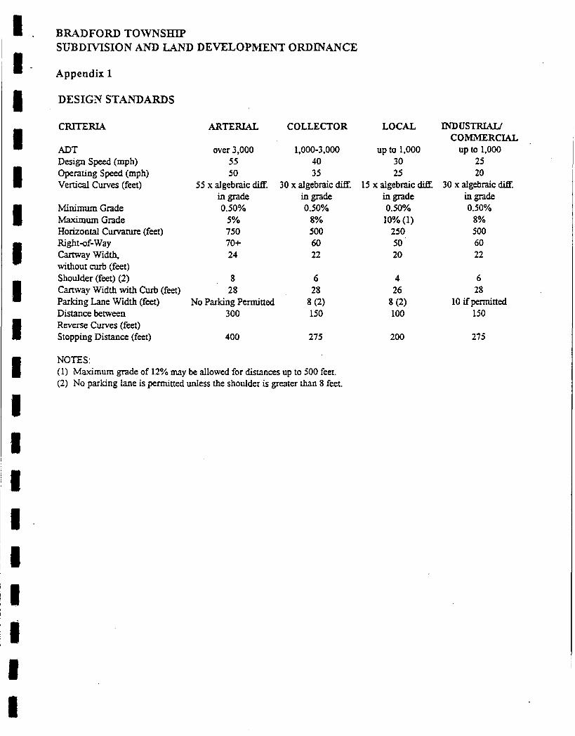
BRADFORD TOWNSHIP SUBDMSION AND LAND DEVELOPMENT ORDINANCE
Appendix 1
DESIGN STANDARDS
CRITERIA
ADT Design Speed (mph) Operating speed (mph) Vertical C w e s (feet)
Minimum Grade Maximum Grade Horizontal Curvature (feet) Right-of-way Cartway Width, without curb (feet) Shoulder (feet) (2) Cartway Width with Curb (feet)
ARTERIAL
over 3,000 55 50
55 x algebraic diE in grade 0.50%
5% 750 70C 24
COLLECTOR
1,000-3.000 40 35
30 x algebraic diff. in grade 0.50%
8% 500 60 22
LOCAL
up to 1,000 30 25
15 x algebraic W. in grade
10% (1) 0.50%
250 50 20
INDusTRML/
up to 1,000 COMMERC][AL
25 20
30 x algebraic diff. in grade 0.50%
8% 500 60 22
8 6 4 6 28 28 26 28
Parking Lane Width (feet) No Parking Permitted 8 (2) 8 (2) 10 ifpermitted Distance between 300 150 100 150 Reverse C w e s (feet) Stopping Distance (feet) 400 275 200 275
NOTES: (1) Maximum grade of 12% may be allowed for distances up to 500 feet. (2) No parking lane is permitted unless the shoulder is greater than 8 feet.

. . BRADFORD TOWNSHIP SUBDMSION AND LAND DE'\ELOPIPIAI+IT ORDNANCE
Appendix 2
INTERSECTION DESIGN SPECIFICATIONS
Intersection Types Arterial herial Collector Collector Local
W i t h with with with with Collector Local (1) Collector Local Local
Minimum distance between 800'/900' 800'/300' 5110'/300' 500'/300' 300'/1 50' intersecting centerlines Same side/Opposite side
Angle at intersection of street centerline
Length and grade of intersection approaches measured from the nearest right-of-way of the street being intersected
Minimum curb radius
Minimum intersection comer sight triangle along centerlines of streets (2)
90 90 90 75 to 105 75 to 105
50'/4% 50'/4% !50'/4% 50'/4% 5074%
50'
300'
20'
200'
35' 20' 20'
200' 200' 150'
NOTES (1) Where the centerlines of local streets opening onto opposite sides of an arterial
street are within 150' of each other, they shall be! made to coincide bycurving the . . - . streets to form a four way intersection wherever possible.
,-- '
(2) Including railroads
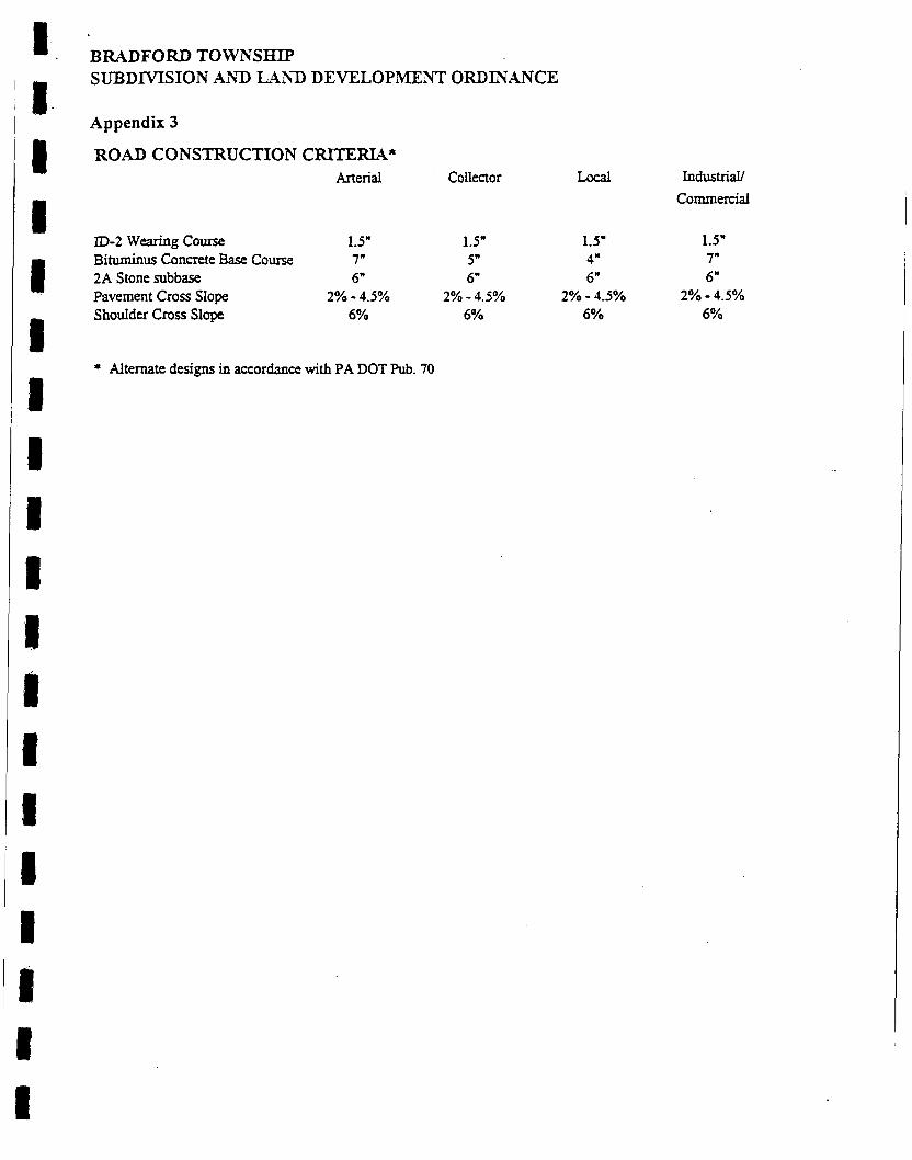
BRADFORD TOWNSHIP SUBDMSION AXD LAN) DEVELOPMENT ORDINANCE
Appendix 3
ROAD CONSTRUCTION CRITERIA* Arterial Collector
ID-2 wearing course 1.5" 1.5" Bittuninus Concrete Base Course 7" 5" 2A Stone subbase 6" 6" Pavement Cross Slope 2% - 4.5% 2% - 4.5% Shoulder Cross Slope 6% 6%
Local Industrial/ Commercial
1.5" 1.5" 4" 7" 6" 6"
6% 6% 2% - 4.5% 2% - 4.5%
* Alternate designs in accordance with PA DOT Pub. 70
I t

.@ .. I ..
0-7,
0- 0- 0- @ - 0- @ - 0- @ - @ - @ -
ID-2 Fi"tAR1ING COURSE - STE TABLZ 3 BITUMINOUS CONCRFCE BASE; COURSE - SEE TAaLE 3
2A S i C l r T S'GBASE - SZZ TAkLZ 3
- -
CARTWAY KIM" - SEE T.WX 1 CARTWAY KIM" - SEE TAXZ 1
S'rl:OULDER WIDTH - SEE TAI3LE 1
PA.VEEhT CROSS F i P E - SEE TAELE 3
Sr:OCTLDER CROSS SLOPE - !SEE TABLE 3 PPkvEi?lENT BASE DRAIN REQUIRED
RTGkT-OF-WAY L I E
I I 1 u I I U I I
I 1. I I
1
.i
m I 52 .

I I '
4 - / I
CEYCI 7 . CCNCRZX s
DETAIL 'A' CONTRACTION JOINT TYPICAL CROSS-SECTION
' STANDARD STRAIGHT CURB DETAIL NO SCALE
FTGCTE 3
NO SCALE FIGURE 3A
TYF3ICAL CURE3 END
53

FIGERE 4
FIGQRE 5
1 I I 'I I I I I It
I r - I
'1 - 1 i 1 1
a
'. '
I I 54 .

R Radius
MlNlMUM USE DRIVEWAY FIGURE 6
I
f
ROAD WAY
w -
W
i
I ROAD WAY t . .
I DRIVE WAY 'WITHOUT CUQDS .
L O W VOLUME D R I V E W A Y
FIGURE 7
55 .

f
;-
1 t
I I 1 I 1
56 ~
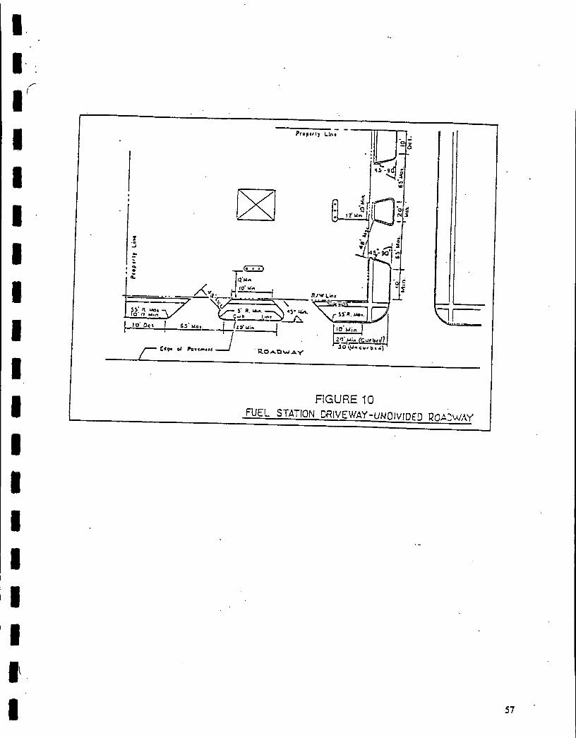
I I I I I I 1
I
f
FIGURE 10 FUEL STATION CRIVEWAY-UNCIVIDED ROAjWAY
57

APPENDIX 4: SIPECIFIC STORMWATER MANAGEMENT DESIGN CRITERIA
SECTION 1: STORMWATER MANAGEMENT COMIPUTATIONAL VALUES
Figure A-I: Design ,Storm Curves for Clearfield Region
Table A-2: TR 55 Curve Numbers
Table A-3:
Table A-4:
Rational Equation Runoff Coefficients
Manning Roughness Coefficients
Table A-5: Permissible Velocities for Channels
A-5.1: A-5.2: A-5.3: A-5.4:
Bare Earth Channels Lined with Vegetation Rock Lined Channels with Riprap Reno Matress and Gabions
SECTION 2: DESIGN CRITERIA FOR DRAINAGE SWALES, PERENNIAL STREAMS, CULVERTS, ANID DRAINAGE CHANNELS
SECTION 3: RUNOFF CONTROL MEASWIPES
SECTION 4: DESIGN CRITERIA FOR FACILITIES TO ENCOURAGE RECHARGE
SECTION 5: GRADING AND LANDSCAPING
8 1 I I I I I I I
APPENDIX 4: SPECIFIC STORMWATER MANAGEMENT DESIGN CRITERIA
SECTION 2: DESIGN CRITERIA FOR DRAINAGE SWALES, PERENNIAL STREAMS, CULVERTS, AND DRAINAGE CHANNELS
A. Drainage Swales
Criteria:
1.
2.
3.
4.
5 .
6.
7.
8.
Where vegetated drainage swales are used in lieu of or in addition to storm sewers, they shall be designed to carry the ten (10) year discharge without erosion, and also to increase the time of concentration, reduce the peak discharge and velocity, and permit the water to percolate into the soil.
Depth of flow in swales provided in cut areas shall not encroach upon the shoulder during a 10-year frequency storm of five (5) minute duration. Frequent and/or sustained flooding of the sub-base shall be avoided.
The maximum velocity as determined by Manning's equation shall not exceed the allowable velocity for specific types of vegetative material as specified in Appendix 4, Section I. Inlets shall be provided to control the shoulder encroach men t and water velocity . The side slope for any vegetated drainage channel requiring mowing of the vegetation shall have a maximum grade of three (3) horizontal to one (1) vertical on those areas to be mowed.
Erosion Prevention: All drainage swales shall be designed to prevent the erosion of the bed and bank areas. Suitable stabilization during vegetative cover establishment shall be provided to prevent erosion.
All storm sewers or drainage swales shall discharge to a detention or retention basin for the control of peak runoff discharge except as provided in the plan.
Design Standard: Because of the critical nature of vegetated drainage channels, the design of all vegetated channels shall, as a minimum, conform to the design procedures outlined in the Clearfield County Conservation District Erosion and Sediment Control Handbook.
A minimum grade of one percent shall be maintained for all swales. Grades less than one percent may be approved by the Township Engineer on a case-by-case basis and only if there are no other alternatives.

APPENDIX 4: !SPECIFIC S 'M)MATIZR MANAGIEMENT DESIGN CRITERIA
Guidelines :
1. Deed restrictions may be required on property(ies) containing draining swales and/or perennial streams. WIien required, these deed restrictions shall specify that no property owner obstruct or alter any drainage swale or perennial stream identified in the stormwater management plan.
B. Culverts and Drainage Channels
Criteria:
1. - Desipn Flow Standard: Culverts and drainage channels shall be designed to carry flow rates determined as outliried in Sectioni 1.11.7 (Soil Conservation Service, Technical Release No. 55).
2. Erosion Prevention: All drainage channels shall be designed to prevent the erosion of the bed and bank areas. Suitable bank stabilization shall be provided where required to prevent erosion of the drainage channels.
a. The maximum velocities permitted for lined water carrying channels shall be in accordance with the values presented1 in Table A-5 in Section I of this Appendix.
b. A minimum grade of one (1) percent shall be maintained for all channel flow. Grades less than one percent may be approved by the Township Engineer on a case-by-case basis and only if there are no other alternatives.
3. piDe Capacity: The capacity of all pipe culverts shall, as a minimum, provide the required carrying capacity as determined by the following sources:
- E%xieral Highway Administration Hydrau:lic Design of Highway Culverts Hydraulic Design Series No. 5 September 1985
Reference to publications and slource dammt:nts in this section shall be deemed to include any amendments and revisions thereof.
4. Minimum Grade and Size: All storm drain culvert pipes shall be designed to maintain a minimum grade of one-half (0.5) percent. All storm pipes shall have minimum inside diameter of fifteen (15) inchies or a cross-sectional area of one hundred seventy-six (176) square inches, exmpt that pipes under a twenty-five (25) foot or greater fill shall not. be less than twenty-four (24) inches or a cross-

I I I I 1 I I I 1 I I I I I I B 8
APPENDIX 4: SPECIFIC STORMWATER MANAGEMENT DESIGN CRITERIA
sectional area of four hundred fifty-three (453) square inches, and shall consist of reinforced concrete.
5 . Where storm sewers discharge into existing drainage channels at an angle greater than thirty (30) degrees from parallel with the downstream channel flow, the far side bank shall be stabilized by the use of riprap or masonry, and/or concrete walls, the stabilization shall be designed to prevent erosion and frost heave under and behind the stabilizing media.
Guidelines:
1. Pipe Arches: Where cover is restricted, equivalent pipe arches may be used in lieu of circular pipe.
SECTION 3: RUNOFF CONTROL MEASURES
A. Design of Detention Basins
Criteria:
1. All detention basin storage shall be designed by hydrograph routings. Hydrographs shall be developed from methods outlined in Section 1407.4 under the approval of the Township Engineer. Hydrographs shall be routed through the basin or stormwater control facility using the Modified Puls Method.
B. Basin Design
Criteria:
The design criteria contained in Section 1407 shall be used in the design of all detention basins in the Township. The emergency spillway must have the ability to pass the post development 100 year flow.
1. Riser: Where a riser is provided at the outlet of the detention basin, the riser shall be constructed of metal or concrete as approved by the Township Engineer. Risers shall be designed so that the rate of outflow is controlled by the pipe barrel through the basin berm when the depth of the water within the basin exceeds the height of the riser, or by accurately sized orifices. All metal risers, where approved for use, shall be suitably coated to prevent corrosion. A trash rack or similar appurtenance shall be provided to prevent debris from entering the riser. All metal risers shall have a concrete base attached with a watertight connection.

APPENDIX 4: SPECIFIC STORMWATER MANAGI7D"T DESIGN CRITERIA
The base shall be sufficient weight to prevent flotation of the riser. An anti- vortex device, consisting of a thin vertical plate normal to the basin berm, shall be provided on the top of all metal risers. Suitable perforated metal riser designs are outlined in the following sources:
- -
Erosion and Sediment Control Handbook Clearfreld County Soil and Water Conaxvation District
2. - Emergency Spillway: Emergency spillways shall be constructed of reinforced concrete, vegetated earth, 01' riprap in accordance with generally accepted engineering practice. All emergency Spillways shall be constructed so that the detention basin berm is protected against erosion. The minimum capacity of all emergency spillways shall be the peak flow rate from the post-development one hundred (100) year design storm. The dimensions of the emergency spillways can be determined from the (Jlearflelld County Erosion and Sediment Control Haridbook. Emergency spillways shall extend along the upstream and downstream berm embankment a minimum of three (3) feet below the spillway crest elevation. The downstream slope of the spillway shall as a minimum extend to the toe of the berm embankment. The emergency spillway shall not discharge over uncompacted earthen fill and/or easily erodible material.
3. - AntiseeD Collars: Antiseep collars shall be installed around the principal pipe barrel within the normal saturation zone of the detention basin berms. The antiseep collars and their connections to the pipe barrel shall be watertight. The antiseep collars shall extend a minimum of two (2) feet beyond the outside of the principal pipe barrel. The maximum spacing between collars shall be fourteen (14) times the minimum projection of the collar measured perpendicular to the pipe:.
4. Freeboard: Freeboard is the difference between the design flow elevations in the emergency spillway and the top of the settled detention basin embankment. The minimum freeboard shall be one (1) foot.
5. &e of Detention Basin Embankment: The top or toe of any slope shall be located a minimum of ten (10) feet from any property line. Whenever possible the side slopes and basin shape shall be amenable to the natural topography. Straight side slopes and rectangular basins shall be avoided whenever possible.

I I I I I I i I 1 1 I 1 I I I I
‘ I
APPENDIX 4: SPECIFIC STORMWATER MANAGEMENT DESIGN CRITERIA
a. Exterior slopes of compacted soil shall not exceed three (3) feet horizontal to one (1) foot vertical, and may be further reduced if the soil has unstable characteristics.
b. Interior slopes of the basin shall not exceed three (3) feet horizontal to one (1) foot vertical, except with approval of the Township.
c. An access ramp at least 10 feet wide must be constructed of durable, non-slip material to a grade of less than ten (10) percent to facilitate accessing the basin’s bottom and outlet structure.
6 . Width of Berm: The minimum top width of detention basin berms shall be ten (10) feet.
7. Slope of Basin Bottom: In order to ensure proper drainage of the detention basin, a minimum grade of two (2) percent shall be maintained for all sheet flow.
a. Inlet and outlet structures will be located at maximum distances from one another. The Township Engineer may require a rock filter berm, rock-filled gabions, or suitable landscaping or vegetative material between inlet and outlet areas when the distance is deemed insufficient, for improved sediment trapping.
b. A collecting swale or low flow channel and/or underdrain shall be provided to drain basins.
8. Energv Dissipators: Energy dissipating devices (riprap, end sills, etc.) shall be placed at all basin outlets.
9. The distance from the highest free water surface of any detention basin or drainage facility to a dwelling unit shall be a minimum of fifty (50) feet.
10. Landscaping and Grading of Detention Basins: All landscaping and grading standards particularly applicable to detention basins are included in Section V of this Appendix.
11. Construction of Basins:
a. A quality control program is critical for embankment fills. Therefore, wherever embankment fill material in excess of three (3) feet is to be used, each layer of compacted fill shall be compacted to not less than 97% of the dry weight density determined in accordance with PTM No. 112 or PTM No.
APPENDIX 4: SPECIFIC STORMWATEX MANAGBME" DESIGN CRITERIA - -
402. Embankment material must be placed in uniform horizontal layers not more than a loose 8" depth.
b. Compaction test reports sliall be kept on file at the 'site and be subject to review at all times with copies being foirwarded to the Township Engineer.
c. When rock is encountered during the excavation of a pond, it shall be removed to an elevation of at least twelve (12) inches below the proposed basin floor. For a manufactured liner, :24" - 30".
d. Temporary and permanent grasses c r stabilization measures shall be established on the sides and base of all earthen basins within 15 days of construction.
12. Desicn Information: As part of the Stormwater Management Plan and Report, all design information along with the information required in Section 1.9 of this Ordinance shall be submitted including, but not limited to, the following:
a. General description of proposed facilities and the operation of the runoff control measures.
b. A detail of the detention basin showing the berm embankment and outlet structure, the embankment top elevation and width, embankment side slopes, emergency spillway elevation, perforated riser dimensions, pipe barrel dimensions, and dimensions and spacing of antiseep collars.
c. Design computations for the pipe barrel and riser.
d. A plot or table of the stage-storage (acre-feet vs. elevation) and all supporting computations.
e. Flood routing computations.
f. A detailed plan of the trash rack and anti-vortex device.
g. A plan, at a scale of one (1) inch equals, fifty (50) feet or larger showing the grading, landscaping, and fencing arourid the detention basin.

I I I I I I I I I I 1 I
I ' I I I
APPENDIX 4: SPECIFIC STORMWATER MANAGEMENT DESIGN CRITERIA
SECTION 4: DESIGN CRITERIA FOR FACILITIES TO ENCOURAGE RECHARGE
A. Methods of Stormwater Infiltration
1. Methods of stormwater infiltration including but not limited to: seepage pits and seepage trenches, multiple, staged, or extended detention (Le., greater than 24 hours), wet ponds with stormwater detention capabilities, infiltration trenches and basins, porous pavement, and vegetative practices including urban forestry, basin landscaping or shallow marsh creation may be used. Suggested guidelines and design criteria for these alternatives are outlined in the publications Controlling Urban Runoff - A Practice Manual for Planning and Designing Urban BMPs, Metropolitan Washington Council of Governments, July 1987, and Standards and Specifications for Infiltration Practices (MD DNR). All design methods and selected alternates shall have prior approval of the Township Engineer.
SECTION 5: GRADING AND LANDSCAPING
A. Cuts
Criteria:
1. No excavation should be made with a cut face steeper than three (3) feet horizontal to one (1) foot vertical, except under the conditions that the material in which the excavation is made is sufficiently stable to sustain a slope of steeper than three (3) feet horizontal to one (1) foot vertical. Retaining walls will be required if a stable slope cannot be maintained. Any retaining wall design must be approved by the Township Engineer. The top of the slope of headwall of any cut must be located a minimum of ten (10) feet from property lines.
B. Fills
Criteria:
No fill shall be made which creates any exposed surface steeper in slope than three (3) feet horizontal to one (1) foot vertical, except where the fill is located so that settlement, sliding, or erosion will not result in property damage or be a hazard to adjoining property, streets, or buildings. For an exposed surface steeper than 3: 1 to be permitted, the applicant must provide documentation that the 3:l slope is not a safety concern.
APPENDIX 4: SPECIF'IC SI'ORMWATICR MAPJAGINEN" DESIGN CRITERIA
Guidelines:
A concrete or stone masonry wall designed and constructed in Accordance with these specifications and standards may be requiredl Uo support face of the fill where the above- specified s:lopes are exceeded.
C. Planting
Criteria:
1. - Grassed or Grass/Ground Cover Combination: All such areas specified on proposed or approved plans shall be prepared, installed, and maintained in accordance with Pennsylvania Department of Transportation, Form 408 Specifications as amended.
2. -:n Space. Storm Drainage. and Retention Areas:
a. .Planting Requirement: All areas proposad for recreational use, whether active or passive, shall be planted to effectively naturalize the areas to become an integral and harmonious element in the natural landscape.
b. Drainage Channels and Retention Areas,: All storm drainage channels and retention areas, whether existing or proposed, shall be graded and planted to effectively naturalize area(s) so as to become an integral and harmonious part of the landscape by contouir and type of plant material employed.
c. Vegetative Filter Path: To work properly, a filter strip must be 1) equipped with some sort of level spreading device; 2) densely vegetated with a mix of erosion resistant plant species that effectively bind the soil; 3) graded to a uniform, even, and relatively low slope; 4) be at least as long as the contributing runoff area; and 5 ) top soil within the vegetative filter path be 12" to 18" deep.
14 dense cover of erosion resistant grass suitable to existing site conditions shall be established including: Kentucky 31 Tall Fescue, where draught resistance is required, or Reed Canary grass, where water tolerance is required.
d. ToD Soil: A minimum of six (6) inches of topsoil material shall be placed on dl areas affected by the basin constructicin (bottom of basin, side slopes, top of berm, etc.). The material must meet tlhe requirements of the Pennsylvania Department of Transportation, Form 408; Specifications as amended.
APPENDIX 4: SPECIFIC STORMWATER MANAGEMENT DESIGN CRITERIA
APPENDIX 4: SPECIFIC S'I'ORMWATEX MAPdAGIrMENT DESIGN CRITERIA
Guidelines :
1. - Crown Vetch: Detention basins may be seeded with crown vetch, or turfed if, in tlhe opinion of the Township, io crown vetch covering would reduce the use of the detention basin for recreational purposes or would be unsightly.
2. - Fencing - and Screening: A fence or suitable vegetative screening may be provided, as required by the Township, around all detention basins. All fencing should be at least three and one-half (3 1/2) feet in height as approved by the Township. A vegetative screening of suitable landscaping plant material in or around a detention basin may also be required. Vegetative screenings should generally provide a barrier to prevent entrance to, and effectively naturalize the appearance of, the detention basin area.
Combinations of grassed areas and densely planted shrub areas consisting of species suited to use in the highway enviralnment are encouraged. Species of raspberry (Rubus spp.) are recommended.
Rock filter check dams are encouraged for use as level spreaders.
D. Building Site Excavation and Surface Runoff
Criteria:
1. If temporary or permanent diversion channel!; or berms have not been established during general site preparation, diversion channels or berms shall be installed whenever slopes exceed 10% above or below proposed excavation areas.
Installation shall occur prior to or concurrent with excavations or other earthmoving on the uphill or downhill sides of the building location and any other areas to be disturbed. This requirement may be waived if it would result in the destruction of trees and shrubs. In all cases, hay bales or silt fence shall be installed and maintained dowrihill of all excavations and until the diversion channels or berms required by the Township Engineer have been stabilized.
2. All exposed earth shall be stabilized with ap,propriate grasses or other materials no later than fifteen (15) days dter construction.

I I I I I I 1 I I 1 I 1 I I ‘ I I I I 1
APPENDIX 5: SUPPLEMENTAL STANDARDS AND CRITERIA
The following technical reference materials are hereby incorporated into these controls for information and to govern the design and hydrologic control provisions of this Ordinance:
1.
2.
3.
4.
5 .
6.
7.
8.
9.
10.
11.
12.
13.
Controlling Urban Runqff - A Practice _for Plannina and Desianing Urban Best Management Practices, Metropolitan Washington, Council of Governments, July 1987.
Design Manual Part 2. Highwig Design. Publication 13, Commonwealth of Pennsylvania, Department of Transportation, January 1990.
Engineering Field Manual, USDA SCS, 1977.
Engineering Standard and Specifications, USDA SCS, May 1977.
Field Manual of Pennyvlvania Department o f Transportation Storm Intensio-Duration- Freauency Charts, Department of Civil Engineering and Institute for Research on Land Water Resources, Pennsylvania State University, University Park, PA, 1986.
Flood Hazard Studv, Township of Bradford, Clearfield County, Federal Insurance Administration, 1989.
Guidelines for Erosion and Sediment Control Planning and Implementation, U.S. Government Printing Office, Washington, DC, EPA-R2-72-015, August 1972.
National Engineering Handbook, Section 4, Hydrology, USDA, August 1972.
Practices in Detention o f Urban Stormwater RunoG Special Report No. 43, American Public Works Association, June 1974.
Soil Erosion and Sediment Pollution Manual, Pennsylvania Department of Environmental Resources, May 1990.
Soil Survev o f Clearfield Coung. Pennsylvania, USDA SCS, August 1988.
Standards _for Roadway Construction. Series RC-0 to 100, Pennsylvania Department of Transportation, Bureau of Highway Design, Publication No. 72, May 1983.
Standards and Specifications_for Infiltration Practices, Maryland Department of Natural Resources, Water Resources Administration, February 1984.
APPENDIX 5: SUPPLEMENTAL STANDARD§ ANI) CRITERIA I
14. ntle 25 Rules and Renulatiom. Chaipter 105. Dam Safe8 and Waterway Management, as amended, Commonwealth of Pennsylvania, Department of Environmental Resources.
Urban Hvdrolopv for Small Watersht&, Technical Release No. 55, USDA SCS, June 1986.
I I
15.
I I 1 I 1
BRADFORD TOWNSHIP ORDINANCE NO. J 6 c X - /
AN ORDINANCE OF THE TOWNSHIP OF BRADFORD, CLEARFIELD COUNTY, COMMONWEALTH OF PENNSYLVANIA, AMENDING THE TOWNSHIP’S SUBDIVISION AND LAND DEVELOPMENT ORDINANCE TO PROVIDE FOR A EXPANDED DEFINITION OF A MAJOR SUBDIVISION, A REDEFINITION OF THE TERM MINOR SUBDIVISION, AMENDING THE NUMBER OF PRELIMINARY PLANS NEEDED FOR A MAJOR SUBDIVISION, AMENDING THE NUMBER OF FINAL PLANS NEEDED FOR A MAJOR SUBDIVISION, REVISING THE NUMBER OF MYLAR AND PRINTS TO BE DELIVERED UPON RECORDING OF A FINAL PLAN, SETTING MINIMUM SETBACK LINES AND PROVIDING FOR BUFFER PLANNING REQUIREMENTS.
WHEREAS, the Board of Supervisors of Bradford Township, Pennsylvania desires to amend its Subdivision and Land Development Ordinance in order to further the community development objectives of the Township, to further provide for the orderly development, redevelopment, use and reuse of property, and to further protect the health, safety and welfare of the residents of Bradford Township;
NOW, THEREFORE, it is hereby ordained by the Bradford Township Supervisors that its Subdivision and Land Development Ordinance be amended as set forth below by adding the following underlined language and deleting the following language which has been identified in brackets.
Section 1 Definition of Major Subdivision.
The definition of Major Subdivision contained in Article II, Section 202 shall be amended to read:
Major Subdivision. [Any subdivision that is not classified as a minor subdivision]. The subdivision of land into ten (10) parcels or more. including the residual located on an existing imDroved street. or .less than ten (10) Darcels if the subdivision involves: installation of road. sewer or utilitv immovements as reauired by this Ordinance: frontage on any arterial or collector street: adverse stormwater runoff effects to adjoining properties and conflict with the Clearfield County ComDrehensive Plan. any portion of this Ordinance or other State. Township. or Countv ordinances. laws or regulations.

Section 2 Definition of Minor Subdivision.
The definition of Minor Subdivision contained in Article 11, Section 202 shall be amended to read:
Minor Subdivision: [The subdivision of land into not more than ten (10) parcels, including the residual located on an existing improved street that does not involve: installation of improvements as required by this Ordinance; extension of utilities; frontage on any arterial or collector street; adverse effect to adjoing properties and conflict with the Clearfield County Comprehensive Plan, any portion of this Ordinance or other State, Township, or County ordinances, laws or regulations.] Anv subdivision of land into less than ten (10) parcels that is not classified as a Major Subdivision.
Section 3 Number of Preliminary Plans and Documentation.
The number of preliminary plans and documentation required in Article 111, Section 302.2 shall be amended to read:
[Fifteen (131 Four (4) copies of the Preliminary Plan and all required exhibits and documentation shall be filed with the Township during regular office hours at least thirty (30) days prior to the next regular Planning Commission meeting in order to be placed on the agenda for that meeting. The form of required exhibits shall be prepared by the Township Solicitor and approved by resolution of the Township Board of Supervisors.
Section 4
The number of final plans and documentation set forth in Article 111, Section 302.2 shall be amended to read:
Number of Final Plans and Documentation
The original and [fifteen (15)J four (4) copies of the Final Plan and all required exhibits and documentation shall be filed with the Township during regular office hours at least thirty (30) days prior to the next regular Planning Commission meeting in order to be placed on the agenda for that meeting. The form of required exhibits shall be prepared by the Township Solicitor and approved by resolution of the Township Board of Supervisors.
~ Section 5 Mylar and Paper Prints Required
The number of mylar and paper prints required in Article 111, Section 309.3 shall be amended to read:
Upon recording of the Final Plan with the Clearfield County Recorder of Deeds, the Developer shall deliver to the Township one (1) reproducible mylar {for ma-ior subdivisions only) and [four (4)] two (2) paper prints of the Final Plan as recorded.
Section 6 Building Setback Lines.
The building setback lines set forth in Article VII, Section 805.7 shall be amended to read:
The lot size, width, depth, shape, orientation and minimum building setback lines shall be appropriate for the location of the subdivision or land development and for the type of development and use contemplated. Buildino - setback lines shall meet the following conditions:
A. The minimum building setback lines for residential lots shall be twenty-five (25) feet from a publicly-dedicated street right-of-wav line or foq-one and one half (41.5) feet from the center line of a Drivate roadway. thirty-five (35) feet from the rear lot line. and ten (10) feet from the side lot lines.
B. The minimum building setback lines for commercial or industrial lots shall be thirtv-five (35) feet from a publiclv-dedicated street right-of-wav line or fiftv-one and one half (5 1.5) feet from the center line of a Drivate roadwav. thirtv-five (35) feet from the rear lot line. and twenty-five (25) feet from the side lot lines.
Section 7 Buffer Planting Requirements
The buffer planting requirements required in Article VII, Section 807.6 shall be amended to read:
Buffer Planting Requirements. [Buffer yard as may be required by the Township Engineer.] The minimum plantinz requirements for commercial or industrial areas that abut a residental area shall be evergreen trees. a minimum of four (4) feet tall, sDaced a minimum of eizht (8) feet aDart slow the side lot buffer area or as reauired by the Township Engineer.
The Ordinance shall become effective immediately.
. c
DULY ENACTED AND ORDAINED the 2nd day of A y ,2000, by the Board
of Supervisors of Bradford Township, Clearfield County, Pennsylvania, in lawful session duly
assembled.
ATTEST
& ZYI. && Lhda M. Wooster
BRADFORD TOWNSHIP CLEAWIELD COUNTY, PENNSYLVANIA
BOARD OF SUPERVISIORS BY:
0
C L W I
- Y
William M. Graham
Charles G. Read
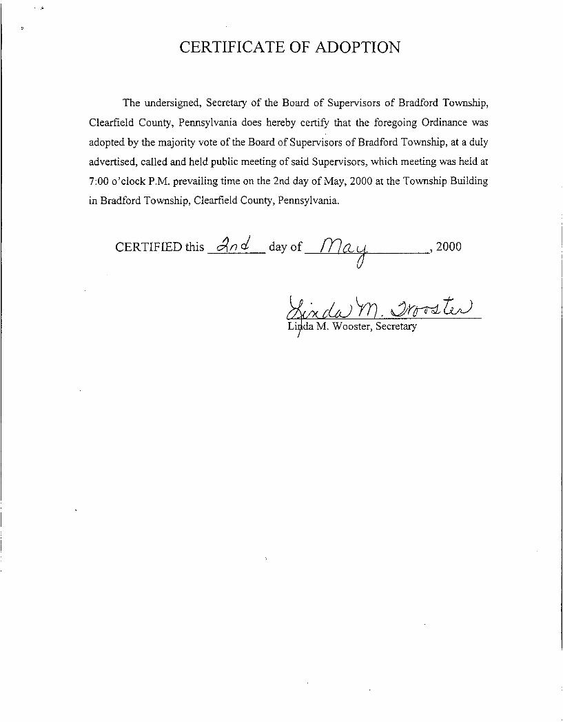
CERTIFICATE OF ADOPTION
The undersigned, Secretary of the Board of Supervisors of Bradford Township,
Clearfield County, Pennsylvania does hereby certify that the foregoing Ordinance was
adopted by the majority vote of the Board of Supervisors of Bradford Township, at a duly
advertised, called and held public meeting of said Supervisors, which meeting was held at
7:OO o’clock P.M. prevailing time on the 2nd day of May, 2000 at the Township Building
in Bradford Township, Clearfield County, Pennsylvania.
+ *Oo0 CERTIFIED this Jn a! day of
Li da M. Wooster, Secretary ?
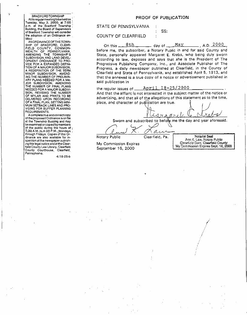
BRADFORD TOWNSHIP Atitsreguhrmeetingtobeheldon
Tuesday, May 2. 2000. at 7:OO p.m. at the Bradford Township Building, the Board of Supervisors of Bradford Township will consider the adoption of an Ordinance en- titled:
AN ORDINANCEOFTHETOWN- SHIP OF BRADFORD, CLEAR- FIELD COUNTY, COMMON- WEALTH OF PENNSYLVANIA, AMENDING THE TOWNSHIP'S SUBDIVISION AND LAND DEVEL- OPMENT ORDINANCE TO PRO- VIDE FOR A EXPANDED DEFINI- TION OF A MAJOR SUBDIVISION, A REDEFINITION OF THE TERM, MINOR SUBDIVISION, AMENO- ING THE NUMBER OF PRELIMIN- ARY PLANS NEEDED FOR A MA- JOR SUBDIVISION. AMENDING THE NUMBER OF FINAL PLANS
SION, REVISING THE NUMBER. OF MYLAR AND PRINTS TO BE DELIVERED UPON RECORDING OF A FINAL PLAN, SETTING MINI- MUM SETBACK LINES AND PRO- VIDING FOR BUFFER PLANNING REQUIREMENTS.
Acompletetrue andcorrectcopy of the proposed Ordinance is on file at the Township Building and may be examined or copied by members of the public during the. hours of .. 7;30.A.M.,tp.4:00 P.M..:Mondays': through Fridays. Copies of this Or- dinance are also available for in- spection at the newspaper publish- ing this legal notice and at the Clear- field County Law Library, Clearfield County Courthouse, Clearfield. Pennsylvania.
NEEDED FOR A MAJOR SUBDIVI-
4:18-25-b
PROOF OF PUBLICATION
STATE OF PENNSYLVAN!A :
COUNTY OF CLEARFIELD : : ss:
On this ath day of May , A.D. 2 o o o , before me, the subscriber, a Notary Public in and for said County and State, personally appeared Margaret E. Krebs, who being duly sworn according t o law, deposes and says that she is the President o f The Progressive Publishing Company, Inc., and Associate Publisher of The Progress, a daily newspaper published at Clearfield, in the County of Clearfield and State o f Pennsylvania, and establisheg April 5, 191 3, and that the annexed is a t rue copy of a notice or advertisement published in said publication in
the regular issues o f April 1 8 - 2 5 / 2 0 0 0 And that the affiant is n o t interested in the subject matter of the notice or
Notary Public Clearfield, Pa.
M y Commission Expires September 16, 2000

BRADFORD TOWNSHIP P. 0. Box 79
e-mail address: bradford twp@ clearnet.net
Phone (814) 857-7283 Woodland, PA 1688 1 F a (514) 857-5480
May 9,2000
VIA FACSIMILE
Ms. Sandra Finn Clearfield County Law Library Clearfield County Courthouse Second Street Clearfield, PA 16830
RE: Bradford Township Ordinance - Ordinance 2000- I Amending the Township’s Subdivision and Land Development Ordinance
Dear Ms. Finn:
In accordance with provisions of the Second Class Township Code, we are transmitting for retention and public access at the Law Library, a copy of Bradford Township Ordinance No. 2000-1 which was adopted on May 2,2000. The Ordinance amends the Township’s Subdivision and Land Development Ordinance.
Should you have any questions or comments concerning the above, please do not hesitate to contact us. Thank you.
Sincerely, Bradford Township Supervisors
dd&m& William M. Graham
1 ’ R&ald L. Maines
u u b Charles G. Read LJ