Town of Pike Road Conventional Zoning ... - docs.wixstatic.com
213
Adopted 02/13/17 Town of Pike Road Conventional Zoning Ordinance Table of Contents Article I. General Provisions and Definitions. Section 100. Title Section 101. Purpose Section 102. Applicability Section 103. Jurisdiction Section 104. Relationship to Comprehensive Plan Section 105. Exceptions Section 106. Severability Section 107. Word Usage Section 108. Abbreviation Section 109. Definitions of General Terms Article II. Zoning Districts and Land Uses Section 200. Purpose and Intent Section 201. Zoning Districts Established Section 202. Zoning Districts Described Section 203. District Land Use Tables Article III. District Bulk Regulations Section 300. Purpose and General Provisions Section 301. District Bulk Tables Section 302. Street Setbacks Section 303. Other Setbacks Section 304. Accessory Buildings Section 305. Building Height Controls Section 306. Temporary Buildings and Material Storage Section 307. Non-Standard Lots Section 308. Manufactured Homes Section 309. Home Repair and Remodeling Section 310. RESERVED Article IV. RESERVED Article V. Land Use Development Standards Section 500. General Provisions Section 501. Uses Permitted with Conditions (PC) Section 502. Uses Permitted as Accessory (A)
Transcript of Town of Pike Road Conventional Zoning ... - docs.wixstatic.com

Adopted 02/13/17
Town of Pike Road Conventional Zoning Ordinance Table of Contents
Article I. General Provisions and Definitions. Section 100. Title Section 101. Purpose Section 102. Applicability Section 103. Jurisdiction Section 104. Relationship to Comprehensive Plan Section 105. Exceptions Section 106. Severability Section 107. Word Usage Section 108. Abbreviation Section 109. Definitions of General Terms
Article II. Zoning Districts and Land Uses Section 200. Purpose and Intent Section 201. Zoning Districts Established Section 202. Zoning Districts Described Section 203. District Land Use Tables
Article III. District Bulk Regulations Section 300. Purpose and General Provisions Section 301. District Bulk Tables Section 302. Street Setbacks Section 303. Other Setbacks Section 304. Accessory Buildings Section 305. Building Height Controls Section 306. Temporary Buildings and Material Storage Section 307. Non-Standard Lots Section 308. Manufactured Homes Section 309. Home Repair and Remodeling Section 310. RESERVED
Article IV. RESERVED Article V. Land Use Development Standards
Section 500. General Provisions Section 501. Uses Permitted with Conditions (PC) Section 502. Uses Permitted as Accessory (A)

Adopted 02/13/17
Article VI. Reserved Article VII. Design and Development Standards
Section 701. Parking, Access and Loading Standards (Add Access Management) Section 702. Landscape Standards Section 703. Open Space Standards Section 704. Lighting Standards Section 705. Community and Building Design Standards Section 706. Signage Standards Section 707. Environmental Protection Standards Section 708. Utilities
Article VIII. Overlay Districts Section 800. Overlay Districts Established Section 801. Planned Unit Development (PUD) District Section 802. Historic Overlay Districts Section 803. Flood Hazard Overlay District Section 804. Trails Overlay District
Article IX. Manufactured Housing Regulations Section 900. Purpose Section 901. Definitions Section 902. Manufactured Homes As In-fill Dwellings Section 903. Standards for All Manufactured Homes Section 904. Placement for Family Use Section 905. Standards for Manufactured Home Communities/Subdivisions
Article X. Procedures Section 1000. Purpose Section 1001. Official Zoning Map Section 1002. Conditional and Accessory Uses Section 1003. Overlay District Procedures Section 1004. Town Center District Procedures Section 1005. Site Plan Review and Approval Section 1006. Landscape Plan Review Procedures Section 1007. Open Space Plan Review Procedures Section 1008. Lighting Plan Review Procedures Section 1009. Building Plan Review Procedures Section 1010. Sign Procedures Section 1011. Tree Preservation Plan Review Procedures Section 1012. Tree Replacement Plan Review Procedures Section 1013. Flood Hazard Area Development Permit Review Section 1014. Certificates
Adopted 02/13/17
Article XI. Administration and Enforcement Section 1100. Purpose Section 1101. Town Clerk: Duties and Powers Section 1102. Building Official: Duties and Powers Section 1103. Duties of the Planning Commission Section 1104. Historic Zoning Commission Section 1105. Board of Zoning Adjustment: Duties and Powers Section 1106. Non-conforming Uses, Structures, Lots, and Signs Section 1107. Enforcement Section 1108. Fees
Article XII. Legal Provisions Section 1200. Penalties Section 1201. Remedies Section 1202. Saving Clause Section 1203. Effective Date Section 1204. Adoption

PIKE ROAD CONVENTIONAL ZONING FOR THE TOWN OF PIKE ROAD, AL
ADOPTED February 13, 2017
ORDINANCE NUMBER: 2017-0363
AN ORDINANCE in pursuance of the authority granted by Title 11, Chapter 52, Articles 1 through 4 inclusive, of the 1975 Code of Alabama, to provide the establishment of districts within the corporate limits of the Town of Pike Road, Alabama; to regulate within such districts the height, number of stories and size of buildings and other structures, the percent of lot that may be occupied, the size of yards and other open spaces, the density of population and the use of buildings, structures, and land, and to provide methods of administration of this Ordinance and penalties for the violation thereof and to repeal Ordinance No. 03-2003 and all amendments thereto.

5 – Adopted 2/13/17
Article I – Adopted 02/13/17
ARTICLE I. TITLE, PURPOSE, AND JURISDICTION.
Section 100. Title. This Ordinance shall be known as and may be referred to as the Zoning Ordinance of Pike Road, Alabama,” and may be cited as the Zoning Ordinance. Said Zoning Ordinance includes maps of the Town that depict the boundaries of zoning districts. Section 101. Purpose. This Zoning Ordinance has been formulated and adopted to promote the health, safety and general welfare, including progressive growth, convenience and the protection of property values, of the citizens of Pike Road, Alabama, by:
A. Providing methods to preserve and maintain a healthful environment for the benefit of present and future generations by providing standards to control the amount of open space and impervious surfaces within a development; to control the intensity of development in areas of sensitive natural resources or natural features in order to reduce or eliminate adverse environmental impacts.
B. Controlling and regulating the growth of Pike Road, concentrating development in areas where adequate sewerage facilities, roads, and schools can be provided, and limiting development in areas where these facilities are not and should not be provided.
C. Regulating and restricting the location and use of buildings, structures, and land
for trade, industry, residences, and other uses. D. Providing standards for all types of dwelling units so that all the people may have
access to decent, sound, and sanitary housing. E. Lessening the danger of congestion of traffic on the roads and highways, limiting
excessive numbers of intersections, driveways, and other friction points, minimizing other hazards, and insuring the continued usefulness of all elements of the existing highway system for their planned function.
F. Securing safety from fire, panic, flood, and other dangers.
G. Providing adequate privacy, light, and air. H. Securing economy in local governmental expenditures. I. Conserving property values throughout Pike Road.
Each purpose listed above serves to balance the interest of the general public of Pike Road and those of individual property owners.

6 – Adopted 2/13/17
Article I – Adopted 02/13/17
Section 102. Applicability A. General. The requirements of this Zoning Ordinance shall apply within the corporate limits of the Town of Pike Road as they exist at the time of adoption or as the corporate limits may be amended in the future. B. Minimum Requirements. The requirements of this zoning code shall be considered as the minimum requirements for the promotion of the public health, safety and general welfare. It is not intended to interfere with or abrogate or annul any easements, covenants or other agreements between parties. Where this zoning code imposes a greater restriction upon property than that imposed by other resolutions, rules, regulations, easements, covenants or agreements, the provisions of this zoning code shall govern. C. New Development. Upon the effective date of this zoning code or any subsequent amendment, any new building or other structure or any tract of land shall be used, constructed or developed only in accordance with all applicable provisions of this zoning code. D. Existing Development. Any existing use, lot, building or other structure legally established prior to the effective date of this zoning code that does not comply with any of its provisions shall be subject to the regulations of the nonconforming provisions of this zoning code stipulated in Article XI.
Section 103. Jurisdiction. All territory that is annexed to the corporate limits, the territories Zoning District classification shall be determined by the following means.
1. If the territory was previously classified and matches a zoning classification within this ordinance, the zoning classification will remain the same classification provided that the district definitions, land uses and long range plans are compatible. The Planning Commission shall make a recommendation to Council for the zoning classification consideration at the time of annexation.
2. If the territory has been previously developed and the land use matches a zoning classification within this ordinance, that zoning classification will be considered if the district definitions, land uses and the long-range plan are compatible. The Planning Commission shall make a recommendation to Council for the zoning classification consideration at the time of annexation.
3. All undeveloped or vacant land that is annexed to the corporate limits shall be
considered to be in the AG District until otherwise classified. Rezoning of land proposed to be annexed into the Town may occur concurrently with the annexation process.
Section 104. Relationship to Comprehensive Plan
The Pike Road Comprehensive Plan establishes the goals, objectives and strategies that serve as a basis for this zoning code. All regulations or amendments adopted pursuant to this ordinance shall be generally consistent with the Comprehensive Plan as adopted and revised or updated.

7 – Adopted 2/13/17
Article I – Adopted 02/13/17
Section 105. Exceptions
A. Previously Issued Permits and Exceptions. Any variance, exception or permit authorized before the effective date of this zoning code may be continued, changed, extended, enlarged or structurally altered only as provided in this title. 1. Any permit issued before the effective date of this zoning code or subsequent
amendment shall remain in effect provided that construction is begun within six months from the date of issuance of the permit. Construction shall mean physical improvements such as, but not limited to, water and sewer lines, footings, and/or foundations have been developed on the site. Clearing, grading, the storage of building materials, or the placement of temporary structures shall not constitute beginning construction.
2. Where no limitation as to duration of the use was imposed at the time of authorization the use may be continued. When the use was granted for a specific period of time, the applicable provisions of this code shall be applied upon the expiration of that time.
3. In no event shall such use be changed except to a conforming use or a nonconforming use as provided for in Section 204. A change of use is a change to another use either under the same use group or any other use group or major class of use. A change in occupancy or ownership shall not by itself constitute a change in use.
B. Temporary Dwelling as a Result of Natural Disaster. The Planning Commission may issue a temporary permit for a mobile home as a single-family dwelling unit on any lot previously occupied by a permanent dwelling that was destroyed by natural causes and is being reconstructed. The Planning Commission may impose conditions upon the issuance of the permit to provide for the least impact on surrounding property. Permits shall be for a period of time not to exceed one year.
Section 106. Severability
Should any article, section, clause or provision of this zoning code be declared by a court of competent jurisdiction to be unconstitutional or invalid, such decision shall not affect the validity of the ordinance codified in this title as a whole or any part thereof other than the part declared to be unconstitutional or invalid, each article, section, clause and provision hereof being declared severable.
Section 107. Word Usage
In the interpretation of this Ordinance, the provisions and rules of this section shall be observed and applied, except when the context clearly requires otherwise:
A. Words used or defined in one tense or form shall include other tenses and derivative forms.
B. in the singular number shall include the plural number and words in the plural number shall include the singular number.
C. The masculine gender shall include the feminine, and the feminine gender shall include the masculine, this shall be extended to apply to partnerships, firms and corporations.
D. The words “shall” and “must” are mandatory. E. The word “may” is permissive.

8 – Adopted 2/13/17
Article I – Adopted 02/13/17
F. The word “person” includes individuals, firms, corporations, associations, trusts, and any other similar entities.
G. The words “governing body” refer to the Town Council of Pike Road. H. The words “Planning Commission” shall mean the Pike Road Planning Commission. I. The word “Board” refers to the Board of Zoning Adjustment of the Town of Pike Road. J. In the case of any difference of meaning or implication between the text of this
Ordinance and any caption, illustration, or table, the text shall control. K. Nontechnical and Technical Words. Words and phrases shall be construed according to
the common and approved usage of the language, but technical words and phrases and such others as may have acquired a peculiar and appropriate meaning in law shall be construed and understood according to such meaning.
L. Fractions. When any requirement of these regulations results in a fraction of a dwelling unit or other measurement, that fraction will be disregarded and the fraction if less than 0.5 shall be rounded down the nearest whole number, and if equal to or greater than 0.5 shall be rounded up to the nearest whole number.
Section 108. Abbreviation.
The following abbreviations are used in this Ordinance and are intended to have the following meanings:
FAR – Floor Area Ratio
ISR – Impervious Surface Ratio
AC – Acre
Section 109. Definitions of General Terms.
A. Applicability. Words in the text or tables of this title shall be interpreted in accordance with the provisions set forth in this section. Where words have not been defined, the definition found in the most current edition of Webster's Unabridged Dictionary shall be used. The Planning Commission shall have the right to interpret the definition of the word.
B. General Terms
"Above ground" means visible from the surface of the earth.
Abutting: Having a common border with, or being separated from such common border by an alley or easement. Access: Any means of ingress/egress to a parcel of property for pedestrians and/or vehicles. Access, Legal: The form of access which qualifies a development site for a building permit or certificate of occupancy, attesting that such property is legally accessible from a public street by means of direct road frontage, or a recorded easement across one (1) or more intervening properties
9 – Adopted 2/13/17
Article I – Adopted 02/13/17
"Accessory apartment" means a secondary dwelling unit, attached to a single-family residence, the principal dwelling unit on a lot. The accessory apartment dwelling shall be subordinate in size, height, and purpose to the principal dwelling.
"Accessory dwelling, detached," also referred to as detached accessory dwelling, means a detached dwelling unit separate from the principal structure. The dwelling shall be clearly subordinate in size, height, and purpose to the principal structure, it shall be located on the same lot as the principal structure, but may be served by separate utility meter(s) and is detached from the principal structure. A detached accessory dwelling can be an independent structure or it can be a dwelling unit above a garage, or it can be attached to a workshop or other accessory structure on the same lot as the principal structure.
Accessory Use, Building or Structure: A separate use, building or structure that is for the convenience and benefit of the occupants of the same lot and that is clearly incidental or subordinate (by nature of use, size and location) to the principal use of the land, building or structure. "Active use" means a habitable space occupied by retail, office, residential, institutional, recreational or similar use, specifically excluding parking and mechanical uses.
"Adjacent" means nearby property touching the property lines of a parcel being considered and including property across streets. "Affordable housing" means housing that is affordable to households earning eighty percent or less than the average median income for Montgomery County as established by the U.S. Department of Housing and Urban Development. "Agricultural activity" means the raising of animal, fowl, fish and agricultural or horticultural crops, including but not limited to soybeans, tobacco, timber, orchard fruits, vegetables, flowers and/or ornamental plants for commercial purposes.
"Airport/heliport" means passenger and freight loading and unloading facilities from aircraft and helicopters. Included are runways, hangers, refueling and repair facilities, parking and all other facilities needed to operate aircraft. Ticket purchasing, restaurants and retail stores are permitted as accessory uses. Alley: A thoroughfare either used or shown on any recorded description of the subject parcel(s) which is not more than 30 feet wide and which affords access to abutting property. Alteration/Altered: Any enlargement or reduction of a building or structure, whether horizontally or vertically, accomplished by a change or rearrangement of parts of an existing building or structural members, such as bearing walls, columns, beams, girders, interior partitions, doors or
10 – Adopted 2/13/17
Article I – Adopted 02/13/17
windows. Alteration shall be extended to the moving of a use, building or structure from one location to another. Animal: All livestock, fowl, poultry, dogs, cats, and all other pet animals of every kind including, but not limited to pets of exotic wildlife such as skunks, raccoons, ocelots and foxes and all other wild and domestic animals of all kinds. "Animal boarding facility" means any buildings or land used, designated or arranged for the temporary boarding, care and grooming of domesticated dogs and cats for profit. This use does not include an animal hospital.
"Animal hospital" means an enterprise for the care and treatment of the diseases and injuries of animals, and where animals may be boarded during their treatment and convalescence.
Antique, Artisan and Craft Shop: A small scale retail establishments selling antiques or art glass, ceramics, jewelry, and other handcrafted items, where the facility includes an area for the crafting of the items being sold. Appeal: A means for obtaining review of a decision, determination, order, or failure to act pursuant to the terms of this Ordinance as expressly authorized by the provisions of Section 908. Applicant: One (1) individual who is duly authorized to submit development plans for review, request variances or changes in zoning classification, and apply for any form of development approval with respect to a development site. An applicant may be the property owner(s), or any person having written authority from the property owner(s). This written authority shall be provided in any form that the Planning Commission determines to be appropriate. Architect: A person licensed, registered and in good standing to practice architecture in the State of Alabama. Area, Sign: The area of the sign, excluding the structural elements not forming an integral part of the display. Assisted Living Facility: A portion of or a complete permanent building in which room, board, meals, laundry, and assistance with personal care and other non-medical services are provided for a minimum of two ambulatory adults, but excluding facilities licensed by the Alabama Department of Mental Health and Retardation. Attached Flush Sign (Announcement or Name Sign): Similar to a wall sign except smaller in size and used to identify the building. Attached flush sign shall be extended to include building cornerstones.

11 – Adopted 2/13/17
Article I – Adopted 02/13/17
"Attachment" means a building element permitted beyond the front of the "Build-to Zone", but not into the right-of-way. "Automated teller machine (ATM)" means a facility to provide banking and other electronic services that are operated by the customer.
"Automobile" means any vehicle designed for carrying 10 passengers or less, is used for the transportation of persons, and has a gross weight of less than 10,000 pounds, but excluding motorcycles and vehicles used to carry passengers for a fee.
"Automobile convenience" means a facility where flammable and combustible liquids, such as gasoline and other motor fuels, are stored and subsequently dispensed, by use of fixed approved dispensing equipment by customers of the facility on a self-service basis and/or by employees on a full-service basis and which may include an automatic car wash for washing one automobile at a time, within an enclosed building; in addition, a facility which also provides sandwiches, snacks, staple groceries and other similar retail products or services, which are not recognized or defined by the zoning code as separate uses or as necessary components of separate uses, for sale on premises for consumption off premises by the customer.
"Automobile parking" means the use of property for the commercial parking or storage of operable automobiles on a temporary basis. This does not include the providing of off-street parking required for a use by Section 7. Such parking shall be for the use of licensed vehicles only and is not intended to include merchandise or vehicles for sale.
"Automobile repair" means any building, structure, improvements, or land used for the general repair, adjusting, overhauling, removing, replacing, rebuilding, or reconditioning of automobiles and engines, including but not limited to body, frame or fender straightening or repair, the reconditioning, repairing, sale, mounting, or installing of any used tires, welding, painting, or upholstery work, collision repair, vehicle steam cleaning, but excluding the assembly, disassembly, dismantling or salvage of automobiles, in whole or in part. No abandoned vehicles shall be stored on the premises. No vehicle to be repaired shall remain on the premises more than sixty days.
"Automobile sales, new" means a franchised retail automobile dealership that is primarily housed in a structure and characterized by a mixture of secondary supporting uses; however, the principal use of the site shall be the marketing and display of new automobiles, whether by sale, rental, lease or other commercial or financial means. Secondary supporting uses may include an inventory of vehicles for sale or lease either on-site or at a nearby location of new or used automobiles in operating condition, and on-site facilities for the repair and service of automobiles previously sold, rented, or leased by the dealership as defined under "Automobile Repair" and "Automobile Service". No abandoned vehicles shall be stored on the premises.
"Automobile sales, used" means a retail business which sells operable, used automobiles that pass state vehicle inspection requirements upon display in the open for sale or trade. Secondary supporting uses may include the service of automobiles previously sold or traded as defined under

12 – Adopted 2/13/17
Article I – Adopted 02/13/17
"Automobile Service". No "Automobile Repair" or "Scrap Operation" activities may occur on-site and no abandoned vehicles shall be stored on the premises.
"Automobile service" means any building, structure, improvements, or land used for the replacement of any part, or repair of any part, to an automobile that does not require removal of the engine head or pan, engine transmission or differential, including, but not limited to oil change and lubrication, cooling, electrical, fuel and exhaust systems, wheel alignment and balancing, brake adjustment, relining and repairs, mufflers, batteries, new tire services and sales, shock absorbers, installation of stereo equipment, car alarms or cellular phones, but excludes dismantling, rebuilding, reconditioning, or salvage of automobiles, in whole or in part. No abandoned vehicles shall be stored on the premises. No vehicle to be serviced shall remain on the premises more than thirty days.
"Awning" means a structural extension over the exterior of a door or window which provides protection from the elements.
"Balcony" means an unenclosed habitable structure cantilevered or recessed from a facade.
Banner: Any sign made of cloth, canvas, plastic sheeting or any other flexible material, which is not rigidly and permanently attached to a building or the ground through a permanent support structure.
"Bed and breakfast inn" means four through ten furnished guest rooms for pay. Meals may be provided overnight guests. The maximum stay for any guest shall be fourteen consecutive days.
"Bike lane" means a section of a roadway which has been designated by striping, signing and pavement markings for the exclusive use of bicyclists.
"Bikeway" is a generic term for any road, street, path, or way that in some manner is specifically designated for bicycle travel, it may be for the exclusive use of bicycles or to be shared with other transportation modes.
Billboard: Any large sign supported by a structure of uprights, such as poles, and braces; typically anchored to the ground, but occasionally placed on top of a building or structure for the purposes of advertising a business, commodity, service or event currently being, or will be, conducted, sold, rented, leased, or otherwise offered for disposition, at a premises other than where the sign is located. "Block" means a unit of land bounded by streets or by a combination of streets and public land, railroad rights-of-way, waterways or any other barrier to the continuity of development.

13 – Adopted 2/13/17
Article I – Adopted 02/13/17
"Block face" means a single boundary of a block described in the definition of a Block. A block face is opposing when it is across a public street.
Boarding House: An establishment other than a hotel, motel, or restaurant where lodging is provided for compensation to at least six (6) persons. Meals, where provided, shall be available to members and employees only. This definition shall include fraternity houses. "Boat storage" means the use of property for the commercial parking or storage of boats. Such parking/storage is not intended to include boats for sale.
"Buffer" means an area of land, including landscaping, berms, wall and fences, which is located between specified uses or rights-of-way. Bufferyard/strip: An area and features, such as landscaping or obscure fencing, separating one use from another in order to shield or block intrusions of light, noise or other nuisance factors or to partially or totally obstruct views between adjacent land uses or from one property to another. Buildable Area: The portion of a lot remaining for construction of a principal building or structure after all required yard setbacks have been provided. Building: Any structure permanently fixed to the ground and having one or more floors, walls and roof and built for the enclosure of persons, personal property or equipment, goods or animals. Building, Accessory: See Accessory Use, Building or Structure. Building Area: The portion of the lot occupied by the principal building including carports, porches, accessory buildings and other structures. "Building contractors supply" means the construction and incidental storage activities performed by construction contractors on zone lots other than construction sites, as well as the retail or wholesale sale of materials used by the construction trades.
Building Official: The designated person responsible for performing or directing building inspection services and processing submissions of subdivision and zoning proposals. "Building permit" means a permit required by the Town of Pike Road for the construction, alteration, expansion or renovation of a structure.
Building, Principal: A building in which the primary use is conducted; typically occupying a prominent area of the lot. Building or Structure, Temporary: A building or structure intended for removal or demolition within a prescribed time as set forth as a condition of the building permit.

14 – Adopted 2/13/17
Article I – Adopted 02/13/17
Building Height: See Height of Structure. Building Setback Line: A line, parallel to the lot line, used to regulate the position of the principal building on the lot.
Front Building Setback Line - The minimum horizontal distance between the street right-of-way line and the area of a lot on which the principal building can be constructed or erected. The required setback to form the front yard. Side Building Setback Line - The minimum horizontal distance between the side property line and the area on a lot on which the principal building can be constructed or erected. The required setback to form the side yard. Rear Building Line - The minimum horizontal distance between the rear property line and the area on a lot where the principal building can be constructed or erected. The required setback to form the rear yard.
"Building type" means a classification of buildings by function, disposition and configuration that provides the norm against which variations are assessed and classified. Buildings shall be classified as residential, commercial, industrial, civic, or support.
"Build-to zone" means an area established within a given lot indicating where the building frontage must be located. Depending on particular circumstances, the build-to zone may be measured from the property line, the back of an easement, or the back of the sidewalk.
"Bulk regulations" means standards and controls that establish the maximum size of buildings and structures on a lot and the buildable area within which the building can be located, including coverage, setbacks, height, impervious surface ratio, floor area ratio and yard requirements.
"Business school" means an enterprise offering instruction and training, including four-year degrees and/or postgraduate degrees, in a service or the arts such as secretarial, cosmetology, commercial artist, computer software, legal, and similar training, provided that such enterprise does not offer student housing or athletic facilities at the site.
"Business service" means the provision of services required for the day to day operation of a business such as, but not limited to, consulting service, photocopy or office supply.
"Caliper inches" means the quantity in inches of the diameter of a tree measured at a height of six inches above the ground for trees with a diameter of four inches and under, and at twelve inches above the ground for trees over four inches in diameter.

15 – Adopted 2/13/17
Article I – Adopted 02/13/17
"Camp" means a place where children, youth and adults gather together for spiritual, recreational, or educational purposes in an organized and supervised manner, and where overnight lodging (e.g. tents, cabins), food, counseling, religious, and outdoor recreational activities may be provided.
Canopy and Awning Sign: Signs on canopies and awnings that are attached to buildings and structures. Car Wash (Truck Wash): A building or structure, used in whole or in part, for the washing of motorized vehicles.
Automatic Car Wash - A car wash using apparatus, such as a conveyor system, and equipment (e.g. stem cleaning device) that mechanically washes automobiles. Some labor may be provided to dry or polish vehicles. Manual Car Wash (Detailing Shop) - A car wash where the proprietor provides labor for the washing or cleaning of vehicles. Coin Operated Car Wash - A car wash providing space and limited facilities, but where labor is not provided for the washing of vehicles.
"Certificate of compliance": A certificate, issued by the Building Official, certifying that a use, building or structure complies with the provisions of this zoning code.
Certificate of Occupancy: A certificate, issued by the Building Official, permitting the use or occupancy of land, buildings or structures after a final inspection has determined that Town codes and regulations have been met. Church: A building used for regular religious worship, by the congregation or parts thereof, of an organized religion. "Civic building" means any building designed and constructed for community use or benefit by governmental, cultural, educational, public welfare, religious or transportation organizations.
"Club" means a facility which offers social, educational, cultural or other similar activities that are only available to members and their guests.
Code of Alabama: The Code of Alabama as recompiled and amended or any subsequent code of this state.) "Collection center" means a facility which is staffed and fenced that has waste receptacles on site that are open to the public, when an attendant is present, to receive household waste, municipal solid waste and recyclable material.

16 – Adopted 2/13/17
Article I – Adopted 02/13/17
"College or university" means an institution of higher education offering undergraduate or graduate degrees.
Commercial and Retail Uses: Establishments primarily engaged in the sale of goods and materials to the general public. Retail and commercial uses may include, but are not limited to bookstores, bakeries, grocery stores, and similar uses. Commercial Sign: When describing the content of a sign, a sign advertising, identifying, directing attention to, or otherwise relating to commerce and to property, goods or services for sale, lease, exchange or any other transaction where value is given or received by any party to the transaction. "Common open space" means land and/or an area of water within the site designed and intended for the use or enjoyment of the occupants, which may contain such complementary structures and improvements as are necessary and appropriate for the benefit and enjoyment of the occupants of the development.
"Community education" means instructions on a elementary, middle and high school level, approved under the regulations of the state.
"Completion" means the earliest of the following dates: The date a temporary certificate of occupancy is issued by the Building Official for a project, the date a certificate of occupancy is issued by the Building Official for a project, or the date the final inspection approving the project is completed.
Comprehensive Plan: Any legally adopted complete plan or element of a plan for the Town of Pike Road and its planning jurisdiction as authorized by the Code of Alabama. This may include, but is not limited to, plans for community facilities, streets, land use, subdivision regulations and zoning ordinance. Conditional Use: A use that, due to special characteristics pertaining to either the installation or operation, is expected to create a need for special requirements to promote and preserve the public health, safety, welfare, morals, order, comfort, convenience, appearance, prosperity, or general welfare of the neighborhood and town.
"Consignment sale" means a sale of personal property by someone who is acting as an agent of another.
"Construction" means the building, rehabilitation, remodeling, renovation or repair of any structure, landscape, hardscape, or any portion thereof, including any associated tenant improvements.

17 – Adopted 2/13/17
Article I – Adopted 02/13/17
Construction Sign: A sign listing architects, contractors, engineers, financial institutions, suppliers or other persons providing materials and services or performing work at the construction site where the sign is located. Corner Lot: See Lot, Corner. Council: See Town Council County: Montgomery County, Alabama Coverage: The percentage of the lot that is covered by all buildings (including accessory buildings), structures and other impervious surfaces (driveways, patios and sidewalks). "Cultural center" means services to the public, such as, but not limited to museums, art galleries and libraries by a public or private, non-profit facility.
Curb Cut: Vehicular entrance onto a public right-of-way.
"Curb level" means the elevation obtained by averaging the points located where the side lot lines of a lot extended will intersect the nearest edge of the travelway of that street.
"Custom assembly" means the on-site production of goods by hand manufacturing that generally involves only the use of hand tools. Incidental direct sale to consumers of the goods produced on-site is permitted.
Day Care, Adult:
Center, Adult Day Care - Any portion of or a complete permanent building or group of buildings and related premises used to provide care, during the day, to five or more ambulatory and semi-ambulatory adults. Home, Adult Day Care - Any private residential building and related premises used for the care, daily activities, eating and resting of four or less adults. Foster Home, Adult Day Care - Any private residential building and related premises used for the care, daily activities, eating and resting of three or less adults because of mental or emotional limitations.
Day Care, Child:
Center, Child day Care - Any portion of or a complete permanent building and related premises used for the care and / or teaching of thirteen or more children. (ZOA)
18 – Adopted 2/13/17
Article I – Adopted 02/13/17
Group Home, Child Day Care - Any portion of or a complete permanent building and related premises used for the care and / or teaching of seven to twelve children. (ZOA) Home, Child Day Care - Any portion of or a complete permanent building and related premises used for the care and / or teaching of six or less children. (ZOA) Foster Care Home - A group care home under the supervision of one or two resident managers who serve socially, physically, mentally, or developmentally impaired children in a family type living environment that meets of exceeds the minimum requirements of Regulation as to housing of mentally retarded or mentally ill persons in multi-family zone, Section 11-52-75.1, Code of Alabama, as amended.
Dedication: The transfer of property interests from private to public ownership for a public purpose. The transfer may be of fee-simple interest or of a less than fee interest, including an easement. "Demolition" means the decimating, razing, ruining, tearing down or wrecking in whole or in part, any facility, structure, foundation, landscaping, pavement or building, (wall, fence) whether in whole or in part, whether interior or exterior.
"Density" means a numerical ratio representing the total number of residential dwelling units on a lot divided by the horizontal area of the lot, expressed in terms of "units per acre."
Developer: Any person, or duly authorized agent, responsible for an application to undertake the use, subdivision or development of land, buildings or structures in accordance with Town ordinances and regulations. Development: The division of a parcel of land into two (2) or more parcels (See Subdivision); the construction, reconstruction, conversion, structural alteration, relocation, or enlargement of any buildings; any use or change in use of any buildings or land; any extension of any use of land or any clearing, grading, or other movement of land, for which an approved development plan is required pursuant to this Ordinance or other regulations, codes and ordinances of Pike Road. Development Site: One (1) or more parcels of land included in a single development plan, and preferably under common ownership, which constitute the entire area of development shown on a site plan or subdivision plat. The development site must include all land needed for required open space, bufferyards, landscaping, parking, internal access roads or driveways, and other physical design features needed to serve the proposed development. "Diameter breast height (DBH)" means the diameter in inches of a tree measured at four and one-half (4½) feet above the existing grade.

19 – Adopted 2/13/17
Article I – Adopted 02/13/17
Direct Light: Light emitted directly from the lamp, off of the reflector or reflector diffuser, or through the refractor or diffuser lens, of a luminaire. Directional Sign: A sign, erected with the approval of the authorized government authority, to denote routes, give directions, regulate traffic, to mark certain facilities for special use (handicapped) or to provide directions to specific buildings or locations. Door and Window Sign: Signs that are on or inside windows and doors and that are visible by normal viewing or due to lighting. "Domestic animals/wildlife" means native and exotic animals and common domestic farm animals, which are kept outdoors for any purpose other than agricultural business.
"Domesticated hens" means female chickens that may, where permitted, be kept and maintained for the non-commercial production of eggs, education, companionship, or recreation. Other types of fowl and poultry shall not be considered domesticated hens.
"Donation center, drop-off" means any lot, building, structure or premises used solely for the collection of clothing furniture, housewares, small electrical appliances, household textiles, toys, and other small household items. The center shall not pay for materials collected or sell any collected materials on the premises. Collected materials shall be stored in an enclosed location on-site until picked up and taken to a central sorting and distribution center. Types of drop-off donation centers range from storefront centers, which may include a drive-thru facility, to other enclosed facilities.
Drainage: The removal of surface water or ground water from land by drains, grading, or other means. Drainage includes the control of runoff to minimize erosion and sedimentation during and after development and includes the means necessary for water-supply preservation or prevention or alleviation of flooding. "Driving range" means an area equipped with distance markers, clubs, balls, and tees for practicing golf drives and putting, and which may include a snack-bar and pro-shop, but excludes miniature golf courses and "putt-putt" courses.
Duplex: Residential structure, divided horizontally or vertically, and designed for or occupied by two (2) dwelling units, contained entirely under one (1) roof on one (1) lot. Dwelling: Any building or portion thereof which is designated or used for residential purposes. "Dwelling unit" means a single unit providing complete, independent living facilities for one or more persons including permanent provisions for living, sleeping, eating, cooking and sanitation.
Easement: Authorization by a property owner of the use by another and for a specified purpose of any designated part of his property. No easement shall be recognized under this Ordinance which has not been created through a valid legal instrument and recorded in the Office of the
20 – Adopted 2/13/17
Article I – Adopted 02/13/17
Judge of Probate of Montgomery County and those established by the Town through continuous historic use. "Eave line" means the extension of a roof line beyond the vertical wall of a building.
"Electrical service lines" means an electrical line serving limited geographic areas of residential neighborhoods by providing electrical power directly to a residence, or group of residences, and not designed to extend service more than one-half mile.
"Electrical distribution lines" means an electrical line designed to distribute electric power to, and through, agricultural, residential, commercial, and industrial areas.
"Electrical transmission lines" means electrical power lines, feeder circuits, or networks designed to transmit electrical power for regional use.
Engineer: A person licensed, registered and in good standing to practice engineering in the State of Alabama.
Town Engineer - The designated person performing engineering services for the Town of Pike Road, Alabama. Owner's Engineer - The person performing engineering services for the owner or developer.
Erect: To construct, reconstruct, build, relocate, raise, assemble, place, affix, attach, create, paint, draw, or in any other way bring into being or establish a sign. It shall not include any of the foregoing activities when performed as an incident to change a message on a reader board, or maintain the sign. Erosion: The wearing away of the ground surface as a result of the movement of wind, water, and/or ice. Event Facility/Reception Hall: A facility for the holding of events including but not limited to weddings, wedding receptions, community meetings, and group gatherings. Family: One (1) or more persons related by blood, marriage, adoption or guardianship plus one (1) unrelated person occupying a dwelling unit and living as a single housekeeping unit. Filling: The depositing of sand, gravel, earth, or other materials to alter the elevation of a given site. Final Plat: See Subdivision Plat, Final Plat

21 – Adopted 2/13/17
Article I – Adopted 02/13/17
"Final site plan" means a detailed set of construction plans that fully demonstrate compliance with all applicable provisions of this code and accurately represent the final form of proposed construction, serving as the basis for the issuance of zoning permits and certificates of compliance.
"Financial institution" means any building, room, space or portion thereof where an establishment provides a variety of financial services, including generally, banks, credit unions, and mortgage companies.
"First floor elevation" means the height of the first floor of a building above the ground.
Fixture: The assembly that houses the lamp or lamps and can include all or some of the following parts: a housing, a mounting bracket or pole socket, a lamp holder, a ballast, a reflector or mirror, and/or a refractor or lens. Flashing Sign: A directly or indirectly illuminated sign on which artificial light is not maintained in a stationary position or at a constant intensity or color at all times when in use.
Flood, 100-year. "100-year flood" means a standard adopted by the Federal Emergency Management Agency (FEMA) to identify areas where there exists a one percent annual chance of a flood occurring.
Flood or Spotlight: Any light fixture or lamp that incorporates a reflector or a refractor to concentrate the light output into a directed beam in a particular direction. Floodplain: For the purposes of this Ordinance, “Floodplain” shall mean areas adjacent to a river, stream, or other drainageway which lie within the 100-year flood elevation contour, as established by Flood Insurance Rate Maps or by certified survey. "Floodway" means the channel of a stream that has current, direction and velocity to it during a flood, and in which debris may be carried.
"Floor area" means the total of the gross horizontal areas of all floors, including usable basements and cellars, below the roof and within the outer surfaces of the main walls of principal or accessory buildings (or the center lines of party walls separating such buildings or portions thereof) or within lines drawn parallel to and two feet within the roof line of any building or portion thereof without walls.
"Floor area ratio (FAR)" means the total floor area of all structures on a lot, divided by the total horizontal area of the lot.
Forestry: A premises, or portion of a premises, occupied by an establishment primarily engaged in the commercial operation of timber tracts, forest nurseries and related activities such as

22 – Adopted 2/13/17
Article I – Adopted 02/13/17
reforestation services and the gathering of gums, barks, balsam needles, maple sap and other forest products. Freestanding Sign: Any sign supported by structures or supports that are placed on, or anchored in the ground and that are independent from any building or other structure. The posts or other supporting structures shall be considered as part of the sign, except that they shall not be included in computing the sign display area.
"Frontage" means any portion of a lot that abuts a public street (excluding alleys) and "open space".
"Frontage, minor" means the frontage with lesser pedestrian importance.
"Frontage, principal" means the frontage of highest pedestrian importance.
"Front facade" means the front vertical face of a building that is substantially in one plane, has associated with it a primary entrance, and is composed from the following architectural components: exterior walls; columns or other vertical structural elements; windows; doors; roof edges; permanently roofed recesses; and arcades, balconies, or porches with permanent roofs supported by vertical structural supports.
"Fuel storage" means the storage of motor vehicle fuels for use by vehicles of an institution or business entity located on the same property.
Garden Center: A place of business where garden-related products and produce are sold to the retail consumer. These centers, which may include a nursery and/or greenhouses, bring in most items offered for sale from other locations. These items may include plants, nursery products and stock, fertilizers, potting soil, hardware, power equipment and machinery, hoes, rakes, shovels, and other garden and farm tools and utensils. Garage: A structure that is owned, operated and used primarily for the parking or storage of vehicles.
Private Garage - An accessory structure used for the storage of vehicles used by the occupants of the building to which it is an accessory. Public Garage - A structure that is privately or publicly owned and operated for the storage of vehicles owed by the general public whether or not a fee is charged.
Garage, Auto Repair: See Automobile Repair, Major and Minor.

23 – Adopted 2/13/17
Article I – Adopted 02/13/17
Glare: Light emitting from a luminaire with intensity great enough to reduce a viewer’s ability to see and, in extreme cases, causing momentary blindness. Governing Body: The Town Council of the Town of Pike Road, Alabama. Grade Level: The finished elevation of the lot or development site upon which the sign is located. Group Child Care Home: A child care facility which is a family home and which receives at least seven (7) but no more than 12 children for care where there are at least two (2) adults present and supervising the activities. Such facility shall be licensed by the State of Alabama. "Habitable space" means building space the use of which involves human presence with direct view of the fronting street, or public or private open space, but excluding parking garages, self-service storage facilities, warehouses, or similar.
"Handicrafts" or "handcrafted" means an object that requires use of the hands, hand tools and human craft skills in its production, and is not mass produced. Health Department: The Montgomery County, Alabama Health Department. Height (of building or structure): The vertical distance measured from the lowest grade level to the highest point on a building or structure. Height of Fixture: The height of a luminaire shall be the vertical distance from the ground directly below the centerline of the luminaire to the lowest direct-light emitting part of the fixture. "Historic bed and breakfast homestay" means three or fewer furnished guest rooms for pay within a private, owner-occupied historically significant structure. Meals may be provided to overnight guests. The maximum stay for any guest shall be fourteen consecutive days. "Home improvement sales" means the retail sale of a diverse range of hardware and related materials generally used in the maintenance, repair or construction of buildings or other structures, including lawn and garden supplies.
Home Occupation: A business, profession, occupation, or trade conducted for gain or support and located entirely within a residential building, which use is accessory, incidental, and secondary to the use of the building for dwelling purposes and does not change the essential residential character or appearance of such building. "Hospice" means an establishment that provides for the physical and emotional needs of terminally ill individuals.

24 – Adopted 2/13/17
Article I – Adopted 02/13/17
Hotel: A building, or portion of a building, containing sleeping units, which are occupied on a daily or short-term basis. A hotel may include a restaurant and banquet or ballrooms, and one (1) self-contained dwelling unit for the use of a resident manager. IESNA: Illuminating Engineering Society of North America. Impervious Surface: A surface that does not absorb water. Buildings, parking areas, driveways, roads, sidewalks, and any areas of concrete or asphalt are impervious surfaces. For the purpose of this Ordinance, impervious surface measurements shall exclude the water surface area of swimming pools. Impervious surface ratio (ISR): A measure of the intensity of land use which is determined by dividing the total area of all impervious surfaces on a development site by the site area. Improvements: A man-made item attached to, or installed under the surface of the land such as, but not limited to, street pavements, curbs, gutters, sidewalks, walkways, water mains, sanitary sewers, street signs, storm drainage systems, erosion control facilities, and other items as may be required. "Incidental alteration" means modifications to a building or structure that are of a cosmetic nature, replacement of utilities, re-arrangement of internal partitions. The replacement of load-bearing walls is not permitted.
Indirect Light: Direct light that has been reflected or has scattered off of other surfaces. Light Trespass: The shining of light produced by a light fixture beyond the boundaries of the property on which it is located. Institutional Use: The use of land, buildings or structures for public or non-profit purposes such as government buildings, schools, places or worship, community centers and hospitals serving the general public. (Also see Public Land Uses) "Inventory stock" means the incidental storage of goods, chattels or products within the structure where sold at retail or wholesale.
Kennel: Any place in or at which any number of dogs are kept for the purpose of sale or in connection with boarding, care or breeding, for which any fee is charged. Keeping: Keeping shall be extended to include harboring or confining. Kindergarten (private): See Day Care Center. Lakes and Ponds: Natural or artificial bodies of water which retain water year round. A lake is a body of water of two (2) or more acres. A pond is a body of water of less than two (2) acres. Artificial ponds may be created by dams or may result from excavation. The shoreline of such

25 – Adopted 2/13/17
Article I – Adopted 02/13/17
bodies of water shall be measured from the maximum condition rather than from the permanent pool in the event of any difference. Lamp: The component of a luminaire that produces the actual light. Lumen: A unit of luminous flux. One foot candle is one lumen per square foot. For the purposes of this ordinance, the lumen-output values shall be the initial lumen output rating of a lamp. Land Surveyor: A person licensed, registered and in good standing to practice land surveying in the State of Alabama. Land Use: See Use, Land "Landfill, construction/demolition" means the disposal of nonbiodegradable waste resulting from road building, construction, remodeling, repair or demolition of structures.
Landfill, sanitary. "Sanitary landfill" means the burial of nonhazardous and non-medical farm, residential, institutional, commercial or industrial waste.
"Landowner" means the legal or beneficial owner or owners of the land. The holder of an option or contract to purchase, a lessee having a remaining term of not less than fifty years in duration, or other person having an enforceable proprietary interest may be considered a "landowner" for the purposes of this title.
"Landscape buffer yard" means a required yard located at the perimeter of the lot containing landscaping, berms, walls or fences that shield uses on adjacent properties from those uses occurring on the subject property. "Leading edge" means that edge of a building's front facade which projects farthest forward on the front portion of a lot. The leading edge may be measured at the forward-most edge of an arcade or of a porch with permanent roof supported by vertical structural supports, but may not be measured at the front-most edge of a projecting awning or stoop.
"Liner building" means a building specifically designed to mask a parking garage or structure from a frontage on a public street or public space.
Lot (parcel, plot tract): An area of land under single ownership or control that is, for purposes of these regulations, considered as a single lot. In the context of municipal development regulations a lot is typically a unit of land considered for use, the development of buildings or structures, or for the transfer of ownership.
Lot Area - The gross area of land within the property lines defining the lot.

26 – Adopted 2/13/17
Article I – Adopted 02/13/17
Lot, Corner - A lot located at the intersection of two (2) or more streets or one street that curves and the interior angle is less than 135°. The street frontage with the least distance shall be deemed the front of the lot. When the two (2) street frontages are approximately equal the owner shall specify which is the front. Lot, Depth - The minimum horizontal distance between the front and rear lot lines. Lot, Double Front (Through Lot) - A lot having frontage on two streets that do not intersect each other while adjacent to the lot. Lot, Frontage - The distance over which the front boundary line of the lot and the street right-of-way line are coincident. Lot, Interior - A lot that has at least one lot abutting each side lot line. Lot Line - The legally defined boundary of a lot.
Lot Line, Front - The lot line coincident with the street right-of-way line upon which the lot fronts. Lot Line, Rear - The lot line at the rear of the lot, typically the dividing line between two tiers of lots. Lot Line, Side - Any lot line other than the front or rear lot lines.
Lot of Record - A lot or parcel of land that has been recorded in the office of the Probate Judge of Montgomery County. Lot, Single Tier - A lot that backs up to a physical barrier (e.g. a railroad) or non residential use and access from the rear of the lot is usually prohibited. Lot, Manufactured Home - See Manufactured Home Site Lot Width - The distance between side lot lines measured at the rear of the minimum required front yard. Lot width shall not be measured at the building line where such line establishes a yard, which exceeds the minimum requirements.
"Major and Collector Street Plan" means a transportation plan prepared as a component of the comprehensive plan and adopted by the planning commission, showing, among other things, the general location, character and extent of the hierarchy of streets within the community.
Manufactured Home (Single wide, multiple wide,): "A structure transportable in one or more sections, which in the traveling mode, is eight body feet or more in width or forty body feet or more in length, or, when erected on site is three hundred and twenty or more square feet, and

27 – Adopted 2/13/17
Article I – Adopted 02/13/17
which is built on a permanent chassis and designed to be used as a dwelling with or without a permanent foundation, when connected to required utilities, and includes the plumbing, heating, air conditioning, and electrical systems therein." (National Manufactured Housing Construction and Safety Standards Act of 1974 as amended, 42 U.S.C. 5401, et. Seq.)
Single Wide - A manufactured home that is manufactured having a width of more than 8 feet and less than 14 feet, excluding expansion bays and a length of not less than 40 feet. Multiple Wide - A manufactured home that is manufactured in two or more parts, that when assembled on a lot becomes a single structural unit having a width greater than 14 feet and a length of not less than 40 feet.
Mobile Home - "A structure, transportable in one or more sections, which in the traveling mode, is eight body feet or more in width or forty body feet or more in length, or, when erected on site is three hundred and twenty or more square feet, and which is built on a permanent chassis and designed to be used as a dwelling with or without a permanent foundation, when connected to required utilities, and includes the plumbing, heating, air conditioning, and electrical systems therein and manufactured prior to June 15, 1976."
Manufactured Home Site (Mobile Home Site): A site designed for the accommodation of one manufactured home. Manufactured Home Community/Subdivision: A subdivision designed and intended for the sale of lots to other individuals for the purpose of siting manufactured homes. Manufactured Home (Lease and Rental) Community (Manufactured Home or Mobile Home Park): An area of land under single ownership or control where the land owner retains the right of ownership and creates two or more sites for the placement of manufactured homes, trailers, campers or recreational vehicles. This shall be extended to apply whether the sites are occupied or vacant and regardless of whether or not a charge is made for such accommodations. Manufactured home community shall be extended to include the lease and rental of sites where the manufactured home is provided with the site, but shall not be extended to include the display and sale of manufactured homes. Manufacturing, heavy. "Heavy manufacturing" means the manufacture or compounding process of raw materials. These activities or processes would necessitate the storage of large volumes of highly flammable, toxic matter or explosive materials needed for the manufacturing process. These activities may involve outdoor operations as part of their manufacturing process. Typical heavy manufacturing uses include but are not limited to: concrete batch plants; concrete, tile, or brick manufacturing; automobile, truck, and tire assembly; ammonia or chlorine manufacturing; metal casting or foundries; gas manufacturing; grain milling or processing; metal or metal ore production, refining, smelting, or alloying; petroleum or petroleum product refining; boat, pool and spa manufacturing; slaughtering of animals; glass manufacturing; paper manufacturing; and wood or lumber processing.
28 – Adopted 2/13/17
Article I – Adopted 02/13/17
Manufacturing, light. "Light manufacturing" means the manufacture, predominately from previously prepared materials, of finished products or parts, including processing, fabrication, assembly, treatment and packaging of such products, and incidental storage, sales and distribution of such products, but excluding basic industrial processing and custom manufacturing. Typical light manufacturing uses include but are not limited to: electronic goods; food and bakery products; non-alcoholic beverages; paper imprinting; household appliances; leather products; jewelry; food and bakery products; and, clothing apparel.
Manufacturing, medium. "Medium manufacturing" means the processing and manufacturing of materials or products predominately from extracted or raw materials. These activities may include outdoor assembly and storage of products. Outdoor manufacturing of raw materials into compost, primarily for commercial resale, is a medium manufacturing activity. These activities do not necessitate the storage of large volumes of highly flammable, toxic matter or explosive materials needed for the manufacturing process. Typical medium manufacturing uses include but are not limited to: alcoholic beverages; glue; carpet; porcelain products for bathroom and kitchen fixtures; bleaching products; vegetable gelatin; dye stuffs; welding; furniture; and sporting goods; Mayor: The Mayor of the Town of Pike Road, Alabama. "Medical or scientific lab" means a facility for research, testing or investigation of a medical or scientific nature, but not for the production of a product.
"Mineral extraction" means the extraction of metallic and nonmetallic minerals or materials, including rock crushing, screening and the accessory storage of explosives.
Mini-Warehouse: A building or group of buildings in a controlled-access and fenced compound that contains varying sizes of individual, compartmentalized stalls or lockers for the “dead” storage of a customer’s goods or wares. No sales, service, or repair activities other than the rental of dead storage units are permitted on the premises. "Minor improvements" means improvements, including buildings and all other structures, that have a total assessed valuation of ten percent or less of the assessed valuation of the lot upon which they are located.
Mobile Home: See Manufactured Home, Mobile Home. Modular, Panelized and Prefabricated Buildings: Any combination of materials assembled off site and transported to the construction site that are permanently attachment to a solid masonry foundation and erected as a permanent building in compliance with local ordinances. These building components are not designed to be moved on a permanent metal chassis or frame with wheels, axles and tongue.

29 – Adopted 2/13/17
Article I – Adopted 02/13/17
Modular Building - A factory fabricated building, constructed in one or more units, typically including walls and sheathing, roof and flooring. that are constructed to local building code standards and transported to a site to be erected and incorporated in a permanent building. Panelized Building - A building for which, at a minimum, the envelope of the building is comprised of panels, including exterior sheathing and window units, that are built to local building code standards and are transported to a site to be erected and incorporated in a permanent building. Prefabricated Building - A building that is comprised of pre-made components, such as studded wall panels without sheathing or sheet rock, that are built to local building code standards and transported to a site and to be erected and finished as a part of a permanent building.
Monument: A permanent object serving as a reference or to directly mark a boundary. (SR) Motel: See Hotel. "Motor freight" means facilities engaged in the shipment of goods from shippers to receivers for a charge including the services of other transportation establishments to effectuate delivery.
"Multi-copy" means services for instant reproduction of documents by the photocopy process for individual patrons.
"Multi-family" means three or more dwelling units within a single structure.
"Multimedia productions" means a facility for the staging and recording of video or audio productions such as, but not limited to music commercials, programs and motion pictures.
"Native vegetation" means any indigenous tree, plant or shrub adapted to soil and climatic conditions occurring on-site. "Non-commercial community gardening" means a group of individuals growing and harvesting food crops and/or non-food, ornamental crops, such as flowers, for personal or group use, consumption, or donation. Community gardens may be divided into separate plots for cultivation by one or more individuals or may be farmed collectively by members of the group and may include common areas maintained and used by group members. Non-commercial community gardening refers to crops for use/consumption by growers only. Nonconforming Lot of Record. Any validly recorded lot which at the time it was recorded fully complied with all applicable laws and ordinances, but which does not fully comply with the lot requirements of this Ordinance concerning minimum area, minimum lot width, or minimum street frontage.

30 – Adopted 2/13/17
Article I – Adopted 02/13/17
Nonconforming Sign. is any sign that does not fully comply with all requirements of Article VII of this Ordinance.
Nonconforming Structure or Development Site. Any structure or development site, established prior to the effective date of this Ordinance or subsequent amendment to it, which does not fully comply with the standards of this Ordinance.
Nonconforming Use. An activity using land, buildings, and/or structures for purposes which were legally established prior to the effective date of this Ordinance or subsequent amendment to it, and which would not be permitted to be established as a new use in a zone in which it is located by the regulations of this Ordinance.
Nonconformity. Any land use or physical design of development, structure, sign, or lot of record legally established prior to the effective date of this Ordinance or subsequent amendment to it, which would not be permitted by or is not in full compliance with the regulations of this Ordinance.
Nursing or Convalescent Home: A portion of or a complete permanent building or group of permanent buildings in which the proprietor provides nursing, medical and similar professional care and personal treatment, in accordance with Alabama statutes and regulations, for persons suffering from illness and ailments requiring acute care. Nursery: An enterprise which conducts the retail and wholesale sale of plants grown on the site, as well as accessory items (but not power equipment such as gas or electric lawnmowers and farm implements) directly related to their care and maintenance. The accessory items normally sold are clay pots, potting soil, fertilizers, insecticides, hanging baskets, rakes and shovels. Office, general. "General office" means the provision of executive, management, administrative or professional services, but not involving medical services.
Office, leasing/sales. "Leasing/sales office" means the use of a unit or dwelling as a leasing and or sales office for other units within that development.
Off-site Sign: A sign relating to subject matter such as, a business, commodity, service or event currently being, or that will be, conducted, sold, rented, leased, or otherwise offered for disposition at another location other than where the sign is located. On-Site: Located within the boundaries of the development site. "On-site agricultural sales" means property containing at least five acres of land and used for sale of seasonal agricultural items produced on the property and sold to the public through a roadside stand, farm stand, "cut your own" and/or "pick your own" activity. For purposes of this use "property" shall mean any contiguous, abutting, or adjacent property under the same ownership.
On-site Sign: A sign related to the use and activities at the location where the sign is located.

31 – Adopted 2/13/17
Article I – Adopted 02/13/17
Open Space: Undeveloped or landscaped area extending from the ground to the sky that is not occupied by a building, structure or site improvements such as a driveway, off-street parking, loading space, or storage. Any parcel or area of land or water, either publicly or privately owned, set aside, dedicated, designated, or reserved for the private use or enjoyment of owners or occupants of land adjoining such open space, or for the public at large. Open Storage: See Storage, Open Outdoor Lighting: The night-time illumination of an outside area or object by any manmade device located outdoors that produces light by any means. Outdoor Storage: Outdoor storage of fuel, raw materials, vehicles, products and equipment. In the case of lumberyards, exterior storage includes any impervious materials stored outdoors. In the case of truck terminals, exterior storage includes all trucks, truck beds, and truck trailers stored outdoors. "Outpatient clinic" means a facility for examining and treating patients with medical problems on an outpatient basis, including ambulatory care or similar medical services that generally require a stay of less than twenty-four hours. Owner: The person or persons having the right of legal title to, beneficial interest in, or a contractual right to purchase a lot or parcel of land. Owner shall be extended to include the owner of the whole and any part owner, joint owner, tenant in common or joint tenant of the whole or part of the property. Parcel: See Lot, Development Site. "Park" means any facility that is:
1. Open to the public for recreational uses, including, but not limited to, hiking, swimming, boating, camping;
2. Predominately kept in a natural state; or
3. Property of the local, state or federal government, or any department or agency thereof, specifically designated as a park, natural area or recreation area.
Parking: An area of land or space in a building or structure designed, used and maintained for the temporary storage of vehicles. This shall be extended to apply to cars, trucks, tractors, or any other type vehicle, regardless of the number of wheels, that is mobile in character.
Off-street Parking - An area of land or space in a building or structure that is not located on a street right-of-way that is used for the parking of vehicles.

32 – Adopted 2/13/17
Article I – Adopted 02/13/17
On-street Parking - An area of land located within the street right-of-way, typically within the developed area of a street, that is used for the parking of vehicles.
Parking Space: A space of usable size, shape and condition designed for the temporary storage of vehicles. "Pedestrian passage" means a pedestrian connection between or through buildings or lots, accessible to the public.
Permanent Sign: A sign affixed to a building or made of durable materials and having a structure permanently attached to the ground and intended to be displayed for an extended period of time.
Person: The word "person" shall extend and be applied to [companies,] firms, partnerships, corporations, associations, organizations, [trusts and] trustees, agents, bodies politic, or any combination thereof, as well as natural persons. "Personal care services" means services such as fitness centers, spas, tanning salons, beauty and barber care, and dry cleaning and laundry services not to include a laundry plant.
"Personal instruction" means services for training individuals or groups in the arts, personal defense, crafts or other subjects of a similar nature.
Planning Commission: The Planning Commission of the Town of Pike Road, Alabama. Pole Sign: A sign that is supported on one or more poles to elevate the sign above the grade level. Political Signs: Any temporary sign promoting the campaign of an individual for public office or an advertisement for an amendment or referendum on a public issue. Pond: See Lakes and Ponds.
"Porch" means an open air room appended to the mass of a building with floor and roof.
Portable Sign: Any sign not permanently attached to the ground or other permanent structure, or a sign designed to be transported. Portable signs include, but are not limited to, signs on wheels, A-frame or T-frame signs, signs attached to vehicles that are not part of the normal day-to-day operation of a business, and temporary metal/cardboard/plastic/wood signs inserted in the ground containing a commercial message other than real estate signs. "Power/gas substation" means a facility that regulates electric current or natural gas pressure for distribution to individual neighborhoods.
33 – Adopted 2/13/17
Article I – Adopted 02/13/17
Principal Building: See Structure, Principal. "Principal pedestrian entrance" means the main point of pedestrian access to a building.
Principal Use: See Use, Principal. "Printing and publishing" means the production and distribution of books, magazines, newspapers and other printed matter, including retail photocopying and blueprinting services, as well as record pressing and publishing, engraving and photoengraving.
Projecting Sign: Any sign extending over the public right-of-way; whether the sidewalk or street line. Provider/Carrier: See Wireless Communication Service Provider. Public Improvement: Any improvement, facility, or service, together with customary improvements and appurtenances thereto, necessary to provide for public needs as: vehicular and pedestrian circulation systems, storm sewers, flood control improvements, water supply and distribution facilities, sanitary sewage disposal and treatment, public utility and energy services. "Radio/television/satellite tower" means towers and accessory buildings for transmitting and receiving radio, television, satellite and other broadcast signals, including radar surveillance.
Reader Board: Permanent sign containing messages in the form of removable letters or changeable copy. A reader board may be a building sign or an integral part of a freestanding sign. "Recreation center" means recreational facilities such as community centers, playgrounds, parks, swimming pools and playing fields that are available to the membership of a club or the general public.
Recreational Vehicle: A vehicle or a unit that is mounted on or drawn by another vehicle primarily designed for temporary living. Recreational vehicles include travel trailers, camping trailers, truck campers, and motor homes. A recreational vehicle shall not be permanently affixed to the ground or any structure. "Recycling collection center" means a drop-off facility for the temporary assemblage of small recyclable consumer items such as food and beverage containers, fabrics and paper.
"Recycling facility" means a facility, other than a facility open to the public to receive household waste and recyclable material, where any method, technique, or process is utilized to separate, process, modify, convert, treat or otherwise prepare non-putrescible waste so that component materials or substances may be used or reused or sold to third parties for such purposes. The
34 – Adopted 2/13/17
Article I – Adopted 02/13/17
use or reuse of a solid waste may not be used in a manner that would constitute solid waste disposal.
"Rehabilitation services" means the provision of treatment for addictive, mental or physical disabilities on either twenty-four hours a day or outpatient basis.
"Rehearsal hall" means the provision of an area for rehearsal of musical or artistic performances without the provision of spectator seating.
"Religious institution" means any structure or site used primarily for religious practices. "Research service" means basic or applied research, or experimental study, testing or analysis in the natural sciences, including any educational uses associated with and accessory to such research.
Restaurant: A building where food and beverages are prepared and offered for sale to the public.
Full-Service Restaurant - Where consumption of the food and beverages occurs on premises, whether indoors or outdoors. Take-Out Restaurant - Where food and beverages are picked-up by the customer for off-premises consumption. Fast Food Restaurant - Where food is sold for consumption on-site or off-site within a short period of time, orders are made at either a walk-up, counter, or drive-thru, and payment for food is made prior to consumption.
Restrictive, More (Less): A regulation imposed by this Ordinance is more (less) restrictive than another if it prohibits or limits development to a greater (lesser) extent or by means of more (less) detailed specifications. For example, regulations governing single-family uses would be more restrictive than the regulations governing business uses. Resubdivision: See Subdivision. "Retail" means the sale of goods and/or services at retail. For purposes of calculating required parking, retail includes "retail, general" and "retail, convenience" and "retail, shopping center.”
Retail, convenience. "Convenience retail" means an establishment engaged in the retail sale or rental of frequently or recurrently needed items for household use to a limited market area, provided that the establishment does not contain more space than the maximums shown in the following table:

35 – Adopted 2/13/17
Article I – Adopted 02/13/17
Type of Establishment Maximum Size
(GFA)
General food stores 15,000
Drugstores, hardware stores, apparel/cosmetic Stores 10,000
Coffee/juice stores, bookstores, retail bakeries, videotape rental stores 5,000
Flower shops, newsstands, and other stores 3,000
Convenience food stores may include accessory gasoline sales, provided that the pump facilities are capable of serving no more than four vehicles at one time.
Retail, general. "General retail" means an establishment providing general retail sales, services or rental from the premises, of goods and/or services not specifically classified in another commercial activity type.
Retail, shopping center. "Shopping center retail" means a single building containing at least twenty-five thousand square feet and containing two or more different individual stores engaged in general retail sales or convenience retail sales.
"Reuse" means (a) the on-site use of reprocessed construction and demolition or (b) the off-site redistribution of a material which would otherwise be disposed of, for use in the same or similar form as it was produced.
"Roof line" means a horizontal line intersecting the highest point or points of a roof.
Roof Sign: Any sign erected, constructed, or maintained on the roof of any building or structure. "Rooming unit" means a residential unit that contains a bed and may contain a bathroom, microwave, television, or dorm-sized refrigerator, but where there is a common kitchen and communal area for all residents within the facility. For purposes of determining density, three rooming units in a facility shall be counted as one dwelling unit.
"Safety service" means the conduct of publicly owned safety and emergency services such as, but not limited to fire stations, police stations and emergency medical and ambulance service.
"Salvage" means the controlled removal of construction or demolition waste/material from a building, construction, or demolition site for the purpose of recycling, reuse, or storage for later recycling, reuse, or proper storage for future recycling or reuse.

36 – Adopted 2/13/17
Article I – Adopted 02/13/17
"Satellite dish" means a specialized antenna for the reception and/or transmission of broadcast signals to and from orbiting satellites.
"Scrap operation" means the storage, processing and/or sale from the premises of used or waste material, including automotive dismantlers and recyclers, where a person, firm, association, corporation, or trust resident or nonresident, is engaged in the business and/or providing facilities for the purpose of recovering parts from automobiles and trucks, which have been wrecked or otherwise rendered inoperable as transportation vehicles with the parts recovered being for resale and further reduce used automobiles and trucks to a condition capable of salvage for their metal scrap content by scrap processors.
"Screening" means visually shielding or obscuring a structure, use or equipment from public view by a liner building, fencing, wall, or densely planted vegetation.
"Security residence" means living quarters for one family for the purpose of providing security as an accessory to a principal use.
"Self-service storage" means the lease or rent of small storage units for the purpose of storing personal property.
"Service area" means an area located at grade that is for the purpose of loading and unloading vehicles.
Setback: The required minimum distance between a structure and the front, side, or rear lot line.
The following setback types are referenced:
1. "Interior side setback" means a side setback that does not abut a street.
2. "Rear setback" means a setback extending for the full length of a lot line not abutting a street, on the opposite end of a lot from a front setback.
3. "Side setback" means a setback extending along a lot line from the front setback to the rear setback, or, in the case of a through lot, to another front setback.
4. “Street side setback” means a setback extending along a side lot line abutting a street.
5. "Street setback" means a setback extending along the full length of the lot line abutting a street.
Shelter (fallout, hurricane, tornado or storm shelter, etc.): A portion of or a complete building or structure intended to provide protection of human life during periods of danger from emergencies.

37 – Adopted 2/13/17
Article I – Adopted 02/13/17
"Shrub" means a woody plant with a multiple stem capable of growing to a height of no more than fifteen feet.
Sidewalk: A walkway constructed for pedestrians.
"Sign" means any writing (including letter, work or numeral), pictorial representation (including illustration or decoration); emblem (including device, symbol or trademark); flag (including banner or pennant); inflatable structure; or any other figure of similar character, which is a structure or any part thereof, or is attached to, painted on, or in any other manner represented on a building or other structure; and is used to announce, direct attention to, or advise.
These terms regarding signs are referenced:
1. "Awning sign" means the application of words, lettering and/or logos to an awning.
2. Billboard. A "billboard" is defined as a sign that is used to advertise or inform by directing attention to a cause, event, campaign, business, profession, commodity, product, service or entertainment which is conducted, sold, distributed or offered elsewhere than upon the same premises as the billboard, or which directs attention to any brand name or trade name product which may be incidentally available on the same premises as the billboard.
3. "Building sign" means any sign attached to or supported by any building or other structure that has a purpose other than solely to support a sign. A building sign may be attached by means of projection, wall mounting or roof support subject to height restrictions.
4. "Canopy sign" means the application of words, lettering and/or logos to a canopy.
5. "Common signage plan" means a document indicating the integration of sign size, design, location or duration when more than one sign/ownership is involved on any zone lot.
6. "Display surface area" means the entire area within a single continuous perimeter enclosing the extreme limits of wording, representation, emblem, or any figure of similar character, together with any background materials, color or area defined by a border or frame, any of which forms an integral part of the display or serves to differentiate such display from the structure to which it is affixed.
7. "Ground sign" means a sign that has no attachment to any part of a building and meets one of the following criteria:
a. Mounted directly on and securely attached to a concrete slab at ground level; or
b. Mounted on and securely attached to one or more posts, columns, braces or structures other than buildings extended from ground level and anchored in the ground with a concrete foundation in compliance with the town building code.
8. "Hanging sign" means a ground sign with one vertical post and one or two arms from which a sign hangs. The sign is intended for buildings with a deep build-to zone and is placed perpendicular to the sidewalk.
9. "Informational sign" means an informational sign is for the purpose of a zone lot occupant, or occupants, to convey discreet informational items, directions or instructions for the safety, convenience and need to know for the use, or restriction of use, of a lot on a permanent basis.

38 – Adopted 2/13/17
Article I – Adopted 02/13/17
10. "Major sign" means a building-mounted sign indicating the name of a building and/or the primary building tenant. The sign is intended for building identification.
11. "Marquee sign" means a canopy sign that includes a section with changeable copy that relates to the principal use on the premises.
12. "Minor sign" means a sign that advertises individual tenants in a multi-tenant building. The sign may be building-mounted or projecting.
13. "Monument sign" means a permanent ground sign where the bottom of the display surface area, along its entire length, is attached to the ground or a continuous pedestal, not support poles.
14. "Multi-tenant sign" means a sign on which the names and locations of occupants in a multi-tenant building are identified along the street.
15. "Overall signage plan" means a plan which indicates the general location, maximum dimensions and structural types of all signs to be erected on the lot.
16. "Parking sign" means a sign indicating the location of parking facilities to both drivers and pedestrians.
17. "Portable sign" means any sign, unless otherwise permitted by this code, that is designed and constructed in such a way as to not require permanent attachment to the ground, a building, or other unmovable structure.
18. "Projection-mounted sign" means a building sign that is:
a. Attached to a wall and projects outward from the wall more than twelve inches; or
b. Suspended from any structure that constitutes a covering or shelter such as a canopy, portico or marquee. Usually, though not always, the face of a projecting sign will be perpendicular to or form a wide angle with the surface to which it is attached.
19. "Roof-mounted sign" means a building sign that is attached to or mounted on a roof in such a way that the top of the sign does not exceed the roof line.
20. "Signage" means area in square feet of the continuous perimeter of copy including any wording, numerals, emblem or representation which is used to announce, direct attention to or advertise.
21. "Sign setback line" means the spacing between a sign and a lot line or two signs.
22. Sign Structure, Permanent Ground. "Permanent ground sign structure" means a structure, including foundations, platforms, uprights, supports, frames, display surfaces, and/or other appurtenances, intended solely to support and display one or more signs and which meets the following requirements:
a. Pole or pylon sign structures are firmly anchored to the ground in compliance with the building code standards; and
b. Ground sign structures include a concrete foundation and concrete slab platform at or near grade to which signs or other appurtenances to support signs can be securely attached.
23. "Temporary on-premises sign" means a permitted sign that announces an event, use or availability for the duration of that event, use or availability and limits the placement and removal of the sign to a limited period of days before and after the duration period.

39 – Adopted 2/13/17
Article I – Adopted 02/13/17
24. "Tri-face billboard" means a non-internally illuminated billboard where the panel display face is made with triangular louvered narrow vertical panels that periodically rotate to display three different advertising messages in a predetermined sequence.
25. "Wall-mounted sign" means a building sign that conforms to the following:
a. That is attached to a wall (including parapet wall) or other structure that supports a roof, including any sign that is part of or attached to a canopy or awning and any sign attached to any side face of a marquee;
b. That does not project outward more than twelve inches from the surface to which it is attached; and
c. In which the sign face is parallel to the plane of the surface to which it is attached.
26. "Window sign" means any sign attached to or directly applied on a window or glass door; intended for viewing from the exterior.
Single-Family Detached Dwelling Unit: Freestanding structure, completely separate from all other structures, designed to house one (1) family as a single housekeeping unit. "Single ownership" means the proprietary interest of a single landowner or person.
Site Plan: A plan, drawn to scale by a licensed engineer or other qualified professional, showing uses, structures, and all other physical features proposed for the development site, including bufferyards, parking, landscaping, and drainage facilities. Site plans shall include, in written form, all information necessary to determine whether the proposed development meets the requirements of this Ordinance, such as proposed use(s) of the site, impervious surface and floor area, number of employees, hours of operation, and calculations of parking requirements. "Special exception (SE)" means uses that require authorization by the board of zoning adjustment prior to the issuance of a zoning permit. "Stoop" means a landing and its associated stair or ramp connecting a building entrance to the ground.
"Story" means a portion of a building between the surface of any floor and the surface of the floor above it, or, if there is no floor above it, the space between such floor and the ceiling above it. A basement or cellar shall not be deemed a story if the finished floor level directly above is not more than six feet above the average elevation of the adjacent finished grade. Street - A publicly or privately maintained road, regardless of the associated name, that affords the primary means for vehicular traffic to access abutting property.
Street Ownership
Street, Public - A dedicated and accepted improved street that is maintained by a public entity.

40 – Adopted 2/13/17
Article I – Adopted 02/13/17
Street, Private - All streets that are not public streets.
Street Right-of-way - The area of land between property lines, regardless of public or private ownership, that is intended for use as a street, alley, bicycle path or pedestrian walkway.
Street Right-of-way Line - The dividing line between a right-of-way and the contiguous property. Street, Right-of-way Width - The minimum horizontal distance between opposing property lines as measured across the land area reserved for a street.
Street Hierarchy - A systematic approach to street design based on classifying streets according to function. All streets that are not designated as “Local Streets” shall be considered to be “Major Streets” within the community. The classifications include Main Streets, Avenues, Boulevards, Parkways, and Local Streets.
Main Streets -- Main Streets are “destination streets”. They provide access to and function as centers of civic, social, and commercial activity. Main Streets contain a mixture of uses, and are comfortable for pedestrians. These streets are currently rare in the Town of Pike Road, but they will become more prevalent as identified “Town Centers” develop. Avenues – Avenues provide access from neighborhoods to commercial areas, between major destinations and, in some cases, through neighborhoods. Avenues function in a wide variety of land use contexts. They carry significant automobile traffic, but are also designed for pedestrian and bicycle comfort. Boulevards -- Boulevards are designed to move larger numbers of vehicles (as through traffic) from one part of the Town to another and to other lower level streets in the network. Therefore, maintaining vehicular movement is a higher priority than with an Avenue. Land uses along Boulevards can vary, but development will usually be set back farther from the street than on Avenues. Parkways -- Parkways are the most auto-oriented of the street types. A Parkway’s primary function is to move motor vehicle traffic efficiently through the Town and to provide access to major destinations. Therefore, design decisions will typically favor the automobile mode over other modes. Local Streets -- Local Streets provide access to residential, industrial, or commercial districts, as well as to mixed-use areas. Speeds and motor vehicle traffic volumes are low, providing a safe and comfortable environment for pedestrians and bicyclists. Local Streets serve a wide variety of development contexts, therefore, specific cross-sections for a variety of different Local Street types are available.

41 – Adopted 2/13/17
Article I – Adopted 02/13/17
Street, Alley - A narrow right-of-way and street not intended for general traffic circulation and affording a secondary means of access to abutting properties; typically at the side or rear of the lot.
Street, Cul-de-sac - A short street designed to have one end permanently closed; the closed end terminated by a vehicular turn-around.
Street, Dead-end - A short street that is permanently closed at one end.
Street, Stub - A portion of a street for which a future extension has been proposed or required. Stub streets may be permitted in phased developments to access future building areas or be planned or required to provide access to future development areas.
Structural Alteration: Any change in the supporting members of a building, such as the bearing walls, beams, or girders, or any change in the dimension or configuration of the roof or exterior walls. Also, see Alteration/Altered. Structure: Anything constructed or erected that requires rigid and permanent location on or attachment to the ground; including, but not limited to, buildings, signs, towers, monuments, statues, walls and fences; but not including telephone and other utility poles, overhead wires, retaining walls and terrace walls, wire fences, and any other object less than three (3) feet in height. Structure, Accessory: A subordinate structure, detached from but on the same development site as the principal structure, the use of which is incidental and secondary to that of the principal structure. Accessory structures shall comply with all regulations setout in Section 304, and shall be subject to other limitations as established under applicable provisions of this Ordinance. Structure, Principal: A building in which is conducted, or in which is intended to be conducted, the main or principal use of the lot on which it is located. An outlying structure shall be considered an accessory building unless connected to the principal building by fully enclosed living space. Subdivision: Any division or redivision of a tract, parcel, or lot of land into two (2) or more parts by means of platting of boundaries in accordance with the Town of Pike Road Subdivision Regulations. All subdivisions are also developments (See Development). Subdivision Plat (Plat): A map and accompanying information presenting a plan for a tract of land that describes the division of the land and the improvements supporting the division of land including, but not limited to, improvements such as water, sewer, drainage and streets.
Schematic Plat - A preliminary plan illustrating the proposed division and development of land in relation to existing conditions.
42 – Adopted 2/13/17
Article I – Adopted 02/13/17
Construction Plat - A detailed engineering plan presenting the design, related data and supporting legal and financial instruments for the construction of improvements and subdivision of land. Final Plat - A detailed engineering plan that 1) accurately describes the actual division of the land and the installed improvements; 2) accompanied by any restrictive covenants, land dedications and required signed certificates; 3) in acceptable form to be approved by the Planning Commission; for 4) recording in the Office of the Probate Judge of Montgomery County, Alabama.
"Temporary festival" means the provision of rides, games, food and amusements outside of permanent structures. The use shall have a duration of no more than ten days in a month.
Temporary Outdoor Lighting: The specific illumination of an outside area or object by any manmade device located outdoors that produces light by any means for a period of less than seven days with at least 180 days passing before being used again. Temporary Use: See Use, Temporary. Town (this town, in the town): The Town of Pike Road, Alabama. Town Clerk (Clerk): The designated Clerk of the Town of Pike Road, Alabama. Town Council (Council): The Town Council of the Town of Pike Road, Alabama. Townhouse: Residential dwelling unit designed and constructed to meet Standard Building Code requirements for single family attached structures, sharing a common side wall with at least one (1) other unit, and located in a structure containing three (3) units or more. Such units shall be built on property which is platted according to the requirements of the Montgomery County Subdivision Regulations. Town Plan: See Comprehensive Plan. "Travelway" means that portion of a public right-of-way that is improved for use by self-propelled vehicles or bicycles, including paved or gravel areas and any other area intended for vehicle movement.
"Tree" means a woody plant with a single trunk, or multiple trunks capable of growing to a height of fifteen feet or more.
Tree, canopy. "Canopy tree" means any self-supporting woody plant of a species that normally achieves an overall height at maturity of thirty feet or more.

43 – Adopted 2/13/17
Article I – Adopted 02/13/17
Tree, understory. "Understory tree" means any self-supporting woody plant of a species that normally achieves an overall height at maturity of fifteen to thirty feet and that can grow beneath larger canopy trees.
"Underground" means not visible from the surface of the earth. Use: The current primary activity resulting from the activities associated with the land, building or structure regardless of the intended design and arrangement. Use shall be extended to the manner in which the property is maintained; especially in relation to parking, storage and accumulations of material typically associated with salvage yards.
Use, Land - The utilization of land for trade, industry, residence, recreation or any other activity. Land use shall be extended to the activities necessary for the preparation of the site for use such as excavation, filing, grading or building construction. Use, Business or Commercial - That use of land, buildings or structures for activities that are strictly commercial in character as indicated by the exchange or sale of goods, wares or property and those which are not strictly commercial such as activities conducted in offices and establishments rendering services. Use, Industrial - That use of land, buildings and structures for manufacturing or similar operations through which component products and marketable commodities are produced. Use, Residential - That use of the land, buildings and structures for dwellings units used for living and sleeping accommodations by natural persons.
Use, Accessory: An accessory use is one which: (1) is subordinate to and serves a principal structure or a principal use, (2) is subordinate in area, extent, and purpose to the principal structure or use served, (3) is located on the same development site as the principal structure or use served, and (4) is customarily incidental to the principal structure or use. See also Section 502. Use, Principal: The specific primary purpose for which land is used. Use, Temporary: A temporary use is one established for a fixed period of time with the intent to discontinue such use upon the expiration of such time. Such uses do not involve the construction or alteration of any permanent structure. "Utility companies" means any person, governmental body, organization, or entity of any type, and their agents, representatives, and employees, supplying electricity, natural gas, water, communications, or similar or associated services to the residential areas of the Town of Pike Road.
44 – Adopted 2/13/17
Article I – Adopted 02/13/17
"Utility equipment" means poles, towers, supports, wires, conductors, conduits, guys, stubs, cross arms, braces, transformers, insulators, cut-outs, switches, communication circuits, used or useful in supplying electricity, natural gas, water, communication or similar or associated services to the residential areas of the Town of Pike Road.
Variance: Permission to depart from the literal requirements of this Ordinance granted pursuant to Section 1105. "Vehicular rental/leasing" means the rental or leasing of automobiles, motorcycles, recreational vehicles, boats, recreational equipment, and light trucks and vans, including incidental parking and servicing of vehicles for rent or lease (e.g. rental car agencies and taxi-cab dispatch areas). No "Automobile Repair" or "Scrap Operation" activities may occur on-site and no abandoned vehicles shall be stored on the premises.
"Vehicular sales and service, limited" or "limited vehicular sales and service" means the retail or wholesale sale of motorcycles, trucks and vans, recreational vehicles, boats, or similar motorized recreational equipment, along with incidental service or maintenance such as, but not limited to boat dealers, motorcycle dealers, and recreational vehicle dealers. (See also "Automobile sales, new", "Automobile sales, used", "Automobile repair", "Vehicular rental/leasing", and "Heavy equipment sales and service.")
"Vocational school" means the offering of regularly scheduled instruction in technical, commercial or trade skills.
Warehousing: A portion of or a complete building or structure or group of buildings and structures used for the storage of goods, merchandise, substances or articles before distribution to retailers. Warehouses may include accessory areas to provide access and areas for loading and unloading trucks. Warehouses shall not be extended to include a fuel storage facility or a truck terminal. "Wrecker service" means the removing of a motor vehicle by towing, carrying, hauling or pushing from public or private property when such vehicle has been ordered to be impounded to a public or private impound lot. This shall not include an "automobile service" use that has a tow truck and services vehicles on-site. (See also "Automobile repair" and "Automobile service"). Yard: The required land areas on a lot between the property lines and the building setback lines that is unobstructed by buildings and structures and unoccupied except as allowed by specific provisions of these regulations.
Yard, Front - The land area extending across the entire width of the lot between the front property line and the front building or setback line. Yard, Rear - The land area extending across the entire width of the lot between the rear building line and the rear property line.

45 – Adopted 2/13/17
Article I – Adopted 02/13/17
Yard, Side - The land area extending from the side lot line to the side building or side setback line and located between the front and rear yards.
Zoning Board of Adjustment: The Zoning Board of Adjustment of the Town of Pike Road, Alabama. Zoning Certificate: A certificate issued by the Planning Commission after all Zoning Ordinance requirements, have been met, which permits a requested use at a specific location. Zoning District: Defined areas of the town in which uniform land use regulations are applied. Zoning map, official. "Official zoning map" means a map, or series of maps and special overlays showing districts and special districts that are established under the provisions of and have been made a part of this title.
Zoning Ordinance: The Zoning Ordinance of the Town of Pike Road, Alabama including all subsequent legally adopted amendments.
46 – Adopted 2/13/17
Article II
ARTICLE II. ZONING DISTRICTS AND LAND USES Section 200. Purpose and Intent This Code establishes zoning districts in order to implement the land use policies of the comprehensive plan.
Section 201. Zoning Districts Established. The following districts are established by this Code. The zoning districts may be referenced in this zoning code as follows:
A. Agricultural District: AG
B. Residential Districts:
1. Single-Family Districts:
a. R5
b. R10
c. R15
d. R20
e. R30
f. R40
g. RE
2. Multi-Family District: RM
C. Office and Institutional District: O-I
D. Commercial Districts: B-1, B-2, B-2s
E. Mixed-Use Districts: SC, TC
F. Industrial District: I
Section 202. Zoning Districts Described
202.01. Agricultural District (AG). This District is intended to protect and preserve areas of Pike Road that are presently rural agricultural, or forested in character and use. The standards developed for these areas are designed to permit development compatible with the preservation of their rural character and agricultural use, while not permanently foreclosing future development. This district does permit very low-density residential development generally on un-subdivided tracts of land where public sanitary sewer service and public water supply are least practical, but may be served by an on-site septic system. 202.02. Residential Districts The residential districts allow a range of densities. These districts offer a diversity of housing types (including single-family and multifamily developments) throughout all density ranges established by the comprehensive plan. Residential districts also permit a limited range of compatible and supportive community-related uses that typically desire to locate within a residential setting.
47 – Adopted 2/13/17
Article II
A. Residential Single-Family (R) Districts
The R districts are intended for single-family residential development at a variety of densities, these districts may be applied to preserve the character of developed residential areas that are predominately single-family in nature and recommended to remain so by the comprehensive plan. These districts also may be applied to establish single-family character in developing areas at densities recommended by the comprehensive plan.
1. R5 and R10 Districts. Designed for higher intensity single-family development, these districts are appropriate for implementing the residential medium density policies of the comprehensive plan. As a general rule, these districts should have good access to major streets within the community.
2. R15 and R20 Districts. Designed for relatively low to moderate intensity single-family development, these districts are appropriate for implementing the residential low-medium policies of the comprehensive plan.
3. R30 and R40 Districts. Designed for low intensity single-family development, these districts are appropriate for implementing the residential low-density policies of the comprehensive plan.
4. RE District. Designed for very low density, single-family residential development and accessory uses normally necessary and compatible with such use. Regulations that apply within this district are designed to encourage the formation and continuance of a stable, healthy environment for single family dwellings situated on lots having an area of at least two (2) acres and to discourage any encroachment by commercial, industrial, or other uses capable of adversely affecting the residential character of the district.
B. Residential Multi-family District (RM)
The intent of the RM district is to permit a wide range of medium density housing types, especially multi-family development, even though single-family dwellings are also allowed to encourage a mixture of dwelling types and meet a variety of housing needs in the Town of Pike Road. This district is appropriate for areas designated in the comprehensive plan to have moderate intensity residential development to meet the goals of preservation of open space or environmental features while creating opportunities for walkable communities with a range of housing choices. Generally, this district should have good access to major streets within the community.
202.03. Office and Institutional District (O-I) This district is intended to provide areas for the development of public, semi-public and private offices; healthcare and child care facilities; places of worship and special residential development. Such uses are supportive of the surrounding residential community and should gain access via a major street. 202.04. Commercial Districts
Commercial Districts are designed for establishments engaged in a variety of consumer sales and service uses, professional and business services, and recreational uses. Freestanding structures are common within these commercial districts, with most businesses desiring to be oriented toward major streets and thoroughfares.

48 – Adopted 2/13/17
Article II
A. Neighborhood Business District (B-1) The intent and purpose of this district is to provide areas for retail trade and personal service enterprises designed to serve surrounding residential neighborhoods in which such uses shall be compatible. Commercial uses within this district shall depend chiefly on the surrounding neighborhoods rather than on the trade areas outside such neighborhoods. This district may also serve as an extension of an established commercial district and act as a zoning district buffer between such commercial district and residential districts. Such districts shall generally be centered at the intersections of major streets, and shall be within walking distance of the area neighborhoods. Outside and open storage or display is not permitted. All storage and display shall occur entirely within a fully enclosed building.
B. General Business District (B-2) This district is intended to be located along more dense areas of Highway 231 and certain major streets, primarily boulevards and parkways, and provide goods and services to residents of the Town as well as the surrounding trade area. Because these uses are subject to the public view, which is a matter of important concern to the entire Town, they should provide an appropriate appearance, ample parking, controlled traffic movement, suitable landscaping, and protection for abutting residential areas from the traffic and visual impacts associated with commercial activity. All storage and display shall occur inside a fully enclosed building and/or outdoors behind the front building line. The Planning Commission may require that outdoor storage and display of equipment or merchandise, be surrounded by an opaque screen, the height and location of which shall be determined by the Commission. Vehicular display areas are exempt.
C. Business Settlement District (B-2S)
This district is a finite area and is composed of those properties that were annexed into the Town of Pike Road as a result of annexation agreements entered into at the time of the Settlement Agreement with the City of Montgomery. This district shall be governed by the zoning classification B-2 as set out in the Zoning Ordinance of the City of Montgomery that was in effect on December 22, 2010.
202.05 Mixed Use Districts The purpose of the mixed-use districts is to provide for and encourage a mix of compatible land uses that provide opportunities to live, work and shop within compact areas. Included among the common goals for these districts is the efficient use of land, capitalizing on a high level of services, reduced reliance on the automobile, and strong pedestrian relationships. A mixture of residential, office, personal service and retail shopping opportunities is encouraged within mixed-use districts, with individual components complimenting and reinforcing other uses within the district.
A. SmartCode(SC)
The SmartCode (SC) district promotes physical form of buildings and developments over the use and density, and the code establishes standards for mixed-use and walkable neighborhoods following the Traditional Neighborhood Development (TND) philosophy. It is a transect-based code that designates zones of human habitats ranging from rural to urban environments. The SmartCode permits a broad range of

49 – Adopted 2/13/17
Article II
standard building types and classifies them based on their suitability for various transect areas. Building standards are organized by transect area, so that a collection of typical building types (based on building height and relationship to the street) is recommended for each transect area. Development standards associated with properties zoned SC are governed by the Town of Pike Road’s adopted SmartCode ordinance. A copy of the SmartCode is attached to the ordinance codified in this section and made a part hereof, the same as if copied verbatim herein.
B. Town Center (TC) The Town Center (TC) district promotes the development of compact, pedestrian-oriented town centers consisting of opportunities for employment, vibrant and dynamic mixed-use areas, and residential living environments that provide a broad range of housing types for an array of housing needs. Town Centers provide a diverse mix of residential, business, commercial, office, institutional, educational, and cultural and entertainment activities for workers, visitors, and residents. These districts should contain uses and open spaces at their centers that provide unique and memorable destinations that encourage physical activity and greater social interaction. A site-specific plan shall be required for development within the TC zoning district. Approval of site-specific plans shall be based upon their compliance with the adopted comprehensive plan. See Section 1004 for additional information.
202.06 Industrial District (I) The intent and purpose of this district is to provide areas for the development of limited manufacturing and industrial uses in which land uses are compatible with abutting districts, such as commercial districts, which will serve as transitional zones between the industrial uses and the lower intensity residential uses. Uses permitted in this district shall generate no objectionable odor, smoke, dust fumes, vibration or excessive noise. New limited industrial and related uses shall be located only in areas directly accessible to major roadways or railroads. Outside and open storage is permitted provided that such activities are screened from the public roadway by an appropriate combination of fencing and landscaping, when such storage is located between the front building line and the public roadway. Such storage shall not exceed the height of the screening except in areas behind the front building line. Outdoor operations other than parking are not permitted between the front building line and the public roadway unless such operations are screened from the public roadway. Section 203. District Land Use Tables A. Uses Shall Conform With Regulations: No land shall be used, nor building or structure
occupied, erected, converted, enlarged, reconstructed, moved or structurally altered unless use of the lot, building, and structure conform with the requirements of all applicable codes, ordinances and regulations.
B. General. The range of land uses permitted as of right, permitted subject to specific conditions, or permitted as accessory to a principal use on the same lot are established in the following district land use tables.
In addition to all other provisions of this title, land uses established by the district land use table as permitted with conditions (PC) and permitted as accessory (A) shall comply with the specified provision of Article V. In the event of any conflict between the district land use table and the text of regulation, the text shall control.

50 – Adopted 2/13/17
Article II
C. Multiple Uses. When two or more principal uses are proposed for the same lot, each principal use shall be subject to the applicable provision of this title.
D. New Uses. The Town of Pike Road recognizes the limitations of a finite list of use classification as utilized in The Zoning District Land Use Table. Therefore, in the event that a request is made for approval of a use not contained in the Table of Permitted Uses, the Town Clerk, or a duly authorized agent, is empowered to make use classification interpretations.
E. Key to the District Land Use Table. The following notations are utilized in the district land use table in conjunction with the zoning districts established by this title and the land uses associated with those districts. Lack of one of the following notations in a cell of the district land use table indicates that the specific land use category is not permitted within that corresponding zoning district.
P — Permitted by right
PC — Permitted subject to specific conditions (Section 501)
A — Permitted as accessory to a principal uses (Section 502)

51 – Adopted 2/13/17
Article II

52 – Adopted 2/13/17
Article II

53 – Adopted 2/13/17
Article II

54 – Adopted 2/13/17
Article II
* The uses permitted within this district shall be governed by the zoning classification B-2 as set out in the Zoning Ordinance of the City of Montgomery that was in effect on December 22, 2010.
** The uses permitted within this district shall be governed by the Town of Pike Road’s adopted SmartCode ordinance.

55 – Adopted 2/13/17
Article III
Article III. District Bulk Regulations Section 300. Purpose and General Provisions
A. Purpose and Intent. The purpose of this chapter is to establish appropriate standards relating to the size and placement of structures within each of the zoning classifications created by this title in order to assist in the achievement of the goals established in the comprehensive plan for the development of the community.
B. General Provisions. The general regulations contained in this Article shall apply in all districts except as specifically provided for elsewhere in this Ordinance. The required specifications for lot area, residential density, floor area ratio (FAR), impervious surface ratio (ISR), setbacks, building heights and separation between buildings are specified in this chapter on the basis of zoning district classification. Lots shall be created, and building and zoning compliance permits shall be issued only in compliance with these bulk regulations.
C. Every building hereafter erected, converted, enlarged, reconstructed, moved or structurally altered shall be located on a lot as herein defined. The minimum yards, parking spaces, and open space, required by this Ordinance for each structure existing at the time of its passage, shall not be encroached upon or considered as part of the yard, parking space or open space required for any other structure. Further, any structure erected or structurally altered subsequent to the passage of this Ordinance shall meet all minimum yard, parking space, and open space requirements independent of any other structure. Additionally, no lot area shall be reduced below the lot area requirements of this Ordinance for the district in which such lot is located. (See Article VII for additional standards regarding reduction in, and sharing of, parking)
Section 301. District Bulk Tables The bulk standards of this code are established by the district bulk tables of this section. The standards contained in these tables apply uniformly to all uses within the same zoning district classification, with the exception of uses that are permitted with conditions (PC) or as accessory (A) in the district land use table provided in Article V, which may have higher standards. Alternative standards may be imposed by any planned unit development overlay district, as long as the standards are consistent with the purpose and intent of the overlay district.
A. District Bulk Table 301.A establishes the bulk requirements for one-family and two-family dwellings in residential districts.
B. District Bulk Table 301.B establishes the bulk requirements for multifamily, mobile home, and non-residential structures in residential districts.
C. District Bulk Table 301.B.1 establishes the bulk requirements for attached multifamily housing.
D. District bulk Table 301.C establishes the bulk requirements for all structures in AG, mixed-use and nonresidential districts.

56 – Adopted 2/13/17
Article III
Table 301.A SINGLE-FAMILY AND TWO-FAMILY DWELLINGS
Zoning District
Minimum Lot Area
Maximum Building Coverage
Minimum Rear Setback (in ft.)
Minimum Side Setback (in ft.)
Minimum Street Side Setback (corner lot)
Maximum Height
AG 5 acres 0.10 20 20 30 3 stories
RE 2 acres 0.20 20 20 30 3 stories
R40 40,000 0.25 20 15 30 3 stories
R30 30,000 0.30 20 15 20 3 stories
R20 20,000 0.35 20 10 20 3 stories
R15 15,000 0.40 20 10 20 3 stories
R10 10,000 0.45 20; 5 (if alley present)
5 10 3 stories
R5 5,000 0.50 20; 5 (if alley present)
5 10 3 stories
RM 10,000 0.60 20; 5 (if alley present)
5 10 3 stories
SC See adopted SmartCode
See adopted SmartCode
See adopted SmartCode
See adopted SmartCode
See adopted SmartCode
See adopted SmartCode
TC 5,000 0.50 20; 5 (if alley present)
5 10 3 stories

57 – Adopted 2/13/17
Article III
Table 301.B MULTIFAMILY, MOBILE HOMES AND NONRESIDENTIAL USES
Zoning Districts
Min. Lot Area (sq. ft.)
Max. Density (units per acre)
Max. FAR
Max. ISR
Min. Rear Setback (in ft.)
Min. Side Setback (in ft.)
Minimum Street Side Setback (corner lot)
Max. Height
AG 5 acres Doesn't apply
0.40 0.60 20 30 30 3 stories
RE 2 acres Doesn't apply
0.40 0.60 20 30 30 3 stories
R40 40,000 Doesn't apply
0.40 0.60 20 25 30 3 stories
R30 30,000 Doesn't apply
0.40 0.60 20 25 20 3 stories
R20 20,000 Doesn't apply
0.40 0.60 20 20 20 3 stories
R15 15,000 Doesn't apply
0.40 0.60 20 20 20 3 stories
R10 10,000 Doesn't apply
0.40 0.60 20; 5 (if alley present)
15 10 3 stories
R5 5,000 Doesn't apply
0.60 0.70 20; 5 (if alley present)
15 10 3 stories
RM 10,000 12 0.75
0.70 20; 5 (if alley present)
10
10 3 stories
SC See adopted SmartCode
See adopted SmartCode
See adopted SmartCode
See adopted SmartCode
See adopted SmartCode
See adopted SmartCode
See adopted SmartCode
See adopted SmartCode
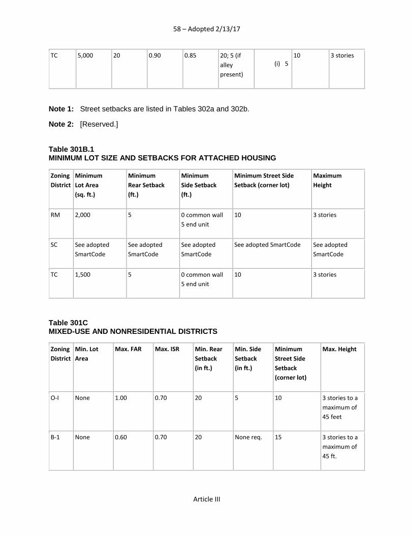
58 – Adopted 2/13/17
Article III
TC 5,000 20 0.90 0.85 20; 5 (if alley present)
(i) 5
10 3 stories
Note 1: Street setbacks are listed in Tables 302a and 302b.
Note 2: [Reserved.]
Table 301B.1 MINIMUM LOT SIZE AND SETBACKS FOR ATTACHED HOUSING
Zoning District
Minimum Lot Area (sq. ft.)
Minimum Rear Setback (ft.)
Minimum Side Setback (ft.)
Minimum Street Side Setback (corner lot)
Maximum Height
RM 2,000 5 0 common wall 5 end unit
10 3 stories
SC See adopted SmartCode
See adopted SmartCode
See adopted SmartCode
See adopted SmartCode See adopted SmartCode
TC 1,500 5 0 common wall 5 end unit
10 3 stories
Table 301C MIXED-USE AND NONRESIDENTIAL DISTRICTS
Zoning District
Min. Lot Area
Max. FAR Max. ISR Min. Rear Setback (in ft.)
Min. Side Setback (in ft.)
Minimum Street Side Setback (corner lot)
Max. Height
O-I None 1.00 0.70 20 5 10 3 stories to a maximum of 45 feet
B-1 None 0.60
0.70 20 None req. 15 3 stories to a maximum of 45 ft.

59 – Adopted 2/13/17
Article III
B-2 None 1.00
0.80 20 None req. 15 3 stories to a maximum of 45 ft.
B-2s See Note 1 See Note 1 See Note 1 See Note 1 See Note 1 See Note 1 See Note 1
SC See adopted SmartCode
See adopted SmartCode
See adopted SmartCode
See adopted SmartCode
See adopted SmartCode
See adopted SmartCode
See adopted SmartCode
TC None 1.00
0.90 20 None req. 5 3 stories to a maximum of 45 ft.
I None 0.60 0.90 20 None req. 10 3 stories to a maximum of 45 ft.
Note 1: This district shall be governed by the zoning classification B-2 as set out in the Zoning Ordinance of the City of Montgomery that was in effect on December 22, 2010.
Section 302. Street Setbacks A. Measurement: The street setback shall be measured from the street right-of-way line. For
streets projected to have wider rights of way in the future, street setbacks shall be measured from the future right-of-way line as established in the Major and Collector Street component of the comprehensive plan.
B. Street Classifications. All street classifications are as established in the Major and Collector Street component of the Comprehensive Plan as adopted by the Planning Commission.
C. Street Setbacks. 1. The minimum setback of a structure from an adjacent street shall be established by
the following tables according to the zoning of the property and the classification of the street.
2. When a subdivision plat establishes a reservation of land for future right-of-way acquisition, the street setback shall be measured from the ultimate right-of-way line.
3. Double frontage lots are subject to the provisions of Section 307.
Table 302.A STREET SETBACKS FOR SINGLE FAMILY STRUCTURES

60 – Adopted 2/13/17
Article III
Zoning Districts Main Streets and Avenues(1) (2) Boulevards and Parkways(1) (2) Local Streets
AG, RE, R40 40 feet 50 feet 40 feet
R30, R20, R15 30 feet 40 feet 30 feet
R10, R5, RM 20 feet 30 feet 20 feet
SC See adopted SmartCode
TC 10 feet
20 feet 10 feet
(1) Lots having vehicular access to these streets shall develop in a manner which avoids back-up movements into the street.
(2) Building setbacks for new developments along existing Major Streets shall conform to the requirements of Section 702.03.A. Separation Distances
Table 302.B STREET SETBACKS FOR MULTI-FAMILY AND NON-RESIDENTIAL DISTRICTS; AND NON-RESIDENTIAL USES IN AG AND R DISTRICTS
Zoning Districts Main Streets and Avenues(2) (3) Boulevards and Parkways(2) (3) Local Streets
AG, RE, R40 40 feet 50 feet 40 feet
R30, R20, R15 30 feet 40 feet 30 feet
R10, R5 20 feet 30 feet 20 feet
RM 10 feet(1) 20 feet(1) 10 feet(1)
O-I 20 feet 20 feet 20 feet
B-1 25 feet 25 feet 25 feet
B-2 25 feet 25 feet 25 feet
B-2s See Note 2
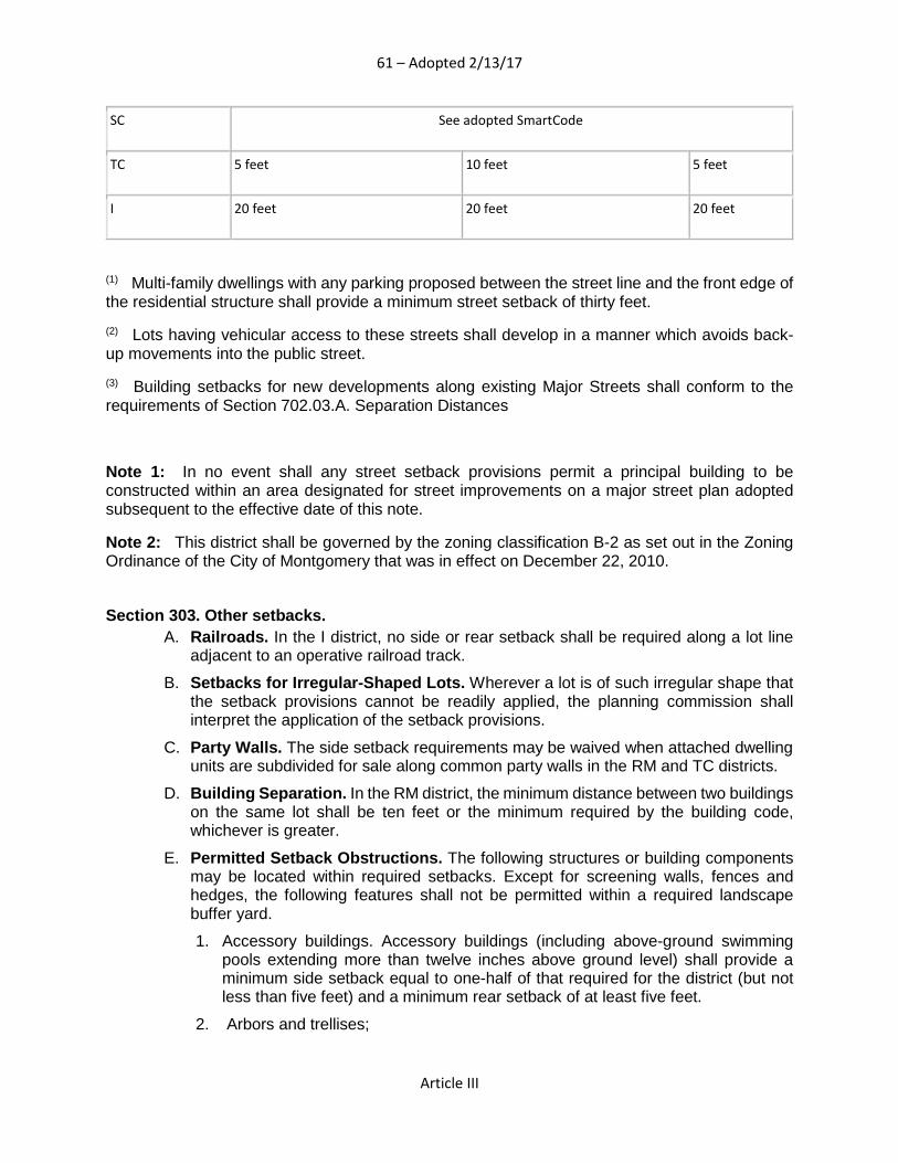
61 – Adopted 2/13/17
Article III
SC See adopted SmartCode
TC 5 feet 10 feet 5 feet
I 20 feet 20 feet 20 feet
(1) Multi-family dwellings with any parking proposed between the street line and the front edge of the residential structure shall provide a minimum street setback of thirty feet.
(2) Lots having vehicular access to these streets shall develop in a manner which avoids back-up movements into the public street.
(3) Building setbacks for new developments along existing Major Streets shall conform to the requirements of Section 702.03.A. Separation Distances
Note 1: In no event shall any street setback provisions permit a principal building to be constructed within an area designated for street improvements on a major street plan adopted subsequent to the effective date of this note.
Note 2: This district shall be governed by the zoning classification B-2 as set out in the Zoning Ordinance of the City of Montgomery that was in effect on December 22, 2010.
Section 303. Other setbacks.
A. Railroads. In the I district, no side or rear setback shall be required along a lot line adjacent to an operative railroad track.
B. Setbacks for Irregular-Shaped Lots. Wherever a lot is of such irregular shape that the setback provisions cannot be readily applied, the planning commission shall interpret the application of the setback provisions.
C. Party Walls. The side setback requirements may be waived when attached dwelling units are subdivided for sale along common party walls in the RM and TC districts.
D. Building Separation. In the RM district, the minimum distance between two buildings on the same lot shall be ten feet or the minimum required by the building code, whichever is greater.
E. Permitted Setback Obstructions. The following structures or building components may be located within required setbacks. Except for screening walls, fences and hedges, the following features shall not be permitted within a required landscape buffer yard.
1. Accessory buildings. Accessory buildings (including above-ground swimming pools extending more than twelve inches above ground level) shall provide a minimum side setback equal to one-half of that required for the district (but not less than five feet) and a minimum rear setback of at least five feet.
2. Arbors and trellises;

62 – Adopted 2/13/17
Article III
3. Awnings, patio covers, or canopies projecting not more than six feet from a building wall over a required setback, and having no supports other than provided by the wall or its integral parts;
4. Chimneys projecting not more than three feet into the required setback, and not exceeding two percent of the overall setback area provided that a minimum setback of three feet to any property line shall be provided;
5. Clothes poles or clothes lines in rear setbacks of residential districts;
6. Curbs and sidewalks;
7. Eaves, gutters or downspouts, projecting into or over required yards not more than twenty-four inches;
8. Fire escapes or staircases, the riser of which shall be at least fifty percent open, subject to the following conditions:
i. In the RM district, the encroachment may be up to three feet into the required yard as long as a minimum setback of two feet from the property is maintained,
ii. In mixed-use and nonresidential districts, the total area of stairway coverage shall not exceed thirty percent of the area of such required yard;
9. Flagpoles having only one structural ground member;
10. Fountains;
11. Heating, ventilation and air conditioning units (including compressors and condensers) for single-family or two-family dwellings, provided exhaust air is directed vertically or otherwise away from the adjacent property line;
12. Mailboxes;
13. Open terraces, including natural plant landscaping;
14. Open, uncovered stoops, including handicap ramps;
15. For single family uses, parking spaces for the handicapped;
16. Recreational equipment in the rear setback in residential districts;
17. Sculpture or other similar objects of art;
18. Signs, subject to the provisions of Section 706;
19. Steps to the principal entrance and necessary landings, together with a railing no more than three feet high, and extending no more than six feet into the setback;
20. Street furniture such as benches, drinking fountains, trash receptacles (not dumpsters), ash trays, light standards or directional signs. Dumpsters may encroach on the required rear setback;
21. In-ground swimming pools extending twelve inches or less above ground level in side or rear setback areas, provided that a minimum setback of five feet to any property line shall be provided;
22. Trees, shrubs, flowers, hedges or other features of natural growth;
23. Vehicular parking areas and associated driveways, except within landscape buffer yards or within the required street setback of the TC district;

63 – Adopted 2/13/17
Article III
24. Screening Walls or Fences;
25. An uncovered deck that is located at least ten feet from the rear property line, does not encroach on required side setbacks and has a maximum deck elevation no greater than the average finished first floor elevation of the principal building as established by the front entrance;
26. Wells;
27. Utility transmission lines and associated structures, such as poles;
28. Satellite dishes not exceeding eighteen inches in diameter; and,
29. Yard and service lighting fixtures and poles.
F. Reserved.
Section 304. Accessory Buildings It is the intent of this Ordinance that there shall be only one main structure and permitted accessory structures on any lot used for detached dwelling units used for residential purposes.
304.01. No accessory structure in the single-family residential zoning districts shall be constructed or moved upon a lot until the construction of the main building has actually been commenced. 304.02. Accessory structures on any lot shall conform to the following regulations:
A. Location on Lot: Detached accessory structures shall: 1. Not be erected in any required front yard; 2. Be at least fifteen (15) feet from any other structure on the same lot; and 3. Be at least ten (10) feet from any easement line.
B. Height: Accessory structures shall not exceed two stories or 25’ in height.
C. Coverage: The building coverage of an accessory structure, complying with the district setbacks, shall not cover more than forty (40) percent of any required side yard or twenty (20) percent of any required rear yard. These floor area controls shall not apply to accessory structures proposed on lots where agricultural activities and domestic animals/wildlife are permitted.
Section 305. Building Height Controls No structure shall be erected, converted, enlarged, reconstructed, moved or structurally altered to exceed the height limit herein established for the district in which such structure is located except as may be otherwise provided in these regulations.
305.01. Heights Restricted: Every part of or complete building or structure that is constructed or altered shall not exceed the lowest height requirement of the zoning district in which the building or structure is located or the following height regulations unless exempted in this section.
305.02. Exemptions from Height Requirement:
64 – Adopted 2/13/17
Article III
A. Height limits shall not apply to portions of buildings and structures that are not
inhabited or regularly used by people. Such portions of buildings and structures include church steeples, farm structures (e.g. silos), chimneys, flag poles, public utility poles, radio and television towers and aerials, and industrial structures (e.g. cooling towers) required by the manufacturing process.
Section 306. Temporary Buildings and Material Storage. 306..01. Temporary Structures: Mobile buildings and temporary structures shall only be used on a temporary basis as an on-site construction office in connection with the construction or remodeling of a permanent, site built building or structure. Temporary permits, when granted, shall only be valid for the period specified as need for completion of site preparation, construction or remodeling, and as indicated on the permit.
306..02. Temporary Shelters: Temporary, protective shelters approved by the Alabama Emergency Management Agency (AEMA) may be used to provide temporary, emergency living quarters in the locations and for the durations as agreed to by AEMA and the Planning Commission.
306.03. Building materials or temporary structures for construction purposes shall not be placed or stored on any lot or parcel of land located in an Agricultural, Residential, or Business Zone District more than one month prior to the commencement of construction.
Section 307. Non-Standard Lots. 307.01. Corner Lots. For corner lots, the street frontage with the least distance shall be considered as the front of the lot when applying other zoning requirements. When the lot frontages are approximately the same distance the owner shall declare which frontage is the front.
A. Both street fronts of a corner lot shall be considered as front yards for setback purposes.
B. Corner lots shall be 20' wider than interior lots.
307.02. Double Front (Through) Lots For double front lots, the street frontage with the least distance shall be considered the rear of the lot. Both street fronts of a double front lot shall be considered as front yards for setback purposes.
Section 308. Manufactured Homes.
A. Manufactured homes may be used for sales offices for outside sales or merchandise such as mobile homes, camping trailers, or automobiles subject to the following criteria:

65 – Adopted 2/13/17
Article III
• All wheels, axles, and towing apparatus must be removed and unit placed on a permanent foundation;
• Unit must be connected to all basic utilities; • A valid HUD Certificate must accompany unit.
B. The use of manufactured homes or trailers for other business or industrial uses may be allowed temporarily by special permit issued by the Planning Commission. Said permit to be for a period to be established by the Planning Commission.
Note: See Article IX “Manufactured Home Regulations” for Additional Manufactured Home Standards. Section 309. Home Repair and Remodeling. All home remodeling, repair, and modification shall be permitted provided that the minimum yard requirements are met for the district involved. Section 310. RESERVED

66 – Adopted 2/13/17
Article V
ARTICLE V. Land Use Development Standards
Section 500. General Provisions
A. Uses specified in a zoning district as "permitted" shall, after filing a written application with the Building Official meeting the requirements of all other codes, ordinances and regulations, be issued a building permit except when a Site Plan Review by the Planning Commission is required.
B. In addition to the zone district bulk, landscaping, parking and other regulatory provisions of this title, supplemental development standards may apply to specific land uses when located in certain zone districts. The zoning district land use table references those specific uses which must comply with supplemental development standards as:
PC - Permitted with conditions
A - Permitted as accessory to another principal use
C. Land use development standards are necessary because certain land uses are more unique or impacting than other uses in the same zone district and therefore conditions are established to insure compatibility with surrounding land uses. These development standards are intended to lessen and minimize incompatible land use relationships. Because the potential impacts cannot be satisfactorily predetermined for every location, some land uses are permitted in a zone district only as a special exception. Finally, other uses are uniquely incidental to other principal land uses and are appropriate when certain minimum standards are satisfied.
D. No zoning permit shall be issued for any development or use of land listed as PC or A in the zoning district land use table, unless the use is in compliance with all applicable land use development standards. Where development standards of this chapter are in conflict with the minimum bulk regulations of Section 301, the more restrictive standard shall apply.
Section 501. Uses Permitted with Conditions (PC)
501.A. Applicability. The land use development standards in this article apply to uses permitted with conditions, referenced as "PC" in the zoning district land use table, Section 203.
501.B. General Provisions A. Ordinance Compliance. The proposed use shall comply with all applicable regulations,
including any specific standards for the proposed use set forth in this title.

67 – Adopted 2/13/17
Article V
B. Integrity of Adjacent Areas. A conditional use permit shall be granted provided that the Planning Commission finds that the use is so designed, located and proposed to be operated that the public health, safety and welfare will be protected. The Commission shall determine from its review that adequate public facilities are available to accommodate the proposed use, and that approval of the permit will not adversely affect other property in the area to the extent that it will impair the reasonable long-term use of those properties. The Commission may request a report from the Town Planning Director regarding long-range plans for land use development.
C. Design and Architectural Compatibility. The operational and physical characteristics of the conditional use shall not adversely impact abutting properties, including those located across street frontages. Site design and architectural features which contribute to compatibility include, but are not limited to, landscaping, drainage, access and circulation, building style and height, bulk, scale, setbacks, open areas, roof slopes, building orientation, overhangs, porches, ornamental features, exterior materials and colors.
D. Natural Features. Uses permitted with conditions in residential zone districts must comply with the nonresidential tree replacement regulations, and other natural site features shall be preserved to the greatest extent possible so as to minimize the intrusion of nonresidential structures and parking areas.
E. Traffic Impact. The applicant shall demonstrate how the proposed use will not adversely affect the safety and convenience of vehicular and pedestrian circulation in the area. The Planning Commission may require a traffic impact study for any use permitted with conditions.
F. Special Conditions. Notwithstanding a finding by the Planning Commission that a special exception application satisfies the minimum development standards of this article, the Commission may restrict the hours of operation, establish permit expiration dates, require extraordinary setbacks and impose other reasonable conditions necessary to protect the public health, safety and welfare.
G. Agricultural Uses.
a. All non-residential and non-agricultural uses permitted in the AG zone are required to have direct frontage on an all-weather hard surface public right-of-way either with a functional classification of arterial or collector or be within 400 feet of a US Highway or Interstate.
b. All non-residential and non-agricultural uses permitted in the AG zone are required to be constructed with a residential or agricultural character. This may include the use of porches, sloped roofs, and other features typically found in non-commercial building forms. Parking shall not be a dominant feature between the building and the public right-of-way.
501.C. Residential uses.
(Refer to zoning district land use table)
A. Two-Family Dwellings. In the AG, RM and TC districts, two-family dwellings in a single residential structure may be permitted on any lot provided:
1. The lot has been zoned AG, RM, or TC; legally created; and is of record in the office of the Town Clerk prior to January 1, 2014; or
68 – Adopted 2/13/17
Article V
2. The lot is created by the subdivision of a parcel of land into no more than three lots; or
3. The following:
a. The lot is part of a subdivision,
b. The subdivision has been approved by the Planning Commission, and
c. The total number of lots permitting two-family dwellings within the subdivision shall be limited to not more than twenty-five percent of the total number of lots within the subdivision, and
d. The lots permitting two-family dwellings are identified on the final plat and the locations of the two-family dwellings have been approved by the planning commission so as to minimize the impact on any existing single family development, and
e. The final subdivision plat has been recorded in the office of the Town Clerk; or
4. The lot is part of a planned unit development authorizing two-family structures as enacted by the Town Council.
B. Multi-family Housing. In the RM and TC districts, multi-family buildings may be permitted on a lot provided:
1. Maximum density does not exceed 12 units per acre.
2. Within TC districts, multi-family housing shall be in the form of townhouses, live/work units, or units above office or retail uses within mixed-use buildings.
C. Accessory Dwelling, Detached. A detached self-sufficient dwelling unit shall be allowed accessory to a principal structure subject to the following standards:
1. Applicability. While the following conditions listed below apply to a detached accessory dwelling, they do not counter-act or over-ride the applicable life safety standards found in the applicable codes adopted by the Town of Pike Road.
2. Lot Area. The lot area on which the detached accessory dwelling is to be placed shall comply with Tables in Section 301.
3. Density. A detached accessory dwelling is not allowed if the maximum number of dwelling units permitted for the lot has been met.
4. Ownership.
a. No more than one detached accessory dwelling shall be permitted on a single lot in conjunction with the principal structure.
b. The detached accessory dwelling cannot be divided from the property ownership of the principal dwelling.
c. The detached accessory dwelling shall be owned by the same person as the principal structure and one of the two dwellings shall be owner-occupied.
5. Setbacks. The setbacks for a detached accessory dwelling shall meet the setbacks found in Section 304 for accessory buildings.
6. Site Requirements.
69 – Adopted 2/13/17
Article V
a. The detached accessory dwelling is to be subordinate to the principal structure and therefore shall be placed to the rear of the lot.
b. There shall be a minimum separation of fifteen feet between the principal structure and the detached accessory dwelling.
7. Driveway Access.
a. On lots with no alley access, the lot shall have no more than one curb-cut from a public street for driveway access to the principal structure as well as the detached accessory dwelling.
b. Parking accessed from a public street shall be limited to one driveway for the lot with a maximum width of twelve feet.
c. If the detached accessory dwelling is part of a garage and an alley exists to the rear of the lot, the garage shall be alley loaded and no curb-cut provided from the front of the lot.
8. Bulk and Massing.
a. The footprint of a single-story detached accessory dwelling shall not exceed seven hundred square feet or fifty percent of the first floor area of the principal structure, whichever is less.
b. The footprint of a two-story detached accessory dwelling shall not exceed five hundred fifty square feet or forty percent of the first floor area of the principal structure, whichever is less.
c. The detached accessory dwelling shall maintain a proportional mass, size, and height to ensure it is not taller than the principal structure on the lot.
d. The roof ridge line of the detached accessory dwelling must be less than the primary structure.
9. Design Standards.
a. Detached accessory dwellings with a second story dwelling unit shall enclose the stairs interior to the structure and properly fire rate them per the applicable life safety standards found in the code editions adopted by the Town of Pike Road.
b. The detached accessory dwelling shall be of similar style, design and material color as used for the principal structure and shall use similar architectural characteristics, including roof form and pitch, to the existing principal structure.
c. The detached accessory dwelling may have dormers that relate to the style and proportion of windows on the detached accessory dwelling and shall be subordinate to the slope of the roof by covering no more than fifty percent of the roof.
d. Detached accessory dwellings may have dormers that are setback a minimum of two feet from the exterior wall.
10. Restrictive Covenant. Prior to the issuance of a permit, an instrument shall be prepared and recorded with the Town Clerk covenanting that the detached accessory dwelling is being established accessory to a principal structure and may only be used under the conditions listed above.

70 – Adopted 2/13/17
Article V
D. Manufactured Home Community. See Article IX. Manufactured Housing Regulations.
E. Manufactured Home. See Article IX. Manufactured Housing Regulations.
F. Mobile Home. See Article IX. Manufactured Housing Regulations.
501.D. Institutional Uses
(Refer to zoning district land use table)
A. Cemetery. 1. Lot Size. The minimum site area shall be ten acres. Private family cemeteries and
cemeteries accessory to a religious institution shall be on a one-acre lot, minimum.
2. Street Standard. For cemetery developments of twenty-five acres or greater, primary access shall be from a major street.
3. Landscape Buffer Yard. Where the perimeter of a cemetery abuts a residential zone district or district permitting residential use, there shall be screening in the form of landscape buffer yard Standard A along common property lines.
4. The following accessory uses shall be permitted: Mausoleums, columbariums, chapels, funeral homes and other facilities for burial and ceremonial purposes.
B. Church. The following standards shall be applied to a church located within a residential district to ensure compatibility with nearby residential uses.
1. Pre-Existing Facilities. A church having a valid use and occupancy permit on the effective date of the ordinance codified in this chapter may expand subject to demonstrating compliance only with the general provisions of Section 501.B, and the off-site parking requirements of subsection (B)(2) of this section. The standards of subsection (B)(3) of this section shall not apply to pre-existing facilities.
2. Pre-Existing Facilities—Off-Site Parking. Approval of an off-site parking lot shall be contingent upon a demonstration that the following standards have been met:
a. The appellant shall demonstrate by a parking study, reviewed by the Town of Pike Road Town engineer, that the minimum number of parking spaces required by Section 701 cannot be developed on the same zone lot containing the place of worship;
b. The amount of off-site parking shall not exceed the actual needs of the place of worship as demonstrated by the parking study;
c. There shall be no vacant property adjacent to the place of worship on the same block face;
d. The off-site parking area shall abut a street upon which the zone lot of the church abuts;
e. Vehicular access shall be restricted to a street upon which the zone lot of the place of worship abuts;
f. All off-site parking spaces shall be within two hundred feet of the zone lot boundary of the place of worship;
71 – Adopted 2/13/17
Article V
g. Pedestrian cross walks shall be provided to connect the off-site parking area and the place of worship if determined necessary by the Town of Pike Road town engineer; and
h. All lighting shall be shielded so that substantially all directly emitted light falls within the property. The parking area shall only be illuminated when in use.
3. New Facilities. New churches, constructed after the effective date of the ordinance codified in this chapter shall be subject to the following performance standards.
a. Minimum Site Size. Land area shall be provided at the rate of .005 acre for every seat in the sanctuary/assembly area. In areas considered by the Planning Commission to be predominately developed, and where assembling land to satisfy this site size standard is not practical, the Commission may waive the minimum site size requirement, based on a determination that the proposed facility can be designed and operated in a manner which will not adversely impact abutting properties or the surrounding neighborhood.
b. Street Standard. A church shall provide principle vehicular access via a street that at a minimum functions, or is otherwise classified, as indicated below:
i. Up to 300 seats: Any Local Street or a temporary dead-end street;
ii. 301 to 1000 seats: Any Main Street or Avenue;
iii. more than 1000 seats: Any Boulevard or Parkway, or two intersecting major streets.
The Planning Commission may waive the above street standards based on a recommendation from the town engineer that the projected volume of traffic, to be generated by the proposed church, can be safely and efficiently accommodated by the existing local street network without adversely impacting the surrounding neighborhood.
c. Landscape Buffers. Screening and buffering in the form of a standard B landscape buffer yard shall separate all structures and parking areas from an abutting residential property.
d. Cemetery. A cemetery may be permitted by the board as an accessory use to a religious institution.
C. Community Center. 1. Setback. Where any building or outdoor storage area, excluding passenger car
parking lots, abuts a residential zone district or district permitting residential use, there shall be a minimum setback of one hundred feet from the property line.
2. Landscape Buffer Yard. Along all residential zone districts and districts permitting residential use, screening in the form of landscape buffer yard standard A shall be applied along common property lines.
3. Street Standard. At a minimum, driveway access shall be from a major street.
D. Cultural Center. 1. Lot Size. The minimum lot area shall be three times the minimum lot area
requirement of the zone district or two acres, whichever is less.
2. Setback. Where active outdoor areas abut a residential zone district or district permitting residential use, there shall be a minimum setback of one hundred feet.

72 – Adopted 2/13/17
Article V
3. Landscape Buffer Yard. Along all residential zone districts and districts permitting residential use, screening in the form of landscape buffer yard Standard B shall be applied along common property lines.
4. Street Standard. At a minimum, primary access shall be from any major street which has primary access to a Boulevard or Parkway.
E. Day Care Center. Day care centers shall be classified according to the ranges below. For existing facilities in residential zone districts, a special exception permit shall be required for any proposed increase which upgrades the classification.
1. Class I—Five to Twenty-Five Individuals.
a. Lot Size. The minimum lot size shall be one-half acre.
b. Street Standard. Driveways may have access on any street.
c. Landscape Buffer Yard. Where the outdoor play area abuts any portion of a residential zone district or district permitting residential use, screening in the form of landscape buffer yard Standard A shall be provided.
2. Class II—Twenty-Six to Fifty Individuals.
a. Lot Size. The minimum lot size shall be one acre.
b. Street Standard. At a minimum, driveways shall have access on a major street.
c. Landscape Buffer Yard. Where the day care center abuts a residential zone district or district permitting residential use, there shall be screening in the form of landscape buffer yard Standard B along common property lines.
3. Class III—Fifty-One to Seventy-Five Individuals.
a. Lot Size. The minimum lot size shall be one and one-half acre.
b. Street Standard. At a minimum, driveways shall have access on a major street.
c. Landscape Buffer Yard. Where the day care center abuts a residential zone district or district permitting residential use, there shall be screening in the form of landscape buffer yard Standard C along common property lines.
4. Class IV—More than Seventy-Five Individuals.
a. Lot Size. The minimum lot size shall be two acres.
b. Street Standard. Driveways shall have access on a major street.
c. Landscape Buffer Yard. Where the day care center abuts a residential zone district or district permitting residential use, there shall be screening in the form of landscape buffer yard Standard D along common property lines.
5. Spacing. No day care center shall locate within one thousand feet of another day care center, measured in a direct line from property line to property line and including any public right-of-way.
6. Play Area. If an outdoor play area is provided, it shall be fenced and attached to the day care structure in a manner which minimizes noise impacts on neighboring residences.
7. All requirements of the state that pertain to the use and operation of the facility shall be met.

73 – Adopted 2/13/17
Article V
8. Preferred Locations. The land use development standards may be waived by the Planning Commission if the site meets any one of the criteria below. The minimum street standard may be waived only upon a favorable recommendation of the town engineer. Preferred residential locations are where:
a. The day care center will be accessory to another institutional use; or
b. The day care center will be the principal use serving as an adaptive reuse of a vacant institutional facility or nonresidential structure; or
c. The day care center lot abuts and has common street frontage with a nonresidential or multifamily zone district.
501.E. Educational uses.
(Refer to zoning district land use table)
A. Community Education. 1. Setback. Where elementary and middle school structures and outdoor activity
grounds abut a residential zone district or district permitting residential use, there shall be a minimum setback of fifty feet. Where high school structures and outdoor activity grounds abut a residential zone district or district permitting residential use, there shall be a minimum setback of one hundred feet.
3. Landscape Buffer Yard. Screening in the form of landscape buffer yard Standard B shall be applied along property lines abutting residential lots.
4. Street Standard. At a minimum, educational facilities shall have driveway access on streets that function at the minimum street standards below:
a. Elementary: Any Local Street;
b. Middle: Any Main Street or Avenue;
c. High: Any Boulevard or Parkway; or the intersection of any two major streets.
5. Community education facilities having a valid use and occupancy permit on the effective date of the ordinance codified in this code, and which cannot satisfy the locational or design standards of this section, may petition the Board of Zoning Adjustment as a special exception use under the provisions of Section 502 of this chapter.
B. Vocational School. 1. Landscape Buffer Yard. Screening in the form of landscape buffer yard Standard B
shall be applied along property lines abutting residential lots.
2. Setback. Whenever a vocational school structure intended for vehicle repair, truck driving, manufacturing, production, or industrial equipment abuts a residential zone district or district permitting residential use, there shall be a minimum setback of fifty feet.
3. Street Standard. At a minimum, a vocational school shall have driveway access on a major street.

74 – Adopted 2/13/17
Article V
501.F. Office uses.
(Refer to zoning district land use table)
A. Financial Institution. A financial institution shall be limited to two thousand five hundred square feet of gross floor area per establishment.
B. General Office. A general office shall be limited to two thousand five hundred square feet of gross floor area per establishment.
C. Leasing/Sales Office. A leasing/sales office shall be limited to two thousand five hundred square feet of gross floor area per establishment.
501.G. Medical uses.
(Refer to zoning district land use table)
A. Medical Office. Medical offices shall be limited to two thousand five hundred square feet of gross floor area per establishment, with no more than two establishments per lot.
B. Veterinarian. The building footprint of veterinary offices and facilities shall be limited to two thousand five hundred square feet with no more than two establishments per lot. The following shall apply:
1. Animal boarding shall occur within completely enclosed structures.
2. Landscape Buffer Yard. Outdoor exercise yards shall be completely fenced. Where such outdoor activities abut a residential zone district, landscape buffer yard Standard B shall apply along common property lines. A six-foot opaque vertical fence may substitute for landscaping; however the buffer yard width of landscape buffer yard Standard B shall still apply along common property lines.
3. Boarding Kennel. Kennels for the boarding of companion animals not undergoing medical treatment are permitted as an ancillary use subject to the following conditions.
a. No more than thirty percent of the gross floor area of the veterinary clinic may be used as a boarding kennel.
b. No outdoor kennels or runs are permitted.
c. No part of any building or structure in which animals are housed shall be closer than fifty feet from any existing residence located on an adjacent parcel.
C. Outpatient Clinic. Outpatient clinics shall be limited to clinics with no more than six thousand square feet, with use being limited to occupational health, which is to be defined as those clinics that provide outpatient services limited to the treatment of minor work-related injuries, physical examinations and drug and alcohol screenings.
501.H. Commercial uses.
(Refer to zoning district land use table)
A. Animal Boarding Facility.

75 – Adopted 2/13/17
Article V
1. Setback. No part of any building or structure in which animals are housed shall be closer than two hundred feet, and no kennel run shall be located within one hundred feet, from any existing residence.
B. Automated Teller Machine (ATM). Where a drive-up ATM kiosk abuts a residential zone district or district permitting residential use, a minimum setback of twenty feet shall be provided and landscape buffer yard Standard B shall be applied within the setback.
C. Automobile Convenience. 1. Minimum Street Frontage. Each parcel shall have a minimum street frontage of one
hundred feet on each abutting street.
2. Gasoline Pumps. Gasoline pumps shall be at least thirty feet from any property line, at least fifty feet from any residentially zoned property, and a minimum of thirty feet from any public right-of-way.
3. Automatic Car Wash.
a. One automatic car wash, capable of washing only one car at a time is permissible. It shall be located fifty feet away from any residential zone district or district permitting residential use.
b. All washing facilities shall be located within a building which is enclosed except those openings necessary for vehicular and pedestrian access. Such openings shall not face any adjacent residentially-zoned property.
4. Convenience Retail. Convenience stores may be permitted on the site of a service station, including restaurants co-located within the same building. Convenience stores shall be limited to two thousand five hundred square feet of gross floor area, maximum. Parking shall be provided for each separate use pursuant to Section 701.
6. Outdoor Loudspeakers. There shall be no outdoor loudspeakers or public address systems.
7. Refuse Storage and Disposal. Trash areas shall be provided and screened on at least three sides from public view by an opaque impact-resistant fence of sufficient height to screen the dumpster(s).
D. Bed and Breakfast Inn. The bed and breakfast inn shall be limited to no more than ten guest rooms.
E. Custom Assembly. 1. In the O-I, B-1, and TC zone districts, custom assembly shall be limited to five
thousand square feet of gross floor area per establishment.
2. In all zone districts, structures used for custom assembly activities shall not have any openings facing any residential zone district other than those required for emergency egress.
F. Donation center, Drop-off. 1. No retail sales shall be conducted at the center.
2. No sorting or distribution of collected materials may occur on-site.
3. Street Standard. At a minimum, donation centers shall have driveway access on any major street.
76 – Adopted 2/13/17
Article V
G. Garden Center or Nursery 1. Landscape Buffer Yard. The Planning Commission shall have the authority to require
landscape buffering for properties abutting a residentially zoned property;
2. Lighting. All lighting shall be shielded so that substantially all directly emitted light falls within the property. No illumination in excess of one-half foot candle shall be permitted across the boundary of any residential property or a public street or alley; and
3. On-Site Storage and Use of Compost and Organic Matter. All compost and/or organic matter on the site:
a. Shall not cover more than ten percent (10%) of the total area of the property;
b. Compost piles abutting adjacent properties must not be visible from adjacent property (shielded from view by shrubbery or an enclosure); and
c. Shall be located to prevent the water that has come in contact with the compost from flowing onto adjacent property or into natural or human-made storm channels.
4. Drainage. The site shall be designed and maintained to prevent water from irrigation and/or other activities and/or fertilizer from draining onto adjacent property.
5. Refuse Storage and Disposal. Trash areas shall be provided and screened on at least three (3) sides from public view by an opaque impact-resistant fence of sufficient height to screen the dumpster(s).
6. Parking. Where the minimum parking space standard requires additional parking area to be constructed, such area shall comply with the perimeter parking lot landscaping according to Section 702 of this Code.
H. Home Improvement Sales. In the B-1 and TC zone districts, each establishment shall be limited to ten thousand square feet of gross floor area, maximum.
I. Kennel/Stable. 1. Setback. No part of any building or structure in which animals are housed shall be
closer than two hundred feet, and no kennel run shall be located within one hundred feet, from any existing residence, other than one owned or occupied by an owner or operator of the kennel or stable.
2. Riding Ring. For a horse, no riding ring, including jumps and corrals, shall be located closer than one hundred feet to any property line.
3. On-Site Waste Collection. All on-site waste shall be housed either within the kennel building or an accessory structure, and all waste shall be disposed of in a sanitary fashion no less frequently than one time per week. The drainage of all liquid by-products from the kennel shall be discharged into a permitted sanitary sewer line or septic tank and shall not be disposed of by way of storm sewers, creeks, streams or rivers.
J. Restaurant, Fast-Food/Restaurant, Full-Service/Restaurant, Take-Out. 1. Each establishment shall be limited to five thousand square feet of gross floor area,
maximum.
2. Drive-through windows and stacking shall be located to minimize views from the street.

77 – Adopted 2/13/17
Article V
K. Retail. 1. Each grocery store shall be limited to fifty thousand square feet, maximum. All other
retail uses shall be no larger than twenty thousand square feet.
2. In the I zone district, each establishment shall be limited to two thousand five hundred square feet of gross floor area, maximum.
L. Self-Service Storage. 1. Each storage unit shall be fully enclosed by walls and roof and shall not exceed six
hundred square feet in area.
2. Outdoor storage shall not be permitted, except for the parking of recreational vehicles, boats and trailers.
3. Storage units shall not be used for the manufacture, processing or assembly of goods, the sale of goods or personal services on the premises, or customer pickup. Active use or activities such as the practice of musical instruments shall not be permitted within individual storage units or anywhere else on site.
4. Storage units shall not have service door openings within thirty-five feet of a residential zone district.
5. Service doors facing a public street or a residential zone district shall be screened by a solid wall or opaque fence with a minimum height of six feet, in addition to any required landscape buffer yard. Chain link fencing, barbed wire and razor wire is prohibited along such public street or residential zone district.
M. Tavern. Establishments shall be limited to two thousand five hundred square feet of gross floor area per establishment, with no more than one establishment per lot.
501.I. Communication uses. (Refer to zoning district land use table)
A. Printing and Publishing. Each establishment shall be limited to five thousand square feet of gross floor area, maximum.
B. Radio/TV/Satellite Tower. 1. The applicant shall demonstrate that existing towers, buildings, or structures within
the proposed service area cannot accommodate the equipment planned to be located on the proposed tower. Factors to be considered by the board of zoning adjustment in evaluating the practicality of siting the proposed equipment on existing or approved towers shall include structural capacity, radio interference, and geographic service area requirements.
2. Height. The board of zoning adjustment shall determine the maximum height of a radio/TV/satellite tower facility based on all engineering concerns having been addressed to the board's satisfaction, and that the proposed facility shall not be detrimental to surrounding properties.
3. Landscape Requirements: Along all residential zone districts and districts permitting residential use, screening in the form of Landscape Buffer Yard Standard A shall be applied.

78 – Adopted 2/13/17
Article V
a. The maintenance standards set forth in Section 701 shall be applicable to all required landscaping.
b. Landscape Plans: Landscape plans that comply with the landscaping requirements of this ordinance shall be required at the time of applying for a building permit or final site plan.
4. Setbacks. Towers shall be set back from all property lines on which the tower is located by the distance equal to the height of the lowest engineered failure point on the proposed structure or the height of the tower.
5. Lights. No lights shall be permitted on the tower except such lighting that is required by state or federal law.
6. Exemptions: Notwithstanding any other provision of this title to the contrary, the following circumstances shall be permitted by right:
a. Concealed Devices: Communication equipment or any new structure that is integrated as an architectural feature of a structure so that the purpose of the facility for providing wireless services is not readily apparent to a casual observer or which is concealed within a building or structure so that it is architecturally indiscernible may be permitted in all zoning districts subject to building permit procedures and standards. Architecturally indiscernible shall mean that the addition or feature containing the antenna is architecturally harmonious in such aspects as material, height, bulk, scale and design with the building or structure to which it is to be a part.
b. Additions to Existing Structures in any Zoning District: An antenna, a dish or transmitter may be placed inside or on an existing structure, including but not limited to telephone service towers, steeples, silos, spires, utility water tanks or towers, athletic field lighting poles, utility poles and similar structures, subject to building permit procedures and standards and provided the addition of the antenna and any supporting structure shall not exceed the height provisions of this ordinance without obtaining a special exception permit.
501.J. Industrial uses.
(Refer to zoning district land use table)
A. Building Contractor Supply. 1. No outdoor storage shall be permitted.
2. Loading Docks. Where the site abuts a residential zone district or district permitting residential use, the building wall facing such lot shall not have any service door openings or loading docks oriented toward the residential zone district.
3. Landscape Buffer Yard. Where such facilities are on a lot adjacent to a residential zone district or district permitting residential use, there shall be screening in the form of landscape buffer yard Standard D applied along common property lines.
4. Maximum Building Size. The gross floor area shall be limited to twenty-five thousand square feet.
B. Distributive Business/Wholesale.

79 – Adopted 2/13/17
Article V
1. No outdoor storage shall be permitted.
2. Loading Docks. Where the site abuts a residential zone district or district permitting residential use, the building wall facing such lot shall not have any service door openings or loading docks oriented toward the residential zone district.
3. Landscape Buffer Yard. Where such facilities are on a lot adjacent to a residential zone district or district permitting residential use, there shall be screening in the form of landscape buffer yard Standard D applied along common property lines.
4. Maximum Building Size. The gross floor area shall be limited to twenty-five thousand square feet.
C. Manufacturing, Light. All light manufacturing activities shall be within completely enclosed structures.
1. No outdoor storage shall be permitted.
2. Loading Docks. Where the site abuts a residential zone district or district permitting residential use, the building wall facing such lot shall not have any service door openings or loading docks oriented toward the residential zone district.
3. Landscape Buffer Yard. Where such facilities are on a lot adjacent to a residential zone district or district permitting residential use, there shall be screening in the form of landscape buffer yard Standard D applied along common property lines.
4. Maximum Building Size. The gross floor area shall be limited to forty thousand square feet.
D. Manufacturing, Medium. Any medium manufacturing activity that stores materials outdoors shall construct an opaque fence to screen the ground-level view of any residential use located in a zoning district permitting residential uses. Materials shall not be piled or stacked higher than the opaque fence.
E. Warehouse. 1. Outdoor Storage. No outdoor storage shall be permitted.
2. Loading Docks. Where the site abuts a residential zone district or district permitting residential use, the building wall facing such lot shall not have any service door openings or loading docks oriented toward the residential district.
3. Landscape Buffer Yard. Where such facilities are on a lot adjacent to a residential zone district or district permitting residential use, screening in the form of landscape buffer yard Standard D shall be provided along common property lines.
4. Maximum Building Size. The gross floor area shall be limited to twenty-five thousand square feet.
501.K. Waste management uses.
(Refer to zoning district land use table)
A. Construction/Demolition Landfill. 1. Lot Size. The minimum lot area shall be five acres.

80 – Adopted 2/13/17
Article V
2. Street Standard. Driveway access can be from any local street, provided that street is not bounded by any residential zoning district from the driveway access point to the street's intersection with a major street.
3. Setback. All buildings, structures, storage containers and areas, and vehicle loading/unloading areas shall be located a minimum of one hundred feet from any property line, two hundred fifty feet from any residential zoning district boundary, and five hundred feet from any residential structure, and further, the facility shall not be located less than two thousand feet from the property line of any school or park.
4. Landscape Buffer Yard. Along all residential zone districts and districts permitting residential use, screening in the form of landscape buffer yard Standard D shall be applied. In addition, the entire facility shall be enclosed by a chain-link-type fence at least eight feet in height.
5. Recycling Facility. If located on the same lot as the construction/demolition landfill, a recycling facility shall be permitted as an accessory use provided it accepts construction/demolition waste only. The provisions of Section 502 shall not apply to an accessory use.
6. All loading, unloading, compacting, sorting, processing or storage shall take place within a completely enclosed building.
B. Sanitary Landfill. 1. Lot Size. The minimum lot area shall be one hundred acres.
2. Setback. All buildings, structures, storage containers and areas, and vehicle loading/unloading areas shall be located a minimum of one hundred feet from any property line, two hundred fifty feet from any residential zoning district boundary, and five hundred feet from any residential structure, and further the facility shall not be located less than two thousand feet from the property line of any school or park.
3. Landscape Buffer Yard. Along all residential zone districts and districts permitting residential use, screening in the form of landscape buffer yard Standard D shall be applied along common property lines.
4. Street Standard. At a minimum, driveway access shall be from a Boulevard or Parkway.
501.L. Recreation and entertainment uses.
(Refer to zoning district land use table)
A. Camp. 1. Lot Size. The minimum lot area shall be ten acres plus one acre per fifty campers.
2. Setback. All structures and activity areas, including outdoor amphitheaters, ballfields, tennis courts, swimming pools, parking or unloading areas, shall be located a minimum of one hundred fifty feet from any residential zoning district boundary or any residential structure.
3. Landscape Buffer Yard. Along all residential zone districts and districts permitting residential use, screening in the form of landscape buffer yard standard B shall be applied along common property lines.

81 – Adopted 2/13/17
Article V
4. Traffic Management Study. The town engineer may require a traffic management study to determine what, if any, improvements may be necessary to accommodate projected traffic to and from the camp facility.
5. Parking. Adequate off-street parking and loading/unloading areas shall be provided on-site, including all accessory uses.
6. Lighting. All light and glare shall be directed on-site to ensure surrounding properties are not adversely impacted by increases in direct or indirect ambient lighting levels. Lighting of outdoor amphitheater, ballfields or other outdoor recreation/activity areas shall be prohibited after ten p.m. any day of the week.
7. Outdoor Loudspeakers. There shall be no outdoor loudspeakers or public address systems, except as may be needed for emergency purposes.
8. Refuse Storage and Disposal. Trash areas shall be provided and screened on at least three sides from public view by an opaque impact-resistant fence of sufficient height to screen the dumpster(s).
9. Uses. All principal and accessory uses shall be labeled on the site plan along with the proposed square footage of each use, including the number of overnight accommodation units. Any changes to a principal or accessory use, including modifications or additions, shall be approved as an amendment to the conditional use permit by the Planning Commission, as provided in Section 1002 of this title.
B. Country Club. 1. Lot Size. The minimum lot area shall be fifty acres.
2. Setback. Where any building or outdoor storage area, excluding passenger car parking lots, abuts a residential zone district or district permitting residential use, there shall be a minimum setback of one hundred feet from the property line.
3. Landscape Buffer Yard. Along all residential zone districts and districts permitting residential use, screening in the form of landscape buffer yard Standard A shall be applied along common property lines.
4. Street Standard. At a minimum, driveway access shall be from a major street.
C. Driving Range. 1. Street Standard. At a minimum, driveway access shall be from a major street.
2. Location. In the AG district, a driving range shall only be permitted in a floodplain, as designated by the Army Corps of Engineers. In any residential district, a driving range shall only be permitted in conjunction with a golf course. The driving range shall be located so that it is one hundred feet away from any residential zoning district boundary or the property line of any property containing a residential use.
3. Lighting. All light and glare shall be directed on-site to ensure surrounding properties are not adversely impacted by increases in direct or indirect ambient lighting levels.
4. Retail/Restaurant. A snack-bar and pro-shop may be permitted on the same parcel as the principal use provided it is contiguous to the area where people stand to drive golf balls. The combined area of the snack-bar and pro-shop shall not exceed one thousand five hundred square feet. The snack-bar shall not provide any sit-down food service or alcoholic beverages.

82 – Adopted 2/13/17
Article V
5. Fencing. Adequate fencing shall be provided to ensure golf balls do not fly into abutting or adjacent properties and streets.
D. Golf Course. 1. Lot Size. The minimum lot area shall be twenty-five acres.
2. Setback. Where any building or outdoor storage area, excluding passenger car parking lots, abuts a residential zone district or district permitting residential use, there shall be a minimum setback of one hundred feet from the property line.
3. Landscape Buffer Yard. Along all residential zone districts and districts permitting residential use, screening in the form of landscape buffer yard Standard A shall be applied along common property lines.
4. Street Standard. At a minimum, driveway access shall be from a major street.
E. Pond/Lake
1. Lot Area. The pond/lake shall not occupy more than ten percent of the total lot area.
2. Site Plan. The plans shall consist, at a minimum, of a plan view and a typical cross section of the proposed pond/lake. The plan view shall include the configuration of the pond/lake with the dimensions and maximum depth areas, distances to property lines, drainage easements, structures, outlet structures, septic systems, proposed overflow spillway, and proposed landscaping. The typical cross section shall identify the bank and bottom slopes, maximum depth, outlet and/or overflow structures with elevations and normal water level evaluation. A description of the soil type(s) and hydraulic conditions at the site shall be provided to determine the feasibility of the pond/lake.
3. Construction and Maintenance. Construction and maintenance of the pond/lake shall be in accordance with all applicable state and local regulations.
4. The following types of ponds/lakes shall be exempt from the provisions of this section:
a. Landscape or ornamental ponds less that one thousand square feet in area and less than three feet in depth;
b. Ponds/lakes used for irrigation or water treatment of a golf course;
c. Farm ponds constructed on a working farm;
d. Required detention and/or water quality ponds;
e. Wildlife ponds and wetlands constructed by governmental agencies or in cooperation with governmental agencies; and
f. Ponds/lakes on property owned by the Town of Pike Road.
F. Recreation Center. 1. Setback. Where any building or outdoor storage area, excluding passenger car
parking lots, abuts a residential zone district or district permitting residential use, there shall be a minimum setback of one hundred feet from the property line.
2. Landscape Buffer Yard. Along all residential zone districts and districts permitting residential use, screening in the form of landscape buffer yard standard A shall be applied along common property lines.

83 – Adopted 2/13/17
Article V
3. Street Standard. At a minimum, driveway access shall be from a major street.
H. Stadium/Arena. 1. Lot Size. The minimum lot area shall be fifteen acres.
2. Setback. Where the structure and related facilities, excluding passenger car parking lot, abut a residential zone district or district permitting residential use, there shall be a minimum setback of two hundred fifty feet.
3. Landscape Buffer Yard. Along all residential zone districts and districts permitting residential use, screening in the form of landscape buffer yard Standard D shall be applied along common property lines.
4. Street Standard. At a minimum, primary access shall be from a major street which has primary access to a Boulevard or Parkway.
5. Traffic Management Study. A traffic management study shall be required.
I. Park. 1. Location. Notwithstanding any other provision of the Town of Pike Road, no new park,
as herein defined, shall henceforth be constructed within two thousand feet of the property line of any landfill or other waste disposal facility.
J. Event Facility/ Reception Hall. 1. Parking: One space per 3 persons of maximum capacity
2. Setback: Must be located at least 50 feet from any property line abutting a residential district and be at least 200 feet from the nearest existing residence.
3. Hours of Operation: No event shall begin before 9 am or end after 10 pm unless it is located in a commercial zoning area.
4. A Type B bufferyard is required on any property line abutting a residential zone.
5. Planning Commission may apply additional requirements to ensure that the use is integrated into its surroundings.
501.M. Agricultural uses.
(Refer to zoning district land use table)
A. On-Site Agricultural Sales.
1. Stand. Any stand and/or structure shall be single-story, temporary/seasonal, readily removable, and not permanently affixed to the ground. Further, any stand and/or structure shall be at least twenty feet from any public right-of-way.
2. Products. Items offered for sale or without charge shall be limited to those produced on the property such as raw unprocessed fruits, vegetables, nuts, seeds, herbs, flowers, ornamental plants, or trees, as well as jams, jellies, pickles, sauces, relishes, or handicrafts.

84 – Adopted 2/13/17
Article V
3. Parking. Adequate off-street parking shall be provided with an all-weather surface that minimizes ruts, potholes, and pooling of water. No portion of any required parking space shall be located within the right-of-way of a public street or require backing-up onto a public street.
B. Mineral Extraction. The Planning Commission may approve accessory uses to the mineral extraction activity including, but not limited to, mineral screening and any combination of uses necessary to extract and process minerals. Such accessory activities shall be located within the perimeter of operation.
1. Lot Size. The minimum lot area for mineral extraction shall be one hundred acres.
2. Street Standard. At a minimum, these uses shall have driveway access on major streets. A traffic impact study shall demonstrate that the truck traffic generated will use only non-residential streets.
3. Separation. In the AG zone district, a one-mile separation shall be required between any two mineral extraction sites, as measured from property lines.
4. Setback. The perimeter of operation shall be located a minimum of 500 feet from any property line and 1,000 feet from any off-site residential structure.
5. Landscape Buffer Yard. The required setback area established in subdivision (4) of this subsection shall be an undisturbed open area, unobstructed from the ground to the sky, where natural vegetation is preserved and enhanced with other natural and artificial screening materials to buffer the use of the property. This area may be used for agricultural purposes.
a. Where the site abuts a residential zone district or district permitting residential use, screening in the form of landscape buffer yard Standard D shall be applied continuously within the setback area where the best opportunity exists to screen the operation, placed either on the property boundary, along the perimeter of operation, or both. This screening shall consist of six feet in height densely planted shrubs and/or trees which are of an evergreen type that provide year-round screening, or an opaque wall or barrier of six feet in height. An earthen berm may supplement this screening. All screening shall be maintained in good condition at all times. Areas of hazardous equipment and quarry pits shall be completely enclosed by fencing.
b. To the greatest extent possible in the AG zone district, the perimeter of operation shall be screened from the view of motorists and abutting property owners by earthen berms, walls, vegetation or other methods. The entrance to the site shall be designed to block the view of passing motorists, by using angled, off-setting walls, berms or permanent opaque fencing.
6. Performance Standards. The operation shall minimize disturbances and adverse impacts on surrounding lands using best available current technology. The operation shall demonstrate the methodology necessary to ensure that the operation complies with all applicable federal, state and local laws.
7. Pre-Blast Survey. A pre-blast survey of property within one-half mile of the perimeter of operation shall be conducted and made part of the application. The proposed blasting schedule shall also be submitted. For any property not included in the pre-blast survey, the applicant shall provide sufficient information to demonstrate that the property owner withheld authorization to conduct the survey.

85 – Adopted 2/13/17
Article V
10. Blasting. In addition to mitigating potential damage to surrounding properties from blasting, the operator shall comply with the following:
a. Prior to commencement of operations, the proposed blasting schedule shall be conveyed to every resident living within one-half mile of the proposed blasting site by certified mail and such proof of notification shall be made available for public inspection. Any subsequent change in blasting schedule shall be preceded by a similar notification to the residents and to the Planning Director;
b. A record of blasting shall be maintained for three years and made available for public inspection. The log shall detail the location of blasts, seismograph readings for each blast, pattern and depth of the drill holes, the amount of explosives used per hole, and the order and length of delay in the blasts;
c. All blasts shall be monitored by an independent geotechnical expert in the field of seismology using best available current technology in measurement instrumentation. Such devices shall be placed one each at all four points of the compass surrounding the excavation area. Such monitoring devices shall produce a hard copy record in graph form or equivalent suitable for filing with the Planning Department as a permanent record. Blasting shall only occur between seven a.m. and seven p.m. Monday through Saturday and may be further restricted to minimize disturbance to surrounding properties.
Section 502. Uses Permitted as Accessory (A)
502.A. Applicability.
The land use development standards in this article apply to uses which are accessory to a principal use on the same property, referenced as "A" in the zoning district land use table, Section 203. While not all accessory uses have land use development standards, those listed in this article have unique characteristics that warrant minimum restrictions on use.
502.B. Residential accessory uses.
(Refer to zoning district land use table)
A. Accessory Apartment. A self-sufficient housekeeping unit shall be considered to be accessory to a single-family residence subject to the following:
1. Only one accessory apartment is permitted per single-family residence;
2. The single-family residence is owner-occupied and meets all regulations of the district;
3. There is free and clear access between the housekeeping units without going outdoors;
4. Only one meter per utility may be installed to service both units;
5. A maximum of twenty-five percent of the gross floor area, excluding garage and utility space, may be used for the accessory apartment; and
6. No entrance, which would be visible from the street, may be added solely for the purpose of providing direct outside access to the street.

86 – Adopted 2/13/17
Article V
B. Home Occupation. A home occupation shall be considered an accessory use to a residence subject to the following:
1. A home occupation conducted entirely within one dwelling unit shall meet the following requirements. No person other than a person permanently residing in the dwelling unit shall be employed in the home occupation. The use of a portion of the dwelling unit for a home occupation shall be clearly incidental and subordinate to the residential use and shall not occupy more than twenty-five percent (25%) of the floor area of the dwelling unit.
2. There shall be no change in the outside appearance of the building, structure or premises.
3. The home occupation shall not be advertised by signs, exterior displays or interior displays of goods visible from the outside, or any exhibit whatsoever that would indicate that the dwelling unit or accessory building is being utilized for any purpose other than a residence.
4. No home occupation shall be conducted in an accessory building, in yards or open space with the following exception. Yard, garage and similar sales are permitted a maximum of three (3) times per year for a period of three (3) consecutive days during each occurrence. All goods and articles for sale shall be used items derived from the premises where the sale is conducted.
5. No traffic, greater in volume than would normally be expected in a residential neighborhood, shall be generated by a home occupation. Any parking or vehicle storage need generated by the conduct of a home occupation shall be provided off-street and is prohibited in the front or side yard.
6. No equipment or process shall be used by a home occupation that creates noise, vibration, glare, fumes, odor, or electrical interference detectable to the normal senses at the perimeter of the lot. In the case of electrical interference, no equipment or process shall be used which creates visual or audible interference in any radio, television or communication devices off the premises, or causes fluctuations in line voltage off the premises.
7. The following uses, listed for emphasis, are not considered home occupations: group (three or more) instruction of any type, band instrument instructor, swimming instructor, studio group instruction, beauty shops, barbershops, public dining facilities or tea rooms, food preparation services, antiques, gift shops, pet shops, veterinarians, kennels or places keeping caged animals, fortune tellers or similar activities, professional services or learned professions (doctors, lawyers, insurance, real estate, theology), photographic studio, wholesale or retail sales, outdoor sales or service, nursery school or kindergarten, or similar type uses.
8. The giving of instruction to an individual person, such as teaching art or piano lessons, shall be deemed a home occupation.
9. Fabrication of articles commonly classified under the terms arts and handicrafts may be deemed a home occupation provided there is no commercial use such as retail sales, wholesaling, warehousing or distribution of goods at the premises.
10. The manufacture or repair of transportation equipment shall not be permitted as a home occupation. All home occupations must fully comply with the requirements for business licenses.

87 – Adopted 2/13/17
Article V
502.C. Office accessory uses. (Refer to zoning district land use table)
A. Leasing/Sales Office. A tenant-leasing office is permitted as an accessory use to a multifamily development. Such office may include clubhouse, laundry and recreational facilities, and other such conveniences associated with a residential development. A developing subdivision of five or more residential lots may use a residential structure as a temporary sales office.
502.D. Commercial accessory uses.
(Refer to zoning district land use table)
A. Inventory Stock. The indoor storage of inventory stock shall be accessory to nonresidential principal uses.
B. Personal Care Services. 1. This use shall be located in the same building as the principal use.
2. In total, all personal care uses shall occupy no more than ten percent of the gross floor area within the principal building.
C. Restaurant, Fast-Food/Restaurant, Full-Service/ Restaurant, Take-Out. 1. This use shall be located within the same building as the office principal use.
2. The leasable floor area for the accessory use shall be accessible only from inside the office building. There shall be no signage advertising the service(s) to the general public on the exterior of the office building.
3. This use shall occupy no more than ten percent of the gross floor area within the principal office building.
D. Retail. 1. This use shall be located within the same building as the office principal use.
2. The leasable floor area for the accessory use shall be accessible only from inside the office building. There shall be no signage advertising the service(s) to the general public on the exterior of the office building.
3. This use shall occupy no more than ten percent of the gross floor area within the principal office building.
502.E. Industrial accessory uses.
(Refer to zoning district land use table)
A. Fuel Storage. The storage of petroleum fuel, oils and lubricants may be an accessory use to activities in nonresidential zone districts provided that the quantity of stored fuels does not exceed what is incidental and necessary to conduct the business. Such fuels shall be quantified, stored, handled and used in compliance with the applicable fire code.
502.F. Waste management accessory uses.
(Refer to zoning district land use table)

88 – Adopted 2/13/17
Article V
A. Recycling Collection Center. The collection and temporary storage of small recyclable items such as cans, glass and plastic containers, cardboard and paper shall be considered an accessory use to any nonresidential principal use, provided that all storage is within totally enclosed weather-resistant containers and the lot is kept debris-free.
502.G. Recreation and entertainment accessory uses.
(Refer to zoning district land use table)
A. Pond/Lake. Agricultural and decorative ponds that are incidental to the residential use and utilized exclusively by the resident shall be permitted as an accessory use. A site plan shall be submitted to the Planning Department for pond approval. 1. The plan shall indicate at a minimum:
a. Purpose and use of the pond; b. Location, size, setbacks and general shape of the pond; c. Indicate weather or not dirt will be removed from the site; and d. with arrows, the general drainage patterns onto and off the site.
2. The size of the pond shall not exceed 1 acre on a site of 5 acres or less. 3. The pond shall be setback a minimum of twenty five (25') from the front, sides and
rear property lines. 4. The final depth of the pond shall not exceed 15' maximum. 5. Plot plan review & approval required by the Town Engineer.
B. Stadium/Arena. This use shall be accessory to a college or university.
C. Swimming Pool. A swimming pool may be permitted as an accessory use to a single-family residence, as long as it meets all setbacks and other applicable regulations within this code. A swimming pool may be permitted as an accessory use within a single-family development of more than five lots or within a multi-family development, as long as the pool as been reviewed and approved through the subdivision and/or site plan review process.
D. Tennis Court. A tennis court may be permitted as an accessory use to a single-family residence, as long as it meets all setbacks and other applicable regulations within this code. A tennis court may be permitted as an accessory use within a single-family development of more than five lots or within a multi-family development, as long as the pool as been reviewed and approved through the subdivision and/or site plan review process.
502.H. Agricultural Uses.
(Refer to zoning district land use table)
A. Agricultural Activity/Farm. 1. Zone Districts. An agricultural activity or farm shall only be permitted as an
accessory use in the RE residential zoning districts.
2. Lot Size. The minimum lot size shall be five acres.
3. Operation. An agricultural activity shall not include any roadside stand, nor shall a "cut your own" or "pick your own" activity of any items grown, produced or raised

89 – Adopted 2/13/17
Article V
on or off-site be offered, whether such stand or offering is supervised or unsupervised, and whether the item(s) are offered for sale or not.

90 – Adopted 2/13/17
Article VII
ARTICLE VII. DESIGN AND DEVELOPMENT STANDARDS Section 701. Parking, Access, and Loading Standards.
701.01. Parking Standards.
A. Intent It is the intent of this section to establish standards to regulate the design of parking facilities and establish the number of parking spaces required for various uses. The standards for parking are intended to promote vehicular and pedestrian safety and efficient land use.
B. Applicability The parking standards of this section shall apply to all new development in the Town. In addition to new development, the standards of this section apply to expansions of buildings or uses that result in an increase in vehicle trips.
C. General Standards 1. Minimum Off-Street Parking
The minimum number of off-street parking spaces by type of use shall be determined in accordance with the following schedule. For purposes of determining compliance with off-street parking requirements, spaces provided in garages and carports shall be included. Upon submission of a parking study, the total number of required parking spaces may be reduced by the Planning Commission in the site plan review process.
Table 7-1: Schedule of Required Off-Street Parking
Use Minimum Required Parking Residential Uses Single Family 2 spaces per unit Two-Family 2 spaces per unit Multi-Family 2 spaces per unit up to two bedrooms,
plus an additional 0.5 spaces per unit for units with three or more bedrooms
Manufactured Home 2 spaces per unit Mobile Home 2 spaces per unit Accessory Dwelling 1 space per unit Accessory Apartment 1 space per unit Home Occupation Same as principal use Institutional Uses Boarding House 1 space per resident Cemetery 1 space per employee Church 1 space per 4 seats of maximum
capacity. Up to 50 percent of required parking spaces may be grassed rather than paved. All unpaved spaces shall be shown on a site plan and organized for
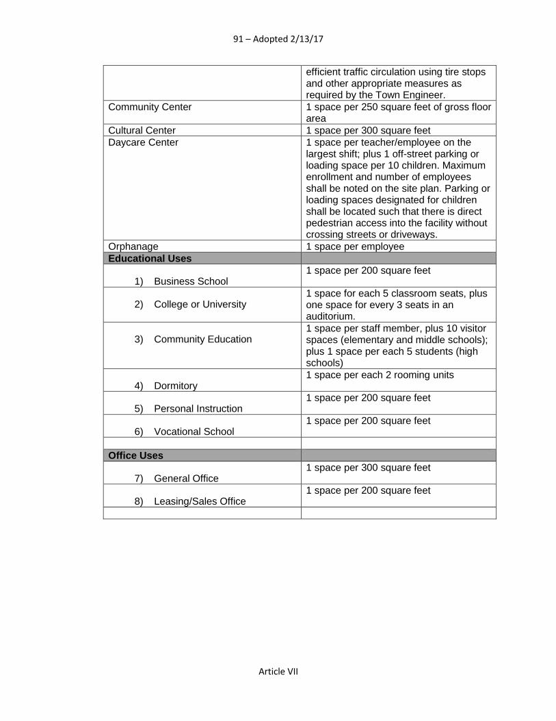
91 – Adopted 2/13/17
Article VII
efficient traffic circulation using tire stops and other appropriate measures as required by the Town Engineer.
Community Center 1 space per 250 square feet of gross floor area
Cultural Center 1 space per 300 square feet Daycare Center 1 space per teacher/employee on the
largest shift; plus 1 off-street parking or loading space per 10 children. Maximum enrollment and number of employees shall be noted on the site plan. Parking or loading spaces designated for children shall be located such that there is direct pedestrian access into the facility without crossing streets or driveways.
Orphanage 1 space per employee Educational Uses
1) Business School 1 space per 200 square feet
2) College or University 1 space for each 5 classroom seats, plus one space for every 3 seats in an auditorium.
3) Community Education 1 space per staff member, plus 10 visitor spaces (elementary and middle schools); plus 1 space per each 5 students (high schools)
4) Dormitory 1 space per each 2 rooming units
5) Personal Instruction 1 space per 200 square feet
6) Vocational School 1 space per 200 square feet
Office Uses
7) General Office 1 space per 300 square feet
8) Leasing/Sales Office 1 space per 200 square feet
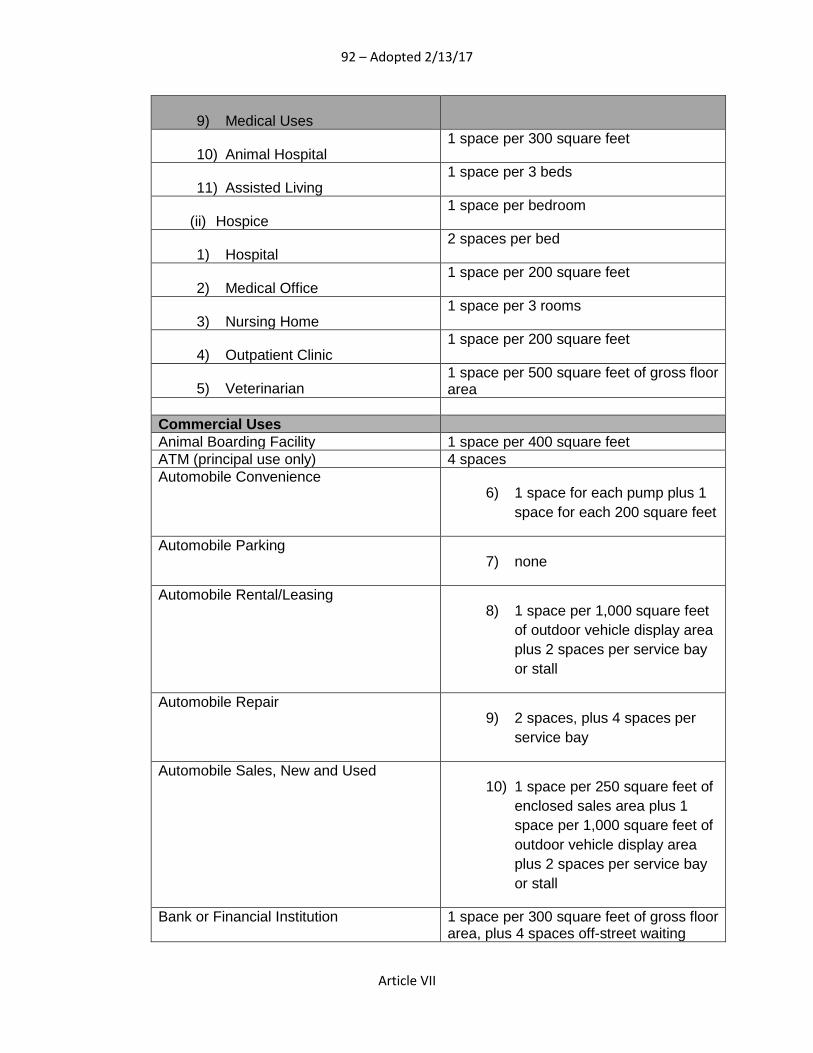
92 – Adopted 2/13/17
Article VII
9) Medical Uses
10) Animal Hospital 1 space per 300 square feet
11) Assisted Living 1 space per 3 beds
(ii) Hospice 1 space per bedroom
1) Hospital 2 spaces per bed
2) Medical Office 1 space per 200 square feet
3) Nursing Home 1 space per 3 rooms
4) Outpatient Clinic 1 space per 200 square feet
5) Veterinarian 1 space per 500 square feet of gross floor area
Commercial Uses Animal Boarding Facility 1 space per 400 square feet ATM (principal use only) 4 spaces Automobile Convenience
6) 1 space for each pump plus 1 space for each 200 square feet
Automobile Parking 7) none
Automobile Rental/Leasing 8) 1 space per 1,000 square feet
of outdoor vehicle display area plus 2 spaces per service bay or stall
Automobile Repair 9) 2 spaces, plus 4 spaces per
service bay
Automobile Sales, New and Used 10) 1 space per 250 square feet of
enclosed sales area plus 1 space per 1,000 square feet of outdoor vehicle display area plus 2 spaces per service bay or stall
Bank or Financial Institution 1 space per 300 square feet of gross floor area, plus 4 spaces off-street waiting

93 – Adopted 2/13/17
Article VII
(loading) spaces per drive-thru lane Bed and Breakfast Inn 1 space per bedroom Business Service 1 space per 250 square feet of gross floor
area Car Wash Car wash (automated): one (1) space per
employee at largest shift, but no less than two (2) spaces total
Convenience Store 1 space per 150 square feet of gross floor area.
Custom Assembly 1 space per 400 square feet Funeral Home 1 space per 3 permanent seats plus 1
space per 25 square feet for temporary seats. If no chapel is provided, 1 space per 500 square feet
Furniture Store 1 space per 200 square feet of display area; 1 space per 1,000 square feet of storage area
Garden Center or Nursery 1 space per 300 square feet of gross floor area. Plus 1 space per 2000-sq. ft. of outdoor display area
Gas Station 1 space per 150 square feet of gross floor area.
Home Improvement Sales 1 space per 250 square feet of gross floor area
Hotel/Motel 1 space per rooming unit, plus 1 space per 2 employees
Inventory Stock 1 space per 1,000 square feet Kennel/Stable 1 space per 400 square feet Liquor Sales 1 space per 250 square feet of gross floor
area Pawnshop 1 space per 250 square feet of gross floor
area Personal Care Services 1 space per 250 square feet of gross floor
area Restaurant, Fast Food 1 space per 100 square feet of gross floor
area.
Restaurant, Full-Service 1 space per 100 square feet of gross floor area.
Restaurant, Take-Out 10 Spaces
Retail 1 space per 250 square feet of gross floor area
Self-service Storage 4 spaces Tavern 1 space per 100 square feet of gross floor
area. Wrecker Service 1 space per 250 square feet of gross floor
area

94 – Adopted 2/13/17
Article VII
Communication Uses Printing and Publishing 1 space per 750 square feet Radio/TV/Telephone/Satellite Tower None Radio/TV Studio 1 space per employee Industrial Uses
Building Contractor Supply 1 space per 1,000 square feet Dry Cleaning Facility 1 space per 1,000 square feet of gross
floor area, but in no case less than 3 Fuel Storage None Heavy Equipment Sales and Service 1 space per 1,000 square feet of building
area Manufacturing, Heavy 1 space per employee on the largest
work shift, plus one 1 space per company vehicle normally stored on premises
Manufacturing, Medium 1 space per employee on the largest work shift, plus one 1 space per company vehicle normally stored on premises
Manufacturing, Light 1 space per employee on the largest work shift, plus one 1 space per company vehicle normally stored on premises
Research Service 1 space per 500 square feet Scrap Operation 1 space per employee, plus 1 space per
5,000 square feet of lot area Warehouse/Distribution 1 space per employee on the largest
shift, plus 1 space per company vehicle normally stored on the premises.
11) Waste Management Uses
Collection Center 1 space per employee Collection Center, Recycling 1 space per employee Landfill, Construction/Demolition 1 space per employee Landfill, Sanitary 1 space per employee
12) Recreation/Entertainment Uses
Camp 13) Set by Board of Zoning
Adjustment Club
14) 1 Space per 300 square feet of building area
Country Club 15) 1 Space per 300 square feet of
building area Driving Range
16) 1 space per tee, plus one space per employee

95 – Adopted 2/13/17
Article VII
Golf Course 17) 45 spaces per 9 holes.
Parking shall be provided for other uses accessory to a golf course (e.g., restaurants, pro shops, driving ranges) at the rate of 50 percent of normal requirements.
Park 18) Established by Planning
Commission Pond/Lake
19) Established by Planning Commission
Recreation Center 20) Established by Planning
Commission Rehearsal Hall
21) 1 space per 3 seats Stadium/Arena
22) Established by Planning Commission
Swimming Pool (iii) 1 space per 200 feet of water
area Tennis Court
1) 2 spaces per court Theater
2) 1 space per 3 seats Agricultural Uses Agricultural/Farm 1 space per employee on the largest shift Forestry 1 space per employee on the largest shift Greenhouse, no sales 1 space per employee on the largest shift Mineral Extraction Established by Planning Commission On-site Agricultural Sales Established by Planning Commission
D. Supplemental Parking Standards
1. Parking for Uses, Buildings or Structures
a. Off-street parking and storage spaces shall be located on the same lot as the use, building or structure they are intended to serve. Required residential off-street parking shall be located within 150' of the use the parking is intended to serve. Required commercial off-street parking shall be located within 300' of the use the parking is intended to serve.
b. Except as provided for elsewhere in this ordinance, no off-street parking space required for any use, building or structure shall be counted as off-street parking space for another use, building or structure. Off-street parking requirements for two or more uses located on the same lot are cumulative, but may be jointly used provided the total parking requirement is met. Whenever a use, building or structure that qualifies under two (2) or more

96 – Adopted 2/13/17
Article VII
classifications, the classification with the larger parking requirement shall govern.
c. When any use is extended or a building or structure is enlarged, the existing parking spaces shall be maintained and the required number of parking spaces to serve the expansion or enlargement of the use, building or structure shall be provided.
d. Off-street parking and storage space shall not be used for the sale, repair, servicing of any vehicles, equipment, or materials.
2. Parking and Storage of Certain Vehicles
a. Automotive vehicles without current license plates shall not be parked or stored on any residentially zoned property other than in completely enclosed buildings.
b. Commercial vehicles exceeding 10,000 lbs. G.V.M. and construction vehicles shall not be parked or stored in recorded residential subdivisions.
c. Major recreational vehicles including houseboats, travel trailers, pick-up campers, motorized dwellings, tent trailers, and other like vehicles shall not be stored or parked on any front yard on any lot in a residential district.
3. Bicycle Parking Standards
All development with surface parking areas with fifty (50) or more spaces shall provide bicycle parking facilities equal to one (1) bicycle space for every twenty (20) off-street parking spaces. Bicycle parking spaces shall not be located farther than one-hundred (100) linear feet from the primary building entrance(s). Bicycle parking spaces shall be equally distributed in developments with multiple buildings or tenants. A rack or similar device so that bicycles may be secured shall be provided.
E. Computation
1. If the required number of spaces is not a whole number, the number of required spaces shall be rounded up to the next higher whole number.
2. Unless otherwise stated in this section, when the standards use amount of square footage in buildings as a unit of measurement, the calculation shall be based on gross floor area.
3. Reference herein to “employee(s) on the largest work shift” means the maximum number of employees employed at the facility regardless of the time period during which this occurs and regardless of whether any such person is a full-time employee. The largest work shift may be a particular day of the week or a lunch or dinner period in the case of a restaurant.
4. The term “capacity” as used herein means the maximum number of persons that may be accommodated by the use as determined by its design or by fire code regulations, whichever is greater.
5. Unless otherwise stated in this section, parking shall be calculated separately for each different use area in a building or on a site, including all accessory uses.
6. When the parking requirement is not specified for a particular use the Planning Commission shall apply the requirements for a similar use.

97 – Adopted 2/13/17
Article VII
F. Accessibility
A portion of the total number of required off-street parking spaces in each off-street parking area shall be specifically designated, located, and reserved for use by person with physical disabilities, based on the requirements of the applicable Building Code and Americans with Disabilities Act guidelines.
G. Alternative and Shared Parking
1. Reduction in the Number of Required Off-Street Parking Spaces for Large Uses In order to prevent the establishment of a greater number of parking spaces than are actually needed to meet the particular needs of a development site containing over 500,000 square feet of gross floor area, a reduction in the number of required off-street parking spaces may be permitted. This reduction shall be permitted subject to the following conditions: a. A maximum reduction of one (1) parking space per every 1,000
square feet of gross floor area or 20 percent of the total spaces required can be permitted. The site plan shall indicate the location and dimensions of the parking area provided, and shall include calculations showing the number of parking spaces eliminated pursuant to this Section which otherwise would have been required.
b. Sufficient area must be reserved to provide for the total number of off-street parking spaces required by Section 702. The purpose of this reservation is to insure adequate area to meet any future need for additional parking spaces. Prior to site plan approval, the applicant shall sign a written statement agreeing to provide additional spaces up to the full amount required by Section 702 upon notification by the Planning Commission that such spaces are needed. This statement shall be provided to the Planning Commission in letter-form and shall be reproduced on the site plan.
c. The reserved parking area shall be shown on the site plan and shall be grassed, landscaped or otherwise covered in vegetation. It shall not include signs or other structures, drainage or percolation fields for sewage disposal.
2. Shared Parking
In order to reduce impervious surface and resulting stormwater runoff, establishments may be allowed to share up to 20 percent of the required parking spaces. In all cases where parking is to be shared by uses on different lots, the subject parcels or lots shall be adjacent to one another and in no case shall properties bound under a shared parking agreement or plan be separated by a public right-of-way. The intention to share parking facilities must be represented to the Planning Commission prior to site plan approval by means of a written agreement between the various property owners, or in the case of a single owner, an overall shared parking plan for the properties or development sites.
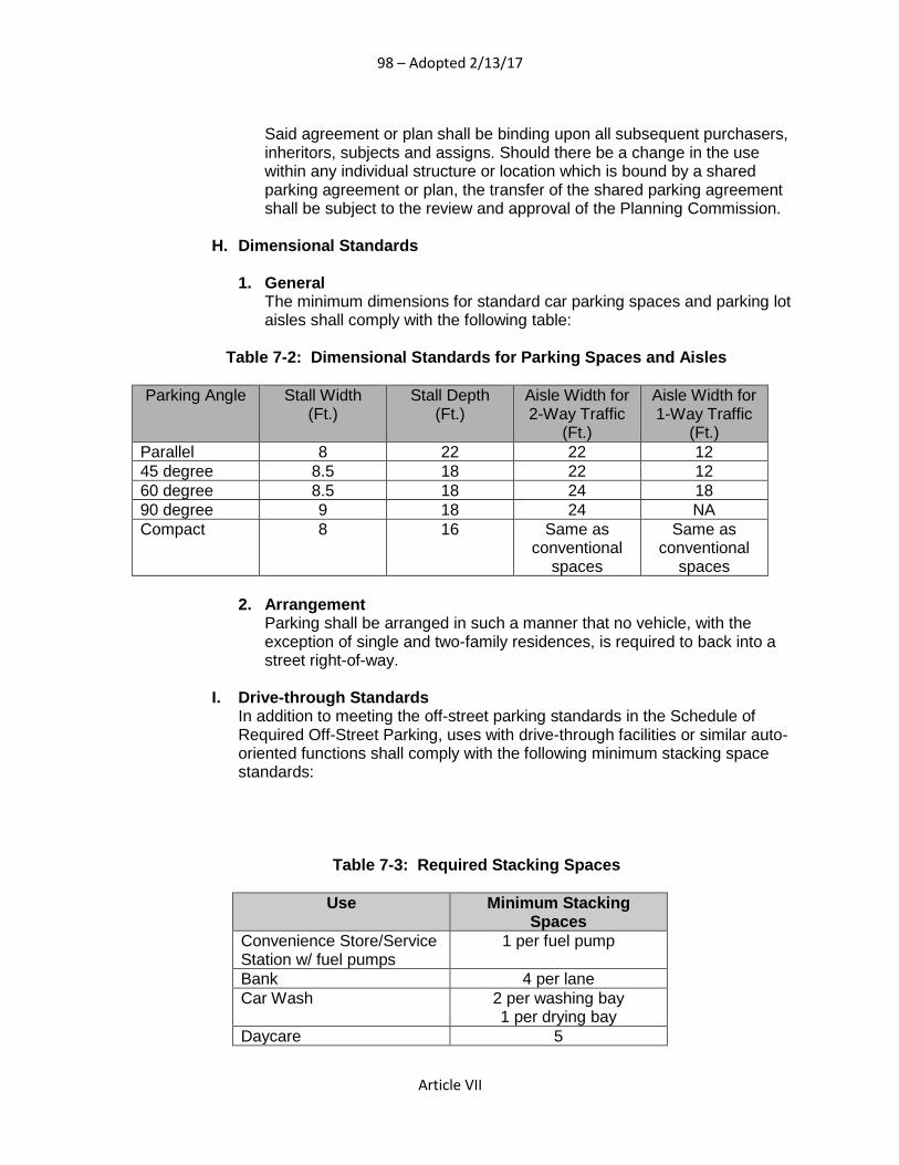
98 – Adopted 2/13/17
Article VII
Said agreement or plan shall be binding upon all subsequent purchasers, inheritors, subjects and assigns. Should there be a change in the use within any individual structure or location which is bound by a shared parking agreement or plan, the transfer of the shared parking agreement shall be subject to the review and approval of the Planning Commission.
H. Dimensional Standards
1. General The minimum dimensions for standard car parking spaces and parking lot aisles shall comply with the following table:
Table 7-2: Dimensional Standards for Parking Spaces and Aisles
Parking Angle Stall Width (Ft.)
Stall Depth (Ft.)
Aisle Width for 2-Way Traffic
(Ft.)
Aisle Width for 1-Way Traffic
(Ft.) Parallel 8 22 22 12 45 degree 8.5 18 22 12 60 degree 8.5 18 24 18 90 degree 9 18 24 NA Compact 8 16 Same as
conventional spaces
Same as conventional
spaces
2. Arrangement Parking shall be arranged in such a manner that no vehicle, with the exception of single and two-family residences, is required to back into a street right-of-way.
I. Drive-through Standards In addition to meeting the off-street parking standards in the Schedule of Required Off-Street Parking, uses with drive-through facilities or similar auto-oriented functions shall comply with the following minimum stacking space standards:
Table 7-3: Required Stacking Spaces
Use Minimum Stacking Spaces
Convenience Store/Service Station w/ fuel pumps
1 per fuel pump
Bank 4 per lane Car Wash 2 per washing bay
1 per drying bay Daycare 5

99 – Adopted 2/13/17
Article VII
Restaurant, Drive-thru 6
J. Parking Location Standards
1. Location and Criteria for Residential Parking Off-street parking spaces, subject to these requirements and the appropriate district regulations, may be included as a portion of the required yard area. Required off-street parking facilities for residential uses may occupy a part of the front yard, but shall not be within twenty feet of a street right-of-way or ten feet of any rear lot line.
701.02 Access Standards
A. Intent It is the intent of this section to establish standards to regulate access to parking areas that is safe, efficient, and convenient for all modes of transportation.
B. Applicability The parking standards of this section shall apply to all new development in the Town. In addition to new development the standards of this section apply to expansions of buildings or uses that result in an increase in vehicle trips.
C. General Standards
1. Driveway Width Driveways providing parking for all development shall not exceed twelve (12) feet in width for one lane of traffic or twenty-four (24) feet in width for two lanes of traffic, unless a larger width is determined necessary due to traffic volumes, exclusive turn lanes are needed, or the driveway serves a surface parking lot of more than five hundred (500) spaces.
2. Cross Access Internal vehicular circulation areas shall be designed to allow for cross-access between adjacent lots of all development. In instances where development is adjacent to vacant land designated for future development, a stub for future cross access shall be provided. Cross-access ways shall be designed for two-way traffic and have a minimum width of 22 feet. A cross-access easement must be recorded prior to issuance of a Certificate of Occupancy for the development.
D. Access to Individual Residential Lots Residential lots are limited to two (2) curb cuts a minimum of fifty feet (50’) apart.
Section 702. Landscape Standards
702.01. Intent Preserving Pike Road’s scenic landscape is essential in maintaining the community’s quality of life, community identity, and civic pride. This section is intended to enhance the quality and character of development by utilizing landscaping to better integrate new

100 – Adopted 2/13/17
Article VII
developments into the pastoral landscape of Pike Road. Landscaping also provides important environmental benefits such as reducing air pollution and stormwater runoff, improving water quality, and creating wildlife habitats. The purpose and intent of this Article are the following:
• To promote the scenic quality of the community; • To improve the appearance of parking areas and property abutting public rights
of way; • To reduce stormwater runoff and improve water quality; • To provide transitions between incompatible land uses; and • To provide relief from traffic, noise, heat, glare, dust, and debris.
702.02. Applicability The provisions of this Article apply to all land within the Town’s zoning jurisdiction. The provisions apply to the following:
• all residential subdivisions creating three (3) or more lots; • all new single-family dwellings; • all new multi-family developments; and • all non-residential developments.
702.03. General Landscape Standards
A. Separation Distances
1. Intent
Separation distances between existing major streets and new residential developments are intended to preserve the rural landscape character, sensitive natural areas, farmland, and other large areas of open land in Pike Road, while still permitting development in the Town. These areas of open space along existing major streets will be located and designed to reduce the perceived intensity of new residential developments, and they will provide increased privacy for residential dwellings.
2. Standards
a. Dimensions
Any residential development proposing new streets accessed from an abutting major street shall provide a separation distance of 200 feet measured from the right-of-way of the existing major street to the edge of any lot line, new street right-of-way, or active open space area.
b. Reductions
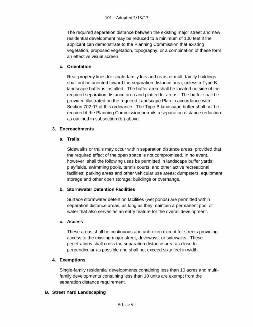
101 – Adopted 2/13/17
Article VII
The required separation distance between the existing major street and new residential development may be reduced to a minimum of 100 feet if the applicant can demonstrate to the Planning Commission that existing vegetation, proposed vegetation, topography, or a combination of these form an effective visual screen.
c. Orientation
Rear property lines for single-family lots and rears of multi-family buildings shall not be oriented toward the separation distance area, unless a Type B landscape buffer is installed. The buffer area shall be located outside of the required separation distance area and platted lot areas. The buffer shall be provided illustrated on the required Landscape Plan in accordance with Section 702.07 of this ordinance. The Type B landscape buffer shall not be required if the Planning Commission permits a separation distance reduction as outlined in subsection (b.) above.
3. Encroachments
a. Trails
Sidewalks or trails may occur within separation distance areas, provided that the required effect of the open space is not compromised. In no event, however, shall the following uses be permitted in landscape buffer yards: playfields, swimming pools, tennis courts, and other active recreational facilities; parking areas and other vehicular use areas; dumpsters, equipment storage and other open storage; buildings or overhangs.
b. Stormwater Detention Facilities
Surface stormwater detention facilities (wet ponds) are permitted within separation distance areas, as long as they maintain a permanent pool of water that also serves as an entry feature for the overall development.
c. Access
These areas shall be continuous and unbroken except for streets providing access to the existing major street, driveways, or sidewalks. These penetrations shall cross the separation distance area as close to perpendicular as possible and shall not exceed sixty feet in width.
4. Exemptions
Single-family residential developments containing less than 10 acres and multi-family developments containing less than 10 units are exempt from the separation distance requirement.
B. Street Yard Landscaping

102 – Adopted 2/13/17
Article VII
1. Intent
Street yard landscaping is intended to provide a visual transition from the more rural areas of the Town and to add quality and definition to the street by planting trees within a landscaped area along the edges of the right-of way. These standards do not apply to single-family lots or properties zoned Town Center. For single-family lot landscaping standards, please see Section 702.03 G below.
2. Dimensions
a. Except for points of access, a street yard shall be provided where the proposed development site adjoins the public street right-of-way. Alleys are exempt from this requirement.
b. The street yard shall have a minimum depth of 12 feet as measured from the edge of the public street right-of-way towards the interior of the property. The yard shall consist of turf grass or other natural living groundcover material. No impervious surfaces are permitted in the street yard area, with the exception of signage, utilities, and pedestrian access ways leading from the public sidewalk system.
3. Plantings
a. Trees shall be planted within the street yard at a minimum ratio of 1 tree per 30 linear feet of right-of-way frontage.
i. Trees do not have to be evenly spaced in 30 feet increments.
ii. Fractions of trees shall be rounded up to the nearest whole number.
b. The minimum spacing between trees is 15 feet measured trunk to trunk. The maximum spacing is 50 feet measured trunk to trunk.
c. The trees referred to in this section shall have a minimum expected maturity height of at least 40 feet and a minimum canopy spread of 30 feet (see 702.03 H “Plant Material Standards”: Class I Shade Trees).
4. Existing Woodlands
a. Existing woodlands along the street right-of-way frontage can be substituted for the street yard requirements subject to the following:
i. Existing woodlands to be set aside shall have a minimum depth of 25 feet as measured from the public street right-of-way;
ii. Number of woodland trees having a minimum caliper of 6 inches shall equal or exceed the required number of trees based on the standard above;

103 – Adopted 2/13/17
Article VII
iii. No impervious surfaces are permitted within the protected woodlands area except for approved access points to the site; and
iv. No cutting/filling activities or storage of materials/equipment are permitted within the protected woodlands.
5. Exemptions/Special Situations
a. Where overhead power lines encroach into the street yard, smaller Class II shade trees can be substituted for Class I shade trees (see 702.03 H “Plant Material Standards”: Class II Shade Trees).
b. Stormwater facilities may be located within the street yard subject to the following conditions:
i. no riprap, crushed stone, concrete, or other impervious materials are exposed; and
ii. trees and other living organic materials can be planted along the stormwater facility
C. Parking Landscaping
1. Intent
The intent of this section is to break up the expanse of asphalt, to provide shade, and to reduce the glare from parked cars and loading docks.
2. Design Criteria
a. No parking space can be more than 90 feet from a tree.
b. Ends of all interior parking bays that contain a minimum of 12 contiguous parking spaces shall be bordered on both sides by a landscape island.
c. Ends of all perimeter-parking bays shall be bordered by a landscaped peninsula.
3. Dimensions/Planting Criteria
a. Landscaped islands and peninsulas used to meet the landscaping requirements shall have a minimum width of nine (9) feet.
b. Each landscaped island and peninsula used to meet the landscaping requirements shall be planted with at least one tree.
c. The trees referred to in this parking section are Class I Shade trees (see 702.03 H “Plant Material Standards). In the special situations specified below, smaller Class II Shade Trees may be substituted for Class I trees:
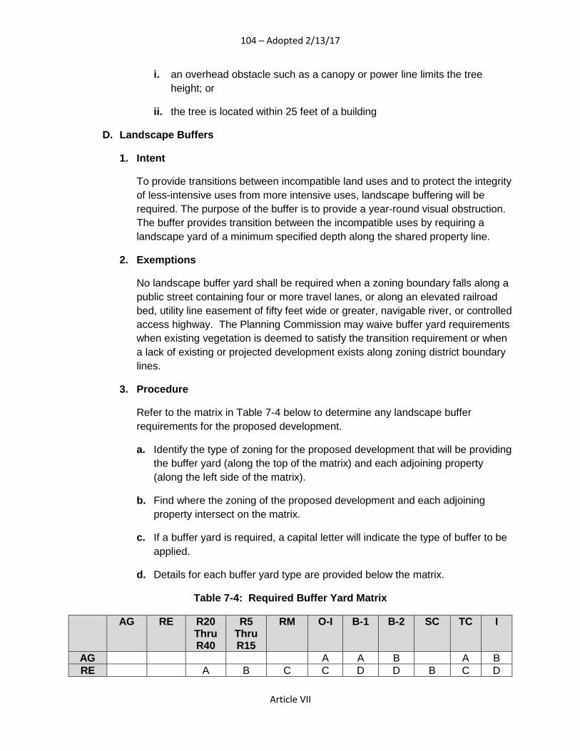
104 – Adopted 2/13/17
Article VII
i. an overhead obstacle such as a canopy or power line limits the tree height; or
ii. the tree is located within 25 feet of a building
D. Landscape Buffers
1. Intent
To provide transitions between incompatible land uses and to protect the integrity of less-intensive uses from more intensive uses, landscape buffering will be required. The purpose of the buffer is to provide a year-round visual obstruction. The buffer provides transition between the incompatible uses by requiring a landscape yard of a minimum specified depth along the shared property line.
2. Exemptions
No landscape buffer yard shall be required when a zoning boundary falls along a public street containing four or more travel lanes, or along an elevated railroad bed, utility line easement of fifty feet wide or greater, navigable river, or controlled access highway. The Planning Commission may waive buffer yard requirements when existing vegetation is deemed to satisfy the transition requirement or when a lack of existing or projected development exists along zoning district boundary lines.
3. Procedure
Refer to the matrix in Table 7-4 below to determine any landscape buffer requirements for the proposed development.
a. Identify the type of zoning for the proposed development that will be providing the buffer yard (along the top of the matrix) and each adjoining property (along the left side of the matrix).
b. Find where the zoning of the proposed development and each adjoining property intersect on the matrix.
c. If a buffer yard is required, a capital letter will indicate the type of buffer to be applied.
d. Details for each buffer yard type are provided below the matrix.
Table 7-4: Required Buffer Yard Matrix
AG RE R20 Thru R40
R5 Thru R15
RM O-I B-1 B-2 SC TC I
AG A A B A B RE A B C C D D B C D

105 – Adopted 2/13/17
Article VII
R20 Thru R40
A B C C D A B D
R5 Thru R15
A B C D A A D
RM A B C A D O-I A B C B-1 B C B-2 B SC B C TC A B I
*Zoning Districts along the top of the table provide the buffer yard to the abutting districts located in the left hand column of the table.
*No buffer is required along B-2s zoning district boundaries. The B-2s zoning district shall be governed by the zoning classification B-2 as set out in the Zoning Ordinance of the City of Montgomery that was in effect on December 22, 2010.
4. Buffer Types
All plantings shall meet the installation and planting size requirements specified in 702.03 H “Plant Material Standards.
a. Type A 10 feet deep Landscape Yard installed with the following:
i. 1 row of large evergreen shrubs (spaced a maximum of 10 feet apart), or 2 rows made up of a combination of small and medium evergreen shrubs (spaced a maximum 6 feet apart); and
ii. 1 row of Class II Shade Trees spaced a maximum of 30 feet on-center.
b. Type B
20 feet deep Landscape Yard installed with the following:
i. 1 row of large evergreen shrubs (spaced a maximum of 10 feet apart);
ii. 2 rows made up of a combination of medium evergreen shrubs and small evergreen or deciduous shrubs (spaced a maximum 6 feet apart); and
iii. 1 row of Class I Shade Trees spaced a maximum of 30 feet on-center.
c. Type C
20 feet deep Landscape Yard installed with the following:
i. 6’ masonry wall, fence, or combination thereof along the property line;
106 – Adopted 2/13/17
Article VII
ii. 1 row of large evergreen shrubs (spaced a maximum of 10 feet apart);
iii. 2 rows made up of a combination of medium evergreen shrubs and small evergreen or deciduous shrubs (spaced a maximum 6 feet apart); and
iv. 1 row of Class I Shade Trees spaced a maximum of 30 feet on-center.
d. Type D
30 Feet deep Landscape Yard installed with the following:
i. 8’ masonry wall, fence, or combination thereof along the property line;
ii. 1 row of small evergreen trees (spaced a maximum of 20 feet apart);
iii. 1 row of large evergreen shrubs (spaced a maximum of 10 feet apart), or 2 rows made up of a combination of medium evergreen shrubs and small evergreen or deciduous shrubs (spaced a maximum 6 feet apart); and
iv. 1 row of Class I Shade Trees spaced a maximum of 30 feet on-center.
E. Landscape Screening
1. Intent The intent of this section is to establish requirements to screen specific uses or structures from public view. All visible surface parking, ground-mounted equipment (i.e., transformers, air conditioner units), dumpsters, trash receptacles, refuse storage containers, outdoor storage, loading docks, substations, large utility cabinets, water and wastewater pumping stations, storage sites, and other similar uses shall be sufficiently screened. Required landscape material shall be located to maximize the screening of these facilities.
2. Surface Parking Lots Landscape screening is essential in order to reduce the visual impact of surface parking lots within the Town of Pike Road. Perimeter landscaping also mitigates glare from headlights; improves the aesthetic quality of the area for users of the site, adjacent sites, roadways, and sidewalks; and defines the perimeter of the parking lot.
a. Landscape screening shall be required between those portions of an off-
street parking area containing five or more parking spaces and a public street where the separation between the parking area and public street is 40 feet or less.
b. Standards

107 – Adopted 2/13/17
Article VII
i. Parking lot screening must be provided within ten feet of the perimeter of the parking lot to be screened.
ii. Parking lot screening must be a minimum of three feet and a maximum of four feet in height as measured from the adjacent finished surface of the parking area.
iii. Medium Evergreen Shrubs (see 702.03 H “Plant Material Standards) shall be used to provide the screen. Such shrubs must be at least two feet tall at planting and anticipated to grow to at least four feet tall at maturity.
iv. Parking lot screening, at a minimum, must consist of:
A. a compact hedge of evergreen shrubs spaced to ensure closure into a solid hedge at maturity;
B. an architecturally compatible opaque wall or fence (see 702.03 F “Fences and Walls”);
C. a berm; or D. a combination of the above.
3. Dumpsters and Trash Receptacles
All dumpsters, trash receptacles, and refuse storage containers shall be located within an enclosure providing screening by the following methods:
a. A decorative masonry wall (minimum six feet in height) on three sides and a gate on the fourth side. The gate shall be constructed with an opaque, non-masonry material. The construction materials of the wall shall match materials used on the principal building located on the same lot.
b. Medium-sized evergreen shrubs shall be arranged, planted a maximum of 6 feet on-center, around the perimeter of the pad area except the side where the gate is located. This landscaping requirement does not apply when the enclosure is an architectural extension of a principal building.
4. Ground-mounted equipment
All proposed ground-mounted equipment shall be screened by evergreen shrubs. Medium-sized evergreen shrubs shall be arranged, planted a maximum of 6 feet on-center, around the boundary of the equipment.
5. Substations, Water/Wastewater Stations
Proposed electric substations, water pump stations and wastewater lift stations shall be screened from public view. In order to screen these facilities, the following elements shall be incorporated:

108 – Adopted 2/13/17
Article VII
a. An eight-foot wide landscape area with one small evergreen tree per 12 linear feet, provided that said trees shall be planted no closer than eight feet and no more than 16 feet apart.
6. Outdoor Storage
Outdoor storage shall be screened from public view as follows:
a. An eight-foot wide landscape area with one small evergreen tree per 12 linear feet of wall constructed, provided that said trees shall be planted no closer than eight feet and no farther than 16 feet apart.
b. All outdoor storage or equipment rental areas that are visible from a public right-of-way or customer parking area shall be screened from view by a 6-foot high wall made of masonry or masonry pilasters and wood or similar decorative materials.
c. If a permitted outdoor sales display area is proposed by the business owner to be fenced, such as with plant nurseries or sales of automobiles, motorcycles, mobile homes, boats, recreational vehicles, etc., all fencing visible from the public right-of-way shall consist of a masonry wall, masonry pilasters and wood fencing, or if open screening is to be used, it shall be made of a decorative material including wrought iron, masonry pilasters and open mesh wiring or other similar material as approved by the Planning Commission.
7. Loading areas
All loading areas visible from public view shall be screened. Side and front-facing truck delivery stalls and loading bays shall be screened from the public right-of-way as described below.
a. Decorative masonry wall (minimum six feet in height). If the wall includes a gate, it shall be constructed with an opaque, non-masonry material. The construction materials of the wall shall match material used on the principal building located on the same lot; and
b. An eight-foot wide landscape area with one small evergreen tree per 12 linear feet of wall constructed, provided that said trees shall be planted no closer than eight feet and no farther than 16 feet apart.
F. Fences and Walls
1. Intent The intent of this section is to provide standards for fences and walls that will help assure design that is aesthetically pleasing and complimentary to buildings and their surroundings. For fences and walls intended for screening, please see the Landscape Screening standards.
2. Applicability All fences and landscape walls which are equal to or exceed 36 inches in height, located in any district, unless specifically noted otherwise, are subject to the requirements below and shall obtain a building permit from the Building Inspector before starting construction of the fence. A building permit application for a fence

109 – Adopted 2/13/17
Article VII
shall consist of a standard building permit application with a site plan drawn to scale. The site plan must show abutting streets, lot lines and their dimensions, existing buildings and their dimensions, the proposed fence location and proposed setbacks. A drawing or picture of the fence indicating its style and height shall also be provided.
3. Standards
a. Location Fencing and walls may be located in order to define the limits of property ownership, create exterior privacy, or for purposes of safety and protection. Fences and walls may be located according to the following criteria: i. Fences and walls over four (4) feet in height which are adjacent to a
sidewalk shall be setback a minimum of two (2) feet from the edge of the sidewalk,
ii. Fences, walls, and hedges shall comply with visibility at intersection and sight triangle requirements.
iii. No fence or wall shall be located closer than one (1) foot to the front yard or street yard property line.
iv. Fences shall be located no closer than one (1) inch from a side or rear property line.
v. Fences shall not be located in drainage or utility easements, unless the owner has received written consent form the affected utility companies.
b. Design
i. Fences and walls shall be consistent in style and design within any property (e.g. same design in front yard or rear yard), and for yards abutting streets (e.g. same or compatible design and style for both front and street side yards for corner lots).
ii. Fences and walls shall be comprised of no more than three (3) materials for panels, posts, rails, columns, and other elements within all yards of any property.
iii. Fences and walls in side and rear yards may be comprised of a different material(s) than that used in the front yard.
iv. Fences shall be designed in accordance with industry standard forms such as: stockade, board-on-board, shadowbox, tongue-and-groove, picket, or split rail. An alternative form may be approved where the Building Inspector finds that the proposed form complies with the intent of the provisions of this section and that the form requested is at least the equivalent to the industry standard in quality, strength, effectiveness, fire resistance, durability and safety.
v. Fences and walls greater than 100 feet in length shall be articulated by columns or other visual breaks measuring at least two (2) feet in width and spaced no more than 24 feet apart.
vi. Fences and walls shall be of a uniform architectural style and color palette compatible with the associated building.
c. Height

110 – Adopted 2/13/17
Article VII
i. Single Family Lots containing less than one acre The maximum height of walls and fences is 4 feet in any required front yard or street side yard and 8 feet in any other required yard, unless as otherwise provided for elsewhere in this chapter.
ii. Multi-family Residential District The maximum height of walls and fences is 4 feet in any required front yard or street side yard and 8 feet in any other required yard, unless as otherwise provided for elsewhere in this chapter.
iii. Commercial, Office, and Industrial Districts. The maximum height of walls and fences is 3 feet in any required front yard or street side yard and 8 feet in any other required yard, unless as otherwise provided for elsewhere in this chapter. Security and screening fences may exceed this height if approved by the Planning Commission.
d. Materials
i. Walls and fences shall be constructed of materials, colors, and textures that are similar and harmonious with the architecture of the associated building.
ii. Chain link fence may be permitted in the rear yard of all zoning districts, subject to approval from the Planning Commission.
iii. Permitted fencing materials include wrought iron, aluminum or other decorative metals suitable for the construction of fences, masonry, concrete, stone, galvanized and wood planks or pickets, and vinyl or composite manufactured specifically as fencing materials.
iv. An alternative material may be approved where the Planning Commission finds that the proposed material complies with the intent of the provisions of this section and that the material requested is at least the equivalent of the industry standard in quality, strength, effectiveness, fire resistance, durability and safety.
4. Maintenance
All walls and fences shall be maintained in good repair and in a safe and attractive condition, including but not limited to replacement of missing, decayed, or broken structural and decorative elements.
G. Single Family Lots
1. Intent Landscaping of single-family homes is a significant contributor to the overall character of Pike Road. It is very important to establish consistency in landscaping while allowing flexibility to allow variety and individuality. The landscape design of single-family home areas shall place emphasis on efficient water management and the use of regionally appropriate plant and landscape materials.
2. Standards

111 – Adopted 2/13/17
Article VII
Single-family landscapes shall be designed to compliment the architectural design of the accompanying house, and shall meet the following minimum requirements.
a. Plantings for lots 50 feet wide and less
i. One Class II shade tree within the front yard; ii. One Ornamental Tree within the front yard; iii. Evergreen shrubs along the front foundation of the house; and iv. Deciduous and/or evergreen shrubs to accent entries into the house.
b. Plantings for lots from 51 feet to 75 feet wide
i. One Class I shade tree within the front yard; ii. One Class II shade tree within the front and rear yards; iii. Two ornamental trees within the front yard positioned to help frame the
house and merge individual lots with the native landscape; iv. Foundation planting along the front of the house containing a mixture of
evergreen and deciduous shrubs; and v. Accent shrubs at entries into the house.
c. Plantings for lots from 76 to 100 feet wide
i. One Class I shade tree within the front yard; ii. One Class II shade tree within the front yard; iii. Two ornamental trees within the front yard positioned to help frame the
house and merge individual lots with the native landscape; iv. Foundation planting along the front and sides of the house containing a
mixture of evergreen and deciduous shrubs; and v. Accent shrubs at entries into the house.
d. Plantings for lots greater than 100 feet wide
i. Two Class I shade trees within the front yard; ii. Four ornamental trees within the front yard positioned to help frame the
house and merge individual lots with the native landscape; iii. Foundation planting along the front and sides of the house containing a
mixture of evergreen and deciduous shrubs; and iv. Accent shrubs at entries into the house.
H. Plant Material Standards
1. Intent
All landscaping materials shall be consistent with the current edition of American Standard for Nursery Stock (ANSI Z60.1) and installed in a professional manner. It is the intent of this Section that a diverse mixture of plantings be provided within the Town of Pike Road. Therefore, all required landscaping shall comply with the following minimum plant material standards.

112 – Adopted 2/13/17
Article VII
2. Plant Quality
Plant materials permitted in required landscaped areas shall be hardy to the climate of Central Alabama, long-lived, resistant to disease and insect attack, and shall have orderly growth characteristics.
3. Plant Size Specifications
All required plant materials shall be of the following sizes at the time of planting, unless otherwise stated in this Section.
a. Class I Shade Trees All Class I Shade Trees shall be installed at a minimum caliper of 3 inches as measured from 6 inches above grade level. Class I Shade Trees shall also have a minimum expected maturity height of at least 40 feet and a minimum canopy spread of at least 30 feet. Evergreen trees can be treated as Class I Shade Trees provided they meet the minimum maturity height and canopy spread criteria.
b. Class II Shade Trees All Class II Shade Trees shall be installed at a minimum caliper of 2 ½ inches as measured at 6 inches above grade level from the base of the tree. Class II trees shall have a maximum expected maturity height of 40 feet and a minimum canopy spread of 10 feet.
c. Ornamental Trees All Ornamental Trees shall be installed at a minimum caliper of 2 inches as measured at 6 inches above grade level from the base of the tree. Ornamental trees shall have a maximum expected maturity height of 30 feet and a maximum canopy spread of 30 feet.
d. Small Evergreen Trees Small Evergreen trees are used to meet the tree planting requirements of the Landscape Buffering and Screening Sections. All evergreen trees shall be installed at a minimum height of 8 feet and have a minimum expected mature spread of 10 feet.
e. Large Evergreen Shrubs All Large Evergreen shrubs shall be installed at a minimum size of 7 gallons and have an expected mature height of at least 8 feet and a mature spread of at least 6 feet.
f. Medium Evergreen Shrubs All Medium Evergreen shrubs shall be installed at a minimum size of 5 gallons and have an expected mature height of at least 4 feet and a mature spread of at least 4 feet.
g. Small Evergreen and Deciduous Shrubs All Small Evergreen and Deciduous shrubs shall be installed at a minimum size of 3 gallons and have an expected mature height of at least 2 feet and a mature spread of at least 2 feet.
113 – Adopted 2/13/17
Article VII
h. Mulch Material Minimum of four (4) inches deep for planted trees, shrubs, and vines, and shall be installed in a manner as to present a finished appearance.
i. All plant materials shall be well-formed, sound, vigorous, healthy and free from disease, sun scald, wind burn, abrasion, and harmful insects at the time of planting.
I. Utility Easement Policy 1. Intent
To avoid damage to utility lines and landscape plantings, all trees and shrubs should be planted outside of existing and proposed utility easements.
2. Policy a. Any tree or shrub used to meet the requirements of this Article shall not be
located within proposed or existing utility easements unless it meets one of the following special exceptions: i. Written permission has been obtained from the holder of the utility
easement; or ii. Where overhead power lines cross an area required by the ordinance to
be planted with shade trees, smaller shade trees may be substituted.
J. Clear Sight Triangle
1. Intent Landscape plans shall be designed to provide safe ingress and egress from one street or driveway to another, by insuring that plant materials do not impair a driver’s ability to see oncoming vehicles and pedestrians.
2. Policy Fences and landscape plants at maturity shall not exceed two and a half (2.5) feet in height within a clear sight triangle for traffic safety as measured from the street centerline. “Sight triangles” shall be designated in order to insure that there are no visibility obstructions for motorists. Sight triangles shall be illustrated on all required Landscape Plans.
702.04. Maintenance
The property owner shall be responsible for the maintenance of all provided landscaping. All landscaped areas must present a healthy, neat and orderly appearance and shall be kept free from refuse and weeds. Any dead or diseased plant material shall be replaced by the property owner with new plantings that meet the requirements of this section.
A. Watering

114 – Adopted 2/13/17
Article VII
All required landscaping shall be provided with a readily available and acceptable water supply.
1. Irrigation Required All required street yard landscaping, parking lot landscaping, landscape bufferyards, and landscape screening shall be irrigated via an underground sprinkler system. An Irrigation Design Plan shall be submitted with any required Landscape Plan. The irrigation designer shall be a certified irrigation designer as regulated by the Irrigation Association, or a person with a minimum of five years of demonstrated experience designing irrigation systems.
2. Irrigation Not Required Underground sprinkler systems are not required for single-family residential lots. Single family lots shall have an outside hose attachment within 100 feet of all landscaping required by this ordinance.
B. Replacement of Dead Materials
The property owner shall replace required plants which die. Replacements shall be installed at the earliest possible time within a planting season, and replacements shall be as shown on the approved landscape plan.
Section 703. Open Space Standards 703.01. Intent The intent of these guidelines is to promote the health, safety, and the general welfare of the public; to conserve natural resources; to enhance properties and their values; to preserve the character of the area; and to encourage the appropriate use of the land. This section is intended to assist in the design and layout of those portions of development that are not occupied by buildings, platted lots, or streets and that are reserved for parks, trails, landscaping, and other open space uses. 703.02. Applicability Open Space is required on all developed sites within the Town’s zoning jurisdiction. The specific amount of open space required varies by zoning district. The required amounts are listed in Table 7-5 below. The standards of this section apply regardless of whether or not the land involved will be dedicated to the Town of Pike Road, and regardless of whether or not such open space will be open to the public or reserved for use only by residents of the development. The provisions apply to the following:
A. all residential subdivisions creating three (3) or more lots; B. all new multi-family developments; and C. all non-residential developments.
703.03. General Open Space Standards
A. Amounts of Open Space Required Development shall provide at least the minimum amounts of open space identified in (Table 7-5)
Table 7-5: Minimum Requirements to be Preserved as Permanent Open Space

115 – Adopted 2/13/17
Article VII
Zoning District Requirement AG No requirement RE 8,000 square feet of open space for every lot proposed R30 and R40 4,000 square feet of open space for every lot proposed R15 and R20 2,000 square feet of open space for every lot proposed R5 and R10 1,000 square feet of open space for every lot proposed RM 375 square feet of open space for every unit proposed O-I 100 square feet of open space for every 1,000 square feet of
building coverage B-1 75 square feet of open space for every 1,000 square feet of
building coverage B-2 75 square feet of open space for every 1,000 square feet of
building coverage TC 100 square feet of open space for every 1,000 square feet of
building coverage I 40 square feet of open space for every 1,000 square feet of
building coverage *No open space is required by this ordinance for the B-2s zoning district. The B-2s zoning district shall be governed by the zoning classification B-2 as set out in the Zoning Ordinance of the City of Montgomery that was in effect on December 22, 2010.
*Open space requirements for the SmartCode (SC) zoning district shall be determined by the SmartCode regulations.
B. Trail and Greenway Dedication
The Pike Road Trail System is essential for providing recreational opportunities to the residents of the Town. Trails and will primarily benefit the residents of subdivisions where the trail is required, but they will also provide necessary connections to help complete the overall network of trails throughout the Town. If any portion of a parcel proposed for development lies within an area designated on the officially adopted Trails Master Plan Map, the developer shall construct the designated improvements in accordance with trail standards and dedicate such land to the Town of Pike Road.
C. Calculation of Open Space For the purposes of complying with this section: 1. Unique Features
Natural features (riparian areas, wetlands, wildlife corridors, steep slopes, floodplains, etc.), water features (drainage canals, ditches, lakes, natural ponds, streams, rivers, etc.), and wildlife habitat areas for threatened and endangered species shall be counted towards the open space reservation requirements.
2. Required Landscaping, Separation Distances, and Tree Protection Zones Except for areas devoted to internal landscaping within a vehicular use area, areas occupied by required landscaping, separation distances, or Tree Protection Zones that are not on private lots as indicated on a Tree Protection Plan shall be counted towards the open space reservation requirements.
3. Active Recreational Areas

116 – Adopted 2/13/17
Article VII
Land occupied by active recreational uses such as pools, playgrounds, tennis courts, jogging trails, and clubhouses used primarily for recreation purposes shall be counted toward the minimum open space reservation requirements.
4. Passive Recreational Areas Passive recreation areas shall be counted towards the open space reservation requirements.
5. Stormwater Management Devices Land area occupied by stormwater management devices, including retention ponds, fully vegetated detention basins, and other bio-retention devices shall be counted towards the open space reservation requirements when such features are treated as a site amenity, and support passive or active recreation uses by providing access, gentle slopes less than three-to-one (3:1), and pedestrian elements such as paths, benches, and similar aspects.
6. Not Counted as Open Space The following areas shall not be counted towards the open space reservation requirements:
a. Private residential yards; b. Public or private street rights-of-way, including sidewalks located within those
rights-of-way; c. Open parking areas and driveways for dwellings; d. Land covered by structures not designated for active recreational uses; and e. Designated outdoor storage areas.
703.04. Design Standards for Reserved Open Spaces Land set aside as reserved open space shall meet the following design standards:
A. Location Where location is not dictated by site geography, open space shall be located so as to be readily accessible and useable by residents and uses of the development. Where possible, a portion of the open space should provide focal points for the development. Developments containing 50 acres or more shall locate an accessible reserved open space at or near the centers of every 50 acres developed for residential use. These open spaces should be designed to serve as central gathering points for residents within the development.
B. Configuration The lands shall be compact and contiguous unless the land is used as a continuation of an existing trail, or specific natural or topographic features require a different configuration.
C. Adjacent to Existing or Planned Open Space Where open areas, trails, parks, or other public spaces are planned or exist adjacent to the parcel, the open space shall, to the maximum extent practicable, be located to adjoin, extend, and enlarge the presently existing trail, park, or other open area land.
D. Prioritization To the maximum extent practicable, the reserved open space should be located and organized to include, protect, or enhance as many of the following open areas and features as possible:

117 – Adopted 2/13/17
Article VII
1. Natural features such as riparian areas, wetlands, wildlife corridors, steep slopes, and mature trees;
2. Water features such as drainages, canals, ditches, lakes, natural ponds, and retention and detention ponds;
3. Landscaped buffers or visual transitions between different types or intensities of uses;
4. Natural or geologic hazard areas or soil conditions, such as wetlands and floodplains;
5. Habitat for endangered species; and 6. Areas that accommodate multiple compatible open space uses rather than a
single use.
703.05. Allowable Uses in Reserved Open Space Areas Open space areas shall not be developed with any uses except for the following:
A. Active Recreation Uses
A minimum of 20% of Reserved Open Space Areas shall be developed for active recreation. Facilities for active recreation, including but not limited to: play structures for children; community gardens; pools; athletic fields; courts; and clubhouses used primarily for recreational purposes (equipment or structures for such uses shall be indicated on the Site Plan, Preliminary Plat for Subdivision, or PUD Master Plan).
B. Passive Recreational Uses A minimum of 50% of Reserved Open Space Areas shall be developed for passive recreation. Passive recreational and educational purposes, including but not limited to walking, jogging, biking, picnicking, fishing, preservation of natural areas and scenic resources, parks, environmental education, and wildlife habitat protection. “Development” of these areas shall include but not be limited to the installation of sidewalks and trails; benches or other seating areas; gazebos or other decorative structures; fountains or other water features.
703.06. Ownership of Reserved Open Space Wherever possible, all reserved open space areas shall be owned jointly or in common by the owners of the development through a recognized Homeowner’s or Property Owner’s Association, which should be established in accordance with the following:
A. The landowners shall submit documents for the creation of the Homeowners or Property Owners Association to the Town for review and approval, including its bylaws, and all documents governing ownership, maintenance, and use restrictions for the dedicated open space, including a legal description of such areas.
B. The landowner shall agree that the association shall be established by the landowner
or applicant and shall be operating (with financial subsidization by the owner or applicant, if necessary) before approval of the first Final Plat for Subdivision of the land, or Building Permit, whichever occurs first; and membership in the association shall be mandatory for all purchasers of land therein and their successors in title.
C. Retained on Private Lots
All required reserved open space areas shall be clearly marked on the Site Plan and Preliminary and Final Plats for Subdivision. Bylaws and maintenance agreements for dedicated open space areas shall be referenced on Final Plats.

118 – Adopted 2/13/17
Article VII
D. Dedicated to the Town
In some cases, certain lands designated as reserved open space areas, such as floodplains, may be dedicated to the Town during the development review process. The Town Council shall determine which lands and under what conditions such dedications will be accepted.
703.07. Maintenance of Reserved Open Space The owner of the land shall be responsible for maintenance of all open space areas unless dedicated to the Town. Failure to maintain open space areas or other community facilities in accordance with the approved Site Plan, Final Plat for Subdivision, or PUD Master Plan, shall be a violation of this Ordinance. Section 704. Lighting Standards 704.01. Intent The intent of these standards is to promote safety and security, to reduce off-site lighting impacts, to prevent the reflection and glare of light in a manner which creates a nuisance or safety hazard to drivers, pedestrians, and neighboring land uses, and to promote energy efficiency, all in keeping with the rural and small town character of Pike Road. 704.02. Applicability All public and private outdoor lighting shall comply with the following standards. 704.03. Outdoor Lighting Standards
A. Pole and Wall-Mounted Fixtures
1. Any light fixture emitting more than 1800 lumens shall be fully shielded so as to produce no light above a horizontal plane through the lowest direct light-emitting part of the fixture.
2. Any light fixture with a lamp or lamps rated at 1800 lumens or less, and all flood or spot lights with a lamp or lamps rated at 900 lumens or less, may be used without restriction to light distribution or mounting height, except that, to prevent light trespass, if any flood or spot light is aimed, directed or focused so as to cause direct light from the luminaire to be directed toward residential buildings on adjacent or nearby land, or to create glare perceptible to pedestrians or persons operating motor vehicles on public ways, the luminaire shall be redirected, or its light output reduced or shielded, as necessary to eliminate such conditions.
B. Light Fixture Height
The height of any light fixture with a lamp or lamps rated at a total of more than 1800 lumens, and all flood or spot lights with a lamp or lamps rated at a total of more than 1300 lumens, shall be as follows:
Table 7-6: Outdoor Light Fixture Height Table
Distance from Property Line Max. Height to Centerline of Light Source 50 ft. and greater 22 ft. Less than 50 ft. 16 ft.

119 – Adopted 2/13/17
Article VII
C. Canopy-Mounted Fixtures
Light fixtures mounted on a gas station canopy shall be recessed in the ceiling of the canopy so that the lens cover is recessed or mounted flush with the ceiling of the canopy and fully shielded. Luminaires shall not be mounted on the sides or top of the canopy, and the sides or fascia of the canopy shall not be illuminated.
D. Lamp Type Any light fixture used to illuminate a public area such as a street or walkway shall utilize an energy efficient lamp such as a low pressure sodium lamp, high pressure sodium lamp, or metal halide lamp. Mercury vapor lamps shall not be permitted. New or replacement installation of mercury vapor lighting shall not be permitted after the effective date of this ordinance, and the public shall be encouraged to remove and safely dispose of existing mercury vapor bulbs as soon as practicable.
E. Roadway, Parking and Exterior Building Illumination Any light fixture used in public areas such as roadway lighting, parking lots and for exterior building illumination shall be designed to provide the minimum illumination recommended by the IESNA in the most current edition of the IESNA Lighting Handbook.
F. Timers, Dimmers and Motion Sensors Whenever practicable, outdoor lighting installations shall include timers, dimmers, and/or motion-sensors to reduce overall energy consumption and eliminate unneeded lighting, particularly after 11 p.m.
H. Special Lighting Moving, fluttering, blinking, or flashing, neon or tubular lights or signs shall not be permitted, except in storefront displays. Signs may be illuminated only by continuous direct white light with illumination confined to the area of the sign and directed downward.
704.04. Exemptions The following exemptions apply:
A. Light fixtures used for roadway illumination may be installed at a maximum height of 25 feet and may be positioned at that height up to the edge of any bordering property.
B. All temporary emergency lighting needed by the police, fire or other emergency
services, as well as all vehicular luminaires, shall be exempt from the requirements of this ordinance.
C. All hazard warning lighting required by federal regulatory agencies are exempt from
the requirements of this article, except that all such luminaires used must be red and must be shown to be as close as possible to the federally required minimum lumen output requirement for the specific task.
D. Light fixtures used primarily for signal illumination may be mounted at any height
required to ensure roadway safety, regardless of lumen rating.
120 – Adopted 2/13/17
Article VII
E. Seasonal holiday lighting and illumination of the American and state flags shall be exempt from the requirements of this ordinance, providing that such lighting does not produce glare on roadways and neighboring residential properties.
F. Installations existing prior to the enactment of this ordinance are exempt from its
requirements. However, any changes to an existing lighting system, fixture replacements, or any grandfathered lighting system that is moved, must meet these standards.
G. Installation of any new public area or roadway lighting fixtures other than for traffic
control shall be permitted only by decision of the Planning Commission.
704.05. Temporary Lighting Any temporary outdoor lighting for construction or other purposes that conforms to the requirements of this article shall be allowed. Non-conforming temporary outdoor lighting may be permitted by the Planning Commission after considering:
A. The public and/or private benefits that will result from the temporary lighting. B. Any annoyance or safety problems that may result from the use of the temporary
lighting. C. The duration of the temporary non-conforming lighting.
Section 705. Community and Building Design Standards 705.01. Intent The intent of this section is to establish community and building design standards in order to protect and preserve the quality and character of Pike Road’s built environment. Specifically, the purpose of these standards is to maintain and enhance citizens’ quality of life; assist in shaping the appearance, aesthetic quality, and spatial form of the Town; and, promote high quality development that endures for future generations. 705.02. Community Design Standards
A. Applicability These Community Design standards apply to all development in the Town that is subject to Site Plan, Subdivision and Planned Unit Development review, with the exception of development that falls under the requirements of the adopted SmartCode.
B. General Standards 1. Sidewalks
a. Local Streets: i. Local streets in rural and estate lot subdivisions are not required to
provide sidewalks. ii. All local streets supporting residential land uses zoned for lots containing
less than two acres shall have a minimum 4-foot wide sidewalk and 6-

121 – Adopted 2/13/17
Article VII
foot wide planting strip on each side of the street, with the back edge of the sidewalk being the edge of the right-of-way.
iii. All local streets supporting multi-family land uses shall include a minimum 5-foot wide sidewalk and 8-foot wide planting strip on each side of the street.
iv. All streets local streets supporting non-residential land uses shall include a minimum 7-foot wide sidewalk and 6-foot wide planting strip on each side of the street.
b. Major Streets – Any streets designated as major streets on the Major Street Plan or within a traffic study as required by these or other Town regulations shall provide the following at a minimum: i. All Main Streets supporting non-residential land uses including
commercial and mixed-use town centers, shall have a minimum 14-foot wide sidewalk, with tree wells on each side of the street.
ii. All Avenues supporting both residential and non-residential uses shall have a minimum 7-foot wide sidewalk and 6-foot wide planting strip on each side of the street.
iii. All Boulevards shall include a minimum 5-foot wide sidewalk and 8-foot wide planting strip on each side of the street.
iv. All Parkways shall include a minimum 10-foot wide multi-purpose path on at least one side of the street, constructed of an asphalt surface meeting Town construction standards.
c. Internal Pedestrian Access All multi-family, mixed-use and non-residential development shall provide internal pedestrian ways to connect the primary entrances of all new buildings. There shall be at least one pedestrian way that connects the internal pedestrian network to existing or planned sidewalks in the adjacent public right-of-way.
2. Streets
a. Street Design
The width and curb radii of new streets shall be minimized to the extent practical in order to calm traffic.
b. Arrangement of Streets
New streets shall be arranged according to the following standards:
1. All streets shall be properly integrated with the existing and proposed system of streets and dedicated rights-of-way as established in the Comprehensive Plan.
2. All streets shall be properly related to special traffic generators, such as industries, business districts, schools, churches, and shopping centers; to population densities; and to the pattern of existing and proposed land uses.

122 – Adopted 2/13/17
Article VII
3. Local streets shall be laid out to conform as much as possible to the topography, to provide for the efficient dispersal of internal traffic while discouraging high volumes of through traffic, and to permit efficient drainage and accommodate utility systems.
4. The use of an interconnected street system shall be used to broadly disperse internal traffic and provide maximum alternatives for access to property for both public and private movement.
5. In non-residential and mixed-use developments, the streets and other access routes shall be planned in connection with the grouping of buildings, loading, and maneuvering areas, and location of walks and parking areas to minimize conflict of movement between the various types of traffic, including pedestrian traffic.
c. Cul-de-sac Streets
Cul-de-sac Streets – Cul-de-sacs shall not be permitted unless required due to topography or preservation of a natural feature. A cul-de-sac street shall have a maximum length of six-hundred-sixty (660) feet, measured from the center line of the street from which the cul-de-sac takes access to the center of the turnaround at the end of the cul-de-sac; except that where there are no more than twenty (20) lots and the net density does not exceed two (2) lots per acre, a maximum length of one thousand (1,000) feet shall be allowed. Any sidewalk on a cul-de-sac street may terminate at the beginning of the radius.
3. Blocks
a. Size and Shape of Blocks – The lengths, widths and shapes of blocks shall be determined with consideration of the limitations and opportunities of topography; the provision of building sites suitable to the intended uses; and the need for convenient access, circulation, control of, and safety from street traffic. In general, block lengths shall not exceed 900 feet and shall not be less than 300 feet, except where site conditions make longer blocks necessary or desirable.
b. Block Layout – Blocks shall be wide enough to provide a minimum of two tiers of lots of minimum depth, except where abutting upon major streets, limited access streets, or railroads, or where other situations make this requirement impracticable. Double frontage lots are prohibited, except in the case where a lot consists of more than 66% of the block.
c. Non—residential Blocks - Blocks used for non-residential purposes, including mixed-use town centers, commercial, retail, or office shall not be longer than 600 feet and the perimeter shall not exceed 2,400 feet.
d. Easements Through Blocks The Town may require the dedication of an easement through blocks to accommodate utilities, drainage facilities, or pedestrian traffic.
705.03. Residential Design Standards

123 – Adopted 2/13/17
Article VII
A. Applicability
The residential design standards in this section apply to all new single-family and multi-family dwellings in the Town, with the exception of the infill of individual lots in subdivisions that were developed prior to the adoption of these design standards.
B. General Standards Unless stated otherwise in this section, all residential buildings shall comply with the following general standards. 1. Orientation
All residential dwellings shall be oriented so that the primary entrance(s) faces the street or fronting open space. Building entrances (excluding emergency egress) facing a public way shall be defined by a roof covering or by being recessed.
2. Building presentation on corner lots Buildings located at the intersection of two streets (public or private) shall address both streets with architectural and massing elements, including porches, windows, bay windows, and other facade projections or features. For the purpose of this provision, a service lane or alley is not a street.
3. Building presentation to street frontage Building facades shall be built parallel to the street frontage. If the street frontage is not straight, facades shall be built tangent to the street frontage.
4. Massing Front facades shall avoid long, monotonous, uninterrupted walls or roof planes facing streets and open spaces. Front facades shall not exceed thirty (30) feet in length without a change in place by means such as a vertical recess, projection, change in material or color, or pilaster. No frontage, however, may present more than six exterior corners to public view. Corners are counted by shifts in roofline and/or shifts in foundation of the main body of the building. Attachments are not included.
5. Outdoor Equipment Outdoor equipment, such as HVAC equipment, meters or panels, satellite dishes, permanent grills (except grills located in public open spaces), and permanent play equipment shall be placed on the roof, in the rear or side of the building, or otherwise screened from the street.
6. Facades
a. Intent These standards are intended to promote building facades that reflect the materials, configuration, and techniques of historic residential building patterns of the surrounding context. Simple, attractive design utilizing durable materials is favored over elaborate design in lesser materials.
b. Applicability These standards apply to facades that are visible from a street (public or private) and visible from a building’s primary entrance.
c. Materials
i. Foundation Wall Materials

124 – Adopted 2/13/17
Article VII
Visible foundation walls shall be constructed of or clad in one of the following materials: • Brick • Cement-parged concrete block • Stone • Stucco • Split-faced concrete block
ii. Principal Facade Materials Facades shall be clad in one of the following materials: • Brick • Fiber-cement siding/shingles • Stone • Stucco • Synthetic stucco, but not within two (2) feet of adjacent grade level,
window, or exterior door • Wood siding/shingles
iii. Accent Façade Materials The following are permitted as accent materials in gables, dormers, and bays: • Vertical siding with flush joints and smooth finish • Medium density overlay (MDO) plywood with smooth finish
d. Configurations and Techniques
i. Siding Siding shall be lap, shiplap, drop, or shingle. Smooth siding is preferred. Siding shall be prefinished, painted, or stained.
ii. Multiple Materials Building walls shall be built of no more than two materials, excluding accent materials, and shall only change material along a horizontal line at front and side elevations with the heavier material (e.g. brick) below the lighter material (siding).
7. Attachments
a. Intent The intent of these standards is to promote porches, stoops, balconies and other façade attachments that include usable space and reflect the patterns of the historic context of surrounding areas.
b. Applicability These standards apply to attachments that are visible from a street (public or private) and visible from a building’s primary entrance.
c. Materials
i. Porch and Stoop Materials Posts and brackets shall be primarily constructed of one of the following materials: • Composite • GFRC • Masonry • Wood

125 – Adopted 2/13/17
Article VII
ii. Piers and arches
Piers and arches shall be finished in one of the following materials: • Brick • Stone • Stucco
iii. Floors Porch and stoop floors shall be constructed of one or more of the following materials: • Brick • Composite decking • Concrete • Stone • Wood
iv. Balconies Balconies shall be constructed of one of the following materials: • Concrete • Metal • Wood
v. Railing Material Railings shall be constructed of one of the following materials: • Metal • Vinyl • Composite • GFRC • Wood
d. Configurations and Techniques
i. Porches
Porches shall have a minimum depth of six (6) feet. ii. Balconies
Balconies shall be a minimum depth of four (4) feet and maximum depth of six (6) feet.
8. Openings a. Intent
The intent of these standards is to promote buildings with doors, windows and other façade openings that reinforce and maintain the patterns of the surrounding context.
b. Applicability These standards apply to openings that are visible from a street (public or private) and visible from a building’s primary entrance.
c. Materials i. Windows
Windows shall be constructed of or clad with one of the following materials: • Metal

126 – Adopted 2/13/17
Article VII
• Vinyl • Wood
ii. Exterior Doors Exterior doors shall be constructed of or clad with one of the following materials: • Metal • Vinyl • Wood
d. Configurations and Techniques
i. Windows Windows, with the exception of transoms and special shapes, shall be square or vertically proportioned and rectangular in shape with vertically proportioned or square sashes and panes. Windows should not be flush mounted to the exterior of the façade.
iv. Alignment of Openings Openings, including dormers, shall be centered vertically with other openings or shall be centered with the wall between openings.
9. Roofs a. Intent
The intent of these standards is to promote buildings with roofs that reflect the patterns of the surrounding context without overwhelming the scale of building facades
b. Materials i. Roof Materials
Roofs shall be clad in one of the following materials: • Composition shingles • Metal with factory-applied finish • Slate (or synthetic equivalent) • Wood shingles
c. Configurations and Techniques
i. Principal Roof Type
The principal roof of a building shall be hipped or gabled. ii. Ancillary Roof Type
Roofs over porches, stoops, and balconies shall be hipped, gabled, shed, or flat.
iii. Roof Orientation The ridge of the roof on a principal building shall be either parallel to or perpendicular to the street.
iv. Roof Slope Hipped and gabled roofs shall be symmetrically pitched between 4:12 and 14:12. Ancillary roofs may have slopes lower than 4:12.
v. Dormers
127 – Adopted 2/13/17
Article VII
Dormers shall light habitable attic spaces, be placed a minimum of 3 feet from side building walls, and shall be a minimum of 3 feet wide (exterior) where found in groups of two or more on a single facade. Dormers shall have shed roofs with a minimum slope of 2:12, or hipped or gable roofs with a slope that matches the principal structure. Eyebrow dormers are also permitted.
C. Standards Specific to Single-family Detached Residential Units 1. Architectural Variation
In developments of four (4) or more lots, single-family detached dwellings shall have multiple front façade designs. Within any single phase of the development, the front façade of each dwelling must differ from those of the two lots on both sides, and the house most directly across the street in at least three (3) of the following four (4) ways:
a. The use of different primary wall materials; b. Variations in roof type, rooflines, roof slope, or the use of dormers; c. Variation in the location, width, or design of front porches; or d. Variation in the location or width of garages and garage doors.
2. Parking
Single-family detached dwellings shall comply with the standards of 701 Parking and Access, and the following: a. Street Facing Garages and Carports
Except for garages and carports set back from the right-of-way at least one-hundred (100) feet and located on lots with a minimum lot size of one (1) acre or greater, street-facing garages and carports shall comply with the following: i. Street-facing garages and carports shall not project beyond the front
façade (attachments shall not be considered part of the front façade).
ii. Any street-facing garage shall include a minimum of at least two of the following architectural features on the side including the garage door(s):
1. Carriage house garage doors;
2. Garage detached from principal dwelling;
3. Garage recessed behind the rear façade a minimum of 2 ft. (attachments shall not be considered part of the front façade);
4. Windows (number of windows to match the quantity of garage doors);
5. Dormers; and
6. Roof line changes.

128 – Adopted 2/13/17
Article VII
iii. Street-facing garage doors shall have a maximum width of ten (10) feet. A maximum of three (3) garage doors shall be visible from the street and there shall be a minimum of one (1) foot between adjacent doors.
b. Garage Design
Except for garages and carports set back from the right-of-way at least one-hundred (100) feet and located on lots with a minimum lot size of one (1) acre or greater, the exterior materials, design features, and roof form of garages and carports shall be compatible with the building they serve.
c. On-street parking One legal on-street parking space (to a maximum of two parking spaces) can be substituted for every required off-street parking space provided the on-street space is located on a public right-of-way immediately abutting the property or tenant space seeking the parking adjustment. Where a partial space straddles the side property line, the space may be counted by the abutting property owner in front of whose property the greater amount of the space is located.
D. Standards Specific to Single-family Attached and Multi-family Residential Units
1. Building Walls The maximum length of any single-family attached or multi-family building shall be two hundred (200) feet. A maximum of eight (8) single-family attached dwellings shall be attached in a single row. The Planning Commission may approve a larger building footprint for uses such as senior housing when compatible with the scale of surrounding development.
2. Building Height Adjacent to Single-Family Detached Development Buildings located within five hundred (500) feet of vacant land classified as AG, RE, R on the Pike Road Zoning Map, or lands containing single-family detached development, shall not exceed two (2) stories and thirty-five (35) feet in height. On sloping sites, an additional half-story basement for parking and storage may be approved.
3. Distinct Building Design Single-family attached and multi-family developments shall include a variety of distinct building designs according to the following:
Table 7-7: Distinct Building Designs
Number of Structures in Development Minimum Number of Distinct Designs
6-18 2 18 or more 1 per every 6 buildings
Distinct building designs shall include a minimum of two of the following: • Variation in length of 30% or more • Variation in building footprint size by 30% or more • Variation in color or use of materials • Variation in type of unit design • Variation in height by 20% • Variation in roof form

129 – Adopted 2/13/17
Article VII
4. Parking Single-family attached or multiple family dwellings shall comply with the standards of Section 701 Parking and Access, and the following: a. Parking location
No off-street surface parking shall be located between the building(s) and the fronting street or open space.
b. Street Facing Garages and Carports Street-facing garages and carports serving single-family attached and two-family dwellings shall comply with the following: i. Garages and carports shall be located a minimum of two (2) feet behind
the front façade of the building they serve. For the purposes of this standard, attachments shall not be considered part of the front façade.
ii. Garage doors shall have a maximum width of ten (10) feet. A maximum of two (2) garage doors shall be visible from the street and there shall be a minimum of one (1) foot between adjacent doors.
c. Garages for Multi-family Dwellings
Garages or carports serving multi-family dwellings shall be located to the side or rear of buildings.
d. Garage Design The exterior materials, design features, and roof form of garages and carports shall be compatible with the building they serve.
e. On-street parking One legal on-street parking space can be substituted for ½ of every required off-street parking space provided the on-street space is located on a public right-of-way immediately abutting the property or tenant space seeking the parking.
5. Access Access shall be provided at all times for any municipal, health and/or safety-related vehicles.
705.04. Non-Residential and Mixed-Use Design Standards
A. Applicability Unless stated otherwise in this section, the following standards shall apply to all non-residential and mixed-use. In addition to new development, an expansion or alteration to buildings existing prior to the adoption of these standards shall comply with these standards if the proposed expansion or alteration exceeds fifty percent (50%) of structure’s assessed value at the time of expansion or alteration.
B. General Standards Unless stated otherwise in this section, all non-residential and mixed-use buildings shall comply with the following general standards. 1. Orientation
Non-residential and mixed-use buildings shall be oriented so that at least one (1) primary, operable entrance faces the street. For buildings on corner lots, the primary entrance(s) shall face the street that the building addresses. Educational

130 – Adopted 2/13/17
Article VII
facilities, medical facilities, religious institutions and municipal facilities shall be exempt from this standard.
2. Building presentation to street frontage Building facades shall be built parallel to the street frontage. If the street frontage is not straight, facades shall be built tangent to the street frontage.
3. Massing A building shall avoid long, monotonous, uninterrupted walls or roof planes facing streets and open spaces. Wall planes of facades visible from a street (public or private) shall not exceed thirty (30) feet in length without a change in plane by means such as a vertical recess or projection with a minimum depth of six (6) inches. Other means of achieving this standard, including changes in material, roofline, or color, may be used when combined with one of the approaches listed above.
4. Outdoor Equipment Outdoor equipment, such as HVAC equipment, meters or panels, satellite dishes, shall be placed on the roof, in the rear or side of the building, or otherwise screened from the street. Equipment placed on the roof shall be screened by a parapet wall along the full width of the front façade.
5. Facades a. Intent
These standards are intended to promote building facades that reflect the materials, configuration, and techniques of historic non-residential building patterns of the surrounding context. Simple, attractive design utilizing durable materials is favored over elaborate design in lesser materials.
b. Applicability These standards apply to facades that are visible from a street (public or private) and visible from a building’s primary entrance.
c. Materials
i. Principal Facade Materials Facades shall be clad in one of the following materials: • Brick • Stone • Stucco • Synthetic stucco up to 50% of the net area of the façade • Split-faced block up to 50% of the net area of the façade and
integrally stained or painted ii. Accent Façade Materials
The following are permitted as accent materials in gables, dormers, and bays: • Vertical siding with flush joints and smooth finish • Medium density overlay (MDO) plywood with smooth finish • Fiber-cement siding/shingles • Vinyl siding • Wood siding/shingles

131 – Adopted 2/13/17
Article VII
d. Configurations and Techniques
i. Siding Siding shall be lap, shiplap, drop, or shingle. Smooth siding is preferred. Siding shall be prefinished, painted, or stained.
ii. Multiple Materials Building walls shall be built of no more than two materials, excluding accent materials, and shall only change material along a horizontal line at front and side elevations with the heavier material (e.g. brick) below the lighter material (siding).
6. Attachments
a. Intent The intent of these standards is to promote awnings, balconies and other façade attachments that reflect the patterns of the historic context of surrounding areas.
b. Applicability These standards apply to attachments that are visible from a street (public or private) and visible from a building’s primary entrance.
c. Materials
i. Awning Materials Awnings shall be primarily constructed of one of the following materials: • Canvas • Metal • Wood
ii. Piers and arches Piers and arches shall be finished in one of the following materials: • Brick • Stone • Stucco
iii. Balconies Balconies shall be constructed of one of the following materials: • Concrete • Metal • Wood
iv. Railing Material Railings shall be constructed of one of the following materials: • Metal • Vinyl • Wood
d. Configurations and Techniques
i. Awnings Awnings shall have a minimum depth of four (4) feet.
ii. Balconies

132 – Adopted 2/13/17
Article VII
Balconies shall be have a minimum depth of four (4) feet and maximum depth of six (6) feet.
7. Openings
a. Intent The intent of these standards is to promote buildings with doors, windows and other façade openings that reinforce and maintain the patterns of the surrounding context.
b. Applicability These standards apply to openings that are visible from a street (public or private) and visible from a building’s primary entrance.
c. Materials
i. Windows Windows shall be constructed of or clad with one of the following materials: • Metal • Vinyl • Wood
ii. Exterior Doors Exterior shall be constructed of or clad with one of the following materials: • Metal • Vinyl • Wood
d. Configurations and Techniques
i. Windows Windows, with the exception of transoms, shall be square or vertically proportioned and rectangular in shape with vertically proportioned or square sashes and panes. Windows should not be flush mounted to the exterior of the façade.
iv. Alignment of Openings Openings, including dormers, shall be centered vertically with other openings or shall be centered with the wall between openings.
8. Roofs
a. Intent The intent of these standards is to promote buildings with roofs that reflect the patterns of the surrounding context without overwhelming the scale of building facades
b. Materials
i. Roof Materials Roofs, with the exception of flat roofs, shall be clad in one of the following materials:

133 – Adopted 2/13/17
Article VII
• Composition shingles • Metal with factory-applied finish • Slate (or synthetic equivalent) • Wood shingles
c. Configurations and Techniques
i. Principal Roof Type The principal roof of a building shall be flat, hipped or gabled.
ii. Ancillary Roof Type Roofs over porches, stoops, and balconies shall be hipped, gabled, shed, or flat.
iii. Roof Orientation The ridge of the roof on a principal building shall be either parallel to or perpendicular to the street.
iv. Roof Slope Hipped and gabled roofs shall be symmetrically pitched between 4:12 and 14:12. Ancillary roofs may have slopes lower than 4:12. Principal roofs with a pitch less than 4:12 shall feature a parapet wall sufficient to visually screen it as viewed from its primary street.
v. Dormers Dormers shall light habitable attic spaces, be placed a minimum of 3 feet from side building walls, and shall be a minimum of 3 feet wide (exterior) where found in groups of two or more on a single facade. Dormers shall have shed roofs with a minimum slope of 2:12, or hipped or gable roofs with a slope that matches the principal structure. Eyebrow dormers are also permitted.
9. Parking Non-residential and mixed-use development shall comply with the standards of Section 701 Parking and Access, and the following: a. Off-street Parking
No more than sixty (60) feet of parking shall be located between a building and any adjacent street. This may be increased to 150 feet for buildings over 50,000 square feet, and to 220 feet for buildings over 100,000 square feet. For buildings of over 100,000 square feet, a parking court surrounded by primary access drives may be established between buildings along the primary street-front and the larger shopping center tenant(s).
C. Standards Specific to Commercial and Mixed-Use Buildings
1. Applicability The following standards shall apply to all building containing commercial uses or a mixture of uses. In addition to new development, an expansion or alteration to buildings existing prior to the adoption of these standards shall comply with these standards if the proposed expansion or alteration exceeds fifty percent (50%) of structure’s assessed value at the time of expansion or alteration.
2. Ground Floor Glazing

134 – Adopted 2/13/17
Article VII
A minimum of 40 percent of the front facade’s ground floor shall be glazed (comprised of glass in the form of doors and/or windows). The ground floor is considered the area between grade and the bottom of the roof or ceiling structure above. Reflective or heavily tinted glazing should be avoided.
D. Standards Specific to Large Footprint Commercial Buildings
1. Applicability
The following standards shall apply to all single tenant commercial uses located within buildings twenty thousand (20,000) square feet in size or larger, or multi-tenant buildings which include a single tenant space twenty thousand (20,000) square feet or larger. In addition to new development, an expansion or alteration to buildings existing prior to the adoption of these standards shall comply with these standards if the proposed expansion or alteration exceeds fifty percent (50%) of structure’s assessed value at the time of expansion or alteration.
2. Entrances Building facades that face or are located within fifty (50) feet of a street (public or private) shall have at least one (1) customer entrance. Entrances shall be defined by roof overhangs, colonnades/arcades, or canopies.
3. Massing Wall planes of facades that are sixty (60) feet or wider and visible from a street (public or private) shall not exceed forty (40) feet in length without a change in plane by means such as a vertical recess or projection with a minimum depth of eight (8) inches. Other means of achieving this standard, including changes in material, roofline, or color, may be used when combined with one of the approaches listed above.
4. Ground Floor Glazing A minimum of 30 percent of the front facade’s ground floor shall be glazed (comprised of glass in the form of doors and/or windows). The ground floor is considered the area between grade and the bottom of the roof or ceiling structure above. Reflective or heavily tinted glazing should be avoided.
E. Standards Specific to Institutional Buildings
1. Applicability
The following standards shall apply to all buildings containing institutional uses. In addition to new development, an expansion or alteration to buildings existing prior to the adoption of these standards shall comply with these standards if the proposed expansion or alteration exceeds fifty percent (50%) of structure’s assessed value at the time of expansion or alteration.
2. Ground Floor Glazing A minimum of 25 percent of the front facade’s ground floor shall be glazed (comprised of glass in the form of doors and/or windows). The ground floor is considered the area between grade and the bottom of the roof or ceiling structure above. Reflective or heavily tinted glazing should be avoided.
F. Standards Specific to Industrial Buildings

135 – Adopted 2/13/17
Article VII
1. Applicability
The following standards shall apply to all buildings containing industrial uses. In addition to new development, an expansion or alteration to buildings existing prior to the adoption of these standards shall comply with these standards if the proposed expansion or alteration exceeds fifty percent (50%) of structure’s assessed value at the time of expansion or alteration.
2. Ground Floor Glazing A minimum of 20% of the ground floor façade at office and employee support locations shall be glazed. The ground floor is considered the area between grade and the bottom of the roof or ceiling structure above. Warehouse and manufacturing areas are exempt from this standard.
Section 706. Signage Standards 706.01. Intent The purpose of this section is to enable the consistent enforcement of sign regulations that encourage the safe construction and effective use of signs as a means of communication with the public; maintain traffic and pedestrian safety; minimize adverse effects to nearby public and private property to protect property values; and protect the general welfare of the community. 706.02. Applicability Signs shall be sized, erected, placed, created, painted and maintained in the entire corporate limits of the Town of Pike Road in conformance with the requirements and procedures of these regulations. 706.03. Pre-Existing Non-Conforming Signs Standards All existing signs, including billboards, erected prior to the effective date of these regulations, but not conforming with these regulations, are considered non-conforming signs and shall be regulated as follows:
A. Permanent Signs
1. Non-conforming permanent signs may be continued and maintained after the effective date of this Ordinance. It is the responsibility of the person owning a non-conforming permanent sign to document that the sign pre-existed and claim non-conforming status for the sign.
2. Normal maintenance of non-conforming signs, such as changes on the faces of the sign is not subject to these requirements. Non-conforming permanent signs that are totally replaced as a part of future maintenance shall fully comply with these regulations.
3. When a change in use, occupancy or ownership occurs that necessitates the changing of a non-conforming permanent sign, the replacement sign shall fully comply with these regulations.
4. Whenever a non-conforming permanent sign is damaged to 80% of the current fair market value or destroyed, including natural acts, or becomes obsolete for any cause, any replacement sign shall fully comply with these regulations.
5. Non-conforming permanent signs that are relocated on the same property or moved to a different lot shall fully comply with these regulations.

136 – Adopted 2/13/17
Article VII
6. A non-conforming permanent sign that has changes to either the height or surface area shall fully comply with the applicable regulations after the modification.
B. Temporary and Non-durable Signs
Non-conforming temporary and non-durable signs shall be brought into compliance with these sign regulations by taking the following actions: 1. All non-conforming signs made of paper, cloth and other non-durable material
shall be removed within 60 days. 2. All other non-conforming temporary signs shall be removed within 120 days.
706.04. Signage Standards Applying to All Districts
A. Maintenance of Signs
1. All signs and related sign structures shall be kept in a proper state of repair and preservation.
2. The Building Official, or an appropriately designated representative is authorized to inspect and order:
a. the painting, repair or alteration of poorly maintained or dilapidated signs; and b. the removal of signs that have been abandoned for a period of six
consecutive months, subject to the requirements of these regulations, or signs that constitute a physical hazard to public safety.
Any repair, painting, alteration or removal shall be at the sign owner's expense.
3. Weeds and grass shall be kept cut beneath and for a distance of 10' in all directions from the perimeter of a sign. This area shall also be maintained free of debris and rubbish that would constitute a fire or health hazard or be construed as a nuisance.
4. Abandoned Signs All signs and sign structures (i.e. frame, supports, etc.) that are no longer functional; that identify a use or activity that has not occupied the site for a period greater than sixty (60) days; or for which the use or activity identified does not maintain a current business license; or which pertains to a time, event or purpose which no longer applies, shall be deemed abandoned. Said signs and sign structures shall be removed at the owners’ expense within 30 days of becoming abandoned. The removal of a frame of an abandoned sign shall not be required, if it conforms to all applicable terms contained in these regulations (including the sign face area). Any structure, which supported or supports an abandoned sign and which conforms to all applicable terms contained in these regulations shall be allowed to remain in place. However, in the event a sign structure which supported or supports an abandoned sign is inconsistent with any term contained in these regulations (including the sign face area for sign replacement yielded by the frame); then the sign structure and frame shall be either altered to comply with the terms contained herein or removed by the owner(s) of such structure or property.
5. Written orders for sign maintenance shall be sent to the person owning or using the sign or advertising structure or the owner of the building or premises on which the sign is affixed or erected. The person responsible for the sign shall
137 – Adopted 2/13/17
Article VII
have thirty (30) days to maintain the sign in accordance with the written notice. If no action is taken, a second thirty (30) day notice will be issued by the Town. Failure to take the required maintenance action in response to the second notice shall be considered a violation of these regulations and grounds for the imposition of penalties and remedies as provided by law.
B. Exempt Signs
1. Signs required for legal notices and other official instruments. 2. Flags and insignias of governmental, religious, charitable or fraternal
organizations with an area of less than 50 square feet and mounted on a single pole.
3. Decorative flags and bunting as authorized by the Council for town-wide celebrations, commemorations or conventions.
4. Memorial signs, tablets or cornerstones, names of buildings and dates of erection when included as an integral part of the building plans and constructed of bronze or other durable non-combustible material or cut into masonry surfaces.
5. Directional signs and symbols (e.g. entrance, exit, handicapped), not exceeding two square feet in size, used solely for the purpose of traffic or pedestrian direction and placed on the property to which the public is directed. No such sign shall display the name of a produce, establishment, service or any other advertising other than a logo. Signs identifying public telephones, trash receptacles, first aid facilities, and shopping cart corrals are considered directional signs.
6. One monument identification sign, with bulletin/reader board, per site for public, educational, charitable and religious buildings that shall be located on-site, the combined area of which is not to exceed 32 square feet in area or 5' in height, and be located a minimum of 15' from the right-of-way.
7. Holiday lights and decorations during customary holiday periods.
C. Temporary Event Signs.
1. Political Signs Political signs are temporary signs that may be placed on private property provided such signs are placed a minimum of 15' from the edge of paving or the curb, mounted no higher than four feet above ground level, and are less than 6 square feet in all residential districts and 16 square feet in all other districts. Any political sign placed in a public right-of-way may be removed by the Town and the candidate billed for each sign removed. It shall be the responsibility of the candidate's sponsor and the private property owner to place political signs in conformance with this requirement and erect and remove them in a timely manner.
2. Community Functions and Special Events Signs to notify the public of community functions and special events are temporary signs that may be placed or erected following approval by the Council. Prior to requesting approval by the Council, the sponsor of the event shall meet with a designated representative of the office of the Building Official and develop a plan for locating the signs and preparing a description of the signs. Special event signs shall not be more than 6 square feet in area and shall be placed or erected in conformance with the plan approved by the Council. Community function and special event signs shall not be placed more than 45 days prior to

138 – Adopted 2/13/17
Article VII
an event and must be removed not more than 14 days after the last day of the event. Identification of a responsible legal entity for the placement and removal of the signs is required.
3. All temporary signs such as yard sale signs, political signs, or other like signs shall be removed by parties involved after their usefulness has been fulfilled or upon notification of the Building Official
D. Prohibited Signs.
1. Any sign using words such as "stop" or "caution" or similar words or that emulates the shape and/or color in a manner to copy or imitate a traffic control sign.
2. Any sign or sign structure placed in any public right-of-way including sidewalks or on any public land except informational and directional signs placed by an appropriate public entity or at the direction of the Town of Pike Road.
3. Signs that flash, illuminate intermittently or are animated to change physical position by movement or rotation, except for date, time, temperature and electronic bulletin board type signs.
4. Signs that emit any detectable smoke, vapor, odor, particles or that include any lighting or control mechanism that interfere with radio, television or electronic means of communication.
5. Any sign painted on or attached to an object and placed less than 15’ from the edge of the pavement or on a public right-of-way or public land for the purpose of advertising.
6. Banners, pennants, streamers or other types of temporary signs that are hung over, or placed within, the public rights-of-way.
7. Signs attached to or painted on trees, fences, fire escapes, elevated water storage tanks (stand pipes), utility poles, or traffic sign standards.
8. Signs painted on a sloping roof or wall of a building. 9. Tethered inflatable signs of all types. 10. Roof Signs. 11. New billboards in all areas with the exception of billboards located along
interstate frontage.
E. Placement of Signs.
1. Signs and advertising structures shall not obstruct any window, door, fire escape, stairway, or opening intended to provide light, air, or access or circulation driveways intended for ingress or egress to any building or structure.
2. No sign or advertising structure shall be placed or erected, permanently or temporarily, that obstructs the sight triangle associated with any public or private street, road, highway or alley within the Town.
3. Any sign exceeding fifty (50) square feet, exclusive of necessary structural support, shall be placed a minimum of ten (10) feet from all property lines and street (public or private) rights-of-way.
F. Design Criteria
1. Illuminated signs and service wiring shall be in compliance with the electrical code.

139 – Adopted 2/13/17
Article VII
2. Lighting, when permitted, shall be so designed that the intensity and characteristics of the lighting shall not interfere with adjoining properties or create danger for street traffic.
706.05. Sign Standards for All Residential Districts.
A. On-site Signs Required All signs in a residential district shall be limited to on-site signs except for subdivision identification markers. Off-site signs displaying information or advertising products or services at other locations are prohibited in all residential districts.
B. Electric Signs Prohibited No electric signs shall be permitted in residential districts.
C. Attached Signs
1. Attached signs, such as house numbers and the name of the residents are permitted.
2. One (1) sign shall be permitted for approved home occupations. The sign shall not exceed two (2) square feet in area and shall be non-illuminated and mounted flat against the wall of the principal building. Other signs or displays of goods on the property are prohibited.
D. Freestanding Signs
1. Multi-family developments shall have development Identification Markers. Each development shall be allowed one sign to identify the name of the development. The sign shall not be more than 5' in height nor have an aggregate area of more than 24 square feet when including the total area defined by the sign and supports.
2. Mailboxes and Street Numbers. Each dwelling unit receiving mail at a curb side mail box may attach one sign to the mail box to identify the name of the resident and provide the street address. Such signs shall be limited to the length of the mailbox and shall not extend either higher than 9" above the mail box or hang lower than 1' below the mailbox.
3. Freestanding Signs Prohibited. All other freestanding signs are prohibited in all residential districts.
E. Temporary Signs
1. Construction Signs:
a. Residential Development A maximum of two temporary construction signs shall be permitted at the primary entrance to a residential development. Each sign may be up to 32 square feet in area and shall not be mounted higher than 6' above ground. The subdivision construction sign shall not be located within 20' of an existing edge of pavement or curb. Temporary subdivision signs shall be removed no more than30 days following the completion of the development of the subdivision, but not including the construction of houses.
b. Building Sites in New Developments

140 – Adopted 2/13/17
Article VII
A maximum of six on-site signs per lot may be posted at any time to indicate that the lot is for sale and to identify contractors and suppliers. Each individual sign shall not exceed 2 square feet in area; be posted higher than 3' above ground level; or be closer than 15' to the edge of pavement or curb. Home site signs posted by contractors and suppliers shall be removed not more than 7 days after the completion of construction. Home site signs posted to identify the lot and offer it for sale shall be removed not more than 7 days after sale closing for the home or lot.
2. Repair Signs A maximum of one on-site sign per lot may be posted for a period not to exceed 30 days to identify the contractor conducting repairs or performing construction at a residential property. The sign shall not exceed 3 square feet in area; be posted higher than 3' above ground level; nor be closer than 15' to the edge of pavement or curb. Home repair signs shall be removed not more than 7 days after completion of the home repair or construction.
3. Real Estate Signs A maximum of one sign per interior lot and two signs per corner lot may be posted to indicate a property or home is for sale or rent. Each sign shall not exceed 4 square feet in area, be more than 3' above ground level, nor be closer than 15' to the edge of pavement or curb. Rent signs shall be removed the day after rental. For sale signs shall be removed not more than 7 days following the sale closing for the home or lot.
4. Yard Sale Signs One sign, not to exceed two (2) square feet or be mounted more than three (3) feet above ground level, may be located in the yard (not on the public right-of-way) of the premises where the sale is being held. Yard sale signs shall not be posted on the property for more than three periods within a calendar year and not for more than three consecutive days during each period.
5. Development Identification Markers Each new development shall be allowed either one double-faced, or two single faced, temporary monument style signs to identify the name of the subdivision. Development identification markers shall be monument style signs not higher than four (4) feet and having a total surface area, including architectural features and signage, of eighty (80) square feet. The signage shall not exceed thirty (30) square feet. Temporary development identification markers shall be removed once permanent development markers are installed.
706.06. Sign Standards for Non-Residential and Mixed-Use Districts.
A. General Requirements These sign requirements shall apply to all land, buildings, and structures in commercial and mixed-use zones based on the actual use characteristics of the land, building, or structure.
B. Attached Signs for Businesses
Each use shall be permitted either one attached “Wall” sign or one projecting sign subject to the following limitations.
1. Allowable Sign Area

141 – Adopted 2/13/17
Article VII
a. The sign area shall be computed at one and one-half square feet of sign per linear foot of wall on which the business, or individual tenant, has a main entrance.
b. Window signs shall be limited to 20 percent of the total glass area of the window in which the sign is placed or near. Neon tubing outlining a window shall be included in the sign area and measured by multiplying the length of tubing by 0.5 feet. Illuminated window signs within five feet of any window shall be included in the computation of sign area. Total overall window signage shall be counted toward the allowable overall building signage of the building or unit which the window occupies.
2. Multiple Frontages
a. Properties located at the intersection of major streets, as identified by designation as a United States or Alabama highway, shall be allowed one additional attached sign on the secondary building face that shall not be more than 65% of the sign area on the primary face of the building.
b. If the intersecting street provides access to residential development immediately behind the lot or if residential development is directly across the intersecting street, then no additional sign shall be permitted on the second frontage.
c. No sign shall project more than five feet from the face of the building. d. No sign shall be erected above the parapet of the building or more than 30'
above ground level, whichever is less. e. Signs may be illuminated subject to the general requirements for all signs. f. In developments with multiple businesses, each business shall be allowed
two canopy or marquee signs, with each such sign limited to a maximum of three square feet.
C. Freestanding Signs for Businesses
Each development shall be allowed one freestanding on-site sign subject to the following conditions. 1. General Criteria
Freestanding sign regulations are intended to reduce competition among signs and increase visibility for individual developments by controlling the size, height and number of freestanding signs. Low "eye level" monument and ground-mounted type signs are encouraged over signs mounted on poles or structures.
2. Allowable Sign Area The allowable sign area for monument and ground-mounted signs shall be computed at two square feet per linear foot of street frontage based on lot width or street frontage for the entire development up to a maximum of 300 square feet of sign area. Multiple tenant developments may add an additional 20 square feet of freestanding sign per tenant up to a maximum of an additional 200 square feet of sign area. The square footage shall include the area identified by color or construction for signage. The allowable sign area for pole-mounted signs shall be limited to 40% of the sign area calculated for monument and ground-mounted type signs.
3. Secondary Signs on Through Lots A second freestanding sign may be located on the second front of a through lot subject to the following conditions. The maximum area of the second sign shall

142 – Adopted 2/13/17
Article VII
be limited to 20 square feet if the through lot is located across from or within 75' distance of any residential district; otherwise the sign may be 50 square feet. The second sign must be incorporated in a landscaped area of at least 50 square feet. The landscaping shall consist of shrubs, ground cover, or other suitable plant materials and exclude grass and impervious surfaces.
4. Sign Height The maximum height of a freestanding sign shall be set in relation to the setback provided as shown in the following Schedule for Sign Height and Setback.
Table 7-8: Schedule for Sign Height and Setback
Height of Sign Setback Requirement Up to 10 ft. 10 ft. 10 ft. – 20 ft. 10 ft. plus 1.0 additional foot of setback
per foot of height Above 20 ft. Approval by Planning Commission,
indemnification of Town and certification by registered engineer
5. All freestanding signs that are 10 feet or more in height shall be constructed with
double supports. 6. Freestanding signs may be illuminated subject to the general requirements for all
signs. 7. Freestanding primary and secondary signs on through lots shall be located to
maintain sight triangles at intersections and driveways.
D. Temporary Signs.
1. Repair Signs
a. Residential Repair signs at residential uses in commercial districts shall comply with requirements for residential repair signs as established elsewhere in this Ordinance.
b. Commercial A maximum of one on-site sign per lot or building may be posted for a period of not to exceed 60 days to identify the contractor conducting repairs or performing construction on the property. The sign shall not exceed twelve (12) square feet in area; be posted higher than 6' above ground level; nor be closer than fifteen (15) feet to the edge of pavement or curb or behind the public right-of-way line, whichever is greater. Business repair signs shall be removed not more than seven (7) days after completion of the business repair or construction.
2. Real Estate Signs
a. Residential Real estate signs on residential uses shall comply with requirements for residential real estate signs as established elsewhere in this Ordinance
b. Commercial

143 – Adopted 2/13/17
Article VII
A maximum of one sign per interior lot and two (2) signs per corner lot may be posted to indicate a property or business is for sale or lease. Each sign shall not exceed forty (40) square feet in area, be posted higher than six (6) feet above ground level, nor be closer than eight (8) feet to the edge of pavement or curb or behind the public right-of-way line, whichever is greater. Lease and rent signs shall be removed the day after leasing.
3. Other Temporary Signs
a. Residential Residential temporary signs shall comply with the residential temporary sign requirements as established elsewhere in this Ordinance.
b. Commercial Temporary signs not identified elsewhere in this Section shall not be posted on the property for more than four periods within a calendar year and not for more than ten (10) consecutive days during each period. Such signs shall not exceed twenty (20) square feet in area. Unless attached to the building the sign shall not be more than three (3) feet above ground level, as measured from grade to top of sign; nor be closer than fifteen (15) feet to the edge of pavement or curb or behind the public right-of-way line, whichever is greater.
E. Off-site Signs
Off-site signs are prohibited in the B-1 district; and shall not be located within 200' of any residential district or 100' of an existing residential development in other commercial districts.
706.07. Sign Regulations for Industrial Districts
A. General Requirements These sign requirements shall apply to all land, buildings and structures in industrial districts.
B. Attached Signs for Industrial Districts
1. Each industrial use may have one surface mounted sign that shall not exceed three hundred (300) square feet. The sign may be internally illuminated, subject to the general requirements, or lit by external spot or floodlights. All external lighting fixtures shall be directed away from or shielded so as not to disturb or be objectionable to adjacent properties, public-rights-of-way and on-site access drives.
2. Roof mounted signs are prohibited.
C. Freestanding Signs Each industry may have one freestanding monument style sign to identify the name of the industry. The sign shall adhere to the yard setback requirements of the Industrial district and shall not be located in a sight triangle. The sign shall not be over 8 feet in height or exceed 150 square feet, excluding architectural features.
D. Temporary Signs

144 – Adopted 2/13/17
Article VII
1. Real Estate Signs. A maximum of two signs per industrial lot may be posted to indicate a property or industry is for sale or lease. Each sign shall not exceed 32 square feet in area, 6 feet in height, nor be closer than 15' to the edge of pavement or curb. Lease signs shall be removed the day after leasing. For sale signs shall be removed not more than 7 days following the sale closing for the industry or lot.
2. All other temporary signs are prohibited in industrial districts.
E. Off-site Signs Off-site signs displaying information or advertising products or services at other locations are permitted in the Industrial (I) district subject to the requirements of Section 508 of this article.
F. Off-site Sign Requirements.
1. Off-site signs shall not be located in the public right-of-way, but shall not be located more than 300 feet from the right-of-way of a designated highway or county road. Off-site signs located along United States and Alabama Highways shall be approved by the Alabama Department of Transportation. Off-site signs located along designated Montgomery County Roads shall be approved by the Montgomery County Engineer. Off-site signs are prohibited along all other streets.
2. Off-site signs located on the same side of a highway or road shall have a minimum of a 2,000 foot interval between signs.
3. No off-site sign shall exceed 672 square feet in area, per face, excluding the base and trim.
4. The sign area of any off-site sign shall count toward the total allowable signage for the site where the sign is located.
Section 707. Environmental Protection Standards 707.01. Tree Protection and Replacement Standards
A. Intent Maintaining mature trees and woodlands helps protect the pastoral setting in the Town of Pike Road. Woodlands beneficially contribute to the character of the community and positively influence the quality of life in the Town. They are also an important asset to the natural ecosystem. Allowing conventional development, without specific regulations to protect existing woodlands, could result in the elimination of important woodlands that make Pike Road unique. It is the Town’s intent to protect, preserve, and enhance the natural environment and to encourage a resourceful and prudent approach to the development of wooded areas. This ordinance will minimize the removal of protected trees, and it will ensure that developers take reasonable measures to design and locate the proposed improvements so that the number of protected trees to be removed is minimized. This article will also mitigate the removal of significant stands of trees by requiring the replacement of a portion of the trees that have been removed for newly developed properties. The standards contained herein are further intended to:

145 – Adopted 2/13/17
Article VII
1. Protect and preserve woodlands that contribute to the natural beauty of the
Town; 2. Assure orderly development within wooded areas that minimizes tree and habitat
loss; and 3. Provide the minimum regulation necessary to ensure these important resources
are preserved wherever possible while accommodating the landowners' property rights to make reasonable use of their property.
B. Applicability
The provisions of this Article apply to all land within the Town’s zoning jurisdiction. The provisions apply to the following: • all residential subdivisions creating three (3) or more lots; • all new multi-family developments; and • all non-residential developments.
C. Tree Protection Standards
The tree canopy in The Town of Pike Road is defined generally as the layer of leaves, branches, and stems comprising the crown of the tallest trees present when viewed from above. These are masses of trees covering areas containing 5,000 square feet or more. The Town desires to maintain the maximum practical tree canopy cover across all land uses within the Town’s jurisdiction. The highest priority for all projects shall be the maintenance and replacement of canopy trees on-site. The tree canopy delineation shall be used during the design review process to determine the most suitable and practical areas for woodland conservation. To the extent practicable, tree canopies shall be preserved and incorporated into site design. Areas designated for preservation on approved plans shall be protected during construction. Through the provisions of this Article, minimum tree canopy preservation percentages are recommended for new subdivisions or new development as outlined in the following zoning districts (Table 7-9):
Table 7-9: Table of Canopy Coverage to be Maintained
Zoning District % of existing canopy coverage to be maintained
RE 75% R20 through R40 65% R5 through R15 55% RM 45% O-I 40% B-1 40% B-2 35% TC 30% I 25%

146 – Adopted 2/13/17
Article VII
*No canopy coverage requirement is required by this ordinance for the B-2s zoning district. The B-2s zoning district shall be governed by the zoning classification B-2 as set out in the Zoning Ordinance of the City of Montgomery that was in effect on December 22, 2010.
*Canopy coverage requirements for the SmartCode (SC) zoning district shall be determined by the SmartCode regulations.
1. Implementation of Tree Protection Standards
Compliance with the canopy coverage standards in Table 1 shall be accomplished by the following methods: a. Protection of existing tree canopy. The extent of existing tree canopy
coverage retained at the time of permit application may be documented by survey or by using current aerial photographs;
b. Replanting to achieve tree canopy. If existing trees must be removed to accommodate a proposed development, the applicant must submit a Tree Replacement Plan that achieves at least the minimum canopy requirements; and
c. Streets, alleys, and utility infrastructure shall be excluded from the required percentage of canopy coverage to be maintained.
D. Tree Replacement Standards
If the existing tree canopy on a site is planned to be reduced below the percentages recommended in Table 1, the applicant shall replace the trees that are removed at a rate consistent with the standards in this section of the ordinance. 1. Implementation of Tree Replacement Standards
If the existing protected tree canopy is reduced below the minimum standard as shown in Table 1, the required minimum canopy shall be established. The tree canopy deficit is determined by subtracting the area of retained tree canopy as shown on the Landscape Protection Plan from the minimum area of canopy coverage required in Table 1. The following standards must be met in order to account for any proposed tree canopy deficit: a. One (1) replacement tree per 1000 square feet of tree canopy coverage
deficit shall be planted in accordance with an approved Tree Replacement Plan;
b. All canopy trees planted in accordance with the Town's Landscaping Standards and Specifications can all be counted when calculating replacement canopy trees provided;
c. Trees must be replaced with at least 60 percent native canopy tree species; d. The use of flowering ornamental trees may be included in the tree
replacement plan, but shall not be used for the purpose of fulfilling density requirements unless approved by the Planning Commission;
e. Supplemental canopy trees planted to complete the canopy coverage requirements shall be planted no less than twenty (20) feet from any other proposed or existing canopy tree; and
f. Replacement trees that are planted in an adjacent right-of-way may count toward total tree canopy.

147 – Adopted 2/13/17
Article VII
Section 708. Utilities
708.01 Applicability Within new developments, all utilities, such as electrical (excluding transformers), gas, sewer, water, cable television, and telephone, shall be placed underground. Off-site utilities that are constructed as a result of new development or to service new development shall be placed underground. 708.02 Option to Require Assessment of Cost Difference In the event that the Town or any public utility installs underground utilities at its own expense to serve a new development, the Town may require, as a condition of subdivision plat approval, the payment of an assessment by the developer or property owner representing the additional cost to the Town or utility of placing the service underground over the normal cost of extending the service to the property in question. In lieu of an assessment the Town may accept a Performance Agreement with adequate surety established

148 – Adopted 2/13/17
Article VIII
Article II. Overlay Districts
Section 800. Overlay Districts Established
800.01. Purpose and intent.
Overlay districts are established by this title as a means of addressing specific aspects of land use control or development design that transcend conventional zoning district provisions. Included is an overlay district that permits greater design flexibility than otherwise permitted by the conventional standards of this code; overlay districts intended to protect the historic attributes of the community; an overlay district that is intended to guide appropriate development within flood prone areas; and an overlay to promote the development and operation of a comprehensive trails system;
800.02. Applicability.
An overlay district shall represent a mapped geographic area applied to the official zoning map according to the amendment procedures of Section 1001. Overlay districts may be applied over any zoning district established by this title, and may encompass one or more of those districts. Unless expressly stated otherwise in this chapter, all lands encumbered by an overlay district shall conform to all other applicable provisions of this title.
Section 801. Planned Unit Development (PUD) District
A planned unit development is an alternate form of subdivision and development regulation to provide a more flexible method of developing land.
801.01 Purpose and scope.
This chapter provides regulations and procedures to guide planned unit development within the Town of Pike Road. The provisions of this chapter are also intended to provide the Planning Commission and Town Council with a basic reference guide in review and approval of planned unit development projects within the town. This chapter is intended to implement the Town of Pike Road’s comprehensive plan policies to promote development in appropriate locations, to provide opportunities for individual home ownership and variety of housing opportunities, to encourage sustainable development, and to allow for the modification of certain regulations as an incentive for urban development of vacant land within existing developed areas.
The purpose of this chapter includes but is not limited to the following:
A. To allow for creative development equal to or superior to traditional lot-by-lot development;
B. To preserve open space, natural vegetation, watercourses, wetlands, historic buildings and places, and other community values;
C. To provide more efficient street and utility systems by clustering buildings; D. To provide for a variety of housing types in one development with architectural design
compatibility; E. To provide integrated landscape development;

149 – Adopted 2/13/17
Article VIII
F. To provide for the integration of new development into the existing community while protecting and preserving the values of the surrounding neighborhood;
G. To provide for the site planning and regulation of nonresidential sites not requiring a subdivision for development.
801.02. Permitted Modifications.
All zoning and subdivision requirements may be modified in a planned unit development in the interest of the expressed purposes in 801.01 above except:
A. Permitted uses; B. Street setbacks on exterior streets in residential zones; C. Surveying standards; and D. Engineering design and construction standards of public improvements but not including
street right-of-way width.
801.03. Required Open Space and Recreation Facilities.
In planned unit developments, fifteen percent of the gross planned unit development area shall be established as open space and/or planned unit development community recreation facilities.
801.04. Minimum Size Requirement
The minimum size for a planned unit development shall be five acres, unless the PUD is deemed by the Planning Director to be a “small infill planned unit development.”
801.05. Small Infill Planned Unit Developments.
A development consisting only of residential uses shall qualify as a small infill planned unit development if the property to be developed does not exceed five acres and is surrounded on at least three sides by developed properties. Minimum open space shall not be required for small infill PUD’s. Infill developments must meet all approval procedures, and submittal of a letter of intent is required. However, because such infill planned unit developments are of small scale, a detailed development plan with all the information specified for development plans is not necessarily required.
801.06. Submittal Requirements.
In addition to the information required in Article X of this ordinance, the following additional information shall be submitted with any application for a PUD:
A. Project Description A written explanation of the design concept, planned features of the development, measures taken to meet the purposes of planned unit developments, the proposed sequence and timing of development, the provisions of ownership and management when developed.
B. Project Ordinance

150 – Adopted 2/13/17
Article VIII
Each Planned Unit Development shall have an Ordinance that establishes the development of regulations for the district. The Ordinance shall include, at a minimum, tables and standards for densities, housing types, lots, open space, and parking. In approving a Planned Unit Development, the ordinance shall reference the site plan, which shall prescribe development standards. The site plan after approval shall become part of the amending ordinance. All development shall be in conformance with the approved Site Plan and development regulations.
C. Binding site plan. A binding site plan is required for all planned unit developments and shall include:
1. All information required on a preliminary plat; 2. The configuration of all streets, alleys, sidewalks, and trails; 3. The location of all proposed uses and major structures; 4. A schematic landscape plan indicating the location of existing vegetation to be
retained and the location of vegetation and landscaping structures to be installed; and
5. Schematic plans and elevations of proposed buildings with samples of all exterior finish material and colors, the type and location of all exterior lighting, signs and accessory structures.
D. Association documents. An outline of the documents of the owners' association, bylaws, deeds, covenants and agreements governing ownership, maintenance and operation of the planned unit development shall be submitted with the binding site plan. Planned unit development covenants shall include a provision whereby unpaid taxes on all property owned in common shall constitute a proportioned lien on all property of each owner in common. The town may require that it be a third party beneficiary of certain covenants with the right but not obligation to enforce the same.
801.07. Phased developments.
If a planned unit development is planned to be completed in more than two years from the date of preliminary plat/site plan approval, the planned unit development will be divided into phases or divisions of development, numbered sequentially in the order construction is to occur. The binding site plan for each phase shall be approved separately. Each division of development in a multiphase planned unit development shall meet all the requirements of a planned unit development independently. Multiple plats may be required for a single division.
801.08. Required certificates and approvals.
Binding site plans shall include all the required certificates of a final plat. No building permit for any structure shall be issued, nor shall a Certificate of Occupancy be granted until the development plans are consistent with the site plan and development regulations of the approved Planned Unit Development. All building permits must be consistent with the Planned Unit Development.

151 – Adopted 2/13/17
Article VIII
801.09. Recording required.
A binding site plan of a planned unit development and accompanying documents, together with covenants running with the land, binding the site to development in accordance with all the terms and conditions of approval shall be recorded by the Town Clerk.
801.10. Expiration.
Approval of a binding site plan expires unless recorded by the Town Clerk within three years from the date of approval. An applicant who files a written request with the Town Clerk within thirty days of the expiration date shall be granted a one-year extension upon a showing of a good faith effort to file the site plan.
801.11. Modifications.
A. Revisions. In issuing building permits for construction of a planned unit development, the Planning Director may approve minor adjustments; provided, that such adjustments shall not:
1. Add or remove land area from the adopted PUD; 2. Increase the number of dwelling units by 5% or more; 3. Decrease the amount of parking spaces by 5% or more; 4. Decrease the amount of open space by 5% or more; 5. Change any points of ingress or egress to the development as set forth in the
final approval by the Council; or 6. Conflict with any conditions of approval.
B. Amendments. Any of the changes listed above to an approved binding site plan shall be considered amendments. Amendments must receive a recommendation from the Planning Commission and a public hearing before the Town Council.
C. Unauthorized Changes. Unauthorized changes or substantial deviations from the approved planned unit development approval shall be subject to a stop work order. If not corrected, no occupancy permits shall be issued until the development is brought into compliance with the approved planned unit development.
Section 802. Historic District (HD). This district is intended to preserve the historic character of the original rural business districts and residential areas, and to provide for uses that will be compatible and in keeping with the historic significance of the area. Property and business owners will be encouraged to restore and maintain historic structures and properties. Infill development in the district will be required to be of an architectural style in keeping with the existing historic structures.
These districts are intended to serve as the focal point of historical Pike Road, as well as to preserve the historic character of the original township districts. Uses in this area will be compatible and in keeping with the historical significance of the area. Use will be of relatively low intensity to allow for the limited parking available and to maintain the small town atmosphere of the district. Property and business owners will be encouraged to restore and maintain historic structures and properties. Infill development in the district will be required to be of an architectural style in keeping with existing historic structures. In general, the Historic District provides for uses of local importance and encourages private investment in the development of uses appropriate for an urbanized area (i.e. small retail shops, restaurants, offices, and
152 – Adopted 2/13/17
Article VIII
government buildings). Aesthetics and access will be of major importance for development proposed in this district and two story buildings will be encouraged.
A design review of all new development and exterior alterations will require review by the Planning Commission. Historic District boundaries shall be shown on the official zoning map or on special overlays thereto which are made a part of this zoning code and noted by name on such maps, in which no structure shall be constructed, altered, repaired, relocated or demolished in whole or in part in this district unless the action complies with the requirements set forth in this title. Section 803. Flood Hazard (FH). This district is intended to account for the presence of flood hazards in and adjacent to the Town of Pike Road and to protect persons and property from flooding. The Flood Damage Prevention Ordinance below outlines measures which must be taken for development to occur within flood prone areas of the Town.
803.01. Flood Damage Prevention Ordinance
A. Statutory Authorization, Findings of Fact, Purpose, and Objectives
1. Statutory Authorization
The Legislature of the State of Alabama has in Title 11 , Chapter 19, Sections 1-24, Chapter 45, Sections 1-11, Chapter 52, Sections 1-84, and Title 41, Chapter 9, Section 166 of the Code of Alabama, 1975, authorized local government units to adopt regulations designed to promote the public health, safety, and general welfare of its citizenry. Therefore, the Town Council, of The Town of Pike Road, Alabama, does ordain as follows:
2. Findings of Fact
a. The flood hazard areas of The Town of Pike Road, Alabama are subject to periodic inundation which results in loss of life and property, health and safety hazards, disruption of commerce and governmental services, extraordinary public expenditures for flood relief and protection, and impairment of the tax base, all of which adversely affect the public health, safety and general welfare.
b. These flood losses are caused by the occupancy in flood hazard areas of uses vulnerable to floods, which are inadequately elevated, flood proofed, or otherwise unprotected from flood damages, and by the cumulative effect of obstructions in floodplains causing increases in flood heights and velocities.
3. Statement of Purpose
It is the purpose of this ordinance to promote the public health, safety and general welfare and to minimize public and private losses due to flood conditions in specific areas by provisions designed to:
a. require that uses vulnerable to floods, including facilities which serve such uses, be protected against flood damage at the time of initial construction;

153 – Adopted 2/13/17
Article VIII
b. restrict or prohibit uses which are dangerous to health, safety and property due to water or erosion hazards, or which increase flood heights, velocities, or erosion
c. control filling, grading, dredging and other development which may increase flood damage or erosion, and;
d. prevent or regulate the construction of flood barriers which will unnaturally divert flood waters or which may increase flood hazards to other lands;
e. control the alteration of natural floodplains, stream channels, and natural protective barriers which are involved in the accommodation of flood waters.
4. Objectives
The objectives of this ordinance are:
a. to protect human life and health;
b. to minimize damage to public facilities and utilities such as water and gas mains, electric, telephone and sewer lines, streets and bridges located in floodplains;
c. to help maintain a stable tax base by providing for the sound use and development of flood prone areas in such a manner as to minimize flood blight areas,
d. to minimize expenditure of public money for costly flood control projects;
e. to minimize the need for rescue and relief efforts associated with flooding and generally undertaken at the expense of the general public;
f. to minimize prolonged business interruptions, and;
g. to insure that potential home buyers are notified that property is in a flood area.
B. General Provisions
1. Lands to Which this Ordinance Applies
This ordinance shall apply to all Areas of Special Flood Hazard within the jurisdiction of The Town of Pike Road, Alabama.
2. Basis for Area of Special Flood Hazard
The Areas of Special Flood Hazard identified by the Federal Emergency Management Agency in its Flood Insurance Study (FIS), dated January 2, 1992 with accompanying maps and other supporting data and any revision thereto, are adopted by reference and declared a part of this ordinance. For those land areas acquired by a municipality through annexation, the current effective FIS and data

154 – Adopted 2/13/17
Article VIII
for Montgomery County are hereby adopted by reference. Areas of Special Flood Hazard may also include those areas known to have flooded historically or defined through standard engineering analysis by governmental agencies or private parties but not yet incorporated in a FIS.
3. Establishment of Development Permit
A Development Permit shall be required in conformance with the provisions of this ordinance PRIOR to the commencement of any Development activities.
4. Compliance
No structure or land shall hereafter be located, extended, converted or altered without full compliance with the terms of this ordinance and other applicable regulations.
5. Abrogation and Greater Restrictions
This ordinance is not intended to repeal, abrogate, or impair any existing ordinance, easements, covenants, or deed restrictions. However, where this ordinance and another conflict or overlap, whichever imposes the more stringent restrictions shall prevail.
6. Interpretation
In the interpretation and application of this ordinance all provisions shall be: (1) considered as minimum requirements; (2) liberally construed in favor of the governing body, and; (3) deemed neither to limit nor repeal any other powers granted under state statutes.
7. Warning and Disclaimer of Liability
The degree of flood protection required by this ordinance is considered reasonable for regulatory purposes and is based on scientific and engineering considerations. Larger floods can and will occur; flood heights may be increased by man-made or natural causes. This ordinance does not imply that land outside the Areas of Special Flood Hazard or uses permitted within such areas will be free from flooding or flood damages. This ordinance shall not create liability on the part of The Town of Pike Road or by any officer or employee thereof for any flood damages that result from reliance on this ordinance or any administrative decision lawfully made thereunder.
8. Penalties for Violation
Violation of the provisions of this ordinance or failure to comply with any of its requirements, including violation of conditions and safeguards established in connection with grants of variance or special exceptions shall constitute a misdemeanor. Any person who violates this ordinance or fails to comply with any

155 – Adopted 2/13/17
Article VIII
of its requirements shall, upon conviction thereof, be fined not more than $500 or imprisoned for not more than thirty (30) days, or both, and in addition, shall pay all costs and expenses involved in the case. Each day such violation continues shall be considered a separate offense. Nothing herein contained shall prevent the Town of Pike Road from taking such other lawful actions as is necessary to prevent or remedy any violation.
D. Provisions for Flood Hazard Reduction
1. General Standards
In ALL Areas of Special Flood Hazard the following provisions are required:
a. New construction and substantial improvements of existing structures shall be anchored to prevent flotation, collapse or lateral movement of the structure;
b. New construction and substantial improvements of existing structures shall be constructed with materials and utility equipment resistant to flood damage;
c. New construction or substantial improvements of existing structures shall be constructed by methods and practices that minimize flood damage;
d. Elevated Buildings - All New construction or substantial improvements of existing structures that include ANY fully enclosed area located below the lowest floor formed by foundation and other exterior walls shall be designed so as to be an unfinished or flood resistant enclosure. The enclosure shall be designed to equalize hydrostatic flood forces on exterior walls by allowing for the automatic entry and exit of floodwaters.
i. Designs for complying with this requirement must either be certified by a professional engineer or architect or meet the following minimum criteria:
A. Provide a minimum of two openings having a total net area of not less than one square inch for every square foot of enclosed area subject to flooding;
B. The bottom of all openings shall be no higher than one foot above grade; and,
C. Openings may be equipped with screens, louvers, valves or other coverings or devices provided they permit the automatic flow of floodwater in both directions.
ii. So as not to violate the "Lowest Floor" criteria of this ordinance, the unfinished or flood resistant enclosure shall only be used for parking of vehicles, limited storage of maintenance equipment used in connection with the premises, or entry to the elevated area; and,
iii. The interior portion of such enclosed area shall not be partitioned or finished into separate rooms.

156 – Adopted 2/13/17
Article VIII
e. All heating and air conditioning equipment and components, all electrical, ventilation, plumbing, and other service facilities shall be designed and/or located so as to prevent water from entering or accumulating within the components during conditions of flooding.
f. Manufactured homes shall be anchored to prevent flotation, collapse, or lateral movement. Methods of anchoring may include, but are not limited to, use of over-the-top or frame ties to ground anchors. This standard shall be in addition to and consistent with applicable State requirements for resisting wind forces.
g. New and replacement water supply systems shall be designed to minimize or eliminate infiltration of flood waters into the system;
h. New and replacement sanitary sewage systems shall be designed to minimize or eliminate infiltration of flood waters into the systems and discharges from the systems into flood waters;
i. On-site waste disposal systems shall be located and constructed to avoid impairment to them or contamination from them during flooding, and;
j. Any alteration, repair, reconstruction or improvement to a structure which is not compliant with the provisions of this ordinance, shall be undertaken only if the non-conformity is not furthered, extended or replaced.
2. Specific Standards
In ALL Areas of Special Flood Hazard designated as Al-30, AE, AH, A (with estimated BFE), the following provisions are required:
a. New construction and substantial improvements - Where base flood elevation data are available, new construction or substantial improvement of any structure or manufactured home shall have the lowest floor, including basement, elevated no lower than one foot above the base flood elevation. Should solid foundation perimeter walls be used to elevate a structure, openings sufficient to facilitate the unimpeded movements of flood waters shall be provided in accordance with standards of Article 4, Section A (4), "Elevated Buildings."
b. Non-Residential Construction. New construction or the substantial improvement of any non-residential structure located in A 1-30, AE, or AH zones, may be flood-proofed in lieu of elevation. The structure, together with attendant utility and sanitary facilities, must be designed to be water tight to one (1) foot above the base flood elevation, with walls substantially impermeable to the passage of water, and structural components having the capability of resisting hydrostatic and hydrodynamic loads and the effect of buoyancy. A registered professional engineer or architect shall certify that the design and methods of construction are in accordance with accepted standards of practice for meeting the provisions above, and shall provide such certification to the official as set forth above and in Article 3, Section C (6).

157 – Adopted 2/13/17
Article VIII
c. Standards for Manufactured Homes and Recreational Vehicles - Where base flood elevation data are available:
i. All manufactured homes placed or substantially improved on:
A. individual lots or parcels, B. in new or substantially improved manufactured home parks or
subdivisions, C. in expansions to existing manufactured home parks or subdivisions,
or (iv) on a site in an existing manufactured home park or subdivision where a manufactured home has incurred "substantial damage" as the result of a flood, must have the lowest floor including basement elevated no lower than one feet above the base flood elevation.
ii. Manufactured homes placed or substantially improved in an existing
manufactured home park or subdivision may be elevated so that either:
A. The lowest floor of the manufactured home is elevated no lower than one foot above the level of the base flood elevation, or
B. The manufactured home chassis is elevated and supported by reinforced piers (or other foundation elements of at least an equivalent strength) of no less than 36 inches in height above grade.
iii. All Manufactured homes must be securely anchored to an adequately anchored foundation system to resist flotation, collapse and lateral movement. (Refer to Article 4, Section A above)
iv. All recreational vehicles placed on sites must either:
A. Be on the site for fewer than 180 consecutive days, fully licensed and ready for highway use if it is licensed, on it's wheels or jacking system, attached to the site only by quick disconnect type utilities and security devices, and has no permanently attached structures or additions; or
B. The recreational vehicle must meet all the requirements for "New Construction," including the anchoring and elevation requirements of Article 4 Section B (3)(a)(c), above.
d. Floodway. Located within Areas of Special Flood Hazard established in Article 2, Section B, are areas designated as floodway. A floodway may be an extremely hazardous area due to velocity floodwaters, debris or erosion potential. In addition, the area must remain free of encroachment in order to allow for the discharge of the base flood without increased flood heights. Therefore, the following provisions shall apply:
i. Encroachments are prohibited , including earthen fill, new construction, substantial improvements or other development within the regulatory
158 – Adopted 2/13/17
Article VIII
floodway. Development may be permitted however, provided it is demonstrated through hydrologic and hydraulic analyses performed in accordance with standard engineering practice that the encroachment shall not result in any increase in flood levels or floodway widths during a base flood discharge. A registered professional engineer must provide supporting technical data and certification thereof.
ii. ONLY if Article 4 (B)(4)(a) above is satisfied, then any new construction or substantial improvement shall comply with all other applicable flood hazard reduction provisions of Article 4.
3. Building Standards for Streams Without Established Base Flood Elevations and/or Floodway (A-Zones)
Located within the Areas of Special Flood Hazard established in Article 2, Section B, where streams exist but no base flood data have been provided (A-Zones), OR where base flood data have been provided but a Floodway has not been delineated, the following provisions apply:
a. When base flood elevation data or flood way data have not been provided in accordance with Article 2(B), then the Planning Commission shall obtain, review, and reasonably utilize any scientific or historic Base Flood Elevation and floodway data avai lable from a Federal, State, or other source, in order to administer the provisions of Article 4. ONLY if data are not available from these sources, then the following provisions (2&3) shall apply:
b. No encroachments, including structures or fill material, shall be located within an area equal to the width of the stream or twenty-five feet, whichever is greater, measured from the top of the stream bank, unless certification by a registered professional engineer is provided demonstrating that such encroachment shall not result in any increase in flood levels during the occurrence of the base flood discharge.
c. In special flood hazard areas without base flood elevation data, new construction and substantial improvements of existing structures shall have the lowest floor of the lowest enclosed area (including basement) elevated no less than three (3) feet above the highest adjacent grade at the building site. Openings sufficient to facilitate the unimpeded movements of flood waters shall be provided m accordance with standards of Article 4, Section A
d. "Elevated Buildings.” The Planning Commission shall certify the lowest floor elevation level and the record shall become a permanent part of the permit file.
4. Standards for Areas of Shallow Flooding (AO Zones)

159 – Adopted 2/13/17
Article VIII
Areas of Special Flood Hazard established in Article 2, Section B, may include designated "AO" shallow flooding areas. These areas have base flood depths of one to three feet (1 '-3') above ground, with no clearly defined channel. The following provisions apply:
a. All new construction and substantial improvements of residential and nonresidential structures shall have the lowest floor, including basement, elevated to the flood depth number specified on the Flood Insurance Rate Map (FIRM) above the highest adjacent grade. If no flood depth number is specified, the lowest floor, including basement, shall be elevated at least FIVE feet (5) above the highest adjacent grade. Openings sufficient to facilitate the unimpeded movements of flood waters shall be provided in accordance with standards of Article 4, Section A (4), "Elevated Buildings.” The Planning Commission shall certify the lowest floor elevation level and the record shall become a permanent part of the permit file.
b. New construction or the substantial improvement of a non-residential structure may be flood-proofed in lieu of elevation. The structure, together with attendant utility and sanitary facilities, must be designed to be water tight to the specified FIRM flood level plus two (2) feet, above highest adjacent grade, with walls substantially impermeable to the passage of water, and structural components having the capability of resisting hydrostatic and hydrodynamic loads and the effect of buoyancy. A registered professional engineer or architect shall certify that the design and methods of construction are in accordance with accepted standards of practice for meeting the provisions above, and shall provide such certification to the official as set forth above and as required in Articles 3(B)(l )(c) and (3)(B)(2).
c. Drainage paths shall be provided to guide floodwater around and away from any proposed structure.
5. Standards for Subdivisions
a. All subdivision proposals shall be consistent with the need to minimize flood damage;
b. All subdivision proposals shall have public utilities and faci lities such as sewer, gas, electrical and water systems located and constructed to minimize flood damage;
c. All subdivision proposals shall have adequate drainage provided to reduce exposure to flood hazards, and;
d. Base flood elevation data shall be provided for subdivision proposals and all other proposed development, including manufactured home parks and subdivisions, greater than fifty (50) lots or five (5) acres, whichever is less.
160 – Adopted 2/13/17
Article VIII
E. Variance Procedures
1. The Pike Road Board of Zoning Adjustment as established by the Town of Pike Road shall hear and decide requests for appeals or variance from the requirements of this ordinance.
2. The board shall hear and decide appeals when it is alleged an error in any requirement, decision, or determination is made by the Planning Commission or other duly authorized official in the enforcement or administration of this ordinance.
3. Any person aggrieved by the decision of the Board of Zoning Adjustment may appeal such decision to the Circuit Court having jurisdiction, as provided in Section 11 -52-81 of the Code of Alabama.
4. Variances may be issued for the repair or rehabilitation of Historic Structures upon a determination that the proposed repair or rehabilitation will not preclude the structure's continued designation as an Historic Structure and the variance is the minimum to preserve the historic character and design of the structure.
5. Variances may be issued for development necessary for the conduct of a functionally dependent use, provided the criteria of this Article are met, no reasonable alternative exists, and the development is protected by methods that minimize flood damage during the base flood and create no additional threats to public safety.
6. Variances shall not be issued within any designated floodway if ANY increase in flood levels during the base flood discharge would result.
7. In reviewing such requests, the Board of Zoning Adjustment shall consider all technical evaluations, relevant factors, and all standards specified in this and other sections of this ordinance.
8. Conditions for Variances:
a. A variance shall be issued ONLY when there is:
i. a finding of good and sufficient cause,
ii. a determination that failure to grant the variance would result in exceptional hardship; and,
iii. a determination that the granting of a variance will not result in increased flood heights, additional threats to public safety, extraordinary public expense, create nuisance, cause fraud on or victimization of the public, or conflict with existing local laws or ordinances.

161 – Adopted 2/13/17
Article VIII
b. The provisions of this Ordinance are minimum standards for flood loss reduction, therefore any deviation from the standards must be weighed carefully. Variances shall only be issued upon a determination that the variance is the minimum necessary, considering the flood hazard, to afford relief; and, in the instance of an Historic Structure, a determination that the variance is the minimum necessary so as not to destroy the historic character and design of the building.
c. Any applicant to whom a variance is granted shall be given written notice specifying the difference between the base flood elevation and the elevation of the proposed lowest floor and stating that the cost of flood insurance will be commensurate with the increased risk to life and property resulting from the reduced lowest floor elevation.
d. The Town Clerk shall maintain the records of all appeal actions and report any variances to the Federal Emergency Management Agency and the Alabama Department of Economic and Community Affairs/Office of Water Resources upon request.
9. Upon consideration of the factors listed above and the purposes of this ordinance, the Board of Zoning Adjustment may attach such conditions to the granting of variances as it deems necessary to further the purposes of this ordinance.
F. Definitions
Unless specifically defined below, words or phrases used in this ordinance shall be interpreted so as to give them the meaning they have in common usage and to give this ordinance its most - reasonable application.
"Addition (to an existing building)" means any walled and roofed expansion to the perimeter of a building in which the addition is connected by a common load-bearing wall other than a firewall. Any walled and roofed addition, which is connected by a fire wall or is separated by an independent perimeter load-bearing wall shall be considered "New Construction".
*"Appeal" means a request for a review of the Planning Commission's interpretation of any provision of this ordinance.
"Area of shallow flooding" means a designated AO or AH Zone on a community's Flood Insurance Rate Map (FIRM) with base flood depths from one to three feet, and/or where a clearly defined channel does not exist, where the path of flooding is unpredictable and indeterminate, and where velocity flow may be evident.
"Area of special flood hazard" is the land in the floodplain within a community subject to a one percent or greater chance of flooding in any given year. In the absence of official designation by the Federal Emergency Management Agency, Areas of Special Flood Hazard shall be those designated by the local community and referenced in Article 2, Section B.

162 – Adopted 2/13/17
Article VIII
"Base flood" means the flood having a one percent chance of being equaled or exceeded in any given year.
"Basement" means that portion of a building having its floor subgrade (below ground level) on all sides.
"Building" means any structure built for support, shelter, or enclosure for any occupancy or storage.
"Development" means any man-made change to improved or unimproved real estate, including, but not limited to, buildings or other structures, mining, dredging, filling, grading, paving, excavation, drilling operations, and permanent storage of equipment or materials.
"Elevated building" means a non-basement building built to have the lowest floor of the lowest enclosed area elevated above the ground level by means of fill, solid foundation perimeter walls, pilings, columns, piers, or shear walls adequately anchored so as not to impair the structural integrity of the building during a base flood event.
*"Existing Construction" Any structure for which the "start of construction" commenced before the date of adoption of this Ordinance. [i .e., the effective date of the FIRST floodplain management code or ordinance adopted by the community as a basis for that community's participation in the National Flood Insurance Program (NFIP)].
*"Existing manufactured home park or subdivision" means a manufactured home park or subdivision for which the construction of facilities for servicing the lots on which the manufactured homes are to be affixed (including at a minimum the installation of utilities, the construction of streets, and final site grading or the pouring of concrete pads) is completed before the date of adoption of this Ordinance. [i.e., the effective date of the FIRST floodplain management regulations adopted by a community].
"Expansion to an existing manufactured home park or subdivision" means the preparation of additional sites by the construction of facilities for servicing the lots on which the manufactured homes are to be affixed, including the installation of utilities, the construction of streets, and either final site grading or the pouring of concrete pads.
"Flood" or "flooding" means a general and temporary condition of partial or complete inundation of normally dry land areas from:
a. the overflow of inland or tidal waters; or
b. the unusual and rapid accumulation or runoff of surface waters from any source.
"Flood Hazard Boundary Map (FHBM)" means an official map of a community, issued by
the Federal Insurance Administration, where the boundaries of areas of special flood hazard have been designated as Zone A.

163 – Adopted 2/13/17
Article VIII
"Flood Insurance Rate Map (FIRM)" means an official map of a community, issued by the
Federal Insurance Administration, delineating the areas of special flood hazard and/or risk premium zones applicable to the community.
"Flood Insurance Study" the official report by the Federal Insurance Administration evaluating flood hazards and containing flood profiles and water surface elevations of the base flood.
"Floodplain" means any land area susceptible to flooding.
"Fioodway" (Regulatory Floodway) means the channel of a river or other watercourse and the adjacent land areas that must be reserved in order to discharge the base flood without cumulatively increasing the water surface elevation more than a designated height.
"Functionally dependent facility" means a facility, which cannot be used for its intended
purpose unless it is located or carried out in close proximity to water, such as a docking or port facility necessary for the loading and unloading of cargo or passengers, shipbuilding, or ship repair facilities. The term does not include long-term storage, manufacture, sales, or service facilities.
"Highest adjacent grade" means the highest natural elevation of the ground surface, prior to construction, adjacent to the proposed walls of a structure.
"Historic Structure" means any structure that is;
a. Listed individually in the National Register of Historic Places (a listing maintained by the U. S. Department of lnterior) or preliminarily determined by the Secretary of the Interior as meeting the requirements for individual listing on the National Register;
b. Certified or preliminarily determined by the Secretary of the Interior as contributing to the historical significance of a registered historic district or a district preliminarily determined by the Secretary to qualify as a registered historic district;
c. Individually listed on a state inventory of historic places and determined as eligible by states with historic preservation programs which have been approved by the Secretary of the Interior; or
d. Individually listed on a local inventory of historic places and determined as eligible by communities with historic preservation programs that have been certified either:
1. By an approved state program as determined by the Secretary of the
Interior, or
2. Directly by the Secretary of the Interior in states without approved programs.

164 – Adopted 2/13/17
Article VIII
“Levee” means a man-made structure, usually an earthen embankment, designed and constructed in accordance with sound engineering practices to contain, control, or divert the flow of water so as to provide protection from temporary flooding.
“Levee System” means a flood protection system which consists of a levee, or levees, and
associated structures, such as closu.re and drainage devices, which are constructed and operated in accordance with sound engineering practices.
“Lowest floor” means the lowest floor of the lowest enclosed area (including basement). An unfinished or flood resistant enclosure, used solely for parking of vehicles, building access, or storage, in an area other than a basement, is not considered a building's lowest floor, provided that such enclosure is not built so as to render the structure in violation of other provisions of this code.
"Manufactured home" means a building, transportable in one or more sections, built on a permanent chassis and designed to be used with or without a permanent foundation when connected to the required utilities. The term also includes park trailers, travel trailers, and similar transportable structures placed on a site for 180 consecutive days or longer and intended to be improved property.
"Mean Sea Level" means the average height of the sea for all stages of the tide. It is used as a reference for establishing various elevations within the floodplain. For purposes of this ordinance, the term is synonymous with National Geodetic Vertical Datum (NGVD) of 1929 or other datum.
"National Geodetic Vertical Datum (NGVD)" as corrected in 1929 is a vertical control used as a reference for establishing varying elevations within the floodplain.
*"New construction" means ANY structure (see definition) for which the "start of construction" commenced after the date of adoption of this Ordinance, and includes any subsequent improvements to the structure. [* i.e., the effective date of the FIRST floodplain management ordinance adopted by the community as a basis for community participation in the (NFIP)] and includes any subsequent improvements to such structures.
*"New manufactured home park or subdivision" means a manufactured home park or subdivision for which the construction of facilities for servicing the lots on which the manufactured homes are to be affixed (including at a minimum, the installation of utilities, the construction of streets, and either final site grading or the pouring of concrete pads) is completed on or after the date of adoption of this Ordinance. [i.e., the effective date of the first floodplain management regulations adopted by a community].
"Repetitive Loss" means flood-related damages sustained by a structure on two separate occasions during a 1 0-year period for which the cost of repairs at the time of each such flood event, on the average, equals or exceeds 25 percent of the market value of the structure before the damages occurred.
"Recreational vehicle" means a vehicle, which is:
a. Built on a single chassis;

165 – Adopted 2/13/17
Article VIII
b. 400 square feet or less when measured at the largest horizontal projection;
c. Designed to be self-propelled or permanently towable by a light duty truck; and
d. Designed primarily not for use as a permanent dwelling but as temporary living quarters for recreational, camping, travel, or seasonal use.
"Start of construction" means the date the development permit was issued, provided the actual start of construction, repair, reconstruction, or improvement was within 180 days of the permit date. The actual start means the first placement of permanent construction of the structure such as the pouring of slabs or footings, installation of piles, construction of columns, or any work beyond the stage of excavation, and includes the placement of a manufactured home on a foundation. (Permanent construction does not include initial land preparation, such as clearing, grading and filling; nor does it include the installation of streets and/or walkways; nor does it include excavation for a basement, footings, piers or foundations or the erection of temporary forms; nor does it include the installation on the property of buildings appurtenant to the permitted structure, such as garages or sheds not occupied as dwelling units or part of the main structure. (NOTE: accessory structures are NOT exempt from any ordinance requirements) For a substantial improvement, the actual start of construction means the first alteration of any wall, ceiling, floor, or other structural pmt of a building, whether or not that alteration affects the external dimensions of the building.
"Structure" means a walled and roofed building that is principally above ground, a manufactured home, a gas or liquid storage tank.
"Substantial damage" means damage of any origin sustained by a structure whereby the cost of restoring the structure to its before damaged condition would equal or exceed 50 percent of the market value of the structure before the damage occurred. Substantial damage also means flood related damages sustained by a structure on two separate occasions during a 1 0-year period for which the cost of repairs at the time of each such flood event, on the average, equals or exceeds 25 percent of the market value of the structure before the damages occurred.
"Substantial improvement" means any reconstruction, rehabilitation, addition, or other improvement of a structure, the cost of which equals or exceeds 50 percent of the market value of the structure before the "start of construction" of the improvement. This term includes structures, which have incurred "repetitive loss" or "substantial damage", regardless of the actual repair\ work performed. The market value of the building should be (1) the appraised value of the structure prior to the start of the initial repair or improvement, or (2) in the case of damage, the value of the structure prior to the damage occurring. This term includes structures, which have incurred "substantial damage", regardless of the actual amount of repair work performed. For the purposes of this definition, "substantial improvement" is considered to occur when the first alteration of any wall, ceiling, floor, or other structural part of the building commences, whether or not that alteration affects the external dimensions of the building. The term does not, however, include either: (1) Any project for improvement of a structure to correct existing violations of state or local health, sanitary, or safety code specifications which have been identified by the local code enforcement official and which are the minimum necessary to assure safe living conditions or; (2) Any alteration of a "historic structure", provided that the

166 – Adopted 2/13/17
Article VIII
alteration will not preclude the structure's continued designation as a "historic structure".
"Substantially improved existing manufactured home parks or subdivisions" is where the repair, reconstruction, rehabilitation or improvement of the streets, utilities and pads equals or exceeds 50 percent of the value of the streets, utilities and pads before the repair, reconstruction or improvement commenced.
"Variance" is a grant of relief from the requirements of this ordinance which permits construction in a manner otherwise prohibited by this ordinance.
G. Severability
If any section, clause, sentence, or phrase of this Ordinance is held to be invalid or unconstitutional by any court of competent jurisdiction, then said holding shall in no way effect the validity of the remaining portions of this Ordinance.
Section 804. Trails Overlay District (TD)
804.01. Purpose and Intent The Town of Pike Road Trails Overlay District is established for the purpose of identifying on the official zoning map those properties, which an adopted trails master plan has determined appropriate for inclusion in a communitywide trails system. The provisions of the Town of Pike Road Trails Overlay District are intended to facilitate the implementation and ongoing utilization of a comprehensive trail system through appropriate design and development of properties within the district, and to encourage active participation in the implementation of an adopted trails master plan. 804.02. Applicability The Town of Pike Road Trails Overlay District shall be applied to all land and water located within the Town of Pike Road Trails Overlay District as indicated on the Official Zoning Map. Interpretation of the exact location of the boundary shall be made by the Planning Director during the preliminary subdivision platting phase. All property within the Town of Pike Road Trails Overlay District shall be subject both to the provisions of this Section and to the provisions of the underlying zoning district. Nothing in this Section shall be construed as a waiver or suspension of the provisions of any underlying zoning district, or any other applicable overlay district. 804.03 General provisions In consideration of a subdivision plat containing property within the Town of Pike Road Trails Overlay District, the planning commission shall base its approval or disapproval on the extent to which a property owner has taken all reasonable measures to orient development in a manner which protects the value of those areas within the district for incorporation into the comprehensive trail system.

167 – Adopted 2/13/17
Article IX
ARTICLE IX. MANUFACTURED HOUSING REGULATIONS.
Section 900. Purpose.
The purpose of these regulations is to provide standards and procedures specifically relevant to the location and development of manufactured housing and manufactured home communities.
Section 901. Definitions.
Manufactured home. A home transportable in one or more sections, which in the traveling mode is eight body feet or more in width or forty body feet or more in length, or when erected on site is three hundred twenty or more square feet and which is built on a permanent chassis, and designed to be used as a dwelling with or without permanent foundation, when connected to the required utilities, and includes plumbing, heating, air-conditioning and electrical systems . The home is built to the National Manufactured Housing Construction and Safety Standards Act.
Manufactured home lot/site. A parcel of land for the placement of a single manufactured home unit and for the exclusive use of its occupants.
Manufactured home community/subdivision. A development that has been planned, improved and used for the placement of four (4) or more manufactured homes for residential occupancy. The lots in said community/subdivision shall be for fee simple sale to individuals wishing to place a manufactured home on said lot, and shall not be used for lease or rental purposes.
Mobile Home or House Trailer. Any detached residential dwelling, built prior to June 15, 1976, prior to the National Manufactured Housing Construction Safety Standards Act. Designed and fabricated to be transported on its own wheels and axles arriving at the site where it is to be occupied as a dwelling, completed and ready for occupancy includes the plumbing, heating, air conditioning and electrical systems. Travel Trailers, campers, recreational vehicles and motor homes are not to be considered as Manufactured Homes, Mobile Homes, or House Trailers.
*NOTE: Modular homes, along with stick-built, pre-cut, and panelized homes shall not be held to the requirements of the Manufactured Housing Regulations.
Section 902. Manufactured Homes As In-fill Dwellings.
902.01. Compatibility Standards – Location Restrictions. Manufactured Homes may be permitted on a vacant lot within the AG, RE, & R1 zoning districts, subject to full compliance with the following conditions:
A. The proposed manufactured home will not be located on a vacant lot that is within a designated local, state or federal historic district, or a vacant lot that is between two or more structures that have been listed on or are eligible for addition to the National Register of Historic Places.
B. The combined value of the proposed manufactured home and the property upon which it will be sited shall not be less than ninety (90) percent of the average fair market value of

168 – Adopted 2/13/17
Article IX
all adjoining properties that have been improved for single family residential use, according to the property value records maintained by the County Tax Assessor’s Office.
902.02. COMPATIBILITY STANDARDS – GENERALLY
The following are compatibility standards for manufactured homes meeting the definition of dwelling-single family.
Manufactured homes qualifying as dwelling, single-family shall be compatible to site-built and other housing in the immediate general area within the same zoning or residential district. Approval shall be granted when the manufactured home is substantially similar in size, siding material, roof material, foundation and general aesthetic appearance to: (1) site-built or other forms of housing which may be permitted in the same general area under this Ordinance or (2) existing development or (3) proposed development in the same zoning district. Items subject to compatibility comparison will include the following:
A. Exterior Finish. Any material may be used for exterior finish that is generally used in areas near the location where the manufactured home is sited.
B. Installation. Manufactured homes and mobile homes shall be installed in accordance with the manufacturer’s installation instructions or the regulations promulgated by the Alabama Manufactured Housing Commission.
C. Size & Appearance. The general appearance and square footage of the home shall conform to housing in adjacent or nearby locations to insure compatibility of site-built homes and manufactured housing.
D. Site-orientation. Manufactured homes and mobile homes shall be placed on lots in a manner compatible with and reasonably similar in orientation to other structures in the area.
E. Towing device. All towing devices, wheels, axles and hitches must be removed.
F. Utilities. The home must be connected to water and sewage systems (including well and septic tank, if applicable) approved by the Alabama Department of Public Health or the Alabama Department of Environmental Management.
G. Underpinning. The type of material and method used for underpinning shall be
consistent with and compatible to site-built homes in adjacent locations.
SECTION 903. STANDARDS FOR ALL MANUFACTURED HOMES.
All manufactured homes shall comply with the following standards:
169 – Adopted 2/13/17
Article IX
A. All mobile homes or trailers that are nonconforming prior to the effective date of this Ordinance shall be treated as nonconforming uses.
B. All manufactured homes placed after the effective date must comply with the requirements of this Zoning Ordinance.
C. HUD Seal required. Prior to installation, each manufactured home shall bear a seal certifying compliance with the Manufactured Home Construction and Safety Standards Act promulgated by the U.S. Department of Housing and Urban Development. Any existing mobile home or trailer not bearing such a seal shall be deemed a non-conforming structure and shall be treated as a non-conforming structure and use in accordance with the regulations established in Article VI of this Ordinance.
D. It shall be unlawful for any person to initially place, replace or relocate a manufactured home within the Town of Pike Road without first being granted a permit approved by the Planning Commission.
E. The Pike Road Town Council, upon recommendation by the Planning Commission,
may grant to an applicant permission to park and/or use a manufactured home upon the premises on which a building or home is being constructed during the time of construction and may qualify, limit or terminate such permission at any time without notice. The permit shall be issued showing permission with a specific time period allowed for building of home to be both started and completed. If sincere construction is not started by the allotted start up date or if the construction is not continuing on a reasonable basis as determined by the Council, the permit shall be revoked unless a plea is made to the Council by the applicant for an extension and that extension is granted.
F. Installation requirements. All manufactured homes shall be set up, installed, and anchored in full compliance with the requirements of the Alabama Manufactured Housing Commission.
G. Skirting required. All manufactured homes shall be skirted with a weather-resistant material, which resembles a single-family dwelling. Skirting shall be adequately vented.
H. Axles and towing devices removed. Once a manufactured home has been placed on an individual lot, all tow bars and axles shall be removed and either removed from the property or stored on the lot where they will not be visible.
I. Access to exterior entrances. Immediately after installation and prior to
occupation, a landing/porch/deck shall be installed on all front and back entrances. At least one of said landings shall be no narrower than five (5) feet in depth (as measured outward from the exterior of the structure) nor shorter than eight (8) feet in length and containing a railing along all exterior edges of the landing. Stairways leading to decks shall be no less than three (3) feet in width with exterior railing. All required stairways and landings/porches/decks shall be constructed of wood or brick
170 – Adopted 2/13/17
Article IX
materials or some combination of both. Required railing may be constructed of wood or metal material.
J. Additions. Additions to manufactured housing must be compatible with the home and surrounding area.
Section 904. Placement for Family Use.
Subject to obtaining the required permits form the Town of Pike Road for each unit, up to three (3) manufactured homes, mobile homes or house trailers on a single lot or premises for family use only, not to be rented or leased in any fashion to anyone, will not be considered as a trailer park under this Ordinance. Each application must be made by the owner of record or their authorized representative or agent.
Additionally, manufactured homes or trailers located on a single parcel as described above shall:
• be required to connect to all basic utilities; • meet all lot size and setback requirements as set out in Section 409.
Section 905. Standards for Manufactured Home Communities/Subdivisions
905.01. Procedures.
A. Community Plan. A manufactured home community plan shall be developed and drawn to a scale of one (1) inch to one hundred (100) feet and shall include the following:
1. The name of the community, the names and addresses of the owners and the names and addresses of the designer or surveyor. 2. The date, scale and approximate north arrow. 3. The boundaries of the community. 4. The site plan of the community showing streets, driveways, open area, parking spaces, service buildings, water courses, easements, manufactured home spaces and other items as may be required by the Commission to assure compliance with the standards contained in these regulations. 5. Names of adjoining property owners. 6. The identification of all gas, water and sewage lines that will service the community. Street lights and solid waste containers shall also be included. 7. Surface water drainage plans.

171 – Adopted 2/13/17
Article IX
B. Review and Approval. Before a permit is issued for construction of a manufactured home community, the plan for the community must be submitted to the Planning Commission for review and approval in accordance with the Montgomery County Subdivision Regulations.
C. Improvements to be Completed. Should the community streets not be completed
within two (2) years of approval of the community plan, the Planning Commission shall notify the Town Clerk that no further building or electrical permits for manufactured home units shall be released within the manufactured home community until such time as improvements are completed.
905.02Platting Requirements.
Manufactured home communities/subdivisions proposed for location within the town limits of the Town of Pike Road must comply with all requirements of the Town of Pike Road Subdivision Regulations, including but not limited to, road construction standards, access requirements, drainage requirements, etc. Additionally, unless otherwise approved, manufactured home communities located in the Town of Pike Road must meet all lot size and setback requirements for the zoning district in which it is to be located, as setout in Article III.

172 – Adopted 2/13/17
Article X
ARTICLE X. Procedures
Section 1000. Purpose. This Article sets forth the procedures required for obtaining development approval within the Town of Pike Road. Subdivisions, conditional uses, overlay districts, site plans, signage, zoning certificates, and certificates of occupancy are addressed herein. However, the approval of a development under the provisions of this Article does not imply any variation or waiver of any provisions of the building code, housing code, fire code, or any other applicable code, standard, or regulation adopted by the Town of Pike Road, the State of Alabama, or the United States Government.
Section 1001. Official Zoning Map.
1001.01. Zoning Map Established. The boundaries of zoning and overlay districts established by this ordinance shall be depicted on the Official Zoning Map of the Town of Pike Road, which is incorporated into the provisions of this ordinance. The Official Zoning Map shall be maintained by the Planning Director. The Planning Commission shall assist the Planning Director in maintaining and updating the Official Zoning Map.
1001.02. Location and Interpretation of District Boundaries. The boundaries of zoning districts are shown on the Zoning Map. The exact location of district boundaries shall be determined using the following rules.
A. Corporate Limits. When district boundaries are indicated as following the corporate limits, the corporate limit lines shall be construed to be the district boundaries.
B. Lot Lines. When district boundaries are indicated as following the lot lines, the lot lines shall be construed to be the district boundaries.
C. Centerlines. When district boundaries are indicated as following the centerline of streets and alleys, railroads, waterways, or such lines extended, the centerlines or the extensions lines shall be construed to be the district boundaries.
D. Parallel Lines. When district boundaries are indicated approximately parallel to corporate limits, lot lines, the center lines of streets and alleys, railroads or waterways, or the extensions of these lines, the zoning district lines shall be construed as being parallel to and at the distance indicated on the Zoning Map. If no dimension is given on the zoning map, the distance shall be determined by use of the scale appearing on the Zoning Map.
E. Divisions of Land. When district boundaries divide a lot or land that is less than five acres in area and in single ownership, the district lines, unless specified by dimensions, shall be determined by use of the scale appearing on the Zoning Map. The district regulation applying to the majority of the lot or land area (51% or more) shall only be extended to the entire lot or land by a ruling made by the Zoning Board of Adjustment. Any other interpretations, adjustments or extensions of district boundaries involving two acres or more shall require rezoning.
F. Vacated Rights-of-Way. When a public right-of-way for a street, alley or other public land, or a private right-of-way such as a railroad, is officially vacated or

173 – Adopted 2/13/17
Article X
abandoned through proper legal procedure as established by the Code of Alabama, 1975 as amended, the district regulations applicable to the property to which the vacated or abandoned land reverted shall apply to the vacated or abandoned land and the district boundary shall be adjusted accordingly without further action.
G. Interpretation by Zoning Board of Adjustment. In the case of any uncertainty, the Zoning Board of Adjustment shall, as authorized elsewhere in this Ordinance, determine the exact location of district boundaries.
1001.03. Zoning Code and Official Zoning Map Amendments.
The Town Council may amend the text of this zoning code or the official zoning map in accordance with the following provisions (As used herein, the term “application” includes Town Council resolution):
A. Initiation Procedures. A proposed change to the zoning district boundaries or
of the regulations may be initiated by the Town Council, the Pike Road Planning Commission, or by petition of one or more owners or authorized agents of such owners of property within the area proposed to be changed.
B. Text Amendments. The application for an amendment to the text of this Ordinance shall state in particular the article, section, subsection, and paragraph sought to be amended. The application shall contain the language of the proposed amendment and shall recite the reasons for such proposed change in the text.
C. Map Amendments.
1. Applications to rezone any property, or any application which seeks to change or modify the standards and requirements imposed on a particular piece of property by the text and maps of this Ordinance, including applications for variances and conditional use permits, may be instituted by the Town of Pike Road or all the owners of the property sought to be affected, or their assigns.
2. In the case where the applicant is not the owner of the subject property, said applicant shall secure a notarized authorization to act as applicant from the property owner, along with the regularly required copy of the deed for the property.
3. When a development proposal involves approval of a site plan or subdivision plat in addition to a zoning map amendment, no site plan or subdivision plat approval shall be granted prior to approval of the map amendment. If a development plan and the corresponding request for zoning change are to be addressed at the same public hearing, the Planning Commission shall render a decision on the zoning application before considering any related site plan or subdivision plat. Such decision shall be based on the requirements of this Ordinance and the full range of uses permitted in the requested district, and not on the specific development concept proposed by the applicant.
4. All properties annexed into the Town of Pike Road shall receive the Agricultural (AG) District designation. If another zoning designation is desired, the owner or authorized representative shall make application for rezoning in accordance with these regulations.

174 – Adopted 2/13/17
Article X
D. Public Hearing. Upon application, the Planning Commission shall, after giving 6 days notice, conduct and make recommendations on all proposed amendments, taking into account: (1) the testimony at the hearing; (2) a site inspection of the property in question; (3) the recommendations from interested official bodies; and (4) the standards provided below.
E. Report of the Planning Commission. 1. The Planning Commission shall make a report to the Town Council. 2. The Planning Commission shall not recommend the adoption of a proposed
amendment unless it finds that the adoption of such an amendment is in the public interest and not solely for the interest of the applicant.
3. For each disapproved map amendment, the Planning Commission shall make findings on each of the following matters based on the evidence presented to it: The suitability of the property in question for the uses permitted under the proposed zoning. The adequacy of public facilities, such as sewer and water, and other required public services.
F. Town Council Action. The Town Council shall, after giving 6 21 days notice, consider all proposed amendments presented in a report of the Planning Commission. No amendment shall be passed without a Public Hearing at Town Council and a majority vote of the members of the Town Council present when the amendment is heard. Material testimony and evidence offered at public hearing may be considered by the Town Council in its deliberations.
1001.04. Mapping of Amendment.
Upon enactment of an amendment to the Official Zoning Map, the Planning Commission shall modify the map for the Town Clerk accordingly, noting the amendatory ordinance number.
Section 1002. Conditional and Accessory Uses. Conditional and Accessory Uses may have some special impact which differs from the potential impacts of permitted uses or exceeds them in intensity, or have uniqueness such that their effect on the surrounding environment cannot be determined in advance of the use being proposed in a particular location. Section 1002.01. Applicability. Any use designated as a conditional or accessory use within Table 203.A. within this Ordinance shall comply with this Section as well as with the Land Use Development Standards of Section 501. In addition, any use that involves filling of a floodplain shall be approved only as a conditional use. Section 1002.02. Procedures. Applications for a conditional or accessory use permit shall be submitted and approved prior to application for a zoning certificate. Site plan or subdivision approval shall not be granted prior to or contingent upon conditional or accessory use approval. The Planning Director shall process applications for conditional and accessory use permits as follows:

175 – Adopted 2/13/17
Article X
A. Applications for a conditional or accessory use permit must be submitted to the Planning Department and Town Council. Copies of the application shall be distributed to the appropriate departments.
B. A public hearing shall be held by the Planning Commission after adjoining property owners have been notified of the public hearing by certified mail and signs announcing the public hearing have been erected on the property in question.
C. The application shall be denied if the Planning Commission finds that the application and record fail to establish compliance with the standards of this Ordinance. Further, the application shall be denied if the adverse impacts of the development, despite any mitigating conditions that might be imposed by the Planning Commission, outweigh any public or private benefits of the proposal and require denial in the interest of the overall public health, safety, and welfare.
D. In order to prevent or minimize adverse effects on other properties in the neighborhood and on the general health, safety, and welfare of the Town of Pike Road, the Planning Commission may impose such restrictions and conditions on approval of the proposed use as it determines are required by the general purposes, goals, and objectives of this Ordinance. The Planning Commission may attach to any recommendation for conditional use approval, additional criteria dealing with bufferyards, parking, lighting, building materials, or any other aspect of site plan approval they deem necessary to mitigate the impact of the proposed conditional use on the surrounding property. All conditions imposed upon any conditional use permit approval, except those which are otherwise stated in this Ordinance, shall be expressly set forth in the resolution granting such conditional use permits.
E. The Planning Commission shall render to the Town Council its recommendation either to grant the application for a conditional use permit, grant it subject to conditions, or deny it. Following a public hearing, the Town Council shall either approve, or disapprove, the application and shall establish the specific conditions under which the application is approved.
F. In the event a permit for a conditional use is approved or approved subject to conditions, the applicant shall submit a site plan meeting all conditions of approval. The Planning Director shall then take action to process the application on the zoning certificate for the development to which the conditional use permit applies. In the event such permit is not approved or is approved subject to conditions that are not acceptable to the applicant, the applicant may, either appeal such decision in accordance with procedures for appeal setout elsewhere in this Ordinance, or abandon the application.
G. Effect of Conditional Use Approval. Upon final approval of a conditional use permit, no structures, uses or development of any kind shall be permitted on a development site except in accordance with the site plan approval process as set forth in Section 1002.02. Conditional use permits shall remain valid for 18 months after final approval. The Town Council, upon recommendation by the Planning Commission, may make an extension of conditional use permit approval for a period of up to six (6) months from the date when a conditional use permit would otherwise expire. An extension may be granted only if the Town Council concludes that the applicant or developer has proceeded with due diligence and in
176 – Adopted 2/13/17
Article X
good faith, and that conditions have not changed substantially so as to warrant a new application. All such requests for extensions must be submitted in writing not less than 30 days before the expiration of the conditional use permit stating the reason for the time extension request.
1002.03. Filling of Floodplain. The filling of areas within the 100-year floodplain shall be considered for approval only where plans and specifications have been submitted that meet all requirements of the Town of Pike Road Flood Damage Prevention Ordinance and documentation has been provided confirming compliance with said Ordinance.
Section 1003: Overlay District Procedures.
All overlay districts established by this ordinance shall be made a part of the Official Zoning Map in accordance with the procedures of this chapter. The following provisions shall apply to the administration of those overlay districts.
1003.01. Planned Unit Development (PUD) Districts.
The following provisions apply to all planned unit development (PUD) districts. No zoning permits shall be issued within a PUD district prior to approval of a master development plan according to the procedures of this article and a final site plan according to the procedures of Section 1005 of this chapter.
A. Pre-application Conference. Prior to preparing or submitting a complete application for PUD Plan approval pursuant to Section 801, an applicant shall meet with the Planning Director or designee to present the concept of the proposed development and to discuss the procedures and standards for development plan approval. The pre-application conference is intended to facilitate the filing and consideration of an innovative development plan and complete application consistent with adopted plans and applicable zoning regulations. No representation made by the Planning Director during such conference or at any other time shall be binding upon the Town with respect to the application subsequently submitted.
B. Applicant. A PUD application shall be submitted to the Planning Director by the landowner (or an authorized agent) in form and content established by the Planning Commission, along with a processing fee assessed according to schedules adopted by the Planning Commission.
C. PUD Review and Approval Process. An applicant for a preliminary planned unit development shall file an application on a form or forms provided by the Planning Director. The plan for the use and development of the tract shall be submitted with the following information and reviewed by the following process:
1. Master Development Plan. The development and use of all land within a planned unit development (PUD) district shall be in keeping with an approved master development plan and the applicable provisions of its associated zoning district(s).
2. Application Requirements. The development concept of all land areas encompassed by a proposed master development plan shall be adequately described on scaled drawings and in associated reports. Applications shall define the general form and scope of proposed development in sufficient detail to demonstrate compliance with all development and performance standards of Section 801 of this ordinance. At a minimum, the master development plan application shall adequately describe:

177 – Adopted 2/13/17
Article X
a. All land area to be encompassed by the planned unit development district and its associated master development plan;
b. The general orientation and size of principal structures and associated parking areas; the general location and size of existing and proposed water mains and sewer trunk lines required to service the development; and general traffic routes (external and internal) to and from the development with major access points identified;
c. Tabular data sufficient to demonstrate compliance with all applicable provisions of this title, including the range and scope of proposed land uses, densities, floor area ratios or impervious surface ratios as applicable to development type; and land areas devoted to each type of general land use and phase of development;
d. A proposed development schedule if the project is to be phased; and
e. Street plan containing identification of new streets and proposed improvements to existing streets, off-site utility systems or the drainage network considered necessary to support the proposed scope of development, with intended assignments of responsibility for providing those improvements.
3. Incomplete Applications. If the Planning Director determines that the application fails to satisfy the minimum requirements of an adopted submittal checklist, the applicant shall be notified in writing within ten working days that the application has been rejected, with the notification stating the reason(s) for rejection.
4. Written Report. The Planning Director shall review all applications and submit a written report to the Planning Commission to serve as a basis for action. The report shall adequately describe the location, nature and scope of the proposed master development plan, and the manner in which the plan demonstrates conformance with the development and performance standards of Section 801 and other applicable provisions of this title.
5. Planning Commission Action. The Planning Commission shall act to approve, conditionally approve, or disapprove a complete application. The Planning Commission’s action will serve as a recommendation to the Town Council.
a. Approval. Approval of a PUD master development plan shall be based on findings that the performance standards of Section 801 and all other applicable provisions of this title have been satisfied.
b. Conditional Approval. If the Planning Commission approves a master development plan subject to conditions, all conditions shall be transmitted in writing to the applicant. The application will not be considered approved until the applicant concurs with all conditions in writing and provides all prescribed amendments to the application.
c. Disapproval. If the Planning Commission acts to disapprove a master development plan application, the reasons for that disapproval shall be stated in writing and transmitted to the applicant.
6. Council Consideration. Following the recommendation of the Planning Commission, the Town Council shall hold a public hearing within forty-five (45) days. At the conclusion of such hearing the Council shall either (1) approve the PUD Plan; (2) approve the PUD Plan subject to further specified approvals or

178 – Adopted 2/13/17
Article X
modifications necessary to achieve full compliance with all standards; or (3) disapprove the PUD Plan.
7. PUD District. Following the enactment of an adopting ordinance by the Council, the Official Zoning Map shall be updated, identifying that the affected properties are subject to the provisions of the PUD overlay district.
8. Final Site Plan. The Planning Commission shall process, review and act to approve, approve with conditions or disapprove a final site plan application for all properties within a planned unit development district according to the procedures of Section 1005 of this chapter.
a. Final Approval by Stages. If so reflected on the master development plan, the Planning Commission may allow the staging of final development. Each phase of development shall adhere to all applicable provisions and standards of this title. If the provision of required infrastructure is to be phased, an implementation schedule and associated cost sharing formula may be required by the Planning Commission prior to or concurrent with the first phase of development.
b. Transfer of Ownership. Property may be subdivided in a manner consistent with a master development plan. All subdivision of property shall conform with the subdivision regulations of the Town of Pike Road.
c. Open Space Maintenance. When provided, common open space shall be maintained subject to the following provisions:
• Responsibility. Common open space areas shall be owned and maintained by an incorporated association for the mutual benefit of residents or property owners within the PUD district and shall be adequately described on a recorded plat of subdivision approved by the Planning Commission. All property owners within the PUD district shall be a member of the association which shall be responsible for the assessment of dues to cover the reoccurring costs of maintaining all common elements. Common open areas may be offered for dedication to the Town subject to approval by the Planning Commission and the Town Council.
• Failure to Maintain. When the failure of an association to properly maintain a common open space results in a public nuisance, the Planning Director is empowered to initiate appropriate measures to eliminate the nuisance. If public funds are utilized to remove a nuisance and/or maintain common open space, those costs shall be assessed proportionally against all properties within the development in the form of a tax lien. This provision shall not apply to any open space that has been dedicated to and accepted by the Town.
D. Changes to a Planned Unit Development District. 1. Modification of Master Development Plan. Applications to modify a master
development plan in whole or in part shall be filed with and considered by the Planning Commission according to the provisions of subsection A of this section. If approved by the Commission, the following types of changes shall require concurrence by the Town Council in the manner described:

179 – Adopted 2/13/17
Article X
a. Land area being added or removed from the planned unit development district shall be approved by the Council according to the provisions of Section 1001.03 of this chapter (Amendments);
b. An increase in residential dwelling units by 5% or more shall be authorized by Council ordinance;
c. An increase or decrease in the number of approved parking spaces by 5% or more shall be authorized by Council ordinance;
d. A decrease in the amount of open space by 5% or more shall be authorized by Council ordinance;
e. A change in land use or development type beyond that permitted by the specific underlying zoning district shall be authorized only by Council ordinance;
f. A change in the points of ingress or egress to the development as set forth in the final approval by Council shall be authorized by Council ordinance; or
g. Conflict with any conditions of approval.
2. Changes to a Final Site Plan. Applications to modify a previously approved final site plan shall follow the procedures of Section 1005 of this ordinance.
3. Subsequent Change in Zoning District. Following adoption of a PUD district, no subsequent change in zoning district classification shall occur within that PUD without concurrent re-approval of the master development plan by the Planning Commission and Council.
4. Cancellation of a PUD District. Cancellation of a PUD district may be initiated by the Planning Commission, the Town Council, or a property owner within the PUD district. A PUD district shall be canceled by ordinance according to the provisions of Section 1001.03 of this chapter.
E. Status of Earlier Planned Unit Developments (PUDs). The following provisions shall apply to a planned unit development (PUD) approved under the authority of a previous zoning code and remaining a part of the official zoning map upon the enactment of this title.
1. The planned unit development (PUD) shall be recognized by this title according to the master development plan and its associated conditions specified in the PUD ordinance last approved by the Town Council prior to the effective date of the ordinance codified in this title.
2. The Planning Commission may consider and approve minor modifications to a previously approved planned unit development subject to the following limitations:
a. In the judgment of the Commission, the change does not alter the basic development concept of the PUD;
b. The boundary of the planned unit development overlay district is not expanded;
c. There is no change in general PUD classification (e.g. residential to any classification of commercial or industrial PUD; any change in general

180 – Adopted 2/13/17
Article X
classification of a commercial PUD; or any change in general classification of an industrial PUD);
d. There is no deviation from special performance criteria, design standards, or other specific requirements made part of the enacting ordinance by the Council;
e. There is no introduction of a new vehicular access point to an existing street, road or thoroughfare not previously designated for access;
f. There is not a 5% or greater increase in the total number of residential dwelling units originally authorized by the enacting ordinance;
g. There is no change from a PUD approved exclusively for single-family units to another residential structure type;
h. The total floor area of a commercial or industrial classification of PUD shall not be increased more than 5% beyond the total floor area last approved by the Council; and
i. The permitted uses within the planned unit development shall be those specifically authorized by the Council through the adopted master development plan.
All other modifications shall be considered by the Planning Commission as an amendment to the previously approved planned unit development and shall be referred back to the Town Council for approval according to the procedures of Section 1003.01A. That portion of a planned unit development master plan being amended by the Council shall adhere to all provisions of this code.
1003.02. Historic Overlay Districts (HD). The Town Council may designate as a historic district any area of the town containing buildings designated by the Historic American Buildings Survey or any other recognized historic buildings survey or having an overall atmosphere of architectural and historic distinction.
A. Designation of historic districts. A historic district shall meet at least one of the following criteria:
1. The district is listed on the national and/or state registers; or 2. The district shall contain a significant number of buildings that are 50 years or older;
or 3. The district shall contain buildings of distinct historical architectural character; or 4. Is an area where significant personalities or events existed or occurred.
B. Application Form. Applications for historic district overlay designation shall be submitted to the Planning Director, and shall contain the following information:
1. The name, address, and telephone number of the applicant. If applicant is a group or organization, include the name of the person who is to be contacted with respect to the application;

181 – Adopted 2/13/17
Article X
2. A written description of the proposed district, including present land use and general location, and of the structures and sites within the district, their condition, appearance, etc;
3. A map or other graphic description of the proposed district; 4. A legal description of the proposed district; 5. The historic, architectural, or other significance of the proposed district; 6. A one page petition for each property owner within the proposed district, whether the
property owner signed in support or opposition or was nonresponsive to the petitioned cause;
7. A list of all land parcels within the district by map and parcel number, property owner name and address, and indication of support or opposition for the petitioned cause;
8. A survey of significant sites and structures within the district; 9. A list of national and/or state register designees; and 10. A proposed plan of development, if any.
C. Approval Process. The application review shall follow the following process:
1. Written Report. The Planning Director shall review the historic district overlay application and submit a written report to the Planning Commission to serve as a basis for action. The report shall adequately describe the location, nature and scope of the proposed overlay, and the manner in which the overlay achieves the criteria necessary for approval and other applicable provisions of this title.
2. Planning Commission Action. The Planning Commission shall act to approve, conditionally approve, or disapprove a complete application. The Planning Commission’s action will serve as a recommendation to the Town Council.
a. Approval. Approval of a Historic District Overlay shall be based on findings that the criteria of Section 1003.02A. has been met and all other applicable provisions of this title have been satisfied.
b. Conditional Approval. If the Planning Commission approves a Historic District Overlay subject to conditions, all conditions shall be transmitted in writing to the applicant. The application will not be considered approved until the applicant concurs with all conditions in writing and provides all prescribed amendments to the application.
c. If the Planning Commission acts to disapprove a Historic District Overlay application, the reasons for that disapproval shall be stated in writing and transmitted to the applicant.
3. Council Consideration. Following the recommendation of the Planning Commission, the Town Council shall hold a public hearing within forty-five (45) days. At the conclusion of such hearing the Council shall either (1) approve the overlay district; (2) approve the overlay district subject to further specified approvals or modifications necessary to achieve full compliance with all standards; or (3) disapprove the overlay district.
4. Historic District Designation. Following the enactment of an adopting ordinance by the Council, the Official Zoning Map shall be updated, identifying that the affected properties are subject to the provisions of the Historic District Overlay.

182 – Adopted 2/13/17
Article X
D. Enlargement of designated district. The Town Council may enlarge a designated historic district if it determines that the best interest of the district and town would be served by such action and where the Council has received an appropriate application. Applicants requesting enlargement of a district shall meet the requirements and follow the procedures set forth above. The geographical area of enlargement shall be contiguous to the existing district.
Section 1004. Town Center District -- Purpose and intent.
The Town Center (TC) district is an alternative zoning process that permits a wide range of land uses, mixture of land uses, and alternative development standards, as may be required to address the unique characteristics of an individual property through a site-specific plan. In return, a TC district requires the site specific plan to be designed such that, at a minimum, the location, integration and arrangement of land uses, buildings, structures, utilities, access, parking, and streets collectively avoid monotony, promote variety, and yield a context sensitive development. The site-specific plan must comply with the bulk standards of this ordinance, the building, fire and life safety codes adopted by the Town of Pike Road, and it must be consistent with the adopted comprehensive plan.
1004.01. Development Plan.
A. Pre-application Conference. Prior to the submittal of a rezoning application for the TC district, all applicants shall meet with the Planning Director or designee for guidance on the proposed development plan and its consistency with the principles and objectives of the comprehensive plan.
B. Application Submittal. An applicant shall submit a rezoning application for the TC district accompanied by a development plan in a form and content established by the Planning Commission, along with a processing fee. At a minimum, the development plan shall consist of written text, exhibits, and plans in a report format that describes existing conditions, the purpose and intent of the site specific development, the plan's consistency with the principles and objectives of the comprehensive plan, a site plan for the development, a list of land uses, height and size of proposed building types, site specific development standards, and a development phasing and construction schedule. All items must be submitted, at the time of application, for the rezoning application to be deemed complete for review. Any omission of a required submittal item shall be identified, and its reason for omission explained in the development plan, including any application submittal waivers granted by the Planning Director.
C. Historic Zoning Commission Action. Any existing or proposed TC district located in whole or in part within a historic overlay district shall first be referred to and reviewed by the Historic Zoning Commission for conformance with the relevant plan or guidelines. Any existing or proposed property for TC district which is, in whole or in part, listed on the National Register of Historic Places, identified as eligible for the National Register of Historic Places, or identified as worthy of conservation shall first be referred to and reviewed by the Historic Zoning Commission to determine the effects of the proposed TC district on the historic properties. The Historic Zoning Commission shall provide a written recommendation to the Planning Commission on any aspects of the proposed TC

183 – Adopted 2/13/17
Article X
district that would be in conflict with the adopted requirements, guidelines, or standards. Adoption of a TC district shall not relieve any property owner from full compliance with the adopted regulations and guidelines of the applicable historic overlay guidelines. Within a TC district, all development shall be consistent with the requirements of the TC district as well as any adopted historical overlay district, whichever is more restrictive.
D. Planning Commission Action. The Planning Commission shall review a proposed TC district application for conformance and consistency with the development plan's stated purpose and intent and the principles and objectives of the comprehensive plan. The Planning Commission shall act to provide a recommendation to the Town Council on the application. Within ten working days of an action, the Commission's resolution shall be transmitted in writing to the applicant, the Town Clerk, and all other appropriate governmental departments.
E. Council Consideration. The Town Council shall consider an ordinance establishing a TC district and its associated development plan according to the procedures of Section 1001.03 of this ordinance.
F. Changes to a TC District. An application to modify a TC district, in whole or in part, shall be filed with, and considered by, the Planning Commission according to the provisions of this section. The Town Council shall approve any proposed change in the geographic boundary of a TC district, the modification of specific performance criteria, development standards, land uses, development types or other requirements as shown, described, illustrated, identified, or noted on the last council-approved development plan. These changes shall be considered by the Town Council according to the procedures of Section 1001.03 of this ordinance. That portion of a TC plan being amended by Council shall adhere to all provisions of this ordinance.
G. Final Site Plan. All final site plans shall conform with the TC development plan, and shall be submitted in conformance with Section 1005 of this ordinance. Approval shall be based on a finding that the final site plan conforms with the approved development plan. Where the development plan approved by the Council is of such detail for a specific land use, phase, or area of development that the submittal of a final site plan would essentially duplicate the applicable portion of the approved development plan, the Planning Director may waive the submittal of a final site plan. In such cases, an applicant shall proceed to the Building Official and apply for all required construction permits.
H. Development Approvals and Permits. Approval of a TC district does not relieve an applicant of any subdivision plat, final site plan, building permit, or other governmental reviews and approvals. Except as specifically provided for in the individual TC ordinance, all development shall be undertaken in conformance with adopted departmental rules and procedures.
Section 1005. Site Plan Review and Approval. 1005.01. Intent and Purpose. This Section shall apply to all site plans as defined in Section 1004.02 below. The site plan procedures shall be required in order to ensure that site-specific development projects meet the requirements of this Ordinance prior to the issuance of a zoning certificate authorizing a building permit. It is the intent of this Section that the site plan review process be a part of the building permit application process, and that the site plan shall be the instrument by which improvements to the site will be constructed and inspected prior to occupancy of the development. 1005.02. Development Requiring Site Plan Approval. Prior to issuance of a zoning certificate, the following uses are subject to Site Plan Review by the Planning Commission:
184 – Adopted 2/13/17
Article X
A. All proposed non-residential development; B. All proposed multi-family development; C. All proposed development containing uses specified in a zoning district as "conditional
uses;" D. All proposed Manufactured Home Communities; E. All proposed clubhouses or other ancillary facilities within a residential subdivision; and F. All proposed expansions, reductions, or reconfigurations of any of the above
development types.
For any proposal in which these requirements are unclear, the Planning Commission shall determine whether site plan approval is necessary.
1005.03. Site Plan Review Process
Applications for site plan review shall be prepared and processed in accordance with the requirements of this Zoning Ordinance. Site plan reviews may be denied, approved with conditions or approved as requested. The Planning Commission may require conditions to preserve and protect the character of the district and the public health, safety, convenience, prosperity and general welfare of the Town as a part of approval of a site plan. Building permits shall only be issued after approval by the Planning Commission. Any development proposal requiring a review by another board, commission or department, such as request for variance from the Zoning Board of Adjustment, shall be reviewed by the other entity and the findings made available to the Planning Commission prior to conducting the site plan review.
A. Pre-Application Conference. A Pre-Application Conference is required for projects subject to Site Plan Review. The applicant shall meet with the Planning Director or designee and representatives of other appropriate agencies to receive information on and discuss all applicable requirements for the anticipated project. It is the intent of the pre-application conference to ensure that the applicant has all necessary information regarding applicable regulations and further to ensure the proper completion of required submittals to enable timely, efficient review and response by the Town and other reviewing agencies regarding the anticipated development application.
B. Application. After an initial pre-application conference, an applicant may file a request for a Site Plan review by filing completed application forms with the Planning Director. The signature of the owner must be on the application signifying their knowledge and approval of the proposed plan and project. For submission requirements, see Section 1005.04 below. Additional submission requirements for site plan approval shall be provided by the Planning Director on adopted forms at the time of application.
C. Action by Staff. Copies will be distributed to an interdepartmental review committee which will review the plans and make recommendations regarding any deficiencies in the plans. These recommendations will be conveyed to the applicant and to the Commission. After staff comments have been received and responded to by the applicant, a corrected Site Plan, as applicable, shall be prepared by the applicant.
D. Action by Planning Commission. Upon receipt of Site Plan application from the Planning Director, the Commission shall, within sixty (60) days, approve or disapprove such Site Plan, advising the applicant in writing of the recommendation, including any changes or modifications in the proposed Site Plan as are needed to achieve conformity to the standards specified in this Ordinance.
185 – Adopted 2/13/17
Article X
1. General review standards. The Commission shall approve the Site Plan only upon finding by it that the building, structures, facilities and uses proposed will not:
a. Adversely affect the health or safety of persons residing in or working on the land in question or in the neighborhood thereof.
b. Be detrimental to the public welfare or adversely affect the use or development of adjacent or surrounding properties.
c. Constitute a violation of any provision of this Ordinance or any other applicable law, regulation or ordinance.
The following criteria shall be required for all site plan approval:
a. Complete application; b. Consistency with adopted policies and standards of the Major Streets and
Utilities Master Plans; c. Permitted uses contained on the development site under the provisions of
this Ordinance; d. Compliance with applicable design standards established by this
Ordinance; e. Availability and adequate capacity of public facilities to serve the
development, such as roads, sewer, water, schools, solid waste disposal, and fire protection (including access to the site for emergency vehicles); and
f. Compatibility with surrounding land uses.
2. Specific review standards. In addition to the standards above, the Commission may establish minimum design standards acceptable for Site Plan development to ensure good site planning and to protect the health, safety and welfare of local citizens. The Commission may attach conditions to the approval of the Site Plan where necessary to assure that the use of land in question will be consistent with the purpose and intent of the Town of Pike Road Comprehensive Plan and this Ordinance. The following criteria shall be used in determining whether to approve a site plan:
a. Elements of the site, including access, circulation, parking, buildings, loading areas, etc., are arranged to produce the most compatible physical relationship with adjacent uses and thoroughfares, given the circumstances of the particular site.
b. Access to the site is limited to that which is sufficient, is arranged to avoid unnecessary impacts on surrounding traffic, and produces an effective circulation pattern within the site and together with adjacent uses, as appropriate. Shared access between abutting, compatible uses should be provided wherever possible.
c. Large parking areas should be broken down into smaller, interconnected units by landscaping and by distributing parking around the building(s) served. For smaller retail developments, parking should be located to the side or rear of buildings to allow buildings closer to the street and sidewalks so that the buildings and the activities within them are more easily observed by the public. Parking areas and driveways should be

186 – Adopted 2/13/17
Article X
located away from intersections to avoid conflicts between turning vehicles and through traffic.
d. For other than industrial uses, adequate improvements should be provided to ensure safe pedestrian access from abutting thoroughfares, between abutting uses, and within the site, wherever appropriate. Such facilities should be arranged to minimize the number of conflict points between pedestrians and vehicles.
e. Sites should be planned and prepared for development to appropriately account for on-site drainage, to incorporate best management practices for stormwater, and to avoid drainage impacts on the surrounding area by reason of the site’s development. Stormwater improvements should be treated as an integral component of the site and landscape design.
f. Buildings should face the thoroughfare for which they are addressed. Building entries and street addresses should be visible from such thoroughfare. Variation may be permitted for industrial uses.
g. Buildings should be designed to be compatible with the buildings and uses in the area; however, excessive uniformity is discouraged.
E. Approval of Site Plan. Upon approval, the applicant shall file with the approving authority
three (3) full size hard copies and one (1) digital copy of the approved Site Plan, including any required revisions. Such authority shall transmit to the Building Official two (2) copies of the approved Site Plan. If the Site Plan is disapproved, notification of such shall be given to the applicant within ten (10) days after such action. The Building Official shall not issue a Building Permit or Certificate of Occupancy until he has received a certified approved Site Plan.
F. Approved Site Plan binding. Land subject to an approved Site Plan shall be used and developed only in accordance with the plan approved or as modified by the Commission. The Commission, in accordance with these regulations, may modify a Site Plan. Use and development of land subject to an approved Site Plan or the construction of a building or structure thereon in a manner not in compliance with that plan shall constitute a violation of this Ordinance.
G. Amendment, Revision of Site Plan. A development plan may be amended upon the request of the applicant. A revised development plan may be submitted to the Building Official for review by the Planning Commission in the same manner as the original application. The amendment shall be reviewed using the same process and subject to disapproval, approval with conditions, or approval the same as the original development plan submission. The Planning Commission will review the revised plan in the same manner as the original submission and render a written decision to the owner / developer. All structures and uses under an amended development plan, or remaining under a partially withdrawn development plan, shall be subject to regulations of the appropriate zone and other conditions as the Planning Commission may require at the time the plan is amended or partially withdrawn. A development plan, under which no work has occurred, may be withdrawn upon request of the applicant by written notice to the Building Official.
H. Expiration of Site Plan Certificate. The Site Plan certificate shall expire, and be of no effect, three hundred sixty-five (365) days after the date of issuance thereof, unless within such time the Building Official has issued a Building Permit or Certificate of Occupancy for any proposed work authorized under a Site Plan certificate.
I. Appeals to the Zoning Board of Adjustment. Nothing in this section shall operate to abridge the rights of any applicant for a Site Plan Certificate under this Section. An applicant, aggrieved by the Commission’s denial of a Site Plan application, may appeal

187 – Adopted 2/13/17
Article X
to the Board. J. Non-Compliance. Failure to comply with a stamped approved site plan or any of the
conditions upon which such approval was contingent, including time limits for performance, shall be cause to deny issuance of a zoning certificate or, where a zoning certificate has been issued pursuant to a stamped approved site plan, to render such zoning certificate invalid. Any action, construction, development or use of property undertaken in violation of the provisions of this Section for a site plan shall constitute a violation of this Ordinance and may be subject to a stop-work order.
1005.04. Site Plan Submission Requirements Any person may file a request for a Site Plan review by filing with the Town Clerk the completed application upon forms furnished by the Clerk. The signature of the owner must be on the application signifying their knowledge and approval of the proposed plan and project. All Site Plan applications shall be filed at least three (3) weeks prior to a regularly scheduled meeting of the Commission. The applicant shall file at least three (3) full size hard copies and one (1) digital copy of the Site Plan. Every Site Plan shall include all of the following, as applicable for the type of project:
A. All Site Plans shall bear the seal of the applicant’s engineer, landscape architect, architect, and/or surveyor as applicable for the type of project.
B. General Information. One or more scaled drawings or maps showing the following: 1. Date and name of project 2. Name and contact information of property owner, developer and person drawing
each map 3. Vicinity map showing location of the project in relation to the surrounding
community 4. Zoning district boundaries of the property and zoning of adjacent properties 5. Accurate shape proportion and dimensions of the site including acreage in total
project and acres to be developed 6. Conditional Use approvals by the Commission and Variance approvals granted
by the Board of Zoning Adjustment, including any appropriate conditions and safeguards imposed by the approving authority
7. Written request for exceptions to or variations from the requirements of these regulations, if any are being requested
8. Restrictions on the use of property including proposed restrictive covenants 9. A statement defining the manner in which the Town is to be assured that all
improvements and protection devices, such as buffers, fences, etc., are to be installed and maintained
C. Site Layout Plan. One or more drawings or maps showing the following: 1. North arrow and scale – not greater than one (1) inch equals twenty (20) ft, nor
less than one (1) inch equals 100 ft, and of such accuracy that the Commission can readily interpret the Site Plan, including more than one drawing where required for clarity
2. Boundaries/property lines (including bearings and distances) of the property involved
3. Location of all existing easements, lot lines, and existing physical and natural features in or abutting the project, including regulated waterways, wetlands, sanitary and storm sewers, water mains, and other public utilities in or adjacent to the project
4. Location of existing and proposed buildings, including dimensions and square footage of all principal and accessory buildings and distances between all

188 – Adopted 2/13/17
Article X
existing and proposed buildings and structures on site 5. Finished floor elevations, grade line elevations, and height of buildings 6. Existing and proposed ROW lines and thoroughfares (including on-street parking
where applicable), alleys, sidewalks, and bicycle/pedestrian ways adjacent to the property, including dimensions
7. Proposed circulation system including all one- and two-way drives and aisles on site, existing and proposed driveways and curb cuts on site, and existing driveway locations on adjacent properties
8. Location, dimensions, area, and number of off-street parking spaces and ADA compliance measures
9. Location of service lanes, loading/unloading areas, and solid waste disposal facilities (dumpster pad, etc.)
10. Location of existing and proposed building entrances, including main and service entrances
11. Location of existing and proposed freestanding signs on site including heights and distances from property lines and ROWs and location of existing freestanding signs within 100 ft of the site
12. Location, dimensions, and proposed use of all open spaces, required yards, and recreation areas where applicable.
13. Grading and drainage plans prepared to professionally acceptable engineering standards, indicating flood hazard zone and boundaries thereof (if applicable) and providing protection from the 100 year flood for all structures, and including pre- and post-runoff calculations where required by the Town Engineer
D. Fee. The applicant shall remit the required fee(s) at the time of application. Failure to pay said fee(s) shall constitute an incomplete submission and the Site Plans shall not be reviewed.
Section 1010. Signage Administrative Requirements and Procedures.
A. Sign Permits Required
A sign permit is required for any permanent sign having one or more of the following characteristics: 1. Exceeding 35 square feet in area; 2. Elevated more than 10 feet above ground level; 3. Projecting over or located in any public right-of-way, such as a sidewalk or bench
sign; 4. The height of the sign, as measured from the outer base of the sign along the
ground, would indicate that if the sign fell it could strike another building or structure or obstruct a public right-of-way; and
5. All off-site signs.
B. Application for Sign Permit Written application for a sign permit shall be made to the Town Clerk on the forms provided by the Town and be supplemented by a location map, site map and a complete description of materials and the structural details of the sign.
1. The site map shall show the location of the sign on the lot and adjacent property
for a distance equal to the height of the sign plus 10'. The map shall indicate the

189 – Adopted 2/13/17
Article X
property lines, existing buildings, structures, existing and proposed signs and their setbacks.
2. The description and details of the sign shall include, but not be limited to, complete structural specifications including footings, anchoring and support for projecting signs and outdoor advertising structures. All sign structures shall conform to the Standard Building Code.
3. Additional information as needed to fully describe the sign and determine that the sign will be in compliance with the requirements of these regulations.
C. Indemnification of Town
Every sign application shall include an agreement of indemnification and hold the Town harmless for any damages or expenses that may be incurred because of the sign and related structure.
D. Certification by Registered Engineer
All signs requiring permits shall be certified by an Alabama registered engineer regarding compliance with the provisions of all codes and ordinances and the use of current engineering structural design criteria and practices.
E. Fees
A permit fee shall be paid to the Town Clerk at the time an application for a sign permit is filed. The fee shall be in the amount specified in the schedule adopted by the Council.
F. Review of Application
Upon receipt of a complete application the Planning Commission or other authorized official shall review the plans, specifications and other data. If the application is determined to meet all requirements, the Planning Commission shall direct that a sign permit be issued. If the application is denied the Planning Commission shall state in writing the reasons for disapproval. The applicant will be notified of approval or disapproval.
G. Duration of Sign Permit
A sign permit shall be valid for a period of six months following the date it was issued. If the sign is not erected within six months a new application for a sign permit shall be submitted.
H. Modification of Permitted Signs
No permitted sign may be structurally altered without obtaining another sign permit and providing complete information regarding the proposed modification.
Section 1011. Tree Preservation Plan Review Process The Tree Preservation Plan shall be submitted with any preliminary subdivision plat for three or more lots or site plan as required by the Subdivision Regulations. The Tree Preservation Plan shall be incorporated as a part of any landscape plan as required by the Zoning Ordinance, or incorporated as part of a land disturbance plan and an application for any land disturbance permit as required by the Town of Pike Road. All Tree Preservation Plans must be certified by a landscape architect, registered forester, or certified arborist retained by the applicant.
1011.01. Tree Preservation Plan

190 – Adopted 2/13/17
Article X
The Tree Preservation Plan shall reflect the developer's best effort to determine the most feasible and practical layout of lots, buildings, parking lots, driveways, streets, storage and other physical features, so that the fewest significant stands of trees are destroyed or damaged. The Plan shall delineate the boundaries of all significant tree stands, and shall also show the proposed clearing limit lines and calculate the percentage of significant tree stand areas that are proposed to be cleared.
1011.02. Tree Preservation Plan Requirements All applicants shall submit a Tree Preservation Plan prepared in accordance with the provisions of this ordinance. The Tree Preservation Plan shall be a separate plan sheet(s) that includes the following information:
A. The name, telephone number, and address of the person(s) responsible for tree
preservation during the course of the development project; B. Outer boundary of all contiguous wooded areas containing 5,000 square feet or more; C. Locations of the proposed buildings, structures, or impervious surfaces; D. Delineation of all areas to be graded and limits of land disturbance; E. Identification of all significant tree stands proposed to be removed within the construction
area; F. Measures to protect significant trees to include the following at a minimum:
1. Tree Protection Zone. A circular tree protection zone shall be established around each protected tree.
2. Fencing of Tree Protection Zone. Prior to the commencement of construction, the developer shall enclose the entire tree protection zone within chain link fencing at least four feet in height and secured using appropriate posts spaced not more than ten feet apart; and
G. Signature of the person(s) preparing the plan.
1011.03. Approval of the Plan Reviews of Tree Preservation Plans shall be conducted by the Town’s Planning Director. The Planning Director will make a recommendation to the Planning Commission, and the Planning Commission will approve, deny, or ask for the plan to be revised and resubmitted to meet the requirements. If, in the opinion of the Planning Commission, the request for tree removal does not satisfy the requirements of this section, then within 30 days from the Planning Commission's decision, an applicant may appeal in writing to the Board of Zoning Adjustments for review and decision.
1011.04. Compliance with the Plan The applicant shall implement the Tree Preservation Plan prior to and during any construction. The tree protection measures shall remain in place until all land disturbance and construction activity is terminated or until a request to remove the tree protection measures is made to, and approved by, the Town.
A. No significant trees shall be removed until a Tree Preservation Plan is approved and
except in accordance with the approved Tree Preservation Plan as approved by the Town.
B. The Town shall have the right to inspect the development and/or building site in order to determine compliance with the approved Tree Preservation Plan. The Town shall determine whether compliance with the tree preservation plan has been met.
191 – Adopted 2/13/17
Article X
Section 1012. Tree Replacement Plan Review Process The Tree Replacement Plan shall be submitted with any preliminary subdivision plat for three or more lots or site plan as required by the Subdivision Regulations, in which the minimum canopy coverage percentage has not been met. The Tree Replacement Plan shall be incorporated as a part of any landscape plan as required by the Zoning Ordinance, or incorporated as part of a land disturbance plan and an application for any land disturbance permit as required by the Town of Pike Road. Tree Replacement Plans shall be prepared by a professional landscape architect, registered forester, or certified arborist in accordance with specifications for such plans contained herein.
1012.01. Tree Replacement Plan The Tree Replacement Plan shall be shown on a site plan, as appropriate to the proposed development, drawn to the same scale as other plan documents prepared for a preliminary subdivision plat or a land disturbance permit application on the property, and shall cover the same area. The Tree Replacement Plan shall provide sufficient information and detail to clearly demonstrate that all applicable requirements and standards of this article will be fully satisfied.
1012.02. Tree Replacement Plan Requirements All applicants shall submit a Tree Replacement Plan prepared in accordance with the provisions of this ordinance when minimum canopy coverage has not been met. The Tree Replacement Plan shall be a separate plan sheet(s) that includes the following information:
A. Identification of all existing significant tree stands that will remain on the site after it is
developed; B. Size, species (common and botanical names), number and location of all replacement
trees proposed to be planted on the property in accordance with the tree replacement schedule;
C. Table illustrating compliance with minimum canopy coverage requirement; D. Locations of the proposed buildings, structures, or impervious surfaces; E. A note indicating the type of irrigation to be used; F. Planting and staking details; and G. Signature of the person(s) preparing the plan.
1012.03. Approval of the Plan Reviews of Tree Preservation Plans shall be conducted by the Town’s Planning Director. The Planning Director will make a recommendation to the Planning Commission, and the Planning Commission will approve, deny, or ask for the plan to be revised and resubmitted to meet the requirements. If, in the opinion of the Planning Commission, the request for tree removal does not satisfy the requirements of this section, then within 30 days from the Planning Commission's decision, an applicant may appeal in writing to the Board of Zoning Adjustments for review and decision. 1012.04. Compliance with the Plan All required plantings shown on an approved Tree Replacement Plan shall be prepared, installed and maintained according to the Town's Landscaping Standards and Specifications and must be planted or an accepted performance guarantee placed with the Town in order to satisfy compliance with the requirements of this Section.
A. Replacement tree caliper shall be two and one-half (2.5) inches at installation. B. Upon approval by the Planning Commission, a replacement tree with a caliper of three
(3) inches or greater may count for two replacement trees.
192 – Adopted 2/13/17
Article X
C. All Replacement Trees shall satisfy current American Standards for Nursery Stock. D. All Replacement Trees shall be nursery grown or comparable, or relocated from the
same parcel. E. They shall be number one (1) grade, with a straight, unsecured trunk and a well-
developed, uniform crown. F. All Replacement Trees shall be guaranteed for one (1) year from the time of planting. G. The property owner is responsible for assuring that the lot in its entirety will continue to
meet minimum tree canopy coverage after issuance of a Certificate of Occupancy. 1013. Flood Hazard Area Development Permit Review 1013.01. Administration
A. Designation of Ordinance Administrator
The Pike Road Planning Commission is hereby appointed to administer and implement the provisions of this ordinance.
B. Permit Procedures Application for a Development Permit shall be made to the Planning Director on forms furnished by the community PRIOR to any development activities, and may include, but not be limited to the following: Plans in duplicate drawn to scale showing the elevations of the area in question and the nature, location, dimensions, of existing or proposed structures, earthen fill placement, storage of materials or equipment, and drainage facilities. Specifically, the following information is required:
1. Application Stage
a. Elevation in relation to mean sea level (or highest adjacent grade) of the
regulatory lowest floor level, including basement, of all proposed structures;
b. Elevation in relation to mean sea level to which any non-residential structure will be flood proofed;
c. Design certification from a registered professional engineer or architect that any proposed non-residential flood-proofed structure will meet the flood-proofing criteria of this ordinance
d. Design certification from a registered professional engineer or architect that any new construction or substantial improvement placed in a Coastal High Hazard Area will meet the criteria of this ordinance;
e. Description of the extent to which any watercourse will be altered or relocated as a result of a proposed development, and;
2. Construction Stage For all new construction and substantial improvements, the permit holder shall provide to the Administrator an as-built certification of the regulatory floor elevation or flood-proofing level using appropriate FEMA elevation or flood-proofing certificate immediately after the lowest floor or flood proofing is

193 – Adopted 2/13/17
Article X
completed. When flood proofing is utilized for non-residential structures, said certification shall be prepared by or under the direct supervision of a professional engineer or architect and certified by same.
Any work undertaken prior to submission of these certifications shall be at the permit holder's risk. The (administrator) Planning Commission shall review the above referenced certification data submitted. Deficiencies detected by such review shall be corrected by the permit holder immediately and prior to further progressive work being allowed to proceed. Failure to submit certification or failure to make said corrections required hereby, shall be cause to issue a stop-work order for the project.
3. Duties and Responsibilities of the Administrator Duties of the Planning Commission shall include, but shall not be limited to:
a. Review all development permits to assure that the permit requirements of this ordinance have been satisfied;
b. Review proposed development to assure that all necessary permits have been received from governmental agencies from which approval is required by Federal or State law, including section 404 of the Federal Water Pollution Control Act Amendments of 1972, 33 U.S.C. 1334. Require that copies of such permits be provided and maintained on file.
c. When Base Flood Elevation data or floodway data have not been provided in accordance with this ordinance, then the Planning Commission shall obtain, review and reasonably utilize any base flood elevation and floodway data available from a Federal, State or other sources in order to administer the provisions of this ordinance.
d. Verify and record the actual elevation in relation to mean sea level (or highest adjacent grade) of the regulatory floor level, including basement, of all new construction or substantially improved structures in accordance with this ordinance.
e. Verify and record the actual elevation, in relation to mean sea level to which any new or substantially improved structures have been flood-proofed, in accordance with this ordinance.
f. When flood proofing is utilized for a structure, the Planning Commission shall obtain certification of design criteria from a registered professional engineer or architect in accordance with this ordinance.
g. Notify adjacent communities and the Alabama Department of Natural Resources prior to any alteration or relocation of a watercourse and submit evidence of such notification to the Federal Emergency Management Agency (FEMA), and the Alabama Department of Economic and Community Affairs/Office of Water Resources.
h. For any altered or relocated watercourse, submit engineering data/analysis within six (6) months to the FEMA and State to ensure accuracy of community flood maps through the Letter of Map Revision process. Assure flood carrying capacity of any altered or relocated watercourse is maintained.
i. Where interpretation is needed as to the exact location of boundaries of the Areas of Special Flood Hazard (for example, where there appears to
194 – Adopted 2/13/17
Article X
be a conflict between a mapped boundary and actual field conditions) the Mayor shall make the necessary interpretation. Any person contesting the location of the boundary shall be given a reasonable opportunity to appeal the interpretation as provided in this Ordinance.
j. All records pertaining to the provisions of this ordinance shall be maintained in the office of the Mayor and shall be open for public inspection.
Section 1014. Certificates. 1014.01. Zoning Certificates. No development permitted by this Ordinance, including accessory and temporary uses, may be established and no existing building may be altered with respect to its use after the effective date of this Ordinance until a zoning certificate has been secured from the Planning Commission or other duly authorized official. Nothing herein shall relieve any applicant of the additional responsibility of seeking any permit required by any applicable statute, ordinance, or regulations in compliance with all of the terms of this Ordinance. Conditions for permits to raze, move or remove buildings are set by other ordinances. The violation of any condition contained in a conditional use permit shall be a violation of this Ordinance.
A. Procedures. All developments for which a zoning certificate is required shall be reviewed for compliance with this Ordinance; within 30 calendar days after the application for a zoning certificate has been accepted, the Planning Director shall inform the applicant whether the application has been granted.
1. Application. All applications for zoning certificates shall be made in writing by
the owner or developer of the property for which it is sought. The application shall be filed with the Planning Director and include two (2) copies of the following:
a. Legal description of the parcel(s) for which the certificate is sought; b. Subdivision Plat. When part of a plat or subdivision, the plat, together with
any covenants, conditions, or other restrictions related thereto, shall be submitted as a part of the application for the zoning certificate;
c. Conditional Use Permit, if required. Conditional Use Permit shall be granted by the Town Council prior to application for a zoning certificate; and
d. Approved Site Plan, if required. 2. Approval. In any case where the application is granted, the Planning Director
shall issue a zoning certificate which shall state: “This certificate does not signify building codes review or approval nor subdivision review or approval and is not authorization to undertake any work without such review and approval where either is required. Before any structure to which this certificate is applicable may be occupied or used for any purpose, a certificate of occupancy must be obtained.”

195 – Adopted 2/13/17
Article X
3. Disapproval. In any case where an application is denied, the Planning Director shall state the specific reasons and shall cite the specific chapters, articles, and sections of this Ordinance upon which denial is based. If relief of such denial would be available by special permit or variance, the Planning Director shall so state and shall refer the applicant to the appropriate sections of this Ordinance.
4. Vested Rights. An applicant shall have 90 days from the date of issuance of a zoning certificate to begin construction. For the purposes of this Section, beginning of construction is defined as the date on which a building permit is issued by the Town of Pike Road for the construction, renovation, modification, or other work required.
1014.02. Certificate of Occupancy. No land or building for which a zoning certificate has been issued shall be occupied or used in whole or in part for any use whatsoever after the effective date of this Ordinance until the owner, tenants, contract purchaser, or authorized agent thereof has been issued a certificate of occupancy by the Building Official or other duly authorized official, indicating that the building or use complies with all zoning requirements of this Ordinance, the building code, and other applicable codes and regulations. No certificate of occupancy shall be issued until the premises in question have been inspected and found by the Building Official or other duly authorized official to comply with the requirements of this Ordinance. No permit for any new use or construction that will involve the on-site disposal of sewage or waste, and no permit for a change in use or an alteration that will result in an increased volume of sewage or waste to be disposed of on the site, or which requires the County Health Department’s approval shall be issued until said approval has been issued by said Health Department. The issuance of a certificate of occupancy in no way relieves any recipient thereof from compliance with all of the terms of this Ordinance and all other applicable regulations. No certificate of occupancy shall be issued unless required landscaping and bufferyards have been installed or appropriately bonded.

196 – Adopted 2/13/17
Article XI
ARTICLE XI. ADMINISTRATION AND ENFORCEMENT Section 1100. Purpose. The powers and duties of the following officers and boards are specified herein insofar as administration of this Ordinance is concerned: the Planning Commission; the Board of Zoning Adjustment; the Planning Director; and the Building Official. This Article also specifies the requirements for amendments, variances, administrative appeals, and interpretations of this Ordinance. Section 1101. Planning Director: Duties and Powers. The Planning Director, or other duly authorized official shall, under the guidance of the Planning Commission, administer all staff activities regarding planning, zoning, and development review. He/she shall perform duties prescribed by this Ordinance, as well as any other assigned by the Planning Commission or the Town Council. The Planning Director shall have a thorough knowledge of the provisions of this Ordinance. The Planning Director shall be appointed by the Mayor and shall have the following additional powers and responsibilities:
A. Advise and cooperate with the Planning Commission in the implementation, amendment and enforcement of this Ordinance.
B. Attend all public hearings at which zoning matters are discussed, including meetings of the Planning Commission, Board of Zoning Adjustment and Town Council.
C. Collect and account for all application fees required for zoning actions and subdivision approvals.
D. Monitor the progress of all development applications through the review process and be available to respond to inquiries from interested persons.
E. Process zoning certificate and conditional use permit applications.
F. Record and file all applications for zoning certificates with accompanying plans and
documents. All applications, plans, and documents shall be a public record.
G. Receive applications for variances and forward them to the Board of Zoning Adjustment for action.
H. Following refusal of a permit, receive applications for interpretation and appeals and
forward them to the Board of Zoning Adjustment for action.
I. Receive and review all site plans whose submission are required by Section 1004, and
review all proposed zoning amendments and prepare a report on said zoning amendments for the Planning Commission and the Town Council.

197 – Adopted 2/13/17
Article XI
J. Promptly indicate any zone boundary or other change to the Official Zoning Map, and make available for public inspection an up-to-date copy of the Official Zoning Map, as amended.
K. Issue a monthly report on all site plan approvals to the Planning Commission
L. Other duties assigned by the Mayor.
Section 1102. Building Official: Duties and Powers. The Building Official shall have the following powers and responsibilities:
A. Receive and examine all applications for building permits and certificates of occupancy.
B. Process all building permit applications and applications for certificates of occupancy.
C. Issue permits only where there is compliance with the provisions of this Ordinance. Permits for construction of uses requiring a variance shall be issued only upon order of the Board of Zoning Adjustment. Permits shall be issued only after receipt of a zoning certificate.
D. Conduct inspections and surveys to determine compliance or non-compliance with the
terms of this Ordinance.
E. Revoke, by writing, a permit or approval issued contrary to this Ordinance or based on a false statement or misrepresentation in the application.
F. Stop, by written order, work being done contrary to the building permit or to this
Ordinance. Such written order, posted on the premises involved, shall not be removed except by order of the Building Inspector. Removal without such order shall constitute a violation of this Ordinance.
G. Institute any appropriate action or proceedings to prevent unlawful erection,
construction, reconstruction, alteration, repair, conversion, maintenance, or use; restrain, correct, or abate such violation, so as to prevent the occupancy or use of any building, structure, or land; or prevent any illegal act, conduct, business, or use in or about such premises.
H. Record and file all applications for permits with accompanying plans and documents.
Section 1103. Duties of the Planning Commission.
The Planning Commission shall have the authority to interpret the intent and meaning of this Ordinance in situations where its applicability is not clear. Appeals of administrative decisions of the Planning Commission may be made to the Board of Zoning Adjustment. The Planning Commission may also revoke any zoning certificate issued under a mistake of fact or contrary to the law or provision of this Ordinance.

198 – Adopted 2/13/17
Article XI
A. General Duties:
1. The Planning Commission, in cooperation with the Planning Director or other duly authorized officials shall study land use and development trends, collect data and analyze such information with regard to future development of the Town of Pike Road.
2. The Planning Commission shall study and report on all proposed amendments to the
text of this Ordinance. When reviewing any such proposed amendments, the Planning Commission shall, within 45 days of receipt of same from the Planning Director, submit its recommendations and findings to the Town Council.
3. The Planning Commission shall study and report on all proposed amendments to the
Official Zoning Map, the procedure for which is contained in Section 1001 of this Article.
4. The Planning Commission shall review and approve, approve with conditions or
deny, all site plans submitted to it by the Planning Director in accordance with Section 1004.
5. The Planning Commission shall hear all applications for conditional and accessory
use permits.
6. The Planning Commission shall cause the posting of notice in the form of a sign on property that is subject to a public hearing.
7. The Planning Commission shall review the character, location, and extent of any
street, square, park or other public way, ground or open space or public building or structure or major utility project whether publicly or privately owned, in accordance with Section 11-52-11 of the Code of Alabama of 1975, as amended.
B. Triennial Review Duties:
The Planning Commission shall review this Ordinance and report on it to the Town Council at least once every three (3) years, commencing three (3) years from the date of adoption of each triennial review amendment. Specifically, the Planning Commission shall:
1. Analyze the extent to which development has occurred in Pike Road as compared to
the projected growth at the time of the last mapping of the districts created by this Ordinance.
2. Recommend any changes in the mapping of Pike Road which would be required in order to accommodate the expected 20-year growth of Pike Road for residential, industrial, commercial, and other land uses.
3. Analyze the continued validity of any other regulations imposed by this Ordinance in terms of changed conditions since the last review.
199 – Adopted 2/13/17
Article XI
Section 1104. Historic Zoning Commission
1104.01. Membership.
The historic zoning commission is established by this code.
A. The commission shall consist of five members who are residents of The Town of Pike Road with a composition as follows:
1. One registered architect;
2. One member of the Planning Commission; and
3. Three members selected from the community.
B. Members shall be appointed by the Mayor and confirmed by the Town Council, serving five-year terms without compensation. A member may be removed for just cause by the Council following a public hearing. The Mayor may appoint a replacement for the remainder of the term subject to Council concurrence. The Historic Zoning Commission shall elect from its members its own chairperson and other officers deemed appropriate to carry out its purpose. The Commission shall adopt rules of order and establish regular meeting dates. At least three members of the Commission shall constitute a quorum for the transaction of its business. The concurring vote of four members of the Commission shall constitute final action of the Commission on any matter before it.
1104.02. Powers and Duties.
A. Creation of Historic Overlay Districts. The Historic Zoning Commission shall review applications calling for the designation of historic overlay districts according to the standards contained in Section 802, referring written recommendations to the Town Council. Establishment of an historic overlay district on the official zoning map shall be in accordance with Section 1001 of this ordinance.
B. Establishment of Design Review Guidelines. The Historic Zoning Commission shall adopt design guidelines for each historic overlay district and apply those guidelines when considering preservation permit applications. Design guidelines relating to the construction, alteration, addition and repair to, and relocation and demolition of structures and other improvements shall be consistent with the National Historic Preservation Act of 1966, as amended. A public hearing shall precede the adoption of all design review guidelines by the Historic Zoning Commission. Testimony and evidence material to the type of historic overlay under consideration may be considered by the Commission in its deliberations.
C. Design and Demolition Review. The Historic Zoning Commission shall make the following determinations with respect to historic overlay districts:
1. The appropriateness of the exterior architectural design and features of, and appurtenances related to, any new structure or improvement;
2. The appropriateness of the exterior architectural design and features of any addition to the existing structure;
3. The appropriateness of exterior alterations and repairs to an existing structure;

200 – Adopted 2/13/17
Article XI
4. The appropriateness of relocating any building out of, into, or within the boundaries of an historic overlay district; and
5. The appropriateness of the maximum size of buildings and structures on a lot and the buildable area within which a building can be located, including setbacks and height; and
6. The appropriateness of demolishing any structure or other improvement. As a condition of any permission to demolish a structure or other improvement, the Historic Zoning Commission may require historical documentation in the manner of interior and exterior photographs, architectural measured drawings of the exterior, or other notations of architectural features, all at the expense of the Commission;
7. The Historic Zoning Commission may take into consideration the historical or architectural significance of the subject structure or improvement; and the impact of the proposed undertaking on the historic character and integrity of the district as a whole.
D. Right of Entry Upon Land. In performance of its duties, the Commission and its staff may access the grounds of any land within its jurisdiction to make examinations and surveys or post public notices as required by this zoning code; however, this code does not empower right of entry into a building without the consent of the owner.
E. Use of Land. The use of property located within an historic overlay district shall be governed solely by the associated base zoning district or an approved PUD master development plan.
1104.03 Preservation Permit.
A. Consideration of Applications. The Historic Zoning Commission shall meet within fifteen working days after receipt of an application for a preservation permit that includes sufficient data for review. Failure of the Commission to act within thirty days after receipt of a sufficient application shall be deemed an approval except when a mutual agreement has been made to extend the time limit. The Commission may conduct a public hearing prior to final action on any application.
B. Preservation Permit. Upon approval of an application, the Historic Zoning Commission shall issue a preservation permit to the applicant and transmit a copy to the Building Official.
C. Disapproval by the Historic Zoning Commission. With the disapproval of an application, the Historic Zoning Commission shall state in writing to the applicant the basis for that action in terms of the applicable design guidelines. The notice of disapproval may also be transmitted to the Building Official.
D. Determination of Economic Hardship. In reviewing an application to remove an historic structure, the Historic Zoning Commission may consider economic hardship based on the following information:
1. An estimated cost of demolition and any other proposed redevelopment as compared to the estimated cost of compliance with the determinations of the Historic Zoning Commission;
2. A report from a licensed engineer or architect with experience in rehabilitation as to the structural soundness of the subject structure or improvement and its suitability for rehabilitation;

201 – Adopted 2/13/17
Article XI
3. The estimated market value of the property in its current condition; its estimated market value after the proposed undertaking; and its estimated value after compliance with the determinations of the Historic Zoning Commission;
4. An estimate from an architect, developer, real estate consultant, appraiser, or other real estate professional experienced in rehabilitation as to the economic feasibility of rehabilitation or reuse of the existing structure;
5. Amount paid for the property, the date of purchase, and the party from whom purchased, including a description of the relationship, if any, between the owner of record or applicant and the person from whom the property was purchased, and any terms of financing between the seller and buyer;
6. If the property is income-producing, the annual gross income from the property for the previous two years; itemized operating and maintenance expenses for the previous two years; and depreciation deduction and annual cash flow before and after debt service, if any, during the same period;
7. Any other information considered necessary by the Commission to a determination as to whether the property does yield or may yield a reasonable return to the owner; and
8. Hardship Not Self-Imposed. The alleged difficulty or hardship has not been created by the previous actions or inactions of any person having an interest in the property after the effective date of the ordinance codified in this title.
Section 1105. Board of Zoning Adjustment: Duties and Powers.
1105.01. General. The Board of Zoning Adjustment heretofore established is continued, and shall be appointed as provided by State law. No member of the Board shall vote upon any matter in which he or she, a spouse or a dependent has a direct interest. No member of the Board shall vote upon any matter involving a business with which he or she, a spouse or dependent has any interest or ownership. The Board shall have the following powers and duties:
A. The Board of Zoning Adjustment shall adopt rules necessary to the conduct of its affairs and in keeping with the provisions of this Ordinance. Meetings shall be held at the call of the chairman, or any three (3) members, at such times and places as the Board may determine. The chairman, or in his/her absence the acting chairman, may administer oaths and compel the attendance of witnesses. All meetings shall be open to the public.
B. The Board of Zoning Adjustment shall keep minutes of its proceedings, showing the vote of each member upon each question, or if absent or failing to vote indicating such fact, and shall keep records of its examinations and other official actions, all of which shall be a public record and be immediately filed in the office of the Board.
C. The Board of Zoning Adjustment shall hear and decide appeals from a decision of the Planning Director made in the performance of his duties.
D. The Board of Zoning Adjustment shall hear and decide all petitions for variances, as provided for in Section 1105.03.
E. The Board of Zoning Adjustment shall hear and decide appeals where it is alleged there is error in any order, requirement, decision or determination made by the Planning Commission or the Building Official in the enforcement of this Ordinance.

202 – Adopted 2/13/17
Article XI
F. The Board of Zoning Adjustment may cause, at its discretion, the posting of notice in the form of a sign on the property that is subject to a public hearing on matters coming before it.
1105.02. Interpretations.
A. Purpose. The provisions of this section are intended to provide a simple and expeditious method for clarifying ambiguities in the text of this Ordinance, the zoning map which it incorporates, and the rules and regulations adopted pursuant to it. It is also intended to provide a simple procedure for overcoming rigidities and limitations of finite use lists.
B. Authority. The Planning Director may, subject to the procedures, standards, and limitations set forth in this Section, render interpretations of any provision of this Ordinance or any rule or regulation issued pursuant to it, including interpretations of the various uses in any district not expressly mentioned in this Ordinance.
C. Procedure.
1. Written Request for Non-Use Interpretation. Except as provided below, a request for interpretation of any provision of this Ordinance, the zoning map, or any rule or regulation adopted pursuant to this Ordinance shall be submitted in writing to the Planning Director. No fee shall be required in connection with any such request. Each such request shall set forth the specific provision or provisions to be interpreted, the facts of the specific situation giving rise to the request for an interpretation, and the precise interpretation claimed by the applicant to be correct. Before rendering any interpretation, the Planning Director receive such further facts and information as are in their judgment necessary to a meaningful interpretation of the provision in question.
2. Application for Use Interpretation. Applications for a use interpretation shall be submitted to the Planning Director and shall, in all instances, contain at least the following information and documentation:
a. The applicant’s names, address, and interest in the subject property. b. The owner’s name and address, if different from the applicant’s, and the
owner’s signed consent to the filing of the application. c. The names and addresses of all professional consultants advising the
applicant with respect to the interpretation. d. The street address and legal description of the subject property. e. The zoning classification and present use of the subject property. f. A complete description of the proposed use. g. The uses permitted by the present zoning classification, which are most
similar to the proposed use. h. Documents, statements, and other evidence demonstrating that the proposed
use will comply with all use limitations established for the district in which it is proposed to be located.
i. Such other and further information or documentation as the Planning Director may deem necessary or appropriate to a full and proper consideration and disposition of the particular application.
3. Planning Director Within 30 days following the receipt of a completed request or
application for interpretation, the Planning Director shall mail a written copy of the

203 – Adopted 2/13/17
Article XI
interpretation to the applicant. The Planning Director shall state the specific precedent, reasons, and analysis on which such interpretation is based. The failure of the Planning Director to render an interpretation within such time, or such longer period of time as may be agreed to by the applicant, shall be deemed to be a rejection of the applicant’s proposed interpretation. The Planning Director shall keep a copy of each such interpretation on file and shall make a copy of each such file interpretation available for public inspection during normal business hours.
4. Appeal. Appeals on interpretations rendered by the Planning Director pursuant to this Section may be taken to the Board of Zoning Adjustment as provided in this Article.
D. Conditions on Use Interpretations. The following conditions shall govern the Planning
Commission, and the Board of Zoning Adjustment on appeals from the Planning Commission, in issuing use interpretations:
1. No use interpretation shall allow the establishment of any use that was previously
considered and rejected by the Board of Zoning Adjustment on an application for amendment.
2. No use interpretation shall permit any use in any district unless evidence shall be presented which demonstrates that it will comply with each use limitation established for the particular district.
3. No use interpretation shall permit any use in a particular district unless such use is substantially similar to other uses permitted in such district and is more similar to such other uses than to uses permitted or conditionally permitted in a less restrictive district.
4. If the proposed use is more similar to a conditional use than a permitted use in the district in which it is proposed to be located, then any use interpretation permitting such use shall be conditioned on the issuance of a conditional use permit.
5. Any use permitted pursuant to this Section shall fully comply with all requirements and standards imposed by this Ordinance.
E. Effect of Favorable Use Interpretation. No use interpretation finding a particular use
to be permitted or conditionally permitted in a specific district shall authorize the establishment of such use or the development, construction, reconstruction, alteration, or moving of any building or structure, but shall merely authorize the preparation, filing, and processing of applications for any permits and approvals which may be required by the codes and ordinances of the Town of Pike Road, or other governmental agencies having jurisdiction. These permits and approvals include, but are not limited to, zoning certificates, conditional use permits, building permits, and certificates of occupancy.
F. Limitations on Favorable Use Interpretations. No use interpretation finding a
particular use to be permitted or conditionally permitted in a specified district shall supercede subsequent amendment to this Ordinance.

204 – Adopted 2/13/17
Article XI
1105.03 Variances.
A. Purpose. The purpose of this Section is to empower the Board of Zoning Adjustment to vary or adapt the strict application of any of the requirements of this Ordinance. It is expected that the granting of variances will be rare; however, a variance may be appropriate where, by reason of exceptional narrowness, shallowness, or shape or by reason of other exceptional topographic conditions or other extraordinary and exceptional situations or conditions on a piece of property, the strict application of any regulation enacted under this Ordinance would result in peculiar, exceptional, and undue hardship on the owner of such property. Those developments requiring a variance from any regulation of this Ordinance in conjunction with site plan review shall have the appropriate request acted upon by the Board of Zoning Adjustment. This shall include existing development sites, proposed for expansion or reconfiguration, which are nonconforming to any requirement of this Ordinance. The site plan may be reviewed concurrently with review and action on the variance request, but the site plan shall not be approved until the variance has been approved.
B. Application. Any property owner may apply to the Board of Zoning Adjustment for a variance using forms to be obtained from the Planning Department at least 15 days prior to the next regularly scheduled meeting of the Board. Standards for Variances. The Board of Zoning Adjustment shall grant no variance in the strict application of the provision of this Ordinance unless it finds that the following requirements and standards are satisfied. In general, the power to authorize a variance from the terms of this Ordinance shall be sparingly exercised. It is the intent of this Ordinance that the variance be used only to overcome some exceptional physical condition of a parcel of land which poses practical difficulty to its development and prevents its owner from using the property as intended by the Zoning Ordinance. Any variance granted shall be the minimum adjustment necessary for the reasonable use of the land.
C. The applicant must prove that the variance will not be contrary to the public interest and that practical difficulty and unnecessary hardship will result if it is not granted. In particular, the applicant shall establish and substantiate in writing that the appeal for the variance conforms to all of the requirements and standards listed below:
1. The granting of the variance shall be in harmony with the general purpose and intent of the regulations imposed by this Ordinance on the district in which it is located and shall not be injurious to the neighborhood or otherwise detrimental to the public welfare.
2. The granting of the variance will not permit the establishment of any use, which is not permitted in the district.
3. There must be proof of unique circumstances: there must exist special circumstances or conditions fully described in the findings, applicable to the land or buildings for which the variance is sought, which circumstances or conditions are peculiar to such land or buildings and do not apply generally to land or buildings in the district, and which circumstances or conditions are such that the strict application of the provisions of this Ordinance would deprive the applicant of the reasonable use of such land or building.
4. There must be proof of unnecessary hardship. It is not sufficient proof of hardship to show that greater profit would result if the variance were granted. Furthermore, the hardship complained of cannot be self-created; nor can it be established on this
205 – Adopted 2/13/17
Article XI
basis by one who purchases with or without knowledge of the restrictions; it must result from the application of this Ordinance; it must be suffered directly by the property in question; and evidence of other variances granted under similar circumstances shall not be considered.
5. That the granting of the variance is necessary for the reasonable use of the land or building and that the variance as granted by the Board of Zoning Adjustment is the minimum variance that will accomplish this purpose.
6. That the proposed variance will not impair an adequate supply of light and air to adjacent property, substantially increase the congestion in the public streets, increase the danger of fire, endanger the public safety, or substantially diminish or impair property values within the adjacent neighborhood.
7. That the granting of the variance requested will not confer on the applicant any special privilege that is denied by this Ordinance to other lands, structures, or buildings in the same district.
The Board may prescribe any safeguard that it deems necessary to secure substantially the objectives of the regulations or provisions to which the variance applies.
D. Public Hearing. Upon application, the Board of Zoning Adjustment shall schedule a public hearing on the proposed variance to be held ten (10) days after a public notice has been published in the local newspaper, after signs announcing the public hearing have been erected on the property in question, and after the adjacent property owners most affected by the variance request have been notified by certified mail. The Board of Zoning Adjustment shall consider and decide all proposed variances taking into account the standards enumerated above. After the close of a public hearing and within ten (10) days the Board of Zoning Adjustment shall render a written decision, setting forth the reasons for such decision, which shall be accompanied by finding of fact(s) specifying the reason(s) for such decision. All such decisions are final and binding on all parties.
1105.04. Appeals.
Appeals to the Board of Zoning Adjustment may be taken by any person aggrieved or affected by any provision of this Ordinance or by any decision, or any order to stop, cease, and desist, issued by the Planning Director in enforcing the provisions of this Ordinance.
A. General Rules and Procedures for Appeals. 1. Any appeals from the ruling of the Planning Director concerning the enforcement and
interpretation of any provision of this Ordinance shall be filed with the Town Clerk within 15 days after the date of the Planning Director’s decision thereon.
2. All appeals and applications made to the Board shall be in writing on forms prescribed by the Board and accompanied by fees prescribed by resolution of the Town Council.
3. All appeals and applications shall refer to the specific provisions of this Ordinance involved.
4. The Board shall select a reasonable time and place for hearing the appeal and give due notice thereof to the parties and shall render a written decision on the appeal without unreasonable delay. The Board may affirm, reserve, wholly or in part, or modify the order, requirement, decision, or determination, as in its opinion it determines ought to be done, and to that end shall have all the powers of the officer

206 – Adopted 2/13/17
Article XI
from whom the appeal is taken. The Planning Director shall maintain complete records of all appeal actions of the Board.
5. Within ten (10) days after the close of a public hearing the Board shall render a written decision giving the reason(s) for its decision.
6. In rendering a decision with respect to an appeal from any order, decision, or determination the Board shall strictly interpret the language of the Ordinance and shall find that the Planning Director was correct in their decision or in error. However, the Board shall not render any decision which shall modify an order, decision, or determination which confers rights or privileges on the appellant that are not otherwise permissible under the strict interpretation of this language of this Ordinance.
7. Such decision shall be submitted to the appellant and the Planning Director.
B. All decisions rendered by the Board shall be final and binding on all parties. No request for a variance or appeal of an administrative decision shall be reheard, and no further application shall be accepted, once a decision has been given, except under one or more of the following conditions: 1. New evidence or information pertinent to the request has been discovered which was
not available to the applicant at the time of the original hearing. 2. The decision resulted from an error in procedures required by the Ordinance or State
law made by the Board, the Planning Director, or any other Town official. 3. The decision resulted from an error in substantive law under the provisions of this
Ordinance or the Code of Alabama.
Where no error is alleged and no new evidence is available, a new or more effective presentation by the applicant shall not constitute grounds for rehearing a decision of the Board of Zoning Adjustment. Any applicant wishing a rehearing shall appear before the Board to present one or more of the qualifying conditions listed in this Section.
If the Board finds that one or more of these conditions exists, the applicant shall be permitted to submit a new application, together with the required fees. The new application shall be heard at a subsequent meeting, and shall be subject to all regular advertising and procedural requirements. Allowing a new application does not obligate the Board to grant the request.
Any person aggrieved by any decision of the Board may within 15 days after such decision appeal to the Circuit Court having jurisdiction.
Section 1106. Non-conforming Uses, Structures, Lots, and Signs Section 1106.01 Purpose. It is the purpose of this Article to provide for the regulation of nonconforming structures, signs, lots of record and uses, and to specify those circumstances and conditions under which such nonconformities shall be permitted to continue. It is necessary and consistent with the regulations prescribed by this Ordinance that those nonconformities that adversely

207 – Adopted 2/13/17
Article XI
affect orderly development and the value of nearby property not be permitted to continue without restriction.
Non-conformities are existing uses, lots, buildings and structures that were previously lawful, but that would be prohibited or subject to more stringent regulation under the zoning districts and related requirements established by this Zoning Ordinance or subsequent amendments.
A. Legally established buildings, structures and uses in existence at the time of adoption of this Zoning Ordinance shall be permitted to continue subject to the provisions of this Article.
B. Uses that were illegally established prior to the adoption of this Zoning Ordinance shall remain illegal and be subject to penalties and remedies that are pursued.
It is the intent of this Zoning Ordinance that legal non-conformities, as described in “A” above, be allowed to continue, in accordance with the requirements of this Article, but not be enlarged or used as the grounds for additional non-conformities. This Article provides for the regulation of legally non-conforming lots, uses, buildings and structures; to specify the conditions under which a legal non-conformity can be continued, expanded or modified; and to specify the circumstances under which a legal non-conformity shall be terminated
Section 1106.02. Authority to Continue. A. Except as otherwise provided in this Article, any nonconforming lot, use, or structure
lawfully existing on the effective date of this Ordinance, or subsequent amendment thereto, may be continued so long as it remains otherwise lawful.
B. No nonconformity shall be enlarged upon, expanded, or extended unless such alteration is in full compliance with all requirements of this Ordinance, except as noted in this Section. Normal maintenance and incidental repair of nonconformity shall be permitted, provided that this does not violate any other section of the Article.
1. Nothing in this Article shall be deemed to prevent the strengthening or restoration to a safe condition of a structure in accordance with an order of a public official who is charged with protecting the public safety and who declares such structure to be unsafe and orders its restoration to a safe condition; provided that such restoration is not otherwise in violation of the various provisions of this Section prohibiting the repair or restoration of partially damaged or destroyed structures.
2. An extension, for the exclusive purpose of providing required off-street parking or loading spaces, involving no structural alteration or enlargement of such structure, shall not be deemed an expansion of a nonconformity.
3. Nothing in this Article shall be interpreted to prohibit routine maintenance, restoration of a structure to a safe condition, and/or internal renovations, provided the total value of such activities does not exceed 50% of the assessed value of the structure as determined by the Montgomery County Tax Assessor.

208 – Adopted 2/13/17
Article XI
1106.03. No nonconformity shall be moved in whole or in part, for any distance whatsoever, to any other location on the same or any other lot unless the entire structure shall thereafter conform to the regulations of the zoning district in which it is located after being moved.
1106.04. Any other provision of this Article to the contrary notwithstanding, no use or structure which is accessory to a principal nonconforming use or structure shall continue after such principal use or structure shall have ceased or terminated, unless it shall thereafter conform to all regulations of this Ordinance.
1106.05. The burden of establishing the nonconforming status of any structure or land use under the terms of this Article, in all cases, shall be upon the owner of such nonconformity and not upon the Town of Pike Road.
1106.06. In the event that a structure or premise occupied by a nonconforming use becomes and remains vacant for twelve (12) months, or is used for a use that is permitted in the zoning district in which such structure or premises is located, the use of same shall thereafter conform to the use regulations of the district in which such structure or premise is located.
1106.07. Termination Required by Modification. A development site that is nonconforming by physical design (i.e., insufficient parking, landscaping, setbacks, etc.), may be utilized for any land use which is permitted at that location. However, any permits for additional floor area, or the replacement of any structure on the development site, shall be contingent upon bringing the entire site into conformity with all requirements of this Ordinance.
Section 1107. Non-Conforming Vacant Lots of Record. Subject to the provisions of this Section, a nonconforming lot of record may be used for any principal use permitted in the zone in which the lot is located, provided that for any use which is to be served by an individual well and/or septic system, the nonconforming lot shall be of a size and design to meet the minimum requirements of the Montgomery County Health Department regulations for such wells and septic systems. 1107.01. Non-conforming Vacant Lot of Record. When a lot exists that does not consist of sufficient land to comply with the lot, yard and setback requirements at the time of adoption of this Zoning Ordinance or any subsequent amendment, it shall be considered a non-conforming vacant lot of record.
1107.02. Effect of Single Owner. If two or more contiguous vacant lots of record are in single ownership at the time of adoption of this Zoning Ordinance, or any subsequent amendment, that makes one or more of the lots a non-conforming lot of record, then the land involved shall be considered an undivided tract of land. No portion of the tract of land shall be divided, sold or developed in a manner that diminishes the ability of all lots to comply with the requirements of this Zoning Ordinance or any subsequent amendment.
209 – Adopted 2/13/17
Article XI
1107.03. Appeal to Build on Non-conforming Vacant Lot of Record. A non-conforming vacant lot may be used as a building site for any use permitted in the zoning district in which the lot is located provided:
A. Other requirements of this Ordinance are complied with; or B. Application is made to the Zoning Board of Adjustment for a variance from applicable
requirements that can not be met. C. A variance for a non-conforming vacant lot of record shall conform, as closely as
possible to the lot area, yard and building setback and other requirements and: 1. The front yard set back shall not be less than the average of the setbacks of existing
buildings within two hundred (200) feet on each side of the lot; except, no front yard shall be less than permitted by underlying zoning;
2. At least one side yard shall not be reduced to less than ten (10) feet in width and the other side yard not less than five (5) feet in width;
3. The rear yard setback shall not be less than twenty (20) feet, and 4. No more than one principal use and building shall be allowed on a non-conforming
vacant lot of record.
Section 1108. Non-Conforming Developed Lot of Record.
1108.01. Non-conforming Developed Lot of Record. When the use complies with the requirements of the district in which the use is located, but the lot has been developed in a manner that does not comply with the lot, yard and setback requirements at the time of adoption of this Zoning Ordinance, or any subsequent amendment, it shall be considered a non-conforming developed lot of record.
1108.02. Expansion of Conforming Use. Provided a proposed use is permitted in the zoning district in which the lot is located, the use, building or structure may be expanded, in accordance with all other requirements, within the buildable area defined by this Zoning Ordinance.
Section 1109. Non-Conforming Use of Land. 1109.01. An existing non-conforming use of land shall not be:
A. Extended to occupy greater land area; or B. Relocated, in whole or part, to another part of the land.
1109.02. If a nonconforming use of land ceases for any reason for 180 consecutive days, the non-conforming use of the land shall not be reestablished and all future uses shall conform to these regulations. Section 1110. Non-Conforming Uses of Buildings and Structures.
1110.01. When a building or structure and related uses exist at the time of adoption of this Zoning Ordinance, or any subsequent amendment, that does not comply with these regulations, that building or structure and related use shall be allowed to continue subject to the following conditions.

210 – Adopted 2/13/17
Article XI
1110.02. Expansion of Non-conforming Use within an Existing Building or Structure. The expansion of a non-conforming use within an existing building or structure shall be allowed provided the use will be expanded in a space contiguous with the existing use. The expansion shall be limited to within the existing building or structure. A non-conforming use shall not be expanded or relocated, in whole or part, to a non-contiguous part of a building or structure. All required on-site improvements, such as parking, loading and buffer areas shall be provided before the use is expanded within the building.
1110.03. Enlarging Non-conforming Principle Buildings and Structures Prohibited. A non-conforming building or structure and related use shall not be enlarged, intensified, or altered in a manner that increases the non-conformity, but may be altered to decrease the non-conformity.
1110.04. Effect of Relocation. If a use, building or structure is relocated on the existing site or moved to another location, the lot, use, building or structure shall comply with all zoning and applicable development regulations after it is moved. Section 1111. Construction Prior to Adoption or Amendment of Zoning Ordinance. Nothing in this Zoning Ordinance shall be interpreted as requiring a change in plans, construction, use or occupancy of land, buildings or structures on which construction was lawfully begun and has been diligently continued prior to the adoption this Ordinance or any subsequent amendment that would make a use, building, structure or occupancy non-conforming.
A. Construction shall mean the erection and fastening of building materials in a permanent manner in accordance with approved plans.
B. Where demolition and removal of an existing building has begun in preparation for rebuilding, or where excavation has begun for building, construction shall be deemed to have begun provided the work is diligently continued.
C. The storage of building materials or location of a temporary office on a lot shall not be deemed as having begun construction.
Section 1112. Repair and Restoration of Non-conforming Buildings and Structures. 1112.01. Nothing in this Zoning Ordinance shall:
A. Prevent the continuous maintenance, internal renovations, strengthening, or restoration of any building or structure to a safe and sanitary condition; or
B. Prevent repairs ordered by a proper authority charged with the duty of protection of health and safety.
1112.02. A non-conforming building, structure or use shall not be rebuilt or restored except in conformance with the provisions of this Zoning Ordinance after being damaged by natural acts (e.g. fire, wind, flood, etc.) to the extent of seventy-five (75) percent or more of the assessed value at the time the damage occurred. If a non-conforming building is damaged less than seventy-five (75) percent of its assessed value at the time of damage it may be rebuilt or

211 – Adopted 2/13/17
Article XI
restored and used provided the rebuilding or restoration is started within twelve (12) months following the date of such damage and that restoration work is diligently continued.
Section 1113. Changes and Reversions to Non-Conforming Uses Prohibited. A non-conforming use of land, buildings or structures shall not be changed to another non-conforming use. A non-conforming use of land, buildings or structures that is changed to a conforming use shall not be permitted to revert to a non-conforming use. Section 1114. Termination of Use of Non-conforming Buildings and Structures. Any non-conforming use of buildings and structures that has been discontinued for any reason for a period of twelve (12) consecutive months shall not be reestablished. The future use of the building or structure shall comply with all applicable regulations.
Section 1115. Nonconforming Signs. A nonconforming sign is any sign within the jurisdiction of the Zoning Ordinance of the Town of Pike Road on the effective date of this Ordinance or any sign existing within any area annexed into such jurisdiction after the effective date of this Ordinance which is prohibited by, or does not conform to the requirements of Section 706 of this Ordinance. Nonconforming signs shall be maintained in good condition. However, such signs shall:
A. not be structurally altered to accommodate another nonconforming sign or sign face; B. not be structurally altered in order to prolong the life of the sign, except to meet
safety requirements as specified by the Building Official; C. not be altered so as to increase the degree of nonconformity of the sign (including
additional sign faces); D. not be enlarged in any manner; E. not be allowed to remain if a change of use occurs as defined by this Ordinance, or if
the premises promoted by the sign comes under new ownership or tenancy and such sign is proposed to be remodeled, repainted or otherwise changed for the purpose of displaying the new name or other new identification of the premises; or
F. not be re-established after damage or destruction if the estimated cost of reconstruction or repair exceeds fifty percent (50%) of the appraised replacement cost. This cost shall be exclusive of any expected or estimated revenue generated by the sign.
Section 1116. Penalties.
Any person violating any provision of this Ordinance, upon conviction, shall be punished by a fine of not more than $500. Each day such violation continues shall constitute a separate offense.
Any person who fails to obtain a Zoning Certificate or other permit prior to beginning construction or erecting any structure or sign shall be subject to doubling of all applicable fees.

212 – Adopted 2/13/17
Article XI
Section 1117. Fees. A schedule of application fees for site plan and subdivision approval, zoning certificates, and other permits and public hearings required under this Ordinance shall be established by separate resolution or ordinance. This fee schedule shall be computed so as to recover all costs incurred by the Town in reviewing and processing zoning-related requests, and shall be revised as necessary by the Town Council.

213 – Adopted 2/13/17
Article XII
ARTICLE XII. LEGAL PROVISIONS
Section 1200. Penalties.
Any person violating any provision of this Ordinance shall be fined, upon conviction, not more than five hundred dollars ($500.00) and costs of court for each offense. Each day the violation continues shall constitute a separate offense.
Section 1201. Remedies
If any use, building or structure is initiated, erected, constructed, reconstructed, altered, repaired, converted, moved or maintained, or any building, structure or land is used in violation of this Ordinance, the Planning Commission, any other appropriate authority, or any property owner who would be damaged by the violation, may, in addition to other remedies, institute injunction, mandamus, or other appropriate action or proceedings to prevent the unlawful erection, construction, reconstruction, alteration, repair, conversion, maintenance or use, or to correct or abate the violation or to prevent occupancy of the buildings, structure, or land.
Section 1202. Saving Clause.
If any article, section, sub-section, paragraph, clause, or provision of this Ordinance is declared invalid or unconstitutional by a court of competent jurisdiction, the declaration shall be limited to the part declared invalid or unconstitutional. The declaration shall not affect the validity or constitutionality of the Zoning Ordinance as a whole or any other article, section, sub-section, paragraph, clause, or provision of this Ordinance.
Section 1203. Effective Date.
This Ordinance shall take effect and be in force from and after its adoption and publication as required by law.