Town of Germania Comprehensive Plan AcknowledgementsSep 10, 2008 · Town of Germania Comprehensive...
106
Town of Germania Comprehensive Plan Acknowledgements ADOPTED: September 10, 2008 1 Acknowledgements Town Board: Other Town Officials: Dan Lehman, Chairman Mike Damrau Stanley Kursczewski Kathryn Breaker, Clerk Diane Kryll, Treasurer Town Plan Commission: Shawano County Staff: Jim Martin, Chair Mike Damrau Marilyn Sivertson Pat Bailey Tim Reed, Planning Director Melinda Barlow, Shawano County Planner Jay Moynihan, UW Extension Community Devel- opment Educator David Poffinbarger, GIS Coordinator Robert Jacobson, Zoning Administrator Frank Pascerella, Shawano County Administrator Planning and Design Assistance by: VANDEWALLE & ASSOCIATES Mark Roffers, AICP, Lead Planner Michael Slavney, FAICP, Principal Planner Dana Jensen, AICP, Associate Planner Cathi Wielgus, AICP, Associate Planner Jessica Schmiedicke, AICP, Associate Planner Megan MacGlashan, AICP, Associate Planner Dan Moser, Assistant Planner Rob Gottschalk, AICP, RLA, Principal Designer Justin Yonker, Assistant Designer Ben Webb, GIS Analyst David Schaefer, GIS Technician Andrew Curtiss, Cartographer Ellen Hall, Communications Manager Nicole Anderson, Planning Assistant David Tollefson, Growth Management Intern Drew Pennington, Growth Management Intern Brittany VandeBerg, Growth Management Intern 120 East Lakeside Street Madison, WI 53715 (608) 255-3988 www.vandewalle.com
Transcript of Town of Germania Comprehensive Plan AcknowledgementsSep 10, 2008 · Town of Germania Comprehensive...

Town of Germania Comprehensive Plan Acknowledgements
ADOPTED: September 10, 2008 1
Acknowledgements
Town Board: Other Town Officials: Dan Lehman, Chairman Mike Damrau Stanley Kursczewski
Kathryn Breaker, Clerk Diane Kryll, Treasurer
Town Plan Commission: Shawano County Staff: Jim Martin, Chair Mike Damrau Marilyn Sivertson Pat Bailey
Tim Reed, Planning Director Melinda Barlow, Shawano County Planner Jay Moynihan, UW Extension Community Devel-opment Educator David Poffinbarger, GIS Coordinator Robert Jacobson, Zoning Administrator Frank Pascerella, Shawano County Administrator
Planning and Design Assistance by: VANDEWALLE & ASSOCIATES Mark Roffers, AICP, Lead Planner Michael Slavney, FAICP, Principal Planner Dana Jensen, AICP, Associate Planner Cathi Wielgus, AICP, Associate Planner Jessica Schmiedicke, AICP, Associate Planner Megan MacGlashan, AICP, Associate Planner Dan Moser, Assistant Planner Rob Gottschalk, AICP, RLA, Principal Designer Justin Yonker, Assistant Designer Ben Webb, GIS Analyst David Schaefer, GIS Technician Andrew Curtiss, Cartographer Ellen Hall, Communications Manager Nicole Anderson, Planning Assistant David Tollefson, Growth Management Intern Drew Pennington, Growth Management Intern Brittany VandeBerg, Growth Management Intern 120 East Lakeside Street Madison, WI 53715 (608) 255-3988 www.vandewalle.com

Town of Germania Comprehensive Plan Acknowledgements
ADOPTED: September 10, 2008 2

Town of Germania Comprehensive Plan Table of Contents
ADOPTED: September 10, 2008 3
Table of Contents
ACKNOWLEDGEMENTS ..........................................................................................1 TABLE OF CONTENTS ............................................................................................3 INTRODUCTION ......................................................................................................5 Purpose of this Plan ..........................................................................................................................................5 General Regional Context ................................................................................................................................5 Selection of the Planning Area.........................................................................................................................5 Regional Planning Effort ..................................................................................................................................6
CHAPTER ONE: ISSUES AND OPPORTUNITIES .........................................................9 Population Trends and Forecasts ....................................................................................................................9 Demographic Trends ......................................................................................................................................13 Household Trends and Forecasts..................................................................................................................15 Employment Trends........................................................................................................................................16 Employment Projections ................................................................................................................................16 Education and Income Levels .......................................................................................................................17 Summary of Public Participation...................................................................................................................19 Regional Context and Influences...................................................................................................................22 Goals, Objectives, Policies, and Programs...................................................................................................22
CHAPTER TWO: AGRICULTURAL, NATURAL AND CULTURAL RESOURCES............. 24 Agricultural Resource Inventory....................................................................................................................25 Agricultural Resource Goals, Objectives and Policies................................................................................27 Agricultural Resource Recommendations and Programs ..........................................................................28 Natural Resource Inventory ...........................................................................................................................35 Natural Resource Goals, Objectives and Policies .......................................................................................38 Natural Resource Recommendations and Programs..................................................................................38 Cultural Resource Inventory ..........................................................................................................................47 Cultural Resource Goals, Objectives and Policies ......................................................................................48 Cultural Resource Recommendations and Programs .................................................................................48
CHAPTER THREE: LAND USE .............................................................................. 51 Land Use Map Categories...............................................................................................................................51 Existing Land Use Pattern..............................................................................................................................52 Projected Land Use Supply and Demand ....................................................................................................57 Land Use Goals, Objectives and Policies.....................................................................................................58 Land Use Recommendations, Specific Policies, and Programs ................................................................60
CHAPTER FOUR: TRANSPORTATION .................................................................... 67 Existing Transportation Network .................................................................................................................67 Transportation Goals, Objectives and Policies ...........................................................................................70 Transportation Recommendations and Programs ......................................................................................71
CHAPTER FIVE: UTILITIES AND COMMUNITY FACILITIES ....................................... 75 Existing Utilities and Community Facilities.................................................................................................75 Utilities and Community Facilities Goals, Objectives and Policies ..........................................................77

Town of Germania Comprehensive Plan Table of Contents
ADOPTED: September 10, 2008 4
Utilities and Community Facilities Recommendations and Programs.....................................................78
CHAPTER SIX: HOUSING & NEIGHBORHOOD DEVELOPMENT ............................... 83 Existing Housing Framework ........................................................................................................................83 Housing Affordability .....................................................................................................................................85 Housing and Neighborhood Development Programs...............................................................................86 Housing and Neighborhood Development Goals, Objectives and Policies ..........................................86 Housing and Neighborhood Development Recommendations and Programs .....................................87
CHAPTER SEVEN: ECONOMIC DEVELOPMENT ..................................................... 89 Existing Economic Development Framework............................................................................................89 Economic Development Goals, Objectives and Policies ..........................................................................92 Economic Development Recommendations and Programs.....................................................................93
CHAPTER EIGHT: INTERGOVERNMENTAL COOPERATION...................................... 95 Existing Regional Framework........................................................................................................................95 Intergovernmental Cooperation Goals, Objectives and Policies..............................................................97 Intergovernmental Cooperation Recommendations and Programs ........................................................98
CHAPTER NINE: IMPLEMENTATION....................................................................101 Plan Adoption ............................................................................................................................................... 101 Implementation Recommendations........................................................................................................... 101 Ordinance Updates ....................................................................................................................................... 103 Plan Monitoring, Amendments, and Update............................................................................................ 104 Consistency Among Plan Elements ........................................................................................................... 106

Town of Germania Comprehensive Plan Introduction
ADOPTED: September 10, 2008 5
Introduction
Located in southwestern Shawano County, the Town of Germania is a community that is characterized by its rural atmosphere, open space, and abundant natural resources. The Town’s fields, forests, and creeks provide an attractive setting for its residents. The Town has experienced population decline over the past 20 years, although new housing and recreational development has occurred during the same time period. Given the range of opportunities and challenges in front of the Town, decisions that are made over the next 20 years will help shape the Town’s future. In this context, land use standards and planned development in a con-trolled, orderly, and predictable manner will help protect the Town’s agricultural land, forest land and other natural features, avoid land use conflicts, provide housing, and protect and improve its rural heritage.
Purpose of this Plan This Comprehensive Plan will allow the Town to guide short-range and long-range growth, development, and preservation. The purposes of the Comprehensive Plan are to:
Identify areas appropriate for development and preservation over the next 20 years;
Recommend types of land use for specific areas in the Town;
Preserve farming and sustainable forestry in the community;
Identify needed transportation and community facilities to serve future land uses;
Direct private housing and other investment in the Town; and
Provide detailed strategies to implement plan recommendations.
This Comprehensive Plan is being prepared under the State of Wisconsin’s comprehensive planning legislation, adopted in 1999 and contained in §66.1001, Wisconsin Statutes. This Plan meets all of the statutory elements and requirements of the law. After 2010, only those plans that contain the nine required elements and were adopted under the prescribed procedures will have legal standing for zoning and subdivision decisions.
The remainder of this Comprehensive Plan is organized in nine chapters containing all of the required elements listed above. Each chapter begins with background information on the element (e.g., land use, transportation, economic development), followed by an outline of the Town’s policy desires related to that element, and ends with detailed recommendations for the element. The final chapter (Implementation) provides recommenda-tions, strategies, and timelines to ensure the implementation of this Plan.
General Regional Context Map 1 shows the relationship of the Town to neighboring communities in the region. The Town is located to the southwest of the City of Shawano and south of the Village of Wittenberg. The Village of Tigerton is lo-cated near the Town’s eastern border. Germania is bordered by the Town of Wittenberg on the north, the Town of Fairbanks to the east, the Town of Harrison in Waupaca County to the south, the Town of Alban in Portage County to the southwest, and the Town of Franzen in Marathon County to the west.
The Town is located roughly 65 miles northwest of Green Bay, roughly 50 miles northwest of Appleton, the largest of the Fox Cities, and 35 miles southeast of Wausau.
Selection of the Planning Area The Town of Germania encompasses approximately 36 square miles. The planning area includes all of the unincorporated land within the Town.

Town of Germania Comprehensive Plan Introduction
ADOPTED: September 10, 2008 6
Regional Planning Effort This Comprehensive Plan was prepared concurrently with plans for 25 other neighboring communities in Sha-wano County as part of a State-funded multi-jurisdictional planning process. In order to facilitate this, process participating communities in Shawano County were organized into three clusters for planning purposes. The Town of Germania is part of the Western Cluster, which is also comprised of the towns of Almon, Aniwa, Birnamwood, Hutchins, Morris, Wittenberg, as well as the Villages of Aniwa, Bowler, Eland, Tigerton, and Wittenberg. A County-wide comprehensive plan was also prepared as part of this planning effort.

Town of Germania Comprehensive Plan Introduction
ADOPTED: September 10, 2008 7
Map 1: Jurisdictional Boundaries

Town of Germania Comprehensive Plan Introduction
ADOPTED: September 10, 2008 8

Town of Germania Comprehensive Plan Chapter One: Issues and Opportunities
ADOPTED: September 10, 2008 9
KEY ISSUES AND OPPORTUNITIES Abundant natural resources
Beautiful setting
Moderate population decline
Decreasing household size & aging population
Household incomes increasing significantly
Regional cooperation on education, economic development, and government services
Timber land coming out of Managed Forest Lands
Chapter One: Issues and Opportunities
This chapter of the Plan provides an overview of demographic trends and background information necessary to develop an understanding of the changes taking place in the Town of Germania. This chapter includes data on population, household and employment trends and forecasts, age distribution, educational attainment levels, and employment and income characteristics. It also includes overall goals to guide future preservation, development, and redevelopment over the 20-year planning period.
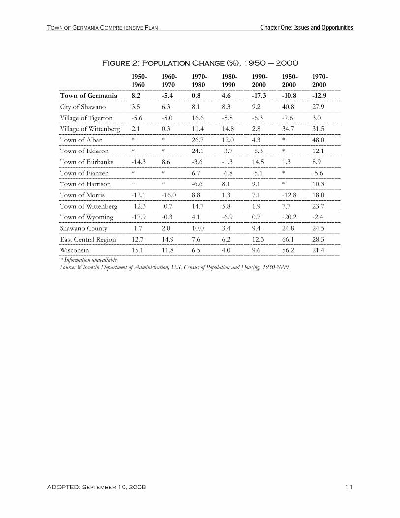
Population Trends and Forecasts The Town of Germania experienced an overall popula-tion decrease of 10.8 percent between 1950 and 2000, from 380 residents to 339. As shown in Figure 1, de-clining population during the 1960s and 1990s outweighed moderate population increases experienced during the 1950s, 1970s, and 1980s. The decrease in Germania’s population since the 1970s (-12.9 percent) was ex-perienced entirely in the 1990s and represents a greater per-centage decline than any of the surrounding towns, the County, the East Central Re-gion (Counties of Calumet, Fond du Lac, Green Lake, Marquette, Menominee, Out-agamie, Shawano, Waupaca, Waushara and Winnebago), or the State. Figure 2 reflects these changes in population. Additionally, Figure 1 indi-cates a slight shift in popula-tion at the County level, mov-ing into villages or cities and away from towns.

Town of Germania Comprehensive Plan Chapter One: Issues and Opportunities
ADOPTED: September 10, 2008 10
Figure 1: Historic Population of Area Communities, 1950 – 2000
1950 1960 1970 1980 1990 2000
Town of Germania 380 411 389 392 410 339
City of Shawano 5,894 6,103 6,488 7,013 7,598 8,298 Village of Tigerton 827 781 742 865 815 764 Village of Wittenberg 874 892 895 997 1,145 1,177 Town of Alban * * 606 768 860 897 Town of Elderon * * 506 628 605 567 Town of Fairbanks 678 581 631 608 600 687 Town of Franzen * * 535 571 532 505 Town of Harrison * * 379 354 383 418 Town of Morris 556 489 411 447 453 485 Town of Wittenberg 830 728 723 829 877 894 Town of Wyoming 357 293 292 304 283 285 Shawano County 32,576 32,006 32,650 35,928 37,157 40,664 East Central Region** 366,887 413,397 475,090 511,033 542,712 609,438 Wisconsin 3,434,575 3,951,777 4,417,731 4,705,767 4,891,769 5,363,675 Shawano County Town Population 21,553
(66%) 20,805 (65%)
20,970 (64%)
23,002 (64%)
23,608 (64%)
25,805 (63%)
Shawano County City and Village Population 11,063 (34%)
11,204 (35%)
11,680 (36%)
12,926 (36%)
13,549 (36%)
14,859 (37%)
* Information unavailable; ** The East Central Region includes Calumet, Fond du Lac, Green Lake, Marquette, Menominee, Outagamie, Shawano, Waupaca, Waushara, and Winnebago Counties
Sources: U.S. Census of Population and Housing, 1950 – 2000; East Central Wisconsin Regional Planning Commission, 2004
Town of Germania Comprehensive Plan Chapter One: Issues and Opportunities
ADOPTED: September 10, 2008 11
Figure 2: Population Change (%), 1950 – 2000
1950-1960
1960-1970
1970-1980
1980-1990
1990-2000
1950-2000
1970-2000
Town of Germania 8.2 -5.4 0.8 4.6 -17.3 -10.8 -12.9
City of Shawano 3.5 6.3 8.1 8.3 9.2 40.8 27.9 Village of Tigerton -5.6 -5.0 16.6 -5.8 -6.3 -7.6 3.0 Village of Wittenberg 2.1 0.3 11.4 14.8 2.8 34.7 31.5 Town of Alban * * 26.7 12.0 4.3 * 48.0 Town of Elderon * * 24.1 -3.7 -6.3 * 12.1 Town of Fairbanks -14.3 8.6 -3.6 -1.3 14.5 1.3 8.9 Town of Franzen * * 6.7 -6.8 -5.1 * -5.6 Town of Harrison * * -6.6 8.1 9.1 * 10.3 Town of Morris -12.1 -16.0 8.8 1.3 7.1 -12.8 18.0 Town of Wittenberg -12.3 -0.7 14.7 5.8 1.9 7.7 23.7 Town of Wyoming -17.9 -0.3 4.1 -6.9 0.7 -20.2 -2.4 Shawano County -1.7 2.0 10.0 3.4 9.4 24.8 24.5 East Central Region 12.7 14.9 7.6 6.2 12.3 66.1 28.3 Wisconsin 15.1 11.8 6.5 4.0 9.6 56.2 21.4 * Information unavailable Source: Wisconsin Department of Administration, U.S. Census of Population and Housing, 1950-2000

Town of Germania Comprehensive Plan Chapter One: Issues and Opportunities
ADOPTED: September 10, 2008 12
Figure 3 indicates that the Town of Germania’s population is projected to decrease over the next 20 years by 82 residents (24 percent) between 2005 and 2025. Actual future population change will depend on market conditions, attitudes about growth, and development regulations.
Figure 3: Population Forecasts, 2005 - 2025
2005 2010 2015 2020 2025
Town of Germania 348* 310 295 280 266
City of Shawano 8,488 8,526 8,632 8,722 8,799 Village of Tigerton 737* 691 655 618 582 Village of Wittenberg 1,152* 1,180 1,181 1,179 1,177 Town of Alban 911* 930 936 950 970 Town of Elderon 584* 544 533 522 512 Town of Fairbanks 706* 731 752 771 790 Town of Franzen 517* 503 502 502 502 Town of Harrison 441* 473 500 527 554 Town of Morris 502* 518 533 548 561 Town of Wittenberg 880* 1,007 1,062 1,113 1,162 Town of Wyoming 299* 284 284 282 281 Shawano County 42,029* 42,987 44,077 45,058 45,995 East Central Region 638,699* 667,636** 691,308** 714,939** 737,521** Wisconsin 5,580,757* 5,751,470 5,931,386 6,110,878 6,274,867 * Source: Wisconsin Department of Administration, 2007 ** Estimates are from the East Central Wisconsin Regional Planning Commission, 2003 Source: Wisconsin Department of Administration, 2004

Town of Germania Comprehensive Plan Chapter One: Issues and Opportunities
ADOPTED: September 10, 2008 13
Demographic Trends Figure 4 shows trends in the Town of Germania’s age and sex distribution from 1990 to 2000, and compares these trends with the surrounding communities, the County, and the State. In 2000 the percentage of the Town’s population less than 18 years old (21.2 percent) was less than Shawano County’s average (25.7 per-cent), the State’s (25.5 percent) and all eight surrounding towns. The percentage of the population over 65 in 2000 (16.5 percent) increased from 1990 (13.4 percent). This percentage is approximately the same as the County’s (16.8 percent), but greater than the percentage of the State (13.1 percent) and all surrounding towns.
Following nationwide trends, the average age of Germania’s population has increased in the past thirty years. In 1990, the Town had a median age of 35.9, and by 2000 it was 44.6. In comparison, Shawano County’s me-dian age increased from 35.3 to 38.5 during the same time period, and the State’s median age increased from 32.9 to 36.0. With prolonged life expectancy and a trend toward declining birth rates, the median age will likely continue to rise over the planning period.
Figure 4: Age and Gender Distribution, 2000
Median Age (2000)
Under 18 (1990), (%)
Under 18 (2000), (%)
Over 65 (1990), (%)
Over 65 (2000), (%)
Female (1990), (%)
Female (2000), (%)
Town of Germania 44.6 29.5 21.2 13.4 16.5 47.1 47.5
City of Shawano 38.3 24.5 24.0 23.9 20.5 54.4 52.3 Village of Tigerton 39.5 26.7 23.3 19.9 21.3 52.8 54.6 Village of Wittenberg 39.8 23.0 24.8 33.0 28.7 56.3 53.3 Town of Alban 38.1 29.8 27.4 15.3 15.4 46.0 47.3 Town of Elderon 40.5 31.7 24.3 11.2 13.2 47.6 47.8 Town of Fairbanks 38.6 28.7 29.5 14.7 15.0 49.3 49.5 Town of Franzen 36.8 33.8 27.7 10.9 15.0 47.7 48.3 Town of Harrison 34.5 33.7 29.9 11.5 10.5 46.7 45.0 Town of Morris 38.6 27.8 25.4 17.9 13.4 46.6 46.8 Town of Wittenberg 34.4 36.6 33.6 10.5 13.4 47.1 44.7 Town of Wyoming 40.1 26.1 22.5 15.9 13.7 47.0 44.9 Shawano County 38.5 26.9 25.7 18.0 16.8 50.1 50.1 Wisconsin 36 26.4 25.5 13.3 13.1 50.6 50.6 Source: U.S. Census of Population and Housing, 1990, 2000

Town of Germania Comprehensive Plan Chapter One: Issues and Opportunities
ADOPTED: September 10, 2008 14
As shown in Figure 5, the Wisconsin Department of Administration has predicted that the median age in the County will continue to increase. The percentage of people aged 65 and older in the County has been pro-jected to increase from 16.8 percent in 2000 to 24.5 percent in 2030. Although a slight increase is predicted until 2010 for the segment of the population between the ages of 20 and 64, the overall percentage of the population in all age categories under 65 is projected to decrease by 2030. When compared to 2000 data, the population of people aged 65 or older is projected to almost double by 2030 while the other age groups will either decrease or increase at a more moderate rate.
Figure 5: Shawano County Age Cohort Forecasts, 2000 to 2030
Year Under 5 5-19 20-64 65+
2000 2,500 (6.1%) 8,863 (21.8%) 22,454 (55.2%) 6,847 (16.8%) 2005 2,465 (5.9%) 8,729 (20.9%) 23,779 (56.9%) 6,842 (16.4%) 2010 2,530 (5.9%) 8,330 (19.4%) 24,909 (57.9%) 7,218 (16.8%) 2015 2,605 (5.9%) 8,185 (18.6%) 25,405 (57.6%) 7,882 (17.9%) 2020 2,658 (5.9%) 8,129 (18.0%) 25,488 (56.6%) 8,783 (19.5%) 2025 2,636 (5.7%) 8,261 (18.0%) 25,032 (54.4%) 10,069 (21.9%) 2030 2,564 (5.5%) 8,337 (17.9%) 24,297 (52.1%) 11,423 (24.5%) Source: Wisconsin Department of Administration, 2004

Town of Germania Comprehensive Plan Chapter One: Issues and Opportunities
ADOPTED: September 10, 2008 15
Household Trends and Forecasts Figure 6 compares selected household characteristics in 2000 for the Town of Germania with surrounding towns, the County, and the State. Following national trends, the average household size declined from 3.01 in 1990 to 2.53 in 2000. The average household size in all of Shawano County in 2000 was 2.57, a decrease from 2.64 in 1990. According to the Wisconsin Department of Administration, the Town’s average household size is forecasted to decrease to 2.45 by 2010, to 2.38 by 2020, and to 2.32 by 2030. These projected household sizes are used to forecast future housing unit demand in the community over the next 20 years and can be found in the Land Use chapter of this Plan.
Figure 6: Household Characteristic Comparisons, 2000
Total Housing Units
Total Households
Average Household Size
% Single-person Household
Town of Germania 142 134 2.53 20.1
City of Shawano 3,587 3,432 2.27 34.7 Village of Tigerton 383 349 2.19 40.1 Village of Wittenberg 331 298 2.72 16.8 Town of Alban 394 325 2.76 20.0 Town of Elderon 260 224 2.53 23.2 Town of Fairbanks 268 235 2.92 19.1 Town of Franzen 212 193 2.62 20.7 Town of Harrison 155 143 2.92 14.0 Town of Morris 217 181 2.68 20.4 Town of Wittenberg 331 298 2.72 16.8 Town of Wyoming 151 111 2.57 21.6 Shawano County 18,317 15,815 2.57 24.9 Wisconsin 2,321,144 2,084,544 2.57 26.8 Source: U.S. Census of Population and Housing, 2000

Town of Germania Comprehensive Plan Chapter One: Issues and Opportunities
ADOPTED: September 10, 2008 16
Employment Trends According to 2000 Census data, the majority of the 201 employed persons living in the Town of Germania work in manufacturing (36.5 percent), education, health and social services (13.2 percent), or industries re-lated to agriculture, forestry, fishing, hunting, and mining (10.7 percent). The percentage of the Town’s labor force employed in each sector in 2000 is shown below:
Figure 7: Town of Germania Labor Force Characteristics, 2000
Occupational Group % of Labor Force
Manufacturing 36.5 Education, Health, Social Services 13.2 Agriculture, Forestry, Fishing, Hunting, Mining 10.7 Entertainment, Recreation, Accommodation, Food Services 9.6 Retail Trade 7.6 Construction 4.6 Transportation, Warehousing, Utilities 4.6 Wholesale Trade 3.0 Information 2.5 Finance, Insurance, Real Estate, Rental, Leasing 2.5 Professional, Scientific, Management, Administrative, Waste Management 1.5 Public Administration 0.5 Source: U.S. Census of Population and Housing, 2000
More current employment data is available at the County level. According to Wisconsin’s Department of Workforce Development, the unemployment rate for Shawano County has increased from 3.5 in 2000 to 5.0 in 2004. Jobs in services increased the most from 1996 to 2001, increasing from 8,865 jobs in 1996 to 9,711 jobs in 2001. The County also experienced a significant amount of growth in government-related jobs, and a small amount of growth in goods producing services such as construction, mining, and durable goods manu-facturing. More recently, in 2002 Shawano County experienced an overall decrease in employment caused mostly by declines in professional and business services, manufacturing, and trade, transportation and utilities. In 2003 an overall increase in employment was driven primarily by increases in financial activities, trade, transportation, and utilities, and education and health.
Overall, the total number of jobs provided in the County remained fairly steady from 1997 to 2004, although a lack of consistent data reporting makes analysis uncertain.
Employment Projections Forecasting employment growth for establishments located within the Town of Germania is difficult because of the community’s small number of employers. Shawano County employment projections provided by Woods & Poole Economics, Inc.—a regional economic and demographics analysis firm—predict the County’s total employment to grow at a rate of 1.25 percent through the year 2030, as shown in Figure 8. The most significant expected increase in employment during this period is in government jobs. In the year 2000,

Town of Germania Comprehensive Plan Chapter One: Issues and Opportunities
ADOPTED: September 10, 2008 17
12.48 percent of all Shawano County jobs were in government. By 2030 this percentage is projected to in-crease to 29.33 percent. At the same time, the percentage of County employment in manufacturing, services, and farming is expected to decline slightly. Figure 9 shows that during the eight year period jobs in manufac-turing, services, and farming are each expected to provide 3 to 4 percent fewer jobs to workers in the County.
Figure 8: Jobs in Shawano County, 1997 – 2004
1997 1998 1999 2000 2001 2002 2003 2004
Manufacturing 2,423 2,426 2,302 2,383 2,275 2,189 2,200 2,329 Education, Health, Social Services 2,117 2,175 2,127 2,013 2,154 2,175 2,197 2,213 Retail Trade 1,572 1,576 1,611 1,598 1,556 1,491 1,562 1,572 Arts, Entertainment, Recreation, Accommodation, Food Services 1,826 1,884 1,980 1,923 1,935 1,952 1,879 1,840
Construction * 471 495 487 513 522 523 508 Transportation, Warehousing, Utilities 613 604 522 517 512 482 446 290* Finance, Insurance, Real Estate, Rental, Leasing 389 382 379 323 311 376 440 438
Public Administration 968 1,019 1,073 1,118 1,182 1,207 1,134 1,202 Professional, Scientific, Management, Administrative, Waste Management 451 523 568 297* 693 502 520 515
Wholesale Trade 437 432 451 454 419 442 437 612 Information * * 236 259 260 261 275 * Total Jobs 10,796 11,492 11,744 11,372 11,813 11,599 11,613 11,519 * Incomplete or unavailable data Source: Wisconsin Department of Workforce Development Annual Census of Employment and Wages
Figure 9: Shawano County Employment Projections, 2000 – 2030
Percent of Jobs in 2000
Percent of Jobs in 2015
Percent of Jobs in 2030
Manufacturing 13.98% 11.15% 9.73% Services 27.86% 22.13% 24.08% Farming 9.32% 7.30% 5.53% Government 12.48% 26.83% 29.23% Source: Woods and Poole Economics, Inc., 2004 State Profile
Education and Income Levels Educational attainment is the highest degree or level of school completed and is one component used to as-sess a community’s labor force potential. Educational attainment often differs by ethnicity, access to higher education, employer expectations and socioeconomic status. Figure 10 compares the educational attainment of Germania residents to those from surrounding communities, the County and the State. According to the

Town of Germania Comprehensive Plan Chapter One: Issues and Opportunities
ADOPTED: September 10, 2008 18
2000 Census, 71.6 percent of the Germania’s population age 25 and older had attained a high school level education or higher. This level is less than the State, the County, and all surrounding towns. Approximately 7.3 percent of this same population had attained a college level education (bachelor’s degree or higher). This is lower than seven of the eight surrounding towns, the County average (12.6 percent) and the State (22.4 per-cent).
Figure 10: Educational Attainment and Median Income Comparisons
High School Graduate or Higher (%)
Bachelor’s Degree or Higher (%)
Graduate or Professional Degree (%)
1989 Median Household Income ($)
1999 Median Household Income ($)
Town of Germania 71.6 7.3 1.9 19,000 38,542
City of Shawano 80.4 18.5 6.0 21,610 31,546 Village of Wittenberg 70.5 14.1 2.5 21,078 29,926 Town of Alban 77.7 8.2 2.2 26,563 36,250 Town of Elderon 81.2 11.4 2.9 26,490 36,667 Town of Fairbanks 72.4 9.4 1.4 22,273 39,432 Town of Franzen 74.8 6.2 1.2 25,000 41,442 Town of Harrison 83.2 7.8 0.0 27,426 40,192 Town of Morris 80.6 11.0 3.4 22,361 36,875 Town of Wittenberg 82.9 15.4 4.5 24,868 42,841 Town of Wyoming 78.9 11.3 4.2 27,292 41,429 Shawano County 81.5 12.6 3.9 23,841 38,069 Wisconsin 85.1 22.4 7.2 29,442 43,791 Source: U.S. Census of Population and Housing, 1990, 2000
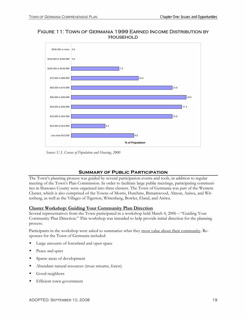
Another measure of a community’s economic well-being is average annual income. Per 2000 Census data, the 1999 median household income in the Town of Germania was $38,542. This figure is greater than the County, less than the State, and roughly equal to the median value of the eight surrounding towns. The re-ported median household income in the Town increased by 102.9 percent from 1989 to 1999, while the State increased by 49 percent and the County increased by roughly 60 percent. This increase was more than three times the rate of inflation or cost of living index (as measured by the Consumer Price Index from the U.S. Department of Labor) for the State and the Midwest Region (approximately 33 percent). As shown in Figure 11, the greatest majority of households in the Town (18.0 percent) reported an income between $35,000 and $49,999, followed by $25,000 to $34,999 (17.3 percent), $50,000 to $74,999 (15.8 percent), $15,000 to $24,999 (15.8 percent) and $75,000 to $99,999 (10.5 percent). More information on County income characteristics can be found in the Economic Development chapter.
Town of Germania Comprehensive Plan Chapter One: Issues and Opportunities
ADOPTED: September 10, 2008 19
Figure 11: Town of Germania 1999 Earned Income Distribution by Household
9.8
5.3
15.8
17.3
18.0
15.8
10.5
7.5
0.0
0.0
Less than $10,000
$10,000 to $14,999
$15,000 to $24,999
$25,000 to $34,999
$35,000 to $49,999
$50,000 to $74,999
$75,000 to $99,999
$100,000 to $149,999
$150,000 to $199,999
$200,000 or more
% of Population
Source: U.S. Census of Population and Housing, 2000
Summary of Public Participation The Town’s planning process was guided by several participation events and tools, in addition to regular meeting of the Town’s Plan Commission. In order to facilitate large public meetings, participating communi-ties in Shawano County were organized into three clusters. The Town of Germania was part of the Western Cluster, which is also comprised of the Towns of Morris, Hutchins, Birnamwood, Almon, Aniwa, and Wit-tenberg, as well as the Villages of Tigerton, Wittenberg, Bowler, Eland, and Aniwa.
Cluster Workshop: Guiding Your Community Plan Direction Several representatives from the Town participated in a workshop held March 4, 2006 – “Guiding Your Community Plan Direction.” This workshop was intended to help provide initial direction for the planning process.
Participants in the workshop were asked to summarize what they most value about their community. Re-sponses for the Town of Germania included:
Large amounts of forestland and open space
Peace and quiet
Sparse areas of development
Abundant natural resources (trout streams, forest)
Good neighbors
Efficient town government

Town of Germania Comprehensive Plan Chapter One: Issues and Opportunities
ADOPTED: September 10, 2008 20
High quality economic development and education
When asked to describe the most crucial trends affecting the Town, the most common responses included:
Residential and recreational development pressures
Managed Forest Law (MFL) lands broken into smaller parcels and closed to recreation
Need to consolidate rural schools
Intensive timber harvest
Based on the identification of individual “Hopes and Dreams” for the future of the community, the group established four key plan directions. These included:
1. Preserve rural character by maintaining open space and high quality natural resources 2. Maintain a local government that is open, participatory, and efficient 3. Enhance regional cooperation in developing economic opportunities consistent with town values 4. Provide high quality public education Attendees also worked together to provide information on a questionnaire to guide the preparation of all nine comprehensive planning elements.
Special Places Photo Exercise In the early fall of 2006, members of the Plan Commission completed a “special places” photo survey to capture the Town’s defining character as seen from the eyes of residents. Commission members photographed the “special places” that capture this character. These photographs suggest places that Com-mission members wish to preserve or see more of in the future. Members also photographed places that they felt hurt the character and appearance of the community, or types of places elsewhere that they did not wish to see in the community.
Of the 94 photos taken in Germania, 57 of them were of “good” or “special” places. These photos can be grouped into three main categories: 1. Scenic roadways throughout the community that serve as constant reminders of the area’s natural beauty,
accentuating the bucolic landscape of the Town; 2. Streams, creeks, and rivers that run through the Town, and are used for recreational purposes such as
trout fishing, wildlife watching, canoeing, and tubing. 3. Historic structures like the Germania Town Hall provide examples of community pride and civic com-
mitment. Photos of places that Commission members felt hurt the character of Germania included: poorly maintained properties in need of clean up or repair (e.g., abandoned buildings, unkempt lawns); streams and creeks threatened by pollution; and family farms (as a symbol of their declining presence).

Town of Germania Comprehensive Plan Chapter One: Issues and Opportunities
ADOPTED: September 10, 2008 21
County Survey A County-wide survey was conducted as part of the Shawano Area Communities Comprehensive Planning Project. In the fall of 2006, 9,993 surveys were sent out to a representative sampling of the 16,312 total households in the County. A total of 1,014 surveys were returned—a 10% response rate. This response rate, coupled with the large percentage of County households who received the survey, provides a significant re-sult. Statistically speaking, we can state that the answers to the survey questions generally yielded a “confi-dence interval” of between 2 and 3 at a “confidence level” of 95%, which means that we can be 95% certain that if every household in the County had responded to a given question, the responses would have varied by less than 3% from the results that were obtained through this survey.
The survey results were also analyzed by cluster (eastern, central, and western). The outcome of this analysis showed a remarkable consistency in responses. The top answers to each question were very similar no matter where in the county the respondent resided. One small difference noted was a difference in importance placed on preservation of farmland and forestland. Respondents in the eastern and central clusters tended to place more value on farmland, while preservation of forestland was more emphasized in the western cluster.
For a complete summary of survey results, see the Shawano County Comprehensive Plan.
Cluster Visioning Session The western cluster Vision workshop was held on October 9, 2006. The group developed the following vi-sion statement: Western Shawano County is a rural area of natural beauty. It contains vibrant towns and vil-lages. They have maintained their natural resources and agricultural lands, and trails. Regular communication and coordinated planning between towns, villages, and the county have encouraged planned, managed growth, and quality essential services, including education, healthcare, and viable businesses.
Cluster Workshop: Building Community Goals The western cluster workshop – “Building Community Goals” - was held on December 13, 2006. Participants from the Town developed goal statements for each element of this Plan as well as ideas for accomplishing the goals. These ideas were incorporated into the programs and recommendations of this Plan.
Planning for Community Character Event This awareness and education event, held January 30, 2007, was intended to help the County and local com-munities begin to consider the types of strategies related to land use and community character that they might like in include in their comprehensive plans. The presentation described proven strategies to help protect and retain small-town or community character in a rural setting. This event provided ideas in advance of the local community Land Use Workshops that were scheduled for February and March; some summary ideas from this event are also included in the Land Use chapter.
Land Use Workshop A meeting was held in March 2007 to develop the Town’s future land use map. This meeting included a discussion of the differences between zoning and land use planning as well as an overview of the trends that are influencing land use in the County. The workshop results were used as a basis for Map 5 Future Land Use in this Plan.
Cluster Workshop: Sharing Future Land Use Maps In October 2007, the Town met again with the western cluster communities. This meeting focused on sharing drafts of individual community draft future land use

Town of Germania Comprehensive Plan Chapter One: Issues and Opportunities
ADOPTED: September 10, 2008 22
GERMANIA’S OPPORTUNITIES Plentiful natural resources
Productive agricultural soils
Rural character
Recreational opportunities
maps, and identifying possible approaches to resolve differences among them. There were no significant dif-ferences observed between Germania’s map and those of nearby Shawano County communities. The work-shop also included discussions of key plan implementation tools, such as zoning updates and intergovern-mental agreements.
Open House and Public Hearing Once the public review draft of this Plan is completed, the Town solicited local public comment. This in-cluded a formal public hearing, held before the Board, in advance of Board adoption of this Plan.
Regional Context and Influences It is useful to step back and understand the forces and factors that shape the area’s physical, economic, and social environ-ment. This “Regional Influences” analysis considers both the assets and challenges of the County related to its position in the broader region. This analysis considers the County’s proximity to growing metropolitan areas, commuting patterns, transportation, recreational resources, and the physical landscape as the key regional influences. These factors are illustrated on the Regional Influences Map in the County Comprehensive Plan and described in the text of the County’s Comprehensive Plan.
Goals, Objectives, Policies, and Programs Each chapter of this Comprehensive Plan includes a set of goals, objectives and policies which will provide the vision and policy guidance that the Plan Commission, Town Board, Town residents, and other interested groups and individuals need to guide the future preservation and development of Germania over the next 20+ years. Goals, objectives, policies, and programs are defined below:
Goals are broad statements that express general public priorities about how the Town will approach de-velopment issues during the next 20+ years. These goals are based on key issues, opportunities and prob-lems that affect the community.
Objectives are more specific than goals and are usually attainable through planning and implementation activities. The accomplishment of an objective contributes to the fulfillment of a goal.
Policies are rules or courses of action used to ensure Plan implementation and to accomplish the goals and objectives. The policies are intended to be used by decision-makers on a day to day basis.
Programs are specific projects or services that are advised to achieve plan goals, objectives, and policies. Programs are sometimes included in the same list as “policies” and are sometimes included in the same section as “recommendations,” depending on the chapter.

Town of Germania Comprehensive Plan Chapter One: Issues and Opportunities
ADOPTED: September 10, 2008 23
Below is a list of goals to guide the future preservation and development in the Town of Germania over the 20-year planning period. Objectives, policies, and programs that forward these goals relevant to each element of this Plan are presented in subsequent chapters.
OVERALL GOALS 1. Encourage the protection and management of natural areas and wildlife habitat. 2. Preserve high water quality. 3. Enhance the Town’s rural character and cherished natural amenities. 4. Protect forested and agricultural lands. 5. Provide safe and affordable housing that reflects the Town’s rural qualities.

Town of Germania Comprehensive Plan
ADOPTED: September 10, 2008 24

Town of Germania Comprehensive Plan Chapter Two: Agricultural, Natural and Cultural Resources
ADOPTED: September 10, 2008 25
AGRICULTURAL RESOURCES RECOMMENDATIONS SUMMARY
Promote family farms
Protect agricultural land & open space
Support large-scale livestock standards
Chapter Two: Agricultural, Natural and Cultural Re-sources
This chapter of the Plan contains background data, goals, objectives, policies, and recommended programs for agricultural preservation, natural resource conservation, and cultural resource protection.
Agricultural Resource Inventory Agriculture is a small but important component of Germania’s local economy, heritage, and character with cultivated agricultural lands mainly located in the central portion of the Town. The character, location, and viability of farming in the Town are described below.
Character of Farming In 2000, approximately 19 percent of the Town’s population lived on farms, and 11 percent of the adult population worked on farms, according to data provided from UW Program on Agricultural and Technical Studies (PATS). Recent reports suggested that there were four dairy farms in the Town of Germania. Over the past 20 years, local trends in farming mirrored the region and the state, with an overall decline in the number of full time farm operators and a drop in average farm sizes (see Figure 12). Overall during this time period over the past two decades, the County experienced a decline in the number of full time farm operators and a drop in average farm sizes. While these statistics indicate a decline in agricul-ture in the County overall, some inconsistencies in the data suggest that differences in methodology or the criteria use to classify “farm use” may lead to under-reporting actual farmland acreage losses. For instance, while the acreage of active agricultural land has declined as a whole, the acreage of land in smaller “hobby” farms may be increasing. The market value of agricultural products sold per farm increased from $81,188 in 1997 to $88,816 in 2002.

Town of Germania Comprehensive Plan Chapter Two: Agricultural, Natural and Cultural Resources
ADOPTED: September 10, 2008 26
Figure 12: Farm Changes in Shawano County, 1987-2002
Number of Farms Number of Farms Lost / Gained
Land in Farm Use (Acres)
Average Farm Size (Acres)
1987 1,631 a - 326,323 a 200 a 1992 1,437 a -194 297,984 a 207 a 1997 1,337 a 1,604 b -100c 297,840 a 270,478 b 223 a 169 b 2002 1,465 b -139d 270,534 b 185 b a Non-adjusted figure: this figure represents the old methodology for counting farms. b Adjusted figure: in 1997, the USDA revised its methodology for counting farms. The new methodology is more accurate and,
as a result, is able to count small farms that would not be counted using the old methodology. c Calculated by comparing the non-adjusted figures from 1992 and 1997. d Calculated by comparing the adjusted figures from 1997 and 2002. Source: USDA Census of Agriculture, 1987-2002
Assessment of Farmland Viability The Natural Resources Conservation Service groups soils based on their capability to produce common culti-vated crops and pasture plants without deteriorating over a long period of time. These capability classifica-tions are based on numerous criteria that include, but are not limited to, the soil’s salinity, capacity to hold moisture, potential for erosion, depth, and texture and structure, as well as local climatic limitations (e.g. tem-perature and rainfall). Under this system of classification, soils are separated into eight classes. Generally, Class I and Class II soils are the best suited for the cultivation of crops.
Class I soils have few limitations that restrict their use. These soils can sustain a wide variety of plants and are well suited for cultivated crops, pasture plants, range lands, and woodlands. Class II soils have moderate limi-tations that restrict the types of plants that can be grown or that require simple conservation practices or soil management techniques to prevent deterioration over time. However, these practices are generally easy to apply, and, therefore, these soils are still able to sustain cultivated crops, pasture plants, range lands, and woodlands.
Soils in Class III have severe limitations that, under natural circumstances, restrict the types of plants that can be grown, and/or that alter the timing of planting, tillage, and harvesting. However, with the application and careful management of special conserva-tion practices, these soils may still be used for cultivated crops, pasture plants, woodlands, and range lands.
Soils in capability classes IV through VIII present increasingly severe limita-tions to the cultivation of crops. Soils in Class VIII have limitations that entirely preclude their use for commercial plant production.
Map 2 depicts the locations of Class I, II, and III soils in the Town of Germa-nia. While there are no Class I soils in the Town, Class II and III soils are dis-persed fairly evenly throughout the Town.

Town of Germania Comprehensive Plan Chapter Two: Agricultural, Natural and Cultural Resources
ADOPTED: September 10, 2008 27
Farmland Preservation Efforts Town of Germania farmers can participate in several federal, State, and Countywide programs and initiatives that are intended to preserve long-term farming activities. The 2002 Farm Bill reauthorized several federal programs, including:
The Conservation Reserve Program (CRP), which provides technical and financial assistance to eligible farmers and ranchers to address soil, water, and related natural resource concerns on their lands in an en-vironmentally beneficial and cost-effective manner.
The Wetland Reserve Program, which provides technical and financial support to help landowners with their wetland restoration efforts.
The Wildlife Habitat Incentives Program, which provides both technical assistance and up to 75 per-cent cost-share assistance to landowners to establish and improve fish and wildlife habitat on their prop-erty.
The Grazing Lands Conservation Initiative, which focuses on providing technical assistance to help new grazers begin using rotational grazing methods. Trained grazing specialists work one-on-one with farmers, developing grazing plans, including seeding recommendations, fencing and watering plans.
The Environmental Quality Incentives Program (EQIP), which provides a voluntary conservation program for farmers and ranchers that promotes agricultural production and environmental quality as compatible national goals. EQIP offers financial and technical help to assist eligible participants install or implement structural and management practices on eligible agricultural land.
In addition, the Wisconsin Department of Revenue offers two important farmland preservation programs, the Farmland Preservation Credit Program and the Farmland Tax Relief Credit Program.
The Farmland Preservation Credit Program strives to preserve Wisconsin farmland by means of local land use planning and soil conservation practices and provides property tax relief to farmland owners. To qualify for the credit, farmland must be 35 acres or more and zoned for exclusive agricultural use or be subject to a preservation agreement between the farmland owner and the State. In addition, all program participants must comply with soil and water conservation standards set by the State Land Conservation Board. The Town of Germania does not have exclusive agriculture zoning; however, in 2005 there were 2 claims for this credit in the Town. It should be noted that claims for both of the Farmland Preservation Credit and the Farmland Tax Relief Credit are documented for the municipality in which the claimant lives, which may not be where the farm is actually located. County-wide, this program has a 31 percent participation rate.
The Farmland Tax Relief Credit Program provides direct benefits to all farmland owners with 35 or more acres. The credit is computed as a percentage of up to $10,000 of property taxes, with the maximum credit of $1,500. In 2005, there were 15 claims for this credit in the Town, constituting a total of $5,522 and an average credit of $368.
Agricultural Resource Goals, Objectives and Policies
Goals: 1. Preserve productive agricultural land for continued agricultural use. 2. Enhance the viability of family-operated farms as an occupation and lifestyle.
Objectives: 1. Protect intensive farm operations from incompatible uses and activities. 2. Preserve the capacity of productive agricultural areas.

Town of Germania Comprehensive Plan Chapter Two: Agricultural, Natural and Cultural Resources
ADOPTED: September 10, 2008 28
Policies: 1. Promote the continuation of agriculture in the Town through encouraging agricultural-related businesses,
value-added agriculture, and other family farm business opportunities to supplement farm income. 2. Direct non-farming uses away from areas with productive agricultural soils and concentrations of farms
through land use planning, enforcement of zoning, and other mechanisms. 3. Support State and County-led efforts to regulate large-scale livestock operations and to mitigate their im-
pacts so that they do not negatively affect nearby land-owners and the environment. 4. Encourage long-term farmers to voluntarily enroll in the State’s Farmland Preservation Program. 5. Work with surrounding communities and the County on programs to preserve farmland and open space
over the long-term (e.g. Purchase of Development Rights program). 6. Cooperate with and support County-level development of animal unit density standards. 7. Require the submittal of a site plan for any livestock operations that desires to expand beyond 1,000 ani-
mal units. 8. Work with UW-Extension, Shawano County, and NRCS to implement and monitor farmland conserva-
tion practices, including Best Management Practices (BMP’s). 9. Promote an educational effort to prevent harmful run-off and other negative water impacts.
Agricultural Resource Recommendations and Programs Expanding on the local planning policies listed above, the following strategies will help preserve and address the Town’s farmland:
Promote the Continuation of the “Family” Farm In Wisconsin, 99% of dairy farms are family-owned. The County and Town planning processes re-vealed support for “family farms” and some apprehension about large “factory” farm operations in Shawano County. Farmers, local governments, and the County have little control over the price for agricultural products, which are set by federal policy and price subsidies. However, interested parties can work locally on a vari-ety of efforts to improve farm family income. These may include:
Working with UW-Extension and County staff to increase efficiency in farm operations, provide technical assistance including exploring alternative farming techniques (e.g., grazing), promote agricultural cooperatives, and provide advice on other financial and technical support opportunities.
Promoting flexibility in zoning regulations to allow non-farm home businesses which have little to no impact on surrounding farm properties.
Developing specialty agriculture, directed primarily to providing food and products for the local and re-gional market. On the demand side, Shawano County communities may work with local stores to pro-

Town of Germania Comprehensive Plan Chapter Two: Agricultural, Natural and Cultural Resources
ADOPTED: September 10, 2008 29
mote sales of local products and help develop Farmers Markets. Strategies for family farms to promote value-added agriculture, directly market farm products to consumers, participate in the Agricultural De-velopment Zone Program, and promote agricultural-based tourism are provided in Chapter Seven: Eco-nomic Development.
Support Efforts to Monitor and Regulate Large-Scale Livestock Operations A growing number of dairy operations across the state have been expanding their herd size and modernizing their facilities to increase productivity and competitiveness. While promoting the continuation of agriculture is a priority in the Town and throughout the County, larger farms may raise concern among neighboring farmers, landowners, and residents because of the intensity of the operation and their impact on local roads, adjacent land uses and the environment. In particular, concerns over animal feedlots and waste storage facili-ties have driven the State and County to establish standards and procedures for regulating these types of uses.
Recognizing the importance of providing standards to guide the siting and operation of feedlots and waste storage associated with livestock operations in the County, Shawano County adopted an Animal Waste Man-agement Ordinance in 2006. Among the purposes of the ordinance are to:
Further the appropriate use and conservation of lands and water resources;
Regulate the location, construction, installation, alteration, design and use of animal feedlots and animal waste storage facilities;
Establish a procedure for the permitting of animal feedlots and waste storage facilities;
Minimize conflicts between municipalities, rural non-farm dwellings and agricultural operations; and
Protect agriculture’s ability to grow and change.
Shawano County’s ordinance requires animal feedlots and/or animal waste storage facilities to obtain the ap-propriate type of permit depending on the size of the existing/proposed operation and the zoning district in which the operation is located. The types of County permits required include the following:
Land Use Permit: required for animal feedlots with between 1 and 249 animal units. An animal unit is not the same as the number of animals on a farm. A conversion factor is used for each animal type (beef, dairy, swine) and maturity (mature or immature) to determine animal units. For instance, a mature dairy cow is equal to 1.4 animal units.
Animal Waste Management Permit: required for animal waste storage facilities for between 1 and 249 animal units when constructing new or modifying existing waste storage facilities, change in location and construction, and ownership; also required for all operations between 250 and 499 animal units
Conditional Use Permit- required for new or existing animal feedlots with greater than 499 animal units. Operations with more than 1000 units also require a Wisconsin Pollution Discharge Elimination System (WPDES) permit from the Wisconsin Department of Natural Resources (see more information on this below)
As referenced above, the State of Wisconsin has rules in place for the siting of new or the expansion of exist-ing livestock operations with 1,000 or more animal units. The WisDNR requires concentrated animal feeding operations with 1,000 or more animal units to obtain a permit. This permit is called a Wisconsin Pollutant Discharge Elimination System (WPDES) Concentrated Animal Feeding Operation permit (CAFO)—or a WPDES CAFO permit. These permits are designed to ensure that farm operations choosing to expand to 1,000 animal units or more use proper planning, construction, and manure management practices to protect water quality from adverse impacts. The State has established the following performance standards for such operations:

Town of Germania Comprehensive Plan Chapter Two: Agricultural, Natural and Cultural Resources
ADOPTED: September 10, 2008 30
Figure 13: Large-Scale Livestock Performance Standards
Performance standard (Type of standard covered) Conservation Initiatives
Control soil erosion to meet tolerable soil loss (T) calculated by RUSLE 2. (Cropland)
Install contour farming, cover and green manure crop, crop rotation, diversions, field windbreaks, residue management, strip-cropping, and terrace systems. Re-lated runoff controls: critical area stabilization, grade stabilization structures, sinkhole treatment, water and sediment control basins, waterway systems.
Construct, maintain and close manure storage facilities to prevent manure overflows and leaks. (Livestock opera-tions and facilities)
Meet Natural Resource Conservation Service (NRCS) standards for construc-tion, maintenance, and closure using technical standards: 313 (waste storage fa-cility), 360 (closure of waste impoundments), 634 (manure transfer standard).
Divert clean water from feedlots. (Live-stock operations and facilities within Water Quality Management Areas)
Install diversions, roof runoff systems, subsurface drains, and underground out-lets.
Enforce manure management prohibi-tions a. No overflow from manure storage
facilities. b. No unconfined manure stacks within
the Water Quality Management Area. c. No direct runoff from feedlots and
manure storage facilities. d. No unlimited access of livestock to
shore land that prevents maintenance of adequate sod cover. (Livestock op-erations and facilities)
a. Design and construct facilities to technical standards, maintain facilities in-cluding adequate freeboard, repair or replace facilities, as needed.
b. Relocate manure piles, construct manure storage facilities. c. Install barnyard runoff control systems, including diversions, milking center
waste control systems, relocating or abandoning animal feeding operations, roof runoff systems, sediment basins, subsurface drains, underground outlets, water and sediment control basin, wastewater treatment strips, well decom-missioning. For manure storage facility runoff, see (b.) above.
d. Install access roads and cattle crossings, animal trails and walkways, critical area stabilization, livestock fencing, livestock watering facilities, prescribed grazing, riparian buffers, stream bank and shoreline protection.
Control nutrient runoff into waters of the state. (Cropland)
Develop and follow an annual nutrient management plan for applying fertilizer or manure. Base plans on soil tests conducted by Department of Agriculture Trade and Consumer Protection certified laboratory. Become qualified to pre-pare plan or use qualified planners. Apply nutrients according to UW-Extension recommendations for crops. Install additional conservation or management practices to reduce nutrient loading.
The Town supports both the application and enforcement of the Shawano County Animal Waste Manage-ment Ordinance and the above State requirements to ensure that the impacts of large-scale livestock opera-tions do not degrade the environment or disturb neighboring uses, and outlines the management of animal units, odor, waste and nutrients, waste storage facilities, runoff, and animal mortality.
As part of providing the required documentation to comply with the County Animal Waste Ordinance or State WPDES CAFO standards, the Town will require that the landowner submit a site plan for any pro-posed operation of over 500 animal units for local review. This site plan should demonstrate how the land-owner intends to mitigate traffic impacts, nuisance issues, and manure storage and water quality impacts asso-ciated with this large-scale operation as outlined in the County and/or State rules. The landowner should meet with the County Zoning Administrator, County Land and Water Conservation staff, and Town Plan Commission or Board to discuss the submitted site plan. The site plan should include all information required per the County Animal Waste Management Ordinance, as well as the information as required for the WPDES CAFO permit application, as applicable.
Town of Germania Comprehensive Plan Chapter Two: Agricultural, Natural and Cultural Resources
ADOPTED: September 10, 2008 31
Animal Unit Density Standards Agriculture is an important component of the character and economy of Shawano County and the Town of Germania. In addition to larger farming operations, “hobby farms” are also prevalent in the County. In order to continue the keeping of farm animals and hobby farm animals in a manner which allows for reasonable numbers of animals, the Town intends to work with the County to establish animal unit density standards in each zoning district where farm animals are allowed. This effort would help to avoid nuisances, undesirable odors, and other negative impacts on neighboring properties; protect human and animal health; satisfy the needs of animals for exercise space; and protect water quality.
The County should consider adopting an animal unit density standard, which is a measure that represents a common denominator for the purpose of defining in what quantity farm animals may be kept. The County’s zoning ordinance could include specific animal unit limitations in each of the zoning districts, particularly for smaller lots where animals are kept as a hobby.
It is also recommended that animal owners manage manure and other waste responsibly. An animal unit den-sity standard assures that land uses that keep or maintain animals provide and continuously maintain land available for animal exercise and nutrient (manure) management.
Town of Germania Comprehensive Plan Chapter Two: Agricultural, Natural and Cultural Resources
ADOPTED: September 10, 2008 32

Town of Germania Comprehensive Plan Chapter Two: Agricultural, Natural and Cultural Resources
ADOPTED: September 10, 2008 33
Map 2: Soil Suitability For Agriculture

Town of Germania Comprehensive Plan Chapter Two: Agricultural, Natural and Cultural Resources
ADOPTED: September 10, 2008 34

Town of Germania Comprehensive Plan Chapter Two: Agricultural, Natural and Cultural Resources
ADOPTED: September 10, 2008 35
NATURAL RESOURCES
RECOMMENDATIONS SUMMARY Protect surface and ground water
Encourage sustainable forestry practices
Protect woodlands
Natural Resource Inventory Understanding the extent and location of the Town’s natural features suggests possible advantages for particular land uses. It is also essential to understand the location of environmentally sensitive areas where development is not appropriate. This will prevent severe developmental or environmental problems that may be difficult or costly to correct in the future. Maintenance of these natural features is also important for community appearance and for the functions they perform for natural communities. Map 3 depicts the Germania’s environmentally sensitive areas and key natural resource areas, some of which are described in more detail below.
Topography The topography in the Town of Germania was shaped over 10,000 years ago by Wisconsin’s most recent pe-riod of glacial activity. The landscape is characterized by gently rolling moraines and drumlins that were formed by material deposited along the edges of the ice sheet during the glacier’s retreat. These landscape features are most prominent in the western half of the County.
Metallic and Non-Metallic Minerals Glacial deposits consist of soil, subsoil, sediment, sand, gravel, and/or stone and are characterized by a variety of depths and patterns throughout the Town. Furthermore, the Town’s glacial deposits can provide many valuable non-metallic minerals such as sand and gravel that are used for road construction, housing, and commercial developments. One active non-metallic mining operation is located in the southeastern portion of the Town. Currently, there are no active metallic mining activities anywhere in Shawano County because me-tallic minerals are not present in high quantities. However, there are some limited deposits of copper and other base metals in the northwestern portion of Shawano County.
Groundwater Groundwater is comprised of the portion of rainfall that does not run off to streams or rivers and that does not evaporate or transpire from plants. This water percolates down through the soil until it reaches the satu-rated zone of an aquifer. Groundwater supplies all of the water for domestic, commercial and industrial uses in the Town of Germania., and the majority of the Town’s residents rely on private wells for their water sup-ply.
The quality of groundwater in the Town is generally good. However, groundwater contamination is of con-cern due to the characteristics of the bedrock and surficial geology found in some parts of the Town. Areas with permeable soils and a high water table are the most susceptible to contamination from specific land uses. The majority of the Town of Germania’s groundwater is at least moderately susceptible to contamination, and there are several significant areas that are highly susceptible to contamination.
In rural areas, the most common groundwater contaminant is nitrate-nitrogen, which can come from im-properly functioning on-site wastewater systems, animal feedlots, livestock waste facilities, sludge and septage application, lawn and agricultural fertilizers, and decaying plant debris. A 2002 report by the Central Wiscon-sin Groundwater Center found that 8.9 percent of private wells tested in Shawano County have levels of ni-trate-nitrogen over the health standard (10 mg/liter). Nitrate-nitrogen is a potential human health threat, par-ticularly for infants. This contaminant has been known to cause the condition methemoglobinemia, which interferes with the blood’s ability to carry oxygen. This same report indicated that 15.3 percent of private wells sampled in Shawano County tested positive for fecal coliform bacteria, which indicates that fecal wastes

Town of Germania Comprehensive Plan Chapter Two: Agricultural, Natural and Cultural Resources
ADOPTED: September 10, 2008 36
may be contaminating the water and that pathogenic organisms could be present. In addition, arsenic has been identified in groundwater, particularly in the eastern part of Shawano County.
Watersheds and Surface Waters The northeastern portion of the Town of Germania is located within the Middle and South Branch of the Embarrass River Watershed, and the southwestern portion of the Town is located within the Upper Little Wolf River Watershed. Both watersheds are located within the Wolf River Basin, which drains over 3,600 square miles and portions of eleven counties in northeastern Wisconsin. The Wolf River, which traverses the eastern portion of Shawano County, is the Basin’s most significant water re-source. Currently, the Basin faces many challenges to its overall ecological health, including non-point source water pollu-tion, the loss of shoreland habitats, and the presence of various exotic invasive species.
The South Branch of the Embarrass River is the most prominent water re-source in the Town. Other streams in-clude Comet Creek, Jackson Creek, Cleveland Creek, Beetle Creek, and Steinke Creek. These creeks are a valued part of the Town’s rural character.
Floodplains The Federal Emergency Management Agency (FEMA) designates floodplains. These are areas predicted to be inundated with flood waters in the 100-year storm event (e.g., a storm that has a 1 percent chance of happen-ing in any given year). Development within floodplains is strongly discouraged so as to property damage.
Map 3 shows the 2,767 acres (12 percent) of land in the Town classified as floodplain. Floodplain areas in the Town are located along the South Branch of the Embarrass River and its tributaries. The Shawano County Floodplain Ordinance regulates land uses and development within designated floodplain areas. The National Flood Insurance Program maps produced by the FEMA should be referenced for official delineation and elevations of floodplain boundaries.
Wetlands According the Wisconsin DNR’s Wetland Inventory Maps, wetland habitats comprise approximately 5,422 acres (23 percent) of the Town’s total land area, not including small tracts of wetland that are less than five acres. Approximately 87 percent of these wetlands are forested. Wetland ecosystems play significant roles in maintaining the quality of groundwater and surface water and provide valuable habitats for fish, birds, and other wildlife. The majority of wetlands are located along the Embarrass River and Cleveland Creek. The Shawano County Shoreland/Wetland Ordinance regulates the filling or modification of wetlands over five acres within 300 feet of navigable streams and 1,000 feet of lake and ponds.
Ecological Landscapes An ecological landscape is defined as a region characterized by a unique combination of physical and biologi-cal attributes, such as climate, geology, soils, water, or vegetation. Different ecological landscapes offer dis-tinct management opportunities based upon their levels of biological productivity, habitat suitability for wild-life, and presence of rare species and natural communities. The Town of Germania is within the Forest Tran-sition Landscape. Understanding the distinct attributes of this landscape will be important when identifying future land management and land use goals.

Town of Germania Comprehensive Plan Chapter Two: Agricultural, Natural and Cultural Resources
ADOPTED: September 10, 2008 37
Woodlands The Town of Germania is located within Wisconsin’s northern forest zone, which is characterized by a mix-ture of coniferous and deciduous forest types. Typical tree species include Hemlock, Beech, Sugar Maple, Yellow Birch, and White and Red Pine. Dense hardwood forests and timber stands are more characteristic of the western portion of Shawano County, and the majority of land in Germania remains wooded.
The Forest Crop Law (FCL), which was enacted in 1927, closed enrollment on January 1, 1986. This program allows landowners to pay taxes on timber only after harvesting, or when the contract is terminated. It has promoted and encouraged long-term investments as well as the proper management of woodlands. This pro-gram has since been replaced by the Managed Forest Law (MFL) Program. However, as of 2006, there were still 370.75 acres of privately-owned wood-lands in the Town enrolled in the FCL pro-gram. As of 2007, there were 4,728.52 acres of pri-vately-owned woodland in the Town en-rolled in the MFL Program. This program is intended to promote sustainable forestry practices and is available to landowners with 10 or more contiguous acres of forestland. Participating landowners must agree to abide by a forest management plan. In exchange, their land is taxed at a rate below the State average. Significant tracts of land are being removed from the MFL Program and are being closed to public recreation and hunt-ing. This issue is addressed in several chap-ters of this Plan.
Steep Slopes As shown on Map 3, steep slopes exceeding a 12 percent grade are scattered throughout most of the Town. Generally, slopes that have between 12 percent and 20 percent grade present challenges for building site de-velopment, and slopes that exceed a 20 percent grade are not recommended for any disturbance or develop-ment.
Rare Species Occurrences/Natural Areas WisDNR’s Natural Heritage Inventory program maintains data on the general location and status of threat-ened or endangered plant and animal species and natural communities and species and communities of spe-cial concern. According to this inventory, the Town of Germania has at least 3 natural communities and 1 plant species that are either threatened or endangered. More specific information on location and type of spe-cies is available from the State’s Bureau of Endangered Resources.
State Natural Areas/Wildlife Areas There are no State Natural Areas or Wildlife Areas located in the Town of Germania.

Town of Germania Comprehensive Plan Chapter Two: Agricultural, Natural and Cultural Resources
ADOPTED: September 10, 2008 38
Natural Resource Goals, Objectives and Policies
Goal: 1. Protect natural features, including wetlands, streams, lakes, woodlands, wildlife habitats, open space, and
groundwater resources.
Objectives: 1. Protect surface water and shorelines from pollution, erosion and other degrading effects. 2. Encourage effective private management of woodlands to reduce the potential for wildfires and other
dangers. 3. Protect large blocks of forest and environmental corridors.
Policies: 1. Encourage and actively promote sustainable forest management practices and programs (MFL) to the
Town’s woodland owners. 2. Encourage property owners to remove downed trees and other potential wildfire hazards. 3. Work cooperatively with Shawano County and neighboring communities to protect natural resources. 4. Identify and promote educational programs for water quality protection, wildlife, wetland, and woodland
management. 5. Identify and promote educational programs regarding the protection of threatened and endangered spe-
cies. 6. Work with the Department of Natural Resources to encourage the sensible use and protection of the
Town’s natural resources. 7. Protect environmental corridors (shown on Map 5) as a composite of the Town’s most sensitive envi-
ronmental areas, including wetlands, floodplains, and steep slopes, especially adjacent to future develop-ment areas.
8. Protect groundwater quality through the proper placement of new on-site wastewater treatment systems, maintenance of older systems, and avoidance of an over-concentration of both new and old systems in one place.
9. Protect surface water quality (lakes, rivers, wetlands) by supporting streambank management, natural shoreline restoration, erosion control, river clean-up initiatives, proper agricultural practices, stormwater management, and use of vegetated buffers.
10. Encourage soil conservation practices related to agricultural activities, forest products, and other devel-opment.
11. Carefully review proposals for mineral extraction operations and the reclamation of existing mineral ex-traction sites.
Natural Resource Recommendations and Programs Expanding on the planning policies listed above, this section of the Plan provides specific recommendations for conserving the Town’s environmentally sensitive areas, woodlands, surface and ground water quality, and natural habitat areas. Specific tools to implement these recommendations are provided in Chapter Nine: Im-plementation.
Protect Environmental Corridors Environmental corridors are, in effect, a composite of important individual elements of the natural resource base. They have immeasurable environmental, ecological, passive recreational, stormwater management, groundwater protection and recharge, erosion control, wildlife, timber, and scenic value. Environmental cor-ridors also have severe limitations for development; therefore, minimizing development in these areas also

Town of Germania Comprehensive Plan Chapter Two: Agricultural, Natural and Cultural Resources
ADOPTED: September 10, 2008 39
protects private property. Environmental corridors generally occur in a linear (corridor) pattern on the land-scape (see Map 5 for Environmental Corridor delineations). Environmental corridors include the following areas:
Wisconsin DNR-identified wetlands as mapped in the Wisconsin Wetlands Inventory and subject to ex-isting zoning control. This layer may not include all wetlands that are subject to State and/or federal dis-turbance rules. Protection from development should be provided to these areas (also shown on Map 2) as well as those identified through more detailed field surveys to preserve the significant natural functions that wetlands provide.
Federal Emergency Management Association (FEMA) designated floodplains subject to existing zoning control. These general floodplain delineations represent the areas potentially subject to the 100-year flood. All areas subject to flooding are not necessarily re-flected in mapped floodplains (or within the environmental corridor delineation). The Town intends to help protect areas within the 100-year floodplain as shown on Flood Insurance Rate Maps and more detailed surveys from develop-ment to avoid damage to property and the health, safety and welfare of the community.
Lands with steep slopes of 12 percent or greater. Due to the instability of these soils and erosion con-cerns, development (including buildings and driveways) on these steep slopes is not advisable.
New development should generally be discouraged in environmental corridors. Development types should be limited to those which will not impair the resource, and which are compatible to existing and proposed uses on surrounding lands. New homes and other buildings should not be placed in these areas if other, more ap-propriate, building sites are available outside the environmental corridor. Sensitivity to surrounding natural resources should be the guiding principal when reviewing the appropriateness of development in mapped environmental corridors. The Town will encourage land owners to minimize the “footprint” of any construc-tion in corridor areas.
The environmental corridors depicted in Map 5 are necessarily general and should be used to identify general areas where development may not be appropriate. Lands within that designation may be removed under one or more of the following circumstances:
More detailed study reveals that the characteristic(s) which originally resulted in its designation as an envi-ronmental corridor no longer exists, never existed, or exists in a different location or configuration on the site, or
Approvals from appropriate agencies are granted to alter a property so that the characteristic which re-sulted in its classification as an environmental corridor will no longer exist, or
A mapping error has been identified.
Protect Surface Water Quality The Town has significant surface water resources, such as the Middle Branch of the Embarrass River, which supports diverse wildlife. Shorelands are defined by the State and Shawano County to include all lands within 300 feet of a river or stream and 1,000 feet from a lake or pond. Within these areas, the types and intensity of

Town of Germania Comprehensive Plan Chapter Two: Agricultural, Natural and Cultural Resources
ADOPTED: September 10, 2008 40
development allowed are limited and special regulations regarding clearance of natural vegetation, structures, and water run-off are established to protect surface water quality.
As development in the Town continues, construction site erosion control and ongoing stormwater manage-ment are increasingly important issues. Soil erosion rates in the Embarrass River watershed have been high in recent history. Unmanaged construction sites are one of the greatest contributors to off-site sediment runoff. Currently, under a recent change to State law, construction site erosion control plans are required for all sites over 1 acre in area. Techniques include natural drainage swales, retention and detention basins, rain gardens on indi-vidual lots, and vegetative buffers adjacent to water bodies and other sensitive re-sources (see Figure 14). These techniques control the quantity and improve the qual-ity of water run-off during storms. Again, these techniques are critical in shoreland areas and may serve as important within groundwater recharge areas.
Figure 14: Benefits of Vegetative Buffers
The Town hopes to preserve surface water quality in existing high-quality watersheds and improving water quality in watersheds with the greatest water quality problems – focusing on maintaining stability in streams like Dent Creek, and improving water quality in the Middle Branch of the Embarrass River. The Town could work cooperatively with the County and WisDNR in these efforts. In cooperation with the County, the Town may seek funds from State programs designed to assist in efforts to protect and enhance surface water quality in key areas, including:

Town of Germania Comprehensive Plan Chapter Two: Agricultural, Natural and Cultural Resources
ADOPTED: September 10, 2008 41
The WisDNR Targeted Runoff Management Program, which provides financial assistance to communi-ties to either construct best management practices themselves or contract with individual landowners to install such practices.
The WisDNR River Protection Grant Program, which aims to prevent the deterioration of water quality, fisheries habitat, and natural beauty as the number of homes, recreational activities, and other uses in-creases along rivers. Grant dollars may be used for river organization development; information and edu-cation; assessments of water quality, fish, and aquatic life; nonpoint source evaluations; purchase of land or easements; development of local ordinances; and habitat restoration.
Protect Groundwater Quantity and Quality Groundwater is the source for all of the Town’s drinking water supply. If groundwater is removed from an aquifer more quickly than it is recharged, the amount of water available in the aquifer is reduced. This may be of particular concern where water tables are dropping from groundwater use in portions of the Town with high concentrations of dwelling units. In addition, groundwater recharges local rivers and streams. For these reasons, groundwater protection is critical. Through this Plan, the Town supports several efforts to protect groundwater quality and quantity, including the following:
Minimize new development in areas susceptible to groundwater contamination. In portions of the Town more highly susceptible to groundwater contamination, the Town will limit the location of commercial or other uses with the potential to emit pollutants into the soil or groundwater. Examples include gas stations or other uses that store fuel or other potential contaminants.
Ensure the proper placement and maintenance of on-site waste disposal (septic) systems. Improper placement and maintenance, particularly of both old systems and chemical and biological treatment systems allowed un-der the new “COMM 83” law, can result in groundwater contamination. In addition, an over-concentration of on-site septic systems can increase the probability of groundwater pollution. On-site system recommendations are addressed more completely in Chapter Six: Utilities and Community Facili-ties.
Remain informed and involved in decisions pertaining to high-capacity wells. Permits for high capacity wells (those withdrawing more than 100,000 gallons per day) must be registered with and permitted by WisDNR. The DNR will not approve wells that impair public water utility supplies, and has authority to deny applica-tions for high-capacity wells should they have the potential to adversely affect the environment. Wells drawing more than 2 million gallons per day are evaluated in terms of whether they impair public water rights, future water use plans, or cause adverse groundwater effects. Should potential new sites be pro-posed in Germania over the planning period, the Town will strive to remain informed and involved in any WisDNR decisions regarding high-capacity well decisions. One way to stay involved in through regu-lar communication and providing public comment during Environmental Impact Statement review peri-ods. The Town could also consider participating in cooperative groundwater management plans with municipalities, industries, local and regional planning agencies, and State agencies where appropriate, should special groundwater protection priority areas be delineated in the future.
Oppose any efforts to site a waste disposal or storage facility in the Town.

Town of Germania Comprehensive Plan Chapter Two: Agricultural, Natural and Cultural Resources
ADOPTED: September 10, 2008 42
Support Woodland Management Efforts The Town’s woodlands are an important component of the area’s landscape and character, as well as the rec-reational base and rural economy. These woodlands provide timber revenues to private landowners and abundant recreational opportunities for both residents and visitors. Development located near and within the Town’s woodlands should be planned and sited in a manner compatible with maintaining the Town’s wood-lands as scenic and economic resources.
As a method to preserve this important natural resource over the planning period, the Town encourages pri-vate landowners to participate in the State’s Managed Forest Land (MFL) Program. Adhering to a forest management plan—prepared for each piece of MFL-enrolled property—is a requirement of the program.
In general, before any logging activities commence on MFL lands in Germania, the private landowner or con-tractor prepare a forest management plan. This plan, covering activities from road construction, timber har-vesting and site preparation, should use WisDNR’s Best Management Practices (or BMPs). BMPs help to reduce erosion to ensure long term woodland maintenance, and promote their economic utilization. WisDNR has cost-sharing assistance for plans written by a consulting forester, or assisted by the regional WisDNR for-ester.
The WisDNR also administers funding to en-courage stewardship and sound management of privately owned forested lands. These in-clude forest stewardship grants and incentives supporting technical assistance, informational and educational materials; plans for practices that protect, maintain, and enhance forest re-sources including wetlands, lakes and streams; tree planting and stand improvement; soil and water protection; and other habitat enhance-ments.
As an alternative or in addition to the above strategies, landowners engaged in active for-estry practices may also consider creating for-est cooperatives.
WisDNR provides information on preventative measures and strategies to mitigate wildfire damage. This Plan includes several strategies to prevent or minimize any major wildfire damage:
Chapter Four recommends updating the Town’s Driveway Ordinance to ensure that emergency vehicles can safely and efficiently access structures.
Chapter Six presents specific recommendations on preventative measures that could be used around a private lot and home to mitigate wildfire damage and spreading.
Carefully Review Proposals for Mineral Extraction Sites and Enforce Reclamation The Town intends to remain aware of and carefully review any proposal for extraction activity. Mineral re-sources have potentially significant economic, community, and environmental impacts. Wisconsin now has administrative rules on the reclamation of nonmetallic mines (NR 135), but these do not cover many aspects of their operation. The Town will work with the County to assure that applications for approval of extraction operations present a clear picture of proposed activities, through submittal of a complete description, a de-tailed site/operations plan map(s), and a reclamation plan.

Town of Germania Comprehensive Plan Chapter Two: Agricultural, Natural and Cultural Resources
ADOPTED: September 10, 2008 43
In its review of proposals for new or expanded mineral extraction operations, the Town will consider the fol-lowing issues:
The site will be developed and operated according to the site/operations plan.
Spraying of the site and driveways should be considered to control dust.
On-site bulk fuel storage and appropriate places for fueling of equipment (e.g., above the water table) should be addressed to minimize the potential for groundwater contamination.
Access should only be through services points designated as entrances on the site/operations plan.
Hours of operation may be limited if the extraction site is close to residential properties.
Expectations for any blasting, drilling, screening and hours should be clearly understood.
If blasting or drilling is requested, additional standards may be applied with relation to frequency, noise and vibration levels, notice to neighbors, pre-inspection of neighboring basements and wells, and claims procedures.
Unless the extraction site is very inaccessible, it should be completely enclosed by a safety fence or main-tained at a gentle slope.
The petitioner should have to furnish a certificate of insurance before operations commence. The Town must be listed as an “additional named insured” on the liability insurance policy.
Provisions for the upgrade, repair, and maintenance of Town roads may be appropriate. Posting a bond for such work may be required.

Town of Germania Comprehensive Plan Chapter Two: Agricultural, Natural and Cultural Resources
ADOPTED: September 10, 2008 44

Town of Germania Comprehensive Plan Chapter Two: Agricultural, Natural and Cultural Resources
ADOPTED: September 10, 2008 45
Map 3: Natural Features

Town of Germania Comprehensive Plan Chapter Two: Agricultural, Natural and Cultural Resources
ADOPTED: September 10, 2008 46

Town of Germania Comprehensive Plan Chapter Two: Agricultural, Natural and Cultural Resources
ADOPTED: September 10, 2008 47
CULTURAL RESOURCES
RECOMMENDATIONS SUMMARY Encourage historic site preservation
Maintain the historic Town Hall and consider designating it on a historic register
Cultural Resource Inventory The Town of Germania and the entire region was once home to the Menominee and Chippewa Native American tribes. They hunted and fished the rivers and lakes of this region for hundreds of years prior to the arrival of the Europeans. In 1673 French Jesuit priest Jacques Marquette and Jean Nicolet journeyed through the County, but did not settle. Samuel Farnsworth came to the region in 1843 via the Wolf River and realized the potential for lumbering. A year later Charles Wescott established a sawmill at the junction of the Wolf River and Shawano Lake. On the November 10, 1845, the first steam-powered boat, The Manchester, arrived at what is now the City of Shawano on the Wolf River.
By 1851 logging had spread out from the Shawano area to other rivers that flowed into the Wolf. In 1853 the population of the region had grown to 254 inhabitants and “Shawanaw” County was established as a separate County from sections of Oconto and Outagamie Counties. The name Shawanaw comes from the Native American Sha-wa-Nah-Pay-Sa which meant “lake to the south” in Menominee and Chippewa; the current spelling was adopted in 1864. As the community grew and the land was cut-over, Germans came in large numbers to clear the land of stumps, drain the swamps, and establish farms that remain to this day. Joining these European pioneers were also Bohemians, Norwegians, Irish, and, to a lesser degree, English and French immigrants. While lumbering still played a small part in the economy after 1900, the primary economy was dairy farming and associated industries.
Each generation of residents has added to the cultural, religious, and architectural flavor of the region. Pres-ervation of these historic and cultural resources fosters a sense of pride, improves quality of life, and provides an important feeling of social and cultural continuity between the past, present, and future. The following sections describe the Town of Germania’s historic and archeological resources.
Historic Resources The Wisconsin Historical Society’s Archi-tecture and History Inventory (AHI) con-tains data on a wide range of historic properties throughout the State – such as round barns, cast iron bridges, commercial buildings, school houses, and turn-of-the-century homes – that create Wisconsin’s distinct cultural landscape. There are no documented properties in the Town of Germania listed on the National or State Historic Registers. However, the Depres-sion-era stone Town Hall is a local land-mark and source of pride.
The Shawano County Historical Society Heritage Park Museum, located in the City of Shawano, seeks to preserve and promote historic resources. The six-building museum compound and its exhibits bring to life the history of immigrants, lumberjacks and early farmers who settled this area of Wisconsin.
Archeological Resources There are no archeological sites within the Town of Germania designated by the Wisconsin State Historical Society, although all human burial sites, including cemeteries and Indian mounds, are protected under State

Town of Germania Comprehensive Plan Chapter Two: Agricultural, Natural and Cultural Resources
ADOPTED: September 10, 2008 48
law. The National Historic Preservation Act of 1966 requires federal agencies to insure that their actions do not adversely affect archeological sites on or eligible for listing on the National Register of Historic Places. Archeological sites can be protected during the course of State agency activities if the sites have been re-corded with the Office of the State Archeologist.
Cultural Resource Goals, Objectives and Policies
Goal: 1. Encourage the maintenance of the historic and scenic character of the Town.
Objectives: 1. Identify and promote the preservation of key historical resources in the Town. 2. Maintain the winding, lightly traveled roadways that contribute to the Town’s scenic character and recrea-
tional opportunities. 3. Preserve blocks of woodlands, hunting land, river corridors, wetlands, and open space that contribute to
Germania’s rural way of life.
Policies: 1. Encourage private landowner voluntary protection and rehabilitation of historic and archaeological sites. 2. Consider participating in a countywide survey of historic resources. 3. Work with other communities to promote “heritage tourism” (e.g. local festivals, fairs, recreation, farm
tours) that celebrate the heritage and rural setting of Germania. 4. Pursue the continued maintenance of Town Hall and encourage its use for community events.
Cultural Resource Recommendations and Programs Expanding on the local planning policies listed above, the Town of Germania intends to preserve and cele-brate its important cultural resources by pursuing the following strategies:
Explore Designation of Town Hall as Historic Structure The Town will continue to maintain its historic Town Hall, and explore its possible designation on a Register of Historic Places. State Register and/or National Register listing recognize properties that physically embody important aspects of local, state, and national history. Eligible properties must retain their essential physical appearance from the period in which they were important and meet one of the four criteria for listing:
Be a good local example of an architectural style. To be individually eligible in the area of architecture, a property must retain the majority of its original architectural features and be a good example of the style and period.
Be associated with a person important in our past. The property must be the resource most closely re-lated to the person’s period and area of importance.
Represent an important period, movement or trend in local, state or national history.
Have the potential to yield information; these types of properties are primarily archaeological sites.
The Town Hall clearly meets at least two of the above requirements. Submitting a National Register Ques-tionnaire is the first step in nominating a property to the State Register and National Register. After the Ques-tionnaire and photos of the property are submitted, historic preservation staff will review the documentation and provide a staff opinion about a property's eligibility.

Town of Germania Comprehensive Plan Chapter Two: Agricultural, Natural and Cultural Resources
ADOPTED: September 10, 2008 49
Protect and Rehabilitate Known Historic and Archeological Sites Under Wisconsin law, Native American burial mounds, unmarked burials, and all marked and unmarked cemeteries are protected from intentional disturbance. The Town may make a specific request to the State Historical Society for more detailed information when a development proposal is offered on land in an area where a historic or archeological site has been mapped.
Promote Heritage Tourism The Town will cooperate with the County and other communities to promote tourism opportunities that celebrate and take economic advantage of the area’s historic, archeological, scenic and natural resources. This type of tourism—often called “Heritage Tourism”—will become increasingly popular as the baby boom gen-eration eases into retirement. Heritage tourism may focus on museums and cultural centers, vibrant rural communities, historic architecture, historic settlement patterns, rustic roads and the Town’s natural amenities. Agricultural tourism highlighting both traditional agriculture and organic farms has also been successful in the State, such as seasonal farm events with maple sugaring, pumpkin patches, sleigh ridges, corn mazes or tours of organic farms.
Community Design Resources Scenic beauty is a very important cultural resource in the Town of Germania. There are numerous local areas that offer expansive views of the landscape, key landmarks (e.g., hills), and bodies of water. Areas identified as having high scenic value through the special places photo exercise include the Town’s woodlands, wooded roads, rivers, and open spaces.
New development should be designed, located, and landscaped in a manner that does not detract from these scenic views. Chapter Six: Housing and Neighborhood Development provides additional guidance on minimizing the visual impact of devel-opment.
Park, Open Space, Recreational Resources The planning goals, objectives, policies, maps and programs related to park, open space, and recreational re-sources in Town of Germania are presented in Chapter Five: Utilities and Community Facilities. Goals, objec-tives, policies, maps, and programs related to community design are presented in Chapter Three: Land Use and Chapter Seven: Economic Development.

Town of Germania Comprehensive Plan Chapter Two: Agricultural, Natural and Cultural Resources
ADOPTED: September 10, 2008 50

Town of Germania Comprehensive Plan Chapter Three: Land Use
ADOPTED: September 10, 2008 51
LAND USE RECOMMENDATIONS SUMMARY
Maintain the Town’s rural character and service levels by:
Promoting continued open space, farming, and forestry uses
Making sure development doesn’t happen too quickly or in large subdivisions
Directing this limited new development to areas close to existing roads
Guiding non-residential development and larger housing developments to nearby villages
Chapter Three: Land Use
This chapter contains a compilation of background information, goals, objectives, policies and recommended programs to guide the future preservation and development of lands in the Town of Germania. It includes maps showing existing land uses and recommended future land uses, and provides land use data and analysis.
Land Use Map Categories
Existing Land Use Map Categories (Map 4) Map 4 divides existing land uses in the community into several categories. These categories are representative of existing (2006) land use and do not necessarily reflect the current zoning district designation, or the desired future land use pattern. This same set of categories was used to map existing land uses over the entire County.
Public Open Space and Recreation: Publicly-owned land designated as State parks, scenic areas, or conservation areas; County parks or recreation areas; town, city, or village parks; or other recreational facilities open to the public and owned by public entities, non-profit agencies, or private owners (e.g. golf courses, campgrounds).
Agriculture: Agricultural and related uses; associated home occupations and small family businesses which do not interfere with the interests of adjacent property owners; agricultural related businesses such as imple-ment dealerships; and housing at a maximum density of one residence per 35 acres.
Open Space and Forestry: Forestry and related uses; conservation of natural resources - swamps, marsh-lands, river and lakeshore, wildlife preserves; associated home occupations and small family businesses which do not interfere with the interests of adjacent property owners; and housing at a maximum density of one residence per 35 acres.
Residential (Unsewered): Mainly single-family housing, served by individual on-site waste treatment (sep-tic) systems.
Mixed Residential: Variety of residential units, including single-family, duplex and multiple-family housing (3+ unit buildings), manufactured home parks, and mobile home parks, served by a public sanitary sewer sys-tem or group on-site waste treatment system.
Commercial: Indoor commercial, retail, service, tourism-oriented, office, and institutional, uses, excluding manufacturing, warehousing, and distribution.
Industrial: Indoor manufacturing, warehousing, distribution, and office uses, sometimes with outdoor stor-age areas.
Mineral Extraction: Current use as a quarry, gravel pit, clay extraction, peat extraction, and related land uses.
Community Facilities: Large-scale public buildings, hospitals, airports, power substations, and special-care facilities.

Town of Germania Comprehensive Plan Chapter Three: Land Use
ADOPTED: September 10, 2008 52
Existing Land Use Pattern An accurate depiction of the Town’s existing land use pattern is the first step in planning for a desired future land use pattern. The existing (2006) land use pattern is shown in Map 4.
The Town’s land use pattern is characterized by large tracts of woodlands, creek corridors, and open space. Pockets of cultivated agricultural land are scattered throughout the Town, with larger farms in the central portion. Existing housing—plus very limited commercial and institutional development—are located along roadways, especially CTHs P and M.
Figure 15: Town of Germania Existing Land Use Totals, 2006
Land Use Acres Percent
Agriculture 3,554 15.3%Open Space and Forestry 18,928 81.5%Residential (Unsewered) 280 1.2%Mixed Residential < 1 < 1%Commercial < 1 < 1%Community Facilities 3 < 1%Right of Way 366 1.6%Surface Water 93 < 1%Total 23,224Source: GIS Inventory, Vandewalle & Associates, 2006
Land Development Trends According to the Shawano County Department of Planning and Development, between 1995 and 2005, there were 4,985 new lots created in Shawano County through subdivision plats, certified survey maps, or deeds. This means, on average, 453 new lots were created annually in the County. Figure 16 summarizes this infor-mation.

Town of Germania Comprehensive Plan Chapter Three: Land Use
ADOPTED: September 10, 2008 53
Map 4: Existing Land Use

Town of Germania Comprehensive Plan Chapter Three: Land Use
ADOPTED: September 10, 2008 54

Town of Germania Comprehensive Plan Chapter Three: Land Use
ADOPTED: September 10, 2008 55
Figure 16: Lots Created in Shawano County, 1995-2005
Year New Lots Created
by Subdivision New Lots Created
by CSM New Lots Created
by Deed* Total Number of
New Lots Created
1995 0 132 250 382 1996 125 195 125 445 1997 113 270 75 458 1998 169 273 60 502 1999 145 370 56 571 2000 74 328 70 472 2001 135 290 60 485 2002 46 300 60 406 2003 42 330 60 432 2004 51 310 60 421 2005 82 269 60 411 Total 982 3,067 936 4,985 *Lots created by Deed (Metes and Bounds) is an estimate Source: Shawano County Department of Planning and Development
There were 29 Land Use Permits issued by Shawano County between the years of 1995 and 2005 for new single family residences in the Town of Germania. This means approximately 3 permits for new homes were issued per year during this time frame within the Town—a very modest level of housing development consis-tent with the Town’s relatively remote location, limited roads and services, and rural character.
Land Market Trends According to the United States Department of Agriculture’s National Agricultural Statistics Service, 26,039 acres of agricultural land were sold in Shawano County from 1998 to 2005. On average, the price of land sold during this eight-year period was $2,041 per acre. Of all agricultural land sold during this period, approxi-mately 19 percent, or 4,973 acres were converted to non-agricultural uses. The price of agricultural land sold has risen dramatically during this period. Measured in dollars per acre, the average sale price has increased over 100 percent between the years of 1998 ($1,348) and 2005 ($2,796). In 2007, fair market value of agricul-tural land has been determined to be $2,000.
State of Wisconsin housing statistics provided by the Wisconsin Realtors Association’s Multiple Listing Ser-vice show 2,865 home sales in Shawano County between the years of 1997 and 2005, with an average of 318 sales per year. Figure 17 shows the median sale price of a home in the County grew from $72,300 in 1997 to $101,200 in 2005. These figures show almost a 40 percent increase in the median sale price of homes in Sha-wano County from 1997 through 2005.

Town of Germania Comprehensive Plan Chapter Three: Land Use
ADOPTED: September 10, 2008 56
Figure 17: County Home Sales
Year Number of Home Sales
Median Sale Price
1997 245 $72,300 1998 306 $77,800 1999 339 $81,000 2000 311 $85,200 2001 305 $89,200 2002 312 $89,200 2003 325 $98,600 2004 339 $101,800 2005 383 $101,200 Source: Wisconsin Realtors Association Consumer Resources
The equalized value of all property in the Town of Germania and Shawano County from 1998 to 2004 is pre-sented in Figure 18. Town land values have increased at a much greater rate than the County, exceeding County level growth in every year shown. Total equalized land value during this seven-year period has in-creased by 119 percent in the Town and by 57 percent in the County. The Town experienced the most sub-stantial increase in land value during the year 2000 (31.2 percent).
Figure 18: Equalized Land Values
Year Town EqualizedLand Value
Percent Increase
County EqualizedLand Value
Percent Increase
1998 14,427,900 -- 1,540,174,900 -- 1999 16,759,300 16.2% 1,669,034,500 8.4% 2000 21,986,800 31.2% 1,816,665,000 8.8% 2001 25,512,800 16.0% 1,994,393,100 9.8% 2002 27,018,500 5.9% 2,108,200,300 5.7% 2003 29,162,000 7.9% 2,257,868,900 7.1% 2004 31,668,700 8.6% 2,423,871,800 7.4% Source Wisconsin Department of Revenue, 1998-2004
Existing and Potential Land Use Conflicts There are few existing land use conflicts in the Town of Germania. Some conflict may exist between agricul-tural uses and rural non-farm developments, but it has not been identified as a problem by the Town. Addi-tionally, the continued fragmentation and privatization of parcels in the State’s Managed Forest Land (MFL) program could lead to conflicts between outdoor recreation and residential uses.
Potential future land use conflicts within the Town revolve around the compatibility between different uses and ensuring that new development is compatible with or enhances the natural and rural character of the community. Single-family residential uses are projected to require the most conversion of agricultural and
Town of Germania Comprehensive Plan Chapter Three: Land Use
ADOPTED: September 10, 2008 57
forest land in the next 20 years, and finding a balance between residential uses and those natural and rural characteristics that define the Town of Germania will be important. Even limited residential development in close proximity to agricultural, forestry, hunting, and sensitive habitats areas can negatively impact these uses and consume more land than is necessary if not carefully planned. Seasonal housing and “trailers” can erode the character of the community unless care is taken to ensure design and maintenance standards for these uses.
Conflicts can also arise between non-residential uses. Farming, forestry, and various recreation activities should not result in large-scale or lasting damage to the natural resource base on which these activities de-pend. Commercial uses must be carefully located and designed to limit the need for new public infrastructure and enhance rather than detract from rural character—most commercial uses are probably not appropriate for Germania.
Projected Land Use Supply and Demand This Plan includes projections of land use demand over the 20-year planning period, in five-year increments, for residential, commercial, industrial, and agricultural uses. Projected demand, presented in Figure 19, is then compared to the potential supply of land to meet that demand. The projections are based on the following data and assumptions:
New dwelling units per year: Residential land use projections in the Town of Germania are based pri-marily on the number of new homes that are expected to be built in the Town in the next 20 years. The number of new homes expected was derived by using the average number of building permit issued in recent years. Recently, an average of 2.6 dwelling building permits were issued for new homes each year in the Town. This average rate of development is expected to remain consistent throughout the 20-year planning period.
Residential lot size: The amount of land required to accommodate new homes will vary depending on the lot size on which the homes are located. The projection assumes an average lot size of 5 acres, which is similar to existing residential development and the Town’s desires for future lot sizes.
Non-residential development ratio: Projected non-residential (commercial and industrial) development in the Town is between two and three acres per each 5-year period through 2030. The Town has limited infrastructure or desire to support non-residential development, beyond small family businesses and home occupations.
Flexibility factor: Because the market for land is not only driven by demand, but is also dictated by the motivations and desires of land owners and developers, it is important to factor in an allowance for un-certainty. In other words, a given parcel of land may not be available for development when the market is ripe for development. Therefore, incorporating a flexibility factor into the projections ensures that the supply of areas designated as appropriate for development will accommodate future demand. These pro-jections utilized a 100% flexibility factor (i.e. total projected land use needs were doubled).

Town of Germania Comprehensive Plan Chapter Three: Land Use
ADOPTED: September 10, 2008 58
Figure 19: Projected Land Use Demand
2005-2010
2010-2015
2015-2020
2020-2025
2025-2030
Total Demand
Projected Additional Housing Units 13 13 13 13 13 65 Projected Residential Land Use Acreage Demand 65 65 65 65 65 325 Projected Non-Residential (Commercial and Industrial) Land Use Demand
2 3 2 3 2 12
Total Land Use Acreage Demand 67 68 67 68 67 337 Total Land Use Acreage Demand w/ Flexibility Factor 134 134 134 134 134 670 Source: Shawano County Building Permits, Vandewalle & Associates
This projections suggest that the Town should anticipate that an additional 337 acres of land will be devel-oped over the period between 2005 and 2030 in the Town—an area about the size of one-half of a section of land. The projections suggest that about double that acreage (670 acres) should be made available for possible development.
Future development planned on Map 5 and allowed under the policies of this Plan will provide more than enough capacity to accommodate the expected demand for residential and non-residential development under either of these projection scenarios. The Town’s future land use categories allow the flexibility to accommo-date homes at different densities. The Open Lands, Agriculture, and Residential (10-35) land use category allows for a variety of different lot sizes. While the Town prefers an overall residential density of no greater than one home per 10 acres in each ownership parcel, the Town encourages smaller lot sizes (minimum of 3 acres each) where new homes are built in an effort to minimize the amount of land that is required for develop-ment and to minimize development, service, and maintenance costs (e.g. fewer roads to maintain, shorter school bus routes).
The Town has large tracts of land suitable for agriculture, forestry and open space uses. These uses are also designated as Open Lands, Agriculture, and Residential (10-35) on Map 5. The majority of this land is currently farmed or forested, and it is projected that most of this land will remain in those uses. The recommended maximum development densities in these allows flexibility for the location of future housing and preserves opportunities for property owners to realize some non-resource based use of their land, while retaining an emphasis on open land preservation. Because the ratio of forest land to agricultural land in the Town is ap-proximately 5:1, it is reasonable to project that about one-fifth of the land used for residential and non-residential development will be taken out of agricultural production during each 5-year period. Based on the projection scenario, the amount of agricultural land would decrease by approximately 14 acres per 5-year pe-riod, depending on average amount of land required for each new residence or non-residential use.
Future non-residential development in the Town is expected to be minimal, with no industrial development occurring over the planning period given the Town’s lack of services to support industrial development.
Land Use Goals, Objectives and Policies
Goals: 1. Promote an efficient, sustainable, and high-quality land use pattern consistent with the Town’s rural char-
acter. 2. Maintain the Town as a predominantly forestry and farming community, with residential and recreational
options.

Town of Germania Comprehensive Plan Chapter Three: Land Use
ADOPTED: September 10, 2008 59
Objectives: 1. Support preservation of large blocks of forestland and environmental corridors, and the availability of
public and private lands for recreational uses. See the Agricultural, Natural, and Cultural Resources chap-ter for additional details.
2. Maintain the Town’s rural character by controlling the pace, size, and location of new development. 3. Plan for a sufficient supply, mix, and location for new development to meet Town objectives and pro-
jected demand for development. 4. Minimize the visual impact of new development on the landscape and avoid land use conflicts. 5. Identify areas most suitable for non-residential development, such as along the CTH M and P corridors.
General Policies: 1. Follow the land use recommendations mapped and described in this Plan when reviewing new rezoning
and land division requests and making other detailed land use decisions. 2. Actively participate in County zoning processes (e.g., rezonings, conditional use permits and ordinance
text amendments). 3. Require the submittal of a conceptual lot layout or site plan before considering the rezoning of land to
the appropriate development-based zoning district or land division approval. Approval of the develop-ment proposal should be based on the degree to which the project fulfills the goals, objectives, and poli-cies of this Plan.
4. Rezone lands as necessary to reflect existing land uses where changes to the existing land use pattern are not desired, and to reflect future land use recommendations where changes are desired.
5. Assure that incompatible land uses are not located close to one another or are buffered through screen-ing, where nearby locations are unavoidable.
6. Work with the County to enforce existing regulations designed to discourage incompatible uses (e.g. junk vehicle storage), particularly in and around housing or in highly visible areas.
7. Following Plan adoption, require a minimum lot size of at least 2 acres. 8. Allow the grouping or clustering of allowable home sites at low overall densities (i.e., maximum of one
house per every 10 acres owned), and direct new development to within 300 feet existing public road-ways. See detailed policies within the Open Lands, Agriculture, and Residential (10-35) category below. These approaches minimize the amount of land that is required for development and minimize service and maintenance costs (e.g. fewer roads to maintain, shorter school bus routes), but also reflect interests in woodland preservation and adequate space for on-site wastewater treatment systems.
9. Allow the division of only four (4) new lots from any one parcel within a period of five (5) years. See de-tailed policies within the Open Lands, Agriculture, and Residential (10-35) category below.
10. Assure that new developments are sustainable and positive for the community from a fiscal, transporta-tion, economic, building quality, and environmental perspective.
11. Direct intensive new development requiring higher levels of municipal utilities and services to the Vil-lages of Tigerton and Wittenberg.
12. Implement approaches to guide placement and maintenance of mobile homes and “hunting shacks.” See the Housing and Neighborhood Development chapter for more detailed recommendations.
13. Work with the County to provide additional protection for shoreline areas. This might include easements or deed restrictions limiting certain practices, such as vegetation removal, or conservation easements.
14. Permit safe and efficient means for lot access and on-site wastewater treatment. Prohibit the use of hold-ing tanks for new residential development, and practice and promote best practices for treatment of sani-tary waste water, particularly where new development is concerned.
15. Do not plan for any new residential development within a ¼ mile (1,200 feet) radius around closed land-fills, unless a WisDNR waiver is granted.

Town of Germania Comprehensive Plan Chapter Three: Land Use
ADOPTED: September 10, 2008 60
PRESERVING AND ENHANCING ELEMENTS OF TOWN CHARACTER “Community Character” is a term often used to describe the way a community looks, feels, and func-tions. A community’s character is a function of the relationships between the built environment, the natural environment, and the people who live in, work in, or visit the community. It’s much more than just where different land uses are located. Communities are usually comprised of different, but ideally compatible, components (historic downtown, residential neighborhoods, employment or shopping dis-tricts, etc.) that make up their overall character.
As Germania continues to change in the future, it will be important for the Town to have standards that help ensure that new development and redevelopment projects have a positive impact on the way the community looks and feels to residents and visitors. Such standards should specifically address aesthetic components of development such as building quality, the careful relationship of agricultural and open spaces to new non-agricultural development, and the preservation of community entryways and historic or culturally significant buildings and places.
Many Germania residents recognize the value of living in a community that has retained its rural atmos-phere, while, at the same time, having limited development opportunities and reasonable access to nearby urban amenities and services. As Germania experiences more growth, the community will be challenged to maintain and enhance its character and rural charm. Identifying the characteristics that make towns desirable places to live will help Germania better protect and build upon its assets.
The Town of Germania will strive to maintain the following characteristics:
Natural areas and forestry as the predominant land uses in most of the Town, within large blocks.
New development integrated with the landscape versus dominating it. The following guidelines will help to achieve this goal:
o Use existing vegetation and additional landscaping to screen development. o Retain wooded areas. o Limit placement of development on hilltops and in environmental corridors. o Minimize the visual impact of development from existing roads at time of land division. o Integrate development with existing topography and landscape patterns.
Few driveways on public roads and limit new road construction.
Where more than one home is located in the same area, “clustering” of allowable home sites at low overall densities in mostly agricultural or forested areas.
Clear separation and buffering between developed areas and long-term farming and forestry areas.
16. Discourage the purchase of Town land by tax-exempt private organizations. 17. New structures should be erected within three hundred (300) feet of a public roadway, unless additional
distance is required due to physical conditions (e.g. wetlands). In such cases, the landowner may exceed this maximum by the minimum distance necessary.
Land Use Recommendations, Specific Policies, and Programs
Future Land Use Recommendations Map 5 presents recommended future land uses over the 20-year planning period for the Town of Germania. The future land use map shows more than enough developable acreage to accommodate projected population and land use demands. Changes from the existing land use pattern to realize this future land use pattern may occur if and when private property owners make requests for rezoning, land divisions, conditional use per-

Town of Germania Comprehensive Plan Chapter Three: Land Use
ADOPTED: September 10, 2008 61
mits, or other development approvals in accordance with appropriate phasing and availability of public ser-vices as determined by the Town. As such, not all land identified for development on Map 5 will be immedi-ately appropriate for rezoning or development approval following adoption of this Plan. Map 5, along with the recommended policies and programs listed in this chapter, should be used to guide Town decision-making on future land use changes. Map 5 uses several future land use categories to describe the desired type and future location of different land uses in the Town. These future land use categories were prepared in a joint effort with other towns, villages, cities, and Shawano County and reflect the range of eco-nomic and geographic conditions in the region. The categories mapped in the Town of Germania were guided by the Town’s Plan Commission and input from the public.
The following is a description and programs and policies for each mapped future land use category shown on Map 5.
Open Lands, Agriculture, and Residential (10-35) Description: This future land use category includes farmland, privately owned undeveloped lots, small woodlots, grasslands, forestland and open lands in agriculture, aquaculture, commercial forestry use; and new housing at a maximum density of one housing unit per 10 acres of land. This future land use category is the predominant future land use mapped throughout the Town.
In addition to agricultural and forestry uses, small-scale forest production and processing, seasonal and permanent single family homes, associated home occupations and small family businesses which do not interfere with the interests of nearby property owners would generally be allowed.
Policies and Programs: The following policies and programs are recommended for this future land use category, in areas on Map 5 where the category is shown:
1. Permit a maximum overall density for new development of one new housing unit per every 10 acres of land in single ownership, with some examples of flexibility in achieving this density based on conserva-tion development (clustering) approaches. These approaches are described in greater detail in the Hous-ing and Neighborhood Development chapter of this Plan.
2. Limit the division of new lots to not more than four (4) new lots from any one parcel in single ownership over any five year period. This means that the Town will not allow subdivision plats. The Town intends to adopt a simple land division ordinance to effectuate this and other related policies in this Plan.
3. Require a 3-acre minimum new lot size for residential development to provide flexibility in lot sizes and to minimize fragmentation and loss of open space.
4. Encourage new development to be located in a manner that does not detract from the Town of Germa-nia rural character and environmental resources, and which may be easily served by existing Town infra-structure and emergency services.
5. Require the placement of new lots such that new homes are not located greater than 300 feet from pre-existing public roads. When physical conditions (e.g. wetlands) prevent the location of new homes within this setback, the landowner may exceed this maximum by the minimum distance necessary.
6. For clusters of two to four new lots, promote the use of shared driveways and shared on-site waste treatment (septic) systems, if proper maintenance agreements are recorded and permanently required for all properties. See Transportation and Utilities and Community Facilities chapters for additional detail.
7. Work with the County to amend current zoning districts and possibly create new ones to best reflect and achieve the recommendations of this Plan. Perhaps the best existing County zoning district to implement the uses and densities recommended in this future land use category is the Agricultural Forestry Residen-tial Zone (A-290).
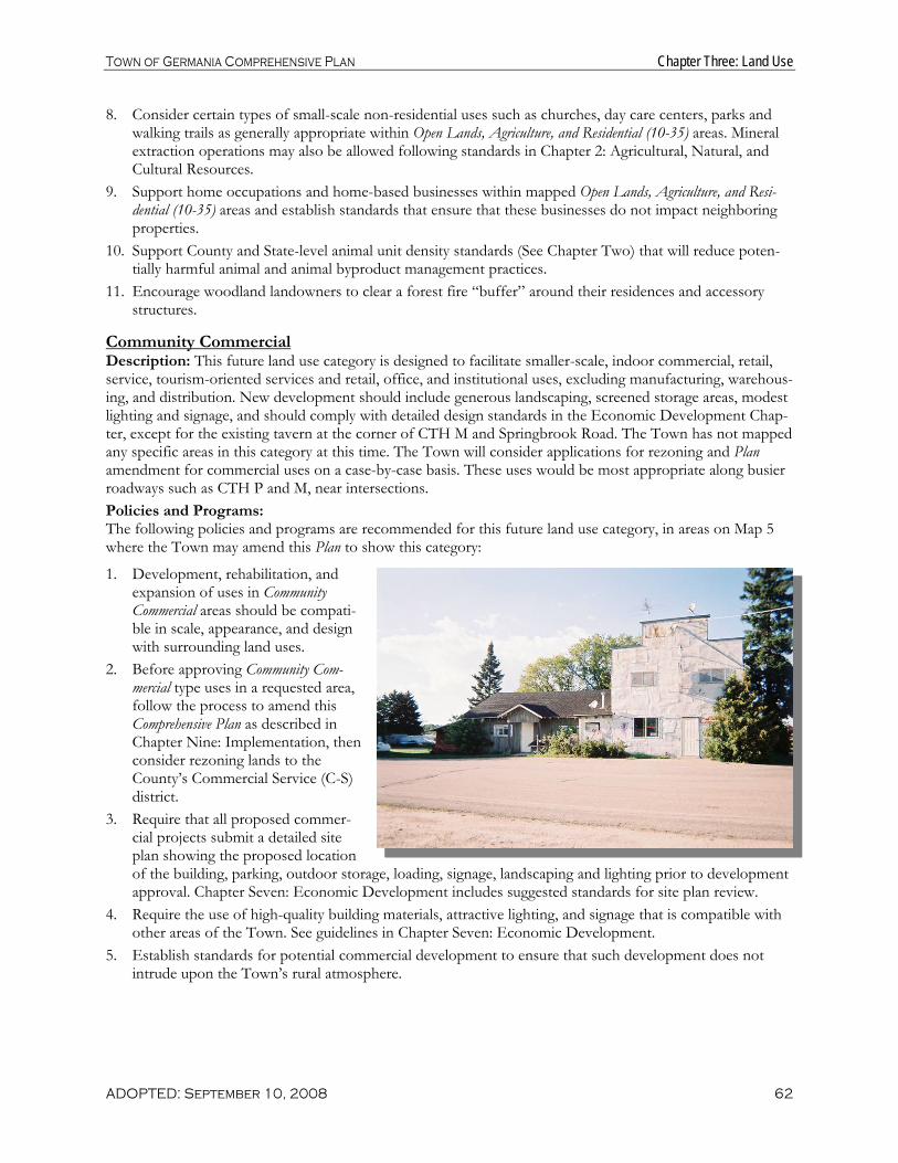
Town of Germania Comprehensive Plan Chapter Three: Land Use
ADOPTED: September 10, 2008 62
8. Consider certain types of small-scale non-residential uses such as churches, day care centers, parks and walking trails as generally appropriate within Open Lands, Agriculture, and Residential (10-35) areas. Mineral extraction operations may also be allowed following standards in Chapter 2: Agricultural, Natural, and Cultural Resources.
9. Support home occupations and home-based businesses within mapped Open Lands, Agriculture, and Resi-dential (10-35) areas and establish standards that ensure that these businesses do not impact neighboring properties.
10. Support County and State-level animal unit density standards (See Chapter Two) that will reduce poten-tially harmful animal and animal byproduct management practices.
11. Encourage woodland landowners to clear a forest fire “buffer” around their residences and accessory structures.
Community Commercial Description: This future land use category is designed to facilitate smaller-scale, indoor commercial, retail, service, tourism-oriented services and retail, office, and institutional uses, excluding manufacturing, warehous-ing, and distribution. New development should include generous landscaping, screened storage areas, modest lighting and signage, and should comply with detailed design standards in the Economic Development Chap-ter, except for the existing tavern at the corner of CTH M and Springbrook Road. The Town has not mapped any specific areas in this category at this time. The Town will consider applications for rezoning and Plan amendment for commercial uses on a case-by-case basis. These uses would be most appropriate along busier roadways such as CTH P and M, near intersections. Policies and Programs: The following policies and programs are recommended for this future land use category, in areas on Map 5 where the Town may amend this Plan to show this category:
1. Development, rehabilitation, and expansion of uses in Community Commercial areas should be compati-ble in scale, appearance, and design with surrounding land uses.
2. Before approving Community Com-mercial type uses in a requested area, follow the process to amend this Comprehensive Plan as described in Chapter Nine: Implementation, then consider rezoning lands to the County’s Commercial Service (C-S) district.
3. Require that all proposed commer-cial projects submit a detailed site plan showing the proposed location of the building, parking, outdoor storage, loading, signage, landscaping and lighting prior to development approval. Chapter Seven: Economic Development includes suggested standards for site plan review.
4. Require the use of high-quality building materials, attractive lighting, and signage that is compatible with other areas of the Town. See guidelines in Chapter Seven: Economic Development.
5. Establish standards for potential commercial development to ensure that such development does not intrude upon the Town’s rural atmosphere.

Town of Germania Comprehensive Plan Chapter Three: Land Use
ADOPTED: September 10, 2008 63
Community Facilities Description: This future land use category is designed to facilitate public buildings, hospitals, airports, non-profit campgrounds, power substations, and special-care facilities. In the Town of Germania the Town Hall is the only use presently mapped in this category.
Policies and Programs: The following policies and programs are recommended for this future land use category, in areas on Map 5 where the category is shown:
1. Should additional Community Facilities uses be necessary, locate them (and promote their location) in areas accessible to Town residents, and amend this Plan in accordance with the approved locations.
2. Ensure that all land use decisions related to the Community Facilities category are in coordination with the recommendations in Chapter Six: Utilities and Community Facilities.
Environmental Corridor Description: This overlay category includes generally continuous open space systems based on lands includ-ing sensitive natural resources characteristics that severely limit development potential. This category includes Wisconsin DNR-identified wetlands subject to existing State-mandated zoning, FEMA designated flood-plains, shoreland setback areas, and slopes of 12 percent or greater, which if disturbed can result in erosion and unstable building sites. Environmental corridors are shown on Map 5 along creek corridors and other areas.
Policies and Programs: The following policies and programs are recommended for this future land use category, in areas on Map 5 where this overlay category is shown. These will be in addition to the policies of the underlying future land use category:
1. New development should be avoided within mapped Environmental Corridors.
2. Allow continued cropping, grazing, and other pre-existing agricultural activities in mapped Environmental Corridors.
3. If development is proposed on parcels where this category is mapped, the prop-erty owner or developer should be respon-sible for determining the exact boundaries of the Environmental Corridor based on the wetland, floodplain, or steep slope feature that defines the corridor. Refer to Chapter Two: Agricultural, Natural and Cultural Resources for more information on map-ping and protecting Environmental Corridors.
Opportunities for Redevelopment Since the majority of the land in the Town of Germania is undeveloped, redevelopment is not a major factor for the Town’s future. Redevelopment and rehabilitation opportunities may exist for some residential areas, particularly those with mobile homes or “hunting shacks.” Other areas for redevelopment include reclama-tion of existing non-metallic mines after closure and improvements to a few commercial and industrial sites in the Town. The Town is generally supportive of upgrades within the community, provided that the overall character is improved and the interest of nearby property owners is considered.

Town of Germania Comprehensive Plan Chapter Three: Land Use
ADOPTED: September 10, 2008 64
“Smart Growth Areas” Wisconsin’s comprehensive planning law requires comprehensive plans to identify “Smart Growth Areas,” defined as “areas that will enable the development and redevelopment of lands with existing infrastructure and municipal, state, and utility services, where practical, or that will encourage efficient development patterns that are both contiguous to existing development and at densities which will have relatively low municipal, state governmental, and utility costs.”
This Plan designates areas within the Village of Tigerton and Village of Wittenberg as “Smart Growth Areas” as defined above. The Town encourages intensive industrial, commercial, and residential projects to locate in or near villages or cities where utilities and greater community services are available or can be efficiently ex-tended. Access to sanitary sewer and water services, as well as the existing development, commercial estab-lishments, and road infrastructure make development in these areas more efficient and cost-effective.
In the context of rural areas of the Town, “smart growth” is defined as that which limits non-agricultural, non-forestry development and is planned to minimize the consumption and fragmentation of agricultural, forest, and recreation land, the number of driveways on existing roads, and the length and number of new Town roads. Therefore, this Plan reflects an effort to apply “Smart Growth” principles to the entire Town.

Town of Germania Comprehensive Plan Chapter Three: Land Use
ADOPTED: September 10, 2008 65
Map 5: Future Land Use

Town of Germania Comprehensive Plan Chapter Three: Land Use
ADOPTED: September 10, 2008 66

Town of Germania Comprehensive Plan Chapter Four: Transportation
ADOPTED: September 10, 2008 67
TRANSPORTATION RECOMMENDATIONS
SUMMARY Discourage new public roads
Ensure a safe and efficient roadway system
Evaluate CTH M’s status as a “Rustic Road”
Improve CTH M’s surface, add paved shoulders, and increase the speed limit to 55 MPH
Update the Town’s Driveway Ordinance
Chapter Four: Transportation
This chapter includes background information, goals, objectives, policies, and recommended pro-grams to guide the future development and maintenance of various modes of transportation in the Town of Germania over the 20-year planning period. Given the Town’s rural surroundings, the primary focus is on highways and local roads. The chapter compares the Town’s transportation poli-cies and programs to State and regional transportation plans.
Existing Transportation Network The Town is relatively well connected to the region through the existing roadway network. This section describes the Town’s existing transportation facilities.
Roadways The Town of Germania is served by County Trunk Highways (CTHs) M, P, and PP, all of which link the Town with the re-gion’s major cities and villages. These links channel commuter flows and provide quality access for residents. County trunk highways (CTHs) act as collector roads that serve rural land uses and distribute traffic to the regional arterial system.
According to the Wisconsin Department of Transportation (WisDOT), which records average daily traffic volumes (num-ber of cars) for major State roadways, traffic volumes increased on all these highways between 1996 and 2002. CTH P in the western part of the Town experienced a 23 percent increase (to 210). CTH PP had only a slight increase in traffic volume be-tween 1996 and 2000 (to 120). CTH M has slightly higher traffic counts, with 440 vehicles daily near its northernmost point in the Town and 730 vehicles daily closer to Tigerton. Traffic vol-ume on CTH M did not change from 2002 to 2005.
Town roads are an important component of the County-wide transportation system. Major east-west town roads include Much Road, Two Mile Road, and Beetle Creek Road. Major north-south roads include Comet Road, Breaker Road, and Spring Brook Road. Town roads serve local development, farm-ing and forest areas. There is a mixture of paved and gravel roads.
ROADWAY FUNCTIONAL CLASSIFICATION SYSTEM
Throughout Wisconsin, all local, County, state and federal transportation routes are classified in categories under the “Road-way Functional Classification” system.
As identified by WisDOT, the functional classification system groups roads and highways according to the character of service they offer, ranging from rapid through access to local land access. The purpose of functional classification is to enhance overall travel efficiency and ac-commodate traffic patterns and land uses by designing streets to the standards sug-gested by their functional class. The three main rural roadway functional classes include:
Arterials that provide primary access to and through an area
Collectors that disperse traffic within an area (CTH M, P, and PP)
Local streets that provide access to individual properties

Town of Germania Comprehensive Plan Chapter Four: Transportation
ADOPTED: September 10, 2008 68
Bridges While there are no State-maintained bridges in the Town of Germania, there are two bridges along County highways and Town roads that are maintained by either Shawano County or local governments. The State and County maintain condition reports for these bridges.
Airports The Shawano Municipal Airport has two paved runways in good condition; the main runway is 3,900 feet long and the smaller runway is 2,225 feet long. The airport is open to the public and mainly serves local avia-tion needs. Central Wisconsin Regional Airport in Mosinee, Austin Straubel International in Green Bay, Wittman Regional Airport in Oshkosh, Antigo Airport, Central Wisconsin Airport in Wausau, and General Mitchell International Airport in Milwaukee also serve the region.
Water and Truck Transportation There is no waterborne freight movement in the County and none is anticipated. Most freight shipments in the Town of Germania occur by truck. Semi-truck shipments are most prevalent along State Highway 29.
Rail There are no rail lines in the Town. The only active rail line in the County runs from the Fox River Valley north to the City of Shawano. An abandoned portion of this rail line continues from the City of Shawano northwest through the Towns of Wescott, Washington, Richmond, Herman and Red Springs. This line is owned by Canadian National.
Recreational Trails Acquisition of abandoned railroad rights-of-way by the Wisconsin Department of Natural Resources (DNR) and conversion to regionally significant multi-use recreational trails has provided new opportunities for linear recreation in Shawano County as well as elsewhere throughout the State. Although ownership of the right-of-way is retained by DNR, under a Letter of Agreement, Shawano County maintains the two State-designated recreational trails which pass through the County. Permitted users on the Shawano County trail segments in-clude hikers, bicyclists, motorized wheel chairs, equestrians, horse drawn vehicles and, during the winter snowmobiles and ATV’s.
While there are no trails in the Town of Germania, residents are in close proximity to the Wiouwash State Trail in the Towns of Fairbanks and Wittenberg. This County-operated trail was named for Winnebago, Out-agamie, Waupaca, and Shawano counties. Although several gaps remain before a continuous trail is in place (including the segment from Birnamwood north through Aniwa to the Langlade County line), ongoing efforts are being made to acquire right-of-way or obtain the necessary easements to complete the trail. Once com-pleted, the Shawano County portion of the Wiouwash Trail will be approximately 30 miles in length.
Paratransit Paratransit is specialized transit service to specific segments of the population that require more accessible vehicles and flexible routing. While the Town does not have its own paratransit service, Shawano County has several paratransit providers who serve the elderly and disabled including Workshop Transportation run by Shawano County Department of Community Programs. Some counties provide flexible fixed route services with buses or minibuses, to give elderly and disabled persons in rural areas an opportunity to travel to larger communities for shopping, nutrition, or other appointments. One example of this type of flexible fixed route service is provided in Shawano County, picking up persons in a different area of the County one day each week, into the City of Shawano, and occasionally to larger shopping areas in Appleton or Green Bay.
Review of State and Regional Transportation Plans The following are State and regional transportation plans and studies relevant to this plan. There are no con-flicts between these State and regional plans and this Town plan.

Town of Germania Comprehensive Plan Chapter Four: Transportation
ADOPTED: September 10, 2008 69
♦ Shawano County Transportation Improvement Plan The Shawano County Highway Department maintains an ongoing list of transportation improvements, both short term (5 years or less) and longer term (up to 15 years).
♦ East Central Wisconsin Regional Planning Commission Highway 29 Preservation Plan. The Wis-consin Department of Transportation (WisDOT) has started a process to preserve the right of way that will be needed to keep drivers safe and STH 29 functional long into the future. As part of the right of way preservation effort in Shawano County, the project team will examine existing conditions and iden-tify future needs along the STH 29 corridor. WisDOT will work with communities to identify the loca-tions of future interchanges, overpasses and local road modifications. These solutions are intended to maintain safe and efficient traffic operation on STH 29 well into the future.
♦ North Central Region Six Year Highway Improvement Plan. Transportation improvements to the County’s highways include relatively minor activities such as resurfacing. There are no projects related to the Town.
♦ Wisconsin State Highway Plan 2020. This plan focuses on the 11,800 miles of State Trunk Highway routes in Wisconsin. The plan does not identify specific projects, but broad strategies and policies to im-prove the State highway system over the next 20 years. Given its focus, the plan does not identify im-provement needs on roads under local jurisdiction. The plan includes three main areas of emphasis: pavement and bridge preservation, traffic movement, and safety. There are no recommendations related to the Town.
♦ Translinks 21: A Multimodal Transportation Plan for Wisconsin’s 21st Century. This plan provides a broad planning “umbrella” including an overall vision and goals for transportation systems in the State for the next 25 years. This 1995 plan recommends complete construction of the Corridors 2020 “back-bone” network by 2005, the creation of a new State grant program to help local governments prepare transportation corridor management plans to deal effectively with growth, the provision of State funding to assist small communities in providing transportation services to elderly and disabled persons, and the development of a detailed assessment of local road investment needs. At the time of writing this Compre-hensive Plan, WisDOT is in the process of updating the Translink Plan in Connections 2030.
♦ Wisconsin Bicycle Transportation Plan 2020. This plan presents a blueprint for improving conditions for bicycling, clarifies the Wisconsin Department of Transportation’s role in bicycle transportation, and establishes policies for further integrating bicycling into the current transportation system. The plan re-ports that, according to a University of Wisconsin survey conducted in August of 1998, more than one-third of all Wisconsin households included someone who took at least one bike trip in the previous week. There are no recommendations related to the Town.
♦ Wisconsin Pedestrian Plan 2020. This plan outlines Statewide and local measures to increase walking and to promote pedestrian comfort and safety. The plan provides a policy framework addressing pedes-trian issues and clarifies WisDOT’s role in meeting pedestrian needs. Pedestrian facilities include side-walks, walkways, streetscapes, crosswalks, traffic controls signals, overpasses and underpasses, bridges, multi-use paths, curb cuts and ramps, transit stops, and paved shoulders. Few of these types of facilities are found in the Town.
♦ Wisconsin State Airport System Plan 2020. This plan includes a general inventory of existing airport facilities in the State and provides a framework for the preservation and enhancement of a system of pub-lic-use airports to meet the current and future aviation needs of the State. It includes recommendations to upgrade existing facilities through runway extensions and replacements and facility improvements, but does not identify any new locations for airports to meet future needs. There are no recommendations re-lated to the Shawano Municipal Airport or Antigo Airport.
♦ Wisconsin Rail Issues and Opportunities Report. This report summarizes critical rail transportation issues identified during a public outreach effort The report serves as a point of departure for the rail

Town of Germania Comprehensive Plan Chapter Four: Transportation
ADOPTED: September 10, 2008 70
component of the upcoming Connections 2030, WisDOT’s next multimodal transportation plan set for completion in 2006. The report identifies the existing rail line in Shawano County as “light density” carry-ing less then 3 million gross tons annually. These “light density” lines could require financial assistance in order to preserve rail service and avoid abandonment of track.
Transportation Goals, Objectives and Policies
Goal: Provide and encourage a safe and efficient transportation system that meets the needs of all residents.
Objectives: 1. Provide for adequate roadway capacities and safe conditions in cooperation with the County and State. 2. Promote the coordination of transportation investments with land use planning and development. 3. Preserve the scenic value along roadways to protect the Town’s rural character. 4. Support biking, walking, public transit, and other alternative modes of transportation for those in need,
including the disabled.
Policies: 1. Work with the County to reevaluate CTH
M’s status as a “Rustic Road,” given its function as a main road through the Town.
2. Identify other Town roads that are more appropriate for “Rustic Road” designation, potentially including Much Road.
3. Work with the County and State to im-prove the surface quality of CTH M, add paved shoulders for cycling and disabled vehicles, and increase the speed limit from 45 to 55 miles per hour in appropriate lo-cations.
4. Discourage the addition of any new roads and/or highways in the Town of Germa-nia.
5. Continue the Town’s partnership with the County to maintain and, as necessary, upgrade Town roads and County highways.
6. Work with Shawano County and private providers to continue and expand transportation options to those who require them, such as the elderly, disabled, and children.
7. Continue to rate the Town’s roads using the DOT’s automated rating system, and use the rating system as a basis for road maintenance and rehabilitation.
8. Coordinate with other units of government to support other forms of transportation, such as rail, air, trucks, and water available to Town residents or businesses in the region.
9. Monitor and participate in pending statewide long-range plans (Connections 2030) for highways, local roads, air, water, rail, bicycle, pedestrian, and transit systems.
10. Encourage safe bicycling and walking opportunities in the Town. 11. Update the Town’s Driveway Ordinance. 12. Adopt a resolution renaming Old Dump Road to Spitzer Spictn Road.

Town of Germania Comprehensive Plan Chapter Four: Transportation
ADOPTED: September 10, 2008 71
Transportation Recommendations and Programs
Expanding on the planning policies listed above, this section of the Plan provides specific recommendations for maintaining a safe and efficient transportation network:
Work with the County to Maintain and Upgrade Roads Shawano County maintains a short-term plan (5 to 7 years) for road improvements within the County. The County also maintains Town roads and has historically included maintenance of such roads in its five-year road plan. The Town will work with the County Highway Department to incorporate road projects into this short-term County-wide road plan as desired by the Town. It has been recommended in the County’s Plan that the County Highway Department update its five-year improvement plan annually. If this recommenda-tion is followed, then ideally the Town would provide road condition ratings and maintenance and improve-ment desires to the County on an annual basis as well.
The Town will also work to maintain, upgrade, and ensure safety on roadways that serve the Town by:
Working with the County and State to evaluate the appropriateness of CTH M’s “Rustic Road” designa-tion. Rustic Road designation and its associated standards (e.g. speed limit) may be more appropriate for other rural roads (e.g. Much Road and Steinke Road).
Increasing the speed limit on CTH M from 45 to 55 MPH in appropriate locations.
Ensuring maintenance of roads to meet acceptable standards for safe bicycling, such as by removing ob-stacles and encouraging paved shoulders where appropriate (e.g. on County high-ways).
Supporting applications to federal and state programs and funding sources, such as the Transportation Enhance-ment Grant program, available to the County and the Town for transportation projects. Additional information on these programs is available in the Sha-wano County Comprehensive Plan, from the WisDOT North Central Region of-fice in Wisconsin Rapids, and from the University of Wisconsin Transportation Information Center.
Monitor and Update the Town Access Driveway Ordinance The Town’s current Access Driveway Ordinance currently addresses a variety of elements, including but not limited to:
The number of driveways allowed on a given parcel of land
The minimum distance between two driveways
Driveway culvert specifications
Driveway width, slope and grade
Driving surface requirements, alignment and marking
Visual Clearance
The Town intends to update its Access Driveway Ordinance to include the following provisions:

Town of Germania Comprehensive Plan Chapter Four: Transportation
ADOPTED: September 10, 2008 72
The maximum length of all new driveways should customarily be three hundred (300) feet, to allow emer-gency vehicles safe and efficient access to the structure(s), and to be consistent with new home siting rec-ommendations in the Land Use chapter. Physical conditions (e.g. wetlands, pre-existing homes set further back) may require a driveway to be longer than 300 feet, in which case the driveway may exceed this length, but only by the minimum distance necessary. Provisions for shared driveways should be included.
If two or more landowners wish to construct a “shared” driveway, they should be required to enter into a private road agreement and the agreement should be recorded against both parcels with the County Register of Deeds. A private road agreement stipulates important details including maintenance responsi-bilities, which reduces the potential for future conflict between the current and future driveway users.
The placement of new driveways should be specified to not interfere with forestry and agricultural prac-tices.
Coordinate with the County and State on Recreational Routes The Town will coordinate with the County and State to add new recreational (hiking, biking, snowmobile) routes, enhance existing routes, and improve the marking of existing recreational routes in the Town. Various funding sources are available through WisDNR and WisDOT to fund trail construction. The Town also sup-ports the paving of shoulders (4 feet) on all County highways identified on a designated bike route. Town roads have low enough traffic volumes where paved shoulders are generally not necessary.
Continue to Work with the County to Support Other Transportation Options Transportation options include commuter facilities, para-transit for the growing elderly and disabled popula-tions and transportation services for lower income workers. Available programs include:
Specialized Transportation Assistance Program for Counties program, which provides funding for transportation services, purchasing services from any public or private organization, subsidizing elderly and disabled passengers for their use of services or use of their own personal vehicles, performing or funding man-agement studies on transportation, training and the purchase of equipment. This program requires a 20% local match in funding.
Elderly and Disabled Transportation Capital Assistance program. Eligible applicants include private and non-profit organizations, local public bodies that do not have private or public transportation providers avail-able, and local public bodies that are approved providers of transportation services for the elderly and disabled. The program covers 80% of the cost of eligible equipment.
Wisconsin Employment Transportation Assistance Program (WETAP). This program supports transportation services to link low-income workers with jobs, training centers and childcare facilities. Applicants must prepare a Regional Job Access Plan that identifies the needs for assistance. Eligible applicants include lo-cal governments and non-profit agencies.
Because the Town’s population will continue to age, the Town supports continuation of and access to these programs.

Town of Germania Comprehensive Plan Chapter Four: Transportation
ADOPTED: September 10, 2008 73
Map 6: Transportation and Community Facilities

Town of Germania Comprehensive Plan Chapter Four: Transportation
ADOPTED: September 10, 2008 74

Town of Germania Comprehensive Plan Chapter Five: Utilities and Community Facilities
ADOPTED: September 10, 2008 75
UTILITIES AND COMMUNITY FACILITIES RECOMMENDATIONS SUMMARY
Maintain a rural level of community services
Maintain the historic Town Hall
Encourage appropriate placement of on-site waste treatment systems & private wells
Oppose the siting of any landfills or waste sites within the Town
Chapter Five: Utilities and Community Facilities
This chapter contains a compilation of background information, goals, objectives, policies and recommended programs to guide the future maintenance and development of utilities and community facilities in the Town of Germania.
Existing Utilities and Community Facilities
Water Supply The Town of Germania does not provide municipal water service to its residents. All of the Town’s house-holds obtain their water supply from private wells.
Sanitary Waste Treatment Facilities The disposal of domestic and commercial wastewater in the Town is handled through the use of individual on-site wastewater treatment systems, often referred to as septic systems, which generally discharge the wastewater to underground drainage fields. There are currently six types of on-site treatment system designs authorized for use today: conventional (underground), mound, pressure distribution, at-grade, holding tank, and sand filter systems. The general suitability of soil for private on-site wastewater treatment systems is shown in Map 7. Several areas in the Town may have challenges with private on-site wastewater treatment systems.
The Wisconsin Department of Commerce (COMM) regulates the siting, design, installation, and inspection of most private on-site sewage systems in the State. In 2000, the State adopted a revised private sewage sys-tem code called COMM 83. This revised code allows conventional on-site systems and alternative systems, such as those that employ biological or chemical treatment. In some cases, alternative wastewater treatment systems can be used in areas where conventional systems are not feasible due to unsuitable soil conditions.
Solid Waste Disposal and Recycling Garbage collection in the Town of Germania is provided by private haulers. Recyclables are also collected. Shawano County is party to a tri-County agreement with Portage and Marathon counties wherein waste is hauled to the City of Shawano (where the landfill is soon to reach its design capacity) and then transported to Marathon County. Shawano County’s current landfill is located east of the Town in the City of Shawano. The landfill is partially closed. Illegal dumping occasionally occurs at the closed Town dump at the end of (to-be-renamed) Old Dump Road.
Recycling in the County is handled through a contract with One Source, which was building a facility in Howard, Wisconsin at the time this Plan was written.
Hazardous waste is handled through an agreement with Brown County Port and Solid Waste. Shawano County residents can deposit their hazardous waste at the Brown County Household Hazardous Waste Site.
The County has a County Solid Waste Management Plan, however this plan was out of date at the time this Comprehensive Plan was prepared.

Town of Germania Comprehensive Plan Chapter Five: Utilities and Community Facilities
ADOPTED: September 10, 2008 76
Stormwater Management Stormwater management has become a significant aspect of comprehensive planning in recent years due to concerns about flooding, property damage, and surface and groundwater quality issues. Many communities around the State are adopting stormwater management rules to control run-off from both urban and rural land uses. Shawano County has a Land and Water Resource Management Plan, a Pensaukee River Watershed Plan, and an Animal Waste Management Ordinance, all of which contribute to the management of stormwa-ter throughout the County.
Nearly one-third of Wisconsin’s 79,000 farms use drains to remove excess water from their land. These drains are regulated by drainage districts. Shawano County currently has two operating drainage districts, which are overseen by commissions of appointed individuals. These districts plan, operate, and maintain district-wide drainage and dam facilities, levy assessments against landowners who benefit from drainage, award damages to landowners negatively affected by the construction of drainage facilities, make or recommend modifica-tions to drainage district boundaries, and resolve drainage disputes.
Town Hall The historic stone Town Hall is located on CTH M. This depression-era building was recently remodeled and is open to all Town residents for meetings and the grounds are open to the public. It is adequately sized to meet the Town’s needs over the planning period.
Law Enforcement and Protection The Shawano County Sheriff’s Department serves as the primary law enforcement agency to Town residents.
Fire Protection The Tigerton Volunteer Fire Department serves the Town of Germania.
Emergency Medical Services The Tigerton Ambulance Service provides emergency medical services to the Town.
Library Town residents are served by Tigerton Branch of the City of Shawano Public Library, which has a total of 128,550 volumes. This library is a member of the Nicolet Federated Library System, which is a State funded organization assisting 42 member public libraries in providing better services to the people of northeastern Wisconsin. The library has four additional branches located in the Villages of Birnamwood, Bonduel, Mattoon, and Wittenberg.
Telecommunication and Power Facilities Telephone, internet, and cable services are provided to the eastern two-thirds of the Town by Northeast Frontier Communications. The western third of the Town is served by Wittenberg Telephone Company.
Electric and gas power are provided to the Town by Central Wisconsin Electric Cooperative. No power fa-cilities are located within the Town. However, five hydroelectric facilities are located in Shawano County. High voltage electric transmission lines are provided by the American Transmission Company.
Schools The eastern half of the Town of Germania is located within the Tigerton School District, which serves stu-dents in the towns of Grant, Fairbanks, Germania, Morris, and Seneca and the Village of Tigerton. The Dis-trict operates one middle/high school and one elementary school and had a K-12 enrollment of 361 during the 2005/06 school year.
The western half of the Town falls within the Birnamwood-Wittenberg School District, which serves students in the towns of Almon, Aniwa, Birnamwood, Germania, Morris, Wittenberg, and the Villages of Birnam-wood, Eland, and Wittenberg. The District operates one high school, one elementary/middle school, and one elementary school and had a K-12 enrollment of 1,346 during the 2005/06 school year.

Town of Germania Comprehensive Plan Chapter Five: Utilities and Community Facilities
ADOPTED: September 10, 2008 77
Parks and Recreation Facilities There are no Town or County parks located in the Town of Germania, and none are anticipated being re-quired over the planning period.
Health and Child Care Facilities There are no medical facilities located in the Town of Germania. The Shawano Medical Center is located in the City of Shawano and is the only general hospital located in the County. Theda Care Physicians operates in the Village of Tigerton, and the Marshfield Clinic is located in the Village of Wittenberg.
There are no child care facilities located in the Town. However, there are seven regulated child care facilities in the City of Shawano and the Villages of Bowler, Wittenberg, and Birnamwood. There are 32 County or State licensed child care facilities within Shawano County.
Cemeteries There are no cemeteries located in the Town of Germania.
Utilities and Community Facilities Goals, Objectives and Policies
Goal: 1. Support the efficient delivery of community utilities, facilities, and services corresponding with the expec-
tations of Town residents and a rural atmosphere.
Objectives: 1. Coordinate community facilities planning with land use, transportation, and natural resource planning. 2. Provide the appropriate level of community services and facilities consistent with a low tax levy and the
rural orientation of the Town. 3. Protect the Town’s public health through proper siting and avoiding over-concentration of on-site
wastewater treatment systems. 4. Prohibit the development of new solid and liquid waste disposal sites.
Policies: 1. Refrain from building new Town facilities and providing new Town-operated services or utilities. 2. Continue to work with the County and other communities for the provision of fire protection, EMS ser-
vices, and law enforcement. 3. Implement strategies to assure a high-quality supply of groundwater – e.g. minimizing potential sources
of pollutants near wells and recharge areas and maximizing permeable area for infiltration. 4. Monitor and avoid over-concentration of private on-site wastewater treatment (septic) systems to mini-
mize groundwater and soil contamination potential, particularly in areas where challenges for on-site wastewater treatment systems exist (as depicted on Map 7).
5. Encourage construction site erosion control and ongoing stormwater management for any larger devel-opment and road projects to protect surface water quality and prevent flooding. Stormwater management techniques include natural drainage swales and retention and detention basins.
6. Vehemently oppose the opening of landfills and/or nuclear waste storage facilities within the Town. (The Town was considered as a potential nuclear waste storage area in the early 1980’s).
7. Continue to maintain the Germania Town Hall and consider designation on the state and/or national register of historic places.
8. Continue to work with private companies by contract to provide solid waste disposal and recycling ser-vices to the Town.

Town of Germania Comprehensive Plan Chapter Five: Utilities and Community Facilities
ADOPTED: September 10, 2008 78
9. Remain informed on the activities and decisions of the School District to ensure that the needs of the Town for school facilities are met.
10. Continue to cooperate with and rely on the broader region and private providers to ensure that Town residents have all the necessary services, including health and child care, police, fire and rescue, recycling and refuse disposal, libraries, utilities, cemeteries, and other government facilities.
11. Prohibit the placement of private wells within one-thousand two hundred (1,200) feet of closed landfills. 12. Cooperate with Shawano County efforts to prepare an update to the Shawano County Solid Waste Man-
agement Plan.
Utilities and Community Facilities Recommendations and Programs
Expanding on the planning policies listed above, this section of the Plan provides specific recommendations related to the provision of utilities, facilities and services in the Town:
Encourage Proper Siting and Maintenance of On-site Wastewater Treatment Systems The Town encourages landowners to utilize the State’s grant program, called the Wisconsin Fund, to help repair or replace failing septic systems. Community/group waste treatment systems in existing and planned areas of intensive development are another option, particularly when connection to a public sewer system is not available. Proper assurances for joint, ongoing maintenance of such facilities is critical, such as through a homeowners association.
Explore Avenues to Assure a High-quality and Abundant Supply of Groundwater Private wells draw water from the upper aquifer, which can be susceptible to contamination. Therefore, the Town will pursue and encourage the following steps to protect groundwater:
Minimize impervious surfaces (e.g., rooftops, paved areas) and promote water infiltration (e.g., stormwa-ter basins) in groundwater recharge areas.
Prohibit the drilling of wells within 1,200 feet of closed landfills
Continue to support and promote recycling and waste-reduction programs to decrease waste loads going to landfills in the region.
Support an effective inspection and required maintenance program at the Town or County level for all private on-site waste disposal systems.
Work with the County to limit the use of salt on roads, and locate and manage snow and salt storage ar-eas to avoid groundwater and stream pollution.
Stay Informed on Plans for the Location of Power Lines and/or a Substation in the Town Because new transmission lines are costly to build and difficult to site, energy providers are increasingly look-ing to increase capacity along existing routes. The Town promotes “corridor sharing” or the use of the trans-mission line’s existing rights-of-way for other facilities. Corridor sharing reduces the impacts by locating linear land uses together, and minimizes the amount of land affected by new easements. It also reduces the prolif-eration of corridors and easements such roads, pipelines, power lines, and other linear features.

Town of Germania Comprehensive Plan Chapter Five: Utilities and Community Facilities
ADOPTED: September 10, 2008 79
Figure 20: Timetable to Expand, Rehabilitate, or Create New Community Utilities or Facilities
Town Utilities & Community Facilities Timeframe Comments
Water Supply N/A All water supplied by private wells; expected to continue
Sanitary Wastewater Disposal N/A All wastewater treatment supplied by on-site wastewater treatment systems
On-Site Wastewater Treat-ment (Septics)
Ongoing – be-ing in 2008
Promote the State’s Wisconsin Fund to help repair or replace failing septic systems; promote the use of community/group waste treatment systems in any areas of intensive develop-ment
Stormwater Management 2008 - 2011 Work with the state and the County to establish and enforce erosion control and stormwater management standards
Solid Waste & Recycling Ongoing Continue to contract with private companies for waste dis-posal and recycling
Town Buildings Ongoing Support ongoing Town Hall maintenance; consider historic site nomination to provide more funds
Telecommunication Facilities Ongoing Support strategies for enhancing telecommunication capabili-ties
Power Plants/Transmission Ongoing Continue to stay informed on any plans by ATC for im-provements to and location of power lines/transmission sta-tions
Child Care Facilities N/A Future needs will be met by private parties Health Care Facilities N/A Existing and proposed medical facilities in nearby communi-
ties appear to meet needs Senior Center/Care Facilities N/A Facilities in nearby communities appear to meet needs Schools Ongoing Work with the School District on long-range planning issues
and retaining local schools Library N/A Area libraries meet current and forecasted needs Police Ongoing County provides services and may explore long-range space
needs for Sheriff’s Department; explore options to expand policing in Town
Fire and EMS 2008 – 2012 Continue to work with neighboring communities to provide these services
Cemeteries N/A Future needs will be met by private parties

Town of Germania Comprehensive Plan Chapter Five: Utilities and Community Facilities
ADOPTED: September 10, 2008 80

Town of Germania Comprehensive Plan Chapter Five: Utilities and Community Facilities
ADOPTED: September 10, 2008 81
Map 7: Soil Suitability for On Site Wastewater Treatment

Town of Germania Comprehensive Plan Chapter Five: Utilities and Community Facilities
ADOPTED: September 10, 2008 82

Town of Germania Comprehensive Plan Chapter Six: Housing & Neighborhood Development
ADOPTED: September 10, 2008 83
HOUSING & NEIGHBORHOOD DEVELOPMENT RECOMMENDATIONS SUMMARY Support private efforts to build affordable and
accessible housing
Enact (or support County enactment of) an ordinance pertaining to “hunting shacks,” trailers, and mobile homes
Require new structures to be within 300 feet of existing roadways and accessible to emergency crews
Chapter Six: Housing & Neighborhood Development
This chapter contains a compilation of background information, goals, objectives, policies and recommended programs aimed at providing an adequate housing supply that meets existing and forecasted housing demand in the Town of Germania.
Existing Housing Framework This section describes Germania’s housing stock characteristics such as type, value, occupancy status, age and structural condition. This section also provides projected housing demand information in Germania and de-scribes housing development and rehabilitation programs available to residents. According to 2000 Census data, the 145 housing units in the Town were predominately single-family detached homes (see Figure 21). This percentage is higher than the County (80 percent), the region (75 percent) and the State (69 percent). There are generally around six or fewer new housing units built each year in the Town of Germania.
Figure 21: Housing Types, 2000
Units per Structure 2000 Units 2000 Percent
Single Family 142 97.3 Two Family (Duplex) 0 0.0 Multi-Family 0 0.0 Mobile Home or Other 4 2.7 Source: U.S. Census of Population & Housing, 2000

Town of Germania Comprehensive Plan Chapter Six: Housing & Neighborhood Development
ADOPTED: September 10, 2008 84
Figure 22 compares some of Germania’s other year 2000 housing stock characteristics with surrounding communities, the County and the State. Of Germania’s 8 vacant housing units, 75 percent were vacant for seasonal, recreational or occasional use. Total housing occupancy was 94 percent. Of these occupied units, 95 percent were owner-occupied. The median housing value in the Town of Germania increased 161 percent from 1990 to 2000. This percent change is greater than all eight surrounding towns, the County and the State. According to U.S. Census data, the median sale price for a home in Shawano County increased 85 percent from 1990 to 2000, and the median sale price for a home in Wisconsin increased 80 percent from 1990 to 2000.
Figure 22: Housing Stock Characteristics, 2000
Total
Housing Units
Seasonal, Recrea-
tional, or Occasional Use Hous-ing Units
% Vacant (Home-owner)
% Vacant (Rental)
% Owner Occupied
Median Housing Value ($)
% Median Housing Value In-
crease from 1990
Town of Germania 145 6 0.8 0.0 94.8 73,300 160.9
City of Shawano 3,587 25 0.9 42.6 60.5 78,900 68.2 Village of Wittenberg 471 2 1.6 42.9 57.6 68,600 85.9 Town of Alban 376 61 0.3 1.4 90.5 87,900 85.8 Town of Elderon 251 28 1.5 0.0 88.8 85,400 91.1 Town of Fairbanks 272 24 0.5 3.0 91.1 59,100 66.5 Town of Franzen 216 15 1.2 0.0 87.0 83,800 97.2 Town of Harrison 148 4 2.4 0.0 85.3 66,700 83.7 Town of Morris 220 28 0.6 0.0 86.2 92,000 133.5 Town of Wittenberg 339 17 1.5 0.0 86.6 84,700 96.5 Town of Wyoming 145 32 2.0 0.0 90.1 78,300 56.6 Shawano County 18,317 1,793 1.2 9.8 78.2 84,000 84.6 Wisconsin 2,321,144 412,313 1.2 16.4 68.4 112,200 79.5 Source: U.S. Census of Population and Housing, 2000

Town of Germania Comprehensive Plan Chapter Six: Housing & Neighborhood Development
ADOPTED: September 10, 2008 85
Figure 23 illustrates the age of Germania’s housing stock based on the 2000 Census data. The age of a com-munity’s housing stock is sometimes used as a measure of the general condition of the community’s housing supply. Germania has a varied housing stock, since new housing construction has been spread fairly evenly over time. Because the Town has a much “newer” housing stock than surrounding communities, fewer re-sources will need to be expended on behalf of older home owners for rehabilitation efforts during the plan-ning period than communities with greater percentages of older housing.
Figure 23: Age of Housing as a Percent of the Total 2000 Housing Stock
24.1
13.8
8.3
20.0
17.2
16.6
0.0 5.0 10.0 15.0 20.0 25.0 30.0
1939 or earlier
1940 to 1959
1960 to 1969
1970 to 1979
1980 to 1989
1990 to 2000
Source: U.S. Census of Population and Housing, 2000
Housing Affordability In 1999, the percentage of homeowners in the Town of Ger-mania paying 30 percent or more of their income for housing was 17 percent, similar to Shawano County (16 percent) and the State (18 percent).
The East Central Wisconsin Regional Planning Commission compiled ten variables (including age of occupied units, home-owner and rental vacancy rates, owner-occupied housing values, renter and owner-occupied housing affordability and housing conditions) from the 2000 Census to produce a composite map of the region indicating the level of “housing stress” in each jurisdiction. The levels range from “adequate” to “moderate” to “substantial” to “severe.” It is important to note that this com-pilation did not include household incomes or household wealth, which could alleviate individual “housing stress” condi-tions through the region. According to this composite map
HOUSING AFFORDABILITY Housing affordability may be measured by the proportion of household income spent for rent or home ownership costs. The national standard for determining whether rent or home ownerships costs comprise a disproportionate share of in-come is set at 30 percent of gross house-hold income. Households spending more than 30 percent of their income for hous-ing may be at risk of losing their housing should they be confronted with unem-ployment, unexpected bills, or other un-expected events.

Town of Germania Comprehensive Plan Chapter Six: Housing & Neighborhood Development
ADOPTED: September 10, 2008 86
(ECWRP 2003 State of the Region Report, page 27) Germania was identified as having a “substantial” level of housing stress.
Housing and Neighborhood Development Programs Throughout Shawano County, several governmental, private and nonprofit agencies provide some form of assistance to meet the needs of individuals who lack adequate housing due to financial difficulties, disabilities, age, domestic violence situations, or drug abuse problems. According to the Wisconsin Housing and Eco-nomic Development Authority (WHEDA), there were 567 federally assisted rental units in the County in 1999. Of these, 356 were elderly units, 198 were family units, and 13 were units for disabled individuals.
The following housing providers and programs are available to Shawano County, its communities and/or its residents:
The U.S. Veterans Administration provides low-cost loans and other housing assistance to veterans in the County.
WHEDA is the most active housing agency in Shawano County and has constructed most of the afford-able housing for low-income families and seniors.
The Wisconsin Department of Administration provides loans to low and moderate income homebuyers in the County.
The Shawano County Community Development Block Grant (CDBG) Housing Rehabilitation Program provides no-interest loans and down payment assistance to homeowners and landlords for housing reha-bilitation projects.
Rural Development is a nonprofit agency active in central Wisconsin that provides housing assistance in the form of low-interest loans to low-income homebuyers.
Habitat for Humanity offers homeownership opportunities to people of moderate or low incomes in Shawano County. Habitat for Humanity asks able-bodied purchasers to help build their new home and, in return, receive low interest loans.
The County of Shawano Housing Authority provides housing of various types to low-income individuals and families, based on income and need.
Other agencies providing housing services in the County include religious institutions and social service agencies that provide housing services to persons with disabilities, persons with HIV/AIDS, and seniors.
Housing and Neighborhood Development Goals, Objectives and Policies
Goal: 1. Encourage the provision of safe and affordable housing options for all Town residents. 2. Encourage the provision of an adequate supply of housing to meet current and future needs.
Objectives: 1. Support a range of housing choices, including affordable housing, to meet the needs of persons of all
income levels, age groups, and special needs. 2. Support the continuation of an adequate supply and variety of housing that all Town residents can afford. 3. Encourage high quality construction and maintenance standards for housing. 4. Encourage home and cabin siting that will not result in property or environmental damage, or impair ru-
ral character or agricultural operations.

Town of Germania Comprehensive Plan Chapter Six: Housing & Neighborhood Development
ADOPTED: September 10, 2008 87
5. Support efforts to rehabilitate housing in areas where current housing stock is deteriorating.
Policies: 1. Encourage high quality construction and maintenance standards for housing by considering:
Regulations designed to discourage incompatible uses (e.g. junk vehicle storage) out of residential ar-eas.
The use of programs funds (e.g. Community Development Block Grant) to provide, maintain and rehabilitate housing for all income and age levels. Using CDBG funds, communities may establish rehabilitation loans or grants to assist owner-occupants with repairs.
Standards (size, location, screening, etc.) and a permitting process to address and manage the perma-nent placement of “hunting shacks” and other mobile homes within the Town of Germania.
2. Support the private market in developing and adequate supply of affordable housing (low and moderate income) and accessible housing for the elderly. Several State and federal programs and funding sources are available to assist private developers, Shawano County, local governments, and residents meet hous-ing objectives.
3. Explore creative solutions to rising utility costs and their impacts on the affordability of housing. 4. Continue to require building inspections and building permits for all new construction. Inspections are
conducted by a private inspection service. 5. Encourage Town residents to participate in housing rehabilitation programs such as the Shawano County
Community Development Block Grant program. 6. Support efforts to protect private homes from wildfire hazard through thoughtful home siting and
grounds maintenance, by: Educating owners on the risk of wildfires and take measures to ensure that emergency responders
can safely and adequately fight fires. Assuring safe access to home sites through the Town’s Driveway Ordinance (as detailed in the
Transportation chapter). WisDNR has additional information to help educate both newcomers and long-term residents on the hazards wildfires pose on lives and private property.
Housing and Neighborhood Development Recommendations and Pro-grams
Expanding on the planning policies listed above, this section of the Plan provides specific recommendations related to ensuring an adequate supply of affordable, safe and attractive housing in the Town:
Standards for Hunting Shacks, Mobile Homes and Campers The Town desires to protect the Town’s aesthet-ics and the welfare of the Town’s year-round residents by ensuring that “hunting shacks,” campers, and mobile homes are thoughtfully sited and appropriately maintained throughout the year. Perhaps working with the County, the Town will develop standards pertaining to the placement and maintenance of “hunting shacks,” mobile homes and campers. A secondary effect of the increase in private woodland ownership is the infusion of “hunting shacks” and campers throughout the Town. These structures are per-manently placed upon parcels but only occupied for a very limited amount of time. A mobile

Town of Germania Comprehensive Plan Chapter Six: Housing & Neighborhood Development
ADOPTED: September 10, 2008 88
home ordinance based on these newly-developed standards will allow the Town to regulate the placement, screening, maintenance and sanitary practices associated with these temporary dwellings. As another alterna-tive, the Town encourages greater enforcement of County zoning regulations that address this issue, and con-sideration of stronger or clearer rules if necessary, in a County zoning ordinance update.
Fire Safety Educational Campaign The Town is committed to educating landowners on the dangers posed by wildfires. Proper forestry man-agement practices and buffers are critical to preventing the loss of life and property. The Town will work with the County and State to further educate residents about fire prevention measures.

Town of Germania Comprehensive Plan Chapter Seven: Economic Development
ADOPTED: September 10, 2008 89
ECONOMIC DEVELOPMENT RECOMMENDATIONS SUMMARY
Support agriculture & ag-based businesses, especially family operations
Encourage home-based businesses
Direct intensive economic development to cities and villages
ECONOMIC STRENGTH POLICOM Corporation-an independent eco-nomic research firm specializing in analyzing local and state economies-annually ranks the local economies of the 361 Metropolitan and 577 Mi-cropolitan Statistical Areas in the United States. Metropolitan Statistical Areas have at least one urbanized area of 50,000 or more population, plus any adjacent territory that is economically and socially tied to the urbanized core, as evidenced by workforce commuting patterns. Micropolitan areas must have an urbanized area of at least 10,000 population but less than 50,000 population and must include at least one county. The rank-ings are based on the area’s level of consistent quality growth over an extended period of time, using various data sectors such as the growth of workers’ earnings, overall economic stability, and per capita income maintenance (welfare). Al-though Shawano County is not part of a “Metro” or “Mircro” area, the adjacent Metro areas of Green Bay (ranked 48 in 2006), Oshkosh (107), Appleton (99), and Wausau (82); as well as the Micro areas of Stevens Point (43), Marsh-field/Wisconsin Rapids (25), and Merrill (115) are represented. These economic health rankings show that all neighboring Metro economies were in the top 1/3 of the national rankings, and all neighboring Micro economies were in the top 1/5. The greater east-central region of the State has a high level of economic health when com-pared on a national level.
Chapter Seven: Economic Development
This chapter contains a compilation of background information, goals, objectives, policies and recommended programs to promote the retention and stabilization of the economic base in the Town of Germania. This chapter includes an assessment of new businesses and industries that are desired in the Town, an assessment of the Town’s strengths and weaknesses with respect to attracting and retaining businesses and industries, and an inventory of environmentally contaminated sites.
Existing Economic Development Framework This section details labor force trends, educational attainment, employment forecasts, income data and other economic development characteristics of the Town. The economic base of lands within the Town primarily consists of farming, with few small non-farm businesses in scattered locations.
Labor Force Trends The Town’s labor force is the portion of the population that is employed or available for work. The labor force includes people who are in the armed forces, employed, unemployed, or actively seeking employment. According to 2000 Census data, 201 Town residents age 16 or older are in the labor force (67.0 percent of the population over age 16). Of those in the labor force, 197 are employed. The Town’s unemployment rate in 2000 was 2.0 percent. Detailed information regarding County labor force trends is included in Chapter One: Issues and Opportunities.
Educational Attainment Educational attainment is another component of a community’s labor force. According to the 2000 Census, more than 70 percent of the Town’s population age 25 and older had attained a high school level education or higher. Approximately 7 percent of this same population had attained a college level education (bachelor’s degree or higher).

Town of Germania Comprehensive Plan Chapter Seven: Economic Development
ADOPTED: September 10, 2008 90
COMMUTER CHALLENGES Many communities in rural areas loose a large percentage of their workforce to neighboring metro areas. The communi-ties of Shawano County face difficult commuter related challenges due to the county’s geographic position. Located between Green Bay, the Fox Valley, and Wausau, nearly half of all workers com-mute outside Shawano County. Common concerns for heavy commuter counties include increased fuel consumption, the loss of a valuable labor source, and a dis-proportionate share of the tax base dedi-cated to maintaining local roadways.
Communities facing these challenges need to find innovative ways to promote local assets. New businesses can benefit from superior existing infrastructure. Sig-nificant advances in technology now make telecommuting a viable option. Losing workers via inter-county commut-ing is an important issue that many rural communities will need to address in the future.
Income Data According to 2000 Census data, the 1999 median household income in the Town of Germania was $38,542. Eighteen percent of households reported an income between $35,000 and $49,999, with the next highest per-centage of Town residents (17.3 percent) earning from $25,000 to $34,999. Figure 24 compares the Town’s median household income and per capita income with neighboring communities.
Figure 24: Median Household Incomes
Median Household
Income ($) Per capita Income ($)
Town of Germania 38,542 17,820
Town of Fairbanks 39,432 16,373 Town of Morris 36,875 14,627 Town of Wittenberg 42,841 15,410 Village of Tigerton 25,278 14,707 Village of Wittenberg 29,226 17,695 City of Shawano 31,546 17,380 Shawano County 38,069 17,991 Wisconsin 43,791 21,271 Source: U.S. Census of Population and Housing, 2000
Commuting Patterns Approximately half of Shawano County’s workforce is employed outside the County, according to 2000 statistics compiled by the Wisconsin Department of Workforce Development. Of the 8,024 workers commuting to places outside the County, 36 percent (2,910 workers) commute to Brown County to the southeast. Waupaca County and Marathon County are the second and third most common workplace destinations, drawing 15 and 13 percent of the commuting workforce respectively (1,199 and 1,066 workers). The fourth most common workplace destination was Out-agamie County with approximately 10 percent of commuters or 812 workers. Nearly 300 or more Shawano County workers commute to one of the other nearby counties: Outa-gamie, Menominee, Langlade, Oconto, and Winnebago. In contrast, about 2,505 workers commute into Shawano County for employment. Substantial numbers drive in from Waupaca (464 workers), Oconto (436 workers), Marathon (391 workers), and Brown (381 workers) counties. The average time a County resident travels to work increased from 19 minutes in 1990 to almost 23 minutes in 2000, suggesting that many are taking jobs even further away.
Location of Economic Development Activity While there are limited commercial and no industrial land uses shown on Map 6, there may be home-based businesses

Town of Germania Comprehensive Plan Chapter Seven: Economic Development
ADOPTED: September 10, 2008 91
and areas of economic development related to agriculture and forestry in the Town. Most commercial and industrial development is located within the County’s villages and city, but there are a few areas in the towns. There are seven industrial parks in the following Shawano County communities: Birnamwood, Bonduel, Gresham, Marion, Shawano (Raasch Industrial Park, Bay Lakes Industrial Park, and Shawano Municipal Utili-ties Industrial Lands), Tigerton, and Wittenberg. Combined, these parks provide 730 acres of Industrial land use. As of 2006, the vast majority of this acreage was vacant and available for development.
Environmentally Contaminated Sites The Wisconsin DNR’s Environmental Remediation and Redevelopment Program maintains a list of contaminated sites, or “brownfields,” in the State. The DNR de-fines brownfields as “abandoned or under-utilized commercial or industrial properties where expansion or redevelopment is hin-dered by real or perceived contamination.” Examples of brownfields might include a large abandoned industrial site or a small corner gas station. Properties listed in the DNR database are self-reported, and do not necessarily represent a comprehensive listing of possible brownfields in a com-munity. As of March 2006, there were no documented sites in the Town listed in DNR’s system.
Brownfield redevelopment programs seek to return abandoned or underused industrial and/or commercial sites to active use through cleaning up environmental contamination and encouraging redevelopment of the sites. The Wisconsin Department of Commerce and DNR work together to administer a grant program that funds brownfields cleanup. This program provides funds for environmental studies that determine the nature and extent of contamination as well as for the actual remediation of contaminated sites. More information on the requirements a community must meet to receive these grants is available through the Department of Commerce and DNR.
Economic Development Programs and Agencies The following list provides information on programs designed to stimulate economic development:
Shawano County Economic Progress, Inc. (SCEPI) is a non-profit corporation dedicated to the mis-sion of promoting economic vitality throughout Shawano County by acting as a technical resource and facilitator for communities and business partners. SCEPI is dedicated to assisting our business partners by providing services that address their top priorities: business start-ups, business expansions, new busi-ness development, relocation, technical and financial assistance, planning, research and application prepa-ration, government liaison, and technology zone tax credits. Other organizations that assist businesses seeking to relocate to the Shawano area include: the Shawano Area Chamber of Commerce, the City of Shawano Industrial and Economic Development Commission, Wittenberg Area Development Corp., Tigerton Advancement Association, and Shawano Improvement, Inc.
Shawano County’s Revolving Fund Loan Program provides assistance to business and industry seeking
to relocate in Shawano County.
The State’s Community Based Economic Development Program (CBED) provides funding assis-tance to local governments and community-based organizations that undertake planning, development and technical assistance projects that support business development. Any Wisconsin municipality or

Town of Germania Comprehensive Plan Chapter Seven: Economic Development
ADOPTED: September 10, 2008 92
community-based organization is eligible to apply for funding. Funds are available on an annual basis through a competitive application process. Application materials are available from the Wisconsin De-partment of Commerce.
The U.S. Small Business Administration’s Certified Development Company (504) Loan Program
provides growing businesses with long-term, fixed-rate financing for major fixed assets, such as land and buildings. 504 loans can be used to fund land purchases and improvements, grading, street improve-ments, utilities, parking lots and landscaping, construction of new facilities, or modernizing, renovating or converting existing facilities.
The Wisconsin Department of Commerce administers several financial assistance programs to com-
munities to promote economic development by linking them to applicable programs within the Depart-ment of Commerce or other agencies.
The State Infrastructure Bank Program is administered through the Wisconsin Department of Trans-
portation to provide revolving loans used by communities for transportation infrastructure improve-ments to preserve, promote, and encourage economic development and transportation efficiency, safety, and mobility.
Assessment of Desired Economic Development Focus The Wisconsin comprehensive planning statute requires that this Plan “assess categories or particular types of new businesses and industries that are desired by the local government unit.” This information will be ob-tained during Plan Commission meetings and through public input. Further information regarding economic development is provided in the Shawano County Comprehensive Plan. Figure 25 considers strengths and weaknesses for economic development in the Town of Germania. Based on these strengths and weaknesses, the Town’s desired economic focus is reflected in the goals, objectives, policies, and recommendations below.
Figure 25:
Town of Germania Strengths and Weaknesses for Economic Develop-ment
Strengths Weaknesses
Potential for Ag-based businesses Excellent natural resources High quality farmland Recreational and hunting opportunities
Desire for continued rural character Low population base Competition from other communities Very limited infrastructure
Economic Development Goals, Objectives and Policies
Goal: 1. Encourage economic development opportunities appropriate to the Town’s resources, character, and
service levels.
Objectives: 1. Focus economic development efforts on farming, farm-related businesses, forestry, and recreation-related
businesses. 2. Encourage commercial activities that are compatible with the Town’s character and infrastructure capac-
ity.

Town of Germania Comprehensive Plan Chapter Seven: Economic Development
ADOPTED: September 10, 2008 93
Policies: 1. Direct intensive, large-scale commercial and industrial uses into the Cities of Clintonville, Marion, Sha-
wano or the Villages of Gresham, Wittenberg, or Tigerton, where public sewer and water services are available.
2. Encourage home-based businesses that will serve the needs of the area’s residents and work with the County to refine standards related to home-based business operations.
3. Encourage community commercial uses and discourage unplanned, continuous strip commercial devel-opment.
4. Encourage the rehabilitation, redevelopment, and reuse of buildings throughout the Town. 5. Promote the careful placement and design of future mineral extraction sites, wireless telecommunication
facilities, and other uses that may have a significant visual, environmental, or neighboring property owner impacts.
6. When reviewing applications for non-metallic mineral extraction sites, refer to the standards listed in Chapter Two and encourage such standards to be added to the County’s zoning ordinance.
7. Encourage the County to refine design standards to guide new commercial projects and commercial re-development projects.
Economic Development Recommendations and Programs
Expanding on the planning policies listed above, this section of the Plan provides specific recommendations related to the promotion of economic development in the Town:
Encourage Businesses that are Related to Farming and Recreation These uses, including home occupations and “cottage industries”, are particularly appropriate in rural areas to supplement household income (e.g., farm families). Home-based businesses and services range from those who supplement their income by selling a craft item or repairing a lawnmower to those who are employed by a company, but do most of their work from a home office (commonly called telecommuters). Two major trends have attributed to the rise of home occupations: the increased use of the personal computer and the re-structuring of the corporate workforce (e.g., downsizing, out-sourcing, “satellite” offices). The Town will work with the County to ensure that its current zoning regulations continue to accommodate the operation of home businesses and services, and specify appropriate standards to avoid conflicts.
Support the Economic Health of Production Agriculture and Forestry in the Town The Town encourages efforts to support the economic health of production agriculture and forestry in the Town, including the exploration of “non-traditional” forms of agriculture and forestry, such as vegetable, fruit and nut farms, and other small-acreage farms; grazing; research farming; community-supported agricul-ture; equine centers; businesses supporting hunting, fishing, and other outdoor recreational activities; and production of specialty products.

Town of Germania Comprehensive Plan Chapter Seven: Economic Development
ADOPTED: September 10, 2008 94

Town of Germania Comprehensive Plan Chapter Eight: Intergovernmental Cooperation
ADOPTED: September 10, 2008 95
INTERGOVERNMENTAL COOPERATION
RECOMMENDATIONS SUMMARY Continue intergovernmental service
agreements
Cooperate with other jurisdictions to protect natural resources & rural character
Support and stay involved in School District issues
INTERGOVERNMENTAL COOPERATION
RECOMMENDATIONS SUMMARY Continue intergovernmental service
agreements
Cooperate with other jurisdictions to protect natural resources & rural character
Support and stay involved in School District issues
Chapter Eight: Intergovernmental Cooperation
This chapter of the Plan contains a compilation of background information, goals, objectives, policies and recommended programs for joint planning and decision making for the Town of Germania with other jurisdictions. It also incorporates by reference all plans and agreements to which the Town is a party.
Existing Regional Framework The following are other local and State jurisdictions operating within or adjacent to the Town, and a sum-mary of their characteristics and plans:
Town of Fairbanks
The Town of Fairbanks is located east of the Town of Germania. The Town’s population was 687 according to the 2000 Census, a 14.5 percent increase from 1990. The Town adopted the Town of Fairbanks Land Management Plan in 2000, prepared with assistance from the East Central Wisconsin Regional Planning Commission. The plan recommends that the majority of land in the Town be preserved as undevel-oped areas and resource protection areas, including most of the land adjacent to the Town of Germania. This is compatible with Germania’s Plan. The Town of Fairbanks is not participating in the Shawano Area Com-munities Comprehensive Planning Project.
Town of Wittenberg
The Town of Wittenberg is located on the northern border of Germania. The Town’s population was 894 in 2000, which is a 1.9 percent increase from 1990. The Town adopted the Town of Wittenberg Land Use Manage-ment Plan in 1998, prepared with the assistance of the East Central Wisconsin Regional Planning Commission. The plan recommends that the great majority of land in the Town be preserved in agricultural, woodlands, and resource protection uses, including nearly all land on the border of Germania. The Town updated its plan concurrent with Germania as part of the Shawano Area Communities Comprehensive Planning Project. The new Wittenberg Comprehensive Plan continues to recommend the preservation of open lands near Germa-nia, using the Open Lands, Agriculture, and Residential future land use category. This in consistent with Germa-nia’s Plan.
Village of Tigerton
The Village of Tigerton is located to the east of Germania. The Town’s population was 764 in 2000, which is a 6.3 percent decrease from 1990. The Town of Germania contracts with Tigerton for fire protection services and the Town is part-owner of the Tigerton EMS. The Village prepared a comprehensive plan concurrent with Germania as part of the Shawano Area Communities Comprehensive Planning Project. There are no conflicts between the Village’s plan and this Town of Germania Comprehensive Plan.

Town of Germania Comprehensive Plan Chapter Eight: Intergovernmental Cooperation
ADOPTED: September 10, 2008 96
Town of Franzen
The Town of Franzen is located west of Germania, in Marathon County. The Town’s population was 505 in 2000, a 5.1 percent decrease since 1990. The Town participated in the Marathon County comprehensive planning process, but stopped short of developing a draft plan. The lack of a plan in the Town of Franzen could result in conflicts between future land use decisions in that community and the plans and desires of Germania. Ideas to address this potential future conflict are discussed later in this chapter.
Town of Harrison The Town of Harrison is located to the south of Germania, in Waupaca County. The Town’s population was 418 in 2000, according to the US Census, a 9.1 percent increase since 1990. The Town adopted its Compre-hensive Plan in 2007 along with Waupaca County and several other communities in that county (see descrip-tion of process below). That plan is focused on protecting the Town’s natural and recreational resources (i.e. forests). There are no apparent conflicts between Harrison’s and Germania’s plans.
Shawano County Over the past fifty years, Shawano County has experienced less than average population growth when com-pared to the State and region. Little or no population growth occurred during the 1950s and 1960s. However, since the 1970s, Shawano County has grown at a rate slightly greater than the State average, and slightly below the regional rate. The County’s population in 2000 was 40,664, an increase of 9.4 percent from 1990. In 2000, 63 percent of the County’s population is located in towns, and 37 percent in cities and villages, a rate that has remained almost constant since 1950.
According to the Wisconsin Department of Administration, the County’s estimated 2005 population is 42,029, and the projected 2030 population is 46,621. In recognition of continued future growth and the stress it will place on both natural and human systems, Shawano County applied for and received a grant to com-plete a comprehensive plan for the County and 26 local communities in the County.
The Town of Germania contracts with Shawano County for road maintenance and plowing.
Marathon County Marathon County is located west of Shawano County. The County covers 1,576 square miles, with 21 incor-porated municipalities and 41 towns. The population according to the 2000 Census was 125,834, a 9 percent increase since 1990. According to the Wisconsin Department of Administration, the population is expected to increase at a relatively steady rate of about 3 percent every five years. In 2001 the County applied for and received a State comprehensive planning grant. The County and 53 of its 62 municipalities recently went through the process of creating a County comprehensive plan and 53 individual municipality comprehensive plans through a massive cooperative effort. Most of the plans were adopted in 2006; notably, the adjacent Town of Franzen did not adopt a comprehensive plan.
Waupaca County Waupaca County is located south and west of Shawano County. Geographically, Waupaca County has a total land area of 761 square miles and is host to 34 units of local government including six cities, six villages, and 22 towns. The County’s landscape is primarily rural, but also includes the urban centers of New London, Waupaca, and Clintonville.
Waupaca County is growing at a rate higher than average for the State of Wisconsin; 12.4 percent between 1990 and 2000. The DOA 2005 population estimate is 53,351. Population changes vary widely among com-munities, but in general the population of villages is remaining fairly constant, while the population of cities is falling and that of towns is rising.
To help its communities address issues related to continuing population growth and land use, the County applied for and was granted a State comprehensive planning grant in 2003 to fund a comprehensive planning

Town of Germania Comprehensive Plan Chapter Eight: Intergovernmental Cooperation
ADOPTED: September 10, 2008 97
process for the County and 33 of its 34 cities, villages, and towns. All of the plans were adopted in 2007, in-cluding that for the adjacent Town of Harrison.
Regional Planning Jurisdictions The Town of Germania is located within the jurisdiction of the East Central Wisconsin Regional Planning Commission (ECWRPC). The ECWRPC is the official regional planning agency for the East Central Wiscon-sin counties of Calumet, Fond du Lac, Green Lake, Marquette, Menominee, Outagamie, Shawano, Waupaca, Waushara and Winnebago. Services provided by the Commission include Comprehensive and Land Use Planning; Transportation Improvement and Corridor Planning; Open Space, Recreational and Environmental Planning; Economic Development; Demographic Information and Projections; Technical Assistance to Local Governments; Geographic Information Services and Aerial Photography Distribution. The ECWRPC pre-pared land use and development plans for many of the Shawano County communities in the mid-to late-1990s. Within the state Administrative Code for Water Quality Management, ECWRPC is the responsible agency for sewer service area delineation and administration in Shawano County. ECWRPC has prepared water quality plans, delineation and amendment of sewer service areas, and delineation and amendment of environmental corridors in coordination with WisDNR. ECWRPC also administers the County’s Non-Metallic Mining Ordinance. There are no apparent conflicts between plans prepared by the ECWRPC and this Germania Comprehensive Plan.
Important State Agency Jurisdictions The Wisconsin Department of Transportation’s (WisDOT) North Central Region main office, located in Rhinelander, and its second office in Wisconsin Rapids, serves all of Shawano County. The Wisconsin De-partment of Natural Resources (WisDNR) Northeast Region provides service to Shawano County residents with offices in Green Bay, Oshkosh, and Peshtigo. The Department of Agriculture, Trade and Consumer Protection (DATCP) is the State agency which administers the State’s Farmland Preservation Program. There are no apparent conflicts between State plans and policies and this Town Plan.
School District The eastern half of the Town of Germania is located within the Tigerton School District. The western half of the Town falls within the Birnamwood-Wittenberg School District. The district boundaries are shown on Map 1. There are no conflicts between School District plans and this Plan.
Intergovernmental Cooperation Goals, Objectives and Policies
Goal: 1. Maintain mutually beneficial intergovernmental relations with neighboring and overlapping governments,
including neighboring towns, nearby cities and villages, Shawano County, and the school districts that serve the Town.
Objectives: 1. Work with surrounding local governments and Shawano County to ensure an orderly land use pattern
that preserves farming and natural resources while mitigating potential land use conflicts. 2. Cooperate with neighboring governments, school districts, Shawano County and State agencies on pro-
viding shared services and planning for future public facility and service needs where appropriate. 3. Stay informed on activities of the School Districts that serve the Town to ensure the Town has the op-
portunity to be involved in decisions that affect Town residents, such as building improvements, tax is-sues, and transportation.
4. Collaborate with Shawano County and neighboring units of government on continuing joint comprehen-sive plan implementation efforts.

Town of Germania Comprehensive Plan Chapter Eight: Intergovernmental Cooperation
ADOPTED: September 10, 2008 98
Policies: 1. Provide copies of this Comprehensive Plan and future amendments to surrounding and overlapping gov-
ernments. 2. Cooperate with other units of government, including the County and WisDNR on the preservation and
sensible use of natural resources (as discussed in greater detail in other chapters). 3. Work with the County Highway Department on maintaining and improving the Town’s transportation
system (as discussed in detail in Chapter Five). 4. Continue intergovernmental and shared service agreements for public facilities and services and consider
additional joint services and facilities where consolidating, coordinating, or sharing services or facilities will result in better services or cost savings.
5. Provide input to School Districts regarding long term district operations planning, including the location of new or expanded facilities as deemed necessary.
6. Ensure maintenance of housing and residential areas by working with the County to possibly access sources of funding for housing rehabilitation, such as CDBG and other grants.
7. Work with agencies like the Shawano County Economic Development, Inc. and ECWRPC to help ad-vance the economic viability of the agriculture, forestry, and business economies of the area.
8. Participate in County-level economic development, recreational planning, and forest management efforts. 9. Cooperate with neighboring communities and other units of government to minimize intergovernmental
conflict and ensure that the policies and recommendations of this Plan are implemented. If conflicts emerge, the process to resolve conflicts should begin with intergovernmental discussions.
Intergovernmental Cooperation Recommendations and Programs Intergovernmental communication, coordination, and cooperation are critical in implementing many of the recommendations in this Plan. This chapter attempts to coordinate recommendations for adjacent and over-lapping jurisdictions, avoid inefficient or conflicting development patterns, and promote intergovernmental cooperation.
The State comprehensive planning law requires that this Plan identify existing and potential conflicts between the Town and other governmental units, and describe processes to resolve such conflicts. This planning process has been designed to avoid and minimize potential conflicts, yet some still exist. The following sub-sections address remaining or potential conflict areas and potential resolution processes.
Between the Town Plan and County Plans This Plan is generally consistent with existing Shawano, Waupaca, and Marathon County plans and policies. Preparing the Town’s and Shawano County’s plans concurrently has and will minimize potential conflicts by providing a forum for resolution.
Among Town/Village Plans For communities within Shawano County, preparing local plans on the same schedule has had the effect of minimizing conflicts among local plans and providing a forum to resolve any conflicts before adoption. There are no conflicts between this Town of Germania Comprehensive Plan and those of nearby communities that par-ticipated in the Shawano County process. Other adjacent communities did not participate in Shawano County’s recent planning process. These include the Town of Fairbanks, to Germania’s east. Fairbanks’ land use decisions are guided by its 2000 Land Man-agement Plan, along with County zoning and subdivision regulations. The Town of Fairbanks plan, zoning, and policies appear to be focused on rural and agricultural preservation, so conflicts among policies and decisions between Germania and Fairbanks appear unlikely. The Town of Harrison, in Waupaca County to Germania’s south, adopted a new comprehensive plan in 2007. Again, there does not appear to be a strong likelihood for

Town of Germania Comprehensive Plan Chapter Eight: Intergovernmental Cooperation
ADOPTED: September 10, 2008 99
conflict among local plans and policies. Germania will share its plans with these adjoining communities, and ask for cross-border communications if any significant development proposals are offered near town lines. The Town of Franzen, in Marathon County to Germania’s east, has elected not to adopt a comprehensive plan under the state legislation. This leads to greater uncertainty as to what types and intensity of land use that that town would like to see near Germania’s borders. Larger-scale residential or non-residential developments there could significantly impact Germania’s roads or rural character. Therefore, in addition to the actions ad-vised above for other adjoining towns, Germania’s Plan Commission will attempt to meet with Franzen’s Plan Commission or other Town leaders to try to understand that Town’s land use plans or intentions, and share concerns about possible future conflicts.

Town of Germania Comprehensive Plan Chapter Eight: Intergovernmental Cooperation
ADOPTED: September 10, 2008 100

Town of Germania Comprehensive Plan Chapter Nine: Implementation
ADOPTED: September 10, 2008 101
IMPLEMENTATION RECOMMENDATIONS
SUMMARY Follow the Implementation Table in this
chapter to carry out this Plan, with the Plan Commission in a lead role
Evaluate new development proposals against the recommendations of this Plan
Monitor, update and amend this Plan as circumstances change and new issues develop
Chapter Nine: Implementation
Few of the recommendations of this Comprehensive Plan will be automatically implemented. Specific follow-up actions will be required for the Plan to become reality. This final chapter is intended to provide the Town of Germania with a roadmap for these implementation actions. It includes a compilation of programs and specific actions to be completed in a stated sequence.
Plan Adoption A first step in implementing the 2008 Town of Germania Comprehensive Plan is making sure that it is adopted in a manner which supports its future use for more detailed decision making. The Town included all necessary elements for this Plan to be adopted under the state’s comprehensive planning statute. Section 66.1001(4), Wisconsin Statutes, establishes the procedures for the adoption of a comprehensive plan. The Town followed this process in adopting this Plan.
Implementation Recommendations Figure 26 provides a detailed list and timeline of the major actions that the Town will complete to implement the Comprehensive Plan. Often, such actions will require substantial cooperation with others, including county government and local property owners. Figure 26 has three different columns of information, described as follows:
Category: The list of recommendations is divided into six different categories—loosely based on the different chapters of this Plan.
Recommendation: The second column lists the actual steps, strategies, and actions recommended to implement key aspects of the Comprehensive Plan. The recommendations are for Town actions, recognizing that many of these actions may not occur without cooperation from others.
Implementation Timeframe: The third column responds to the new state comprehensive planning statute, which requires implementation actions to be listed in a “stated sequence.” The suggested time-frame for the completion of each recommendation reflects the priority attached to the recommendation. Suggested implementation timeframes span the next 10 years, because the Plan will have to be updated by 2018.

Town of Germania Comprehensive Plan Chapter Nine: Implementation
ADOPTED: September 10, 2008 102
Figure 26: Implementation Strategies Timetable
Category Program/Recommended Action Implementation Timeframe
Agricultural, Natural, and Cultural Resources
Consider process to place Town Hall on state or federal Register of Historic Places
2011-2015
Support animal unit density and large-scale livestock operations standards in the County
2008-2010
Land Use Establish standards for “hunting shacks” and for new commercial development, working with Shawano County
2008-2010
Work with the County on a zoning ordinance update and to im-plement density-based zoning standards (e.g. max 1 new house per 10 acres) advised in this Plan
2008-2010
Consider adopting a simple land division ordinance to carry out the recommendations in this Plan, or work with the County on updates to its land division/subdivision ordinance to meet Town objectives
2008-2010
Transportation Work with Shawano County to evaluate CTH M’s status as a “Rus-tic Road” and to improve and enhance CTH M
2011-2015
Amend the Town’s Access Driveway Ordinance to implement the recommendations in this Plan
2008-2010
Adopt a resolution renaming Old Dump Road 2008 Utilities and Community Fa-cilities (see also figure in Utilities and Community Fa-cilities chapter)
Refrain from building any new Town facilities or expanding Town services unless directed by Town residents.
Ongoing
Continue partnerships for the provision of Fire & EMS service Ongoing Oppose any proposed landfills or waste sites in the Town Ongoing Intergovernmental Cooperation
Continue shared service agreements and discussions with adjoining communities to avoid land use conflicts
Ongoing
Request meeting with Town of Franzen to discuss future land use intentions and development philosophy
2008-2009
Participate in County-level, economic development, recreation, and forest management efforts
Ongoing

Town of Germania Comprehensive Plan Chapter Nine: Implementation
ADOPTED: September 10, 2008 103
Ordinance Updates The following figure provides a list of potential ordinances and codes, indicating generally for each how or if the Town of Germania will update to implement this Comprehensive Plan.
Figure 27: Ordinance and Code Updates
Code or Ordinance Programs or Specific Actions
Zoning ordinance Work with the County on updates to the zoning or-dinance and actively participate in its administration and enforcement
Official Map Town does not have, and does not intend to adopt over the planning period
Sign regulations Town does not have, and does not intend to adopt over the planning period; will instead rely on County sign regulations
Erosion Control / Stormwater Management Ordi-nances
Work with the County and State on administration of requirements and improvements where warranted.
Historic Preservation Ordinance Town does not have, and does not intend to adopt over the planning period
Site Plan Regulations Site plan regulations are included in the County zon-ing ordinance. The Town will work with the County to review and enforce.
Design Review Ordinances Work with the County to include design review pro-visions in the County zoning ordinance
Building Codes Town adopted Unified Dwelling Code (UDC), ad-ministered by the Town; no further recommenda-tions
Mechanical Codes Town adopted UDC, administered by Town; no fur-ther recommendations
Housing Codes Town adopted UDC, administered by Town; no fur-ther recommendations
Sanitary Codes Administered by County, no Town recommendations
Subdivision/Land Division Ordinance Consider preparing and adopting a simple land divi-sion ordinance, or advocate for changes to the County’s land division/subdivision ordinance to meet Town objectives
Driveway Ordinance Amend the Town’s Access Driveway Ordinance to implement the recommendations in this Plan

Town of Germania Comprehensive Plan Chapter Nine: Implementation
ADOPTED: September 10, 2008 104
Plan Monitoring, Amendments, and Update The Town intends to regularly evaluate its progress towards achieving the recommendations of the Comprehen-sive Plan, and amend and update the Plan as appropriate. This section suggests recommended criteria and pro-cedures for monitoring, amending, and updating the Plan.
Plan Monitoring and Use The Town intends to constantly evaluate its decisions on private development proposals, public investments, regulations, incentives, and other actions against the recommendations of this Comprehensive Plan. The Town Plan Commission ideally will have a central role in implementing and amending this Plan, as required. Specifi-cally, the Commission will:
Have the function of reviewing, studying, and offering advice on private development proposals and other proposed land use changes in the Town. This should occur by the Town Board referring formal re-quests for conditional use permits, rezonings, and other development approvals to the Town Plan Com-mission for its recommendation, before the Town Board takes final action or makes a final recommenda-tion to the County. The Town Plan Commission should compare these proposals to applicable sections of this Comprehensive Plan, and to Town ordinances.
Review informal development inquiries from property owners before a property owner submits a formal application to the Town and/or County for development approval. This type of informal discussion al-most always results in an improved development and saves time and money.
Carry out specific recommendations of this Plan, such as updating the Town driveway ordinance and possibly preparing a simple Town land division ordinance. These ordinances would have to be recom-mended to the Town Board for final approval.
On an annual basis, review decisions on private development proposals and implementation actions over the previous year against the recommendations of this Plan and consider potential changes to the Plan. This will help keep the Plan a “living document.” This type of review should ideally take place in a consis-tent month, prior to the annual Town meeting, and should be preceded by proper public notice. The Plan Commission and Town Board may also consider changes to this Plan at other times of the year if deter-mined to be in the Town’s best interests, according to the procedures that follow.
Serve as liaison to adjoining towns as they prepare plans or consider private development proposals and help communicate Germania’s plans to them.
Monitor progress toward achieving Plan objectives.
Plan Amendments Amendments to this Comprehensive Plan may be appropriate in the years following initial plan adoption and in instances where the Plan becomes irrelevant or contradictory to emerging policy or trends. “Amendments” are generally defined as minor changes to the Plan maps or text. In general, this Plan should be specifically evaluated for potential amendments every three years. Frequent amendments to accommodate specific devel-opment proposals should be avoided.
The State comprehensive planning law requires that the Town use the same basic process to amend, add to, or update this Comprehensive Plan as it used to initially adopt the Plan. This does not mean that new vision fo-rums need to be held, old committees need to be reformed, or recent relationships with nearby communities need to be reestablished. It does mean that the procedures defined under Section 66.1001(4) and Chapter 91, Wisconsin Statutes, need to be followed. Specifically, the Town will use the following procedure to amend, add to, or update the Comprehensive Plan:
a. Either the Town Board or Plan Commission initiates the proposed Comprehensive Plan amendment. This may occur as a result of a regular Plan Commission review of the Plan, or may by initiated at the request of a property owner or developer.

Town of Germania Comprehensive Plan Chapter Nine: Implementation
ADOPTED: September 10, 2008 105
b. The Town Board adopts a resolution outlining the procedures that will be undertaken to ensure public participation during the Plan amendment process (see Section 66.1001(4)a of Statutes and model resolu-tion included in this Comprehensive Plan).
c. The Town Plan Commission prepares or directs the preparation of the specific text or map amendment to the Comprehensive Plan.
d. The Town Plan Commission holds one or more public meetings on the proposed Comprehensive Plan amendment. Following the public meeting(s), the Plan Commission makes a recommendation by resolu-tion to the Town Board by majority vote of the entire Commission (see Section 66.1001(4)b of Statutes and model resolution in this Plan).
e. The Town Clerk sends a copy of the recommended Plan amendment (not the entire comprehensive plan) to all adjacent and surrounding government jurisdictions and the County as required under Section 66.1001(4)b, Wisconsin Statutes. These governments should have at least 30 days to review and comment on the recommended Plan amendment. Nonmetallic mine operators, any person who has registered a marketable nonmetallic mineral deposit with the local government, and any other property owner or leaseholder who has requested notification in writing must be informed through this notice procedure. These governments and individuals should have at least 30 days to review and comment on the recom-mended Plan amendment.
f. The Town Clerk directs the publishing of a Class 1 notice, with such notice published at least 30 days before a Town Board public hearing and containing information required under Section 66.1001(4)d, Wisconsin Statutes.
g. The Town Board holds the formal public hearing on an ordinance that would incorporate the proposed Plan amendment into the Comprehensive Plan.
h. Following the public hearing, the Town Board approves (or denies) the ordinance adopting the proposed Plan amendment. Adoption must be by a majority vote of all members. The Town Board may require changes from the Plan Commission recommended version of the proposed Plan amendment.
i. The Town Clerk sends a copy of the adopted ordinance and Plan amendment (not the entire Comprehensive Plan) to all adjacent and surrounding government jurisdictions, nonmetallic mine operators, any person who has registered a marketable nonmetallic mineral deposit with the local government, and any other property owner or leaseholder who has requested notification in writing as required under Sections 66.1001(4)b and c, Wisconsin Statutes.
j. The Town Clerk sends copies of the adopted Plan amendment to the Shawano County Planning and De-velopment Department for County for incorporation in the Farmland Preservation Plan and County Comprehensive Plan.
Plan Update The State comprehensive planning law requires that this Comprehensive Plan be updated at least once every ten years. As opposed to an amendment, an update is often a substantial re-write of the Plan document and maps. Further, on January 1, 2010, all decisions related to zoning, subdivisions, and official maps will need to be consistent with this Comprehensive Plan. Based on these two deadlines, the Town intends to update its Compre-hensive Plan before the year 2018 (i.e., ten years after 2008), at the latest. The Town will continue to monitor any changes to the language or interpretations of the State law over the next several years.

Town of Germania Comprehensive Plan Chapter Nine: Implementation
ADOPTED: September 10, 2008 106
Consistency Among Plan Elements The State comprehensive planning statute requires that the implementation element “describe how each of the elements of the comprehensive plan shall be integrated and made consistent with the other elements of the comprehensive plan.” Because the various elements of the Town of Germania Comprehensive Plan were pre-pared simultaneously, there are no known internal inconsistencies between the different elements of chapters of this Plan. The Plan was carefully written to balance the various goals and interests in the Town.