Town of Dillsboro Subdivision Control Ordinance...To help safeguard against the pollution of air,...
139
Transcript of Town of Dillsboro Subdivision Control Ordinance...To help safeguard against the pollution of air,...


Acknowledgements Town Council Members:
Mary Lou Powers
David “Woody” Fryman
Casey Finnegan
Andy Seaver
Tom Wafford
Town Plan Commission Members:
Brian Murray
Mary Lou Powers
Janice Sullivan
Mike Heffelmire
Dave Williams
Richard Federmann
Andy Seaver
Staff:
Doug Rump, Town Manager
Mark McCormack, Director of Planning & Zoning
This ordinance was adopted by the Dillsboro Town Council on May 13th, 2019 as Ordinance # 2019-5-1 and became
effective on May 13th, 2019.

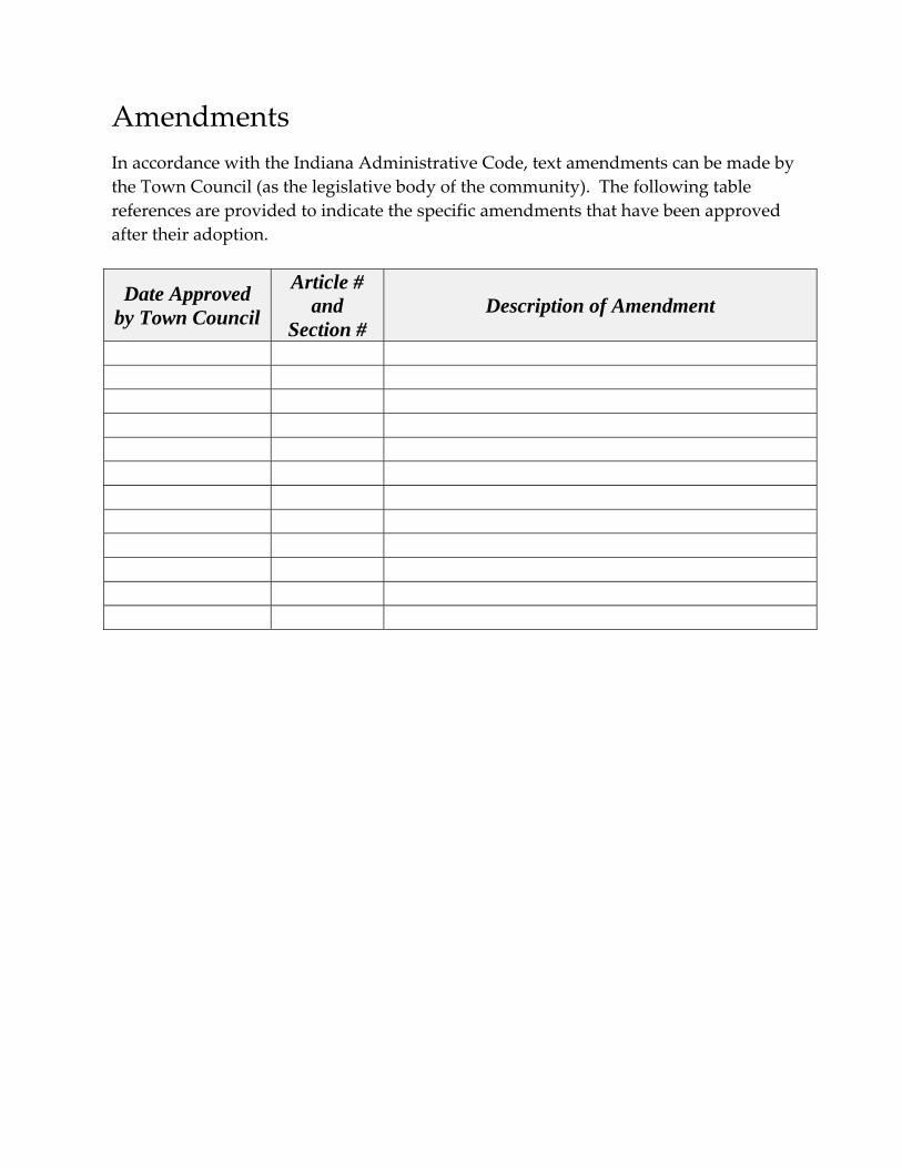
Amendments
In accordance with the Indiana Administrative Code, text amendments can be made by
the Town Council (as the legislative body of the community). The following table
references are provided to indicate the specific amendments that have been approved
after their adoption.
Date Approved by Town Council
Article # and
Section # Description of Amendment

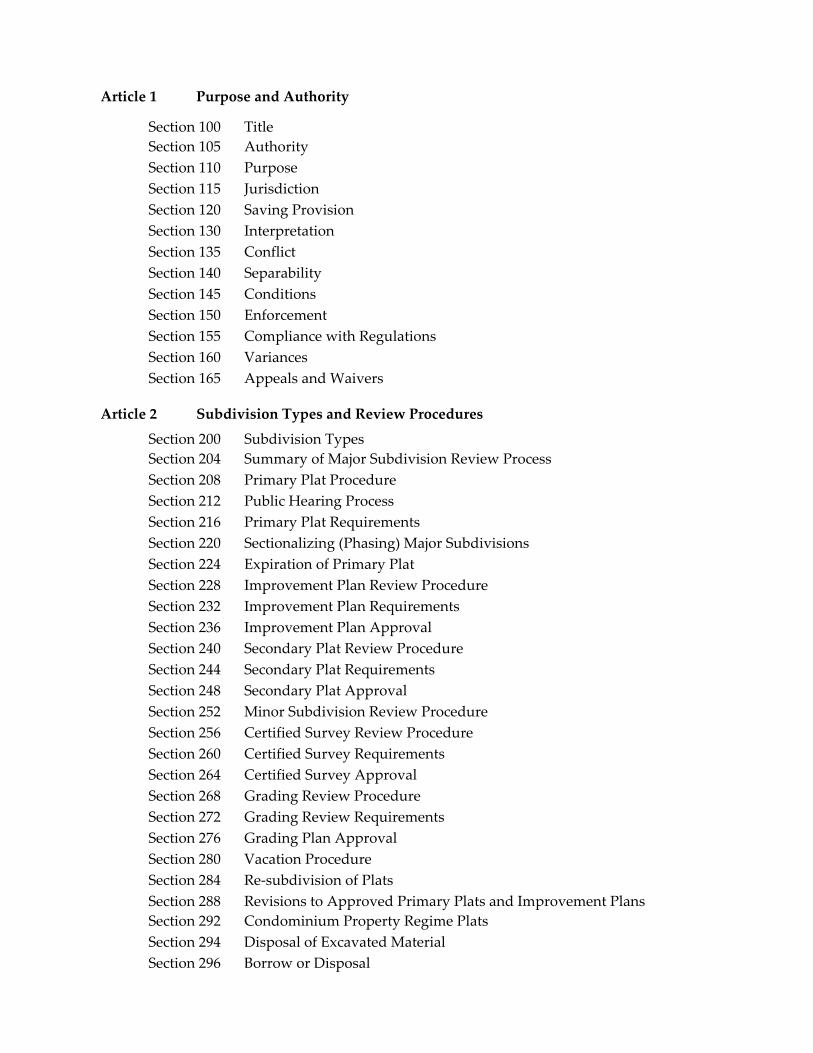
Article 1 Purpose and Authority
Section 100 Title
Section 105 Authority
Section 110 Purpose
Section 115 Jurisdiction
Section 120 Saving Provision
Section 130 Interpretation
Section 135 Conflict
Section 140 Separability
Section 145 Conditions
Section 150 Enforcement
Section 155 Compliance with Regulations
Section 160 Variances
Section 165 Appeals and Waivers
Article 2 Subdivision Types and Review Procedures
Section 200 Subdivision Types
Section 204 Summary of Major Subdivision Review Process
Section 208 Primary Plat Procedure
Section 212 Public Hearing Process
Section 216 Primary Plat Requirements
Section 220 Sectionalizing (Phasing) Major Subdivisions
Section 224 Expiration of Primary Plat
Section 228 Improvement Plan Review Procedure
Section 232 Improvement Plan Requirements
Section 236 Improvement Plan Approval
Section 240 Secondary Plat Review Procedure
Section 244 Secondary Plat Requirements
Section 248 Secondary Plat Approval
Section 252 Minor Subdivision Review Procedure
Section 256 Certified Survey Review Procedure
Section 260 Certified Survey Requirements
Section 264 Certified Survey Approval
Section 268 Grading Review Procedure
Section 272 Grading Review Requirements
Section 276 Grading Plan Approval
Section 280 Vacation Procedure
Section 284 Re‐subdivision of Plats
Section 288 Revisions to Approved Primary Plats and Improvement Plans
Section 292 Condominium Property Regime Plats
Section 294 Disposal of Excavated Material
Section 296 Borrow or Disposal
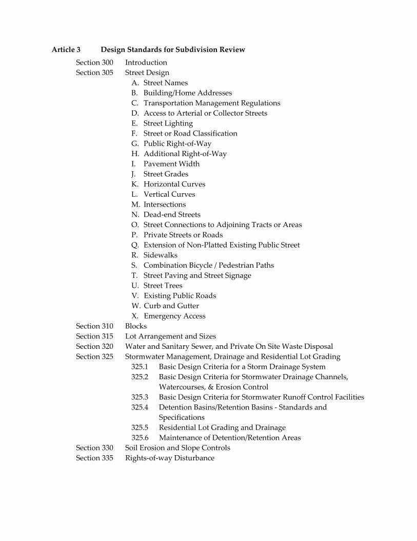
Article 3 Design Standards for Subdivision Review
Section 300 Introduction
Section 305 Street Design
A. Street Names
B. Building/Home Addresses
C. Transportation Management Regulations
D. Access to Arterial or Collector Streets E. Street Lighting
F. Street or Road Classification
G. Public Right‐of‐Way
H. Additional Right‐of‐Way
I. Pavement Width
J. Street Grades
K. Horizontal Curves
L. Vertical Curves
M. Intersections N. Dead‐end Streets O. Street Connections to Adjoining Tracts or Areas P. Private Streets or Roads
Q. Extension of Non‐Platted Existing Public Street
R. Sidewalks
S. Combination Bicycle / Pedestrian Paths
T. Street Paving and Street Signage
U. Street Trees V. Existing Public Roads W. Curb and Gutter X. Emergency Access
Section 310 Blocks
Section 315 Lot Arrangement and Sizes
Section 320 Water and Sanitary Sewer, and Private On Site Waste Disposal
Section 325 Stormwater Management, Drainage and Residential Lot Grading
325.1 Basic Design Criteria for a Storm Drainage System
325.2 Basic Design Criteria for Stormwater Drainage Channels,
Watercourses, & Erosion Control
325.3 Basic Design Criteria for Stormwater Runoff Control Facilities
325.4 Detention Basins/Retention Basins ‐ Standards and
Specifications
325.5 Residential Lot Grading and Drainage
325.6 Maintenance of Detention/Retention Areas
Section 330 Soil Erosion and Slope Controls
Section 335 Rights‐of‐way Disturbance

Article 4 Assurances for Completion and Maintenance of Improvements
Section 400 Completion Requirements for Public Improvements
Section 405 Construction Bond Alternative to Completion Requirements
Section 410 Types of Financial Guaranty
Section 415 Governmental Units
Section 420 Temporary Public Improvements
Section 425 Cost of Public Improvements
Section 430 Release of Construction Financial Guarantee
Section 435 Maintenance Bond of Public Improvements
Section 440 Issuance of Permits
Section 445 Acceptance of Dedication Offers
Section 450 Acceptance of Maintenance for Public Improvements
Article 5 Procedures for Inspections and Fees
Section 500 Construction Inspections
Section 510 Final Clean‐Up of Site
Section 520 Review Fees
Section 530 Inspection Fees
Article 6 Definitions
Article 7 Certificates Used on Secondary Plats and Certified Surveys
Certificate A Land Surveyor’s Certificate
Certificate B‐1 Dedication Certificate for Roadway
Certificate B‐2 Dedication Certificate for Public Uses
Certificate C Plan Commission Approval Certificate
Certificate D Owner’s Certificate
Certificate E County Recorder’s Certificate
Certificate F Acceptance of Dedications
Certificate G Sight Distance Certificate
Certificate H County Auditor’s Certificate
Certificate I Subdivider’s Contract
Certificate J Irrevocable Letter of Credit Form (Construction)
Certificate K Irrevocable Letter of Credit Form (Maintenance)
Appendix A Construction of Streets, Curbs & Gutters, Sidewalks & Driveways
Appendix B Thickness Requirements for Asphalt Paved Streets
Appendix C Street Typical Sections ‐ Geometric Design Criteria


ARTICLE 1
PURPOSE AND AUTHORITY
SECTION 100 – Title
These regulations shall be known, and may be cited, as the Subdivision Control Ordinance of the
Town of Dillsboro, Indiana.
SECTION 105 – Authority
Indiana Code 36‐7‐4‐700, et. seq., as amended, establishes the authority for the Town of Dillsboro
to adopt regulations governing plats and subdivision of land within its jurisdiction.
SECTION 110 ‐ Purpose
The purpose of this Ordinance is to ensure the following:
1. To assist the orderly and efficient development of the Town of Dillsboro;
2. To provide for the coordination of new thoroughfares with existing and planned
thoroughfares;
3. To secure and provide for the proper arrangement of streets or other highways in relation
to existing or planned streets or highways or to the Town Comprehensive Plan;
4. To protect and provide for the public health, safety, and general welfare of the Town;
5. To ensure the coordination with, and extension of, community facilities and utilities;
6. To ensure proper legal descriptions and monumenting of subdivided land;
7. To help safeguard against the pollution of air, and waterways; to help assure the adequacy
of drainage facilities; to help safeguard the water table; and to encourage the wise use and
management of natural resources throughout the Town;
8. To secure equitable handling of all Subdivision plans by providing uniform procedures
and standards;
9. To establish procedures for the division of land in accordance with the requirements of the
Town of Dillsboro Zoning Ordinance.
SECTION 115 ‐ Jurisdiction
This Ordinance shall apply to all land within the Town of Dillsboro.

SECTION 120 ‐ Saving Provision
These regulations shall not be construed as abating any action now pending under, or by virtue
of, prior existing Subdivision regulations, or as discontinuing, abating, modifying, or altering any
penalty accruing or about to accrue, or as affecting the liability of any person, firm, or corporation,
or as waiving any right of the Town, under any section or provision existing at the time of
adoption of these regulations, or as vacating or annulling any rights obtained by any person, firm,
or corporation, by lawful action of the Town except as shall be expressly provided for in these
regulations.
SECTION 130 – Interpretation
In their interpretation and application, the provisions of these regulations shall be held to be the
minimum requirements for the promotion of the public health, safety, and general welfare.
SECTION 135 – Conflict
The regulations are not intended to interfere with, abrogate, or annul any other ordinance, rule or
regulation, statute, or other provision of law. Where any provision of these regulations imposes
restrictions different from those imposed by any other provision of these regulations or any other
provision of law, whichever provisions are more restrictive or impose higher standards shall
control.
SECTION 140 – Separability
Should any section or provision of these regulations be declared by a court of competent
jurisdiction to be unconstitutional or invalid, such decision shall not affect the validity of these
regulations as a whole, or any part thereof other than the part so declared to be unconstitutional
or invalid.

SECTION 145 – Conditions
The attachment of reasonable conditions to the subdividing of land is an exercise of valid police
power delegated by the State of Indiana to the Town of Dillsboro. However, conditions imposed
by the Commission must be supported and permitted by this Ordinance. Conditions that are not
requirements of this Ordinance shall not be permitted by the Commission. The Subdivider has
the duty of compliance with reasonable conditions as provided in this Ordinance and as set forth
by the Commission for design, dedication, improvement, and restrictive use of the land. The
failure to comply with such conditions may be cause for denial of the submitted application and
shall, if such failure occurs after Secondary Approval, constitute a violation of the Ordinance.
SECTION 150 ‐ Enforcement
Whenever a violation of this Ordinance occurs, or is alleged to have occurred, any person may file
a written complaint. Such complaint shall fully, and accurately, state the causes and basis of the
alleged violation, and be filed with the Planning Director or his designee. The Planning Director
or his designee shall investigate the complaint in a timely manner (generally within one to two
weeks) and, if warranted, take action thereon as provided by this Ordinance. Any person filing a
written complaint shall be notified in writing by the Planning Director or his designee of the
action taken and/or status of such complaint.
If the Planning Director determines that a violation exists, the Planning Director or his designee
shall issue a written notice to the person(s) responsible for the alleged violation, by certified mail.
The notice shall describe the details of the alleged violation and the basis for the violation. The
notice shall also require an explanation, or correction, of the alleged violation to the satisfaction of
the Planning Director or his designee, within a specified time limit, which is to be determined by
the Planning Director or his designee. The notice shall state, and it is hereby declared, that failure
to reply or to correct the alleged violation to the satisfaction of the Planning Director or his
designee within the specified time limit constitutes admission of the violation of the terms of this
Ordinance.
Any person who violates any provisions of this Ordinance shall upon conviction be fined not less
than $10.00 and not more than $300.00 for each offense. Each day that the violation exists shall
constitute a separate offense. Violations of this Ordinance resulting from failure to apply for or
obtain a permit shall result in a doubling of the permit fee.
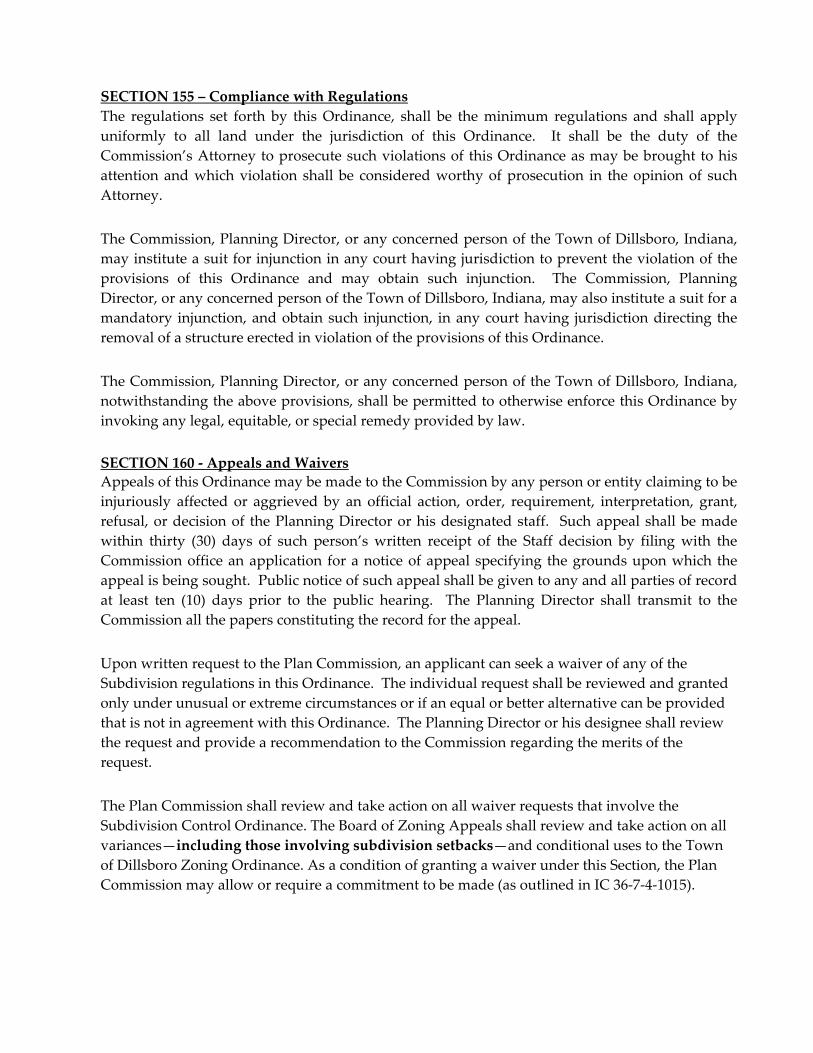
SECTION 155 – Compliance with Regulations
The regulations set forth by this Ordinance, shall be the minimum regulations and shall apply
uniformly to all land under the jurisdiction of this Ordinance. It shall be the duty of the
Commission’s Attorney to prosecute such violations of this Ordinance as may be brought to his
attention and which violation shall be considered worthy of prosecution in the opinion of such
Attorney.
The Commission, Planning Director, or any concerned person of the Town of Dillsboro, Indiana,
may institute a suit for injunction in any court having jurisdiction to prevent the violation of the
provisions of this Ordinance and may obtain such injunction. The Commission, Planning
Director, or any concerned person of the Town of Dillsboro, Indiana, may also institute a suit for a
mandatory injunction, and obtain such injunction, in any court having jurisdiction directing the
removal of a structure erected in violation of the provisions of this Ordinance.
The Commission, Planning Director, or any concerned person of the Town of Dillsboro, Indiana,
notwithstanding the above provisions, shall be permitted to otherwise enforce this Ordinance by
invoking any legal, equitable, or special remedy provided by law.
SECTION 160 ‐ Appeals and Waivers
Appeals of this Ordinance may be made to the Commission by any person or entity claiming to be
injuriously affected or aggrieved by an official action, order, requirement, interpretation, grant,
refusal, or decision of the Planning Director or his designated staff. Such appeal shall be made
within thirty (30) days of such person’s written receipt of the Staff decision by filing with the
Commission office an application for a notice of appeal specifying the grounds upon which the
appeal is being sought. Public notice of such appeal shall be given to any and all parties of record
at least ten (10) days prior to the public hearing. The Planning Director shall transmit to the
Commission all the papers constituting the record for the appeal.
Upon written request to the Plan Commission, an applicant can seek a waiver of any of the
Subdivision regulations in this Ordinance. The individual request shall be reviewed and granted
only under unusual or extreme circumstances or if an equal or better alternative can be provided
that is not in agreement with this Ordinance. The Planning Director or his designee shall review
the request and provide a recommendation to the Commission regarding the merits of the
request.
The Plan Commission shall review and take action on all waiver requests that involve the
Subdivision Control Ordinance. The Board of Zoning Appeals shall review and take action on all
variances—including those involving subdivision setbacks—and conditional uses to the Town
of Dillsboro Zoning Ordinance. As a condition of granting a waiver under this Section, the Plan
Commission may allow or require a commitment to be made (as outlined in IC 36‐7‐4‐1015).

ARTICLE 2
SUBDIVISION TYPES AND REVIEW PROCEDURES SECTION 200 – Subdivision Types
The following applies to Subdivisions or the divisions of land which are used for commercial,
industrial, office, residential, or other types of uses. The Subdivision of land can occur in the
following four (4) forms:
1. Major Division of Land ‐ A Major Subdivision of land involves eight (8) or more buildable
lots in addition to the Parent Tract and can include public improvements such as streets,
grading, utilities and stormwater detention. The review procedure for a major division of
land involves a Primary Plat, Improvement Plan, and a Secondary Plat as outlined in this
Article. If, however, a division of land containing eight (8) or more buildable lots does not
require any public street improvements or stormwater detention and only requires
minimal grading, the developer will only be required to submit a Primary Plat and a
Secondary Plat for review and approval;
2. Minor Division of Land ‐ A Minor Subdivision of land involves the division of seven (7)
buildable lots or less in addition to the Parent Tract, and is located along an existing public
street or a private drive as specified in this Ordinance and involves minimal grading. The
review procedure for a minor division of land involves a Primary Plat and a Secondary
Plat as outlined in this Article. The minor division of land involves no widening or
extension of a public street or stormwater detention. The procedures and application
requirements are outlined in this Article;
3. Administrative Division of Land – Administrative Subdivisions (hereafter called Certified
Surveys) are exempt from most provisions of this Ordinance, may not result in or require
the creation of a public easement or the installation of public improvements, and must be
one of the following types of division:
a. The division by conveyance of a single lot, tract, or parcel of land or a part thereof,
shown as a unit on the last preceding transfer of ownership record, into more than
two lots, tracts, or parcels of land in any one (1) year period of time for the purpose,
whether immediate or future, of transfer of ownership for residential, commercial,
or industrial purposes. Additional divisions of this type shall be required to follow
the Major or Minor Subdivision procedure;
b. A division of land for the transfer of a tract, or tracts, to correct errors in an existing
legal description, provided that no additional building sites other than for
accessory buildings are created by the division;
c. A division of land pursuant to an allocation of land in the settlement of a
decedentʹs estate or a court decree for the distribution of property;
d. A division of land for the transfer of a tract, or tracts, between adjoining lots
provided that no additional principal use building sites are created by the division.
Each lot created shall be clearly identified as a non‐buildable parcel on the plat and
within the deed. The adjoined lots so created hereunder shall have only one
principal use building site each;
e. A division of land into cemetery plots for the purpose of burial of corpses;
4. Exempt Division of Land – The following types of land divisions and survey plats are
exempt from the provisions of this Subdivision Control Ordinance—with the exception of
retracement or combination or consolidation surveys which are subject to the plat
requirements set forth in Section 262 of this Article and must be reviewed (to ensure
compliance with the plat standards and requirements set forth by Indiana ‘Rule 12’ and
Section 262 of this Order) by both the Town of Dillsboro Plan Commission staff and the
Dearborn County Surveyor or his designee, but are otherwise exempt from the provisions
of this Ordinance:
a. A division of land for federal, state or local government to acquire street right‐of‐
way;
b. A division of land for the direct use of utilities to meet the public’s needs for sewer,
water, gas, or electrical service.
c. A combination or retracement of an existing parcel(s) of record in which either a
survey plat does not exist, a survey error is being corrected, or an error associated
with an existing legal description is being resolved.
All Exempt Plats shall be entitled as such and shall be recorded with the Dearborn County
Recorder’s Office. No Exempt Subdivision may result in the creation of an additional,
principal use building site.
SECTION 204 – Summary of Major Subdivision Review Process
Major Subdivisions involve three separate review steps before the proposed property can be
developed and then recorded. The first step, the Primary Plat, involves a Public Hearing before
the Commission as required in this Article 2. This step allows a conceptual review of the layout of
the proposed development. The second step, the Improvement Plan, involves detailed
construction plans of how the Subdivision will be developed as set forth in this Article 2. The
Secondary Plat involves the recording of the Subdivision as set forth in this Article 2.
After the Commission has approved the Primary Plat and, if the development includes public
improvements, an Improvement Plan approval is required before any construction on the site can
begin. Improvement Plans are the construction plans for the Subdivision and any public
improvements that are to be dedicated to the Town. If the Improvement Plan complies with the
requirements of this Ordinance and the Town of Dillsboro Zoning Ordinance, the Improvement
Plan will be approved by the Commission. After this approval, construction can begin on the
property as indicated by the Improvement Plan. Before any property can be recorded through the
Secondary Plat procedure, thus allowing the transfer of the property, all required public
improvements must be completed and inspected and approved or a surety must be in place to
guarantee the completion and approval of the improvements. (See Article 4)

After the improvements have been installed and a request is made for their acceptance to the
legislative unit, a maintenance bond is required to cover any final improvements still to be
completed, as well as to cover the performance of the improvements for a minimum of two years.
(See Article 4)
SECTION 208–Primary Plat Procedure
The purpose of Primary Plat approval is to determine whether a proposed plat complies with all
relevant development requirements set forth, or incorporated, in this Ordinance, and to identify
the relevant development standards with which the proposal does not comply, if any. The
Primary Plat is intended to be a conceptual layout of the proposed Subdivision and not a
construction level detailed review. The following is required for this process:
1. An informal pre‐application meeting with the Planning Department Staff to review the
proposed Subdivision development prior to submittal of an application. The purpose is to
allow the Staff to explain the Subdivision process and to review the proposed
development with the applicant;
2. File a completed application with the Staff which application will be prescribed by the
Staff;
3. Within thirty (30) days after receiving a complete application, the Planning Director or his
designee shall schedule a Public Hearing as described in Section 212;
4. Prior to the Commissionʹs Public Hearing on the application, the Staff and the Technical
Review Committee shall review the submitted Primary Plat for compliance with these
regulations and provide a written report that indicates compliance with the requirements
of the Ordinance or a list of any deficiencies. The applicant shall then be given the
opportunity to correct these deficiencies prior to the public hearing.
SECTION 212 – Public Hearing Process
After scheduling a Public Hearing as specified in Section 208 the Commission shall provide
notification of the Public Hearing as follows:
1. Notice of the hearing shall be given by the Staff (postmarked and mailed) at least ten (10)
days in advance of the Public Hearing by certified mail to the applicant and the owners of
all property adjoining the property of the proposed Subdivision. The Applicant proposing
the Subdivision shall furnish to the Staff the names and addresses of the owners of all
adjoining property. The Dearborn County Assessor’s Office may be relied upon to
determine the identity for all adjoining property owners. In the cases where a Subdivision
abuts or includes a county line, notice shall be given to properties at least 660 feet from the
county line or property line into the neighboring county. The notice shall state, at a
minimum, the time, place and purpose of the hearing.
a. Notice of the Public Hearing shall be published in a newspaper of general
circulation at least ten (10) days prior to the hearing. Said published notice shall
state, at a minimum, the time, place and purpose of the hearing.
2. The Commission shall take the following action on the Applicantʹs request after the public
hearing:

a. If, after the Public Hearing, the Commission determines that the application and
Primary Plat comply with the standards in this Ordinance, the Commission shall
make written findings and a decision granting primary approval to the Primary
Plat. Reasonable conditions may be imposed to the approval of the plat that are
supported by the requirements of this Ordinance;
b. If, after the Public Hearing, the Commission denies the Primary Plat, it shall make
written findings that set forth its reasons and a decision denying primary approval
and shall provide the applicant with a copy of such findings.
c. The Commission meeting minutes shall serve as the written findings of fact in
support of its decision on the Primary Plat. After the minutes are approved by the
Commission, the minutes shall serve as his confirmation of the Commissionʹs
official action on the Applicant’s request. If the Applicant requests written
notification of the decision prior to the adoption of the official minutes of their
application, the Planning Director or his designee shall upon request by the
Applicant provide this written notification;
d. If the approved by the Commission, Planning Director or his designee shall stamp
and sign the Primary Plat according to the final action taken by the Commission
and provide a copy to the applicant as well as for the file.
3. The Plan Commission’s approval of a Primary Plat shall not constitute approval of Improvement Plan or Secondary Plat unless otherwise stated within this Ordinance.
SECTION 216 ‐ Primary Plat Requirements
The Primary Plat shall meet the minimum acceptable design standards set forth in Article III of
this Ordinance and the general applicable regulations for the construction of public improvements
as set forth in this Ordinance, and the Town of Dillsboro Zoning Ordinance. In addition to the
requirements of the preceding sentence, the Primary Plat shall contain the following information:
1. The proposed Subdivision plat shall be drawn to a scale of not less than one‐inch equals
one‐hundred feet (1ʺ= 100’) unless Staff approves another scale. The submitted drawing
shall be on a 24ʺ x 36ʺ paper size. A graphic or written scale shall be noted on the plat
along with the date of the plat and north arrow. All multiple sheet plans shall be stapled
together to form plan sets;
2. The proposed Subdivision name, the names and addresses of the owner and developer,
and the name, address, and seal of an Indiana Professional Engineer, or Registered Land
Surveyor responsible for designing the plat. In no case shall the name of a proposed
Subdivision duplicate or be similar to an existing Subdivision in the Town of Dillsboro
unless it is an extension or expansion of an existing Subdivision unless approved by the
Planning Director or his designee;
3. A vicinity map showing the proposed location of the Subdivision by township and section
and in relation to major or minor roads in the area. The vicinity map shall have an
approximate scale;

4. All proposed uses including the type of housing (e.g. single‐family attached or detached,
townhouses, duplexes, etc.) or other uses in the Subdivision and any public dedication or
reservation of land;
5. Label all open space and common areas;
6. Acreage of land to be subdivided, the total number of lots, and if applicable, the
approximate number of acres of open space or other public uses;
7. Existing contours with intervals of not more than ten (10) feet to reflect the current
topography of the proposed Subdivision with elevations based on mean sea level (U.S.G.S.
Datum). Also, the current elevations on adjoining streets or roads shall be required to
determine proper access management;
8. If any type of fence, brick wall, or earthen berm is being proposed to screen the proposed
Subdivision from a street or adjoining land use, it shall be noted on the Primary Plat.
Details such as height and type of screen shall be indicated on the Primary Plat. Identify
all landscaped areas within a public street right‐of‐way along with maintenance of such
features. If landscaped islands are proposed, drainage facilities are required;
9. Boundary lines of the land to be subdivided shall be shown in heavy solid lines, including
lengths and bearings. The following existing features within 100 feet of the proposed
Subdivision boundary shall be indicated, as referenced either from scaled aerial
photography or orthophotography, or as referenced from field observations: all existing
buildings, cemeteries, historical landmarks or features, water courses, railroads, bridges,
all private/public utility facilities and easements. In addition, the present zoning
classification, both on the land to be subdivided and on the adjoining land, and the names
of adjoining property owners and adjacent Subdivisions within one hundred (100) feet of
the Subdivision boundary. If the proposed Subdivision is an additional section of an
existing Subdivision, the plat shall show the numbering of all adjoining sections and lots;
10. Information pertaining to proposed and existing public/private utility layouts (e.g. storm
and sanitary sewer, water, gas, telephone, electric, cable, etc.) based upon existing service
lines. If applicable, the location of all detention/retention structures. The primary utility
layout for the Subdivision shall define the location and direction of flow of each
stormwater and sanitary sewer, and the location of each water line. Telephone, electrical,
and cable service should be noted as being installed underground or overhead;
11. A letter from all utility and service providers indicating the availability of sewer, water,
electric, gas, fire protection services, and emergency services, and / or schools (as
applicable) for the proposed Subdivision;

12. Names, locations, widths, lengths, grades and curves of proposed streets pursuant to
Section 305 Street Design herein. The Applicant shall state whether the proposed streets
will be public or private. Also, any existing easements shall be shown along with other
open spaces or reservation of land. Lots shall be numbered and the lot sizes (in acres) shall
be noted on the plat. The minimum building lines shall be denoted on the plat. In no case
shall the name of a proposed street duplicate or be similar to an existing street in the Town
of Dillsboro unless it is an extension or expansion of existing street;
13. Approximate boundaries of 100‐year flood plain using the Flood Insurance Rate Maps and
Floodway Maps for the Town of Dillsboro. Properties located within the floodplain shall
provide written documentation from the Indiana Department of Natural Resources
regarding the Flood Protection Grade and the location of the floodway (See Article 8 of
Town of Dillsboro Zoning Ordinance). The plat shall show all flood‐prone areas and a
sketch map using the current U.S. Geological Survey data to demonstrate the drainage
basins upstream and downstream from the development;
14. Reference to the existing soil types of the site or proposed Subdivision. The location and
identification of soil types can be found in the Soil Survey of Dearborn and Ohio Counties,
Indiana produced by the USDA. This document is available at the Planning Department.
If other data is used it shall be certified by a professional engineer licensed in Indiana. The
soil types shall be listed on the Primary P1at in order to determine any potential
environmental impact as a result of building or public improvement construction on each
soil type;
15. The phasing proposed and estimated time needed to reach build‐out of the Subdivision.
SECTION 220 ‐ Sectionalizing (Phasing) Major Subdivisions
During the Primary Plat review of a Major Subdivision, a Subdivider may present a phasing or
sectionalizing plan. If a phasing plan is submitted, the build‐out of the Subdivision must be
identified on the Primary Plat drawing and accompanying materials. As a part of this process, the
Plan Commission can require that certain improvements be completed within or by a certain
phase of the Subdivision’s development. For example, road termini, utility improvements, or
neighborhood or community amenities may be required within the early phases of the
Subdivision.
Additional financial guarantee may be required for Subdivisions developed in phases to ensure
that public improvements are connected as shown in the approved Primary Plat or financial
guarantee may be required to remain in place until all sections of the Subdivision are completed.
For example, prior to the development of a new phase or section, a maintenance guarantee may be
required to ensure the satisfactory condition of the required improvements from earlier sections of
the affected Subdivision—or adjacent development. Financial guarantees must also be
consolidated if different phases or sections are owned or controlled by the same Subdivider.

SECTION 224 – Expiration of Primary Plat
The approval of the Primary Plat shall be in effect for two (2) years from the date of the
Commission’s approval unless an Improvement Plan for at least one (1) section of the Subdivision
is submitted for review and approval. As each section of a Subdivision is approved and
developed, the approval of the Primary Plat will be extended for a two‐year period beyond each
approved section. A one (1) year extension of the approval of a Primary Plat is possible through an
application to the Planning Director.
SECTION 228 ‐ Improvement Plan Review Procedure
After the approval of the Primary Plat and after meeting informally with the Staff, the Subdivider
or Applicant shall, prior to the construction and installation of any utilities, roads or grading of any
parcel, prepare and submit an Improvement Plan for review and action by a Technical Review
Committee and Staff. The Improvement Plan shall be consistent with the approved Primary Plat.
Any changes to the approved Primary Plat shall be reviewed by the Planning Director or his
designee to determine if the changes are major or minor in scope. Minor changes shall include
slight movement of streets, reconfiguration of lots, renumbering of lots, increasing or reducing lot
sizes or similar changes. Major changes can include increases in the number of lots or removal of
street connections. Any changes considered to be major in scope shall require a new Public
Hearing by the Applicant as described in Section 215 of this Ordinance.
The Applicant may file an application and submit an Improvement Plan application to the
Planning Department after Primary Plat approval has been received. Upon receipt of a complete
application, the Planning Department shall distribute the required copies of the Improvement Plan
to the members of the Technical Review Committee for review. The Technical Review Committee
and staff will meet informally on a scheduled, or as needed basis, to review each Improvement
Plan for its compliance with the Subdivision Ordinance. The Planning Director or designee shall
then forward a list of deficiencies, if any, to the applicant. If the Applicant corrects the deficiencies,
and the Improvement Plan is in compliance with the Subdivision Control Ordinance and the Town
of Dillsboro Zoning Ordinance, the Plan must be approved.
SECTION 232 ‐ Improvement Plan Requirements
The Improvement Plan shall provide the minimum acceptable design and improvement standards
which will be required by the Commission as a precondition to development or in conjunction
with development for lots, streets, utilities, and other physical elements in the Subdivision. Based
upon the information and design plans of the Subdivision, the Planning Director or his designee
may request additional information on any of the following requirements in order to clarify design
issues. The Improvement Plan shall be designed by an Indiana Registered Professional Engineer
or Surveyor and installed in accord with these and other applicable regulations, and shall contain
the following information:
1. The proposed name of the Subdivision or development as approved in the Primary Plat. In
no case shall the name of a proposed Subdivision duplicate or be similar to an existing
Subdivision in the Town of Dillsboro unless it is an extension or expansion of an existing
Subdivision;
2. Names and addresses of owner or developer of the Subdivision and the Indiana Registered
Professional Engineer or Surveyor responsible for the design of all improvements. The
Improvement Plan shall be certified with the seal of the engineer or surveyor;
3. The plan shall be to a scale of one inch equals fifty feet (1”= 50’) unless Staff approves
another scale and the submitted drawing shall be on a 24ʺ x 36ʺ paper size. On large lots,
this scale may be used to show just the graded portion of the lots, and improvements. A
graphic or a written scale shall be on each sheet of the plan. All multiple sheet plans shall be
stapled together and numbered to form plan sets;
4. A vicinity map showing the proposed location of the Subdivision by township and section
and in relation to major or minor roads in the area. The vicinity map shall have an
approximate scale. In addition, if the Subdivision is done in sections, a reduction of the
overall subdivision plan shall be provided on the cover sheet that graphically indicates the
area under review;
5. The date shall be on the cover or first sheet of the Improvement Plan, and a north arrow
shall be on all sheets of the Improvement Plan;
6. The boundary of the Subdivision or section of Subdivision under review shall be indicated
by a heavy, solid line on one sheet of the Improvement Plan at a standard scale to show the
location of the section under review with other sections of the Subdivision. All Subdivision
boundary lines shall be labeled with the bearing and distance;
7. The location and name of all existing and recorded streets, right‐of‐way and roadway
widths, railroads, public and private utility right‐of‐ways or easements (including drainage
easements); public parks and open spaces; buildings (labeled as ʺto remainʺ or ʺto be
removed”); township, city, town, county and state boundary lines; cemeteries and other
historical landmarks or features. Drainage easements not planned to be piped shall be
labeled “surface drainage easement”;
8. Sight distances in both directions for any proposed road that intersects with an existing
street shall meet the minimum sight distance requirements found in Section 2410 of the
Town of Dillsboro Zoning Ordinance. The sight distances shall also be denoted on the plat
along with the speed limits of the roads to be intersected.
9. Location and sizes of all existing utility facilities (public and private) within or adjacent to
the Subdivision or development area. Location and width of all public or private
sidewalks, including ownership and maintenance of private sidewalks and pathway
systems;
10. Location and identification of all existing zoning districts within, or adjoining, the
Subdivision or project area. If used for residential purposes, the type of housing shall be
stated on the Improvement Plan;
11. Existing contours with intervals of not more than ten (10) feet shall be clearly marked with
elevations based on mean sea level (U.S.G.S. Datum) and the location and description of the
benchmark used. All subdivisions larger than 50 total lots will be required to tie into the
State Plane Coordinate System;

12. Proposed finished contours with intervals of not more than five (5) feet, shall be clearly
labeled and be related to the existing contours. Maximum grade for any excavated (cut or
fill) slopes shall be 2.5:1 (2.5 feet horizontal for each 1 foot vertical), and the design slope
shall be labeled on the plan. Excavated slopes may be steeper upon report by a
geotechnical engineer approved by the Planning Department. Disturbed limits shall be
clearly identified on the submitted plan and in the field;
13. Location, right‐of‐way and pavement width, name of all proposed streets and other public
utility right‐of‐ways or easements. Show striping of street lanes on roads with more than
two lanes. Also, show location of streetlights and submit detail of a typical light fixture. A
typical detail drawing that depicts the classification of the proposed street shall be shown
on the Improvement Plan. Where divided entrances are proposed, detail plans may be
required when appropriate. Proposed street names shall not duplicate or too closely
approximate phonetically, the name of any other street in Dearborn County. Street stations
and PVI’s shall be labeled on the centerline of proposed streets and correspond to profiles
of said street;
14. The location and lot number of all lots with the distances shown on each lot line. Arrows
showing the water flow off the lot will indicate the proposed drainage of individual lots;
15. Profile of each proposed street with finish grades (including adequate extensions, where
necessary, beyond the proposed Subdivision, development or section) including all existing
and proposed underground public utility crossings with catch basins, junction boxes,
manholes and existing private utility crossings including gas, electricity, and telephone.
Horizontal scale shall be the same as the plan scale and vertical scale not less than one‐inch
equals ten‐feet (1ʺ=10ʹ) unless approved by the Staff. Stationing shall be labeled and
correspond to the plan view;
16. Location of proposed sanitary, storm water, and water resource systems, including all
facilities relating thereto such as manholes, pump stations, sewerage plants, catch basins,
junction boxes, headwalls, water valves and fire hydrants. Detention/retention areas or
ponds shall be clearly identified with the maximum volume capacities labeled. Detailed
drawings of all overflow facilities shall be shown. All stormwater and sanitary sewer
facilities (catch basins, junction boxes, headwalls and manholes) shall be numbered and
correspond to those facilities on profiles as described in paragraph ʺ18ʺ of this section.
Connection to existing facilities shall be shown and labeled. Responsibility of maintenance
of any detention/retention areas shall be noted on the Improvement Plan;
17. Location and identification of any drainage facility (i.e. man‐made dams) or natural feature
(i.e. lake or pond) on the site or within one hundred (100) feet of the Subdivision or
development boundary which has, or could have, a significant impact on drainage or
siltation control;

18. Profiles of all proposed stormwater and sanitary sewer pipelines and facilities including
percent grade, pipe diameters, pipe lengths, and invert elevations. Profiles shall also show
all existing and proposed public utility (water, storm and sanitary sewer) crossings, and all
existing private utility (gas, electric, and telephone) crossings. The facilities (catch basins,
junction boxes, headwalls and manholes) shall be numbered and correspond to those
facilities as described in paragraph ”16” of this section. The design velocity of stormwater
flow shall be shown at the headwall and the re‐entrance into the natural stream. Detail
drawings of all detention/retention overflow and controlling facilities including valves shall
be shown. Connections to existing pipelines or facilities shall be shown and labeled;
19. Design calculations for all drainage facilities including detention/retention basins, sediment
basins, stormwater pipelines and drainage channels. All calculations must be approved by
an Indiana Register Professional Engineer or Surveyor. (See Article 3 Section 325 thru
325.6);
20. If a grading plan of the proposed Subdivision or section thereof was approved under
Section 272 of this Article, then a copy of that approved plan shall be submitted with the
proposed Improvement Plan;
21. Names of adjacent property owners and recorded Subdivisions with section or phase
number within one hundred (100) feet of the site under review;
22. Reference to the type of street and a typical cross‐section detail as noted in the current
Town Street Specifications;
23. The minimum building setback lines as stated in the current Town of Dillsboro Zoning
Ordinance shall be noted either graphically and in written form;
24. Indicate lots in the proposed Subdivision or development that are intended to be dedicated
or temporarily reserved for public use, or to be reserved by deed covenant for use of all
property owners in the Subdivision, and the conditions, if any, of such dedication or
reservation. The applicant shall provide information regarding any dedication of public
lands, restrictive covenants on non‐development areas, or conservation easements;
25. The location of all erosion and sediment control facilities shall be shown on the plan, with
detail drawings of each type of facility being used. The detailed soil erosion techniques or
features may be referenced on the plan in accordance with the Indiana Department of
Natural Resources Rule 5 Permit for Erosion Control. All excavated slopes (4:1 or steeper)
shall be seeded and mulched immediately upon completion of grading of that particular
slope, and right‐of‐ways shall be seeded and mulched within 120 days of the Planning
Departmentʹs Secondary Plat approval of that section;
26. A draft copy of any Homeowners Association Agreement document which deals with the
future maintenance of sidewalks, streets, open areas, recreational lands, street lighting,
private utilities, and other items. At a minimum, the Homeowners Agreement document
should include membership names, fee or dues structure, estimated cost for future
maintenance items, a detailed list of maintenance items, a budget description and a
description of ownership boundaries;

27. Additional documentation or information such as geotechnical studies may be required by
the Planning Department if an applicant is proposing to make improvements on property
located on steep slopes of 25 percent or greater or that have types of soils and geologic
formations, which severely limit development;
28. A copy of written approval shall be provided for all public utility improvements to be
provided. The letter should not only indicate that the service is available but that the
applicant has permission to extend or tap into the service. A copy of any required IDEM
approval for any sanitary sewer service shall also be provided. Developments requiring
access onto a state highway shall be required to provide a copy of any required INDOT
permit; and
29. Any applicable Floodway or Flood Plain information as determined in Section 216, Item 13;
30. A Phase I Environmental Site Assessment prepared by a certified environmental consultant
licensed in the State of Indiana, in accordance with ASTM E 1527‐00 for any subdivision
proposed for a commercial use. Any Subdivision may be subject to this requirement, at the
request of the Technical Review Committee, if the site contains a potential environmental
risk.
SECTION 236 ‐ Improvement Plan Approval
The Technical Review Committee and Planning Department Staff shall have thirty (30) days from
date of receipt of the completed application to review the Plan and take action unless the applicant
waives the time limitation, in writing. If the Improvement Plan is in agreement with requirements
within this Ordinance and the Town of Dillsboro Zoning Ordinance, then the Plan shall be
approved by the Technical Review Committee and the Planning Department Staff. If the Plan is
not in compliance with the requirements of this order and the zoning ordinance the Plan cannot be
approved until it is made to be compliant. If the Plan is approved with or without conditions, then
the applicant may proceed with construction. If the submitted Improvement Plan is not approved,
then the property owner, developer; or applicant may resubmit a new application or may appeal
the decision before the full Plan Commission at its next available meeting.
Approval of the Improvement Plan by the Technical Review Committee shall not constitute
acceptance of the Secondary Plat. Approval of the Improvement Plan also shall not be construed
as acceptance or agreement to accept any proposed improvement intended to be dedicated for
public use.
The Improvement Plan shall become null and void after two (2) years from the date of approval,
unless a substantial amount of construction of significant improvements in the Subdivision are
made (as determined by the Planning Director) and include the following: utility installation, road
construction, or extensive excavation. In addition, acceptance of a financial guaranty will extend
the approval period for the length of the guaranty. A one (1) year extension of approval for an
Improvement Plan can be issued by the Planning Director. Any deviation from or changes made
to the approved Improvement Plan shall be submitted to the Planning Department for review and
approval by the Staff and/or by the Technical Review Committee of the Plan Commission. In the
event that any person holding an approved improvement plan permit pursuant to this ordinance
violates the terms of the permit or implements site development in such a manner as to materially
adversely affect the health, welfare, or safety of persons residing or working in the neighborhood
or development site so as to be materially detrimental to the public welfare or injurious to property
or improvements in the neighborhood, the Building Commissioner or Planning Director, or their
respective designees, may suspend or revoke a site development permit. The Planning Department
shall stamp and distribute the approved copies of the Improvement Plan to the appropriate
organizations.
SECTION 240 ‐ Secondary Plat Review Procedure
The Secondary Plat shall conform to the approved Improvement Plan, and if desired by the
Applicant, it may constitute only that portion of the approved Improvement Plan, which the
Applicant proposes to record and develop at the time. However, any section, phase or part shall
conform to all requirements of these regulations.
SECTION 244 –Secondary Plat Requirements
The Secondary Plat shall conform to the requirements listed below, as well as those set forth in 865
IAC 1‐12, commonly known as ‘Indiana Rule 12’:
1. The proposed name of the Subdivision or development, as established by the Improvement
Plan. Also, names of adjacent property owners and recorded Subdivisions with section or
phase number. All Secondary Plats shall be drawn on a 24” x 36” inch fixed line mylar. The
font size shall be no less than .08 of an inch, for any text on the survey;
2. A vicinity map showing the proposed location of the Subdivision by township and section
and in relation to major or minor roads in the area. The vicinity map shall have an
approximate scale. In addition, if the Subdivision is done in sections a reduction of the
overall Subdivision plan shall be provided on the cover sheet that graphically indicates the
area of the Subdivision to be recorded;
3. Any information required by the Dearborn County Recorder’s Office;
4. Name(s) and address(es) of the Owner or developer of the Subdivision and the Indiana
Registered Land Surveyor or surveying firm responsible, for survey and lot design of the
Subdivision;
5. Date, north arrow, and graphic or written scale. The scale shall not be less than one inch
equals fifty feet (1”=50’), except Subdivision or developments with lots having a minimum
area of two acres which shall not be less than one inch equals one hundred feet (1”=100’);

6. Names of adjacent property owners+, deed record and page number*, and recorded
Subdivisions with section or phase number. *Instrument numbers may be supplied for any
parcels established after 2000. +For the purposes of this Ordinance, adjacent property
owners shall include anyone who owns land that is contiguous to a subject property as well
as anyone who owns land that is directly across the road rights‐of‐way—if property lines
are / were projected to the center of the adjacent road rights‐of‐way;
7. Boundary of the Subdivision or section thereof, with bearings and distances based on the
field traverse that has an accuracy of not less than one part in five thousand (1:5000);
8. The Property Parcel Map Numbers (#s) that the new lots are being divided from;
9. Area of the Subdivision or section of the Subdivision and area of each lot in acres;
10. Location and right‐of‐way width and length of all streets and easements which are to be
dedicated or reserved for public or private use;
11. Location, width, and names of public or private road rights‐of‐way that adjoin the
boundary, and whether the road is maintained or abandoned. For situations where the
rights‐of‐way are unknown or cannot be readily sourced through a prior survey or deed,
the approximate width of pavement must be provided along the frontage(s) of the affected
property;
12. Centerline curve data for the right‐of‐way of the streets and easements with the data to
include: central angle and radius, arc length, long chord and tangent distances;
13. Numbered, lots whose boundaries are described by bearing and distance for each tangent
course, and proper curve data (as given above) for curve courses. Side lot lines that are not
radial with curved street centerlines shall have a reference tie to the tangent line of that
centerline curve. Also, if any lots were subject to a Certified Survey, those lots shall be
noted with dashed lines and referenced;
14. Description of all monumentation, including notation as whether were found or set, and
the type of monument used;
15. Location of areas to be dedicated for, public use and with the planned use clearly indicated.
Areas intended to be reserved for common use but not dedicated to public use shall be
identified by a lot number and treated as a private lot. A statement shall appear on the
Secondary Plat that clearly describes the ownership and maintenance responsibilities for
any public or non‐public common areas;
16. The following statement shall appear on the Secondary Plat unless noted in the form of a
deed restriction by the developer of a Subdivision;
a. Current applicable zoning regulations or districts will determine building setbacks.
17. Certificate and seal of the Indiana Registered Land Surveyor, who is responsible for the
survey that the plat represents (Article 7, Certificate A);
18. A signed and notarized certificate of the owner(s) indicating adoption of the plat and
dedication of the streets, easements, and any other public areas (Article 7, Certificates B‐1
and B‐2, where applicable). This certificate shall be signed prior to the plat being signed by
the Planning Director or his designee;

19. Reference to the current Deed Book(s) and Page Number(s) as to the transfer to the current
owner(s) of all property that is a part of the Subdivision or section thereof. If the reference
is of more than one tract, the tract lines shall be shown on the plat;
20. Certificate of approval of the Town of Dillsboro Plan Commission (Article 7, Certificate C);
21. Certificate of approval of the Property Owner (Article 7, Certificate D), for Subdivisions
that do not involve public dedications;
22. Certificate of the Dearborn County Recorder and Auditor (Article 7, Certificate E & H);
23. Certificate of Dedication for public streets and storm sewer line(s), if applicable (Article 7,
Certificate F);
24. A final copy of any Homeowners Agreement document which deals with the future
maintenance of sidewalks, streets, open areas, recreational lands, street lighting, private
utilities, and other items. At a minimum, the Homeowners Agreement document should
include membership names fee or dues structure, estimated cost for future maintenance
items, a detailed list of maintenance items, a budget description and a description of
ownership boundaries;
25. Label and show the boundaries of any cemetery if it exists on the site—or is situated within
100 feet of the affected property. The following statement shall also be added where
cemeteries are noted: “Cemeteries subject to the requirements set forth in IC 14‐21‐1 et. seq
and Article 25, Section 2570, Town of Dillsboro Zoning Ordinance.”
26. Label and show the boundaries of any flood zones on the subject property which have been
identified as being within a floodway, 100‐year or 500‐year floodplain(s), if any exist on the
site. The current, applicable flood panel must also be referenced;
27. The following statement shall also appear on the plat:
ʺThis plat shall be void if not recorded within three (3) months of the survey certification
date, as stipulated in Indiana Rule 12.ʺ
SECTION 248 ‐ Secondary Plat Approval
Approval, approval with conditions or modifications, or disapproval shall occur within ten (10)
working days from the date of submittal of the application by the Planning Director or his
designee. Any public improvements as required by this Ordinance shall be addressed according to
Article 4 before the Secondary Plat can be approved. If the Plat is in agreement with requirements
within this Ordinance and the Town of Dillsboro Zoning Ordinance, then the Plat shall be
approved. If the Plat is not in compliance with the requirements of this order and the Zoning
Ordinance the Plat cannot be approved until it is made to be compliant.
Upon approval by the Planning Department, two copies of the Secondary Plat will be filed in the
Planning Department, one copy shall be forwarded to the Dearborn County Assessor and the
original mylar will be hand carried to the to the Dearborn County Auditor’s Office. The Auditor’s
Office will duly enter each parcel for taxation then the Plat will be delivered to the Dearborn
County Recorder for recording.

Approval of the Secondary Plat by the Plan Commission shall not constitute the acceptance by the
appropriate legislative body of the public dedication or maintenance of any street or other facility
nor shall it imply acceptance by the Dearborn County Recorder for recording purposes.
SECTION 252 ‐ Minor Subdivision Review Procedure
The purpose of this Minor Subdivision review procedure is to potentially allow for a more
expedient review process. A Minor Subdivision as defined in Section 200 shall be required to
follow the Primary Plat requirements in Section 216 and Secondary Plat review procedures
outlined within this Article. Within ten (10) days of receipt of a complete application, the Planning
Director or his designee shall:
1. Review the Applicantʹs application for technical conformity with these regulations;
2. Prepare a report and recommendation;
3. Schedule a Plat Committee (hereafter called Technical Committee) review of the
application within fifteen (15) days of the receipt of the complete application;
The Technical Committee shall review the Applicantʹs application for compliance with these
regulations. The Technical Committee may approve the application, approve the application with
conditions or deny the application. However, if the Technical Committee determines that the
application and Plat comply with these regulations, it shall grant primary approval. The Planning
Department shall stamp the Plan approved after expiration of the appeal period and distribute the
copies accordingly.
Within ten (10) days after the Technical Committeeʹs approval of the Applicantʹs application, the
interested parties shall be notified by certified mail, of their right to appeal the Technical
Committeeʹs decision. In order to appeal a decision of the Technical Committee, the Applicant or
Appellant must file a notice of appeal with the Planning Department within ten (10) days of receipt
of the notice. The appeal of a decision of the Technical Committee may be taken only to the
Commission.
Upon the filing of a notice of appeal, the Applicantʹs application for primary approval shall be
subject to the procedures of Section 208 as if it were a new application. If no appeal is filed the
Applicant shall proceed with the Secondary Plat procedures as outlined in this Ordinance.
SECTION 256 – Certified Survey Review Procedure
The provisions for Certified Survey Review and approval are intended to provide a convenient
and expeditious process for the conveyance or transfer of land from the parent tract as described in
definition section of this Ordinance. Property can be divided through this procedure if it falls into
the categories identified within Section 200, Administrative Subdivision of Land. Each lot
intended for building or development purposes must still meet the minimum standards in each
zoning district as stated on the Town of Dillsboro Zoning Map and in the Town of Dillsboro
Zoning Ordinance. This type of plat is intended to allow the division of a single lot from a larger
tract for building purposes and for the casual sale of property, including the sale of property for
non‐buildable lots, when the imposition of the Major or Minor Subdivision procedure would be
unnecessary. Certified Surveys may be submitted at any time to the Planning Department for Staff
review and approval.
SECTION 260 – Certified Survey Requirements
Certified Surveys are intended to graphically represent the information of a boundary survey of
property that is to be subdivided. The plat shall conform to the following requirements, as well as
those set forth in 865 IAC 1‐12, commonly known as ‘Indiana Rule 12’:
1. Date, north arrow, and standard engineering scale not less than one inch equals two
hundred feet (1”= 200’), unless approved by the Planning Department Staff. Plats shall be
at a minimum size of 18” x 24” on mylar drawn in ink. The font size shall be no less than .08
of an inch, for any text on the survey. The title of each survey must also be conspicuous on
either the top of the page or in the title block and must contain a clear reference to
acknowledge the type of survey that has been created (e.g. original survey, retracement
survey—including whether the retracement is a combination survey, or consolidation
survey);
2. Name, address, telephone number and seal of the Indiana Registered Land Surveyor
responsible for the survey Plat and the Land Surveyorʹs Certificate (Article 7, Certificate A);
3. Boundary of the parcel and Subdivision of that parcel, including bearings and distances of
each tangent course, and all necessary data for curve courses. The traverse that the
boundary is depended on shall meet the Indiana minimum standards, and if requested by
the Planning Department, closure documentation shall be submitted in addition to the plat;
4. Area in acres of the parent parcel and each Subdivision of the parcel. If a parcel falls in two
different townships, sections, or quarter sections, separate acreages shall be listed;
5. Location, width, and names of public or private road rights‐of‐way that adjoin the
boundary, and whether the road is maintained or abandoned. For situations where the
rights‐of‐way are unknown or cannot be readily sourced through a prior survey or deed,
the approximate width of pavement must be provided along the frontage(s) of the affected
property;
6. Encroachments discovered in the course of the survey;

7. Names of adjacent property owners+, deed record and page number*, and recorded
Subdivisions with section or phase number. *Instrument numbers may be supplied for any
parcels established after 2000. +For the purposes of this Ordinance, adjacent property
owners shall include anyone who owns land that is contiguous to a subject property as well
as anyone who owns land that is directly across the road right‐of‐way(s)—if property lines
are / were projected to the center of the adjacent road right‐of‐way;
8. Vicinity Map with an accurate scale, at a township level;
9. Statement by the applicant as to whether the transfer will be used, or is being used, for
building or non‐building purposes, and label this with bold letters on the parcel;
10. A description of the size, character, and location—including the location relative to the
surface of the ground—of all monuments, with notations indicating which were found and
which were set;
11. Current zoning of the subject property;
12. The Property Parcel Map Number (#) that the new lot is being divided from;
13. Existing structures and distances to the newly established property lines;
14. Label and show the boundaries of any cemetery if it exists on the site—or is situated within
100 feet of the affected property. The following statement shall also be added where
cemeteries are noted: “Cemeteries subject to the requirements set forth in IC 14‐21‐1 et. seq
and Article 25, Section 2570, Town of Dillsboro Zoning Ordinance.”
15. Label and show the boundaries of any flood zones on the subject property which have been
identified as being within a floodway, 100‐year or 500‐year floodplain(s), if any exist on the
site. The current, applicable flood panel must also be referenced;
16. Show utility, drainage, and any other known easements (where applicable) and road
frontage;
17. Variances and/or covenants if applicable;
18. Reference to source of title;
19. Reference to Section, Township, Range and Political Township;
20. Owner’s Certificate (Article 7, Certificate B‐1, B‐2 or D) and Certificate for Plan Commission
approval (Article 7, Certificate C), Certificate of the Dearborn County Recorder and
Auditor (Article 7, Certificate E & H);
21. For Subdivisions that are intended to be developed immediately, a sight distance study
shall be performed. The location of the future access point shall be indicated on the plat
with the following statements. Existing access points should also have the following notes
but may not be required to meet the sight distance requirements. A waiver can be granted
if a documented sight distance study has been previously performed by the Planning
Director or Designee.

a. “The recording of this plat provides no guarantee that the designated location for
the access point will receive sight distance approval from the Town of Dillsboro
Plan Commission.”
b. On _____ Day of _________, 200__ there are ________ feet of sight distance in the
(easterly, westerly, northerly, southerly) direction and ________ feet of sight
distance in the opposite (easterly, westerly, northerly, southerly) direction
measured to meet the minimum sight distance requirements of Article 24, Section
2410 of the Town of Dillsboro Zoning Ordinance.
If the Subdivision is not intended to be developed immediately, or a sight distance study
has not been performed, the following statements shall appear on the plat:
a. Upon visual inspection, there are approximately ________ feet of sight distance
in the (easterly, westerly, northerly, southerly) direction and approximately
________ feet of sight distance in the opposite (easterly, westerly, northerly,
southerly) direction. (If multiple sections of sight distance exist, each section
must be denoted on the plat.)
b. “At the time of this plat, a sight distance study has not been performed. A sight
distance study will have to be performed by an Indiana registered Professional
Engineer or Land Surveyor in accordance with the Major Plot Plan Review
process prior to construction of new access points. THE APPROVAL OF THIS
PLAT PROVIDES NO GUARANTEE THAT THIS PARCEL WILL MEET THE
MINIMUM SIGHT DISTANCE REQUIREMENTS ESTABLISHED BY THE
TOWN OF DILLSBORO PLAN COMMISSION.”
22. A Surveyor’s Report and Legal Description of the property;
23. When a parcel adjoins an existing public street, a minimum width of one‐half the right‐of‐
way shall be required in the form of an easement and shown on the plat along the entire lot
frontage (s) as detailed in Table 3.1.
24. The following statement shall also appear on the plat:
ʺThis plat shall be void if not recorded within three (3) months of the survey certification
date, as stipulated in Indiana Rule 12.ʺ
SECTION 262 – Retracement Survey Requirements
Retracement Surveys shall follow the process associated with Certified Surveys—as set forth in
Section 264 of this Order (although no fees are associated with the Plan Commission’s review for
this type of plat as it is considered exempt)—and must conform to the following requirements, as
well as those set forth in 865 IAC 1‐12, commonly known as ‘Indiana Rule 12’:
1. Date, north arrow, and standard engineering scale not less than one inch equals two hundred
feet (1”= 200’), unless approved by the Planning Department Staff. Plats shall be at a
minimum size of 18” x 24” on mylar drawn in ink. The font size shall be no less than .08 of an
inch, for any text on the survey. The title of each survey must also be conspicuous on either
the top of the page or in the title block and must contain a clear reference to acknowledge the
type of survey that has been created (e.g. original survey, retracement survey—including
whether the retracement is a combination survey, or consolidation survey);
2. Name, address, telephone number and seal of the Indiana Registered Land Surveyor
responsible for the survey Plat and the Land Surveyorʹs Certificate (Article 7, Certificate A);
3. Boundary of the parcel, including bearings and distances of each tangent course, and all
necessary data for curve courses. The traverse that the boundary is depended on shall meet
the Indiana minimum standards, and if requested by the Planning Department, closure
documentation shall be submitted in addition to the plat;
4. Area in acres of the parent parcel. If a parcel falls in different townships, sections, or quarter
sections, separate acreages shall be listed;
5. Location, width, and names of public or private road rights‐of‐way that adjoin the boundary,
and whether the road is maintained or abandoned. For situations where the rights‐of‐way are
unknown or cannot be readily sourced through a prior survey or deed, the approximate width
of pavement must be provided along the frontage(s) of the affected property;
6. Encroachments discovered in the course of the survey;
7. Names of adjacent property owners+, deed record and page number*, and recorded
Subdivisions with section or phase number. *Instrument numbers may be supplied for any
parcels established after 2000. +For the purposes of this Ordinance, adjacent property owners
shall include anyone who owns land that is contiguous to a subject property as well as anyone
who owns land that is directly across the road right‐of‐way(s)—if property lines are / were
projected to the center of the adjacent road right‐of‐way;
8. Vicinity Map with an accurate scale, at a township level;
9. A description of the size, character, and location—including the location relative to the surface
of the ground—of all monuments, with notations indicating which were found and which
were set;
10. The Property Parcel Map Number (#) of the affected property;
11. Existing structures and distances to the property lines;
12. Label and show the boundaries of any flood zones on the subject property which have been
identified as being within a floodway, 100‐year or 500‐year floodplain(s), if any exist on the
site. The current, applicable flood panel must also be referenced;
13. Label and show the boundaries of any cemetery if it exists on the site—or is situated within
100 feet of the affected property. The following statement shall also be added where
cemeteries are noted: “Cemeteries subject to the requirements set forth in IC 14‐21‐1 et. seq
and Article 25, Section 2570, Town of Dillsboro Zoning Ordinance.”
14. Show utility, drainage, and any other known easements (where applicable) and road frontage;
15. Variances and/or covenants if applicable;
16. Reference to source of title;
17. Reference to Section, Township, Range and Political Township;
18. Certificate for Plan Commission approval (Article 7, Certificate C), Certificate of the Dearborn
County Recorder and Auditor (Article 7, Certificate E & H);
19. Owner’s Certificate stating:
“This is to certify that the undersigned are the owners of the land shown and described in
this plat and as said owners we have caused the said above described property to be
surveyed as shown on the herein drawn plat, as our free and voluntary act and deed.
Signed this ______ day of __________________ (year).
(Ownerʹs Signature) ________
(Type or Printed Name)
NOTARY CERTIFICATE
STATE OF INDIANA, COUNTY OF DEARBORN, ss:
Before me the undersigned, a Notary Public, for said County and State, personally
appeared (Name of person), and acknowledged the execution of the foregoing certificate as
her voluntary act this _____ day of _____________, (year).
____________________________ ___________________________
Notary Public (Signature) (Name Typed or Printed)
My Commission Expires: _________________
Resident of ________________ County, _______________”
20. A Surveyor’s Report and Legal Description of the property;
21. The following statement shall also appear on the plat:
ʺThis plat shall be void if not recorded within three (3) months of the survey certification
date, as stipulated in Indiana Rule 12.ʺ

SECTION 264 – Certified Survey Approval
Approval, approval with conditions or modifications, or disapproval shall occur within ten (10)
working days from the date of submittal of the application. Once reviewed and approved by
Planning Director or his designee the Plat will be signed and stamped “Approved” by the
Planning Department Official. Approval of the Certified Survey by the Planning Department does
not record the parcel of land. A parcel is not recorded until the Plat and deed has been duly
entered for taxation by the Dearborn County Auditor and then accepted for recording by the
Dearborn County Recorder. All Certified Surveys shall require a newly created deed unless the
survey is a retracement of a currently recorded parcel. However, if a new deed and/or legal
description is created the retracement plat must follow the same procedure as a Certified Survey.
Upon approval by the Planning Department, the original mylar will be hand carried by the
property owner/applicant to the Dearborn County Auditor’s Office. The Auditor Office’s will
match the deed to the plat and duly enter the parcel for taxation and then the plat and deed will be
delivered to the Dearborn County Recorder for recording. A copy of the Certified Survey shall
also be forwarded to the Dearborn County Assessor.
Approval of the Certified Survey by the Plan Commission shall not constitute the acceptance by
the appropriate legislative body of the public dedication or maintenance of any street or other
facility nor shall it imply acceptance by the Dearborn County Recorder for recording purposes.
SECTION 268 ‐ Grading Review Procedure
Due to construction time limitations, unique soil conditions or weather conditions, a Subdivider or
Applicant may find it necessary to submit a Grading Plan after approval of a Primary Plat and
before a submittal of an Improvement Plan. The Grading Plan will not include final engineered
drawings for streets, water lines, and sanitary sewer lines. A Subdivider or Applicant may submit
a Grading Plan for review by the Staff.
If the Grading Plan has been approved by the Staff, the Subdivider or Applicant has one (1) year
from the date of the approved Grading Plan to begin and to complete the work as stated in the
Grading Plan or the Plan shall become null and void.
SECTION 272 ‐ Grading Plan Requirements
Upon the approval of the Primary Plat the developer of a proposed Subdivision or property owner
may submit a Grading Plan of the proposed Subdivision or section thereof for review by the Staff.
The grading plan shall be designed by an Indiana Registered Professional Engineer or Surveyor
and installed in accordance with these and other applicable regulations, and shall contain the
following information:
1. The name of the proposed Subdivision or development;
2. Name(s) and address(es) of owner or developer of the Subdivision and the Indiana
Registered Professional Engineer or Surveyor, responsible for all of the improvements. The
plan shall be certified with the seal of the Engineer or Surveyor;
3. The plan shall be to a scale of not less than one inch equals fifty feet (1”=50’). On large lots,
this scale may be used to show just the graded portion of the lots and improvements. A
graphic or written scale shall be placed on each sheet of the plan;
4. The date shall be on the cover or first sheet of the plan, and a north arrow shall be on all
sheets of the plan;
5. The boundary of the Subdivision or section of Subdivision under review shall be indicated
by a heavy, solid line on one sheet of the plan at a standard scale to show the location of
section under review with other sections of the Subdivision. All Subdivision boundary
lines shall be labeled with the bearing and distance;
6. Location, right‐of‐way width, and name of all existing or recorded streets, railroads, and
public and private utility easements (including drainage easements), public parks and open
spaces; buildings (labeled “to remain” or “to be removed”); incorporation, county and state
lines; cemeteries (see Article 3 Design Standards) and other historical landmarks or natural
features;
7. Location of all existing utilities (public and private) within or adjacent to the Subdivision or
project area;
8. Existing contours with intervals of not more than ten (10) feet shall be clearly marked with
elevations based on mean sea level (U.S.G.S. Datum) and location and description of
benchmark used;
9. Proposed finished contours with intervals of not more than five (5) feet shall be clearly
labeled, and related to existing contours. Maximum grade for any excavated (cut or fill)
slopes shall be 2.5:1 (2.5 feet horizontal for each 1‐foot vertical), and the design slope shall
be labeled on the plan. Excavated slopes may be steeper upon report by a geotechnical
engineer approved by the Commission. Disturbed limits shall be clearly identified on the
submitted plan and in the field;
10. Provide a copy of Rule 5 Permit from the Indiana Department of Natural Resources if
applicable and show on the plan the location of erosion and sediment control facilities with
detail drawings of each type of facility being used. The detailed soil erosion techniques or
features may be referenced on the plan in accordance with the Indiana Handbook for
Erosion Control in Developed Areas. All excavated areas and slopes (4:1 or steeper) shall
be seeded and mulched immediately upon completion of grading of that particular slope,
and right‐of‐ways shall be seeded and mulched immediately after the grading has been
completed if road construction will not start within two weeks of grading. All seeding and
mulching will be as detailed by the Indiana Department of Natural Resources, Soil
Conservation techniques;
11. Additional documentation or information such as geotechnical studies may be required by
the Commission Staff if an applicant is proposing to make improvements on property
located near or in areas with slopes, of twenty percent (20%) or greater, and types of soils
and geologic formations, which severely limit development.
SECTION 276 ‐ Grading Plan Approval
Approval, approval with conditions, or disapproval shall occur within ten (10) business days from
the date of submittal of the completed application. Once reviewed by the Staff, the Planning
Director or his designee shall sign and stamp the approved copies.
Upon approval, a copy of the Grading Plan will be forwarded by the Planning Department to the
Subdivider or Applicant. The Grading Plan will not serve as a replacement or substitute for the
Improvement Plan.
SECTION 280 –Vacation of Plats
In a case in which all of the owners in a plat are in agreement regarding a proposed vacation, the
owners may file a written instrument to vacate all or part of that plat as prescribed in IC 36‐7‐3‐10.
In a case in which all of the owners in a plat are NOT necessarily in agreement regarding a
proposed vacation, one (1) or more owners of land in a plat may file a petition with the Plan
Commission to vacate all or part of the plat pertaining to the land owned by the petitioner.
The petitioner’s application must:
1. State the reasons for and the circumstances prompting the request;
2. Include a survey that meets all of the requirements for a Certified Survey, as set forth in
Article 2, Section 260 of this order and as prepared by a registered Indiana Land Surveyor;
and
3. Give the names and addresses of every other owner of land in the plat;
Within thirty (30) days after receipt of a petition for a vacation of a plat, the plan commission staff
shall schedule the petition to be heard by the Plan Commission at a public hearing. The Plan
Commission shall follow the same public hearing procedure(s) to review proposed plat vacations
as those requirements outlined (earlier) in this Article for the review of Primary Plats.
After hearing the petition, the Plan Commission shall approve or deny the plat vacation request.
The Commission may approve the vacation of all or part of a plat only upon a determination that:
1) Conditions of the platted area have changed so as to defeat the original purpose of the plat;
2) It is in the public interest to vacate all or part of the plat; and
3) The value of that part of land in the plat not owned by the petitioner will not be diminished
by the vacation.
The Plan Commission may impose reasonable conditions as part of any approval. The Commission
shall furnish a copy of its decision to the County Recorder for recording. A petitioner or other
interested party may appeal the Plan Commission’s approval or disapproval of a plat vacation in
the manner prescribed by IC 36‐7‐4‐1016.
SECTION 282 –Vacation of Public Ways or Places
As identified in IC 36‐7‐3‐12, persons who:
1) Own or are interested in any lots or parts of lots; and
2) Want to vacate all or part of a public way or public place in or contiguous to those lots or
parts of lots;
may file a petition for vacation with the Dillsboro Town Council.
The petitioner’s application must:
1) State the circumstances of the case;
2) Include a survey that meets all of the requirements for a Certified Survey, as set forth in
Article 2, Section 260 of this order and as prepared by a registered Indiana Land Surveyor;
and
3) Give the names and addresses of all owners of land that abuts the property proposed to be
vacated.
The Dillsboro Town Council shall hold a hearing on a vacation petition within thirty (30) days after
it is received. The clerk of the Council shall give notice of the petition and of the time and place of
the hearing:
1) In the manner prescribed in IC 5‐3‐1; and
2) By certified mail to each owner of land that abuts the property proposed to be vacated.
The petitioner shall pay the expense of providing the required notice.
The hearing on the petition is subject to IC 5‐14‐1.5. Any person(s) aggrieved by the proposed
vacation may object but only on the following grounds:
1. The vacation would hinder the growth or orderly development of the unit or neighborhood
in which it is located or to which it is contiguous;
2. The vacation would make access to the lands of the aggrieved person by means of public
way difficult or inconvenient;
3. The vacation would hinder the publicʹs access to a church, school, or other public building
or place;
4. The vacation would hinder the use of a public way by the neighborhood in which it is
located or to which it is contiguous.
After the hearing on the petition, the Dillsboro Town Council may, by ordinance, vacate the public
way or public place. The clerk of the Town Council shall furnish a copy of each vacation ordinance
to the County Recorder for recording and to the County Auditor.
Within thirty (30) days after the adoption of a vacation ordinance, any aggrieved person may
appeal the ordinance to the circuit court of the county. The court shall try the matter de novo and
may award damages.
SECTION 284 ‐ Resubdivision of Plats
The Planning Director or his designee shall determine the appropriate Subdivision procedure for
modifying an existing, recorded Subdivision plat based on the following criteria. Any replat of a
Subdivision that creates the same or less of an impact to any platted public right‐of‐ways or that
does not increase the density of buildable lots, shall be permitted through the Secondary Plat or
Certified Survey procedure. However, any replat that significantly alters the public right‐of‐way
or increases the number of buildable lots shall be required to follow the Minor or Major Division
review procedure. An Improvement Plan will be required if the replat results in construction
changes to the Subdivision and/or the public right‐of‐way.
SECTION 288 ‐ Revisions to Approved Primary Plats and/or Improvement Plans
In certain cases, a Developer or Applicant may find it necessary to make changes to the
arrangement, size, number, or location of individual lots, streets, or utilities. These changes are
recognized as a typical part of the development process. In general, the Improvement Plan, and
Secondary Plat should be the same in design and layout as the approved Primary Plat. Any
changes that are made to the approved Primary Plat shall be submitted to and reviewed by the
Planning Director or his designee to determine if these changes are major or minor in scope. Major
changes will require a new public hearing as identified in Section 208.
Any changes made to the Improvement Plan shall be submitted to and reviewed by the staff to
determine if the changes are major or minor. Major changes will require the developer to reapply
under the Improvement Plan procedure identified in Section 228. Minor changes shall be
submitted as an as‐built plan.
Major changes shall consist of any substantial increase in density, elimination of roadway
connections, major realignment of roadways, major reconfiguration of lots and similar type
changes.
SECTION 292 ‐ Condominium Property Regime Plats
Condominiums are not regulated by this Ordinance but rather by I.C. 32‐1 et seq. Horizontal
Property Law. This law describes the procedure and process for creating and recording a
condominium.

SECTION 294 – Disposal of Excavated Material
All surplus or unsuitable excavated material in the subdivision, including rock or large boulders,
shall be disposed of by one of the following methods as determined by the Town Engineer:
1. Wasted adjacent to or incorporated in the regular construction where and as ordered by the
Town Engineer.
2. Disposed of by the Subdivider at his own responsibility and expense outside the limits of
the right‐of‐way.
Prior to the disposal of the waste materials, the Subdivider shall submit an executed copy of its
contract or permission statement from the property owner to the Town Engineer. The contract or
permission statement must recite that waste materials are not the property of the Town. Further, it
must expressly state that the Town is not a party to that contract or permission statement and that
the Subdivider and property owner will hold the Town harmless from any claim that may arise
from their contract or permission statement.
SECTION 296 ‐ Borrow or Disposal
Borrow shall consist of approved material required for the construction of embankments or for
other portions of the work and shall be obtained from approved locations and sources outside the
right‐of‐way. Borrow material shall be free of substance that will form deleterious deposits, or
produce toxic concentrations or combinations that may be harmful to human, animal, plant or
aquatic life, or otherwise impair the designated uses of the stream or area.
The proposed disposal site(s) for excavated material shall be identified before such material is
disposed of within or outside the right‐of‐way. An inspection shall be in accordance with the
Federal Manual for Identifying and Delineating Jurisdictional Wetland.
If the Subdivider elects to use the site, all required permits shall be obtained. The Subdivider shall
develop and construct all mitigation measures and fulfill all requirements detailed by such
permits.
Before borrow or disposal operations are begun, the Subdivider shall submit operation plans for
approval by the Town Engineer. Such plans shall include the following:
a. a detailed sketch showing the limits relative to property and right‐of‐way lines;
b. the grade of all slopes;
c. an erosion control plan in accordance with the requirements of 237 IAC 15‐5;
d. the encasement, finished grading, and seeding procedures; and
e. archaeological clearance.
Notice shall be given in advance of opening borrow areas so that cross section elevations and
measurements of the ground surface after stripping may be taken and the borrow material may be
tested before being used.

Except when a commercial source is utilized, a qualified archaeologist shall perform a record check
and field survey of borrow or disposal limits to determine if any significant archaeological sites are
within the limits. Results of the record check and survey shall be furnished in writing prior to the
excavation of any material. If any archaeological sites are identified, the archaeologist shall
establish the limits of the site along with a reasonable border. The site shall not be disturbed
unless the archaeological site is cleared by established procedures and written authorization to
enter the site has been issued. Under no circumstances shall an employee of the Contractor or the
State of Indiana share in the ownership or profit from the sale of any archaeological artifacts that
may be salvaged. No extension of completion time will be granted due to any delays in securing
approval of a borrow or disposal area.
Unless written permission is granted, there shall be no excavation in a borrow area below the
elevation of the adjacent properties within one hundred fifty (150) feet of the nearest right‐of‐way
line of an existing highway, Town road, or city street; the nearest right‐of‐way line of a proposed
highway, Town road, or city street; or adjacent property lines. If the properties adjacent to the
borrow area are privately owned, the setback limit of one hundred fifty (150) feet may be lessened
if written approval or permission is granted by the owner of the adjacent property, the excavation
is in accordance with local zoning laws and requirements, and if lessening the limit is in the best
interest of the State. Such minimum distance shall not be closer than fifty (50) feet to an adjacent
property line. All excavated slopes of a borrow area shall not be steeper than 3:1 down to 2 feet
below the ground water elevation. All excavated slopes two (2) feet below the ground water
elevation shall not be steeper than 2:1.
Top soil from the borrow or disposal area shall be stockpiled for use in restoring the disturbed
area. A minimum encasement of six (6) inches shall be placed on the 3:1 or flatter slopes. Final
restoration of borrow or waste disposal areas shall include grading, seeding, or other necessary
treatments that will blend the area into the surrounding landscape. Restored areas within one
hundred fifty (150) feet of the nearest right‐of‐way line shall be well drained. Areas beyond one
hundred fifty (150) feet shall be drained unless the landowner desires other treatment of the
borrow area. Construction of borrow or disposal areas shall be in accordance with existing laws,
regulations, and ordinances. Under no conditions shall borrow sites detract from the appearance
of the natural topographical features nor increase the potential hazard to a vehicle that has
inadvertently left the highway.
If granulated slag, dunes sand, or other granular material which is not suitable for the growth of
vegetation is used, such material shall not be placed within one (1) foot of the required finished
surfaces of shoulders and fill slopes. Additional material required to complete the embankment,
such as sandy loam, sandy clay loam, clay loam, clay, or other materials suitable for the growth of
vegetation and free from clods, debris, and stones, shall be furnished at the contract price for
borrow.

Additional fill material may be secured from within the permanent or temporary right‐of‐way in
lieu of borrow, or borrow either from vertical or horizontal extensions, or both, beyond the lines
and elevations of roadway and drainage excavation as shown on the contract plans when
authorized in writing. If additional material has been obtained without written approval, the
material will be classified, either as to source or use, to the best advantage of the Department.

ARTICLE 3
DESIGN STANDARDS FOR SUBDIVISION REVIEW SECTION 300 ‐ Introduction
The following design standards are intended to assist a developer or property owner in creating a
Subdivision and meeting the purposes of this Subdivision Control Ordinance. These standards are
to be used in preparing a Primary Plat, Improvement Plan, Grading Plan, Secondary Plat and
Certified Surveys.
The purpose of these standards is to establish minimum design and improvement standards for
lots, streets, utilities, and other physical elements of a Subdivision or development. The
developerʹs engineer or surveyor (Indiana Registered) shall design these aspects of the
Subdivision or development and the Town of Dillsboro Plan Commission Staff shall review them.
SECTION 305 ‐ Street Design
A. Street Names
Proposed streets, which are in alignment with other existing streets, shall bear the names of
existing streets unless separated by an intersecting collector or arterial street, or a legislative or
fire district boundary. In no case shall the name of a proposed street duplicate an existing
street name, irrespective of the use of the suffix street, road, lane, avenue, boulevard, way,
place, or court, nor shall a proposed street name phonetically approximate the name of any
existing or approved street name in Dearborn County. Proposed street names are added to a
master list or index (maintained by the Plan Commission) in order to reserve these names
when the Primary Plat is approved. Street names on Improvement Plans and Secondary Plats
shall follow the approved names listed on the Primary Plat unless approved through a
subsequent review by the Planning Department. If street names are changed in comparison
with the approved Primary Plat, then a revised Plat shall be submitted within thirty (30) days
of the name changes reflecting the approved changes for the Planning Commission’s and the
appropriate legislative unit’s files.
Street names on previously recorded Secondary Plats can be changed but the applicant must
verify the proposed street name with the Planning Department and then make a formal request
to the appropriate legislative body for any public street name to be changed. Private road
name changes shall be changed through the Planning Department by application. The
Secondary Plat shall also be amended and submitted to the Planning Department to reflect the
new street name.
B. Building/House Addresses
The Planning Department shall assign Building/House addresses, once a Secondary Plat has
been approved by the Planning Department and upon an application for a Zoning Permit to
the Planning Department.
C. Transportation Management Regulations
All Subdivision proposals shall follow the requirements of Article 24 of the Town of Dillsboro
Zoning Ordinance. Article 24, describes in detail Transportation Management Regulations,
which include classification of roadways, minimum spacing of driveways, minimum corner
clearance of driveways, minimum sight distances, maintaining capacity of roadways, design of
access points (e.g. number, location, coordination, consolidation, and spacing), turning lanes,
frontage roads, the review procedure and waiver of requirements. The applicant or subdivider
shall also meet the requirements of Section 2524 of the Town of Dillsboro Zoning Ordinance,
which describes frontage roads, setbacks.
D. Access to Arterial or Collector Streets
Where a Subdivision borders on or contains an existing or proposed Arterial roadway—or an
existing or proposed Collector roadway that exceeds 1000 vehicle trips per day—all new access
points involving either three (3) or more residential units or thirty (30) vehicle trips per day
(regardless of the proposed use) shall not be permitted access to such streets without approval
of the Commission Projects involving access to either to a Category I Collector roadway or
access to a proposed use that generates more than ten (10) but less than thirty (30) vehicle trips
per day—on all other types of Arterial and Collector roadways—shall require approval of the
Technical Review Committee. Direct access to an arterial or collector roadway shall only be
permitted if the other access scenarios such as local street access, frontage roads, shared
driveways and other forms of access control are unacceptable, unsafe or inappropriate as
determined by the Commission. All shared driveway accesses shall be identified on the
Subdivision’s Secondary Plat along with the appropriate covenants and restrictions that shall
also be placed on each affected lotʹs deed. All proposed driveway and road / street accesses in a
Subdivision must also meet the rules and procedures set forth in Article 24 of the Town of
Dillsboro Zoning Ordinance.
E. Street Lighting
Streetlights may be required at intersections if the Commission feels they are necessary for
pedestrian and vehicle safety reasons. If the Subdivider intends, or is required, to install
streetlights within the Town street right‐of‐way, the location and installation of such lights
shall not in anyway interfere with the Town’s use of the right‐of‐way as determined by the
Town Engineer. The Subdivider shall be responsible for the design, expense, installment,
location, maintenance and operation of such street lights unless such responsibility is assigned
to and accepted by a homeowners’ association or other entity to include the Town.

F. Street or Road Classification
The Developer or Subdivider shall use Table 3.1 to determine the design requirements and
road classification type for existing or proposed streets. The Planning Director or designee
shall determine the classification of streets where there is a discrepancy or the classification
cannot be determined from the table. The classification shall be based on the Town of Dillsboro
Zoning Ordinance and the definition of this Subdivision Control Ordinance. In addition, the
standards established by this table may be amended by the Commission if it determines that it
is necessary for reasons of safety, efficiency, maintenance, anticipated problems or future
growth as advised by the Planning Department and Town Engineer.
Arterial System
Arterials are categorized by their linkages to cities or larger towns and they generally
provide interstate or intercounty service. They are capable of attracting travel over long
distances and have a spacing that is consistent with the population density in the county.
See Zoning Ordinance Article 24 for a listing of the Arterial Roadways in the Town of
Dillsboro. The roadways in this category are classified by sub‐categories developed based
on the ADT volumes on the facilities. As each sub‐category serves a separate level of
traffic, design criteria has been developed separately to accommodate these differences.
For example, a high‐volume arterial’s design standards will be greater than that of a low‐
volume arterial. Example typical sections and criteria for each are illustrated in Appendix
C of this Ordinance.
Collector System
The collector system generally serves intra‐county travel as opposed to statewide
movements. The trips associated with a collector are predominantly shorter than those
associated with arterial routes. Consequently, lesser design speeds are used and the design
standards are generally less than that of arterial routes. Collector routes provide service to
smaller communities and provide connections to the arterial system. They are categorized
as serving the more important intra‐county routes. In order to further define the collector
system sub‐categories have been developed based on the ADT volumes on the roadway.
Local Roadways
The local roadway system in contrast to the arterial and collector system primarily provides
access to adjacent land and to the wider network. It serves principally shorter trips and
constitutes all roadways not classified as arterials or collector roads. To further designate
this category and the design parameters required a set of sub‐categories are defined based
on the roadway traffic volumes. In some cases, as that of a subdivision for example, right
of way is limited and numerous driveway cuts are needed. In these instances, a curb and
gutter section may be required. An example curb and gutter section is illustrated in
Appendix C.
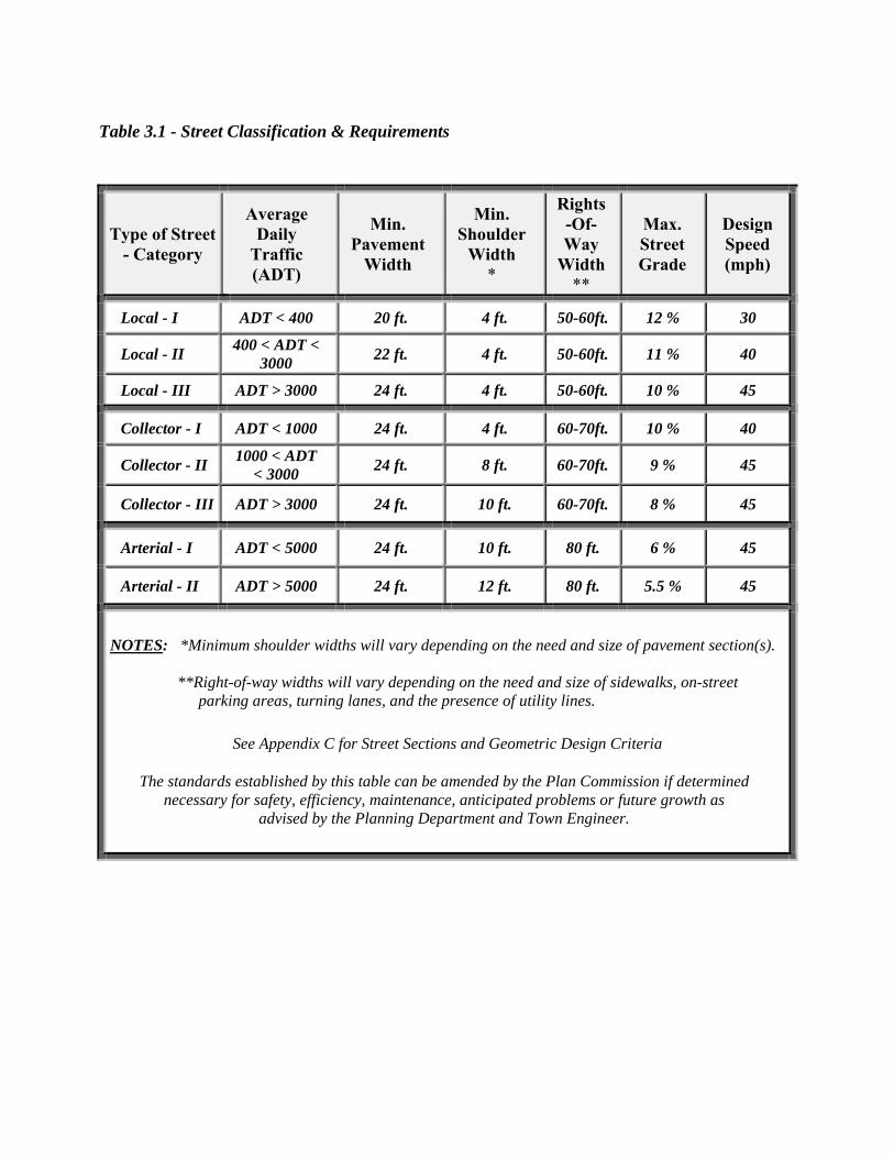
Type of Street - Category
Average Daily
Traffic (ADT)
Min. Pavement
Width
Min. Shoulder
Width *
Rights-Of-Way
Width**
Max. Street Grade
Design Speed (mph)
Local - I ADT < 400 20 ft. 4 ft. 50-60ft. 12 % 30
Local - II 400 < ADT <
3000 22 ft. 4 ft. 50-60ft. 11 % 40
Local - III ADT > 3000 24 ft. 4 ft. 50-60ft. 10 % 45
Collector - I ADT < 1000 24 ft. 4 ft. 60-70ft. 10 % 40
Collector - II 1000 < ADT
< 3000 24 ft. 8 ft. 60-70ft. 9 % 45
Collector - III ADT > 3000 24 ft. 10 ft. 60-70ft. 8 % 45
Arterial - I ADT < 5000 24 ft. 10 ft. 80 ft. 6 % 45
Arterial - II ADT > 5000 24 ft. 12 ft. 80 ft. 5.5 % 45
NOTES: *Minimum shoulder widths will vary depending on the need and size of pavement section(s). **Right-of-way widths will vary depending on the need and size of sidewalks, on-street parking areas, turning lanes, and the presence of utility lines.
See Appendix C for Street Sections and Geometric Design Criteria
The standards established by this table can be amended by the Plan Commission if determined necessary for safety, efficiency, maintenance, anticipated problems or future growth as
advised by the Planning Department and Town Engineer.
Table 3.1 - Street Classification & Requirements

G. Public Right‐of‐Way Width
The minimum width of right‐of‐way for a public street shall be as listed in Table 3.1. (See
Definitions section for Type of Street) Additional right‐of‐way width shall be required
whenever, due to topography or turn lanes, additional width is necessary to provide
adequate earth slopes, accommodate additional pavement width and afford maintenance.
Easements may be provided in lieu of additional right‐of‐way dedication for maintenance or
construction in locations where additional right‐of‐way dedication would be problematic to
lot development.
NOTE: Generally, signs, (other than street signs and traffic control signs) walls, fences,
sprinkler systems and other obstructions shall not be located in public street right‐of‐ways
unless approved within the Subdivision plans.
H. Additional Right‐of‐Way
Subdivisions that adjoin existing public street rights‐of‐way shall dedicate additional right‐
of‐way according to the Table 3.1 if the minimum right‐of‐way does not exist along the
property road frontage. The entire right‐of‐way shall be provided where any part of the
Subdivision is on both sides of the existing street; and one half of the right‐of‐way shall be
provided, as measured from the centerline, for Subdivisions that are located only on one side
of the existing street.
I. Pavement Width
No public street shall be constructed except in conformance with the minimum pavement
widths as listed above in Table 3.1. (See Definitions Section for Type of Street)
J. Street Grades
Grades of both public and private streets in proposed Subdivisions or developments shall
not be greater than as listed in Table 3.1. (See Definitions Section for Type of Street) The
maximum grade may be waived however, upon request of the Applicant to the Town
Engineer, if, due to topographic conditions, access is prohibited or requires excessive
grading. The Town Engineer shall determine whether a waiver will be granted. To
determine the waiver the Town Engineer shall review the slope percent proposed, length of
slope, lot access, vertical curve at landing and drainage to determine if the waiver request
can be permitted safely. The Town Engineer shall forward a letter indicating whether to
approve the waiver and any conditions that are necessary for safety to the Planning Director.
K. Horizontal Curves
Central angles of horizontal curves shall be kept to a minimum unless there is sufficient
radius length to minimize the severity of the curve. At no time shall the radius of the
centerline of a proposed street be less than three hundred (300) feet for collector streets, and
one hundred fifty (150) feet for local streets, except at intersections or divided roadways.
The tangent distance between horizontal curves of proposed street centerlines shall not be
less than one hundred (100) feet for all streets.
L. Vertical Curves
Any change in grade of proposed streets shall be transitioned by a vertical curve. The
minimum length for a vertical curve shall be fifteen (15) times the absolute value of the
algebraic difference of the grades (in percent) of the two tangents for collector streets. The
minimum length for a vertical curve shall be ten (10) times the absolute value of the algebraic
difference of the grades (in percent) of the two tangents for sub‐collector, local, cul‐de‐sac,
and court streets.
M. Intersections
The two centerlines of proposed streets at their intersection shall be as nearly to a right angle
as possible and that angle at no time shall be less than seventy‐five (75) degrees. For
Residential Subdivisions, the radius of the curve at the intersection of the two right‐of‐way
lines shall not be less than twenty‐five (25) feet, and for the intersection of the two pavement
edges, the radius curve shall not be less than twenty‐five (25) feet.
For industrial and Commercial Subdivisions, the radius of the curve at the intersection of the
two right‐of‐way lines shall not be less than forty (40) feet, and for the intersection of two
pavement edges, the radius curve shall not be less than forty‐five (45) feet. The Commission
may, in certain situations, increase the minimum radii based upon existing road conditions
and traffic patterns. (See Appendix C)
There shall be no greater than four basic street legs at any proposed intersection unless the
intersection is divided. Merging lanes, deceleration lanes, ʺYʺ intersections, etc. are
considered as being parts of one street leg or approach.

Proposed new intersections along one side of an existing‐street shall, wherever practicable,
coincide with any existing intersection on the opposite side of such street. Street jogs with
centerline offsets of less than one hundred fifty (150) feet shall not be permitted. Where a
local street is proposed to intersect with an arterial street, the alignment of the streets shall be
mandatory. Proposed street intersections with arterials shall be at least eight hundred (800)
feet apart and at least eight hundred (800) feet from any existing street intersection(s) along
the arterial. Proposed intersections with existing streets shall not be closer than one hundred
and seventy‐five (175) feet to an intersection of two existing streets as measured from edge of
pavement.
Intersections shall be designed with a flat grade wherever practical. In hilly or rolling areas,
at the approach to an intersection a leveling area shall be provided having not greater than a
two percent (2%) grade at a distance of sixty (60) feet for collector or arterial streets and three
percent (3%) for local streets as measured from the nearest right‐of‐way line of the
intersecting street.
Where any street intersection will involve earth banks or existing vegetation inside any lot
corner that would create a traffic hazard by limiting visibility, the developer shall cut such
ground and/or vegetation (including trimming trees) in connection with the grading of the
public right‐of‐way to the extent deemed necessary by the Town Engineer to provide an
adequate sight distance.
N. Dead‐end Streets
A dead‐end street is a street, or a portion of a street, or a system of streets that is connected to
other public streets from only one point of access. The regulations set forth in this Section
shall apply to dead‐end streets, portions of streets, or street systems. Proposed streets or
street systems that do not conform with this Section shall require a Waiver, as outlined in
Article 1.
Dead‐end streets or street systems shall not serve more than 30 dwelling units for residential
Subdivisions unless an acceptable alternative access is approved by the Plan Commission.
An acceptable access alternative may include, but is not necessarily limited to: connectivity to
an existing or planned open street or street system, wider streets, navigable sidewalks or
medians, stub streets or an emergency access—as set forth later in this Section.
A dead‐end street or street system shall not be more than twelve hundred (1200) feet in
length. The length of a dead‐end street or street system shall be the cumulative distance
measured from the intersection of the centerlines of the dead‐end street and the intersecting
public street to the center of the radial turnaround(s) provided at the terminus of the street or
street system. Please refer to Figures 3.1 & 3.2. This 1200‐foot length requirement may be
waived by the Plan Commission.
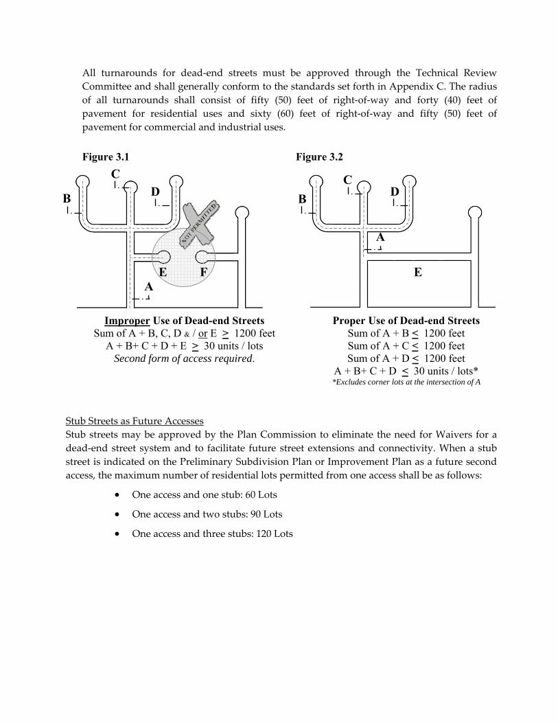
All turnarounds for dead‐end streets must be approved through the Technical Review
Committee and shall generally conform to the standards set forth in Appendix C. The radius
of all turnarounds shall consist of fifty (50) feet of right‐of‐way and forty (40) feet of
pavement for residential uses and sixty (60) feet of right‐of‐way and fifty (50) feet of
pavement for commercial and industrial uses.
Figure 3.1 Figure 3.2
Stub Streets as Future Accesses
Stub streets may be approved by the Plan Commission to eliminate the need for Waivers for a
dead‐end street system and to facilitate future street extensions and connectivity. When a stub
street is indicated on the Preliminary Subdivision Plan or Improvement Plan as a future second
access, the maximum number of residential lots permitted from one access shall be as follows:
One access and one stub: 60 Lots
One access and two stubs: 90 Lots
One access and three stubs: 120 Lots
A
B
Improper Use of Dead-end Streets Sum of A + B, C, D & / or E > 1200 feet
A + B+ C + D + E > 30 units / lots Second form of access required.
C
Proper Use of Dead-end Streets Sum of A + B < 1200 feet Sum of A + C < 1200 feet Sum of A + D < 1200 feet
A + B+ C + D < 30 units / lots* *Excludes corner lots at the intersection of A
A
B D
C D
E F E
O. Street Connections to Adjoining Tracts or Areas
Street connections to adjoining developed or undeveloped tracts, or to existing or planned
street systems, shall be required by the Plan Commission as outlined below. The purpose of
this requirement includes the layout of the Subdivision, the staging of development, the
opportunity for reasonable access alternatives to adjoining tracts, the necessity of providing
through connections between collector or arterial streets, to distribute traffic patterns by
providing alternative routes, and to provide convenient and efficient access for emergency
vehicles, street maintenance, school buses, postal delivery, and other essential services. The
street connection with adjoining property shall be constructed upon Secondary Plat
recording of seventy five percent (75%) of the Subdivision lots as approved on the Primary
Plat, or if the designated street in the Subdivision is within five hundred (500) feet of the
required connection point.
The Commission shall consider the following criteria for requiring street connections or the
provision of stub streets:
1. Street connections—or the provision of stub streets—to adjoining properties, or
existing or planned street systems, must be feasible and practical. Connections will
not be required if significant grading (slopes over twenty percent (20%) for several
hundred feet) and/or the construction of a bridge structure would be necessary to
make such connections;
2. The adjoining land should be compatible with the subject development as determined
by current zoning and the current Comprehensive Plan;
3. Future desired transportation patterns as described by the current Comprehensive
Plan and special funding projects recommended in the Transportation Plan shall be
considered;
4. The Commission may require the connection of local streets, or the provision of stub
streets, to adjoining tracts or areas in order to prevent the local street from becoming a
cul‐de‐sac street which exceeds the maximum length permitted for a dead‐end street;
5. Proposed street connections or stub streets to adjoining properties, or existing or
planned street systems, shall be constructed in accordance to the same standards as
their corresponding local public ‘Street Type’ (see Appendix C);
6. “Future Street Extension” & ʺNo Outletʺ signage must be placed at the entrances of
future street extensions or stub streets and a barricade must be placed at their ends.
These features must be identified on the Improvement Plans;
7. A notation must be included on the final plat to acknowledge that a street connection
or stub street shall be extended during subsequent phases of adjacent development;
8. All temporary turnarounds must be provided in accordance with the terms set forth
in Article 3, Section 305 and Appendix C of this order;

9. All street connections and stub street right‐of‐ways shall extend to the limits of the
proposed subdivision. All stub streets shall be improved and extended at least
twenty‐five feet (25’) into the right‐of‐way provided;
10. The end of any right‐of‐way that results in a connection or stub street shall not be
used for frontage to individual lots.
Extension of Existing Streets or Stubs
An existing dead‐end street or a stub street adjoining a proposed subdivision shall be
extended if one (1) of the following applies:
1. A proposed subdivision provides a second point of access required for an adjacent
subdivision;
2. The extension provides a second point of access required for the proposed
subdivision;
3. Overall circulation of the surrounding neighborhood is improved by providing
potential extension to multiple points of access;
4. To provide adjacent landlocked parcels with access without exceeding the maximum
number of lots permitted on a dead‐end street system in this Section.
P. Private Streets or Roads
Intent & Purpose
Private streets may be permitted in any zoning district. The intent of the private street
standard is to allow limited lot splits without requiring public streets that are costly or
inefficient to maintain. Private streets are not intended to be a method for reducing
development costs, but rather a method of reducing maintenance costs to the public. Private
streets serving six (6) or less units may be approved through the Minor Subdivision process if
all necessary specifications have been submitted and reviewed by the Technical Review
Committee and have been determined to be compliant with this Ordinance. All other
applications or plans involving the establishment of a private street shall follow the
Subdivision review process as outlined in Section 200(1).
Design Standards
All private streets must be centered within the easement and the easement must be a
minimum of fifty (50) feet in width. A reduction of the easement width can be granted by the
Planning Director for Minor Subdivisions for lots of record created prior to the adoption of
this Ordinance that have limited road frontage along a public road or have other limiting
width restrictions. The Commission can also reduce the easement width for Major
Subdivisions for the reasons described above.
Private streets shall only be granted if the (existing) public street in which the private street
has access to is at least 16 feet in width or allows sufficient two‐way travel. The Technical
Review Committee must also find that the proposed private street will not have a
detrimental affect to the public street’s level of service and safety.
The private street shall consist of a deeded access easement and maintenance agreement tied
to each lot that is accessed by or uses the private street as road frontage. The statement
“Private Street NOT Publicly Maintained” shall be provided in a conspicuous location on the
Subdivision Plat and shall also be contained within the legal description of the deed for each
lot served by the private street. In addition, a street sign with the statement above shall be
located conspicuously at the entrance of the private street from the adjacent public roadway.
This sign and the street sign shall be installed according to the Town of Dillsboro Department
of Transportation standards, at the Subdivider’s expense.
A private street must maintain a height clearance of at least 14 feet and may not serve more
than six (6) additional buildable lots—unless a Concept Development Plan involving a
rezone has been submitted and approved as outlined in Article 5 of the Town of Dillsboro
Zoning Ordinance. A private street cannot access another private street unless both
individually connect with a public street. For Major Subdivisions in which multiple private
streets are proposed the Commission shall have discretion in granting approval of the
private streets. The private street(s) shall not be granted if the Commission believes that the
property can be more efficiently, effectively and safely divided with a public street(s).
Private streets cannot be used during a re‐platting of a recorded Subdivision unless
approved by the Commission.
A private street shall be constructed, at minimum, to the same standard as its corresponding
local public ‘Street Type’ (see Appendix C)—except for maximum allowable grade (15%) and
pavement design, which shall consist of a minimum of eight (8) inches of No. 53 Compacted
Aggregate Stone. A private street that dead‐ends shall terminate with a cul‐de‐sac—unless it
serves an agricultural residential use A private street will require a permit from the entity
with jurisdiction over the public street with which it connects. Street names for private
streets shall be proposed and approved as outlined in Section 305 A. See Figures 3.2 & 3.3

Q. Extension of Non‐Platted Existing Public Street
There exist within the Town of Dillsboro publicly maintained roads which are not platted
and are maintained at a standard which is less than the required standard for newly
constructed Town roads. In some situations, the road inventory maintained by the Town
Engineer may contradict with the physical or the perceived termination of a public road. In
these situations, the Town road can be extended by the Applicant if the following standards
are met:
1. The extended road must have a minimum platted right‐of‐way of fifty (50) feet or a
minimum twenty‐five (25) feet half right‐of‐way;
2. Application must be made to the Town Engineer to have the maintenance of the road
extended;
3. The road must be installed at a standard that is consistent with the existing road at
the applicant’s expense and must provide an adequate public turnaround. This
standard shall be determined by the Town Engineer;
4. Property owners who adjoin the portion of the road to be extended shall be notified
by certified mail at the applicant’s expense ten (10) days prior to the hearing of the
proposed extension if different than the applicant/owner;
Figure 3.3 - Improper Use of a Private Street Figure 3.2 - Proper Use of a Private Street

5. The Dillsboro Town Council shall determine if the road extension shall be granted at
a public meeting. The Council can use the following standards to assist in their
determination of the road extension:
a. Would the extension of the road create a safety, maintenance or cost issue to
the Town?
b. Would the extension have a detrimental effect to the existing public street’s
level of service and safety as proposed or if additional lot splits where
created?
c. Does the extension of the street provide for a needed street connection?
d. Does the extension provide legal road frontage for a land locked parcel(s)?
e. Can access be provided to the parcel(s) in question with a private street?
R. Sidewalks
All Subdivisions or developments shall have sidewalks constructed according to the
following standards:
a. Sidewalks shall be required along both sides of all local streets in new residential
Subdivisions that have an average density of two (2) dwelling units per acre or greater.
However, sidewalks are not required along cul‐de‐sac streets serving 6 lots or less and
are only required on one side if it serves 12 lots or less but more than 6 lots. The
Commission can require sidewalks as described in this item if the Subdivision contains a
large lot or lots that might skew the density calculations;
b. Sidewalks shall be required along one side of all local streets in new Residential
Subdivisions that have an average density of one (1) dwelling unit per acre or greater but
less than two dwelling units per acres. The Commission can require sidewalks as
described in Item A or B above if the Subdivision contains a large lot or lots that might
skew the density calculations. Sidewalks are not required along cul‐de‐sac streets serving
6 lots or less;
c. Sidewalks are not required for new Residential Subdivisions if the average density is less
than one (1) dwelling unit per acre. The Commission can require sidewalks as described
in Item A or B above if the Subdivision contains a large lot or lots that might skew the
density calculations;
d. Sidewalks may be required between blocks when determined by the Commission to be
appropriate;
e. A subdivider can propose paths or trails as substitutes for conventional sidewalks if the
alternative system provides the same or better level of pedestrian access, upon approval
by the Commission;
f. Commercial and office Subdivisions shall provide sidewalks on both sides of all streets;

g. The Commission in Industrial Subdivisions may require sidewalks if the Subdivision
contains a mixture of office and commercial uses that will likely generate pedestrian
traffic;
h. The Commission, upon request of the subdivider can grant waivers of the sidewalk
requirements, if extreme grading or construction techniques would be necessary to
accommodate the sidewalks. In addition, the Commission can grant a waiver upon
request, if the Average Daily Traffic (ADT) for the Subdivision is less than 250 trips per
day;
i. The Commission can require sidewalks to be placed along existing public streets where
the Subdivision fronts if the Subdivision adjoins or is near other community services such
as a school, library or existing sidewalks;
j. Sidewalks shall be required along both sides of all new Subdivisions that require sub‐
collector, collector or arterial streets. Sidewalks shall only be required on one side if these
streets do not have direct lot access.
k. Sidewalks shall be constructed of a stable, firm, consistent, and slip resistant surface.
Construction should consist of Portland Cement concrete on compacted subgrade and
have a minimum depth of four (4) inches, except at driveways—unless an equal or better
alternative is approved by the Town Technical Review Committee. The minimum depth
shall be the same thickness as the driveway where the sidewalk passes through the
driveway. In commercial or industrial zones, driveways shall have the same depth as the
road leading to the parking area.
l. Sidewalks must be at least (5) feet in width along all types / classes of streets and shall be
located at least five (5) feet from the curb or the edge of the pavement if the sidewalk
system is situated within a public right‐of‐way. The cross slopes associated with
sidewalks shall not be permitted to exceed two (2) percent—in any portion of the
sidewalk system, including driveway aprons and associated improvements. The running
slopes associated with sidewalks shall not exceed the adjacent roadway gradient(s).
Sidewalk systems that do not meet all of the construction standards set forth in this
Section must be situated outside of the Town’s right‐of‐way and must be privately‐
constructed and maintained.
m. At intersections and pedestrian crosswalks, curb ramps shall be installed. (See Appendix
C.) Curb ramp assembly should include top and bottom landings, the ramp run itself,
and an edge treatment.

The Developer of the Subdivision shall be responsible for the installation of sidewalks, to
ensure continuality and compliance to ADA standards. Sidewalks must meet all applicable
requirements and approved standards and shall be subject to inspections by: 1) the Town of
Dillsboro Department of Transportation & Engineering—prior to the acceptance of any
application for public improvements to be reviewed by the Town Council; and 2) the
Dearborn County Building Department—prior to the County’s issuance of a Certificate of
Occupancy. Roadways and their associated required improvements—including sidewalks—
that have not been built to meet the standards set forth herein will not be accepted into the
Town’s maintenance system.
S. Combination Bicycle/Pedestrian Paths
A path for joint use by bicycles and pedestrians may be provided within a public street right‐
of‐way in accordance with the following standards:
a. Combination bicycle/pedestrian paths shall be provided only on subcollector, collector, or
arterial streets that have no vehicular access points for individual lots, that connect
between other subcollector, collector, and/or arterial streets, or a public facility such as a
school, park, library, etc.
b. A combination bicycle/pedestrian path shall be provided on one side of the street. Where
combination bicycle/pedestrian paths are provided, sidewalks are not required on the
other side of the street as per Section 305R.
c. Combination bicycle/pedestrian paths must be at least eight (8) feet wide and shall be
paved in accordance with the requirements of the appropriate legislative body. At
intersections and pedestrian crosswalks, wheelchair ramps shall be installed. (See
Appendix C) Traffic control signage or signage for safety purposes shall be installed
along the path in accordance with the requirements of the appropriate legislative body.
T. Street Paving and Street Signage
Street paving for Subdivisions or developments shall be carried out in conformance with the
current Town Street Specifications as maintained by the Department of Transportation and
the provisions stated in this document. Street signage installation, maintenance, and
replacement shall be the responsibility of the developer until the appropriate legislative body
has accepted the streets. New roadways shall be signed in accordance with the Indiana
Manual of Uniform Traffic Control Devices for regulatory and warning signs.

U. Street Trees
Street trees, when provided, shall be installed in accordance with the current Town Street
Specifications, and shall not be located in a manner that would conflict with either
underground or overhead utility lines or easements. The minimum width of street rights‐of‐
way which are planned to include street trees shall be increased a minimum of ten (10) feet
above the minimum requirements stated in Section 305, Item F, ʺPublic Right‐of‐Way Width.ʺ
The spacing and arrangement of street trees shall be subject to approval by the Planning
Commission Staff. Street tree species shall be subject to approval by the Planning
Commission Staff.
V. Existing Public Streets
No Major Subdivision shall be permitted that is accessed from an existing public street which
does not enable two‐way travel, unless said public street is upgraded to the Town
specification. In situations where the existing rights‐of‐way prohibit or restrict the street
from complying with new road specifications in Table 3 in this Ordinance, the Town
Engineer shall determine an acceptable street standard and width that affords safe two‐way
travel. All improvements shall be made at the Subdivider’s expense from the entrance of the
Subdivision to the nearest two‐way public street. The Subdivider can be required to improve
the ditch and drainage along an existing public street where the Major Subdivision adjoins if
the Town Engineer determines the Subdivision will negatively impact the drainage of the
public street.
The Commission can require road improvements to existing public streets when the level of
service is increased due to the development of large Subdivisions that significantly add to the
Average Daily Traffic (ADT) of the public street(s) they access. These improvements can
include deceleration and turn lanes, road widening or intersection improvements if
determined necessary by the Town Engineer. The intent of this requirement is to have
improvements made to public streets that are needed, due directly to the impact of the new
development and not fix problems that are in existence before the proposed development. If
the Commission or the Town Engineer believe it is necessary, a traffic study as outlined in
Article 24, Section 2448 of the Town of Dillsboro Zoning Ordinance can be required to
determine the impacts and remedies of the proposed Subdivision. If the required street
improvements cannot be accomplished within the existing public rights‐of‐way the
applicant/owner shall work with the Dillsboro Town Council and the Town Engineer to
secure additional rights‐of‐way necessary to facilitate the improvements.
Subdivisions that connect with existing public streets that do not comply with the sight
distance requirements can be required by the Commission, as part of Subdivision approval,
to make necessary sight distance improvements to the existing public street at the
subdividerʹs expense. See Article 24, Section 2410 of the Town of Dillsboro Zoning
Ordinance sight distance standards.

W. Curb and Gutter Requirements
All residential streets that have an average lot frontage of one hundred (100) feet or less shall
be required to install curb and gutter according to Appendix C. All commercial, office and
Industrial Subdivisions that have an average lot frontage of two hundred fifty (250) feet or
less shall be required to provide curb and gutter according to Appendix C. Residential
collector streets shall not be required to provide curb and gutter unless determined to be
necessary by the Town Engineer because of drainage, maintenance or safety concerns.
X. Emergency Accesses
All Subdivisions will be evaluated individually to determine the type of emergency entry
that may be appropriate to the access interior lots of a dead‐end street or street system. The
Plan Commission may permit the use of emergency accesses to address issues associated
with dead‐end streets or street systems that exceed the length, dwelling unit, and use
requirements set forth in this Order—although no emergency access may be used for lot
frontage. All final emergency access designs and materials shall be reviewed and approved
by the Technical Review Committee and should generally conform to the following
performance standards:
Surface:
Any approved all‐weather driving surface that is designed to support the weight of up to
40,000 lbs. may be permitted. This may include asphalt, concrete, grass‐crete, paving blocks,
etc.
Width:
The minimum width shall be 12 feet.
Slope:
The maximum slope shall not exceed 15 percent.
Signage:
Approved signs or other approved notices shall be provided for emergency access to identify
such and to prohibit the obstruction thereof. All signage shall be installed according to the
Town Department of Transportation standards, at the Subdivider’s expense.
Point of Entry:
Automatic or manual gates or alternative mechanisms may be required to restrict traffic
movements onto emergency accesses. These items, if applicable, shall be installed according
to the Department of Transportation standards, at the Subdivider’s expense.
Turning Radius:
The minimum (centerline) turning radius shall be forty feet (40’).
Vertical Clearance:
The minimum vertical clearance shall be 14 feet.
Maintenance of Emergency Accesses:
Right‐of‐way for all emergency accesses must be dedicated to the Town in accordance with
approved design standards. During the Primary Plat review process, a Subdivider must
indicate his intent to maintain the access as a private improvement—or whether these
improvements are proposed to be maintained by the Town, once completed as required.
The Subdivider shall maintain all emergency accesses until such time that the required
improvements are accepted by either a Homeowners’ Association or the Town.
For privately‐maintained emergency accesses, a deeded access easement and maintenance
agreement shall be tied to each lot that is accessed by or abuts the emergency lane(s). All
“Emergency Access” easements shall be noted in a conspicuous manner on the Subdivision
Plat and shall also be contained within the legal description of the deed for each lot served
by the emergency access.
If improved as required and accepted as a public improvement, the Town shall maintain the
emergency access only to the extent that access will not be encroached, obstructed, or closed.
Snow and ice removal maintenance will not be provided.
SECTION 310 ‐ Blocks
Intersecting streets, which determine block length and width shall be provided at intervals that
include existing street patterns, topography, and requirements for safe and convenient vehicular
and pedestrian circulation. Blocks of proposed Subdivisions or developments shall not be less
than two hundred forty (240) feet or more than twelve hundred (1200) feet in length.
SECTION 315 ‐ Lot Arrangement and Sizes
The size, shape, and arrangement of lots in proposed Subdivisions shall be such as set forward in
the current Town of Dillsboro Zoning Regulations and these Subdivision regulations.
Rectangular shaped lots shall be encouraged in all zoning districts. Extremely irregularly
shaped lots shall be avoided. Consideration of additional lot depth should be made when lots
adjoin railroads, major utility easements, commercial or industrial areas or other conflicting land
uses.
Side lot lines shall be as close to right angles with the street centerline as possible, or radial to
curve street centerlines. Lot lines not at right angles with the street centerline, and lot lines
intersecting with curved right‐of‐ways shall have a reference tie to the tangent line of that
centerline curve. Lot lines of a Subdivisions should display an organized and uniform
development pattern.

a. Lot Size ‐ The minimum size, width and area of a lot in a proposed Subdivision or
development depends on the current zoning district that said Subdivision or section
thereof lies in. The minimum size for the respective zone is contained in the current
Town of Dillsboro Zoning Ordinance;
b. Irregular Lots ‐ Corner lots should be sufficiently large enough to allow building frontage
on either street. Double frontage lots shall be avoided except where essential to provide
separation of a residential development from arterial streets or to overcome specific
disadvantages of topography and orientation. Double frontage lots can be restricted to
one driveway in Residential Subdivisions;
c. Flag Lots ‐ Flag lots can be used in those locations where because of limited road frontage
or geometric, topographic, or other natural features, it would be impractical to extend a
public street. Flag lots shall have a panhandle extending to a publicly dedicated street for
the purpose of access, and shall have two conforming, independently buildable lots
adjoining the flag lot along contiguous road frontage.
Single flag lots shall have a minimum of thirty feet (30’) and a maximum of sixty feet (60’)
of panhandle width on a publicly maintained street. A second, contiguous flag lot may
be accessed by the panhandle established for the initial flag lot land division; however,
for two contiguous panhandle lots, an (equal) deeded strip of land for each lot is required
for a common unobstructed access easement to the public street. The area of the access
driveway of the flag lot shall not be included in computing minimum lot area
requirements, as referenced in Article 25, Table 25.1 of the Town of Dillsboro Zoning
Ordinance. The minimum front yard setback shall be thirty feet (30’)—as measured from
the lot line that is most parallel and closest to the public street, excluding the panhandle
portion of the flag lot. All proposed access points on the land division plat shall contain
the Land Surveyor’s certification that indicates the approximate number of feet of sight
distance that exists for both directions at the intersection with the public road—or the
conditions that must be addressed to meet the requirements set forth in Article 24,
Section 2410 of the Town of Dillsboro Zoning Ordinance. All flag lots shall have a
panhandle for a minimum distance of one hundred fifty (150) feet from a publicly
dedicated street—which can include where the panhandle turns, bends, opens, or
increases in size. In no case shall more than two flag lots be contiguous to each other at
the publicly dedicated street. The maximum number of flag lots permitted for each phase
of a Major Subdivision (Improvement Plan submittal) shall not exceed fifteen percent
(15%) of the total number of lots.
A driveway must be located within the panhandle of the deeded property for a flag lot,
except in the following conditions, where this requirement may be exempted by the both
the Planning Director and Town Engineer or their assigned designees:
The driveway may be located within an access easement across an adjoining
conforming lot provided: 1) the access easement is at least fifty feet (50ʹ) wide;
and 2) the access easement serves no more than two new lots in addition to
the adjoining, conforming lot on which it is located or exists.

Unless an exemption is granted as noted above, a driveway for a flag lot shall be located at a
minimum of five (5ʹ) feet from each lot line. For all contiguous flag lots involving a common
driveway, a joint access easement shall be shown across the entire width of both panhandles
containing the common driveway on the final plat. All record plats and corresponding deed
documentation shall contain an appropriate written agreement to assure the perpetual
maintenance of the common driveway.
Figure 3.4: Proper Use of Flag Lots
d. Lot Frontage ‐ All lots in a Subdivision shall have the minimum frontage on a public or
private street as stated for their respective zone under the current Town of Dillsboro
Zoning Ordinance;
e. Cemeteries ‐ An Applicant, property owner or Subdivider has the option either to
relocate an existing private family cemetery or preserve it and develop around an
existing cemetery. In relocating a private family cemetery, an applicant, property owner
or developer shall be required to follow applicable local and state laws. In preserving a
cemetery, while at the same time developing a parcel, an applicant, property owner or
developer has the following options:
1. Transfer the existing cemetery as part of a buildable lot. Ownership and
maintenance of the cemetery would be left to the individual lot owner.
2. Make the existing cemetery a separate lot. Ownership and maintenance of the
cemetery would be assigned by written agreement with either of Subdivision
Homeowners Association, the developer of a Subdivision, a local legislative unit,
or an historical organization.
3. See Section 2570 of the Town of Dillsboro Zoning Ordinance for specific
requirements regulating private cemeteries.
30’- 60’
30’-
60’
30’
30’ – 60’
50’
50’

SECTION 320 ‐ Water and Sanitary Sewer, and Private On‐Site Waste Disposal
The following shall be the minimum standards for utilities (with the exception of storm water
drainage; See Section 325). These standards are minimum requirements and more stringent
local, county, town, state, or federal regulations may apply. In general, water and sanitary sewer
service shall be designed to tie into a public system. It is recommended that utility construction
doesnʹt occur until permission has been granted by the appropriate utility company or
organization.
a. Water Systems and Fire Hydrants ‐ Connection into either an existing or planned public
water supply system shall be required if the system is sufficient or can be expanded in
order to provide an adequate amount of water to a proposed Subdivision. Where
appropriate water supply lines shall be designed to loop back to existing or proposed
systems. Fire hydrants shall be provided in all Subdivisions where public water systems
are provided. Fire hydrants should be located with a maximum spacing of five hundred
(500) feet, as measured along the street right‐of‐way. Fire hydrants should be located no
further than two hundred fifty (250) feet from any building site, as determined by the
applicable setbacks set forth by the Town of Dillsboro Zoning Ordinance if the specific
building footprint is unknown at the time of platting. Additional hydrants are not
required to serve a flag lot if a hydrant is located within 100 feet of the vehicular entrance
to the flag lot and the panhandle is not more than three hundred (300) feet long.
Where existing public water mains that have existing fire hydrants are to serve a
proposed Subdivision and no public water main construction is necessary, no additional
fire hydrants are required unless the standards in this Paragraph (a.) above are not met.
Fire hydrants shall be designed and constructed in accordance with the appropriate
water and fire department district specifications. Public water supply systems shall be
designed and constructed in accordance with the water utility provider. Individual on‐
site water supply systems (wells and cisterns) shall be constructed in accordance with the
current standards and specifications of the state or local health department/district.
Major Subdivisions shall provide access to a public water system unless public water
is not available within 1000 or more feet of the Subdivision property line, or the
Subdivision is a low density with large lot sizes and a viable alternative water supply
is available. In addition, if water capacity is not adequate for fire protection, an
alternative fire protection system (i.e. dry hydrant) shall be required. The type of
system shall be reviewed and approved by the Commission and applicable Fire
Department;
b. Sanitary Sewer Systems ‐ Connection into either an existing or planned public sanitary
sewer system shall be required if the system is sufficient or can be expanded in order to
accommodate the additional flow from the proposed Subdivision. Sanitary sewer
systems shall be designed and constructed in accordance with the sanitary sewer
provider. Private lateral lines may only occupy the lot it is serving, except where
approved by the appropriate utility.
c. Utilities ‐ Utilities such as electric, telephone, natural gas, and cable television shall be
placed underground whenever possible, within minimum ten (10) feet platted
easements, and must be constructed per applicable standards and specifications, which
includes inspections by the appropriate legislative units, permit requirements and
compaction requirements if necessary.
SECTION 325 ‐ Stormwater Management, Drainage and Residential Lot Grading
Storm sewer systems are designed to collect and convey stormwater runoff from street inlets,
runoff control structures, and other locations where the accumulation of stormwater is
undesirable. The objective is to remove runoff from an area to avoid unacceptable amounts of
ponding damage and inconvenience. No storm sewer shall be permitted to run into a sanitary
sewer system within a proposed Subdivision. The design of the stormwater system in general,
shall produce the same rate of stormwater runoff at post‐development as the pre‐development
rate. Stormwater runoff from a site or Subdivision shall not adversely impact natural drainage
from an uphill drainage basin or to a downhill drainage basin or adjacent properties. The
property owner shall be responsible for stormwater drainage facilities located on private
property where runoff will be principally collected within that property and be minimally
discharged over a larger area before the stormwater naturally drains on adjacent properties,
unless a large drainage basin exists or is being planned. Stormwater drainage easements shall be
required if stormwater is directly discharging from a pipe to an adjoining property and not being
dispersed on the subject property.
All storm sewer systems shall be designed and constructed per flows calculated on the 10‐year
storm frequency. Overflows shall be designed on the 100‐year storm frequency. No living area
shall be affected by the 100‐year storm. Safety swales shall be designed to carry all runoff away
from any residential structure.
For all areas of stormwater control that are not addressed by this ordinance or in which a conflict
may exist, the current HERPICO Stormwater Drainage Manual shall be used as the regulatory
source to address the conflict or provide the requirements for stormwater control as determined
by the Planning Director.
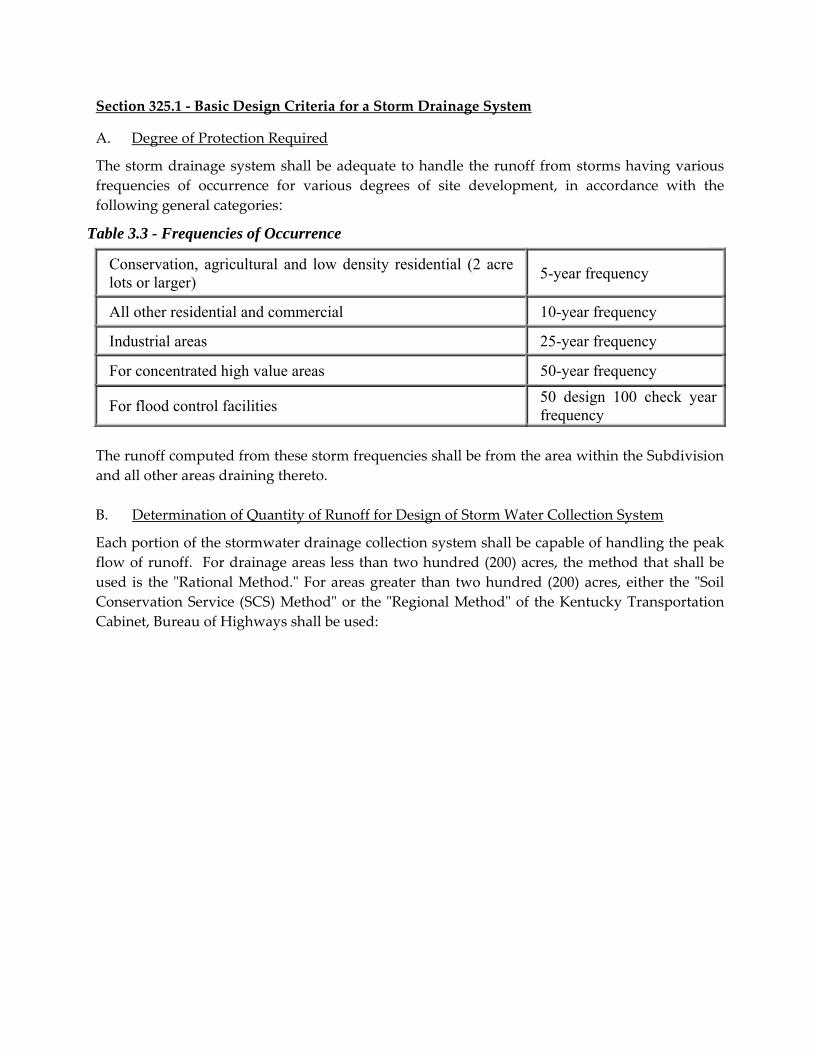
Section 325.1 ‐ Basic Design Criteria for a Storm Drainage System
A. Degree of Protection Required
The storm drainage system shall be adequate to handle the runoff from storms having various
frequencies of occurrence for various degrees of site development, in accordance with the
following general categories:
Conservation, agricultural and low density residential (2 acre lots or larger)
5-year frequency
All other residential and commercial 10-year frequency
Industrial areas 25-year frequency
For concentrated high value areas 50-year frequency
For flood control facilities 50 design 100 check year frequency
The runoff computed from these storm frequencies shall be from the area within the Subdivision
and all other areas draining thereto.
B. Determination of Quantity of Runoff for Design of Storm Water Collection System
Each portion of the stormwater drainage collection system shall be capable of handling the peak
flow of runoff. For drainage areas less than two hundred (200) acres, the method that shall be
used is the ʺRational Method.ʺ For areas greater than two hundred (200) acres, either the ʺSoil
Conservation Service (SCS) Methodʺ or the ʺRegional Methodʺ of the Kentucky Transportation
Cabinet, Bureau of Highways shall be used:
Table 3.3 - Frequencies of Occurrence

1. "Rational Methodʺ where Q = CiA
Q = peak runoff quantity in cubic feet per second;
C = runoff coefficient varying with perviousness and other characteristics of the
drainage area;
i = average intensity of precipitation in inches per hour, varying with frequency
of storm occurrence, duration or concentration time, and area of the tributary
watershed;
A = area in acres of the tributary watershed.
2. Runoff Coefficients: The runoff coefficient is the portion of the precipitation, expressed as
a decimal, that will reach a given storm water facility. Each lot within a Subdivision
contributes runoff from the roof, driveway, sidewalk and street. Generally, the smaller
the
lot width, the less impervious area. As the lot increases in width so does the impervious
area. Weighted coefficients shall be used with the impervious areas C = 0.90, for all other
areas see Table 3.4a. Residential developments shall be calculated using lot impervious
areas as shown on Table 3.4b.
Figure 3.5 - Intensity - Duration Curves Chart
10 20 30 40 50 60 70 80 90 100 110 120
1
2
3
4
5
6
7
8
9
10
0
INTENSITY - DURATION CURVESFOR
CINCINNATI, OH1904 - 1965
2 7.26 -0.127 -0.0745 7.98 -0.040 -0.084
10 8.53 -0.000 -0.08825 9.26 +0.038 -0.09250 9.81 +0.060 -0.095100 10.37 +0.079 -0.097
RI A0 A1 A2
(A + A LOG T ) C1 2RII A0TC=
RI = 100RI = 50RI = 25RI = 10RI = 5
RI = 2
INT
EN
SIT
Y (
I) -
IN
CH
ES
PE
R H
OU
R
DURATION (T ) - MINUTESC
DATA POINTS
Source: Kentucky Department of Highways
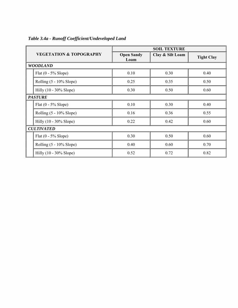
Table 3.4a - Runoff Coefficient/Undeveloped Land
VEGETATION & TOPOGRAPHY SOIL TEXTURE
Open Sandy Loam
Clay & Silt Loam Tight Clay
WOODLAND
Flat (0 - 5% Slope) 0.10 0.30 0.40
Rolling (5 - 10% Slope) 0.25 0.35 0.50
Hilly (10 - 30% Slope) 0.30 0.50 0.60
PASTURE
Flat (0 - 5% Slope) 0.10 0.30 0.40
Rolling (5 - 10% Slope) 0.16 0.36 0.55
Hilly (10 - 30% Slope) 0.22 0.42 0.60
CULTIVATED
Flat (0 - 5% Slope) 0.30 0.50 0.60
Rolling (5 - 10% Slope) 0.40 0.60 0.70
Hilly (10 - 30% Slope) 0.52 0.72 0.82

Table 3.4b - Runoff Coefficients / Land Imperviousness
LAND USE AVERAGE PERCENT
IMPERVIOUS
HARD SURFACE AREA
Pervious and/or existing pre-developed areas Varies Varies
Residential Uses Average Lot Size/Width
3 Acre / 300 feet 6 8000
2 Acre / 200 feet 7 6750
1 Acre / 100 feet 12 5500
½ Acre / 100 feet 23 5500
12500 S.F. / 80 feet 34 5000
9000 S.F. / 70 feet 42 4500
7500 S.F. / 60 feet 44 4000
6000 S.F. / 50 feet 48 3500
6000 S.F. / 50 feet 65 3250
Multi-Family Residential 75 To be calculated
Commercial/Office 85 To be calculated
Industrial 72 To be calculated
Impervious Areas including: Streets, Roofs, Flatwork, etc.
72 To be calculated
3. Intensity of Precipitation: The ʺpointʺ values of average precipitation intensity in inches
per hour, at Cincinnati can be extrapolated from Figure 3.5. For any given storm
duration (concentration time of runoff) the curves show the average precipitation
intensity of storms having 2, 5, 10, 25, 50, and 100‐year frequencies.
CHARACTERISTICS CONCENTRATION TIME
Flat (Less than 2%) Steep (More than 7%)
For Residential and Undeveloped areas 15 minutes. 10 minutes.
Residential on 1 acre or more lots 10 minutes. 8 minutes.
Table 3.5 - Time of Concentration
4. Concentration Time (T c): The time of concentration (T c) in minutes, is the estimated time
it will take the storm runoff from the most remote part of the area to reach the point of
the storm drainage system under consideration. This includes the time for water to flow
over roofs, thru roof gutters and downspouts, over ground, turfed areas, streets, through
street gutters to the nearest inlet of the drainage system plus the time of flow in the sewer
pipes to the point under consideration.
Unless otherwise determined by overland flow charts (Table 3.5) or nomographs, the
Time of Concentration (T c) for inlets of storm water collection systems may be used as
follows:
a. At no time shall the Time of Concentration be greater than thirty (30) minutes for
design of storm inlets.
b. ʺSoil Conservation Service (SCS) Methodʺ ‐ All formulas, constants and data shall
be used with regard to the current Manual from the U.S. Natural Resources
Conservation Service.
c. ʺRegional Methodʺ of Bureau of Highways ‐ All formulas, constants and data shall
be used with regard to the ʺRegional Methodʺ from the current Manual of
Instruction of Drainage and Design, Kentucky Transportation Cabinet, Bureau of
Highways.
C. Stormwater System Facilities
1. Flow times in sewers or conduits to the point of design may be determined from the
hydraulic properties of the sewers upstream of that point, assuming average flow‐full
velocity at the proposed sewer slopes;
2. Pipe Capacities ‐ Public storm sewer pipes shall be designed and constructed to carry
peak flows as determined by the methods previously described. At the design storm
the drainage system shall be designed and constructed as open channel (non‐
surcharged) flow. Sizes shall be determined by Manningʹs Formula.
3. Minimum Pipe Size ‐ The minimum diameter for public storm sewer pipe shall be
fifteen (15) inches for inlet headwalls and twelve (12) inches for systems with a catch
basin at the initial point;
4. Minimum and Maximum Velocities ‐ Velocities in public storm sewer pipes, when
flowing full at average peak flows, shall not be less than two (2) feet per second.
Velocities shall not exceed fifteen (15) feet per second at the flowʹs re‐entrance into the
natural stream, unless approved by the Planning Commissionʹs Engineer. The outlet
velocities of all headwalls shall be shown on the profiles of the storm water system;
5. Gradients of Pipe ‐ The sewer pipe shall be laid on gradients so that the velocity
(flowing full) shall be kept within the foregoing stated minimum and maximum
unless other special provisions are made. Pipe sizes shall be so selected as to avoid
large differences in velocities between consecutive reaches;

6. Hydraulic Grades ‐ To ensure against surface ponding or street flooding due to
surcharging, the hydraulic grade line (HGL) in any inlet or manhole shall not be
higher than the inlet grade. The HGL shall be shown on all profiles of the storm
water system.
Design and construction of all public storm sewer appurtenances shall consider the
balance of energy plus the loss due to entrance in all structures having a critical
change in horizontal or vertical alignment. In no case shall the difference in invert
elevations be less than the result of equal crowns when a smaller pipe empties into a
larger one. In no case shall storm sewer pipe sizes be reduced more than one
standard increment of pipe diameter due to an increase in invert gradient after
balancing the energy losses within the structure.
7. Manholes (Junction Boxes) ‐ Manholes shall be constructed in accord with Standard
Construction Drawings as shown in the current city/county street specifications.
Drop manholes may be required to reduce the slope of any sewer that has a velocity
that exceeds twenty (20) feet per second. Pipes shall not extend more than two (2)
inches into the side of the manhole, and the invert of the outlet pipe shall be at the
bottom;
8. Inlets (Catch Basins) ‐
Capacity: The capacity of the grate on the inlet should not be less than the quantity
of flow tributary to the inlet. Inlets at low points or sags should have extra capacity
as a safeguard for street flooding from flows overtopping the street curb. A safety
swale designed for the 100‐year storm shall be placed at all low points or sags.
Curb openings on combination inlets shall be used for overflows in the event that
the grate is clogged. Special inlets may be required for streets with steep gradients
to provide the extra capacity such situations require. Inlets shall not be placed
along the frontage of flag lots. Pipes shall not extend more than two (2) inches into
the side of the manhole, and the invert of the outlet pipe shall be at the bottom.
Location: Inlet spacing shall be based upon gutter and inlet capacity, street slope
and contributing drainage area. The spacing of inlets should ensure that street
drainage generated along continuous grades or in sags will not damage and flood
private properties or residential basements. For the design storm, no more than 5
cfs shall enter any grade inlet; no more than 8 cfs shall enter any sump inlet; and
no more than 2.5 cfs is permitted to flow in side yards between houses.
a. Along continuous grades (less than two percent (2%)) ‐ 400 feet maximum;
b. Along continuous grades (two percent (2%) and over) ‐ 600 feet maximum;
c. At sag locations (draining less than 2 percent (2%) grades) ‐ 400 feet
maximum between inlets or from a high point;
d. At sag locations (draining 2 percent (2%) and over grades) ‐ 600 feet
maximum between inlets or from a high point.
Special consideration should be given to storm drainage entering cul‐de‐sacs.
Additional inlets shall be required when drainage areas and/or street slopes are
excessive. In addition to an inlet provided near the low point within the cul‐de‐sac
two (2) additional inlets shall be required along each curb prior to the entrance of
the cul‐de‐sac in accordance with the following criteria:
a. For street slopes less than eight percent (8%) and draining more than four
hundred (400) feet of pavement; and
b. For street slopes eight percent (8%) or greater and draining more than three
hundred (300) feet of pavement.
9. Intersections ‐ Storm water runoff crossing the intersection of a street shall be kept to
a minimum;
10. Outfalls ‐ When a storm sewer system outfalls into a flood plain of any major
watercourse, the outfall shall not be subject to frequent floods or backwaters.
Standard headwalls and/or headwalls with wingwalls including rock channel
protection as aprons as erosion control, shall be constructed for all outfalls. Suitable
baffles or other energy dissipaters shall be provided if maximum velocities are
exceeded. The invert of the first storm sewer appurtenance upstream of the outfall
structure shall be above the elevation of the calculated 100 year flood plain. The
calculated 100 year flood plain for all channels with a drainage area of more than 50
acres within the project shall be shown on the Improvement Plan;
11. Culverts and Bridges ‐ Culverts and bridges shall be designed in accordance with the
methods given by the Indiana Department of Transportation as modified from time
to time; except that storm water quantities to be handled by the culverts and bridges
shall be determined on the basis described in these standards. The allowable
headwater (AHW) shall not be greater than HW/D = 2.+;
12. Headwalls ‐ Standard headwalls for pipe sizes twelve (12) inch thru twenty‐four (24)
inch and headwalls including wingwalls and aprons for pipes larger than twenty‐four
(24) inch, shall be constructed at the outfall of all storm sewers;
13. Other Drainage Improvement Measures ‐ Other drainage improvement measures
may be undertaken to provide the necessary hydraulic characteristics required for
adequate drainage. These other measures include stream bed clearing, removal or
obstructions, stabilization of banks or areas to eliminate erosion, widening, deepening
or realignment of streams, construction of ponds behind dams, or other measures for
adequate drainage;
14. Specifications for Construction and Materials ‐ See Appendices.
Section 325.2 ‐ Basic Design and Construction Criteria for Stormwater Drainage Channels,
Water Courses
Open channels provide many advantages in the management and control of stormwater runoff.
Such channels provide for natural infiltration of stormwater into ground water supply and
extend the Time of Concentration (T c) helping to maintain the runoff rate nearer to that which
existed prior to development. The objective of open channel flow design is: (a) to determine a
channel slope and size that will have sufficient capacity to prevent undue flooding damage
during the anticipated peak runoff period; and (b) to determine the degree of protection based
on stream velocity to prevent erosion in the drainage channel. Existing drainage channels,
which will remain undisturbed, shall not be required to be reconstructed unless additional
capacity and erosion control is required.
A. Degree of Protection ‐ The Subdivider shall ensure that stormwater drainage channels and
water courses shall be adequate to handle runoff from storms of the frequencies of
occurrence shown for the degrees of site development as follows:
1. For all Subdivisions and developments 25‐year frequency;
2. For main flood control channels – 100‐year frequency. The runoff computed from
these storms shall be that from the area within the Subdivision and from all other
areas considered as fully developed in accord with development planned in the
Townʹs Comprehensive Plan.
B. Determination of Quantity of Runoff ‐ Each portion of the stormwater system of drainage
channels and water courses shall be capable of handling the peak flows as determined by
the proper method previously described in Section 1.
C. Drainage Channel Capabilities ‐ Drainage channels shall be designed to carry peak flows as
determined by the methods previously described. Channel cross‐section areas shall be
determined by Manningʹs formula, using a value of n = 0.030 for earth sections, n = 0.020‐
0.025 for aggregate linings, and n = 0.015 for paved sections.
D. When open drainage channels require various lining types to attain ultimate design
capacity, the earth sections of the drainage channel and its structure shall be designed and
constructed to the ultimate design required.
Lining will not be required in the initial construction and may be delayed until
development of the area produces runoff quantities large enough to result in erosive
channel flows, unless drainage channel velocities are excessive initially.
E. Erosion Control for Drainage Channels ‐ Runoff flows in open channels may cause
accelerated erosion. Such erosion can be controlled by limiting velocities, changing the
channel lining, and reshaping the channel to spread the flow of runoff. Methods of
controlling erosion in open channels include the following: (1) grass covers or sod; (2) Type
II channel lining; and (3) reinforced concrete or precast paving. Erosion control for newly
created or disturbed drainage channels shall be provided as follows:
1. Velocities of less than two (2) feet per second (fps). Design velocities should
generally be greater than 1.5 fps to avoid excessive deposition of sediments. When
flat slopes are unavoidable, concrete paving should be used to accelerate runoff;
2. Velocities between one and one‐half (1.5) feet and four (4) feet per second. The
bottom and sides of the earth channel shall be seeded, mulched and fertilized to
an elevation of three (3) feet above the design water surface. Seeding shall be a
perennial or annual mixture of grass seeds at a rate of seventy‐five (75) pounds
per acre. Acceptable whole fertilizer shall be applied at a rate of seventy‐five (75)
pounds per one thousand (1000) feet. On slopes over five percent (5%), the
bottom and sides of the earth channel shall be sodded and pegged to remain in
place. Where seeding or sodding is required and the soil is not capable of
supporting vegetation (such as, sandy soil or other clay types), appropriate action
shall be taken to bring the soil to an acceptable condition which will support the
growth of seed or sod;
3. Velocities over four (4) feet per second. The bottom and sides of the earth channel
shall be protected from erosion with an application of stone rip‐rap, coarse
aggregate and/or dumped rock channel linings. The type of application thickness
and quantities shall be designed by the Town’s engineer to ensure maintenance
free permanent stabilization. Reinforced concrete pavement at least four (4)
inches thick may also be used at bends, changes in alignment, junctions with other
ditches, and at other locations where erosion is likely to occur. On slopes over ten
‐percent (10%), consideration should be given to the construction of larger sized
channel linings, gabions (wire boxes) or paved channels with energy blocks or
dissipaters to reduce excessive velocities and damage to receiving streams;
4. Consideration shall be given for the construction of other methods of lining for
erosion control including check dams, drop structures, gabions, etc. subject to
approval of the Planning Commissionʹs duly authorized representative.
F. Drainage Channel or Water Course Relocations ‐ In order to minimize hillside slippage
near relocated drainage channels or water courses due to drainage channel depth or
character of the earth in the drainage channel fill and side slopes, precautions shall be
taken to compact the fill and side slopes, provision of under drainage, bank protection or
reinforcing or other measures. Additional easement width shall be provided at such
possible slide areas as determined by the Technical Review Committee.

Section 325.3 ‐ Basic Design and Construction Criteria for Stormwater Runoff Control
Facilities
These regulations affect all Subdivisions :
A. General‐ In order to minimize runoff damage to downstream properties, sediment
pollution of public and private waters and hydraulic overloading of existing drainage
facilities, the stormwater runoff from a Subdivision after development shall not exceed the
pre‐development discharge from that Subdivision calculated by using a undeveloped
runoff coefficient as detailed on Table 3.4a. Detention/retention basins shall be provided
for all Subdivisions . These basins may be designed and constructed for each individual lot
but regional basins are encouraged throughout the Subdivision or development. Such
facilities shall be designed and constructed so that no standing water will remain in
detention basins during dry weather, or the design of retention basins that will not allow
standing water to stagnate and present health hazards. In certain cases, other non‐basin
detention/retention techniques such as underground vault storage may be utilized when
approved by the Planning Department. The amount of water to be detained shall be
determined by the method described in the following paragraphs using the design criteria
as referenced in Tables 3.1 thru 3.5.
Stormwater Control Facility Volume Calculations Estimated Runoff shall be calculated by
an accepted method that generates an inflow/outflow hydrograph such as the Soil
Conservation Service (SCS) Method or Modified Rational Method (MRM). It is
recommended that these methods are used through a computer program. All
documentation shall be submitted for review by the Planning Commission Staff.
B. Pre‐Development Calculations ‐ Calculate the Subdivision or development site runoff
based on a 2 and 50‐year storm frequency. The entire acreage contributing to the runoff
shall be included in the calculations.
C. Post‐Development Runoff Calculations ‐ Calculate the proposed ultimate development
runoff based on a 2, 50 and 100‐year storm frequency curve. The entire acreage
contributing to the runoff shall be included in the calculations.
D. Storage Requirement ‐ The amount of detention/retention required for a shall be the
amount determined from the inflow/outflow hydrograph as previously outlined based on
the 50‐year storm frequency. If the MRM is used by computer program, the storm duration
used shall be the one that produces the maximum storage, if calculating by hand the
duration shall be greater than the time of concentration.
E. Discharge from Detention Basin ‐ The discharge from the detention/retention basin shall be
controlled by a multi‐stage release outlet structure and not be greater than a pre‐developed
runoff rate based on a 2 and 50‐year storm frequency at that particular point where the
discharge occurs. The routing of an emergency spillway shall be shown based on the 100‐
year storm frequency. Trash racks shall be installed on the low flow outlet in detention
basins.

Section 325.4 ‐ Detention Basins/Retention Basins ‐ Standards and Specifications
A. Definition and Scope ‐ These standards apply to permanent and temporary stormwater
runoff, sediment and debris basins formed by an embankment, or excavation. These
standards shall be used for the installation of basins on sites where:
1. Failure of the structure will not result in loss of life, damage to homes, or interruption
of use or service of public utilities;
2. Drainage area does not exceed two hundred (200) acres unless approved by the
Commission;
3. The water surface at the crest of the emergency spillway does not exceed five (5)
acres;
4. All detention basins shall be designed and built with side‐slopes no greater than 3:1
(three feet horizontal per one foot vertical), paved channel bottoms and proper outlet
structures to insure no standing water during dry periods;
5. All retention ponds shall have dams that conform to all current State and Federal
Regulations if applicable. In cases when the top of the dam is also a publicly
dedicated street right‐of‐way, the developer shall have a geotechnical report prepared
for and submitted to the Town Engineer with recommendation on the design and
construction of the dam. If the Town Engineer believes that this dam would create
maintenance or expense burden on the Town due to repairs or replacement, the
Subdivider shall be required to place a permanent guaranty in an amount established
by the Town Engineer or some other acceptable funding mechanism such as a Home
Owners Association.
NOTES:
a. All computations in this Section shall be prepared by a Registered Professional
Engineer or Surveyor licensed in Indiana;
b. All detention areas and methods shall be reviewed by the engineer or surveyor of the
Commission and if applicable the Town Engineer to ensure compliance with the
appropriate regulations of the Town;
c. Fencing may be required when the location of the detention area is not easily
observed or in the opinion of the inspector a safety problem would exist.

Section 325.5 ‐ Residential Lot Grading and Drainage
A. Lot Grading ‐ Lot grading shall be accomplished as follows:
Within the limits of the public right‐of‐way adjacent to street pavements, all final grading
for grass strip, sidewalk, and yards to the building structure, shall comply with minimum
and maximum grades in accord with typical sections for streets as shown in the Appendix
C. For lots that drain toward the street, the areas between the right‐of‐way line and the
curb shall be graded so that water drains to the street at a minimum grade of 1 inch per
foot (approximately 8 percent) except where sidewalks are required. All grading behind
the street shall be done in a fashion that does not allow ponding of water adjacent to the
paved street. For lots that drain away from the street, the area between the right‐of‐way
line and the curb shall be graded so that water drains away from the street at a minimum
grade of ½ inch per foot (approximately 4 percent) except where sidewalks are required.
Top Soil: If grading results in the stripping of topsoil, topsoil shall be uniformly spread
over the lots as grading is finished. Temporary silt barriers should be installed around
stockpiled topsoil for erosion and sediment control.
Trees: As many trees as can be reasonably utilized in the final development plan shall be
retained by the Subdivider and the grading adjusted to the existing grade of the trees
where practicable.
B. Swales ‐ Swales carry surface runoff from roofs, yards, and other areas to the rear of lots or
along common property lines to streets or other drainage areas to prevent ponding of
water near building structures or other portions of the lot. Surface drainage swales shall
have a minimum grade of two percent (2%) and shall be constructed so that the surface
water will drain onto a street, storm inlet, or natural drainage area. Swales for handling lot
drainage shall be constructed as a part of final lot grading and be seeded and mulched or
sodded as soon as possible to prevent erosion.
C. Roof and Subsurface Drains ‐ Roof downspouts, footing or foundation drains shall be
discharged onto the same parcel of land from which the water is generated. Roof
downspouts should be piped to natural drainage areas away from the street or onto
concrete splash blocks, which direct water away from the building structure into swales, or
other natural drainage areas. Downspouts constructed toward the street shall be
discharged on the surface as far back onto the lot as possible and in no case be closer than
twenty (20) feet from the nearest edge of right‐of‐way (property line). All subsurface
drains shall be constructed toward the rear of the lot or connected into the storm sewer
system. Any connection into a storm sewer system must be approved by the inspector.
Outlets for roof drains shall have erosion control in place at the outlet areas to minimize
erosion on site.
Section 325.6 ‐ Maintenance of Retention/Detention Areas
Unless dedicated to and accepted by a legislative body, the owner of each lot and/or the
Subdivider shall be responsible for properly maintaining each retention/detention areas in order
for such facility to function according to its design and purpose. Maintenance for the
retention/detention areas shall be noted on the Improvement Plan, including access roads. If
publicly dedicated, the area shall be included within the right‐of‐way and shown on the
Secondary Plat. In Residential Subdivisions, all Detention Basins shall be deeded to the
appropriate legislative body and the area shall be shown as a lot on the Secondary Plat. For any
Retention Basin, only the appropriate inlets and outlet structures shall be dedicated to the
appropriate legislative body. The area of the pond or lake shall be owned and maintained by the
adjoining residents. This shall include maintaining the shoreline and removing sedimentation,
and shall be included in the Subdivision’s Restrictions and Covenants.
SECTION 330 ‐ Soil Erosion and Slope Control
The developer of a proposed Subdivision or development shall be required to submit to the
Planning Department a detailed plan for erosion and/or sedimentation control as part of the
Improvement Plan, Grading Plan or Site Plan review for all sites that do not require a Rule 5
Permit from the Department of Environmental Management. For sites that do require a Rule 5
Permit, a copy of the approved plan review from the Dearborn County Soil and Water
Conservation District will be required to be submitted for review. Any time the requirements
listed below conflict with the Rule 5 requirements, the more restrictive requirement shall be
followed. The plan shall contain proposed methods for slope stabilization, erosion control and
water pollution abatement and shall be reviewed by the Planning Department. The Commission
shall require that such a plan, or part thereof, be submitted with the Improvement Plan, Grading
Plan or Site Plan.
a. Prior Grading or Disturbed Site ‐ No Improvement Plan, Grading Plan or Site Plan may be
approved where the site has been graded, stripped, excavated, de‐vegetated or otherwise
disturbed so that slipping, erosion and/or water pollution has or may reasonably be expected
to occur until such conditions are corrected to the satisfaction of the Commission;
b. Soil Survey ‐ The current ʺSoil Survey of Dearborn and Ohio Counties, Indianaʺ issued by the
United States Department of Agriculture Soil Conservation Service in cooperation with the
Purdue University Agricultural Experiment Station is hereby made a part of these
regulations and will be used for informational and reference purposes;
c. Erosion Control Measures ‐ (To the extent inconsistent, this Ordinance shall supersede the Erosion
Control Ordinance of the Code of Ordinances.) Per the current ʺIndiana Handbook for Erosion
Control in Developed Areasʺ the following shall be followed:
1. All exposed and graded land will be covered by mulch, permanent seeding, or temporary
seeding, or a combination of seeding and mulch (hay, straw, or other natural fiber ‐
spread for a seventy‐five percent (75%) or greater ground coverage) within 45 days of
exposure. Seeding rates, dates, and materials may be obtained from the local Natural
Resources Conservation Field Office;

2. All exposed and graded land will be mulched at seventy‐five percent (75%) or greater
coverage;
3. Sediment basins (debris basins, desilting basins, or silt traps) shall be properly designed
according to runoff and sedimentation load calculations and installed during initial
grading at locations which will provide the best protection from off‐site damages. The
construction of diversions to direct runoff form disturbed areas into sedimentation
basin(s) shall be installed at the earliest possible time before larger site grading occurs
whenever possible. A multi‐purpose basin used for a silt trap then converted to a
detention/retention basin is encouraged if properly designed and located. This
combination structure will need to be dredged periodically during construction activities
and after stabilization in order to provide adequate storage;
4. Concentrated flow areas, including storm sewer entrances, will need proper water
control barriers to slow the runoff for rill and gully erosion control. These barriers shall
include rock check dams and a series of pegged straw bales or properly installed silt
fence where needed;
5. Suitable site perimeter protection shall be provided below all bare areas regardless of
slope percentage. In addition, silt fence or straw bale barriers shall be installed at all toe
slopes eight percent (8%) or greater in slope;
6. Individual building sites will need erosion control barriers (silt fence or straw bales)
below all bare land;
7. Individual building sites will be seeded (temporary or permanent) and mulched within
45 days of disturbance where land is void of grass vegetation;
8. Until all lot and street improvements in the Subdivision have been completed, the
Subdivider shall take such measures as are necessary to prevent erosion of graded
surfaces, and to prevent the deposit of soil and debris from graded surfaces onto public
streets, into drainage channels or sewers, or onto adjoining land.
SECTION 335 ‐ Rights‐of‐way Disturbance Requirements
Prior to placing any object within or disturbing Town of Dillsboro Right‐of‐way, a permit shall
be obtained from the Town of Dillsboro. Failure to obtain a permit shall be construed as an
encroachment and shall be subject to removal by the Town at the expense of the responsible
party. The approved Improvement Plans shall serve as the required permit for right‐of‐way
disturbance within Subdivisions but individual developments shall be required to obtain a
permit from the Town Department of Transportation. The Town Engineer shall determine a
financial guaranty as described in Section 410, depending on the proposed right‐of‐way
disturbance or the bond amounts listed below.
No headwalls or other obstructions shall be allowed within the right‐of‐way that is higher than
four (4) inches unless designed and approved as breakaway or mountable. Utilities shall install
breakaway or flexible markers for utility location signs.

a. Driveway Permit ‐ Anyone wishing to connect a private driveway or new roadway on to
a public road within the Town of Dillsboro shall be required to obtain a Driveway Permit.
It is the intent of this regulation to adopt the same driveway permit standards as
established in the ʺIndiana Department of Transportation Driveway Permit Handbook.ʺ
Plans shall be submitted that provide the details as outlined within INDOT Permit
Handbook or as required by the Driveway Permit application. A financial guaranty shall
be established as necessary by the Town Engineer and remain in effect until released
upon inspection by the Town Engineer. Traffic control shall be provided and the Town
shall be held harmless from any and all claims, which are related to construction
activities within the right‐of‐way. All ditches shall be set back from the edge of
pavement as shown in Appendix C, unless otherwise directed by the Town. Ditches shall
be seeded, sodded, have gutter installed or have Rip‐rap installed as required. Mailboxes
shall be installed with a minimum three (3) feet wide apron and the front face of mailbox
shall be a minimum of three feet six inches (3ʹ‐6ʺ) from edge of pavement along existing
public streets.
The Driveway Apron shall be constructed of consistent material as the existing roadway.
b. Utility Installation ‐ All construction and utility installations within the Town of
Dillsboro’s rights‐of‐way shall require a permit from the Town Department of
Transportation. The permit is to be accompanied by a financial guaranty as identified in
Section 410 of the Subdivision Control Ordinance. The financial guaranty amount shall
be as established by the Town Engineer. A minimum amount of $500.00 is established
per permit with a minimum of $2,500.00 per major road right‐of‐way cut. A yearly
renewable guaranty may be obtained for an aggregate amount of $12,000.00. The
renewal date shall be January 1 for a yearly bond. Bonds on major road right‐of‐way cuts
shall remain in effect for not less than one year after final inspection by the Town
Engineer. A major road right‐of‐way cut shall be defined as any cut within the Town
right‐of‐way where:
1. The surface width of cut is twenty‐four (24) inches or greater, or
2. A cut that is parallel to the road surface or close proximity of the surface where
the bottom of the trench is lower than a line running at a 45‐degree angle from the
edge of pavement where the pavement surface may be damaged by future
settlement of the cut area. Cuts outside of the edge of pavement with a width of
six (6) inches or less shall not be considered a major cut.
Plans or drawings of the proposed work shall accompany all requests for permits.
The intent of this permit is to regulate construction within the right‐of‐way to
limit damages to the highway system and maintain a safe highway system. It is
not intended to establish a permanent location for utilities within the right‐of‐
way. Utilities shall continue to be responsible for relocation as necessitated by
future use of right‐of‐way.

c. Road Cuts ‐ It is the intent of the Dillsboro Town Council to limit the number of open
cuts allowed across public roads. Care should be taken to limit the required road cuts
necessary within a given project. Open or trench cuts will not be allowed across any
paved roadway unless special permission is granted by the Town Engineer on a per cut
basis. All road cuts shall be made expeditiously as possible to cause a minimal amount of
delay or inconvenience to the traveling public.
No more than two hundred (200) LF of trench is to be open at one time. Maintenance on
road cuts shall be required for one (1) year from date of patching. Any settlement during
this period shall be repaired to the satisfaction of the Town Engineer. Ditches shall be re‐
established to the satisfaction of the Engineer. Ditches shall be repaired by seeding,
sodding, or rip‐rap as required by the Engineer.
d. Trench Excavation and Backfill ‐ Utility excavations in the right‐of‐way shall be backfilled
to subgrade level according to Section 211 of the INDOT Standard Specifications with
grade ʺBʺ Borrow. On steep grades (6% or greater), cuts that run parallel with the
roadway surface either under, or within two (2) feet of the paved surface, shall be
backfilled with clay material at its optimum moisture content and compacted to one
hundred percent (100%) modified proctor. A lean concrete filler such as low strength
mortar or flowable fill, must be used as trench backfill under any pavement.
The road surface shall be repaired to the minimum requirements for new construction or
of the same thickness and type of materials as was existing whichever would provide the
greatest structural capacity. Road cuts made through concrete pavements shall be
repaired as directed by the Town Engineer.

ARTICLE 4
ASSURANCES FOR COMPLETION AND MAINTENANCE OF
IMPROVEMENTS SECTION 400 ‐ Completion Requirement for Public Improvements
Before the Staff can consider the Secondary Plat application, the Subdivider shall be required to:
1. Complete the required improvements in the manner prescribed by this Ordinance, the
approved Primary Plat, Improvement Plan, and by the Subdividers Contract;
2. Follow the requirements as outlined within Section 430 and Article 5; and
3. Provide the Town with a maintenance bond that complies with Section 435. SECTION 405 – Performance Guarantee Alternative to Completion Requirement
An alternative to the Subdivider’s completion of the required improvements and installations
prior to seeking Secondary Plat approval is to provide a financial Performance Guarantee.
Required improvements and installations to be constructed shall include, but may not
necessarily be limited to: streets, curbs and gutters, sidewalks, stormwater drain and sewer
systems, sanitary sewer systems, water supply systems, street signs, monuments and the various
appurtenances related thereto.
Prior to or at the time of the Secondary Plat approval, the Subdivider shall be required to
provide a financial Performance Guarantee to ensure that all improvements and installations set
forth in this Section are completed within two (2) years of the approval date of the Secondary
Plat—or as set forth in an amended Subdivider’s Contract.* The Subdivider’s engineer or
surveyor shall provide an itemized, detailed estimate of the cost for construction to assist the
Town Engineer or his designee in the process of fixing the amount of the guarantee. The initial
estimate approved by the Town Engineer or his designee must equal one hundred percent
(100%) of the total estimated completion cost of all required improvements and installations
including, but not necessarily limited to: streets, curbs and gutters, sidewalks, stormwater drain
and sewer systems, sanitary sewer systems, water supply systems, street signs, monuments and
the various appurtenances related thereto. The Town Engineer or his designee shall use the
Subdivider’s estimate as a guide to establish the dollar amount needed for the Performance
Guarantee. The final amount established by the Town Engineer or his designee shall include a
twenty percent (20%) contingency for any unforeseen expense(s).

The time period for financial Performance Guarantees shall correspond to the entire time that is
necessary to complete all construction and inspections. The Town Engineer or his designee can
reduce the Performance Guarantee amount proportionally for partial completion of the required
improvements. The Town Engineer or his designee shall establish the Performance Guarantee
amount within fourteen (14) days of receipt of the information listed above and notify the
Subdivider in writing. If the Town Engineer or his designee has not responded within fourteen
(14) days, the submitted amount shall become the amount for the guarantee.
All financial guarantees shall be deposited and placed under the control of the Planning
Director, or his designee. The Planning Director will present monthly reports to the Plan
Commission, Town Engineer and Town Clerk that detail the status of all financial Performance
Guarantees. The purpose of these reports is to ensure that these entities remain informed of the
subdivision review process associated with each development and to make certain that both
Subdividers and financial institutions are notified in the following prescribed manner:
The Planning Director, or his designee, will notify the Subdivider and the affected financial
institutions approximately ninety (90) days prior to the expiration of the Subdivider’s Contract
and its corresponding financial Performance Guarantee to determine if the required
improvements have not been—or will not be—completed.
If the Subdivider has not completed the necessary improvements and installations within thirty
(30) days prior to the expiration of the approved two (2) year period—or within a time extension
approved in accordance with the terms set forth in this Section—the Planning Director and Town
Engineer shall take the necessary steps to proceed with the construction of these improvements
and installations, making use of the financial Performance Guarantee to the extent required.
Renewal Process, Detailed
*The completion period for the required improvements can be extended once for an additional
two (2) years by submitting an amended Subdivider’s Contract (proposal) and a corresponding
financial Performance Guarantee to both the Town Engineer and the Planning Director. All
requests pertaining to an extension must be submitted in writing at least sixty (60) days prior to
the expiration of the effective Subdivider’s Contract and corresponding financial Performance
Guarantee; extensions shall only be issued if the Subdivider has been unable to complete the
required improvements despite due diligence. All requests for renewals must be received, and
completed, thirty (30) days before the expiration of the Subdivider’s Contract and its
corresponding financial Performance Guarantee to avoid a withdrawal as noted earlier in this
Section.

SECTION 410 ‐ Types of Financial Guarantees
A Performance Guarantee or Maintenance Guarantee authorized or required by these
regulations shall be secured by one (1) surety bond, which must be obtained from a single
financial institution licensed in the State of Indiana in the amount required to complete
improvements as described in Section 405 and Section 435. The beneficiary of such financial
guarantee shall be the Dillsboro Town Council or appropriate legislative unit. Financial
Guarantees submitted pursuant to this Article shall comply with Certificates J and K of Article 7.
A Subdivider’s Contract shall be completed and attached to any financial Performance
Guarantee. (See Article 7, Certificate I)
SECTION 415 ‐ Governmental Units
Governmental units, to which these regulations apply, may secure financial Performance
Guarantees by filing a certified resolution, or ordinance, with the Dillsboro Town Council. The
resolution, or ordinance, must have been adopted by the unitʹs fiscal body and must affirm the
unitʹs obligation and financial ability to complete the required improvements.
SECTION 420 ‐ Temporary Public Improvements
The Subdivider, at the Subdividerʹs expense, shall complete, maintain, and remove all temporary
public improvements required by this ordinance, the approved Primary Plat and Improvement
Plan, and the Subdivider’s Contract. The schedule for the completion, maintenance and removal
of temporary improvements shall be incorporated in the approved Improvement Plan. The
amount of the Performance Guarantee shall be adjusted to reflect the cost of the temporary
improvements.
SECTION 425 ‐ Cost of Required Improvements
All required improvements shall be made by the Subdivider, at the Subdividerʹs expense,
without reimbursement by the Town, unless the Board expressly agrees to share in the cost of
the required improvements.
SECTION 430 ‐ Release of Financial Performance Guarantee
The Town Engineer may release the construction financial guarantee, but only if:
1. The Subdivider applies to the Town Engineer, in writing, for the release of the
Performance Guarantee and provides accompanied by a certification signed by the
Subdividerʹs engineer or surveyor. This certification shall state that, based on the
information provided and to the best of his knowledge, all required improvements have
been completed in the manner prescribed by this Ordinance, the Subdivider’s Contract,
and the approved Primary Plat and Improvement Plan(s). The certification of the
Subdividerʹs engineer or surveyor shall also be accompanied by “record drawings.” The
record drawings shall be submitted as an up‐to‐date Improvement Plan, and shall
contain all of the information set forth in Article 2, Section 232 of this Ordinance. Such
record drawings must be prepared, signed, and stamped by the Subdividerʹs engineer or
surveyor and must be submitted in both electronic (preferably CAD‐based, where
applicable)* and hard copy formats; and
2. The Board, or legislative unit with jurisdiction, has accepted the dedication of required
improvements and a Maintenance Guarantee, if required, has been established.
The Town Engineer, in coordination with the Technical Review Committee, shall review the
record drawings and any inspection reports provided by the Town’s road inspector (See Article
5) to determine if the Performance Guarantee can be released. He will then notify the Subdivider
in writing within fourteen (14) days of receipt of the letter of the decision and the amount and
term needed for the Maintenance Guarantee, if required. (See Section 435) This guarantee must
be provided prior to the release of the Performance Guarantee.
Any costs incurred by the Town in connection with a request for Performance Guarantee release
(for example, without limitation, engineering inspection fees, legal fees, etc.) shall be borne by
the Subdivider, regardless of whether the request is ultimately granted. A Maintenance
Guarantee shall only be released when the Subdivider has paid such costs.
(*) Footnote:
The engineer’s or surveyor’s signature and stamp are not required on the electronic record
drawings.
SECTION 435 ‐ Maintenance Guarantee of Public Improvements
The Subdivider shall be required to maintain the improvements and to provide for snow and ice
removal on streets. If the Town accepts the dedication and maintenance of such improvements,
then the Town shall maintain the improvements and provide for snow and ice removal.
Prior to the Townʹs acceptance of the required improvements, and prior to the release of the
financial Performance Guarantee, the Subdivider shall be required to post a Maintenance
Guarantee if less than eighty percent (80%) of the proposed development is complete—unless a
reduction is requested in writing and is subsequently authorized by both the Town Engineer and
the Planning Director. The purpose of this financial guarantee shall be to ensure the satisfactory
condition of the required improvements over a specified period of time and/or to complete any
unfinished final improvements common in road construction, such as the finish course of
asphalt. The length of time and amount of the Maintenance Guarantee shall be established by
the Town Engineer, however, the minimum amount shall be no less than twenty five percent
(25%) of the financial Performance Guarantee. This guarantee cannot be reduced prior to
release. The Maintenance Guarantee shall be secured in the manner prescribed by Article 7,
Certificate K for a minimum period of two (2) years. The release of the Maintenance Guarantee
shall be by the same procedure as outlined in Section 430.
Any costs incurred by the Town in connection with a request for Maintenance Guarantee release
(for example, without limitation, engineering inspection fees, legal fees, etc.) shall be borne by
the Subdivider, regardless of whether the request is ultimately granted. A Maintenance
Guarantee shall only be released when the Subdivider has paid such costs.
For Subdivisions developed in phases, the Town Engineer shall consider construction damage to
the accepted phase of the Subdivision during construction of the remaining phases and adjust
the Maintenance Guarantee amount accordingly. In addition, Maintenance Guarantee amounts
shall be increased accordingly to add appropriate permanent termination points for roads that
developed in phases in the event the subsequent phase(s) are not built. Also, improvements that
were required to be connected by a designated phase of the Subdivision shall be added to the
Maintenance Guarantee amount and shall not be released until such improvements have been
completed.
SECTION 440 ‐ Issuance of Permits
No building permit or zoning permit shall be issued for a Subdivision lot until the Subdivider
has obtained Secondary Plat approval, has submitted a signed and approved Subdivider’s
Contract, and has completed—or provided an approved financial guarantee for—all of the
required improvements, except sidewalks and the final pavement course.
SECTION 445 ‐ Acceptance of Dedication Offers and Maintenance
The Commissionʹs approval of a Primary Plat, Improvement Plan or Secondary Plat shall not be
deemed to constitute or imply the Townʹs acceptance of any street, easement, park or other
public improvement shown on the plat. Acceptance of dedication of streets, public areas,
easements, and parks shall be by ordinance of the legislative unit as required by law. The
Secondary Plat shall be endorsed with appropriate notes to that effect by the Subdivider. The
Town may accept the dedication of such public improvements by appropriate official action.
SECTION 450 ‐ Acceptance of Maintenance for Public Improvements
The Subdivider may petition to the Town Engineer in writing for acceptance of public
improvements for maintenance by the Town of Dillsboro. The Town Engineer shall then, if
warranted, certify to the Board or legislative unit with jurisdiction in writing that all required
improvements have been satisfactorily completed according to Town regulations. This
legislative unit may then upon ordinance or resolution at any duly advertised public meeting
accept the maintenance of the certified improvements. A copy of the ordinance or resolution
shall be provided to the Commission for its file.

ARTICLE 5
PROCEDURE FOR INSPECTIONS AND FEES SECTION 500 ‐ Construction Inspections
A company approved by the Town Engineer must perform inspections within the Town of
Dillsboro and conduct all public improvement construction inspection. Each approved testing
agency shall be certified by INDOT. At a minimum an approved inspection company must have
a business license within the State of Indiana, meet the standards of ASTM E 329 and possess at
least one million dollars of liability insurance (for errors and omissions). Annual renewal will be
required and performed by the Town Engineer. The Subdivider can select and hire any
company to perform the required construction inspections for the public improvements within
their development, providing they meet the qualifications noted above. Inspection reports from
non‐approved companies are not acceptable and may result in the calling of the financial
guaranty at the discretion of the Town Engineer. Nothing in this Ordinance precludes the Town
Engineer or his designee from performing construction inspections or overseeing inspections
performed by the approved inspection company on any given development. If adequate
funding becomes available, Town employed inspection companies or employees will perform all
required inspections. This will become the only acceptable form of inspection for public
improvements and all fees associated with these inspections shall be paid by the Subdivider
according to the established fee schedule current at such time.
The approved testing agency shall make inspections relative to the construction and installation
of public improvements such as streets, stormwater facilities and driveway aprons among other
things. This inspection also includes soil erosion control measures as it relates to public
improvement construction and lot grading. The Building Department, as part of the building
permit process, shall inspect sidewalks and individual lot soil erosion.
The following are the inspection steps that the Subdivider shall follow for concrete pavement
and asphalt pavement. The licensed testing agency must perform all the listed inspections and
certify that the improvements are installed according to the standards established by the Indiana
Department of Transportation (INDOT) and this Ordinance.

Inspection Steps for Concrete or Rigid Pavement, Curbs and Gutters, and Sidewalks:
1. Preliminary Grading ‐ This covers initial site grading as well as all fills;
2. Subgrade ‐ prior to placing aggregate base;
3. Base ‐ prior to placing concrete;
4. Storm sewers ‐ Inspections shall be randomly performed;
5. Concrete (pre‐final) ‐ This shall include inlets;
6. Final
Inspection Steps for Asphalt or Flexible Pavement:
1. Preliminary Grading ‐ This covers initial site grading as well as all fills;
2. Subgrade ‐ prior to placing stone base;
3. Subbase ‐ prior to placing asphalt base;
4. Storm sewers ‐ Inspections shall be randomly performed;
5. Bituminous Base (pre‐final);
6. Bituminous Surface;
7. Final
Notes:
Core samples will be performed by the Town of Dillsboro Department of Transportation &
Engineering, or its approved testing company, to determine pavement thickness. All costs
associated with core sampling shall be paid by the Developer.
The Town Engineer or his designee must be notified by the testing agency once testing for each
phase is complete. This notification must occur, at minimum, three (3) days prior to
commencement of the next phase of construction to allow the Town Engineer or his designee
sufficient time to review testing records and perform a visual inspection.
An approved testing company is authorized to inspect all work done and all materials furnished.
Such inspection, including final inspection, may extend to all or any part of the work and to the
preparation, fabrication, or manufacture of the materials to be used. The inspector shall not be
authorized to revoke, alter, or waive any requirements of the approved Improvement Plan
drawings and specifications. Although, they are authorized to call to the attention of the
contractor, any failure of the work or materials that do not conform to the approved
Improvement Plan drawings and specifications. Any change in the approved plan and
specifications shall require an as‐built plan as outlined in Section 288 of this Ordinance that will
be reviewed by the Planning Department and the Town Engineer. Minor changes that comply
with the Ordinance shall be approved, as per the as‐built plan and placed in the Subdivision file.
Major changes will result in reapplication as outlined in Article 2 of the Improvement Plan
and/or Primary Plat and the appropriate fee.

The owner, developer and/or general contractor shall contact and meet with the appropriate
inspection official for the purpose of a pre‐construction meeting. The purpose of this meeting is
to discuss the projectʹs timetable, local specifications and general information relating to the
proposed development.
Before construction begins on the development the Subdivider shall submit to the Town
Engineer, an Inspection Schedule prepared by an approved testing company hired to perform
the construction inspections for the Subdivider. The inspector shall begin inspections at the
time of construction and maintain inspections as the work progresses on each phase of the
project until all construction is complete. During construction, any work determined by the
inspector not to conform with the requirements of the approved Improvement Plans, and
specifications found within the Ordinance shall be suspended and corrected prior to proceeding
with that phase of the project or follow the as‐built procedure described in Section 288.
After the final inspection an inspection report shall be filed with the Town Engineer that states
that the improvements are complete and have been constructed in accordance with the approved
Improvement Plan and the construction requirements of this Ordinance.
All construction shall be performed by (Indiana) *State‐certified contractors that are licensed,
insured, and bonded.
Note:
*Requires a Certificate of Authorization from the (Indiana) Office of the Secretary of State.
SECTION 520 ‐ Final Clean‐Up of Site
Upon completion of construction work of the Subdivision or an individual lot, the Subdivider,
developer, and/or contractor shall remove all debris or excess fill in connection with the
completed work prior to Secondary Plat approval.
SECTION 530 ‐ Review Fees
The Subdivider shall pay all fees for the review of a Primary Plat, Improvement Plan, Secondary
Plat, Certified Surveys, and Grading Plan applications as specified in the approved Town Plan
Commission Schedule of Fees.

SECTION 540 ‐ Inspection Fees
An inspection fee shall be charged by the Town to the Subdivider or Applicant for inspections
during the construction of public improvements if the Town employs the inspection company or
if the inspection is performed by a Town employee. The fee shall be based upon a ʺSchedule of
Feesʺ established by the Town Engineer. No fees will be charged by the Town to a Subdivider
whose inspections are performed by an approved inspection company.
Where improvements are to be installed prior to Secondary Plat approval, no Secondary Plat
approval will be given, nor shall such a plat be recorded, until all inspection fees are paid in full.
It shall be the responsibility of the Subdivider to ensure that proper notice is given to the
appropriate inspector. In the event Secondary Plat approval is given prior to the installation of
the improvements, the guarantee posted by the Subdivider shall assure the payment of all
inspection fees and no guarantees shall be released until all inspection fees are paid in full.

ARTICLE 6
DEFINITIONS
Unless otherwise specifically provided, or unless clearly required by the context:
1. Words and phrases that are defined in this Article shall be given their defined meaning
when used in this Ordinance;
2. Words and phrases that are not defined in this chapter but that are defined in the Town
of Dillsboro Zoning Ordinance or in the Town of Dillsboro Code shall be given their
defined meanings when used in this chapter;
3. Technical words and phrases that are not defined in this chapter, or in the Town of
Dillsboro Zoning Ordinance, or in the Town of Dillsboro Code, but that have established
and appropriate meanings in law shall be given such meanings when used in this
chapter;
4. Words and phrases that are not otherwise specifically defined shall be taken in their
plain, ordinary and usual sense or as defined in current industry publication or
references to include the current edition of Webster’s Dictionary or by publication
provided by the American Planning Association.
Definitions
Access Easement
A private way which provides access to lots, tracts or parcels of land and which meets the
minimum standards set for in these regulations.
Accessory Building or Structure
A building, or structure, the use of which is customarily incidental and subordinate to the use of
the principal building or the principal use of the land on which the structure is located. Where a
substantial part of the wall of a building housing an accessory use is a part of the wall of the
principal building or where an accessory building is attached to the principal building in a
substantial manner, as by roof, such accessory building shall be considered a part of the principal
building.
Administrator
The Planning Director or designee appointed by and/or delegated the responsibility for the
administration of these regulations by the Subdivision Ordinance or Zoning Ordinance. This
term shall be construed to include those planning staff members working under the direction of
the Director.
ADT
Average Daily Traffic
Advisory Plan Commission
A Plan Commission serving a single local government jurisdiction established as defined under
the Indiana Code 36‐7‐4‐101 as amended.
Agency
See Public Agency.
Alley
A public or private right‐of‐way primarily designed to provide secondary access to the side or
rear of those properties, which have principal frontage and/or access on a street.
Applicant
The owner of the land proposed to be subdivided or the Ownerʹs agent or the Ownerʹs legal
representative or a person who owns a subordinate interest in the land and who has the Ownerʹs
consent to apply for a Subdivision of the land.
Arterial
See “Streets” defined in this Article.
Block
A tract of land bounded by streets, or by a combination of streets and public parks, cemeteries;
railroad rights‐of‐way, shorelines of waterways, or boundary lines of municipalities.
Board of Commissioners
The duly elected Board of Commissioners of the County of Dearborn, Indiana.
Building Department
The Department within Dearborn County Government that under Indiana Law reviews building
plans, issues building permits and inspects buildings or structure to ensure compliance with the
Building Codes of the State of Indiana.
Building Line
The line that establishes the minimum permitted distance on a lot between the front‐most
portion of any building or structure and the street right‐of‐way line.
Building Permit
A certificate issued by the building permit official of a governing body that permits a person,
firm or corporation to erect, construct, enlarge, alter, repair, move, improve, remove, convert, or
demolish any building or structure within the governing bodyʹs jurisdiction, or cause the same to
be done.

Capital Improvements Program
A proposed schedule of all future, major Town capital improvements projects listed in order of
construction priority together with cost estimates and the anticipated means of financing each
project. All projects that require the expenditure of public funds, over and above the annual local
governmentʹs operating expenses, for the purchase, construction, or replacement of the more
durable, longer lived physical assets for the community shall be considered as major projects.
Cemetery
Land used for the burial of the dead and dedicated for cemetery purposes, including
columbarium, crematories, mausoleums and mortuaries when operated in conjunction with and
within the boundary of such cemetery.
Cfs
Cubic feet per second
Checkpoint Agency
A public agency or organization that is called upon by the Commission to provide expert
counsel with regard to a specific aspect of community development or that is required by law to
give its assent before Subdivision may take place (e.g., without limitation, Indiana Department of
Transportation, Indiana Department of Environmental Management, Federal Emergency
Management Agency, Army Corps of Engineers, Public Service Commission, Indiana Stream
Pollution Control Board, Indiana Department of Natural Resources, Indiana State Board of
Health, Dearborn County Board of Health, or other Town departments or boards as necessary).
Collector Street
See Streets defined in this Article.
Commercial or Industrial Subdivision
Any Subdivision of land which involves land that is zoned or intended to be used for
commercial, industrial or multifamily purposes as defined in these regulations and/or in Zoning
Ordinance.
Commission
The Town Plan Commission and/or a delegate of the Town Advisory Plan Commission, unless
the context indicates to the contrary.
Conceptual Layout
A drawing that generally illustrates, depicts, and/or describes a Subdivision development
proposal (Primary Plat) for a specific piece of property. This plan is meant to illustrate prior to
completed surveying or engineering data, how this property will be subdivided with all of the
lots and streets prior to a detailed engineering plan. It is understood that after the final detailed
engineering plans have been completed minor changes will likely result from the approved
Primary Plat or as defined here Conceptual Layout.

Condominium
The division of building(s) and the related land into horizontal property interests meeting the
requirements of condominiums as prescribed by Indiana Code 32‐1 ‐ 6‐1 through 31.
Conservation Easement
An easement which restricts the use and/or guarantees preservation and/or maintenance of
existing vegetation and/or other natural features within environmentally sensitive portions of
the site.
Construction Bond
A financial guarantee from an institution licensed by the Secretary of State as a financial
guarantor provided to cover the construction cost of public improvements in the case of default
by the Subdivider. Sometimes referred to as a Performance Bond or Insurance Bond.
Construction Plan(s)
See Improvement Plan
County
The word County means Dearborn County, Indiana
County Auditor
The County official empowered to examine and settle all accounts and demands that are
chargeable against the County and not otherwise provided for by statute.
County Recorder
The County official empowered to record and file Subdivision plats and deeds.
County Surveyor
The county official empowered to keep and maintain the legal survey record book and the
corner record book.
Covenant
See restrictive covenant.
Cul‐de‐loop
A cul‐de‐sac with a center or island, that is intended to be used, for parking or open space
purposes.
Cul‐de‐sac
See Streets

Department
The Town Planning Department and the staff thereof—which currently consists of the Dearborn
County Department of Planning & Zoning, through inter‐local agreement.
Designated Officials
Those officials of the Commission designated in the Subdivision Control Ordinance as required
signatories of the certificate.
Developer
The word developer as used in this Ordinance has the same meaning as Subdivider or
Applicant.
Drainage Swale
A natural or constructed waterway, usually broad and shallow covered with erosion‐resistant
grasses, used to conduct surface water from a field, diversion or other site feature.
Drainage System
Any combination of surface and/or subsurface drainage components fulfilling the drainage
requirements of these regulations.
Drives, Private
Vehicular streets and driveways, paved or unpaved, which are wholly within private property
except where they intersect with other streets within public rights‐of‐way.
Driveway
An access to a public road for one residence or one tract of land.
Driveway Apron
The portion of the driveway lying within the Town right‐of‐way.
Driveway Shared
A single access to a public road shared by two or more tracts of land.
Dwelling
A structure or portion thereof that is used exclusively for human habitation.
Environmental Constraints
Features, natural resources, or land characteristics that are sensitive to improvements and may
require conservation measures or the application of creative development techniques to prevent
degradation of the environment, or may require limited development, or in certain instances
may preclude development.
Erosion Control Handbook
The Indiana Construction Site Erosion Control Handbook or any other erosion control handbook
designated by Town ordinance or by official action of the Commission.
Escrow
A deposit of cash with the Commission in lieu of an amount required and still in force on a
Performance or Maintenance bond. Such escrow funds shall be held by the Town Clerk.
Exempt Divisions
See definition of Subdivision.
Feasibility Report
A written report prepared by a registered professional engineer or a registered land surveyor
pertaining to the suitability of the site for various types of water and sewage disposal systems,
for drainage retention or detention; and the subsoil conditions for various methods of street
construction.
Financial Institution
Any bank, trust company, corporate fiduciary, building and loan association, credit union,
savings bank, bank of discount and deposit or industrial loan and investment company
organized or reorganized under the laws of the State of Indiana.
Frontage
That side of a lot abutting on a street watercourse or lake and ordinarily regarded as the front of
the lot. Lots shall not be considered to front on stub ends of streets and in the case of corner and
through lots will be considered to front on both intersecting streets. Multiple frontage lots will
be considered to front on each street, watercourse or lake.
Frontage Street
A service road, usually parallel to a highway, designed to reduce the number of driveways that
intersect the highway.
Grade
The rise over run of a street or other public way specified in percentage (%) terms.
Grading
The stripping, cutting, filling, spreading or stockpiling of soil, sand, gravel or stone or any
combination or mixture thereof on a tract, parcel or lot.
Health Department and County Health Officer
The Dearborn County Health Department and the person(s) designated by the County to
administer the state and local health regulations within the County.
Height, Building
The vertical distance from the average grade level adjoining the building to the highest point of
the roof for flat roofs; to the deck line of mansard roofs; and, to the average height between the
eaves and the ridge for gable, hip and gambrel roofs.
Highway, Limited Access
See Streets.
Improvement Plan
The engineering plans showing grading, types of materials and construction details for the
physical structures and facilities to be installed in, or in conjunction with, the proposed
Subdivision.
Individual Sewage Disposal System
A septic tank, seepage tile sewage disposal system, or any other approved sewage treatment
device approved by the Health Department to serve the disposal needs of one single‐family
residential dwelling. An individual sewage disposal system is a private sewage disposal system.
Interested Parties
Those persons who are to be notified by mail of a public hearing, or other action, on a proposed
Subdivision of land. Namely, the applicant or developer of the property to be subdivided and
the fee simple owners of those properties that share a common boundary line or point with the
property to be subdivided or that would share a common boundary line or point with the
property to be subdivided but for the existence of a public or private street. If an abutting
property consists of common areas that are owned and/or maintained by a
Subdivision/condominium property ownersʹ association, the association, rather than the
individual Subdivision lot/condominium owners shall be deemed the interested party for
purposes of notice.
Intermittent Stream
A surface watercourse which flows typically only after significant precipitation events or during
a particular season and contains evidences of a discernable streambed. The term intermittent
stream does not encompass man‐made drainage ways or natural swales, which lack a
discernable streambed.
Interstate
See Streets.
Irrevocable Letter of Credit
A financial commitment provided by a lending institution, on behalf of a Subdivider, which
cannot be revoked except as expressly stated in the terms of the agreement within the letter of
credit.
Land Disturbing Activity
Any man‐made change of the land surface including the removal of vegetative cover, the
removal of trees and filling or grading, but not including agricultural land uses such as planting,
growing, cultivating and harvesting crops, growing and tending gardens and minor landscaping
modifications.

Land Divider
The owner of a parcel of land to be further divided pursuant to the exempt division regulations.
Legal Access
A platted access easement or the minimum required frontage on a street.
Legal Description
A description recognized by law, which definitely describes real property by reference to
government surveys, coordinate systems or recorded maps; a description, which is sufficient to
locate property without oral testimony.
Legal Drain
Any drainage system consisting of an open drain, a tiled drain, or any combination of the two,
that is under the jurisdiction of the County Drainage Board as provided by IC 36‐9‐27, as
amended.
Location Map
A map showing the location of the property proposed to be subdivided. Such a map shall show
the closest cross streets in all directions.
Local Street
See Streets.
Lot
See the Town of Dillsboro Zoning Ordinance.
Lot Area
The area of horizontal plane bounded by the vertical planes through front, side and rear lot lines.
Lot, Corner
A lot situated at the intersection of two (2) streets. A corner lot has a front yard on each abutting
street
Lot Depth
The horizontal distance from the midpoint of the front lot line to the midpoint of the rear lot line.
The lot depth of a multiple frontage lot may be determined from any of its front lot lines.
Lot Improvement
Any building, structure, or other object, or improvement of the land on which such objects are
situated that constitute a physical betterment of real property.

Lot Line, Front
The lot line abutting a street, watercourse or lake. Corner lots and through lots have at least two
front lot lines, multiple frontage lots may have more than two front lot lines.
Lot Line, Rear
The lot line that is opposite to and most distant from the front property line. In the case of a
triangular or irregularly shaped lot, the rear property line shall be assumed to be a line not less
than ten (10) feet long, lying within the lot and parallel to the front property line at a maximum
distance from the front lot line. If the front property line is a curved line, then the rear property
line shall be assumed to be a line not less than ten (10) feet long, lying within the lot and parallel
to a line tangent to the front property line at its midpoint. A lot may have more than one rear lot
line.
Lot, Substandard
A parcel of land that has less than the minimum area or minimum dimensions required in the
zone in which the lot is located.
Lot, Through
A lot having frontage on two parallel or approximately parallel streets or on a street and a
watercourse or lake. A through lot has a front yard on each abutting street, watercourse or lake.
Lot Width
The horizontal distance between the side lot lines measured at right angles to its depth along a
straight line parallel to the front lot line at the minimum required building line. The width of a
multiple frontage lot shall be determined at all of its building lines.
Maintenance Bond
A financial guarantee from an institution licensed by the Secretary of State as a financial
guarantor provided to insure the performance of a public improvement for a specified period of
time and to cover the cost of any unfinished improvements in the case of default by the
Subdivider. Sometimes referred to as a Performance Bond or Insurance Bond.
Major Subdivision
Any Subdivision not classified as a Minor Subdivision or as an Administrative Division of Land,
including but not limited to Subdivisions of eight (8) or more buildable lots in addition to the
Parent Tract, or any size Subdivision requiring any new street or extension of the facilities, which
require public maintenance by the local government.
Map
A representation of the earth’s surface, or any part thereof, in signs and symbols, on a plane
surface, at an established scale with a method or orientation indicated.

Master Plan
See Comprehensive Plan.
Minor Subdivision
Any Subdivision containing seven (7) buildable lots or less, in addition to the Parent Tract, that is
located along an existing public street or private drive. This type of Subdivision does not
involve any new public street or extension of the facilities, which require public maintenance by
the local government.
Non‐Buildable Parcel
A parcel of land that is created on which a principally permitted use, as defined and permitted
by the Town of Dillsboro Zoning Ordinance, is not permitted to be constructed. This parcel will
be label on the plat and within the deed as non‐buildable.
Non‐residential Subdivision
A Subdivision intended for nonresidential use, such as commercial or industrial. Such
Subdivision shall comply with the applicable provisions of these regulations.
Official Map
The map or maps established by the Town pursuant to law showing the existing and proposed
streets, highways, parks, drainage systems, and setback lines theretofore laid out, adopted and
established by law, and any amendments or additions thereto adopted by the Town or additions
thereto resulting from the approval of Subdivision plats by the Commission and the subsequent
filing of such approved plats.
Ordinance
The word Ordinance shall have the meaning of Subdivision Control Ordinance unless otherwise
stated.
Open Space
Total horizontal area of all portions of the lot not covered by buildings, structures, streets,
parking areas or paved walkways.
Owner
Any person listed in the records of the County Auditor and/or County Recorder as having title to
land sought to be subdivided under these regulations. For purposes of these regulations, any
land, which is involved in a contract purchase, may be subdivided only if both the contract
purchaser and the contract seller sign the application for such Subdivision.
Parcel
A part or portion of land having a legal description formally set forth in a conveyance
instrument (e.g., a deed) together with the boundaries thereof, in order to make possible its easy
identification.

Parent Tract
An existing lot, parcel, or tract of land as established and referenced by deed and plat in the
Dearborn County Recorder’s Office.
Performance Bond
A financial guarantee from an institution licensed by the Secretary of State as a financial
guarantor provided to insure the performance of a public improvement for a specified period of
time and to cover the cost of any unfinished improvements in the case of default by the
Subdivider. Sometimes referred to as a Maintenance Bond or Insurance Bond.
Person
A natural person or legal entity
Planning Department
Staff hired by the Plan Commission to perform the daily responsibilities of the Plan Commission.
Planning Director
The individual appointed by the Plan Commission to administer, interpret, and enforce the
provisions of the zoning regulations and subdivision ordinance pursuant to the provision of this
order.
Plat
A map, drawing or plan indicating the Subdivision or re‐subdivision of land which is filed or
intended to be filed with the Commission for approval under these regulations and with the
County Recorder for recording.
Plat Committee
The Dearborn County P1at Committee, also known as the Technical Review Committee,
appointed by the Commission may hear Subdivision proposals which do not involve the
opening of new public ways and that comply in all other respects with these regulations and
with the Zoning Ordinance. *The Dearborn County Plat Committee shall also serve as the Town of
Dillsboro’s Plat Committee, with the addition of the Town Manager and a plan commission / public utility
rep.
Primary Approval
An approval (or approval with conditions imposed) granted to a Subdivision by the Commission
after having determined in a public hearing that the Primary Plat of the Subdivision complies
with the standards prescribed in this Ordinance.
Primary Plat
The preliminary drawing or drawings described in these regulations, indicating the proposed
manner or layout of the Subdivision to be submitted to the Commission for approval.

Private Water System
Any plumbing system for providing potable water to a lot or parcel of property that is not
constructed, installed, maintained, operated and owned by a municipality, a taxing district or a
corporation or organization possessing a ʺCertificate of Territorial Authorityʺ issued by the
Indiana Utilities Regulatory Commission and established for that purpose. A private water
system is typically a well drilled to serve a single lot.
Property Line
The boundaries of a lot of record excluding any right‐of‐way.
Public Agency
An agency or government department acting under the aegis of and representing an elected or
appointed council, commission, or other policy‐making or advisory body of federal, state or local
government to whom it is responsible.
Public Hearing
Public Hearing means, after proper publication of notice as required herein at which the public
can comment upon the matter at issue and which complies with Indiana Law.
Public Improvement
Any drainage facility, street, thoroughfare, highway, parkway, sidewalk, pedestrian or bike‐way,
tree, lawn, off‐street parking area, lot improvement, or other facility for which the local
government may ultimately assume the responsibility for maintenance and operation, or which
may affect an improvement for which local government responsibility is established.
Public Sewage System
Any sewage disposal system constructed, installed, maintained, operated, owned or defined as a
public sewage, disposal system by a municipality, taxing district possessing a ʺCertificate of
Territorial Authorityʺ issued by the Indiana Utilities Regulatory Commission and established for
that purpose.
Public Water System
Any water system that is constructed, installed, maintained, operated, owned or defined as a
public water system by a municipality, taxing district or a corporation or organization
possessing a Certificate of Territorial Authority issued by the Indiana Utilities Regulatory
Commission and established for that purpose.
Registered Land Surveyor
A land surveyor properly licensed and registered or, through reciprocity, permitted to practice
in the State of Indiana.
Registered Professional Engineer
An engineer properly licensed and registered in the State of Indiana or, through reciprocity,
permitted to practice in the State of Indiana.
Regulatory Flood
The flood having a peak discharge which can be equaled or exceeded on the average of once in a
one hundred (100) year period, as calculated by a method and procedure which is acceptable to
and approved by the Indiana Natural Resources Commission; this flood has a probability of
occurrence of one percent (1 %) in any given year.
Regulatory Flood Elevation
The maximum elevation, as established by the Indiana Department of Natural Resources reached
by the Regulatory Flood at the locations in question relevant to approval of a given Subdivision.
Regulatory Floodway
The channel of a river or stream and those portions of the Flood Plains adjoining the channel
which are reasonably required to efficiently carry and discharge the peak flow of the Regulatory
Flood of any river or stream as shown on the Flood Insurance Rate Map Maps of Dearborn
County, Indiana, as prepared by the Federal Emergency Management Agency.
Re‐plat
A change in a map of an approved or recorded Subdivision plat which affects any street layout
on such map or area reserved thereon for public use, or any lot line, or setback; or if it affects any
map or plan legally recorded prior to the adoption of any regulations controlling Subdivisions.
Required Improvements
The public improvements lot improvements and/or landscaping features required by these
regulations, by primary approval and by the Subdivision improvement agreement.
Restrictive Covenant
Private limitations of various kinds on the usage of lots or parcels of land within a Subdivision
which are proposed by the Subdivider that are recorded with the plat and run with the land.
These covenants are not enforceable by the Plan Commission and have no bearing upon
decisions made by the Plan Commission. Any decision made by the Plan Commission has

Right‐of‐way
A strip of land (other than an easement) occupied or intended to be occupied by a street,
pedestrian‐way, crosswalk, railroad, electric transmission line, oil or gas pipeline water main,
sanitary or storm sewer main, special landscaping, drainage swale or for another special use.
The usage of the term ʺright‐of‐wayʺ for land platting and zoning purposes shall mean that
every right‐of‐way hereafter established and shown on a Secondary Plat is to be separate and
distinct from the lots or parcels adjoining such right‐of‐way and not included within the
dimensions or areas of such lots or parcels. Rights‐of‐way intended for streets, crosswalks, water
mains, sanitary sewers, storm drains, screening or special landscaping, or any other use
involving maintenance by a public agency shall be dedicated to public use by the Subdivider on
whose plat such right‐of‐way is established.
Road(s)
See Street(s).
Roadway
The portion of the street right‐of‐way that is surfaced and available for vehicular movement.
Roadway width shall be measured between the edges of the curbs, which are furthest from the
street pavement. Same Ownership
Ownership by the same person, corporation, firm, entity, partnership, or unincorporated
association; or ownership by different corporations, firms, partnerships, entities, or
unincorporated associations, in which a stockholder, partner, or associate, or a member of his
family owns an interest in each corporation, firm, partnership, entity, or unincorporated
association. Secondary Plat
The map, drawing, or plan, described in this ordinance, of a subdivision (including any
accompanying material) submitted to the Commission for final approval which, if approved and
signed by the designated officials, may be submitted to the County Recorder for recording. Secondary Plat Approval or Secondary Approval
Commission approval of a Secondary Plat of a Subdivision the construction of which has been
completed or secured by a performance bond and financial guaranty. Sectionalizing or Phasing
A process whereby an Applicant seeks Secondary Plat approval on only a portion of a plat,
which has been, granted Primary Approval. Section Corner
A corner established as part of the United States Public Land Survey System used for horizontal
control in describing land.

Sewage
The water‐carried waste derived from ordinary living processes, including, but not limited to,
human excrete and waste water derived from water closets, urinals, laundries, sinks, utensil and
clothes washing machines, bathing facilities or similar facilities or appliances. Sewage Disposal System
Any arrangement of devices and structures used for receiving, treating, disposing or storing of
sewage. Soil Survey
The National Cooperative Soil Survey Project by the United States Department of Agriculture,
Soil Conservation Service (now Natural Resources Conservation Service} in cooperation with
Purdue University.
Spite Strip
An unbuildable, usually narrow, strip of land situated between a property line and a proposed
road or street right‐of‐way, the primary purpose of which is to prohibit access to the street or
right‐of‐way from the adjacent property. The creation of a spite strip is not permitted.
Staff
The staff of the Plan Commission or Planning Department.
State Acts
Such legislative acts of the State of Indiana as they affect these regulations.
State Plane Coordinateʹs System
A system of plane coordinates, based on the Transverse Mercator Projection for the Western
Zone of Indiana, established by the United States Coast and Geodetic Survey for the State of
Indiana.

Streets
Improved land right‐of‐way that provides the principal means of vehicle access. The following
shall be used to classify all streets:
Arterial: Public thoroughfares, which serve the major movements of traffic
within and through the community. Arterials connect centers of
population and economic activity with the state or federal highway
system.
Collector: Public thoroughfares, which serve to collect and distribute traffic
primarily from local to arterial streets.
Cul‐de‐sac: A street having an outlet at one end only and having the other end
permanently closed with facilities permitting vehicles to turn around.
These permanent dead‐end roads are intended to serve only adjacent
property owners and shall not be extended.
Court: A street having an outlet at one end only and terminated at the other
end with facilities permitting vehicles to turn around. This type of
street serves six (6) residential lots/units or less.
Expressway: A divided arterial highway for through traffic with full or partial
control of access and generally with grade separations at major
intersections.
Freeway: A divided multi‐line highway for through traffic with all crossroads
separated in grades and with full control of access. (Or Interstate)
Frontage Road: A parallel street adjacent to a freeway, expressway, or arterial street
that provides access to adjoining properties.
Local: A street designed to be used primarily for direct access to adjoining
properties.
Public: A public roadway, constructed and or maintained by the federal, state,
county, city or town government normally with dedicated public right‐
of‐way which affords the principal means of access to abutting
property.

Streets, Classification
For the purpose of providing for the development of the streets, highways, and rights‐of‐way in
the Town, and for their future improvement, reconstruction, realignment, and necessary
widening, including provision for curbs and sidewalks, each existing street, highway, and right‐
of‐way, and those located on approved and filed plats, has been or will be designated on the
Official Map of the Town or Thoroughfare Plan and classified therein. The classification of each
street, highway, and right‐of‐way is based upon its location in the Town, its present and
estimated future traffic volumes and its relative importance and function as specified in the
Town Comprehensive Plan and/or its Thoroughfare Plan component. The required
improvements shall be measured as set forth for each street classification on the Official Map.
Street Right‐of‐Way Width
The width of the street right‐of‐way measured at right angles to the centerline of the street.
Subdivider
Any person who, having a proprietary interest in land, causes it, directly or indirectly, to be
divided into a Subdivision; or who, directly or indirectly sells, leases, or develops, or offers to
sell, lease, or develop, or advertises for sale, lease, or development, any interest, lot, parcel site,
unit, or plat in a Subdivision; or who engages directly, or through an agent, in the business of
selling, leasing, developing, or offering for sale, lease, or development a Subdivision of any
interest, lot, parcel site, unit, or plat in a Subdivision; and who is directly or indirectly controlled
by, or under direct, or indirect common control with any of the foregoing.
Subdivider’s Contract
An agreement by the subdivider with the Town that clearly establishes the subdividerʹs
responsibility regarding the performance and completion of certain work in connection with
improvements necessitated by the division of land in the Subdivision as identified within the
approved Improvement Plan and the regulations within the Town of Dillsboro Subdivision
Control Ordinance.
Subdivision
The division of a parcel of land into two (2) or more lots, parcels, sites, units, plats, or interests
for the purpose of offer, sale, lease, or development, either on the installment plan or upon any
and all other plans, terms, and conditions, including resubdivision. Subdivision includes the
division or development of land zoned for residential and nonresidential uses, whether by deed,
metes and bounds description, devise, intestacy, lease, map, p1at, or other recorded instrument.
Administrative Subdivisions are exempt from most provisions of this ordinance, may not result
in or require the creation of an easement or the installation of public improvements, and must be
one of the following types of division:
1. A division of land into two (2) or less tracts divided from the parent parcel.
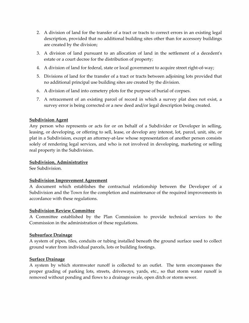
2. A division of land for the transfer of a tract or tracts to correct errors in an existing legal
description, provided that no additional building sites other than for accessory buildings
are created by the division;
3. A division of land pursuant to an allocation of land in the settlement of a decedentʹs
estate or a court decree for the distribution of property;
4. A division of land for federal, state or local government to acquire street right‐of‐way;
5. Divisions of land for the transfer of a tract or tracts between adjoining lots provided that
no additional principal use building sites are created by the division.
6. A division of land into cemetery plots for the purpose of burial of corpses.
7. A retracement of an existing parcel of record in which a survey plat does not exist, a
survey error is being corrected or a new deed and/or legal description being created.
Subdivision Agent
Any person who represents or acts for or on behalf of a Subdivider or Developer in selling,
leasing, or developing, or offering to sell, lease, or develop any interest, lot, parcel, unit, site, or
plat in a Subdivision, except an attorney‐at‐law whose representation of another person consists
solely of rendering legal services, and who is not involved in developing, marketing or selling
real property in the Subdivision.
Subdivision, Administrative
See Subdivision.
Subdivision Improvement Agreement
A document which establishes the contractual relationship between the Developer of a
Subdivision and the Town for the completion and maintenance of the required improvements in
accordance with these regulations.
Subdivision Review Committee
A Committee established by the Plan Commission to provide technical services to the
Commission in the administration of these regulations.
Subsurface Drainage
A system of pipes, tiles, conduits or tubing installed beneath the ground surface used to collect
ground water from individual parcels, lots or building footings.
Surface Drainage
A system by which stormwater runoff is collected to an outlet. The term encompasses the
proper grading of parking lots, streets, driveways, yards, etc., so that storm water runoff is
removed without ponding and flows to a drainage swale, open ditch or storm sewer.

Technical Review Committee
A Committee created by this Ordinance to review plans submitted for action by the Plan
Commission for a technical evaluation of the plan’s compliance with the regulations governing
its approval. This Committee will provide a report to the Plan Commission indicating its
compliance with the regulations. The members of the Committee will include at a minimum the
Town Engineer, County Surveyor, Plan Commission Staff and other members as needed for the
given request or as determined by the Planning Director.
Temporary Improvement
Improvements built and maintained by a Subdivider during construction of the Subdivision and
intended to be replaced by a permanent improvement prior to release of the performance bond,
or turnaround improvements at the ends of stub streets intended to be replaced when the
adjoining area is developed and the through street connection made.
Topographic Plat
A plat drawing with contour lines (delineating elevation) superimposed over the Subdivision lot
and street layout that indicates existing and proposed contours and other site features, such as
structures, drainage ways, proposed changes in drainage features, etc.
Town Engineer
The person designated by the Town to furnish engineering assistance in the administration of
these regulations.
Town Jurisdictional Area
The areas of the Town of Dillsboro, Indiana, in which the Town exercises planning and zoning
jurisdiction. NOTE: Pursuant to IC. 36‐7‐4‐1104(b), the planning and zoning ordinances of
Indiana political Subdivisions may not regulate or restrict the use of property that is owned or
occupied by the state or by any state agency.
Thoroughfare Plan
See Official Map.
Variance
A variance is an exception granted from the literal enforcement of the Subdivision Control
Ordinance where, by reason of exceptional topographic conditions, or some other extraordinary
situation or condition of that site that would deprive the applicant of reasonable capacity to
make use of the land in a manner equivalent to those permitted to other landowners in the same
zone district. It is a departure from dimensional terms of the Subdivision Control Ordinance.


ARTICLE 7
CERTIFICATES USED ON FINAL AND CERTIFIED SURVEYS
All certificates found within this Article shall be of print large enough to be clearly legible, and
shall be dated, signed and stamped if necessary.
CERTIFICATE A
LAND SURVEYORʹS CERTIFICATE
The following certificate shall appear on all Secondary Plats and Certified Surveys presented to
the Town of Dillsboro Plan Commission for approval pursuant to this Ordinance
“LAND SURVEYORʹS CERTIFICATE
I hereby certify that I am a Land Surveyor registered in compliance with the laws of the State of
Indiana; and I do hereby further certify that this plat depicts a survey made by me or under my
supervision, and to the best of my knowledge and belief, conforms with the requirements as set
forth in Indiana Surveying Law and complies with all requirements of the Town of Dillsboro
Zoning and Subdivision Regulations. Signed this _______ day of __________________ (year).
(Land Surveyors Signature)
(Typed or Printed Name) (SEAL)”

CERTIFICATE B ‐ 1
OWNER’S CERTIFICATE – WITH ROADWAY DEDICATION
The following Certificate shall appear on all Secondary Plats and Certified Surveys presented to
the Town of Dillsboro Plan Commission for approval that contain a dedication of property for
roadway purposes when there is a new or existing roadway.
ʺThis is to certify that the undersigned are the owners of the land shown and described on this
plat and as said owners we have caused the said above described property to be surveyed and
subdivided as shown on the herein drawn plat, as our own free and voluntary act and deed. We
attest that to our knowledge, the proposed land division does not interfere with the performance
of an existing individual sewage disposal system. We hereby grant to the Dillsboro Town
Council a ____ foot right‐of‐way for constructing and/or maintaining a road. Signed this _____
day of ________________ (year).
______________________________
Owner’s Signature
______________________________
Owner’s Typed or Printed nameʺ
NOTARY CERTIFICATE
STATE OF INDIANA, COUNTY OF DEARBORN, ss:
Before me the undersigned, a Notary Public, for said County and State, personally appeared
(Name of person), and acknowledged the execution of the foregoing certificate as his/her
voluntary act the _____ day of ________________, (year).
___________________________________ _____________________________
Notary Public (signature) (Name Typed or Printed)
My Commission Expires:______________
Resident of ____________ County, ________________
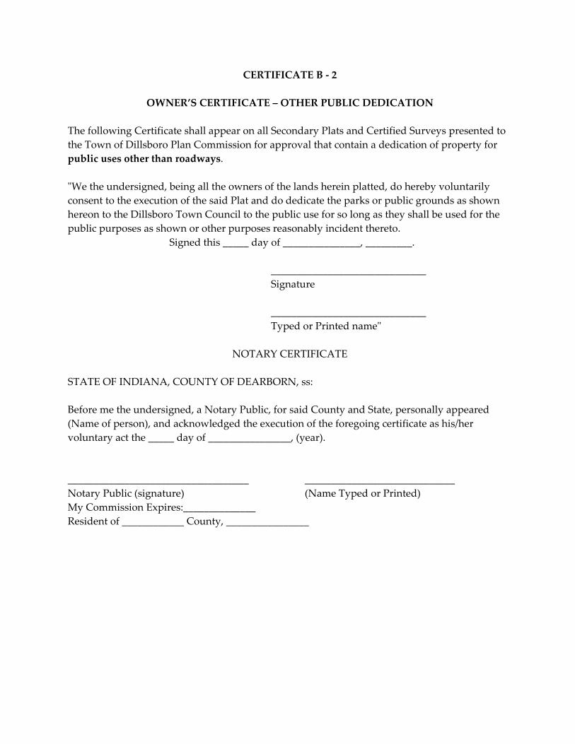
CERTIFICATE B ‐ 2
OWNER’S CERTIFICATE – OTHER PUBLIC DEDICATION
The following Certificate shall appear on all Secondary Plats and Certified Surveys presented to
the Town of Dillsboro Plan Commission for approval that contain a dedication of property for
public uses other than roadways.
ʺWe the undersigned, being all the owners of the lands herein platted, do hereby voluntarily
consent to the execution of the said Plat and do dedicate the parks or public grounds as shown
hereon to the Dillsboro Town Council to the public use for so long as they shall be used for the
public purposes as shown or other purposes reasonably incident thereto.
Signed this _____ day of _______________, _________.
______________________________
Signature
______________________________
Typed or Printed nameʺ
NOTARY CERTIFICATE
STATE OF INDIANA, COUNTY OF DEARBORN, ss:
Before me the undersigned, a Notary Public, for said County and State, personally appeared
(Name of person), and acknowledged the execution of the foregoing certificate as his/her
voluntary act the _____ day of ________________, (year).
___________________________________ _____________________________
Notary Public (signature) (Name Typed or Printed)
My Commission Expires:______________
Resident of ____________ County, ________________
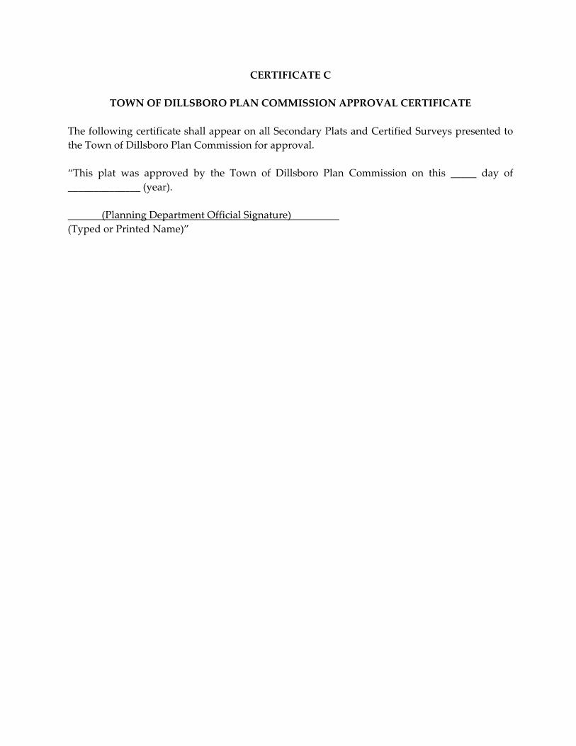
CERTIFICATE C
TOWN OF DILLSBORO PLAN COMMISSION APPROVAL CERTIFICATE
The following certificate shall appear on all Secondary Plats and Certified Surveys presented to
the Town of Dillsboro Plan Commission for approval.
“This plat was approved by the Town of Dillsboro Plan Commission on this _____ day of
______________ (year).
(Planning Department Official Signature)
(Typed or Printed Name)”

CERTIFICATE D
OWNER’S CERTIFICATE – NO DEDICATION
The following certificate shall appear on all Secondary Plats and Certified Surveys that do not
involve a public dedication.
”This is to certify that the undersigned are the owners of the land shown and described on this
plat and as said owners we have caused the said above described property to be surveyed and
subdivided as shown on the herein drawn plat, as our own free and voluntary act and deed. We
attest that to our knowledge, the proposed land division does not interfere with the performance
of an existing individual sewage disposal system. Signed this _____ day of ________________
(year).
(Ownerʹs Signature)
(Type or Printed Name)
NOTARY CERTIFICATE
STATE OF INDIANA, COUNTY OF DEARBORN, ss:
Before me the undersigned, a Notary Public, for said County and State, personally appeared
(Name of person), and acknowledged the execution of the foregoing certificate as her voluntary
act this _____ day of _____________, (year).
______________________________________ ______________________________
Notary Public (Signature) (Name Typed or Printed)
My Commission Expires: _________________
Resident of ________________ County, _______________”

CERTIFICATE E
COUNTY RECORDER’S CERTIFICATE
The following certificate shall appear on all Secondary Plats and Certified Surveys presented to
the Town of Dillsboro Plan Commission for approval and the certificate shall be clearly legible.
COUNTY RECORDER’S CERTIFICATE
“Received for recording this ______ day of __________ (year) and recorded in the Office of the
Recorder of Dearborn County, Indiana.
(Recorder of Dearborn County Signature)
(Typed or Printed Name)”
CERTIFICATE F
ACCEPTANCE OF DEDICATIONS
The following certificate shall appear on all Secondary Plats and Certified Survey including an
Acceptance of Dedication.
“Be it resolved by the Dillsboro Town Council, Indiana, that the dedications shown on this plat
are hereby approved and accepted this ______ day of __________________ (year).
( Dillsboro Town Council Official Signature)___
(Type or Printed Name)”
CERTIFICATE G
SIGHT DISTANCE CERTIFICATE
“I hereby certify that this plat meets the minimum sight distance requirements of Article 24,
Section 2410 of the Town of Dillsboro Zoning Ordinance. Signed this _______ day of
________________________ (year).
(Land Surveyors Signature)
(Type or Printed Name)”
CERTIFICATE H

COUNTY AUDITOR’S CERTIFICATE
The following certificate shall appear on all Secondary Plats and Certified Surveys presented to
the Town of Dillsboro Plan Commission for approval and the certificate shall be clearly legible.
COUNTY AUDITOR’S CERTIFICATE
“Presented to the Auditor this ______ day of _________, (year).
(Auditor of Dearborn County Signature)
(Type or Printed Name)”

CERTIFICATE I
SUBDIVIDER’S CONTRACT
This contract is executed this _______ day of __________________, 20____ by
____________________________________________ Subdivider(s), and between the Town of
Dillsboro Government, as evidenced by a plat of a Subdivision which is on file in the Town of
Dillsboro Plan Commission Office, referred to as ___________________________________
Subdivision, in Town of Dillsboro, Indiana.
WITNESSETH:
1. The Subdivider(s) herein above set forth are/is the owner(s) in fee simple of the real estate
known as __________________________________________ Subdivision, located in Section(s)
__________Township_________ Range _________, of the First Principle Meridian, Dearborn
County, Town of Dillsboro, Indiana;
2. It is the purpose and intention of this agreement to have the Subdivider(s) agree in writing to
the performance and completion of certain work in connection with improvements
necessitated by the division of land in the Subdivision as identified within the approved
Improvement Plan and the regulations within the Town of Dillsboro Subdivision Control
and Zoning Ordinances. It is further the purpose of this agreement to enter into a contract
obligating the Subdivider(s) to perform as hereinafter set forth, and secure this construction
and performance by an approved form of guarantee.
NOW, THERFORE IT IS AGREED:
A. The Subdivider(s), as herein before described, do (does) herewith agree to construct,
install, and provide without variation all required improvements—including, but not
necessarily limited to streets, curbs and gutters, sidewalks, stormwater drain and sewer
systems, sanitary sewer systems, water supply systems, street signs, monuments and the
various appurtenances related thereto—as established on the approved Subdivision
Improvement Plans approved by the Plan Commission on file with the Town
Department of Transportation & Engineering and the Department of Planning & Zoning;
B. The Subdivider(s) agree(s) that said work shall be performed, completed and installed
pursuant to inspection and approval by the Town Engineer or his designee and in
accordance with the Town of Dillsboro Subdivision Control and Zoning Ordinances;
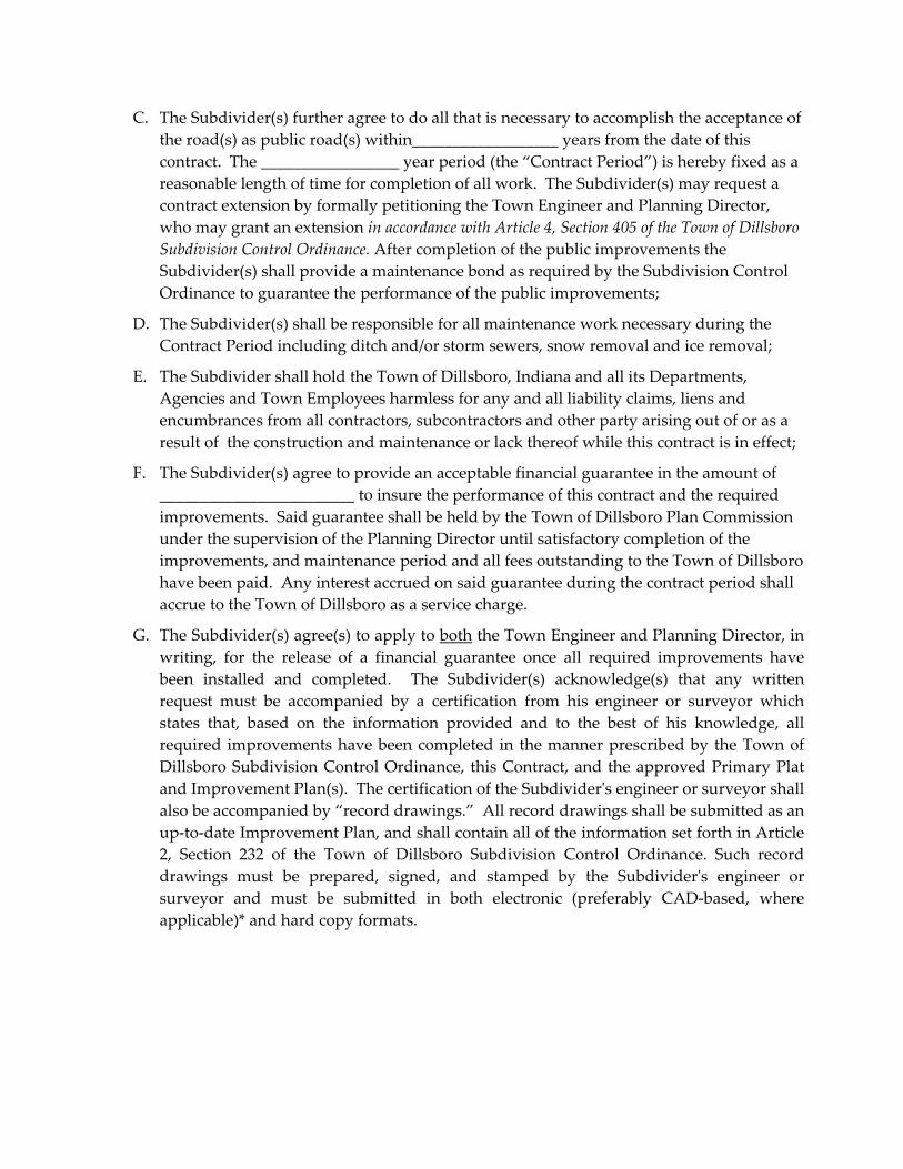
C. The Subdivider(s) further agree to do all that is necessary to accomplish the acceptance of
the road(s) as public road(s) within__________________ years from the date of this
contract. The _________________ year period (the “Contract Period”) is hereby fixed as a
reasonable length of time for completion of all work. The Subdivider(s) may request a
contract extension by formally petitioning the Town Engineer and Planning Director,
who may grant an extension in accordance with Article 4, Section 405 of the Town of Dillsboro
Subdivision Control Ordinance. After completion of the public improvements the
Subdivider(s) shall provide a maintenance bond as required by the Subdivision Control
Ordinance to guarantee the performance of the public improvements;
D. The Subdivider(s) shall be responsible for all maintenance work necessary during the
Contract Period including ditch and/or storm sewers, snow removal and ice removal;
E. The Subdivider shall hold the Town of Dillsboro, Indiana and all its Departments,
Agencies and Town Employees harmless for any and all liability claims, liens and
encumbrances from all contractors, subcontractors and other party arising out of or as a
result of the construction and maintenance or lack thereof while this contract is in effect;
F. The Subdivider(s) agree to provide an acceptable financial guarantee in the amount of
________________________ to insure the performance of this contract and the required
improvements. Said guarantee shall be held by the Town of Dillsboro Plan Commission
under the supervision of the Planning Director until satisfactory completion of the
improvements, and maintenance period and all fees outstanding to the Town of Dillsboro
have been paid. Any interest accrued on said guarantee during the contract period shall
accrue to the Town of Dillsboro as a service charge.
G. The Subdivider(s) agree(s) to apply to both the Town Engineer and Planning Director, in
writing, for the release of a financial guarantee once all required improvements have
been installed and completed. The Subdivider(s) acknowledge(s) that any written
request must be accompanied by a certification from his engineer or surveyor which
states that, based on the information provided and to the best of his knowledge, all
required improvements have been completed in the manner prescribed by the Town of
Dillsboro Subdivision Control Ordinance, this Contract, and the approved Primary Plat
and Improvement Plan(s). The certification of the Subdividerʹs engineer or surveyor shall
also be accompanied by “record drawings.” All record drawings shall be submitted as an
up‐to‐date Improvement Plan, and shall contain all of the information set forth in Article
2, Section 232 of the Town of Dillsboro Subdivision Control Ordinance. Such record
drawings must be prepared, signed, and stamped by the Subdividerʹs engineer or
surveyor and must be submitted in both electronic (preferably CAD‐based, where
applicable)* and hard copy formats.
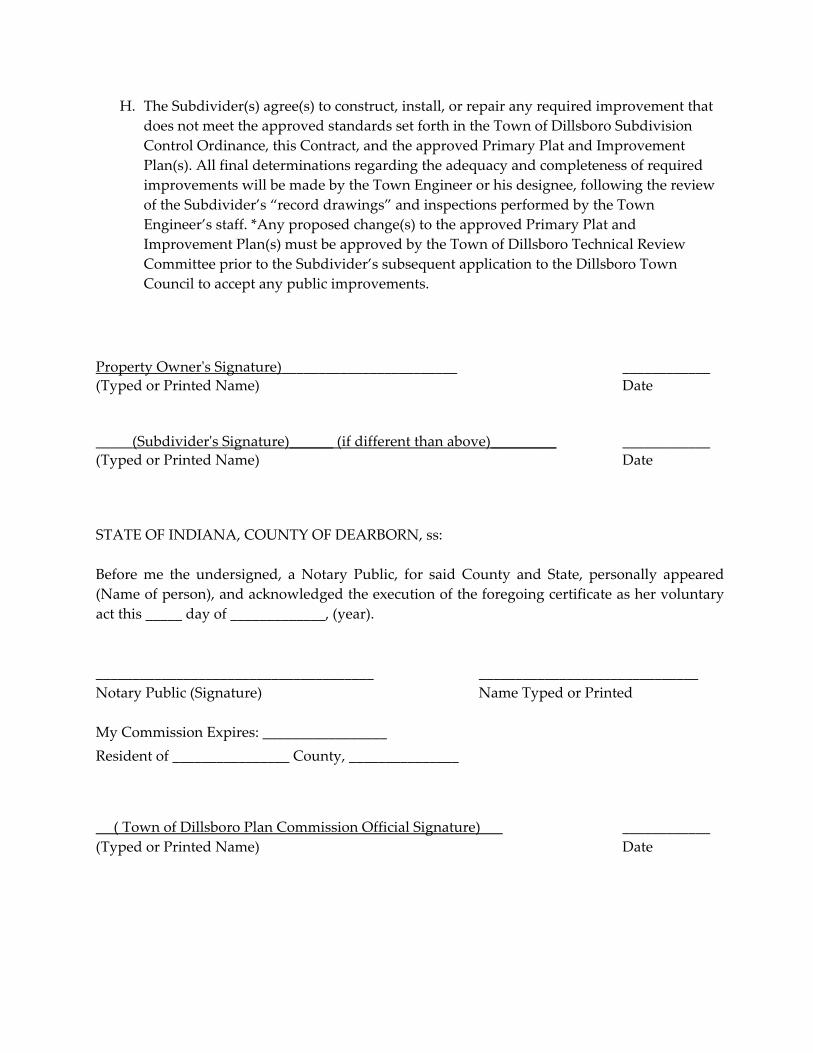
H. The Subdivider(s) agree(s) to construct, install, or repair any required improvement that
does not meet the approved standards set forth in the Town of Dillsboro Subdivision
Control Ordinance, this Contract, and the approved Primary Plat and Improvement
Plan(s). All final determinations regarding the adequacy and completeness of required
improvements will be made by the Town Engineer or his designee, following the review
of the Subdivider’s “record drawings” and inspections performed by the Town
Engineer’s staff. *Any proposed change(s) to the approved Primary Plat and
Improvement Plan(s) must be approved by the Town of Dillsboro Technical Review
Committee prior to the Subdivider’s subsequent application to the Dillsboro Town
Council to accept any public improvements.
Property Ownerʹs Signature)________________________ ____________
(Typed or Printed Name) Date
_____(Subdividerʹs Signature)______ (if different than above)_________ ____________
(Typed or Printed Name) Date
STATE OF INDIANA, COUNTY OF DEARBORN, ss:
Before me the undersigned, a Notary Public, for said County and State, personally appeared
(Name of person), and acknowledged the execution of the foregoing certificate as her voluntary
act this _____ day of _____________, (year).
______________________________________ ______________________________
Notary Public (Signature) Name Typed or Printed
My Commission Expires: _________________
Resident of ________________ County, _______________
( Town of Dillsboro Plan Commission Official Signature) ____________
(Typed or Printed Name) Date

CERTIFICATE J
PERFORMANCE GUARANTEE FORM
TO BE ISSUED WITH BONDING COMPANY STATIONERY, SEAL, & LOGO
(Where applicable)
Date of Issue:
Financial Institution Performance Guarantee Identification # (if applicable):
Amount:
Expiration Date: _________________________
Financial Institution Address: _______________________________________________ ______
Contact and Telephone #
Beneficiary: Town of Dillsboro
13030 Executive Dr.
Dillsboro, Indiana 47018
Attn: Town Planning Director
We (Financial Institution) , hereby establish in
your favor this Performance Guarantee for the account of _______________________________,
(hereinafter “Subdivider”), and ___________________________________________, (hereinafter
“Owner”), up to an aggregate amount of ______________________________________ (US dollars)
which equals One Hundred Twenty percent (120%) of the cost of the Land Improvements
described herein. We understand that this Performance Guarantee is to be used to construct all
required improvements within the Town of Dillsboro as shown on the approved Improvement
Plan on file within the Town Engineer and Planning Department offices and the submitted
Secondary Plat as listed. (List Subdivision
Name_______________________________________________ and Section or Phase
_____________________)
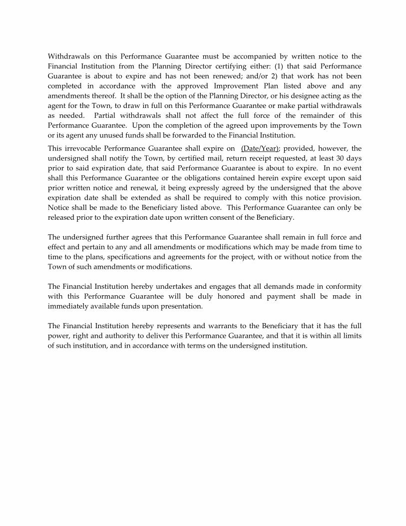
Withdrawals on this Performance Guarantee must be accompanied by written notice to the
Financial Institution from the Planning Director certifying either: (1) that said Performance
Guarantee is about to expire and has not been renewed; and/or 2) that work has not been
completed in accordance with the approved Improvement Plan listed above and any
amendments thereof. It shall be the option of the Planning Director, or his designee acting as the
agent for the Town, to draw in full on this Performance Guarantee or make partial withdrawals
as needed. Partial withdrawals shall not affect the full force of the remainder of this
Performance Guarantee. Upon the completion of the agreed upon improvements by the Town
or its agent any unused funds shall be forwarded to the Financial Institution.
This irrevocable Performance Guarantee shall expire on (Date/Year); provided, however, the
undersigned shall notify the Town, by certified mail, return receipt requested, at least 30 days
prior to said expiration date, that said Performance Guarantee is about to expire. In no event
shall this Performance Guarantee or the obligations contained herein expire except upon said
prior written notice and renewal, it being expressly agreed by the undersigned that the above
expiration date shall be extended as shall be required to comply with this notice provision.
Notice shall be made to the Beneficiary listed above. This Performance Guarantee can only be
released prior to the expiration date upon written consent of the Beneficiary.
The undersigned further agrees that this Performance Guarantee shall remain in full force and
effect and pertain to any and all amendments or modifications which may be made from time to
time to the plans, specifications and agreements for the project, with or without notice from the
Town of such amendments or modifications.
The Financial Institution hereby undertakes and engages that all demands made in conformity
with this Performance Guarantee will be duly honored and payment shall be made in
immediately available funds upon presentation.
The Financial Institution hereby represents and warrants to the Beneficiary that it has the full
power, right and authority to deliver this Performance Guarantee, and that it is within all limits
of such institution, and in accordance with terms on the undersigned institution.

NAME OF THE FINANCIAL INSTITUTION
ATTEST:_____________________________
By: _________________________________
(Principal’s Signature)
_________________________________
(Principal’s Typed Name & Title)
By: __________________________________
(Surety Representative’s Signature)
__________________________________
(Surety Representative’s Typed Name & Title)
STATE OF INDIANA, COUNTY OF DEARBORN, ss:
Before me the undersigned, a Notary Public, for said County and State, personally appeared
_____________________________(Name of persons above), and acknowledged the execution of
the foregoing Performance Guarantee as his or her voluntary act this _____ day of
_____________, (year).
______________________________________ ______________________________
Notary Public (Signature) Name Typed or Printed
My Commission Expires: _________________
Resident of ________________ County, _______________
( Town of Dillsboro Plan Commission Official Signature) ____________
(Typed or Printed Name) Date

CERTIFICATE K
MAINTENANCE GUARANTEE FORM
TO BE ISSUED WITH BONDING COMPANY STATIONERY, SEAL, & LOGO
(Where applicable)
Date of Issue:
Financial Institution Maintenance Guarantee Identification # (if applicable):
Amount:
Expiration Date: _________________________
Financial Institution Address:
Contact and Telephone #
Beneficiary: Town of Dillsboro
13030 Executive Dr.
Dillsboro, Indiana 47018
Attn: Town Planning Director
We (Financial Institution) , hereby establish in
your favor this financial guarantee for the account of______________________________,
(hereinafter “Subdivider”), and ___________________________________________, (hereinafter
“Owner”), up to an aggregate amount of ______________________________________ (US dollars)
which equals One Hundred Twenty percent (120%) of the cost of the Land Improvements
described herein. We understand that this financial guarantee is to be used to finish all required
improvements not completed or installed by the Owner / Subdivider and to secure the
performance of all required maintenance improvements as shown on the approved
Improvement Plan on file within the Department of Transportation and Planning Department
offices and the submitted Secondary Plat as listed. (List Subdivision Name____________
________________________and Section / Phase __________)
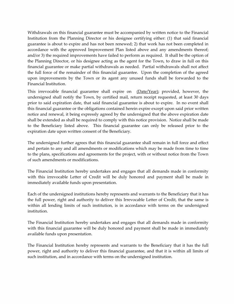
Withdrawals on this financial guarantee must be accompanied by written notice to the Financial
Institution from the Planning Director or his designee certifying either: (1) that said financial
guarantee is about to expire and has not been renewed; 2) that work has not been completed in
accordance with the approved Improvement Plan listed above and any amendments thereof;
and/or 3) the required improvements have failed to perform as required. It shall be the option of
the Planning Director, or his designee acting as the agent for the Town, to draw in full on this
financial guarantee or make partial withdrawals as needed. Partial withdrawals shall not affect
the full force of the remainder of this financial guarantee. Upon the completion of the agreed
upon improvements by the Town or its agent any unused funds shall be forwarded to the
Financial Institution.
This irrevocable financial guarantee shall expire on (Date/Year); provided, however, the
undersigned shall notify the Town, by certified mail, return receipt requested, at least 30 days
prior to said expiration date, that said financial guarantee is about to expire. In no event shall
this financial guarantee or the obligations contained herein expire except upon said prior written
notice and renewal, it being expressly agreed by the undersigned that the above expiration date
shall be extended as shall be required to comply with this notice provision. Notice shall be made
to the Beneficiary listed above. This financial guarantee can only be released prior to the
expiration date upon written consent of the Beneficiary.
The undersigned further agrees that this financial guarantee shall remain in full force and effect
and pertain to any and all amendments or modifications which may be made from time to time
to the plans, specifications and agreements for the project, with or without notice from the Town
of such amendments or modifications.
The Financial Institution hereby undertakes and engages that all demands made in conformity
with this irrevocable Letter of Credit will be duly honored and payment shall be made in
immediately available funds upon presentation.
Each of the undersigned institutions hereby represents and warrants to the Beneficiary that it has
the full power, right and authority to deliver this Irrevocable Letter of Credit, that the same is
within all lending limits of such institution, is in accordance with terms on the undersigned
institution.
The Financial Institution hereby undertakes and engages that all demands made in conformity
with this financial guarantee will be duly honored and payment shall be made in immediately
available funds upon presentation.
The Financial Institution hereby represents and warrants to the Beneficiary that it has the full
power, right and authority to deliver this financial guarantee, and that it is within all limits of
such institution, and in accordance with terms on the undersigned institution.

NAME OF THE FINANCIAL INSTITUTION
ATTEST:_____________________________
By: _________________________________
(Principal’s Signature)
_________________________________
(Principal’s Typed Name & Title)
By: __________________________________
(Surety Representative’s Signature)
__________________________________
(Surety Representative’s Typed Name & Title)
STATE OF INDIANA, COUNTY OF DEARBORN, ss:
Before me the undersigned, a Notary Public, for said County and State, personally appeared
_____________________________(Name of persons above), and acknowledged the execution of
the foregoing Maintenance Guarantee as his or her voluntary act this _____ day of
_____________, (year).
______________________________________ ______________________________
Notary Public (Signature) Name Typed or Printed
My Commission Expires: _________________
Resident of ________________ County, _______________
( Town of Dillsboro Plan Commission Official Signature) ____________
(Typed or Printed Name) Date

APPENDIX A
CONSTRUCTION OF STREETS, CURBS & GUTTERS, SIDEWALKS &
DRIVEWAYS
The construction of streets and their associated improvements shall conform to the current
Public Right‐of‐Way Accessibility Guidelines+, the current edition of the Indiana Department of
Transportation (INDOT) Standard Specifications*, the current effective INDOT Supplemental
Specifications*, INDOT Standard Drawings*, and the applicable improvement drawings.
Construction activities include, but are not limited to, excavation, grading, backfill and
compaction. Construction improvements include, but are not limited to, drainage structures,
sidewalks, curbs and gutters, and streets.
Foot Notes:
+ The aforementioned guidelines may be acquired via the United States Access Board’s website
at: www.access‐board.gov/prowac/
*The aforementioned documents may be acquired via INDOT by calling (317) 232‐5070 or by
accessing the following website: http://www.in.gov/dot/pubs/

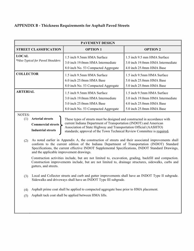
APPENDIX B ‐ Thickness Requirements for Asphalt Paved Streets
PAVEMENT DESIGN
STREET CLASSIFICATION OPTION 1 OPTION 2
LOCAL *Also Typical for Paved Shoulders
1.5 inch 9.5mm HMA Surface
3.0 inch 19.0mm HMA Intermediate
8.0 inch No. 53 Compacted Aggregate
1.5 inch 9.5 mm HMA Surface
3.0 inch 19.0mm HMA Intermediate
4.0 inch 25.0mm HMA Base
COLLECTOR 1.5 inch 9.5mm HMA Surface
6.0 inch 25.0mm HMA Base
8.0 inch No. 53 Compacted Aggregate
1.5 inch 9.5mm HMA Surface
5.0 inch 25.0mm HMA Base
5.0 inch 25.0mm HMA Base
ARTERIAL 1.5 inch 9.5mm HMA Surface
3.0 inch 19.0mm HMA Intermediate
5.0 inch 25.0mm HMA Base
8.0 inch No. 53 Compacted Aggregate
1.5 inch 9.5mm HMA Surface
3.0 inch 19.0mm HMA Intermediate
4.0 inch 25.0mm HMA Base
5.0 inch 25.0mm HMA Base
NOTES:(1)
(2)
(3)
(4)
(5)
Arterial streets
Commercial streets
Industrial streets
As noted earlier in Appendix A, the construction of streets and their associated improvements shall conform to the current edition of the Indiana Department of Transportation (INDOT) Standard Specifications, the current effective INDOT Supplemental Specifications, INDOT Standard Drawings, and the applicable improvement drawings.
Construction activities include, but are not limited to, excavation, grading, backfill and compaction. Construction improvements include, but are not limited to, drainage structures, sidewalks, curbs and gutters, and streets.
Local and Collector streets and curb and gutter improvements shall have an INDOT Type II subgrade. Sidewalks and driveways shall have an INDOT Type III subgrade.
Asphalt prime coat shall be applied to compacted aggregate base prior to HMA placement.
Asphalt tack coat shall be applied between HMA lifts.
These types of streets must be designed and constructed in accordance with current Indiana Department of Transportation (INDOT) and American Association of State Highway and Transportation Official (AASHTO) standards; approval of the Town Technical Review Committee is required.


133
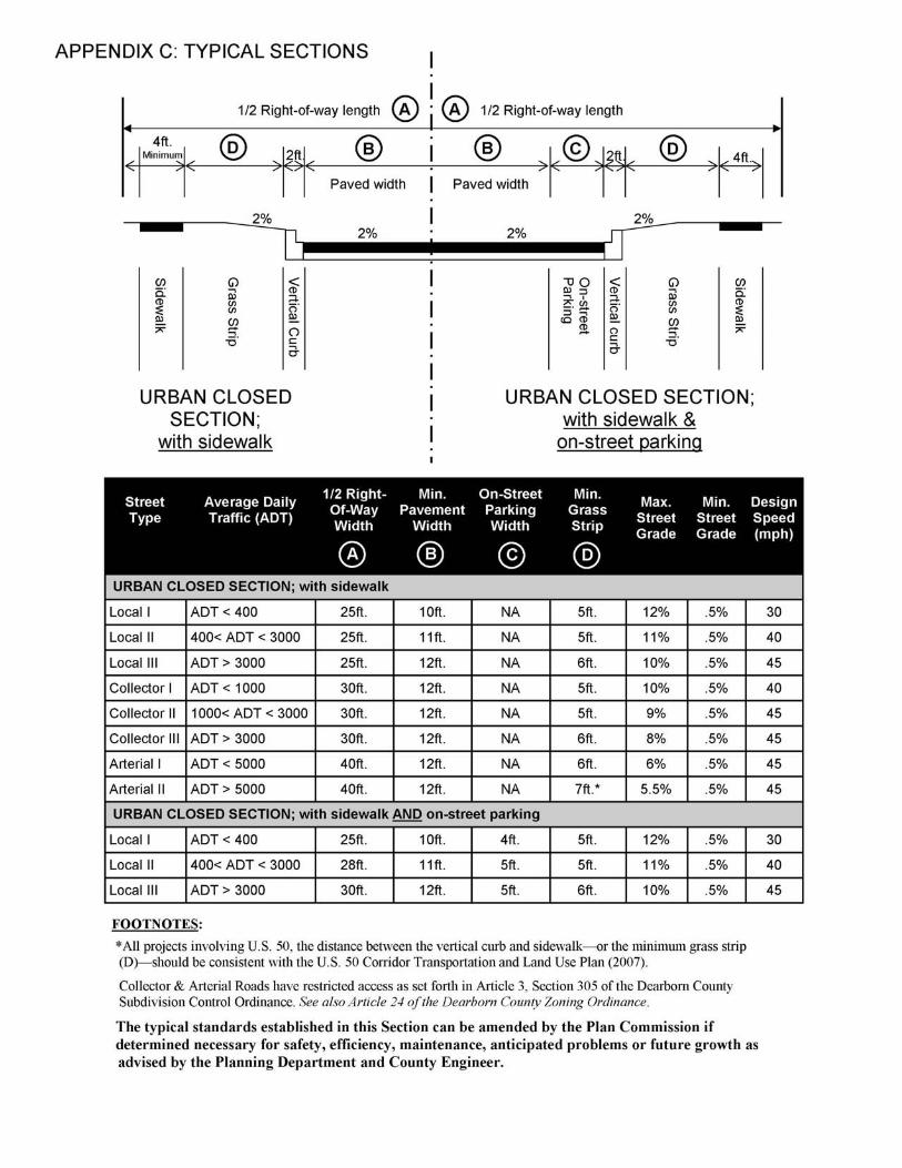
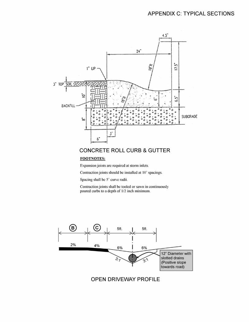

TYPICAL TURN AROUNDS FOR DEAD-END STREETS
A = 40-foot pavement radius, Residential Streets B = 50-foot R.O.W. radius, Residential Streets
A = 50-foot pavement radius, Commercial & Industrial Streets B = 60-foot R.O.W. radius, Commercial & Industrial Streets
APPENDIX C: DETAILS
R.O.W. Varies
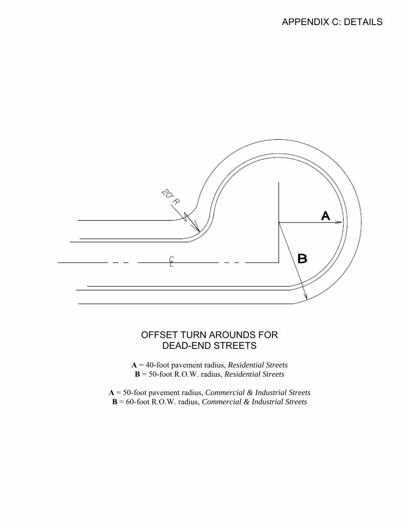
APPENDIX C: DETAILS
OFFSET TURN AROUNDS FOR DEAD-END STREETS
A = 40-foot pavement radius, Residential Streets B = 50-foot R.O.W. radius, Residential Streets
A = 50-foot pavement radius, Commercial & Industrial Streets B = 60-foot R.O.W. radius, Commercial & Industrial Streets
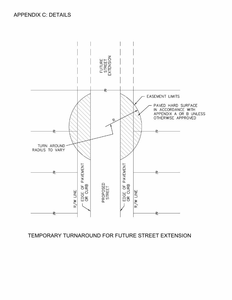
APPENDIX C: DETAILS
TEMPORARY TURNAROUND FOR FUTURE STREET EXTENSION
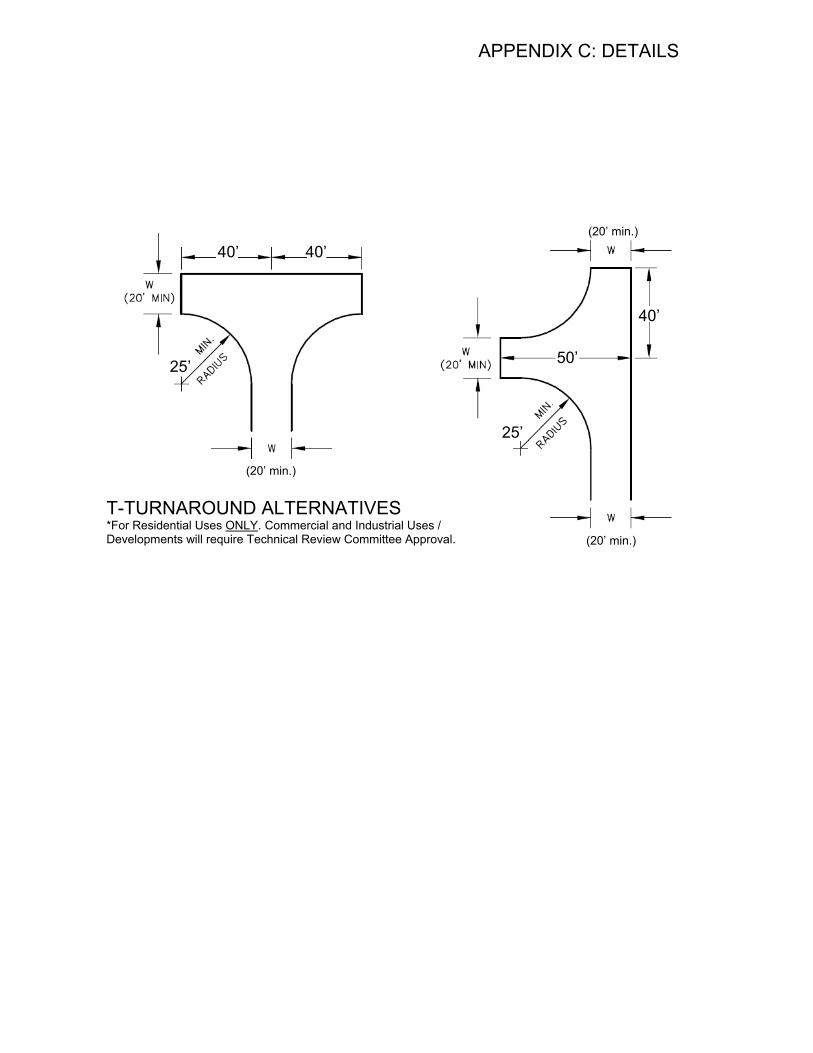
APPENDIX C: DETAILS
T-TURNAROUND ALTERNATIVES *For Residential Uses ONLY. Commercial and Industrial Uses / Developments will require Technical Review Committee Approval.
40’ 40’
25’
40’
25’
50’
(20’ min.)
(20’ min.)
(20’ min.)


![TEMPORARY INJUNCTION 1] The law relating to injunction has ...](https://static.fdocuments.us/doc/165x107/5868c8491a28ab5e1c8b5f3f/temporary-injunction-1-the-law-relating-to-injunction-has-.jpg)