Town Hall House Environmental Factors - City of Sydney · Review of Environmental Factors 1...
109
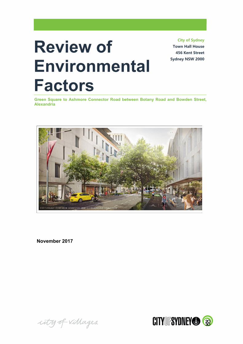
Review of Environmental Factors City of Sydney Town Hall House 456 Kent Street Sydney NSW 2000 Green Square to Ashmore Connector Road between Botany Road and Bowden Street, Alexandria November 2017
Transcript of Town Hall House Environmental Factors - City of Sydney · Review of Environmental Factors 1...
�
Review of Environmental Factors
City�of�Sydney�
Town�Hall�House�
456�Kent�Street�
Sydney�NSW�2000�
Green Square to Ashmore Connector Road between Botany Road and Bowden Street,Alexandria
November 2017
�
CERTIFICATION
This report has been prepared and reviewed by the City of Sydney Council as prescribed below.
Action Name Title Signature Date
Prepared by David White Senior Development Planner
17/11/17
Supported by Suzanne Lange
Specialist Design Manager (Landscape)
17/11/17
Reviewed by Morris Bellamy
Manager Green Square Place Making
20/11/17
Supported by Andrew Christie
Manager City Infrastructure Traffic Operations
20/11/17
Approved for Issue by
Kim Woodbury
Chief Operating Officer
20/11/17
�
Ref: 2017/519377 Green Square to Ashmore Connector Review of Environmental Factors
i
TABLE OF CONTENTS
TABLE OF CONTENTS ............................................................................................................................ I
EXECUTIVE SUMMARY ........................................................................................................................ III
ABBREVIATIONS .................................................................................................................................... V
INTRODUCTION .................................................................................................................. 1
Background............................................................................................................................. 1 Proposal Identification ............................................................................................................. 1 Project Objectives .................................................................................................................... 2 Environmental Assessment Process ........................................................................................... 2 Scope of this Review of Environmental Factors .......................................................................... 3
SITE LOCATION AND CONTEXT....................................................................................... 7
Site location and context ........................................................................................................... 7 Land ownership and legal description ........................................................................................ 7 Existing Development ............................................................................................................ 10 Surrounding Development ...................................................................................................... 12 Affected roads ....................................................................................................................... 13 Existing Infrastructure ............................................................................................................ 14 Existing Zoning ..................................................................................................................... 16
PROPOSAL DESCRIPTION ............................................................................................... 17
Project Overview ................................................................................................................... 17 Design .................................................................................................................................. 18 Staging ................................................................................................................................. 23 Project Justification ............................................................................................................... 23 Alternatives Considered ......................................................................................................... 23 The Preferred Option ............................................................................................................. 25 Project Benefits ..................................................................................................................... 25 Construction Activities ........................................................................................................... 26 Land Ownership .................................................................................................................... 27 Residual Land Parcels ............................................................................................................ 28
LEGISLATIVE AND PLANNING FRAMEWORK ............................................................. 31
NSW Environmental Planning & Assessment Act 1979 ............................................................. 31 State Environmental Planning Policies ..................................................................................... 31 Local Environmental Plans and Strategies ................................................................................ 32 Ecologically sustainable development ...................................................................................... 34 Commonwealth Legislation .................................................................................................... 36 Other relevant policies ........................................................................................................... 36
CONSULTATION ............................................................................................................... 39
Authorities ............................................................................................................................ 39 Community ........................................................................................................................... 39 Public Exhibition ................................................................................................................... 39
ENVIRONMENTAL IMPACT ASSESSMENT .................................................................... 41
Traffic and Transport ............................................................................................................. 41 Hydrology ............................................................................................................................ 53 Noise and Vibration ............................................................................................................... 57 Landscape and Visual ............................................................................................................ 60 Contamination and Remediation .............................................................................................. 64 Indigenous Heritage ............................................................................................................... 65
�
Ref: 2017/519377 Green Square to Ashmore Connector Review of Environmental Factors
ii
Non Indigenous Heritage ........................................................................................................ 66 Flora and Fauna ..................................................................................................................... 66 Air Quality ............................................................................................................................ 70 Natural Hazards ..................................................................................................................... 71 Climate Change ..................................................................................................................... 72 Socio Economic .................................................................................................................... 72 Waste ................................................................................................................................... 75 Chemical and hazardous substance management ....................................................................... 75 Future Land Use .................................................................................................................... 75 Cumulative Impacts ............................................................................................................... 75
ENVIRONMENTAL FACTORS CONSIDERED ................................................................. 77
Consideration of Clause 228 Factors ........................................................................................ 77 Ecologically Sustainable Development .................................................................................... 79 Requirements of the Director General of the NSW Department of Planning & Environment .......... 81 Consideration of National Environmental Significance .............................................................. 81
SUMMARY OF MITIGATION MEASURES ....................................................................... 83
Construction environmental management plans ........................................................................ 83 Safeguards and mitigation measures ........................................................................................ 83 Licensing and approvals ......................................................................................................... 97
CONCLUSION AND CERTIFICATION ............................................................................. 99
Certification .......................................................................................................................... 99
REFERENCES .................................................................................................................. 101
APPENDICES
APPENDIX A CONCEPT LAYOUT OF THE GREEN SQUARE TO ASHMORE CONNECTOR (AECOM) A
APPENDIX B REF CONCEPT DESIGN PLANS (AECOM) B
APPENDIX C TRAFFIC AND TRANSPORT IMPACT ASSESSMENT (AECOM) C
APPENDIX D HYDRAULIC IMPACT ASSESSMENT (AECOM / HYDROSTORM) D
APPENDIX E NOISE AND VIBRATION ASSESSMENT (RENZO TONIN & ASSOCIATES) E
APPENDIX F ARBORICULTURAL ASSESSMENT REPORT (EARTHSCAPE HORTICULTURAL SERVICES) F
APPENDIX G CONSIDERATION OF NATIONAL ENVIRONMENTAL SIGNIFICANCE MATTERS G
�
Ref: 2017/519377 Green Square to Ashmore Connector Review of Environmental Factors
iii
EXECUTIVE SUMMARY
Introduction
This Review of Environmental Factors has been prepared by the City of Sydney (the City) to assess the Green Square to Ashmore Connector road, which is a proposed new local public access road located between Botany Road and Bowden Street Alexandria, just south of Green Square Rail Station.
The City of Sydney is the proponent for the proposed Connector Road and is also the “determining authority” for the project under Part 5 of the NSW Environmental Planning and Assessment Act 1979 (EP&A Act).
Background
The Green Square to Ashmore Connector road (the proposed Connector Road) has long been considered as a transport solution to improve access to the Green Square Town Centre (the Town Centre) for pedestrians, cyclists, buses and vehicles.
The road was originally investigated in the Green Square Street Structural Masterplan 1997 and throughout the 2000’s where a preliminary route alignment was suggested. In 2008, Green Square Transport Management and Accessibility Plan further identified the proposed Connector Road to improve road access to the Town Centre. The proposed Connector Road is currently identified in the Sydney Development Control Plan 2012.
The Proposal
The proposal includes a 380 metre road from Botany Road to Bowden Street via O'Riordan Street and Bourke Road with two (2) signalised intersections and integration works to the proposed Botany Road / Geddes Avenue intersection. The road is planned to carry up to 2,000 vehicles per day. Key road infrastructure includes lighting, signage and stormwater and also public domain works and landscaping. There is also space for on-street car parking, shared car parking spaces, a bi-directional cycleway and two (2) bus stops.
The proposed road is planned to open in 2020 to ensure the timely provision of road infrastructure needed for the Town Centre. Renewal of adjoining lands for affordable housing and long term employment based uses will be completed within or near this time.
Assessment
The proposed Connector Road has been assessed in a Review of Environmental Factors (REF) under Part 5 of the EP&A Act. The REF has assessed key local environmental planning provisions which includes State Environmental Planning Policy (Infrastructure 2007) and relevant Commonwealth and State environmental and planning legislation. The proposed Connector Road is consistent with Sustainable Sydney 2030 which aims to improve road and transport access to the Town Centre which is a planned Town Centre.
The REF has been prepared in accordance with the City of Sydney Part 5 Environmental Impact Assessment Procedures Manual and includes the assessment of key engineering, environmental and planning issues such as traffic, transport and access, flooding and hydrology, landscape and visual and geotechnical and contamination. Recommended mitigation measures aim to minimise the potential construction and operation stage impacts.
Consultation
The City has continually maintained a high level of community and stakeholder consultation with the Green Square project. The public exhibition of this REF report provides another opportunity for the community to learn more about the project and provide comment.
Conclusion
The proposed road is crucial to support the Town Centre with improved local access. The proposed Connector Road is consistent with relevant State and local environmental planning instruments and policies and strategies, as well as Sustainable Sydney 2030.
This REF has assessed key engineering, environmental and planning issues and recommends mitigation measures to minimise potential environmental impacts. The project should therefore be approved under Part 5 of the Act by the City who is the determining authority for this project.

�
Ref: 2017/519377 Green Square to Ashmore Connector Review of Environmental Factors
iv
This Page Intentionally Left Blank

�
Ref: 2017/519377 Green Square to Ashmore Connector Review of Environmental Factors
v
ABBREVIATIONS
Abbreviation� Meaning��ARI Average Recurrence Interval
AS Australian Standard
ASS Acid Sulfate Soils
BGL Below ground level
BTEX Benzene, toluene, ethylbenzene and xylenes
Council The City of Sydney Council
The City / City of Sydney The City of Sydney organisation
CEMP Construction Environmental Management Plan
CMMP Contaminated Materials Management Plan
CNVMP Construction Noise Vibration Management Plan
CTMP Construction Traffic Management Plan
dB(A) A weighted decibels
DCP Development Control Plan
DECC / DECCW Department of Environment and Climate Change / Water (former NSW Street ate government departments)
DPE NSW Department of Planning & Environment
EIA Environmental impact assessment
ELA Eco Logical Australia
ESD Ecologically Sustainable Development
EMP Environmental Management Plan
EMMP Excavated Materials Management Plan
EMS Environmental Management System
EPA Environment Protection Authority
EP&A Act NSW Environmental Planning and Assessment Act 1979
EPI Environmental Planning Instrument
EPBC Act Environment Protection Biodiversity and Conservation Act 1999
ICNG Interim Construction Noise Guideline
JBS&G Consultancy responsible for the preparation of the Remedial Action Plan Green Square Town Centre Infrastructure Works and Corridors and Public Open Space Site, dated 18 October 2013
Km Kilometres
LEP Local Environmental Plan
LGA Local Government Area
LoS Level of Service
m Metres
MSDS Materials Safety Data Sheet
NEPM National Environment Protection Measures
NES National Environmental Significance
OEH Office of Environment and Heritage
PAH Poly Acrylic Hydrocarbon
PCB Polychlorinated biphenyl
PMF Probable maximum flood
PPE Personal Protective Equipment
RAP Remedial Action Plan
�
Ref: 2017/519377 Green Square to Ashmore Connector Review of Environmental Factors
vi
Abbreviation� Meaning��REF Review of Environmental Factors
RMS Roads & Maritime Services
SEPP State Environmental Planning Policy
STA State Transit Authority
Streets Code City of Sydney Streets Code
TSC Act 1995 Threatened Species Conservation Act 1995
The Minister The NSW Minister for Planning
The Part 5 Manual Environmental Impact Assessment Part 5 Procedures Manual (City of Sydney)
The Regulations NSW Environmental Planning & Assessment Regulations 2000
TMAP Transport Management Accessibility Plan
TN Total nitrogen
the Town Centre Green Square Town Centre
TPH Total Petroleum Hydrocarbon
TRH Total Recoverable Hydrocarbons
TP Total Phosphorous
TSS Suspended Solids
WSUD Water Sensitive Urban Design
�
Ref: 2017/519377 Green Square to Ashmore Connector Review of Environmental Factors
1
INTRODUCTION
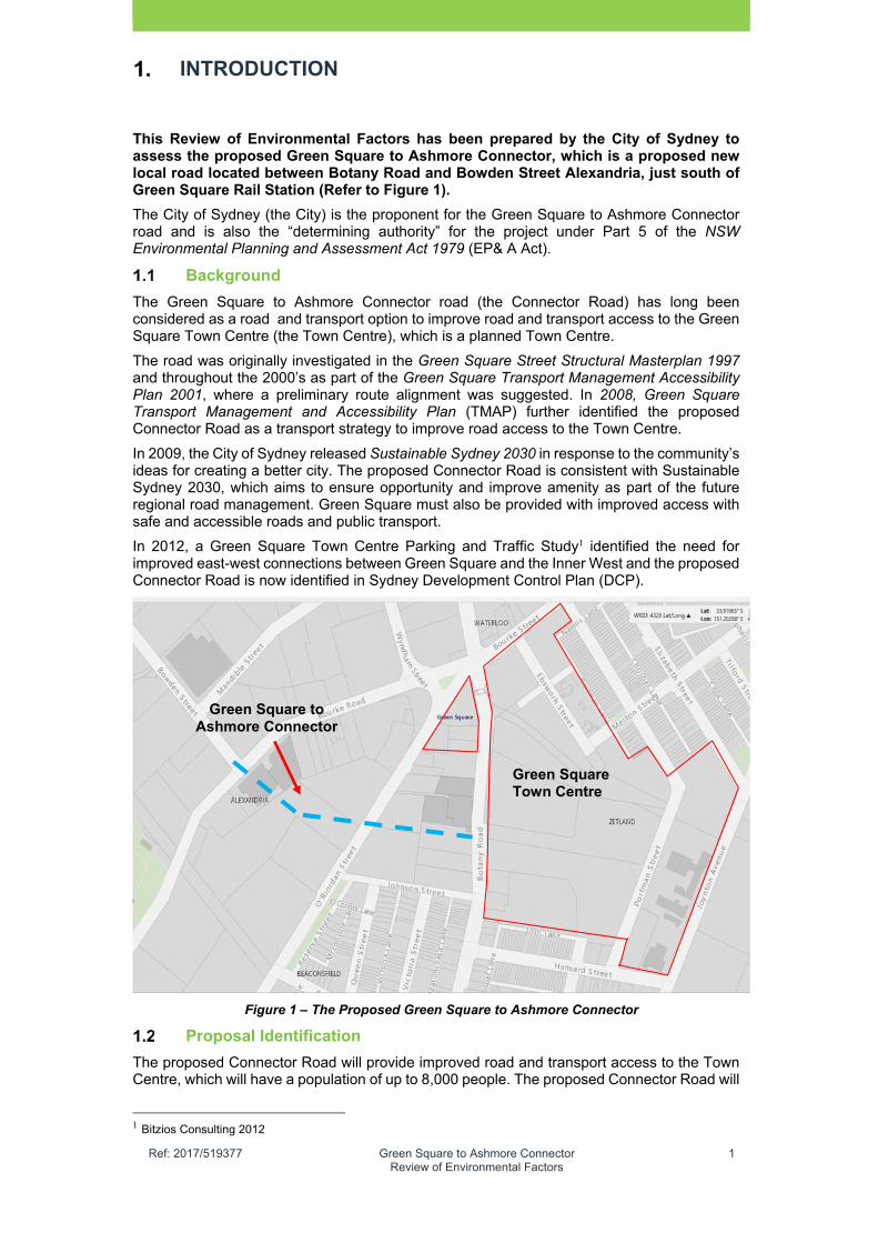
This Review of Environmental Factors has been prepared by the City of Sydney to assess the proposed Green Square to Ashmore Connector, which is a proposed new local road located between Botany Road and Bowden Street Alexandria, just south of Green Square Rail Station (Refer to Figure 1).
The City of Sydney (the City) is the proponent for the Green Square to Ashmore Connector road and is also the “determining authority” for the project under Part 5 of the NSW Environmental Planning and Assessment Act 1979 (EP& A Act).
Background
The Green Square to Ashmore Connector road (the Connector Road) has long been considered as a road and transport option to improve road and transport access to the Green Square Town Centre (the Town Centre), which is a planned Town Centre.
The road was originally investigated in the Green Square Street Structural Masterplan 1997 and throughout the 2000’s as part of the Green Square Transport Management Accessibility Plan 2001, where a preliminary route alignment was suggested. In 2008, Green Square Transport Management and Accessibility Plan (TMAP) further identified the proposed Connector Road as a transport strategy to improve road access to the Town Centre.
In 2009, the City of Sydney released Sustainable Sydney 2030 in response to the community’s ideas for creating a better city. The proposed Connector Road is consistent with Sustainable Sydney 2030, which aims to ensure opportunity and improve amenity as part of the future regional road management. Green Square must also be provided with improved access with safe and accessible roads and public transport.
In 2012, a Green Square Town Centre Parking and Traffic Study1 identified the need for improved east-west connections between Green Square and the Inner West and the proposed Connector Road is now identified in Sydney Development Control Plan (DCP).
Figure 1 – The Proposed Green Square to Ashmore Connector
Proposal Identification
The proposed Connector Road will provide improved road and transport access to the Town Centre, which will have a population of up to 8,000 people. The proposed Connector Road will
1 Bitzios Consulting 2012
Green Square Town Centre
Green Square to Ashmore Connector
�
Ref: 2017/519377 Green Square to Ashmore Connector Review of Environmental Factors
2
especially improve access for all road users including pedestrians, cyclists and other transport uses and provide for good integration with existing transport networks.
The road will also provide improved east-west access in this part of Green Square area, from Bowden Street to the Town Centre via, Bourke Road O’Riordan Street and Botany Road.
The proposed Connector Road corridor will also allow for the future provision of water servicing infrastructure to address flooding constraints in this part of the City of Sydney Local Government Area (LGA) and provide an opportunity to expand the Town Centre water recycling system.
The proposal is funded by the Council of the City of Sydney (Council) and construction is planned to commence following the approval of the REF, which is planned to occur in early 2018. Detailed design and road construction could take place from 2019 with a planned road opening by 2020. The City is currently in the process of acquiring lands for the proposed Connector Road.
Project Objectives
The project objectives for the delivery of the Green Square to Ashmore Connector road are provided below:
Provide a local access road that improves access to the Green Square Town Centre for all transport users including pedestrians, cyclists, vehicles and other transport users
Provide a road with a high quality public domain that acts as a gateway to the Town Centre which incorporates modern design elements and landscape treatment
Achieve the integration of the proposed Connector Road with the existing and future road and transport network
Provide an opportunity for conveyance of stormwater through the project site via the Green Square Stormwater Drain from Link Road Rosebery to the Alexandra Canal
Achieve the integration and timely provision of future servicing infrastructure within the road corridor and provide an opportunity to expand the Town Centre water recycling network into the East Alexandria precinct
Provide a road which complies with relevant Australian, Roads & Maritime Services’ and Council road access and safety standards
Provide an opportunity to achieve the sustainable reuse of lands for affordable housing and other employment generating uses
Provide a road of minimal engineering, environmental and planning impact
Ensure timely and accurate project communication and notification with key stakeholders and local residents during planning and construction
Minimise environmental impacts during the construction stage
Minimise potential disruption to existing road users and adjoining property owners during the construction stage.
Environmental Assessment Process
Roads are permissible with consent in the B7 Business Park Zone under Sydney Local Environmental Plan (LEP) 2012 which applies to the lands located between Botany Road and Bowden Street. This would allow a development application to be lodged under Part 4 of the EP&A Act and for a determination to be obtained from a consent authority (a council).
Road and Transport
Under Clause 93 on the State Environmental Planning Policy (Infrastructure) 2007 (“the Infrastructure SEPP”), the proposed Connector Road can be defined either as a “public road” and “road infrastructure facilities”. In each case, the proposed activity is classified as development permitted without consent under Clause 94 of Division 17 Roads and traffic. Proposed retaining walls are defined as “road infrastructure facilities” as well as other related construction works including:
construction works (whether or not in a heritage conservation area), including:
temporary buildings or facilities for the management of construction, if they are in or adjacent to a road corridor, and

�
Ref: 2017/519377 Green Square to Ashmore Connector Review of Environmental Factors
3
creation of embankments, and extraction of extractive materials and stockpiling of those materials, if:
the extraction and stockpiling are ancillary to road construction, or
the materials are used solely for road construction and the extraction and stockpiling take place in or adjacent to a road corridor, and
temporary crushing or concrete batching plants, if they are used solely for road construction and are on or adjacent to a road corridor, and
temporary roads that are used solely during road construction,
Bus stops are classified as exempt development under Clause 97 of the Infrastructure SEPP, provided they are constructed as part of a proposed Connector Road.
Stormwater Reuse Scheme
The proposed water recycling network is defined as a stormwater management system under Clause 110 of the Infrastructure SEPP. A stormwater management system means the following:
(a) works for the collection, detention, distribution or discharge of stormwater (such as channels, aqueducts, pipes, drainage works, embankments, detention basins and pumping stations), and
(b) stormwater quality control devices (such as waste entrapment facilities, artificial wetlands, sediment ponds and riparian management), and
(c) stormwater reuse schemes.
Under Clause 111 Development permitted without consent, stormwater management systems (proposed water recycling network) may be carried out by or on behalf of a public authority (a Council) without consent on any land.
Stormwater Reuse Systems
Any water quality systems proposed with the road such as Water Sensitive Urban Design measures (WSUD) are defined as a stormwater management system which covers stormwater quality control devices. Stormwater management systems are also classed as development without consent under Clause 111 of the Infrastructure SEPP.
On this occasion and to assess the proposed Connector Road, the City has undertaken an environmental impact assessment (EIA) under Part 5 of the EP&A Act and the associated Clause 228 Guidelines under NSW Environmental Planning and Assessment Regulation 2000 (the Regulations).
Scope of this Review of Environmental Factors
This Review of Environmental Factors (REF) provides an assessment of the potential construction and operation impacts of the proposal in accordance with Clause 111 of the EP&A Act. This REF has been prepared based on the City of Sydney Part 5 Environmental Impact Assessment Procedures Manual (“the Manual”) and is classed as a “Level 3 REF”. The REF describes the proposal and proposes mitigation measures to ameliorate any potential issues related to the design, construction and operation of the road.
The following clarifies the terminology used throughout the REF to describe the areas assessed:
Study area – the minimum area that has been investigated for the purposes of the REF and specialist studies in order to identify environmental constraints to the proposal in order to adequately assess impacts.
Proposal footprint – includes the footprint of the concept design and any other areas that would be impacted during construction, including locations of compound sites, stockpiles sites and areas where utilities would be relocated. The proposal footprint is shown in Figure 2.

�
Ref: 2017/519377 Green Square to Ashmore Connector Review of Environmental Factors
4
Figure 2 – Green Square to Ashmore Connector road Proposal Footprint
(Source: City of Sydney)
The REF also identifies whether the proposal is likely to have a significant effect on the environment including whether there is likely to be any impact on critical habitat, or threatened species, population or ecological communities, or their habitats. This REF also specifies mitigation measures to minimise potential impacts (Refer to Section 8).
The assessment has also been undertaken in accordance with the requirements of relevant NSW and Commonwealth legislation including Threatened Species Conservation Act 1995 (TSC Act), and the Environment Protection and Biodiversity Conservation Act 1999 (EPBC Act) and associated guidelines and the City policies.
In doing so, this REF helps fulfill the requirements of section 111 of the EP&A Act that the City examine and take into account, to the fullest extent possible, all matters affecting or likely to affect the environment by reason of that activity. The findings of this REF will be considered when assessing:
Whether the proposal is likely to have a significant impact on the environment and therefore the necessity for an environmental impact statement (EIS) to be prepared and approval to be sought from the Minister for Planning and Environment under Part 5. 1 of the EP&A Act.
The significance of any impact on threatened species as defined by the TSC Act in section 5A of the EP&A Act and therefore the requirement for a species impact statement.
The potential for the proposal to significantly impact a matter of national environmental significance or Commonwealth land and the need to make a referral to the Australian Government Department of Environment for a decision by the Commonwealth Minister for the Environment on whether assessment and approval is required under the EPBC Act.
�
Ref: 2017/519377 Green Square to Ashmore Connector Review of Environmental Factors
5
An outline of the information provided in each Chapter of this REF is provided in Table 1.
TABLE�1�–�SUMMARY�OF�THE�ISSUES�ADDRESSED�IN�EACH�CHAPTER�
Section� Issues�Addressed�
Chapter 1 Proposal identification and purpose of REF Chapter 2 Assessment of the existing Green Square to Ashmore Connector site and
surrounding area Chapter 3 Description of the proposed activity assessed in the REF as well as the
justification of the project Chapter 4 Assessment of the statutory planning framework Chapter 5 Authority and community consultation Chapter 6 Assessment of key engineering and environmental issues Chapter 7 Assessment of Clause 228 matters under the Regulations Chapter 8 Mitigation measures and environmental management and required
approvals Chapter 9 Conclusion and certification Chapter 10 References
This REF has been prepared based on the following technical reports contained in the appendices:
Appendix A – Survey of the site provided (City of Sydney)
Appendix B – Concept design plans for the Green Square to Ashmore Connector (AECOM)
Appendix C – Traffic and Transport Impact Assessment Report (AECOM)
Appendix D – Hydraulic Impact Assessment (HydroStorm & AECOM)
Appendix E – Noise and Vibration Assessment (Renzo Tonin & Associates)
Appendix F – Arboricultural Assessment including a Tree Survey and Report (Earthscape Arboricultural Services)
Appendix G – Consideration of National Environmental Significance matters.
Note: Direct quotations have been taken from the above reports and included in this REF where relevant. Minor changes have been made to these quotations to ensure consistency within the REF.

�
Ref: 2017/519377 Green Square to Ashmore Connector Review of Environmental Factors
6
This Page Intentionally Left Blank

�
Ref: 2017/519377 Green Square to Ashmore Connector Review of Environmental Factors
7
SITE LOCATION AND CONTEXT
Site location and context
The proposed Connector Road site is located in the East Alexandria Precinct of the Green Square Urban Renewal Area. The area is mostly characterised by older style industrial factories and warehousing with some modern office buildings and factory conversions. Modern motor showrooms are also located in the area as well as a number of vacant industrial premises. Major sites include the Ausgrid Site (vacant), the Taxis Combined Site and nearby auto repairs dealerships (Perfect Autobody) and Australian Red Cross.
The area is dominated by three (3) north-south roads including Botany Road O’Riordan Street and Bourke Road and Bowden Street, which is a local collector road that connects Bourke Road to McEvoy Street (Refer to Figure 3).
Figure 3 – Location map
Land ownership and legal description
The proposed Connector Road affects seven (7) properties (Refer to Appendix A), which includes four (4) sites that are owned by the City. Table 2 provides a summary of these properties, with City owned sites highlighted green.
TABLE�2�–�LIST�OF�PROPERTIES�DIRECTLY�IMPACTED�BY�THE�PROPOSED�CONNECTOR�
ROAD�
Address� Existing�Building�and�Land�
Location�of�Proposed�
Connector�Road�within�
Property�
1. 334 – 336 Botany Road Alexandria
(Lot 1 DP 739598) 2. City�of�Sydney�
Vacant�Land se
Land Rectangular shaped block with frontage to Botany Road which has an area of 2,111 sqm. There are no trees on this land and the site has an access driveway to O’Riordan Street. Building��Older style industrial and warehouse building.
Located on southern boundary which impacts 271.5 sqm of land. Residue land at this site is proposed for affordable housing.
Green Square Town Centre
Proposed Green Square to Ashmore Connector

�
Ref: 2017/519377 Green Square to Ashmore Connector Review of Environmental Factors
8
SITE LOCATION AND CONTEXT
ADDRESS� EXISTING�BUILDING�AND�LAND�LOCATION� OF� PROPOSED�CONNECTOR� ROAD� WITHIN�PROPERTY�
3. 338 Botany Road Alexandria
(Lot 101 DP 569709) City� of� Sydney�Vacant�Land
Land Larger rectangular block with long frontage to Botany Road, which has an area of 5,238 sqm There are no trees on this land and the site has direct access to Botany Road. Building Two (2) older style industrial and warehouse buildings with grade car parking area and storage of construction materials and equipment.
Located on south boundary which impacts of 1,689 sqm of land. Residue land at this site is proposed for affordable housing.
4. 9 - 13 O’Riordan Street, Alexandria
(Lot 11 DP 785355, Lots 1-3 SP 34626)�Taxis� Combined�Site��
Land��The land is 8,489 sqm and comprises a triangular shaped lot with a long frontage to O’Riordan Street. The land is owned by a strata association including Taxis Combined. Mature trees are located at site’s frontage to O'Riordan Street. Building��The Site contains an office warehouse facility currently used by Taxis Combined. There is also a front car parking area and two (2) access driveways to O’Riordan Street.
The proposed Connector Road affects the south-eastern corner of the site (521 sqm). The City is proposing to purchase this land from the Strata Plan owners of this site.
5. 20 O’Riordan Street, Alexandria
(Lot 12 DP 214410, Lot 11 DP 214410, Lot 10 DP 214410, Lot 9 DP 214410, Lot 7 DP 214410) City� of� Sydney�Vacant�Land�
Land��The land comprises a square shaped parcel with an area 3,627 sqm which fronts onto O’Riordan Street. Driveway access is provided via O'Riordan Street. There are no trees on this land Land to the south comprises a Perfect Autobody motor showroom and service yard. Land to north comprises a serviced apartment. Building There is a vacant former taxi depot building located in the north eastern corner of the site. �
The proposed Connector Road passes in an east-west trajectory through the southern boundary of the site which impacts 1,752 sqm of land. Residue land at this site is proposed for affordable housing.

�
Ref: 2017/519377 Green Square to Ashmore Connector Review of Environmental Factors
9
SITE LOCATION AND CONTEXT
ADDRESS� EXISTING�BUILDING�AND�LAND�LOCATION� OF� PROPOSED�CONNECTOR� ROAD� WITHIN�PROPERTY�
6. 22 O’Riordan Street, Alexandria
(Lot 1 DP 1004389 Perfect�Autobody�
Land��The land is 7,396 sqm and comprises a rectangular shaped lot with a long frontage to O’Riordan Street to the west and also to Johnson Street to the south. The land is presently occupied by Perfect Autobody which undertakes car body repairs and detailing. Mature trees are located at site’s frontage to O'Riordan Street, which also includes a gas utility installation.Building��The Site contains a modern office warehouse facility currently used by Perfect Autobody.�
The proposed Connector Road affects the north-western corner of the site requiring on a small portion of land (36 sqm). The City is proposing to purchase this land from Perfect Autobody. The City is not proposing to remove the gas utility installation.
7. 15 O’Riordan Street, Alexandria
(Lot 7 DP 818246) Ausgrid
Land��The Ausgrid site is an irregular polygon shaped lot, with an area 1.85 ha of land. The land is currently vacant but has occasionally been used for storage. The land has an eastern frontage and access to O’Riordan Street but is landlocked on the southern, northern and western boundaries. There is no vegetation on this land. The site is adjoined by the Red Cross office building to the south, the City land at 44–54 Bourke Road and an electrical substation to the west as well as a drainage infrastructure reservation (Sydney Water / City of Sydney). The Taxis Combined site is located to the north. The land slopes to west and south at the southern portion of the site. There is also a significant grade change with the City land at 44-54 Bourke Road. Building��There are no buildings on site only a telecommunications tower in the north-western corner of the site, adjacent to the Taxis Combined site.
The proposed Connector Road route passes through the northern part of the site. The City is proposing to purchase two land parcels within the Ausgrid site. This includes: 1) A road section comprising
2386.7 sqm 2) A triangular section in the
northwest corner comprising 880 sqm.
The remaining land within this site will be retained by Ausgrid.
�
Ref: 2017/519377 Green Square to Ashmore Connector Review of Environmental Factors
10
SITE LOCATION AND CONTEXT
Temporary storage of Red Cross transport vehicles has occurred on an occasional basis, as well as storage of demountables for the Green Square Stormwater Drain project, which will be removed once the project finishes in early 2018.
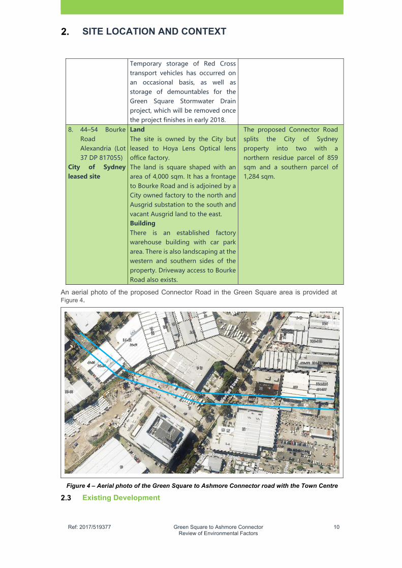
8. 44–54 Bourke Road Alexandria (Lot 37 DP 817055)
City� of� Sydney�leased�site�
Land��The site is owned by the City but leased to Hoya Lens Optical lens office factory. The land is square shaped with an area of 4,000 sqm. It has a frontage to Bourke Road and is adjoined by a City owned factory to the north and Ausgrid substation to the south and vacant Ausgrid land to the east. Building There is an established factory warehouse building with car park area. There is also landscaping at the western and southern sides of the property. Driveway access to Bourke Road also exists.
The proposed Connector Road splits the City of Sydney property into two with a northern residue parcel of 859 sqm and a southern parcel of 1,284 sqm.
An aerial photo of the proposed Connector Road in the Green Square area is provided at Figure 4.
Figure 4 – Aerial photo of the Green Square to Ashmore Connector road with the Town Centre
Existing Development
�
Ref: 2017/519377 Green Square to Ashmore Connector Review of Environmental Factors
11
SITE LOCATION AND CONTEXT
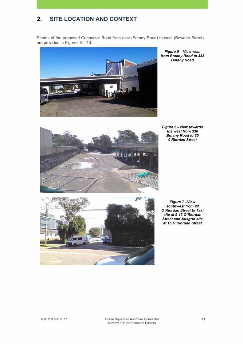
Photos of the proposed Connector Road from east (Botany Road) to west (Bowden Street) are provided in Figures 5 – 10.
Figure 5 – View west from Botany Road to 338
Botany Road
Figure 6 –View towards the west from 338 Botany Road to 20 0’Riordan Street
Figure 7 –View southwest from 20
O’Riordan Street to Taxi site at 9-13 O’Riordan
Street and Ausgrid site at 15 O’Riordan Street

�
Ref: 2017/519377 Green Square to Ashmore Connector Review of Environmental Factors
12
SITE LOCATION AND CONTEXT
Figure 8 –View looking east from Ausgrid site to
O’Riordan Street
Figure 9 –View looking west from Ausgrid site
(15 O’Riordan Street ) to City of Sydney property (44–54 Bourke Road )
Figure 10 – View looking south west towards
Bowden Street / Bourke Road intersection
Surrounding Development
Residential development occurs to the south of the proposed Connector Road corridor (200 m) in Victoria Street, Queen Street an also in Hansard Street. The residential typology includes one – two storey older style terraces and worker cottages, modern townhouses and detached dwellings, as well as some new residential flat buildings.
One residential site has been completed in the Town Centre with over five (5) residential buildings due for completion in 2018. The Town Centre will also include a library plaza and new town park (The Drying Green) to be completed in 2018.

�
Ref: 2017/519377 Green Square to Ashmore Connector Review of Environmental Factors
13
SITE LOCATION AND CONTEXT
Affected roads
There are four (4) existing roads affected by the proposed Connector Road which include Botany Road O’Riordan Street, Bourke Road and Bowden Street which are discussed below in Table 3. Information has been taken from Appendix C.
TABLE�3�–�EXISTING�ROADS�AFFECTED�BY�THE�PROPOSED�CONNECTOR�ROAD�Existing�Road�� Context�and�Function��Botany Road Botany Road is a RMS managed classified road and national freight
corridor and forms part of an arterial route linking Sydney CBD with the Sydney Airport and Port Botany terminals. It is a designated B-Double truck route providing four (4) lanes of undivided carriageways with two traffic lanes in each direction to accommodate high volumes of traffic during the peak periods. The corridor has been identified as a key transport corridor with plans to develop a Botany Road transit corridor noted in the City’s Sustainable Sydney 2030. During peak periods, clearway restrictions are effective for the peak directional flow along Botany Road. In the vicinity of the study area Botany Road is signposted at 50 kilometres (km) per hour. In the immediate vicinity of the proposed Connector Road corridor, Botany Road has “No Stopping” restrictions on the kerbside lane in both directions. A bus stop exists on the western side. On the eastern side there is an access driveway to the Bridgehill Development site (future Geddes Avenue) and two access driveways to 336 and 338 Botany Road. The road contains a footpath on either side with electricity light poles and wires. The City has recently upgraded Botany Road telegraph poles.
O’Riordan Street
O’Riordan Street is a RMS managed classified road that provides a similar level of functionality to Botany Road as an arterial connection and B-Double truck route between central and eastern Sydney to Sydney Airport and Port Botany. In the vicinity of the study area O’Riordan Street is signposted at 60 km per hour. O’Riordan Street is characterised by two lanes in both directions of travel. During AM and PM peak periods, clearway restrictions are in place with limited kerbside parking being effective outside of the peak periods. The corridor has limited function as a bus corridor. At the point where the proposed Connector Road is proposed to cross O’Riordan Street, there are three (3) driveways on the western side (two at 9-13 O’Riordan Street and one at 15 O’Riordan Street). On the eastern side there is one access driveway to 20’O’Riordan Street and one access to 22 O’Riordan Street. Established trees also line each side of the carriageway.
Bourke Road Bourke Road is a local road owned and managed by the City and performs the role of a collector road. Bourke Road aligns parallel to O’Riordan Street and provides access to commercial and industrial properties along the corridor as well as adjacent roads. Between O’Riordan Street and Gardeners Road, traffic is accommodated on a single traffic lane in each direction with a segregated bicycle lane along the western side of the road and kerbside parking along the eastern

�
Ref: 2017/519377 Green Square to Ashmore Connector Review of Environmental Factors
14
SITE LOCATION AND CONTEXT
side of the corridor. Bourke Road has a sign posted speed of 50 km per hour. There are also street tree plantings along most sections of the road. Electricity light poles and wires also dominate the streetscape along Bourke Road.
Bowden Street Bowden Street is a local east-west road providing connection between the higher order roads of Bourke Road and McEvoy Street. It provides two (2) directional lanes with parking allowed only on the northern side. The sign-posted speed limit is 50 km per hour. The road also has a separated on-road cycleway on the western side. There are street tree plantings along most section of the road with a footpath either side.
Key Intersections
Figure 11 provides the location of key intersections in the broader area.
Figure 11 – Key Intersections (Source: City Of Sydney modified By AECOM, 2017)
Existing Infrastructure
The existing infrastructure at the proposed Connector Road is provided below
Public Transport
The proposed Connector Road is located just south of Green Square Rail Station, which provides a regular heavy rail access to the City and the Airport and also towards Kingsgrove, Campbelltown and Macarthur. Train services are regular during the peak periods (five minute intervals). The underground section of the rail line passes beneath the Ausgrid Site.
Green Square Rail Station has experienced significant patronage increase with a 421% increase between 2004 and 2014, which increased significantly after the station access fee was removed in 2011.
The Green Square area is will services by district and local buses, including State Transit Authority routes 309, 310, 370, L09, M20, X03, X09, X10 and X93, which predominantly use Botany Road. Other nearby bus routes such as 301, 343 and 348 run along Joynton Avenue and Route 305 which runs between Redfern Station and Mascot via Bourke Road.

�
Ref: 2017/519377 Green Square to Ashmore Connector Review of Environmental Factors
15
SITE LOCATION AND CONTEXT
Key utilities
Substantial existing services are potentially impacted by roadworks associated with the proposed Connector Road, generally where crossing new intersections created at Botany Road, O’Riordan Street and Bourke Road. Table 4 provides a summary of the existing services potentially impacted by the proposed Connector Road works. The City will work with the various utility authorities and agencies to relocate services as required to deliver the proposed road.
TABLE�4�–�EXISTING�SERVICES�IMPACTED�BY�THE�PROPOSED�CONNECTOR�ROADWORKS�
Authority Location Description
Ausgrid Botany Road, O’Riordan Street, Bourke Road
Existing aerial and underground assets present.
Sydney Water (water)
Botany Road, O’Riordan Street, Bourke Road
Existing water mains in Botany Road in western footpath and roadway. Existing main in O’Riordan Street located in eastern footpath. Existing main in Bourke Road located in western footpath.
Sydney Water (sewer)
Botany Road, O’Riordan Street, Bourke Road
Existing main in Botany Road located in roadway. Existing trunk main in O’Riordan Street located in roadway. Existing main in Bourke Road located in roadway. Existing sewer mains expected to be maintained without change.
Telstra Botany Road, O’Riordan Street, Bourke Road
Existing Telstra infrastructure is located in Botany Road, comprising major duct bank within the western footpath. Existing infrastructure also located in O’Riordan Street and Bourke Road footpaths, as well as lead-in infrastructure servicing existing lots impacting zone of works in multiple locations.
Optus Botany Road Existing major Optus infrastructure located in eastern footpath.
Pipe Networks
Botany Road Existing Pipe Networks infrastructure is located in the main Telstra duct bank in Botany Road western footpath.
NextGen Botany Road Existing NextGen infrastructure is located in the main Telstra duct bank in Botany Road western footpath.
AAPT/Powertel
Bourke Road, Bowden Street
Existing infrastructure located in the north-eastern footpath at the Bowden Street/Bourke Road intersection.
Verizon Bourke Road, Bowden Street
Existing infrastructure located in the north-eastern footpath at the Bowden Street/Bourke Road intersection.

�
Ref: 2017/519377 Green Square to Ashmore Connector Review of Environmental Factors
16
SITE LOCATION AND CONTEXT
Authority� Location� Description�
Vocus Bourke Road, Bowden Street
Existing infrastructure located in the north-eastern footpath at the Bowden Street/Bourke Road intersection.
Jemena Botany Road, O’Riordan Street, Bourke Road
Jemena natural gas mains located in Botany Road eastern and western footpaths, O’Riordan Street eastern footpath, and Bourke Road eastern and western footpaths.
Green Square Stormwater Drain
Sydney Water and the City are in the final stages of the delivery of the Green Square Stormwater Drain beneath the proposed Connector Road corridor to address catchment wide flooding issues in Green Square area. The project is due to be completed in early 2018.
Sewerage
The main sewerage pipes in the area are located in the existing main roads. A large sewer pipe runs in a north westerly direction adjacent to the southern boundary of the Ausgrid Property at 15 O’Riordan Street within a land reservation owned by Sydney Water.
Existing Zoning
Sydney Local Environmental Plan 2012
The land affected by the proposed Connector Road is zoned B7 Business Park under the Sydney LEP 2012 (Refer to Figure 12).
The Green Square to Ashmore Connector
Figure 12 – Extract of Sydney Local Environmental Plan 2012 Zoning Plan
(Sheet 11 and 18)
B7
B7
�
Ref: 2017/519377 Green Square to Ashmore Connector Review of Environmental Factors
17
PROPOSAL DESCRIPTION
Project Overview
Key features of the Green Square to Ashmore Connector road are presented below:
Construction of new road for approximately 380m from the proposed Botany Road/Geddes Avenue intersection to the existing Bourke Road/Bowden Street to be designed in accordance with Australian and City standards
Incorporation of a western arm to the signalized intersection currently under construction at Botany Road – Geddes Avenue
New signalised intersection at O’Riordan Street to include the eastern and western approaches of the proposed Connector Road
New signalised intersection at Bourke Road / Bowden Street to include an eastern approach from the proposed Connector Road. This intersection will provide interchange between the north-south cyclepath on Bourke Road and the east-west cyclepath on Bowden Street
On-road two-way cyclepath located on the southern side of the proposed Connector Road to connect the existing east-west cyclepaths on Bowden Street and Geddes Avenue
Future development to align with the proposed Connector Road
Batters, mounds and retaining walls to provide the structural support to the road and required interfaces to adjacent properties
Stormwater connections to the Green Square Stormwater Drain
Street lighting of all roads to meet required statutory requirements with increased illumination at proposed pedestrian crossing facilities
Road signage and directional signage
Provision for electrical, telecommunications and gas infrastructure and other utilities for required for the project
Provision of a recycled water main to service proposed affordable housing developments located between Botany Road and O’Riordan Street and potentially future developments in the Northern Investigation Area and Ashmore Precinct.
Landscaping and tree planting as well as street furniture
Coordination with detailed design of Geddes Avenue and new Green Square Town Centre where applicable
New accessways to future development sites adjacent to the road corridor
Removal of trees affected by the proposed road
Adjustment to adjoining property fences as required
Provision of a service driveway to allow the servicing and maintenance of existing telecommunications tower on site at 15 O’Riordan Street (Ausgrid)
Future service driveways to adjoining development within the road corridor (study area)
Relocation of utilities and services as required including those identified in Table 4
Property access and service driveways for sites including 15 O’Riordan Street (Ausgrid) 330 – 338 Botany Road (City West) and 338 Botany Road (Preferred community housing provider) and 9-13 O’Riordan Street (Taxis Combined)
Demolition and/or partial demolition in the road corridor as required which includes existing buildings, structures, utilities and vegetation at No. 334 – 336 Botany Road 338 Botany Road, 20 O’Riordan Street, 15 O’Riordan Street (road reservation only) 22 O’Riordan Street and 44-54 Bourke Road Alexandria
Other ancillary works as required to deliver the road
�
Ref: 2017/519377 Green Square to Ashmore Connector Review of Environmental Factors
18
PROPOSAL DESCRIPTION
Design
The design of the proposed Connector Road (Refer to Appendix B) will be in accordance with the following principles:
Maximise pedestrian priority, accessibility, connectivity and permeability
Integrate links to public transport, including future provision for buses
Provide a separated cycleway, linking to the Town Centre and wider regional routes;
Facilitate vehicular access in a slow-speed and safe environment
Demonstrate design integration and coordination with streets and built form
Develop a space that is safe, engaging and legible
Be fully integrated with the proposed water management and civil utilities design strategies
Apply accessible design principles and ensure safe and direct connection into the adjacent streets
Provide a green landscape character
Integrate water sensitive design
Implementation of Sydney Streets Code.
The proposed Connector Road geometry and alignment where designed in accordance with the City’s design standards, and where applicable AUSTROADS – Guide to Road Design and RMS guidelines. The road reserve width is generally consistent with the width adopted for Geddes road (which extends across Botany Road into the Town Centre).
Travel lanes are to be 3.25m wide to facilitate incorporation of future potential bus routes. The intersections were designed using the turning template of a 12.5m rigid vehicle at 15 km/h. The cycleway was designed using RMS NSW Bicycle Guidelines and the City’s standard drawings.
Road Alignment
The proposed Connector Road was designed and modelled in two (2) parts. The western part is between Bourke Road/Bowden Street and O’Riordan Street, and the eastern part is between O’Riordan Street and Botany Road. The length of each part of the road is 224m and 156m respectively.
From west to east, the proposed Connector Road extends from the Bowden Street alignment at the intersection with Bourke Road. The alignment would then pass eastward through 44-54 Bourke Road, 15 O’Riordan Street and 9-13 O’Riordan Street until it connects to O’Riordan Street. The east part would then start at O’Riordan Street, pass through 20 O’Riordan Street, 22 O’Riordan Street, 338 Botany Road and 334-336 Botany Road before connecting to Botany Road, which is aligned with Geddes Avenue in the Town Centre.
The properties at 15 O’Riordan Street and 338 Botany Road will be divided by the proposed Connector Road with a portion of the residual land remaining on either side of the road.
Horizontal Alignment
The road alignment (particularly the western section) is restricted by several existing property boundaries and buildings. Where possible the alignment is located within single property blocks and lots within the ownership of the City. Where the alignment is required to extend into properties not owned by the City, the impact on existing buildings and site operations has sought to be minimised.
The overall geometry of the proposed Connector Road ties in with Geddes Avenue (in the Town Centre), and generally comprises the following elements:
2.65m wide clear footpath on the southern edge
2.40m wide bi-directional cyclepath
�
Ref: 2017/519377 Green Square to Ashmore Connector Review of Environmental Factors
19
PROPOSAL DESCRIPTION
Widened separator median incorporating tree planting and lighting infrastructure, width varies with minimum 1.6m width (providing 1.2m planting between 200mm wide kerbs)
Between two (2) and four (4) traffic lanes depending on turn bay requirements, through lanes at 3.25m width (to accommodate planned bus movements) and turn bay lanes at 3.0m width
4.00m wide northern footpath for the eastern section (comprising 1.5m furniture zone and 2.5m through zone)
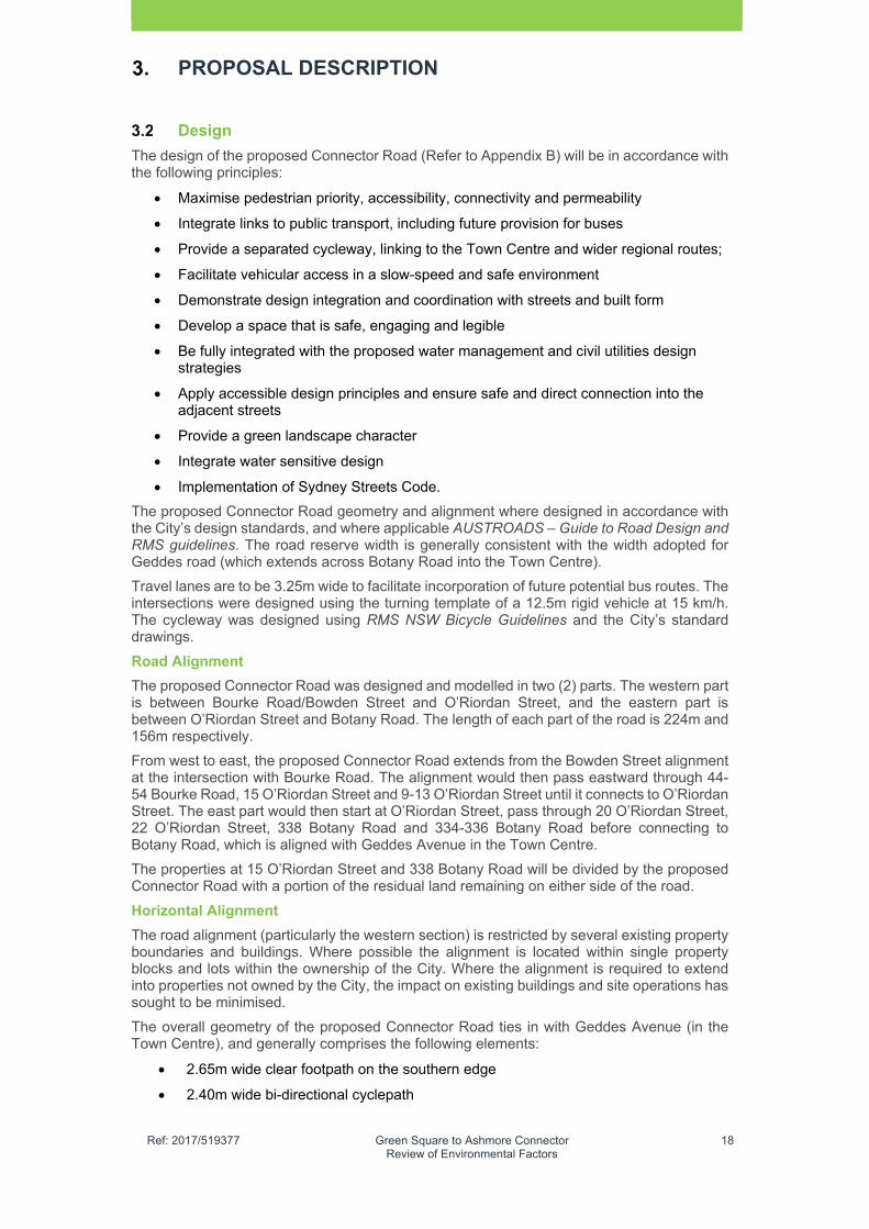
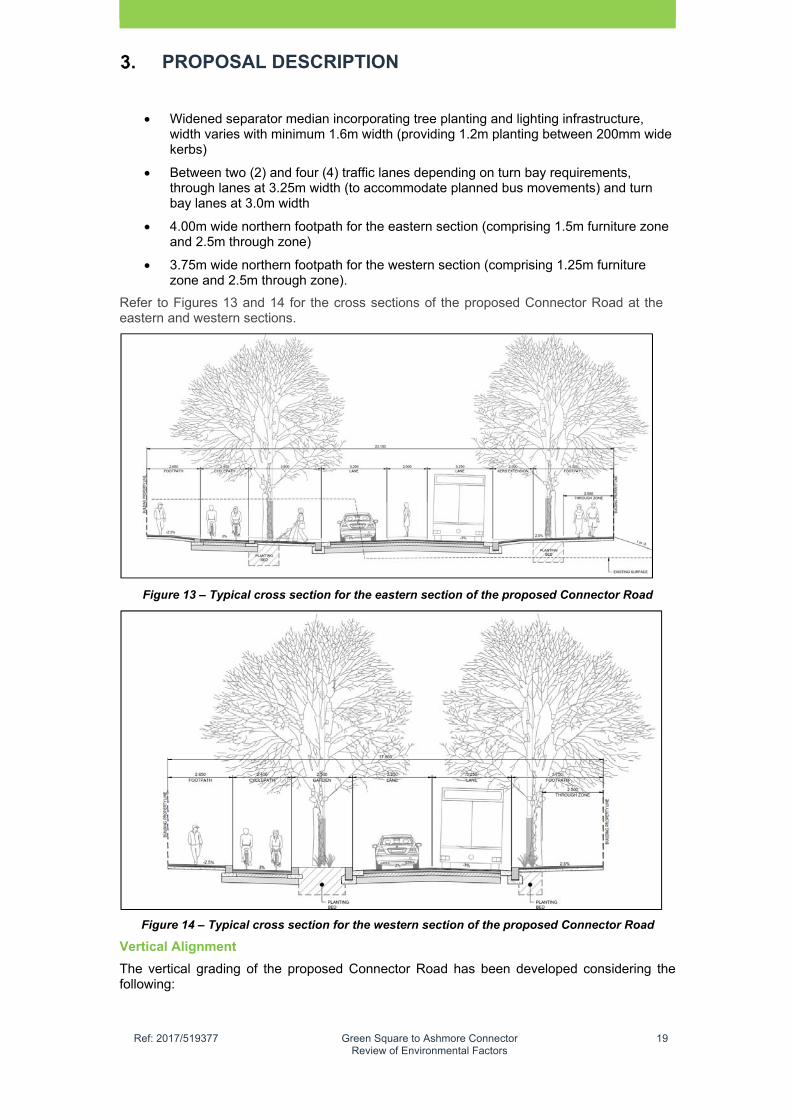
3.75m wide northern footpath for the western section (comprising 1.25m furniture zone and 2.5m through zone).
Refer to Figures 13 and 14 for the cross sections of the proposed Connector Road at the eastern and western sections.
Figure 13 – Typical cross section for the eastern section of the proposed Connector Road
Figure 14 – Typical cross section for the western section of the proposed Connector Road
Vertical Alignment
The vertical grading of the proposed Connector Road has been developed considering the following:

�
Ref: 2017/519377 Green Square to Ashmore Connector Review of Environmental Factors
20
PROPOSAL DESCRIPTION
Minimise vertical grades and maintain footpaths below 3% longitudinal fall where possible noting that the City prefers a standard grade for footpaths at 2.5% in accordance with the Sydney streets technical specification Vertical alignment
Manage flooding and overland flows to ensure no adverse impacts results from creation of the new road
Minimise impacts to existing road corridors
Consider interfaces with adjacent sites along the route.
Due to the need to avoid adverse flood impact from introducing new overland flow paths from the existing north-south road corridors, intermediate high points are required to the west of each of the intersections. This has resulted in the longitudinal grades slightly exceeding the desirable maximum, with a resultant grade of 3.7% being achieved in the eastern section and 3. 3% achieved in the western part.
The alignment of the proposed Connector Road will require localised cutting beyond the road reserve boundary to provide the roads formation. Retaining walls and embankments are present along the proposed Connector Road route due to previous filling of land beyond the original surface levels of the properties. The maximum retaining height will be approximately 3.0m, noting that it is expected that this will be removed when the adjacent sites are redeveloped.
Intersections
New traffic signals are proposed at the following intersections;
Bowden Street, Bourke Road and the proposed Connector Road
O’Riordan Street and the proposed Connector Road
Botany Road, Geddes Avenue and the proposed Connector Road.
Note that the proposed traffic signal at Botany Road / the proposed Connector Road / Proposed Geddes Avenue was approved by the Central Sydney Planning Committee in 2013 as part of the Green Square Town Centre Essential Infrastructure Development Application (D/2012/1175).
Signalisation of these intersections is critical to achieve the required pedestrian and cycle permeability in the east-west direction across the busy north south road corridors.
The proposed signalisation of these intersections has been discussed with RMS and the anticipated performance of the intersections assessed through traffic modelling. RMS has not identified any concerns with the proposed signalisation or the proposed level of service achieved.
The proposed Connector Road has been designed as a local access road and will not accommodate additional regional traffic coming from the Alexandria to Moore Park Connectivity Upgrade, which is due to be completed in 2021. To prevent traffic migration from this future regional road, the route assessment considered the introduction of numerous right turn bans at the three (3) intersections along the proposed Connector Road to reinforce its function as a local access road that connects with the Town Centre.
Each of the intersections has been designed to allow for 12.5m vehicles (nominally buses) to manoeuvre into and out of the proposed Connector Road. The exception is at the existing Bowden Street-Bourke Road intersection where the existing intersections’ geometry restricts movements to a 9.9m refuse vehicle.
The lengths of turn bays adopted in the concept design were informed by the traffic modelling.
Pavement and Kerb Types
The pavement and kerb materials proposed for the eastern section of the Connector Road are consistent with the Village Palette, which is the same material pallete for Geddes Avenue. For the western section, proposed materials are consistent with the Local Street palette in the City of Sydney Streets Code (City’s Streets Code). The only deviation from this, is the

�
Ref: 2017/519377 Green Square to Ashmore Connector Review of Environmental Factors
21
PROPOSAL DESCRIPTION
extension of bluestone kerb from Bourke Road to O’Riordan Street, to achieve a cohesive public domain. This same approach is applied to residential zones within the Town Centre.
The street pavements and materials would be consistent with the design objectives, key principles, and latest requirements of all relevant Australian Standards and the City’s Streets Code. The primary principles for the choice of paving and kerb materials include:
Sustainable, locally sourced, high durability, low embodied energy
Flexible plus easy to remove and re-lay
Create a high quality pedestrian environment with materials which are robust, durable and easy to maintain
A reinforced streetscape hierarchy of uses and character for the Green Square precinct and its surrounding neighbourhoods. This includes targeted application of higher quality pavement for areas around transport hubs, public activities, recreational uses and shopfront retail.
Public Domain Furniture and Lighting
The public domain furniture and lighting selection are in accordance with the latest edition of all relevant Australian Standards, City’s Streets Code (local areas standard public domain furniture palette) and the Sydney Lights Code.
The public domain furniture applied with the proposed Connector Road project is to achieve the following objectives:
Achieves compliance with the City’s Streets Code
Reinforces the public domain character by providing adequate amenities which add functionality and vitality to the public realm
Appropriately placed to achieve convenient use, such as social seating and focus points for communal activity or consolidated at key crossing points on pedestrian desire lines
Minimise life cycle costs and maintenance requirements
Coordinated with street trees, to complement street calming applications such as raised thresholds
Provides a clear path of travel unobstructed by public domain furniture and outdoor seating arrangements
The provision of bicycle racks at regular intervals, which are consolidated at key destination points such as bus stops, retail and commercial areas and/or adjacent to key open spaces.
The lighting objectives for the public domain are to:
Provide illumination which ensures public safety, public enjoyment and an urban design outcome
Use smart poles in the eastern section and standard City of Sydney lighting fixtures in the western section
Coordinated with other street furniture, signage and planting to minimise visual clutter within the public domain areas
Minimises light spill and glare
Meets the requirements of relevant authorities
Note that the City will own the lighting asset on handover.
All lighting will be fitted with low energy demand Light Emitting Diode or similar technology. To further reduce energy consumption and light pollution, the lighting levels may be staged in a way to provide safely lit movement corridors and areas of reduced lighting levels elsewhere.
�
Ref: 2017/519377 Green Square to Ashmore Connector Review of Environmental Factors
22
PROPOSAL DESCRIPTION
Street Trees
Proposed street trees planting is crucial to achieving a high quality for public realm and also creating green corridors increased canopy cover as proposed in Sustainable Sydney 2030. Street tree selection has considered the following objectives:
To provide tree species based on the City of Sydney Street Tree Master Plan to connect the new development with the adjacent neighbourhoods
To provide tree species in response to the micro climates created by the adjacent developments (building heights, street widths, land uses) and maximise winter sun where possible
To provide tree species that maximise light penetration to street level of future residential and commercial buildings.
There are two tree species proposed which include:
Ulmus parvifolia “Todd” (Chinese Elm) from Botany Road to O’Riordan Street East
Lophostemon confertus (Brush Box) from O’Riordan Street west to Bourke Road
There are opportunities to include understorey and shrub planting to further define spaces and create micro habitats. Considerations include:
Prioritise native species (locally indigenous) which are drought tolerant
Uses species that are easy and maintain and provide clear sight lines
Maximise use of provenance stock to retain and increase local biodiversity
Avoid mono cultural planting and provide plant mixes that achieve more diversity and ensure long term success
Incorporate a rich palette of different plant communities in relationship to their location (e.g. use of native riparian species in rain gardens and retention swales).
Water Management
The water management strategy for the proposed Connector Road public domain has been developed to manage existing flooding issues and achieve best-practice Water Sensitive Urban Design (WSUD).
The study area the proposed Connector Road is impacted by existing flooding, particularly at the trapped low point formed in O’Riordan Street near the proposed Connector Road intersection. The vertical alignment and proposed drainage infrastructure for the proposed Connector Road has been developed to minimise adverse impact on existing flooding and to improve on the existing conditions where possible. The proposed Green Square Stormwater Drain (delivered as a separate project) allows flood levels in O’Riordan Street to be reduced from existing conditions.
The proposed concept design incorporates WSUD and all works adopt an integrated approach to urban water cycle management to minimise impacts on local waterways. The principles for this integrated approach are to achieve:
A reduction in potable water demand through the use of rainwater and or greywater / recycled water
Achieving City of Sydney targets for stormwater quality for either reuse or discharge into local waterways
An opportunity to expand the water recycling network in the Town Centre by providing new pipes in the road reservation and supporting proposed future development
Use runoff from paved areas to maximise passive irrigation
The proposed Connector Road has adopted WSUD infrastructure generally consistent with that provided in Geddes Avenue comprising:

�
Ref: 2017/519377 Green Square to Ashmore Connector Review of Environmental Factors
23
PROPOSAL DESCRIPTION
Raingardens at sag low points at northern side of the road
Use of vegetation that is low maintenance and drought tolerant
Passively irrigated median garden bed along the southern side of road – set down 50mm, broken kerb to capture road catchment
Additional passively irrigated raingardens, garden beds or link trenches along the northern footpath as required to meet the reduction targets.
The adopted Stormwater Pollution Control Targets for the proposed Connector Road are consistent with those set by the NSW Department of Environment and Climate Change (DECC) in Managing Urban Stormwater: Environmental Targets (Consultation Draft, 2007). This includes:
A 85% reduction in the mean annual load of Total Suspended Solids (TSS)
A 65% reduction in the mean annual load of Total Phosphorus (TP)
A 45% reduction in the mean annual load of Total Nitrogen (TN).
Staging
In early 2015 the City determined that the proposed Connector Road project would be delivered in in a single stage. It is anticipated that construction of this road would commence in early 2019 and be delivered by the end of 2020.
This timing has the support of RMS and allows the City to redevelop the residue lands at 330 332, 334-336 and 338 Botany Road for affordable housing and ground floor commercial uses to achieve activation.
The timing also aligns with the timeline for the City of Sydney property to vacate premises at 44-54 Bourke Road.
As the project develops there is potential for the project to be delivered in two stages:
Botany Road to O’Riordan Street
O’Riordan Street to Bourke Road.
In the event that the project is delivered in two (2) stages, the City will develop specific mitigation measures and responses to reduce potential impacts.
Project Justification
The proposed Connector Road has long been identified as a transport solution to improve road access to the Town Centre. Sustainable Sydney 2030 also reinforced the strategic need to improve connectivity and access to the Town Centre with improved access with safe and accessible roads and public transport routes. In accordance with Sustainable Sydney 2030, the City is aiming to achieve substantial modal shift from private vehicle use to more sustainable transport modes such as walking and cycling.
In 2012, a Green Square Town Centre Parking and Traffic Study2 highlighted the need for improved east-west connections between Green Square and the Inner West (including the Ashmore Precinct).
The proposed Connector Road is now identified in Sydney DCP 2012 and is required within the next three (3) years to support the Town Centre. Based on the concept design for the Connector Road, the City is currently in the process of acquiring lands for the proposed Connector Road based on the Concept Plan and Sydney DCP 2012 alignment.
The proposed Connector road will enhance pedestrian and cycle access in this part of the Green Square Urban Renewal Area and provide an opportunity for better east-west cycle access in this part the City.
Alternatives Considered
2 Bitzios Consulting 2013
�
Ref: 2017/519377 Green Square to Ashmore Connector Review of Environmental Factors
24
PROPOSAL DESCRIPTION
This section provides an assessment of the various road alignment options considered by the City in formulating the current preferred concept design for the proposed Connector Road.
Option 1 – Harley Street Extension
The City investigated an alternative option for an east-west road connection between Botany Road and Bourke Road. The Harley Street extension was identified by the City from Botany Road south of the Town Centre, to Harley Street between Mitchell Road and Euston Road. This option was abandoned prior to the development of the TMAP (2008) due to the following reasons:
The proposed route does not directly link with the Town Centre and is 200m south of the proposed Botany Road/Geddes Avenue access. This access also has the potential to create further traffic conflicts on Botany Road
The proposed route does not align with the preferred services route for the Green Square Stormwater Drain and to allow joint use of the corridor in the future, sewer and other services upgrades needed for the Green Square Urban Renewal Area.
Furthermore, this option does not achieve the following project objectives:
Providing a gateway road that improves road and transport access to the Town Centre and which improves east-west road and transport access in this part of Inner Southern Sydney.
Achieve the integration and timely provision of future servicing infrastructure within the road corridor.
The Harley Street option was discussed at an early stage and no further investigation has been undertaken by the City.
Option 2 – Sydney Development Control Plan 2012 Route Alignment
Sydney DCP 2012 presents a slightly modified alignment to the current preferred concept design option as presented in the REF. The main difference is a straighter section of road from O’Riordan Street to Bourke Road.
This provides an alignment that is consistent with RMS requirements for straight angle approaches to signalised intersections and allows for improved sightlines for users of the proposed Connector Road providing a continual uninterrupted visual link towards the east and west along the route.
Design investigation of this option occurred but was not considered further due to additional land impacts within the Taxi Site. Under the preferred option, only a small triangular portion of the land (approximately 521m2) would need to be purchased with represents 6% of the total land area (approximately 8,849m2).
Since the DCP has a straighter road alignment, a greater land area (1,750m2 or 20% of the total land) within the Taxi Site would have been needed with a subsequent broader impact area.
Another constraint Option 2, is that it requires a small amount of City owned land at 34-42 Bourke Road as compared to the preferred option which does not use this property.
In summary, Option 2 has a broader impact area with the project without adding a significant improvement to road function. The preferred Connector Road alignment will significantly improve accessibility to this part of the LGA and support the function of the emerging Town Centre.
Option 3 – “Do Nothing” Option
The “Do Nothing” options does not provide a viable solution which achieves the TMAP and Sustainable Sydney 2030.
The “Do Nothing” option will result in further constraints to accessibility in this part of the Green Square area and will undermine the vision contained Sustainable Sydney 2030 and Three Cities Metropolitan Strategy 2017. Further, it will prevent access from east to west to the Green Square area which exists in an area with predominantly north-south roads.
�
Ref: 2017/519377 Green Square to Ashmore Connector Review of Environmental Factors
25
PROPOSAL DESCRIPTION
The Preferred Option
The preferred route alignment provides a more appropriate solution to address existing and future transport and access constraints affecting the development of the Town Centre and the broader Green Square area.
The project will provide a direct western approach to the Town Centre by linking up with proposed Geddes Avenue. The road also connects with three (3) main roads in the Green Square area. This will allow an easier path of travel for road users, including cyclists and also for pedestrians wishing to gain access to the Town Centre and rail station. Essentially the proposed Connector Road allows an alternative path of travel via the congested intersection at Bourke Road/Wyndham Street/Botany Road/ and Bourke Road.
By providing a public road corridor, it allows land within this corridor to deliver the Green Square Stormwater Drain, which is a significant stormwater infrastructure asset being developed by Sydney Water and the City to address existing flooding constraints in Green Square area. The road reservation also provides an opportunity to expand the water recycling network in the Town Centre.
The proposed Connector Road also provides the potential for urban renewal of vacant industrial land to be used for affordable housing and long term employment uses, without a significant loss of commercially viable land.
The proposed design option has the general support of RMS and key land owners subject to further negotiations regarding the proposed design.
The proposed option is also more favourable due to the presence of existing City owned land.
Project Benefits
The benefits of the proposal include:
Provision of an important local access transport corridor for all road uses, with proposed bus stops in both directions and opportunity to move existing bus routes to the proposed Connector Road or even create new routes to help service the Green Square Urban Renewal Area, accommodating future expansion.
Establishment of high pedestrian priority including a wide footpath zone, furniture zone, continuous tree canopy to reduce heat island effect, ground level shops, bus stops and kerb extensions. These inclusions help facilitate the movement of people within the Green Square area
A bidirectional cycle path to provide a much needed connection between existing cycle paths on Bowden Street and Bourke Road and new cycle paths being constructed along the southern edge of Geddes Avenue in the Town Centre and broader network.
A local road connection between Bowden Street at the western end and Botany Road at the eastern end, which will highlight and enhance the arrival into the Town Centre as a significant urban hub
Provision of an easement corridor to expand the water recycling network from the Town Centre towards future development sites adjacent to the proposed Connector Road and further west towards the Northern Investigation Area and Ashmore Precinct
A proposed Connector Road with a strong east-west spine formed through the Town Centre along Geddes Avenue to the west and ultimately onto Bowden Street
An opportunity to deliver new affordable housing and increased ground floor commercial and retail premises in order to generate increased community interaction and vibrancy for the urban core
Proposed signalised intersections at Botany Road, O’Riordan Street and Bourke Road, to enhance pedestrian and cyclist safety and accessibility in this part of the Green

�
Ref: 2017/519377 Green Square to Ashmore Connector Review of Environmental Factors
26
PROPOSAL DESCRIPTION
Square, where east-west permeability is currently limited, and which will also improve access to the Green Square Rail Station and Town Centre.
Construction Activities
The following indicative construction staging is proposed for the purposes of the concept design. After site establishment the proposal would be implemented in the following 10 stages, which are likely to be refined during the detailed design phase:
Stage 1: Install environmental controls and implement traffic management measures
Stage 2: Survey, set-out and identification of services
Stage 3: Commence remediation activities and bulk earthworks. This includes sorting, stockpiling, loading and transporting material
Stage 4: Install retaining walls, excavate, cut and fill to design levels
Stage 5: Install pipe drainage and utilities works (including adjustments to existing services and utilities as required)
Stage 6: Import pavement sub-base material and compact
Stage 7: Install kerbs, footpath slabs, lighting and traffic signals installation
Stage 8: Install asphalt wearing course and footpath pavements
Stage 9: Complete landscaping (including tree planting), install street furniture and commission traffic signals
Stage 10: Demobilise, clean site and remove traffic management and environmental controls.
Construction Hours and Duration
Standard construction hours plus night work (on occasions) to minimise traffic disruption to existing arterial roads only. Hours would include:
Monday to Friday: 7:30am to 5:30pm
Saturdays: 7:30am to 3:30pm
Sundays or public holidays: No work permitted (except without approval)
Plant and Equipment
Plant and equipment required to undertake the works would likely consist of a combination of:
Tracked excavators (10 tonnes, 15 tonnes and 30 tonnes)
Tipper trucks
Tree trimmers and mulchers
Compaction equipment such as drum, vibrating rollers and plate compactors
Air compressors
Pumping equipment
Crushing / screening plant
Smaller tools and equipment such as concrete and paver cutting equipment, jack hammers and miscellaneous hand held tools.
Traffic Management and Access
The contractor will be required to implement a traffic management plan (TMP) that will identify the following:
proposed arrangements for access to the site
proposed haul routes that will use the existing arterial road network
traffic management measures to be implemented for works on existing roads.
�
Ref: 2017/519377 Green Square to Ashmore Connector Review of Environmental Factors
27
PROPOSAL DESCRIPTION
The TMP will be required to include mitigation measures and work practices to minimise impact to the public road networks and in particular existing traffic and pedestrian provision on Botany Road, O’Riordan Street, Bourke Road and Bowden Street.
Ancillary Activities
Public Utility Adjustment
The project will result in the adjustment of the following public utilities:
Sydney Water water mains
Sydney Water sewer mains (generally limited to manhole adjustments)
Ausgrid electrical infrastructure (aerial and underground assets)
Jemena gas infrastructure
Various Communications infrastructure (including Optus, Telstra, Pipe Networks, NextGen, Verizon, AAPT/Powertel and Vocus)
Plus other utility installations as identified in Table 4.
Property Acquisition
Further to Table 2, the partial or full acquisition of the following properties will be required to facilitate delivery of this road (Refer to Appendix A):
Taxis Combined site at 9-13 O’Riordan Street, Alexandria (partial acquisition)
Ausgrid site at 15 O’Riordan Street, Alexandria (partial acquisition)
Perfect Autobody site at 22 O’Riordan Street, Alexandria (partial acquisition).
All remaining lands required for delivery of the project have now been acquired by the City of Sydney and no further property acquisitions are required.
Land Ownership
The proposed Connector Road alignment passes through a number of existing land parcels, some of which are currently owned by the City and others which remain in private ownership. Where the route passes through private land parcels, extensive consultation has been undertaken with relevant land owners to discuss potential implications on the current operations and further discussions will occur as part of project delivery.
The land ownership parcels along the proposed Connector Road alignment are presented in Appendix A.
The main land parcels in private ownership and key consideration which informed the detailed alignment are:
Taxi Site – Maintain existing building and minimise impact on operations
Ausgrid Site – Maximise interconnectivity between the eastern and western parts of the site and maintain access to telecommunications tower at the site’s northern corner
Perfect Autobody Site – Minimise impact during operations, particularly existing servicing.
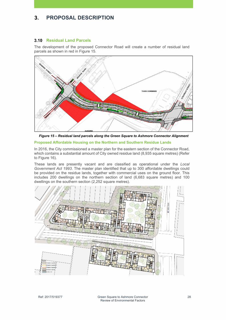
�
Ref: 2017/519377 Green Square to Ashmore Connector Review of Environmental Factors
28
PROPOSAL DESCRIPTION
Residual Land Parcels
The development of the proposed Connector Road will create a number of residual land parcels as shown in red in Figure 15.
Figure 15 – Residual land parcels along the Green Square to Ashmore Connector Alignment
Proposed Affordable Housing on the Northern and Southern Residue Lands
In 2016, the City commissioned a master plan for the eastern section of the Connector Road, which contains a substantial amount of City owned residue land (8,935 square metres) (Refer to Figure 16).
These lands are presently vacant and are classified as operational under the Local Government Act 1993. The master plan identified that up to 300 affordable dwellings could be provided on the residue lands, together with commercial uses on the ground floor. This includes 200 dwellings on the northern section of land (6,683 square metres) and 100 dwellings on the southern section (2,252 square metres).

�
Ref: 2017/519377 Green Square to Ashmore Connector Review of Environmental Factors
29
PROPOSAL DESCRIPTION
Figure 16 – Green Square to Ashmore Connector Master Plan
The residual land parcels located at the western section of the proposed Connector Road, between O’Riordan Street and Bourke Road, are generally smaller (less 1,500 sqm) with an irregular land shapes, which undermines their potential to achieve a short term redevelopment once the road opens in 2020 (Refer to Figure 15). In the short term, the City will provide these lands as public recreation and open space. In the longer term City will work to develop these sites as part of the redevelopment of adjoining lots for permissible uses in accordance with the B7 Business Park zone.

�
Ref: 2017/519377 Green Square to Ashmore Connector Review of Environmental Factors
30
This Page Intentionally Left Blank
�
Ref: 2017/519377 Green Square to Ashmore Connector Review of Environmental Factors
31
LEGISLATIVE AND PLANNING FRAMEWORK
This chapter provides a summary of the statutory and stratgic planning context of the proposed Connector Road including the need to consider relevant provisions of Part 5 of the EP&A Act, relevant environmental planning instruments (EPI) and other approval and policy requirements.
NSW Environmental Planning & Assessment Act 1979
The EP&A Act establishes the system of environmental planning and assessment in NSW. Part 5 of the Act specifies the EIA requirements for activities undertaken by public authorities, such as a council, which are permissible without development consent under Part 5.
As previously stated in Section 1.4, this proposal is subject to the EIA and planning approval requirements under Part 5 of the EP&A Act. In accordance with Section 111, a council, as the proponent and determining authority, must examine and take into account to the fullest extent possible all matters affecting or likely to affect the environment by reason of the proposed activity.
Under Section 112, a council must consider whether the proposal is likely to significantly affect the environment, including threatened species populations, ecological communities or their habitants. If any critical habitat is affected or where any significant impacts on threatened species, populations or ecological communities or their habitats are likely, a species impact statement must be prepared.
Where a council forms the opinion that any significant impact is likely, an Environmental Impact Statement (EIS) would in turn need to be assessed and prepared under sections 78A (8) or (8A) or 112 of the Act.
Clause 228 of the Regulations defines the factors which must be considered when determining if an activity assessed under Part 5 of the Act, has a significant impact on the environment.
Comment
Chapter 6 of this REF provides a full environmental impact assessment of the proposal in accordance with these guidelines. A checklist of the key issues outlined in the clause 228 guidelines is provided in Chapter 7.
State Environmental Planning Policies
State Environmental Planning Policies (SEPP) cover issues significant to the state and people of NSW. They are made by the Minister for Planning & Environment (the Minister) and may be exhibited in draft form for public comment before being gazetted as a legal document. Relevant SEPPs are assessed below
4.2.1 State Environmental Planning Policy (Infrastructure) 2007
State Environmental Planning Policy (Infrastructure) 2007 (“the Infrastructure SEPP”) is the principal State EPI that applies to the assessment and approval of infrastructure in NSW. The main aims of this Infrastructure SEPP are to provide a consistent approval system for the assessment of public infrastructure in NSW and to promote better coordination and integration with adjacent development and to achieve the efficient redevelopment of surplus government-owned land. The Infrastructure SEPP also stipulates consultation requirements with key government agencies during the EIA process or prior to development.
The Infrastructure SEPP includes development controls and exempt development provisions relating to the construction of a range of infrastructure and related service works, as well as requirements regarding consultation with relevant authorities. Relevant to this proposal, it covers roads, road infrastructure facilities, stormwater management systems, stormwater reuse schemes and water supply systems.
Comment
Clause 16 Consultation with public authorities other than councils
Clause 16 requires a proponent to consult with relevant government agencies if the project affects particular areas of environmentally sensitive land.

�
Ref: 2017/519377 Green Square to Ashmore Connector Review of Environmental Factors
32
LEGISLATIVE AND PLANNING FRAMEWORK
The project does not impact on land as identified within Clause 16 and therefore no consultation has occurred with those relevant government agencies.
Consultation with Roads & Maritime Services
The City has maintained extensive consultation with RMS during the project, especially with the drafting of the concept design and preparation of the Traffic and Transport Impact Assessment Report. RMS approval is requirement under Section 138 of the Roads Act 1993 to connect the proposed Connector Road to classified roads and work in a classified road.
Environmental Assessment Requirements
The environmental assessment requirements of key elements of the project are established in Section 1.4 of this report to allow for the project to be assessed under Part 5 of the EP&A Act.
4.2.2 State Environmental Planning Policy No. 55 – Remediation of Land
State Environmental Planning Policy No. 55 – Remediation of Land (SEPP 55) applies to NSW and establishes a planning approach to the remediation of contaminated land that minimises risk or harm to human health or any other aspect of the environment. SEPP 55 establishes the consent requirements for remediation work and also establishes standards and notification requirements for proposed remediation work.
Clause 7 Contamination and remediation requires a consent authority to not consent to the carrying out of any development on land unless it has considered whether the land is contaminated, and if the land is contaminated, the level of remediation needed to allow the proposed development to be carried out. Furthermore, a council must be satisfied that the land will be remediated before the land is used for that purpose.
Other provisions requires a council to consider reports (prepared in accordance with the contaminated land planning guidelines) or preliminary investigations that involve land use change use in an investigation area, a known area of potential contamination and land for a range of sensitive uses residential, child care hospital etc.
Comment
Contaminated land issues at the site are being managed in accordance with SEPP 55. A Preliminary and Phase 2 Contamination Assessment has been undertaken and a remediation action plan (RAP) has been prepared3 for the proposed Connector Road. The RAP has been reviewed by an auditor and it contains mitigation measures to minimise contamination impacts (Refer to Chapter 8).
Local Environmental Plans and Strategies
4.3.1 Sydney Local Environmental Plan 2012
The Sydney LEP 2012 is the principal local EPI which applies to the proposed Connector Roadcorridor. Table 5 provides an assessment of relevant clauses in Sydney LEP 2012.
TABLE�5�–�ASSESSMENT�OF�SYDNEY�LOCAL�ENVIRONMENTAL�PLAN�2012�Sydney Local Environmental Plan 2012
Comment on Proposed Development
2. 6 Subdivision – consent requirements.
The project involves a proposed subdivision of the affected lands to provide the proposed Connector Road which is provided as Appendix A. In September 2017, the City lodged a development application to obtain consent for the subdivision of the road and adjoining residue lands under Part 4 of the EP&A Act.
2. 7 Demolition requires development consent.
The project involves the demolition of proposed structures located on the following properties which are affected by the
3 East West Relief Route Remedial Action Plan, Parsons Brinckerhoff January 2016
�
Ref: 2017/519377 Green Square to Ashmore Connector Review of Environmental Factors
33
LEGISLATIVE AND PLANNING FRAMEWORK
proposed Connector Road and are covered by the definition of construction which includes demolition;
334-336 Botany Road Alexandria – warehouse buildings
338 Botany Road Alexandria – warehouse buildings 20 O’Riordan Street Alexandria – Existing vacant
taxi depot (front portion of building if required) 22 O’Riordan Street, Alexandria – Existing brick wall
along the northern boundary and landscaped setback.
44–54 Bourke Road – Existing building, car park area and associated landscaping and vegetation
Zone B7 Business Park
The road is zoned B7 Business Park, which aims to provide a range of office and light industrial uses and encourage employment opportunities. Other land uses that provide facilities or services to meet the day to day needs of workers in the area are also supported and provide uses that support the viability of nearby centres. The proposed Connector Road is consistent with the B7 zone and will improve access to the nearby Town Centre and employment generating uses in the area. Residue lands will be redeveloped for affordable housing at the eastern end and long term employment generating uses at the western end.
5. 2 Classification and reclassification of public land
Prior to the road being opened, the City proposes to classify the land as a “road” under the Roads Act 1993.
5. 9 Preservation of trees An arboricultural assessment has been undertaken as part of this REF. (Refer to Appendix F) which concludes that a number of trees within the corridor will need to be removed and further assessment of trees worthy of protection will occur as part of the detailed design. Further assessment occurs on this issue in Chapter 6.
5. 10 Heritage conservation
The proposed Connector Road does not impact any listed heritage items under SLEP 2012. A RMS Section 170 register includes a listed heritage item (Alignment Mark) at Botany Road Alexandria, which does not exist within the study area at the Botany Road connection. Two other alignment pins are located at 527 Botany Road and also 330-332 Botany Road Alexandria (West Side). Other state heritage items are located a significant distance (200 m) away from the proposed Connector Road and have not been assessed in this REF.
5. 12 Infrastructure development and use of existing buildings of the Crown
The Infrastructure SEPP is relied upon to allow the proposed Connector Road to be assessed as development that can occur without development consent.
7. 14 Acid Sulfate Soils
In 2014, the City commissioned Parsons Brinckerhoff to prepare a Geotechnical Investigation Report for the
�
Ref: 2017/519377 Green Square to Ashmore Connector Review of Environmental Factors
34
LEGISLATIVE AND PLANNING FRAMEWORK
proposed Connector Road, which provided an assessment of acid sulfate soils (ASS), which is presented below. Acid Sulfate Soils The 1:25 000 Sydney Acid Sulfate Soil (ASS) map indicates a low probability of occurrence within the extents for the proposed Connector Road corridor. However due to the high water table and possibility of encountering marine sediments on-site. Based on the Potential ASS sampling undertaken during the investigation laboratory results indicated that the underlying natural silty clay materials contained some Acid Sulfate Soil at Borehole (BH) 01, in the eastern portion of the site which exceeds the action criteria for disturbance of greater than 1,000 Tonnes of material. Additional ASS may be present in other areas of the site where testing has not been undertaken. Preparation of an ASS Management Plan is recommended in Chapter 7 to mitigate the potential impacts of acid sulfate soils.
7. 15 Flood planning
A hydraulic assessment has been completed in support of the proposed Connector Road (Refer to Appendix D) which concluded that the proposed Connector Road will result in a minor increase depth in flooding but with no significant impact to lands within the area. Further assessment of flooding issues will occur during detailed design and prior to construction to further address flooding within the proposed Connector Road corridor.
7. 19 Demolition must not result in long term adverse visual impact
The City is seeking a renewal of the residue lands created by the proposed Connector Road. Based on a Master Plan which was endorsed by Council in mid-2016, the City is seeking to provide mixed affordable housing development (up to 300 dwellings with ground floor retail uses to achieve activation) on the residue lands at the eastern section. For the western section the City will develop these three (3) residue lands parcels for open space and recreational uses in the short term, with a view to develop these lands in the long term as part of the redevelopment of adjoining lands for uses which are permissible in the B7 Business Park Zone. The City will also provide maintenance access from the proposed Connector Road to the residue lands containing the telecommunications tower on the former Ausgrid site.
Ecologically sustainable development
Council is committed to ensuring that this project is implemented in a manner that is consistent with the principles of Ecologically Sustainable Development (ESD) outlined in Section 6 of the NSW Protection of the Environment Administration Act 1991 and Schedule 2 of the Regulations.
�
Ref: 2017/519377 Green Square to Ashmore Connector Review of Environmental Factors
35
LEGISLATIVE AND PLANNING FRAMEWORK
The principles of ESD have been adopted by the City throughout the design development and assessment of the proposed Connector Road through the implementation of Sustainable Sydney 2030.
The road project is a sustainability initiative to increase sustainable transport (walking and cycling) and public transport to the Town Centre with only a minor increase in private vehicle use. Tree planting and WSUD measures will also lead to a sustainable outcome with the project.
ESD principles are assessed in Chapter 6 and Chapter 8 provides the mitigation measures to ensure that these principles are incorporated during the detailed design and construction phase of the project.
4.1 Other relevant legislation
Table 6 provides a list of relevant legislation that has been considered in relation to the proposal.
TABLE�6�–�SUMMARY�OF�OTHER�LEGISLATIVE�REQUIREMENTS�NSW Legislation Relevance to proposed Connector Road
Contaminated Land Management Act 1997 (NSW)
In 2014 – 2015, the City completed a geotechnical and contamination assessment of the proposed Connector Road (Parsons Brinckerhoff) which forms part of a RAP, which concluded the following:
There are existing contamination concerns in the form of friable asbestos (Ausgrid Property), lead (across the site in fill) and residual petroleum hydrocarbons (Mobil property at 20 O'Riordan Street) that may pose a risk to human health during construction. Lead impacts exceeding criteria were identified in shallow fill material along the full length of the proposed Connector Road and adjacent areas that were subject to intrusive investigation, extending to a depth of approximately 3 mBGL. Asbestos contamination has been observed in the fill material across the Ausgrid site to a maximum depth of 2.2 mBGL. Residual hydrocarbon impact is present at the Mobil property, in soil in localised areas to a depth of 3 mBGL and in groundwater within the Mobil site (20 O'Riordan Street) boundary. This risk can be mitigated through a construction environmental management plan (CEMP) that would be implemented prior to the commencement of works.
Crown Lands Act 1987 (NSW)
The site is not Crown land and therefore does not require a lease or licence under this Act.
Heritage Act 1977 (NSW) There are no heritage listed properties directly affected by the proposed Connector Road listed under the Heritage Act 1977. A Section 170 register held by RMS has a listed heritage item (Alignment Mark) at Botany Road Alexandria (East Side). These exist at 527 Botany Road and also 330-332 Botany Road Alexandria (West Side). Both Alignment Marks are outside of the study area for the proposed Connector Road and have not been assessed in this REF.

�
Ref: 2017/519377 Green Square to Ashmore Connector Review of Environmental Factors
36
LEGISLATIVE AND PLANNING FRAMEWORK
National Parks and Wildlife Act1974 (NSW)
The proposal is unlikely to disturb any Aboriginal objects of listed threatened species. Therefore a permit under this Act is not required.
NSW�Legislation Relevance�to�proposed�Connector�Road� Native Title Act 1993 (Commonwealth)
The proposed site is not affected by any native title holders or claimants. Therefore the provisions of this Act do not apply.
Protection of the Environment Operations Act 1997 (NSW)
Construction of the proposed Connector Road is not a scheduled activity under the Protection of the Environment Operations Act 1997. The proposal, with the inclusion of mitigation measures, is unlikely to cause significant air and water pollution. Therefore an environment protection licence under this Act is not required. Part 5 provides a Duty to notify the Office of Environment & Heritage (OEH) in the event of a pollution incident occurring.
Roads Act 1993 (NSW) Under Section 138, the City needs approval to carry out work on a state road (O’Riordan Street and Botany Road) and also link a local road to a state road (Section 116).
Sydney Water Act 1994 (NSW)
The City needs to obtain an approval under Section 146 to connect the proposed stormwater network to the Green Square Trunk Drain, which is a Sydney Water asset.
Threatened Species Conservation Act 1995 (NSW)
The City has undertaken an assessment and determined that the proposed Connector Road site does not contain suitable habitat for any listed threatened species or community. Therefore an approval under this Act is not required.
Waste Avoidance and Resource Recovery Act 2001 (NSW)
The City will carry out the proposed construction of the proposal in accordance with the objects of this Act. A site specific Waste Management Plan will be prepared for the construction stage.
Water Management Act 2000 / 2010 (NSW)
There are no approvals required under the Water Management Act.
Commonwealth Legislation
Commonwealth Environment Protection & Biodiversity Conservation Act 1999
The Commonwealth EPBC Act 1999 requires Commonwealth assessment and referral to the Minister for a Proposal that is likely to have a significant impact on matters of National Environmental Significance (NES) or impacts on Commonwealth land. NES matters are considered in full in Appendix G.
The proposal will not impact on any matters of NES or on Commonwealth land. Therefore a referral to the Federal Minister for the Environment is not required.
Other relevant policies
Sydney Metropolitan Strategy
A Plan for Growing Sydney (the Sydney Metropolitan Strategy) was released in 2015 as the NSW Government’s 20-year plan for the Sydney Metropolitan Area. It provides direction for Sydney’s productivity, environmental management, and livability; and for the location of housing, employment, infrastructure and open space. The Plan establishes a vision for Sydney as a strong global city, and great place to live. The vision is supported by four (4) goals:
Goal 1: A competitive economy with world-class services and transport
�
Ref: 2017/519377 Green Square to Ashmore Connector Review of Environmental Factors
37
LEGISLATIVE AND PLANNING FRAMEWORK
Goal 2: A city of housing choice with homes that meet our needs and lifestyles Goal 3: A great place to live with communities that are strong, healthy and well
connected Goal 4: A sustainable and resilient city that protects the natural environment and
has a balanced approach to the use of land and resources.
The Plan also contains three (3) planning principles that will guide how Sydney grows:
Principle 1: Increasing housing choice around all centres through urban renewal in established areas
Principle 2: Stronger economic development in strategic centres and transport gateways
Principle 3: Connecting centres with a networked transport system.
The Plan distributes the metropolitan area into six (6) subregions and Green Square forms part of the Central Subregion. Green Square is also nominated as a “Strategic Centre” which will contain mixed uses, density and diversity that is of metropolitan significance, which includes commercial (office, business and retail), civic and cultural uses; government services; and higher density housing.
A strategic centre is typically on the passenger rail network or serviced by other high frequency public transport. Strategic centres typically contain at least 10,000 jobs, with the potential to accommodate ongoing jobs growth over the long-term. They are priority locations for employment and retail activity.
Comment
The proposed Connector Road is consistent with A Plan for Growing Sydney, which will provide a new road and transport corridor linking to a Strategic Centre. This will enhance the area’s access and provide increased amenity for residents, workers and visitors.
Our Greater Sydney 2056, A metropolis of three cities
In October 2017, the Greater Sydney Commission released Our Greater Sydney 2056 which supports the vision for a metropolis of three (3) cities to balance growth and deliver its benefits more equally and equitably to residents across Greater Sydney.
Green Square is nominated centre that exists in the Eastern Economic Corridor (Macquarie Park to Sydney Airport) which is of national significance and currently contains approximately 775,000 jobs. The Town Centre is nominated as a place for transformation and growth managed by Landcom and stakeholders. Green Square – Mascot is also recognised as having a commercial function.
Under the eastern city district plan, which covers land from the inner west to the eastern beaches and Sydney CBD, the City needs to accommodate 18,300 of the 46,550-dwellings target covering the Central District in the Plan.
Comment
The proposed Connector Road is in accordance with the broader metropolitan vision for Greater Sydney by ensuring that Green Square contributes to the economic function of the Eastern Economic Corridor. It will also support local access for an increasing number of residents moving in the area.

�
Ref: 2017/519377 Green Square to Ashmore Connector Review of Environmental Factors
38
This Page Intentionally Left Blank
�
Ref: 2017/519377 Green Square to Ashmore Connector Review of Environmental Factors
39
CONSULTATION
This Chapter summarises the consultation that has been adopted for the proposal, discusses the consultation that has been undertaken to date, and outlines the consultation that is proposed prior to determining the proposal and during construction (if determined). It will involve consultation with the community, relevant government agencies and other stakeholders.
Authorities
Throughout the preparation of this REF, the City held discussions with Transport for NSW, RMS and Sydney Water. Issues raised by both agencies have been incorporated in the design of the road and the assessment undertaken in this report.
Community
The proposed Connector Road was identified in the public exhibition of the Sydney DCP 2012 and subsequent amendments in 2014.
Throughout the preparation of this REF, the following engagement activities have been undertaken:
Included on Green Square Town Centre map (updated August 2017)
Map update on Green Square website
Mentioned in broader information sessions in Green Square (e.g. Have Your Say Day, May 2016 and Green Square Info Day, October 2016).
Green Square print newsletter (April 2017 edition)
These activities have allowed the Green Square community an opportunity to learn about the City’s overarching plans for streets in the Town Centre and broader area.
Public Exhibition
Council proposes to undertake the following tasks as part of the public exhibition of the REF
Public exhibition of the REF for a four (4) week period
Notification of the project to adjoining residents and businesses
Placement of an ad in the Sydney Morning Herald, Central Sydney and Southern Magazines
Public display at Town Hall House (Level 2)
Public display at the Redfern and Green Square Neighbourhood Service Centres
Placement of the REF on Council’s Sydney Your Say and Green Square websites
Inclusion in Green Square print newsletter
Inclusion in the Sydney Your Say eNewsletter
The REF will also be provided to RMS and Transport for NSW, Sydney Water and Sydney Trains.

�
Ref: 2017/519377 Green Square to Ashmore Connector Review of Environmental Factors
40
This Page Intentionally Left Blank
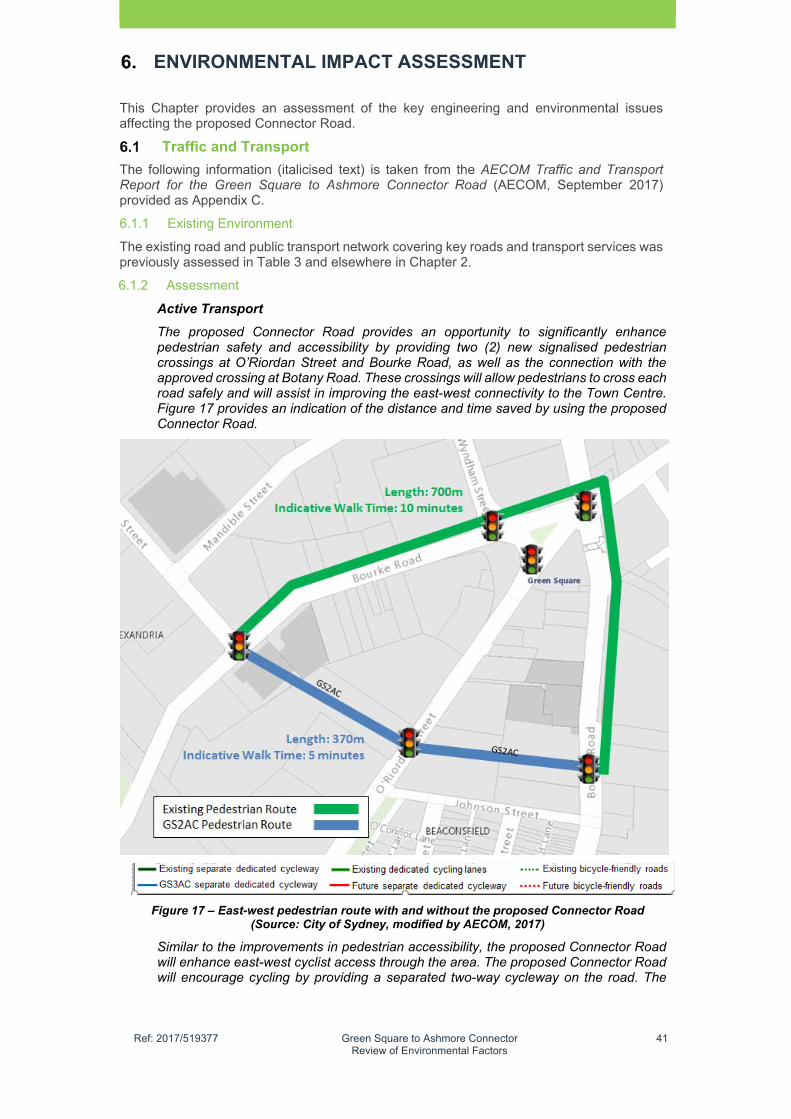
�
Ref: 2017/519377 Green Square to Ashmore Connector Review of Environmental Factors
41
ENVIRONMENTAL IMPACT ASSESSMENT
This Chapter provides an assessment of the key engineering and environmental issues affecting the proposed Connector Road.
Traffic and Transport
The following information (italicised text) is taken from the AECOM Traffic and Transport Report for the Green Square to Ashmore Connector Road (AECOM, September 2017) provided as Appendix C.
6.1.1 Existing Environment
The existing road and public transport network covering key roads and transport services was previously assessed in Table 3 and elsewhere in Chapter 2.
6.1.2 Assessment
Active Transport
The proposed Connector Road provides an opportunity to significantly enhance pedestrian safety and accessibility by providing two (2) new signalised pedestrian crossings at O’Riordan Street and Bourke Road, as well as the connection with the approved crossing at Botany Road. These crossings will allow pedestrians to cross each road safely and will assist in improving the east-west connectivity to the Town Centre. Figure 17 provides an indication of the distance and time saved by using the proposed Connector Road.
Figure 17 – East-west pedestrian route with and without the proposed Connector Road (Source: City of Sydney, modified by AECOM, 2017)
Similar to the improvements in pedestrian accessibility, the proposed Connector Road will enhance east-west cyclist access through the area. The proposed Connector Road will encourage cycling by providing a separated two-way cycleway on the road. The

�
Ref: 2017/519377 Green Square to Ashmore Connector Review of Environmental Factors
42
ENVIRONMENTAL IMPACT ASSESSMENT
infrastructure will also include bicycle crossings across the intersections with dedicated lights.
This route will be well linked to the surrounding local and strategic cycling network. The proposed Connector Road cycleway is connected with the existing separated cycleways on Bourke Road and Bowden Street to the west, as well as the planned cycleway on Geddes Avenue to the east.
Figure 18 shows the proposed cycleway in the new road in the context of existing cycleways and planned cycle paths from the City’s proposed regional bike network.
As seen, the proposed cycleway will provide a strategic east-west link between two (2) separate dedicated cycleways. The Bourke Road cycleway is a popular route for those travelling between the CBD and Mascot. Further, the route along Bowden Street will lead towards the Ashmore Precinct as well as to Newtown and the Inner West. Meanwhile, the cycleways on the eastern side will connect to the M1 Motorway and Kensington. The proposed Connector Road cycleway will be vital in creating a safe route for cyclists and linking the Town Centre with the broader cycle network.
Figure 18 – Existing and planned cycle network near Green Square (Source: Sydney Cycleways, modified by AECOM)
Road Function and route strategy
A vehicle route assessment and strategy was carried out by AECOM for the City, to review the proposed turning movement associated with the proposed Connector Road. The primary function of the proposed Connector Road is to provide a multi-modal east-west connection to the Town Centre and to enhance the road and transport access in the area. In order to ensure this function could be achieved, without attracting broader cross-regional (east-west through) trips, a route strategy was developed.
A summary of the turn bans proposed to manage traffic flow, enabling a focus on east-west connectivity to Town Centre, is provided in Appendix C.
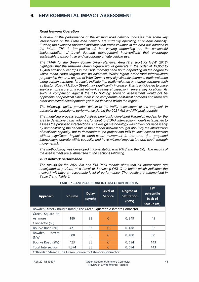
�
Ref: 2017/519377 Green Square to Ashmore Connector Review of Environmental Factors
43
ENVIRONMENTAL IMPACT ASSESSMENT
Road Network Operation
A review of the performance of the existing road network indicates that some key intersections on the State road network are currently operating at or near capacity. Further, the evidence reviewed indicates that traffic volumes in the area will increase in the future. This is irrespective of, but varying depending on, the successful implementation of travel demand management interventions that encourage sustainable transport use and discourage private vehicle use.
The TMAP for the Green Square Urban Renewal Area (Transport for NSW, 2012) highlights that the renewed Green Square would generate in the order of 13,050 to 19,450 additional car trips in the 2031 morning peak hour, depending on the degree to which mode share targets can be achieved. Whilst higher order road infrastructure proposed in the area as part of WestConnex may significantly decrease traffic volumes along certain corridors, forecasts indicate that traffic volumes on nearby corridors such as Euston Road / McEvoy Street may significantly increase. This is anticipated to place significant pressure on a road network already at capacity in several key locations. As such, a comparison against the “Do Nothing’ scenario assessment would not be applicable nor practical since there is no comparable east-west corridors and there are other committed developments yet to be finalised within the region.
The following section provides details of the traffic assessment of the proposal, in particular its operational performance during the 2021 AM and PM peak periods.
The modelling process applied utilised previously developed Paramics models for the area to determine traffic volumes, for input to SIDRA Intersection models established to assess the proposed intersections. The design methodology was driven not necessarily by demonstrating the benefits to the broader network brought about by the introduction of available capacity, but to demonstrate the project can fulfil its local access function without significant impact to north-south movement in the area (i.e. proposed intersections operate within capacity, and have minimal impacts to north-south through movements).
The methodology was developed in consultation with RMS and the City. The results of the assessment are summarised in the sections following.
2021 network performance
The results for the 2021 AM and PM Peak models show that all intersections are anticipated to perform at a Level of Service (LOS) C or better which indicates the network will have an acceptable level of performance. The results are summarised in Table 7 and Table 8.
TABLE�7�–�AM�PEAK�SIDRA�INTERSECTION�RESULTS�
Approach� Volume�Delay�
(s/veh)�
Level�of�
Service�
�
Degree�of�
Saturation�
(DOS)�
95th�
percentile�
back�of�
Queue�(m)�
Bowden Street / Bourke Road / The Green Square to Ashmore Connector Green Square to Ashmore Connector (SE)
180 33 C 0. 249 45
Bourke Road (NE) 471 33 C 0. 478 82 Bowden Street (NW)
300 36 C 0. 408 50
Bourke Road (SW) 423 38 C 0. 694 143
Total Intersection 1,374 35 C 0. 694 143
O'Riordan Street / The Green Square to Ashmore Connector
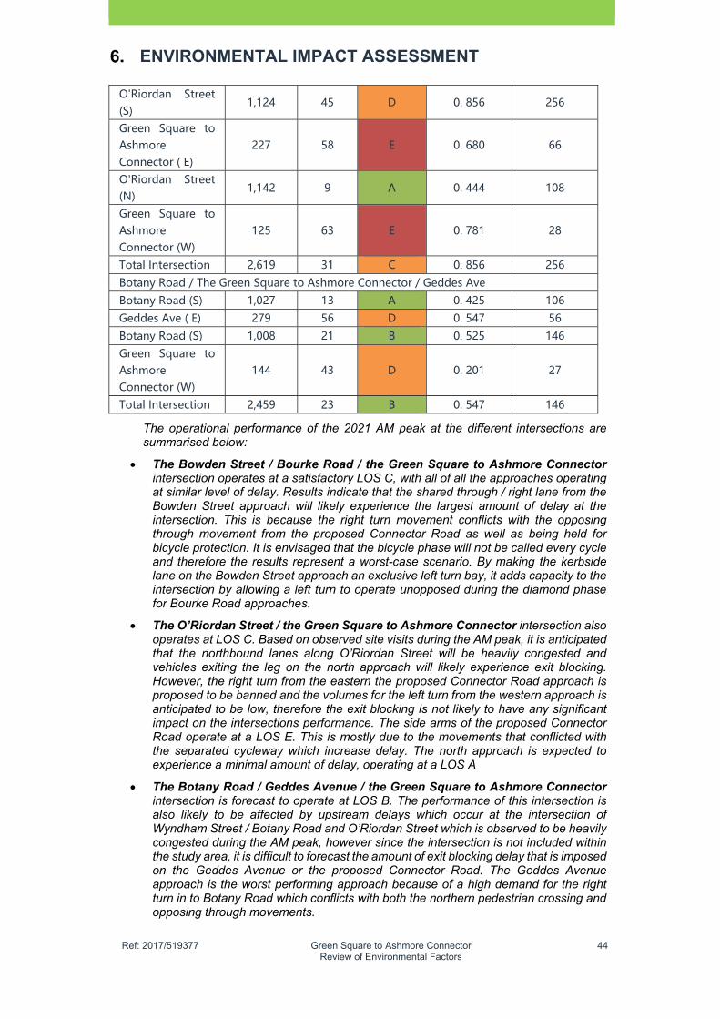
�
Ref: 2017/519377 Green Square to Ashmore Connector Review of Environmental Factors
44
ENVIRONMENTAL IMPACT ASSESSMENT
O'Riordan Street (S)
1,124 45 D 0. 856 256
Green Square to Ashmore Connector ( E)
227 58 E 0. 680 66
O'Riordan Street (N)
1,142 9 A 0. 444 108
Green Square to Ashmore Connector (W)
125 63 E 0. 781 28
Total Intersection 2,619 31 C 0. 856 256
Botany Road / The Green Square to Ashmore Connector / Geddes Ave
Botany Road (S) 1,027 13 A 0. 425 106
Geddes Ave ( E) 279 56 D 0. 547 56
Botany Road (S) 1,008 21 B 0. 525 146 Green Square to Ashmore Connector (W)
144 43 D 0. 201 27
Total Intersection 2,459 23 B 0. 547 146
The operational performance of the 2021 AM peak at the different intersections are summarised below:
The Bowden Street / Bourke Road / the Green Square to Ashmore Connector intersection operates at a satisfactory LOS C, with all of all the approaches operating at similar level of delay. Results indicate that the shared through / right lane from the Bowden Street approach will likely experience the largest amount of delay at the intersection. This is because the right turn movement conflicts with the opposing through movement from the proposed Connector Road as well as being held for bicycle protection. It is envisaged that the bicycle phase will not be called every cycle and therefore the results represent a worst-case scenario. By making the kerbside lane on the Bowden Street approach an exclusive left turn bay, it adds capacity to the intersection by allowing a left turn to operate unopposed during the diamond phase for Bourke Road approaches.
The O’Riordan Street / the Green Square to Ashmore Connector intersection also operates at LOS C. Based on observed site visits during the AM peak, it is anticipated that the northbound lanes along O’Riordan Street will be heavily congested and vehicles exiting the leg on the north approach will likely experience exit blocking. However, the right turn from the eastern the proposed Connector Road approach is proposed to be banned and the volumes for the left turn from the western approach is anticipated to be low, therefore the exit blocking is not likely to have any significant impact on the intersections performance. The side arms of the proposed Connector Road operate at a LOS E. This is mostly due to the movements that conflicted with the separated cycleway which increase delay. The north approach is expected to experience a minimal amount of delay, operating at a LOS A
The Botany Road / Geddes Avenue / the Green Square to Ashmore Connector intersection is forecast to operate at LOS B. The performance of this intersection is also likely to be affected by upstream delays which occur at the intersection of Wyndham Street / Botany Road and O’Riordan Street which is observed to be heavily congested during the AM peak, however since the intersection is not included within the study area, it is difficult to forecast the amount of exit blocking delay that is imposed on the Geddes Avenue or the proposed Connector Road. The Geddes Avenue approach is the worst performing approach because of a high demand for the right turn in to Botany Road which conflicts with both the northern pedestrian crossing and opposing through movements.
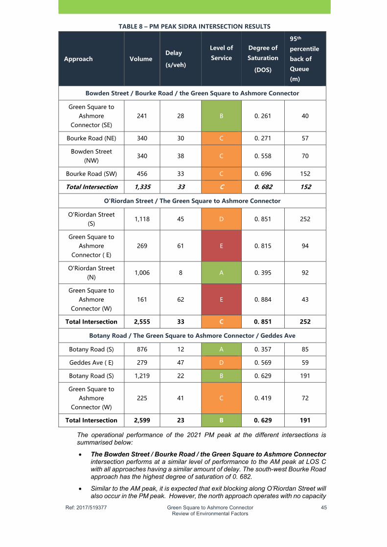
�
Ref: 2017/519377 Green Square to Ashmore Connector Review of Environmental Factors
45
TABLE�8�–�PM�PEAK�SIDRA�INTERSECTION�RESULTS�
Approach� Volume�Delay�
(s/veh)�
Level�of�
Service�
�
Degree�of�
Saturation�
(DOS)�
95th�
percentile�
back�of�
Queue�
(m)�
Bowden�Street�/�Bourke�Road�/�the�Green�Square�to�Ashmore�Connector��
Green Square to Ashmore
Connector�(SE) 241 28 B 0. 261 40
Bourke Road (NE) 340 30 C 0. 271 57
Bowden Street (NW)
340 38 C 0. 558 70
Bourke Road (SW) 456 33 C 0. 696 152
Total�Intersection� 1,335� 33� C� 0.�682� 152�
O'Riordan�Street�/�The�Green�Square�to�Ashmore�Connector�
O'Riordan Street (S)
1,118 45 D 0. 851 252
Green Square to Ashmore
Connector�( E) 269 61 E 0. 815 94
O'Riordan Street (N)
1,006 8 A 0. 395 92
Green Square to Ashmore
Connector�(W) 161 62 E 0. 884 43
Total�Intersection� 2,555� 33� C� 0.�851� 252�
Botany�Road�/�The�Green�Square�to�Ashmore�Connector�/�Geddes�Ave�
Botany Road (S) 876 12 A 0. 357 85
Geddes Ave ( E) 279 47 D 0. 569 59
Botany Road (S) 1,219 22 B 0. 629 191
Green Square to Ashmore
Connector�(W) 225 41 C 0. 419 72
Total�Intersection� 2,599� 23� B� 0.�629� 191�
The operational performance of the 2021 PM peak at the different intersections is summarised below:
The Bowden Street / Bourke Road / the Green Square to Ashmore Connector intersection performs at a similar level of performance to the AM peak at LOS C with all approaches having a similar amount of delay. The south-west Bourke Road approach has the highest degree of saturation of 0. 682.
Similar to the AM peak, it is expected that exit blocking along O’Riordan Street will also occur in the PM peak. However, the north approach operates with no capacity

�
Ref: 2017/519377 Green Square to Ashmore Connector Review of Environmental Factors
46
ENVIRONMENTAL IMPACT ASSESSMENT
restraints and receives minimal delays. Because of the higher flows on the O’Riordan Street, priority is given to these approaches over the Connector Road leading to a LOS E and D for the east and west approaches respectively.
The Botany Road / Geddes Avenue / the Green Square to Ashmore Connector is forecast to operate at LOS B. It was observed during the PM site visit that southbound queuing from the Epsom Road intersection extended back to the proposed location of Geddes Avenue. Therefore, the performance of this intersection is also likely to be affected by these upstream delays. The Epsom Street/ Botany Road intersection is not included within the study area and therefore it is difficult to forecast the amount of exit blocking and its impacts on Geddes Avenue or the proposed Connector Road.
Post 2021 network performance
Given the current stages of major transport projects in the region, no updated strategic volumes have been made available for future year analysis of the traffic network beyond 2021. In consultation with RMS, it was agreed that the growth rate of 1.1 percent compounding annual growth rate would be applied uniformly across the network to obtain a failure year and assess the location of any potential capacity restraints within the proposed Connector Road.
Table 9 below shows the design life analysis of the three (3) signalised intersections along the proposed Connector Road. The failure year shown indicates when the intersection reaches capacity (degree of saturation approaches 100 percent) under a compounding annual growth rate of 1.1% from the 2021 year volumes.
TABLE�9�–�DESIGN�LIFE�ANALYSIS�
Peak�Period� Failure�Year� Failure�Approach�Failure�
Movement�
Bowden�Street�/�Bourke�Road�/�the�proposed�Connector�Road�
AM Peak 2052 (31 years) Bourke Road (SW) Through/Left
PM Peak 2038 (17 years) Bourke Road (SW) Through/Left
O'Riordan�Street�/�The�Green�Square�to�Ashmore�Connector�
AM Peak 2042 (21 years) The proposed Connector Road (West)
Right
PM Peak 2029 (8 years) The proposed Connector Road (West)
Right
Botany�Road�/�the�Green�Square�to�Ashmore�Connector�/�Geddes�Ave�
AM Peak 2040 (19 years) Geddes Ave (East) Right
PM Peak 2037 (16 years) Geddes Ave (East) Right
In the AM peak, results indicate that the Geddes Avenue approach will be the first intersection within the network to reach capacity, 19 years after the 2021 opening year. As one of the main egress points, the Geddes Avenue approach right turn movement in to Botany Road provides egress for the AM commuter trips generated by the Town Centre to the Sydney CBD.
It can be seen from the above results that the intersection that reaches capacity first is O’Riordan Street / the proposed Connector Road in the 2029 PM peak. The western approach right turn movement reaches capacity because of an increased volume of
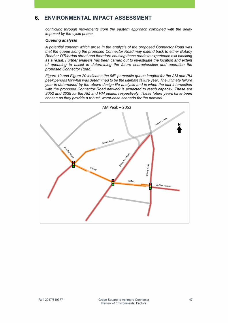
�
Ref: 2017/519377 Green Square to Ashmore Connector Review of Environmental Factors
47
ENVIRONMENTAL IMPACT ASSESSMENT
conflicting through movements from the eastern approach combined with the delay imposed by the cycle phase.
Queuing analysis
A potential concern which arose in the analysis of the proposed Connector Road was that the queue along the proposed Connector Road may extend back to either Botany Road or O’Riordan street and therefore causing these roads to experience exit blocking as a result. Further analysis has been carried out to investigate the location and extent of queueing to assist in determining the future characteristics and operation the proposed Connector Road.
Figure 19 and Figure 20 indicates the 95th percentile queue lengths for the AM and PM peak periods for what was determined to be the ultimate failure year. The ultimate failure year is determined by the above design life analysis and is when the last intersection with the proposed Connector Road network is expected to reach capacity. These are 2052 and 2038 for the AM and PM peaks, respectively. These future years have been chosen as they provide a robust, worst-case scenario for the network.
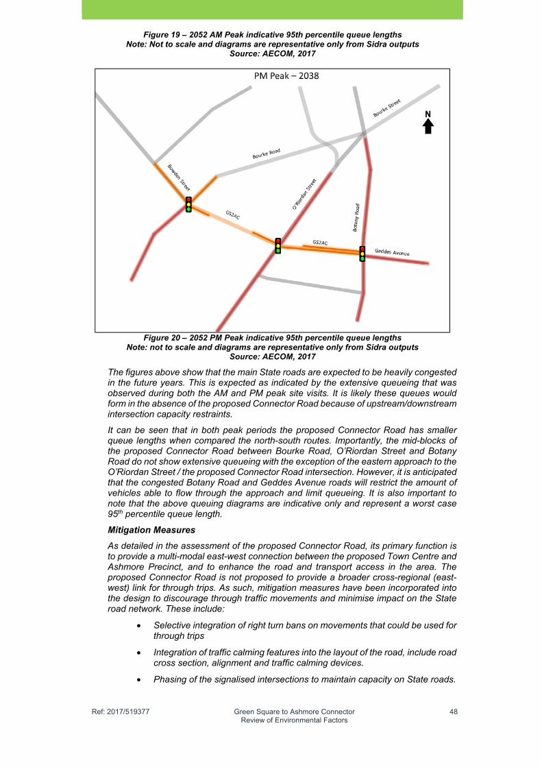
�
Ref: 2017/519377 Green Square to Ashmore Connector Review of Environmental Factors
48
Figure 19 – 2052 AM Peak indicative 95th percentile queue lengths Note: Not to scale and diagrams are representative only from Sidra outputs
Source: AECOM, 2017
Figure 20 – 2052 PM Peak indicative 95th percentile queue lengths
Note: not to scale and diagrams are representative only from Sidra outputs Source: AECOM, 2017
The figures above show that the main State roads are expected to be heavily congested in the future years. This is expected as indicated by the extensive queueing that was observed during both the AM and PM peak site visits. It is likely these queues would form in the absence of the proposed Connector Road because of upstream/downstream intersection capacity restraints.
It can be seen that in both peak periods the proposed Connector Road has smaller queue lengths when compared the north-south routes. Importantly, the mid-blocks of the proposed Connector Road between Bourke Road, O’Riordan Street and Botany Road do not show extensive queueing with the exception of the eastern approach to the O’Riordan Street / the proposed Connector Road intersection. However, it is anticipated that the congested Botany Road and Geddes Avenue roads will restrict the amount of vehicles able to flow through the approach and limit queueing. It is also important to note that the above queuing diagrams are indicative only and represent a worst case 95th percentile queue length.
Mitigation Measures
As detailed in the assessment of the proposed Connector Road, its primary function is to provide a multi-modal east-west connection between the proposed Town Centre and Ashmore Precinct, and to enhance the road and transport access in the area. The proposed Connector Road is not proposed to provide a broader cross-regional (east-west) link for through trips. As such, mitigation measures have been incorporated into the design to discourage through traffic movements and minimise impact on the State road network. These include:
Selective integration of right turn bans on movements that could be used for through trips
Integration of traffic calming features into the layout of the road, include road cross section, alignment and traffic calming devices.
Phasing of the signalised intersections to maintain capacity on State roads.

�
Ref: 2017/519377 Green Square to Ashmore Connector Review of Environmental Factors
49
ENVIRONMENTAL IMPACT ASSESSMENT
Preliminary Construction Traffic Impacts
Construction Traffic Volumes (Refer to Chapter 3 for Construction Methods)
Traffic generated by the construction works includes construction worker light vehicles (including utility vans), as well as heavy vehicles for periodic delivery and removal of materials, including plant and equipment. Vehicle types and sizes would vary depending on the required use, but include medium and large rigid vehicles and articulated vehicles for import of bulk materials or minor spoil removal, as well as concrete trucks.
Although the level of construction vehicle activity is unknown at this stage, the volumes are expected to be up to 60 vehicles per day (120 one-way trips).
A summary of the anticipated traffic generation per stage of works is presented in Table 10.
TABLE�10� CONSTRUCTION�TRAFFIC�GENERATION�
Name Duration (weeks)
Start Finish Vehicle Trips
(Duration)
Vehicle Trips
(per day)
The�Green�Square�to�Ashmore�Connector�East�
54 03/04/18 04/10/19
Remediation and Excavation and in-ground services other than trunk
16 31/08/18 21/12/18 750 9
Retaining wall/batters 12 07/01/19 01/04/19 450 7
Sub-grade 8 02/04/19 30/05/19 600 14
Kerb & gutter 8 31/05/19 26/07/19 380 9
Footpaths 6 29/07/19 06/09/19 700 21
Pavement Lanes Surfacing
4 09/09/19 04/10/19 600 28
Taxi Building Demolition (if Required
26 03/04/18 03/10/18 - -
The�Green�Square�to�Ashmore�Connector�West�
54 07/01/19 06/02/20
Remediation and Excavation
16 07/01/19 02/05/19 700 8
Retaining wall/batters 12 03/05/19 26/07/19 450 7
Sub-grade 8 29/07/19 20/09/19 600 14
Kerb & gutter 8 23/09/19 18/11/19 380 9
�
Ref: 2017/519377 Green Square to Ashmore Connector Review of Environmental Factors
50
ENVIRONMENTAL IMPACT ASSESSMENT
Footpaths 6 19/11/19 09/01/20 700 21
Pavement Lanes Surfacing
4 10/01/20 06/02/20 600 28
Access Arrangements
Access to the works sites will be directly from Bourke Road, O’Riordan Street and Botany Road. It is anticipated that the following conditions will be placed on theses access:
The Green Square to Ashmore Connector Road West (Bourke Road to O’Riordan Street)
Bourke Road: All movements
O’Riordan Street: Left-in/ Left-out
The Green Square to Ashmore Connector Road East (O’Riordan Street to Botany Road)
O’Riordan Street: Left-in/ Left-out
Botany Road: Left-in/ left or right out (signalised)
The current staging for the intersection of Geddes Avenue / Botany Road indicates signalisation approximately 12 months prior to the construction commencement of the proposed Connector Road. Due to traffic volumes on Botany Road and potential safety issues associated with priority control turn arrangements, it is proposed that this intersection is utilised to provide safe and controlled access from the road network to the eastern section of the proposed Connector Road construction site.
Construction Traffic Volumes
Traffic generated by the construction works includes construction worker light vehicles (including utility vans), as well as heavy vehicles for periodic delivery and removal of materials, including plant and equipment. Vehicle types and sizes would vary depending on the required use, but include medium and large rigid vehicles and articulated vehicles for import of bulk materials or minor spoil removal, as well as concrete trucks.
Although the level of construction vehicle activity is unknown at this stage, the volumes are expected to be up to 60 vehicles per day (120 one-way trips).
Haulage Routes
The origin and destination of truck movements is currently not known. Generally, construction vehicles will have origins and destinations from a wide variety of locations throughout Sydney. However, all construction vehicles are to be restricted to the State and Regional Road network, where possible. No construction vehicles are to use Geddes Avenue, Wyndham Street, Johnson Street or Maddox Street to Access the site. In addition construction traffic must not access the site via Elizabeth Street, Hansards Street and Joynton Avenue.
As such, likely construction vehicle routes have been developed with the aim to provide the shortest distances to/from the arterial road network, whilst minimising the impact of construction traffic on streets in the vicinity of the site. Alternative routes would not be used without specific prior approval from the appropriate stakeholders.
In general, construction vehicle routes via Bourke Road will not be supported. Vehicles routes should generally be via Lachlan Street, McEvoy Street, Botany Road and Epsom Road.
It is noted that during the early bulk earthworks and materials phases some of the exported material may be used at the Green Square Aquatic Centre Development. Vehicles accessing this site will do so via Collins Street/ Botany Road, Epsom Road and Johnston Avenue.
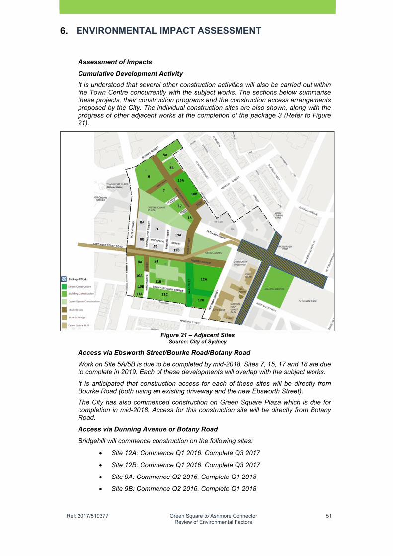
�
Ref: 2017/519377 Green Square to Ashmore Connector Review of Environmental Factors
51
ENVIRONMENTAL IMPACT ASSESSMENT
Assessment of Impacts
Cumulative Development Activity
It is understood that several other construction activities will also be carried out within the Town Centre concurrently with the subject works. The sections below summarise these projects, their construction programs and the construction access arrangements proposed by the City. The individual construction sites are also shown, along with the progress of other adjacent works at the completion of the package 3 (Refer to Figure 21).
Figure 21 – Adjacent Sites Source: City of Sydney
Access via Ebsworth Street/Bourke Road/Botany Road
Work on Site 5A/5B is due to be completed by mid-2018. Sites 7, 15, 17 and 18 are due to complete in 2019. Each of these developments will overlap with the subject works.
It is anticipated that construction access for each of these sites will be directly from Bourke Road (both using an existing driveway and the new Ebsworth Street).
The City has also commenced construction on Green Square Plaza which is due for completion in mid-2018. Access for this construction site will be directly from Botany Road.
Access via Dunning Avenue or Botany Road
Bridgehill will commence construction on the following sites:
Site 12A: Commence Q1 2016. Complete Q3 2017
Site 12B: Commence Q1 2016. Complete Q3 2017
Site 9A: Commence Q2 2016. Complete Q1 2018
Site 9B: Commence Q2 2016. Complete Q1 2018
�
Ref: 2017/519377 Green Square to Ashmore Connector Review of Environmental Factors
52
ENVIRONMENTAL IMPACT ASSESSMENT
Lateral Corp will commence construction on the following sites:
Site 10A: Commence Q1 2017. Complete Q2 2019
Site 10B: Commence Q1 2017. Complete Q2 2019
Site 11A: Commence Q1 2017. Complete Q2 2019
Site 11B: Commence Q1 2017. Complete Q2 2019
Site 11C: Commence Q1 2017. Complete Q2 2019
Additional Developments
200 affordable housing development at northern side of the proposed Connector Road at 330-338 Botany Road
100 affordable housing development at the southern side of the proposed Connector Road at 338 Botany Road
Traffic
Given the number of daily construction vehicles, overall the construction works could not be expected to significantly impact intersection operation external to the site.
This includes the Botany Road, O’Riordan Street and the arterial network more broadly. This also assumes that construction vehicle activity outside typical weekday AM and PM peak hours.
Any works on weekends would not present significant traffic related impacts, with no known specific restrictions limiting access and/ or the work hours as specified.
All works within the site and associated vehicle movements will be restricted to the permitted working hours of the site.
Signalised Intersection Works
The installation of two (2) new signalised intersections (Bourke Road/ the proposed Connector Road and O’Riordan Street) as well as modification to the signalised intersection at Botany Road/ Geddes Avenue will require works to be completed within the completed road reserve. This includes fitting and connection of loop detectors as well as painting of line markings. These works would likely require the closure of two (2) trafficable lanes at any one time. The closure of two (2) lanes should allow the remaining two (2) open lanes to facilitate traffic in both directions. This will require a contraflow operation If the lane closures occupy either both the northbound or southbound lanes. It is anticipated that these works would be carried out as night works to minimise the impact on these roads.
Active Transport
Existing pedestrian footpaths on Bourke Road, Botany Road and O’Riordan Street form part of the construction of the proposed Connector Road and it is expected that pedestrians would be diverted to temporary pedestrian paths whilst the upgrades are undertaken.
Cyclists are permitted to travel in a traffic lane on Botany Road and O’Riordan Street. The separated cycleway on Bourke Road is to be maintained. Temporary diversion or closure for short periods of time may be required during the works, at which time a suitable alternative facility would be provided.
Traffic controllers are required on site to monitor and supervise the safe movements for trucks, pedestrian and cyclists past the median worksites, provide priority for emergency services or monitor access to the driveways opposite.
Public Transport
It is not anticipated that bus services in the vicinity of the study area will be impacted upon during construction of the proposal. Minor impacts may occur during off peak times resulting in reduced speeds however it is anticipated that buses would continue to use

�
Ref: 2017/519377 Green Square to Ashmore Connector Review of Environmental Factors
53
ENVIRONMENTAL IMPACT ASSESSMENT
Botany Road at all times. In the scenario where bus movements will be impacted by construction works, the STA will require notification.
Property Access
Minimising the impact of construction works on, and maintaining the operation of, businesses in and around the proposed Connector Road is a top priority for the City. Affected property access locations adjacent to the proposed work site includes:
Taxis, 9-13 O’Riordan Street
Perfect AutoBody, 22 O’Riordan Street
These properties have alternate access points which with minor adjustments, will be able to service both inbound and outbound movements. If required, staged construction within the affected area is a possibility. It is understood that the City will consult with both Taxis Combined and Perfect AutoBody to come to an agreement regarding maintaining access to both businesses.
The City will also work with Ausgrid to minimise construction impacts on their site at 15 O’Riordan Street. As such, property access would be maintained at all times, and any impacts would be short-term.
Conclusion
The Connector Road has long been considered a road-based option to improve local transport access to, and support the growth of, the Town Centre. Once complete, the proposed Connector Road is predicted to improve multiple traffic and transport aspects within the vicinity of the site. The proposed Connector Road provides an opportunity to significantly enhance pedestrian and cyclist safety and accessibility by providing two new signalised crossings at O’Riordan Street and Bourke Road, as well as the connection with the approved crossing at Botany Road.
The assessment has confirmed that the proposed Connector Road is consistent with key State and local transport planning strategy and policy including Sustainable Sydney 2030. The design of the road also complies with relevant Australian standards such as Austroads and RMS and Transport for NSW requirements.
The assessment has determined, in line with the design and project objectives, that the proposed Connector road will fulfil its local access function without significantly impacting the north-south movements in the area (i.e. proposed intersections operate within capacity, and have minimal impacts to north-south through movements). To ensure the Connector Road functions as a multi-modal east-west connection improving transport access to the Town Centre, without attracting broader cross-regional (east-west through) trips, a route strategy was developed. This includes restricting certain turning movements at each of the intersections. The proposed separated two-way cycleway will be well linked to the surrounding local and strategic cycling network. The proposed cycleway is connected with the existing separated cycleways on Bourke Road and Bowden Street to the west, as well as the planned cycleway on Geddes Avenue to the east. As such, providing a vital link in the network.
Further approvals will be obtained from RMS to enable the integration and approval of the proposed two signalised intersections as well as approvals from other utility agencies to provide key services within the proposed Connector Road reservation. Construction mitigation measures will also be implemented and will include the preparation of a traffic management plan.
The preparation of the Traffic and Transport Impact Assessment report has identified that the proposed Connector Road to will operate in a safe and efficient manner to improve accessibility to the proposed Town Centre.
Hydrology
This section is based on the Green Square to Ashmore Connector Hydraulic Impact Assessment (AECOM in association with HydroStorm Consulting, October 2017), which is provided in Appendix D.
�
Ref: 2017/519377 Green Square to Ashmore Connector Review of Environmental Factors
54
ENVIRONMENTAL IMPACT ASSESSMENT
6.2.1 Existing Environment
Introduction
The proposed Connector Road's intersection with O'Riordan Street is at a sag point along O'Riordan which floods to a depth of approximately 1m in a 100 year flood event.
The proposed Connector Road site is generally flood prone and any development within the site needs to address the flood risk associated with the development. Additionally, the proposed development should not have an adverse impact on the surrounding environment.
This report provided in Appendix D was prepared to present the results of hydraulic modelling, which was undertaken to assess the impact of the proposed Connector Road on existing flood behaviour. The report also presents the basic hydraulic parameters relevant to the development, in order to manage the flood risk to the development.
It is noted that the impact assessment is for the proposed Connector Road only. It has been assumed that the Town Centre has been developed to Stage 4 (Option2) and the proposed Green Square Stormwater Drain is also operational before the commencement of the proposed Connector Road.
Green Square to Ashmore Connector Road Details
The proposed Connector Road design has been undertaken by AECOM and the complete terrain was provided for modeling purposes. The terrain provided for modelling also includes two (2) developments along the proposed Connector Road west of Botany Road.
The detailed drainage design for the proposed Connector Road would be completed as per the Council requirements and the standard Australian Rainfall & Runoff minor/major system design philosophy. The infrastructure development application is required to incorporate street drainage catering 2 / the Green Square to Ashmore Connector Hydraulic Impact Assessment (Issue 1, 9 October 2017) for a 20 year Average Recurrence Interval (ARI) event and the road network to act as an overland flow path for flood greater than the 20 year ARI event.
Hydraulic Modelling
Existing Conditions
Development of the proposed Connector Road would follow completion of Stage 4 development in the Town Centre. In addition, the proposed Green Square Stormwater Drain is also under construction and would be completed before the proposed Connector Road works commence. The existing conditions for the assessment of the proposed Connector Road include completed Stage 4 and the Green Square Stormwater Drain.
The Stage 4 terrain has been used as the base case to assess the impact of the proposed Connector Road.
It is noted that two (2) options for Stage 4 were considered previously. The base case used for the current study is based on Option 2 of Stage 4.
Figure 22 Shows the 100 year flood depth and Figure 23 shows the Probable Maximum Flood (PMF) flood depth for the proposed Connector Road. The flood depths in these figures is shown as gradation of different colours and should be read with caution.

�
Ref: 2017/519377 Green Square to Ashmore Connector Review of Environmental Factors
55
Figure�22�–�100�Year�Flood�Depth�–�Green�Square�to�Ashmore�Connector�The proposed design results in significant reduction in flood depths for a 100 year event at O'Riordan Street. However, a significant increase in flood depth occurs near the Bowden Street intersection. Although this depth does not result in high hazard, it is desirable that this depth be further reduced by raising the road levels at the detailed design stage.
Figure�23�–�PMF�Flood�Depth�The flood depths presented in Figure 24 and Figure 25 are based on the modelled terrain. Since the modelled terrain is based on a 4 m grid, the gutter and spill levels at critical low points within the local drainage system are not well defined. As such the flood depth data is approximate and this should be taken into account while using this data. It should also be noted that the local drainage has not been taken into account in undertaking the flood modelling for the proposed Connector Road. Provision of local drainage is likely to reduce the flood depths along the proposed Connector Road.
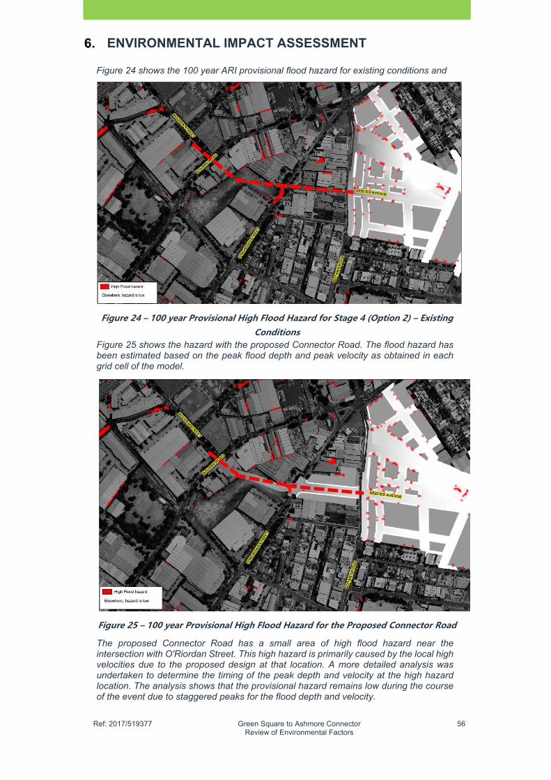
�
Ref: 2017/519377 Green Square to Ashmore Connector Review of Environmental Factors
56
ENVIRONMENTAL IMPACT ASSESSMENT
Figure 24 shows the 100 year ARI provisional flood hazard for existing conditions and
Figure�24�–�100�year�Provisional�High�Flood�Hazard�for�Stage�4�(Option�2)�–�Existing�Conditions�
Figure 25 shows the hazard with the proposed Connector Road. The flood hazard has been estimated based on the peak flood depth and peak velocity as obtained in each grid cell of the model.
Figure�25�–�100�year�Provisional�High�Flood�Hazard�for�the�Proposed�Connector�Road�
The proposed Connector Road has a small area of high flood hazard near the intersection with O'Riordan Street. This high hazard is primarily caused by the local high velocities due to the proposed design at that location. A more detailed analysis was undertaken to determine the timing of the peak depth and velocity at the high hazard location. The analysis shows that the provisional hazard remains low during the course of the event due to staggered peaks for the flood depth and velocity.
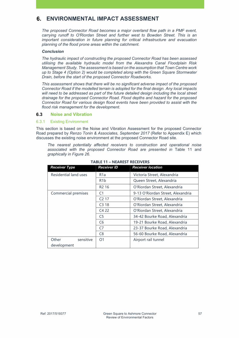
�
Ref: 2017/519377 Green Square to Ashmore Connector Review of Environmental Factors
57
ENVIRONMENTAL IMPACT ASSESSMENT
The proposed Connector Road becomes a major overland flow path in a PMF event, carrying runoff to O'Riordan Street and further west to Bowden Street. This is an important consideration in future planning for critical infrastructure and evacuation planning of the flood prone areas within the catchment.
Conclusion
The hydraulic impact of constructing the proposed Connector Road has been assessed utilising the available hydraulic model from the Alexandra Canal Floodplain Risk Management Study. The assessment is based on the assumption that Town Centre work up to Stage 4 (Option 2) would be completed along with the Green Square Stormwater Drain, before the start of the proposed Connector Roadworks.
This assessment shows that there will be no significant adverse impact of the proposed Connector Road if the modelled terrain is adopted for the final design. Any local impacts will need to be addressed as part of the future detailed design including the local street drainage for the proposed Connector Road. Flood depths and hazard for the proposed Connector Road for various design flood events have been provided to assist with the flood risk management for the development.
Noise and Vibration
6.3.1 Existing Environment
This section is based on the Noise and Vibration Assessment for the proposed Connector Road prepared by Renzo Tonin & Associates, September 2017 (Refer to Appendix E) which discusses the existing noise environment at the proposed Connector Road site.
The nearest potentially affected receivers to construction and operational noise associated with the proposed Connector Road are presented in Table 11 and graphically in Figure 26.
TABLE�11�–�NEAREST�RECEIVERS�Receiver Type Receiver ID Receiver location
Residential land uses
R1a Victoria Street, Alexandria R1b Queen Street, Alexandria
R2 16 O'Riordan Street, Alexandria
Commercial premises
C1 9-13 O'Riordan Street, Alexandria C2 17 O'Riordan Street, Alexandria C3 18 O'Riordan Street, Alexandria C4 22 O'Riordan Street, Alexandria
C5 34-42 Bourke Road, Alexandria C6 19-21 Bourke Road, Alexandria C7 23-37 Bourke Road, Alexandria C8 56-60 Bourke Road, Alexandria
Other sensitive development
O1 Airport rail tunnel
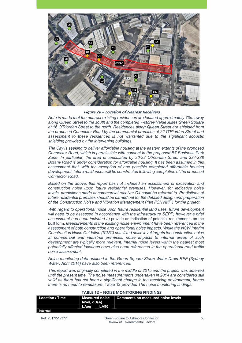
�
Ref: 2017/519377 Green Square to Ashmore Connector Review of Environmental Factors
58
Figure�26�–�Location�of�Nearest�Receivers�Note is made that the nearest existing residences are located approximately 70m away along Queen Street to the south and the completed 7-storey ValueSuites Green Square at 16 O’Riordan Street to the north. Residences along Queen Street are shielded from the proposed Connector Road by the commercial premises at 22 O'Riordan Street and assessment to these residences is not warranted due to the significant acoustic shielding provided by the intervening buildings.
The City is seeking to deliver affordable housing at the eastern extents of the proposed Connector Road, which is permissible with consent in the proposed B7 Business Park Zone. In particular, the area encapsulated by 20-22 O’Riordan Street and 334-338 Botany Road is under consideration for affordable housing. It has been assumed in this assessment that, with the exception of one possible completed affordable housing development, future residences will be constructed following completion of the proposed Connector Road.
Based on the above, this report has not included an assessment of excavation and construction noise upon future residential premises. However, for indicative noise levels, predictions made at commercial receiver C4 could be referred to. Predictions at future residential premises should be carried out for the detailed design and preparation of the Construction Noise and Vibration Management Plan (‘CNVMP’) for the project.
With regard to operational noise upon future residential land uses, future development will need to be assessed in accordance with the Infrastructure SEPP, however a brief assessment has been included to provide an indication of potential requirements on the built form. Measurements of the existing noise environment have been referenced in the assessment of both construction and operational noise impacts. While the NSW Interim Construction Noise Guideline (ICNG) sets fixed noise level targets for construction noise at commercial and industrial premises, noise impacts to internal areas of such development are typically more relevant. Internal noise levels within the nearest most potentially affected locations have also been referenced in the operational road traffic noise assessment.
Noise monitoring data outlined in the Green Square Storm Water Drain REF (Sydney Water, April 2014) have also been referenced.
This report was originally completed in the middle of 2015 and the project was deferred until the present time. The noise measurements undertaken in 2014 are considered still valid as there has not been a significant change in the receiving environment, hence there is no need to remeasure. Table 12 provides The noise monitoring findings.
TABLE�12�–�NOISE�MONITORING�FINDINGS��Location / Time Measured noise
level, dB(A) Comments on measured noise levels
LAeq LA90Internal

�
Ref: 2017/519377 Green Square to Ashmore Connector Review of Environmental Factors
59
ENVIRONMENTAL IMPACT ASSESSMENT
S1 - 9-13 O’Riordan Street 08:36-08:51
59 56 The background LA90 and the ambient LAeq noise level was determined by vehicle pass-bys on O’Riordan Street.
S2 - 9-13 O’Riordan Street08:52-09:07
59 56 The background LA90 and the ambient LAeq noise level was determined by vehicle pass-bys on O’Riordan Street.
S3 - 17 O’Riordan Street09:23-09:38
60 50 The background LA90 and the ambient LAeq noise level was determined by the use of a radio, telephone conversation and general office activities.
S4 - 17 O’Riordan Street09:42-09:48
62 57 The background LA90 and the ambient LAeq noise level was determined by delivery warehouse activities, including unloading of delivery van.
S5 - 22 O’Riordan Street10:12-10:27
71 65 The background LA90 and the ambient LAeq noise level was determined by car servicing activities, including car detailing, buffering, sprays and cleaning.
S6 - 22 O’Riordan Street10:33-10:48
52 43 The background LA90 and the ambient LAeq noise level was determined by general reception activities, including telephone conversation and air-conditioning noise.
S7 - 34-42 Bourke Road 11:32-11:47
48 36 Note is made that the office area/tea room area was unoccupied during the measurement. The background LA90 and the ambient LAeq noise level was determined.
S8 - 34-42 Bourke Road 11:49-12:04
60 44 The background LA90 and the ambient LAeq noise level was determined by warehouse activities, including loading/unloading of pallets, warehouse conversation and the occasional use of a forklift.
S9 - 19-21 Bourke Road
59 52 The background LA90 and the ambient LAeq noise level was determined by customers browsing and being assisted by a sales clerk.
Location / Time Measured noise level, dB(A)
Comments on measured noise levels
LAeq LA90 External
S10 - 34-42 Bourke Road 12:07-12:22
71 63 The background LA90 and the ambient LAeq noise level was determined by vehicle pass-bys on Bourke Road.
S11 - 9-13 O’Riordan Street 12:29-12:44
73 63 The background LA90 and the ambient LAeq noise level was determined by vehicle pass-bys on O’Riordan Street.
S12 - 3 Queen Street 12:47-01:02
63 54 The background LA90 and the ambient LAeq noise level was predominantly determined by vehicle passbys on O’Riordan Street, with occasional pass-bys along Johnson and Queen Streets.
L1 - 1 Queen Street 46
�
Ref: 2017/519377 Green Square to Ashmore Connector Review of Environmental Factors
60
ENVIRONMENTAL IMPACT ASSESSMENT
Note: The equipment used for noise measurements was a Brüel & Kjær Type 2250 precision sound level analyser which is a Class 1 instrument having accuracy suitable for field and laboratory use. The instrument was calibrated prior and subsequent to measurements using a Bruel & Kjaer Type 4231 calibrator. No significant drift in calibration was observed. All instrumentation complies with IEC 61672 (parts 1-3) 'Electroacoustics - Sound Level Meters' and IEC 60942 'Electroacoustics - Sound calibrators' and carries current NATA certification (or if less than 2 years old, manufacturers certification).
It is noted that the long-term noise monitoring results at 1 Queen Street reveal significantly lower background noise levels compared with the short-term measurements at 3 Queen Street. As the exact location of the 1 Queen Street logger has not been confirmed, it is possible that the noise monitor was located in the rear yard of the property and therefore acoustically shielded. The lower background noise monitoring results have nonetheless been utilised for the assessment.
The background noise levels at the completed ValueSuites Green Square are also expected to be higher than the measured noise levels at 1 Queen Street; however, due to the on-going construction work in the area, it will be nearly impossible to monitor the real background noise levels. Based on the measured results at S11 and S12, the long-term background noise level at 16 O’Riordan Street is estimated to be 55dB(A).
6.3.2 Assessment
According to the Noise and Vibration Assessment report, the following provides an assessment of the noise and vibration impacts associated with the project construction activities, along with noise from operation of the project road has also been assessed.
Construction noise and vibration assessment
Construction noise is likely to exceed the construction noise goals for the majority of receivers along the construction route. Impacts will be greatest for residential receivers when construction is taking place towards the eastern end of the works. All reasonable and feasible noise mitigation should be applied during the construction phase. Possible noise mitigation measures and their effectiveness have been discussed.
The risk of structural damage during construction is generally assessed as being low, although this should be confirmed for the detailed design. There is low risk of adverse comment from the nearest receivers for tactile vibration. Vibration mitigation measures and indicative buffer distances have been provided.
Dilapidation surveys are recommended prior to the commencement of construction at properties that do not comply with the nominated indicative buffer distances.
Vibration monitoring is recommended during the construction phase to determine site specific buffer distances.
Traffic noise assessment
Traffic noise levels along existing surrounding roads (i.e. Botany Road, O'Riordan Street, Bourke Road and Bowden Street) are not predicted to increase by more than 2dB(A) as a result of the proposed Connector Road. Therefore the impact associated with increased noise from the project along existing roads is considered minor and does not warrant any noise mitigation measures.
Noise compliance is achieved at all existing assessment locations.
Possible at-road mitigation options for future residential housing is limited. The need for any noise mitigation treatment for future residential housing should be assessed for each proposed development along the proposed Connector Road corridor, and where required, noise mitigation treatment applied to the building.
Landscape and Visual
�
Ref: 2017/519377 Green Square to Ashmore Connector Review of Environmental Factors
61
ENVIRONMENTAL IMPACT ASSESSMENT
This section is based on the Green Square to Ashmore Connector Design report (AECOMNovember 2017). It is also covers the impacts associated with tree removal (Refer to AppendixF).
6.4.1 Existing Environment
The proposed Connector Road study area exists in the Southern Employment Lands, which is a large expanse of older style industrial and warehouse sites located to the southeast and southwest of the Town Centre. The Southern Employment Lands are beginning to experience land use as traditional warehouses and factories are being replaced with modern industrial units and office buildings and pockets of residential.
As previously stated in Table 2, the proposed Connector Road directly impacts seven (7) properties which includes vacant sites and older style factory / warehouse buildings. These sites are mostly industrial with two (2) storey buildings, extensive car park areas with little or no landscaping. Photos of existing buildings are provided in Chapter 2. There are no heritage items affected by the proposed Connector Road and the closest heritage conservation areas / items are located over 100m away in Hansard Street and Beaconsfield. There is no dominant building type with a variety of building styles and constructions and some modern office buildings.
Land Use Development and Road Pattern
The land use and development pattern is predominantly characterised by lots of varying sizes with most having an east-west orientation and frontage to main roads in the area. Other than Ausgrid and the Taxis sites, most lots are a rectangular or square shaped.
The road pattern is dominated by three (3) major north-south roads including Botany Road O’Riordan Street and Bourke Road, all of which meet just to the north of Green Square Rail Station. These roads have a similar appearance with adjoining low rise industrial office buildings, street tree planting and overhead power lines and footpaths on each either side. Botany Road and O’Riordan Street are the higher order roads, which carry a significant amount of traffic compared to Bourke Road which is a local collector road.
Botany Road is also the main public transport corridor which contains a number of bus stops along the route; O’Riordan Street is a key City-Airport corridor and Bourke Road is a local service corridor and location for the City’s main cycle route. Refer to Figure 10.
Other roads in the area include Bowden Street, which is a local industrial road that connects Bourke Road to McEvoy Street / Euston road; and Johnson Street which functions as a mini bypass and buffer between residential areas located further south in Beaconsfield. Bowden Street and Johnson Street are the only roads that have an east-west orientation.
Landscape Character
This area of Alexandria was historically a low lying area and prone to flooding as the soils are primarily derived sandy loam, as is the case with much of the Sydney Basin. There is a gradual landfall from east to west which is particularly noticeable between 338 Botany Road and 20 O’Riordan Street and also between the Ausgrid Site (15 O’Riordan Street) and the City of Sydney property (44-54 Bourke Road).
The industrial landscape character of the proposed Connector Road site has two (2) dominant landscape character zones, which includes a semi-business park character (City of Sydney property at 44-54 Bourke Road, Australian Red Cross Building (17 O'Riordan Street) and Perfect Autobody 22 O'Riordan Street). The other landscape character is dominated by vacant sites, with exposed concrete and a lack of vegetation (Botany Road Sites) and 20 O'Riordan Street.
The landform itself has been significantly modified and contains very few natural elements other than a few concentrations of street trees along the main roads and also at Perry Park.
The area suffers from poor legibility with very few noticeable landmarks in the area. Orientation is difficult due to the similar appearance of each of the main north-south roads. Views into and out of the area are also limited, which is partly due to the existing development scale and the orientation of existing roads, which collectively provides a canyon-type appearance at a number of locations. The main points of orientation is the Green Square Rail

�
Ref: 2017/519377 Green Square to Ashmore Connector Review of Environmental Factors
62
ENVIRONMENTAL IMPACT ASSESSMENT
Station with its open-air front plaza and distinct public art and also residential apartment buildings under construction in the Town Centre.
Existing Vegetation
The proposed Connector Road study area and surrounds is generally devoid of significant vegetation other than trees in Perry Park and Beaconsfield Park. There is also a predominance of street trees along roads in the area.
Based on an arboricultural report (Earthscape Horticultural Services, March 2015), the following provides a summary of vegetation in the area and also remaining trees:
Most of the locally indigenous vegetation has been cleared from surrounding areas for residential and industrial development. The original vegetation of this area consisted of open woodland and Eastern Suburbs Banksia Scrub, with dominant locally-indigenous tree species formerly occurring in this area including Angophora costata (Sydney Red Gum), Eucalyptus piperita (Sydney Peppermint) and Banksia aemula (Wallum Banksia), with Eucalyptus robusta (Swamp Mahogany) and Melaleuca quinquenervia (Broad leaved Paperbark) occurring in low lying areas.
Appendix F provides an assessment of impacted trees and mitigation measures are recommended in Chapter 8. 2
Soils and Landform
Based on the report by Earthscape Horticultural Services (March 2015), the following was recorded about the previous soils and landform:
The landscape and soils of this area have been extensively disturbed and modified for urban development. Remnant soils of this area are typical of the Tuggerah Soil Landscape Group (as classified in the Soil Landscapes of the Sydney 1:100,000 Sheet), consisting of “deep (greater than 2000mm) Podzols on dunes and Podzol/Humus Podzol intergrades on swales.” The landscape of the area was formerly gently undulating to rolling coastal dune fields with slope gradients of 1- 10%.
According to the NSW Government website eSPADE, the area for the proposed Connector Road has a soil profile of Course Loamy Sand with a pH of 6. 5.
6.4.2 Assessment
Landscape Impact
The proposed Connector Road directly impacts on 14 existing mature street trees (6 regarded as having a low rating and eight (8) having a moderate rating. These street trees provide a natural appearance to the area at specific locations i.e. O’Riordan Street and Bourke Road / Bowden Street. The proposed Connector Road will directly impact on the landscape contribution provided by these street trees as road infrastructure (signalised intersections) are installed. Street tree planting will increase the natural appearance of the precinct which has suffered from past development and a challenging road layout.
The loss of existing industrial / warehouse buildings will not result in any noticeable impact to the urban design quality of the area. The proposed Connector Road will improve legibility and overall permeability of the East Alexandria precinct and will provide an opportunity to enhance the public domain and achieve the sustainable renewal of the residue lands, which are either vacant and/or under utilised.
Visual Impact
The proposed Connector Road is unlikely to result in significant impact to the visual quality of the area. The road will be largely hidden meaning that the broader visual impact will be limited to the immediate surrounding area i.e. the proposed intersections. At these points, there will be a loss of existing street trees and placement of road utilities and infrastructure.
The main point of impact is the view corridor from Bowden Street towards the east where a “Moderate Low” impact will occur (Refer to Figure 27). There is also potential for further visual impact with the removal of street trees, as existing older style industrial buildings of little architectural merit are exposed along O’Riordan Street closer to Green Square Rail Station.
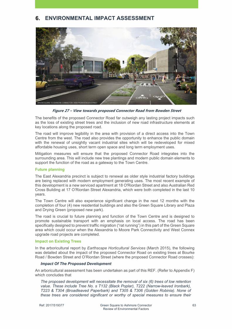
�
Ref: 2017/519377 Green Square to Ashmore Connector Review of Environmental Factors
63
ENVIRONMENTAL IMPACT ASSESSMENT
Figure�27�–�View�towards�proposed�Connector�Road�from�Bowden�Street�
The benefits of the proposed Connector Road far outweigh any lasting project impacts such as the loss of existing street trees and the inclusion of new road infrastructure elements at key locations along the proposed road.
The road will improve legibility in the area with provision of a direct access into the Town Centre from the west. The road also provides the opportunity to enhance the public domain with the renewal of unsightly vacant industrial sites which will be redeveloped for mixed affordable housing uses, short term open space and long term employment uses.
Mitigation measures will ensure that the proposed Connector Road integrates into the surrounding area. This will include new tree plantings and modern public domain elements to support the function of the road as a gateway to the Town Centre.
Future planning
The East Alexandria precinct is subject to renewal as older style industrial factory buildings are being replaced with modern employment generating uses. The most recent example of this development is a new serviced apartment at 18 O'Riordan Street and also Australian Red Cross Building at 17 O’Riordan Street Alexandria, which were both completed in the last 10 years.
The Town Centre will also experience significant change in the next 12 months with the completion of four (4) new residential buildings and also the Green Square Library and Plaza and Drying Green (proposed new park).
The road is crucial to future planning and function of the Town Centre and is designed to promote sustainable transport with an emphasis on local access. The road has been specifically designed to prevent traffic migration (“rat running”) in this part of the Green Square area which could occur when the Alexandria to Moore Park Connectivity and West Connex upgrade road projects are completed.
Impact on Existing Trees
In the arboricultural report by Earthscape Horticultural Services (March 2015), the following was detailed about the impact of the proposed Connector Road on existing trees at Bourke Road / Bowden Street and O’Riordan Street (where the proposed Connector Road crosses):
Impact Of The Proposed Development
An arboricultural assessment has been undertaken as part of this REF. (Refer to Appendix F) which concludes that
The proposed development will necessitate the removal of six (6) trees of low retention value. These include Tree No. s T132 (Black Poplar), T222 (Narrow-leaved Ironbark), T223 & T304 (Broadleaved Paperbark) and T305 & T306 (Golden Robinia). None of these trees are considered significant or worthy of special measures to ensure their

�
Ref: 2017/519377 Green Square to Ashmore Connector Review of Environmental Factors
64
ENVIRONMENTAL IMPACT ASSESSMENT
preservation. The removal of these trees to accommodate the proposed development is considered warranted in this instance.
The proposed development will also necessitate the removal of eight (8) trees of moderate retention value. These include Tree No. s T128 (Mugga Ironbark), T133 (Balsam Poplar) and T101, T129, T206, T207, T208 & T221 (Broadleaved Paperbark). These trees are not considered significant, but are in good health and condition and make a fair contribution to the amenity of the site and surrounding properties. In order to compensate for loss of amenity resulting from the removal of these trees to accommodate the proposed development, consideration should be given to replacement planting elsewhere within the road reserve.
The proposed development will also necessitate the removal of one (1) tree of high retention value, being T120, a Broadleaved Paperbark. This tree has no special ecological or heritage significance, but is in good health and condition and makes a positive contribution to the amenity of the streetscape. Given the limitations of the road alignment and design, there are no feasible alternatives that can be recommended that would permit the retention of this tree.
Proposed kerb and gutter and stormwater works are located within the TPZs of trees T204 & T218 (Narrow-leaved Ironbark), T106 (Broad-leaved Paperbark) and T108 (Balsam Poplar) of moderate retention value and T303 (London Plane) & T227 (Narrow-leaved Ironbark) of low retention value.
These works have the potential to result in an adverse impact on these trees. However, implementation of suitable tree protection measures prior to and during construction should avoid any adverse impact. About the trees at the Taxi Combined site, the City of Sydney property and the Perfect Autobody site, the following was assessed in TABLE 13.
TABLE�13�–�ASSESSMENT�OF�PRIVATE�PROPERTY�TREES�AFFECTED�BY�THE�GREEN�SQUARE�
TO�ASHMORE�CONNECTOR�ROAD�Address Description of existing trees
9-13 O’Riordan Street All are in fair health and condition however they will require removal to allow construction of the road. One (1) large dead tree is located along the southern boundary and should be removed irrespective of any proposed works.
20 and also 22 O’Riordan Street
The trees are all showing signs of stress and are in poor health. At least one of the trees will require removal for construction. Once the final design is completed a more detailed assessment of the site will be required to determine if additional trees will need to be removed.
44-54 Bourke Road
The trees are in good health and provide amenity and shade to the cars in the side car parking area and also for the staff outdoor area. Construction of the proposed Connector Road is likely to require the removal of at least one (1) tree. Once the final design is completed a more detailed assessment of the site will be required to determine if additional trees will need to be removed.
Rear of 44-54 Bourke Road
These trees are likely to have self-sown over time and will all require removal to allow for construction of the new road.
Contamination and Remediation
A Remediation Action Plan (RAP) for the Green Square to Ashmore Connector (former East West Relief Route) was prepared by Parsons Brinkerhoff in February 2016. The RAP identifies the following extent of contamination within the project area:
�
Ref: 2017/519377 Green Square to Ashmore Connector Review of Environmental Factors
65
ENVIRONMENTAL IMPACT ASSESSMENT
Lead impacts exceeding criteria were identified in shallow fill material along the full length of the proposed Connector Road and adjacent areas that were subject to intrusive investigation, extending to a depth of approximately 3 m Below Ground Level (BGL)
Asbestos contamination has been observed in the fill material across the Ausgrid site to a maximum depth of 2. 2 mBGL. Residual hydrocarbon impact is present at the Mobil property, in soil in localised areas to a depth of 3 mBGL and in groundwater within the Mobil site (20 O'Riordan Street) boundary
Groundwater in the vicinity of the Mobil property has been identified as being impacted by hydrocarbons and only limited groundwater assessment has been undertaken across the site. However, based on the details provided by the City, the maximum cut depth will be approximately 2. 5m on the eastern portion of the Ausgrid property, where groundwater depths are between 3. 5 mBGL and 5. 5 mBGL. Therefore, groundwater is not anticipated to be encountered during the construction work.
Based upon the assessment of available remedial technologies, the potential risks to human health and the environment and considering the cost effectiveness of each remedial technique, the recommended remedial strategy for site is managing the risks of the lead and asbestos-contaminated fill through a CEMP for the site during construction and ongoing management of asbestos-contaminated fill through capping and a revised Site Management Plan (SMP). Some excess material will require off-site disposal or reuse at another City of Sydney site under the JBS&G Consultants 2015, Excavated Materials Management Plan (EMMP) and in accordance with NSW Environment Protection Authority (EPA) approvals.
The selected remedial strategy is designed to render the site suitable for the proposed future use (Refer to Chapter 8 for mitigation measures).
Indigenous Heritage
6.6.1 Existing Environment
A search of the Aboriginal Heritage Information Management Systems identified that there are no recorded Aboriginal heritage sites or places of significance within proximity to the proposed study area.
The closest Aboriginal place is located within the suburb of Beaconsfield, about 700m to the south. Another Aboriginal site is located 380m east in Zetland.
Based on the REF for the Green Square Stormwater Drain (Sydney Water 2014), the following was recorded about the presence of Aboriginal sites and places within the Green Square area:
Aboriginal archaeological context
The AECOM / Aurecon Joint Venture searched the Aboriginal Heritage Management Information System (AHIMS) database for the entire project area on 29 January 2014 (AHIMS Search #123199) as part of a Heritage Assessment (AAJV, 2014e). As the project area contained no Aboriginal sites, they increased the search area to a five (5) km radius to cover the wider south Sydney area to appreciate the potential archaeological resources of the area.
The closest registered site to the project area is Shea’s Creek (AHIMS #45-6-0751), an artifact scatter with associated dugong bones. Shea’s Creek artefact scatter was identified in 1896 during works associated with the construction of Alexandra Canal, roughly due west of the end of Gardeners road Mascot, directly south of the project area.
Etheridge et. al. (1896) reported that dugong bones and axe heads were identified within a layer of sandy clay with interspersed marine shells. The site was identified, excavated and destroyed in 1896.
Areas of potential Aboriginal heritage sensitivity exist within 100m of previous watercourses including Shea’s Creek and the former Waterloo Swamp. However, The AECOM / Aurecon Joint Venture did not identify any Aboriginal archaeological sites
�
Ref: 2017/519377 Green Square to Ashmore Connector Review of Environmental Factors
66
ENVIRONMENTAL IMPACT ASSESSMENT
within the proposed Green Square Stormwater Drain corridor options and in-situ Aboriginal archaeological deposits are unlikely to occur in the identified layers of historic fill present across the proposed works area. On this basis, we have not consulted with Aboriginal stakeholders and do not require any further detailed Aboriginal heritage assessment.
6.6.2 Assessment
The proposed Connector Road exists in a significantly modified area that has limited potential for any remaining Aboriginal sites or places. Mitigation measures are recommended to ensure protection of previously unidentified Aboriginal archaeological items identified during the construction works.
Non Indigenous Heritage
6.7.1 Existing Environment
The proposed Connector Road study area exits in an older industrial area within the City of Sydney. There are number of heritage items within the vicinity of the proposed Connector Road but there are no directly impacted heritage items. Heritage items within a 500m radius of the site are listed in Table 14.
TABLE�14�–�HERITAGE�ITEMS�NEAR�THE�PROPOSED�CONNECTOR�ROAD�
Item Heritage�Listing Distance�from�the�
proposed�Connector�Road
Survey Alignment Mark, Botany Road Alexandria (Item No. 4309671)
Section 170 Register (Roads & Maritime Services )
Unknown but not within the proposed Connector Road study area
Beaconsfield Conservation Area
Sydney LEP 2012 100 m south
21 Queen Street Beaconsfield
Sydney LEP 2012 160m south
Hansard Street Conservation Area
Sydney LEP 2012 185m south east
10, 12, 15 and 24 Hansard Street
Sydney LEP 2012 170 – 200m south east
Portman Street Conservation Area
Sydney LEP 2012 300m northeast
Yu Ming Temple 16-22 Retreat Street
NSW State Heritage Register / Sydney LEP 2012
580 north
6.7.2 Assessment
The proposed Connector Road is unlikely to impact on nearby heritage items or conservation areas, which are located over 100m from the boundary of the study area. A Survey alignment mark was observed within the footpath at No. 330-332 Botany Road during a site visit undertaken in February 2015 and also another at 527 Botany Road but both are not the actual listed items as provided in the RMS Section 170 Register (Item No. 4309671). The construction of the road is also unlikely to impact on any nearby existing heritage items or conservation areas.
Flora and Fauna
6.8.1 Existing Environment
The proposed Connector Road study area has been significantly modified by previous and current urban development. This is supported in the Green Square Stormwater Drain REF (Sydney Water, 2014), which states:
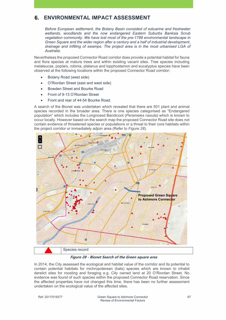
�
Ref: 2017/519377 Green Square to Ashmore Connector Review of Environmental Factors
67
ENVIRONMENTAL IMPACT ASSESSMENT
Before European settlement, the Botany Basin consisted of estuarine and freshwater wetlands, woodlands and the now endangered Eastern Suburbs Banksia Scrub vegetation community. We have lost most of the pre-1788 environmental landscape in Green Square and the wider region after a century and a half of industrial development, drainage and infilling of swamps. The project area is in the most urbanised LGA of Australia.
Nevertheless the proposed Connector Road corridor does provide a potential habitat for fauna and flora species at mature trees and within existing vacant sites. Tree species including melaleucas, poplars, robinia, platanus and lopphostemon and eucalyptus species have been observed at the following locations within the proposed Connector Road corridor:
Botany Road (west side)
O’Riordan Street (east and west side)
Bowden Street and Bourke Road
Front of 9-13 O’Riordan Street
Front and rear of 44-54 Bourke Road.
A search of the Bionet was undertaken which revealed that there are 501 plant and animal species recorded in the broader area. There is one species categorised as “Endangered population” which includes the Longnosed Bandicoot (Perameles nasuta) which is known to occur locally. However based on the search map the proposed Connector Road site does not contain evidence of threatened species or populations or a threat to their core habitats within the project corridor or immediately adjoin area (Refer to Figure 28).
Species record
Figure�28�-�Bionet�Search�of�the�Green�square�area�
In 2014, the City assessed the ecological and habitat value of the corridor and its potential to contain potential habitats for michropoterean (bats) species which are known to inhabit derelict sites for roosting and foraging e.g. City owned land at 20 O’Riordan Street. No evidence was found of such species within the proposed Connector Road reservation. Since the affected properties have not changed this time, there has been no further assessment undertaken on the ecological value of the affected sites.
Proposed Green Square to Ashmore Connector
�
Ref: 2017/519377 Green Square to Ashmore Connector Review of Environmental Factors
68
ENVIRONMENTAL IMPACT ASSESSMENT
Urban Ecology Strategic Action Plan
The Urban Ecology Strategic Action plan outlines the City of Sydney’s approach to biodiversity management over a five (5) year timeframe. The City’s Urban Ecology Strategic Action Plan raised concern that renewal areas, such as Green Square have the potential to impact on local ecology from the removal of thick weeds, long grass and ground debris.
This plan identified 6 (six) priority sites that contain relatively high biodiversity values. The closest priority site is Sydney Park, about 1 km west of the proposed Connector Road. The Urban Ecology Strategic Action Plan also nominates green corridors to link key ecological areas and other priority sites.
Based on the Green Square Stormwater Drain REF (Sydney Water Corporation, July 2014) which covers the proposed Connector Road study area, the following was recorded by Ecological Australia (ELA):
ELA completed a field investigation in February 2014. They inspected culverts and pipes in open drain channels to determine their potential as cave-roosting bat habitat.
The field investigation also included identifying hollow bearing trees or vegetation patches that provide potential roosting or foraging habitat for the Grey-headed Flying-fox.
A search of the OEH Bionet Wildlife Atlas shows a very low occurrence of threatened fauna species within the project area. The Green and Golden Bell Frog was recorded about 380m south (Epsom road and Link road intersection) in 1992 and 1993. This area has since been developed into high density residential apartments and it is unlikely that the frogs are still there. A very small population (estimated at less than 20) in a residential backyard south of the project area in Rosebery (City of Sydney, 2013).
While ELA found no insectivorous bats during the field investigations, potential roosting sites exist in cracks and gaps in culverts and drainage pipes entering the existing open drain at Alexandra Canal (2km south) and at Link Road/Epsom road (1 kilometre west).
Flora
The landscape within the project area is built up with many concrete surfaces and grounds that support lawn or weedy disturbed vegetation with no over or mid-storey. While ELA did not record any hollow-bearing trees during their field investigation, trees with flaking bark are abundant.
These may provide some roosting opportunities for bark-roosting bats. Street trees were predominantly broad-leaved Paperbark M. quinquenervia and Lombardy poplar (Populus nigra). Private property contained a variety of species with Eucalyptus and Chinese Celtis (Celtis sinensis) being most common.
An EPBC Act Protected Matters search incorporating a two (2) kilometre buffer zone surrounding the project identified two listed threatened ecological communities and 11 threatened species as potentially occurring within two (2) km of the project.
Register of significant trees
The City maintains a Register of Significant Trees that recognises and safeguards trees with historical, cultural or botanical importance. None of the 2,688 trees on the register are located within or next to the construction footprint of the project.
Noxious weeds
A total of 81 weed species have been recorded in the City of Sydney LGA from surveys conducted by the Australia Museum (2010-2011), including four (4) weeds of national significance, 13 weeds declared as noxious in the LGA, and 20 environmental weeds. Major weed infestations are prevalent in rail corridors and water easements, such as the pipeline easement next to Perry Park
Ramsar wetlands
�
Ref: 2017/519377 Green Square to Ashmore Connector Review of Environmental Factors
69
ENVIRONMENTAL IMPACT ASSESSMENT
The closest Ramsar wetland is the Towra Point Nature Reserve, which is located about 10 km south and downstream in Botany Bay. In 1984, Towra Point Nature Reserve was listed as an internationally important wetland under the Ramsar convention.
6.8.2 Assessment of Impact
Based on the ecological investigations undertaken as part of the proposed Connector Road and the Green Square Stormwater Drain projects, the road corridor has a low habitat value due to a lack of vegetation.
The site has been heavily modified and only contains remnant street trees as well as a few isolated patches on some privately owned sites.
Investigation undertaken by the City found no potential habitat sites for michropoterean species which are known to inhabit derelict sites for roosting and foraging e.g. City owned land at 20 O’Riordan Street. There was also no evidence found of such species within the proposed Connector Road reservation.
The following was recorded based on the Green Square Stormwater Drain REF (2014):
Field investigations did not find any of these threatened species or ecological communities.
The project will not have any impact on this, or any other Ramsar wetland.
Noxious weeds may be present in the project area.
A threatened species search of the OEH Wildlife Atlas database showed that no threatened flora have been recorded within the Project area.
Fauna habitat availability and value within the project area is generally very low. This is due to the highly modified nature of the project area which is dominated by the built environment. As most of the vegetation in the project area includes trees over mown lawn or mulch, with understorey vegetation sparse or absent, areas of structurally complex habitat are scarce or non-existent.
Fauna habitat availability and value within the project area is generally very low. This is due to the highly modified nature of the project area which is dominated by the built environment. As most of the vegetation in the project area includes trees over mown lawn or mulch, with understorey vegetation sparse or absent, areas of structurally complex habitat are scarce or non-existent. ELA did not record any Grey-headed Flying-fox during the field investigation.
As part of the Green Square Stormwater Drain REF (Sydney Water, 2014)…..ELA completed assessments of significance according to Section 5A of the EP&A Act. One Assessment of Significance (7-part-test) was done for cave dwelling bats and one for the Greyheaded Flying-fox. Construction of the project could have the following potential impacts to cave-dwelling bats:
impacts from strikes by construction machinery or from work blocking their roost site entry
stress induced impacts as a result of the work surrounding them.
The three (3) cave-roosting microbat species potentially using the project area are highly mobile, so losing potential foraging habitat is unlikely to increase the fragmentation or isolation of habitat for these species. Lost breeding or roosting habitat will be replaced by the construction of new culverts that contain similar roosting opportunities, so there is still potential local habitat for these species…. a site walkover in February 2014 by ELA did not identify any threatened bat species using these potential habitats.
The Grey-headed Flying-fox is known to move great distances (up to 50 km in one night) to exploit foraging opportunities. Potential habitat for the species was recorded within the project area in the form of street trees, park trees and trees on private land. The project will remove an estimated 80 trees that hold some foraging potential for this species including Fiscus species, Eucalyptus species and Melaleuca Species.

�
Ref: 2017/519377 Green Square to Ashmore Connector Review of Environmental Factors
70
ENVIRONMENTAL IMPACT ASSESSMENT
The assessment of significance concluded that it is unlikely that the project will have a significant impact given the abundance of comparable tree species surrounding the area.
The project involves removing potential roost habitat for cave-dwelling bats and foraging habitat for Grey-headed Flying-fox, which is inconsistent with the overall objectives of the Urban Ecology Strategic Plan. The plan targets protection of habitat within six (6) priority areas and other opportunities, such as smaller parks, schools and backyards.
Conclusions
The Project area is in a highly urbanised area characterised by commercial and industrial development. Despite the potential loss of habitat street trees, the project is unlikely to significantly affect threatened species. Implementing mitigation measures will make flora and fauna impacts from the project unlikely.
Based on the ecological investigations undertaken as part of the proposed Connector Road and the Green Square Stormwater Drain proejcts, no significant impact on existing species, populations or habitats as identified in the Threatened Species Conservation Act 1995 and the Commonwealth EPBC Act 1999 are likely to occur. There is also unlikely to impact on Ramsar wetlands which are located over 10 km away.
Tree planting (33 new trees) will create for future habitat for native birds, provided that a suitable lighting intensity is provided. The Urban Ecology Strategic Plan also nominates the Green Square Area as a having potential to establish habitat connectivity with other areas such Sydney Park.
Overall the proposed Connector Road will provide for an improved ecological outcome in the area with new opportunities for new tree planting and potential habitats for fauna and flora species.
Air Quality
6.9.1 Existing Environment
The air quality of the area is typical of inner industrial areas affected by high volumes of vehicle traffic, airline exhaust and also from industrial and manufacturing processes. The following was recorded with regard to air quality in the Sydney region (Air quality trends in Sydney, OEH 2014):
The Sydney region carbon monoxide, nitrogen dioxide, sulfur dioxide and lead concentrations are consistently well below national standards. Ambient levels of ozone and particles can exceed national standards in the Sydney region, with no definite downward trend in the concentrations of these pollutants apparent.
Total emissions of ozone precursors and particles have decreased in Sydney over the last decade despite the growth in vehicle activity, energy consumption, population and the economy. Reductions in on-road mobile source emissions have been significant over the last decade due to improved fuel quality and more stringent vehicle emission standards.
Despite reductions in vehicle emissions, transport remains a major source of air pollution in Sydney, being the largest source of oxides of nitrogen and carbon monoxide emissions and contributing significantly to total emissions of volatile organic compounds and fine particles.
Regional modelling for Sydney has indicated that the pattern of motor vehicle emissions is a major factor determining the timing and peak of ozone concentrations in the region.
The NSW air quality monitoring network operated by the Office of Environment and Heritage (OEH) is located to meet the requirements of the National Environment Protection (Ambient Air Quality) Measure (AAQ NEPM). The purpose of the network is to measure air quality that is representative of that experienced by the general population rather than peak pollution near an industrial site or busy road.
In general, air quality in Sydney is comparable with other Australian cities, and is relatively good if compared with other urban regions overseas. Concentrations of Carbon Monoxide, Nitrogen Dioxide, Sulfur Dioxide and Lead are low and stable, and

�
Ref: 2017/519377 Green Square to Ashmore Connector Review of Environmental Factors
71
ENVIRONMENTAL IMPACT ASSESSMENT
consistently meet the national air quality standards. However, ozone and particle (PM10 and PM2.5) levels can exceed the national standards from time to time locally or across the region, posing pollution-related health risks to local communities as well as the environment.
6.9.2 Assessment
The construction and operation of the proposed Connector Road has the potential to create short term and long term impacts on local and regional air quality. The excavation of the land impacted by the proposed Connector Road and associated crushing and grinding works could result in short term impacts to local air quality.
Once operational, up to 2,000 vehicles per day will use the proposed Connector Road which is being developed as a local access road that will be used by private cars and taxis, buses and a range trucks and delivery vehicles. As such local air quality will also be impacted by vehicle exhausts which in turn can contribute to impacts on human health.
The predicted traffic represents a very low percentage of the total vehicle exhaust directly attributable to the proposed Connector Road as compared to the total traffic movements in the City of Sydney area and broader region.
The City is also proposing up to 33 trees to be placed along the proposed Connector Road which will provide will improve local air quality through carbon dioxide absorption and also by trapping airborne particles, dust and the toxins that mostly come from diesel exhausts.
Air quality mitigation measures will be implemented during the construction stage to reduce dust impacts, which has emerged as a key air quality concern with the redevelopment of the Town Centre. Such measures may include covering of stockpiles, watering of stockpiles during windy days and turning off construction equipment when not in use. These practical measures can help reduce impacts on the local air quality.
Natural Hazards
6.10.1 Existing Environment
The site is located in a flood plain area which is subject to high depth flooding the 20 year and also the 100 year flood event.
There is no significant bushland within the proposed Connector Road corridor or broader areas and the land is also not impacted by naturally occurring acid sulfate soils which is located on land to the north (Class 4).
Geotechnical assessments have confirmed that the land is not subject to landslip or subsidence.
There is potential for significant flooding during the construction stage could result in an increased safety risk for construction workers and adjoining occupied buildings. Recently in Harris Park Sydney (April 2015) a sinkhole emerged when a large volume of water filled up an adjoining vacant development site, which undermined the structural footings of and forced the temporary relocation of residents from an adjoining three-storey residential building. The sinkhole threat required immediate work to strengthen footings and prevent building collapse.
Based on the Remediation Action Plan4 for the proposed Connector Road, the following was concluded in relation to groundwater:
Groundwater in the vicinity of the Mobil property has been identified as being impacted by hydrocarbons and only limited groundwater assessment has been undertaken across the site. However, based on the details provided by the City the maximum cut depth will be approximately 2.5 m on the eastern portion of the Ausgrid property, where groundwater depths are between 3.5 mBGL and 5.5 mBGL. Therefore, groundwater is not anticipated to be encountered during the construction work.
6.10.2 Assessment
4 Remediation Action Plan for the East West Relief Route, Parsons Brinckerhoff 2016

�
Ref: 2017/519377 Green Square to Ashmore Connector Review of Environmental Factors
72
ENVIRONMENTAL IMPACT ASSESSMENT
The Green Square Stormwater Drain (City and Sydney Water) is being developed to address catchment flooding in the area (20 year event) and will be mostly completed prior to the opening of the proposed Connector Road in 2020.
The hydrological assessment of the proposed Connector Road has identified that even with the Green Square Stormwater Drain, there will be minor depth flooding at the proposed new intersection with Bourke Road. This minor flooding impact which should not impact on the access and safety of commuters and further design work will occur during detailed design to address this issue.
During construction there is potential for sinkholes or impacts to adjoining buildings usually to occur after significant rainfall at construction sites which closely adjoin existing buildings. A mitigation measure is recommended to minimise potential impacts to protect the construction footings of adjoining buildings.
Construction and design mitigation measures are included to protect the structural footings of adjoining development sites prior to construction as well as monitoring of adjoining buildings during construction.
Climate Change
6.11.1 Existing Environment
Scientific evidence suggests that the climate of Australia is changing due to man-made activities such as industry, transport and related fossil fuel consumption. This is resulting in prolonged drought periods, higher maximums and minimum temperatures, increasing heatwave periods and at times more intense rainfall. There is also associated sea level rise anticipated due to the melting of ice caps and glaciers.
The other relevant issue related to climate is the “heat island effect”, which occurs in a metropolitan area which has a significantly warmer climate than its surrounding rural area The heat island effect is largely due to human activities such as urban development replacing vegetation with hardstand area. Concrete and asphalt are the main contributors to the heat island effect.
6.11.2 Assessment
Climate change and the associated impacts caused by the heat island effect are relevant to the proposed new road. Whilst there is no attributable increase in hardstand area with the project, there is potential for a minor contribution to the impacts climate change due to a potential increase in the use of fossil fuels from vehicle exhaust. There is also a smaller contribution from construction.
There is no increase in total hardstand areas than what currently exists within the proposed road corridor. The planting of 33 trees will provide for cooling during summer arising from shading of the street, which should minimise the impacts associated with the heat island affect in the local area.
Socio Economic
6.12.1 Existing Environment
The area surrounding the proposed Connector Road is similar to other inner Sydney industrial areas due to its abundance of older style warehousing mixed with modern industry, warehousing and offices and residential. The Southern Employment Lands which includes the East Alexandria Precinct, has limited residential zoned land. Beaconsfield is the only nearby contiguous residential area which contains modern apartments and older style worker cottages. There are also some pockets of housing along O’Riordan Street, just south of the proposed Connector Road.
Due to its location between the central Sydney and the airport, the area experiences a high level of through traffic (up to 3,000 vehicles per hour on Botany Road / O’Riordan Street) which affects the amenity of the area. However outside of daytime and peak periods, the environment changes as the area becomes quieter.
The presence of an existing rail line and station and Green Square, as well as a number of regional and local bus routes, allows for good access into and out of the area to the City,
�
Ref: 2017/519377 Green Square to Ashmore Connector Review of Environmental Factors
73
ENVIRONMENTAL IMPACT ASSESSMENT
airport and also Port Botany. East west access through the area is quite challenging due to a lack of continuous road connections from the Inner West to the Eastern Suburbs.
Due to the industrial nature of the East Alexandria precinct, there is a general lack of community facilities and open spaces, with only two (2) parks (Perry Park and Beaconsfield Park) in the immediate area.
6.12.2 Economic Assessment
The proposed Connector Road route directly results in the loss of 1 hectare of employment zoned land in the South Employment Lands, which is regarded by the City as one of the main employment areas in the LGA.
The loss of employment generating land represents less than 1% of the total employment generating in the Southern Employment lands (230 hectares). Further most of this land is either presently vacant or operates on a short term lease (City owned land). Essentially there is only one (1) directly impacted operating business (Hoya Lens) that will relocate from their present site before construction of the road is planned to commence in 2019. An assessment of the directly impacted operating properties is provided below.
City of Sydney Property at 44-54 Bourke Road
The proposed Connector Road impacts one operating businesses (Hoya Lens), which currently employs 50 people and has been operating at this site for over 20 years.
The impact on the City of Sydney property, which is leased to Hoya Lens, represents a small loss of employment generating land (4,000 sqm) and the kind of employment which is well suited to the area.
In 2016, the City purchased the Hoya Lens property, who plan to relocate from their site prior to the planned construction of the road. The residue lands (two sites) at the Hoya Lens property will be developed for short term public open space and recreational uses, before they are redeveloped into employment generating uses once adjoining lands redevelop.
Taxis Combined Site
The project impacts the Taxis Combined site at 9-13 O’Riordan Street which contains an operating taxi depot. The proposed area of impact is 521 sqm which is located at the southeastern corner of the site. This area contains a parking area, accessway and entrance to a maintenance depot (Refer to Figure 29). The area of impact affects an existing access and service driveway to the site with no significant impacts to current buildings.
The City will continue to work with the Taxis Combined to minimise impact on their business during construction and once the road has been opened in 2020.
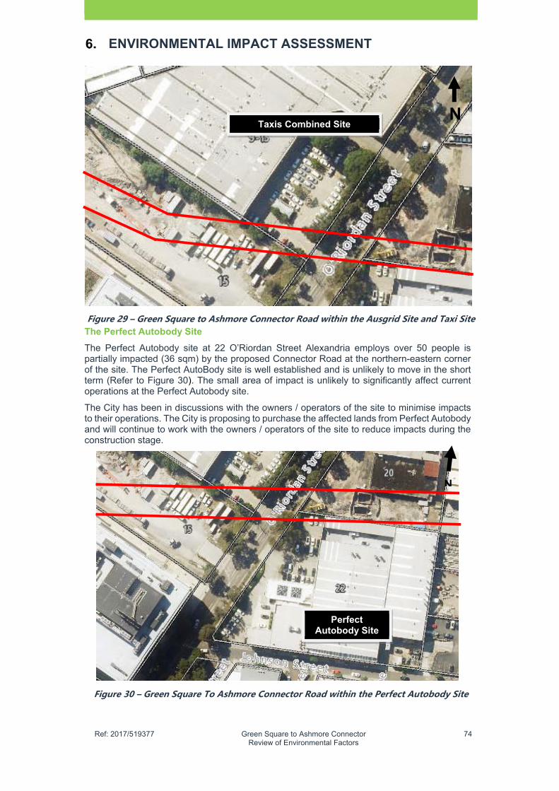
�
Ref: 2017/519377 Green Square to Ashmore Connector Review of Environmental Factors
74
ENVIRONMENTAL IMPACT ASSESSMENT
Figure�29�–�Green�Square�to�Ashmore�Connector�Road�within�the�Ausgrid�Site�and�Taxi�SiteThe Perfect Autobody Site
The Perfect Autobody site at 22 O’Riordan Street Alexandria employs over 50 people is partially impacted (36 sqm) by the proposed Connector Road at the northern-eastern corner of the site. The Perfect AutoBody site is well established and is unlikely to move in the short term (Refer to Figure 30). The small area of impact is unlikely to significantly affect current operations at the Perfect Autobody site.
The City has been in discussions with the owners / operators of the site to minimise impacts to their operations. The City is proposing to purchase the affected lands from Perfect Autobody and will continue to work with the owners / operators of the site to reduce impacts during the construction stage.
Figure�30�–�Green�Square�To�Ashmore�Connector�Road�within�the�Perfect�Autobody�Site�
Taxis Combined Site
Perfect Autobody Site
N
N

�
Ref: 2017/519377 Green Square to Ashmore Connector Review of Environmental Factors
75
ENVIRONMENTAL IMPACT ASSESSMENT
Other properties
There will be no economic impact to existing sites at 330 – 332, 334 – 336 and 338 Botany Road and also 20 O'Riordan Street, which are owned by the City and are presently vacant.
The Ausgrid site has been vacant for some time and there is no loss of employment due to the proposed Connector Road. The City will work with Ausgrid to confirm access during the construction stage and once the Ausgrid site redevelops.
6.12.3 Social Assessment
As previously discussed in Chapter 3, the City is working to achieve the sustainable renewal of residue lands located at the eastern section to provide two (2) mixed use affordable housing developments. This will include a 200 unit affordable housing development on the northern residue lands and a 100 unit affordable housing development on the southern residue lands. This aligns with Sustainable Sydney 2030 and its objective to achieve more affordable housing options in the LGA.
There are substantial social benefits that the proposed road will provide to existing and future workers and residents, which includes safer and more accessible pedestrian and cycle routes to key transport locations and services in the area. The road is unlikely to generate any negative social impacts to nearby residential areas located to the south. It will also lead to increased urban activity and overall safety in the area.
The proposed Connector Road is unlikely to impact on nearby residential areas in Queen Street and Johnson Street and also southeast in Hansard Street. The proposed Connector Road also does not impact any existing social or community facilities and key public domain and open space areas in the East Alexandria Precinct.
Waste
6.13.1 Existing Environment
There is a potential for waste generation as a result of the construction of the proposed Connector Road works arising mostly demolition and excavation works. There is also general waste arising from construction. There is a current excess cut generated from the project which will need to be managed.
The City is committed to recycling and reusing 80 percent of waste generated during construction and this remains a priority with this project. Proposed open space areas at the western section may also provide an option for the sustainable management of the current excess cut with the project through the use of landscaped mounds etc.
The proposed Connector Road has the potential to generate waste during the construction and appropriate mitigation measures are provided in Chapter 8 which includes the preparation of waste management plan.
Chemical and hazardous substance management
The City’s preferred treatment system for the road is based on a filtration (e.g. sand filters) as opposed to chemical treatment. In the event a preferred operator nominates a chemical treatment for facility, compliance with OEH Guidelines would be required.
Future Land Use
The proposed Connector Road is being delivered in accordance with the City’s future plans to transform East Alexandria precinct into a vibrant mixed use area with modern employment generating uses, affordable housing and new public domain spaces in accordance with the Sydney DCP 2012 and Sydney LEP 2012.
The eastern section of the road will be redeveloped into two (2) mixed affordable housing developments and retail area with good quality public domain that will align with the Town Centre. The residue lands at the western section will also be transformed as redevelopment occurs on adjoining sites. In the short term they will be delivered for use as public open space and outdoor recreation uses.
Cumulative Impacts
�
Ref: 2017/519377 Green Square to Ashmore Connector Review of Environmental Factors
76
ENVIRONMENTAL IMPACT ASSESSMENT
The delivery of the proposed road has the potential to result in cumulative impacts. This will largely occur during the construction stage due to other proposed development occurring in the area such as the redevelopment of the residue lands for affordable housing and also redevelopment in the Town Centre. Collectively the proposed Connector Road and nearby redevelopment sites could result in increased cumulative impacts related to traffic, noise and air quality impacts on the local area arising from construction.
To address relevant issues, the City will work with other developers as part of a construction liaison group similar to what is presently being undertaken in the Town Centre. This group would coordinate construction of each project to minimise associated impacts on the local area, especially to existing businesses adjoining the proposed Connector Road.
Once operational, the predicted daily traffic of 2,000 vehicle movements per day along the proposed Connector Road is unlikely to significantly add to total traffic volumes in the surrounding area or place significant strain on the surrounding area and / or local environment.

�
Ref: 2017/519377 Green Square to Ashmore Connector Review of Environmental Factors
77
ENVIRONMENTAL FACTORS CONSIDERED
Consideration of Clause 228 Factors
Clause 228 of the NSW Environmental Planning & Assessment Regulations 2000 details those factors that must be taken into account concerning the impact of an activity on the environment. Table 15 provides an assessment of the Clause 228 factors in relation to the proposed Green Square to Ashmore Connector.
TABLE�15�–ASSESSMENT�OF�CLAUSE�228�FACTORS�
Clause�� � Impact�
� � � � � N/A� Negative� Nil� Positive�(a) any environmental impact on a community � Comment�The proposed Connector Road study area exists in a significantly modified urban area and will not result in any environmental impact on a community. The project will involve public domain and additional street tree planting to provide a positive contribution to the environment. The project includes WSUD measures to manage urban runoff.
(b) any transformation of a locality �
Comment The proposed Connector Road has long been identified as a transport strategy to improve access to the Town Centre. The road provides an opportunity for sustainable urban renewal in this part of the East Alexandria Precinct to provide affordable housing and employment generating uses. The area will also be enhanced with streetscape and public domain improvements such as tree planting.
(c) any environmental impact on the ecosystems of the locality
�
Comment The proposed Connector Road study area exists in a significantly modified urban area with very limited natural environmental areas or values. There are no identified threatened species or habitats and no impacted heritage items within the proposed Connector Road project area.
(d) any reduction of the aesthetic recreational scientific or other environmental quality or value of a locality
�
Comment The study area has been significantly modified by previous and current development and lacks any aesthetic recreational and scientific value or other environmental quality. There are no identified threatened species or habitats and no impacted heritage items within the proposed Connector Road project area.
(e) any effect on a locality place or building having aesthetic anthropological archaeological architectural cultural historical scientific or social significance or other special value for present or future generations
�
Comment The study area has been significantly modified by previous and current development and is unlikely to have any effect on a locality place or building having aesthetic, anthropological, archaeological, architectural or cultural historical scientific or social significance or other special value for present or future generations. Clause�� Impact�

�
Ref: 2017/519377 Green Square to Ashmore Connector Review of Environmental Factors
78
ENVIRONMENTAL FACTORS CONSIDERED
� N/A� Negative� Nil� Positive�(Continued) There are no identified threatened species or habitats and no impacted heritage items within the proposed Connector Road project area.
(f) any impact on the habitat of protected fauna (within the meaning of the National Parks and Wildlife Act 1974)
�
Comment The proposed Connector Road exists in a significantly modified urban environment that does not contain any habitat of protected fauna.
(g) Any endangering of any species of animal, plant or other form of life whether living on land in water or in the air
�
Comment The proposed Connector Road exists in a significantly modified urban environment that does not contain any habitat of protected fauna. Proposed tree planting along the proposed Connector Road has potential for additional habitat for tree dwelling fauna, especially airborne species.
(h) any long-term effects on the environment �
Comment The proposed Connector Road is proposed as a transport solution to improve access in the area and promote urban renewal for mixed employment and affordable housing uses. Whilst there will be short term construction impacts and ongoing impacts to local air quality, proposed tree planting will offset any resulting increase in vehicle exhaust fumes, and mitigation measures will alleviate environmental impacts during construction.
(i) any degradation of the quality of the environment
�
Comment The proposed Connector Road exists in a significantly modified urban environment with limited environmental qualities and is unlikely to result in any degradation to the quality of the environment.
(j) any risk to the safety of the environment �
Comment The proposed Connector Road will not provide any risk to the safety of the environment, rather it will improve local road and transport access to the Town Centre. Mitigation measures (Refer to Chapter 8) will minimise potential environmental impacts The Green Square Stormwater Drain and detailed design and construction will reduce any potential flooding impacts in the Green Square area.
(k) any reduction in the range of beneficial uses
Comment�The proposed Connector Road will not result in the range of beneficial uses of the environment but will support sustainable urban renewal of the area to provide enhanced opportunity for employment generating and affordable housing uses. The road will provide for an increase in sustainable transport use and public domain enhancements will provide increased value to the area. The proposed road will ensure long term access improvements in the area. Clause��
�
Ref: 2017/519377 Green Square to Ashmore Connector Review of Environmental Factors
79
ENVIRONMENTAL FACTORS CONSIDERED
�N/A� Negative� Nil� Positive�
(l) any pollution of the environment �
Comment The proposed Connector Road will result in a minor increase in air pollution during the construction stage and also from vehicle exhausts once the road opens in 2020. Proposed WSUD measures will improve catchment water quality and inclusion of sustainable transport measures will air pollution from excessive car use. The Green Square Stormwater Drain is also being delivered to address catchment flooding in the area.
(m) any environmental problems associated with the disposal of waste
�
Comment�A Waste Management Plan will be prepared to properly document and dispose of waste generated during the construction stage. Once operational the proposed Connector Road is unlikely to generate significant waste.
(n) any increased demands on resources (natural or otherwise) that are or are likely to become in short supply
�
Comment�The road will be used by up to 2,000 vehicles per upon opening. This is a very small increase in the total amount of traffic in the Green Square area which is unlikely to generate additional resources during construction. The operation of the road will not result in a significant amount of resources at the year of opening in 2020.
(o) any impact on coastal processes and coastal hazards including those under projected climate change conditions.
�
Comment�The project is located over two (2) km from the coast at Alexandra Canal (Cooks River) and is unlikely to impact on coastal processes.
Ecologically Sustainable Development
In accordance with Section 6 of the Protection of Environment Operations Act 1997 Schedule 2 of the Regulations, ecologically sustainable development (ESD) principles must be addressed in decision-making processes relating to proejcts approved and assessed under the EP&A Act.
The City has incorporated ESD principles in the concept design development and assessment of the proposed Connector Road. Firstly the design of the project as a local access road will result in less vehicle use and less potential for environmental impact. Secondly the design also includes tree planting, provision for sustainable transport and WSUD measures to further lessen its environmental impact.
Furthermore there are also a number mitigation measures that will be implemented to reduce further environmental impact during construction. ESD measures would be achieved through the implementation of the following principles and programs which are assessed in Table 18.
�
Ref: 2017/519377 Green Square to Ashmore Connector Review of Environmental Factors
80
TABLE�16�–ASSESSMENT�OF�ESD�PRINCIPLES��
ESD Principles Comment on Proposed Activity
(a) the precautionary principle—namely, that if there are threats of serious or irreversible environmental damage, lack of full scientific certainty should not be used as a reason for postponing measures to prevent environmental degradation. In the application of the precautionary principle, public and private decisions should be guided by: careful evaluation to avoid, wherever practicable, serious or irreversible damage to the environment, and an assessment of the risk-weighted consequences of various options,
The proposed Connector Road is an important part of a strategy by the City to improve road and transport access to the Town Centre. This REF has assessed relevant engineering, environmental and planning issues and concluded that the project is unlikely to lead to irreversible damage to the environment. Whilst there is a slight increase in traffic movements, the project benefits provided such as improved sustainable transport options, will lead to less reliance on car use for local trips. The sustainable renewal of the residue lands will also lead to improved urban design outcomes and increased activity in the area. Construction and operation mitigation measures provided in Chapter 8 will reduce potential environmental impacts. The City will also ensure that the road is operated in an environmentally sustainable manner once it opens in 2020.
(b) inter-generational equity—namely, that the present generation should ensure that the health, diversity and productivity of the environment are maintained or enhanced for the benefit of future generations
The road is unlikely to impact on future generations. The road has been assessed to have a low environmental impact provided mitigation measures are implemented and the design is delivered. The proposed Connector Road is a key part of the strategy to transform the East Alexandria precinct into a mixed employment and affordable housing area with good quality access and public domain.
(c) conservation of biological diversity and ecological integrity—namely, that conservation of biological diversity and ecological integrity should be a fundamental consideration.
The study area has limited ecological value but proposed local planting of trees and shrubs will enhance local biodiversity.
(d) improved valuation, pricing and incentive mechanisms—namely, that environmental factors should be included in the valuation of assets and services, such as:
The proposed Connector Road will provide improved road and transport access to the Town Centre with enhance sustainable transport options.
ESD Principles Comment on Proposed Activity
(d) continued (i) polluter pays—that is, those who
generate pollution and waste
There will a short term demand for resources during construction but overall the anticipated 2,000 vehicles per day will

�
Ref: 2017/519377 Green Square to Ashmore Connector Review of Environmental Factors
81
ENVIRONMENTAL FACTORS CONSIDERED
should bear the cost of containment, avoidance or abatement,
(ii) the users of goods and services should pay prices based on the full life cycle of costs of providing goods and services, including the use of natural resources and assets and the ultimate disposal of any waste,
(iii) environmental goals, having been established, should be pursued in the most cost effective way, by establishing incentive structures, including market mechanisms, that enable those best placed to maximise benefits or minimise costs to develop their own solutions and responses to environmental problems.
not generate significant traffic movements as compared to the total vehicle movements in the broader region. Specific WSUD measures and tree planting for the proposed Connector Road will ensure that the road operates with a lesser environmental impact.
Requirements of the Director General of the NSW Department of Planning & Environment
There are no relevant Director-General of the NSW Department of Planning & Environment guidelines which need to be considered given its likely impact of an activity on the environment, in relation to proposed activity.
Consideration of National Environmental Significance
The site is not classified as “National Environmental Significance” under the Commonwealth Environment & Biodiversity Conservation Act 1999. NES matters are assessed in Appendix G.

�
Ref: 2017/519377 Green Square to Ashmore Connector Review of Environmental Factors
82
This Page Intentionally Left Blank

�
Ref: 2017/519377 Green Square to Ashmore Connector Review of Environmental Factors
83
SUMMARY OF MITIGATION MEASURES
This Chapter describes how the proposal will be managed, via environmental management plans and specific safeguards, to reduce the potential environmental impacts throughout detailed design, construction and operation.
Safeguards and mitigation measures have been developed in accordance with the Clause 228 Guidelines. Section 8.2 includes a comprehensive list of safeguards and mitigation measures including general measures from the Clause 228 Guidelines. Section 8.3 identifies any relevant licences and approvals required to fulfill the City’s legislative responsibilities during the delivery of the proposal.
Construction environmental management plans
A CEMP would be prepared in accordance with the requirements of Council’s Environmental Management System for the construction phase of the project. The CEMP provides a mechanism through which all potential environmental impacts relevant to the proposal will be controlled and outlines a framework of procedures and controls for managing environmental impacts during construction.
Safeguards and mitigation measures
Environmental safeguards of the proposal are listed in Table 17. These safeguards would minimise the potential adverse engineering, environmental and planning impacts of the proposal described in Chapter 3 and assessed in Chapter 6.
TABLE�17�–ENVIRONMENTAL�SAFEGUARDS�/�MITIGATION�MEASURES�General An appropriately qualified and experienced site-based environmental manager will be
appointed prior to the commencement of construction to oversee the implementation of key plans and environmental controls associated with the project
The City will prepare a Construction Environmental Management Plan that provides an overall management of the potential construction environmental impacts with the project. The CEMP will include necessary subplans as identified in Table 17.
A project risk assessment including environmental aspects and impacts will be undertaken prior to the commencement of construction with a strategy developed to mitigate all risks as required.
The City to investigate at 2.5% grade for footpaths in accordance with the Sydney streets technical specification
Notification of surrounding properties of construction activities and temporary traffic management arrangements will be undertaken at key intervals throughout construction
The City establish a construction liaison group with the developers of the adjoining affordable housing development sites to coordinate construction and reduce potential environmental impacts during construction
The City to prepare detailed designs for three (3) parks to be provided on the residue lands which must be approved by the Manager Aquatic Greening and Leisure prior to construction. The park will included facilities for local recreational enjoyment and may include earth mounds to manage excess cut from the project.
The City will provide service and maintenance access during construction and operation to the telecommunications tower at the northern part of the Ausgrid site at 15 O’Riordan Street
The City will work with Taxis (9-13 O'Riordan Street) to minimise impacts on the operations of this site during construction and once the road is operational.
The City will work with Perfect Autobody (22 O'Riordan Street) to minimise impacts on the site’s core operations during construction and once the road is operational.
The City will work with Ausgrid (15 O'Riordan Street) to minimise impacts on the site’s core operations during the construction and once the road is operational.

�
Ref: 2017/519377 Green Square to Ashmore Connector Review of Environmental Factors
84
SUMMARY OF MITIGATION MEASURES
Traffic Pre-Construction� The City will consult with both the Taxis Site (9-13 O'Riordan Street), Ausgrid site (15
O'Riordan Street) and Perfect AutoBody (22 O'Riordan Street) to confirm a preferred access arrangement during construction of the road
Signage placed at entrances / exits to alert truck drivers to the designated entry and exit points
Prior to the commencement of construction, a detailed Construction Traffic Management Plan (CTMP) is to be prepared by the Principal Contractor. The CTMP would include the guidelines, general requirements and procedures to be used when activities or areas of work have a potential impact on existing traffic arrangements. The approval of the CTMP is to be sort by the appropriate authorities.
The CTMP, at a minimum, will address the following: consultation with the consent Authorities and relevant approvals consultation with State Transit Authority to minimise impacts on existing bus
movements the likely construction vehicle numbers and frequency approach and departure routes anticipated special out of hours or escorted deliveries parking access arrangements during construction construction work zone locations site entry and exit points proposed traffic control signage proposed traffic management at critical locations provision of acceptable pedestrian management measures. The Principal Contractor will implement, update and maintain the CTMP throughout
the construction period and until completion. Communications Plan
The Principal Contractor(s) is to prepare a communication plan to manage and provide updates to businesses and residents on in the immediate vicinity throughout the works. Appropriate site, warning and wayfinding signage are to be provided as necessary and existing businesses and residents at to be notified of the upcoming works potentially impacting on access.
The Principal Contractor(s) is to provide a designated person(s) as a point of contact at all times prior to and during the works, which would permit residents and others to advise of any particular concerns and/or access requirements. This would be undertaken prior to the proposed Connector Road occupancy or speed restriction application, which would, by implication, require consultation and notifications in excess of 10 days prior to the proposed start of works.
A summary of the key notifications and timeframes follows: Notifying emergency services and relevant sections of the community and transport
industry: For works, which result in significant traffic disruption, such as stop/go operation
and diversions, an appropriate advertisement would be placed in local newspapers one (1) week prior to the works. The timing of the notice would be dependent on authority approvals / agreement that the works may proceed.
This may be supplemented by VMS notifying of upcoming works, where warranted. Emergency service providers would be notified, once road occupancy approval is
granted. The local Police Traffic Officer would be advised on the any traffic changes

�
Ref: 2017/519377 Green Square to Ashmore Connector Review of Environmental Factors
85
SUMMARY OF MITIGATION MEASURES
and speed zoning authorisations, in particular. For works with more significant traffic impacts, prior consultation with ambulance service, fire brigade and Police would be undertaken to confirm agreement and any particular requirements, before submitting the road occupancy application.
Notifying residents and businesses affected by disruption to property access or by night works:
For works adjacent to roads but not affecting access, a letter box-drop at least three (3) working days before the proposed date.
For works restricting access, requiring detours or side tracks, a letter box drop at least 5-10 working days before the proposed date.
Notifications would detail the dates and times of the proposed access restrictions and a designated contact.
Lodging any road occupancy licence application and speed zoning authorisation, as early as possible (not less than 10 working days before the work) for any major works.
Noting, however, there may be exemptions for emergencies and hazards requiring an initial response, prior to emergency services arriving on site.
Promptly advising the City/Roads & Maritime Services Traffic Management Centre of any unexpected delays or incidents affecting Bourke Road.
Work with other contractors working on developments in the Town Centre precinct to minimise traffic conflict and congestion that may occur due to the cumulative increase in construction vehicle traffic.
Construction
No construction vehicles are to use Geddes Avenue, Wyndham Street, Johnson Street or Maddox Street to access the site. In addition construction traffic must not access the site via Elizabeth Street, Hansard Street and Joynton Avenue.
Vehicles routes should generally be via O'Riordan Street, Botany Road, Bourke Road and Bowden Street.
Access to the works sites will be directly from Bourke Road, O’Riordan Street and Botany Road.
No idling of trucks in residential streets prior to 7.00 am before site construction commences
Hydrology�and�flooding�Pre�–�Construction�� The City will undertake further hydrological modelling to minimise the flooding risk within
the corridor that considers the following options: Connection of the street drainage system to the Green Square Stormwater Drain with
a maximum discharge of 2.3 m3/s from the street to the trunk drain local drainage upgrades near the area of impact raising the road level at Bowden Street and Bourke Road an appropriate overland flow path within the road corridor.
Preparation of a flood emergency response plan as part of the CEMP for the site that identifies a flood-free area for evacuation of personnel and potentially construction equipment.
Noise�and�Vibration Pre-Construction
It is recommended that a site specific Construction Noise and Vibration Management Plan ('CNVMP') as part of the CEMP which should include noise modelling of construction activities after the exact selection of equipment to be used on-site becomes available.

�
Ref: 2017/519377 Green Square to Ashmore Connector Review of Environmental Factors
86
SUMMARY OF MITIGATION MEASURES
The following at-source control and management measures should be considered for the management of noise from excavation and construction works to reduce potential noise impacts. Noise reductions of between 3-8dB(A) for individual plant items could be expected where alternative process or localised noise barriers are practical. In other area, the management measures are focused on minimising unnecessary noise generation from the site and the extent and duration of peak noise levels.
Measure Detail Source controls
Noise barriers Construction of solid site hoarding along the corridor is unlikely to be practical or feasible. Noise barriers would provide some noise reduction to ground level receptors only. Where possible, localised barriers could be constructed for stationary equipment.
Equipment selection Use the quietest and least vibration emitting construction methods where feasible and reasonable, e.g. use of eccentric rippers rather than rock hammers.
Limit equipment in use
Only the equipment necessary for the upgrade works will be used at any time. Avoid any unnecessary noise when carrying out manual operations and when operating plant. Simultaneous operation of noisy plant and equipment within discernible range of a sensitive receiver should be avoided/ limited where possible.
Limit activity duration Any equipment not in use for extended periods shall be switched off. For example, heavy vehicles should switch engines off whilst being unloaded.
Reversing alarms Alternatives reverse alarm, such as ‘quackers’ should be installed where feasible and reasonable.
Management measures
Implement community consultation measures
Inform community of construction activity and potential impacts.
Develop good relations Good relations with building occupants should be established at the beginning of the works and be maintained throughout the project, as this is of paramount importance. Keeping people informed of progress and taking complaints seriously and dealing with them expeditiously is critical. The person selected to liaise with the building occupants should be adequately trained and experienced in such matters.
Work staging Where practical, stage works so that that intrusive works are carried out at least noise sensitive periods.
Site inductions All employees, contractors and subcontractors are to receive a Project induction. The environmental component may be covered in toolboxes and must include: • all relevant project specific and standard noise and vibration
mitigation measures • relevant licence and approval conditions • permissible hours of work • any limitations on high noise and vibration generating activities • location of nearest sensitive receivers • environmental incident procedures
Complaints management procedure
A management procedure would need to be put in place to deal with noise complaints that may arise from construction activities. Each complaint would need to be investigated and appropriate noise amelioration measures put in place to mitigate future occurrences, where the noise in question is in excess of allowable limits.
Noise monitoring A monitoring schedule is recommended to be developed and implemented during high noise and vibration generating activities where required. Noise and vibration monitoring would be carried out for any identified sensitive works, where monitoring could be used to
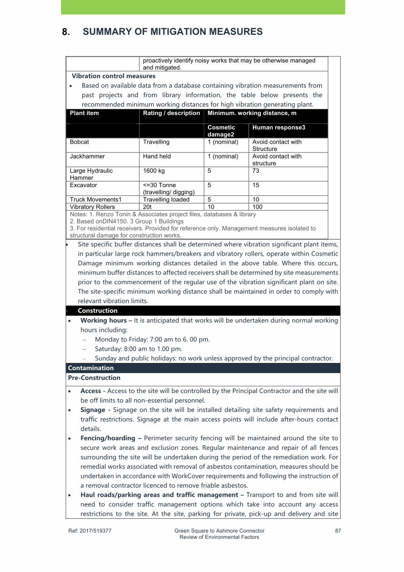
�
Ref: 2017/519377 Green Square to Ashmore Connector Review of Environmental Factors
87
SUMMARY OF MITIGATION MEASURES
proactively identify noisy works that may be otherwise managed and mitigated.
Vibration�control�measures� Based on available data from a database containing vibration measurements from
past projects and from library information, the table below presents the recommended minimum working distances for high vibration generating plant.
Plant item
Rating / description Minimum. working distance, m
Cosmetic damage2
Human response3
Bobcat
Travelling 1 (nominal) Avoid contact with Structure
Jackhammer
Hand held 1 (nominal) Avoid contact with structure
Large Hydraulic Hammer
1600 kg 5 73
Excavator <=30 Tonne (travelling/ digging)
5 15
Truck Movements1 Travelling loaded 5 10 Vibratory Rollers 20t 10 100 Notes: 1. Renzo Tonin & Associates project files, databases & library 2. Based onDIN4150. 3 Group 1 Buildings 3. For residential receivers. Provided for reference only. Management measures isolated to structural damage for construction works.
Site specific buffer distances shall be determined where vibration significant plant items, in particular large rock hammers/breakers and vibratory rollers, operate within Cosmetic Damage minimum working distances detailed in the above table. Where this occurs, minimum buffer distances to affected receivers shall be determined by site measurements prior to the commencement of the regular use of the vibration significant plant on site. The site-specific minimum working distance shall be maintained in order to comply with relevant vibration limits.
Construction Working�hours�– It is anticipated that works will be undertaken during normal working
hours including: Monday to Friday: 7:00 am to 6. 00 pm. Saturday: 8:00 am to 1.00 pm. Sunday and public holidays: no work unless approved by the principal contractor.
Contamination��Pre-Construction��
Access�- Access to the site will be controlled by the Principal Contractor and the site will be off limits to all non-essential personnel.
Signage� - Signage on the site will be installed detailing site safety requirements and traffic restrictions. Signage at the main access points will include after-hours contact details.
Fencing/hoarding� – Perimeter security fencing will be maintained around the site to secure work areas and exclusion zones. Regular maintenance and repair of all fences surrounding the site will be undertaken during the period of the remediation work. For remedial works associated with removal of asbestos contamination, measures should be undertaken in accordance with WorkCover requirements and following the instruction of a removal contractor licenced to remove friable asbestos.
Haul�roads/parking�areas�and�traffic�management�– Transport to and from site will need to consider traffic management options which take into account any access restrictions to the site. At the site, parking for private, pick-up and delivery and site

�
Ref: 2017/519377 Green Square to Ashmore Connector Review of Environmental Factors
88
SUMMARY OF MITIGATION MEASURES
vehicles is already in place. Additional designated areas may need to be marked as appropriate
Decontamination� facilities� – A decontamination facility for workers (a station with showers, hand and eye washing facilities etc.) should be installed for use during the works. These facilities should be clearly signposted and indicated to site workers during site inductions.
Contractor's facilities - All site facilities required for the remediation works will be established in conformance with relevant regulations and authority’s requirements. The following facilities may need to be established at the site: site offices temporary site sheds bins for rubbish generated by personnel.
Construction� Remediation capping layer to be located min of 1.5 metres form the finished surface Excavation of contaminated soil – The excavation for the roadway and footpath will
require excavation to depths of up to 3m. The excavation to these depths may intersect natural soil in some locations but will primarily be in contaminated fill. It will be a requirement of the construction works that soils are to remain segregated to prevent cross contamination of the natural soils.
The proposed stormwater drainage trunk will be installed by micro-tunnelling, and therefore will not result in significant excavation. Some areas of deeper excavation will be required for the tunnel drive and receival pits and where changes in the horizontal alignment require additional structures. These excavations will intersect natural soil and bedrock in addition to contaminated fill, and proper segregation of the materials must be undertaken.
Excavation of asbestos contaminated soils in the section of the proposed Connector Road which passes through the Ausgrid property will be undertaken to the depth required for the construction design or until native soils have been encountered and confirmed by the environmental consultant, whichever occurs first. Natural soils have been encountered around this area at 2. 60 mBGL (8. 20 mAHD) at BH08 during the Parsons Brinckerhoff investigation (2014) and between 3 and 4 mBGL based on the Coffey investigation (2010). These soils should be stockpiled separately from other soils and appropriately managed. If deeper excavation is required in this area natural material not impacted by asbestos should be stockpiled and managed separately. �
Controls to mitigate the potential risks should be employed, such as wetting the soil during excavation, as necessary. Air monitoring should be undertaken during the excavation work at the site boundaries to ensure that controls are effective. �
Contaminated� groundwater� – Groundwater in the vicinity of the Mobil site (20 O'Riordan Street) has been identified to be contaminated with hydrocarbons and may pose a risk to workers during deeper excavations undertaken for the trunk drain. The following measures should be put in place to reduce the risk of potential exposure: If groundwater is exposed, dewatering should be undertaken to limit potential
exposure. Pumped water should be stored in retention basins or fully contained tanks on-site. An environmental scientist will collect a sample to assess the contaminant concentration of the groundwater. If the water is found to be suitable for reuse at the site for dust suppression or other appropriate uses it may be retained and used. This would be appropriate only where no detectable concentrations of concern are identified. Where contaminant concentrations are detected the water should be removed for disposal at an appropriate waste facility.
�
Ref: 2017/519377 Green Square to Ashmore Connector Review of Environmental Factors
89
SUMMARY OF MITIGATION MEASURES
All personnel must where the appropriate Personal Protective Equipment (PPE) at all times.
All personnel must wear disposable nitrile gloves when in contact with material identified as contaminated, personnel must also decontaminate any equipment that has come into contact with contaminated material. Decontamination of equipment/tools should be completed by: o rinsing in a large container with fresh water to remove any accumulated soil o washing in a second container containing a 5% Decon 90 solution, using a
rubbing brush o rinsing with fresh water and allowing to dry prior to use.
Stockpiling� –� Stockpile management procedures, soil erosion and sedimentation controls and procedures to manage contamination will be applied to all wastes prior to removal off-site. The location of the stockpiles will be selected to fit with the expected stages of the project. Stockpiles will be located in accordance with the following general requirements:
Stockpiles will only be placed at locations approved by the site based environmental manager appointed to the project. Stockpiles will be strategically located to mitigate environmental impacts while
facilitating material handling requirements. Contaminated materials will only be stockpiled in non-remediated areas of the site
or at locations that do not pose any risk of environmental impairment of the stockpile area or surrounding areas (e.g. hardstand areas).
Stockpiles will only be constructed in areas of the site that have been located and prepared in accordance with the requirements of this RAP. All such preparatory works will be undertaken prior to the placement of material in the stockpile.
Stockpiles must be located on sealed surfaces such as sealed concrete, asphalt, high density polyethylene or a mixture of these, to mitigate appropriately potential cross contamination of underlying soil.
Access routes will be established around the material stockpiles to enable access from adjoining haul roads.
All contaminated stockpiles will be covered and wet down to prevent dust contamination.
All asbestos contamination will be managed in accordance with relevant WorkCover and any other regulatory requirements, this will include but is not limited to air monitoring, appropriate signage, and the establishment of an exclusion zone established around the area.
Reinstatement� of� contaminated� soil� –� Asbestos-contaminated soil at the Ausgrid property (15 O'Riordan Street) which has been excavated and stockpiled should be reinstated on the Ausgrid property following the completion of the construction works where possible. The reinstatement should be undertaken in accordance with geotechnical design requirements. During reinstatement controls such as wetting of the soil should be employed to mitigate the potential risks and air monitoring should be undertaken at the site boundaries to confirm controls are effective.
Asbestos-impacted and other contaminated material will be covered with a marker layer, capped with clean fill material and covered by hardstand such as concrete, asphalt or other paving to prevent exposure. The capping layer should be installed below the pavement or footpath. Minimum capping thickness for the various proposed structures will be: 550mm beneath the carriageway
�
Ref: 2017/519377 Green Square to Ashmore Connector Review of Environmental Factors
90
SUMMARY OF MITIGATION MEASURES
850mm beneath footpaths where deep services will be installed 300mm beneath footpaths where no services present 500mm beneath driveways 1,100mm beneath rain gardens 750mm beneath planted median 300mm beneath concrete unit pavers 300mm beneath the cycleway.
The marker layer must be brightly coloured/highly visible, permeable and durable. Marker layer material will be installed directly above the residual contaminated material before the capping layer is placed. Where services or other structures locally extend deeper than the specified capping depth a localised adjustment to the marker layer will be made by the principal contractor.
In some locations along the proposed Connector Road deeper excavations will be required for installation of streetlights or stormwater piping, which will be up to 1. 5m deep. In these areas the marker layer will be placed inside the excavation and any voids filled with clean fill.
Any imported material used in the capping layer should be certified as virgin excavated natural material (VENM) or excavated natural material (ENM), and should be sampled to confirm that it is suitable for the ongoing use of the site. Where excavated material from the site or other Town Centre sites is used as capping material under the Contaminated Materials Management Plan (JBS&G, 2015) it must be sampled to confirm that it is suitable for use above the marker layer; i.e. no contamination is present which could present an exposure risk. A survey of the completed level should be undertaken following the placement of the marker layer and the placement of the capping layer to confirm the minimum 0. 5m thickness has been achieved where hardstand is not present.
A revised SMP should be prepared to address ongoing management of the site. � Disposal of excavated soil – Further assessment is required for excavated soil which will
be reused on-site or at other City of Sydney sites or disposed of off-site. An in situ waste classification has been prepared that indicates that soils range from general solid waste to hazardous waste based on the lead concentrations and special waste due to the presence of asbestos.
It is understood that the NSW EPA has approved the reuse of material from the proposed Connector Road at another site being developed as part of the Town Centre, the Aquatic Centre. The Contaminated Materials Management Plan (JBS&G, 2015) has been prepared to manage the reuse of excavated material across various Town Centre sites; all transport and placement of material should be undertaken in accordance with this plan.
Excess contaminated fill material not to be reused which requires disposal at a commercial landfill will be sampled at the site following excavation and stockpiling in accordance with the stockpile sampling methodology outlines in the National Environment Protection Measures (NEPM), (2013): For stockpiles of less than 200 m3, 1 sample per 25 m3, with a minimum of three (3)
samples, will be collected. For stockpiles greater than 200 m3 but less than 3,000 m3, a minimum of 10 samples
will be collected. For stockpiles greater than 3,000 m3, 1 sample per 250 m3 will be collected.
All samples will be analysed for the contaminants of concern for the site; Total recoverable hydrocarbons (TRH), Benzene, toluene, ethylbenzene and xylene (BTEX), Poly Acrylic Hydrocarbon (PAH), Polychlorinated biphenyl (PCB), metals and asbestos. Results should be compared to the relevant criteria in the NEPM (2013).
�
Ref: 2017/519377 Green Square to Ashmore Connector Review of Environmental Factors
91
SUMMARY OF MITIGATION MEASURES
Any material which is required to be disposed of off-site as waste, rather than being reused at the site or another Town Centre site, will be classified in accordance with Part 1 of the NSW EPA waste classification guidelines prior to removal from site.
Where excavations may encounter potential acid sulfate soil, waste disposal should be undertaken in accordance with the acid sulfate soil management plan (Parsons Brinckerhoff 2014) and Part 4 of the NSW EPA waste classification guidelines.
Materials� tracking�– Materials excavated from the site should be tracked in order to provide detailed and accurate information about the location and quantity of all materials both on- and off-site from the time of their excavation until their disposal. The location of disposal locations will be determined by the remediation contractor. For any truck leaving the site, the following information would be recorded: origin of material material type approximate volume truck registration number.
This information, along with the landfill docket number, will be provided in the validation report. �
Remedial� contingencies� – At this stage it is anticipated that the proposed remedial technologies should be effective in dealing with the contamination present, however contingency strategies may be required in the event of certain scenarios. Anticipated potential contingencies are detailed in the table below.
Scenario� Remedial�contingencies/actions�required��Highly contaminated soils not identified during previous investigation are encountered
If encountered, work is to be suspended until environmental consultant can further assess impacted soils/materials and associated risks and amend the remediation plans, as necessary, with approval of the City project manager and the site auditor.
Asbestos wastes are encountered in areas outside of the Ausgrid site
If asbestos is encountered subsurface, a management plan will be prepared. Measures such as watering during excavation will be used to mitigate air borne asbestos fibre release may be employed, along with air monitoring. The management plan would be provided to the City and the site auditor for approval. Work to be suspended and asbestos removed by a suitably qualified contactor, in accordance with WorkCover regulations, or other control measures are implemented as required.
Changes in proposed future land uses at the site
A revised RAP will need to be issued, including a review of the remediation works completed for the site.
Unexpected�finds�protocol�– Contamination that may not have been detected during previous investigation works may be discovered during the course of excavation works. Such contamination may be discovered due to observations such as: odour discolouration or staining of soil or rock seepage of unusual liquids
from soil or rock unusual odours or sheens on groundwater
unusual metal objects presence of underground storage tanks
presence of oil
�
Ref: 2017/519377 Green Square to Ashmore Connector Review of Environmental Factors
92
SUMMARY OF MITIGATION MEASURES
potential asbestos containing material
presence of waste or rubbish above or below ground
unusual colour in groundwater
unusual colour in soil.
During removal of building slabs and other site coverings inspection of the underlying soil should be undertaken to identify potential evidence of contamination, such as staining/discolouration, odours, presence of anthropogenic inclusions (for example asbestos-containing material, ash, slag, bitumen, etc. ) or oil or hydrocarbon sheen. If any evidence of contamination or materials different from those previously encountered at the site are found further consideration will be undertaken to identify any necessary assessment or actions.
If such contamination is discovered, the following procedure will be implemented: excavation will cease in the vicinity of the discovery the Principal Contractor will be informed immediately of the event excavation should stop and a suitably experienced environmental consultant would
undertake an assessment of any unexpected finds and determine any further actions required e.g. sampling and/or validation of material, potential for remediation and/or management
excavation will not recommence until the extent of the contamination has been assessed and, if necessary, additional controls have been implemented
the material will be separated from other materials and stockpiled for assessment sampling of the materials will be undertaken in accordance with the relevant
guidelines samples will be analysed for a range of analytes as required laboratory results will be assessed to determine the appropriate waste classification
of the material depending on the classification, material already excavated and stockpiled will be
transported to an appropriate waste facility that is licensed to accept waste of the relevant classification or beneficially reused if appropriate.
Any unexpected finds should be documented in the validation report to be prepared at the completion of the work.
Contingency – The Contractor shall apply those measures identified in Table 10. 2 of the Remediation Action Plan for East West Relief Route (Parsons Brinckerhoff, 12 February 2016).
Characterisation�sampling�– Material excavated as part of the construction of the drain and roadway and which is proposed to be retained on-site and capped will be sampled for contaminants of concern at a rate meeting the stockpile sampling requirements of the NEPM (2013) to confirm that the proposed capping strategy will provide suitable control for the contamination identified. The NEPM stockpile sampling density requires sampling at 1 per 25 m3 for up to 200 m3 of soil, a minimum of 10 samples for between 200 m3 and 3,000 m3 of soil and 1 per 250 m3 for greater than 3,000 m3 of soil disturbed.
Imported� fill� material� sampling� - Any imported fill, whether VENM, ENM or other imported material, should be accompanied by relevant documentation. The source site of the material should be inspected and material sampled at a rate of one sample per 100 m3, with a minimum of 10 samples taken from each product imported.
Imported fill samples would be submitted for analysis of TRH, BTEX, PAHs, PCBs, metals and pesticides. Results of the analysis should be below detection for hydrocarbons, other organics and pesticides and in the range of background concentrations for metals.
�
Ref: 2017/519377 Green Square to Ashmore Connector Review of Environmental Factors
93
SUMMARY OF MITIGATION MEASURES
All documentation verifying the status of imported materials should be included in the validation report including any documentation relation to exemptions).
Validation�reporting�- Following the remediation works a final report will be prepared in accordance with the Guidelines for Consultants Reporting on Contaminated Sites. The validation report will detail the extent and nature of the remedial works undertaken, characterisation and disposal of contaminated soils, reinstatement and capping of asbestos-contaminated soils, the validation of imported clean fill and topsoil (if any) and will consider the overall status of the site.
The report should include the following sections: scope of works previous investigation results
validation criteria site conditions and
surrounding environment sampling and analysis plan and sampling
methodology summary of the RAP results of sampling of waste materials and
imported fill materials nature and extent of the
remediation undertaken discussion of the land use suitability at the
completion of remedial works. field and laboratory QA/QC contractor supplied information (such as
waste disposal documentation) site identification and history
To enable the validation report to be produced, the contractor must supply: the quantities and types of waste disposed of details of the receiving facility/facilities accepting waste from the site disposal dockets for the waste disposed details of any imported materials (including VENM certification, laboratory results,
origin and supplier, exemption details, quantities and areas of placement). Soil validation to be undertaken in accordance with Section 9 (Table 9. 1) of the
Remediation Action Plan for East West Relief Route (Parsons Brinckerhoff, 12 February 2016).
Work� health� and� safety� –� As part of the work health and safety (WHS) plan to be prepared for the works, the health and safety of site workers and nearby site users should be addressed when considering site security, excavation safety, vibration, noise, odour and dust levels. The plan should address the risks during the remediation works and ensure they are addressed. The plan should cover site specific requirements associated with the lead contamination present within surficial soil at the site which would likely include the use of personal protective equipment and dust suppression measures where necessary.
All work associated with the remediation of the site should conform at a minimum, to the requirements of the NSW Work Health and Safety Act 2011 and associated regulations.
Typically the OHS plan should address the following issues: regulatory requirements responsibilities hazard identification and
control air monitoring (including
action levels) during excavation and construction (if necessary)
odours chemical hazard control handling procedures Personal Protection Equipment (PPE) work zones decontamination procedures emergency response plans contingency plans
�
Ref: 2017/519377 Green Square to Ashmore Connector Review of Environmental Factors
94
SUMMARY OF MITIGATION MEASURES
noise incident reporting. The plan should include emergency contact numbers such as police, fire brigade, hospital
and contact details for all relevant personnel. Response to any incidents occurring on site should be in accordance with the plan.
Site� management� plan� update� –� Following the completion of the construction and remediation work the SMP currently in place for the Ausgrid property will need to be revised to account for the change in conditions. The revised SMP must contain: site details and background, including a conceptual site model legislative/regulatory framework responsibilities of the owner, contractors and primary stakeholders document controls licensing and approval requirements training and induction requirements record keeping requirements emergency contacts and response procedures risk assessment environment management activities and controls performance criteria, monitoring and reporting auditing, review and corrective action requirements plans/maps detailing the areas to be managed any forms or checklists required for monitoring, reporting, auditing or
recordkeeping. Air�Quality��Pre-Construction� Preparation of a Dust Suppression Management Plan to minimise the movement of air
borne dust Construction�� Odour�and�Vapour�–Control measures could be implemented to minimise the impact of
odour and vapour, including the following: workers should be fitted with appropriate respirators for continuation of site works
in the area wetting down the excavated material with the use of water sprays (and/or
commercial odour suppressants if required) all contaminated material loaded onto trucks for off-site disposal to be securely
covered. Cover stockpiles, (where possible) that are not in use to minimise dust and particle
movement Undertake watering of stockpiles during windy days (days where wind speed is expected
to be more than 20km / hour)� Dust� – During earthworks, dust minimisation systems shall be put in place by the
contractor, such as water carts or sprinkler systems to prevent airborne migration of dust and contaminates. All stockpiled soil will be covered to minimise dust generation.
Water�Quality�Construction�
�
Ref: 2017/519377 Green Square to Ashmore Connector Review of Environmental Factors
95
SUMMARY OF MITIGATION MEASURES
Measures will be implemented to ensure debris is not tracked off site and onto public roads e.g. cattle grids, vehicle wash downs, street sweeping etc.
Water quality control measures will be implemented to prevent any materials (e.g. sediment entering drain inlet)
All fuels, chemicals and liquids will be stored in an impervious bunded area a minimum of 40 metres away from flooded or poorly drained areas
Refueling of plant and equipment is to occur in impervious bunded areas located a minimum of 40m from drainage lines.
Emergency spill kits will be kept on site at all times. All staff to be made aware of the location of the spill kit and be trained in its use.
Surface�water�management�– During the period of site works any open excavations will be minimised in size and bunded as required with sand bags or hay bales. Stockpiled soils will be removed from site once classified, in the interim soils will be suitably covered and bundled to prevent run off of contaminated water or soil to the surrounding environment, including storm drains. Control measures should be established to prevent surface water runoff entering and leaving excavation and stockpile areas. Control measures may include: temporary bunding or diversion drains plastic sheeting placed under stockpiles silt fences/hay bales to surround stockpiles protection of existing drains with silt fencing/hay bales.
These mitigation measures should be regularly inspected to ensure that they are in good condition and if necessary upgraded where their performance is deteriorating.
Subsurface� seepage� and� accumulated� excavation� water� – Water accumulated in excavations will be sampled for the appropriate contaminants of concern and upon receipt of the analytical results, management or disposal options will be formulated.
Sediment�– Drains, gutters, roads and access ways shall be maintained free of sediment to the satisfaction of Council. Where required, gutters and roadways shall be swept regularly to maintain them free from sediment. Control measures, as for surface water should be implemented and maintained.
Refuelling/storage� of� fuels/oils/� hazardous� substances/� dangerous� goods� - Any handling, storage and/or disposal of fuel, oil and other chemicals will be undertaken in accordance with the AS1940 – 2004: The Storage and Handling of Flammable and Combustible Liquids and/or the NSW DECC (2009) Waste Classification Guidelines. All potentially hazardous substances onsite should have an appropriate material safety data sheet (MSDS) to be kept with the site management plan. If fuels are to be stored onsite or refuelling of plant of machinery is necessary, this should be done in appropriate areas such as designated storage trays or hardstand. Drip trays should be used to prevent spills impacting the ground surface during refuelling activities. Appropriate spill response kits should be accessible for use in the event of a leak or spill.
Visual� Construction
The construction site to be maintained in a tidy manner with the placement of hoarding around the construction perimeter of the site
Indigenous�and�Non-Indigenous�Heritage�

�
Ref: 2017/519377 Green Square to Ashmore Connector Review of Environmental Factors
96
SUMMARY OF MITIGATION MEASURES
Construction
If previously unidentified European heritage archaeological items are uncovered during the works; all works must cease in the vicinity of the material/find and City staff notified immediately.
If previously unidentified Aboriginal heritage archaeological items are uncovered during the works, all works must cease in the vicinity of the material/find and the Site Construction Manager immediately notified.
Arboricultural Pre-Construction
Trees nominated as significant or of high retention value located outside of the road corridor are considered worthy of preservation. Careful consideration should be given to their retention. Proposed site design and placement of buildings and infrastructure should consider the recommended Tree Protection Zones (Section 7) to minimise any adverse impact.
Trees nominated as being of moderate retention value located outside of the road corridor should be retained wherever possible. These trees are considered to be worthy of preservation but are less critical for retention.
Trees nominated in as being of low or very low retention value are not considered to be worthy of any special measures to ensure their preservation. These trees should not be viewed as a constraint to the development.
Materials, plant, equipment and stockpiles will not be placed within the drip-lines of any trees not marked for removal
Roots will only be cut roots when absolutely necessary and this will be done by a qualified arborist
Any weed removal/control will be done by suitably qualified and/or experienced licenced subcontractors.
We will manage declared noxious weeds according to the requirements of the Noxious Weeds Act 1993.
The location and full extent of any lopping, trimming, clearing or other vegetation disturbance will be delineated for the works.
Erosion�and�Sediment�Control Construction
Erosion and sediment control measures will be implemented as part of the CEMP and maintained in accordance with the Landcom/Department of Housing Managing Urban Stormwater, Soils and Construction Guidelines (the Blue Book) to: Prevent sediment moving off site and sediment-laden water entering any water
course, drainage lines, or drain Inlets; Reduce water velocity and capture sediment on site; Minimise the amount of material transported from site to surrounding pavement
surfaces; and Divert clean water around the site.
Erosion and sedimentation controls will be checked and maintained on a regular (including clearing of sediment from behind barriers) by the appointed Site Construction Contractor.
Erosion and sediment control measures will not be removed until the works are complete or areas are stabilised.
Work areas will be stabilised progressively during the works. Resource�Management��
�
Ref: 2017/519377 Green Square to Ashmore Connector Review of Environmental Factors
97
SUMMARY OF MITIGATION MEASURES
Preparation of a Waste Management Plan to manage construction waste in accordance with the City of Sydney waste management targets
Resource management hierarchy principles will be followed: Avoid unnecessary resource consumption as a priority; Avoidance is followed by resource recovery (including reuse of materials,
reprocessing. recycling and energy recovery); and Disposal is undertaken as a last resort.
Each subcontractor must ensure that they will monitor and report on all waste generated during the construction phase.
Each subcontractor must ensure that they adhere to the target that at least 80% (by mass) of all waste generated during construction is either recycled or re-used (i.e. diverted from going to landfill)
Waste material will not be left on site once the works have been completed. Working areas are to be maintained, kept free of rubbish and cleaned up at the end of
each working day. Waste material taken off site will be appropriately classified and managed in accordance
with the Waste Classification Guidelines (DECC, April 2008). Utilities�and�Services��Construction
A Condition (Dilapidation) report will be prepared for streets and roads impacted by the proposed Connector Road (100m north and south of the proposed Connector Road route at Botany Road O’Riordan Street and Bourke Road and 50m
Any damage resulting from the construction of the project, aside from that resulting from normal wear and tear must be repaired. Alternative arrangements for repair may be negotiated with the relevant authority futility owner.
Community�Consultation Construction
Regular project updates will be provided to nearby businesses regarding key progress milestones, through flyers, website announcements or letterbox drops�
Natural�Hazards�Pre-Construction� The placement of “sub-grade improvement” under the proposed road which would
comprise impact rolling (which imparts compactive effort on deep material) or subgrade removal and replacement to a depth of 1.5m below the finished surface level, to provide a “bridge” over the poor quality material below. This approach will be confirmed following additional specific geotechnical testing along the route.
Licensing and approvals
Provided below are the licenses / approvals required for the delivery of the proposed Connector Road :
1. Obtain approval from Sydney Water to connect the stormwater network to the Green Square Stormwater Drain under Section 48 of the Sydney Water Act 1994
2. Approval from the City of Sydney Local Pedestrian, Cycling and Traffic Calming Committee is required for proposed traffic works
3. Obtain an approval under the Local Government Act 1993 to classify the land for the Green Square to Ashmore Connector as road once it opens in 2020
4. Obtain approval under Section 116 and 138 of the Roads Act 1993 to connect the proposed Green Square to Ashmore Connector to a classified road.
�
Ref: 2017/519377 Green Square to Ashmore Connector Review of Environmental Factors
98
SUMMARY OF MITIGATION MEASURES
5. Obtain authorisation under Section 138 of the Roads Act 1993 to undertake works within a classified road (Roads & Maritime Services) including the preparation of a traffic control signal plan for the following intersections at:
a) Botany Road / the proposed Connector Road
b) O’Riordan Street / the proposed Connector Road
c) Bourke Road / the proposed Connector Road (remaining connection).

�
Ref: 2017/519377 Green Square to Ashmore Connector Review of Environmental Factors
99
CONCLUSION AND CERTIFICATION
This Review of Environmental Factors has been prepared to assess the environmental impacts of the proposed Green Square to Ashmore Connector which forms part of a strategy being implemented by the City of Sydney to provide a local access road with improved sustainable transport options to link with the Green Square Town Centre.
The road corridor provides a further opportunity to achieve the sustainable renewal of adjoining residue lands for mixed affordable housing and employment generating uses. The new road corridor also provides an opportunity to place the Green Square Stormwater Drain to address catchment wide flooding and also expand the Green Square Town Centre water recycling network.
This Review of Environmental Factors has been prepared in accordance with Part 5 of the NSW Environmental Planning and Assessment Act 1979 and has assessed those matters listed in Clause 228 of the NSW Environmental Planning and Assessment Regulation 2000. The format of the report and level of environmental impact assessment also complies with the City of Sydney Part 5 Environmental Impact Assessment Procedures manual.
The proposed Connector Road complies with relevant State and local planning strategy and policy that includes Sustainable Sydney 2030, which aims to connect Green Square and achieve the sustainable renewal and design of older style industrial areas in the City.
The assessment has confirmed that the works will not result in any significant impact on any declared critical habitat, threatened species, populations or ecological communities or their habitats. Therefore a Species Impact Statement is not required. The assessment has determined that the proposed Connector Road will improve local access and will integrate within the existing road and transport network.
The City will continue to work with affected landowners to minimise impacts during construction and operation and will also obtain the necessary permits and approvals by working with stakeholders such as Sydney Water and Roads & Maritime Services.
The public exhibition of this Review of Environmental Factors will provide an opportunity for the community and landowners to comment on the project’s benefits.
The REF has assessed key engineering, environmental and planning issues including contamination, noise, traffic and transport and hydrology which are assessed in supporting technical reports. Mitigation measures identified in Chapter 8 will also be implemented to reduce environmental impacts during the construction stage, which includes the preparation of a Construction Environmental Management Plan.
The recommended safeguards will ensure that the proposed Connector Road does not result in any significant adverse effect on the environment. In this regard an Environmental Impact Statement is not required.
Certification
Person writing the report David White
Position Senior Development Planner (City of Sydney)
Signature
Date 20th November 2017
Determining officer (print name)
Position
Signature
Date

�
Ref: 2017/519377 Green Square to Ashmore Connector Review of Environmental Factors
100
This page intentionally left blank

�
Ref: 2017/519377 Green Square to Ashmore Connector Review of Environmental Factors
101
REFERENCES
The following references have been used as part of the preparation of this REF for the Green Square to Ashmore Connector road:
East West Relief Route Remedial Action Plan, Parsons Brinckerhoff January 2016
Sydney Local Environmental Plan 2012 (Green Square Town Centre) 2013 (City of Sydney, 2012)
Sydney Local Environmental Plan 2012 (City of Sydney, 2012)
Green Square Town Centre Town Centre Development Control Plan (City of Sydney, 2012)
NSW Department of Environment and Climate Change (DECC) in Managing Urban Stormwater: Environmental Targets (Consultation Draft, 2007)
City of Sydney Street Tree Master Plan 2011
Sydney Development Control Plan 2012 (City of Sydney, 2012)
Review of Environmental Factors for the Green Square Stormwater Drain (Sydney Water Corporation, July 2014)
Air quality trends in Sydney (Office of Environment and Heritage, 2014)