Towards a groundwater SDI
29
Towards a groundwater SDI By Dr Zaffar Sadiq Mohamed-Ghouse Practice Head, Spatial Information Sinclair Knight Merz, Australia www.globalskm.com 5 th NGIS, Putrajaya Malaysia 1
Transcript of Towards a groundwater SDI

Towards a groundwater SDI
By
Dr Zaffar Sadiq Mohamed-Ghouse
Practice Head, Spatial Information Sinclair Knight Merz, Australia
www.globalskm.com
5th NGIS, Putrajaya
Malaysia
1

Decommissioned Can’ t Find
Bore data
Costing Summary
Cost value references
Risk Maintenance
Typical bore well data management ...
State Observation Bore Network Data Catalogue
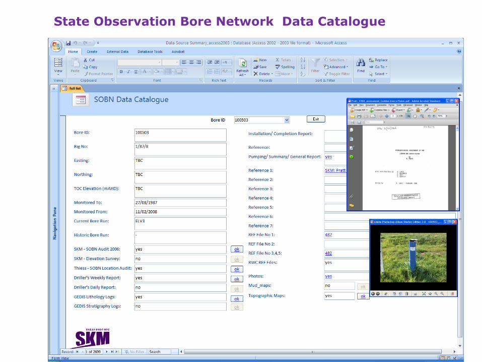
Pyramid Creek Salt Interception Scheme
Mobile Database
for PCSIS (Sprint DB Pro)
KaioneSync
Reports
Data Extracts Automatic Report Generation
MS ACCESS
Database for PCSIS

Hydrogeological mapping

Hydrogeological mapping
STRATIGRAPHY INTERPRETATION TOOL

Web Interface

Hydrogeological mapping – Visualisation of Aquifers
Benefits of Database engineering

INTEGRATED SPATIAL DATA MODEL FOR MANAGING BORE STRATIGRAPHIC AND HYDROLOGICAL INFORMATION
Mohamed-Ghouse, Z. Sadiq., Goodin, D. and H. Chaplin (2009).Integrated spatial data model for managing bore stratigraphic and hydrological information. In: Ostendorf B., Baldock, P., Bruce, D., Burdett, M. and P. Corcoran (eds.), Proceedings of the Surveying & Spatial Sciences Institute Biennial International Conference, Adelaide 2009, Surveying & Spatial Sciences Institute, pp. 857-862. ISBN: 978-0-9581366-8-6.

National Groundwater Information System (NGIS) – Phase 1
Concept: SKM and Continuum consulting Client : Australian National Water Commission

National Groundwater Information System (NGIS) – Phase 2
Australian Bureau of Meteorology
Using ArcHydro Groundwater Data Model

Interim Groundwater Dataset as part of Australian Geofabric
•SKM was engaged by the Bureau of Meteorology to develop consistent national spatial groundwater datasets as part of the Geofabric.
•The project involved collecting and collating aquifer extent, salinity, elevation and uncertainty information and populating a pre-defined geodatabase.
•To address different definitions of the same aquifers across jurisdictional boundaries, it was necessary to develop a national aquifer framework to allow each of the jurisdictional datasets to be transferred into a nationally consistent dataset.
•The development of the framework included consultation with each of the relevant State and Territory jurisdictions in a series of workshops.
•The outcomes of the workshops and existing frameworks were simulated to develop a list of 24 aquifers across Australia.
•The project also involved developing a relationship between the geological units (both outcropping and sub-surface) to aquifers and using this relationship to develop a consistent GIS layer of the “Land Surface Aquifer” (surface expression of the aquifers whether saturated or not) and the “Watertable Aquifer” (extent of the first saturated aquifer).
•The extents of sub-surface aquifers, groundwater salinity and aquifer yield data provided by the jurisdictions was also translated into the nomenclature of the “interim aquifer framework”.
Client : Australian Bureau of Meteorology

Interim Groundwater Dataset as part of Australian Geofabric
Client: Australian Bureau of Meteorology

Link between State/Territory frameworks and NAF
NAF Geological Units
(GA Strat Database)
NAF Hydrogeological
Unit NAF Aquifer
One to one
or many to
one or one
to many
One to one
or many to
one
One to one or
many to one
State/ Territory
surface
Geological Units
State/ Territory
non-outcropping
geological units
State/ Territory
hydrogeological
units
State/ Territory
Aquifers
One to one or
many to one One to one or
many to one
LOOKUP
TABLE
LOOKUP
TABLE LOOKUP
TABLE
Australian Bureau of Meteorology
National Aquifer Framework (NGIS – Phase 2)
Client: Australian Bureau of Meteorology

NGIS
Jurisdiction
NGIS < V2.1
Database
(State Framework)
NGIS V2.1
NAF compliant
Database
Conversion
Tool
Jurisdictions
BoM
National Aquifer Framework (NGIS – Phase 2)
Client: Australian Bureau of Meteorology

Australian National Water Commission
Hosted by : Australian Bureau of Meteorology

National Atlas of Groundwater Dependent Ecosystems (GDE)
Concept: SKM Client : Australian National Water Commission
Production
Spatial Data Model
Spatial Data
Model
Atlas Hosting
Spatial Data Model
ETL
process
for
Data
loads
GDE
Data
Atlas User Interface
GDE Presentation
Spatial Data Model
The Spatial Data Model (SDM) presented is a basic
framework to represent GDE data. The SDM Production is
aimed at GDE data population from various sources. An
Extract Transform and Load (ETL) process enables GDE data
population to the Production SDM. The Atlas Hosting SDM is
aimed at presentation of GDE data in the web based Atlas.

National Atlas of Groundwater Dependent Ecosystems (GDE)
Concept: SKM Client : Australian National Water Commission

National Atlas of Groundwater Dependent Ecosystems (GDE)
Concept: SKM Client : Australian National Water Commission
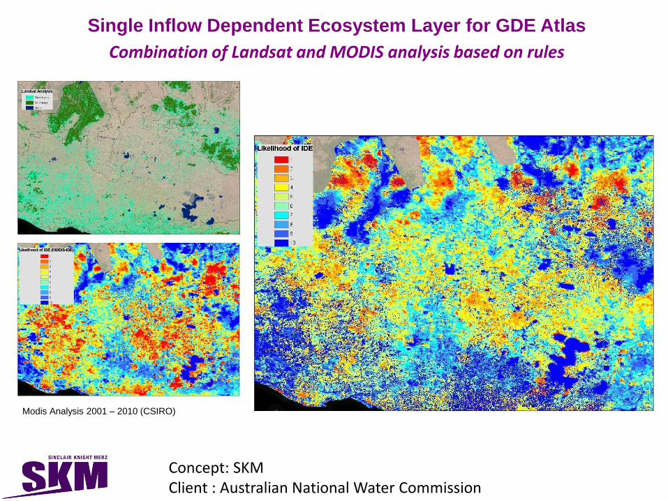
Single Inflow Dependent Ecosystem Layer for GDE Atlas
Combination of Landsat and MODIS analysis based on rules
Modis Analysis 2001 – 2010 (CSIRO)
Concept: SKM Client : Australian National Water Commission

Concept: SKM Client : Australian National Water Commission
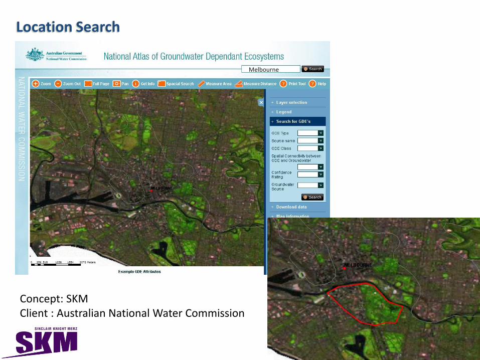
Location Search
Melbourne
Concept: SKM Client : Australian National Water Commission

Adding or Replacing Layers
• Import to SDE with PostGres as backend DB
• Export the PostGres Table to an archive file format
• If a replacement delete the existing table from the Web Server Database (PostGres)
• Import archive file to Web Server Database (PostGres)
Updating GDE Atlas
Concept: SKM Client : Australian National Water Commission

Updating GDE Atlas
Export existing GDE data to an ESRI Geodatabase format (This would preferably be ArcSDE within PostGres. ArcSDE within MS SqlServer, etc would require extra steps to convert to PostGIS format.
Use Arc Map to do the edits (spatial or attribute edits).
For large bulk replacements features would be deleted using Arcmap in an edit region and loaded from other feature datasets as supplied by jurisdictions.
ArcSDE is used to maintain Version Control and be used to assign the create_date and retire_date columns of respective GDE Layers in the data model.
Concept: SKM Client : Australian National Water Commission

• SKM have been involved in Building SDI’s for the NRM sector in particular: Water and Environment
• Water
– Australian National Water Commission
• World’s first National Atlas of Groundwater Dependent Ecosystem
• National Groundwater Information System
• National Aquifer Framework
– Review of Australian Water Information System (AWRIS)
• Environment
– Department of Primary Industries, Victoria Future Farming Divisions Spatial Capability Review
– Data Policy framework for the Australian Bureau of Meteorology
– New South Wales (NSW) Government’s Location Strategy 2011-15
– Spatial Information Exchange Business Case for NSW government
Sinclair Knight Merz’s role in building SDI for NRM Sector

3D GIS for Groundwater
3D GIS for Groundwater comprises of 3D geometry, 3D topology, semantics and appearance
Way forward ...

Representing 3D geometry from a spatial database perspective for groundwater data has been a challenge.
Although, 3D geometry has been well represented for above surface features for eg. 3D city models , but there are limitations in representing subsurface features such as groundwater data in 3D geometry.
There are data models such as ArcHydro groundwater with 2.5 D representation, still the true 3D geometry which includes 3D topology for groundwater related features from a spatial database perspective has to be explored.
By representing true 3D geometry the users will be able to analyse (query) the spatial data from a 3D perspective and generate better visualisation from true 3D.
Absence of remote sensors to depict the reality below ground and limited data models across the 3rd dimension for sub surface features are the problems across this area.
Another interesting problem in groundwater related 3D features is the spatial semantics
Way forward ...

Sinclair Knight Merz (SKM) has been involved in projects in
Malaysia since the early 1970s. In 1997, we opened a permanent
office in Kuala Lumpur. In Malaysia, SKM now employs more than
300 people based in Mont’ Kiara, including Registered Professional
Engineers and other technical staff across multiple disciplines.
The SKM team in Malaysia is particularly strong in building and
infrastructure projects such as highways, maritime and high rise
residential buildings, water and environment consulting and the
management of fuel retail facility construction programmes.
Among others, it has completed the engineering design of many
prestigious buildings in Malaysia, including the award-winning
Putrajaya Convention Centre, the Sunway Pyramid Shopping
complex and the Prince Court Medical Centre in Kuala Lumpur.
Sinclair Knight Merz, Malaysia

Thank You
Questions?
Email : [email protected]
29
Building sustainable water resources using strength of
Spatial Information!