Tourismo:A User-Preference Tourist Trip Search Engine · Tourismo:A User-Preference Tourist Trip...
5
Tourismo:A User-Preference Tourist Trip Search Engine Gregor Joss´ e 1 , Klaus Arthur Schmid 1 , Andreas Z ¨ ufle 1 , Georgios Skoumas 2 , Matthias Schubert 1 , Dieter Pfoser 3 1 Ludwig-Maximilians-Universit¨ at M ¨ unchen, Germany {josse,schmid,schubert,zuefle}@dbs.ifi.lmu.de, 2 National Technical University of Athens, Greece [email protected], 3 George Mason University, USA [email protected] Abstract. In this demonstration we re-visit the problem of finding an optimal route from location A to B. Currently, navigation systems compute shortest, fastest, most economic routes or any combination thereof. More often than not users want to consider “soft” qualitative metrics such as popularity, scenic value, and general appeal of a route. Routing algorithms have not (yet) been able to appre- ciate, measure, and evaluate such qualitative measures. Given the emergence of user-generated content, data exists that records user preference. This work ex- ploits user-generated data, including image data, text data and trajectory data, to estimate the attractiveness of parts of the spatial network in relation to a par- ticular user. We enrich the spatial network dataset by quantitative scores reflect- ing qualitative attractiveness. These scores are derived from a user-specific self- assessment (“On vacation I am interested in: family entertainment, cultural ac- tivities, exotic food”) and the selection of a respective subset of existing POIs. Using the enriched network, our demonstrator allows to perform a bicriterion op- timal path search, which optimizes both travel time as well as the attractiveness of the route. Users will be able to choose from a whole skyline of alternative routes based on their preference. A chosen route will also be illustrated using user-generated data, such as images, textual narrative, and trajectories, i.e., data that showcase attractiveness and hopefully lead to a perfect trip. 1 Introduction Nowadays, social networks are a great source of rich geo-spatial data. Almost every social network allows users to incorporate geo-social features into their data stream. The different features include, amongst others, geo-tagged pictures (e.g., Flickr), geo- descriptive text (e.g., travel blogs), and tracked movement (e.g., runners’ trajectories). For this demo, we rely on all these kinds of user-generated data to define attractiveness on a real world road network. Our aim is to reflect human fondness according to the crowd by using qualitative information and making it measurable. We present Tourismo, a tourist search engine, which computes attractive paths along points of interest (POIs), tailored to the interest of the user issuing the query. Based on this enriched spatial net- work, which has information about the attractiveness of locations, we aim at answering attractive path queries. Currently, navigation systems, i.e., machines, perform this task for us, computing routes such as the shortest route, the fastest route, the most economic route [1], or some combination of such quantitative measure on a spatial network [2]. In all of these cases, the employed algorithms optimize cost measures inherent in the underlying road network. What is rarely reflected, however, is user preference on sub- jective measures, such as attractiveness and interestingness of a route. Often users are
Transcript of Tourismo:A User-Preference Tourist Trip Search Engine · Tourismo:A User-Preference Tourist Trip...

Tourismo:A User-Preference Tourist Trip Search Engine
Gregor Josse1, Klaus Arthur Schmid1, Andreas Zufle1, Georgios Skoumas2,Matthias Schubert1, Dieter Pfoser3
1 Ludwig-Maximilians-Universitat Munchen, Germany{josse,schmid,schubert,zuefle}@dbs.ifi.lmu.de,
2 National Technical University of Athens, [email protected],
3 George Mason University, [email protected]
Abstract. In this demonstration we re-visit the problem of finding an optimalroute from location A to B. Currently, navigation systems compute shortest, fastest,most economic routes or any combination thereof. More often than not userswant to consider “soft” qualitative metrics such as popularity, scenic value, andgeneral appeal of a route. Routing algorithms have not (yet) been able to appre-ciate, measure, and evaluate such qualitative measures. Given the emergence ofuser-generated content, data exists that records user preference. This work ex-ploits user-generated data, including image data, text data and trajectory data,to estimate the attractiveness of parts of the spatial network in relation to a par-ticular user. We enrich the spatial network dataset by quantitative scores reflect-ing qualitative attractiveness. These scores are derived from a user-specific self-assessment (“On vacation I am interested in: family entertainment, cultural ac-tivities, exotic food”) and the selection of a respective subset of existing POIs.Using the enriched network, our demonstrator allows to perform a bicriterion op-timal path search, which optimizes both travel time as well as the attractivenessof the route. Users will be able to choose from a whole skyline of alternativeroutes based on their preference. A chosen route will also be illustrated usinguser-generated data, such as images, textual narrative, and trajectories, i.e., datathat showcase attractiveness and hopefully lead to a perfect trip.
1 IntroductionNowadays, social networks are a great source of rich geo-spatial data. Almost everysocial network allows users to incorporate geo-social features into their data stream.The different features include, amongst others, geo-tagged pictures (e.g., Flickr), geo-descriptive text (e.g., travel blogs), and tracked movement (e.g., runners’ trajectories).For this demo, we rely on all these kinds of user-generated data to define attractivenesson a real world road network. Our aim is to reflect human fondness according to thecrowd by using qualitative information and making it measurable. We present Tourismo,a tourist search engine, which computes attractive paths along points of interest (POIs),tailored to the interest of the user issuing the query. Based on this enriched spatial net-work, which has information about the attractiveness of locations, we aim at answeringattractive path queries. Currently, navigation systems, i.e., machines, perform this taskfor us, computing routes such as the shortest route, the fastest route, the most economicroute [1], or some combination of such quantitative measure on a spatial network [2].In all of these cases, the employed algorithms optimize cost measures inherent in theunderlying road network. What is rarely reflected, however, is user preference on sub-jective measures, such as attractiveness and interestingness of a route. Often users are

willing to take a suboptimal detour, a deviation from quantitative optimality (shortest,fastest, etc.), in order to improve the quality of their route. In order to see more attrac-tions, for instance, a tourist may be willing to take a moderate detour from a fast, butnot very attractive, highway.
How can we measure a subjective concept of “quality”? How to measure attractive,scenic, recreative routes? As machines are not (yet) capable to reflect this concept, werely on the crowd to answer this question, i.e., we propose to use crowdsourced data toestimate the attractiveness of an area. Relying on different datasets, image data (fromFlickr1), textual narratives (from travel blogs), and trajectory data (from Endomondo1),we investigate the applicability of different data sources as cost measures for the under-lying road network. More precisely, we enrich the road network by quantitative scoresof qualitative statements as follows:
– areas having a large density of Flickr images indicate a particularly attractive area,increasing the attractiveness score;
– locations mentioned in the positive context of travel blogs increase attractivenessscores;
– routes commonly used by other users are also considered more attractive.
Furthermore, we incorporate meta-information from OpenStreetMap1 (OSM), in orderto categorize POIs and, using the aforementioned popoularity score, propose routesaccording to the user’s preferences and the fondness of the crowd. Tourismo presentssolutions to enrich the underlying road network using the data sources. We show an ini-tial approach to map these attractiveness scores to cost measures correlated with traveltime, allowing to apply existing routing algorithms which aim at minimizing edge-labeled cost metrics. We apply algorithms for pareto-optimal route search similar to[3] and [4], to find paths which are optimal w.r.t. the popularity scores. Our frameworkallows to specify origin and destination, computes and displays the skyline of pareto-optimal paths. Furthermore, the reasons for attractiveness of each path are illustrated:Flickr images along the way, travel blog entries mentioning locations on the way, andhistorical trajectories which share the same route. Our demonstrator is an extension of[5] it has three major features: First, we incorporate new, route search algorithms whichenable higher dimensional cost spaces at the same reducing computation time. Second,the demonstration allows to specify the interest of a user, thus returning routes that con-tain POIs which are of particular interest to the user. Third, this version considers a thirdtype of data to enrich the underlying road network with attractiveness information: Inaddition to geotagged images, and texts containing geospatial references, we also learnattractiveness from an existing base of historic trajectory data.
2 State of the ArtRecently, a lot of interesting research has been done in the context of finding scenic,interesting or popular routes. The first set of related work focuses on providing pathswhich are easier to memorize, describe, and follow. For example, the authors of [6]and [7] try to tackle the problem by introducing cost criteria that allow for a trade-off between minimizing the length of a path while also minimizing the complexity in
1 www.flickr.com, www.endomondo.com, www.openstreetmap.org

terms of instructions or turns along the path. Furthermore, an existing research directioncovers the problem of defining tourist routes, which maximize the subset of a set of pre-defined POIs which can be visited in a tourist tour that has a time-constraint [8,9]. Inthese works, the set of interesting POIs is given, and the main conceptual contribution ofis to automatically extract interesting locations, as well as a quantitative estimate of thepopularity of this location from a variety of data sources. Another research direction,which is not necessarily restricted to touristic routing but lacks the aspect of qualitativemeasures, are the Trip Planning Query and variants thereof [10,11].
The approach most similar to the one presented in this work is [12], which proposesa method for computing beautiful paths, as the authors phrase it. However, in orderto quantify quality, the authors rely on explicit statements about the beauty of specificlocations, obtained from a crowd-sourcing platform which collects user opinions onphotos of specific locations. In contrast, we propose to mine this kind of informationfrom existing crowd-sourced data, which does not require any monetary investment toaquire. Thus our approach has the crucial advantage that it is scalable as the used datais already available globally available, while having local expert users rate photos oneby one can hardly be extended to a global scale.
Another important research direction is the stitching existing trajectories in order toobtain new trajectories which guarantee that each sub-trajectory is used by other users,and is thus, “popular” following the definition [13] of Chen et al. This, however, onlyreflects a notion common usage, not taking into account, why a specific sub-trajectoryhas been favored. For instance, when mining trajectories of commuters, the fastest pathis most likely to be chosen by most users. Hence, we propose mining trajectories spe-cific to recreational use and merging this information with the attractiveness scores wederive from other user-generated data sources.
3 FeaturesThe main feature of this demonstrator is the estimation of attractiveness from text, im-age, and trajectory data. Details covering text and image data can be found in [5]. In thissection, we briefly describe how we enrich the underlying road network using historicaltrajectory data. For our demonstrator, we use trajectories of walkers, runners and bikersthat have uploaded their workouts to Endomondo. Our dataset contains eight milliontrajectories, which are located all around the world, but have a strong regional focus inNorthern Europe. To match each of the GPS trajectories, we apply state-of-the-art mapmatching techniques, similar to those presented in [14]. In a first step, we perform abasic enrichment: For each edge e of the spatial network, we count the number tra(e) ofhistorical trajectories that contain this edge. This count can be used as an indication ofattractiveness of the nodes delimiting the edge, following the assumption that runnersare, in average, more likely to choose a particularly nice running trail. We assign ver-tices in a road network attractiveness scores derived from different datasets. We referto the score of a vertex v derived from Flickr image data as im(v), to the score derivedfrom travel blog text data as txt(v), and to the score derived from trajectory data astra(v). In contrast to [5], where the different data source scores were combined into onecost measure, we now propose to diversified measures. For each edge e = (u, v) andeach of the scores f ∈ {im,txt,tra} we define:
pf (e) = tt(e) · φCf (f(u)+f(v))
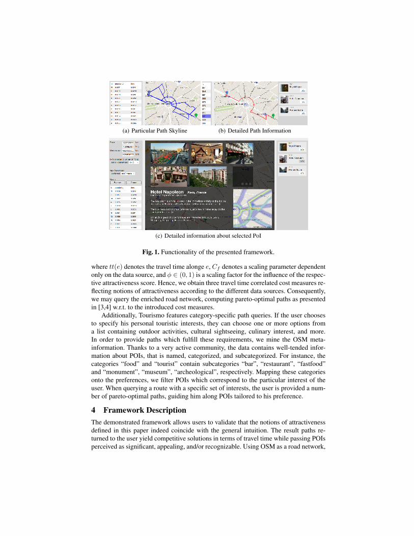
(a) Particular Path Skyline (b) Detailed Path Information
(c) Detailed information about selected PoI
Fig. 1. Functionality of the presented framework.
where tt(e) denotes the travel time alonge e, Cf denotes a scaling parameter dependentonly on the data source, and φ ∈ (0, 1) is a scaling factor for the influence of the respec-tive attractiveness score. Hence, we obtain three travel time correlated cost measures re-flecting notions of attractiveness according to the different data sources. Consequently,we may query the enriched road network, computing pareto-optimal paths as presentedin [3,4] w.r.t. to the introduced cost measures.
Additionally, Tourismo features category-specific path queries. If the user choosesto specify his personal touristic interests, they can choose one or more options froma list containing outdoor activities, cultural sightseeing, culinary interest, and more.In order to provide paths which fulfill these requirements, we mine the OSM meta-information. Thanks to a very active community, the data contains well-tended infor-mation about POIs, that is named, categorized, and subcategorized. For instance, thecategories “food” and “tourist” contain subcategories “bar”, “restaurant”, “fastfood”and “monument”, “museum”, “archeological”, respectively. Mapping these categoriesonto the preferences, we filter POIs which correspond to the particular interest of theuser. When querying a route with a specific set of interests, the user is provided a num-ber of pareto-optimal paths, guiding him along POIs tailored to his preference.
4 Framework DescriptionThe demonstrated framework allows users to validate that the notions of attractivenessdefined in this paper indeed coincide with the general intuition. The result paths re-turned to the user yield competitive solutions in terms of travel time while passing POIsperceived as significant, appealing, and/or recognizable. Using OSM as a road network,
our demonstrator visualizes a map relying on Google Maps. Upon selecting an originand a destination location on the map, the user is presented with the skyline view asshown in Figure 1(a). In this view, the path skyline is presented to the user. For eachsuch route, the corresponding cost values are shown in a table in the lower left cornerof Figure 1(a). Using this table, the user can browse the choise and select a desiredrouteyielding the route view shown in Figure 1(b). For the selected route A, this viewshows the most “popular” points of interest on A. Once a point of interest is selected,the sources of popularity of this POI are displayed, as shown in Figure 1(c). For thispurpose, Figure 1(c) shows all the pictures relevant for the selected POI, i.e., the setof images having a sufficiently low distance. The bottom-left corner shows all travelblog entries where this entry was mentioned in a positive context. Finally, the lowerleft corner shows a heatmap derived from all trajectories that share the same trajectory.During the demonstration, users will be able to specify start and target locations (also,if desired, specific categories of interest) and compute different sets of skyline paths.
AcknowledgementsThis research has received funding from the Shared E-Fleet project (in the IKTII program) by theBMWi (grant no. 01ME12107), from the DFG (grant no. RE 266/5-1), from the DAAD supportedby the BMBF (grant no. 57052426). Dieter Pfoser has been partially supported by NGA NURI(grant no. HM02101410004).
References1. Andersen, O., Jensen, C.S., Torp, K., Yang, B.: Ecotour: Reducing the environmental foot-
print of vehicles using eco-routes. In: MDM. (2013) 338–3402. Graf, F., Kriegel, H.P., Renz, M., Schubert, M.: Mario: Multi-attribute routing in open street
map. In: SSTD. (2011) 486–4903. Shekelyan, M., Josse, G., Schubert, M.: Linear path skylines in multicriteria networks. In:
ICDE15. (2015) 459–4704. Shekelyan, M., Josse, G., Schubert, M.: Paretoprep: Efficient lower bounds for path skylines
and fast path computation. In: SSTD15. (2015)5. Josse, G., Franzke, M., Skoumas, G., Zufle, A., Nascimento, M.A., Renz, M.: A framework
for computation of popular paths from crowdsourced data. In: ICDE. (2015) 1428–14316. Sacharidis, D., Bouros, P.: Routing directions: keeping it fast and simple. In: ACM SIGSPA-
TIAL GIS. (2013) 164–1737. Westphal, M., Renz, J.: Evaluating and minimizing ambiguities in qualitative route instruc-
tions. In: ACM SIGSPATIAL GIS. (2011) 171–1808. Garcia, A., Arbelaitz, O., Linaza, M.T., Vansteenwegen, P., Souffriau, W.: Personalized
tourist route generation. Springer (2010)9. Gavalas, Konstantopoulos, C., Mastakas, K., Pantziou, G.: A survey on algorithmic ap-
proaches for solving tourist trip design problems. Journal of Heuristics 20 (2014) 291–32810. Kanza, Y., Safra, E., Sagiv, Y., Doytsher, Y.: Heuristic algorithms for route-search queries
over geographical data. In: ACM SIGSPATIAL GIS. (2008) 1111. Chen, H., Ku, W.S., Sun, M.T., Zimmermann, R.: The partial sequenced route query with
traveling rules in road networks. Geoinformatica 15 (2011) 541–56912. Quercia, D., Schifanella, R., Aiello, L.M.: The shortest path to happiness: Recommending
beautiful, quiet, and happy routes in the city. CoRR (abs/1407.1031) (2014)13. Chen, Z., Shen, H.T., Zhou, X.: Discovering popular routes from trajectories. In: ICDE.
(2011) 900–91114. Newson, P., Krumm, J.: Hidden markov map matching through noise and sparseness. In:
ACM SIGSPATIAL GIS. (2009) 336–343