
TOUR OF ASTORIA’S NEIGHBORHOOD GROCERY STORE … · The Fornas Grocery store sits prominently...
7
TOUR OF ASTORIA’S NEIGHBORHOOD GROCERY STORE BUILDINGS In the 1920s (and thought the 1980s), most Astoria neighborhoods had at least on small store conveniently located for nearby residents and workers. Many of these store buildings still stand. Some continue to house businesses and others have since been converted into residences, apartments or studios. Resource No. 1 Name : NAVAL BASE GROCERY Location : 5202 Birch Street, Astoria, Clatsop County, Oregon Address prior to 1952 renumbering--2602 Birch St. The Naval Base Grocery building is located in the north side of Birch Street, just past 52nd Street in the Alderbrook neighborhood. The property borders the tidelands of the Columbia River. The view to the west is of Union Fishermen's Cooperative Packing Co. Alderbrook Station (1903) just 3 blocks away. Significance : Navy Base Grocery is one of only two remaining neighborhood grocery stores that retain a more single-family residential appearance than that of a commercial storefront. It also gains historical significance as the residence of Rev. R.L. Gregory (1948-1968). Description : This store is a 1.5 story vernacular gable structure with a front wall dormer and shiplap siding. Windows include paired 1/1 double-hung wood sash with lamb’s tongue detail, paired four-light fixed display and vinyl sliders. Decorative features include corner boards, a gable covered entry, and a plate glass glazed front door with transom above. Alterations include some windows and a historic, one story shed roof addition, east. A mural, painted by artist Roger McKay, celebrates the structures history as a grocery store. History : Naval Base Grocery was built circa 1900. It was listed as Simi & Co. Grocery in both 1920 and 1921. A newspaper account in 1921 referred to the business as Alderbrook Grocery. Polk City Directories list the building as Naval Base Grocery 1931-34. It become the residence of Rev. Robert Lee Gregory in the 1940s and until his death in 1968. There was also an attached apartment, listed historically as 2602 1/2 Birch Street. The naval reference comes from nearby Tongue Point, a submarine and destroyer base completed in 1924, one mile east of the store. The base was not used, however, until it was designated a Naval Air Station in 1943. The base was closed in 1963 and the facilities has been used as a U.S. Jobs Corps training center since 1964. SURVEY OF HISTORIC NEIGHBORHOOD GROCERY STORES Astoria, Oregon (Page 1)
Transcript of TOUR OF ASTORIA’S NEIGHBORHOOD GROCERY STORE … · The Fornas Grocery store sits prominently...
TOUR OF ASTORIA’S NEIGHBORHOOD GROCERY STORE
BUILDINGS
In the 1920s (and thought the 1980s), most Astoria neighborhoods had at least on small store conveniently located for nearby residents and workers. Many of these store buildings still stand. Some continue to house businesses and others have since been converted into residences, apartments or studios.
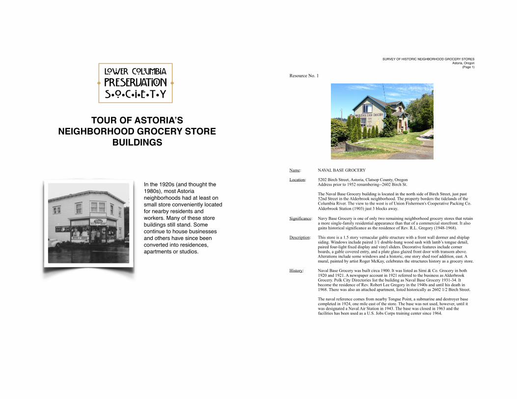
Resource No. 1
Name: NAVAL BASE GROCERY
Location: 5202 Birch Street, Astoria, Clatsop County, Oregon Address prior to 1952 renumbering--2602 Birch St.
The Naval Base Grocery building is located in the north side of Birch Street, just past 52nd Street in the Alderbrook neighborhood. The property borders the tidelands of the Columbia River. The view to the west is of Union Fishermen's Cooperative Packing Co. ! ! Alderbrook Station (1903) just 3 blocks away.
Significance: Navy Base Grocery is one of only two remaining neighborhood grocery stores that retain a more single-family residential appearance than that of a commercial storefront. It also gains historical significance as the residence of Rev. R.L. Gregory (1948-1968).
Description: This store is a 1.5 story vernacular gable structure with a front wall dormer and shiplap siding. Windows include paired 1/1 double-hung wood sash with lamb’s tongue detail, paired four-light fixed display and vinyl sliders. Decorative features include corner boards, a gable covered entry, and a plate glass glazed front door with transom above. Alterations include some windows and a historic, one story shed roof addition, east. A mural, painted by artist Roger McKay, celebrates the structures history as a grocery store.
History: Naval Base Grocery was built circa 1900. It was listed as Simi & Co. Grocery in both 1920 and 1921. A newspaper account in 1921 referred to the business as Alderbrook Grocery. Polk City Directories list the building as Naval Base Grocery 1931-34. It become the residence of Rev. Robert Lee Gregory in the 1940s and until his death in 1968. There was also an attached apartment, listed historically as 2602 1/2 Birch Street.
The naval reference comes from nearby Tongue Point, a submarine and destroyer base completed in 1924, one mile east of the store. The base was not used, however, until it was designated a Naval Air Station in 1943. The base was closed in 1963 and the facilities has been used as a U.S. Jobs Corps training center since 1964.
SURVEY OF HISTORIC NEIGHBORHOOD GROCERY STORESAstoria, Oregon
(Page 1)
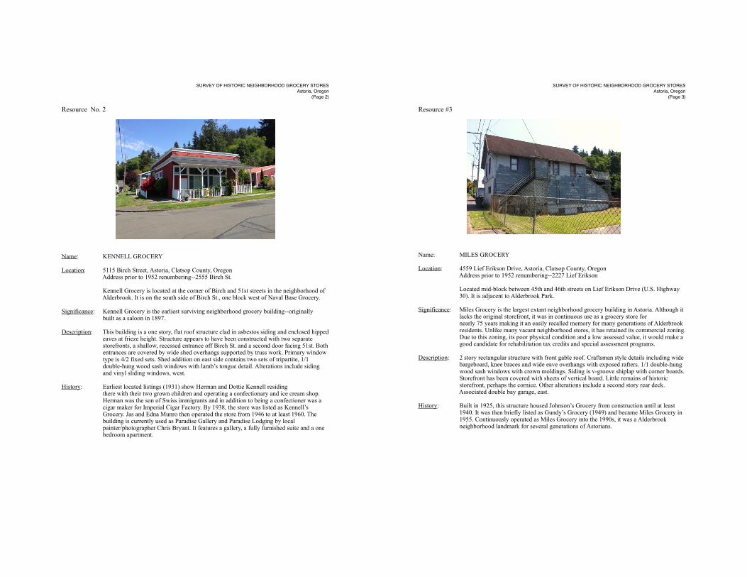
Resource No. 2
Name: KENNELL GROCERY
Location: 5115 Birch Street, Astoria, Clatsop County, Oregon Address prior to 1952 renumbering--2555 Birch St.
Kennell Grocery is located at the corner of Birch and 51st streets in the neighborhood of Alderbrook. It is on the south side of Birch St., one block west of Naval Base Grocery.
Significance: Kennell Grocery is the earliest surviving neighborhood grocery building--originally built as a saloon in 1897.
Description: This building is a one story, flat roof structure clad in asbestos siding and enclosed hipped eaves at frieze height. Structure appears to have been constructed with two separate storefronts, a shallow, recessed entrance off Birch St. and a second door facing 51st. Both entrances are covered by wide shed overhangs supported by truss work. Primary window type is 4/2 fixed sets. Shed addition on east side contains two sets of tripartite, 1/1 double-hung wood sash windows with lamb’s tongue detail. Alterations include siding and vinyl sliding windows, west.
History: Earliest located listings (1931) show Herman and Dottie Kennell residing there with their two grown children and operating a confectionary and ice cream shop. Herman was the son of Swiss immigrants and in addition to being a confectioner was a cigar maker for Imperial Cigar Factory. By 1938, the store was listed as Kennell’s Grocery. Jas and Edna Munro then operated the store from 1946 to at least 1960. The building is currently used as Paradise Gallery and Paradise Lodging by local painter/photographer Chris Bryant. It features a gallery, a fully furnished suite and a one bedroom apartment.
SURVEY OF HISTORIC NEIGHBORHOOD GROCERY STORESAstoria, Oregon
(Page 2)
Resource #3
Name: MILES GROCERY
Location: 4559 Lief Erikson Drive, Astoria, Clatsop County, Oregon Address prior to 1952 renumbering--2227 Lief Erikson
Located mid-block between 45th and 46th streets on Lief Erikson Drive (U.S. Highway 30). It is adjacent to Alderbrook Park.
Significance: Miles Grocery is the largest extant neighborhood grocery building in Astoria. Although it lacks the original storefront, it was in continuous use as a grocery store for nearly 75 years making it an easily recalled memory for many generations of Alderbrook residents. Unlike many vacant neighborhood stores, it has retained its commercial zoning. Due to this zoning, its poor physical condition and a low assessed value, it would make a good candidate for rehabilitation tax credits and special assessment programs.
Description: 2 story rectangular structure with front gable roof. Craftsman style details including wide bargeboard, knee braces and wide eave overhangs with exposed rafters. 1/1 double-hung wood sash windows with crown moldings. Siding is v-groove shiplap with corner boards. Storefront has been covered with sheets of vertical board. Little remains of historic storefront, perhaps the cornice. Other alterations include a second story rear deck. Associated double bay garage, east.
History: Built in 1925, this structure housed Johnson’s Grocery from construction until at least 1940. It was then briefly listed as Gundy’s Grocery (1949) and became Miles Grocery in 1955. Continuously operated as Miles Grocery into the 1990s, it was a Alderbrook neighborhood landmark for several generations of Astorians.
SURVEY OF HISTORIC NEIGHBORHOOD GROCERY STORESAstoria, Oregon
(Page 3)

Resource #4
Name: LOVVOLD GROCERY
Location: 304 37th Street, Astoria, Clatsop County, Oregon Address prior to 1952 renumbering--154 37th St. This building is located at the corner of 37th and Lief Erikson Drive in the Uppertown-Adair neighborhood. It is three blocks from the West End Mooring Basin.
Significance: Lovvold Grocery is a largely intact example of a two-story corner grocery from the 1920s. Its association with Hans Lovvold, a Norwegian fisherman, and the history of being used as a marine supply store in addition to a grocery, adds to the significance of he store in the history of the neighborhood. Uppertown Astoria was largely settled l by Scandinavian fishermen and their families. It continues to be used as a retail commercial space with the proprietors living above the store.
Description: This two-story flat roof structure is built in the Commercial Style. narrow beveled board. paired and single 1/1 double-hung wood sash with crown molding. Wide cornice with square cornice brackets. Alterations include rear two-story, flat roof addition (historic) wooden awning, previously recessed residential entrance has been infilled and door moved. Some windows replaced with fixed pane. Large metal windows run most of the north side of the building--facing the river.
History: Built circa 1920, the building was first owned and occupied by the Rouwens family, Belgium immigrants who operated Rouwens Grocery. Hans and Anna Lovvold, both from Norway, opened Lovvold Grocery and Fisherman’s Supply in 1930. In 1952, Hans and his son Howard listed the business associated with this address as Lovvold Marine Supply Company, Around this time, Howard developed Lovvold Mobile Park across Lief Erikson Dr. from the Lovvold Grocery building. Hans Lovvold died in 1965. Since that time the structure has housed several small businesses including Karlen’s East Grocery (1980), Uppertown Market (1985) and currently, Astoria Coffee Company (1997). The building was also used as the “Stop and Snack” store in the opening to the film The Goonies (1985).
SURVEY OF HISTORIC NEIGHBORHOOD GROCERY STORESAstoria, Oregon
(Page 4)
Resource #5
Name: FORNAS GROCERY
Location: 2740 Grand Avenue, Astoria, Clatsop County, Oregon Address prior to 1952 renumbering--1270 Grand Ave.
The Fornas Grocery store sits prominently along the north side of Grand Avenue between 27th and 28th streets. Access to this portion of Grand Avenue starts at 30th Street and runs west, reaching a dead end at 26th Street.
Significance: Fornas Grocery was an institution for several generations of Astorians. Unique amongst ! ! the many extant grocery store buildings that once serviced residential neighborhoods in ! ! Astoria, Fornas Grocery was operated exclusively by one family--from its opening in ! ! 1925 until Joseph’s death in 1967. The store maintains a high level of historic integrity ! ! and authenticity, having not been rehabilitated for either residential or other commercial ! ! use.
Description: Fornas Grocery is a Commercial Style structure that retains the elements which ! ! characterize this style. These elements include: a front gable roof with false front, a ! ! stepped parapet and a recessed front entry with large display windows and transom. ! ! Additional residential structures on property are architecturally significant in their own ! ! right but also contribute to our understanding of the Fornas family who built, owned and ! ! operated the store.
History: Date of erection is circa 1925. The property was associated with the Fornas family the late 1980s when it was sold to Alfred and Trinna Tollefson. The current owner, Dennis Borkgren purchased the complex from them in 2003. Fornas Grocery was operational from 1925 until Joseph Fornas’s death in 1967. During the late 1970s and early 1980s, the store was used as a wood shop by local furniture craftsmen Peter Huhtala, Joe Patenaude and Randy Pusemen.
SURVEY OF HISTORIC NEIGHBORHOOD GROCERY STORESAstoria, Oregon
(Page 5)

Resource #6
Name: TAPSCOTT GROCERY
Location: 949 14th Street, Astoria, Clatsop County, Oregon Address prior to 1952 renumbering--477 14th St..
This structure is located at the corner of 14th Street and Parker Place in the heart of the Shively-McClure residential neighborhood. Significance: Tapscott Grocery is one of two remaining neighborhood grocery stores that have a more residential appearance than that of a commercial storefront. Despite this residential massing and detail, the original storefront is largely intact, making it one of the most Complete examples of historic storefronts in Astoria. It is listed as a contributing resource in the Shively-McClure Historic District which is on the National Register of Historic Places.
Description: This store is a 1.5 story vernacular storefront with Craftsman style details. The building has a steep side gable roof with wide eave overhangs, exposed rafters, wide barge board and knee braces. Three-bay shed dormer. Shiplap and wood shingle siding. Windows are 6/1 double-hung wood sash with plain casings. Storefront includes central recessed entry, 9/3 fixed pane displays and a 15-light glazed front door with transom above. Original residential entrance is to the left of the storefront. Alterations include the addition of a metal roof.
History: Built in 1922, this structure housed Tapscott Grocery from construction until 1949, with a brief period being listed as Bungalow Grocery (1931). It purchased by Peter Mardesich in 1947 as a residence. His son-in-law, Don Westley managed the store, which was renamed Parker Way Grocery. Listed as Parkerway Grocery in 1959, it was owned and operated by Mr. & Mrs. Albert Brunmeir.
SURVEY OF HISTORIC NEIGHBORHOOD GROCERY STORESAstoria, Oregon
(Page 6)
Resource #7
Name: PALMBERG GROCERY
Location: 1305 8th Street, Astoria, Clatsop County, Oregon Address prior to 1952 renumbering--663-665 8th St.
This store building is located at the corner of 8th Street and Madison Ave. on the hilltop of Astoria. It contains two separate storefronts, both accessed from 8th St.
Significance: Palmberg Grocery is part of a large, vacant commercial building on the hilltop above Astoria’s Shively-McClure Historic District.
Description: The Palmberg Grocery building is one-story flat roof structure with a chamfered corner entrance. It is currently vacant and is deteriorating quickly. It is currently cited as a derelict property by the City of Astoria. Current owner is taking steps to improve the building which is on a busy street, used as a shortcut over the hill between South Slope and downtown. The west side has been recently resided.
History: Built circa 1920, for Emil Palmberg most likely constructed by Palmberg & Matteson General Contractors with Emil’s assistance as a painter, paperhanging and sign contractor. The address was listed as Palmberg’s Mercantile Co. Inc., general merchandise in 1925 and listed as Palmberg Grocery from 1931-65. Emil’s wife Marie-Louise Palmberg operated the store after Emil’s death in 1938.
SURVEY OF HISTORIC NEIGHBORHOOD GROCERY STORESAstoria, Oregon
(Page 7)
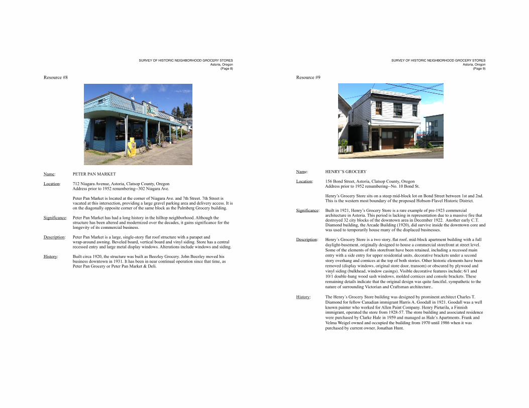
Resource #8
Name: PETER PAN MARKET
Location: 712 Niagara Avenue, Astoria, Clatsop County, Oregon Address prior to 1952 renumbering--302 Niagara Ave.
Peter Pan Market is located at the corner of Niagara Ave. and 7th Street. 7th Street is vacated at this intersection, providing a large gravel parking area and delivery access. It is on the diagonally opposite corner of the same block as the Palmberg Grocery building.
Significance: Peter Pan Market has had a long history in the hilltop neighborhood. Although the structure has been altered and modernized over the decades, it gains significance for the longevity of its commercial business.
Description: Peter Pan Market is a large, single-story flat roof structure with a parapet and wrap-around awning. Beveled board, vertical board and vinyl siding. Store has a central recessed entry and large metal display windows. Alterations include windows and siding.
History: Built circa 1920, the structure was built as Beezley Grocery. John Beezley moved his business downtown in 1931. It has been in near continual operation since that time, as Peter Pan Grocery or Peter Pan Market & Deli.
SURVEY OF HISTORIC NEIGHBORHOOD GROCERY STORESAstoria, Oregon
(Page 8)
Resource #9
Name: HENRY’S GROCERY
Location: 156 Bond Street, Astoria, Clatsop County, Oregon Address prior to 1952 renumbering--No. 10 Bond St.
Henry’s Grocery Store sits on a steep mid-block lot on Bond Street between 1st and 2nd. This is the western most boundary of the proposed Hobson-Flavel Historic District.
Significance: Built in 1921, Henry’s Grocery Store is a rare example of pre-1923 commercial architecture in Astoria. This period is lacking in representation due to a massive fire that destroyed 32 city blocks of the downtown area in December 1922. Another early C.T. Diamond building, the Arcade Building (1920), did survive inside the downtown core and was used to temporarily house many of the displaced businesses.
Description: Henry’s Grocery Store is a two story, flat roof, mid-block apartment building with a full ! ! daylight-basement, originally designed to house a commercial storefront at street level. ! ! Some of the elements of this storefront have been retained, including a recessed main ! ! entry with a side entry for upper residential units, decorative brackets under a second ! ! story overhang and cornices at the top of both stories. Other historic elements have been ! ! removed (display windows, original store door, transom) or obscured by plywood and ! ! vinyl siding (bulkhead, window casings). Visible decorative features include; 6/1 and ! ! 10/1 double-hung wood sash windows, molded cornices and console brackets. These ! ! remaining details indicate that the original design was quite fanciful, sympathetic to the ! ! nature of surrounding Victorian and Craftsman architecture..
History: The Henry’s Grocery Store building was designed by prominent architect Charles T. ! ! Diamond for fellow Canadian immigrant Harris A. Goodall in 1921. Goodall was a well known painter who worked for Allen Paint Company. Henry Pietarila, a Finnish immigrant, operated the store from 1928-57. The store building and associated residence ! ! were purchased by Clarke Hale in 1959 and managed as Hale’s Apartments. Frank and ! ! Velma Weigel owned and occupied the building from 1970 until 1986 when it was ! ! purchased by current owner, Jonathan Hunt.
SURVEY OF HISTORIC NEIGHBORHOOD GROCERY STORESAstoria, Oregon
(Page 9)

Resource #10
Name: BEEMER’S GROCERY
Location: 695 Alameda Avenue, Astoria, Clatsop County, Oregon Address prior to 1952 renumbering--694 Alameda Ave.
Beemer’s Grocery Store is located the intersection of Alameda and W. Lexington ! ! (formerly Hermosa) avenues.
Significance: Beemer’s Grocery Store is one of only two commercial building with a chamfered corner ! ! entrance located in a residential Astoria neighborhood. It is a quality example of the ! ! two-story corner storefront and retains much of its historic character. Situated on the ! ! South Slope, it was largely affiliated with the Beemer grocery business. George S. ! ! Beemer and family operated the store and resided in the building from 1930-1957.
Description: Beemer’s Grocery is a corner store that retains several of the features characterizing this ! ! type. These elements include; two story wood construction, street facades flush with the ! ! streets, a chamfered corner entry and a rear entry into the residential portion of the ! ! building. Other elements of a modern storefront have been removed, including the ! ! recessed corner entrance, the large display windows and transoms. Modest decorative ! ! features, such as plain window casings with crown moldings, are consistent with ! ! surrounding residential buildings. Italianate inspired brackets beneath the buildings large ! ! cornice reflect the eclectic “historic style” design popping up in commercial buildings of ! ! the period.
History:! George S. and Manna K. Beemer operated Beemer’s Grocery from 1930 through !1952. ! ! After George’s death in 1952, Mrs. Eldred Mittet and Mrs. Bob Graves operated the store ! ! (M&G Grocery) but it was still listed as Beemer’s Grocery. Robert Overby moved into ! ! the building and began managing the store in 1955 but closed the store for good onec he ! ! acquired the store across the street (690 Alameda). Overby sold the building to Alven and ! ! Wilma Johnson in 1965. Alven Johnson converted the storefront into additional living ! ! quarters by 1968
SURVEY OF HISTORIC NEIGHBORHOOD GROCERY STORESAstoria, Oregon
(Page 10)
Resource #11
Name: ASTOR COURT GROCERY
Location: 690 Alameda Avenue, Astoria, Clatsop County, Oregon Address prior to 1952 renumbering--same
Astor Court grocery is located on Alameda Ave. on Astoria’s South Slope. It is just south of the Alameda’s intersection with W. Lexington Ave. and is in close proximity to the historic Beemer’s Grocery.
Significance: This commercial building has been used as a neighborhood grocery store for much of the past 90 years. It derives significance from the physical integrity of the historic storefront and also its history as a staple business in the South Slop neighborhood.
Description: Astor Court Grocery is a Commercial Style structure that retains the elements which ! ! characterize this style. These elements include: a front gable roof with false front, a ! ! decorative cornice and a central front entry with large display windows and transoms. ! ! The building is one-story with a gable roof and was built on a steep lot, providing a daylight-basement beneath street level.
History: Astor court grocery was built circa 1921 and purchased by R. Simonson in 1923. Frequent newspaper accounts report a steady change of ownership; E.W.Swanson takes over in 1929, Edward H. Anderson open’s Anderson’s Grocery in 1935, Anderson sells the store to Mrs. Leone Tavener in 1945, Mr. and Mrs. Chester A. Weaver purchase the store from Tavener in 1947, Mr. And Mrs. Clarence Hill purchased the store from the Weavers in 1950. Robert Overby purchased the property in the 1960s. Listed as Astor Court Grocery, but commonly referred to as “Bob’s,” it was in operation until 2000. It then was briefly a quilting shop, but was returned to use as a market in the mid-2000s. The store is currently still in operation as Astor Court Grocery and specializes in Mexican goods and groceries.
SURVEY OF HISTORIC NEIGHBORHOOD GROCERY STORESAstoria, Oregon
(Page 11)
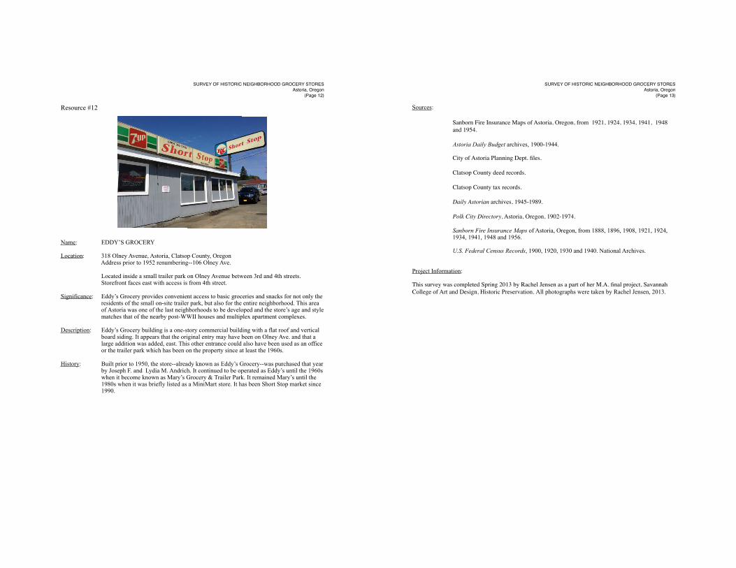
Resource #12
Name: EDDY’S GROCERY
Location: 318 Olney Avenue, Astoria, Clatsop County, Oregon Address prior to 1952 renumbering--106 Olney Ave.
Located inside a small trailer park on Olney Avenue between 3rd and 4th streets. Storefront faces east with access is from 4th street.
Significance: Eddy’s Grocery provides convenient access to basic groceries and snacks for not only the residents of the small on-site trailer park, but also for the entire neighborhood. This area of Astoria was one of the last neighborhoods to be developed and the store’s age and style matches that of the nearby post-WWII houses and multiplex apartment complexes.
Description: Eddy’s Grocery building is a one-story commercial building with a flat roof and vertical board siding. It appears that the original entry may have been on Olney Ave. and that a large addition was added, east. This other entrance could also have been used as an office or the trailer park which has been on the property since at least the 1960s.
History: Built prior to 1950, the store--already known as Eddy’s Grocery--was purchased that year by Joseph F. and Lydia M. Andrich. It continued to be operated as Eddy’s until the 1960s when it become known as Mary’s Grocery & Trailer Park. It remained Mary’s until the 1980s when it was briefly listed as a MiniMart store. It has been Short Stop market since 1990.
SURVEY OF HISTORIC NEIGHBORHOOD GROCERY STORESAstoria, Oregon
(Page 12)
Sources:
! ! Sanborn Fire Insurance Maps of Astoria, Oregon, from 1921, 1924, 1934, 1941, !1948 ! ! and 1954.
! Astoria Daily Budget archives, 1900-1944.
! City of Astoria Planning Dept. files.
! Clatsop County deed records.
! Clatsop County tax records.
Daily Astorian archives, 1945-1989.
! Polk City Directory, Astoria, Oregon, 1902-1974.
Sanborn Fire Insurance Maps of Astoria, Oregon, from 1888, 1896, 1908, 1921, 1924, 1934, 1941, 1948 and 1956.
U.S. Federal Census Records, 1900, 1920, 1930 and 1940. National Archives.
Project Information:
This survey was completed Spring 2013 by Rachel Jensen as a part of her M.A. final project, Savannah College of Art and Design, Historic Preservation. All photographs were taken by Rachel Jensen, 2013.
SURVEY OF HISTORIC NEIGHBORHOOD GROCERY STORESAstoria, Oregon
(Page 13)