TORRES PRAWN HANDBOOK 2006 - fish · Fishery (TSPF) licence holders with the latest management,...
111
TORRES STRAIT PROTECTED ZONE JOINT AUTHORITY TORRES STRAIT PRAWN FISHERY HANDBOOK 2011
Transcript of TORRES PRAWN HANDBOOK 2006 - fish · Fishery (TSPF) licence holders with the latest management,...

T O R R E S S T R A I T P R O T E C T E D Z O N E J O I N T A U T H O R I T Y
TORRES STRAIT PRAWN
FISHERY HANDBOOK 2011
T O R R E S S T R A I T P R O T E C T E D Z O N E J O I N T A U T H O R I T Y

T O R R E S S T R A I T P R O T E C T E D Z O N E J O I N T A U T H O R I T Y
TORRES STRAIT PRAWN FISHERY HANDBOOK
2011
Compiled by
Cocking, L., Turnbull, C., and Jacobsen, I.

T O R R E S S T R A I T P R O T E C T E D Z O N E J O I N T A U T H O R I T Y
© Commonwealth of Australia 2011
ISSN: 1835-6273 (Print)
ISSN: 1835-8281 (Online)
This work is copyright. Apart from any use as permitted under the Copyright Act 1968, no part may be reproduced by any process without prior written permission from the Ausinfo. Requests and inquiries concerning reproduction and rights should be addressed to the Manager, Legislative Service, Ausinfo, GPO Box 1920, Canberra, ACT, 2601. COPIES AVAILABLE FROM: Australian Fisheries Management Authority 73 Northbourne Ave, Civic ACT 2600 Box 7051, Canberra Business Centre, Canberra, ACT 2601 Australia. or electronically on the Torres Strait Protected Zone Joint Authority official website: www.pzja.gov.au Preferred way to cite this publication: Cocking, L., Turnbull, C., and Jacobsen, I. (2011), Torres Strait Prawn Fishery Handbook 2011, Australian Fisheries Management Authority. Canberra, Australia. Acknowledgements This report is the result of collaboration between the Australian Fisheries Management Authority (AFMA) and Queensland Primary Industries and Fisheries, part of the Department of Employment, Economic Development and Innovation (Fisheries Queensland). We gratefully acknowledge the support of staff members from the Australian Fisheries Management Authority, the Department of Agriculture, Fisheries and Forestry (DAFF), Fisheries Queensland of the Department of Employment, Economic Development and Innovation and the Torres Strait Regional Authority (TSRA) for their contributions to this document.
T O R R E S S T R A I T P R O T E C T E D Z O N E J O I N T A U T H O R I T Y
TORRES STRAIT PRAWN FISHERY HANDBOOK 2010 i
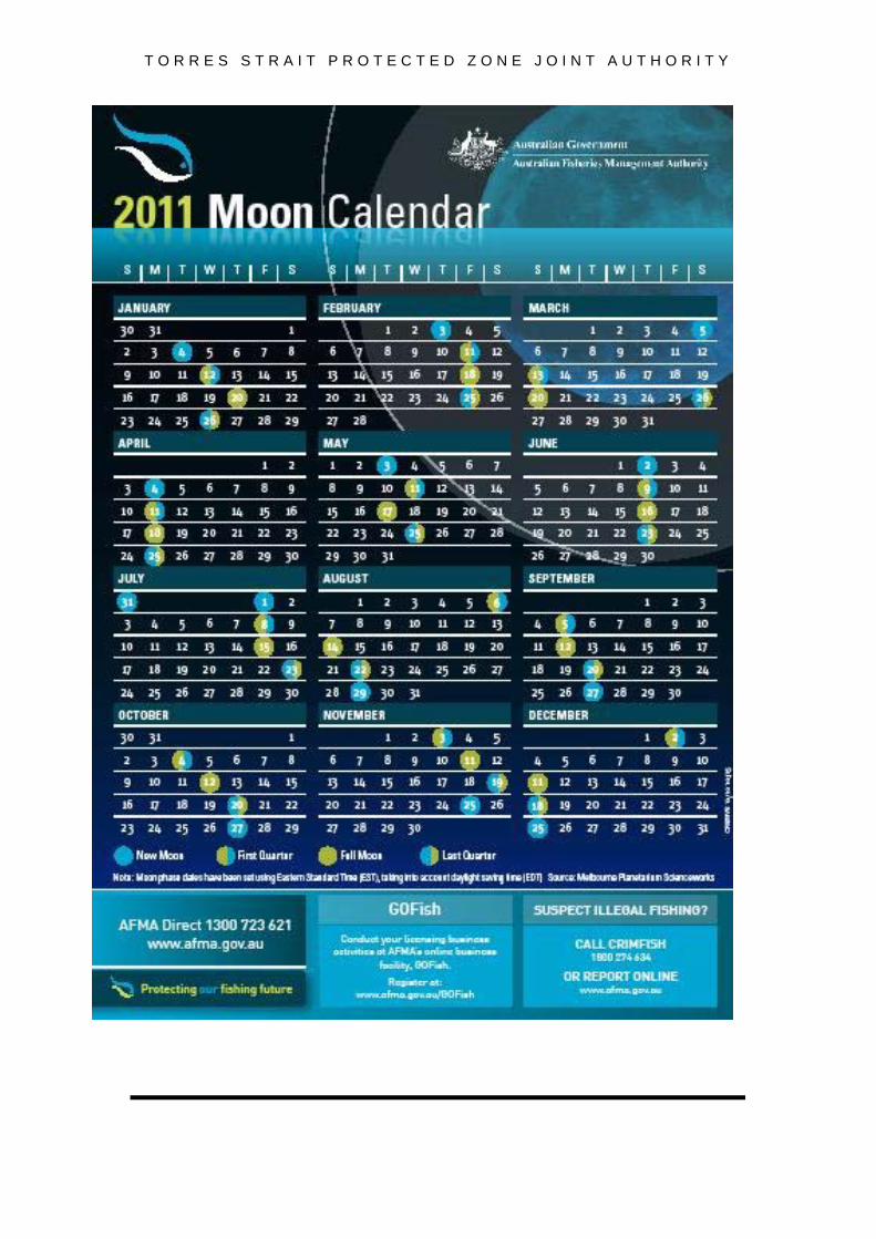
TORRES STRAIT PRAWN FISHERY HANDBOOK 2011 Moon Phase Calendar 2011.......................................................... inside front cover List of Contacts ............................................................................. inside back cover 1 Introduction…………………………………………………………………………. 1
1.1 ACRONYMS............................................................................................. 1
2 Management………………………………………………………………………… 2
2.1 HISTORY.................................................................................................. 2 2.2 TSPF MANAGEMENT PLAN.................................................................... 3 2.3 MANAGEMENT CONSULTATIVE PROCESS......................................... 5 2.4 HOW TO HAVE YOUR SAY IN MANAGEMENT...................................... 6 2.5 PZJA MEETING OUTCOMES.................................................................. 6 2.6 COST RECOVERY.................................................................................. 7 2.7 MANAGEMENT PLAN OBJECTIVES..................................................... 8 2.8 CATCH SHARING WITH PAPUA NEW GUINEA (PNG) ........................ 8
3 What do I need to fish in the TSPF? …………………………………………… 8
3.1 LICENSES.................................................................................................9 3.2 RENEWAL OF LICENCES........................................................................9 3.3 SURRENDER OF LICENCES...................................................................9 3.4 CURRENT LICENCE FEES......................................................................9 3.5 TRANSFERS OF LICENCES AND UFCs.................................................9 3.6 FORFEITURE OF ENDORSEMENTS UPON TRANSFER......................10 3.7 GEAR AND BOAT REQUIREMENTS....................................................... 10 3.8 BOAT LENGTH......................................................................................... 10 3.9 MANNER OF MEASURING LENGTH OF A BOAT.................................. 10 3.10 NET LENGTH AND MESH SIZE.............................................................. 11 3.11 MANNER OF MEASURING A NET OR A MESH..................................... 11 3.12 MANDATORY USE OF TURTLE EXCLUDER DEVICES........................ 11 3.13 MANDATORY USE OF BYCATCH REDUCTION DEVICES.................... 13 3.14 CARRIAGE OF OTHER SPECIES........................................................... 17 3.15 LOGBOOK REPORTING.......................................................................... 17 3.16 EXPORT OF SEAHORSES, SEADRAGONS AND PIPEFISH................. 18
4 Reporting requirements for Vessel Monitoring Systems (VMS).................. 19
4.1 VESSEL MONITORING SYSTEM (VMS) ................................................ 19 4.2 DESIGNATED ANCHORAGES USING WGS84 DATUM......................... 21 4.3 WHO HAS WHAT UNITS?........................................................................ 23 4.4 TOTAL FISHING DAYS SPENT IN THE AREA OF THE FISHERY......... 24
5 Closures and Exclusion Zones...................................................................... 25
5.1 SEASONAL CLOSURE OF THE ENTIRE FISHERY............................... 25 5.2 WEST OF WARRIOR REEF EXCLUSION ZONE.................................... 25

T O R R E S S T R A I T P R O T E C T E D Z O N E J O I N T A U T H O R I T Y
TORRES STRAIT PRAWN FISHERY HANDBOOK 2010 ii
5.3 TRANSIT ZONE - EXEMPTION TO EXCLUSION ZONE......................... 25 5.4 TRANSIT ZONE....................................................................................... 26 5.5 DARNLEY ISLAND EXCLUSION ZONE................................................. 26 5.6 DELIVERANCE, KERR AND TURU EXCLUSION ZONES (NEW) ......... 26 5.7 EAST OF WARRIOR REEF SEASONAL CLOSURE............................... 26 5.8 KAILAG ENTERPRISES SPONGE AQUACULTURE FARM……………. 26
6 Breaches of Regulations................................................................................. 27
7 Fisheries legislation affecting the Torres Strait Prawn Fishery.................. 28
7.1 LEGISLATION INDEX............................................................................... 28 7.2 FISHERIES MANAGEMENT NOTICES/ INSTRUMENTS........................ 29
8 Maps.................................................................................................................. 68
8.1 FISHERIES JURISDICTION LINE............................................................ 68 8.2 AREA AND CLOSURES OF THE TORRES STRAIT PRAWN FISHERY 70
9 Research.......................................................................................................... 71 9.1 RESEARCH REPORT.............................................................................. 71
10 Logbook Statistics........................................................................................... 78
10.1 CATCH AND EFFORT BY YEAR............................................................. 78 10.2 FISHING CATCH RATES AND STOCK BIOMASS.................................. 80 10.3 REGIONAL CATCH AND EFFORT.......................................................... 81 10.4 SPATIAL DISTRUBUTION OF CATCHES & EFFORT............................ 81 10.5 MONTHLY TRENDS IN CATCH AND EFFORT....................................... 84 10.6 DETAILS BY MONTH CATCHES AND EFFORT SINCE 1989............... 88
11 Fishery Observer Program.............................................................................. 90 11.1 OBJECTIVE OF THE PROGRAM............................................................ 90 11.2 ROLES OF THE OBSERVER................................................................... 90 11.3 OBLIGATIONS OF AFMA AND THE OBSERVER................................... 91 11.4 OBLIGATIONS OF THE LICENCE HOLDER AND THE VESSEL’S OPERATOR ........................................................................... 91
12 Other Information............................................................................................ 92
12.1 TORRES STRAIT ISLANDERS AND THEIR LIFE STYLE....................... 92 12.2 KAILAG ENTERPRISES SPONGE AQUACULTURE FARM .................. 93 12.3 INTERACTIONS WITH COMMONWEALTH PROTECTED MARINE SPECIES.................................................................................... 94 12.4 TURTLE RECOVERY PROCEDURES.................................................... 96 12.5 CODE OF PRACTICE FOR THE HANDLING OF SHARKS AND RAYS IN THE TORRES STRAIT PRAWN FISHERY............................... 100 12.6 AUSTRALIAN MARITIME SAFETY AUTHORITY (AMSA) POLLUTION FROM FISHING VESSELS................................................. 100 12.7 OTHER READING.................................................................................... 101
13 Publications relevant to the TSPF.................................................................. 102 LIST OF CONTACTS.............................................................................................. 104

T O R R E S S T R A I T P R O T E C T E D Z O N E J O I N T A U T H O R I T Y
____ TORRES STRAIT PRAWN FISHERY HANDBOOK 2011
1 Introduction The 2011 Torres Strait Prawn Fishery handbook aims to provide Torres Strait Prawn Fishery (TSPF) licence holders with the latest management, logbook and scientific information available on the TSPF. The 2011 Handbook has been compiled by the Australian Fisheries Management Authority (AFMA) in conjunction with Fisheries Queensland (under the Department of Employment, Economic Development and Innovation; DEEDI) to inform and assist prawn fishers and licence holders in their fishing operations.
This year’s handbook provides an update on the status of the fishery and recent developments. A detailed background and history of the TSPF can be obtained from the TSPF strategic assessment, previous TSPF handbooks and the Torres Strait Protected Zone Joint Authority (PZJA) annual report. The summary information in the handbook is intended only to provide a guide to arrangements in the TSPF and does not replace legislation, legislative instruments or detailed advice specific to individual circumstances. For more detailed information readers should make use of the contacts listed inside the back cover and the copies of legislation in Section 7 of the handbook and on the PZJA website, including the Torres Strait Prawn Fishery Management Plan 2008.
The information in this handbook in no way limits the powers and decisions of the Protected Zone Joint Authority (PZJA) in its determinations, or in its considerations of any matters placed before it. Specific individual applicants who wish to take part in Torres Strait fisheries or who wish to vary the conditions under which they take part should be aware that the powers are vested with the PZJA to consider each application on its individual merits.
1.1 Acronyms
ABARE Australian Bureau of Agriculture and Resource Economics AFMA Australian Fisheries Management Authority AMSA Australian Maritime Safety Authority BAP Bycatch Action Plan BRD Bycatch Reduction Device CPUE Catch Per Unit Effort DAFF Department of Agriculture, Fisheries and Forestry DEWHA Department of Environment, Water, Heritage and the Arts ERA Ecological Risk Assessment FMN Fisheries Management Notice FRDC Fisheries Research and Development Corporation ECOTF East Coast Otter Trawl Fishery EMSY Effort at Maximum Sustainable Yield. EPBC Act Environmental Protection and Biodiversity Conservation Act 1999 NPF Northern Prawn Fishery PNG Papua New Guinea PZJA Protected Zone Joint Authority QB&FP Queensland Boating and Fisheries Patrol The Plan Torres Strait Prawn Fishery Management Plan 2009 TSFMAC Torres Strait Fisheries Management Advisory Committee TSPMAC Torres Strait Prawn Management Advisory Committee TSPEHA Torres Strait Prawn Entitlement Holders' Association TSPF Torres Strait Prawn Fishery TSPZ Torres Strait Protected Zone TSRA Torres Strait Regional Authority TSSAC Torres Strait Scientific Advisory Committee VMS Vessel Monitoring System

TORRES STRAIT PRAWN FISHERY HANDBOOK 2011 2
2 Management 2.1 History
A detailed history of the TSPF can be found in the TSPF Strategic Assessment on the Torres Strait Website (http://www.pzja.gov.au/). A brief overview of changes to management arrangements within the fishery since 2005 follows. Further, a diagrammatic history is detailed in Figure 1.
On 3 November 2005, the PZJA met via teleconference and agreed to introduce a total cap of 9,197 days (via a 31.8% pro-rata effort reduction to TSPF entitlement holders), in the TSPF. This decision was taken in light of scientific advice on the number of days to achieve the maximum sustainable yield of tiger prawns, the species considered to be most vulnerable to over-fishing in this multi-species fishery. The stock assessment indicated that activation of latent effort at current effort limits would likely lead to unsustainable harvest levels. An independent review of the stock assessment modelling which produced this estimate found it to be robust. It is possible that stock assessment advice will change in the future and the available effort in the fishery could be more or less than the current estimate of fishing effort required for maximum sustainable yield (EMSY). Things that may change the estimate of EMSY are changes in fishing practices (increase fishing power), new information on the status of the stock, spatial or seasonal closures in some areas or a combination of these.
0
20
40
60
80
100
120
140
160
1987
- Li
mite
d en
trycr
iteria
app
lied
1989
- St
rict b
oat
repl
acem
ent p
olic
y &
freez
e on
tran
sfer
s
1993
- Fi
shin
g da
ysy
stem
intro
duce
d
Jan
2000
- Fu
rther
licen
ce re
duct
ions
achi
eved
thro
ugh
amal
gam
atio
n of
days
Feb
2006
- Fu
rther
licen
ce re
duct
ions
achi
eved
thro
ugh
the
volu
ntar
y te
nder
proc
ess
Lice
nce N
umbe
rs
0
5,000
10,000
15,000
20,000
25,000
30,000
35,000
40,000
45,000
Pote
ntia
l Fis
hing
Day
s
Licence Num bers Potential fishing days
Figure 1: Diagrammatic history of the Torres Strait Prawn Fishery.
The Australian Government Department of Agriculture Fisheries and Forestry issued a Request for Tender (RFT) to Australian operators to fund payments for the voluntary surrender or reduction of fishing days in December 2005. This had the primary objective of surrendering 25% of the 9,197 days allocated in the TSPF for the 2006 season, so that these days could be held in trust to allow for PNG’s catch sharing entitlements under the Torres Strait Treaty. In February 2006, it was announced that the tender process had resulted in the removal of sixteen licences from the fishery and the surrender of

TORRES STRAIT PRAWN FISHERY HANDBOOK 2011 3
approximately 25 per cent (2,333 allocated fishing days) of total fishing effort (Abetz, 2006b).
In accordance with an out-of-session decision of the PZJA, the 9,197 nights was rounded up to an overall effort cap of 9,200 fishing days available in the TSPF for the 2006 season, of which 6,867 fishing days were available to Australian operators, 2,070 fishing days were available to PNG operators and 263 days were held in trust by the Australian Government.
Licence holders must hold a minimum number of nights to operate in the fishery. Prior to the 2006 season, the minimum number required was 50 days. Paralleling the total allowable effort reduction in the 2006 season, the minimum number of days required decreased to 34 days (Larcombe and McLoughlin, 2007). Despite these changes, there was still unused effort in the 2006 season with only 41% of Australian operators fishing all their allocated fishing nights. A number of vessels used less than half of their allocated fishing nights while four vessels with large allocations did not fish at all (Larcombe and McLoughlin, 2007).
During 2008, the TSPF continued to operate under management arrangements rolled over from the 2007 season until the Torres Strait Prawn Management Plan was approved in February 2009. In addition, the Australian Government negotiated access to unused 2008 and 2009 season fishing days in the TSPF allocated to PNG under the Torres Strait Treaty (see catch sharing arrangements under S2.8 of the Treaty for additional details). At 1 February 2011 there were 47 active licenses in the fishery and 14 inactive licenses that did not have a boat attached.
2.2 TSPF Management Plan
To introduce a more flexible system of management for the TSPF, the PZJA agreed by teleconference on November 3, 2005 to move the management of the TSPF under a plan of management. Subsequently, at an out-of-session meeting of the PZJA on 23 December, 2005 the PZJA agreed to a number of new arrangements to be packaged under a management plan to promote greater efficiency including;
• moving from the existing system of fishing days to the new system involving a form of effort units and access as a proportion of the total pool of available fishing days in any season;
• Introducing a formal system to allow operators to temporarily transfer unused fishing effort within a season.
As a result of these decisions, The Torres Strait Prawn Fishery Management Plan 20091 (The Plan), was developed through consultation with industry members (including two port meetings in September 2008), PZJA consultative bodies including the Torres Strait Prawn Management Advisory Committee, key government agency personnel, and broader stakeholder consultation (through a 30 day public consultation period from 2 June to 2 July 2008).
The Plan was approved by the PZJA on 15 December 2008 and was determined on 6 February 2009. The management plan formalised management arrangements that already existed in the fishery. There are also two major changes that occurred under the Plan:
1 Due to an administrative error some parts of the management plan, particularly clause 1.1, refer to it as the Torres Strait Prawn Fishery Management Plan (2008). This is incorrect and it should be referred to as the Torres Strait Prawn Fishery Management Plan (2009). This error does not affect the status of the Plan and any reference to the Torres Strait Prawn Fishery Management Plan (2008) should be read as Torres Strait Prawn Fishery Management Plan (2009).

TORRES STRAIT PRAWN FISHERY HANDBOOK 2011 4
Granting of ongoing access rights as UFCs Under the Plan, the PZJA has allocated long term ongoing access rights in the form of units of fishing capacity (UFCs). Through this process, the TSPF has been divided into 9,200 UFCs and these have been issued to the holders of TSPF boat licences. These UFCs are valid for the life of the Plan and one UFC was issued for each fishing day held by a licence holder immediately before the commencement of the Plan (allocations did not include temporarily allocated fishing days including PNG days).
For example;
Under the Plan, if a holder had multiple licences in the same name, the fishing days from these were pooled together and converted to UFCs in the same holder's name. Under the Plan the pooled amount can be utilised in any proportion by any of the licences held in the same name as the UFCs.
Each season, these units of fishing capacity will be transferred into an annual use entitlement in the form of fishing days. For example;
Temporary Transfer of unused UFCs The Plan provides for TSPF licence holders to temporarily transfer unused UFCs to another holder of a TSPF boat licence by applying to the PZJA to register a transfer of a specific number of UFCs. These units can only be used by the transferee for the season in which they are transferred. Any temporarily transferred units cannot be transferred on by the transferee.
The system automatically transfers any temporarily transferred units back to the transferor before the commencement of the following season.
If a licence holder wishes to temporarily transfer a given number of fishing days, it is the transferor and transferee’s obligation to determine the equivalent number of UFCs. See section 3.5 within the handbook for information regarding the process to transfer unused UFCs.
These management arrangements aim to maintain the sustainability and profitability of the fishery whilst minimising the variation from one year to the next to facilitate business efficiency, thus providing more certainty to industry. The Plan also ensures that Australia’s fisheries obligations to PNG and Torres Strait Islanders under the Torres Strait Treaty are upheld, delivering equitable resource distribution between the commercial and community fishing sectors. In addition, the objectives under the Plan assist the PZJA in achieving improved fisheries resource sustainability consistent with the requirements of the Environment Protection and Biodiversity Conservation Act 1999 (EPBC Act).
Frequently asked questions regarding the operation of the fishery under the Torres Strait Prawn Fishery Management Plan can be found in the document “Torres Strait Prawn Fishery Management Plan Frequently Asked Questions” on the PZJA website (www.pzja.gov.au).
230 fishing days (pre-plan) = 230 UFCs under the Plan.
Use entitlement = TAE /9,200 x UFCs held
250 days from licence 1 and 130 days from licence 2 (380 days pre-plan) = 380 units under the plan

TORRES STRAIT PRAWN FISHERY HANDBOOK 2011 5
2.3 Management consultative process
The PZJA has responsibility for management decisions of the TSPF (Figure 2). At the time of publication the PZJA comprised of the Commonwealth Minister for Agriculture, Fisheries and Forestry, Senator the Hon. Joe Ludwig (Chair), the Queensland Minister for Primary Industries, Fisheries and Rural and Regional Queensland, the Honourable Tim Mulherin MP, and the Chair of the Torres Strait Regional Authority, Mr John (Toshie) Kris.
The role and functions of the Torres Strait Prawn Management Advisory Committee (TSPMAC) In April 2006 the PZJA agreed to elevate the Prawn Working Group to the Torres Strait Prawn Management Advisory Committee (TSPMAC), which includes members from Industry, traditional inhabitants (i.e. Torres Strait Islanders) and State and Commonwealth Government representatives who actively participate in the development of management arrangements. Under the current structure the TSPMAC provides advice for the PZJA on fishery-specific management issues for the TSPF which are put forward to the PZJA for approval.
The TSPMAC has specific functions that support the decision making process. A MAC advises the PZJA on fishery objectives, strategies, reference points, risk profiles and management arrangements for achieving fishery-specific goals. For the PZJA to be able to make decisions based upon MAC advice, the PZJA has to be confident that a MAC has put in place rigorous processes to determine the best package of measures in pursuit of the PZJA’s objectives. Good governance and business efficiency demand that the PZJA is normally able to approve MAC advice without delving into MAC business details, or needing to seek clarification from a MAC.
The role of a MAC is to advise the PZJA on management issues for the fisheries managed under the Act. It provides the forum where issues relating to the fisheries are discussed, problems identified and possible solutions developed. The outcome of these deliberations determines the recommendations a MAC will make to the PZJA concerning the management of relevant fisheries.
Protected Zone Joint AuthorityCommonwealth Minister (Chair), Queensland Minister and
TSRA Chair
Management Advisory Committee(MAC)
Resource Assessment Group (RAG)
Scientific Advisory Committee
(SAC)
Resource Assessment Group (RAG)
Scientific Advisory Committee
(SAC)
Fishery Working Groups(WG)
Figure 2: The consultative structure of the Torres Strait Protected Zone Joint Authority (PZJA). Solid lines and dashed lines indicate primary and secondary lines of communication respectively.

TORRES STRAIT PRAWN FISHERY HANDBOOK 2011 6
2.4 How to have your say in management
To have your views put forward for management consideration you should contact one of the representatives on the TSPMAC. Current Industry and Islander members are: Industry Ms Kylie Paulsen Phone: (02) 6166 4500 Mobile: 0438 630 491
Mr. Marshall Betzel Phone: (07) 4035 1989 Fax: (07) 4035 1552 Mobile: 0408 202 089
Mr. Ron Earle Phone: (07) 4945 7132 Mobile: 0429 660 928
Mr Chris Bourke Phone: (07) 3883 1813 Fax: (07) 3283 1641 Mobile: 0438 514 138
Islander c/o TSRA Fisheries Co-ordinator Phone: (07) 4069 0700 Fax: (07) 4069 2967
There are usually two face to face meetings of the TSPMAC held each year.
2.5 PZJA meeting outcomes The PZJA did not conduct a formal face to face meeting of the PZJA in 2010 but participated in out-of-session decision making processes. The PZJA made the following relevant decisions in regard to the Prawn Fishery for the 2011 season (refer to PZJA website for the complete decision record and papers discussed):
ON 25 NOVEMBER 2010
Torres Strait Prawn Fishery 2011 Total Allowable Effort The PZJA AGREED that consistent with the TSPF management plan, harvest strategy and PZJA sustainability reference point, the maximum combined Total Allowable Effort in the Torres Strait prawn fishery should be set at 9,200 days for the 2011, 2012 and 2013 seasons.
Torres Strait Prawn Fishery Levies for the 2011 Season
The PZJA AGREED:
(a) to the setting of levies for the TSPF for the 2011 fishing season at $2895.59 per licence and $21.19 per effort unit;
(b) to the proposed Fisheries Levy (Torres Strait Prawn Fishery) Amendment Regulations 2010 (No. ), Explanatory Memorandum and Explanatory Statement, noting minor changes to these documents may be made during the clearance process with DAFF and ExCO; and
(c) to the PZJA Chair presenting the Explanatory Statement, along with the proposed Fisheries Levy (Torres Strait Prawn Fishery) Amendment Regulations 2010 (No. ) to the Federal Executive Council at their 8 December 2010 or subsequent Executive Council meeting to ensure that licences can be granted for the 2011 fishing season, commencing on 1 March 2011.
The PZJA NOTED:
(a) the Torres Strait Prawn Management Advisory Committee considered the TSPF levies for the 2011 season at an out-of-session meeting on 3 November 2010;
(b) that these levy amounts have been set using both Australian Fisheries Management Authority (AFMA) and Queensland Primary Industries and Fisheries (QPIF) budgets;

TORRES STRAIT PRAWN FISHERY HANDBOOK 2011 7
(c) that the per licence levy has decreased from $4,229.06 in 2010 to $2895.59 in 2011 ($1333.47 decrease) and the per unit levy has decreased from $27.23 in 2010 to $21.19 in 2011 ($6.04 decrease); and
(d) that for the 2010-11 financial year, the total levy to be collected from industry is $322,162 comprising a QPIF component of $163,387 and an AFMA component of $158,775. Of the total to be collected, QPIF will retain $163,387 to meet Queensland expenses and provide $158,775 to AFMA to meet AFMA expenses.
2.6 Cost recovery
In October 1996, the PZJA determined that the TSPF be subject to cost recovery and that it should be phased in at 40%, 70% and 100% in subsequent years.
The budgets/costs for 2011 season are displayed in Table 1. The licence and per day levies are based on budgeted costs. Savings or additional costs in actual expenditure from the previous financial year budget will continue to be credited/ debited to the following year’s budget. The levy for 2011 is $2895.59/ licence and $21.19 / day.
Budgeted Costs
2010/11
Carry forward Surplus/ (deficit)
from 2009/10 budget
Total to be
Attributed
% Fixed/ License
component 2011
% Variable/ Unit
component 2011
AFMA Data management 17,065 (643) 17,708
0
100 17,708
AFMA Data entry and logbooks 10,248 11,112 -864
100
-864
0 QBFP
surveillance 56,960 0 56,960 50
28,480 50
28,480 Administration/
other & licensing
AFMA QPIF
Subtotal
258,117 106,427 364,544
116,186 0
116,186 248,358
60
149,014.80
40
99,343.20 TOTAL 448,817 126,655 322,162
176,630.80
145,531.20
Number of licences as at 30 January 2011 61 Fixed component/ licence (based on 61 licences) $2,895.59 Number of days allocated to these 61 licence holders 6,867 Variable component/ day $21.19 Budgets and costs will be continually reviewed and open to scrutiny by TSPMAC members, with a view to achieving the most cost effective management arrangements.

TORRES STRAIT PRAWN FISHERY HANDBOOK 2011 8
2.7 Management objectives as defined in the Plan
In addition to the objectives in the Torres Strait Fisheries Act 1984, the PZJA is to have regard to the following objectives for the TSPF: Objective 1 Ensure the optimum utilisation of the fishery resources within the TSPF is
consistent with the principles of ecologically sustainable development and the exercise of the precautionary principle.
Objective 2 Promote economic efficiency in the utilisation of the fisheries resources within the TSPF.
Objective 3 Ensure cooperative, efficient and cost effective management of the Fishery.
Objective 4 Manage the fishery’s interaction with the marine environment including the incidental capture of non-target species and impacts on demersal habitats.
2.8 Catch sharing with Papua New Guinea (PNG)
Under the Torres Strait Treaty 1985, Papua New Guinea (PNG) is entitled to a 25 per cent share of the catch in the TSPF located within Australian fisheries jurisdictional waters of the Protected Zone. It also entitles Australia to a 25 per cent share of the catch of the prawn fishery in PNG’s jurisdiction of the zone. This recognition is implemented through the catch sharing provisions under Article 23 of the Treaty, negotiated typically on a yearly basis between Australia and PNG. All PNG vessels that take up this option are required to operate under the same regulations that exist for Australian vessels. In addition, the crew is subject to Australian quarantine, customs and immigration laws and is therefore not permitted to have contact with any Australian inhabitant or set foot on Australian territory. Historically, PNG participation in Australian waters has been low.
Following the permanent surrender of Torres Strait Islander interests in 2005, Torres Strait Islanders no longer participate in the TSPF in the Australian area of the fishery (PZJA, 2005).
At the PNG / Australia bilateral fisheries meeting held in Cairns on 7 October 2010, PNG and Australia discussed at an agency level the 2010 management arrangements. At this meeting PNG officers offered to Australia their share of the prawn fishery for 2011, comprising 2,104 units. The minutes are still to be agreed to formally by the Commonwealth Minister for Agriculture, Fisheries and Forestry and the PNG Minister for Fisheries and Marine Conservation, as is required by the Treaty.
3 What do I need to fish in the TSPF? To fish in the TSPF there are minimum requirements of operators. The complete requirements for TSPF operators are outlined in the following documents;
• The Commonwealth Torres Strait Fisheries Act 1984; • Torres Strait Prawn Fishery Management Plan 2009; • Torres Strait Fishery Regulations 1985; • Fishery Management Instruments; • Fisheries Levy (Torres Strait Prawn Fishery) Regulations 1998; and • The Torres Strait Treaty 1985.

TORRES STRAIT PRAWN FISHERY HANDBOOK 2011 9
It is the responsibility of operators to familiarise themselves with these documents and understand the requirements when fishing within the TSPF (legislation is available from www.comlaw.gov.au). As a minimum requirement, operators fishing in the TSPZ must hold:
• a Torres Strait Master Fisherman’s licence; • a Fishing Boat License endorsing them to take prawns in the area of the fishery; • unused UFCs (fishing days).
3.1 Licenses
Policy on issue of vessel licences No new licences will be issued for the Torres Strait Prawn Fishery (TSPF).
3.2 Renewal of licences
A TSPF licence comes into effect on the day of issue and expires on 25 February each year, as per section 3.2(2) of the TSPF Management Plan.
3.3 Surrender of licenses
PZJA licence holders may surrender their licences by written notice to the Protected Zone Joint Authority, GPO Box 46, Brisbane, Queensland, 4001.
3.4 Current licence fees
A new fee structure for Master Fisherman’s licences and Australian Fishing Boat licences was introduced for all Torres Strait fisheries following the introduction of single jurisdiction on 1 April 1999.
Fees for licences relevant to the Torres Strait fisheries under the Torres Strait Fisheries Act 1984 as at January 2011 are: • Grant or renewal of a 1 year Master Fisherman’s Licence $ 50 • Grant or renewal of a 5 year Master Fisherman’s Licence $ 100 • Grant or renewal of a 1 year Fishing Boat Licence $ 100 • For each endorsement on a 1 year Fishing Boat Licence:
Boat less that 6 metres in length $ 10 Boat at least 6 metres but less than 10 metres in length $ 20 Boat at least 10 metres but less than 15 metres in length………………..$ 40 Boat at least 15 metres in length $ 80
• Transfer of Fishing Boat Licence $ 10
The option to apply for a 5 year Fishing Boat Licence does not extend to the TSPF as any transactions involving a transfer and split of fishing days requires the issue of a revised licence to reflect the reassigned days. The correct fee must be tendered with the application for the renewal or transfer of a licence.
3.5 Transfers of licences and Units of Fishing Capacity (UFCs)
Permanent transfer of licenses and UFCs A holder of a TSPF boat licence (the transferor) may transfer the licence to another person (the transferee) as set out in section 25 of the Act and Part 3, Section 3.3 of the TSPF Management Plan. A licence may only be transferred to a person who is an Australian citizen. If the licence is the transferor’s last licence, the transferor must transfer all his or her units before or at the same time as the licence transfer. The transferor and transferee must apply to the PZJA using the appropriate form and tender the fee payable for the transfer.

TORRES STRAIT PRAWN FISHERY HANDBOOK 2011 10
The PZJA must not transfer a licence if: (a) a proceeding for an offence under the Act or Regulations has been brought
against the transferor or the transferee and has not been decided; or (b) levy due and payable by the transferor or the transferee has not been paid.
Temporary transfer UFCs The holder of a TSPF boat licence (the transferor) that has unused units for a fishing season may temporarily transfer the unused units to the holder of another TSPF boat licence (the transferee) for a season, as set out in this section. A temporary transfer of Australian units:
(a) must be of whole unused units only; (b) does not take effect until it is registered; (c) entitles the transferee to use the temporarily transferred units during the fishing
season for which the temporary transfer is registered; and (d) remains in force for that season, after which the PZJA will automatically transfer
the units back to the transferor before the commencement of the following season. The transferor and transferee must apply to the PZJA using the approved form for the temporary transfer to be registered, and pay the prescribed fee. The PZJA must not register the temporary transfer if:
(a) a proceeding for an offence under the Act or Regulations has been brought against the transferor or transferee and has not been decided; or
(b) levy due and payable by the transferor or transferee has not been paid.
A person who holds Australian units as the result of a temporary transfer is not entitled to transfer or temporarily transfer those units.
3.6 Forfeiture of endorsements upon transfer The policy of forfeiting endorsement on transfer of commercial licences was abolished by the PZJA in July 1999.
3.7 Gear and boat requirements Restriction on the sizes of boat and gear are set out in Fisheries Management Notices (FMN) No. 47 of 2 September 1997 and No. 71 of 18 February 2004. The contents of these Notices are outlined below, however it is the operators responsibility to be familiar with the contents of the Notices in Section 7 for precise details, or to contact AFMA, Fisheries Queensland or Queensland Boating and Fisheries Patrol (QB&FP), if you have any queries.
3.8 Boat length
Boats in the TSPF may not exceed 20 m in length unless when FMN No. 4 came into effect (2 September 1997) there was, in respect of the boat longer than 20 m, a Torres Strait prawn licence in force. This provision for boats in excess of 20 m ceases to apply if the boat is replaced or increased in length.
3.9 Manner of measuring length of a boat
The length of a boat is determined by measuring the distance between a vertical line passing through the foremost part of the hull and a vertical line passing through the aftermost part of the hull in a horizontal plane. This includes the length of any appendage, which effectively increases the length of the hull, but excluding the length of any anchor rail, bowsprit or similar appendage. Diagrams which are used as a guide for determining the length of a boat are included in Fisheries Management Notice No. 47 in Section 7.

TORRES STRAIT PRAWN FISHERY HANDBOOK 2011 11
3.10 Net length and mesh size
Where otter trawl equipment is used the following provisions apply: Nets • where only one net is used - the length of the net must not exceed 88 metres
(including tri-net); or • where one or more nets are used, the total combined lengths of the nets must not
exceed 88 metres (including tri-net). Mesh • the size of the meshes in the cod end is not to be less than 38 millimetres; or • the size of the meshes in all other parts of the net other than the cod end should
not be less than 45 millimetres; or • there must not be more than 150 meshes when measured in the vertical plane
from the drawstring; or • there must not be more than 1 line of ground chain across the mouth of each net;
or • the diameter of the links of the ground chain must not exceed 10 millimetres; and • the chain must not be used with a weight or attachment, other than an attachment
for joining the chain to the net.
3.11 Manner of measuring a net or a mesh
The length of a net is determined by combining the lengths when taut, of each headrope, bottom rope, any rope which determines the opening of the net, and any other rope to which meshes of the net are attached, with the lengths, measured along the points of attachment, of any part of any other rope (other than a lazy line or log rope) to which a wing net is attached. The size of a mesh is determined by measuring the distance between the innermost edges of two diagonally opposite knots of the mesh, while the net is wet and while the two knots are pulled in opposite directions so that the twine is taut.
3.12 Mandatory use of Turtle Excluder Devices
As outlined in Fishery Management Notice No. 81 all Torres Prawn operators are required to use a Turtle Excluder Device (TED) in their nets (Figure 3-5). “Turtle Excluder Device” means a device fitted to a net, and modification made to a net, that allows turtles to escape immediately after being taken in the net, and which has: (a) A rigid or semi rigid inclined barrier structure comprised of bars extending from the
foot to the head of the net that is attached to the circumference of the net which must guide turtles towards an escape hole immediately forward of the grid. The minimum dimensions of this structure to be at least 80cm by 80cm. This structure is to be set within an angle range of 30 – 55 degrees in relation to the horizontal plane of water through the net;
(b) an escape hole which must be either: (i) A double flap rectangular net opening where the cut immediately forward of the TED
must allow a minimum opening of 61 cm when attached to the frame and the two forward cuts of the escape opening must not be less than 51 cm long from the points of the cut immediately forward of the TED frame. The resultant length of the leading edge of the escape opening cut must be no less than 142 cm stretched, or a double flap net triangular opening where the cut immediately forward of the TED frame must allow a minimum opening of 102 cm when attached to the frame with minimum forward cuts of 101 cm. The flaps must be composed of two equal size rectangular panels of mesh. Each panel must be a minimum of 147 cm wide and may overlap each other no more than 38 cm. The panels may only be sewn together along the

TORRES STRAIT PRAWN FISHERY HANDBOOK 2011 12
leading edge of the cut. The trailing edge of each panel must not extend more than 61 cm past the posterior edge of the TED frame. Each panel may be sewn down the entire length of the outside edge of each panel; or
(ii) A single flap rectangular net opening where the cut immediately forward of the TED must allow a minimum opening of 61cm when attached to the frame and the two forward cuts of the escape opening must not be less than 66 cm long from the points of the cut immediately forward of the TED frame. The resultant length of the leading edge of the escape opening cut must be no less than 181 cm stretched, or a single flap triangular net opening where the cut immediately forward of the TED must be a minimum of 102 cm with minimum forward cuts of 136 cm. The flap must be a minimum of 338 cm by 132 cm piece of mesh. The 132 cm edge of the flap is attached to the leading edge of the escape opening cut. The flap may extend no more than 61cm behind the posterior edge of the TED frame;
(c) a maximum bar spacing of 120 mm between bars; and (d) it is not permitted to attach any weights, chains or other devices on the escape flap
which may prevent the flap from opening. (e)
Figure 3: Dimensions of the flap of a turtle excluder device with single triangular net opening.
Figure 4: Dimensions of the escape opening of a turtle excluder device with a single triangular net opening.
30 – 55°
≥ 132cm
Indicates unattached/floating edges of escape flap
Leading edge
≥ 338cm
TED
Escape opening
>

TORRES STRAIT PRAWN FISHERY HANDBOOK 2011 13
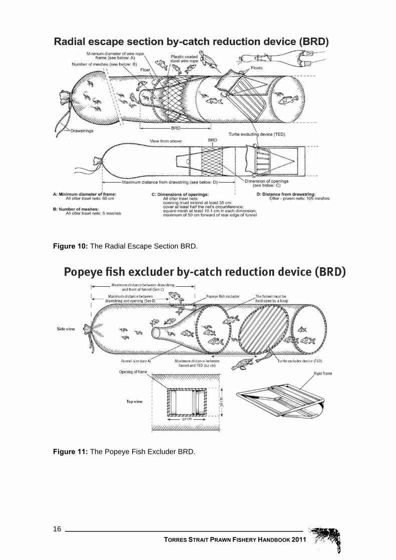
Figure 5: Correct position for measuring angle size on turtle excluder devices. 3.13 Mandatory use of Bycatch Reduction Devices
As outlined in Fishery Management Notice No. 82 all Torres Prawn operators are required to use an approved Bycatch Reduction Device (BRDs; Figures 6 – 11) in their nets. “By-catch Reduction Device” means a device that allows fish and other animals to escape immediately after being taken in the net and is constructed in accordance with Schedule 1 in Fishery Management Notice No. 82.
The following contacts welcome any calls with respect to the trialling of Bycatch Reduction Devices (BRDs) by TSPF operators or any other enquiries about the operation of BRDs:
Australian Fisheries Management Authority (AFMA) Senior Fisheries Management Officer – Torres Strait Fisheries PO BOX 7051 Canberra Business Centre, ACT 2610 Phone – 02 6225 5555 Fax – 02 6225 5500
Fisheries Queensland Senior Fisheries Management Officer - Torres Strait Fisheries GPO BOX 46, Brisbane QLD 4001 Phone – 07 3225 1851 Fax – 07 3225 1823

TORRES STRAIT PRAWN FISHERY HANDBOOK 2011 14
Figure 6: The Square-Mesh Codend BRD.
Figure 7: The Square-Mesh Panel BRD.

TORRES STRAIT PRAWN FISHERY HANDBOOK 2011 15
Figure 8: The Fish Eye BRD.
Figure 9: The Big Eye BRD.
TORRES STRAIT PRAWN FISHERY HANDBOOK 2011 16
Figure 10: The Radial Escape Section BRD.
Figure 11: The Popeye Fish Excluder BRD.

TORRES STRAIT PRAWN FISHERY HANDBOOK 2011 17
3.14 Carriage of other species
Table 2 details information on the carriage of particular species by prawn trawlers in the Torres Strait. Changes in the maximum quantities of each respective species from previous seasons and their corresponding Fisheries Management Notices are displayed (Table 2). Size limits also apply for relevant species.
Table 2: Torres Strait Prawn Fishery species carriage allowances.
SPECIES MAXIMUM QUANTITY
Previous New Under TSPF Management Plan
Mackerels (Scombrids) Total of 20kg combined in any form
Nil
Finfish Total of 20kg combined in any for, including Mackerels
NA
Shark Lesser of 5 sharks or 30kgs of shark
Nil
Shark fin Nil NA Tropical rock lobster Nil NA Pearl shell Nil NA Turtle Nil NA Coral Nil NA
3.15 Logbook reporting
Logbook reporting in the Torres Strait Prawn Fishery is compulsory. The NP16 logbook was introduced for the TSPF for the 2009 season and will remain in effect until revoked. License holders or their Authorised Agents are required to ensure all fields contained in the logbook are fully completed by no later than one day after the day on which the fishing activities took place. Each logbook contains full instructions on how the logbook should be completed and license holders or their authorised agents are required to return them in the manner specified in the logbook. Logbooks are supplied by AFMA and a new logbook may be acquired by contacting:
AFMA Logbook Section PO Box 7051 Canberra Business Centre Canberra 2610 ACT or Freecall: 1300 723 621

TORRES STRAIT PRAWN FISHERY HANDBOOK 2011 18
IMPORTANT REMINDER
COMPLETING AND RETURNING LOGBOOKS ON TIME
LICENSE HOLDERS OR THEIR AUTHORISED AGENTS ARE ASKED TO PLEASE ENSURE THAT LOGBOOKS HAVE ALL FIELDS FULLY COMPLETED AND THE LOGSHEET COPIES SENT TO AFMA AS PER THE INSTRUCTIONS CONTAINED IN THE LOGBOOK, “A vessel must submit their completed up to date logsheets to AFMA each time they return to port or rendezvous with a mothership that holds an AFMA Carrier Boat Permit”
LATE AND IRREGULAR RETURNS CREATE DIFFICULTIES FOR STAFF PROCESSING THE DATA AND RESULT IN INCOMPLETE INFORMATION FOR REPORTS SUCH AS THIS HANDBOOK.
THE PENALTY FOR FAILURE TO SUPPLY OR COMPLETE LOGBOOK RETURNS CORRECTLY IS UP TO $10,000 AND/OR CANCELLATION OF LICENCE.
Registration for use of e-logs and e-licensing AFMA has introduced a new on-line business system called GOFish which provides for electronic logbook reporting (E-logs) and electronic licensing functions for Commonwealth fishers. GOFish commenced in 2009. E-logs are also available for Torres Prawn Fishery operators if you wish to use them.
To use e-logs, you will need to purchase and install a software package that has been accredited by AFMA. You will also need to register for GOFish, AFMA’s online business facility.
Please note: licensing functions for the Torres Prawn Fishery continue to be provided by Fisheries Queensland and thus will not be available to TSPF operators through GOFish.
You will still be required to submit paper logbook forms for Turtle Exclusion Devices (TED’s) and Bycatch Reduction Devices (BRD’s).
For information on e-logs, please visit: http://www.afma.gov.au/industry/logbooks/elogbooks.htm or contact Narelle Williams direct on 02 6225 5542 or 1300 723 621 or email [email protected]
If e-logs are used, the NP16 Logbook must be carried on board the vessel at all times and must be used if the e-log system is not operational at any time during the season.
3.16 Export of seahorses, seadragons and pipefish
Sygnathids (seahorses, pipefish and seadragons) are listed marine species under Part 13 of the Environment Protection and Biodiversity Conservation Act 1999. Some species (Hippocampus) are also listed under the Convention on the International Trade of Endangered Species of Wild Fauna and Flora (CITES).
This means that in order to retain and/or export sygnathids, permits from the Australian Government Department of Sustainability, Environment, Water, Population and Communities (The Commonwealth Government environmental agency; previously DEWHA) must be obtained. In the case of export permits, these will typically only be granted for captive bred specimens or specimens that have been taken from the wild under an appropriate management regime that has been approved under the EPBC Act to ensure sustainable harvesting.

TORRES STRAIT PRAWN FISHERY HANDBOOK 2011 19
It is important that any fishermen who catch these species and any persons exporting these species are aware of the above requirements. If you require further information regarding this matter please contact either the Australian Government Department of Sustainability, Environment, Water, Population and Communities on (02) 6274 1111 or AFMA Environment section on freecall 1300 723 621.
4 Reporting requirements for Vessel Monitoring Systems (VMS) 4.1 Vessel Monitoring System (VMS)
All Torres Strait prawn trawlers are required to have an approved VMS fitted. The VMS unit, also known as the Automatic Location Communicator (ALC), must be operational at all times unless prior arrangements have been entered into with the PZJA or manual position reporting is being undertaken as a result of a unit failure. The VMS unit, including the antenna and cabling, must not be altered, damaged, disabled or tampered with. For mandatory VMS installation requirements, please see the PZJA published document entitled Torres Strait Prawn Fishery VMS guidelines on the PZJA website.
How is VMS to be used in the fishery? The primary role of VMS in the fishery is to provide an efficient automated mechanism for monitoring (counting) fishing days, and to improve the effectiveness and efficiency of the compliance program.
How will VMS be used to count fishing days? From the commencement of the 2004 season, masters were no longer required to make a notification when entering or exiting the TSPF. Utilising VMS, a boat entering the fishery will now be automatically determined and every subsequent day monitored whilst the boat remains in the fishery.
Whilst in the area of the fishery “fishing days” will only be deducted if the boat: 1. is in an area where prawns are permitted to be taken; and 2. is not within the area of one of the designated anchorages specified below in section
5.2; and 3. has moved more than 250 metres at any time between 1800 hours local time on one
day and 0600 hours local time on the next day; or 4. no boat position reports are received via the Vessel Monitoring System or through
another arrangement entered into with PZJA.
How will I know if my VMS has broken down? Fisheries Queensland will contact the boat or licence holder by phone, fax or e-mail and advise that the unit is not responding. However, if you become aware that your VMS is not operational, please inform Fisheries Queensland immediately on mobile telephone number 0428 112 917.
What must I do if my VMS breaks down? If your VMS breaks down the master will be contacted and efforts made to rectify the fault. Should this not be possible, the master will be requested to submit manual position reports to Fisheries Queensland at times or at a frequency determined by Fisheries Queensland until the VMS unit functions correctly.
Manual position reports must be sent to facsimile number (07) 3229 8146 or to another location agreed to with Fisheries Queensland. Manual position reports must include the following information:

TORRES STRAIT PRAWN FISHERY HANDBOOK 2011 20
• the boat name; • the boat distinguishing symbol; • the date and time; • the current position of the boat in Latitude and Longitude (in degrees and decimal
minutes); and • whether the boat is fishing, steaming or anchored.
Fisheries Queensland will notify the master of the boat when the VMS recommences functioning correctly.
If the VMS cannot be brought back on line the master of the boat or the licence holder must make immediate arrangements to have the unit repaired and Fisheries Queensland notified of these arrangements in writing immediately. If Fisheries Queensland is not satisfied with the arrangements, Fisheries Queensland may order the master to immediately stow the fishing gear and take the boat directly to port or anchorage so that the unit can be replaced or serviced.
Allocated fishing days and VMS detection Each month, licence holders are sent a ‘Torres Strait Prawn Fishery Use of Fishing Days’ statement by Fisheries Queensland. The statement lists the fishing days recorded as being used for that month. If you consider that a fishing day should not have been recorded as used for your boat for any of the days listed, you should submit evidence to demonstrate that the boat was not fishing on that particular day. To avoid delays in processing such applications, they should be lodged as soon as possible after receiving the notice.
These applications are subject to the decision of the Fisheries Queensland delegate. You should not use a trawl fishing day on the presumption that such an application will be successful. You must await the delegate’s decision.
Please forward all correspondence and supporting documents to:
Senior Fisheries Management Officer - Torres Strait Fisheries, Fisheries Queensland, GPO BOX 46, Brisbane QLD 4001 Phone – (07) 3225 1851 Fax – (07) 3225 1823

TORRES STRAIT PRAWN FISHERY HANDBOOK 2011 21
4.2 Designated anchorages using WGS84 datum
The geographical co-ordinates used in these areas are in WGS84.
AUREED ISLAND
That area of waters bounded by a line: (1) commencing at the point of intersection of the parallel of Latitude 9° 55' 59.10"
South and the meridian of Longitude 143° 18' 56.10" East; (2) running thence south-easterly along the geodesic to the point of Latitude 9° 57'
18.54" South, Longitude 143° 19' 22.38" East; (3) thence south-westerly along the geodesic to the point of Latitude 9° 58' 47.22"
South, Longitude 143° 18' 02.28" East; (4) thence west along the geodesic to the point of Latitude 9° 58' 31.02" South,
Longitude 143° 15' 52.92" East; (5) thence north along the geodesic to the point of Latitude 9° 57' 28.32" South,
Longitude 143° 15' 51.24" East; (6) thence north-easterly along the geodesic to the point of Latitude 9° 56' 00.18"
South, Longitude 143° 17’10.08" East; (7) thence easterly along the meridian to the point of commencement where it
terminates. ____________________
YORKE ISLANDS
That area of waters bounded by a line: (1) commencing at the point of intersection of the parallel of Latitude 9° 43' 11.82" South and the meridian of Longitude 143° 27' 38.82" East; (2) running thence south-easterly along the geodesic to the point of Latitude 9° 43'
47.04"South, Longitude 143° 28' 01.86" East; (3) thence south along the geodesic to the point of Latitude 9° 44' 42.72" South,
Longitude 143° 28' 04.38" East; (4) thence south-westerly along the geodesic to the point of Latitude 9° 45' 27.48"
South, Longitude 143° 27' 35.22" East; (5) thence south-westerly along the geodesic to the point of Latitude 9° 45' 51.18"
South, Longitude 143° 26' 45.42" East; (6) thence south-westerly along the geodesic to the point of Latitude 9° 46' 02.34"
South, Longitude 143° 25' 43.68" East; (7) thence south-westerly along the geodesic to the point of Latitude 9° 46' 21.42"
South, Longitude 143° 24' 33.30" East; (8) thence north-westerly along the geodesic to the point of Latitude 9° 46' 05.88"
South, Longitude 143° 23' 49.68" East; (9) thence north-westerly along the geodesic to the point of Latitude 9° 45' 22.80"
South, Longitude 143° 23' 25.86" East; (10) thence north-easterly along the geodesic to the point of Latitude 9° 44' 45.90"
South, Longitude 143° 23' 36.84" East; (11) thence north-easterly along the geodesic to the point of Latitude 9° 43' 15.96"
South, Longitude 143° 26' 33.90" East; (12) thence easterly along that meridian to the point of commencement where it
terminates. ____________________

TORRES STRAIT PRAWN FISHERY HANDBOOK 2011 22
DUGONG ISLAND
That area of waters bounded by a line: (1) commencing at the point of intersection of the parallel of Latitude 10° 30’ 19.62"
South and the meridian of Longitude 143° 04’ 27.78" East; (2) running thence east along the geodesic to the point of Latitude 10° 30’ 19.08"
South, Longitude 143° 05’ 48.54" East; (3) thence south-easterly along the geodesic to the point of Latitude 10° 30’ 36.00"
South, Longitude 143° 06’ 44.16" East; (4) thence south-easterly along the geodesic to the point of Latitude 10° 31’ 05.88"
South, Longitude 143° 07’ 22.92" East; (5) thence south along the geodesic to the point of Latitude 10° 31’ 55.38" South,
Longitude 143° 07’ 25.56" East; (6) thence south-westerly along the geodesic to the point of Latitude 10° 32’ 30.66"
South, Longitude 143° 07’ 04.86" East; (7) thence south-westerly along the geodesic to the point of Latitude 10° 32’ 37.68"
South, Longitude 143° 06’ 14.64" East; and (8) thence north-westerly along the geodesic to the point of Latitude 10° 31’ 26.94"
South, Longitude 143° 03’ 56.64" East; (9) thence north-easterly along that meridian to the point of commencement where it
terminates. ____________________
COCONUT ISLAND That area of waters bounded by a line: (1) commencing at the point of intersection of the parallel of Latitude 10° 02’ 24.18"
South and the meridian of Longitude 143° 04’ 00.72" East; (2) running thence south-easterly along the geodesic to the point of Latitude 10°02’
25.98" South, Longitude 143° 04’ 29.46" East; (3) thence south-easterly along the geodesic to the point of Latitude 10° 02’ 40.14"
South, Longitude 143° 06’ 01.08" East; (4) thence east along the geodesic to the point of Latitude 10° 02’ 27.12" South,
Longitude 143° 07’ 11.46" East; (5) thence south-easterly along the geodesic to the point of Latitude 10° 02’ 43.50"
South, Longitude 143° 07’ 53.46" East; (6) thence south-easterly along the geodesic to the point of Latitude 10° 03’ 38.46"
South, Longitude 143° 08’ 10.32" East; (7) thence south-westerly along the geodesic to the point of Latitude 10° 04’ 20.88"
South, Longitude 143° 06’ 36.48" East;; (8) thence west along the geodesic to the point of Latitude 10° 04’ 26.82" South,
Longitude 143° 04’ 33.72" East; (9) thence north-westerly along the geodesic to the point of Latitude 10° 03’ 20.88"
South, Longitude 143° 02’ 43.02" East; (10) thence north-easterly along the geodesic to the point of Latitude 10° 02’ 31.92"
South, Longitude 143° 03’ 29.94" East; (11) thence north-easterly along that meridian to the point of commencement where it
terminates. ____________________

TORRES STRAIT PRAWN FISHERY HANDBOOK 2011 23
4.3 Who has what units?
The number of UFCs which were held by each operator as at 17 January 2011 is shown in Table 3.
Table 3. The number of UFCs held by each operator as at 17 January 2011 Boat distinguishing symbol
Boat name Units Boat distinguishing symbol
Boat name Units
G30 Roper Therese 50 FRBZ No Boat 118
FQFD Stacey Lee 184 FVPL Regulus 131 FQFG Millenium II FVPN Millie Rose 262 FQFX Serenity FPHN Mingara II FSJK Trinity FRNK Ali-star 55 FAFE Vandalia 34 FAAP Warlord 39 FXEU Larissa E 297 RU3 Aquarius 255
FZAC Bounty Hunter FRJM Lin-G
FPQQ Second Wind 186 FNGN Danny-B 165
HSJ Ocean Miss 149 FQMM No Boat 246 FPHA K. Vern 41 FTLW No Boat 11 FRVG No Boat 227 FWVW Darden Star 179 FUDG Maggie-Jo FRQK Markina 87 FQFM No Boat 246 FVZK No Boat FXSD Advantage 186 FVMJ Proteus 169 FMWS No Boat 206 FVNV Gulf Bounty FXFD No Boat FCFN No Boat 367 FVHK No Boat 96 FPEB No Boat FVKB Jalaura 34 FWPK No Boat 96 FWDE Avenger 1 772 FRNS No Boat 319 FWGX Kimissa-Lee FWQF Impact
FZAB Samantha J FZAD Caledon Pearl
FHWE Relentless FWSZ Shomac 183 FWEZ Heaven FVMU Somatina 172 FPFZ Janntone 102 FQWS Torakina 227 FVLW Crystal King 101 FWNC Iron Cassia
FVRQ Lady Moreton 124 FALP Faysea G 48
FSTE No Boat – FRMA Roden Lee 93 K6D Cape York 40 FLSQ No Boat 165
FWMN Crystal Enterprise 34 FRSQ Signet 103
FXFC Assailant 105

TORRES STRAIT PRAWN FISHERY HANDBOOK 2011 24
4.4 Total fishing days spent in the area of the fishery
The total fishing days spent in the area of the fishery from 1993-2010 are illustrated in Figure 12. The total percentage of days used in 2010 are shown in Figure 13.
Total days fished in the TSPF from 1993-2010
10375
8868
10562 10344
9310
74306633
46855253
4127
2599 2309
10568
9361
10828 1105511451
10353
0
2000
4000
6000
8000
10000
12000
14000
1993 1994 1995 1996 1997 1998 1999 2000 2001 2002 2003 2004 2005 2006 2007 2008 2009 2010
Figure 12: Total days in the area of the fishery 1993 – 2010.
Proportion of the total allocated* days used in the TSPF for the 2010 season
6867, 60%
4558, 40%
number of Australian days used
allocated* unused Australiandays
Figure 13: Proportion of the total allocated fishing days spent in the TSPF for the 2010 season.

TORRES STRAIT PRAWN FISHERY HANDBOOK 2011 25
5 Closures and Exclusion Zones Seasonal area closures and exclusion zones of the TSPF are an important management tool, keeping sensitive areas free from trawling and allowing protection for areas at important times - such as during recruitment of small prawns to the fishery.
The summaries given below are to be used only as a guide and do not replace the formal legislation in Fisheries Management Notices. It is strongly recommended that you contact AFMA, Fisheries Queensland or the QB&FP if you have any queries.
5.1 Seasonal closure of the entire fishery
The entire TSPF is closed between 0600 hours local time on 1 December in any year and 1700 hours local time on 1 March in the following year.
Carriage of equipment: During the seasonal closure of the entire fishery all equipment that is capable of being used for any kind of trawling, or being used for taking prawns (this includes nets, boards, beams, and skids) must be carried either in the racks or on the deck; except;
1. between 1200 hours and 1700 hours local time on 1 March (in any year) if the boat is anchored; or
2. between 0600 hours and 1800 hours local time on 1 December (in any year); o if all equipment is out of the water; or o if any part of the equipment is in the water - that part is drawn up to the
boat and is visible from nearby aircraft or boat, and if the equipment includes cod ends, the cod ends are open.
Carriage of prawns: The carriage of prawns in the area of the TSPF from 0600 local time on 15 December to 1700 hours local time on 1 March each year. This is currently provided for in Fisheries Management Notice (FMN) No. 49. Fisheries Management Instrument No 1 (FMI1) will replace this Notice in the near future.
5.2 West of Warrior Reef exclusion zone
The taking of prawns in the area west of Warrior Reef is permanently prohibited. This is currently provided for in FMN No. 40 however this notice will be revoked upon the making of Fisheries Management Instrument No. 2. FMI No. 2 will then provide for this prohibition and is expected to be in force before the commencement of the 2009 season. The prohibition also specifies that prawns may not be carried in this area with the exception of the Transit zone as described in Schedule 1 of FMI No. 1.
This closure, as well as providing some protection for smaller prawns, was introduced taking into consideration that most of the inhabited islands are in this region and that a significant concentration of traditional fishing for tropical rock lobster occurs in this area.
Carriage of equipment: In the west of Warrior Reef exclusion zone all equipment that is capable of being used for any kind of trawling, or being used for taking prawns (this includes nets, boards, beams, and skids) must be carried either in the racks or on the deck.
5.3 Transit Zone - exemption to exclusion zone
The transit zone, which overlaps the west of Warrior Reef exclusion zone, was designed to allow vessels safe passage into Thursday Island.
Carriage of equipment: In the transit zone all equipment that is capable of being used for any kind of trawling, or being used for taking prawns (this includes nets, boards, beams, and skids) must be carried so that all of the equipment is out of the water, or if any part of the equipment is in the water that all cod ends are open and drawn up to the

TORRES STRAIT PRAWN FISHERY HANDBOOK 2011 26
boat so that the cod ends would be visible from an aircraft or another boat and the boards are at the blocks.
5.4 Transit zone
The Cape York transit zone allows NPF endorsed vessels to transit between the ECOTF and the NPF. This area is not considered part of the TSPF and trawlers are required to log out of the fishery when entering the transit zone.
Carriage of equipment: In the transit zone all equipment that is capable of being used for any kind of trawling, or being used for taking prawns (this includes nets, boards, beams, and skids) must be carried so that all of the equipment is out of the water, or if any part of the equipment is in the water that all cod ends are open and drawn up to the boat so that the cod ends would be visible from an aircraft or another boat and the boards are at the blocks.
5.5 Darnley Island exclusion zone
The Darnley Island exclusion zone was introduced in response to Islanders' concern at the possible damaging effect of trawling on pearl shell beds in the area.
Carriage of equipment: In the Darnley Island exclusion zone all equipment that is capable of being used for any kind of trawling, or being used for taking prawns (this includes nets, boards, beams, and skids) must be carried so that all of the equipment is out of the water, or if any part of the equipment is in the water that all cod ends are open and drawn up to the boat so that the cod ends would be visible from an aircraft or another boat and the boards are at the blocks.
5.6 Deliverance, Kerr and Turu Exclusion Zones
On 22 May 2008 the PZJA agreed to implement exclusion zones under the Plan around Deliverance Island, Kerr Islet, and Turu Cay. These areas have been excluded from the fishery in response to concern about the important nesting areas for Green and Flatback turtles.
Carriage of equipment: In the Deliverance Island, Kerr Islet, and Turu Cay exclusion zones all equipment that is capable of being used for any kind of trawling, or being used for taking prawns (this includes nets, boards, beams, and skids) must be carried so that all of the equipment is out of the water, or if any part of the equipment is in the water that all cod ends are open and drawn up to the boat so that the cod ends would be visible from an aircraft or another boat and the boards are at the blocks.
5.7 East of Warrior Reef seasonal closure
This closure was introduced at the request of industry to gain a better economic yield from the prawns harvested in this area. Background to the closure was provided in the article from Fisheries Queensland in the 1998 Torres Prawn Handbook.
Timing: The east of Warrior Reef closure applies every year from 0600 hours local time on 1 December in any year and ends at 1700 hours local time on 31 July in the following year.
Carriage of equipment: During the seasonal closure of the entire fishery all equipment that is capable of being used for any kind of trawling, or being used for taking prawns (this includes nets, boards, beams, and skids) must be carried either in the racks or on the deck; except between 1200 hours and 1700 hours local time on 1 March (in any year), the boat is anchored; or between 0600 hours and 1800 hours local time on 1 December (in any year), all equipment is out of the water or if any part of the equipment

TORRES STRAIT PRAWN FISHERY HANDBOOK 2011 27
is in the water - that part is drawn up to the boat and is visible from nearby aircraft or boat; and if the equipment includes cod ends, the cod ends are open.
5.8 Kailag Enterprises sponge aquaculture farm Kailag Enterprises Pty has developed a commercial aquaculture sponge farm in the area around Masig (York) Island. There has been a history of marine incidences with this farm by vessels, including Torres Strait Prawn Fishery vessels. The coordinates of the farm are detailed below. Latitude 9 degrees 44.800’S Longitude 143 degrees 25.630’E Latitude 9 degrees 44.695’S Longitude 143 degrees 25.860’E Latitude 9 degrees 44.520’S Longitude 143 degrees 25.780’E Latitude 9 degrees 44.630’S Longitude 144 degrees 25.550’E Although this is not a formal exclusion zone or closure, PZJA agencies support the operation of the Kailag Enterprises sponge farm and ask all fishing vessels operating in the Torres Strait to respect the facility. PZJA agencies expect operators to be aware of the sponge farm and to make the necessary amendments to their navigation systems and appropriate charts to clearly indicate the farm site co-ordinates. See section 12.2 of this handbook for further information regarding the farm.
6 Breaches of regulations The Torres Strait Treaty allows Australian authorities to consider cancellation or suspension of Australian TSPZ licences held by persons convicted under the Commonwealth Torres Strait Fisheries Act 1984 for either: • breach of PNG law; or • being found by the Australian authorities, on the basis of the available evidence, to
have contravened or failed to comply with a condition of a licence while fishing in PNG jurisdiction of the TSPZ.
If an Australian vessel, endorsed by PNG under catch sharing arrangements to fish in the PNG sector of the TSPZ, is charged under the Commonwealth Torres Strait Fisheries Act 1984 for breach of PNG law, the PNG authorities may, if the Australian Government requests, cancel or suspend this endorsement.
The Treaty requires Australia to consider in Australian courts corrective action (including apprehension of a suspected offender, prosecution, execution of penalties ordered by a Court and cancellation or suspension of licences) against Australians who breach PNG law.
The Commonwealth Torres Strait Fisheries Act 1984 allows the Australian authorities to suspend, for up to one month, an Australian vessel licence on reasonable suspicion that:
• there has been a breach or failure to comply with a condition to which the licence is subject;
• the licence holder or a person acting on their behalf has done an act prohibited by a Notice; or
• the applicant for the licence knowingly made a false or misleading statement in relation to a material particular in the application.
In July 1999 the PZJA agreed that Master Fisherman’s licences will be suspended for serious fisheries offences (i.e. fishing in closed waters) in the TSPF as follows:-
First Offence 3 month suspension Second Offence 12 month suspension Third Offence 5 year suspension

TORRES STRAIT PRAWN FISHERY HANDBOOK 2011 28
7 Fisheries Management Notices and Instruments affecting the Torres Strait Prawn Fishery 7.1 Index of Fisheries Management Instruments and Notices
Notice No. Description Page No.
43 Torres Strait Prawn Fishery – Prohibition on taking prawns (Time allocation) and amendment to FMN No 40. 29
47 Torres Strait Fisheries – restriction on size of boats 33
71 Torres Strait Prawn Fishery – restriction on net sizes 36
81 Torres Strait Prawn Fishery – requirement for use of Turtle Excluder Device
38
82 Requirement for use of bycatch reduction devices 40
Instrument No.
1 Torres Strait Prawn Fishery – Prohibition on taking prawns (time allocation, transit zone and designated anchorages)
44
2 Torres Strait Prawn Fishery – Prohibition on taking prawns and carrying equipment (exclusion zones) 52
3 Torres Strait Prawn Fishery – Prohibition on taking prawns and carrying equipment (seasonal area closures) 60
4 Torres Strait Prawn Fishery – Prohibition on taking prawns by Papua New Guinea boats 64
5 Revocation of Fisheries Management Notices 19 and 61 66
_______________________________________
Extract from the Papua New Guinea Torres Strait Fisheries Act
Carriage of equipment while on route between two areas of Australian jurisdiction 67
NOTE: For a full list of legislation affecting the Torres Strait Prawn Fishery please refer to the PZJA website – www.pzja.gov.au.

TORRES STRAIT PRAWN FISHERY HANDBOOK 2011 29
7.2 Fisheries Management Notices/ Instruments Fisheries Management Notice No. 43
TORRES STRAIT PRAWN FISHERY
PROHIBITION ON TAKING PRAWNS (TIME ALLOCATION) AND AMENDMENT TO FMN NO 40
I, David Peter Beddall, Minister for Resources and member of the Protected Zone Joint Authority, in accordance with a decision of the Protected Zone Joint Authority, hereby make, on behalf of that Authority, the following notice.
_______________________________________
CITATION
1. This notice may be cited as Torres Strait Fisheries Management Notice No 43.
COMMENCEMENT
2. This notice commences on gazettal.
NOTICE TO APPLY WITH OTHER NOTICES
3. This notice applies in conjunction with any other notice in force in the area of the prawn fishery.
INTERPRETATION
4.1 In this notice, unless the contrary intention appears, words have the same meaning as in the Torres Strait Fisheries Act 1984, and:
"prawns" means fish of the family Penaeidae; and
"reporting area" means the area of water described in schedule 1 that does not lie within the area of water described in schedule 2; and
"the Act" means the Torres Strait Fisheries Act 1984; and
"transit zone" means the area described in schedule 2.
4.2 Where for the purposes of this Notice it is necessary to determine the position on the surface of the Earth of a point, line or area, that position shall be determined by reference to the Australian Geodetic Datum, that is by reference to a spheroid having its centre at the centre of the Earth and a major (equatorial) radius of 6,378,160 metres and flattening of 1/298.25 and by reference to the Johnston Geodetic Station in the Northern Territory of Australia. That station shall be taken to be situated at Latitude 25°56’ 54.5515" South and at Longitude 133° 12’ 30.0771" East and to have a ground level of 571.2 metres above the spheroid referred to above.
REVOCATION OF FISHERIES MANAGEMENT NOTICE NO 37
5. Fisheries Management Notice No 37 dated 26 February 1993 is revoked.
PROHIBITIONS (GENERAL) 6.1 Pursuant to paragraph 16(1)(a) of the Act, the taking of prawns is prohibited.
6.2 Pursuant to paragraph 16(1)(a) of the Act, the processing or carrying of prawns is prohibited.

TORRES STRAIT PRAWN FISHERY HANDBOOK 2011 30
6.3 Pursuant to paragraph 16(1)(o) of the Act, the possession of any equipment capable of being used for prawn trawling is prohibited, unless it is carried by having the boards unshackled from the nets and placed on board the boat.
6.4 The prohibitions in paragraphs 6.1, 6.2 and 6.3 apply in the reporting area.
EXEMPTIONS FROM PROHIBITIONS
7.1 Pursuant to paragraph 16(1A)(d) of the Act, if:
(a) a person is, or is acting on behalf of, the holder of a licence in respect of a boat, granted under subsection 19(2) of the Act, or is the master of a boat in respect of which such a licence is in force; and
(b) before the boat entered the area of the prawn fishery the master of the boat notified the Minister in accordance with the procedures in schedule 3; and
(c) there is specified in the licence a condition, under subsection 22(1) of the Act, that limits the number of days in a year that the boat can be in the reporting area; and
(d) the number of days that the boat, and any other boats in respect of which that licence was in force, have been in the reporting area since the start of the year is less than the number specified in the licence
then the person is exempt from the prohibitions in paragraphs 6.1, 6.2 and 6.3.
7.2 For the purposes of paragraph 7.1, if a boat is in the reporting area at any time between 1700 hours local time on one day and 0600 hours local time on the next day, then it is taken to have been in the area for one full day.
7.3 For the purposes of paragraph 7.1 a boat is deemed to have left the reporting area at the time that notification in accordance with paragraph 9 is received.
7.4 Pursuant to paragraph 16(1A)(d) of the Act, a person who holds a licence under subsection 19(3) of the Act in respect of the reporting area is exempt from the prohibition in paragraph 6.2.
7.5 Pursuant to paragraph 16(1A)(d) of the Act, if:
(a) a person holds a licence, in respect of a boat, that was issued under the law of Papua New Guinea; and
(b) the boat is authorised to trawl for prawns in the reporting area
then the person is exempt from the prohibitions in paragraphs 6.1, 6.2 and 6.3 in respect of the boat.
PROHIBITIONS (TRANSIT ZONE) 8.1 Pursuant to paragraph 16(1)(a) of the Act, the taking of prawns is prohibited.
8.2 Pursuant to paragraph 16(1)(o) of the Act, a person is prohibited from having in that persons possession or in that persons charge in a boat, equipment that is:
(i) capable of being used for any kind of trawling; or
(ii) capable of being used for taking prawns
unless that equipment is carried so that all of the equipment is out of the water, or if any part of the equipment is in the water:
(iii) that all cod ends are open and drawn up to the boat so that the cod ends would be visible from an aircraft or another boat; and
(iv) the boards are at the blocks.
8.3 The prohibitions in paragraphs 8.1 and 8.2 apply in the transit zone.
MASTER REQUIRED TO GIVE NOTICE

TORRES STRAIT PRAWN FISHERY HANDBOOK 2011 31
9.1 Pursuant to subsection 14(2A) of the Act, a person who is the master of a boat in respect of which a licence is in force under section 19 of the Act must immediately after leaving the reporting area notify the Minister in accordance with the procedures set out in schedule 3 and state the time and date that the boat left.
9.2 A notification under paragraph 9.1 must be made in the manner specified in schedule 3.
AMENDMENT OF FISHERIES MANAGEMENT NOTICE NO 40 10.1 Fisheries Management Notice No 40, schedule 2, dated 24 February 1994 is
amended by deleting paragraph (26) and substituting the following:
(26A) then south east along the geodesic to the point of Latitude 10°41’ 17" South, Longitude 142°38’ 30" East;
(26B) then west along that parallel to its intersection by the meridian of Longitude 142° 31’ 49" East.
10.2 Fisheries Management Notice No 40, schedule 3, dated 24 February 1994 is amended by deleting paragraph (4) and substituting the following:
(4A) then south east along the geodesic to the point of Latitude 10°41’ 17" South, Longitude 142°38’ 30" East;
(4B) then west along that parallel to its intersection by the meridian of Longitude 142° 31’ 49" East;
(4C) the south along that meridian to its northernmost intersection by the coastline of Cape York Peninsula at low water.
____________________
SCHEDULE 1 Area of the Prawn Fishery
The area consisting of: (a) the area of waters in the Protected Zone to the south of the Fisheries Jurisdiction
Line; and (b) the area of waters (excluding any waters within the limits of Queensland) bounded
by a line- (1) commencing at the point of intersection of the parallel of Latitude 10° 28’ 00"
South and the meridian of Longitude 142° 09’ 00" East; (2) running then east along the parallel of Latitude 10° 28’ 00" South to its
intersection by the meridian of Longitude 144° East; (3) then south along that meridian to its intersection by the parallel of Latitude 10°
41’ 17" South; (4) then west along that parallel to its intersection by the meridian of Longitude 142°
31’ 49" East; (5) then south along that meridian to its northernmost intersection by the coastline of
Cape York Peninsula at low water; (6) then generally south-westerly along the western coastline of Cape York
Peninsula, that is along the low water line on that coast and across any river mouth, to its intersection by the meridian of Longitude 142° 09’ 00" East;
(7) then north along that meridian to the point of commencement; and (c) the territorial sea of Australia north of the Fisheries Jurisdiction Line.
____________________

SCHEDULE 2 Transit Zone
That area of waters bounded by a line:
(1) commencing at the point of intersection of the parallel of Latitude 10°28’ 00" South and the meridian of Longitude 142°09’ 00" East;
(2) then east along the Latitude of 10°28’ 00" South, to its intersection by the meridian of Longitude 142°31’ 49" East;
(3) then in a south easterly direction to its intersection by the parallel of Latitude 10°41’ 17" South, and the meridian of Longitude 142° 38’ 30" East;
(4) then west along that parallel to its intersection by the meridian of Longitude 142° 31’ 49" East;
(5) then south along that meridian to its northernmost intersection by the coastline of Cape York Peninsula at low water;
(6) then generally south-westerly along the western coastline of Cape York Peninsula, that is along the low water line on that coast and across any river mouth, to its intersection by the meridian of Longitude 142° 09’ 00" East; and
(7) then north along that meridian to the point of commencement. ____________________
SCHEDULE 3
Form and Manner of Notification (1) A notification must specify:
(a) the name and distinguishing number of the boat; and
(b) the name of the master; and
(c) the next consecutive number from the list provided with the Torres Strait fishing vessel licence granted in respect of the boat; and
(d) that the boat is entering or leaving the reporting area; and
(e) the date and time of entering or leaving the reporting area.
(2) A notification must be made by telephone to the number 07-830 5852.
(3) The information contained in the notification as specified in (1) shall be recorded in a register.
(5) A notification made in accordance with this schedule is taken to have been made to the Minister.
Approved by DAVID PETER BEDDALL Dated this eighth day of February 1995
Commonwealth of Australia Gazette No. S72, 1 March 1995
TORRES STRAIT PRAWN FISHERY HANDBOOK 2011 32
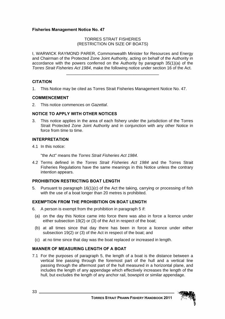
TORRES STRAIT PRAWN FISHERY HANDBOOK 2011 33
Fisheries Management Notice No. 47
TORRES STRAIT FISHERIES (RESTRICTION ON SIZE OF BOATS)
I, WARWICK RAYMOND PARER, Commonwealth Minister for Resources and Energy and Chairman of the Protected Zone Joint Authority, acting on behalf of the Authority in accordance with the powers conferred on the Authority by paragraph 35(1)(a) of the Torres Strait Fisheries Act 1984, make the following notice under section 16 of the Act.
________________________________________
CITATION
1. This Notice may be cited as Torres Strait Fisheries Management Notice No. 47.
COMMENCEMENT
2. This notice commences on Gazettal.
NOTICE TO APPLY WITH OTHER NOTICES
3. This notice applies in the area of each fishery under the jurisdiction of the Torres Strait Protected Zone Joint Authority and in conjunction with any other Notice in force from time to time.
INTERPRETATION
4.1 In this notice:
"the Act" means the Torres Strait Fisheries Act 1984.
4.2 Terms defined in the Torres Strait Fisheries Act 1984 and the Torres Strait Fisheries Regulations have the same meanings in this Notice unless the contrary intention appears.
PROHIBITION RESTRICTING BOAT LENGTH
5. Pursuant to paragraph 16(1)(c) of the Act the taking, carrying or processing of fish with the use of a boat longer than 20 metres is prohibited.
EXEMPTION FROM THE PROHIBITION ON BOAT LENGTH
6. A person is exempt from the prohibition in paragraph 5 if:
(a) on the day this Notice came into force there was also in force a licence under either subsection 19(2) or (3) of the Act in respect of the boat;
(b) at all times since that day there has been in force a licence under either subsection 19(2) or (3) of the Act in respect of the boat; and
(c) at no time since that day was the boat replaced or increased in length.
MANNER OF MEASURING LENGTH OF A BOAT
7.1 For the purposes of paragraph 5, the length of a boat is the distance between a vertical line passing through the foremost part of the hull and a vertical line passing through the aftermost part of the hull measured in a horizontal plane, and includes the length of any appendage which effectively increases the length of the hull, but excludes the length of any anchor rail, bowspirit or similar appendage.

7.2 The diagrams in Schedule A are to be used as a guide for interpreting paragraph 7.1.
____________________________________________________
Approved by WARWICK PARER Dated this second day of September 1997
Commonwealth of Australia Gazette No. GN36, 10 September 1997
SCHEDULE A
TORRES STRAIT PRAWN FISHERY HANDBOOK 2011 34

SCHEDULE A (continued)
TORRES STRAIT PRAWN FISHERY HANDBOOK 2011 35

TORRES STRAIT PRAWN FISHERY HANDBOOK 2011 36
Fisheries Management Notice No. 71
TORRES STRAIT PRAWN FISHERY RESTRICTION ON NET SIZE
The Protected Zone Joint Authority, acting in accordance with the powers conferred on the Authority by paragraph 35(1)(a) of the Torres Strait Fisheries Act 1984, and in accordance with the decisions made by the Authority, make the following Notice under section 16 of the Torres Strait Fisheries Act 1984.
________________________________________
CITATION
1. This Notice may be cited as Torres Strait Fisheries Management Notice No. 71.
COMMENCEMENT
2. This Notice commences on Gazettal.
THIS NOTICE TO APPLY WITH OTHER NOTICES
3. This Notice applies in conjunction with any other Notice in force in the area of the Torres Strait Prawn Fishery.
REVOCATION OF FISHERIES MANAGEMENT NOTICE NO. 59
4. Fisheries Management Notice No. 59, dated 21 February 2002, is revoked.
INTERPRETATION 5.1 In this Notice:
"prawns" means fish of the family Penaeidae spp;
"the Act" means the Torres Strait Fisheries Act 1984. 5.2 Terms used but not defined in this Notice have the same meaning as in the Act
and the Torres Strait Fisheries Regulations.
PROHIBITION 6.1 Pursuant to paragraph 16(1)(f) of the Act, the use or possession of otter trawl
equipment in the area of the Torres Strait Prawn Fishery is prohibited if:
(a) where only one net is used or in possession on board a boat or attached to a boat, the length of the net is longer than 88 metres; or
(b) where more than one net, including a try-net, is rigged for fishing, the total combined length of the nets is longer than 88 metres; and
(c) where more than one net is rigged for fishing, and a try-net is in possession on board the boat but not rigged for fishing, the total combined length of the nets rigged for fishing and the largest try-net in possession on board the boat is longer than 88 metres; and
(d) where a try net is rigged for fishing, in possession on board a boat, or is attached to a boat, the try net is of a length is longer than 10 metres, and
(e) where other nets, excluding try nets, are in possession on board a boat and are not rigged for fishing, the nets are of a size greater than 10% smaller than the largest net in possession on board the boat.

TORRES STRAIT PRAWN FISHERY HANDBOOK 2011 37
6.2 A net is rigged for fishing if part or all of the net is in the water, or if it is shackled, tied or otherwise connected to any trawl door or trawl board, or to any tow rope or cable, either on board the boat or attached in any manner to the boat.
6.3 Pursuant to paragraph 16(1)(c) of the Act, the use or possession of otter trawl equipment in the area of the Torres Strait Prawn Fishery is prohibited if:
(a) the size of the meshes in the cod end is less than 38 millimetres; or
(b) there are more than 150 meshes when measured in the vertical plane from the drawstring; or
(c) the size of the meshes in all other parts of the net other than the cod end does not exceed 45 millimetres; or
(d) there is more than 1 line of ground chain across the mouth of each net; or
(e) the diameter of the links of the ground chain exceed 10 millimetres; or
(f) the chain is used with a weight or an attachment, other than an attachment for joining the chain to the net.
MEASURING NETS AND MESHES 7.1 For the purposes of paragraph 6.1 the length of a net is determined by
measuring the combined length, in metres, of the head rope and bottom rope when taut between the outermost points of the meshes that are attached to each rope respectively.
7.2 For the purposes of paragraph 6.3 the size of a mesh of a:
(a) knotless trawl net is determined by measuring the average distance when the net is taut, between the inner edges of 2 diagonally opposite corners of each of 10 meshes that are at least 30 centimetres from each other; or
(b) knotted trawl net is determined by measuring the average distance when the net is taut, between the inner edges of 2 diagonally opposite knots of each of 10 meshes that are at least 30 centimetres from each other.
________________________________________
Approved by IAN MACDONALD (Chairman of the PZJA) Dated this eighteenth day of February 2004
Commonwealth of Australia Gazette No. S42, 23 February 2004

TORRES STRAIT PRAWN FISHERY HANDBOOK 2011 38
Fisheries Management Notice No. 81
Torres Strait Fisheries Act 1984
Fisheries Management Notice No. 81
TORRES STRAIT PRAWN FISHERY
REQUIREMENT FOR USE OF TURTLE EXCLUDER DEVICE
The Protected Zone Joint Authority, acting in accordance with the powers conferred on the Authority by paragraph 35(1)(a) of the Torres Strait Fisheries Act 1984, and in accordance with the decisions made by the Authority, make the following Notice under section 16 of the Torres Strait Fisheries Act 1984. ________________________________________
CITATION 1. This Notice may be cited as Torres Strait Fisheries Management Notice No. 81.
COMMENCEMENT 2. This Notice commences on 1 March 2007.
THIS NOTICE TO APPLY WITH OTHER NOTICES 3. This Notice applies in conjunction with any other notice in force in the area of the
prawn fishery.
INTERPRETATION 4.1 In this Notice:
"prawns" means fish of the family Penaeidae spp;
"the Act" means the Torres Strait Fisheries Act 1984.
“Turtle Excluder Device” means a device fitted to a net, and modification made to a net, that allows turtles to escape immediately after being taken in the net, and which has:
(a) a rigid or semi rigid inclined barrier structure comprised of bars extending from the foot to the head of the net that is attached to the circumference of the net which must guide turtles towards an escape hole immediately forward of the grid. The minimum dimensions of this structure to be at least 80cm by 80cm. This structure is to be set within an angle range of 30 – 55 degrees in relation to the horizontal plane of water through the net;
(b) an escape hole which must be either (i) a double flap rectangular net opening where the cut immediately forward of the
TED must allow a minimum opening of 61 cm when attached to the frame and the two forward cuts of the escape opening must not be less than 51 cm long from the points of the cut immediately forward of the TED frame. The resultant length of the leading edge of the escape opening cut must be no less than 142 cm stretched, or a double flap net triangular opening where the cut immediately forward of the TED frame must allow a minimum opening of 102 cm when attached to the frame with minimum forward cuts of 101 cm. The flaps must be composed of two equal size rectangular panels of mesh. Each panel must be a minimum of 147 cm wide and may overlap each other no more than 38 cm. The panels may only be sewn together along the leading edge of the cut. The trailing

TORRES STRAIT PRAWN FISHERY HANDBOOK 2011 39
edge of each panel must not extend more than 61 cm past the posterior edge of the TED frame. Each panel may be sewn down the entire length of the outside edge of each panel, or;
(ii) a single flap rectangular net opening where the cut immediately forward of the TED must allow a minimum opening of 61 cm when attached to the frame and the two forward cuts of the escape opening must not be less than 66 cm long from the points of the cut immediately forward of the TED frame. The resultant length of the leading edge of the escape opening cut must be no less than 181 cm stretched, or a single flap triangular net opening where the cut immediately forward of the TED must be a minimum of 102 cm with minimum forward cuts of 136 cm. The flap must be a minimum of 338cm by 132 cm piece of mesh. The 132 cm edge of the flap is attached to the leading edge of the escape opening cut. The flap may extend no more than 61 cm behind the posterior edge of the TED frame;
(c) a maximum bar spacing of 120mm between bars; and (d) it is not permitted to attach any weights, chains or other devices on the escape
flap which may prevent the flap from opening.
4.2 For the purposes of this Notice, all net measurements refer to the measurement from centre of opposing knots, when the mesh is pulled taut.
4.3 Terms used but not defined in this Notice have the same meaning as in the Act and the Torres Strait Fisheries Regulations.
REVOCATION OF FISHERIES MANAGEMENT NOTICE NO 60 5. Fisheries Management Notice No 60 dated 21 February 2002 is revoked.
PROHIBITION 6.1 Pursuant to paragraph 16(1)(c) of the Act, the use or possession of otter trawl
equipment in the area of the Torres Strait Prawn Fishery is prohibited unless each net that is used is fitted with a Turtle Excluder Device.
6.2 However, if a try-net is used, it does not need to be fitted with a Turtle Excluder Device.
________________________________________
Approved by ERIC ABETZ (Chairman of the PZJA) Dated this ninetieth day of December 2006
Registered with FRLI 22 December 2006

TORRES STRAIT PRAWN FISHERY HANDBOOK 2011 40
Fisheries Management Notice No. 82
Torres Strait Fisheries Act 1984
Fisheries Management Notice No. 82
TORRES STRAIT PRAWN FISHERY
REQUIREMENT FOR USE OF BYCATCH REDUCTION DEVICES The Protected Zone Joint Authority, acting in accordance with the powers conferred on the Authority by paragraph 35(1)(a) of the Torres Strait Fisheries Act 1984, and the Minister in accordance with the powers under section 16 of the Torres Strait Fisheries Act 1984, makes the following notice. Dated this 19 day of May, 2008.
______________________
CITATION 1. This Notice may be cited as Torres Strait Fisheries Management Notice No. 82.
COMMENCEMENT 2. This Notice commences on the day it is registered on the Federal Register of Legislative Instruments.
THIS NOTICE TO APPLY WITH OTHER NOTICES 3. This Notice applies in conjunction with any other notice in force in the area of the Prawn Fishery.
REVOCATION OF FISHERIES MANAGEMENT NOTICES 4. Fisheries Management Notice No 70, dated 18 February 2004 is revoked.
INTERPRETATION 5.1 In this Notice, unless the contrary intention appears:
"prawns" means fish of the family Penaeidae spp;
"Bycatch Reduction Device" means a device that allows fish and other animals to escape immediately after being taken in the net and is constructed in accordance with Schedule 1.
"bar" in relation to square mesh in a trawl net, means:
for a knotted trawl net, a side of a mesh from one knot to the next knot on the same side of the mesh; or
for a knotless net, a side of a mesh from one corner to the next corner.
"the Act" means the Torres Strait Fisheries Act 1984;
“try net” means a net, no longer than 10 metres, used for no longer than 25 minutes at a time for sampling or testing or to work out the abundance or presence of prawn; and
“TED” or “turtle excluder device” means a device fitted to a net, and modification made to a net, that allows turtles to escape immediately after being taken in the net, and is constructed in accordance with any instruments under section 16 of the Act that apply to the fishery.

TORRES STRAIT PRAWN FISHERY HANDBOOK 2011 41
5.2 Terms used but not defined in this Notice have the same meaning as in the Torres Strait Fisheries Act 1984 and the Torres Strait Fisheries Regulations.
PROHIBITION 6.1 Pursuant to paragraph 16(1)(c) of the Act, the use or possession of otter trawl
equipment in the area of the Torres Strait Prawn Fishery is prohibited unless each net that is rigged for fishing is fitted with a Bycatch Reduction Device.
6.2 A net is rigged for fishing if part or all of the net is in the water, or if it is shackled, tied or otherwise connected to any trawl door or trawl board, or to any tow rope or cable, either on board the boat or attached in any manner to the boat.
6.3 However, if a try net is used, the try net is not required to be fitted with a Bycatch Reduction Device.
______________________
SCHEDULE 1
SQUARE MESH COD END The net's cod end is a recognised BRD if:
(a) at least half the cod end's circumference is square mesh of at least 45mm; and (b) the square mesh has at least 75 bars along each side of the mesh; and (c) the square mesh net is no more than 5 meshes from the cod end drawn strings of
the net; and (d) nothing covers any of the square meshes during trawling.
SQUARE MESH PANEL A panel of the net is considered to be a recognised BRD if:
(a) the panel: (i) is square mesh of at least 101 mm; and (ii) is at least 600 mm wide and 400 mm long; and
(b) the entire panel is no more than 100 meshes from the cod end drawstrings of the net; and
(c) nothing covers any of the square meshes during trawling.
FISHEYE An opening in the net is a recognised BRD if:
(a) the opening is: (i) held open by a rigid frame; and (ii) at least 350 mm wide and 150 mm long; and
(b) the opening is no more than 100 meshes from the cod end drawstrings of the net; and
(c) nothing covers any part of the opening during trawling.

TORRES STRAIT PRAWN FISHERY HANDBOOK 2011 42
BIGEYE An opening in the net is a recognised BRD if:
(a) the opening is: (i) in the top of the net; and (ii) at least 1 metre across the width of the net;
(b) the opening is no more than 200 meshes from the cod end drawstrings of the net; and
(c) the opening has, during trawling, a weighted forward section and buoyed rear section; and
(d) the edges of the opening do not overlap by more than 285 mm; and (e) nothing covers any part of the opening during trawling.
POPEYE FISH EXCLUDER (1) A combination of a funnel, frame and a rectangular opening in the net is a
recognized BRD if— (a) they comply with subsections (2) and (3); and (b) nothing covers any part of the opening during trawling.
(2) The funnel must— (a) be attached to the net by all of the funnel’s front edge circumference; and (b) be held open by—
(i) a hoop attached to the net at the funnel’s front edge; or (ii) a TED that is not more than 62cm from the funnel’s front edge; and
(c) have a number of meshes in its rear edge circumference of no more than 60% of the number of meshes in the circumference of the net at the rear edge; and
(d) have a stretched length no longer than 2.25m; and (e) be no more than 110 meshes of the net from the cod end drawstrings of the net.
(3) The opening must be— (a) no more than 95 meshes of the net from the drawstrings; and (b) at least 40cm long and 38cm wide; and (c) held open by a frame made of material that is rigid enough to ensure that, while
the net is being used for trawling, the opening is at least 40cm long and 38cm wide.
RADIAL ESCAPE SECTION A combination of a funnel, hoops and an opening in the net is a recognised BRD if:
(a) the funnel: (i) is attached to the net by all of the funnel's front edge circumference; and (ii) has a number of meshes in its rear edge circumference of no more than 60% of
the number of meshes in the circumference of the net at its rear edge; and (b) the net has:
(i) either: (1) a hoop attached to it at the funnel's front edge that keeps the funnel fully
open; or (2) a TED within 900 mm of the front of the funnel's front edge; and
(ii) a hoop (the rear hoop): (1) with a diameter of at least 650 mm; and

TORRES STRAIT PRAWN FISHERY HANDBOOK 2011 43
(2) no more than 105 meshes from the cod end drawstrings of the net; and (c) the openings are as follows:
(i) forward of the rear hoop; and (ii) the rear edge of the rear opening are within 5 meshes of the rear hoop; and (iii) extend for at least 350 mm and cover at least half of the net's
circumference; and (iv) are at least 101 mm in each of their dimensions; and (v) no more than 500 mm forward of the funnel's rear edge.
V-CUT / FLAP An opening in the net is a recognised BRD if:
(a) the opening is: (i) in the top of the net; (ii) in the form of a triangular flap of netting which at its widest point is at
least 250 mm across the width of the net and each edge at least 250 mm long;
(iii) no more than 100 meshes from the cod end drawstrings of the net; and (b) during trawling the opening is held open:
(i) with the use of a weighted flap; or (ii) by the flap being stitched to the side of the cod end; and
(c) nothing covers any part of the opening during trawling.
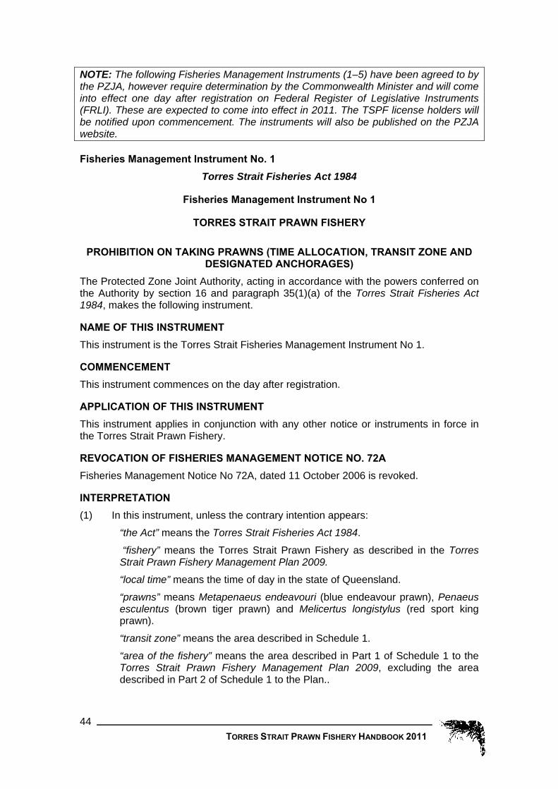
TORRES STRAIT PRAWN FISHERY HANDBOOK 2011 44
NOTE: The following Fisheries Management Instruments (1–5) have been agreed to by the PZJA, however require determination by the Commonwealth Minister and will come into effect one day after registration on Federal Register of Legislative Instruments (FRLI). These are expected to come into effect in 2011. The TSPF license holders will be notified upon commencement. The instruments will also be published on the PZJA website. Fisheries Management Instrument No. 1
Torres Strait Fisheries Act 1984
Fisheries Management Instrument No 1
TORRES STRAIT PRAWN FISHERY
PROHIBITION ON TAKING PRAWNS (TIME ALLOCATION, TRANSIT ZONE AND DESIGNATED ANCHORAGES)
The Protected Zone Joint Authority, acting in accordance with the powers conferred on the Authority by section 16 and paragraph 35(1)(a) of the Torres Strait Fisheries Act 1984, makes the following instrument.
NAME OF THIS INSTRUMENT This instrument is the Torres Strait Fisheries Management Instrument No 1.
COMMENCEMENT This instrument commences on the day after registration.
APPLICATION OF THIS INSTRUMENT This instrument applies in conjunction with any other notice or instruments in force in the Torres Strait Prawn Fishery.
REVOCATION OF FISHERIES MANAGEMENT NOTICE NO. 72A Fisheries Management Notice No 72A, dated 11 October 2006 is revoked.
INTERPRETATION (1) In this instrument, unless the contrary intention appears:
“the Act” means the Torres Strait Fisheries Act 1984.
“fishery” means the Torres Strait Prawn Fishery as described in the Torres Strait Prawn Fishery Management Plan 2009.
“local time” means the time of day in the state of Queensland.
“prawns” means Metapenaeus endeavouri (blue endeavour prawn), Penaeus esculentus (brown tiger prawn) and Melicertus longistylus (red sport king prawn).
“transit zone” means the area described in Schedule 1.
“area of the fishery” means the area described in Part 1 of Schedule 1 to the Torres Strait Prawn Fishery Management Plan 2009, excluding the area described in Part 2 of Schedule 1 to the Plan..

TORRES STRAIT PRAWN FISHERY HANDBOOK 2011 45
(2) A word used in this instrument that is used in the Act, the Torres Strait Fisheries Regulations or the Torres Strait Prawn Management Plan 2009 has the same meaning as in the Act, Regulations or Plan.
DESCRIPTION OF TRANSIT ZONE AND ANCHORAGE ZONES (1) The position of a geographical coordinate in the description of the area of the
transit zone in Schedule 1 is to be determined by reference to the Australian Geodetic Datum 1966 (AGD66).
(2) The position of a geographical coordinate in the description of the area of the anchorage zones in Schedule 1 is to be determined by reference to the World Geodetic Datum 1984 (WGS84).
(3) For convenience in the use of navigational aids, the area of the transit zone is also described in Schedule 2 by reference to the World Geodetic Datum 1984 (WGS84).
(4) Any inconsistency between the description of the areas in Schedules 1 and 2 is to be resolved by reference to Schedule 1.
PROHIBITIONS (1) Under paragraph 16(1)(a) of the Act, the taking of prawns is prohibited in the
area of the fishery unless an exemption under this instrument is in force.
(2) Under paragraph 16(1)(a) of the Act, the processing or carrying of prawns is prohibited in the area of the fishery unless an exemption under this instrument is in force.
(3) Under paragraph 16(1)(o) of the Act, in the area of the fishery the possession of any equipment capable of being used for prawn trawling is prohibited unless:
(a) the boards are unshackled from the nets and are placed on board the boat; or (b) an exemption under this instrument is in force.
(4) The carrying of prawns is prohibited absolutely in the area of the fishery during the period commencing at 0600 hours local time on 15 December in a year and ending at 1700 hours local time on 1 March in the following year.
EXEMPTIONS – FISHING DAYS (1) Under paragraph 16(1A)(d) of the Act a person is exempt from subsections
7(1) and 7(3) if: (a) the person is, or is acting on behalf of, the holder of a TSPF boat licence or is
the master of a boat for which a TSPF boat licence is in force; and (b) there is specified in the licence a condition, under subsection 22(1) of the Act,
that limits the number of days in a year that the boat can be used for fishing in the area of the fishery; and
(c) the number of days that the boat, and any other boats for which the TSPF boat licence was in force, has been used for fishing in the area of the fishery since the start of the year is less than the number specified in the licence.
(2) For the purposes of subsection 8(1), a boat is taken to have been fishing for one day if:
(d) the boat's position reports, received via the Vessel Monitoring System (“VMS”)or through another arrangement entered into with the PZJA, indicate that the boat:
(i) is in an area of the fishery where prawns are permitted to be taken; and

TORRES STRAIT PRAWN FISHERY HANDBOOK 2011 46
(ii) is not within the area of one of the designated anchorages specified in Schedule 3; and
(iii) at any time between 1800 hours local time on one day and 0600 hours local time on the next day:
(A) has moved at a speed of less than 5 knots; and (B) has moved more than 250 metres; or
(e) no boat position reports are received via the Vessel Monitoring System.
(3) A boat is not taken as having been fishing for one full day because of paragraph 8(2)(b) if:
(a) the boat is not used for fishing, and an exemption is granted as set out in section 9; or
(b) the boat is being moved from one place to another without fishing, and an exemption is granted as set out in section 10; or
(c) the boat is testing fishing apparatus, and an exemption is granted as set out in subsection 11; or
(d) the boat is undergoing maintenance, and an exemption is granted as set out in subsection 12.
VMS – NON-FISHING EXEMPTION (1) The holder of a TSPF boat licence may apply to the PZJA for an exemption
from reporting via the VMS during a period if the boat will not be used for fishing during that period.
(2) The application must: (a) be made while the boat is outside the fishery; and (b) state:
(i) the boat’s name and distinguishing number; and (ii) the start and end of the period for which the exemption is required; and (iii) where the boat will be during the period.
(3) The VMS may be switched off during the period of the exemption.
VMS – STEAMING EXEMPTION (1) The holder of a TSPF boat licence may apply to the PZJA for an exemption
from reporting via the VMS during a period if during that period the boat will be moving from one place to another, as follows:
(a) from one designated anchorage area to another; or (b) from a designated anchorage area to a place outside the fishery; or (c) from a place outside the fishery to a designated anchorage area; or (d) from a place outside the fishery to another place outside the fishery.
(2) The application must state: (a) the boat’s name and distinguishing number; and (b) the boat’s proposed destination; and (c) the time, date and place of departure; and (d) the estimated date and time of arrival; and (e) each time the boat will enter and leave the fishery, if the boat’s proposed
movement involves entering and leaving the fishery.

TORRES STRAIT PRAWN FISHERY HANDBOOK 2011 47
(3) The licence holder must notify the PZJA if the following details change during the trip:
(a) the proposed destination; or (b) the estimated date and time of arrival; or (c) the proposed entries and exits from the fishery.
(4) During the trip: (a) the VMS must be on and operational; and (b) no fish can be taken using trawl nets in the fishery; and (c) all trawl nets must be stored in-board the boat and not suspended from a mast
or boom, unless the trip is from one designated anchorage area to the nearest designated anchorage.
VMS – GEAR TRIAL EXEMPTION (1) The holder of a TSPF boat licence or the person in control of a boat may apply
to the PZJA for an exemption from reporting via the VMS during a period if the person wants to test fishing apparatus without losing a fishing day.
(2) The application must be made at least 24 hours before the proposed testing and must state:
(a) the boat’s name and distinguishing number; and (b) the proposed destination; and (c) the time, date and place of departure; and (d) the estimated date and time of arrival at the destination.
(3) During the period of the exemption: (a) the destination must be no more than one nautical mile from where the trip
started; and (b) the trip must substantially comply with the trip details stated in the application;
and (c) the VMS must be on and operational; and (d) no fish can be taken using the trawl nets; and (e) the cod ends of each trawl net must be open.
VMS – MAINTENANCE EXEMPTION (1) The holder of a TSPF boat licence or the person in control of the boat may
apply to the PZJA for an exemption from reporting via the VMS during a period if the person wants to shut down the VMS for maintenance.
(2) The application must state: (a) the boat’s name and mark; and (b) the start and end of the period for which the exemption is required; and (c) where the boat will be located; and (d) the reason for the maintenance.
(3) An exemption will be granted for no more that 6 hours.
EXEMPTIONS – LICENCE (1) Under paragraph 16(1A)(d) of the Act, a person who holds a licence under
subsection 19(3) of the Act for the fishery is exempt from the prohibition in subsection 7(2).
TORRES STRAIT PRAWN FISHERY HANDBOOK 2011 48
(2) Under paragraph 16(1A)(d) of the Act, a person is exempt from the prohibitions in subsections 7(1) and 7(3) if:
(a) the person holds a PNG licence for the boat; and (b) a TSPF Treaty endorsement is in force for the boat.
[NOTE: TSPF Treaty endorsement is defined in the Torres Strait Prawn Fishery Management Plan 2009.]
PROHIBITIONS – TRANSIT ZONE (1) Under paragraph 16(1)(a) of the Act, in the area of the transit zone the taking of
prawns is prohibited.
(2) Under paragraph 16(1)(o) of the Act, in the area of the transit zone a person is prohibited from having in that person's possession or under that person’s control in a boat, equipment that is:
(a) capable of being used for any kind of trawling; or (b) capable of being used for taking prawns; unless the equipment is carried so that all of the equipment is out of the water or, if any part of the equipment is in the water: (c) all cod ends are open and drawn up to the boat so that the cod ends would be
visible from an aircraft or another boat; and (d) the boards are at the blocks.
______________________
SCHEDULES NOTES:
(1) The position of a geographical coordinate in the description of the area of the transit zone is to be determined by reference to the Australian Geodetic Datum 1966 (AGD66), that is to say, by reference to a spheroid having its centre at the centre of the Earth and a major (equatorial) radius of 6,378,160 metres and a flattening of 1/298.25 and the position of the Johnston Geodetic Station in the Northern Territory of Australia. That station is to be taken to be situated at Latitude 25°56'54.5515" South and at Longitude 133°12'30.0771" East and to have a ground level of 571.2 metres above the spheroid referred to above.
(2) For convenience, the coordinates of the transit zone are also expressed in Schedule 2 based on the World Geodetic Datum 1984 (WGS84) Reference Frame at the 2005.0 epoch. The geographic coordinates are referenced to the WGS84 reference spheroid having its centre at the centre of the Earth and a major (equatorial) radius of 6,378,137 metres and a flattening of 1/298.257223563.
(3) In the case of an inconsistency between the coordinates in Schedule 1 and Schedule 2, Schedule 1 takes precedence – see section 6.
SCHEDULE 1 Transit Zone
That area of waters bounded by a line: (1) commencing at the point of Latitude 10°06'00" South, Longitude 142°54'00"
East; (2) running thence south-westerly along the geodesic to the point of Latitude 10°
13'00" South, Longitude 142°51'00" East;

TORRES STRAIT PRAWN FISHERY HANDBOOK 2011 49
(3) thence south-westerly along the geodesic to the point of Latitude 10°28'00" South, Longitude 142°31'49" East;
(4) thence in a south easterly direction to its intersection along the geodesic by the parallel of Latitude 10°41'17" South, and the meridian of Longitude 142° 38'30" East;
(5) thence west along that parallel to its intersection by the meridian of Longitude 142°31'49" East;
(6) thence south along that meridian to its northernmost intersection by the coastline of Cape York Peninsula at low water;
(7) thence generally south-westerly along the western coastline of Cape York Peninsula, that is along the low water line on that coast and across any river mouth, to its intersection by the meridian of Longitude 142°09'00" East; and
(8) thence north along that meridian to its intersection by the parallel of latitude 10°28'00" South;
(9) thence north-easterly along the geodesic to the point of commencement.
SCHEDULE 2 Area of the transit zone expressed using coordinates based on WGS84
NOTES:
(1) For ease of use of navigational aids, the coordinates of the closure are also tabulated in this Schedule by reference to WGS84. Any discrepancy between these coordinates and the description in Schedule 1 is to be resolved by reference to AGD66 – see s.4.4.
(1) The reference field within the conversions tables in Schedule 2 contain numbers and characters which reference the schedule 1 numbers and characters.
That area of waters bounded by a line: REFERENCE LAT. WGS84
(ITRF2000@2005) LONG. WGS84
(ITRF2000@2005) 1 10º 05' 54.66" S 142º 54' 03.94" E 2 10º 12' 54.66" S 142º 51' 03.94" E 3 10º 27' 54.65" S 142º 31' 52.95" E 4 10º 41' 11.65" S 142º 38' 33.95" E 5 10º 41' 11.65" S 142º 31' 52.96" E 6 10º 41' 15.15" S 142º 31' 52.96" E 7 10º 55' 57.65" S 142º 09' 03.97" E 8 10º 27' 54.66" S 142º 09' 03.97" E 9 10º 05' 54.66" S 142º 54' 03.94" E
SCHEDULE 3 Designated Anchorages in WGS84
AUREED ISLAND
That area of waters bounded by a line: (1) commencing at the point of intersection of the parallel of Latitude 9º 55' 59.10"
South and the meridian of Longitude 143º 18' 56.10" East; (2) running thence south-easterly along the geodesic to the point of Latitude 9º
57' 18.54" South, Longitude 143º 19' 22.38" East; (3) thence south-westerly along the geodesic to the point of Latitude 9º 58' 47.22"
South, Longitude 143º 18' 02.28" East;

TORRES STRAIT PRAWN FISHERY HANDBOOK 2011 50
(4) thence west along the geodesic to the point of Latitude 9º 58' 31.02" South, Longitude 143º 15' 52.92" East;
(5) thence north along the geodesic to the point of Latitude 9º 57' 28.32" South, Longitude 143º 15' 51.24" East;
(6) thence north-easterly along the geodesic to the point of Latitude 9º 56' 00.18" South, Longitude 143°17’10.08" East;
(7) thence easterly along the meridian to the point of commencement where it terminates.
YORKE ISLANDS
That area of waters bounded by a line: (1) commencing at the point of intersection of the parallel of Latitude 9º 43' 11.82" South and the meridian of Longitude 143º 27' 38.82" East; (2) running thence south-easterly along the geodesic to the point of Latitude 9º
43' 47.04"South, Longitude 143º 28' 01.86" East; (3) thence south along the geodesic to the point of Latitude 9º 44' 42.72" South,
Longitude 143º 28' 04.38" East; (4) thence south-westerly along the geodesic to the point of Latitude 9º 45' 27.48"
South, Longitude 143º 27' 35.22" East; (5) thence south-westerly along the geodesic to the point of Latitude 9º 45' 51.18"
South, Longitude 143º 26' 45.42" East; (6) thence south-westerly along the geodesic to the point of Latitude 9º 46' 02.34"
South, Longitude 143º 25' 43.68" East; (7) thence south-westerly along the geodesic to the point of Latitude 9º 46' 21.42"
South, Longitude 143º 24' 33.30" East; (8) thence north-westerly along the geodesic to the point of Latitude 9º 46' 05.88"
South, Longitude 143º 23' 49.68" East; (9) thence north-westerly along the geodesic to the point of Latitude 9º 45' 22.80"
South, Longitude 143º 23' 25.86" East; (10) thence north-easterly along the geodesic to the point of Latitude 9º 44' 45.90"
South, Longitude 143º 23' 36.84" East; (11) thence north-easterly along the geodesic to the point of Latitude 9º 43' 15.96"
South, Longitude 143º 26' 33.90" East; (12) thence easterly along that meridian to the point of commencement where it
terminates.
DUGONG ISLAND
That area of waters bounded by a line: (1) commencing at the point of intersection of the parallel of Latitude 10°30’19.62"
South and the meridian of Longitude 143°04’27.78" East; (2) running thence east along the geodesic to the point of Latitude 10°30’19.08"
South, Longitude 143°05’48.54" East; (3) thence south-easterly along the geodesic to the point of Latitude 10°30’36.00"
South, Longitude 143°06’44.16" East; (4) thence south-easterly along the geodesic to the point of Latitude 10°31’05.88"
South, Longitude 143°07’22.92" East; (5) thence south along the geodesic to the point of Latitude 10°31’55.38" South,
Longitude 143°07’25.56" East;

TORRES STRAIT PRAWN FISHERY HANDBOOK 2011 51
(6) thence south-westerly along the geodesic to the point of Latitude 10°32’30.66" South, Longitude 143°07’04.86" East;
(7) thence south-westerly along the geodesic to the point of Latitude 10°32’37.68" South, Longitude 143°06’14.64" East; and
(8) thence north-westerly along the geodesic to the point of Latitude 10°31’26.94" South, Longitude 143°03’56.64" East;
(9) thence north-easterly along that meridian to the point of commencement where it terminates.
COCONUT ISLAND
That area of waters bounded by a line: (1) commencing at the point of intersection of the parallel of Latitude 10°02’24.18"
South and the meridian of Longitude 143°04’00.72" East; (2) running thence south-easterly along the geodesic to the point of Latitude
10°02’25.98" South, Longitude 143°04’29.46" East; (3) thence south-easterly along the geodesic to the point of Latitude 10°02’40.14"
South, Longitude 143°06’01.08" East; (4) thence east along the geodesic to the point of Latitude 10°02’27.12" South,
Longitude 143°07’11.46" East; (5) thence south-easterly along the geodesic to the point of Latitude 10°02’43.50"
South, Longitude 143°07’53.46" East; (6) thence south-easterly along the geodesic to the point of Latitude 10°03’38.46"
South, Longitude 143°08’10.32" East; (7) thence south-westerly along the geodesic to the point of Latitude 10°04’20.88"
South, Longitude 143°06’36.48" East; (8) thence west along the geodesic to the point of Latitude 10°04’26.82" South,
Longitude 143°04’33.72" East; (9) thence north-westerly along the geodesic to the point of Latitude 10°03’20.88"
South, Longitude 143°02’43.02" East; (10) thence north-easterly along the geodesic to the point of Latitude 10°02’31.92"
South, Longitude 143°03’29.94" East; (11) thence north-easterly along that meridian to the point of commencement
where it terminates. ____________________

TORRES STRAIT PRAWN FISHERY HANDBOOK 2011 52
Fisheries Management Instrument No. 2 Torres Strait Fisheries Act 1984
Fisheries Management Instrument No 2
TORRES STRAIT PRAWN FISHERY
PROHIBITION ON TAKING PRAWNS AND CARRYING EQUIPMENT (EXCLUSION ZONES)
The Protected Zone Joint Authority, acting in accordance with the powers conferred on the Authority by section 16 and paragraph 35(1)(a) of the Torres Strait Fisheries Act 1984, makes the following instrument.
NAME OF THIS INSTRUMENT This instrument is the Torres Strait Fisheries Management Instrument No 2.
COMMENCEMENT This instrument commences on the day after registration.
APPLICATION OF THIS INSTRUMENT This instrument applies in conjunction with any other notice or instruments in force in the Torres Strait Prawn Fishery.
REVOCATION OF FISHERIES MANAGEMENT NOTICES NO. 40, 49 AND 68 Fisheries Management Notice No. 40, dated 24 February 1994, Fisheries Management Notice No.49, dated 16 April 1998, and Fisheries Management Notice No.68, dated 8 December 2003, are revoked.
INTERPRETATION (1) In this instrument, unless the contrary intention appears:
“Act” means the Torres Strait Fisheries Act 1984.
“area of the fishery” means the area described in Part 1 of Schedule 1 to the Torres Strait Prawn Fishery Management Plan 2009, excluding the area described in Part 2 of Schedule 1 to the Plan.
“exclusion zone” means the areas described in Schedule 1.
“fishery” means the Torres Strait Prawn Fishery as described in the Torres Strait Prawn Fishery Management Plan 2009.
“local time” means the time of day in the state of Queensland.
“prawns” means Metapenaeus endeavouri (blue endeavour prawn), Penaeus esculentus (brown tiger prawn) and Melicertus longistylus (red sport king prawn).
“transit zone” means the area described in Schedule 1 of Fisheries Management Notice No.1.

TORRES STRAIT PRAWN FISHERY HANDBOOK 2011 53
(2) A word used in this instrument that is used in the Act, the Torres Strait Fisheries Regulations or the Torres Strait Prawn Management Plan 2009 has the same meaning as in the Act, Regulations or Plan.
DESCRIPTION OF EXCLUSION ZONES (1) The position of a geographical coordinate in the description of the area of an
exclusion zone in Schedule 1 is to be determined by reference to the Australian Geodetic Datum 1966 (AGD66).
(2) For convenience in the use of navigational aids, the area of the exclusion zones is also described in Schedule 2 by reference to the World Geodetic Datum 1984 (WGS84).
(3) In the case of an inconsistency between the coordinates in Schedule 1 and Schedule 2, Schedule 1 takes precedence.
PROHIBITIONS (1) Under paragraph 16(1)(a) of the Act, the taking of prawns in an exclusion zone
is prohibited.
(2) Under paragraph 16(1)(a) of the Act, the carrying of prawns is prohibited in an exclusion zone, except in an area that is a transit zone.
(3) Under paragraph 16(1)(o) of the Act, in an exclusion zone except in an area that is a transit zone, a person is prohibited from having in that person's possession or under that person’s control, equipment that is:
(a) capable of being used for any kind of trawling; or (b) capable of being used for taking prawns;
unless the equipment is carried so that all of the equipment is out of the water or, if any part of the equipment is in the water:
(c) all cod ends are open and drawn up to the boat so that the cod ends would be visible from an aircraft or another boat; and
(d) the boards are at the blocks. ____________________
SCHEDULES
NOTES:
(1) The position of a geographical coordinate in the description of the area of the exclusion zones is to be determined by reference to the Australian Geodetic Datum 1966 (AGD66), that is to say, by reference to a spheroid having its centre at the centre of the Earth and a major (equatorial) radius of 6,378,160 metres and a flattening of 1/298.25 and the position of the Johnston Geodetic Station in the Northern Territory of Australia. That station is to be taken to be situated at Latitude 25°56'54.5515" South and at Longitude 133°12'30.0771" East and to have a ground level of 571.2 metres above the spheroid referred to above.
(2) For convenience, the coordinates of the exclusion zones are also expressed in Schedule 2 based on the World Geodetic Datum 1984 (WGS84) Reference Frame at the 2005.0 epoch. The geographic coordinates are referenced to the WGS84 reference spheroid having its centre at the centre of the Earth and a major (equatorial) radius of 6,378,137 metres and a flattening of 1/298.257223563.

TORRES STRAIT PRAWN FISHERY HANDBOOK 2011 54
(3) In the case of an inconsistency between the coordinates in Schedule 1 and Schedule 2, Schedule 1 takes precedence – see section 6.
SCHEDULE 1
Exclusion zones
WEST OF WARRIOR REEF EXCLUSION ZONE
The areas bounded by a line -- (1) commencing at the point of Latitude 9° 46' 00" South, Longitude 142° 00' 00"
East; (2) running thence north-easterly along the geodesic to the point of Latitude 9° 45'
24" South, Longitude 142° 03' 30" East; (3) thence north along the meridian of Longitude 142° 03' 30" East to its
intersection by the parallel of Latitude 9° 15' 43" South; (4) thence north-easterly along the geodesic to the point of Latitude 9° 12' 50"
South, Longitude 142° 06' 25" East; (5) thence north-easterly along the geodesic to the point of Latitude 9° 11' 51"
South, Longitude 142° 08' 33" East; (6) thence south-easterly along the geodesic to the point of Latitude 9° 11' 58"
South, Longitude 142° 10' 18" East; (7) thence north-easterly along the geodesic to the point of Latitude 9° 11' 22"
South, Longitude 142° 12' 54" East; (8) thence south-easterly along the geodesic to the point of Latitude 9° 11' 34"
South, Longitude 142° 14' 08" East; (9) thence south-easterly along the geodesic to the point of Latitude 9° 13' 53"
South, Longitude 142° 16' 26" East; (10) thence south-easterly along the geodesic to the point of Latitude 9° 16' 04"
South, Longitude 142° 20' 41" East; (11) thence south-easterly along the geodesic to the point of Latitude 9° 22' 04"
South, Longitude 142° 29' 41" East; (12) thence north-easterly along the geodesic to the point of Latitude 9° 21' 48"
South, Longitude 142° 31' 29" East; (13) thence south-easterly along the geodesic to the point of Latitude 9° 22' 33"
South, Longitude 142° 33' 28" East, (14) thence north-easterly along the geodesic to the point of Latitude 9° 21' 25"
South, Longitude 142° 35' 29" East; (15) thence north-easterly along the geodesic to the point of Latitude 9° 20' 21"
South, Longitude 142° 41' 43" East; (16) thence north-easterly along the geodesic to the point of Latitude 9° 20' 16"
South, Longitude 142° 43' 53" East; (17) thence north-easterly along the geodesic to the point of Latitude 9° 19' 26"
South, Longitude 142° 48' 18" East where it joins the outer limit of the three nautical mile territorial sea of Saibai Island;
(18) thence along that outer limit so as to pass to the east of Saibai Island to the point of Latitude 9° 23' 40" South, Longitude 142° 51' 00" East;
(19) thence south along the meridian of Longitude 142° 51' 00" East to its intersection by the parallel of Latitude 9° 40' 30" South;

TORRES STRAIT PRAWN FISHERY HANDBOOK 2011 55
(20) thence north-easterly along the geodesic to the point of Latitude 9° 40' 00" South, Longitude 143° 00' 00" East;
(21) thence north-easterly along the geodesic to the point of Latitude 9° 33' 00" South, Longitude 143° 05' 00" East;
(22) thence east along the parallel of Latitude 9° 33' 00" South, to its intersection by the median of Longitude 143° 11' 00" East;
(23) thence south-westerly along the geodesic to the point of Latitude 9° 46' 00" South, Longitude 143° 02' 20" East;
(24) thence south-westerly along the geodesic to the point of Latitude 10° 13' 00" South, Longitude 142° 51' 00" East;
(25) thence south-westerly along the geodesic to the point of Latitude 10° 28' 00" South, Longitude 142° 31' 49" East;
(26) then south-easterly along the geodesic to the point of Latitude 10° 41' 17" South, Longitude 142° 38' 30" East;
(27) then west along that parallel to its intersection by the meridian of Longitude 142° 31' 49" East;
(28) then south along the meridian of Longitude 142° 31' 49" East to its intersection by the northernmost point of the shore of Cape York Peninsula at the low water mark;
(29) thence generally south-westerly along the western coastline of Cape York Peninsula, that is along the low water line on that coast and across any river mouth, to its intersection by the meridian of Longitude 142° 09' 00" East;
(30) thence north along that meridian to its intersection by the parallel of Latitude 10° 28' 00" South;
(31) thence west along that parallel to its intersection by the meridian of Longitude 141° 20' 00" East;
(32) thence north along that meridian to its intersection by the Fisheries Jurisdiction Line close to the parallel of Latitude 10° 10' 28.73" South; and
(33) thence north-easterly along the Fisheries Jurisdiction Line to the point of commencement.
DARNLEY ISLAND EXCLUSION ZONE
The area bounded by a line – (1) commencing at the point of Latitude 10° 00' 00" South, Longitude 143° 39'
00" East; (2) thence east along that parallel to its intersection by the meridian of
Longitude 144° 07' 00" East; (3) thence north-easterly along the geodesic to the Fisheries Jurisdiction Line
at the point of Latitude 9° 30' 00" South, Longitude 144° 15' 00" East; (4) thence north-westerly along the Fisheries Jurisdiction Line to its
intersection with the parallel of Latitude 9° 27' 20" South, close to Longitude 144° 06' 00" East;
(5) thence west along that parallel to its intersection by the meridian of Longitude 143° 52' 00" East;
(6) thence south-westerly along the geodesic to the point of Latitude 9° 33' 00" South, Longitude 143° 39' 00" East;
(7) thence south along that meridian to the point of commencement.
TORRES STRAIT PRAWN FISHERY HANDBOOK 2011 56
DELIVERANCE ISLAND AND KERR ISLET EXCLUSION ZONE
The outer limit of the territorial sea of Deliverance Island and Kerr Islet shall be a continuous line formed by a series of intersecting arcs of circles having a radius of three nautical miles and drawn successively, so as to enclose the islands, from the following points—
REFERENCE LATITUDE (AGD66) LONGITUDE (AGD66) (i) 9o 32’ 39” S 141o 32’ 15” E (ii) 9o 32’ 35” S 141o 32’ 11” E (iii) 9o 32’ 07” S 141o 31’ 50” E (iv) 9o 32’ 02” S 141o 31’ 54” E (v) 9o 31’ 56” S 141o 31’ 58” E (vi) 9o 31’ 51” S 141o 32’ 02” E (vii) 9o 31’ 29” S 141o 32’ 17” E (viii) 9o 31’ 27” S 141o 32’ 19” E (ix) 9o 31’ 24” S 141o 32’ 21” E (x) 9o 30’ 40” S 141o 33’ 32” E (xi) 9o 30’ 08” S 141o 34’ 01” E (xii) 9o 30’ 01” S 141o 34’ 05” E (xiii) 9o 29’ 57” S 141o 34’ 08” E (xiv) 9o 29’ 51” S 141o 34’ 14” E (xv) 9o 29’ 51” S 141o 34’ 19” E (xvi) 9o 29’ 58” S 141o 36’ 13” E (xvii) 9o 30’ 04” S 141o 36’ 16” E (xviii) 9o 30’ 12” S 141o 36’ 16” E (xix) 9o 30’ 28” S 141o 36’ 18” E (xx) 9o 30’ 47” S 141o 36’ 18” E (xxi) 9o 31’ 00” S 141o 36’ 15” E (xxii) 9o 31’ 11” S 141o 36’ 10” E (xxiii) 9o 31’ 29” S 141o 36’ 02” E (xxiv) 9o 31’ 38” S 141o 35’ 55” E (xxv) 9o 31’ 47” S 141o 35’ 46” E (xxvi) 9o 31’ 50” S 141o 35’ 42” E (xxvii) 9o 32’ 02” S 141o 35’ 21” E (xxviii) 9o 36’ 21” S 141o 34’ 33” E (xxix) 9o 36’ 24” S 141o 34’ 34” E (xxx) 9o 36’ 35” S 141o 34’ 33” E (xxxi) 9o 36’ 49” S 141o 34’ 26” E (xxxii) 9o 36’ 56” S 141o 34’ 21” E (xxxiii) 9o 37’ 05” S 141o 34’ 02” E (xxxiv) 9o 37’ 14” S 141o 33’ 47” E (xxxv) 9o 37’ 15” S 141o 33’ 28” E (xxxvi) 9o 37’ 13” S 141o 33’ 25” E (xxxvii) 9o 37’ 09” S 141o 33’ 22” E (xxxviii) 9o 37’ 03” S 141o 33’ 21” E (xxxix) 9o 36’ 58” S 141o 33’ 22” E (xl) 9o 36’ 52” S 141o 33’ 27” E
TURU CAY EXCLUSION ZONE

The outer limit of the territorial sea of Turu Cay shall be a continuous line formed by a series of intersecting arcs of circles having a radius of three nautical miles and drawn successively, so as to enclose the island, from the following points—
REFERENCE LATITUDE (AGD66) LONGITUDE (AGD66) (i) 9o 49’ 53” S 141o 24’ 42” E (ii) 9o 49’ 39” S 141o 24’ 44” E (iii) 9o 49’ 31” S 141o 24’ 52” E (iv) 9o 49’ 25” S 141o 25’ 02” E (v) 9o 49’ 23” S 141o 25’ 13” E (vi) 9o 49’ 20” S 141o 25’ 25” E (vii) 9o 49’ 19” S 141o 25’ 36” E (viii) 9o 49’ 18” S 141o 25’ 43” E (ix) 9o 49’ 18” S 141o 25’ 53” E (x) 9o 49’ 17” S 141o 26’ 07” E (xi) 9o 49’ 23” S 141o 26’ 09” E (xii) 9o 49’ 26” S 141o 26’ 06” E (xiii) 9o 49’ 32” S 141o 25’ 58” E (xiv) 9o 49’ 38” S 141o 25’ 49” E (xv) 9o 49’ 44” S 141o 25’ 38” E (xvi) 9o 49’ 47” S 141o 25’ 31” E (xvii) 9o 49’ 53” S 141o 25’ 19” E (xviii) 9o 49’ 56” S 141o 25’ 09” E (xix) 9o 49’ 57” S 141o 24’ 54” E (xx) 9o 49’ 56” S 141o 24’ 45” E
SCHEDULE 2 Area of the exclusion zones expressed using coordinates based on WGS84
WEST OF WARRIOR REEF EXCLUSION ZONE
EFERENCE LAT. (WGS84) LONG. (WGS84) DESCRIPTIVE NOTES
(1) 9º 45' 54.68" S 142º 00' 03.97" E (2) 9º 45' 18.67" S 142º 03' 33.96" E (3) 9º 15' 37.69" S 142º 03' 33.96" E (4) 9º 12' 44.69" S 142º 06' 28.95" E (5) 9º 11' 45.69" S 142º 08' 36.95" E (6) 9º 11' 52.69" S 142º 10' 21.95" E (7) 9º 11' 16.69" S 142º 12' 57.95" E (8) 9º 11' 28.69" S 142º 14' 11.95" E (9) 9º 13' 47.68" S 142º 16' 29.95" E
(10) 9º 15' 58.68" S 142º 20' 44.95" E (11) 9º 21' 58.68" S 142º 29' 44.94" E (12) 9º 21' 42.68" S 142º 31' 32.94" E (13) 9º 22' 27.68" S 142º 33' 31.94" E (14) 9º 21' 19.68" S 142º 35' 32.94" E (15) 9º 20' 15.68" S 142º 41' 46.93" E (16) 9º 20' 10.68" S 142º 43' 56.93" E (17) 9º 19' 20.68" S 142º 48' 21.93" E (18) 9º 23' 34.67" S 142º 51' 03.93" E (19) 9º 40' 24.67" S 142º 51' 03.93" E (20) 9º 39' 54.67" S 143º 00' 03.93" E (21) 9º 32' 54.67" S 143º 05' 03.92" E (22) 9º 32' 54.67" S 143º 11' 03.92" E
TORRES STRAIT PRAWN FISHERY HANDBOOK 2011 57
R

TORRES STRAIT PRAWN FISHERY HANDBOOK 2011 58
(23) 9º 45' 54.66" S 143º 02' 23.93" E (24) 10º 12' 54.66" S 142º 51' 03.94" E (25) 10º 27' 54.65" S 142º 31' 52.95" E (26) 10º 41' 11.65" S 142º 38' 33.95" E (27) 10º 41' 11.65" S 142º 31' 52.96" E (28) 10º 41' 15.15" S* 142º 31' 52.96" E Estimated coordinate (29) 10º 55' 57.65" S* 142º 09' 03.97" E Estimated coordinate (30) 10º 27' 54.66" S 142º 09' 03.97" E (31) 10º 27' 54.67" S 141º 20' 04.00" E (32) 10º 10' 23.40" S 141º 20' 03.99" E (33) 9º 45' 54.68" S 142º 00' 03.97" E
DARNLEY ISLAND EXCLUSION ZONE REFERENCE LAT. (WGS84) LONG. (WGS84)
1 9º 59' 54.65" S 143º 39' 03.91" E 2 9º 59' 54.65" S 144º 07' 03.89" E 3 9º 29' 54.66" S 144º 15' 03.88" E 4 9º 27' 14.66" S 144º 06' 03.88" E 5 9º 27' 14.66" S 143º 52' 03.89" E 6 9º 32' 54.66" S 143º 39' 03.90" E 7 9º 59' 54.65" S 143º 39' 03.91" E
DELIVERANCE ISLAND AND KERR ISLET EXCLUSION ZONE REFERENCE LAT. (WGS84) LONG. (WGS84)
(i) 9º 32' 33.69” S 141º 32' 18.98” E (ii) 9º 32’ 29.69” S 141º 32’ 14.98” E (iii) 9º 32’ 01.69” S 141º 31’ 53.98” E (iv) 9º 31’ 56.69” S 141º 31’ 57.98” E (v) 9º 31’ 50.69” S 141º 32’ 01.98” E (vi) 9º 31’ 45.69” S 141º 32’ 05.98” E (vii) 9º 31’ 23.69” S 141º 32’ 20.98” E (viii) 9º 31’ 21.69” S 141º 32’ 22.98” E (ix) 9º 31’ 18.69” S 141º 32’ 24.98” E (x) 9º 30’ 34.69” S 141º 33’ 35.98” E (xi) 9º 30’ 02.69” S 141º 34’ 04.98” E (xii) 9º 29’ 55.69” S 141º 34’ 08.98” E (xiii) 9º 29’ 51.69” S 141º 34’ 11.98” E (xiv) 9º 29’ 45.69” S 141º 34’ 17.98” E (xv) 9º 29’ 45.69” S 141º 34’ 22.98” E (xvi) 9º 29’ 52.69” S 141º 36’ 16.98” E (xvii) 9º 29’ 58.69” S 141º 36’ 19.98” E (xviii) 9º 30’ 06.69” S 141º 36’ 19.98” E (xix) 9º 30’ 22.69” S 141º 36’ 21.98” E (xx) 9º 30’ 41.69” S 141º 36’ 21.98” E (xxi) 9º 30’ 54.68” S 141º 36’ 18.98” E (xxii) 9º 31’ 05.68” S 141º 36’ 13.98” E (xxiii) 9º 31’ 23.68” S 141º 36’ 05.98” E (xxiv) 9º 31’ 32.68” S 141º 35’ 58.98” E (xxv) 9º 31’ 41.68” S 141º 35’ 49.98” E (xxvi) 9º 31’ 44.68” S 141º 35’ 45.98” E (xxvii) 9º 31’ 56.68” S 141º 35’ 24.98” E (xxviii) 9º 36’ 15.68” S 141º 34’ 36.98” E (xxix) 9º 36’ 18.68” S 141º 34’ 37.98” E (xxx) 9º 36’ 29.68” S 141º 34’ 36.98” E

TORRES STRAIT PRAWN FISHERY HANDBOOK 2011 59
(xxxi) 9º 36’ 43.68” S 141º 34’ 29.98” E (xxxii) 9º 36’ 50.68” S 141º 34’ 24.98” E (xxxiii) 9º 36’ 59.68” S 141º 34’ 05.98” E (xxxiv) 9º 37’ 08.68” S 141º 33’ 50.98” E (xxxv) 9º 37’ 09.68” S 141º 33’ 31.98” E (xxxvi) 9º 37’ 07.68” S 141º 33’ 28.98” E (xxxvii) 9º 37’ 03.68” S 141º 33’ 25.98” E (xxxviii) 9º 36’ 57.68” S 141º 33’ 24.98” E (xxxix) 9º 36’ 52.68” S 141º 33’ 25.98” E (xl) 9º 36’ 46.68” S 141º 33’ 30.98” E
TURU CAY EXCLUSION ZONE REFERENCE LATITUDE (WGS84) LONGITUDE (WGS84) (i) 9º 49’ 47.68” S 141º 24’ 45.99” E (ii) 9º 49’ 33.68” S 141º 24’ 47.99” E (iii) 9º 49’ 25.68” S 141º 24’ 55.99” E (iv) 9º 49’ 19.68” S 141º 25’ 05.99” E (v) 9º 49’ 17.68” S 141º 25’ 16.99” E (vi) 9º 49’ 14.68” S 141º 25’ 28.99” E (vii) 9º 49’ 13.68” S 141º 25’ 39.99” E (viii) 9º 49’ 12.68” S 141º 25’ 46.99” E (ix) 9º 49’ 12.68” S 141º 25’ 56.99” E (x) 9º 49’ 11.68” S 141º 26’ 10.99” E (xi) 9º 49’ 17.68” S 141º 26’ 12.99” E (xii) 9º 49’ 20.68” S 141º 26’ 09.99” E (xiii) 9º 49’ 26.68” S 141º 26’ 01.99” E (xiv) 9º 49’ 32.68” S 141º 25’ 52.99” E (xv) 9º 49’ 38.68” S 141º 25’ 41.99” E (xvi) 9º 49’ 41.68” S 141º 25’ 34.99” E (xvii) 9º 49’ 47.68” S 141º 25’ 22.99” E (xviii) 9º 49’ 50.68” S 141º 25’ 12.99” E (xix) 9º 49’ 51.68” S 141º 24’ 57.99” E (xx) 9º 49’ 50.68” S 141º 24’ 48.99” E
____________________

TORRES STRAIT PRAWN FISHERY HANDBOOK 2011 60
Fisheries Management Instrument No. 3 Torres Strait Fisheries Act 1984
Fisheries Management Instrument No 3
TORRES STRAIT PRAWN FISHERY
PROHIBITION ON TAKING PRAWNS AND CARRYING EQUIPMENT (SEASONAL AREA CLOSURES)
The Protected Zone Joint Authority, acting in accordance with the powers conferred on the Authority by section 16 and paragraph 35(1)(a) of the Torres Strait Fisheries Act 1984, makes the following instrument.
NAME OF THIS INSTRUMENT This instrument is the Torres Strait Fisheries Management Instrument No 3.
COMMENCEMENT This instrument commences on the day after registration.
APPLICATION OF THIS INSTRUMENT This instrument applies in conjunction with any other notice or instruments in force in the Torres Strait Prawn Fishery.
INTERPRETATION (1) In this instrument, unless the contrary intention appears:
“Act” means the Torres Strait Fisheries Act 1984.
“area of the fishery” means the area described in Part 1 of Schedule 1 to the Torres Strait Prawn Fishery Management Plan 2009, excluding the area described in part 2 of Schedule 1 to the Plan.
“closed area” means the areas described in Schedule 1.
closure period” means the period commencing at 1700 hours local time on 1 March in a year and ending at 1700 hours local time on 31 July in the same year.
“local time” means the time of day in the state of Queensland.
“prawns” means Metapenaeus endeavouri (blue endeavour prawn), Penaeus esculentus (brown tiger prawn) and Melicertus longistylus (red sport king prawn).
“fishery” means the Torres Strait Prawn Fishery as described in the Torres Strait Prawn Fishery Management Plan 2009.
(2) A word used in this instrument that is used in the Act, the Torres Strait Fisheries Regulations or the Torres Strait Prawn Management Plan 2009 has the same meaning as in the Act, Regulations or Plan.
TORRES STRAIT PRAWN FISHERY HANDBOOK 2011 61
DESCRIPTION OF CLOSED AREAS (1) The position of a geographical coordinate in the description of a closed
seasonal area in Schedule 1 is to be determined by reference to the Australian Geodetic Datum 1966 (AGD66).
(2) For convenience in the use of navigational aids, the area of the exclusion zones is also described in Schedule 2 by reference to the World Geodetic Datum 1984 (WGS84).
(3) In the case of an inconsistency between the coordinates in Schedule 1 and Schedule 2, Schedule 1 takes precedence.
PROHIBITIONS (1) Under paragraph 16(1)(a) of the Act, the taking of prawns in the closed area is
prohibited during the closure period.
(2) Under paragraph 16(1)(o) of the Act, in the closed area during a closure period a person must not have in his or her possession or charge in a boat, equipment that is:
(a) capable of being used for any kind of trawling; or (b) capable of being used for taking prawns;
unless the equipment is carried so that all of the equipment is out of the water or, if any part of the equipment is in the water: (c) all cod ends are open and drawn up to the boat so that the cod ends would be
visible from an aircraft or another boat; and (d) the boards are at the blocks.
__________________________________________
SCHEDULES NOTES:
(1) The position of a geographical coordinate in the description of the area of the East of Warrior Reef seasonal closure is to be determined by reference to the Australian Geodetic Datum 1966 (AGD66), that is to say, by reference to a spheroid having its centre at the centre of the Earth and a major (equatorial) radius of 6,378,160 metres and a flattening of 1/298.25 and the position of the Johnston Geodetic Station in the Northern Territory of Australia. That station is to be taken to be situated at Latitude 25°56'54.5515" South and at Longitude 133°12'30.0771" East and to have a ground level of 571.2 metres above the spheroid referred to above.
(2) For convenience, the coordinates of the East of Warrior Reef seasonal closure are also expressed in Schedule 2 based on the World Geodetic Datum 1984 (WGS84) Reference Frame at the 2005.0 epoch. The geographic coordinates are referenced to the WGS84 reference spheroid having its centre at the centre of the Earth and a major (equatorial) radius of 6,378,137 metres and a flattening of 1/298.257223563.
(3) In the case of an inconsistency between the coordinates in Schedule 1 and Schedule 2, Schedule 1 takes precedence – see section 5.

TORRES STRAIT PRAWN FISHERY HANDBOOK 2011 62
SCHEDULE 1 East of Warrior Reef seasonal closure
The area bounded by a line- (1) commencing at the point of Latitude 10° 00' 00" South, Longitude 142° 56' 28"
East; (2) thence east along that parallel to its intersection by the meridian of Longitude
143° 04' 24" East; (3) thence north-easterly along the geodesic to the point of Latitude 9° 52' 30" South,
Longitude 143° 09' 30" East; (4) thence north-easterly along the geodesic to the point of Latitude 9° 46' 00" South,
Longitude 143° 14' 00" East; (5) thence north-easterly along the geodesic to the point of, Latitude 9° 36' 30"
South, Longitude 143° 17' 00" East; (6) thence north-easterly along the geodesic to the point of Latitude 9° 33' 00" South,
Longitude 143° 20' 00" East; (7) thence west along that parallel to its intersection by the meridian of Longitude
143° 19' 46" East; (8) thence along a series of intersecting arcs of circles having a radius of three miles
and drawn successively from the following points, - (which describe that part of the territorial sea of Pearce Cay which lies North of the Fisheries Jurisdiction Line) -
Latitude Longitude (South) (East)
(a) 9° 30' 50" 143° 17' 40" (b) 9° 30' 48" 143° 17' 42" (c) 9° 30' 41" 143° 17' 43" (d) 9° 30' 42" 143° 17' 34" (e) 9° 30' 43" 143° 17' 26" (f) 9° 30' 46" 143° 17' 19" (g) 9° 30' 50" 143° 17' 08" (h) 9° 30' 53" 143° 17' 03" (i) 9° 30' 56" 143° 17' 03"
to the point of Latitude 9° 33' 00" South, Longitude 143° 14' 51" East; (9) thence west along that parallel to its intersection by the meridian of Longitude
143° 11' 00" East; (10) thence south-westerly along the geodesic to the point of Latitude 9° 46' 00"
South, Longitude 143° 02' 20" East; (11) thence south-westerly along the geodesic to the point of commencement.

TORRES STRAIT PRAWN FISHERY HANDBOOK 2011 63
SCHEDULE 2 Area of the East of Warrior Reef seasonal closures expressed using coordinates
based on WGS84 REFERENCE LAT. (WGS84) LONG. (WGS84) 1 9º 59' 54.66" S 142º 56' 31.93" E 2 9º 59' 54.66" S 143º 04' 27.93" E 3 9º 52' 24.66" S 143º 09' 33.92" E 4 9º 45' 54.66" S 143º 14' 03.92" E 5 9º 36' 24.66" S 143º 17' 03.92" E 5 9º 32' 54.67" S 143º 20' 03.91" E 6 9º 32' 54.67" S 143º 19' 49.91" E 8a 9º 30' 44.67" S 143º 17' 43.91" E 8b 9º 30' 42.67" S 143º 17' 45.91" E 8c 9º 30' 35.67" S 143º 17' 46.91" E 8d 9º 30' 36.67" S 143º 17' 37.91" E 8e 9º 30' 37.67" S 143º 17' 29.91" E 8f 9º 30' 40.67" S 143º 17' 22.91" E 8g 9º 30' 44.67" S 143º 17' 11.91" E 8h 9º 30' 47.67" S 143º 17' 06.91" E 8i 9º 30' 50.67" S 143º 17' 06.91" E 8j 9º 32' 54.67" S 143º 14' 54.92" E 9 9º 32' 54.67" S 143º 11' 03.92" E 10 9º 45' 54.66" S 143º 02' 23.93" E 11 9º 59' 54.66" S 142º 56' 31.93" E

TORRES STRAIT PRAWN FISHERY HANDBOOK 2011 64
Fisheries Management Instrument No. 4 Torres Strait Fisheries Act 1984
Fisheries Management Instrument No. 4
TORRES STRAIT PRAWN FISHERY
PROHIBITION ON TAKING OF PRAWNS BY PAPUA NEW GUINEA BOATS
The Protected Zone Joint Authority, acting in accordance with the powers conferred on the Authority by section 16 and paragraph 35(1)(a) of the Torres Strait Fisheries Act 1984, makes the following instrument.
NAME OF THIS INSTRUMENT This instrument is the Torres Strait Fisheries Management Instrument No 4.
COMMENCEMENT This instrument commences on the day after registration.
APPLICATION OF THIS INSTRUMENT This instrument applies in conjunction with any other notice or instruments in force in the Torres Strait Prawn Fishery.
REVOCATION OF FISHERIES MANAGEMENT NOTICE NO. 29, DATED 14 APRIL 1989 Fisheries Management Notice No. 29, dated 14 April 1989 is revoked.
INTERPRETATION (1) In this instrument, unless the contrary intention appears:
”Act” means the Torres Strait Fisheries Act 1984.
“area of the fishery” means the area described in Part 1 of Schedule 1 to the Torres Strait Prawn Fishery Management Plan 2009, excluding the area described in Part 2 of Schedule 1 to the Plan
“fishery” means the Torres Strait Prawn Fishery as described in the Torres Strait Prawn Fishery Management Plan 2009.
“prawns” means Metapenaeus endeavouri (blue endeavour prawn), Penaeus esculentus (brown tiger prawn) and Melicertus longistylus (red sport king prawn).
(2) A word used in this instrument that is used in the Act, the Torres Strait Fisheries Regulations 1985 or the Torres Strait Prawn Fishery Management Plan 2009 has the same meaning as in the Act, Regulations or Plan.
PROHIBITIONS (1) Under paragraph 16(l)(c) of the Act, the taking of prawns is prohibited in the
area of the fishery with the use of a boat for which a Papua New Guinea licence is in force;
TORRES STRAIT PRAWN FISHERY HANDBOOK 2011 65
(2) Under paragraph 16(l)(o) of the Act, a person in charge of a boat for which a PNG licence is in force must not, in the area of the fishery, have in his or her possession or under his or her control, otter trawl nets and boards, unless:
(a) no part of the nets or boards is in the water; and
(b) each board is stowed in the racks or hanging from the blocks; and
(c) the cod-end of each net is open.
EXEMPTION Under paragraph 16(lA)(d) of the Act, section 5 does not apply to a boat with a PNG licence that has a TSPF Treaty endorsement.
[NOTE: PNG Treaty endorsement is defined in the Torres Strait Prawn Fishery Management Plan 2009.]
____________________

TORRES STRAIT PRAWN FISHERY HANDBOOK 2011 66
Fisheries Management Instrument No. 5 Torres Strait Fisheries Act 1984
Fisheries Management Instrument No 5
TORRES STRAIT PRAWN FISHERY
REVOCATION OF FISHERIES MANAGEMENT NOTICES 19 AND 61
The Protected Zone Joint Authority, acting in accordance with the powers conferred on the Authority by section 16 and paragraph 35(1)(a) of the Torres Strait Fisheries Act 1984, makes the following instrument.
NAME OF THIS INSTRUMENT This instrument is the Torres Strait Fisheries Management Instrument No 5.
COMMENCEMENT This instrument commences on the day after registration.
APPLICATION OF THIS INSTRUMENT This instrument applies in conjunction with any other notice or instruments in force in the Torres Strait Prawn Fishery.
REVOCATION OF FISHERIES MANAGEMENT NOTICES Fisheries Management Notice No 19, dated 1 March 1988 and Fisheries Management Notice No 61, dated 21 February 2002 are revoked.
____________________

TORRES STRAIT PRAWN FISHERY HANDBOOK 2011 67
Extract from the Papua New Guinea Torres Strait Fisheries Act
CARRIAGE OF EQUIPMENT WHILE ON ROUTE BETWEEN TWO AREAS OF AUSTRALIAN JURISDICTION
________________________________________
14. OFFENCES
(2) It is a defence to a prosecution for an offence against Subsection (1)(b)(iv) if the person charged satisfies the court that at the time of the alleged offence, the boat-
(a) was a licensed Australian boat; and (b) was travelling by the shortest practicable route between two areas of Australian
jurisdiction; and (c) had its fishing gear stowed and secured.
(3) It is a defence to a prosecution for an offence against Subsection 1(d) if the person charged satisfies the court-
(a) that the fish was not taken, caught, captured or retained for trading or manufacturing purposes and that there is no notice under Section 4 prohibiting fishing in respect of that fish; or
(b) that the fish was not taken, caught or captured in the area referred to in that paragraph; or
(c) that the taking, catching or capturing of the fish was not in contravention of this Act.
Prepared for inclusion as at 1 January 1986
TORRES STRAIT PRAWN FISHERY HANDBOOK 2011 68
8 Maps The maps on the following pages are indicative only. The charts listed below are given as a reference to fishermen so they can accurately plot the different closures and boundary lines within the Torres Strait Protected Zone.
AUS 376 Torres Strait (West of Warrior Reef exclusion zone) (the Fisheries Jurisdiction Line is marked on this chart).
AUS 377 Bligh entrance to Eastern Fields (Darnley Island exclusion zone) (the Fisheries Jurisdiction Line is marked on this chart).
AUS 839 Cairncross Island to Arden Island (Outside but near area of the prawn fishery).
AUS 840 Arden Island to Bramble Cay (East of Warrior Reef seasonal closure).
8.1 Fisheries jurisdiction line
Feedback from fishermen indicates that the fisheries notices in this Handbook are useful for skippers to enter the co-ordinates of closures etc in their plotters and charts. The co-ordinates of the Australia-PNG Fisheries Jurisdiction line are defined in the Torres Strait Fisheries Act 1984 but not specifically detailed in the notices in the Handbook. In order to assist skippers who may find this useful the co-ordinates of this line are set out below.
Co-ordinates of the Fisheries Jurisdiction Line as provided in Annex 8 to the Torres Strait Treaty.
A line- (a) commencing at the point of Latitude 10° 50’ 00”South, Longitude 139° 12’ 00”East; (b) running thence south-easterly along the geodesic to the point of Latitude 11° 09’
00”South, Longitude 139° 23’ 00”East; (c) thence north-easterly along the geodesic to the point of Latitude 10° 59’ 00”South,
Longitude 140° 00’ 00”East; (d) thence north-easterly along the geodesic to the point of Latitude 9° 46’ 00”South,
Longitude 142° 00’ 00”East; (e) thence north-easterly along the geodesic to the point of Latitude 9° 45’ 24”South,
Longitude 142° 03’ 30”East; (f) thence north along the meridian of Longitude 142° 03’ 30”East to its intersection by
the parallel of Latitude 9° 15’ 43”South; (g) thence north-easterly along the geodesic to the point of Latitude 9° 12’ 50”South,
Longitude 142° 06’ 25”East; (h) thence north-easterly along the geodesic to the point of Latitude 9° 11’ 51”South,
Longitude 142° 08’ 33”East; (i) thence south-easterly along the geodesic to the point of Latitude 9° 11’ 58”South,
Longitude 142° 10’ 18”East; (j) thence north-easterly along the geodesic to the point of Latitude 9° 11’ 22”South,
Longitude 142° 12’ 54”East; (k) thence south-easterly along the geodesic to the point of Latitude 9° 11’ 34”South,
Longitude 142° 14’ 08”East; (l) thence south-easterly along the geodesic to the point of Latitude 9° 13’ 53”South,
Longitude 142° 16’ 26”East;

TORRES STRAIT PRAWN FISHERY HANDBOOK 2011 69
(m) thence south-easterly along the geodesic to the point of Latitude 9° 16’ 04”South, Longitude 142° 20’ 41”East;
(n) thence south-easterly along the geodesic to the point of Latitude 9° 22’ 04”South, Longitude 142° 29’ 41”East;
(o) thence north-easterly along the geodesic to the point of Latitude 9° 21’ 48”South, Longitude 142° 31’ 29”East;
(p) thence south-easterly along the geodesic to the point of Latitude 9° 22’ 33”South, Longitude 142° 33’ 28”East;
(q) thence north-easterly along the geodesic to the point of Latitude 9° 21’ 25”South, Longitude 142° 35’ 29”East;
(r) thence north-easterly along the geodesic to the point of Latitude 9° 20’ 21”South, Longitude 142° 41’ 43”East;
(s) thence north-easterly along the geodesic to the point of Latitude 9° 20’ 16”South, Longitude 142° 43’ 53”East;
(t) thence north-easterly along the geodesic to the point of Latitude 9° 19’ 26”South, Longitude 142° 48’ 18”East where it joins the outer limit of the three mile territorial sea of Saibai Island;
(u) thence along that outer limit so as to pass to the east of Saibai Island to the point of Latitude 9° 23’ 40”South, Longitude 142° 51’ 00”East;
(v) thence south along the meridian Longitude 142° 51’ 00”East to its intersection by the parallel of Latitude 9° 40’ 30”South;
(w) thence north-easterly along the geodesic to the point of Latitude 9° 40’ 00”South, Longitude 143° 00’ 00”East;
(x) thence north-easterly along the geodesic to the point of Latitude 9° 33’ 00”South, Longitude 143° 05’ 00”East;
(y) thence east along the parallel of Latitude 9° 33’ 00”South to its intersection by the meridian of Longitude 143° 20’ 00”East;
(z) thence north-easterly along the geodesic to the point of Latitude 9° 24’ 00”South, Longitude 143° 30’ 00”East;
(za) thence north-easterly along the geodesic to the point of Latitude 9° 22’ 00”South, Longitude 143° 48’ 00”East;
(zb) thence south-easterly along the geodesic to the point of Latitude 9° 30’ 00”South, Longitude 144° 15’ 00”East;
(zc) thence south-easterly along the geodesic to the point of Latitude 9° 51’ 00”South, Longitude 144° 44’ 00”East;
(zd) thence south-easterly along the geodesic to the point of Latitude 12° 20’ 00”South, Longitude 146° 30’ 00”East;
(ze) thence south-easterly along the geodesic to the point of Latitude 12° 38’ 30”South, Longitude 147° 08’ 30”East;
(zf) thence south-easterly along the geodesic to the point of Latitude 13° 10’ 30”South, Longitude 148° 05’ 00”East;
(zg) thence south-easterly along the geodesic to the point of Latitude 14° 38’ 00”South, Longitude 152° 07’ 00”East;
(zh) thence south-easterly along the geodesic to the point of Latitude 14° 45’ 00”South, Longitude 154° 15’ 00”East; and
(zi) thence north-easterly along the geodesic to the point of Latitude 14° 05’ 00”South, Longitude 156° 37’ 00”East where it terminates.
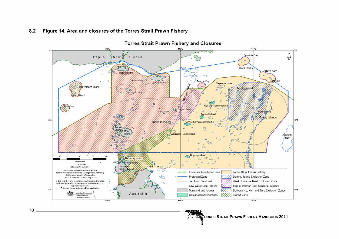
TORRES STRAIT PRAWN FISHERY HANDBOOK 2011 70
8.2 Figure 14. Area and closures of the Torres Strait Prawn Fishery

TORRES STRAIT PRAWN FISHERY HANDBOOK 2011 71
9 Research Research into PZJA fisheries has concentrated on the most valuable fisheries, prawn and tropical rock lobster, with environment and traditional fishing also being studied. Research programs in the Torres Strait tend to be long term and aimed at providing resource or fish stock assessment advice.
Research report Provided by: Clive Turnbull Northern Fisheries Centre, Cairns Fisheries Queensland
Department of Employment, Economic Development and Innovation Telephone (07) 4057 3707
Background
The following is a summary of the research detailed in the Final Report for DAFF Consultancy DAFF83/06. The report is titled, “Torres Strait Prawn Spatial Management Research Project 2007-09”. A draft version of the report was provided to the members of the Torres Strait Prawn Management Advisory Committee (TSPMAC) for review and comment in June 2009. James Woodhams (BRS) and Veronica Rodriguez (BRS) undertook an external independent scientific review of the report. The comments of the reviewers and TSPMAC members were addressed and incorporated into the final version of the report.
In the 2006-07 federal budget, the Australian Government announced $1 million of special research funding to conduct research into the TSPF that would assess and further develop the spatial management arrangements proposed at the July 2005 Alternative Management Workshop and an endeavour prawn stock assessment. QPIF successfully tendered for this research funding which was combined with additional funding from the National Fisheries Agency of Papua New Guinea to conduct trawl surveys of the PNG area of the TSPZ during 2007-08.
The report provides an assessment of a proposed tiger prawn spawner closure and the ‘risk’ associated with a range of levels of fishing effort in the Torres Strait Prawn Fishery (TSPF). The assessment is based on trawl surveys of the fishery conducted during 2007-08 and simulation modelling. The report also details the results of an endeavour prawn stock assessment for the TSPF. These results are informing the development of a harvest strategy for the TSPF.
The report is available for download from http://www.pzja.gov.au/resources/publications/scientific/tsp_spatial_mgt.htm.
An overview of recent trends in effort and catch
The level of active effort in the TSPF has always been considerably lower than the 13540 allocated fishing days assigned to the licences in the fishery in 1993. During this decade the size of the active fleet has dropped from 74 to 37 vessels and the observed fishing effort from an average of 10264 days during 1997-2001 to less than 4000 vessel nights in 2008. This decrease in the effort resulted in the annual harvest dropping from the average of 1,900 t per annum during the years 1997-2001 to 907t in 2008. The largest decrease has been in the endeavour prawn harvest due to fishers targeting the more valuable tiger prawns. The decrease in fishing effort is due to the combined effect of the reduced allocation to Australian vessels, a down turn in the economics of prawn trawling (e.g.

declining prawn market price and increasing fuel costs) and a decrease in the infrastructure (supply barges and air services) that support this remote fishery.
Figure 15. Catch composition based on weight of prawn in each catch category. The sizes of the pie charts indicate the prawn catch rate (CPUE). This plot is based on the data from all surveys grouped by site.
TORRES STRAIT PRAWN FISHERY HANDBOOK 2011 72

Research surveys
Fishery independent research trawl surveys were conducted during May, July, September and November of 2007 and 2008 by the QPIF research trawler, “Gwendoline May”. Sampling sites were randomly spread through the main Australian trawl grounds and Papua New Guinea waters of the Torres Strait Protected Zone between Warrior Reef and Bramble Cay.
A half nautical mile trawl was conducted at each site using a quad gear configuration of four 4-fathom commercial mesh tiger prawn nets. The species, gender, carapace length and spawning condition of all commercial prawns from each net were recorded. The point data from the surveys was plotted and interpolated using Geographic Information Software (ArcGIS Version 9) to generate models of prawn distribution in terms of species abundance (stock size), size (prawn grades) and fecundity (egg production).
The survey results indicate that the prawn stock of the PNG region is a continuation of the prawn stock in the Australian region as the overall catch composition and catch rates across the fishery are quite similar based on both weight and number of prawns (Figure 15). The regions with the highest catch rate and proportion of tiger prawns were the Central and Deep regions around Yorke Island. At a finer spatial scale there is variability between relatively close sites that reflect the patchy nature of the trawl grounds and is probably the result of variations in sediment type and depth. The deeper sites in the north-east and south-east areas of the fishery produced the highest catches of king prawns. Tiger and endeavour prawns clearly occur together as all of the sites produced at least a few of each species but at a finer spatial level there are areas where tiger prawns are more prevalent and others where endeavour prawns are more prevalent.
Figure 16. Distribution of spawning based on data from all surveys. The left plot shows tiger prawn and the right plot shows endeavour prawn. The level of egg production for each site (circle) and the modelled (predicted) distribution is scaled from 0 to 100. The site with the highest egg production was scaled to 100.
TORRES STRAIT PRAWN FISHERY HANDBOOK 2011 73

A relative measure of spawning or egg production was calculated from the standardised catch rate of ripe female prawns of each species at each site and the relationship between female size (carapace length) and egg production. The plots show that the highest levels of spawning (egg production) for tiger prawn occurs in the deep water that runs from Bramble Cay south-west to Stephens Island and then to the south-east of Yorke Island (Figure16). The relative proportion of tiger prawn spawning occurring in the deep region (proposed spawner closure) ranged from 15 to 35 percent.
In contrast to tiger prawns the highest levels of endeavour spawning occurred in slightly shallower areas to the west of the tiger prawn spawning areas. As for tiger prawns there was a change in the intensity and spatial distribution of spawning during the season. The highest levels of egg production occurred during the September surveys of both years. During May of both years the highest levels of spawning occurred in the area to the south-west of Yorke Island. In July the highest levels tended to be north of Stephens Island and mainly within the PNG area. By September spawning had shifted to near Dalrymple Island on the western side of the fishery and during November spawning was generally at a lower level.
Figure 17. Size distribution of female tiger prawn (left) and male tiger prawn (right).
Size distribution plots show that the smallest tiger and endeavour prawns occur in the shallow closure areas on the western side of the fishery and the largest are found in deep waters of the eastern and southern areas. Although there are slight variations this trend is consistent throughout the fishing season. These plots can be used to assess whether the proposed extension to the East of Warrior closure would be of any benefit. The pooled data indicates that the southern half of the proposed closure would limit the harvesting of 15/20 female and 21/30 male tiger prawns (Figure 17). The seasonal plots indicate that
TORRES STRAIT PRAWN FISHERY HANDBOOK 2011 74
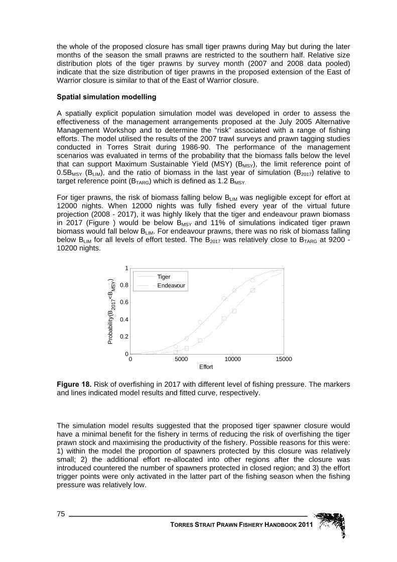
the whole of the proposed closure has small tiger prawns during May but during the later months of the season the small prawns are restricted to the southern half. Relative size distribution plots of the tiger prawns by survey month (2007 and 2008 data pooled) indicate that the size distribution of tiger prawns in the proposed extension of the East of Warrior closure is similar to that of the East of Warrior closure.
Spatial simulation modelling
A spatially explicit population simulation model was developed in order to assess the effectiveness of the management arrangements proposed at the July 2005 Alternative Management Workshop and to determine the “risk” associated with a range of fishing efforts. The model utilised the results of the 2007 trawl surveys and prawn tagging studies conducted in Torres Strait during 1986-90. The performance of the management scenarios was evaluated in terms of the probability that the biomass falls below the level that can support Maximum Sustainable Yield (MSY) (BMSY), the limit reference point of 0.5BMSY (BLIM), and the ratio of biomass in the last year of simulation (B2017) relative to target reference point (BTARG) which is defined as 1.2 BMSY.
For tiger prawns, the risk of biomass falling below BLIM was negligible except for effort at 12000 nights. When 12000 nights was fully fished every year of the virtual future projection (2008 - 2017), it was highly likely that the tiger and endeavour prawn biomass in 2017 (Figure ) would be below BMSY and 11% of simulations indicated tiger prawn biomass would fall below BLIM. For endeavour prawns, there was no risk of biomass falling below BLIM for all levels of effort tested. The B2017 was relatively close to BTARG at 9200 - 10200 nights.
0 5000 10000 150000
0.2
0.4
0.6
0.8
1
Effort
Pro
babi
lity(
B20
17<B
MSY
)
TigerEndeavour
Figure 18. Risk of overfishing in 2017 with different level of fishing pressure. The markers and lines indicated model results and fitted curve, respectively.
The simulation model results suggested that the proposed tiger spawner closure would have a minimal benefit for the fishery in terms of reducing the risk of overfishing the tiger prawn stock and maximising the productivity of the fishery. Possible reasons for this were: 1) within the model the proportion of spawners protected by this closure was relatively small; 2) the additional effort re-allocated into other regions after the closure was introduced countered the number of spawners protected in closed region; and 3) the effort trigger points were only activated in the latter part of the fishing season when the fishing pressure was relatively low.
TORRES STRAIT PRAWN FISHERY HANDBOOK 2011 75
TORRES STRAIT PRAWN FISHERY HANDBOOK 2011 76
The simulation results also showed that the effort trigger points were unlikely to be activated unless 100% usage of total allocated effort was assumed. Fishers do not currently fully utilize all their allocated nights due to the current general market conditions of low prawn prices and high fuel costs. Unless this situation changes it is unlikely that the triggers will be activated. Even if the TAE was increased to 12000 nights, it is unlikely that fishers would make full use of their allocated nights under the current economic conditions, the likelihood of overfishing is low and the proposed spawner closure would not be activated. These results will inform the long-term harvest strategy for the TSPF by providing stakeholders with estimates of the risk of the stock biomass falling below a sustainable level for a range of fishing effort (Figure18).
One of the biggest challenges in the model development was to simulate the movement of prawns between regions using a movement transition matrix that was based largely on tiger prawn tagging data. Although the overall movement of the Torres Strait prawns was generally well captured by the model there were some discrepancies between the model and survey estimates of spawning.
The distribution of tiger and endeavour prawn stocks overlaps spatially making it difficult to control targeting of effort for each species through the use of spatial management arrangements. The performance measures indicated that endeavour prawns are more resilient to fishing pressure than tiger prawns. As the endeavour prawn price is almost half the value of tiger prawns and fuel cost is high, there is no incentive for the industry to target endeavour prawns. Therefore the risk of overfishing endeavour prawns is low and the TSPF is biologically sustainable for both species as long as the more susceptible tiger prawns are harvested sustainably.
Endeavour prawn stock assessment
The fitting of a stock assessment model to the data for endeavour prawns in Torres Strait has been challenging due to the nature of the harvest data available for this species. As the distribution of tiger and endeavour prawns completely overlap there are few daily vessel records that report only one of the species. Although the AFMA logbooks have a target species field many TSPF fishers do not fill out this field and the reliability of the information where it has been filled out is dubious as fishers target the mix of species which provide the highest return rather than a particular species. At industry meetings fishers have stated that they “target dollars not a species”. Endeavour prawns are of less value than tiger prawns so they tend to be the secondary target species making the CPUE data for endeavour prawns less reliable than the tiger prawn CPUE data. The CPUE data for the years prior to 1989 came from a variable subset of the total fishing effort, making the catch rates for those years even less reliable as an index of abundance.
Another difficulty with the data is that the endeavour prawn harvest during the years 1991-2001 was significantly higher than prior to 1991. Possible reasons for this trend are; the East of Warrior Closure, increased targeting of endeavour prawns during the 1990’s and possible discarding of endeavour prawn catch during the early 1980’s.
As the CPUE data does not appear to be a consistent index of abundance over the whole time series different catchability coefficients were calculated for the two data periods: pre 1989 and the compulsory logbook period (post 1988). The catchability coefficient for the post 1988 period was estimated as higher than for the voluntary period.
Catch rate standardisation analysis indicates that the increase in fishing power for endeavour prawns was less than for tiger prawns and that the 10% decrease in net size during 2002-03 resulted in a 3% reduction in fishing power. This is slightly less than the 4 % negative net size effect suggested by Dr David Die which was based on fishing power
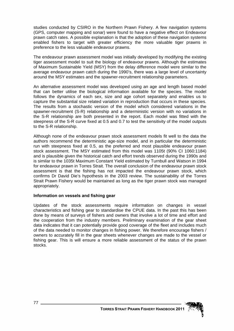
TORRES STRAIT PRAWN FISHERY HANDBOOK 2011 77
studies conducted by CSIRO in the Northern Prawn Fishery. A few navigation systems (GPS, computer mapping and sonar) were found to have a negative effect on Endeavour prawn catch rates. A possible explanation is that the adoption of these navigation systems enabled fishers to target with greater efficiency the more valuable tiger prawns in preference to the less valuable endeavour prawns.
The endeavour prawn assessment model was initially developed by modifying the existing tiger assessment model to suit the biology of endeavour prawns. Although the estimates of Maximum Sustainable Yield (MSY) from the delay difference model were similar to the average endeavour prawn catch during the 1990’s, there was a large level of uncertainty around the MSY estimates and the spawner-recruitment relationship parameters.
An alternative assessment model was developed using an age and length based model that can better utilise the biological information available for the species. The model follows the dynamics of each sex, size and age cohort separately and enables us to capture the substantial size related variation in reproduction that occurs in these species. The results from a stochastic version of the model which considered variations in the spawner-recruitment (S-R) relationship and a deterministic version with no variations in the S-R relationship are both presented in the report. Each model was fitted with the steepness of the S-R curve fixed at 0.5 and 0.7 to test the sensitivity of the model outputs to the S-R relationship.
Although none of the endeavour prawn stock assessment models fit well to the data the authors recommend the deterministic age-size model, and in particular the deterministic run with steepness fixed at 0.5, as the preferred and most plausible endeavour prawn stock assessment. The MSY estimated from this model was 1105t (90% CI 1060:1184) and is plausible given the historical catch and effort trends observed during the 1990s and is similar to the 1035t Maximum Constant Yield estimated by Turnbull and Watson in 1994 for endeavour prawn in Torres Strait. The overall conclusion of the endeavour prawn stock assessment is that the fishing has not impacted the endeavour prawn stock, which confirms Dr David Die’s hypothesis in the 2003 review. The sustainability of the Torres Strait Prawn Fishery would be maintained as long as the tiger prawn stock was managed appropriately.
Information on vessels and fishing gear
Updates of the stock assessments require information on changes in vessel characteristics and fishing gear to standardise the CPUE data. In the past this has been done by means of surveys of fishers and owners that involve a lot of time and effort and the cooperation from the industry members. Preliminary examination of the gear sheet data indicates that it can potentially provide good coverage of the fleet and includes much of the data needed to monitor changes in fishing power. We therefore encourage fishers / owners to accurately fill in the gear sheets whenever changes are made to the vessel or fishing gear. This is will ensure a more reliable assessment of the status of the prawn stocks.

10 Logbook Statistics Provided by: Clive Turnbull
Northern Fisheries Centre, Cairns Fisheries Queensland Department of Employment, Economic Development and Innovation
Telephone (07) 4057 3707 The final catches and effort values for 2010 will be slightly higher than those shown in this edition of the handbook. The following statistics are based on AFMA logbook data extracted during early January 2011. The estimated coverage of the 2010 data is March to June 100%, July 96.1%, August 94.5%, September 93.9%, October 89% and November 87.2%. Thanks to the cooperation of trawler skippers in filling out and returning their log sheets, an essential record of catches and effort for the fishery has been built up over many years. The usefulness of this data increases as the length of the time-series data increases and the level of fishing effort and catch rates become more varied. This “time-series” of logbook data is used to monitor trends in fishing effort, catches and catch rates by area (spatial trends), year and month (temporal trends). The data is also used in various stock models to estimate the level of catch and fishing effort that should both maximise the productivity of the fishery and ensure that catches are sustainable in the long term.
10.1 Catch and effort by year The current catch estimates for the 2010 fishing season are 331, 105 and 9 tonnes for tiger, endeavour and king prawn respectively ( Table 4). Although these estimates will increase slightly when all logbook records have been entered, the final catches will still be much lower than the long term averages. During the years 1991 to 2003 which was a period of high fishing effort the average catch of tiger, endeavour and king prawn was 668, 1044 and 70 tonnes respectively.
0
200
400
600
800
1,000
1,200
1,400
1,600
1989
1990
1991
1992
1993
1994
1995
1996
1997
1998
1999
2000
2001
2002
2003
2004
2005
2006
2007
2008
2009
2010
Cat
ch (t
)
0
2,000
4,000
6,000
8,000
10,000
12,000
Effo
rt (d
ays)
Tiger (t) Endeavour (t) King (t) Nights Fished vms
Figure 19. Prawn catches by species (columns) and effort (line).
TORRES STRAIT PRAWN FISHERY HANDBOOK 2011 78
The steep decline in fishing effort since 2003 appears to be levelling out and the current estimate of fishing effort for 2010 is 1,805 days based on the logbook data. Although the final estimate will be closer to the 2,309 days estimated from the VMS data it will be still the lowest level of fishing effort recorded since the early 1980’s. The 2009 and 2010

fishing effort (2,599 and 2,309 days based on VMS data) were 28 and 25 percent respectively of the Emsy limit reference point (9,200 days). The VMS data is an overestimate of effort as vessels are automatically flagged as fishing when steaming at trawl speed or if the VMS unit fails to poll. Fishers can claim a credit if they can verify that they were not fishing but often do not if it is near the end of the season and they have unused days of access. Despite the decrease in effort since 2001 the annual tiger prawn catch remained close to the long term average during the years 2001 to 2006. However, since 2006 the annual tiger prawn catch has dropped in line with the decrease in effort (Figure 19). In contrast to tiger prawn, the annual endeavour prawn catch rapidly decreased between 2001 and 2005 as rising fuel costs, low prawn prices and marketing problems have made it less profitable to fish for endeavour prawn.
Table 4. Yearly Totals since 1989 (t = tonnes). The “All prawn” column includes “mixed prawn” and other minor categories and so may be higher than the sum of the tiger, endeavour and king prawn columns and the 2009 data is incomplete.
Year All prawn (t) Hours Trawled Nights Fished Tiger (t) Endeavour (t) King (t)1989 1,188 71,069 7,824 539 614 251990 858 56,480 5,688 396 435 231991 1,871 100,683 9,983 709 1,079 701992 2,048 123,618 11,907 880 1,103 551993 1,417 89,077 8,525 487 885 381994 1,528 97,261 9,244 465 1,013 451995 1,861 86,594 8,158 648 1,179 311996 1,592 91,073 8,453 670 893 251997 1,799 108,227 10,097 694 1,065 351998 2,119 109,738 10,182 965 1,050 1041999 2,202 117,912 10,904 629 1,511 612000 1,634 107,331 9,979 479 1,079 722001 1,797 108,946 10,158 621 1,095 772002 1,753 104,477 9,641 721 864 1652003 1,597 97,272 9,000 712 759 1262004 1,373 76,108 7,041 606 689 742005 1,311 63,300 5,966 651 594 512006 1,331 47,273 4,407 602 672 452007 1,137 51,398 4,832 582 503 472008 907 37,023 3,453 439 418 482009 547 19,435 2,165 348 178 172010 447 16,105 1,805 331 105 9
average (91-03) 1,786 103,247 9,710 668 1,044 70 average (04-08) 1,212 55,021 5,140 576 575 53 In 2009 and 2010 the percentage of tiger prawn in the catch has been the highest on record, at 64% and 75% respectively. Conversely the percentage of endeavour prawn was the lowest on record; 33% and 24% for 2009 and 2010 respectively. Although on average tiger prawn has made up about 40 percent of the catch by weight, this has varied markedly over the time series (Figure 20). During the time period 1989 - 2004 endeavour prawn was the largest component of the annual catch. King prawn is clearly a small component of the catch. During 2002-03 the proportion of king prawns was higher than the long term average.
TORRES STRAIT PRAWN FISHERY HANDBOOK 2011 79
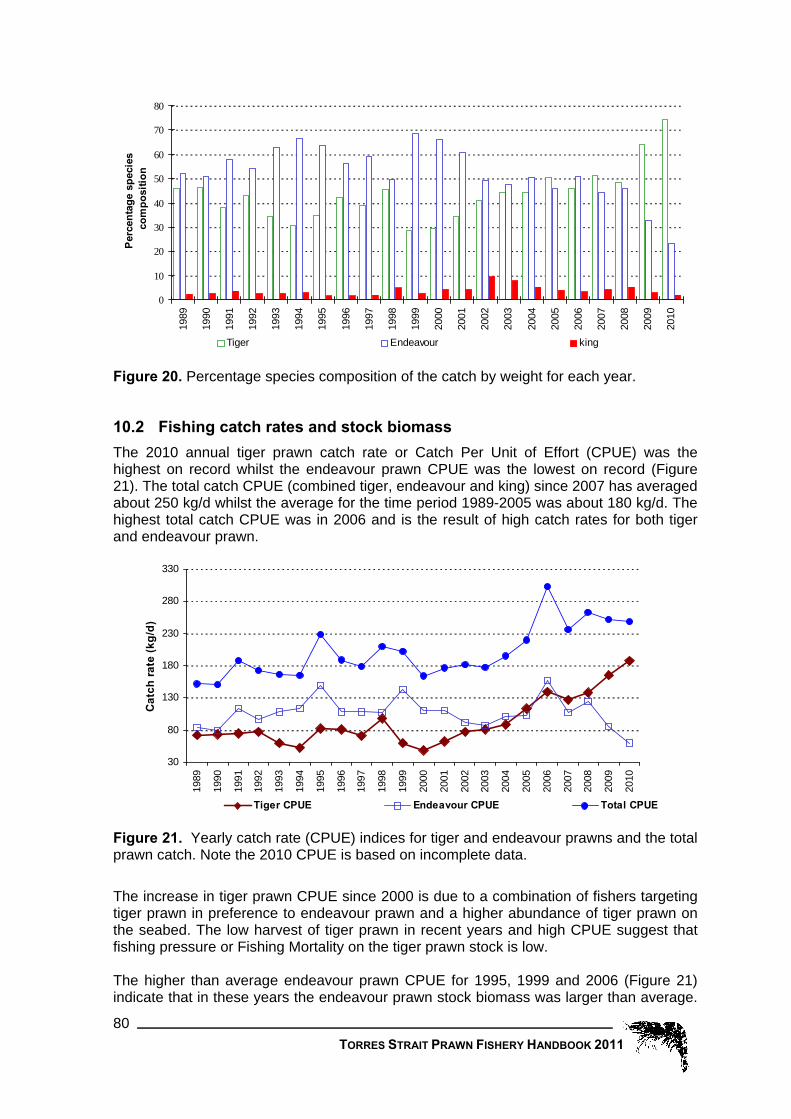
0
10
20
30
40
50
60
70
80
1989
1990
1991
1992
1993
1994
1995
1996
1997
1998
1999
2000
2001
2002
2003
2004
2005
2006
2007
2008
2009
2010
Perc
enta
ge s
peci
esco
mpo
sitio
n
Tiger Endeavour king
Figure 20. Percentage species composition of the catch by weight for each year.
10.2 Fishing catch rates and stock biomass The 2010 annual tiger prawn catch rate or Catch Per Unit of Effort (CPUE) was the highest on record whilst the endeavour prawn CPUE was the lowest on record (Figure 21). The total catch CPUE (combined tiger, endeavour and king) since 2007 has averaged about 250 kg/d whilst the average for the time period 1989-2005 was about 180 kg/d. The highest total catch CPUE was in 2006 and is the result of high catch rates for both tiger and endeavour prawn.
30
80
130
180
230
280
330
1989
1990
1991
1992
1993
1994
1995
1996
1997
1998
1999
2000
2001
2002
2003
2004
2005
2006
2007
2008
2009
2010
Cat
ch ra
te (k
g/d)
Tiger CPUE Endeavour CPUE Total CPUE
Figure 21. Yearly catch rate (CPUE) indices for tiger and endeavour prawns and the total prawn catch. Note the 2010 CPUE is based on incomplete data.
The increase in tiger prawn CPUE since 2000 is due to a combination of fishers targeting tiger prawn in preference to endeavour prawn and a higher abundance of tiger prawn on the seabed. The low harvest of tiger prawn in recent years and high CPUE suggest that fishing pressure or Fishing Mortality on the tiger prawn stock is low. The higher than average endeavour prawn CPUE for 1995, 1999 and 2006 (Figure 21) indicate that in these years the endeavour prawn stock biomass was larger than average.
TORRES STRAIT PRAWN FISHERY HANDBOOK 2011 80

TORRES STRAIT PRAWN FISHERY HANDBOOK 2011 81
These were most likely years when the endeavour prawn recruitment was above average resulting in more endeavour prawns on the trawl grounds. Ideally catch rates (or CPUE) are an indication of the numbers of prawns on the seabed. High catch rates indicate a large prawn biomass while low catch rates indicate a small prawn biomass. There are, however, many other factors that can impact on the catch rate of an individual vessel other than prawn abundance. These factors are vessel size, engine power, type of nets, time of the year, moon phase, area within the fishery etc. The standardised catch rates used in the stock assessment models are slightly different to those shown in Figure 21 as they are adjusted for the factors that can affect individual vessel catch rates. This ensures that the catch rates can more accurately reflect the biomass of prawns on the seabed. The stock assessments conducted in 2004 and 2006, which are based on the monthly catch and standardised catch rates of tiger prawns since 1980, indicate that from 2002 to 2006 the tiger prawn biomass was higher than during the 1990’s and the stock level required for maximum stock productivity (Bmsy). Since 2006 tiger prawn catch rates have increased further and harvest decreased indicating that the stock biomass should be even higher than during 2002-06.
10.3 Regional catch and effort The distribution of catch and effort since 1998 over four regions within the fishery is shown in Figure 22. Peter Channells arbitrarily defined these regions in the late 1980’s and they have been used in all the Torres Strait Newsletters and Handbooks produced during the 1990’s. The regions are defined by latitude and are; Dalrymple-Yorke 9° 22” to 9° 46”, Aureed-Bourke 9° 46” to 10°, Coconut-PD 10° to 10° 26”, Dugong 10° 26” to 10° 41”. During 2010 effort and the catch of tiger and endeavour prawns was fairly evenly distributed across the three main regions but very low in the south (Dugong). This is reflects the general trend since 2004 where fishing effort and catch were fairly evenly distributed across the regions except for the Dugong region which has always had the lowest effort and catch. In contrast, during the earlier years (1991 to 2003) effort and catches, for tiger prawn in particular, where usually highest in the north of the fishery (Dalrymple-Yorke) and lowest in the south (Dugong). During the time periods 1993-95 and 1999-2001 when endeavour prawn dominated the annual catch (Figure 220) fishing effort and endeavour prawn catch was often higher than average in the south of the fishery, especially the Coconut-PD region.
10.4 Spatial distribution of catches and effort The spatial distribution of catch by species group for the 2009 and 2010 seasons are shown in Figure 23 as pie charts that summarise the data to the centres of the logbook 6-minute grid squares. The sizes of the pie charts are scaled to the total annual prawn catch from each grid. The largest circle on the 2009 map (1st grid above the 10 degree line) represents 42 tonnes and the largest circle on the 2010 map (again the1st grid above 10 degree line) represents 38 tonnes. The spatial distribution of the overall catch is 2010 is similar to that for 2009 but most grids have a higher proportion of tiger catch compared with the 2009 season. Note that logbook data is still coming in for the 2010 season so the map may change slightly in the next edition of the handbook.
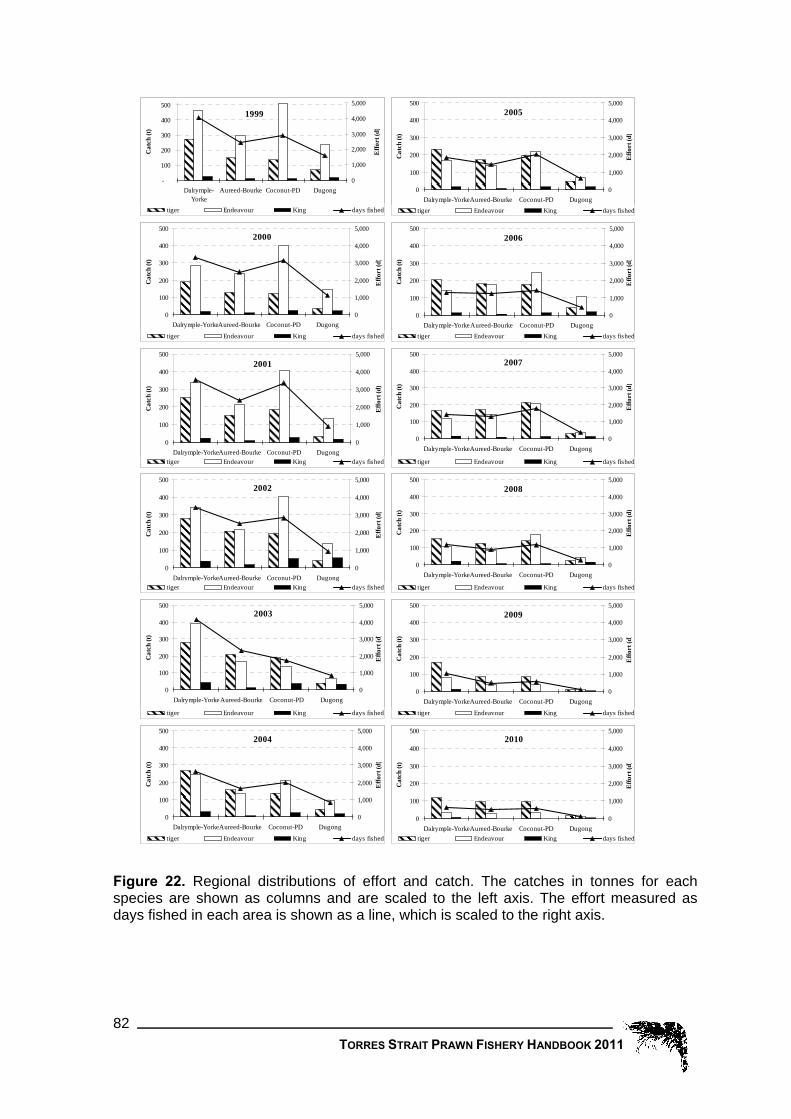
2008
0
100
200
300
400
500
Dalrymple-YorkeAureed-Bourke Coconut-PD Dugong
Cat
ch (t
)
0
1,000
2,000
3,000
4,000
5,000
Effo
rt (d
)
tiger Endeavour King days fished
1999
-
100
200
300
400
500
Dalrymple-Yorke
Aureed-Bourke Coconut-PD Dugong
Cat
ch (t
)
0
1,000
2,000
3,000
4,000
5,000
Effo
rt (d
)
tiger Endeavour King days fished
2000
0
100
200
300
400
500
Dalrymple-YorkeAureed-Bourke Coconut-PD Dugong
Cat
ch (t
)
0
1,000
2,000
3,000
4,000
5,000
Effo
rt (d
)
tiger Endeavour King days fished
2001
0
100
200
300
400
500
Dalrymple-YorkeAureed-Bourke Coconut-PD Dugong
Cat
ch (t
)
0
1,000
2,000
3,000
4,000
5,000
Effo
rt (d
)
tiger Endeavour King days fished
2002
0
100
200
300
400
500
Dalrymple-YorkeAureed-Bourke Coconut-PD Dugong
Cat
ch (t
)
0
1,000
2,000
3,000
4,000
5,000
Effo
rt (d
)
tiger Endeavour King days fished
2003
0
100
200
300
400
500
Dalrymple-YorkeAureed-Bourke Coconut-PD Dugong
Cat
ch (t
)
0
1,000
2,000
3,000
4,000
5,000
Effo
rt (d
)
tiger Endeavour King days fished
2004
0
100
200
300
400
500
Dalrymple-YorkeAureed-Bourke Coconut-PD Dugong
Cat
ch (t
)
0
1,000
2,000
3,000
4,000
5,000
Effo
rt (d
)
tiger Endeavour King days fished
2005
0
100
200
300
400
500
Dalrymple-YorkeAureed-Bourke Coconut-PD Dugong
Cat
ch (t
)
0
1,000
2,000
3,000
4,000
5,000
Effo
rt (d
)
tiger Endeavour King days fished
2006
0
100
200
300
400
500
Dalrymple-YorkeAureed-Bourke Coconut-PD Dugong
Cat
ch (t
)
0
1,000
2,000
3,000
4,000
5,000
Effo
rt (d
)
tiger Endeavour King days fished
2007
0
100
200
300
400
500
Dalrymple-YorkeAureed-Bourke Coconut-PD Dugong
Cat
ch (t
)
0
1,000
2,000
3,000
4,000
5,000
Effo
rt (d
)
tiger Endeavour King days fished
2009
0
100
200
300
400
500
Dalrymple-YorkeAureed-Bourke Coconut-PD Dugong
Cat
ch (t
)
0
1,000
2,000
3,000
4,000
5,000
Effo
rt (d
)
tiger Endeavour King days fished
2010
0
100
200
300
400
500
Dalrymple-YorkeAureed-Bourke Coconut-PD Dugong
Cat
ch (t
)
0
1,000
2,000
3,000
4,000
5,000
Effo
rt (d
)
tiger Endeavour King days fished
Figure 22. Regional distributions of effort and catch. The catches in tonnes for each species are shown as columns and are scaled to the left axis. The effort measured as days fished in each area is shown as a line, which is scaled to the right axis.
TORRES STRAIT PRAWN FISHERY HANDBOOK 2011 82

War
rior R
eefs
Yorke Island
143°30'E
143°30'E
143°E
143°E
9°30'S
10°S
10°30'S
2009 Species Compositiontiger prawnendeavour prawnking prawnTSPZFisheries Jurisdiction LinePremanent closuresEast of Warrior seasonal closureAustralian outside but near
War
rior R
ee
fs
Yorke Island
143°30'E
143°30'E
143°E
143°E
9°30'S
10°S
10°30'S
2010 Species Compositiontiger prawnendeavour prawnking prawnTSPZFisheries Jurisdiction LinePremanent closuresEast of Warrior seasonal closureAustralian outside but near
Figure 23. Spatial distribution of catches during the 2008 (Left) and 2009 (Right) seasons. The diameters of the pie charts indicate the total prawn catch for each grid. Tom Toranto (CSIRO) provided the base map.
144°E
144°E
142°30'E
142°30'E
10°3
0'S
10°3
0'S
Torres Strait Prawn Fishery2010 Fishing Effort (days)
16 - 51
52 - 86
87 - 120
121 - 155
Australian Fishery Jurisdiction
PNG Fishery Jurisdiction
Permanent Closure
Seasonal Closure
Papua New Guinea
Cape York
War
rior R
eefs
Torres Strait
Yorke Id
Darnley Is
Murray Is
Thursday Is
Figure 24. Effort distribution (fishing days) within the Torres Strait Prawn Fishery for the 2010 season.
TORRES STRAIT PRAWN FISHERY HANDBOOK 2011 83

Although the grids in the northern area of the fishery have generally had a higher proportion of tiger prawn in the catch than the grids in the south of the fishery (south of 10 degrees), this trend is less obvious in the plots for 2009 and 2010. In last two years the only grids where the proportion of endeavour prawn has been greater than tiger is in “outside but near area” between the Torres Strait Protected Zone and the Queensland East Coast fishery. There is a consistent trend between years for the grids in the southeast and northeast areas of the fishery to have the highest proportion of king prawn. The spatial distribution of fishing effort in 2010 by six minute grid is shown in Figure 24 and indicates that the highest effort occurs along the diagonal through the middle of the fishery from the north-east to the south-west. In both the catch and effort figures, data for grids where less than five vessels fished during the season were not included in the summaries. This was done to abide with confidentiality requirements. As the Fisheries Jurisdiction Line passes through the lower sections of grids along the border region the catch of these grids ‘appear’ to be in PNG waters as the grid centre is north of the line.
10.5 Monthly trends in catch and effort The following figures compare the monthly trends for the last two seasons with the average of the prior years. The range markers on the average lines in Figure 25 to Figure 31 indicate the minimum and maximum values that occurred over the years 1989-08.
Total days fished in the Torres Strait Prawn Fishery
0
500
1,000
1,500
2,000
2,500
Mar Apr May Jun Jul Aug Sep Oct Nov
Effo
rt (d
)
Average Effort for 1989-08 2009 2010 vms10
Figure 25. Monthly fishing effort in days.
During the first half of 2010 fishing effort was slightly lower than during first half of 2009. In contrast the 2010 August-September fishing effort was slightly higher than in 2009 (Figure 25). The estimate of fishing effort from the VMS data is slightly higher than but a close match to the effort calculated from the logbook data.
TORRES STRAIT PRAWN FISHERY HANDBOOK 2011 84

The monthly 2010 catch was slightly lower than for 2009 until July where the trend reversed reflecting the increase in fishing effort (Figure 26). The trend in the monthly tiger prawn catch for 2009 follows the trend in monthly effort for the 2009 season. Similarly the trend in the monthly tiger prawn catch for 2010 follows the trend in monthly effort for the 2010 season.
Monthly tiger prawn catch
0
50
100
150
200
250
Mar Apr May Jun Jul Aug Sep Oct Nov
Cat
ch (t
)
Average catch for 1989-08 2009 2010
Figure 26. Monthly tiger prawn catches in tonnes.
Monthly tiger prawn CPUE
20
40
60
80
100
120
140
160
180
200
220
Mar Apr May Jun Jul Aug Sep Oct Nov
Cat
ch r
ate
(kg
/d)
Average CPUE for 1989-08 2009 2010
Figure 27. Monthly tiger prawn catch rates (CPUE).
The 2010 monthly tiger prawn catch rates were the highest on record for all months of the season (Figure 27). The highest CPUE was in June followed by a slow decrease over the remainder of the season. It is unusual for the highest catch rate to occur in June and generally it occurs in March or April. This may be a result to the low effort in the fishery as when effort is low the monthly fleet average can be influenced by high catch rates from a few of vessels. It is interesting that effort increased in August-September when CPUE was declining.
TORRES STRAIT PRAWN FISHERY HANDBOOK 2011 85

The 2009 monthly tiger prawn catch rates (Figure 27) were also all well above average. The May CPUE was slightly higher than March and there were increases in catch rates during August and September. Overall there is still a general decline in the tiger prawn CPUE during the season. A linear regression through the 2009 and 2010 plots follows the trend in the average CPUE but at a much higher level. The 2009 and 2010 monthly endeavour prawn catches (Figure 28) were well below average for the whole season due to the very low level of effort during both seasons.
Monthly endeavour prawn catch
0
50
100
150
200
250
300
Mar Apr May Jun Jul Aug Sep Oct Nov
Cat
ch (t
)
Average endeavour prawn catch for 1989-08 2009 2010
Figure 28. Monthly endeavour prawn catches in tonnes.
Monthly endeavour prawn CPUE
20
70
120
170
220
Mar Apr May Jun Jul Aug Sep Oct Nov
Cat
ch r
ate
(kg
/d)
Average endeavour prawn CPUE for 1989-08 2009 2010
Figure 29. Monthly Endeavour Prawn catch rates (CPUE).
The 2010 monthly endeavour prawn catch rates (Figure 29) were well below average. The pattern is fairly flat with the highest CPUE occurring in August. The 2009 monthly endeavour prawn catch rates largely followed the trend in the average endeavour catch rate but at a lower level.
TORRES STRAIT PRAWN FISHERY HANDBOOK 2011 86
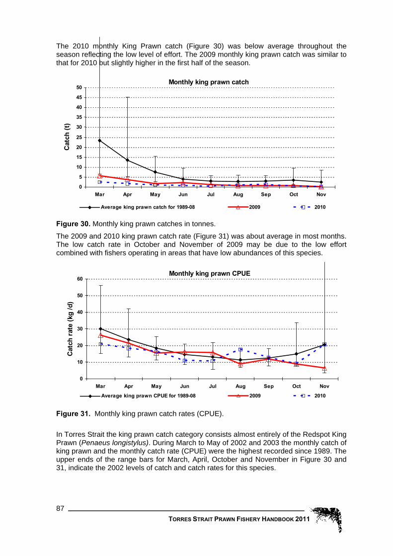
The 2010 monthly King Prawn catch (Figure 30) was below average throughout the season reflecting the low level of effort. The 2009 monthly king prawn catch was similar to that for 2010 but slightly higher in the first half of the season.
Monthly king prawn catch
0
5
10
15
20
25
30
35
40
45
50
Mar Apr May Jun Jul Aug Sep Oct Nov
Cat
ch (t
)
Average king prawn catch for 1989-08 2009 2010
Figure 30. Monthly king prawn catches in tonnes. The 2009 and 2010 king prawn catch rate (Figure 31) was about average in most months. The low catch rate in October and November of 2009 may be due to the low effort combined with fishers operating in areas that have low abundances of this species.
Monthly king prawn CPUE
0
10
20
30
40
50
60
Mar Apr May Jun Jul Aug Sep Oct Nov
Cat
ch r
ate
(kg
/d)
Average king prawn CPUE for 1989-08 2009 2010
Figure 31. Monthly king prawn catch rates (CPUE).
In Torres Strait the king prawn catch category consists almost entirely of the Redspot King Prawn (Penaeus longistylus). During March to May of 2002 and 2003 the monthly catch of king prawn and the monthly catch rate (CPUE) were the highest recorded since 1989. The upper ends of the range bars for March, April, October and November in Figure 30 and 31, indicate the 2002 levels of catch and catch rates for this species.
TORRES STRAIT PRAWN FISHERY HANDBOOK 2011 87

10.6 Details by month of catches and effort since 1989 For fishers interested in more detail than that presented in the graphs, the following tables provide a break down of catch and effort for each month of each year since 1989. *Note: Only the southern section of Torres Strait was open during March of 1989 so this data was neither presented nor used to calculate the averages displayed in the previous monthly figures.
TablYear
Mar
e 5. 1989
48*
Tota1990
l pr1991
545
awn 1992
491
catc1993
275
h in 1994
341
tonn1995
475
es b1996
497
y m1997
415
onth1998
486
1999
412
and yea2000
434
r 2001
450
2002
495
2003
390
2004
283
2005
329
2006
395
2007
261
2008
191
2009
129
2010
86
Apr
May
Jun
312
259
138
169
150
79
154
299
253
316
227
197
243
170
100
314
219
167
349
302
207
238
170
151
306
246
155
377
261
237
411
343
268
293
194
166
365
271
166
360
237
129
323
183
117
258
190
131
307
208
111
309
181
99
251
205
105
186
147
74
85
68
71
58
43
40
Jul 135 126 147 145 124 131 161 142 131 239 231 165 147 97 142 142 63 89 73 90 43 37
Aug
Sep
Oct
104
87
76
114
106
78
120
180
106
213
199
161
201
132
115
145
106
71
139
135
65
156
126
77
196
183
113
194
157
135
198
167
118
132
135
83
131
146
81
118
129
123
157
135
96
156
116
59
79
110
79
92
83
64
85
78
60
93
64
42
43
47
34
70
58
13
Nov
24 36 67 99 59 33 28 35 53 45 54 31 38 65 55 37 25 20 20 19 8 0
TablYear
Mar
e 6. 1989
13*
Tige1990
r pr1991
217
awn 1992
245
catc1993
90
h in 1994
124
tonn1995
187
es b1996
246
y m1997
172
onth1998
261
1999
129
and ye2000
121
ar 2001
133
2002
195
2003
177
2004
141
2005
194
2006
191
2007
117
2008
87
2009
90
2010
63
Apr
May
Jun
169
126
64
99
76
41
67
117
110
147
102
87
87
64
40
87
64
51
120
107
73
90
68
71
109
92
59
185
117
108
89
96
74
74
52
61
124
88
75
141
112
57
134
79
61
111
80
61
165
96
51
117
79
45
126
111
59
81
71
37
51
44
45
43
32
31
Jul 60 66 56 62 51 42 53 58 53 99 76 59 64 46 77 65 31 45 40 51 28 31
Aug
Sep
Oct
43
30
25
46
34
22
42
49
31
87
67
52
72
37
30
41
26
20
45
36
20
57
40
29
74
69
43
77
60
43
62
49
35
42
36
23
56
48
24
54
48
44
74
54
36
67
44
22
34
42
28
49
38
28
46
40
31
46
29
23
28
30
25
53
47
21
Nov
9 11 20 29 16 10 9 10 23 15 18 10 10 24 20 16 10 11 12 13 7 11
Tabl
Year
Mar
e 7.
1989
32*
End
1990
eav
1991
293
our
1992
222
praw
1993
172
n ca
1994
202
tch i
1995
279
n to
1996
241
nnes
1997
236
by
1998
190
mont
1999
263
2000
279
2001
290
h and year
2002
225
2003
165
2004
116
2005
117
2006
187
2007
125
2008
87
2009
47
2010
20
Apr
May
Jun
135
125
71
64
67
35
81
172
136
160
119
104
148
99
57
215
146
112
222
189
131
141
98
78
189
149
92
165
130
120
308
239
189
200
136
101
227
177
89
174
110
67
163
89
48
129
102
65
124
101
54
178
95
51
113
87
43
93
71
34
31
22
24
14
10
7
Jul 73 57 86 79 69 86 105 82 76 134 151 102 82 49 60 73 31 41 30 34 13 9
Aug
Sep
Oct
59
55
48
65
69
54
73
125
70
122
125
104
123
93
82
102
78
50
92
97
45
97
85
47
118
111
67
110
90
85
133
113
80
88
96
58
73
91
47
62
76
68
78
75
52
85
67
33
42
64
46
40
41
32
36
36
27
42
32
18
14
16
8
20
18
5
Nov 15 24 43 67 42 21 19 24 26 27 33 19 19 33 29 19 14 8 6 6 2 1
TORRES STRAIT PRAWN FISHERY HANDBOOK 2011 88

Table 8. King prawn catch in tonnes by month and year.
TORRES STRAIT PRAWN FISHERY HANDBOOK 2011 89
Year 1989 1990 1991 1992 1993 1994 1995 1996 1997 1998 1999 2000 2001 2002 2003 2004 2005 2006 2007 2008 2009 2010
Mar 3* 30 20 12 13 10 10 6 29 19 34 28 75 48 26 12 16 17 16 6 2
Apr
May
Jun
6
6
3
5
7
3
6
9
6
8
5
6
7
5
3
11
8
4
6
6
3
6
3
1
7
4
3
25
14
9
13
6
4
18
6
4
14
6
3
45
15
5
26
15
7
16
8
5
14
10
5
12
6
3
12
6
3
12
5
2
4
2
2
2
Jul 2 3 4 3 3 2 3 1 2 6 4 4 1 3 5 4 1 2 2 5 1
Aug
Sep
Oct
1
2
2
2
1
1
3
4
5
3
4
3
5
1
1
2
1
1
1
1
1
1
1
1
3
3
3
6
6
7
3
4
4
2
2
2
2
5
10
2
4
8
4
6
8
4
5
4
2
3
3
2
2
1
2
2
2
4
2
1
1
1
1
Nov 1 1 3 3 1 2 0 0 3 3 3 1 9 7 6 3 1 0 1 1 0
Table 9. Number of nights recorded as fished in Torres Strait by the fleet Year 1989 1990 1991 1992 1993 1994 1995 1996 1997 1998 1999 2000 2001 2002 2003 2004 2005 2006 2007 2008 2009 2010
Mar
Apr
May
Jun
Jul
Aug
Sep
Oct
Nov
184*
1,370
1,605
1,062
1,064
812
744
670
282
910
1,005
509
867
812
724
543
318
2,431
596
1,228
1,531
1,030
734
1,046
856
531
2,218
1,453
1,377
1,358
1,084
1,209
1,170
1,184
854
1,115
1,076
1,016
645
794
1,440
949
933
557
1,570
1,494
1,160
956
921
1,161
887
734
361
1,610
1,249
1,147
970
868
842
763
488
221
1,709
1,080
882
877
918
1,078
833
736
340
1,672
1,488
1,306
1,092
853
1,209
1,157
853
467
1,694
1,371
1,126
1,099
1,199
1,104
1,051
1,031
507
1,387
1,332
1,479
1,505
1,335
1,252
1,148
964
502
1,892
1,506
1,101
1,061
1,154
934
1,098
835
398
1,835
1,565
1,365
1,206
1,063
1,056
1,082
700
285
1,916
1,506
1,445
864
715
851
970
908
466
1,797
1,573
1,066
620
765
930
1,007
794
448
1,123
1,107
844
675
788
984
802
447
271
1,129
1,184
914
606
386
432
583
547
185
1,145
878
578
358
316
356
361
304
111
1,023
871
703
442
342
425
432
409
185
534
535
532
341
370
414
291
271
165
488
300
238
284
193
197
202
204
59
321
222
171
149
153
274
279
154
82
1
1
0
1
1
0
0

TORRES STRAIT PRAWN FISHERY HANDBOOK 2011 90
11 Fishery Observer Program 11.1 Objective of the program
Introduced in the 2005 fishing season, the purpose of the TSPF Observer Program is to provide fisheries management, research organisations, fishing industry and the wider community with up-to-date, reliable and accurate information on the fishing catch, effort and practice in the TSPF. The primary objective of the Observer Program is to place observers on fishing vessels in the fishery to collect fishery dependent scientific data, including commercial catch, bycatch and TEP (Threatened, Endangered and Protected) species information. The data will be used to aid fisheries management decisions and assist in verifying data required by Logbooks, the Bycatch Action Plan (BAP) and the Environmental Risk Assessment (ERA). In the 2010 fishing season, the observers program also collected data on species of particular cultural significance to the Torres Strait Islander community.
A total of 60 days of observer coverage was allocated to the TSPF for the 2010/11 financial year. This equates to approximately 2.6% coverage for the fishery (based on 6,867 allocated nights to the Australian industry).
During the 2010 season one 17 day observer trip was undertaken on one vessel in October. The remaining 43 days of coverage will be aimed to be achieved during March and April 2011.
Vessels owners and masters wishing to participate by taking an observer should contact the Observer Coordinator to organise placement. The Observer Program wish to express their thanks for the cooperation of industry and vessel crews involved in the program to date.
11.2 Roles of the observer
The roles of the observer include: 1. Validate the vessel’s logbooks, observe, monitor and record fishing vessel operations. 2. Record the number and weight, life status, fate and where feasible the weight of all
retained and discarded species. 3. Measure and record the length and sex of key species. 4. Collect biological samples including prawn lengths, prawn sexes, sea snake lengths
and tropical crayfish lengths. 5. Monitor and record catches in relation to catches and life status of ecologically related
key fish species to traditional fishing. 6. Collect information concerning the configurations of mitigation measures (e.g. TEDs
and BRDs) to avoid incidental take of bycatch. 7. Record information by species including: numbers, time, and location (latitude and
longitude) of incidental catch of Threatened Endangered and Protected species. 8. Record gear information (e.g. net type, net mesh size, ground gear type, otter-board
types etc). 9. Assistance may be provided to operators in the event of misunderstandings as well
as in improving the level of compliance of various conditions of the fishing concession, MARPOL regulations and the Industry Code of Practice.
10. Provide an extension service to industry on management and bycatch issues.

TORRES STRAIT PRAWN FISHERY HANDBOOK 2011 91
The observer program will provide (upon request) to the vessel’s operators a copy of the observer manual, outlining various information regarding the observer’s role in the TSPF.
11.3 Obligations of AFMA and the observer
The obligations of AFMA and the observer towards the licence holder and master of the vessel include: 1. AFMA shall ensure the observer is adequately trained to carry out safely and
competently their duties as required by AFMA. 2. AFMA shall ensure the observer is covered under appropriate Occupational Health
and Safety (OH&S) and Equal Employment Opportunity (EEO) guidelines relevant to the particular tasks in which they are engaged, and that the observer is covered by suitable workers compensation and insurance relevant to their duties.
3. Observers will conduct themselves in accordance with the AFMA professional Code of Conduct, and the AFMA observer ‘At sea’ Code of Conduct.
4. Observers will have a sound and comprehensive knowledge of fisheries research methodologies, species identification and experience at sea in the collection of scientific data and biological sampling.
5. Observer will have the ability to work with the boat’s crew on a cooperative and team basis over a long and continuous period of time, at sea under difficult conditions and at varying times of the day and night.
6. Observers are expected to be mindful and respectful of crews’ customs and work routines. They will, where possible, try to fit in and not disrupt either the work routine or living arrangements of the crew.
7. Observers will have no right to collect or seek any material or information from vessels unless authorised by AFMA, and consistent with that stipulated in this project plan.
8. The observer will show the vessel master all observer data recorded and collected by the observer, as requested during the voyage.
9. The observer will submit to AFMA a report on each vessel placement undertaken. A copy will be sent to the relevant licence holder, if requested. (See contact below).
10. All observers will be employees of AFMA. AFMA warrants that each observer is only collecting and using information for the purposes of this Program.
11.4 Obligations of the license holder and the vessel’s operator
The licence holder and the vessels operator are under obligation to: 1. Facilitate embarkation and disembarkation of observers. 2. Allow the observer access to the vessels position finding and communications
equipment. 3. Facilitate collection of position and scientific catch data and the storage of samples. 4. Licence observers to remove copies of official catch records, if requested. 5. Co-operate and assist observers generally. 6. Provide an appropriate standard of accommodation and victualling (provisions) similar
to a crew member. Reasonable costs for victualling may be charged to the program. 7. Provide medical care if required; and 8. Provide a safe and healthy living and working environment in which the observer is
free from harassment and undue influence.
Vessels have an obligation to assist observers, within the parameters of their normal working environment, planned fishing operations and the master’s vessel responsibilities. This in effect means observers cannot unduly disrupt the vessels operations and

observers must obey any lawful request of the vessel’s master, particularly if it involves safety issues.
The following contact welcomes any calls with respect to the AFMA TSPF Observer Program: Observer Co-ordinator Observer Section Australian Fisheries Management Authority
Phone: (02) 6225 5555 Fax: (02) 6225 5440 Email: [email protected]
12 Other Information 12.1 Torres Strait Islanders and their life style
It is important that fishermen who may be new to the Torres Strait have some understanding of the culture and lifestyle of the Torres Strait Islanders. The Islanders are a proud people who have both respect for the sea and the people who make a living from it.
The Torres Strait is culturally distinct within Australia, being home to Australia's indigenous Melanesian people - the Torres Strait Islanders. It is estimated that 8000 Islanders live within the Torres Strait, including 3500 living in the major commercial and administrative centre of Thursday Island.
The Islanders have a strong relationship with the sea, coast and reefs. The significance of the sea as a basis of their livelihoods and food source can be appreciated by the fact that average rates of consumption of seafood in the Torres Strait are amongst the highest in the world. This is reflected in their myths and legends that contain many references to fish, turtle, dugong and shellfish. Marine resources, particularly dugong and turtle, are important in community ceremonies such as weddings and tombstone openings.
Everyday life on island communities revolves around maintaining essential services, schooling and supporting other members of the village as well as duties to the various churches of the islands. Islanders today use outboard motors and dinghies for fishing and inter-island travel rather than dugouts as they did in the past. Islanders are involved in the commercial fishing for lobster, sea cucumbers, mackerel and reef fish, trochus and pearl shell. The taking of turtle and dugong is restricted to the indigenous inhabitants and the sale of either species (including the shell of the turtle) is strictly prohibited. Women often handline from the reefs and jetties for fish which is consumed by their immediate and extended family.
The communities are managed by elected Chairpersons and councillors in the same way as local councils are on the mainland. Visitors to communities are reminded that resources on communities are limited. Water, telephone services and food stores are designed for community use only. When visiting a community for medical help or to connect with an airline service, visitors are asked to respect community standards and remember that you are on someone else's home or property. There are accepted protocols for visiting island communities. The correct approach is to first visit the council office and speak to the Chairperson, councillor or clerk, explain why you are on the island
TORRES STRAIT PRAWN FISHERY HANDBOOK 2011 92

TORRES STRAIT PRAWN FISHERY HANDBOOK 2011 93
and how long you will be staying. Remember that some of the islands have a complete ban on alcohol.
12.2 Kailag Enterprises Sponge Aquaculture Farm Over the past four years a collaborative research study involving the Australian Institute of Marine Science (AIMS) and Masig (Yorke) Community undertook research on sponges and the potential for future farming. The research has (and continues to) pivot around the ecological and commercial importance of sponges (including the bath sponge Coscinoderma mathewsii). Kailag Enterprises Pty is currently implementing the first phase of the commercial aquaculture sponge farm, based on an approved business plan and in early 2009 species of Coscinoderma sponges were grown for trial harvesting. The farm is currently stocked with about 7,500 to 8,000 sponges, with the expectation of about 12,000 sponges in the water by December 2009 and the potential for a further 75,000 by 2011. The area adjacent to the sponge farm is regularly frequented by commercial vessel traffic. With the substantial amount of investment in the water around Masig (Yorke) and potential new sites yet to be surveyed in the region, there is a risk of marine traffic causing significant damage to the sponge farm infrastructure or staff working on site. A number of navigational aids have been positioned to ensure marine vessels are aware of the location of the sponge farm leases. The TSPMAC, at their meeting in June 2009, discussed the concern from Community Fisher Group (CFG) members over prawn fishing vessels operating within close proximity to Masig Community and the sponge farm leases. In August 2009 a prawn trawler was involved with a marine incident adjacent to the sponge farm. The trawler incident has highlighted the vulnerability of the site to damage from commercial activities. The TSPMAC, at their meeting in December 2009, discussed options to formally protect the safety of employees and infrastructure of the sponge aquaculture farm to prevent further incidents involving Torres Strait Prawn fishery vessels. The CFG members of the TSPMAC have asked the Torres Strait Prawn Fishing industry to be aware of the exact location of the sponge farm sites (coordinates are shown below). Farm site co-ordinates: Latitude 9 degrees 44.800’S Longitude 143 degrees 25.630’E Latitude 9 degrees 44.695’S Longitude 143 degrees 25.860’E Latitude 9 degrees 44.520’S Longitude 143 degrees 25.780’E Latitude 9 degrees 44.630’S Longitude 144 degrees 25.550’E PZJA agencies support the operation of the Kailag Enterprises sponge farm and ask all fishing vessels operating in the Torres Strait to respect the facility. PZJA agencies expect operators to be aware of the sponge farm and to make the necessary amendments to their navigation systems and appropriate charts to clearly indicate the farm site co-ordinates.

TORRES STRAIT PRAWN FISHERY HANDBOOK 2011 94
12.3 Interactions with Commonwealth protected marine species
Protected species interactions What is a protected species? There are four categories of protected species listed under the Environment Protection and Biodiversity Conservation Act 1999 (EPBC Act)[1].
1. Listed threatened species or listed threatened ecological communities generally include species with low population numbers, those that have had a reduction in habitat or distribution, or are subject to an increase in other threats.
2. Listed migratory species are listed to meet Australia’s obligations under certain International treaties (such as the Convention on Migratory Species).
3. Listed marine species are listed to provide general protection to Australia’s marine native wildlife to reduce the likelihood of population decline. It is an offence to kill injure, trade, take, keep or move native wildlife without a permit or other authorization.
4. All cetaceans (Whales and dolphins) are listed to uphold Australia’s strong international, regional and national measures for the protection of this group of animals.
Under Part 13 of the EPBC Act it is an offence to kill, injure, or move any member of a listed marine species on Commonwealth land or in Commonwealth waters without the appropriate approval issued under that Act.
The TSPF has undergone a strategic assessment process which was approved by the delegate to the then Minister for Environment, Water, Heritage and the Arts following the determination of the Plan. Consistent with the approval, an operator who interacts with a protected species as listed in Part 13 of the EPBC Act as part of their fishing operation, will not have committed an offence if their operations are consistent with the TSPF Plan and all interactions with protected species are reported in the TSPF logbook. Failure to report an interaction is an offence under the EPBC Act.
What is an interaction with a protected species? "Interaction" means any physical contact that you (personally, your boat or your fishing gear) has with a protected species that causes death, injury or stress to an individual member of a protected species. This includes any incidental collision, catching, hooking, netting, entangling, or trapping of a protected species.
Reporting of Interactions with protected species under the EPBC Act
To the DSEWPaC Until 2006, under the EPBC Act, operators were required to report all interactions with protected species to the Department of Sustainability, Environment, Water, Population and Community (DSEWPaC - formally DEWHA) within seven (7) days of the interaction and to AFMA through the daily fishing logbook reporting process. This dual reporting to DSEWPaC and AFMA is no longer required provided interactions are reported via the reporting initiative outlined below.
In the AFMA logbook In 2005, AFMA and DSEWPaC streamlined the reporting requirements for protected species interactions with Commonwealth fisheries. A Memorandum of Understanding (MOU) was signed enabling operators to fulfill their reporting obligations under the EPBC
[1] The EPBC Act is administered by The Department of Sustainability, Environment, Water, Population and Community.

Act by reporting through AFMA logbooks – AFMA then periodically reports to DSEWPaC on behalf of fishers. All concession holders were notified of this reporting arrangement in 2006 and have since been reporting interactions to DSEWPaC via the AFMA logbooks.
Through this reporting arrangement, operators only need to report protected species interactions once, to AFMA, through the listed marine and threatened species form (which is located at the back of the logbook). AFMA then provides summary protected species interaction information to DSEWPaC on a quarterly basis on behalf of operators. Names of persons or boats are not provided in the reports. AFMA uses the interaction information to develop and monitor management arrangements that minimise the likelihood of future protected species interactions. All summary quarterly reports for AFMA managed fisheries can be found on AFMA’s website at: http://www.afma.gov.au/environment/eco_based/reporting.htm.
TSP operators are required to report all interactions with protected species in the Torres Strait Prawn Fisheries Daily Fishing Log (NP15) or (NP16). Operators, who have an interaction with a turtle, sawfish, seasnake, or a syngnathid (seahorse, pipefish, sea dragon) must record the interaction on the daily catch and effort log page. Operators, who have an interaction with a protected species other than those listed on the log page, are required to circle Yes in the box at the bottom of the log page and fill out the Listed marine and threatened species form located at the back of the logbook. The completed form must be returned to AFMA with the respective logsheets at the end of the fishing trip.
Protected species Identification Guide To help operators accurately report their protected species interactions, AFMA produced a protected species identification guide. This guide covers the range of protected species that AFMA managed fisheries do, or have the potential to, interact with during their normal fishing operations. The guide provides pictures of these species along with an indicative distribution and key biological information. All TSP boats have been provided with a copy of this identification guide – if you would like a free waterproof hard copy or a CD version, please contact Sally McCarthy at AFMA. An electronic version is also available (to download) on AFMA’s website at: http://www.afma.gov.au/environment/eco_based/id_guide.htm
For further information about protected species interaction issues contact: Sally McCarthy Senior Environment Officer Threatened, Endangered & Protected Species (TEPS) Australian Fisheries Management Authority 73 Northbourne Ave, Civic ACT 2600 or Box 7051,CBC Canberra ACT 2610 Ph: 02 6225 5415, 1300 723 621 Fax: 02 6225 5446
[email protected] www.afma.gov.au
TORRES STRAIT PRAWN FISHERY HANDBOOK 2011 95

12.4 Turtle recovery procedures
The following guidelines are intended to help skippers and crews reduce deaths of any sea turtles caught when prawn trawling. The guidelines below are a copy of those provided (in colour) in the TSPF logbooks.
TORRES STRAIT PRAWN FISHERY HANDBOOK 2011 96

TORRES STRAIT PRAWN FISHERY HANDBOOK 2011 97

TORRES STRAIT PRAWN FISHERY HANDBOOK 2011 98

TORRES STRAIT PRAWN FISHERY HANDBOOK 2011 99

TORRES STRAIT PRAWN FISHERY HANDBOOK 2011 100
12.5 Code of Practice for the handling of sharks and rays in the Torres Strait Prawn Fishery.
Sharks and rays are elasmobranchs which means they have a cartilaginous skeleton rather than one consisting of bone as in the majority of fish species. This cartilaginous skeleton leaves sharks and rays susceptible to damage if handled inappropriately.
The internal organs of many shark and ray species are loosely held in place by connective tissue. When in the water these organs are supported, however when removed from the water, for example when on a sorting tray, the weight distribution changes and internal damage may occur. There is also the danger of damaging tendons which hold the vertebrae in place. This is particularly the case if the shark is lifted by the tail. These problems are less likely to damage small sharks, but it is best to try and lift sharks in a horizontal position. This is achieved by holding the shark by the tail with one hand, and placing the other hand under the stomach.
The use of turtle excluder devices in the TSPF has all but eliminated the capture of large sharks and rays which are most at risk to internal damage when removed from the water. However, increased awareness and better handling can further reduce the impact of the TSPF on smaller sharks and rays.
The methods below should be followed when sharks and rays are captured: - Crew safety is the highest priority. In the first instance ensure that sharks and
rays are handled in a safe manner, avoid handling near the jaws of sharks and avoid the tails of rays
- Return to the water quickly. Sharks and rays should be the first species returned to the water. Not only will this result in reduced mortality for these species but also will reduce the damage caused to the prawns and other target species,
- Handle carefully. Sharks and rays should be returned to the water as gently as possible and supported by the tail with one hand with the other hand supporting the shark under the stomach. Often, if a shark is turned over onto its back and held upside down, it will become quite calm and easy to handle, probably because it becomes disorientated in this position.
- Don’t swing. Sharks and rays should never be held solely by the tail and should never be swung into the water by the tail.
12.6 Australian Maritime Safety Authority (AMSA) pollution from fishing vessels
During 2010, PZJA agencies in consultation with the Torres Strait Prawn Management Advisory Committee developed an Industry Code of Practice for the Responsible Disposal of Marine Debris. This information replaces this section of the handbook on marine pollution that was included in past years. All TSPF vessels should make themselves familiar with the information within this code, which includes both the law relating to marine pollution, and further guidelines for responsible disposal of marine rubbish. A copy of this code of practice should be kept on board each TSPF vessel along with this handbook for reference.
Reporting Pollution Under the laws pollution or potential pollution incidents should be reported to the authorities. Vessels will avoid prosecution where an accident has occurred and everything has been done to minimise the pollution. Not reporting a pollution incident may result in a fine. Reporting pollution may eliminate your vessel as a suspect.

TORRES STRAIT PRAWN FISHERY HANDBOOK 2011 101
Pollution incidents can be reported to the Australian Search and Rescue Centre or the local port/marine/transport authority, and the incident will be investigated. Please provide relevant details of the incident such as when and where incident occurred, name of the vessel, type and extent of pollution and any other information.
The Australian Search and Rescue Centre operates 24 hours and can be contacted on:
Freecall 1800 641 792 Ph: (02) 6230 6811 Fax: (02) 6230 6868
Pollution report messages via a Telstra Maritime Communications Station are free of charge. For further information on the legislation, contact:
Marine Environment Protection Services Australian Maritime Safety Authority GPO Box 2181 CANBERRA ACT 2601 Telephone: (02) 6230 6811 Freecall: 1800 641 792 Facsimile: 02 2630 6868 or visit the Australian Maritime Safety Authority at www.amsa.gov.au
12.7 Other reading
PZJA Annual Reports
The PZJA has produced an annual report since its inception in February 1985. The annual reports provide background on the Treaty and the PZJA, information on the status of each fishery under PZJA control (including prawn), licensing and financial details and decisions of the PZJA each year.
Australian Bureau of Agriculture and Resource Economics and Sciences (ABARES), Fishery Status Reports, 2009 BRS provides regular independent assessments of the status of Commonwealth managed fish stocks and the Fishery Status Reports provide an overview on the stocks of each fishery. Over time, the reports provide a means of monitoring whether management strategies are succeeding in sustaining the resources upon which each fishery is based. The 2009 Fishery Status Reports are freely available online or in print. See http://adl.brs.gov.au/data/warehouse/fishrp9abc_011/fishrp9abc_0111011a/FishStatusReport2009.pdf
Bureau of Rural Sciences (BRS), Fisheries and Marine Research in Torres Strait In 1994, BRS published a report examining research undertaken in the Torres Strait since the signing of the Treaty. The report provides an overview of that research, including information on environmental research during those years.
Australian Maritime College (AMC), A Guide to Bycatch Reduction in Australian Prawn Trawl Fisheries Produced in 1997, the guide discusses bycatch reduction and includes construction details for devices that have been developed for various Australian conditions. It includes detailed operating and trouble-shooting instructions.

TORRES STRAIT PRAWN FISHERY HANDBOOK 2011 102
Fishermen wishing to obtain copies of any of the above reports or publications should call one of the AFMA or Fisheries Queensland contacts provided at the end of the Handbook.
13 Publications relevant to the TSPF Anon. (1985). The management of the fisheries in the Torres Strait Protected Zone. Australian Fisheries Service, Canberra, Fisheries Paper No. 85 - 9.
Anon. (1987a). Synopsis of the major Torres Strait fisheries. (Ed. M.J. Storrs, Resource Management Section, Aust. Fisheries Service). Mimeo. 108pp. (Dept. Primary Industry: Canberra).
Anon. (1992). Torres Strait Prawns; Fishery Status Report. Comm. Gov. Printer, Canberra.
Bishop M., O’Brien V. and Pond P. (1992). Future management of the Torres Strait Prawn Fishery: A discussion paper prepared on behalf of the Torres Strait Prawn Task Force.
Die, D.J., and Watson, R.A. (1992a). Dissipation of spatial closure benefits as a result of non-compliance. Mathematics and Computers in Simulation 33: 451-456
Die, D.J., and Watson, R.A. (1992b). A per-recruit simulation model for evaluating spatial closures in an Australian penaeid fishery. Aquatic Living Resources 5(3):145-153.
Gribble, N.A, and Turnbull, C.T. (1996). Assessment of the seasonal closure of the North Queensland prawn trawl grounds. DPI Qld Information Series QI96021 27p
Kung, J.P., Turnbull, C., Murphy, R. and Taylor, S. (2004). Torres Prawn Handbook 2004, Australian Fisheries Management Authority. Canberra, Australia.
Kung, J.P., Turnbull, C., Murphy, R., Taylor, S. and Marrington, J. (2005). Torres Prawn Handbook 2005, Australian Fisheries Management Authority. Canberra, Australia.
Larcombe, J. and McLoughlin, K. (eds.) (2007). Fishery Status Reports 2006: Status of Fish Stocks Managed by the Australian Government. Bureau of Rural Sciences, Canberra.
Mellors, J.E. (editor) (1990). Torres Strait prawn project: a review of research 1986-1988. Qld Dept Primary Industries Information Series, Qld Dept of Primary Industries, Brisbane, Australia, QI90018. 153p.
Pitcher, C.R., Haywood, M., Hooper, J., Coles, R., Bartlett, C., Browne, M., Cannard, T., Carini, G., Carter, A., Cheers, S., Chetwynd, D., Colefax, A., Cook, S., Davie, P., Ellis, N., Fellegara, I., Forcey, K., Furey, M., Gledhill, D., Hendriks, P., Jacobsen, I., Johnson, J., Jones, M., Last, P., Marks, S., McLeod, I., Sheils, J., Sheppard, J., Smith, G., Strickland, C., Van der Geest, C., Venables, W., Wassenberg, T., Yearsley, G. (2007). Mapping and Characterisation of Key Biotic & Physical Attributes of the Torres Strait Ecosystem. CSIRO/QM/QDPI CRC Torres Strait Task Final Report. 145 pp.
Quinn, T.J, Turnbull, C.T., and Fu, C. (1998). A Length-Based Population Model for hard-to-age invertebrate populations. In Fishery Stock Assessment Models for the 21st Century: Proceedings of an International Symposium.
Reid, C., Collins, P. and Battaglene, A. (1993). Torres Strait Prawn Fishery: An Economic Analysis. ABARE Research Report 93.15, Canberra.
Taylor, S., Prescott, J. and Kung, J. (eds & rev.) (2004). A Guide to Management Arrangements in the Torres Strait - June 2004. Australian Fisheries Management Authority, Canberra, Australia.

TORRES STRAIT PRAWN FISHERY HANDBOOK 2011 103
Torres Strait Prawn Fishery Working Group (2005). Bycatch Action Plan 2005, Australian Fisheries Management Authority. Canberra, Australia.
Torres Strait Protected Zone Joint Authority. (2002). Torres Strait Protected Zone Joint Authority Annual Report 2001 – 2002, Australian Fisheries Management Authority, Canberra, Australia.
Torres Strait Protected Zone Joint Authority (2004). Torres Strait Protected Zone Joint Authority Annual Report 2005 – 2006, Australian Fisheries Management Authority, Canberra, Australia.
Turnbull, C.T. (1997). The Torres Strait Prawn Fishery 1997, Fishery Assessment Report, edited by the Torres Strait Fisheries Assessment Group, Australian Fisheries Management Authority, Canberra.
Turnbull, C.T. (1991a). Aspects of the biology of commercial penaeid prawns in Torres Strait. In 'Proceedings of the 1990 International Crustacean Conference'. (Eds. P.J.F. Davie, and R.H. Quinn) Memoirs of the Queensland Museum. 31, 459.
Turnbull, C.T. (1991b). A review of the Queensland Department of Primary Industries' research on commercial prawn species in Torres Strait. In 'Proceedings of the Torres Strait Baseline Study Conference'.(Eds. D. Lawrence, and T. Cansfield-Smith) Great Barrier Reef Marine Park Authority, Townsville, Australia. QI90018. p29-37.
Turnbull, C.T. and Watson, R.A. (1991). The effect of the 1990-91 seasonal and strip closures on catches in the Torres Strait Prawn Fishery. QDPI report to the Torres Strait Prawn Working Group.
Turnbull C.T., Watson R.A. and Mellors J.E. (1991) A preliminary report on the effectiveness of seasonal closures in the Torres Strait Prawn Fishery. QDPI report to the Torres Strait Prawn Working Group.
Turnbull, C.T. and Watson, R.A. (1992). Sledges for daylight sampling of juvenile penaeid shrimp. Fish. Res. 14: 31-40
Turnbull, C. and Watson, R. (1995a). The Torres Strait Prawn Fishery 1994, Fisheries Assessment Report, edited by the Torres Strait Fisheries Assessment Group. Australian Fisheries Management Authority, Canberra.
Turnbull, C. and Watson, R. (1995b). Torres Strait Prawns 1994, Stock Assessment Report, Torres Strait Fisheries Assessment Group, edited by the Torres Strait Fisheries Assessment Group. Australian Fisheries Management Authority, Canberra.
Turnbull, C. and Williams, G. (1998). Torres Strait Prawn Fishery, pp. 41-45. In Fishery status reports 1988: Resource assessments of Australian Commonwealth fisheries, Caton, A., McLaughlin, K. and Staples, D. (eds). Bureau of Rural Sciences, Canberra.
Turnbull, C. and Williams G. (2000). The Torres Strait Prawn Fishery 2000, Fisheries Assessment Report, edited by the Torres Strait Fisheries Assessment Group. Australian Fisheries Management Authority, Canberra.
Turnbull C.T., Shootingstar, C. and Foster, S. (2005). Developing indicators of recruitment and effective spawner stock levels in North Queensland east coast prawn stocks. FRDC Final Report. Department of Primary Industries and Fisheries, Queensland.
Watson, R.A. and Restrepo, V.R. (1995) Evaluating closed season options with simulation for a tropical shrimp fishery. ICES Mar. Sci. Symp. 199 : p391-398
Watson, R.A., Die, D. and Restrepo, V.R. (1993). Closed seasons and tropical penaeid fisheries: a simulation including fleet dynamics and parameter uncertainty. N.A. J. Fish. Management 13:326-336.

TORRES STRAIT PRAWN FISHERY HANDBOOK 2011 104
Watson, R.A. and Turnbull, C.T. (1993). Migration and growth of two tropical penaeid shrimps within Torres Strait, northern Australia. Fish. Res. 17: 353-368.
Watson, R.A., Turnbull, C.T. and Derbyshire, K.J. (1996). Identifying tropical penaeid recruitment patterns. Mar. Freshwater Res. 47: 77-85

TORRES STRAIT PRAWN FISHERY HANDBOOK 2011
105
List of Contacts MANAGEMENT (AFMA)
Manager, AFMA Canberra Torres Strait Fisheries PO Box 7051 Canberra BC ACT 2610 Freecall: 1300 723 621 Phone: (02) 6225 5555 Fax: (02) 6225 5500 Senior Management Officer (AFMA Canberra) PO Box 7051 Canberra BC ACT 2610 Freecall: 1300 723 621 Phone: (02) 6225 5451 Fax: (02) 6225 5500 MANAGEMENT (FISHERIES QLD)
Senior Fisheries Management Officer (Torres Strait) FISHERIES QUEENSLAND GPO BOX 46 BRISBANE QLD 4001 Call Centre: 13 25 23 Phone: (07) 3225 1851 Fax: (07) 3229 8146 LICENSING
PZJA Licensing Delegate FISHERIES QUEENSLAND GPO BOX 2764 BRISBANE QLD 4001 Call Centre: 13 25 23 Phone: (07) 3225 1868 Fax: (07) 3229 8182 PRAWN RESEARCH
Torres Strait Prawn Project Northern Fisheries Centre FISHERIES QUEENSLAND PO Box 5396 CAIRNS QLD 4870 Call Centre: 13 25 23 Phone: (07) 4057 3707
PRAWN LOGBOOKS
Data Entry/ Logbook Help (AFMA Canberra) PO Box 7051 Canberra BC ACT 2610 Freecall: 1300 723 621 Phone: (02) 6225 5542 Fax: (02) 6235 5440 ENFORCEMENT
District Officer Thursday Island Queensland Boating and Fisheries Patrol PO Box 238 THURSDAY ISLAND QLD 4875 Call Centre: 13 25 23 Phone: (07) 4069 1772 Fax: (07) 4069 1385 PRAWN WORKING GROUP TORRES STRAIT ISLANDER CONTACT
TSRA Fisheries Co-ordinator c/- Torres Strait Regional Authority PO Box 261 THURSDAY ISLAND QLD 4875 Phone: (07) 4069 0700 Fax: (07) 4069 1879 PRAWN MAC INDUSTRY REPRESENTATIVES KYLIE PAULSEN Mobile: 0438 630 491 Phone: (02) 6166 4500
MARSHAL BETZEL Mobile: 0408 202 089 Phone: (07) 4035 1989 Fax: (07) 4035 1552
RON EARLE Mobile: 0407 650 523 Phone: (07) 4945 7132
CHRIS BOURKE Mobile: 0438 514 138 Phone: (07) 3883 1813 Fax: (07) 3283 1641
VESSEL MONITORING SYSTEM (VMS) BREAKDOWNS
DPI&F VMS SECTION GPO Box 46 BRISBANE QLD 4001
Phone: (07) 3225 1809 Fax: (07) 3247 5117 MANUAL REPORTING
Mobile: 0428 112 917 Phone: (07) 3225 1851 Fax: (07) 3229 8146
Note: FISHERIES QUEENSLAND will contact the boat or licence holder by phone, fax or e-mail and advise that the VMS unit is not responding. However, if you become aware that your VMS is not operational, please inform DPI&F immediately on the mobile telephone number listed above. The phone may not be attended at all times, if unanswered leave a message and a DPI&F staff member will contact you.