TORNADOES IN THE MOLDAVIAN PLATEAU BETWEEN … -Volume11_issue_2 17_paper.pdf · meteorological...
16
DOI 10.1515/pesd-2017-0037 PESD, VOL. 11, no. 2, 2017 TORNADOES IN THE MOLDAVIAN PLATEAU – BETWEEN MYTH AND REALITY Viorel Paraschiv 1 , Ovidiu – Miron Machidon 2 Keywords: tornadoes, Moldova Abstract: All those who spent our holidays in the countryside to our gradparents or relatives, we heard about the elders’ stories about storms that rained frogs and fish. I also remember such a story that occured in the villages of Covasna river basin in 1970. The elders were speaking about such a heavy rain accompanied by fish that would have occurred due to an overheating of the active surface in July or August 1946 as well as in 1968 (!). Then, out of the blue, out of the forest, from ESE, black clouds accompanied by thunder and lightning occured, while frogs and fish fell among heavy drops of dirty rain. Introduction Tornadoes, tornado clouds and thrombi are a special category of meteorological phenomena which can be considered as natural hazard phenomena with a low occurrence frequency, amid local training conditions and short evolutions. Tornado clouds are a meteorological phenomenon consisting of a violent whirlwind which is associated with the presence of a cloudy column vortex or cone shaped descending from the bottom of a Cumulonimbus cloud. When a mass of cold air encounters a warm and humid air, this leads to forming clouds called Cumulonimbus with strong vertical development. These clouds generate storms, accompanied by electrical discharges, in which hotter air rises as a strong upward current. At the top of the storm, the powerful drafts at the contact of the two air masses begin to spin faster and faster, finally resulting in rapid swirls, often cyclonic, a motion that can be seen up to a certain distance around the cloudy column and the “bush” on the surface of the soil or water. The axis of the column 1 Teacher at The Economic Technological High School of Tourism in Iași: [email protected] 2 Regional Meteorological Centre of Moldova, National Meteorological Administration of Romania: [email protected]
Transcript of TORNADOES IN THE MOLDAVIAN PLATEAU BETWEEN … -Volume11_issue_2 17_paper.pdf · meteorological...
DOI 10.1515/pesd-2017-0037 PESD, VOL. 11, no. 2, 2017
TORNADOES IN THE MOLDAVIAN PLATEAU –
BETWEEN MYTH AND REALITY
Viorel Paraschiv 1, Ovidiu – Miron Machidon2
Keywords: tornadoes, Moldova
Abstract: All those who spent our holidays in the countryside to our gradparents or
relatives, we heard about the elders’ stories about storms that rained frogs and fish. I
also remember such a story that occured in the villages of Covasna river basin in
1970. The elders were speaking about such a heavy rain accompanied by fish that
would have occurred due to an overheating of the active surface in July or August
1946 as well as in 1968 (!). Then, out of the blue, out of the forest, from ESE, black
clouds accompanied by thunder and lightning occured, while frogs and fish fell
among heavy drops of dirty rain.
Introduction
Tornadoes, tornado clouds and thrombi are a special category of
meteorological phenomena which can be considered as natural hazard phenomena
with a low occurrence frequency, amid local training conditions and short
evolutions.
Tornado clouds are a meteorological phenomenon consisting of a violent
whirlwind which is associated with the presence of a cloudy column vortex or cone
shaped descending from the bottom of a Cumulonimbus cloud. When a mass of
cold air encounters a warm and humid air, this leads to forming clouds called
Cumulonimbus with strong vertical development. These clouds generate storms,
accompanied by electrical discharges, in which hotter air rises as a strong upward
current. At the top of the storm, the powerful drafts at the contact of the two air
masses begin to spin faster and faster, finally resulting in rapid swirls, often
cyclonic, a motion that can be seen up to a certain distance around the cloudy
column and the “bush” on the surface of the soil or water. The axis of the column
1Teacher at The Economic Technological High School of Tourism in Iași: [email protected] 2Regional Meteorological Centre of Moldova, National Meteorological Administration of Romania:
Tornadoes in the Moldavian Plateau – between myth and reality
204
may be vertical, inclined, or sometimes sinuous, depending on the vertical shear of
the wind in the air layer where the phenomenon occurs.
At a greater distance from these, the air can often be calm. The cloud
column diameter, which is normally in the range of ten meters, can sometimes
reach several hundred meters. The tornado cloud can extend up to the terrestrial
surface, but without reaching it. In this case, water, dust and other objects are lifted
off the ground. The diameter of the whirlpool can range from a few meters to
several hundred meters. Such a funnel cloud is considered to be well developed if
the violent spin of the air column reaches the ground or the surface of the water. A
developed cloud-shaped (when touching the soil or the surface of the water) is
considered a tornado if it occurs above the earth surface and thrombus if it occurs
over a surface of water. The most violent tornadoes can associate wind speeds of
up to 150 m/s.
The most affected areas by tornadoes / thrombi are located in those regions
where tropical cyclones are effective, but this phenomenon can also be observed in
Europe or even in the Romanian geographical areas.
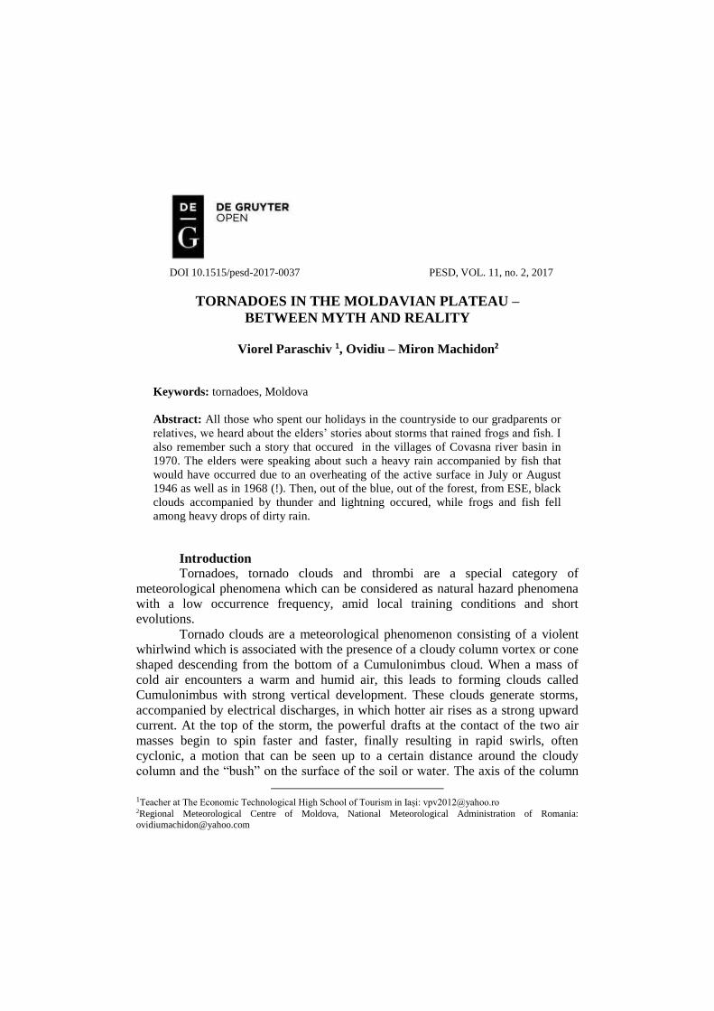
Table 1.Thepotential intensity of temperate region tornadoes (Fujitascale)
After a concrete analysis of the damages and of the globally expanded
Fujita scale (F-Scale) which classifies tornadoes in the US, even if it is less
scientifically proven considered by some experts, we can talk about mini-tornadoes
or local swirls / thrombus in the temperate region, of F0 - F1 intensity (Table 1).
Hardly can we speak of F2 level, only when the wind speed exceeds 182 km/h.
Viorel Paraschiv, Ovidiu – Miron Machidon
205
Risk issues. The phenomenon is particularly dangerous and damaging, and
in all cases its destructive effects can be seen on a long and narrow strip that
follows the path of its movement, sometimes over several hundreds of kilometers,
and whose width does not exceed 5 km. In its short, but violent evolution, a
tornado / whirlwind can cause loss of life as well as considerable material damage.
The most disastrous effects are, of course, recorded in densely populated areas. It
can destroy solid buildings, can uproot large trees, pick up and transport different
objects at large distances. Although the air speed is very high inside the cone
around the spindle itself and may sometimes reach 100 m/s, the speed of the
thrombus displacement is relatively low in general and overlaps that of
Cumulonimbus cloud (about 30 ÷ 40 km/h).
Tornadoes in Europe.The ancient Greeks were the first to make regular
meteorological observations and also the first to propose theories about
meteorological phenomena. Theories on tornadoes and water whirlwinds were
proposed by Greek natural philosophers, such as Aristotle (384-322 BC) in
Meteorologica (dated 356-330 BC), Theophrastus of Ereus (ca. 372 - 287 BC) in
Meteorology and Roman philosophers, or Seneca (ca. 4 BC - 65 AD) in Naturales
Quaestiones (dated ca. AD 65) and Titus Lucretius Carus (ca. 90 AD) -50 BC) in
De Rerum Natura (from the first century BC). These theories, according to which
the tornado emerged as a result of the wind deviation within the surrounding cloud,
were generally repeated in the Early Middle Ages by authors such as Isidore de
Sevilla (ca.560-636) in Etymologiae (ca. 600-625) and the High Middle Ages (for
example, Vincentius Bellovacensis (ca. 1190-1264) in Speculum Naturale (ca.
1260).
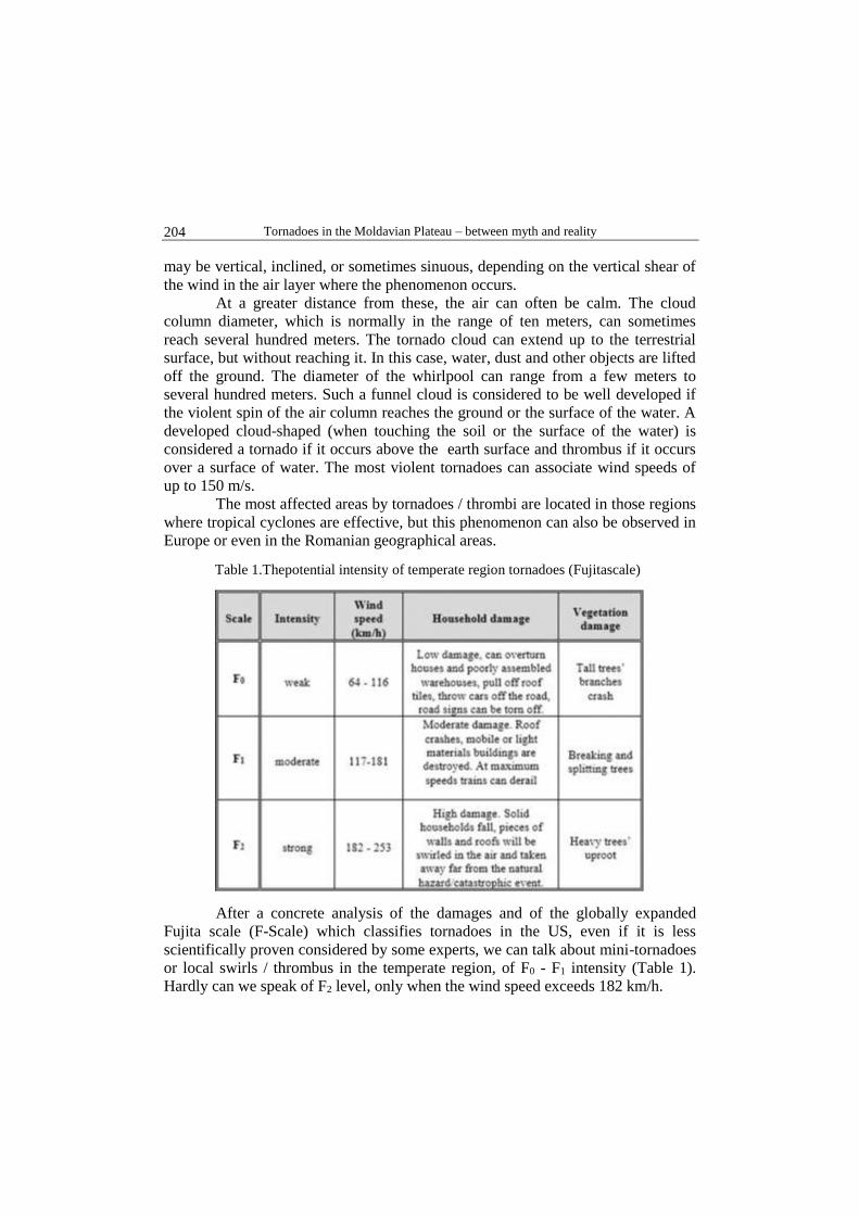
Fig.1. Spatial distribution of tornadoes reported over continental Europe
between 1456 and 1839 (a) and between 1459 and 1913 (b) (Antonescu, 2016)
Peltier (1840) probably performs the first climatology of the European
tornadoes based on 91 reports of tornadoes, mainly collected from the scientific
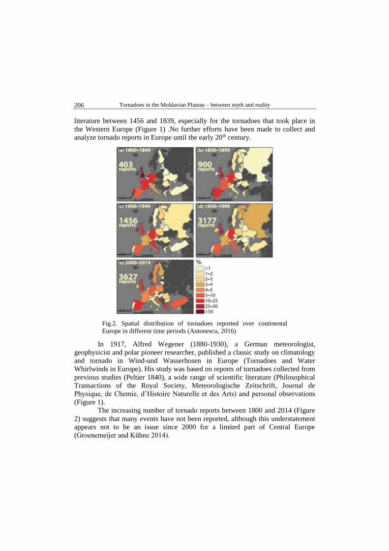
Tornadoes in the Moldavian Plateau – between myth and reality
206
literature between 1456 and 1839, especially for the tornadoes that took place in
the Western Europe (Figure 1) .No further efforts have been made to collect and
analyze tornado reports in Europe until the early 20th century.
Fig.2. Spatial distribution of tornadoes reported over continental
Europe in different time periods (Antonescu, 2016)
In 1917, Alfred Wegener (1880-1930), a German meteorologist,
geophysicist and polar pioneer researcher, published a classic study on climatology
and tornado in Wind-und Wasserhosen in Europe (Tornadoes and Water
Whirlwinds in Europe). His study was based on reports of tornadoes collected from
previous studies (Peltier 1840), a wide range of scientific literature (Philosophical
Transactions of the Royal Society, Meteorologische Zeitschrift, Journal de
Physique, de Chemie, d’Histoire Naturelle et des Arts) and personal observations
(Figure 1).
The increasing number of tornado reports between 1800 and 2014 (Figure
2) suggests that many events have not been reported, although this understatement
appears not to be an issue since 2000 for a limited part of Central Europe
(Groenemeijer and Kühne 2014).

Viorel Paraschiv, Ovidiu – Miron Machidon
207
The monthly distribution of tornado reports for most of Europe is at peak
in June-August, with a minimum in November-March (Figure 3).
Fig. 3.Monthly distribution of tornadoes reported over continental
Europe (Antonescu, B, 2016). Each cell represents the monthly
percentage of the total number of tornadoes reported in each country
(shown in brackets)
The daily distribution of tornado reports is shown in Figure 4. The number
of tornado reports increases towards midday, with a peak between 11 and 17 UTC
in Western Europe and, to some extent, southern Europe and between 13 and 15
UTC in the eastern and northern parts of the continent.
Tornadoes in Romania. The first tornado reported in Romania dates back
to the 19th century, but tornadoes had also been observed before, as demonstrated
by the Romanian folk mythology related to the image of the “dragon” or
“solomonar”. According to this popular belief, the dragon is the character who
disturbs the order of nature and people communities by bringing storms and hail.
The solomonar, the character of order, is a wizard who has the power to control the
meteorological elements and to slay the dragon (Oisteanu 2013).
The description of dragons varies from one region to another, but sharing
some common features. Thus, the dragon has a long tail, which revolves when
inside the cloud (representing the cloud’s cone) and “roaring by a loud noise when
touching the ground” (representing the tornado itself); The head of the dragon is
either that of a crocodile or a horse (representing the anvil of Cumulonimbus

Tornadoes in the Moldavian Plateau – between myth and reality
208
cloud). The dragon’s breathing is “so cold that water froze in the clouds”, thereby
producing large hail (sometimes associated with tornado events). The dragon is
also able to “raise people in the clouds” (Antonescu, 2015).
Fig. 4. Daily distribution of tornadoes reported over continental Europe (Antonescu, B,
2016). The local solar time for each country is shown in the first set of brackets.
The total number of reports containing the time of occurrence is shown in the second set
of brackets. Each cell represents the percentage of the total number of tornadoes
reported in each country. The dots represent the sunrise and sunset in summer (blue)
and winter (green)
Fig. 5. Time distribution of tornadoes reported in Romania between
1822 - 2013 (first decade includes the years 1822 to 1829 and the last
decade, the years 2010-2013)- Antonescu, 2015-

Viorel Paraschiv, Ovidiu – Miron Machidon
209
The first historical record of a tornado in Romania was made on June 4,
1822 in Banat (near Timişoara). The most significant tornado event found in
newspaper archives is a tornado ranked as a Category 3 event (F3) on Fujita scale
that took place on May 13, 1912. The tornado killed 6 people and injured more
than 50 causing serious damage in 5 villages near Dej, in the center of Romania.
For the socialist period (1945-1989), only 7 tornado reports were included
in the database (Figure 5). Two reports originated from the monthly meteorological
bulletin published by the Meteorological Institute. In the 1960s, 2 tornadoes were
documented in meteorological works, but since they were considered erroneous
observations, they were not included in the official reports.
Fig. 6. Spatial distribution of tornadoes reported in Romania in different time periods(a)
- historical tornadoes (33 reports between 1822 and 1944); (b) - tornado reports in the
socialist period (seven reports between 1945 and 1989) and (c) – late tornado reports
(89 reports between 1990 and 2013). In Romania, the tornadoes were classified
according to their intensity on Fujita scale: weak tornado (F0 or F1 in yellow) and
significant tornadoes (F2 and F3 in red).
The spatial distribution of tornados in Romania is shown in Figure6.
Their distribution at historical intervals reflects the availability of
documentary sources rather than their actual distribution. Thus, most tornadoes (29
reports representing 87.9% of all historical reports) were reported in the southern
and eastern region of Romania, known as the Kingdom of Romania between 1881
Tornadoes in the Moldavian Plateau – between myth and reality
210
and 1913. The Romanian region bordered by the Carpathian Mountains to the east
and south was part of the Austro-Hungarian Empire between 1822 and 1918 and
there are no official reports for this region before 1920.
All the tornadoes reported during the socialist period, except one (the
tornado of 12 June 1961 in Cluj), took place in the eastern and southern Romania
(Figure 6b). The absence of tornado reports is an “artifact” of the socialist period
and not the result of climatology.
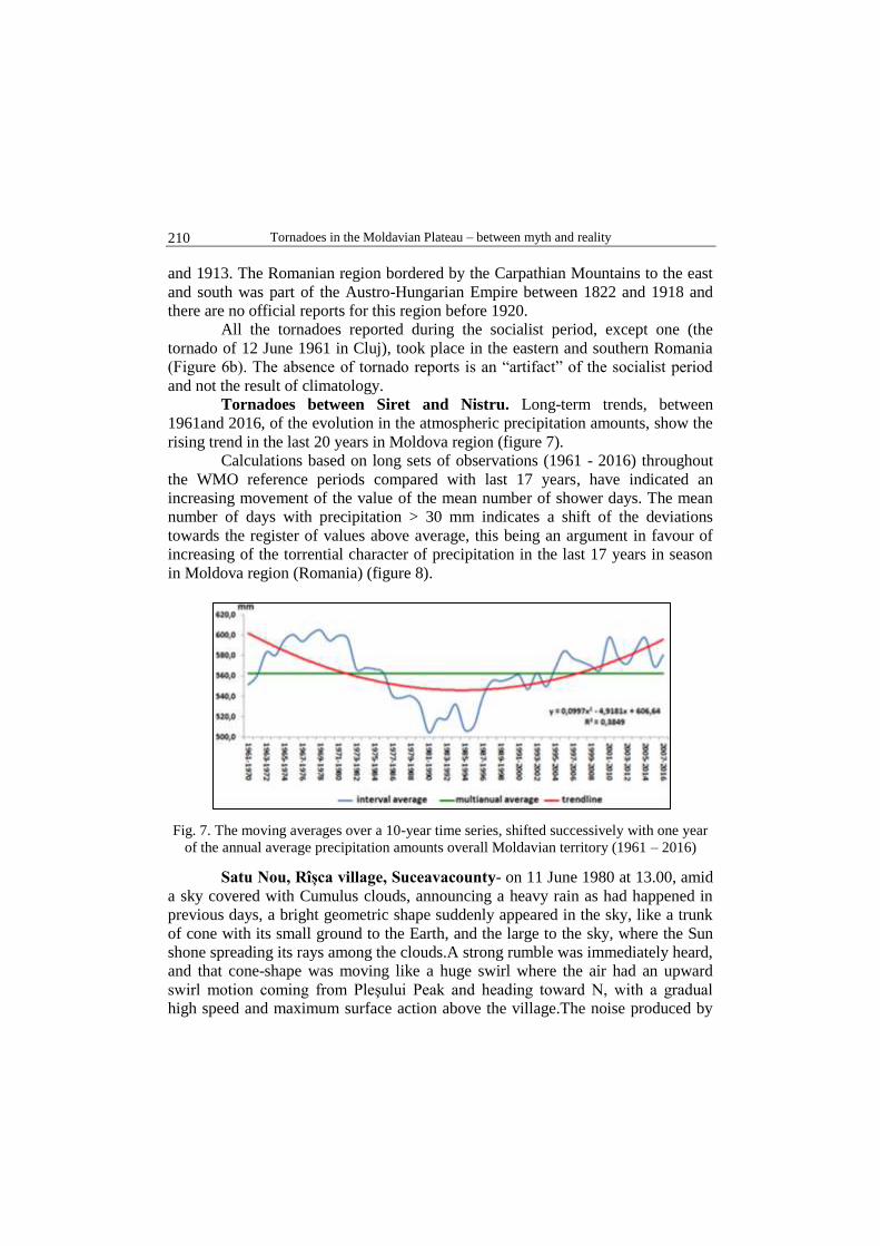
Tornadoes between Siret and Nistru. Long-term trends, between
1961and 2016, of the evolution in the atmospheric precipitation amounts, show the
rising trend in the last 20 years in Moldova region (figure 7).
Calculations based on long sets of observations (1961 - 2016) throughout
the WMO reference periods compared with last 17 years, have indicated an
increasing movement of the value of the mean number of shower days. The mean
number of days with precipitation > 30 mm indicates a shift of the deviations
towards the register of values above average, this being an argument in favour of
increasing of the torrential character of precipitation in the last 17 years in season
in Moldova region (Romania) (figure 8).
Fig. 7. The moving averages over a 10-year time series, shifted successively with one year
of the annual average precipitation amounts overall Moldavian territory (1961 – 2016)
Satu Nou, Rîșca village, Suceavacounty- on 11 June 1980 at 13.00, amid
a sky covered with Cumulus clouds, announcing a heavy rain as had happened in
previous days, a bright geometric shape suddenly appeared in the sky, like a trunk
of cone with its small ground to the Earth, and the large to the sky, where the Sun
shone spreading its rays among the clouds.A strong rumble was immediately heard,
and that cone-shape was moving like a huge swirl where the air had an upward
swirl motion coming from Pleşului Peak and heading toward N, with a gradual
high speed and maximum surface action above the village.The noise produced by
Viorel Paraschiv, Ovidiu – Miron Machidon
211
the swirling motion of the air was boosted by the damaged trees and buildings,
whose materials were broken, crushed and lifted at heights, transported at different
distances which once collapsed on the ground, they turned into a chaotic piles of
wood, bricks, tiles etc.A cherry tree with a diameter of about 60 cm was uprooted
and designed at a distance of about 70 m, while pieces of the house roof were
drilled up to about 200 m high (Petroaia, 1980).Pieces of shingle and tin escalated
the Pleşului Peak, over the Ceardac Peak (911 m), reaching Neamţ Monastery, over
10-12 km away.
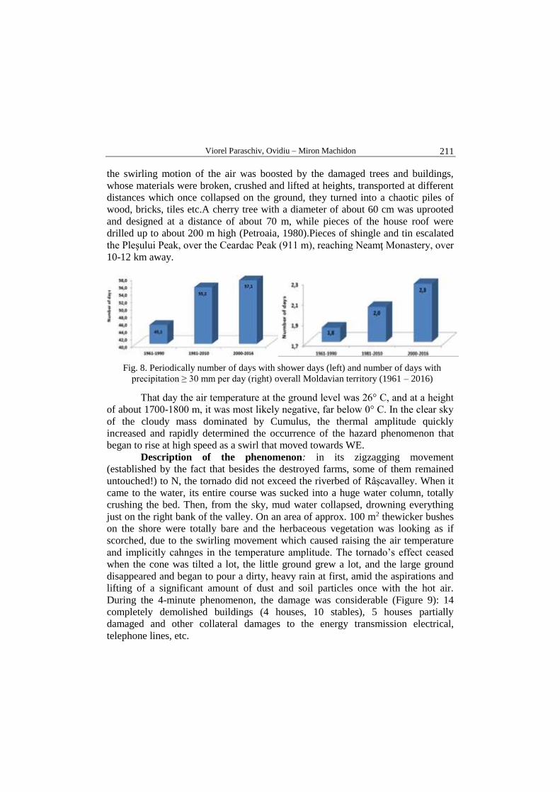
Fig. 8. Periodically number of days with shower days (left) and number of days with
precipitation ≥ 30 mm per day (right) overall Moldavian territory (1961 – 2016)
That day the air temperature at the ground level was 26° C, and at a height
of about 1700-1800 m, it was most likely negative, far below 0° C. In the clear sky
of the cloudy mass dominated by Cumulus, the thermal amplitude quickly
increased and rapidly determined the occurrence of the hazard phenomenon that
began to rise at high speed as a swirl that moved towards WE.
Description of the phenomenon: in its zigzagging movement
(established by the fact that besides the destroyed farms, some of them remained
untouched!) to N, the tornado did not exceed the riverbed of Râșcavalley. When it
came to the water, its entire course was sucked into a huge water column, totally
crushing the bed. Then, from the sky, mud water collapsed, drowning everything
just on the right bank of the valley. On an area of approx. 100 m2 thewicker bushes
on the shore were totally bare and the herbaceous vegetation was looking as if
scorched, due to the swirling movement which caused raising the air temperature
and implicitly cahnges in the temperature amplitude. The tornado’s effect ceased
when the cone was tilted a lot, the little ground grew a lot, and the large ground
disappeared and began to pour a dirty, heavy rain at first, amid the aspirations and
lifting of a significant amount of dust and soil particles once with the hot air.
During the 4-minute phenomenon, the damage was considerable (Figure 9): 14
completely demolished buildings (4 houses, 10 stables), 5 houses partially
damaged and other collateral damages to the energy transmission electrical,
telephone lines, etc.

Tornadoes in the Moldavian Plateau – between myth and reality
212
There were no major human casualties, only a few with a small impact: a
6-year-old girl was pulled from her big brother, raised to a 3m height and hit by the
ground when she broke her hand, while a woman who wished to climb the attic of
the house on an external staircase was slammed under a bridge (Petroaia,
1980).The psychic effects on the population have not been measured but they were
certainly severe.
Fig. 9. Household from Satu Nou - Rîşca, after the
hazard on 11.06.1980(Source: Terra Magazine
4/1980)
Fig. 10. Tornado effects at Leorda – Botoşani
(according to Mintici et al., 2007)
Leorda, Botoșanicounty:in the Thursday evening of Aug. 18, 2005,
around 18.00, a strong wind related to a tornado reached speeds of about 200 km/h,
being accompanied by hail and thunder.For 5 min., as long as the hazard
phenomenon lasted, dozens of households were destroyed, the roofed tiles, wood
and tin board being worn down to about 2 km from the nucleus of the village, and
the trees were split. (Figure. 10) The secular limestone in the railway station yard,
which had deep roots of about 2 m, was uprooted along with the concrete around it
(Mintici, 2007).
Hănești, Botoșani county –in the afternoonof July 11, 2014a
meteorological phenomenon of tornado type (figure 11) hit 44 housing roofs
(figure 12), broke the electrical, phone and Internet networks, as well as the lush
trees (acacia, chestnuts) with trunks of 30 - 40 cm in diameter (Figure 13), their
tears being made at 1.0 – 2.5 m above the ground, etc. (Table 2).Thetornado
touched the ground in the eastern part of Hăneşti, out of town, towards Brăteni, in
open field, between P1 and P3 on a distance of 4.5 km.It penetrates the village of
Hăneşti between P3 and P6 on a distance of 2 km, from east to west, parallel to DJ
294 B, affecting a diameter of about 100 m. At the intersection with DJ 282, the
diameter increases to ca.150 m and causes the greatest damage, so that in the end to
move on the beam of Hăneşti Lake, in the shape of a thrombus while lowering its
intensity, towards the Miron Costin spot (figure14).The tornado was accompanied
by haze phenomena and a 20-minute heavy rain that cut off asphalt into pieces.
Viorel Paraschiv, Ovidiu – Miron Machidon
213
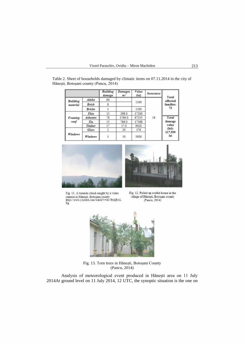
Table 2. Sheet of households damaged by climatic items on 07.11.2014 in the city of
Hăneşti, Botoşani county (Pancu, 2014)
Fig. 13. Torn trees in Hăneşti, Botoşani County
(Pancu, 2014)
Analysis of meteorological event produced in Hănești area on 11 July
2014At ground level on 11 July 2014, 12 UTC, the synoptic situation is the one on

Tornadoes in the Moldavian Plateau – between myth and reality
214
the synoptic map presented in figure 15. Romania was under a low pressure area
which occupies most of the Eastern European continent.
Fig. 14. Tornado trajectory over Hăneşti, Botoşani County on 11.07.2014 (Pancu, 2014)
Source: http://eumetrain.org/eport.html Source: http://www1.wetter3.de/Archiv
Fig. 15. Synoptic situation on 11 July 2014, 12 UTC at ground level
Viorel Paraschiv, Ovidiu – Miron Machidon
215
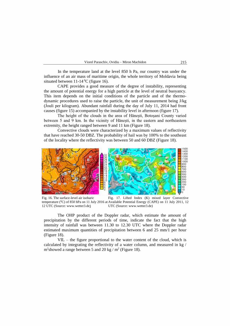
In the temperature land at the level 850 h Pa, our country was under the
influence of an air mass of maritime origin, the whole territory of Moldavia being
situated between 11-14 0C (figure 16).
CAPE provides a good measure of the degree of instability, representing
the amount of potential energy for a high particle at the level of neutral buoyancy.
This item depends on the initial conditions of the particle and of the thermo-
dynamic procedures used to raise the particle, the unit of measurement being J/kg
(Jouli per kilogram). Abundant rainfall during the day of July 11, 2014 had front
causes (figure 15) accompanied by the instability level in afternoon (figure 17).
The height of the clouds in the area of Hănești, Botoșani County varied
between 5 and 9 km. In the vicinity of Hănești, in the eastern and northeastern
extremity, the height ranged between 9 and 11 km (Figure 18).
Convective clouds were characterized by a maximum values of reflectivity
that have reached 30-50 DBZ. The probability of hail was by 100% to the southeast
of the locality where the reflectivity was between 50 and 60 DBZ (Figure 18).
Fig. 16. The surface-level air isobaric
temperature (0C) of 850 hPa on 11 July 2016 at
12 UTC (Source: www.wetter3.de)
Fig. 17. Lifted Index (K) mixed layer Convective
Available Potential Energy (CAPE) on 11 July 2011, 12
UTC (Source: www.wetter3.de)
The OHP product of the Doppler radar, which estimate the amount of
precipitation by the different periods of time, indicate the fact that the high
intensity of rainfall was between 11.30 to 12.30 UTC where the Doppler radar
estimated maximum quantities of precipitation between 6 and 25 mm/1 per hour
(Figure 18).
VIL – the figure proportional to the water content of the cloud, which is
calculated by integrating the reflectivity of a water column, and measured in kg /
m2showed a range between 5 and 20 kg / m2 (Figure 18).
Tornadoes in the Moldavian Plateau – between myth and reality
216
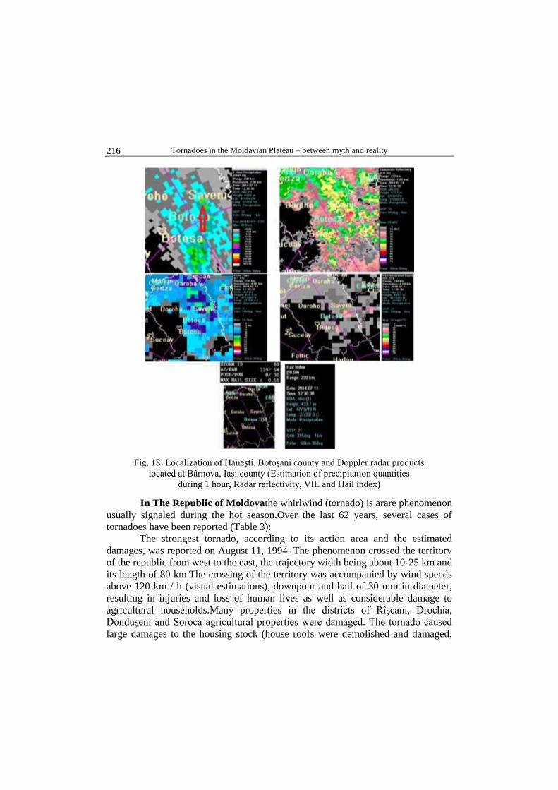
Fig. 18. Localization of Hănești, Botoșani county and Doppler radar products
located at Bârnova, Iaşi county (Estimation of precipitation quantities
during 1 hour, Radar reflectivity, VIL and Hail index)
In The Republic of Moldovathe whirlwind (tornado) is arare phenomenon
usually signaled during the hot season.Over the last 62 years, several cases of
tornadoes have been reported (Table 3):
The strongest tornado, according to its action area and the estimated
damages, was reported on August 11, 1994. The phenomenon crossed the territory
of the republic from west to the east, the trajectory width being about 10-25 km and
its length of 80 km.The crossing of the territory was accompanied by wind speeds
above 120 km / h (visual estimations), downpour and hail of 30 mm in diameter,
resulting in injuries and loss of human lives as well as considerable damage to
agricultural households.Many properties in the districts of Rîşcani, Drochia,
Donduşeni and Soroca agricultural properties were damaged. The tornado caused
large damages to the housing stock (house roofs were demolished and damaged,

Viorel Paraschiv, Ovidiu – Miron Machidon
217
doors and windows were broken, as well as communications and power
transmission networks).
Table 3.Days and locations where several cases of tornadoeswere
reportedbetween 1950 and 2011 in The Republic of Moldova
(Boian,20120
The Sunday storm on May 20, 2012 would have gone without being
observed if the inhabitants of Chişinău would not have noticed and filmed the
tornadoes that passed the city.Svetlana Şalova, chief synoptician at the State
Hydrometeorological Service of Moldova, argues that tornadoes usually occur once
in 15 years, but they do not cause material damage.She refers to the analyses made
by climatologists and meteorological data.
Conclusions
Not all tornados are associated with supercellular storms.In fact,it seems
that there are several mechanisms by which convective storms can produce a strong
vortex.Moreover,different tornadoes of the same storm can result in various
physical processes.In contrast with supercelular tornadoes that develop in
association with deep and persistent mesocyclones,thenon-supercelular ones are
rather small swirls of the border layer known as misocyclones.Misocyclones are
characterized by a radar detectable horizontal extension less than 2 nm.Although
non-supercellular tornadoes are generally less violent, weaker and less persistent
than those with deep mesocyclones, some of these tornadoes reach F2
intensity.Consequently, they are capable of causing damage, devastation and death.
Tornadoes in the Moldavian Plateau – between myth and reality
218
These tornadoes are difficult to detect even with WSR-88D.In this case,
which is specific to tornadoes that are not supercellular, there is very little
likelihood and even impossible for prognosis and warning.The causes are: they
may occur before any echoes of precipitation is detected;low horizontal traffic
narrows the radar detection range;the fact that only weak, low intensity tornadoes
(F0 - F2) are encountered indicates that the rotational speeds are relatively
low.Therefore, radar detection is generally limited to a range of 25 nm. In the Moldavian Plateau, as shown by the figured data, the tornado
meteorological phenomenon is quite rare and it can be generated during the hot
season of the year. The increase in the number of recent reports aims at public awareness (due
to tornado-based documentaries and television series), increased access to
information and communication technology (e.g. mobile phones, the Internet), and
last but not least to volunteer weather observers. Acknowledgements:We are deeply grateful to Diana-Corina Bostan, the head of the Regional
Meteorological Forecasting Service Division in Bacau for her kindness to provide us with radar
imagery.
References
Antonescu, B., Bell, A., (2015), Tornadoes in Romania, Monthly Weather Review, vol.
143, pg. 689 – 701, DOI: 10.1175/MWR-D-14-00181.1;
Antonescu, B., Schultz, D., Lomas, F.(2016), Tornadoes in Europe: Synthesis of the
Observational Datasets, Monthly Weather Review, vol. 144, pg. 2445 – 2480, DOI:
10.1175/MWR-D-15-0298.1
Bălteanu, D., Alexe, R., (2000), Hazarde naturale şi antropice, Editura Corint, București;
Bălteanu, D., Stan-Sion, A., Cheval, L., Trandafir, P., Dobre, B., (2004), Tornada de la
Făcăeni, 12.08.2002. Cauze, consecinţe, management, Editura Telegrafia,
Bucureşti;
Bâzâc, Gh., (1983), Influenţa reliefului asupra principalelor caracteristici ale climei
României, Editura Academiei, Bucureşti;
Bogdan, O., Niculescu, E., (1999), Riscuri climatice din România, Academia Română,
Institutul de Geografie, București
Boian, I., (2012), Vârtejurile din Republica Moldova, www.meteo.md/hazard/tornade;