Topanga State Park Preliminary General Plan Draft ... 1_prelimgpdrafteir... · Table of Contents i...
24
Topanga State Park Preliminary General Plan Draft Environmental Impact Report December 2011
Transcript of Topanga State Park Preliminary General Plan Draft ... 1_prelimgpdrafteir... · Table of Contents i...

Topanga State Park Preliminary General Plan Draft Environmental Impact Report December 2011
Topanga State Park
General Plan Inquiries
The Topanga State Park General Plan was prepared by California State Parks, Southern Service Center. For general information regarding the document contact the Service Center at 619-220-5300, or direct correspondence to:
California State Parks Southern Service Center 8885 Rio San Diego Drive, Suite 270 San Diego, California 92108
Attention: Topanga State Park General Plan Team
Publication Price and Order Information
Digital copies on CD can be ordered for $3.80 each. Make checks payable to California State Parks, and send your order to the address denoted above.
Front cover: The “Wildlands” of Topanga State Park.
Topanga State Park Preliminary General Plan/Draft EIR
SCH #2010031111
Edmund G. Brown, Jr. Governor
John Laird Secretary for the Natural Resources Agency
Ruth Coleman Director of Parks and Recreation
State of California The Resources Agency Department of Parks and Recreation P.O. Box 942896 Sacramento, California 94296-0001

Topanga State Park
Hub Junction

Table of Contents i
Table of Contents
Executive Summary vii
Chapter One - Introduction 1
Introduction To The Park 3
Definition of State Park 3
Purpose Acquired 3
Purpose of the General Plan 4
Chapter Two – Existing Conditions and Issues 9
Park Summary 11
Existing Land Use 11
Existing Facilities 11
Operations 13
Adjacent Land Use 14
Natural Resources 14
Cultural Resources 30
Collections 36
Interpretation and Education 37
Aesthetic Resources 43
Recreational Resources 44
Planning Influences 46
Issues and Analysis 52
Chapter Three - The Plan 55
PLAN OVERVIEW 57
CSP’s Mission 57
Classification 58
Proposed Sub-classification 58
Declaration of Purpose 59
Parkwide Management Goals and Guidelines 60
Physical Resource Management 60
Natural Resource Management 62

Topanga State Park ii
Cultural Resources 73
Ethnographic Resources 75
Historic Resources (Structures, Sites, and Landscapes) 76
Collections 80
Interpretation and Education 81
Area Specific Goals and Guidelines 86
Visitor use and development 95
Visitor Use 95
Recreational Uses 95
Development 99
Concession and Revenue Generation 101
Acquisitions 102
Management Zones 104
Carrying Capacity 104
Management Zones 104
Chapter Four - Environmental Analysis 119
SUMMARY 121
Project Description 121
Environmental Setting 122
Plan Alternatives 123
Environmental Effects of the Preferred Plan 130
Unavoidable and Irreversible Significant Effects 131
Potential Significant Effects and Proposed Mitigation 131
Effects Found Not To Be Significant 139
Growth Inducing Impacts 142
Cumulative Impacts 142
Mitigation Monitoring 142

Table of Contents iii
Public and Agency Coordination 147
Reasonable Projection of Development under the General Plan 148
Appendices 153
APPENDIX A—Defined Terms and List of Abbreviations 155
Appendix B 163
Listing Status Definition 165
Appendix C 167
Listing Codes Definitions 169
APPENDIX D—Cultural Resources in Context 171
Native American 171
Archaeology (Historic) 172
Exploration/Settlement 173
Agriculture 173
Transportation 174
Industrial/Economic 174
Recreation 174
Military 175
Resource Conservation 175
APPENDIX E 177
References Consulted 177
Planning Team 197
Planning Assistance 197
UNDER SEPARATE COVER
Appendix F (NOP and Checklist)
Appendix G (Resource Inventories)
Appendix H (Scope of Collections)
Appendix I (Traffic Study)

Topanga State Park iv
List of Tables
Table 1 (Location of EIR Required Content) 7
Table 2 (Fire History) 26
Table 3 (Planning Matrix) 112
Table 4 (Alternatives Matrix) 125
Table 5 (Mitigation Monitoring) 143
Table 6 (Reasonable Development Projection Matrix) 149
List of Figures
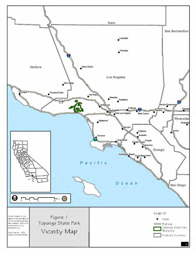
Figure 1 (Vicinity Map) v
Figure 2 (Regional Map) 15
Figure 3 (Topography) 17
Figure 4 (Site Character) 21
Figure 5 (Vegetation) 23
Figure 6 (Preferred Plan) 105
Figure 7 (Preferred Plan Lower Topanga) 115
Figure 8 (Lower Topanga/ Preferred Section) 117

Topanga State Park vi
Topanga Creek

Executive Summary vii
Executive Summary Topanga State Park (the Park) is located in the Santa Monica Mountains of Los Angeles County, California. Opened to the public in 1973 and operated by California State Parks (CSP), it is located within the Santa Monica Mountains National Recreation Area (SMMNRA), a large area of open space and parklands.
Roughly 8,960 acres of the 11,525-acre Topanga State Park are within the City of Los Angeles. The Park is also bordered by the cities of Malibu, Santa Monica, and Calabasas; unincorporated Los Angeles County; and the communities of Topanga, Pacific Palisades, Brentwood, Encino, Tarzana, and Woodland Hills (Figure 1).
Street access to the Park’s Trippet Ranch entrance is from Entrada Road via Topanga Canyon Boulevard (State Highway 27) in the west central part of the Park. Los Liones* Drive provides access to the Park’s Los
* Throughout this document, the name “Los Leones” is used to refer to the area of the Park formerly called “Los Liones.” This change reflects both the correct spelling and the historical name of this area. The canyon was originally called “Cañada del León” but was renamed around 1924 when the area was platted as the Miramar Estates subdivision. Los Liones Drive, the street that accesses this area of the Park, and Los Liones Canyon and Creek, geo-graphical landscape features, are outside of CSP’s purview and their names have not been changed.

Topanga State Park viii
Leones entrance in the south central part of the Park. The Park’s Lower Topanga Canyon area is accessed from Pacific Coast Highway (State Highway 1) in the southwestern part of the Park. Various other street parking or walk-in access points exist throughout the local communities. The closest freeway access is from the Ventura Freeway (U.S. Highway 101) in the north or from the Santa Monica Freeway (Interstate 10) in the south.
A General Development Plan (GDP) for Topanga State Park was finalized in 1977 and amended in 1978. Over time the usefulness and applicability of this GDP has diminished. The need for an updated General Plan is based on a number of factors including:
• insufficient resource protection in the 1977 GDP • development goals and guidelines in the 1977 GDP that are inconsistent
with the current and historical uses of the Park • significant new acquisitions to the Park, including Lower Topanga Canyon • changes in the environments of the Park and surrounding communities
Partial funding for this General Plan update is from Proposition 84 bonds (2006 Safe Drinking Water, Water Quality and Supply, Flood Control, River and Coastal Protection Bond Act).
Section 5002.2 of the Public Resources Code and Section 4332 Title 14 of the California Administration Code require that CSP prepare a General Plan for a park prior to permanent development. A General Plan provides guidelines for future land-use management within a state park, including land acquisitions and the facilities required to accommodate an expected visitation increase. A General Plan does not provide detailed management recommendations, but rather provides conceptual parameters for future management actions. General planning provides an opportunity to assess a park’s resource stewardship and interpretation, regional significance, facilities development, and recreational opportunities (see Chapter 2 and the Appendices for further details).
A first-tier Environmental Impact Report (EIR), as defined in Section 15166 of the California Environmental Quality Act (CEQA) Guidelines is also incorporated into this General Plan. California State Parks is the lead agency for this EIR. Please refer to page 5 of the Introduction for a description of how this General Plan functions as a joint General
Plan/EIR. The EIR addresses the broader impacts of plan implementation in Chapter 4 (Environmental Analysis), but does not specifically address projects that may be proposed in the future.
Appendix A provides definitions of certain terms as well as a listing of abbreviations and acronyms used in this document.

Executive Summary ix
The following revised Declaration of Purpose is based on the 1977 General Development Plan. It reflects a strong philosophy of park stewardship while describing the Park’s unique qualities and character:
Topanga State Park is a significant place of scenic wildlands within a fragmented and ever-encroaching urban setting. Although it is in the middle of the most heavily populated area of California, the Park maintains a sense of wholeness and integrity. It is a landscape shaped by its underlying natural history and by its rich and diverse cultural history. Some of the earliest known areas of human habitation in California were established here thousands of years ago. Today many people have a great respect and passion for Topanga State Park including the descendants of those ancient inhabitants who hold these lands as sacred.
The purpose of Topanga State Park is to preserve, interpret, and protect a substantial and meaningful portion of its natural and cultural resources, so that the Park can:
restore and sustain dynamic natural processes,
retain its unique, rugged, and inherently majestic character,
maintain and enhance wildlife corridors,
nurture and promote superior coastal water quality,
defend vital open space qualities and ecological integrity,
provide a refuge that promotes the physical and mental wellbeing of its visitors,
offer high-quality recreation and outdoor experiences,
fulfill its highest potential for interpretation and education.
present self-sustaining programs, services, and activities,
honor and teach awareness, appreciation, and better understanding of the people who lived here before,
facilitate the discovery and recognition of our relationships with the natural world and with each other,
inspire us and our children to realize the importance of these landscapes to our health and the health of our urban environment.

Topanga State Park x
Chapter 3 (the Plan) of this Preliminary General Plan/Draft EIR delineates ten management zones and a set of goals and guidelines that will guide park management, as well as specific project management and implementation. These goals and guidelines address recreational, operational, interpretive, and resource management opportunities and constraints consistent with the classification of State Park, as set forth in sections 5019.53 and 5019.68 of the Public Resources Code and CSP policies. Relevant CSP policies include CEQA compliance as set forth in CSP’s Department Operations Manual (DOM) 0600 and resource policies including DOM Section 0300, Natural Resources; DOM Section 0400, Cultural Resources (under revision 2011); the Cultural Resources Management Handbook; and other policies set forth in CSP’s Resource Management Directives. Please see Planning Influences section (page 46) for additional information. A General Plan usually does not locate or design facilities, but instead provides goals and guidelines for the appropriate types, locations, and designs of those that may be proposed in the future. A General Plan also establishes the primary interpretive themes for interpretive programs and activities.
The Topanga State Park General Plan (Preferred Plan) proposes to:
Continue to provide a visitor experience that provides public access and enjoyment of the “wild” essence of the Park, the essence for which Topanga State Park was initially acquired, by setting aside 8,445 of the Park’s 11,525 acres as a management zone to maintain and protect these “wildlands”.
Establish a visual and physical gateway into the Park beginning at the mouth of Topanga Creek at the intersection of Pacific Coast Highway and Topanga Canyon Boulevard (TCB), and traveling up the TCB corridor. This gateway does not necessarily depend on physical structures such as a traditional visitor center, but will be expressed by an uncluttered and scenic entrance leading into the Park.
Establish a 158-acre Cultural Preserve (sub-classification) to heighten the protection, recognition, and interpretation of a very distinct area of outstanding cultural interest, including the largest known Native American site within the Park, and the first site recorded in Los Angeles County under the State
Management Zones 1. Wildlands 2. Mulholland Corridor 3. Operations/
Maintenance Zone 4. Historic Zone 5. Topanga Cultural
Preserve 6. Rustic Canyon Zone 7. Los Leones Zone 8. Watershed
Conservation Zone 9. Lagoon Zone 10. Lower Topanga Zone
Executive Summary xi
Trinomial System. The essence of this zone is to make the public aware of the importance and fragility of this very important cultural resource and to encourage protection through education and interpretation.
Establish an 18-acre Historic Zone that comprises the historic core of the former Rancho Las Lomas Celestiales (The Ranch of the Heavenly Hills), which is now known as Trippet Ranch. The majority of park operations and maintenance will be relocated from this zone, to enhance the historic fabric and cultural landscape of this 1940s “Gentleman’s Ranch”.
Embrace the concept of restoration and renewal of both the land and its people by restoring Topanga Creek and Lagoon, from shore to canyon, through a balanced approach of lagoon/creek hydrological science and design with the interpretation and protection of the existing Native American and historical resources. This concept has the potential to integrate modern land management techniques with traditional sustainability practices as well as provide for interpretive and educational opportunities and public access to the Lower Topanga Canyon area. This concept may entail the adaptive reuse of the existing historic Topanga Ranch Motel and/or alteration or even removal of these structures depending on the ultimate scope of the proposed lagoon restoration project.
Establish other management zones for resource management, visitor use, and accessible interpretive and recreational programs for the public.
Alternatives
During the current General Plan process, three Plan Alternatives were considered including Alternative 1 – the Resource Protection Alternative, Alternative 2 – the Visitor-Use Alternative, and the No Project Alternative. These alternatives are discussed on page 123 and in Table 4—the Alternatives Matrix (page 125). The primary distinctions between the alternatives are the allowable activities and facilities in each of the management zones. The Preferred Plan Alternative was developed as a combination of Alternatives 1 and 2, and modified after a series of public meetings and focus group meetings that brought forth additional information.
Final EIR
The updated Preliminary General Plan and Draft Environmental Impact Report (DEIR) for Topanga State Park will be released for public review and begin a 45-day review period in which agencies and the public may provide comment on its sufficiency. Please see the Public and Agency Coordination section of Chapter 4 for additional information. Any comments received will be responded to and these comments and their responses will be provided as an appendix to the Final General Plan/EIR.

Topanga State Park xii
Findings regarding potentially significant impacts and appropriate mitigation measures to aesthetics, biological resources, cultural resources, geologic resources/soils/erosion, recreational resources, water resources, hazardous waste, noise, and fire hazard were made and are included in Chapter 4 (Environmental Analysis). All potentially significant impacts will be avoided, minimized, and/or mitigated below the level of significance under the General Plan/EIR. A Mitigation Monitoring Plan and Program detailing measures to be implemented in future projects is located in Chapter 4.

Chapter One - Introduction

Introduction 2
Eagle Rock

Introduction 3
INTRODUCTION TO THE PARK Topanga State Park (the Park) is one of the four original cornerstone state parks (including Leo Carrillo State Park, Malibu Creek State Park, and Point Mugu State Park) of the Santa Monica Mountains National Recreation Area (SMMNRA). This nationally significant, multi-jurisdic-tional public land management area is a pioneer in bringing the natural, cultural, scenic, and recreational resources of this diverse mountainous area right to the edge of urban Los Angeles, providing easy access for over 10 million potential park visitors.
At 11,525 acres, the Park, with its varied and dramatically rugged, steep terrain, is situated along the Transverse Ranges of southern California. Significant portions of many coastal-running creeks lie within its boundaries, including the creeks of Topanga, Santa Ynez, Temescal, Los Liones, and Rustic Canyons, as well as countless tributaries and drainages.
The Park is located almost entirely within the city limits of Los Angeles, approximately 30 miles from the heart of downtown, with its remaining sections falling within the boundaries of the County of Los Angeles. The Park is adjacent or in close proximity to the communities of Topanga, Pacific Palisades, Brentwood, Santa Monica and a number of communities of the San Fernando Valley, with major vehicular corridors of Topanga Canyon Boulevard (State Highway 27), Pacific Coast Highway (State Highway 1), the San Diego Freeway (Interstate 405), the Santa Monica Freeway (Inter-state 10), and the Ventura Freeway
(U.S. Highway 101) all within easy access to the Park (see Figure 1).
DEFINITION OF STATE PARK
Topanga State Park is currently classified entirely as a State Park, which is defined by California Public Resource Code 5019.53:
State parks consist of relatively spacious areas of outstanding scenic or natural character, oftentimes also containing significant historical, archaeo-logical, ecological, geological, or other similar values. The purpose of state parks shall be to preserve outstanding natural, scenic, and cultural values, indigenous aquatic and terres-trial fauna and flora, and the most significant examples of ecological regions of California, such as the Sierra Nevada, northeast volcanic, great valley, coastal strip, Klamath-Siskiyou Mountains, southwest moun-tains and valleys, redwoods, foothills and low coastal mountains, and desert and desert mountains.
PURPOSE ACQUIRED
Between 1964 and 1973, organizations such as the Santa Monica Mountains Regional Park Association, Friends of
Topanga State Park 4
the Santa Monica Mountains State Park, and other interested groups lobbied the State of California to acquire undeveloped land in the Santa Monica Mountains for the purposes of preserving open space and creating a state park. The initial 7,200 acres of Topanga Canyon State Park opened to the public on July 1, 1973.
Various acquisitions followed including Topanga State Beach (later deeded to the Los Angeles County Department of Parks and Recreation) and Los Leones (acquired in 1974 and 1975).
In August 2001, California State Parks (CSP) acquired 1,659 additional acres adjacent to the southwest boundary of Topanga State Park. Proposition 12 (approved by California voters in 2000) provided the source of funds to acquire the property in order to
“…protect and preserve this ecologically important area as open space and recreation land. It will open to public access an area that contains preserved grasslands, meadows, wetlands, creeks, live oaks, cliffs and canyons that will provide extensive recreational opportu-nities for the Los Angeles region.”
PURPOSE OF THE GENERAL PLAN
This General Plan was developed to serve as a long-range management tool that provides guidelines for achieving the purpose of the Park. This document does not attempt to provide detailed management recommendations, but rather provides conceptual parameters for future management actions.
Specifics, such as the exact location of a visitor center or campground, will be
determined by future management plans. These subsequent management plans will require additional data collections and public/internal reviews to ensure adherence to the goals and
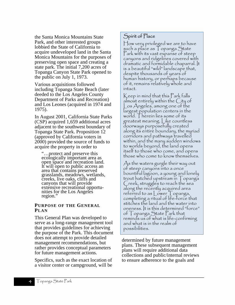
Spirit of PlaceHow very privileged we are to have such a place as Topanga State Park with its vast expanse of steep canyons and ridgelines covered with dramatic and formidable chaparral. It is a beautiful “wild” landscape that, despite thousands of years of human history, or perhaps because of it, remains relatively whole and intact. Keep in mind that this Park falls almost entirely within the City of Los Angeles, among one of the largest population centers in the world. Therein lies some of its greatest meaning. Like countless doorways purposefully created along its entire boundary, the myriad corridors and pathways travelled within, and the many sudden windows to worlds beyond, the land opens itself to those who come, and opens those who come to know themselves. As the waters gurgle their way out of steep canyons into a once bountiful lagoon, a young and lonely trout hatched upstream in Topanga Creek, struggles to reach the sea along the recently acquired area referred to as Lower Topanga, completing a ritual of life-force that stitches the land and the water into oneness. It is this determined “force” of Topanga State Park that reminds us of what is life-confirming and what is in the realm of possibilities.

Introduction 5
guidelines established within this General Plan.
Partial funding for the resource inventories and General Plan for Topanga State Park is from the 2006 Safe Drinking Water, Water Quality and Supply, Flood Control, River and Coastal Protection Bond Act (Proposition 84).
Combined Plan/EIR
The California Environmental Quality Act (CEQA) of 1970 requires all state agencies to consider, analyze, and disclose the potential environmental impacts of any proposed action they undertake in the operation and development of property or programs in their jurisdiction. In addition agencies must provide for public input and review on these actions. If such actions have the potential to create significant impacts to the environment, then the agencies should create an environmental impact report (EIR) to document their analysis and complete the public input process. The EIR should consider, disclose, and analyze potential significant impacts and propose alternatives and mitigation measures to eliminate or reduce any potential significant impacts to an acceptable level.
Unlike individual projects, general plans provide programmatic direction for long-term land-use decisions. In order to provide appropriate environmental review of these general land-use decisions, the EIR is combined with the general plan document to avoid redundancy and duplication (CEQA Guidelines §15166). The programmatic nature of the general plan document therefore leads to evaluation of the broader analysis of its land-use decisions but
leaves detailed site-specific project analysis to future environmental reviews at the time of project undertaking. This is known as tiering, a process where a lead agency prepares a programmatic EIR that is followed by subsequent CEQA documents appropriate to the undertaking of specific future actions or projects (CEQA Guidelines §15152).
When the lead agency combines a General Plan and an EIR, all requirements of CEQA must still be covered and the document must identify where the requirements are met. The following section provides a guide to the structure and contents of the General Plan/EIR, which meets CEQA requirements.
As explained here, the General Plan/EIR in its whole constitutes the required content of an EIR; therefore this document refers to the “General Plan/EIR” to reinforce the concept of a single document fulfilling the dual requirements of park general planning and appropriate CEQA compliance.
Tiered CEQA Analysis
Tiering is defined as “the coverage of general matters and environmental effects in an environmental impact report prepared for a policy, plan, program, or ordinance followed by narrower or site-specific environ-mental impact reports…” (Public Resources Code [PRC] §21068.5; CEQA Guidelines §15385). While a tiered EIR may not defer all consideration of impacts to a point in the future, it can legitimately indicate that more detailed studies and project-specific impacts may be considered in future environmental documents.

Topanga State Park 6
The level of detail addressed in Chapter 4 (Environmental Analysis) is comparable to the level of detail provided in the land-use proposals of the Plan. The Alternatives Matrix (Table 4) and Reasonable Develop-ment Projection Matrix (Table 6) in Chapter 4 provide quantitative data relative to the land-use proposals in the rest of the General Plan. What is critical (and what is set forth in the Plan) is the formulation and eventual adoption of a set of policies designed to minimize and mitigate impacts that might occur from the implementation of operations and projects under the General Plan. For example, the Plan divides the Park into management zones. Goals and policies are proposed for adoption for each of these zones which provide conceptual parameters for future management actions.
Authority, Structure and Contents of the General Plan/EIR
CSP’s Acquisition and Development Division, Southern Service Center with input and assistance from CSP’s Angeles District has prepared this General Plan/EIR. The California State Park and Recreation Commission has approval authority for all CSP General Plan/EIRs. This commission determines whether or not to:
Accept the certified General Plan/EIR as a “Final EIR” under CEQA Guidelines Section 15166.
Adopt the General Plan/EIR as a General Plan under PRC 5002.2.
This general plan/EIR is prepared in accordance with Article 9 of the CEQA Guidelines (Title 14, California Code of Regulations). Contents of Section 15120(c) state that Draft EIRs shall contain the information required
by Sections 15122 through 15131. Table 1 shows where the required items are found in this General Plan/EIR document.
Uses of this General Plan/EIR
The Topanga State Park General Plan is the guiding policy document for subsequent operation and land-use management of the Park. The Plan identifies ten management zones within the Park. These zones are described in detail on page 104 of this General Plan/EIR.
Also included in this General Plan are goals and guidelines that address particular issues for certain topics, program areas, or specific zones within the Park. This plan may recommend, or the department may decide to create, future focused “management plans” that provide more specific program, use, or development direction for these zones. Therefore prior to taking any further action proposed by the General Plan or associated and compatible management plans, CSP must evaluate whether that action constitutes a “project” under CEQA, whether it is categorically exempt (for example routine maintenance), or whether it may have a significant impact on the environment, and if so, whether a CEQA document (mitigated negative declaration or an EIR) needs to be prepared.
All future action by CSP will need to be consistent with the adopted Topanga State Park General Plan. The Plan’s management zones along with the Goals and Guidelines, define the main approach to avoid and mitigate subsequent actions. The General Plan/EIR establishes the baseline for future environmental review as a first tier program EIR.

Introduction 7
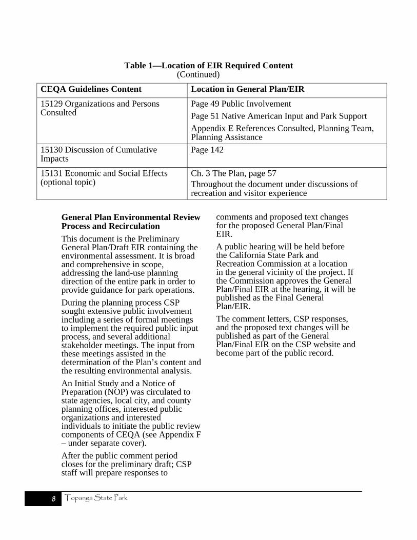
Table 1—Location of EIR Required Content
CEQA Guidelines Content Location in General Plan/EIR
15122 Table of Contents or Index Beginning of this document
15123 Summary Follows the Table of Contents
15124 Project Description Ch. 1 Introduction (information about project objective and General Plan process), page 3
Ch. 3 The Plan (description), page 57
Page 60 Project Description (summarized)
15125 Environmental Setting Ch. 2 Existing Conditions, page 11
15126 Consideration and Discussion of Environmental Impacts
Ch. 4 Environmental Analysis, page 119
(a) Significant Environmental Effects of the Proposed Project.
Page 131 Potential Significant Effects and Proposed Mitigation.
(b) Significant Environmental Effects Which Cannot be Avoided if the Proposed Project is Implemented.
Page 131 Unavoidable and Irreversible Significant Environmental Effects.
(c) Significant Irreversible Environmental Changes Which Would be Involved in the Proposed Project Should it be Implemented.
Page 131 Unavoidable and Irreversible Significant Environmental Effects.
(d) Growth-Inducing Impact of Proposed Project.
Page 142
(e) The Mitigation Measures Proposed to Minimize the Significant Effects.
Table 5 “Mitigation Monitoring,” Page 143Ch. 3 The Plan - Goals and Guidelines (intended to minimize adverse environmental effects) and Discussion of Guidelines as mitigation for subsequent action, page 60
(f) Alternatives to the Proposed Project. Page 123 Plan Alternatives
Table 4 “Alternatives Matrix—Proposed Uses and Environmental Impacts,” page 125
15127 Limitations on Discussion of Environmental Impact
Page 131 (discussion - irreversible changes)
15128 Effects Not Found to be Significant
Page 139 Effects found not to be significant
Appendix F (the Initial Study checklist - under separate cover)
(Continued)
Topanga State Park 8
Table 1—Location of EIR Required Content (Continued)
CEQA Guidelines Content Location in General Plan/EIR
15129 Organizations and Persons Consulted
Page 49 Public Involvement Page 51 Native American Input and Park Support Appendix E References Consulted, Planning Team, Planning Assistance
15130 Discussion of Cumulative Impacts
Page 142
15131 Economic and Social Effects (optional topic)
Ch. 3 The Plan, page 57 Throughout the document under discussions of recreation and visitor experience
General Plan Environmental Review Process and Recirculation
This document is the Preliminary General Plan/Draft EIR containing the environmental assessment. It is broad and comprehensive in scope, addressing the land-use planning direction of the entire park in order to provide guidance for park operations.
During the planning process CSP sought extensive public involvement including a series of formal meetings to implement the required public input process, and several additional stakeholder meetings. The input from these meetings assisted in the determination of the Plan’s content and the resulting environmental analysis.
An Initial Study and a Notice of Preparation (NOP) was circulated to state agencies, local city, and county planning offices, interested public organizations and interested individuals to initiate the public review components of CEQA (see Appendix F – under separate cover).
After the public comment period closes for the preliminary draft; CSP staff will prepare responses to
comments and proposed text changes for the proposed General Plan/Final EIR.
A public hearing will be held before the California State Park and Recreation Commission at a location in the general vicinity of the project. If the Commission approves the General Plan/Final EIR at the hearing, it will be published as the Final General Plan/EIR.
The comment letters, CSP responses, and the proposed text changes will be published as part of the General Plan/Final EIR on the CSP website and become part of the public record.