Toms Marseille Port Guide · Toms Marseille Port Guide Maps for 1) ... I've also shown the usual...
47
Transcript of Toms Marseille Port Guide · Toms Marseille Port Guide Maps for 1) ... I've also shown the usual...
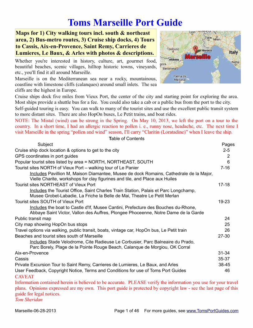
Toms Marseille Port Guide Maps for 1) City walking tours incl. south & northeast area, 2) Bus-metro routes, 3) Cruise ship docks, 4) Toursto Cassis, Aix-en-Provence, Saint Remy, Carrieres de Lumieres, Le Baux, & Arles with photos & descriptions. Whether you're interested in history, culture, art, gourmet food,beautiful beaches, scenic villages, hilltop historic towns, vineyards,etc., you'll find it all around Marseille.Marseille is on the Mediterranean sea near a rocky, mountainous,coastline with limestone cliffs (calanques) around small inlets. The seacliffs are the highest in Europe. Cruise ships dock five miles from Vieux Port, the center of the city and starting point for exploring the area.Most ships provide a shuttle bus for a fee. You could also take a cab or a public bus from the port to the city. Self-guided touring is easy. You can walk to many of the tourist sites and use the excellent public transit systemto more distant sites. There are also HopOn buses, Le Petit trains, and boat rides. NOTE: The Mistal (wind) can be strong in the Spring. On May 10, 2013, we left the port on a tour to thecountry. In a short time, I had an allergic reaction to pollen i. e., runny nose, headache, etc. The next time Ivisit Marseille in the spring “pollen and wind” season, I'll carry “Claritin (Loratadine)” when I leave the ship.
Table of Contents Subject PagesCruise ship dock location & options to get to the city 2-5GPS coordinates in port guides 2Popular tourist sites listed by area = NORTH, NORTHEAST, SOUTH 6Tourist sites NORTH of Vieux Port – walking tour of Le Panier 7-16
Includes Pavillion M, Maison Diamantee, Musee de dock Romains, Cathedrale de la Major, Vielle Charite, workshops for clay figurines and tile, and Place aux Huiles
Tourist sites NORTHEAST of Vieux Port 17-18Includes the Tourist Office, Saint Charles Train Station, Palais et Parc Longchamp, Musee Grobet-Labadie, La Friche la Belle de Mai, Theatre Le Petit Merlan
Tourist sites SOUTH of Vieux Port 19-23Includes the boat to Castle d'If, Musee Cantini, Prefecture des Bouches du-Rhone, Abbaye Saint Victor, Vallon des Auffres, Plongee Phoceenne, Notre Dame de la Garde
Public transit map 24City map showing HopOn bus stops 25Travel options via walking, public transit, boats, vintage car, HopOn bus, Le Petit train 26Beaches and tourist sites south of Marseille 27-30
Includes Stade Velodrome, Cite Radieuse Le Corbusier, Parc Balneaire du Prado, Parc Borely, Plage de la Pointe Rouge Beach, Calanque de Morgiou, OK Corral
Aix-en-Provence 31-34Cassis 35-37Private Excursion Tour to Saint Remy, Carrieres de Lumieres, Le Baux, and Arles 38-45User Feedback, Copyright Notice, Terms and Conditions for use of Toms Port Guides 46CAVEATInformation contained herein is believed to be accurate. PLEASE verify the information you use for your travelplans. Opinions expressed are my own. This port guide is protected by copyright law - see the last page of thisguide for legal notices.Tom Sheridan
Marseille-06-28-2013 Page 1 of 46 For more guides, see www.TomsPortGuides.com
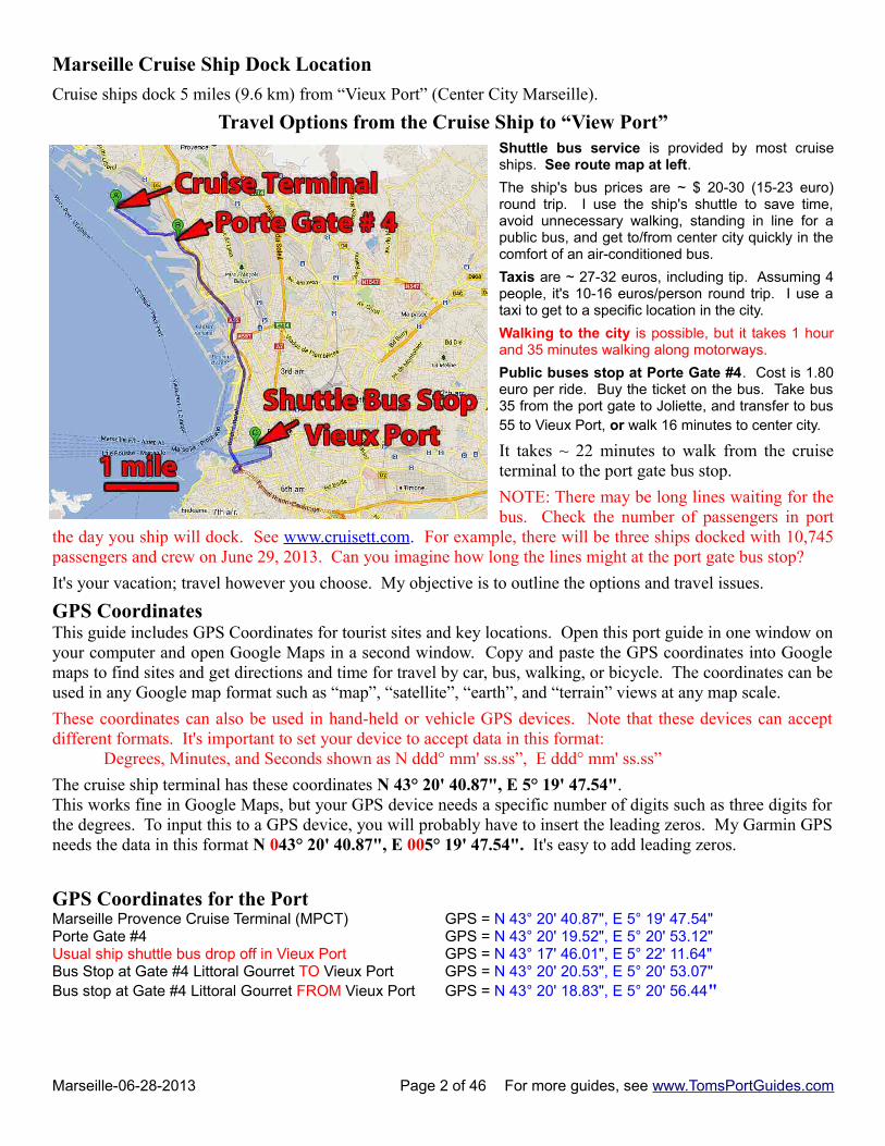
Marseille Cruise Ship Dock Location
Cruise ships dock 5 miles (9.6 km) from “Vieux Port” (Center City Marseille).
Travel Options from the Cruise Ship to “View Port”Shuttle bus service is provided by most cruiseships. See route map at left.
The ship's bus prices are ~ $ 20-30 (15-23 euro)round trip. I use the ship's shuttle to save time,avoid unnecessary walking, standing in line for apublic bus, and get to/from center city quickly in thecomfort of an air-conditioned bus.
Taxis are ~ 27-32 euros, including tip. Assuming 4people, it's 10-16 euros/person round trip. I use ataxi to get to a specific location in the city.
Walking to the city is possible, but it takes 1 hourand 35 minutes walking along motorways.
Public buses stop at Porte Gate #4. Cost is 1.80euro per ride. Buy the ticket on the bus. Take bus35 from the port gate to Joliette, and transfer to bus55 to Vieux Port, or walk 16 minutes to center city.
It takes ~ 22 minutes to walk from the cruiseterminal to the port gate bus stop.
NOTE: There may be long lines waiting for thebus. Check the number of passengers in port
the day you ship will dock. See www.cruisett.com. For example, there will be three ships docked with 10,745passengers and crew on June 29, 2013. Can you imagine how long the lines might at the port gate bus stop?
It's your vacation; travel however you choose. My objective is to outline the options and travel issues.
GPS CoordinatesThis guide includes GPS Coordinates for tourist sites and key locations. Open this port guide in one window onyour computer and open Google Maps in a second window. Copy and paste the GPS coordinates into Googlemaps to find sites and get directions and time for travel by car, bus, walking, or bicycle. The coordinates can beused in any Google map format such as “map”, “satellite”, “earth”, and “terrain” views at any map scale.
These coordinates can also be used in hand-held or vehicle GPS devices. Note that these devices can acceptdifferent formats. It's important to set your device to accept data in this format:
Degrees, Minutes, and Seconds shown as N ddd° mm' ss.ss”, E ddd° mm' ss.ss”
The cruise ship terminal has these coordinates N 43° 20' 40.87", E 5° 19' 47.54". This works fine in Google Maps, but your GPS device needs a specific number of digits such as three digits forthe degrees. To input this to a GPS device, you will probably have to insert the leading zeros. My Garmin GPSneeds the data in this format N 043° 20' 40.87", E 005° 19' 47.54". It's easy to add leading zeros.
GPS Coordinates for the PortMarseille Provence Cruise Terminal (MPCT) GPS = N 43° 20' 40.87", E 5° 19' 47.54" Porte Gate #4 GPS = N 43° 20' 19.52", E 5° 20' 53.12" Usual ship shuttle bus drop off in Vieux Port GPS = N 43° 17' 46.01", E 5° 22' 11.64" Bus Stop at Gate #4 Littoral Gourret TO Vieux Port GPS = N 43° 20' 20.53", E 5° 20' 53.07"Bus stop at Gate #4 Littoral Gourret FROM Vieux Port GPS = N 43° 20' 18.83", E 5° 20' 56.44"
Marseille-06-28-2013 Page 2 of 46 For more guides, see www.TomsPortGuides.com

Marseille Provence Cruise Terminal (MPCT) to Porte Gate #4
I entered GPS coordinatesfor the cruise terminal andPorte Gate #4 into GoogleMaps “Get Directions” tocreate the map at right.
The distance is 1.7 km.
Travel time is 3 minutes ina car/bus or a 21-minutewalk.
NOTES:
There is a car parkinglot next to the cruiseterminal.
The port has dock spacefor five cruise ships.
The bus stops at Gate #4 are named “Littoral Gourret”. I entered GPS coordinates for the stops in GoogleMaps and magnified the screen in “satellite” view to see details of the bus stops. The bus stop just outside thegate is the route into the city. When returning from the city, you exit the bus at a lower-level motorway, climbthe stairs (I estimate it's ~ 25 feet high), and cross over the motorway to the port gate. See the map below.
Marseille-06-28-2013 Page 3 of 46 For more guides, see www.TomsPortGuides.com
Marseille has an excellent bus, tram, & metro systemWhether or not you use the bus from the port to the city, you may want to use public transit to visit tourist sitesin the city or ride a bus along the coast to view the scenery.
The website for public transit is http://www.rtm.fr/ Download excellent maps from this link http://www.rtm.fr/guide-voyageur/se-deplacer/plans
If you plan to use any of the buses, it's a good idea to download the schedules for the lines you plan to use.
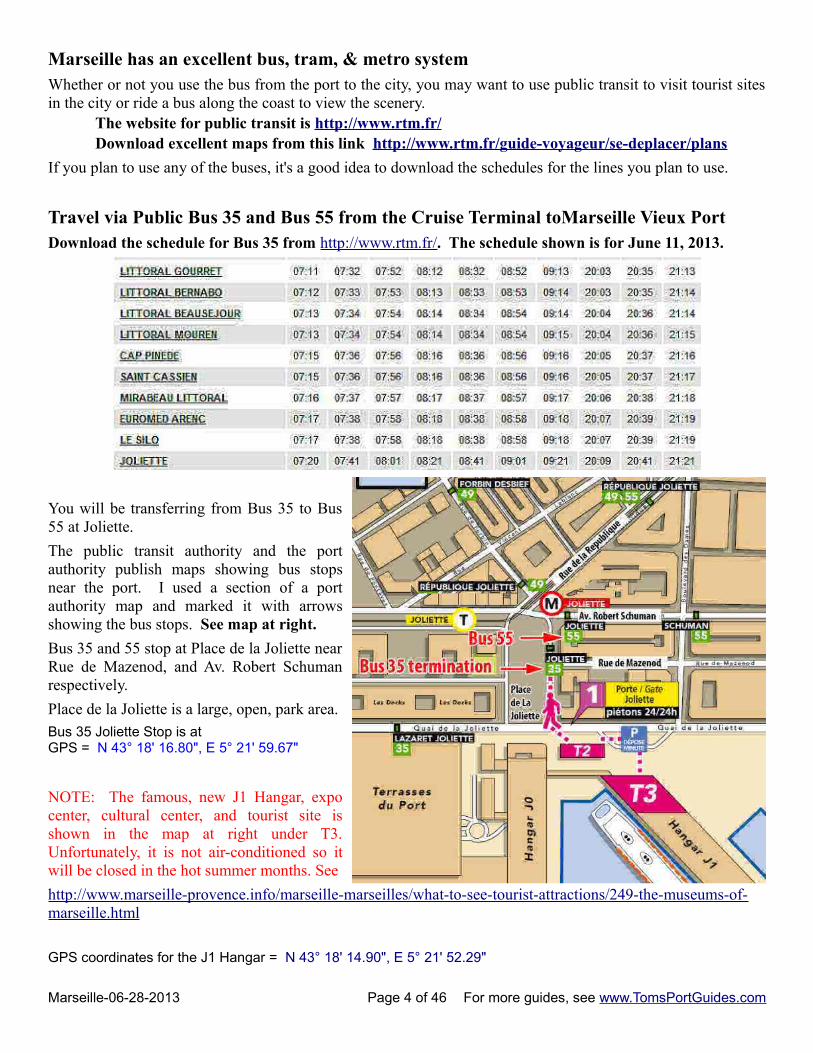
Travel via Public Bus 35 and Bus 55 from the Cruise Terminal toMarseille Vieux PortDownload the schedule for Bus 35 from http://www.rtm.fr/. The schedule shown is for June 11, 2013.
You will be transferring from Bus 35 to Bus55 at Joliette.
The public transit authority and the portauthority publish maps showing bus stopsnear the port. I used a section of a portauthority map and marked it with arrowsshowing the bus stops. See map at right.
Bus 35 and 55 stop at Place de la Joliette nearRue de Mazenod, and Av. Robert Schumanrespectively.
Place de la Joliette is a large, open, park area.
Bus 35 Joliette Stop is atGPS = N 43° 18' 16.80", E 5° 21' 59.67"
NOTE: The famous, new J1 Hangar, expocenter, cultural center, and tourist site isshown in the map at right under T3.Unfortunately, it is not air-conditioned so itwill be closed in the hot summer months. See
http://www.marseille-provence.info/marseille-marseilles/what-to-see-tourist-attractions/249-the-museums-of-marseille.html
GPS coordinates for the J1 Hangar = N 43° 18' 14.90", E 5° 21' 52.29"
Marseille-06-28-2013 Page 4 of 46 For more guides, see www.TomsPortGuides.com
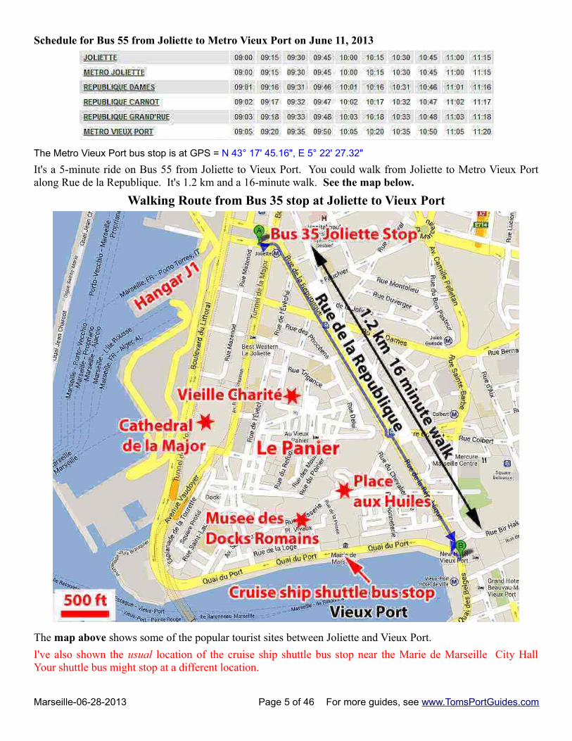
Schedule for Bus 55 from Joliette to Metro Vieux Port on June 11, 2013
The Metro Vieux Port bus stop is at GPS = N 43° 17' 45.16", E 5° 22' 27.32"
It's a 5-minute ride on Bus 55 from Joliette to Vieux Port. You could walk from Joliette to Metro Vieux Portalong Rue de la Republique. It's 1.2 km and a 16-minute walk. See the map below.
Walking Route from Bus 35 stop at Joliette to Vieux Port
The map above shows some of the popular tourist sites between Joliette and Vieux Port.
I've also shown the usual location of the cruise ship shuttle bus stop near the Marie de Marseille City HallYour shuttle bus might stop at a different location.
Marseille-06-28-2013 Page 5 of 46 For more guides, see www.TomsPortGuides.com
Begin Your Self-Guided Tour of Marseille at Vieux PortVieux Port is the center of Marseille. It's a scenic area with gorgeous sail boats in the harbor. You'll findconvenient public transit by bus, tram, and metro. The Saint Charles Train Station is only a short walk. Thereare regional buses at the train station to take you to tourist areas outside Marseille such as Aix en Provence.
The Le Grande Tour HopOn bus and the Le Petit Train begin their tours near Marie de Marseille City Hall.
There are many things to see and do. A good approach to planning your self-guided tour is to research and listmore places to visit than possible during the brief time your ship is in port. That way, you can adjust yourschedule if you find long lines waiting for the tourist site you planned to visit first. You can walk to manytourist sites, but you'll need transportation to some sites. I've included public transit maps to help you decidewhich bus, tram, or metro to use.
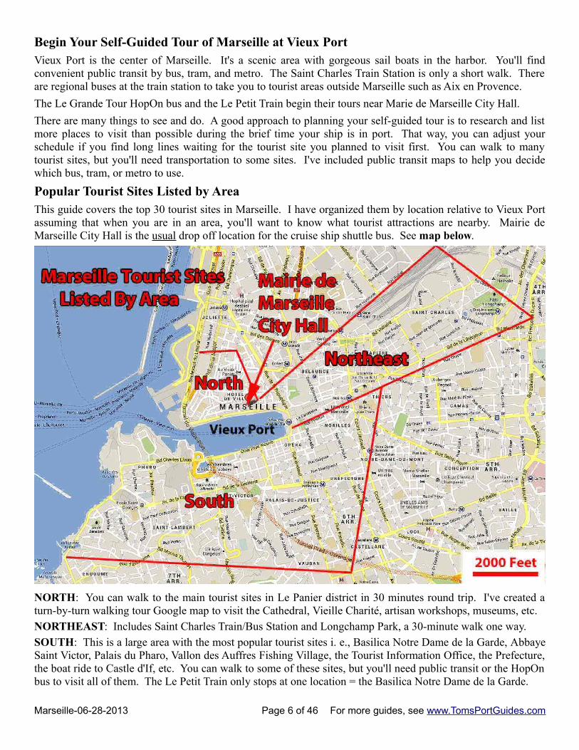
Popular Tourist Sites Listed by AreaThis guide covers the top 30 tourist sites in Marseille. I have organized them by location relative to Vieux Portassuming that when you are in an area, you'll want to know what tourist attractions are nearby. Mairie deMarseille City Hall is the usual drop off location for the cruise ship shuttle bus. See map below.
NORTH: You can walk to the main tourist sites in Le Panier district in 30 minutes round trip. I've created aturn-by-turn walking tour Google map to visit the Cathedral, Vieille Charité, artisan workshops, museums, etc.
NORTHEAST: Includes Saint Charles Train/Bus Station and Longchamp Park, a 30-minute walk one way.
SOUTH: This is a large area with the most popular tourist sites i. e., Basilica Notre Dame de la Garde, AbbayeSaint Victor, Palais du Pharo, Vallon des Auffres Fishing Village, the Tourist Information Office, the Prefecture,the boat ride to Castle d'If, etc. You can walk to some of these sites, but you'll need public transit or the HopOnbus to visit all of them. The Le Petit Train only stops at one location = the Basilica Notre Dame de la Garde.
Marseille-06-28-2013 Page 6 of 46 For more guides, see www.TomsPortGuides.com
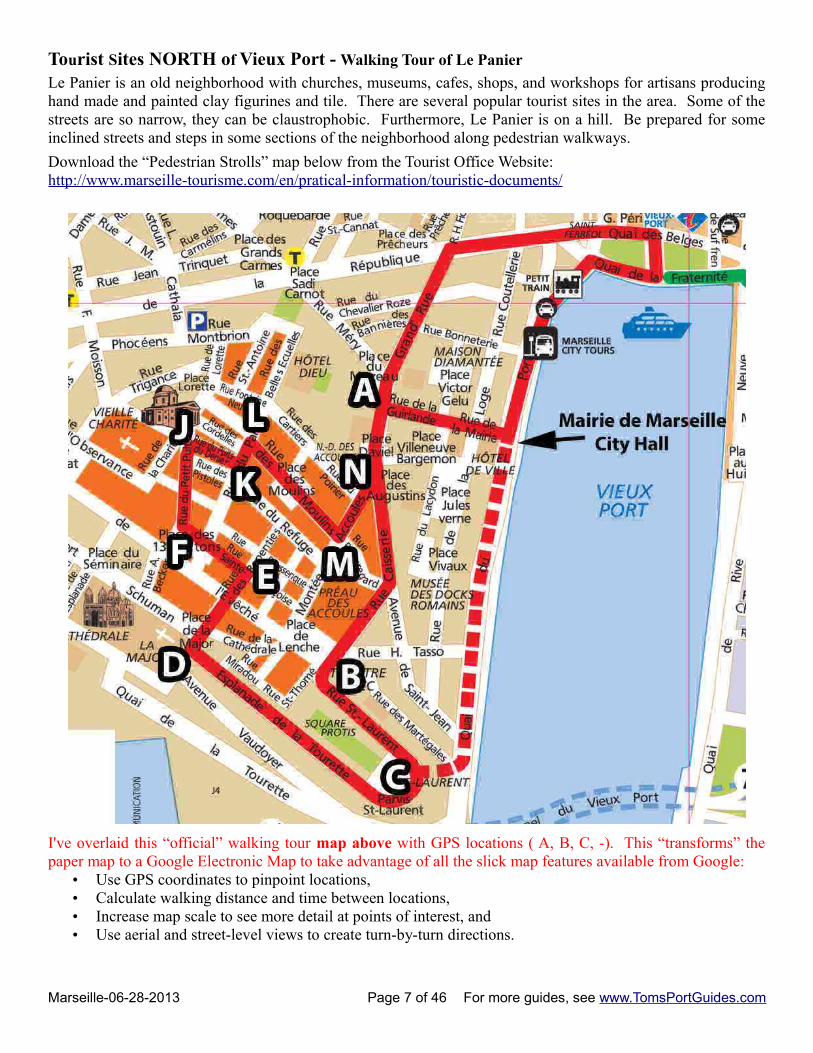
Tourist Sites NORTH of Vieux Port - Walking Tour of Le Panier
Le Panier is an old neighborhood with churches, museums, cafes, shops, and workshops for artisans producinghand made and painted clay figurines and tile. There are several popular tourist sites in the area. Some of thestreets are so narrow, they can be claustrophobic. Furthermore, Le Panier is on a hill. Be prepared for someinclined streets and steps in some sections of the neighborhood along pedestrian walkways.
Download the “Pedestrian Strolls” map below from the Tourist Office Website:http://www.marseille-tourisme.com/en/pratical-information/touristic-documents/
I've overlaid this “official” walking tour map above with GPS locations ( A, B, C, -). This “transforms” thepaper map to a Google Electronic Map to take advantage of all the slick map features available from Google:
• Use GPS coordinates to pinpoint locations,• Calculate walking distance and time between locations, • Increase map scale to see more detail at points of interest, and • Use aerial and street-level views to create turn-by-turn directions.
Marseille-06-28-2013 Page 7 of 46 For more guides, see www.TomsPortGuides.com
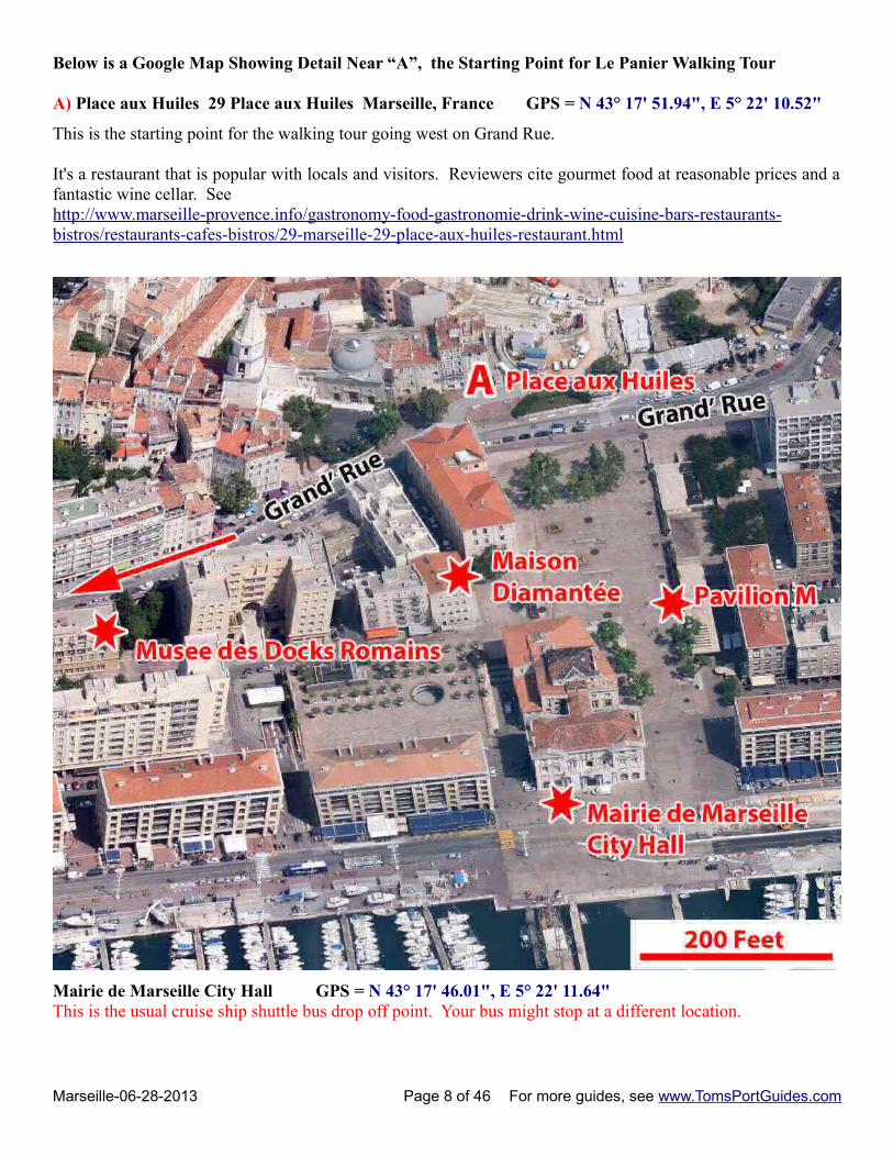
Below is a Google Map Showing Detail Near “A”, the Starting Point for Le Panier Walking Tour
A) Place aux Huiles 29 Place aux Huiles Marseille, France GPS = N 43° 17' 51.94", E 5° 22' 10.52"
This is the starting point for the walking tour going west on Grand Rue.
It's a restaurant that is popular with locals and visitors. Reviewers cite gourmet food at reasonable prices and afantastic wine cellar. Seehttp://www.marseille-provence.info/gastronomy-food-gastronomie-drink-wine-cuisine-bars-restaurants-bistros/restaurants-cafes-bistros/29-marseille-29-place-aux-huiles-restaurant.html
Mairie de Marseille City Hall GPS = N 43° 17' 46.01", E 5° 22' 11.64"This is the usual cruise ship shuttle bus drop off point. Your bus might stop at a different location.
Marseille-06-28-2013 Page 8 of 46 For more guides, see www.TomsPortGuides.com
Pavilion M GPS = N 43° 17' 48.92", E 5° 22' 12.72"Pavilion M provides information on art. cultural events, and general tourist information. It has exhibits andmovies about Marseille and the area. It's open 7 days a week from 11 am to 8 pm.
Maison Diamantée 3 Rue de la Prison Marseille, France GPS = N 43° 17' 49.62", E 5° 22' 10.02"
The “Diamond Palace” is named for diamond shaped stones on the facade. It was built by wealthy merchants inthe 1600s. It houses a museum with:
Eighteenth century Provencal furniture, domestic objects, and a large collection of santons from 1830 tothe early 1900’s. There is also a relief model of Old Marseille from 1848 plus an area dedicated to 19thcentury paintings and costumes. Exhibits demonstrate the town’s rich history with artifacts of Provencallife. It is a museum of art and popular traditions. For example, the large wrought iron grip used toremove corpses in the street, during the great plague.
Musee des Docks Romains GPS = N 43° 17' 48.20", E 5° 22' 5.56"
The ancient commercial life in Marseille is evidenced by a variety of remains found in the wreckage of boats sunk in the harbor or nearby. The amphorae wall shows the diversity of forms made in Marseilles. The Dolia (large jars that contained probably wine), dating from the Hellenistic period to the Middle Ages, is the highlight of the visit. Finally measuring instruments such as currencies and treasures, perfectly illustrate the importance trade in the ancient port of Marseille
Hours: Tuesday to Sunday: from 10h to 18h Admission 5 euroWebsite = http://www.marseille.fr/siteculture/les-lieux-culturels/musees/le-musee-des-docks-romains
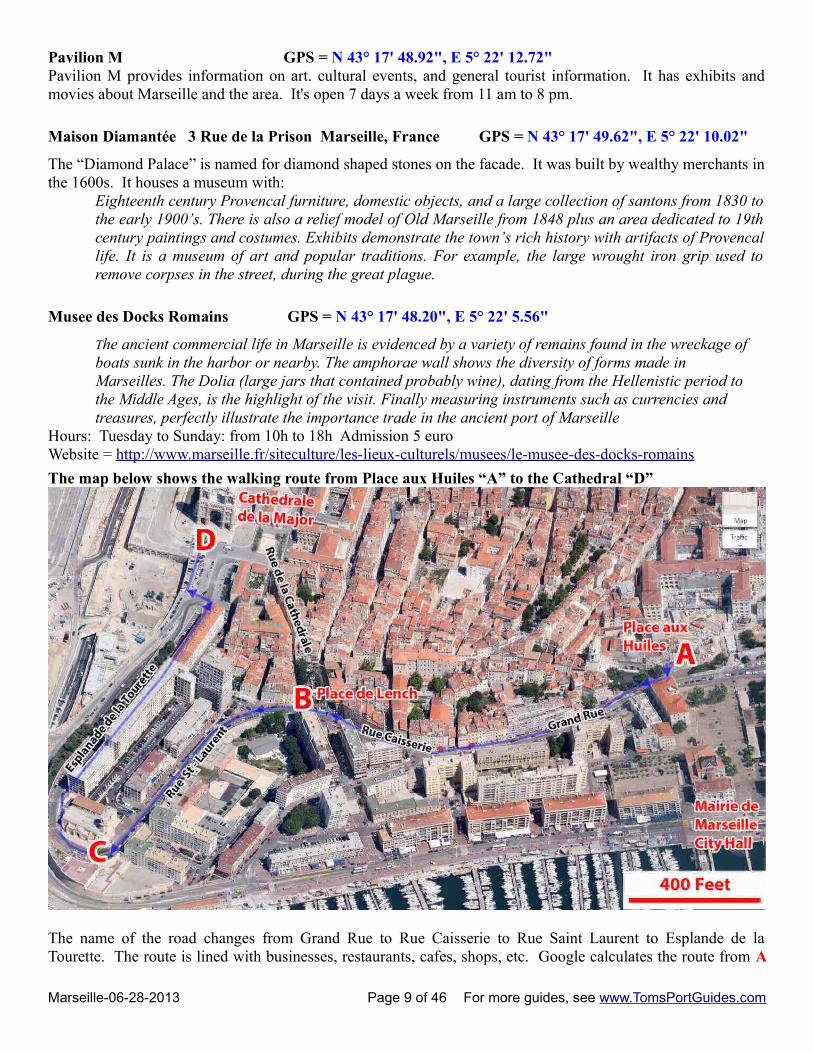
The map below shows the walking route from Place aux Huiles “A” to the Cathedral “D”
The name of the road changes from Grand Rue to Rue Caisserie to Rue Saint Laurent to Esplande de laTourette. The route is lined with businesses, restaurants, cafes, shops, etc. Google calculates the route from A
Marseille-06-28-2013 Page 9 of 46 For more guides, see www.TomsPortGuides.com
to B to C to D is 1.1 km and a 14 minute walk. An alternate route is to walk from A to B to D via Rue deCathedrale from the northwest corner of Place de Lench. This route is 600 meters and an 8 minute walk, butyou'll miss the scenic, postcard photo opportunities near point C on the map.
Here are the GPS coordinates to create the map above:A) Place aux Huiles 29 Place aux Huiles Marseille, France GPS = N 43° 17' 51.94", E 5° 22' 10.52"Restaurant.
B) Place de Lench GPS = N 43° 17' 50.32", E 5° 21' 56.34"
Place de Lenche is an attractive square with cafes and shops.
C) Rue St Laurent intersection with Esplande de la Tourette GPS = N 43° 17' 44.32", E 5° 21' 48.42"
This is a scenic area with many photo opportunities.
D) Cathedral de la Major GPS = N 43° 17' 56.72", E 5° 21' 52.64"
Prince Louis Napoleon Bonaparte wanted a majestic church. It was finished in 1893. For details, seehttp://www.marseille-provence.info/marseille-marseilles/what-to-see-tourist-attractions/140-the-churches-of-marseille.html
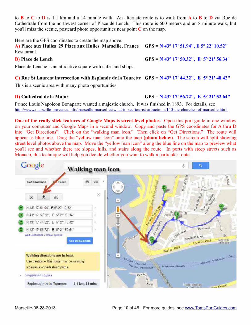
One of the really slick features of Google Maps is street-level photos. Open this port guide in one windowon your computer and Google Maps in a second window. Copy and paste the GPS coordinates for A thru Dinto “Get Directions”. Click on the “walking man icon.” Then click on “Get Directions.” The route willappear as blue line. Drag the “yellow man icon” onto the map (photo below). The screen will split showingstreet level photos above the map. Move the “yellow man icon” along the blue line on the map to preview whatyou'll see and whether there are slopes, hills, and stairs along the route. In ports with steep streets such asMonaco, this technique will help you decide whether you want to walk a particular route.
Marseille-06-28-2013 Page 10 of 46 For more guides, see www.TomsPortGuides.com
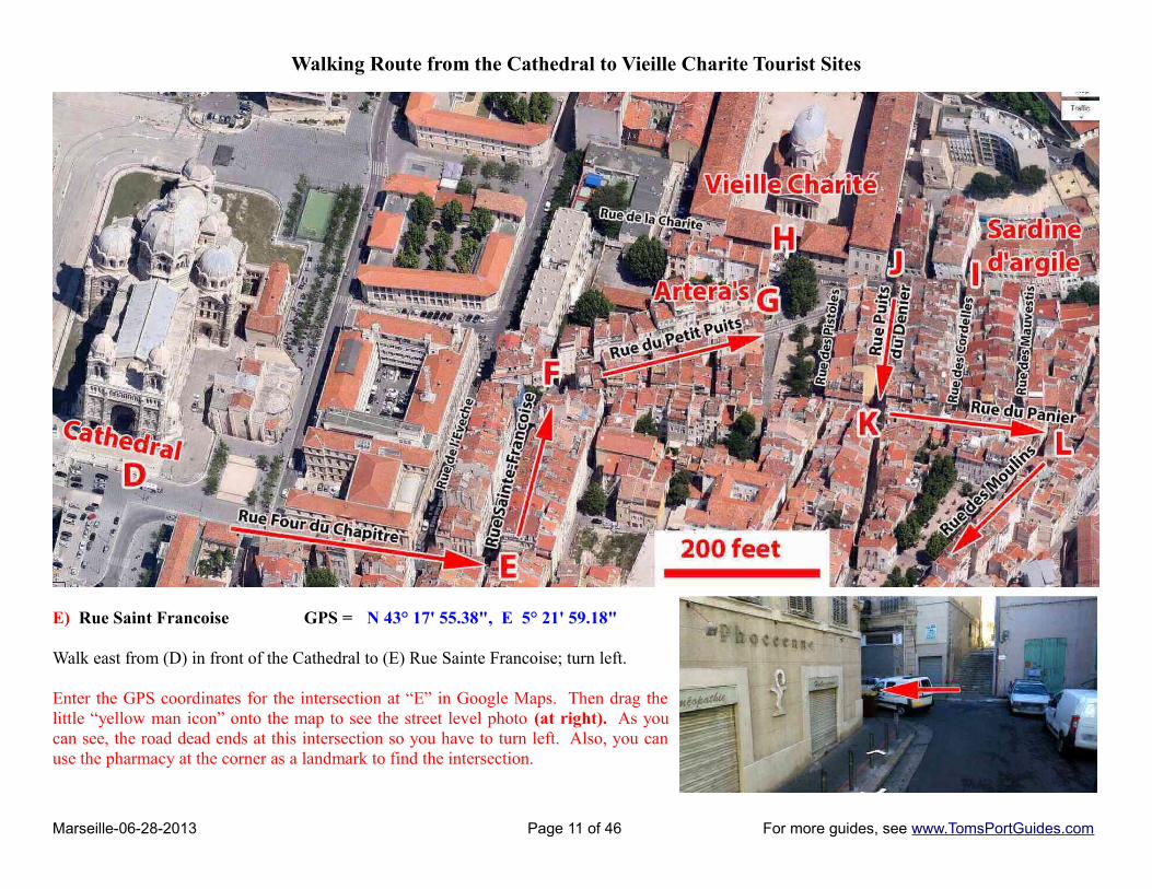
Walking Route from the Cathedral to Vieille Charite Tourist Sites
E) Rue Saint Francoise GPS = N 43° 17' 55.38", E 5° 21' 59.18"
Walk east from (D) in front of the Cathedral to (E) Rue Sainte Francoise; turn left.
Enter the GPS coordinates for the intersection at “E” in Google Maps. Then drag thelittle “yellow man icon” onto the map to see the street level photo (at right). As youcan see, the road dead ends at this intersection so you have to turn left. Also, you canuse the pharmacy at the corner as a landmark to find the intersection.
Marseille-06-28-2013 Page 11 of 46 For more guides, see www.TomsPortGuides.com
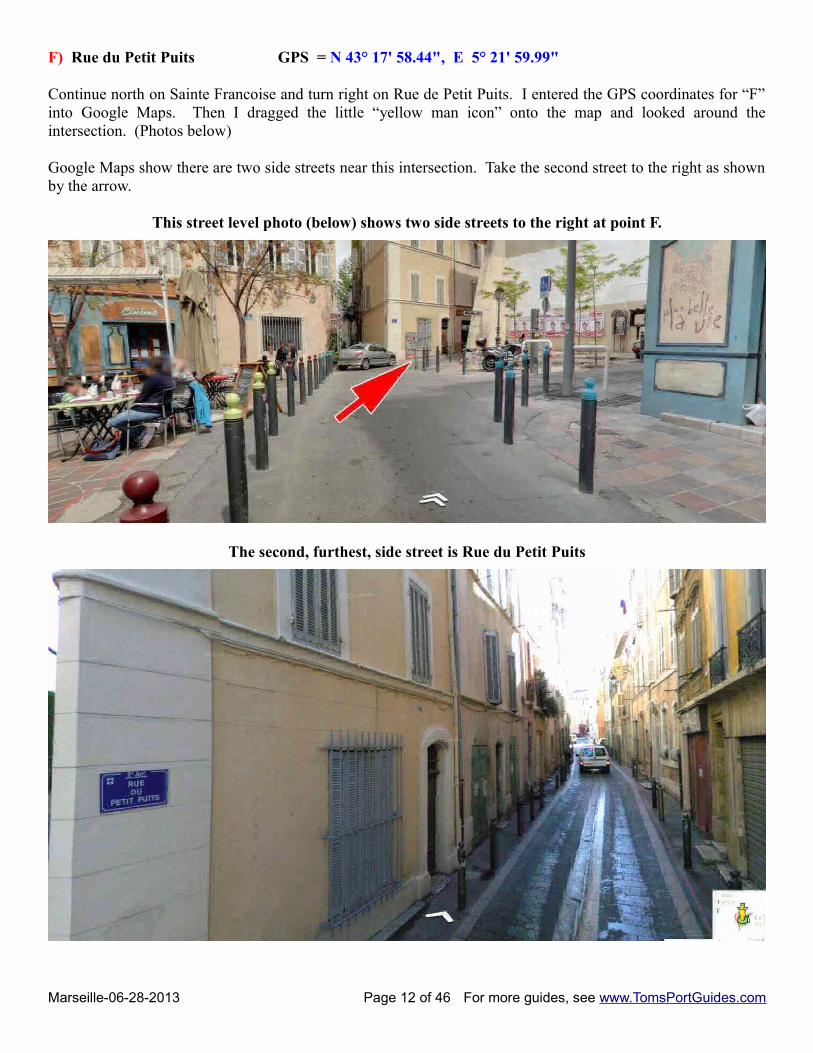
F) Rue du Petit Puits GPS = N 43° 17' 58.44", E 5° 21' 59.99"
Continue north on Sainte Francoise and turn right on Rue de Petit Puits. I entered the GPS coordinates for “F”into Google Maps. Then I dragged the little “yellow man icon” onto the map and looked around theintersection. (Photos below)
Google Maps show there are two side streets near this intersection. Take the second street to the right as shownby the arrow.
This street level photo (below) shows two side streets to the right at point F.
The second, furthest, side street is Rue du Petit Puits
Marseille-06-28-2013 Page 12 of 46 For more guides, see www.TomsPortGuides.com
G) Artera's 15 Rue du Petit Puits Marseille, France GPS = N 43° 17' 59.43", E 5° 22' 3.94" Workshop for clay figurines:
Housed in the old quarter of the "Shopping Cart" in Marseille, the Arterra workshop since 1996 came from the family of Santon. From the beginning Arterra has become a very personal style. A style that combines tradition and modernity sparked the enthusiasm of fans and collectors. Our collections are also very popular in the world of Santon nursery, in the decoration. Our collection is available in five sizes: 7, 9, 12, 18, and 30 cm. All our subjects are obviously clay and made entirely by hand. The different stages of production are successively: See http://santons-arterra.com/
H) Vieille Charité GPS = N 43° 18' 0.43", E 5° 22' 3.99"
Old Charity Cultural Center - Centre de la Vieille CharitéSet in the heart of the "Panier" district is a beautiful, baroque chapel in a large courtyard surrounded by a building with three-tiered arched balconies, all made of a rose or yellow tinted Couronne stone. The Vieille Charité was built from 1671 to 1749 (and never actually finished) to house the poor and needy.Entrance is free to wander around in the courtyard, and visit the book store or stop at the café. Museums located in the "Charité" building include:
• Museum of Mediterranean Archaeology about 2 €, • Museum of African, South Seas and American Indian Arts about 2 €, and • Temporary Exhibits about 4 €• Open: June-Sept, 11h-18h; Oct-May, 10h-17h• Closed: Mondays, holidays
I) Sardine d'argile 5 Rue Du Petit Puits Marseille, France GPS =N 43° 17' 59.77", E 5° 22' 7.31"
Workshop for ceramic tiles:La Sardine clay is the appointment of Marseille artisans. Jean-Marc Saman, history buff and travel, creates ceramic tiles inspired Medieval and Renaissance Mediterranean, where the blue and white dominate: azuleros (Portugal), Iznik (Turkey) (Delft below), Moustiers. Authentic style pleases its singularitySee http://www.culture-13.fr/annuaire/la-sardine-d-argile.html
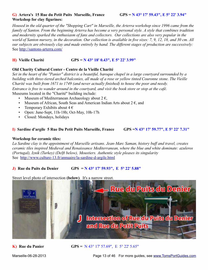
J) Rue du Puits du Denier GPS = N 43° 17' 59.93", E 5° 22' 5.88"
Street level photo of intersection (below). It's a narrow street.
K) Rue du Panier GPS = N 43° 17' 57.69", E 5° 22' 5.65"
Marseille-06-28-2013 Page 13 of 46 For more guides, see www.TomsPortGuides.com
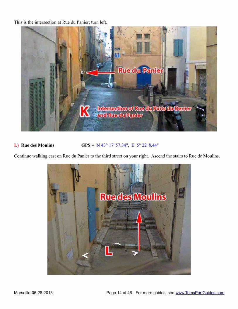
This is the intersection at Rue du Panier; turn left.
L) Rue des Moulins GPS = N 43° 17' 57.34", E 5° 22' 8.44"
Continue walking east on Rue du Panier to the third street on your right. Ascend the stairs to Rue de Moulins.
Marseille-06-28-2013 Page 14 of 46 For more guides, see www.TomsPortGuides.com

The Map Below Shows the Remaining Section of the Walking Tour of Le PanierFrom “L”, walk south on Rue des Moulins along the tree-lined square. Stop at the figurine workshop at “M”.Turn left (east) on Montee des Accoules. You'll see washed clothes hanging from the balconies as you pass Ruedu Poirier. You'll find a flight of stairs at “N”. Go down the stairs to Grand Rue. Point “A”, Place aux Huilesrestaurant is where you began the walking tour.
M) Lagnel André Robbe GPS = N 43° 17' 51.75", E 5° 22' 2.94"
Lagnel André Robbe is one of the famous workshops for fine clay figurines. It is located on Rue des Moulinsnear Montee des Accoules. See http://www.culture-13.fr/annuaire/cabanon-des-accoules.html
Marseille-06-28-2013 Page 15 of 46 For more guides, see www.TomsPortGuides.com
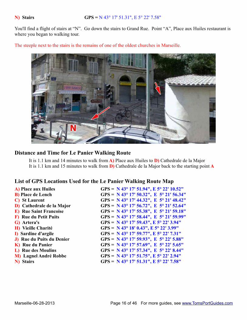
N) Stairs GPS = N 43° 17' 51.31", E 5° 22' 7.58"
You'll find a flight of stairs at “N”. Go down the stairs to Grand Rue. Point “A”, Place aux Huiles restaurant is where you began to walking tour.
The steeple next to the stairs is the remains of one of the oldest churches in Marseille.
Distance and Time for Le Panier Walking Route It is 1.1 km and 14 minutes to walk from A) Place aux Huiles to D) Cathedrale de la MajorIt is 1.1 km and 15 minutes to walk from D) Cathedrale de la Major back to the starting point A
List of GPS Locations Used for the Le Panier Walking Route MapA) Place aux Huiles GPS = N 43° 17' 51.94", E 5° 22' 10.52"B) Place de Lench GPS = N 43° 17' 50.32", E 5° 21' 56.34" C) St Laurent GPS = N 43° 17' 44.32", E 5° 21' 48.42" D) Cathedrale de la Major GPS = N 43° 17' 56.72", E 5° 21' 52.64" E) Rue Saint Francoise GPS = N 43° 17' 55.38", E 5° 21' 59.18" F) Rue du Petit Puits GPS = N 43° 17' 58.44", E 5° 21' 59.99" G) Artera's GPS = N 43° 17' 59.43", E 5° 22' 3.94"H) Vieille Charité GPS = N 43° 18' 0.43", E 5° 22' 3.99"I) Sardine d'argile GPS = N 43° 17' 59.77", E 5° 22' 7.31" J) Rue du Puits du Denier GPS = N 43° 17' 59.93", E 5° 22' 5.88" K) Rue du Panier GPS = N 43° 17' 57.69", E 5° 22' 5.65" L) Rue des Moulins GPS = N 43° 17' 57.34", E 5° 22' 8.44" M) Lagnel André Robbe GPS = N 43° 17' 51.75", E 5° 22' 2.94"N) Stairs GPS = N 43° 17' 51.31", E 5° 22' 7.58"
Marseille-06-28-2013 Page 16 of 46 For more guides, see www.TomsPortGuides.com
Tourist Sites NORTHEAST of Vieux Port
A) Mairie de Marseille City Hall GPS = N 43° 17' 46.01", E 5° 22' 11.64"
This is the usual cruise ship shuttle busdrop off point. Your bus might stop at adifferent location.
B) Saint Charles Train and Bus StationGPS = N 43° 18' 10", E 5° 22' 46"
C-D) Palais et Parc Longchamp areaGPS = N 43° 18' 13.37", E 5° 23' 36.05"
E) La Friche la Belle de MaiGPS = N 43° 18' 34.55", E 5° 23' 25.75"
F) Theatre Le Petit MerlanGPS = N 43° 20' 7.02", E 5° 24' 26.36"
Note the map scale of 2000 feet:
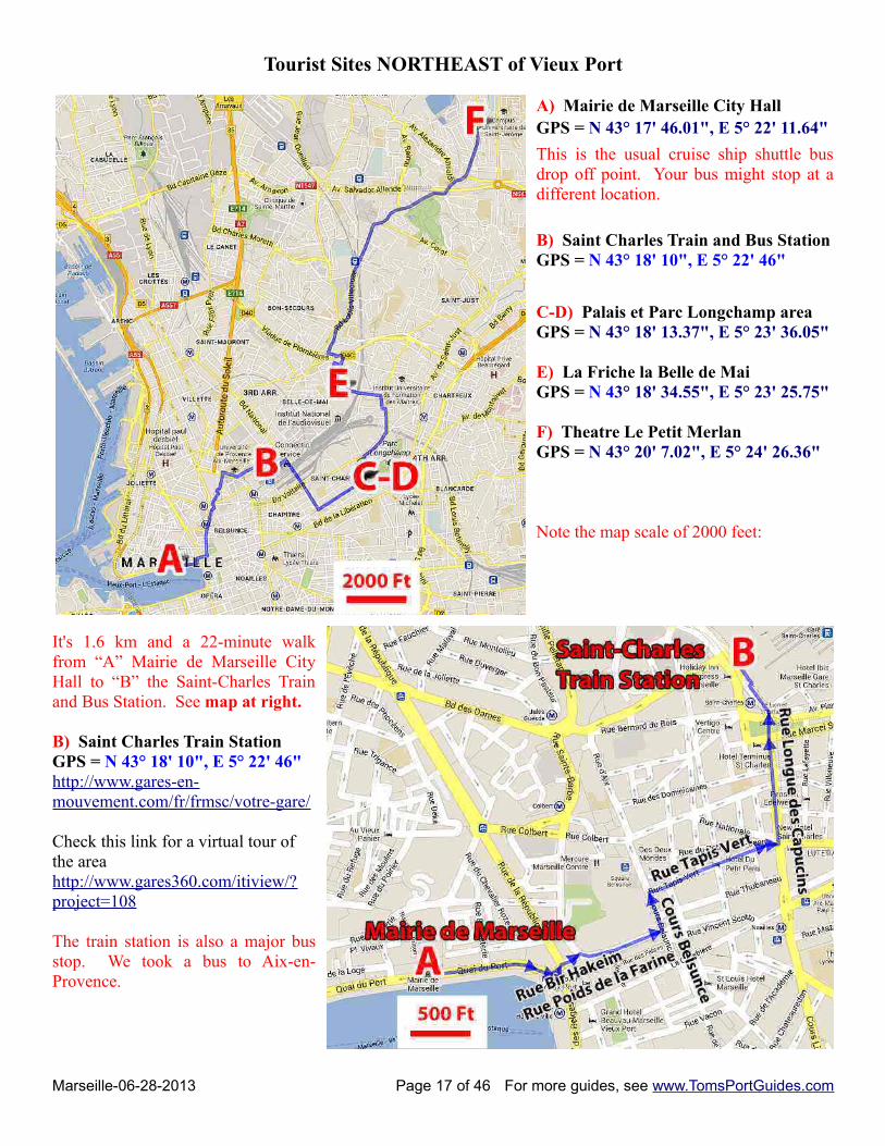
It's 1.6 km and a 22-minute walkfrom “A” Mairie de Marseille CityHall to “B” the Saint-Charles Trainand Bus Station. See map at right.
B) Saint Charles Train Station GPS = N 43° 18' 10", E 5° 22' 46"http://www.gares-en-mouvement.com/fr/frmsc/votre-gare/
Check this link for a virtual tour ofthe area http://www.gares360.com/itiview/?project=108
The train station is also a major busstop. We took a bus to Aix-en-Provence.
Marseille-06-28-2013 Page 17 of 46 For more guides, see www.TomsPortGuides.com
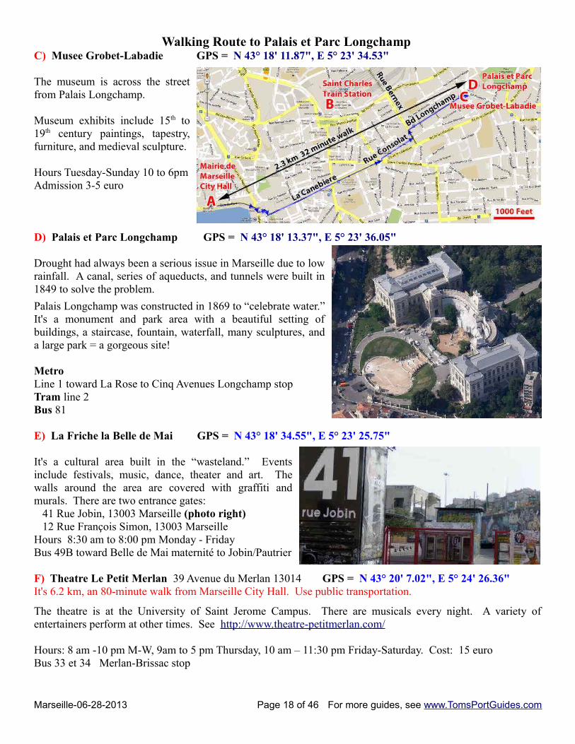
Walking Route to Palais et Parc Longchamp C) Musee Grobet-Labadie GPS = N 43° 18' 11.87", E 5° 23' 34.53"
The museum is across the streetfrom Palais Longchamp.
Museum exhibits include 15th to19th century paintings, tapestry,furniture, and medieval sculpture.
Hours Tuesday-Sunday 10 to 6pmAdmission 3-5 euro
D) Palais et Parc Longchamp GPS = N 43° 18' 13.37", E 5° 23' 36.05"
Drought had always been a serious issue in Marseille due to lowrainfall. A canal, series of aqueducts, and tunnels were built in1849 to solve the problem.
Palais Longchamp was constructed in 1869 to “celebrate water.”It's a monument and park area with a beautiful setting ofbuildings, a staircase, fountain, waterfall, many sculptures, anda large park = a gorgeous site!
Metro Line 1 toward La Rose to Cinq Avenues Longchamp stop Tram line 2 Bus 81
E) La Friche la Belle de Mai GPS = N 43° 18' 34.55", E 5° 23' 25.75"
It's a cultural area built in the “wasteland.” Eventsinclude festivals, music, dance, theater and art. Thewalls around the area are covered with graffiti andmurals. There are two entrance gates: 41 Rue Jobin, 13003 Marseille (photo right) 12 Rue François Simon, 13003 Marseille Hours 8:30 am to 8:00 pm Monday - FridayBus 49B toward Belle de Mai maternité to Jobin/Pautrier
F) Theatre Le Petit Merlan 39 Avenue du Merlan 13014 GPS = N 43° 20' 7.02", E 5° 24' 26.36" It's 6.2 km, an 80-minute walk from Marseille City Hall. Use public transportation.
The theatre is at the University of Saint Jerome Campus. There are musicals every night. A variety ofentertainers perform at other times. See http://www.theatre-petitmerlan.com/
Hours: 8 am -10 pm M-W, 9am to 5 pm Thursday, 10 am – 11:30 pm Friday-Saturday. Cost: 15 euroBus 33 et 34 Merlan-Brissac stop
Marseille-06-28-2013 Page 18 of 46 For more guides, see www.TomsPortGuides.com
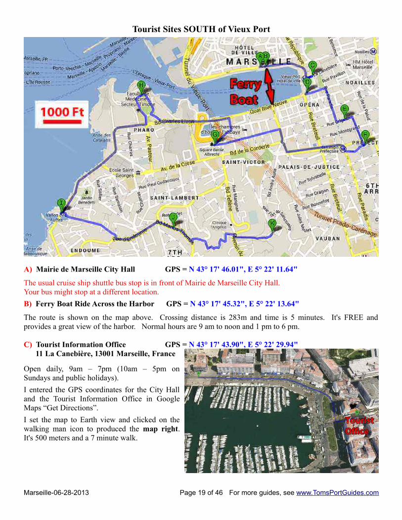
Tourist Sites SOUTH of Vieux Port
A) Mairie de Marseille City Hall GPS = N 43° 17' 46.01", E 5° 22' 11.64"
The usual cruise ship shuttle bus stop is in front of Mairie de Marseille City Hall. Your bus might stop at a different location.
B) Ferry Boat Ride Across the Harbor GPS = N 43° 17' 45.32", E 5° 22' 13.64"
The route is shown on the map above. Crossing distance is 283m and time is 5 minutes. It's FREE andprovides a great view of the harbor. Normal hours are 9 am to noon and 1 pm to 6 pm.
C) Tourist Information Office GPS = N 43° 17' 43.90", E 5° 22' 29.94" 11 La Canebière, 13001 Marseille, France
Open daily, 9am – 7pm (10am – 5pm onSundays and public holidays).
I entered the GPS coordinates for the City Halland the Tourist Information Office in GoogleMaps “Get Directions”.
I set the map to Earth view and clicked on thewalking man icon to produced the map right.It's 500 meters and a 7 minute walk.
Marseille-06-28-2013 Page 19 of 46 For more guides, see www.TomsPortGuides.com
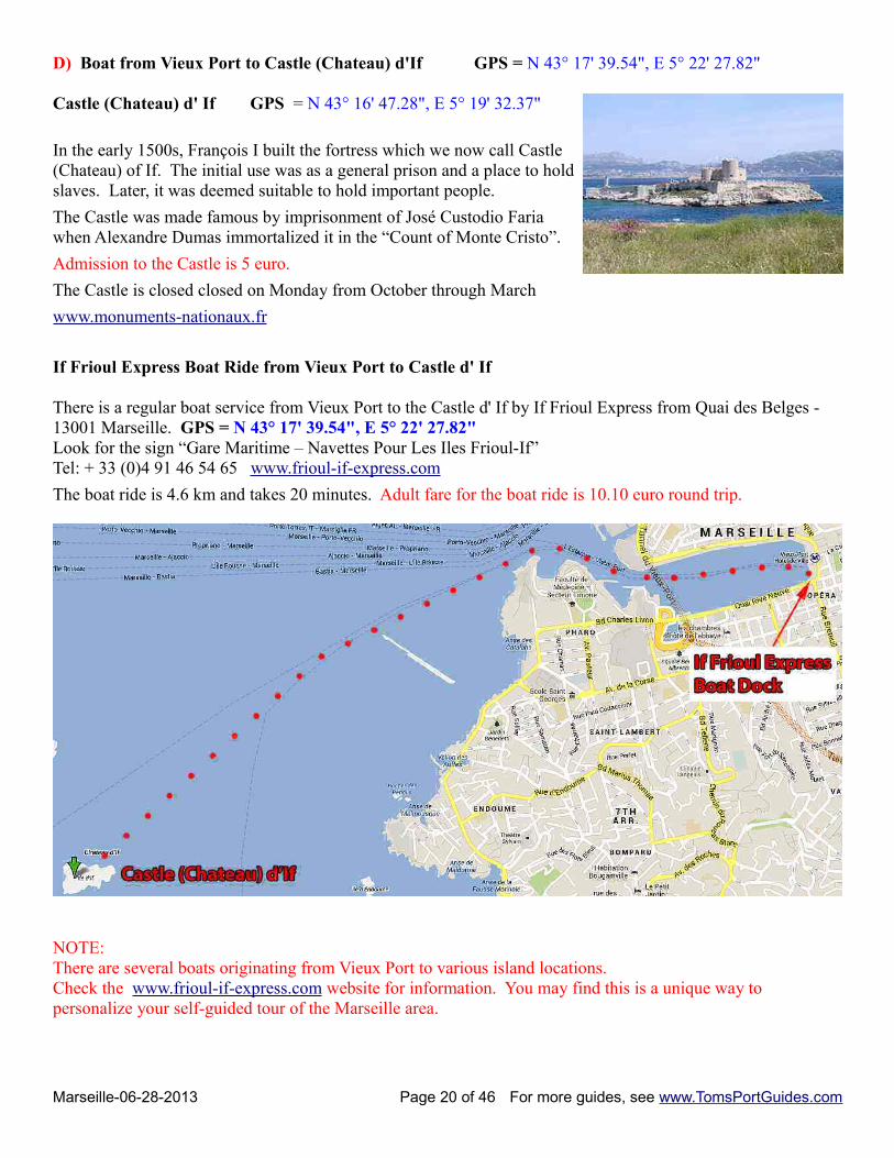
D) Boat from Vieux Port to Castle (Chateau) d'If GPS = N 43° 17' 39.54", E 5° 22' 27.82"
Castle (Chateau) d' If GPS = N 43° 16' 47.28", E 5° 19' 32.37"
In the early 1500s, François I built the fortress which we now call Castle(Chateau) of If. The initial use was as a general prison and a place to holdslaves. Later, it was deemed suitable to hold important people.
The Castle was made famous by imprisonment of José Custodio Fariawhen Alexandre Dumas immortalized it in the “Count of Monte Cristo”.
Admission to the Castle is 5 euro.
The Castle is closed closed on Monday from October through March
www.monuments-nationaux.fr
If Frioul Express Boat Ride from Vieux Port to Castle d' If
There is a regular boat service from Vieux Port to the Castle d' If by If Frioul Express from Quai des Belges - 13001 Marseille. GPS = N 43° 17' 39.54", E 5° 22' 27.82" Look for the sign “Gare Maritime – Navettes Pour Les Iles Frioul-If”Tel: + 33 (0)4 91 46 54 65 www.frioul-if-express.com
The boat ride is 4.6 km and takes 20 minutes. Adult fare for the boat ride is 10.10 euro round trip.
NOTE:There are several boats originating from Vieux Port to various island locations. Check the www.frioul-if-express.com website for information. You may find this is a unique way to personalize your self-guided tour of the Marseille area.
Marseille-06-28-2013 Page 20 of 46 For more guides, see www.TomsPortGuides.com
E) Musee Cantini GPS = N 43° 17' 31.78", E 5° 22' 41.42"
The collection of the Musée Cantini includes Fauvism, the first cubist experiments, and different streams post-cubist or purists 1920s -1940. Some of these works reveal the fascination of many artists in the early twentiethcentury to light and southern landscapes. Another major focus of the collection is the Surrealist Revolution.Lyrical or gestural abstraction is also represented. A little away from historically defined streams, thecollection has some great individuals who deeply marked the twentieth century, including Pablo Picasso, HenriMatisse, Jean Arp, Balthus, Alberto Giacometti and Francis Bacon. Photographic collections offer a fairly richpanorama of the history of this art from the most historic period.
The museum has been closed for a year and will reopen in June 2013.Hours: 10am-5pm Tue-Sun Oct-May, 11am-6pm Tue-Sun Jun-Sep Admission ~ 2 euros
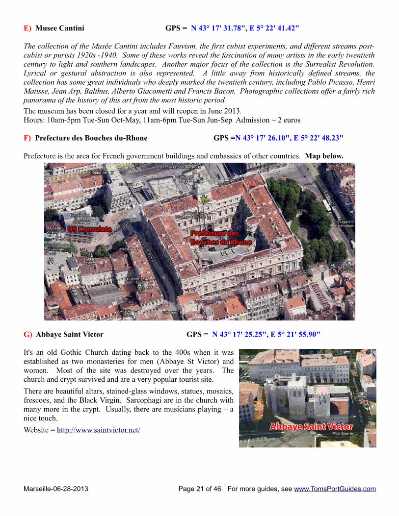
F) Prefecture des Bouches du-Rhone GPS =N 43° 17' 26.10", E 5° 22' 48.23"
Prefecture is the area for French government buildings and embassies of other countries. Map below.
G) Abbaye Saint Victor GPS = N 43° 17' 25.25", E 5° 21' 55.90"
It's an old Gothic Church dating back to the 400s when it wasestablished as two monasteries for men (Abbaye St Victor) andwomen. Most of the site was destroyed over the years. Thechurch and crypt survived and are a very popular tourist site.
There are beautiful altars, stained-glass windows, statues, mosaics,frescoes, and the Black Virgin. Sarcophagi are in the church withmany more in the crypt. Usually, there are musicians playing – anice touch.
Website = http://www.saintvictor.net/
Marseille-06-28-2013 Page 21 of 46 For more guides, see www.TomsPortGuides.com
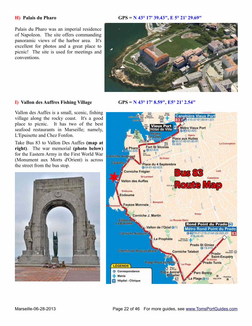
H) Palais du Pharo GPS = N 43° 17' 39.43", E 5° 21' 29.69"
Palais du Pharo was an imperial residenceof Napoleon. The site offers commandingpanoramic views of the harbor area. It'sexcellent for photos and a great place topicnic! The site is used for meetings andconventions.
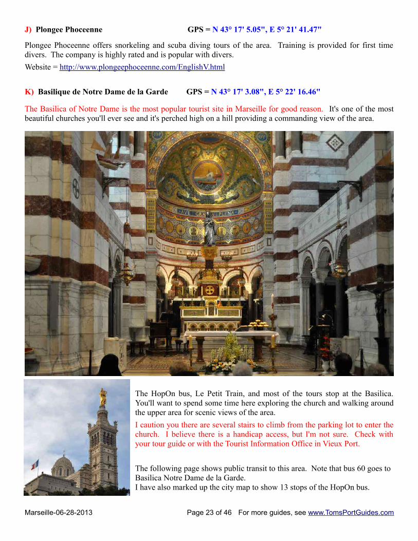
I) Vallon des Auffres Fishing Village GPS = N 43° 17' 8.59", E5° 21' 2.54"
Vallon des Auffes is a small, scenic, fishingvillage along the rocky coast. It's a goodplace to picnic. It has two of the bestseafood restaurants in Marseille; namely,L'Epuisette and Chez Fonfon.
Take Bus 83 to Vallon Des Auffes (map atright). The war memorial (photo below)for the Eastern Army in the First World War(Monument aux Morts d'Orient) is acrossthe street from the bus stop.
Marseille-06-28-2013 Page 22 of 46 For more guides, see www.TomsPortGuides.com
J) Plongee Phoceenne GPS = N 43° 17' 5.05", E 5° 21' 41.47"
Plongee Phoceenne offers snorkeling and scuba diving tours of the area. Training is provided for first timedivers. The company is highly rated and is popular with divers.
Website = http://www.plongeephoceenne.com/EnglishV.html
K) Basilique de Notre Dame de la Garde GPS = N 43° 17' 3.08", E 5° 22' 16.46"
The Basilica of Notre Dame is the most popular tourist site in Marseille for good reason. It's one of the mostbeautiful churches you'll ever see and it's perched high on a hill providing a commanding view of the area.
The HopOn bus, Le Petit Train, and most of the tours stop at the Basilica.You'll want to spend some time here exploring the church and walking aroundthe upper area for scenic views of the area.
I caution you there are several stairs to climb from the parking lot to enter thechurch. I believe there is a handicap access, but I'm not sure. Check withyour tour guide or with the Tourist Information Office in Vieux Port.
The following page shows public transit to this area. Note that bus 60 goes to Basilica Notre Dame de la Garde. I have also marked up the city map to show 13 stops of the HopOn bus.
Marseille-06-28-2013 Page 23 of 46 For more guides, see www.TomsPortGuides.com
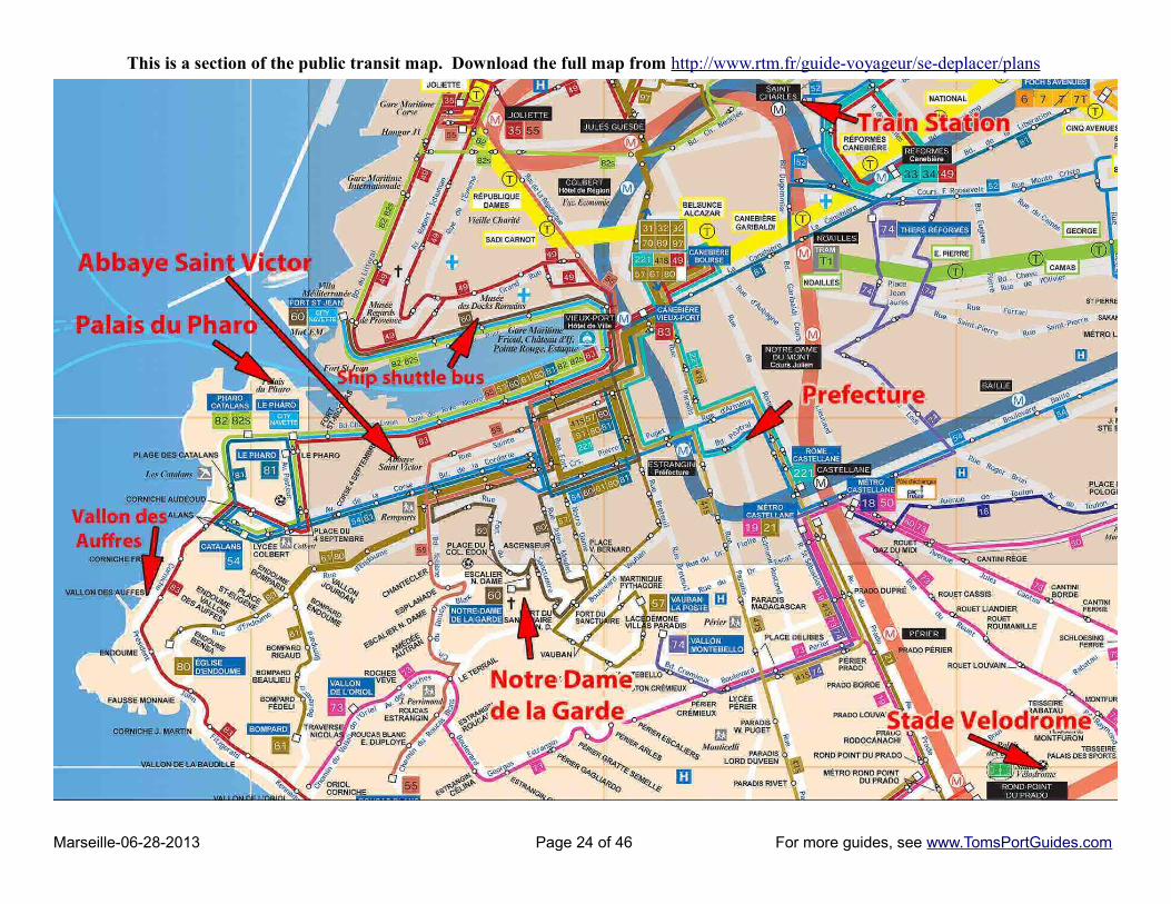
This is a section of the public transit map. Download the full map from http://www.rtm.fr/guide-voyageur/se-deplacer/plans
Marseille-06-28-2013 Page 24 of 46 For more guides, see www.TomsPortGuides.com

City Map Showing Le Grande HopOn Bus Stops 1-13
Marseille-06-28-2013 Page 25 of 46 For more guides, see www.TomsPortGuides.com
Travel Options for Self-Guided Touring in Marseille
Walking
Download maps from http://www.marseille-tourisme.com/en/pratical-information/touristic-documents/print/1/
Bus, Tram, Metro
Download bus, tram, and metro maps from http://www.rtm.fr/guide-voyageur/se-deplacer/plans
Check schedules and routes at http://www.rtm.fr/
The real time network is AWESOME to locate bus stops near tourist sites ! http://map.rtm.fr/map.html
Public transit stops can be difficult to locate on Google Maps. Use this website, change the view from “Map” to“Satellite”, magnify the view, and you can see all the bus, tram, and metro stops around the tourist sites you are interested in visiting!
Trains Check http://www.raileurope.com/index.html
The main train station in the city is Marseille Saint Charles
Boats from Vieux Port www.frioul-if-express.com
Touring in a 1975 vintage car
This a unique and popular way to tour Marseille and the surrounding area in a vintage 1975 convertible. Cost is55 euro/hour with room for 3 people. See http://www.marseille-en-2cv.fr/en/
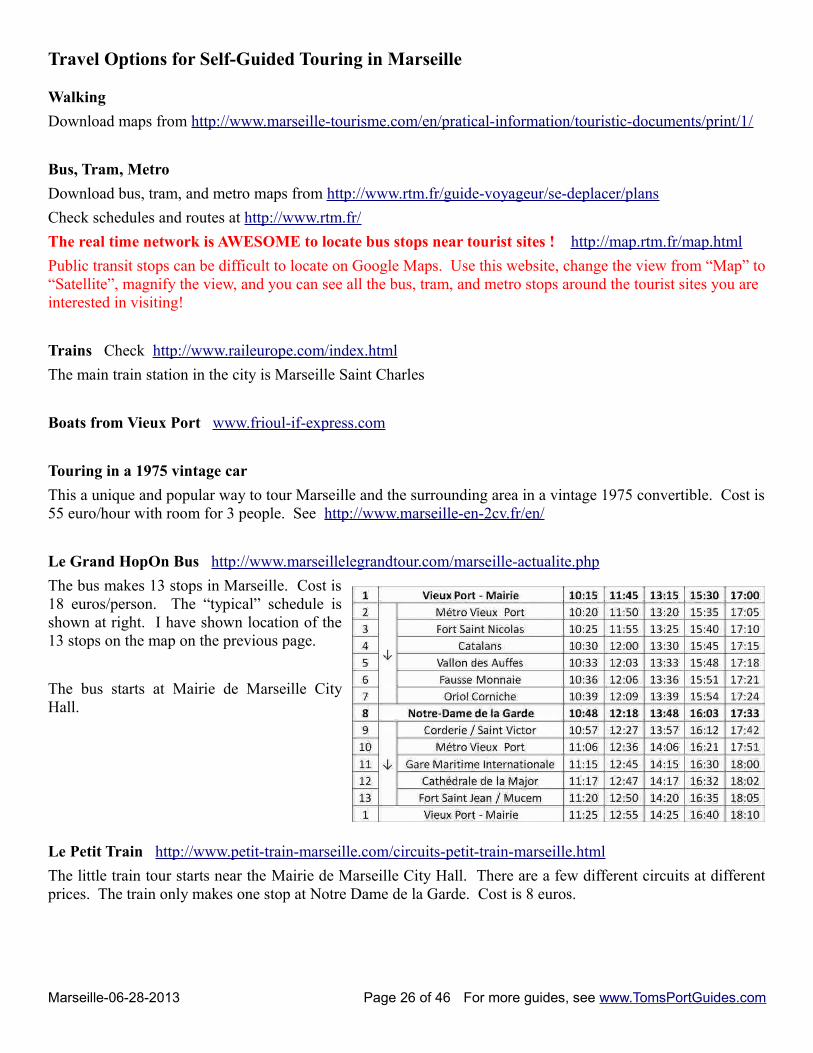
Le Grand HopOn Bus http://www.marseillelegrandtour.com/marseille-actualite.php
The bus makes 13 stops in Marseille. Cost is18 euros/person. The “typical” schedule isshown at right. I have shown location of the13 stops on the map on the previous page.
The bus starts at Mairie de Marseille CityHall.
Le Petit Train http://www.petit-train-marseille.com/circuits-petit-train-marseille.html
The little train tour starts near the Mairie de Marseille City Hall. There are a few different circuits at differentprices. The train only makes one stop at Notre Dame de la Garde. Cost is 8 euros.
Marseille-06-28-2013 Page 26 of 46 For more guides, see www.TomsPortGuides.com

The Beaches and Tourist Sites South of Marseille
A) Mairie de Marseille City Hall GPS = N 43° 17' 46.01", E 5° 22' 11.64" This is the usual ship shuttle bus drop off location.
B) Stade Velodrome GPS = N 43° 16' 11.62", E 5° 23' 45.92"
The Stade Vélodrome is a football stadium in Marseille, France. It is home to the Olympique de Marseillefootball club of Ligue 1, and was a venue in the 1998 FIFA World Cup and the 2007 Rugby World Cup.
It's located ~ 3.5 km south of Vieux Port. Take metro line 2 southbound to Rond-Point du Prado or SainteMarguerite Dromel located at different sides of Stade Vélodrome. Address: 3 Boulevard Michelet, 13008
Website = http://www.stadiumguide.com/velodrome/
C) Cite Radieuse Le Corbusier GPS = N 43° 15' 41.19", E 5° 23' 46.38"
If you're interested in architecture, youmight wish to visit this site. It's aunique housing design built on stilts bya Swiss architect Charles-EdouardJeanneret, A.K.A. Le Corbusier. It wasdesigned to resemble an urbansteamboat anchored in a park. Thebuilding has over 300 flats and is 165mby 24m and 56m high.
Marseille-06-28-2013 Page 27 of 46 For more guides, see www.TomsPortGuides.com
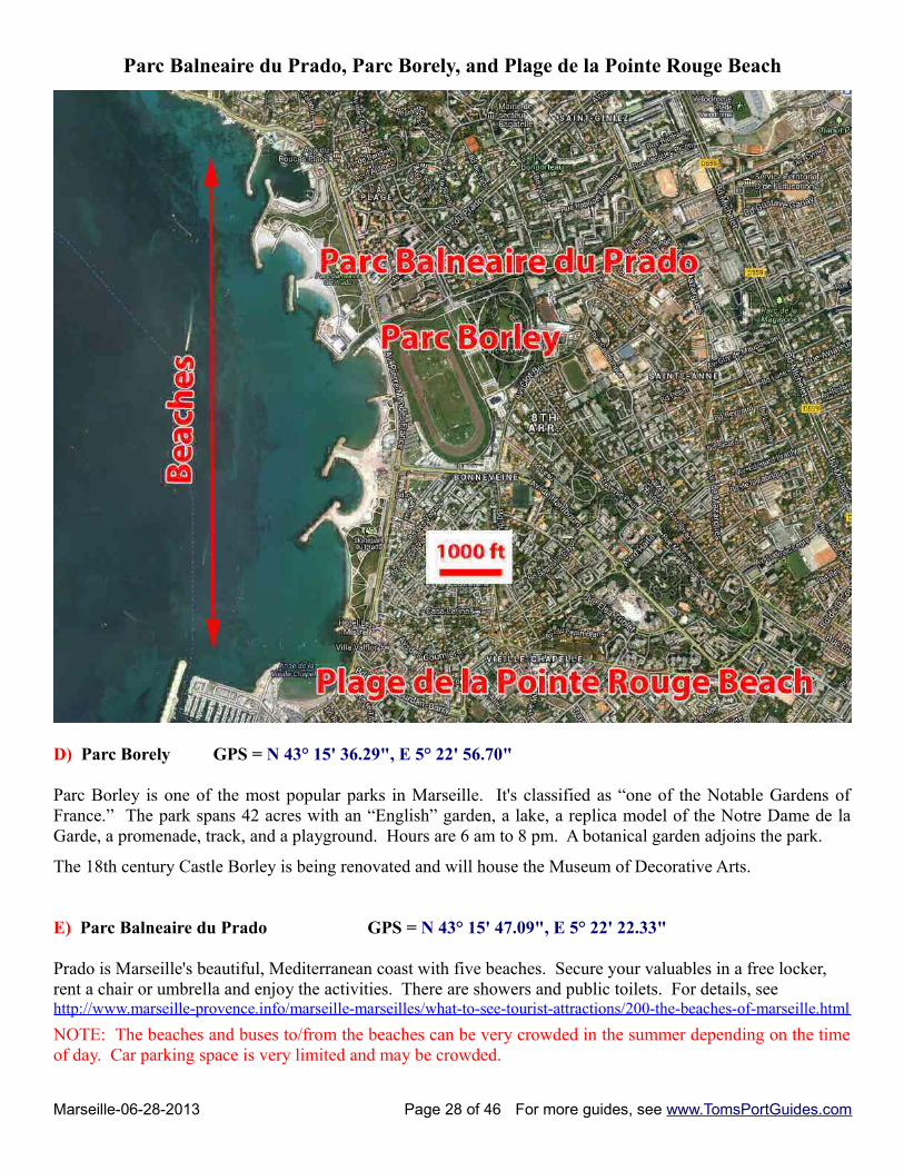
Parc Balneaire du Prado, Parc Borely, and Plage de la Pointe Rouge Beach
D) Parc Borely GPS = N 43° 15' 36.29", E 5° 22' 56.70"
Parc Borley is one of the most popular parks in Marseille. It's classified as “one of the Notable Gardens ofFrance.” The park spans 42 acres with an “English” garden, a lake, a replica model of the Notre Dame de laGarde, a promenade, track, and a playground. Hours are 6 am to 8 pm. A botanical garden adjoins the park.
The 18th century Castle Borley is being renovated and will house the Museum of Decorative Arts.
E) Parc Balneaire du Prado GPS = N 43° 15' 47.09", E 5° 22' 22.33"
Prado is Marseille's beautiful, Mediterranean coast with five beaches. Secure your valuables in a free locker, rent a chair or umbrella and enjoy the activities. There are showers and public toilets. For details, see http://www.marseille-provence.info/marseille-marseilles/what-to-see-tourist-attractions/200-the-beaches-of-marseille.html
NOTE: The beaches and buses to/from the beaches can be very crowded in the summer depending on the timeof day. Car parking space is very limited and may be crowded.
Marseille-06-28-2013 Page 28 of 46 For more guides, see www.TomsPortGuides.com
F) Plage de la Pointe Rouge Beach GPS = N 43° 14' 41.15", E 5° 22' 18.02"
La Pointe Rouge Beach is one of the few sandy beaches of Marseille.
This beach is south of the Prado beaches. It's a sandy beach popular with families.
NOTE: The beaches and buses to/from the beaches can be very crowded in the summer depending on the timeof day. Car parking space is very limited and crowded.
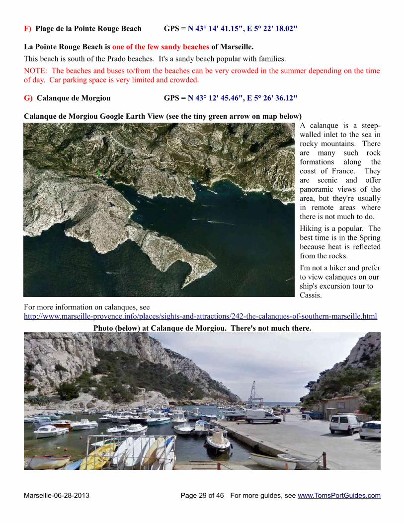
G) Calanque de Morgiou GPS = N 43° 12' 45.46", E 5° 26' 36.12"
Calanque de Morgiou Google Earth View (see the tiny green arrow on map below)A calanque is a steep-walled inlet to the sea inrocky mountains. Thereare many such rockformations along thecoast of France. Theyare scenic and offerpanoramic views of thearea, but they're usuallyin remote areas wherethere is not much to do.
Hiking is a popular. Thebest time is in the Springbecause heat is reflectedfrom the rocks.
I'm not a hiker and preferto view calanques on ourship's excursion tour to Cassis.
For more information on calanques, see http://www.marseille-provence.info/places/sights-and-attractions/242-the-calanques-of-southern-marseille.html
Photo (below) at Calanque de Morgiou. There's not much there.
Marseille-06-28-2013 Page 29 of 46 For more guides, see www.TomsPortGuides.com
Caution re Boat Tours:
You'll find many ports where there are small boat excursions to see the coastline, visit coastal towns or islands,see dolphins or whales, etc. I call your attention to two possible issues with small boat tours.
The first issue is discomfort i. e., motion sickness. We've taken the boat from Naples to Capri many times without incident. On a recent boat ride, there was arhythmic roll even though the seas were calm, A few people ran to the toilets at the front of the boat. Theattendants handed out barf bags; several people got sick. On the return trip to Naples, we were on a hugehydrofoil boat. It was a very calm ride. Bigger is better!
Statement on Cassis Tourist Website re Boat Tours Visitors to Cassis France can enjoy an adventurous boat tour of the spectacular Calanques fjords. The small vessels leave from Cassis every half hour or so. Tour durations are a minimum of two hours in length.Boat tours depart from the Port of Cassis, not far from the tourist information centre. Because the Mediterranean waters can be quite rough, the tours are not recommended for those who suffer from motion sickness or serious health conditions.
The second issue is travel delays. Small boats sloowww down due to slight wind and waves. If you're traveling a long distance on the boat, timecan be significant! On our ship's excursion from Genoa to Portofino, our guide estimated the small boat ridewould take several hours. The tour was changed. We rode the bus close to Portofino and only took a short boatride to the harbor. Ship's excursions are a good bet when the tour includes a lengthy ride on a small boatbecause the ship will not leave without you.
H) OK Corral GPS = N 43° 16' 3.52", E 5° 43' 46.30"
It's a cowboys and Indians themed amusement park popular with families. Cost is ~ 20 euro/person. See http://www.okcorral.fr/index.html and http://www.marseille-provence.info/family-friendly-children-kids/marseille-area/192-ok-corral.html
Here are the GPS coordinates for this section of the guide.
A Mairie de Marseille City Hall Usual ship shuttle bus drop off
N 43° 17' 46.01", E 5° 22' 11.64"
B Stade Velodrome N 43° 16' 11.62", E 5° 23' 45.92"
C Cite Radieuse Le Corbusier N 43° 15' 41.19", E 5° 23' 46.38"
D Parc Borely N 43° 15' 36.29", E 5° 22' 56.70"
E Parc Balneaire du Prado N 43° 15' 47.09", E 5° 22' 22.33"
F Plage de la Pointe Rouge N 43° 14' 41.15", E 5° 22' 18.02"
G Calanque de Morgiou N 43° 12' 45.46", E 5° 26' 36.12"
H OK Corral N 43° 16' 3.52", E 5° 43' 46.30"
Marseille-06-28-2013 Page 30 of 46 For more guides, see www.TomsPortGuides.com
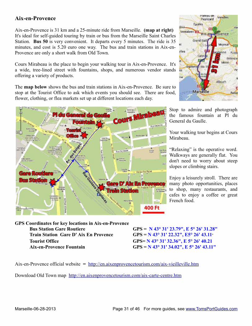
Aix-en-Provence
Aix-en-Provence is 31 km and a 25-minute ride from Marseille. (map at right)It's ideal for self-guided touring by train or bus from the Marseille Saint CharlesStation. Bus 50 is very convenient. It departs every 5 minutes. The ride is 35minutes, and cost is 5.20 euro one way. The bus and train stations in Aix-en-Provence are only a short walk from Old Town.
Cours Mirabeau is the place to begin your walking tour in Aix-en-Provence. It'sa wide, tree-lined street with fountains, shops, and numerous vendor standsoffering a variety of products.
The map below shows the bus and train stations in Aix-en-Provence. Be sure tostop at the Tourist Office to ask which events you should see. There are food,flower, clothing, or flea markets set up at different locations each day.
Stop to admire and photographthe famous fountain at Pl duGeneral du Gaulle.
Your walking tour begins at CoursMirabeau.
“Relaxing” is the operative word.Walkways are generally flat. Youdon't need to worry about steepslopes or climbing stairs.
Enjoy a leisurely stroll. There aremany photo opportunities, placesto shop, many restaurants, andcafes to enjoy a coffee or greatFrench food.
GPS Coordinates for key locations in Aix-en-ProvenceBus Station Gare Routiere GPS = N 43° 31' 23.79", E 5° 26' 31.28" Train Station Gare D' Aix En Provence GPS = N 43° 31' 22.32", E5° 26' 43.11" Tourist Office GPS= N 43° 31' 32.36", E 5° 26' 40.21 Aix-en-Provence Fountain GPS = N 43° 31' 34.02", E 5° 26' 43.11"
Aix-en-Provence official website = http://en.aixenprovencetourism.com/aix-vieilleville.htm
Download Old Town map http://en.aixenprovencetourism.com/aix-carte-centre.htm
Marseille-06-28-2013 Page 31 of 46 For more guides, see www.TomsPortGuides.com
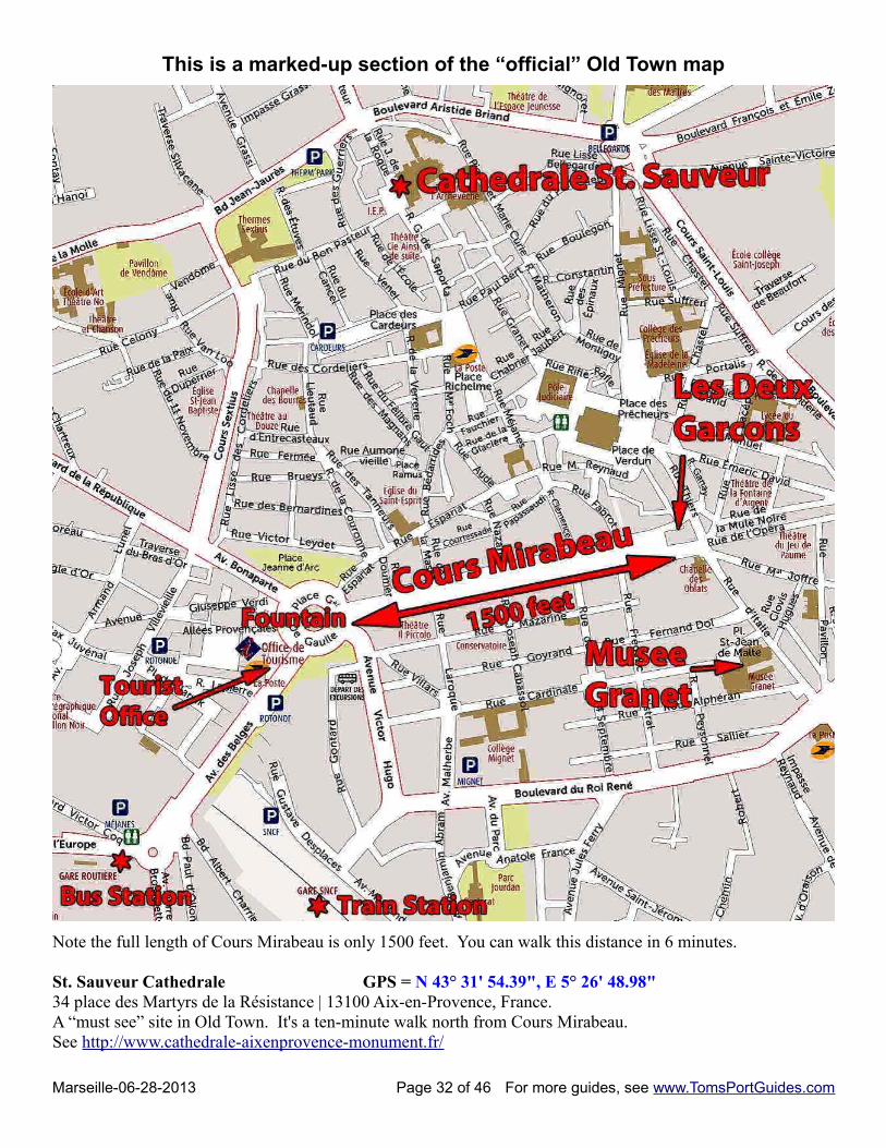
This is a marked-up section of the “official” Old Town map
Note the full length of Cours Mirabeau is only 1500 feet. You can walk this distance in 6 minutes.
St. Sauveur Cathedrale GPS = N 43° 31' 54.39", E 5° 26' 48.98"34 place des Martyrs de la Résistance | 13100 Aix-en-Provence, France. A “must see” site in Old Town. It's a ten-minute walk north from Cours Mirabeau. See http://www.cathedrale-aixenprovence-monument.fr/
Marseille-06-28-2013 Page 32 of 46 For more guides, see www.TomsPortGuides.com
Les Deux GarconsThis is a famous cafe that was popular with artists and intellectuals. Recent reviewers all agree the interior giltdécor is impressive, but many complain the food and service have been poor.
Musée Granet Place Saint Jean de Malte 13100 Aix-en-Provence, FranceSee http://www.museegranet-aixenprovence.fr/www/index5.html http://en.aixenprovencetourism.com/aix-granet-tipi.htm
Nearly 600 paintings, sculptures and archaeological pieces are on display: paintings from the 17th century French school, a room devoted to Paul Cézanne with 9 oil paintings, the Cézanne to Giacometti Collection (works by Giacometti, Picasso, Léger, Klee, de Staël, Tal Coat, Velde) as well as collections from the European schools (Flemish, Italian, Dutch) with Rubens, Rembrandt, a sculpture gallery, and an Entremont room (Celto-Ligurian sculptures from the Entremont archaeological site)
Summer hours: 9 am to 7 pm all week except 9 am to 11 pm on ThursdayAdmission: 4 euros
Getting from Marseille to Aix-en-Provence
My strategy for self-guided touring from a cruise port is to go to the furthest site first and travel closer to theport to visit other sites so that I can spend a full day without risk of being too far from the ship to get back intime. We took the ship's shuttle bus from the cruise dock to Vieux Port and walked to the train station:Saint Charles Train and Bus Station GPS = N 43° 18' 10", E 5° 22' 46"http://www.gares-en-mouvement.com/fr/frmsc/votre-gare/
Train schedules and fares:See http://www2.raileurope.com/ Trains run twice an hour, cost ~ 9 euro, and it's a 44 minutes ride.
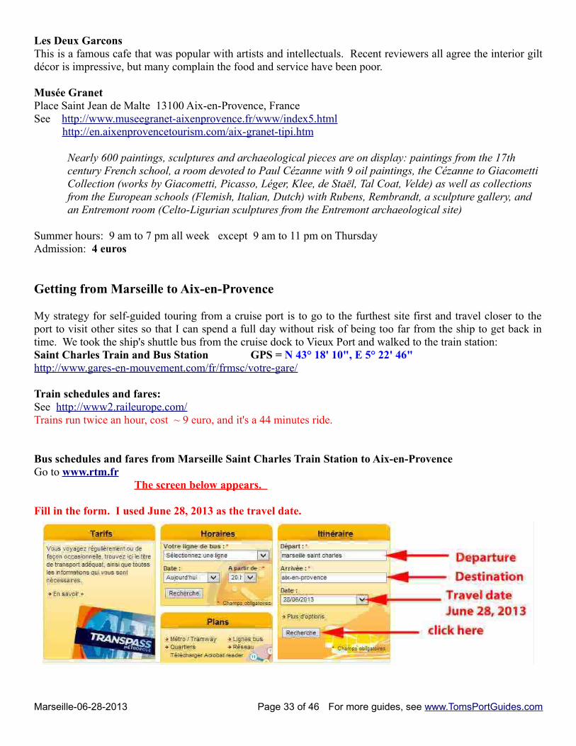
Bus schedules and fares from Marseille Saint Charles Train Station to Aix-en-ProvenceGo to www.rtm.fr
The screen below appears.
Fill in the form. I used June 28, 2013 as the travel date.
Marseille-06-28-2013 Page 33 of 46 For more guides, see www.TomsPortGuides.com
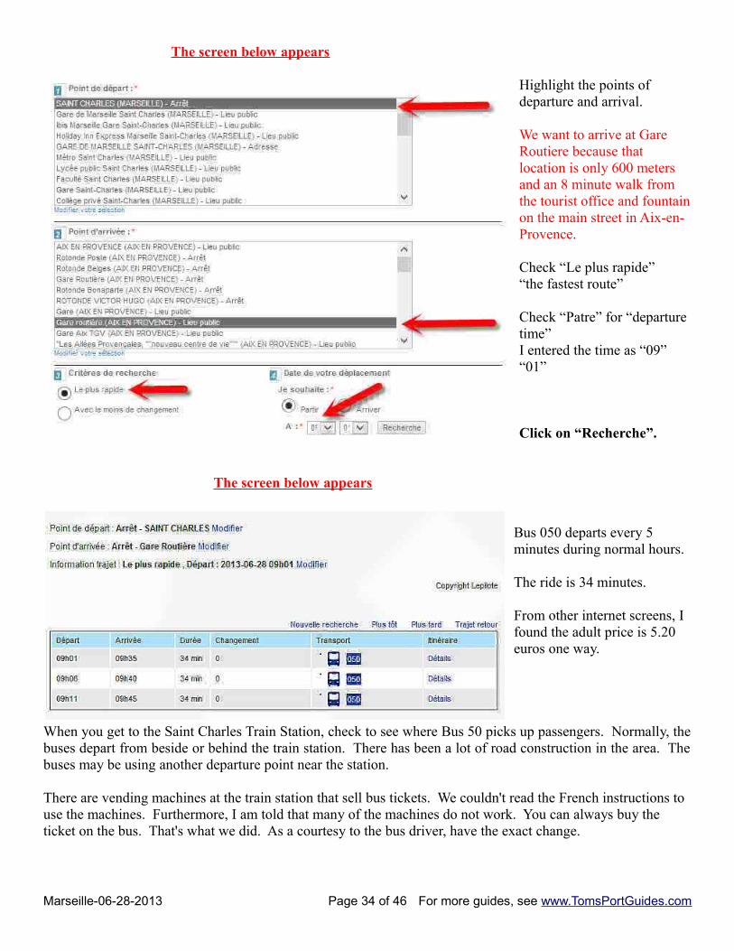
The screen below appears
Highlight the points of departure and arrival.
We want to arrive at Gare Routiere because that location is only 600 meters and an 8 minute walk from the tourist office and fountainon the main street in Aix-en-Provence.
Check “Le plus rapide”“the fastest route”
Check “Patre” for “departure time”I entered the time as “09” “01”
Click on “Recherche”.
The screen below appears
Bus 050 departs every 5 minutes during normal hours.
The ride is 34 minutes.
From other internet screens, I found the adult price is 5.20 euros one way.
When you get to the Saint Charles Train Station, check to see where Bus 50 picks up passengers. Normally, thebuses depart from beside or behind the train station. There has been a lot of road construction in the area. Thebuses may be using another departure point near the station.
There are vending machines at the train station that sell bus tickets. We couldn't read the French instructions to use the machines. Furthermore, I am told that many of the machines do not work. You can always buy the ticket on the bus. That's what we did. As a courtesy to the bus driver, have the exact change.
Marseille-06-28-2013 Page 34 of 46 For more guides, see www.TomsPortGuides.com
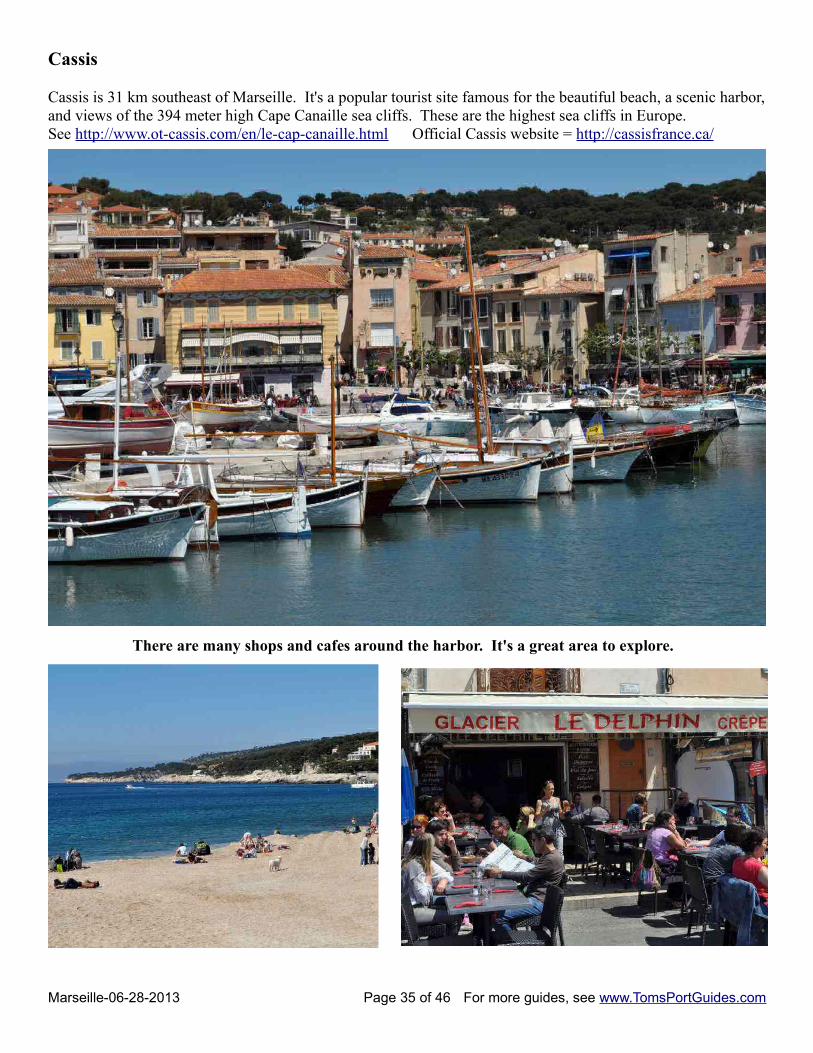
Cassis
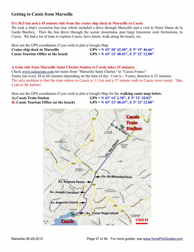
Cassis is 31 km southeast of Marseille. It's a popular tourist site famous for the beautiful beach, a scenic harbor,and views of the 394 meter high Cape Canaille sea cliffs. These are the highest sea cliffs in Europe.See http://www.ot-cassis.com/en/le-cap-canaille.html Official Cassis website = http://cassisfrance.ca/
There are many shops and cafes around the harbor. It's a great area to explore.
Marseille-06-28-2013 Page 35 of 46 For more guides, see www.TomsPortGuides.com
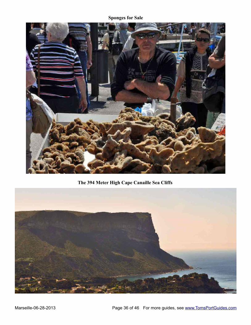
Sponges for Sale
The 394 Meter High Cape Canaille Sea Cliffs
Marseille-06-28-2013 Page 36 of 46 For more guides, see www.TomsPortGuides.com
Getting to Cassis from Marseille
It's 38.5 km and a 45 minute ride from the cruise ship dock in Marseille to CassisWe took a ship's excursion bus tour which included a drive through Marseille and a visit to Notre Dame de laGarde Basilica. Then the bus drove through the scenic mountains, past large limestone rock formations, toCassis. We had a lot of time to explore Cassis, have lunch, walk along the beach, etc.
Here are the GPS coordinates if you wish to plot a Google Map.Cruise ship dock in Marseille GPS = N 43° 20' 42.40", E 5° 19' 46.66"Cassis Tourism Office at the beach GPS = N 43° 12' 48.43", E 5° 32' 12.00"
A train ride from Marseille Saint Charles Station to Cassis takes 25 minutesCheck www.raileurope.com for trains from “Marseille Saint Charles” to “Cassis France”Trains run every 30 to 60 minutes depending on the time of day. Cost is ~ 9 euro; duration is 25 minutes. The only problem is that the train station in Cassis is 3.1 km and a 37 minute walk to Cassis town center. Takea cab to the harbor!
Here are the GPS coordinates if you wish to plot a Google Map for the walking route map below.A) Cassis Train Station GPS = N 43° 14' 2.30", E 5° 33' 10.02"B) Cassis Tourism Office (at the beach) GPS = N 43° 12' 48.43", E 5° 32' 12.00"
Marseille-06-28-2013 Page 37 of 46 For more guides, see www.TomsPortGuides.com
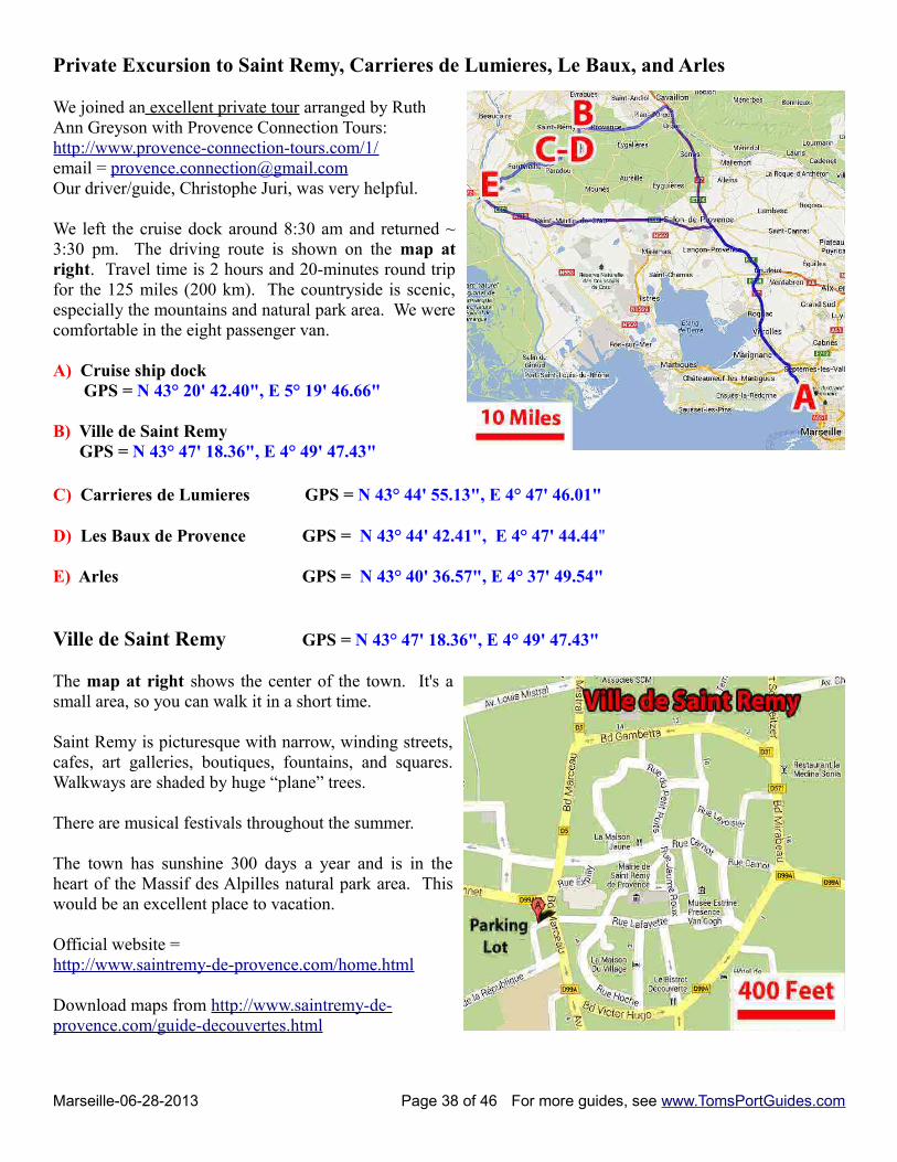
Private Excursion to Saint Remy, Carrieres de Lumieres, Le Baux, and Arles
We joined an excellent private tour arranged by RuthAnn Greyson with Provence Connection Tours:http://www.provence-connection-tours.com/1/ email = [email protected] driver/guide, Christophe Juri, was very helpful.
We left the cruise dock around 8:30 am and returned ~3:30 pm. The driving route is shown on the map atright. Travel time is 2 hours and 20-minutes round tripfor the 125 miles (200 km). The countryside is scenic,especially the mountains and natural park area. We werecomfortable in the eight passenger van.
A) Cruise ship dock GPS = N 43° 20' 42.40", E 5° 19' 46.66"
B) Ville de Saint Remy GPS = N 43° 47' 18.36", E 4° 49' 47.43"
C) Carrieres de Lumieres GPS = N 43° 44' 55.13", E 4° 47' 46.01"
D) Les Baux de Provence GPS = N 43° 44' 42.41", E 4° 47' 44.44"
E) Arles GPS = N 43° 40' 36.57", E 4° 37' 49.54"
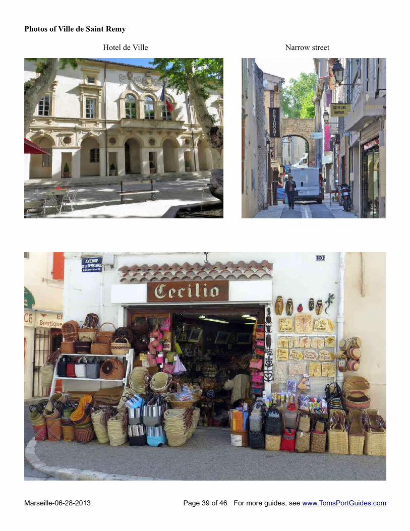
Ville de Saint Remy GPS = N 43° 47' 18.36", E 4° 49' 47.43"
The map at right shows the center of the town. It's asmall area, so you can walk it in a short time.
Saint Remy is picturesque with narrow, winding streets,cafes, art galleries, boutiques, fountains, and squares.Walkways are shaded by huge “plane” trees.
There are musical festivals throughout the summer.
The town has sunshine 300 days a year and is in theheart of the Massif des Alpilles natural park area. Thiswould be an excellent place to vacation.
Official website =http://www.saintremy-de-provence.com/home.html
Download maps from http://www.saintremy-de-provence.com/guide-decouvertes.html
Marseille-06-28-2013 Page 38 of 46 For more guides, see www.TomsPortGuides.com
Photos of Ville de Saint Remy
Hotel de Ville Narrow street
Marseille-06-28-2013 Page 39 of 46 For more guides, see www.TomsPortGuides.com
Carrieres de Lumieres GPS = N 43° 44' 55.13", E 4° 47' 46.01"http://www.carrieres-lumieres.com/fr/home
This site is amazing! I've never seen anything like it, and highly recommend it.
The setting is an abandoned limestone quarry carved into a mountain. You enter through an opening in thelimestone into a huge cavern with perpendicular, white walls about 30 to 50 feet high. There are no lightsexcept projectors which display paintings by French Impressionist artists. Music is playing in the backgroundas the paintings move along the walls and floor. Unlike museums which are static, this experience immersesyou in the art as the paintings slowly move across the walls and floor. People standing and moving about theroom become part of the art. I loved it!
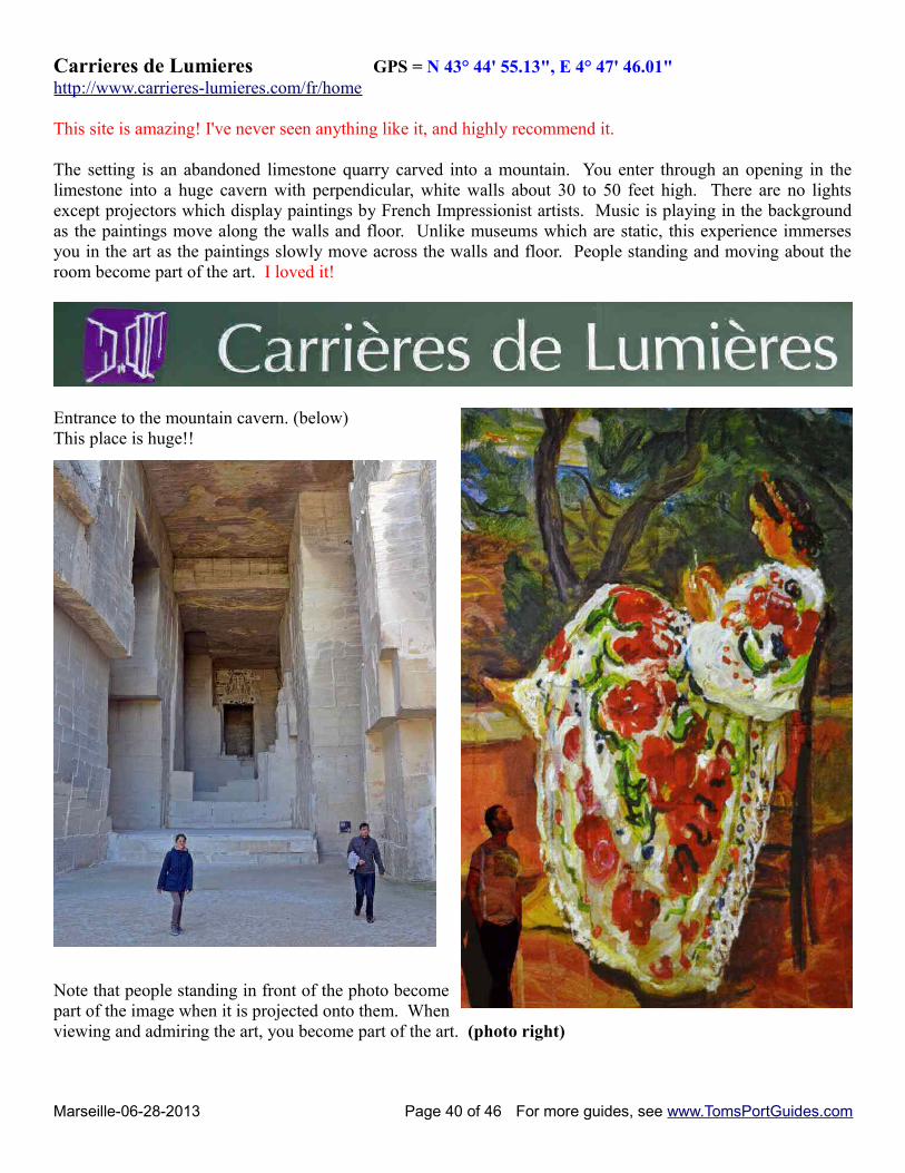
Entrance to the mountain cavern. (below)This place is huge!!
Note that people standing in front of the photo becomepart of the image when it is projected onto them. Whenviewing and admiring the art, you become part of the art. (photo right)
Marseille-06-28-2013 Page 40 of 46 For more guides, see www.TomsPortGuides.com
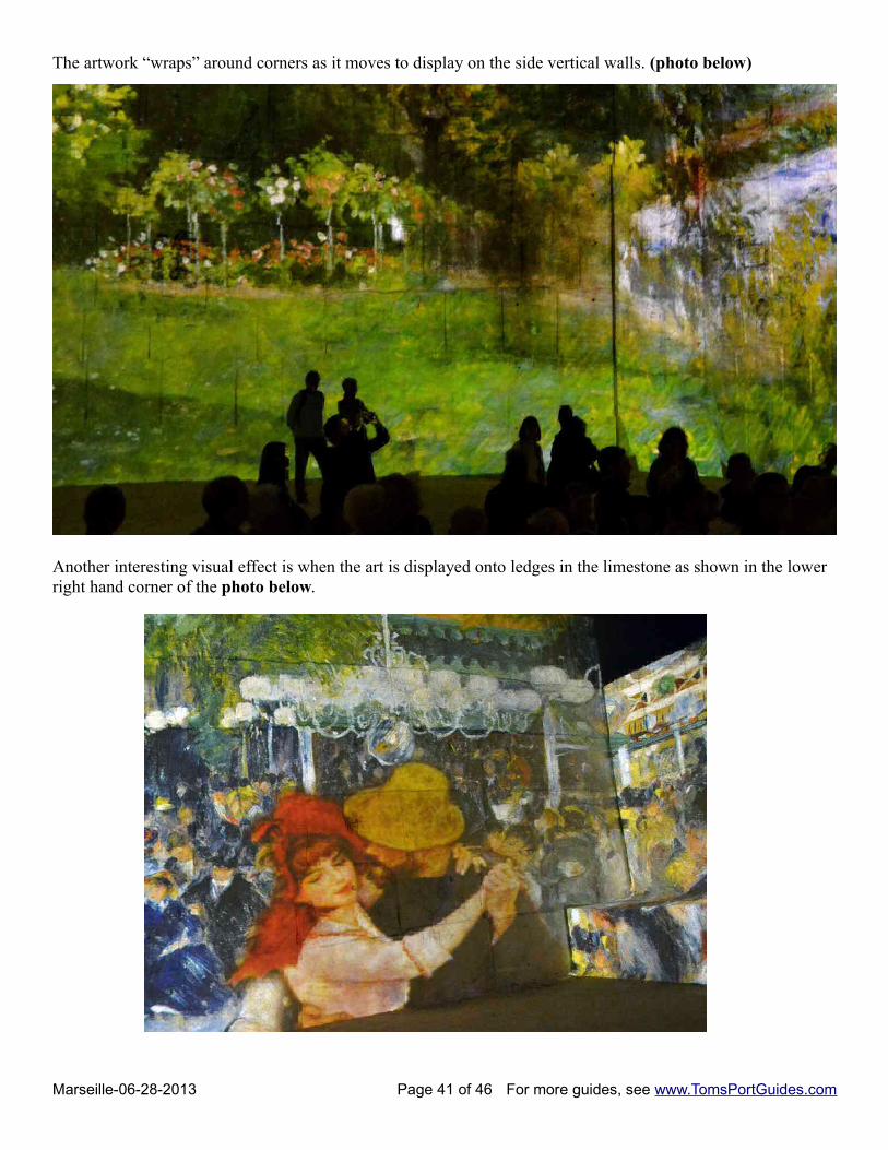
The artwork “wraps” around corners as it moves to display on the side vertical walls. (photo below)
Another interesting visual effect is when the art is displayed onto ledges in the limestone as shown in the lower right hand corner of the photo below.
Marseille-06-28-2013 Page 41 of 46 For more guides, see www.TomsPortGuides.com
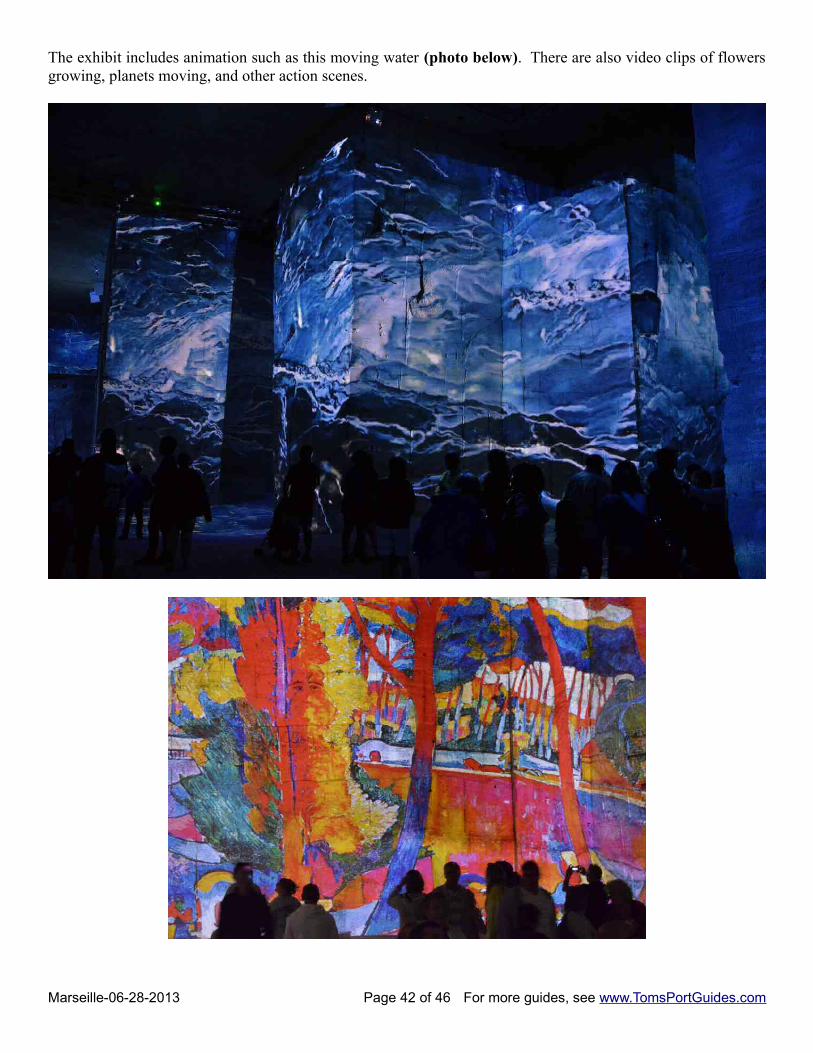
The exhibit includes animation such as this moving water (photo below). There are also video clips of flowersgrowing, planets moving, and other action scenes.
Marseille-06-28-2013 Page 42 of 46 For more guides, see www.TomsPortGuides.com
Hours: 9:30 am – 7 pm March 8 – September 30 10 am – 6 pm October 1 – January 5Admission: 9.50 euroYou'll need an hour to see the entire show
Tips on taking photos:There isn't much light. The camera has to acquire focus and render colors faithfully in very low-light conditions. Iuse a Nikon D7000 because it handles low light photography well in cathedrals, caves, museums, the cruise ship'sdarkened theater, etc. My camera takes “no excuse” photos at ISO 6400 without color separation. At the quarry,the camera automatically selected ISO 6400 and a shutter speed of 1/60 to 1/15 with an f-stop of 4.0. I leanedagainst a wall to hold the camera steady.
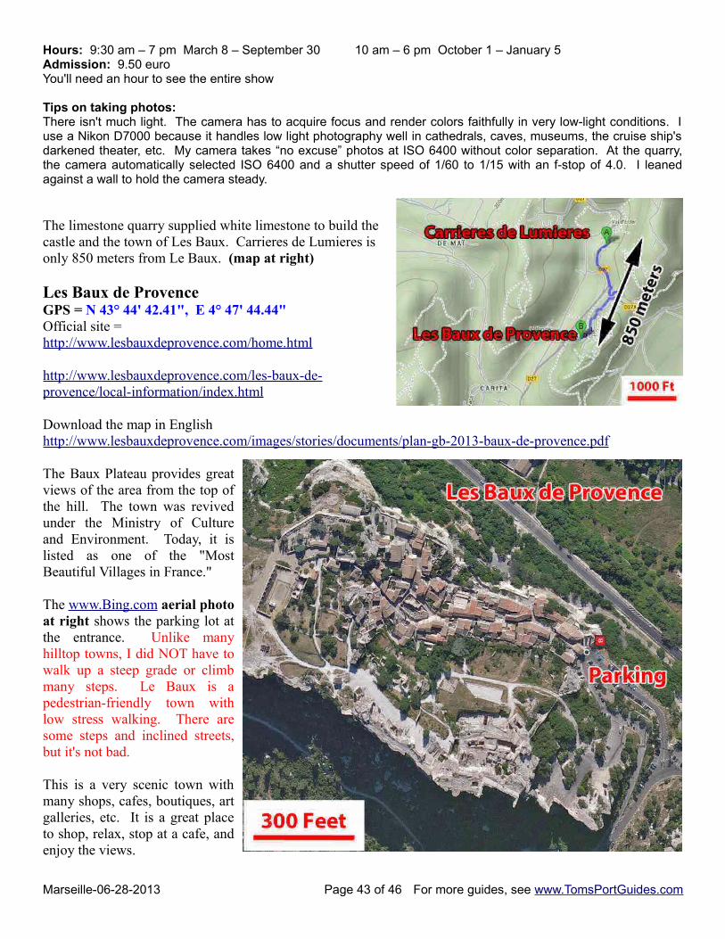
The limestone quarry supplied white limestone to build thecastle and the town of Les Baux. Carrieres de Lumieres isonly 850 meters from Le Baux. (map at right)
Les Baux de Provence GPS = N 43° 44' 42.41", E 4° 47' 44.44"Official site = http://www.lesbauxdeprovence.com/home.html
http://www.lesbauxdeprovence.com/les-baux-de-provence/local-information/index.html
Download the map in Englishhttp://www.lesbauxdeprovence.com/images/stories/documents/plan-gb-2013-baux-de-provence.pdf
The Baux Plateau provides greatviews of the area from the top ofthe hill. The town was revivedunder the Ministry of Cultureand Environment. Today, it islisted as one of the "MostBeautiful Villages in France."
The www.Bing.com aerial photoat right shows the parking lot atthe entrance. Unlike manyhilltop towns, I did NOT have towalk up a steep grade or climbmany steps. Le Baux is apedestrian-friendly town withlow stress walking. There aresome steps and inclined streets,but it's not bad.
This is a very scenic town withmany shops, cafes, boutiques, artgalleries, etc. It is a great placeto shop, relax, stop at a cafe, andenjoy the views.
Marseille-06-28-2013 Page 43 of 46 For more guides, see www.TomsPortGuides.com
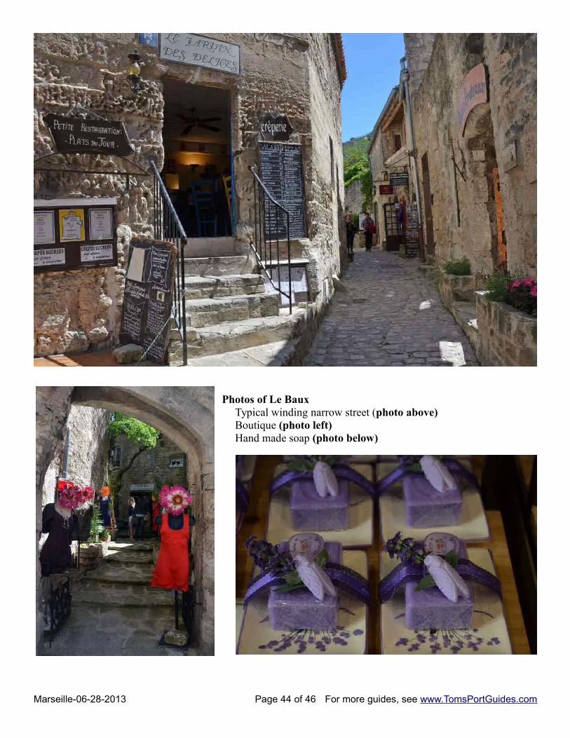
Photos of Le BauxTypical winding narrow street (photo above)Boutique (photo left)Hand made soap (photo below)
Marseille-06-28-2013 Page 44 of 46 For more guides, see www.TomsPortGuides.com
Arles GPS = N 43° 40' 36.57", E 4° 37' 49.54"Arles is a large, scenic town influenced by the Romans and the French:
• The most prominent landmark is the huge arena used by Roman gladiators two thousand years ago. There are several other well-preserved Roman landmarks.
• Arles was also influenced by famous painters such as Van Gogh. There are many art galleries and museums in the area.
Official website= http://www.ville-arles.fr/ Download brochures http://www.arlestourisme.com/download-brochures.html download old town map http://www.arlestourisme.com/document/pdfs_document/plan_cv_arles_2012.pdf For info on landmarks http://arlesfrance.ca/attractions/landmarks.html
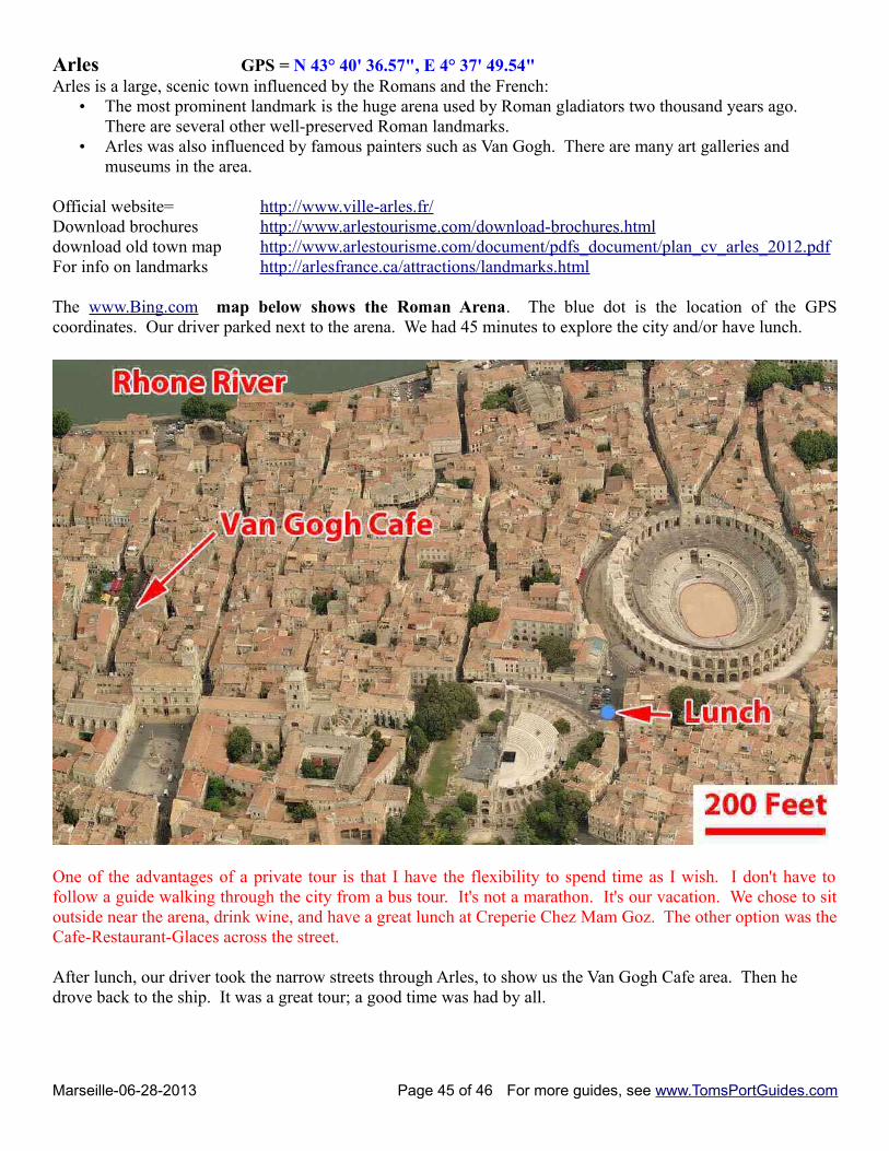
The www.Bing.com map below shows the Roman Arena. The blue dot is the location of the GPScoordinates. Our driver parked next to the arena. We had 45 minutes to explore the city and/or have lunch.
One of the advantages of a private tour is that I have the flexibility to spend time as I wish. I don't have tofollow a guide walking through the city from a bus tour. It's not a marathon. It's our vacation. We chose to sitoutside near the arena, drink wine, and have a great lunch at Creperie Chez Mam Goz. The other option was theCafe-Restaurant-Glaces across the street.
After lunch, our driver took the narrow streets through Arles, to show us the Van Gogh Cafe area. Then he drove back to the ship. It was a great tour; a good time was had by all.
Marseille-06-28-2013 Page 45 of 46 For more guides, see www.TomsPortGuides.com
User Feedback Is Welcome GoalMy guides are designed to help you plan a great cruise vacation by providing information such as where the ship docks, location of tourist sites, public transit, walking tour maps, things to see and do, travel issues unique to the port, etc. Knowledge of ports is important when planning shore excursions because you have to make many decisions and commitments long before your ship docks. I believe the information in this guide is accurate, however you are responsible to verify accuracy of the information that you use to plan your vacation.
Information on cruise ports frequently changes such as bus routes, admission fees to sites, rental car locations, etc. Cruise Critic is the best source for up-to-date, detailed information on travel details for shore excursions, reviews of cruise ships, etc. There are many knowledgeable people on Cruise Critic who are willing to share their expertise and travel experience. I highly recommend www.CruiseCritic.com; it's free to join.
Why feedback is importantUser feedback helps me make corrections and improve the format and content in my quest to produce the“ultimate” port guides. I welcome offers to collaborate with me or provide materials for use in my guides.
PLEASE Help “spread the word” about my websiteThe only negative feedback I get is, “I wish I knew about your port guides before my vacation”. Please tellyour friends and post a reference to my guides and website on the blogs. To receive email notification whennew guides are available, send your email address to me at [email protected]
Copyright Notice & Terms and Conditions for Use of My Guides
My port guides and everything on my website www.TomsPortGuides.com is copyrighted by Thomas Sheridanwith all rights reserved, and protected by international copyright laws.
PERMITTED USE: Personal, non-commercial use of my port guides and/or material from my website.
I allow individuals to take my guides apart for personal, non-commercial use. Many cruisers carry a map or afew pages from my guide on a shore excursion. That's OK. I also allow people to post my guides on websitesthey set up for fellow travelers to share information on shore excursions such as the websites set up by CruiseCritic members for the Roll Calls. That's OK. My guides are for use and enjoyment of individual travelers.
PROHIBITED USE of my port guides and/or material from my website.NO person, company, organization, website, etc. is permitted to use material from my website for a commercialpurpose, to sell, require a membership to download my port guides, or use my copyrighted material for acommercial purpose.
NO person, company, organization, website, etc. is permitted to distribute excerpts from my guides or materialfrom my website as electronic, digital, or paper copies. My Port Guides must be kept intact, as downloadedfrom my website, with this copyright notice.
NO Cruise Ship employee, representative, contractor, port lecturer, etc. is permitted to distribute excerpts frommy guides or material from my website as electronic, digital or paper copies. My Port Guides must be keptintact, as downloaded from my website, with this copyright notice. A blatant example of violation of mycopyright was a cruise ship docked in Copenhagen where the shore excursion desk personnel removed mapsfrom my guide, removed my name as the copyright owner, and copied/distributed my maps.
Fortunately, a friend of mine on that ship complained to the purser and the ship stopped violating my copyright.
If there is any question about use of my guides, contact me at [email protected]
Tom Sheridan
Marseille-06-28-2013 Page 46 of 46 For more guides, see www.TomsPortGuides.com