Toms Bilbao Cruise Port Guide: Spain...Toms Bilbao Cruise Port Guide: Spain A 37 page guide with 18...
38
Transcript of Toms Bilbao Cruise Port Guide: Spain...Toms Bilbao Cruise Port Guide: Spain A 37 page guide with 18...


Toms Bilbao Cruise Port Guide: Spain A 37 page guide with 18 maps, 29 photos, descriptions of tourist sites in Bilbao, San Juan de Gatzelugatxe, Bermeo Fishing Village, and Guernika (Gernika). The guide includes:
An overview map of Bilbao port, ferry port, train station, airport, key metro stops, and tourist sites, Three Bilbao city walking tour maps with metro/bus stops, and location of lifts/elevators and stairs to deal with elevation changes in the hills and mountains that surround the city, Bilbao points of interest including museums, churches, gardens, shopping areas, the funicular, etc., San Juan de Gatzelugatxe - an amazing, tiny rock peninsula with a chapel built high above the sea by the Knights Templar in the 10th Century. Access is via walkways and steps on top of narrow rock walls,A Bermeo Old Town walking tour with maps and descriptions of the sites, and A walking tour map of Gernika to the two most popular sites, the Assembly House and Oak Tree.
In 1992, city planners decided to transform Bilbao from a declining, unsustainable, polluted, industrial city to aworld class, vibrant, beautiful, cosmopolitan city. Bilbao is one of best known success stories in Europe.
Today, Bilbao is clean and inviting with excellent restaurants, cafes, shopping, tourist sites, historic buildings,museums, churches, and a new network of efficient, modern, beautiful, world-class public transportation i. e.Norman Foster's Underground and Calatrava's airport with towers designed by architects Arata Isozaki andCésar Pelli. Other examples of impressive architecture include the Guggenheim Museum, the EuskaldunaConference and Music Centre (designed to look like a ship under construction), the Zubizuri pedestrian bridge,etc. Buildings are more than functional, the architecture is like “works of art in an outdoor museum.”
Bilbao is the centre of economic-social development of the Bay of Biscay. The city is set into scenic mountains surrounded by a fertile landscape with forests, beaches, and steep coasts. Visit fishing villages, historic towns, and the capitals of Vitoria and San Sebastián in Basque Country. Bilbao is a privileged destination for visitors.
This guide includes a detailed description of the cruise ship's 5.5 hour bus excursion tour to San Juan deGatzelugatxe, an amazing peninsula with pedestrian access via a very narrow rock walk hundreds of feet abovethe sea, a walking tour of Bermeo Old Town, and a stop at Guernika to see the Assembly House and Oak Tree.
The good news is that there are many things to see and do from Bilbao port. Unfortunately, time is limited on acruise shore excursion. You can't do it all. Hopefully, this guide will help you plan your time in port for yourpriorities to have a memorable visit.
GPS coordinates from this guide can be used in Google or Microsoft Bing maps such as “road”, “satellite”,“birdseye”, “earth”, or “terrain” views to see details at the location at any map scale. You can “walk” throughthe city using Google street-level photos and determine distance and time for walking or riding in a vehicle.
The coordinates can also be used in hand-held or vehicle GPS devices. Set your device to input data in theformat of Degrees, Minutes, and Seconds shown as N ddd° mm' ss.ss”, W ddd° mm' ss.ss”
You can copy and paste GPS coordinates from this guide into Google or Bing maps. You can also type thecoordinates into the map. You don't need to type the symbols for degrees, minutes, and seconds. Replace thesesymbols with “spaces” and type the letters, numbers, and decimal points into the map.
Example: The cruise ship terminal in Bilbao has GPS = 43° 20' 21.378" N 3° 1' 16.824" W"
Type 43 20 21.378 n 3 1 16.824 w into the Google Map search box. Google will find the location.
CAVEAT
Information contained herein is believed to be accurate. PLEASE verify the information you use for your travelplans. Opinions expressed are my own. This port guide is protected by copyright law - see the last page of thisguide for legal notices.
Tom Sheridan
Bilbao-Spain-09-20-2015 Page 1 of 37 For more guides, see www.TomsPortGuides.com

Table of Contents – Bilbao Port Guide: Spain
Subject Page
Overview map showing the port, airport, train station, metro stops, port shuttle bus stops, funicular 3
Travel options from the port to the city via shuttle bus, public bus, taxi, metro 4
Metro Lines 1 & 2 with key stops highlighted 5
Walking route maps from the cruise terminal to Neguri metro station 6-7
Description of the three metro zones with information on prices and the metro website 8
Getting around – walking, HopOn bus, tourist information and maps, urban bus network and website 9-10
Center city Bilbao orientation map and popular walking routes 11
Walking tour and tourist sights between Moyua to Plaza Circular 12
Casco Viejo (Old Quarter) walking tour and tourist sites 13-15
How to get to the top of the hill to visit the Virgin of Begoña Basilica 15-17
Walking tour from Casco Viejo along Nervion River to the Funicular & Center City sights 18-23
Map – ship's bus excursion to San Juan de Gatzelugatxe, Bermeo, and Gernika (Guernika) 24
Bermeo Fishing Village points of interest 25
Map – walking tour of Bermeo Old Town 26
The whale boat, marina, and bronze statues looking out to sea watching and waiting for the boats 27-28
Town Hall and Santa Maria Church at the main square in Old Town 29-30
San Francisco Church and Cloister 31
Gernika (Guernika) walking tour map 32
Santa Maria Church, Museo Euskal Herria, Oak Tree of Gernika 33
The Assembly House (Arbol de Gernika y Casa de Juntas) 34-35
Santa Clara Church, sculpture in the park, tourist information on Gernika 36
User Feedback, Copyright Notice, Terms and Conditions for use of Toms Port Guides 37
Bilbao-Spain-09-20-2015 Page 2 of 37 For more guides, see www.TomsPortGuides.com
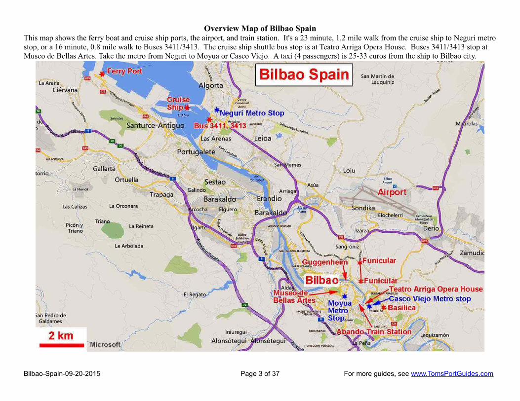
Overview Map of Bilbao SpainThis map shows the ferry boat and cruise ship ports, the airport, and train station. It's a 23 minute, 1.2 mile walk from the cruise ship to Neguri metrostop, or a 16 minute, 0.8 mile walk to Buses 3411/3413. The cruise ship shuttle bus stop is at Teatro Arriga Opera House. Buses 3411/3413 stop at Museo de Bellas Artes. Take the metro from Neguri to Moyua or Casco Viejo. A taxi (4 passengers) is 25-33 euros from the ship to Bilbao city.
Bilbao-Spain-09-20-2015 Page 3 of 37 For more guides, see www.TomsPortGuides.com

Travel Options from the Port to Bilbao CityNOTE: The Ferry boats and Cruise ships dock on opposite sides of the harbor. Travel options to/from the ferry boats and cruise ships are entirely different.
Ferry Boat Dock GPS = 43°21'12.3"N 3°04'14.8"W
The Ferry Port is near Santurtzi Metro Stop on Line 2 connecting to Bilbao center city
It's a 3 km, 5-minute, ~ 10 euros taxi ride from the Ferry Port to Santurtzi metro station. There is no public transport directly to the ferry terminal. Book taxis through Parada de Taxis de Santurtzi (Tel +34 94 461 03 56) parada-taxis-santurtzi
For information, see Brittany Ferries http://www.brittany-ferries.co.uk/guides/ports/bilbao
Cruise Ship Dock next to the cruise terminal GPS = 43° 20' 21.378" N 3° 1' 16.824" W
The cruise ship terminal is in the town of Getxo, beside a marina, a leisure area, and the beautiful EreagaEU Flag Beach. There are a few restaurants and shops next to the dock.
For information on the port, see http://www.bilbaoport.es/aPBW/web/en/port/cruises/index.jsp
Shuttle bus from Cruise Terminal to Teatro Arriga (Opera House) GPS = 43°15'35.3"N 2°55'27.6"W
Cruise ships usually provide a shuttle bus for ~ 15 euros round trip to Teatro Arriga (the Opera House) next to Puente del Arenal (bridge) in Casco Viejo (the Old Quarter)
Taxi from the Cruise Terminal to Bilbao Centre CityTaxis from the cruise ship pier to center city are ~ 25-33 euros (4 person capacity).
I used the Taxi Fare Calculator Website to estimate the taxi fare from the “port” to “Guggenheim” as shown below. See http://www.numbeo.com/taxi-fare/city_result.jsp?country=Spain&city=Bilbao
Estimated Taxi Price from the Cruise Ship to Guggenheim MuseumDistance: 13.7 kmDuration: 20 minsStart Price: €4.0013.7 km x €1.86 : €25.49Waiting time (estimated 10.83 min): €3.16Overall price (estimation): €32.65
Neguri is the Closest Metro Stop to the Cruise Ship Terminal
It's a 23-minute, 1.2 mile walk from the cruise terminal to Neguri Metro Stop on Line 1. The walk is through an attractive neighborhood. See pages 6 and 7 of this guide for walking route maps to the metro. The metro departs on about 5 to 10 minute intervals. Travel time from Neguri to centre city is about 20 minutes.
Bizkaibus Bus from the Cruise Ship Terminal to Bilbao Centre City
This bus line connects the airport and port with the city. Bus line 3413 runs every 30 minutes, line 3411 runs once an hour. The bus stop is a 16 minute, 0.8 mile walk from the cruise terminal as shown on the map on page 7 of this guide.
The 30 minute bus ride to center city Bilbao is a scenic route along the river ending at the Fine Arts Museum, Museo de Bellas Artes GPS = 43°15′54.9″N 02°56′16.8″W
Free shuttle bus from the Cruise Terminal to Gexto Metro Stops
There are also free shuttle buses every 20 minutes from the cruise terminal to metro stations of Areeta and Algorta in Gexto. These metro stations are on either side of Neguri (two metro stops) away. See themetro map on the next page.
Bilbao-Spain-09-20-2015 Page 4 of 37 For more guides, see www.TomsPortGuides.com

Metro Lines 1 and 2 from Bilbao Port to the City
Bilbao-Spain-09-20-2015 Page 5 of 37 For more guides, see www.TomsPortGuides.com

Walking route from the Cruise Ship Terminal to Neguri Metro Station. The Cruise Terminal GPS = 43° 20'21.378"N 3°1'16.824" W Neguri Metro Station GPS = 43°20'24.9"N 3°00'20.3"W
If you don't mind a 23-minute, 1.2 mile (1.9 km) walk, the Metro from Neguri is one of the best ways to get from the ship to center city:• The metro runs every 5-10 minutes. Buses do not run that frequently.• The metro travels underground and is not delayed by road traffic.• Buses and taxis can be delayed by road traffic. When I visited Bilbao, there was a huge traffic jam between the port and the city. Our tour
bus was delayed 30 minutes due to traffic. Our guide told us that morning traffic jams are common in Bilbao. • You'll waste 20 minutes waiting in line and getting on the ship's shuttle bus at the port. You could use those 20 minutes walking to the metro.
The first part of the walking route from the cruise ship terminal to Neguri Metro Station is shown as a blue dashed line on the map below.
Turn right at Ereaga Beach and walk southeast along the harbor past the mansions. This is a very attractive area in an upscale neighborhood.
Bilbao-Spain-09-20-2015 Page 6 of 37 For more guides, see www.TomsPortGuides.com

The map below shows the second part of the walk to Neguri Metro Station.
Turn right at the beach; walk southeast along the harbor. At the first intersection, turn left (north). Bear right at the square and continue to bear right to the metro station. It's a gradual uphill walk rising from 45 feet above sea level near the harbor to 100 feet above sea level at the metro station.
Stops for Bizkaibus bus 3411 and 3413 are shown on the map. It's a 16 minute, 0.8 mile walk from the cruise terminal to these bus stops. The buses only run on 30 or 60 minute intervals. By comparison, it's a 23 minute, 1.2 mile walk to Neguri metro with departure every 5 to 10 minutes, no delaydue to road traffic, and the option to exit the metro at different locations in the city. I believe metro is better than public bus travel to/from the port.
Bilbao-Spain-09-20-2015 Page 7 of 37 For more guides, see www.TomsPortGuides.com
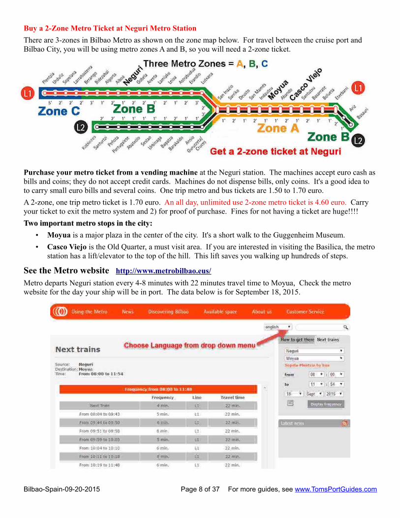
Buy a 2-Zone Metro Ticket at Neguri Metro Station
There are 3-zones in Bilbao Metro as shown on the zone map below. For travel between the cruise port and Bilbao City, you will be using metro zones A and B, so you will need a 2-zone ticket.
Purchase your metro ticket from a vending machine at the Neguri station. The machines accept euro cash asbills and coins; they do not accept credit cards. Machines do not dispense bills, only coins. It's a good idea to to carry small euro bills and several coins. One trip metro and bus tickets are 1.50 to 1.70 euro.
A 2-zone, one trip metro ticket is 1.70 euro. An all day, unlimited use 2-zone metro ticket is 4.60 euro. Carry your ticket to exit the metro system and 2) for proof of purchase. Fines for not having a ticket are huge!!!!
Two important metro stops in the city:Two important metro stops in the city:
• Moyua is a major plaza in the center of the city. It's a short walk to the Guggenheim Museum.
• Casco Viejo is the Old Quarter, a must visit area. If you are interested in visiting the Basilica, the metrostation has a lift/elevator to the top of the hill. This lift saves you walking up hundreds of steps.
See the Metro website http://www.metrobilbao.eus/
Metro departs Neguri station every 4-8 minutes with 22 minutes travel time to Moyua, Check the metro website for the day your ship will be in port. The data below is for September 18, 2015.
Bilbao-Spain-09-20-2015 Page 8 of 37 For more guides, see www.TomsPortGuides.com

Getting Around BilbaoBilbao is a beautiful city with many things to see and do. There are many ways to get around the city:
Walking – it's a great city to explore on foot. Travel distances are reasonable. However, the city is surrounded by mountains. Outside center city, there are some areas where you may be walking on steep streets, climbing stairs, and areas where you need to use lifts/elevators. I have included detailed maps in this guide showing the location of lift/elevators and stairs with information on how to avoid or minimize stressful walking and climbing. The good news is that most of the tourist areas are in flat, easy to walk areas.
Most visitors combine walking with use of public transit via the metro or bus. Another very popular way to tourthe city is the HopOn bus.
HopOn Sightseeing Bus
Tickets (14 euros adult) can be purchased at any stop or beside Bilbao Turismo (near Abando Train Station), thedeparture point. The circuit takes about an hour, see http://www.busturistikoa.com/pdf/mapa_bilbao.pdf
Tourist Information and Maps for Bilbao SpainBilbao Tourism website http://www.bilbaoturismo.net/BilbaoTurismo/en/tourists
The tourism website is an excellent source of information with maps to download as high resolution pdf files.
Bilbao-Spain-09-20-2015 Page 9 of 37 For more guides, see www.TomsPortGuides.com
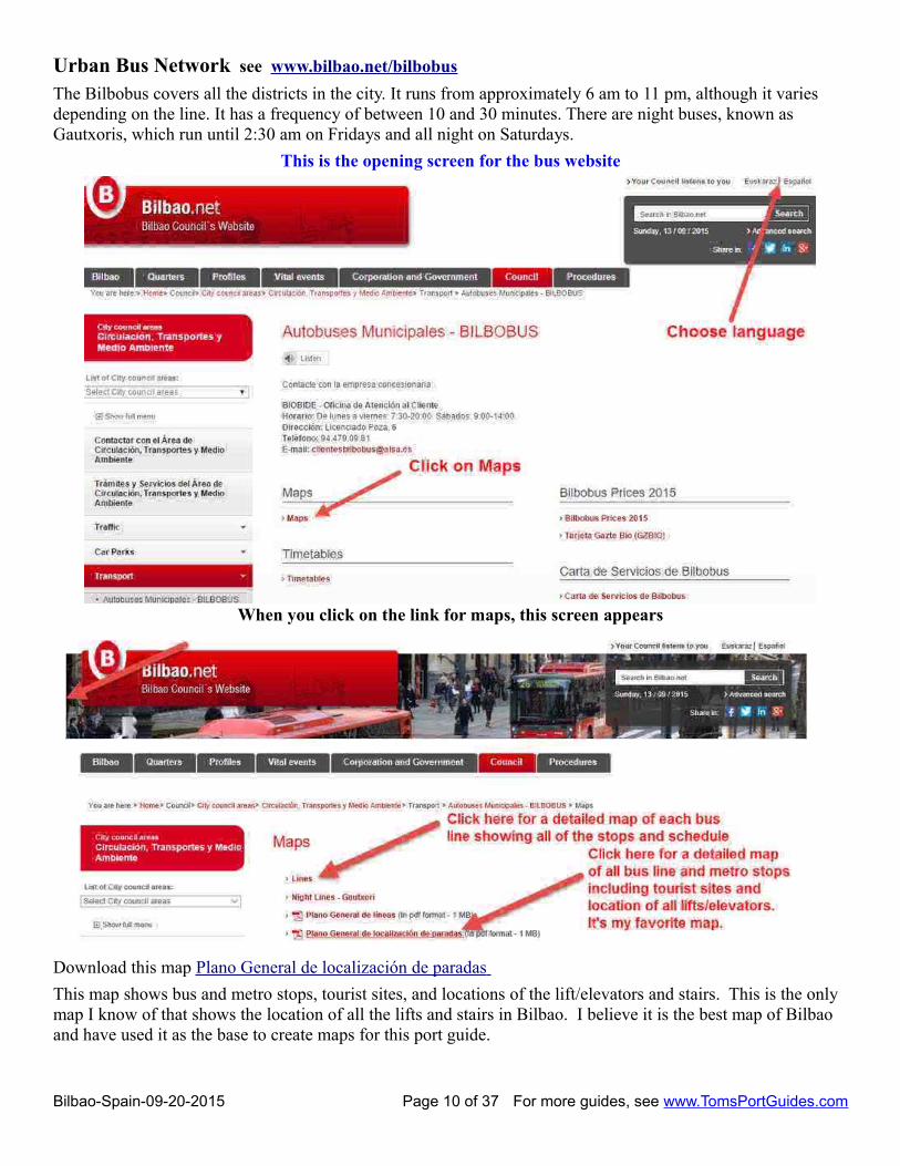
Urban Bus Network see www.bilbao.net/bilbobus
The Bilbobus covers all the districts in the city. It runs from approximately 6 am to 11 pm, although it varies depending on the line. It has a frequency of between 10 and 30 minutes. There are night buses, known as Gautxoris, which run until 2:30 am on Fridays and all night on Saturdays.
This is the opening screen for the bus website
When you click on the link for maps, this screen appears
Download this map Plano General de localización de paradas
This map shows bus and metro stops, tourist sites, and locations of the lift/elevators and stairs. This is the only map I know of that shows the location of all the lifts and stairs in Bilbao. I believe it is the best map of Bilbao and have used it as the base to create maps for this port guide.
Bilbao-Spain-09-20-2015 Page 10 of 37 For more guides, see www.TomsPortGuides.com

Center City Bilbao - Orientation Map
The cruise ship shuttle bus drops passengers off at Teatro Arriga, (Opera House) in the Old Quarter. Buses 3411 and 3413 from the port drop passengers off at Museo de Bellas Artes. Three metro stops of interest are Moyua, Circular, and Casco Viejo Unamuno.
This map also shows important landmarks including the Abando Train Station, Basilica, Funicular, Guggenheim Museum, and Museo Maritimo which is slightly west of the edge of this map. La Alhondiga is an old wine warehouse that has been converted to a cultural and leisure center with fine restaurants, shops, a swimming pool, library, etc.
Walking distance from Moyua to the Circular Metro Stop is 650 m (2130 feet) and takes 8 minutes. It's shown as a blue dashed line on the map above. From Circular, take the bridge across the river to Old Quarter. A popular walk is from Teatro Arriga to Museo Maritimo. This walk is 3.4 km and takes 45 minutes. It is shown as dashed red lines.
Bilbao-Spain-09-20-2015 Page 11 of 37 For more guides, see www.TomsPortGuides.com

Plaza de Don Federico MOYUA GPS = 43°15'46.8"N 2°56'06.0"W
This is one of the main plazas in the city. It's atransportation hub for the metro and several buses.
LA ALHONDIGA cultural and leisure centerGPS = 43°15'36.6"N 2°56'11.1"W
This is a must visit site. It's a huge building thattakes up an entire city block. It's the former siteof an old wine warehouse. The interior has beenrebuilt as a modern, very impressive structurewith cafes, upscale restaurants, a library, shops, agym, swimming pool, art, and exhibitions. It isalso used to host special events.
It is open Monday to Friday: 9:00 a.m. to 9:00p.m. Saturdays, Sundays and public holidays11:00 a.m. to 9:00 p.m. http://www.azkunazentroa.com/az/ingl/home
Google estimates it is a 3-minute 280m walk fromMoyua to La Alhoindiga. Walk along RecaldeZumarkalea. See the Map at right
This is an attractive area to explore on foot.
PLAZA CIRCULAR GPS = 43°15′40.7″N 02°55′37.9″W
The walk from Moyua to Plaza Circular is shown on the map below. Don Diego Lopez is the grand boulevard to the Old Quarter. There are cafes, hotels, banks, shops and many impressive buildings along the route. Stop at the provincial Council Hall for a photo. The Abando Train Station has a very large stained glass window inside the station. There is a tourist office at Plaza Circular. It's gorgeous inside. Walk across Puente del Arenal to the Old Quarter. Teatro Arriaga, the Opera House, will be on your right. This is the bus stop for the ship's shuttle bus between the dock and the city.
Bilbao-Spain-09-20-2015 Page 12 of 37 For more guides, see www.TomsPortGuides.com

Casco Viejo Walking TourThe Tourism website describes a walking route of the Old Quarter, but they do not provide a map. I created the map below and used the description of the tour from the Tourism website. This walk takes 18 minutes and is 0.9 miles. The terrain is generally flat. It's in a pedestrian area of Old Quarter with little traffic except at the squares where there are bus stops. It's a lovely area to have a stroll.The walk begins near (1) at the east end of Puente del Arenal next to Teatro Arriga and Arenal Park.
When the city of Bilbao was founded over 700 years ago, inhabitants made their living from market gardens and fishing. The river was beginning to emerge as the best means of communication with the outside world. At that time, there were two different centres of population. The left bank or Bilbao la Vieja, was a mining area where iron was worked in the foundries. The right bank, called the Old Quarter ("Casco Viejo"), engaged in commerce and port activities.
Bilbao-Spain-09-20-2015 Page 13 of 37 For more guides, see www.TomsPortGuides.com

Arenal Gardens GPS = 43°15′37.6″N 02°55′25.1″W
The Arenal, garden and Gateway, is reflected in the estuary. Trees and footpaths invite you to stroll and to sit in the shade of its plane trees. A bandstand and three paths, with their fountains, tell of past times. The Neo-Baroque façade of the (1) Arriaga Theatre emerges on one side, while opposite it the towers of (2) San Nicolás stand watch over this church reminiscent of fishermen and mariners.
Alongside the church, the first headquarters of the Banco Bilbao overlook a small square that takes its name from the temple.
Plaza Nueva GPS = 43°15′32.6″N 02°55′21.5″W
We turn into Askao street and then Fueros to head towards the heart of this city, the (3) Plaza Nueva; new because there was another old square and new because it never fails to reinvent itself. Businesses and Italian festivities of yesteryear have today given way to bars, where the pintxos jostle with each other to make room on the bar; and shops... and life.
Miguel de Unamuno Square
Leaving this square under one of its arches and going towards Sombrerería/Kapelagile, still enjoying the taste of txakoli, we glimpse the (4) Plaza Unamuno, and when we arrive, if we look up, perhaps we meet the gaze of the distinguished writer, who watches the Calzadas de Mallona from his column. This great bilbaíno was born close to this square, in Ronda street, and lived and grew up in these streets. We now take Calle de la Cruz street towards another of the historical churches in the city.
Portal de Zamudio
The façade of the (5) Santos Juanes church speaks of the counter-reformation and the company founded by Iñigo de Loiola, St. Ignatius, which settled in Bilbao and opened the San Andrés College, currently the Euskal Museoa. Portal de Zamudio opens the Seven Streets for us, the city’s first streets, which looked onto the Plaza Mayor. And at this crossroads, where the gate in the wall was located, the first of the seven is on our left.
Somera Street
Along Somera street, the highest, we enter into this maelstrom of life. The Old Quarter has never ceased to be akey shopping area for this city. At the end of the street we see the living coat of arms of the city: the San Antón church (6) guarding the bridge and defending the city from the waters. We get closer and see bridge and church, with the estuary uniting everything.
La Ribera Market 43°15′19.9″N 02°55′26.9″W
The La Ribera market (7), like a ship in the old port, loaded with stalls holding everything imaginable, to make cuisine an art in Bilbao. Strolling under the arcades of La Ribera, we feel how the city lives: market and shops, cars and tram. We walk on, passing some streets… Artekale, Tendería, Belostikale, with the Palacio de Arana on the corner.
La Ribera Street
Taking Belostikale, we head towards the alley that links the Seven Streets, Cantón J. Echevarria "Camarón", and continue along it. Carnicería Vieja, Barrenkale and Barrenkale Barrena, the lowest street, where it still seems that the stores are full of cod and oil, to quench hunger with a good pil-pil. Taking the last of these, we again enter the Old Quarter until we come across a palace, that was a tower, and by turning to the left we look for its façade.
Yhon Palace
A star on the ground in front of the façade of the (8) Yhon Palace, “la Bolsa” (Stock Exchange), invites us to look up at the Amatxu, to the Virgen de Begoña, who contemplates us from on high. Santa María, Jardines and Perro streets surround us, with their people, with their bars, with their pintxos. Walking along this last street wecome to its fountain, to then go on to Bidebarrieta and the Plazuela de Santiago.
Bilbao-Spain-09-20-2015 Page 14 of 37 For more guides, see www.TomsPortGuides.com

Santiago Square Cathedral 43°15′25.9″N 02°55′25.5″W
In the shadow of its single spire stands this (9) basilica-cathedral, older than the city itself and the purest Gothic style to have arrived to these lands. A church that ceased to be one to become a basilica, and then a cathedral. The first parish church in the city, that watched its creation and growth. Its naves invite calmness and the light that penetrates its stained glass windows enfolds the visitor. Leaving by the side door, the porch, that still supports this Church. We walk round the temple to get to the Puerta del Ángel and look for a pilgrim scallop shell among its Plateresque decoration. From her, in the background, the Arenal is already in sight, but we must still walk down Correo street.
Correo Street
We walk along (10) Correo street, between shops, with coats of arms watching us from Baroque façades. Biscayan hidalgos, free men, came out of these houses to see the world, and headed through these streets to (11)the Arenal, to the port, as we are doing now.
Virgin of Begoña BasilicaThe Basilica stands high on a hill with great views over the city. It is open Monday to Friday, 9:30am to 1:30pm and 4:30pm to 8:30pm.
Our Lady of Begoña (Nuestra Señora de Begoña) called "Amatxu" (meaning "mother" in Basque) is said to have appeared to local people in the early 16th century. Pius X declared her the patron saint of Biscay in 1903.
The Basilica was built in 1519. The statue of the Saint has been extremely well preserved in a silver camarín, above the high-altar. The clock tower houses 24 bells; seven different melodies can be produced.
The "La Salve" (Spanish for "salute" or "pray to the Virgin Mary") quarter of Bilbao is so named because it is the first point where sailors returning up the river Nervión were able to see the basilica's steeple. Sailors would pray to the Virgin Begoña and thank her for protecting them at sea.
Major festivals are held on 15 August (Assumption of Mary), and 11 October, the saint day of Begoña. Midnight mass is celebrated on these dates with pilgrimages for locals and visitors to worship.
Getting to the BasilicaThe Basilica is high on a hill, one of the highest elevations in the Old Quarter. You could take a cab or a bus to the Basilica. If you are walking, you have two choices:
1. Climb the Mallona Stairs from Plaza Unamuno. The vertical height of the stairs starts at 65 feet abovesea level and ends at 195 feet above sea level = 130 foot climb. That's like climbing a 13-story building while walking a horizontal distance up the slope of 886 feet. In the United States, the standard height of a step is 7.5 inches or 0.625 feet. The vertical distance of 130 feet would involve 312 steps. When you get to the top of the stairs, you'll need to walk along the Virgen de Begona 1804 feet (550 meters) where there is a gradual elevation change/increase of 85 feet.
2. Take the Lift/Elevator inside the metro tunnels and exit the lift next to the top of the Mallona Stairs. If you have a metro ticket, use of the lift is free; otherwise the cost is 1.50 euros.Taking the lift saves you climbing the stairs, but you still have to walk along the road to the Basilica.
I've created a map (on the next page) showing elevation above sea level, the Mallona Stairs, the Metro Lift to the top of the stairs, and the walking route to the Basilica. I highly recommend using the Metro Lift.
If you arrive in Casco Viejo on the Metro, stay in the Metro tunnels and follow the signs to the lift for the Basilica. If you arrive Casco Viejo by some other means, walk to Plaza Unamuno, enter the metro next to the stairs and go to the lift and take it to the top of the hill.
Bilbao-Spain-09-20-2015 Page 15 of 37 For more guides, see www.TomsPortGuides.com
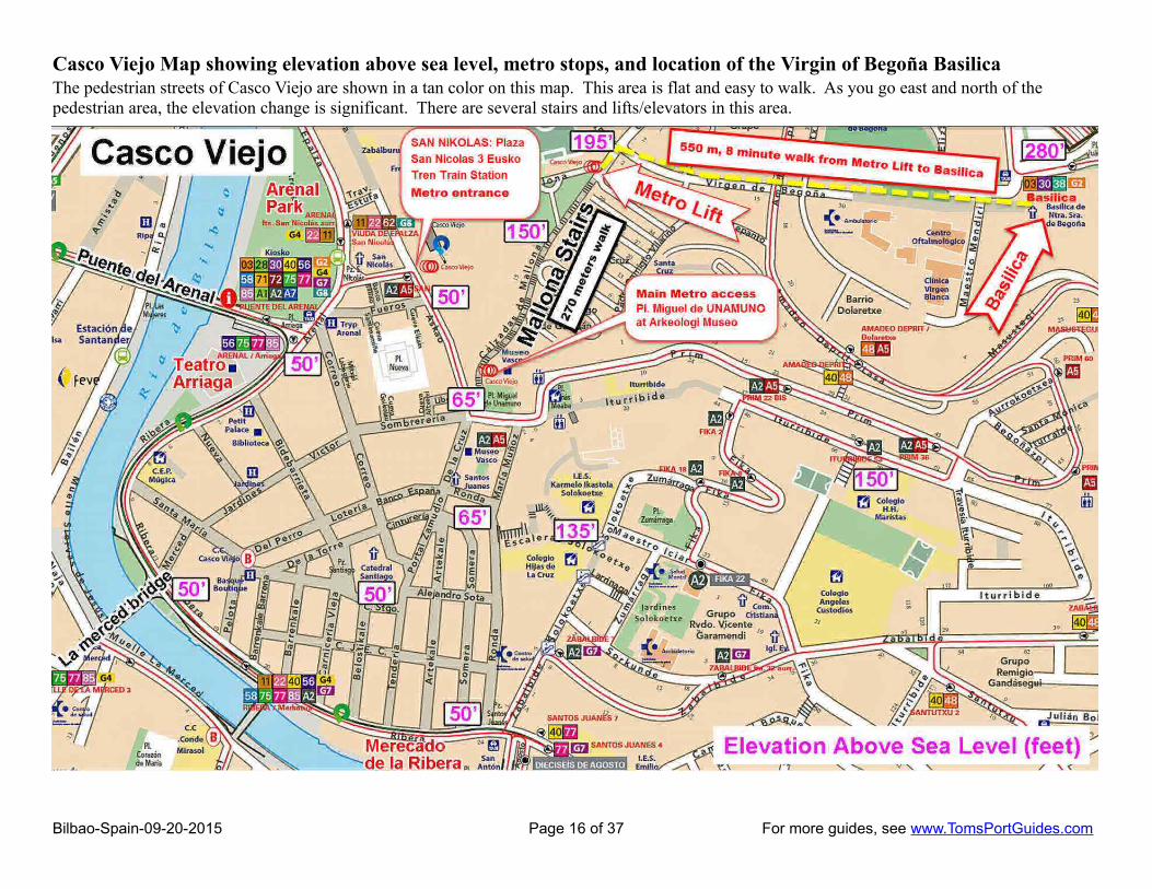
Casco Viejo Map showing elevation above sea level, metro stops, and location of the Virgin of Begoña Basilica The pedestrian streets of Casco Viejo are shown in a tan color on this map. This area is flat and easy to walk. As you go east and north of the pedestrian area, the elevation change is significant. There are several stairs and lifts/elevators in this area.
Bilbao-Spain-09-20-2015 Page 16 of 37 For more guides, see www.TomsPortGuides.com

The main metro station is Unamuno at Pl. Miguel. To reach the Basilica, high on the hill, you could:• Walk up the Mallona Stairs which involves climbing hundreds of steps, or• Stay in the metro tunnels and take the lift/elevator. Cost is 1.50 euro; it's included in your metro ticket.
The bottom of the Mallona Stairs at Pl. Miguel. GPS = 43°15'29.9"N 2°55'18.5"W
The entrance to the Unamuno Casco Viejo Metro station is under the Archeologi Museoa, next to the stairs as shown on this Google street-level photo below.
The top of metro lift is next to top of Mallona Stairs GPS = 43°15'37.1"N 2°55'11.2"W (photo below)
If you are walking up the stairs, continue straight on to the next street and turn right on Virgen de Begona
If you take the lift, walk to the top of the Mallona Stairs, turn left, walk one block, and turn right on Virgen de Begona.
Bilbao-Spain-09-20-2015 Page 17 of 37 For more guides, see www.TomsPortGuides.com
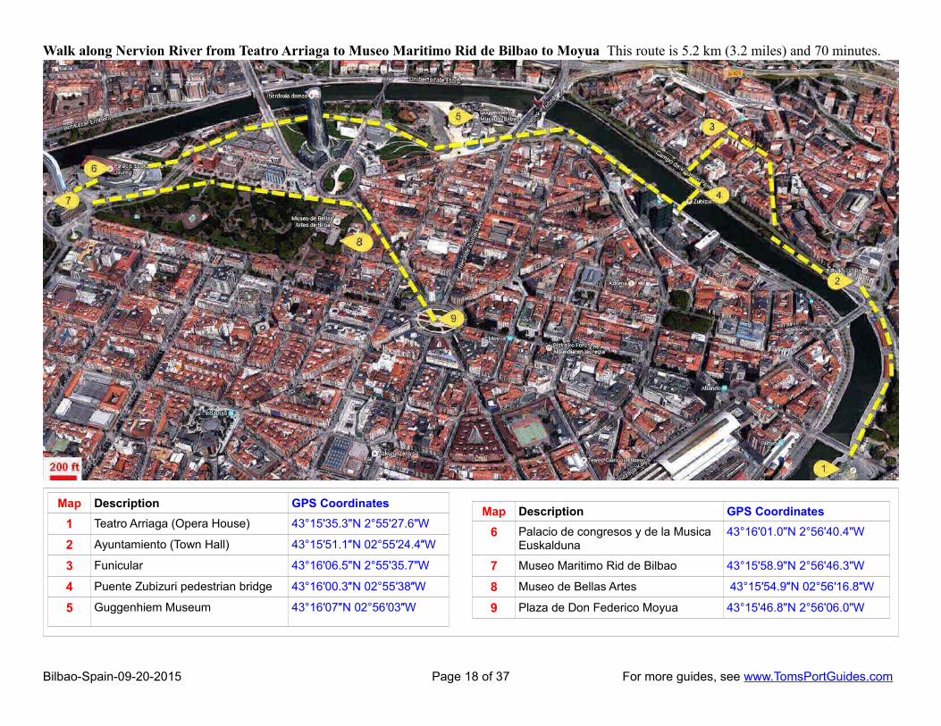
Walk along Nervion River from Teatro Arriaga to Museo Maritimo Rid de Bilbao to Moyua This route is 5.2 km (3.2 miles) and 70 minutes.
Bilbao-Spain-09-20-2015 Page 18 of 37 For more guides, see www.TomsPortGuides.com
Map Description GPS Coordinates
1 Teatro Arriaga (Opera House) 43°15'35.3"N 2°55'27.6"W
2 Ayuntamiento (Town Hall) 43°15′51.1″N 02°55′24.4″W
3 Funicular 43°16'06.5"N 2°55'35.7"W
4 Puente Zubizuri pedestrian bridge 43°16′00.3″N 02°55′38″W
5 Guggenhiem Museum 43°16′07″N 02°56′03″W
Map Description GPS Coordinates
6 Palacio de congresos y de la Musica Euskalduna
43°16'01.0"N 2°56'40.4"W
7 Museo Maritimo Rid de Bilbao 43°15'58.9"N 2°56'46.3"W
8 Museo de Bellas Artes 43°15′54.9″N 02°56′16.8″W
9 Plaza de Don Federico Moyua 43°15'46.8"N 2°56'06.0"W

1) The walk begins at Teatro Arriaga. Walk next to the river to enjoy unobstructed views.
2) Ayuntamiento (Town Hall) GPS = 43°15′51.1″N 02°55′24.4″W
You can plot the walking route using GPS coordinatesfrom this port guide in Google Maps.
Drag the little yellow man icon from the bottom right ofthe Google map onto the walking route to view streetlevel photos. This is a good way to preview yourwalking tour of Bilbao from your home computer.
A Google street level photo of Town Hall is at left. I captured this photoas a screen shot on my home computer.
Bilbao-Spain-09-20-2015 Page 19 of 37 For more guides, see www.TomsPortGuides.com

Walk to Funicular, or continue along the river and take one of the bridge walking routes shown as a black or red dashed line.
If you want to ride the Funicular, bear right on Toboli Kalea Street and turn left on Castanos to Plaza Funicular. Otherwise continue straight along the river to the bridges.
3) Base of the Funicular at Funicular Plaza GPS = 43°16'06.5"N 2°55'35.7"W Top of the Funicular at Artxanda Mountain GPS = 43°16'26.8"N 2°55'12.6"W
The Funicular connects Plaza del Funicular with Artxanda Mountain. At the top, there is a park area with excellent views of the city.
Monday-Friday hours of operation are 7:15 a.m. to 22:00 p.m. On Sundays and holidays, the Funicular begins at 8:15 a.m.
Service is every 15 minutes. The journey takes 3 minutes. The standard fare is 0.95 €. (2015 prices)
Bilbao-Spain-09-20-2015 Page 20 of 37 For more guides, see www.TomsPortGuides.com

There are two bridges to cross the river to the Guggenheim MuseumPuente Zubizuri pedestrian bridge (#4 on the map on page 20) GPS = 43°16′00.3″N 02°55′38″W
The pedestrian bridge has long ramps to walk up/down to the bridge on either side of the river (photo below).
Puente de La Salve bridge is next to the Guggenheim Museum GPS = 43°16′10.3″N 02°55′52.9″WNote there elevators on the north side of the bridge. Take the elevator on the northwest side so that you will be walking on the pedestrian path as shown by the red dashed line (photo below) to the “Puppy” statue.
Bilbao-Spain-09-20-2015 Page 21 of 37 For more guides, see www.TomsPortGuides.com

5) Guggenhiem Museum GPS = 43°16′07″N 02°56′03″W
http://www.guggenheim-bilbao.es/en/
When it opened in 1997, the Frank Gehry–designed Guggenheim Museum Bilbao—a spectacular structure made of titanium, glass, and limestone—was hailed as the most important building of its time. Located in the Basque city of Bilbao in northern Spain, the museum features exhibitions organized by the Guggenheim Foundation and by the Guggenheim Museum Bilbao, as well as selections from the permanent collection of the Guggenheim Museums.
Bilbao’s collection of art spans from the mid-twentieth century to the present day. Concentrated on post-war painting and sculpture in America and Europe, the collection is autonomous yet complements the Solomon R. Guggenheim Museum’s outstanding holdings of modern and contemporary art. This concept of individual collections existing within a shared network is at the heart of the Guggenheim’s aim to foster cultural exchangeand exhibit art to the widest possible audience. (Source: Guggenheim Museum website)
HOURS: Tuesday to Sunday 10 am to 8 pm Closed Mondays iAdmission: 10 euros adult. Prices vary depending on the exhibits.
6) Palacio de Congresos y de la Musica Euskalduna GPS = 43°16'01.0"N 2°56'40.4"W
The Euskalduna Conference Centre and Concert Hall is a very unique building; one of the flagships of the new Bilbao of the 21st century. It is designed to look like a ship that is permanently under construction in a dock at aformer shipyard.
Designed by architects Federico Soriano and Dolores Palacios, it is a 53,000 m2 multi-purpose centre that stands in the heart of the city of Bilbao designed to host many different kinds of corporate, financial, institutional, social and cultural events. It is also the venue of the ABAO opera season, a major event in Spain and Europe and home to the Bilbao Symphony Orchestra, a magnificent ensemble whose first concert dates back to 1922.
The building offers a perfect co-ordination of areas open to the public such as its Auditorium, numerous halls, meeting and board rooms, offices, foyers, exhibition lobbies and services areas featuring warehouses, workshops, changing rooms, dressing rooms, rehearsal rooms, etc.
It is a very interesting building to see, but it is only open for events.
See http://www.euskalduna.net/ for the schedule of events
7) Museo Maritimo Rid de Bilbao GPS = 43°15'58.9"N 2°56'46.3"W
The purpose of the museum is to preserve the history, culture, and identity of men and women who lived near the Bilbao Estuary in the maritime tradition. There are outdoor and indoor spaces/exhibits.
The outdoor exhibits are under the roundabout of the EuskaldunaBridge where the columns support the road, which serves as theroof of this unique structure.
This was a former shipyard, a port, a market, and a factory.There are several ships/boats, a crane, and equipment used inport activities.
The indoor exhibit describes the physical evolution of theestuary and the activities and functions it promoted.
This is a very popular tourist site for young and old.
Summer hours Tuesday to Sunday: 10:00 am - 8:00 pm Monday: closed Standard adult admission is 6 euros
Bilbao-Spain-09-20-2015 Page 22 of 37 For more guides, see www.TomsPortGuides.com

Tourist Sites near the Guggenheim Museum (map below)
8) Museo de Bellas Artes Fine Art Museum See https://www.museobilbao.com/in/ GPS = 43°15′54.9″N 02°56′16.8″W
For a virtual tour, see https://www.museobilbao.com/visita-virtual/in/anonimo_catalan.htmlOpen Wednesday to Monday 10 a.m to 8 p.m Closed Tuesday Adult admission: 7 euros
9) Plaza de Don Federico Moyua GPS = 43°15'46.8"N 2°56'06.0"W
Bilbao-Spain-09-20-2015 Page 23 of 37 For more guides, see www.TomsPortGuides.com

Ship's Excursion Tour: Bilbao Port to San Juan de Gaztelugatxe, Bermeo. and Gernika.The driving distance is 71 miles (114 km). With light traffic, the drive takes 2 hours and 25 minutes. On May 8, 2014, there was a huge traffic jam near the port that added 45 minutes to our driving time.
Our 5.5 hour bus tour made three stops as shown on the map below:1. San Juan de Gaztelugatxe a 20-minute photo stop from a roadside park on top of the mountain 2. Bermeo Fishing Village a 75-minute stop for a walking tour and free time in the Old Town area, and3. Gernika (Guernika) a 45 minute stop for a walking tour and some free time.
NOTE: Train travel is an option between Bilbao and Bermeo. Cost is ~ 6 euros; travel time is 1 hour 20 minutes. There is also a train station in Gernika. There are also buses connecting these cities.
1) Photo stop of San Juan de Gaztelugatxe GPS = 43° 26' 27.57" N 2° 46' 15.048" W
Our bus stopped at a scenic overlook, roadside park with toilets. We could see Gaztelugatxe, but our photos were partially blocked by power lines and trees. To get the best photos, you need the time and energy to walk tothe site. This involves zig-zag paths on top of very narrow rock walls hundreds of feet above the sea and climbing hundreds of steps to visit St John the Baptist Chapel built by the Knights Templar in the 10th century. It is a breathtaking location for a day trip from from Bilbao and a perfect site for hikers.
Bilbao-Spain-09-20-2015 Page 24 of 37 For more guides, see www.TomsPortGuides.com

See http://christineinspain.com/san-juan-de-gaztelugatxe/ for amazing photos and a detailed description of the site. For aerial views, enter the GPS coordinates into Google or Bing maps. The photo below is from the roadside park looking down from the mountain. Note the narrow, zig-zag pathway to the chapel.
2) Bermeo fishing village GPS = 43°25′09″N 02°43′21.7″W
Bermeo is a centuries old fishing village with a beautiful harbor, narrow streets lined with colorful buildings, impressive architecture, and historic buildings including churches, museums, and monuments.
We walked with our guide through the Old Town area and had some free time. Bermeo is an excellent village toexplore. We didn't have much time to visit the shops, cafes, bars, or visit the museums. This would be a perfectarea to vacation to visit not only Bermeo, but also the nearby villages, and explore the coast in Basque Country.
Sites in Bermeo
Train Station (Eusko Tren) GPS = 43°25′03.2″N 02°43′23.7″W
Our Walking Tour began at Lamera Park GPS = 43°25′09″N 02°43′21.7″W
Tourism Office GPS = 43°25′08.9″N 02°43′16.7″W
Aita Guria Whaleboat GPS = 43°25′07.6″N 02°43′17.3″W
Santa Eufemia`s Church GPS = 43°25′09″N 02°43′15.2″W
Stairs from harbor to scenic overlook GPS = 43°25'11.2"N 2°43'14.8"W
Scenic overlook of harbor GPS = 43°25'12.9"N 2°43'15.8"W
Ercilla Tower & Arrantzales MuseumDedicated to Basque fishermen
GPS = 43°25′13.3″N 02°43′16.2″W
Santa Maria Church Town Hall & Main Square
GPS = 43°25′13.4″N 02°43′19.9″W
San Francisco Church and Cloister GPS = 43°25′08.1″N 02°43′29.9″W
Bilbao-Spain-09-20-2015 Page 25 of 37 For more guides, see www.TomsPortGuides.com

Walking Tour Map of Old Town in Bermeo This walk is ½ mile and takes 15 minutes without stopping.
1) Our walking tour began as the bandstand in Lamera Park. There are underground toilets next to the bandstand.
2) We stopped at the Aita Guria Whaleboat. Bermeo is famous for whale fishing. It's an important part of the history of the village. You will see whaleboats and whales in coats of arms in the town.
Bilbao-Spain-09-20-2015 Page 26 of 37 For more guides, see www.TomsPortGuides.com

Aita Guria Whaleboat
3) We did not stop at the Tourist Information Office or Santa Eufemia Church, the oldest church in Bermeo dating back to the 13th Century.
4) This is the view looking west across the marina to the buildings in Old Town
Bilbao-Spain-09-20-2015 Page 27 of 37 For more guides, see www.TomsPortGuides.com

5) Go up the stairs and turn right.
6) It's a short walk to the scenic overlook of the harbor.
There are four bronze statues looking out to sea. On the building near the statues, there are brass plaques in several languages. The sign in English is shown at the right of the photo above. You can see the anxiety of the people depicted in the statues as they look out to see watching and waiting for their loved ones and friends on the fishing boats to return safely to Bermeo.
7) We walked to the Ercilla Tower, a 15th Century medieval tower, and turned left.
The Arrantzales Museum, dedicated to Basque fishermen, is on upper levels of the Ercilla Tower. The museumis open Tuesday to Saturday 10 am-2 pm and 4pm-7pm and Sunday 10am-2 pm. Admission is 3 euros.
Bilbao-Spain-09-20-2015 Page 28 of 37 For more guides, see www.TomsPortGuides.com

8) Plaza de Sabino Arana Goiri is the main square in Old Town. Town Hall (photo below) was built in 1732.
Bilbao-Spain-09-20-2015 Page 29 of 37 For more guides, see www.TomsPortGuides.com

Santa Maria Church (photos below)
Bilbao-Spain-09-20-2015 Page 30 of 37 For more guides, see www.TomsPortGuides.com

9 & 10) There are many narrow, streets from the main square to Lamera Park. We walked on these streets as shown on the map on page 26.
San Francisco Church and Cloister were built in 1357. We walked pass it on our way back to our bus.
Our next stop was Gernika. The Spanish spelling is “Guernika”, the Basque spelling is “Gernika”. It is also called Gernika-Lumo. I use the Basque spelling because it is commonly used on maps and tourist websites.
Bilbao-Spain-09-20-2015 Page 31 of 37 For more guides, see www.TomsPortGuides.com

Gernika (also spelled as Guernika)Our third stop was 45 minutes for a walking tour of the park and historic area.
Gernica was the site of a horrific act on April 26, 1937 when Nazi Germany's Luftwaffe attacked and destroyed the city. Our tour guide told us the attack was to test the killing and destructive power of the new Nazi air force.That day will never be forgotten. Pablo Picasso commemorated it in his Gernica painting.
Walking tour of Gernika (Guernika)
1) The bus dropped us off at at the entrance to a beautiful park. GPS = 43°18′50.6″N 02°40′57.2″W
There were tree lined paths, benches, ponds, swans, and sculptures. We crossed a bridge over a narrow passage way connecting the main roads on either side of the park.
2) Santa Maria Church
GPS = 43°18'51"N 2°40'45"W
The church is a huge structure dating back to 1418. Unfortunately, the church was closed. It is only open for services. See photos on the next page.
Bilbao-Spain-09-20-2015 Page 32 of 37 For more guides, see www.TomsPortGuides.com

Santa Maria Church
Museo Euskal Herria GPS = 43°18'50"N 2°40'46"W The museum has engravings and canvases illustrating the history of the Basque people, and their traditions. Hours Tuesday – Saturday: 10 a.m. - 2 p.m. and 4 p.m. - 7 p.m. Sunday: 10.30 a.m. – 2.30 p.m. Admission 3 Euros See http://www.gernika-lumo.net/en-US/Tourism/Visit-Gernika/Pages/notelopierdas2_2MuseoEuskalHerria.aspx
3) Oak Tree of Gernika
For centuries Gernika has been the venue for assemblies of representatives of the towns and villages of Bizkaia.The earliest records of their meetings beneath the now famous oak tree date from the 14th century. These assemblies sought to establish a set of laws and a system of representation of the people. The Assembly House and the Tree of Gernika are therefore must-see attractions, as they are living symbols of the history of the Basque people.
The Oak Tree is next to the Assembly House that is used by the General Assembly of Bizkaia.
We spent most of our time on the tour visiting the Assembly House. It has very impressive architecture, a beautiful rotunda meeting room, and stained glass ceilings in the adjacent room.
Opening hoursEvery day: 10 a.m. - 2 p.m. and 4 p.m. - 6 p.m.June - September: Open until 7 p.m.Admission: freeAlthough admission is free, I believe you have to schedule group visits to the Assembly House.
Bilbao-Spain-09-20-2015 Page 33 of 37 For more guides, see www.TomsPortGuides.com
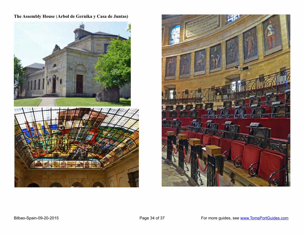
The Assembly House (Arbol de Gernika y Casa de Juntas)
Bilbao-Spain-09-20-2015 Page 34 of 37 For more guides, see www.TomsPortGuides.com

It's a gorgeous building! Note the Oak Tree in the stained glass ceiling.
Bilbao-Spain-09-20-2015 Page 35 of 37 For more guides, see www.TomsPortGuides.com

Santa Clara Church, Convent, and a former Hospital are located behind the Assembly House. The Convent was established in 1422 for the Third Order of St Francis.
Sculpture in the Park
As we walked back to the bus through the park, we passed two interesting sculptures:
At Point 5 on the map, there is a sculpture by Chillida. It is called “Our Father's House” and was designed so that the Tree of Gernika, the symbol of Basque freedom, would be visible from its "window". (photo at left)
At Point 6 on the map, there is a sculpture by Moore. It is called “Large Figure in a Shelter” and is part of a collection called “War Helmets” (photo at right below)
Udetxea Palace
The Udetxea Palace, built by the Allendesalazar family in 1890 as a summer residence, houses the headquarters of the Board of Trustees of the Urdaibai Biosphere Reserve. It has an information office for school groups, visitors and tourists, where information on nature, ecological-cultural issues and the task undertaken in the field of sustainable development, can be obtained. It is open year round from 9:30 am.
Tourist Information on Gernika (Gernika-Lumo)
Train Station Lurgorri-Gernika is ½ mile south of Assembly House at GPS = 43°18′24.2″N 02°40′49.2″W
Travel time by train from Bilbao to Gernika is about an hour. You'll need to walk, take a cab, or a bus from the train station to the Assembly House.
Tourism website
http://www.gernika-lumo.net/eu-ES/Turismoa/Orrialdeak/default.aspx
There are many things to see and do in Gernika. The tourism website provides details on places to visit and a pdf map showing all the sights. Download the map from:
http://www.gernika-lumo.net/es-ES/Recursos/Mapas/Documents/plano_turistico_ing-fra.pdf
Bilbao-Spain-09-20-2015 Page 36 of 37 For more guides, see www.TomsPortGuides.com

User Feedback Is Welcome GoalMy guides are designed to help you plan a great cruise vacation by providing information such as where the ship docks, location of tourist sites, public transit, walking tour maps, things to see and do, travel issues unique to the port, etc. Knowledge of ports is important when planning shore excursions because you have to make many decisions and commitments long before your ship docks. I believe the information in this guide is accurate, however you are responsible to verify accuracy of the information that you use to plan your vacation.
Information on cruise ports frequently changes such as bus routes, admission fees to sites, rental car locations, etc. Cruise Critic is the best source for up-to-date, detailed information on travel details for shore excursions, reviews of cruise ships, etc. There are many knowledgeable people on Cruise Critic who are willing to share their expertise and travel experience. I highly recommend www.CruiseCritic.com; it's free to join.
Why feedback is importantUser feedback helps me make corrections and improve the format and content in my quest to produce the“ultimate” port guides. I welcome offers to collaborate with me or provide materials for use in my guides.
PLEASE Help “spread the word” about my websiteThe only negative feedback I get is, “I wish I knew about your port guides before my vacation”. Please tellyour friends and post a reference to my guides and website on the blogs. To receive email notification whennew guides are available, send your email address to me at [email protected]
Copyright Notice & Terms and Conditions for Use of My Guides
My port guides and everything on my website www.TomsPortGuides.com is copyrighted by Thomas Sheridanwith all rights reserved, and protected by international copyright laws.
PERMITTED USE: Personal, non-commercial use of my port guides and/or material from my website.
I allow individuals to take my guides apart for personal, non-commercial use. Many cruisers carry a map or afew pages from my guide on a shore excursion. That's OK. I also allow people to post my guides on websitesthey set up for fellow travelers to share information on shore excursions such as the websites set up by CruiseCritic members for the Roll Calls. That's OK. My guides are for use and enjoyment of individual travelers.
PROHIBITED USE of my port guides and/or material from my website.NO person, company, organization, website, etc. is permitted to use material from my website for a commercialpurpose, to sell, require a membership to download my port guides, or use my copyrighted material for acommercial purpose.
NO person, company, organization, website, etc. is permitted to distribute excerpts from my guides or materialfrom my website as electronic, digital, or paper copies. My Port Guides must be kept intact, as downloadedfrom my website, with this copyright notice.
NO Cruise Ship employee, representative, contractor, port lecturer, etc. is permitted to distribute excerpts frommy guides or material from my website as electronic, digital or paper copies. My Port Guides must be keptintact, as downloaded from my website, with this copyright notice. A blatant example of violation of mycopyright was a cruise ship docked in Copenhagen where the shore excursion desk personnel removed mapsfrom my guide, removed my name as the copyright owner, and copied/distributed my maps.
Fortunately, a friend of mine on that ship complained to the purser and the ship stopped violating my copyright.
If there is any question about use of my guides, contact me at [email protected]
Tom Sheridan
Bilbao-Spain-09-20-2015 Page 37 of 37 For more guides, see www.TomsPortGuides.com