Lee Gardens North Historic District (000-9411) Arlington County ...

STAFF: Jill Hunger and Jennifer Smith, DCPHD, Planning Division Dave Robinson, DPW, Planning Reviewed by the County Attorney's Office: County Board Meeting – July 19, 2003 PLA - 3321
July 10, 2003 TO: The County Board of Arlington, Virginia FROM: Ron Carlee, County Manager APPLICANT: Keating Development Company BY: Timothy S. Sampson, Attorney/Agent Walsh Colucci Lubeley Emrich & Terpak 2200 Clarendon Boulevard, 13th Floor Arlington, VA 22201 SUBJECT: A. GP-286-03-1 GENERAL LAND USE PLAN AMENDMENT: from
“Government and Community Facilities” (County, state and Federal administration and service facilities (police, fire, property yard, etc.); hospitals, nursing homes, and institutional housing; utilities, military reservations, airports, etc.) to “Medium Density Mixed-Use” (3.0 Floor Area Ratio (FAR) with special provision for up to an additional 1.0 FAR for residential) for the property bordered by Washington Boulevard to the north, N. Hudson Street to the west, N. 10th Road to the south, and N. Highland Street to the east; and maintain the existing stipple pattern over the current Federally-owned property to indicate public ownership.
B. Z-2497-03-1 REZONING: from “C-3” General Commercial
Districts to ”C-R” Commercial Redevelopment Districts; premises known as 3118 N. Washington Blvd. (RPC #19-005-002)
C. SP #333 SITE PLAN AMENDMENT: incorporate additional land,
renovation/addition to existing post office, construct new residential/retail/postal facility, modifications of use regulations to exclude mechanical, HVAC, and storage from GFA; premises known as 3100, 3118 N. Washington Blvd., 3102, 3108, 3112, N. 10th Rd., 3101, 3109, 3115, N. 10th St.,
General Land Use Plan Amendment, Rezoning and Site Plan Approval Request -2- GP-286-03-1, Z-2497-03-1 and SP #333
PLA - 3321
1008 N. Highland St., 1009 N. Hudson St. (RPC #19-005, -001, -002, 19-006-001, -002, -003, -004, -005, -006, -007, -008)
RECOMMENDATIONS: A. Adopt the attached resolution to approve the
change on the General Land Use Plan from “Government and Community Facilities” (County, state and Federal administration and service facilities (police, fire, property yard, etc.); hospitals, nursing homes, and institutional housing; utilities, military reservations, airports, etc.) to “Medium Density Mixed-Use” (3.0 Floor Area Ratio (FAR) with special provision for up to an additional 1.0 FAR for residential) for the property bordered by Washington Boulevard to the north, N. Hudson Street to the west, N. 10th Road to the south, and N. Highland Street to the east; and maintain the existing stipple pattern over the current Federally-owned property to indicate public ownership.
B. Accept the withdrawal of the proposed rezoning
request. C. Approve the proposed site plan amendment,
subject to the conditions of the staff report and to the related vacation of a portion of 10th Road North, and subject to obtaining a Certificate of Appropriateness to incorporate additional land, renovation/addition to existing post office, construct new residential/ retail/postal facility, modifications of use regulations to exclude mechanical, HVAC, and storage from GFA; premises known as 3100, 3118 N. Washington Blvd., 3102, 3108, 3112, N. 10th Rd., 3101, 3109, 3115, N. 10th St., 1008 N. Highland St., 1009 N. Hudson St. (RPC #19-005, -001, -002, 19-006-001, -002, -003, -004, -005, -006, -007, -008)
ISSUES: Is the proposed mix of uses consistent with the vision the County
Board had in its adoption of the Resolution on the Preferred Land Use Balance for the Clarendon Urban Village Concept?

General Land Use Plan Amendment, Rezoning and Site Plan Approval Request -3- GP-286-03-1, Z-2497-03-1 and SP #333
PLA - 3321
SUMMARY: This proposal is a major site plan amendment for the Arlington Main Post Office (Joseph Fisher Building) in Clarendon. The United States Postal Service (USPS) has partnered with a private developer to achieve construction of a consolidated distribution facility. The proposed project incorporates the north block with both the historic post office and the Dan Kain Building with substantial preservation and renovation of those buildings. The proposal includes a mix of uses: residential (194 units); live-work (9 units); office (52,405 square feet); retail (13,650 square feet); and postal facilities (39,900 square feet) with a below-grade distribution facility. In order to achieve this redesign, the applicant has also requested a General Land Use Plan amendment and the vacation of a portion of 10th Road North.
The plans have evolved into a truly mixed-use development with six unique elements: residential units; live-work units; retail; office; USPS distribution facilities and offices; and USPS retail space. The overall mix could range from 60% residential – 40% commercial to 63% residential – 37% commercial depending on the leasing and use of the live-work units along 10th Street North. Staff conclude that the proposed mix is appropriate for the Clarendon area as the project preserves and restores a significant community facility, creates a smaller office building with the potential for a different type of user, establishes retail along significant pedestrian pathways and provides a different type of living space in the Clarendon area with the live-work units. The proposed building relates well to surrounding uses, both existing and proposed. For these reasons, staff conclude that the proposed site plan would promote and protect the public health, safety, and welfare and therefore recommend that the County Board adopt the attached resolution to approve the General Land Use Plan and approve the proposed site plan amendment.
BACKGROUND: On October 10, 2000, the County Board approved the United States Postal Service (USPS) site plan on a .9269 acre site on the block bounded by 10th Street North, 10th Road North, North Highland and North Hudson Streets. The site plan included a three-story building with structured parking (three levels above grade and three levels below grade) to house the postal delivery unit, parking for postal vehicles, offices for the post office, a post office box lobby, counter services, customer and employee parking, and 1,600 square feet of retail space. The facility had been designed to consolidate and serve the 22201/03/09 Zip Code areas. It was anticipated that, at its peak within the next 10 years, the new Delivery Unit would have a peak duty staff of 164 employees – including up to 101 carriers, management staff, custodians,

General Land Use Plan Amendment, Rezoning and Site Plan Approval Request -4- GP-286-03-1, Z-2497-03-1 and SP #333
PLA - 3321
supporting distribution clerks and mail handlers. Due to substantial budget constraints, the USPS has not built the facility. The USPS has collaborated with the applicant, Keating Development Company, to overcome the budgetary issues though redevelopment of the site. The applicant has submitted a proposal for the development of the two blocks owned by the USPS that includes a General Land Use Plan amendment from “Government and Community Facilities” to “Medium Density Mixed-Use;” a site plan to permit the construction of a mixed use project which contains residential, live-work, office, retail and postal facility components with related parking. The applicant has also requested a vacation of a portion of 10th Road North which is discussed in an accompanying report. The following provides additional information about the site and location:
• Site: The 2.05-acre site contains the historic Arlington Main Post Office and Dan Kain Trophy building block (“North Block”). The post office is both locally designated and listed on the Federal Registers of Historic Places and the Dan Kain building is recognized as a contributing structure to the historic fabric of Clarendon. The site also includes the block to the immediate south – bounded by 10th Street North, North Highland and North Hudson Streets and 10th Road North (“South Block”). This block includes eight lots and is vacant. The USPS uses the site for parking postal delivery and employee vehicles.
To the north: North Washington Boulevard and the Olmsted Building (3100 Clarendon
Boulevard). The block is designated “High” Office-Apartment-Hotel on the General Land Use Plan and zoned “C-O.”
To the west: Clarendon Fire Station (4-story brick building), located on the southern portion
of the block, is designated “Government and Community Facilities” on the General Land Use Plan and zoned “C-3.” The First Union Bank (2-story building), on the Washington Boulevard side of the block, is designated “Medium Density Mixed Use” on the General Land Use Plan and zoned “C-3.”
To the east: 3000 Washington Boulevard (11-story commercial /residential site plan building
nearing completion), across from North Highland Street, is designated “Medium Density Mixed-Use” on the General Land Use Plan and zoned “C-R.”
To the south: 10th Street North and small commercial buildings are located immediately south
of the project and designated “Service Commercial” on the General Land Use Plan and zoned “C-3.” Clarendon Self Storage facility, located southeast of the site is also designated “Service Commercial” on the General Land Use Plan and zoned “C-TH.”
• Zoning: The north block is currently zoned “C-3” General Commercial Districts
and the south block is currently zoned “C-R” Commercial Redevelopment Districts.

General Land Use Plan Amendment, Rezoning and Site Plan Approval Request -5- GP-286-03-1, Z-2497-03-1 and SP #333
PLA - 3321
• Land Use: The northern portion of the site is currently designated “Government and Community Facilities” on the General Land Use Plan. The stipple pattern is currently placed on a portion of the northern block to indicate the current and future public ownership of the Arlington Main Post Office property. The southern portion of the site area is designated “Medium Density Mixed-Use” on the General Land Use Plan.
• Neighborhood: The site is located within the Clarendon-Courthouse Civic
Association. However, several other civic associations are in close proximity including Lyon Park Citizens Association, Ashton Heights Civic Association and Lyon Village Citizens Association.
Proposed General Land Use Plan Amendment: The General Land Use Plan is the primary policy guide for the future development of the County. Since its original adoption in 1961, the Plan has been updated and periodically amended to more clearly reflect the intended use for a particular area. The Plan may be amended either as part of a long-term planning process for a designated area or as a result of an individual request for a specific change. The applicant has requested a General Land Use Plan Amendment from “Government and Community Facilities” to “Medium Density Mixed-Use.” In addition to this request, staff proposes to maintain the stipple pattern on the General Land Use Plan to continue the vision for public use and ownership of the Arlington Main Post Office property. The following table summarizes the maximum development permitted under the existing “Government and Community Facilities” designation and the proposed “Medium Density Mixed-Use” designation, which is consistent with both the “C-3” and “C-R” zoning districts that comprise the site. Density Allowed Maximum Development1
Existing Designation (North Block) “Government and Community Facilities”
The General Land Use Plan designation does not set forth parameters for development density. The designation lists types of uses and associated zoning districts (“S-3A”, “S-D” and “P-S”).
As regulated by the “S-3A”, “S-D” and “P-S” zoning districts. The current zoning, “C-3” would permit commercial development up to 75 feet in height without an FAR regulation and/or up to 36 residential units per acre (32 units).
Requested Designation (North Block) “Medium Density Mixed-Use”
3.0 FAR with special provision for up to an additional 1.0 FAR for residential
155,080 square feet
1 There is an historic overlay district on the north block of the subject site. This does not affect the underlying zoning district of “C-3” but would require review by the Historical Affairs and Landmark Review Board.
General Land Use Plan Amendment, Rezoning and Site Plan Approval Request -6- GP-286-03-1, Z-2497-03-1 and SP #333
PLA - 3321
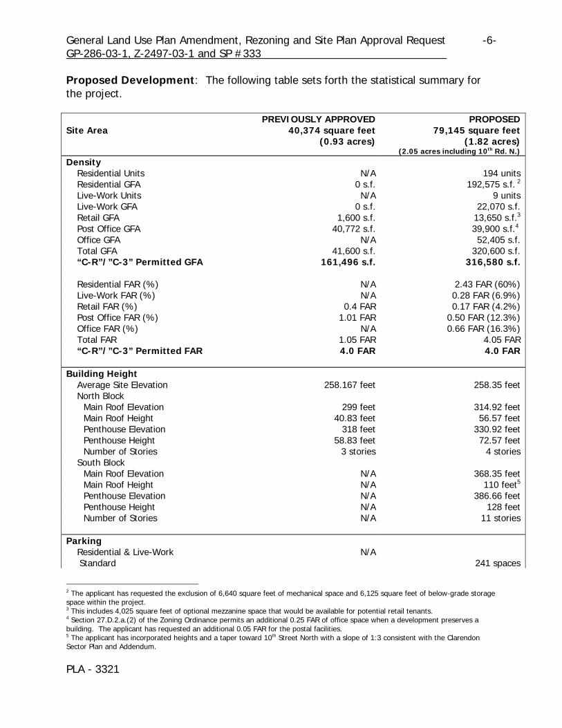
Proposed Development: The following table sets forth the statistical summary for the project. PREVIOUSLY APPROVED PROPOSEDSite Area 40,374 square feet
(0.93 acres)79,145 square feet
(1.82 acres)(2.05 acres including 10th Rd. N.)
Density Residential Units N/A 194 units Residential GFA 0 s.f. 192,575 s.f. 2
Live-Work Units N/A 9 units Live-Work GFA 0 s.f. 22,070 s.f. Retail GFA 1,600 s.f. 13,650 s.f.3
Post Office GFA 40,772 s.f. 39,900 s.f.4
Office GFA N/A 52,405 s.f. Total GFA 41,600 s.f. 320,600 s.f. “C-R”/”C-3” Permitted GFA 161,496 s.f. 316,580 s.f. Residential FAR (%) N/A 2.43 FAR (60%) Live-Work FAR (%) N/A 0.28 FAR (6.9%) Retail FAR (%) 0.4 FAR 0.17 FAR (4.2%) Post Office FAR (%) 1.01 FAR 0.50 FAR (12.3%) Office FAR (%) N/A 0.66 FAR (16.3%) Total FAR 1.05 FAR 4.05 FAR “C-R”/”C-3” Permitted FAR 4.0 FAR 4.0 FAR Building Height Average Site Elevation 258.167 feet 258.35 feet North Block Main Roof Elevation 299 feet 314.92 feet Main Roof Height 40.83 feet 56.57 feet Penthouse Elevation 318 feet 330.92 feet Penthouse Height 58.83 feet 72.57 feet Number of Stories 3 stories 4 stories South Block Main Roof Elevation N/A 368.35 feet Main Roof Height N/A 110 feet5
Penthouse Elevation N/A 386.66 feet Penthouse Height N/A 128 feet Number of Stories N/A 11 stories Parking Residential & Live-Work N/A Standard 241 spaces
2 The applicant has requested the exclusion of 6,640 square feet of mechanical space and 6,125 square feet of below-grade storage space within the project. 3 This includes 4,025 square feet of optional mezzanine space that would be available for potential retail tenants. 4 Section 27.D.2.a.(2) of the Zoning Ordinance permits an additional 0.25 FAR of office space when a development preserves a building. The applicant has requested an additional 0.05 FAR for the postal facilities. 5 The applicant has incorporated heights and a taper toward 10th Street North with a slope of 1:3 consistent with the Clarendon Sector Plan and Addendum.

General Land Use Plan Amendment, Rezoning and Site Plan Approval Request -7- GP-286-03-1, Z-2497-03-1 and SP #333
PLA - 3321
PREVIOUSLY APPROVED PROPOSED Residential Parking Ratio 1.19 spaces per unit Required Residential Ratio 1 space per unit Post Office Standard (employee spaces) 171 spaces 128 spaces Hybrid6 91 spaces 96 spaces Post Office Parking Ratio 1 space per 312 s.f. Required Post Office Ratio 1 space per 580 s.f. Office7 Standard 73 spaces Office Parking Ratio 1 space per 580 s.f. Required Office Ratio 1 space per 580 s.f. Retail/Visitor8
Standard 49 spaces for retail and USPS 16 spaces Retail Parking Ratio 1 space per 541 s.f. Required Retail Ratio 1 space per 580 s.f. Coverage 85% 83%9
LEED Score N/A 22 points
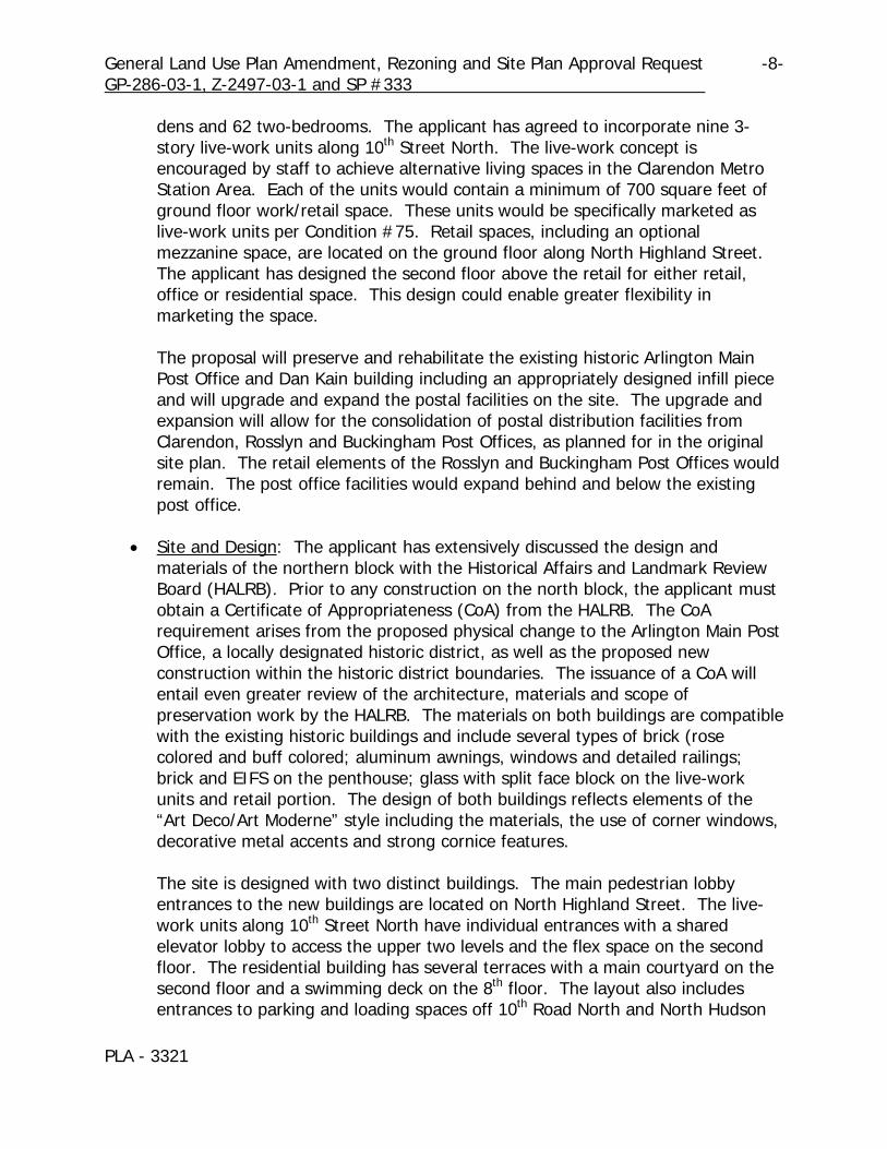
• Density and Uses: The applicant proposes to maintain the previously approved post office facility (in a different form) and incorporate the density from the existing post office site into the entire site area. On the northern block, a lower three-story office building would be added to the top of the post office facility with a floor plate of approximately 14,000 square feet. Retail would be along Washington Boulevard in the existing Dan Kain building and the proposed infill piece. Further, the applicant proposes to build a workroom and parking garage below grade beneath both buildings to serve the postal facility. The proposed workroom and associated parking create an efficiency of use for distribution operations and keep the mail trucks located below grade. To construct such an arrangement, the applicant has requested the vacation of 10th Road North which is discussed in a companion report. The applicant has not requested density from the vacation and further intends to maintain vehicular and pedestrian access on 10th Road North with a permanent public access easement. The parking garage and buildings are divided – completely separating post office uses from residential, retail and office uses for both safety and security concerns. On the southern block, the proposal introduces an 11-story residential tower, with 194 units, that tapers to three stories where it fronts on 10th Street North. The mix of units consists of 19 studios, 93 one-bedrooms, 20 one-bedroom-plus-
6 The hybrid spaces are the Post Office LLV and 2.5 Ton Vehicle spaces. 7 The office portion of the project also includes half of the GFA associated with the leasing/management office and the ftness center which will be shared between all of the uses. The office space, without the associated amenities, is parked at a ratio of 1 space per 580 square feet. 8 The Zoning Ordinance permits the exclusion of the first 5,000 square feet of retail space from parking requirements if the site is within 1,000 feet from a Metro Station entrance. 9 The Zoning Ordinance permits up to 86% for this site due to the preservation of two existing buildings.
General Land Use Plan Amendment, Rezoning and Site Plan Approval Request -8- GP-286-03-1, Z-2497-03-1 and SP #333
PLA - 3321
dens and 62 two-bedrooms. The applicant has agreed to incorporate nine 3-story live-work units along 10th Street North. The live-work concept is encouraged by staff to achieve alternative living spaces in the Clarendon Metro Station Area. Each of the units would contain a minimum of 700 square feet of ground floor work/retail space. These units would be specifically marketed as live-work units per Condition #75. Retail spaces, including an optional mezzanine space, are located on the ground floor along North Highland Street. The applicant has designed the second floor above the retail for either retail, office or residential space. This design could enable greater flexibility in marketing the space. The proposal will preserve and rehabilitate the existing historic Arlington Main Post Office and Dan Kain building including an appropriately designed infill piece and will upgrade and expand the postal facilities on the site. The upgrade and expansion will allow for the consolidation of postal distribution facilities from Clarendon, Rosslyn and Buckingham Post Offices, as planned for in the original site plan. The retail elements of the Rosslyn and Buckingham Post Offices would remain. The post office facilities would expand behind and below the existing post office.
• Site and Design: The applicant has extensively discussed the design and
materials of the northern block with the Historical Affairs and Landmark Review Board (HALRB). Prior to any construction on the north block, the applicant must obtain a Certificate of Appropriateness (CoA) from the HALRB. The CoA requirement arises from the proposed physical change to the Arlington Main Post Office, a locally designated historic district, as well as the proposed new construction within the historic district boundaries. The issuance of a CoA will entail even greater review of the architecture, materials and scope of preservation work by the HALRB. The materials on both buildings are compatible with the existing historic buildings and include several types of brick (rose colored and buff colored; aluminum awnings, windows and detailed railings; brick and EIFS on the penthouse; glass with split face block on the live-work units and retail portion. The design of both buildings reflects elements of the “Art Deco/Art Moderne” style including the materials, the use of corner windows, decorative metal accents and strong cornice features.
The site is designed with two distinct buildings. The main pedestrian lobby entrances to the new buildings are located on North Highland Street. The live-work units along 10th Street North have individual entrances with a shared elevator lobby to access the upper two levels and the flex space on the second floor. The residential building has several terraces with a main courtyard on the second floor and a swimming deck on the 8th floor. The layout also includes entrances to parking and loading spaces off 10th Road North and North Hudson

General Land Use Plan Amendment, Rezoning and Site Plan Approval Request -9- GP-286-03-1, Z-2497-03-1 and SP #333
PLA - 3321
Street. The streetscape would be designed with paver sidewalks, street trees in tree pits along Washington Boulevard, North Highland Street, 10th Street North, North Hudson Street and 10th Road North. The sidewalk width ranges from 10 feet along 10th Road North to 26 feet along Washington Boulevard. Because of the wider sidewalks at the corners of North Highland Street and Washington Boulevard and North Highland Street and 10th Street North, the applicant proposes outdoor café space.
• Affordable Housing: Staff have calculated a Housing Reserve Fund contribution totaling $283,800, based on the office, new retail, post office work space, residential and live/work uses (Condition #64). An equivalent value in on-site affordable units would result in about three units. Because the project does not make use of bonus density or height, along with the complexity of uses on this site and the considerable expense entailed for historic preservation, staff does not recommend requiring such a small number of on-site affordable units in lieu of the Housing Reserve Fund contribution.
• LEED Scorecard: The current LEED Scorecard for the proposed development
identified a possible score of 22 points. This includes points for Sustainable Sites, Water Efficiency, Energy and Atmosphere, Materials and Resources, and Indoor Environmental Quality. The applicant has consulted with a LEED-certified engineer to further refine the LEED score and incorporate additional green building technologies. The applicant anticipates that the score may be increased.
Transportation: The site has street frontage along Washington Boulevard, North Highland Street, 10th Street North, North Hudson Street and 10th Road North. The Master Transportation Plan – Part I classifies Washington Boulevard and 10th Street North (Virginia Route 237) as principal arterial streets. North Highland Street is classified as a minor arterial and North Hudson Street and 10th Road North are classified as neighborhood-minor streets. Adjacent to the site, both Washington Boulevard and 10th Street North provide two travel lanes in each direction separated by a raised median. North Highland and North Hudson Streets and 10th Road North provide a single travel lane in each direction. On-street parking is allowed along the site’s five frontages. The North Highland Street intersections with Washington Boulevard and 10th Street North operate under traffic signal control. The North Hudson Street intersections with Washington Boulevard and 10th Street North and the 10th Road North intersections with North Highland Street and North Hudson Street are controlled by stop signs on the North Hudson Street and 10th Road North approaches, respectively. Traffic volumes for several streets in the area have fluctuated with some streets showing no growth while others have increased. Volumes are expected to increase in the future as a result of planned development in the Rosslyn-Ballston Corridor in
General Land Use Plan Amendment, Rezoning and Site Plan Approval Request -10- GP-286-03-1, Z-2497-03-1 and SP #333
PLA - 3321
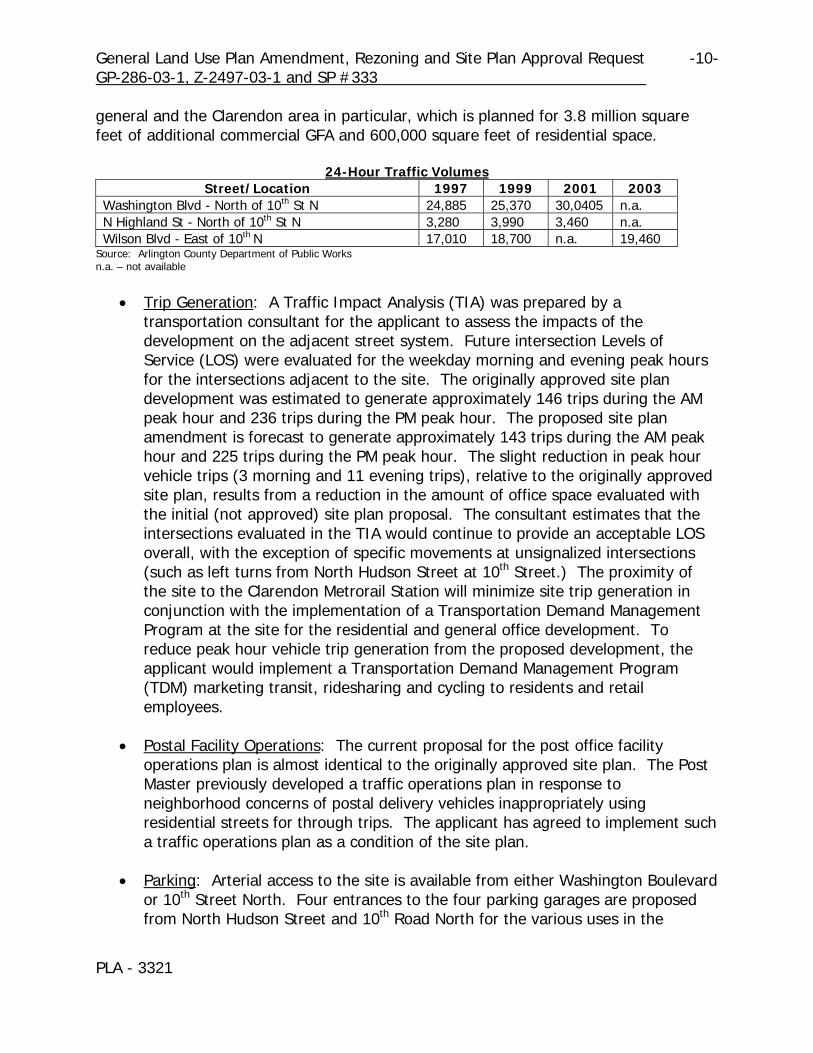
general and the Clarendon area in particular, which is planned for 3.8 million square feet of additional commercial GFA and 600,000 square feet of residential space.
24-Hour Traffic Volumes Street/Location 1997 1999 2001 2003
Washington Blvd - North of 10th St N 24,885 25,370 30,0405 n.a. N Highland St - North of 10th St N 3,280 3,990 3,460 n.a. Wilson Blvd - East of 10th N 17,010 18,700 n.a. 19,460
Source: Arlington County Department of Public Works n.a. – not available
• Trip Generation: A Traffic Impact Analysis (TIA) was prepared by a
transportation consultant for the applicant to assess the impacts of the development on the adjacent street system. Future intersection Levels of Service (LOS) were evaluated for the weekday morning and evening peak hours for the intersections adjacent to the site. The originally approved site plan development was estimated to generate approximately 146 trips during the AM peak hour and 236 trips during the PM peak hour. The proposed site plan amendment is forecast to generate approximately 143 trips during the AM peak hour and 225 trips during the PM peak hour. The slight reduction in peak hour vehicle trips (3 morning and 11 evening trips), relative to the originally approved site plan, results from a reduction in the amount of office space evaluated with the initial (not approved) site plan proposal. The consultant estimates that the intersections evaluated in the TIA would continue to provide an acceptable LOS overall, with the exception of specific movements at unsignalized intersections (such as left turns from North Hudson Street at 10th Street.) The proximity of the site to the Clarendon Metrorail Station will minimize site trip generation in conjunction with the implementation of a Transportation Demand Management Program at the site for the residential and general office development. To reduce peak hour vehicle trip generation from the proposed development, the applicant would implement a Transportation Demand Management Program (TDM) marketing transit, ridesharing and cycling to residents and retail employees.
• Postal Facility Operations: The current proposal for the post office facility
operations plan is almost identical to the originally approved site plan. The Post Master previously developed a traffic operations plan in response to neighborhood concerns of postal delivery vehicles inappropriately using residential streets for through trips. The applicant has agreed to implement such a traffic operations plan as a condition of the site plan.
• Parking: Arterial access to the site is available from either Washington Boulevard
or 10th Street North. Four entrances to the four parking garages are proposed from North Hudson Street and 10th Road North for the various uses in the

General Land Use Plan Amendment, Rezoning and Site Plan Approval Request -11- GP-286-03-1, Z-2497-03-1 and SP #333
PLA - 3321
project. A total of 554 parking spaces are proposed for the mixed use development and are allocated as follows: shared retail - 16 spaces, post office - 224 spaces (128 employee spaces, 96 delivery vehicles spaces), residential - 241 (including live/work) spaces, office – 73 spaces.
Three driveway entrances are proposed on the north side of 10th Road North to provide access to two post office parking garages and the three loading docks serving the post office (2) and office building (1). One driveway entrance is proposed to serve the loading dock for deliveries to both the post office and the office building and is sized to accommodate the USPS tractor trailer design vehicle. A second driveway entrance accesses a parking garage (Garage 2) for postal service delivery vehicles, and the third driveway entrance provides access to the parking garage (Garage 1) serving the mail trucks and postal employees. The applicant has agreed to develop a service delivery/loading dock transportation management plan detailing an operations plan for refuse storage and deliveries from the post office, office or the residential building’s loading dock.
Two driveway entrances are proposed on the south side of 10th Road North for the southern block and provide access to the loading dock serving the residential building and a driver accessible mail drop box adjacent to the curb. The exclusive mail drop drive-thru lane operates similarly to a porte-cochere or building drop-off. Special paving materials and bollards would be installed to delineate vehicle travel paths to enhance pedestrian safety and minimize pedestrian/vehicle conflicts.
Two driveway entrances are proposed on North Hudson Street and provide access to two parking garages (Garages 3 and 4). Garage 3 provides for visitor parking and Garage 4 provides parking for the office, live/work and residential buildings. The driveway entrances have been separated by a pedestrian refuge and each entrance has been narrowed to a maximum width of 23 feet.
• Streets: The applicant has proposed parking lane nubs at all intersections
around the periphery of the site with the exception of North Hudson Street at 10th Street and 10th Road North where the applicant is proposing to eliminate curb lane parking. The site plan proposal incorporates two curb ramps at each curb return (corner) and the appropriate realignment of cross walks. The following details each street in more detail.
Washington Boulevard: The median in Washington Boulevard is proposed to be widened by two to four feet in width, narrowing the travel lane widths to a maximum of 11 feet and extending the median noses through the proposed cross walks at the intersections.

General Land Use Plan Amendment, Rezoning and Site Plan Approval Request -12- GP-286-03-1, Z-2497-03-1 and SP #333
PLA - 3321
North Highland Street: North Highland Street is currently constructed to a 45-foot width and is proposed to be narrowed to a 36-foot-wide street providing a single travel lane in each direction and curb lane parking on both sides of the street. 10th Street North: In accordance with the Clarendon Sector Plan - Addendum A, the 10th Street North corridor between Wilson and Washington Boulevard is proposed to be improved to provide a wider, landscaped median, similar to Fairfax Drive in the Ballston and Virginia Square areas. No additional travel lanes would be provided. The 10th Street North Boulevard concept plan would provide two travel lanes in each direction separated by a raised, landscaped median. The median on 10th Street is proposed to be widened to 8 feet and the median noses will be extended through the proposed crosswalks at North Hudson and North Highland Streets. The boulevard concept plan recommended maintaining on-street parking in the curb lane as presently exists to provide convenient parking and access to the adjacent first floor retail businesses. North Hudson Street: North Hudson Street is constructed to a 31-foot width adjacent to the post office (south of Washington Boulevard) and provides a single travel lane in each direction and curb lane parking along the side east side of the street. Parking is prohibited along the west side of the street because of numerous driveway entrances. South of 10th Road North, North Hudson Street is constructed to a 36-foot-width, and provides a single travel lane in each direction and parking is generally allowed along both sides of the street. North Hudson Street is proposed to be narrowed adjacent to the residential building to 30 feet with parking allowed along the west side of the street only. The location of the two driveway entrances to the residential building parking garage and the short length of the block frontage limit the ability to locate on-street parking along the east side of the street. 10th Road North: The applicant has proposed to vacate 10th Road North and reconstruct it to provide a 30-foot-wide street adjacent to the loading dock for the post office transitioning to a 26-foot width at North Highland Street. On-street parking would be prohibited along the vacated 10th Road North right of way to provide the necessary maneuvering area for post office tractor trailer deliveries to the loading dock.
• Pedestrian Access: The Rosslyn-Ballston Corridor Streetscape Design standards
provide for widened sidewalks, special paving materials and street trees. These standards are being implemented as redevelopment occurs and are intended to improve pedestrian access to the Metrorail stations. The “C-R” zoning district streetscape standards are as incorporated in the adopted Clarendon Streetscape

General Land Use Plan Amendment, Rezoning and Site Plan Approval Request -13- GP-286-03-1, Z-2497-03-1 and SP #333
PLA - 3321
Plan Standards of the Clarendon Sector Plan. Sites fronting on any public right of way shall be landscaped with curb, gutter and sidewalk, street lights and furniture and other elements, and all aerial utilities on and along the periphery of the site shall be relocated to underground facilities.
North Highland Street adjacent to the site is designated as a special pedestrian walkway from 10th Street North to 13th Street North. Special features include paver sidewalks, tree grates, and paver crosswalks. The proposed site plan is generally consistent with the streetscape standards and includes a 16-foot wide paver sidewalk with street trees in tree grates along the North Highland and 10th Street frontages and a minimum 14-foot wide paver sidewalk with street trees in tree grates along the North Hudson Street frontages of the site. The applicant is proposing to improve the existing streetscape sections adjacent to the existing Arlington Main Post Office along the Washington Boulevard and North Hudson Street frontages of the site to improve access for mobility-impaired pedestrians. The applicant has proposed to provide a six-foot-wide sidewalk adjacent to the curb along the north side of 10th Road North tapering to 10 feet at the intersection with the North Highland Street sidewalk. This sidewalk crosses two wide loading dock driveway entrances serving the main post office and a garage entrance. The sidewalk along the south side of 10th Road North is proposed at 10 feet in width (including a four-foot planting area) and again is generally located adjacent to the curb. The sidewalk crosses a loading dock driveway entrance serving the residential building and veers around the driver side mail box drive thru lane.
• Public Transit: Clarendon Metrorail Station, served by the Metrorail Orange Line,
is located approximately one block north of the site. Several Metrobus routes are available in the area. Metrobus Route 38B provides service along Wilson and Clarendon Boulevards (east of Washington Boulevard) and provides connections between the Ballston Metrorail Station and Farragut Square in the District of Columbia. Route 24M and 24P provide service along Washington Boulevard and provide service between the Ballston and Pentagon Metrorail Stations.
• Bicycle Access: The site is conveniently located in Clarendon with access to
several bicycle routes and trails. On-street bike lanes have been implemented along Wilson and Clarendon Boulevards east of Clarendon toward Rosslyn. An existing on-street bike route is located on North Highland Street adjacent to the site. The route connects with the Arlington Boulevard Trail to the south and the Key Boulevard Route to the north that connects to the Custis Memorial Parkway Trail (I-66). The applicant has agreed to provide bicycle parking and storage facilities within the parking garage for residents and surface bike racks for guests and visitors to the retail and postal facility.

General Land Use Plan Amendment, Rezoning and Site Plan Approval Request -14- GP-286-03-1, Z-2497-03-1 and SP #333
PLA - 3321
Utilities: Adequate water and sanitary sewer capacity is available to serve the development. However, due to the age and inadequate size of the water lines along the 10th Street North and North Hudson Street frontages of the site, the applicant will be required to construct local system improvements. Staff recommend and the applicant has agreed to construct and extend an 8-inch water main along the North Hudson Street frontages of the site to provide adequate supply and pressure to serve the development. Consistent with site plan development and the Utility Undergrounding Plan, staff recommend and the applicant has agreed that all aerial utilities located along the site periphery be placed underground and that the applicant contribute to the Utility Underground Fund as the rate of $50,000 per acre of site area. DISCUSSION: Adopted Plans and Policies: The proposed site plan is consistent with the adopted plans and policies for the area as outlined below:
• General Land Use Plan and Sector Plans: When the County Board adopted the General Land Use Plan and policies for the Clarendon station area in July, 1982, a new designation, “Medium Density Mixed-Use”, was adopted for most of the area zoned “C-3”. This new designation represented the intent of the County Board that a new zoning category be developed which would provide future development that meets the guidelines established by the General Land Use Plan and development policies of Clarendon.
Since 1982, the General Land Use Plan for the Clarendon station area has generally concentrated medium-density development in the Commercial Redevelopment District (boundary modified and renamed as Clarendon Revitalization District in 1990) around a central focal point with building heights and density of new structures tapering up from the established neighborhoods of Ashton Heights, Ballston-Virginia Square, Clarendon-Courthouse, Lyon Park and Lyon Village. The “Medium Density Mixed-Use” designation was designed to allow mixed retail, office, and residential uses regulated through the “C-R” Zoning District. Both the General Land Use Plan designation and zoning district were created to encourage redevelopment of under-utilized sites while encouraging an urban village character and scale that enhances the focal point Olmsted building and Metro park site in the center of Clarendon. Additionally, several sub-areas within the original Commercial Redevelopment District were designated as “Public”, “Government and Community Facilities”, and “High” Office-Apartment-Hotel on the General Land Use Plan in 1982. When the Clarendon Sector Plan was originally drafted, there was no indication that the post office would relocate from its circa 1930s building or the Clarendon area. Further, the 1984 Sector Plan described the post office structure as an “important community facility in the Clarendon Station area”. Thus, the block

General Land Use Plan Amendment, Rezoning and Site Plan Approval Request -15- GP-286-03-1, Z-2497-03-1 and SP #333
PLA - 3321
including the Arlington Main Post Office remained designated as “Government and Community Facilities” on the General Land Use Plan. In response to the United States Postal Service's desire to maintain and expand post office operations in the Clarendon area, the USPS’ need for a joint development project to financially support this expansion, preservation of an historic structure and maintaining a major community facility, staff recommend a change to the General Land Use Plan concurrent with approval of the site plan. A change from “Government and Community Facilities” to “Medium Density Mixed-Use” would be advantageous for the County and community for the following reasons: • The current regulations of both zoning districts, “C-R” and “C-3”, do not allow
access to the Special Exception Site Plan process unless a property is designated as “Medium Density Mixed-Use”. Changing the General Land Use Plan to the “Medium Density Mixed-Use” designation would permit such access and afford the opportunity for the County and community to review development plans. Through that public process the County and community can also gain improvements such as street and sidewalk improvements, consolidation of loading and parking garage entrances, utility undergrounding, input to the architectural design, street-level retail, parking management plans, architectural rehabilitation of the historic post office and Dan Kain structures, renovation of the interior public art panels, a mix of uses, and affordable housing contributions. These items are not gained with by-right development.
• After changing the General Land Use Plan and utilizing the Special Exception
Site Plan Process, conditions may be placed to further achieve goals of the General Land Use Plan such as mixed-use development, maximum and tapered building heights, retention of a community facility and historic preservation.
• Changing the General Land Use Plan designation to “Medium Density Mixed-
Use” for the northern portion of the Post Office property would be compatible with the surrounding General Land Use Plan designations including “Medium Density Mixed-Use”, “High” Office-Apartment-Hotel. This designation allows for a transition in height and density between the lower density single-family neighborhood of Lyon Park south of 10th Street North, and the high density designation at the focal point, the Olmsted Building.
• Changing the General Land Use Plan would not negatively impact the historic
district that affects these properties. Any proposed development would require approval and issuance of a Certificate of Appropriateness from the
General Land Use Plan Amendment, Rezoning and Site Plan Approval Request -16- GP-286-03-1, Z-2497-03-1 and SP #333
PLA - 3321
Historic Affairs and Landmark Review Board (HALRB). Such an approval required the HALRB to review the proposal’s design and scale and ensure compatibility with the two historic resources.
• Changing the General Land Use Plan and maintaining the existing stipple
pattern would continue to indicate the County’s preference to maintain public ownership of the property with presumably public uses contained within the Arlington Main Post Office structure and reinforce the vision of an urban village with a variety of uses.
• At the time of the previous site plan approval for the USPS site, the County
Board approved a site plan project that included postal operations in an area designated as “Medium Density Mixed-Use”.
• Clarendon Sector Plan: In late 2002, the County Board appointed a task force to
lead the community process for the sector plan update. It is anticipated that this process would take approximately 12 to 18 months and the task force is now six months into the process. The applicant has participated in the on-going process and continues to work with staff, the task force and citizens to ensure that the proposal meets the direction and vision of the updated sector plan.
The existing sector plan, the 1990 addendum and Retail Action Plan address the subject site and make a number of recommendations pertaining to this site. The recommendations include, but are not limited to: • Mixed use development concept including office, retail and residential. • Building heights that taper down from the Metro station toward the single-
family residential neighborhoods. • Pedestrian walkways along North Highland Street and Washington Boulevard. • Appropriate street furniture and lighting. • Street-level retail on North Highland Street with personal and business
services. • Resolution on the Preferred Land Use Balance for the Clarendon Urban Village
Concept: On December 7, 2002, the County Board adopted a resolution to achieve a mix of uses that best achieves the Urban Village concept in Clarendon. The County Board specifically excluded the blocks containing the subject properties from the Resolution. For those blocks excluded, the Resolution suggested that future projects “contribute to the overall mix in the area, ideally with a more or less even balance of office/retail/commercial and residential.” Further, the Resolution acknowledged the North Block specifically, stating that the existing buildings “contribute to the overall character of Clarendon, [and] are envisioned to be developed in a manner that respects the sensitive historic

General Land Use Plan Amendment, Rezoning and Site Plan Approval Request -17- GP-286-03-1, Z-2497-03-1 and SP #333
PLA - 3321
nature of those buildings.” Although the proposal is not an even split, several factors distinguish the subject site from the other remaining developable sites. First, the southern block is currently zoned “C-R” which permits a residential density of 4.0 FAR under a by-right scenario. Second, the northern block is within an historic district and the Arlington Main Post Office is on the local and National Register of Historic Places. The project has received conceptual approval by the HALRB and is compatible with the historic fabric of the existing buildings. Finally, the applicant does not receive a substantial density increase over the by-right scenario and the site plan scenario results in a better mix of uses with further control over the site.
• Retail Action Plan: The Retail Action Plan, adopted by the County Board on May
19, 2001, states that Clarendon is a blend of new office and commercial development with an older neighborhood commercial district that results in a lively urban village with a Main Street appeal. The Plan highlights Washington Boulevard, North Highland Street and 10th Street North as “shopping streets principally providing personal and business services.” North Hudson Street is identified as a “neighborhood street where consumer services are encouraged but not required.” The applicant has designed a project which incorporates retail space along Washington Boulevard, North Highland Street and 10th Street North. The applicant has incorporated elements of the strategies of the Plan including convenient parking, reinvestment in existing buildings, enhancing the streetscape along the primary pedestrian streets, and designing a smaller office which may appeal to “design and creative firms that mesh with Clarendon’s evolving image as an arts-oriented community.”
Site Plan Issues:
• Mix of Use: The County Board’s Resolution on the Preferred Land Use Balance for the Clarendon Urban Village Concept was developed after evaluating the development trends in the Clarendon area and setting forth a strategy to maintain the overriding goal of the initial Clarendon Sector Plan – a mixed-use Urban Village. Based on that Resolution, members of the community, the Site Plan Review Committee (SPRC) and staff discussed the preferred mix of use in the Clarendon area throughout the public review process for this site plan and continue discussion with the Clarendon Sector Plan update. The initial plans for this site proposed a predominately residential development with little office space except that for the USPS. The plans have evolved into a truly mixed-use development with six unique elements: residential units; live-work units; retail; office; USPS distribution facilities and offices; and USPS retail space. The overall mix could range from 60% residential–40% commercial to 63% residential–37% commercial depending on the leasing and use of the live-work units along 10th Street North. Staff conclude that the proposed mix is appropriate for the Clarendon area as the project preserves and restores a significant community
General Land Use Plan Amendment, Rezoning and Site Plan Approval Request -18- GP-286-03-1, Z-2497-03-1 and SP #333
PLA - 3321
facility, creates a smaller office building with the potential for a different type of user, establishes retail along significant pedestrian pathways and provides a different type of living space in the Clarendon area with the live-work units.
• Modification of Use Regulations: The applicant is proposing modification of use
regulations to exclude GFA associated with residential mechanical closets and below grade storage. Section 36.H.5 of the Zoning Ordinance allows the County Board to modify the uses permitted and use regulations in harmony with the general purposes and intent of the Zoning Ordinance.
The applicant proposes to exempt a total of 12,765 square feet of mechanical closets and storage from the density calculation; 6,640 square feet are within mechanical closets and 6,125 square feet are within the confines of the parking garage. Staff supports this request because it is consistent with prior, similar approvals. Below grade storage makes use of otherwise unusable space in the garage levels and does not contribute to the building’s height or bulk. Staff has consistently supported these exemptions in other projects and also supports this request to modify the use regulations. Staff has also supported requests to exempt HVAC closets from density calculations. With the move over time to individual heating and cooling capabilities in each unit, these spaces have been added to residential projects. In order to avoid exposed HVAC units on open balconies, which would not be counted in GFA, staff has supported requests to exempt these spaces when they have been enclosed in closets that would be counted toward density. Consistent with a number of previous projects, staff supports this request.
• Comprehensive Sign Plan: The applicant has not submitted a formal
comprehensive sign plan. Members of the community, staff and the applicant have discussed ideas pertaining to appropriate signage. In general, the signage should promote and uniquely identify the retail uses within the building. The types of retail signs could include building wall signs; blade signs; window signs; carved, painted or sculptural signs; canopy or awning signs; logo signs; and, permanent quotes on building walls and blade signs.
• Community Amenities: The following community amenities would be provided
by the applicant with the proposed site plan. This listing is not exhaustive, but rather highlights several of the significant contributions of this project to the community. • Preservation and restoration of the Arlington Main Post Office and the Dan
Kain Building which is estimated at $2,200,000. • Utility undergrounding contribution of $102,586 (Condition #5). • Housing Reserve Fund contribution in excess of $250,000 (Condition #64)
General Land Use Plan Amendment, Rezoning and Site Plan Approval Request -19- GP-286-03-1, Z-2497-03-1 and SP #333
PLA - 3321
• Provision of seven brick paver crosswalks with associated curb ramps at both ends of the crosswalk which establish the pedestrian connections (approximately $77,000) (Condition #16)
• Median widening and improvements on Washington Boulevard and 10th Street North.
• Removal of five existing utility poles located along the site’s frontage and undergrounding of all utilities (approximately $400,000) (Condition #27).
• Contribution to the future signalization improvements at the site at a cost of $25,000 (Condition #16).
Community Process: The following bullets highlight the public meetings at which the proposed site plan has been reviewed. This does not include all of the meetings that the applicant has held with the community prior to and after the filing of the site plan application.
• Site Plan Review Committee (SPRC): Five meetings were held on January 23, March 18, April 22, May 27, and June 19, 2003. Members of the Committee discussed the proposed mix of use, the USPS operations, parking operations, the site improvements focusing on pedestrian circulation and the building design and façade treatment. At the fifth SPRC meeting, members concluded that the applicant has addressed many of the concerns raised at previous SPRC meetings.
• Historical Affairs and Landmark Review Board (HALRB): At least five meetings
have been held by the HALRB or its Design Review Committee to discuss the project. The early discussions focused on the massing and design of the 3-story addition and infill piece adjacent to the Arlington Main Post Office. The applicant will continue to meet with the HALRB to further refine the design and materials, consistent with any County Board approval, prior to any issuance of the Certificate of Appropriateness.
• Transportation Commission: The Transportation Commission heard this site plan
twice – on May 21 and June 25, 2003. At its first meeting, the Transportation Commission voted to defer the project and requested the applicant address numerous issues including a parking management plan, a truck turning radius study, a USPS vehicle routing system, etc. At its second meeting, the Transportation Commission voted to recommend approval of the project. A separate letter from the Transportation Commission details the conditions of the approval.
• Planning Commission: The Planning Commission heard this proposal on July 7,
2003. A letter to the County Board reflecting the results of the vote will be prepared. Additional discussion is contained in the next section of the staff report.
General Land Use Plan Amendment, Rezoning and Site Plan Approval Request -20- GP-286-03-1, Z-2497-03-1 and SP #333
PLA - 3321
Planning Commission Recommendation: The Planning Commission heard the General Land Use Plan amendment, rezoning and site plan request at its meeting on July 7, 2003. The Commission unanimously voted to recommend adoption of the resolution for the General Land Use Plan amendment, acceptance of the rezoning request withdrawal, and approval of the site plan request, subject to all the conditions of the staff report, with changes to six conditions (#12, 37, 61, 62, 68 and 75), one new condition and three recommendations.
• Condition #12: The Planning Commission recommended that the applicant complete a conceptual landscape plan including the proposed “feature” at the intersection of North Highland Street and 10th Street North.
Staff Response: Staff concur with the Planning Commission recommendation
and have included language in Condition #12.k. to ensure that such a feature would be included in the final site development and landscape plan. The applicant is agreeable to such a change.
• Condition #37: The Planning Commission recommended that the applicant
further detail the loading plan and trash removal management for the retail spaces in the project.
Staff Response: Staff concur with the Planning Commission recommendation and have incorporated additional language to Condition #37 to further strengthen the applicant’s commitment to ensure appropriate loading and trash management plans for the retail uses. The applicant continues to work on such draft plans.
• Condition #61: The Planning Commission recommended that the preservation of both the Arlington Main Post Office and the Dan Kain building are concurrent with the first phase of construction.
Staff Response: Staff concur with the Planning Commission recommendation and have included language in Condition #61 to further specify the timing of the preservation. The applicant will continue to work with the HALRB on refining the preservation scope of work and anticipate doing both the exterior and interior preservation work with the first phase of construction.
• Condition #62: The Planning Commission recommended clarification of the shared parking arrangement for both the office spaces and the postal employee spaces. The shared parking spaces should include all of the postal employee spaces (128 spaces) and the office and live-work spaces (84 spaces). Further, the Planning Commission recommended that any owners’ association formed as part of this project should not preclude tenants from maintaining shared parking.

General Land Use Plan Amendment, Rezoning and Site Plan Approval Request -21- GP-286-03-1, Z-2497-03-1 and SP #333
PLA - 3321
Staff Response: Staff understand the importance of shared parking options within the Clarendon Metro Station Area. Convenient parking encourages additional patronage to nearby retail businesses and restaurants. Staff has modified Condition #62 in response to the concerns of the Planning Commission. The applicant continues to work with the United States Post Office on the concept but generally agree to the condition.
• Condition #68: The Planning Commission recommended that the applicant agree to a higher commitment of sustainable design and achieve a higher score on the LEED scorecard. The Planning Commission recommended that the applicant should attain a score of 33 points for the North Block and a score of 26 points for the South Block.
Staff Response: Staff does not disagree with the Planning Commission recommendations for a higher commitment of sustainable design and the recognition of separating the North and South Blocks. However, instead of setting a higher, but not mandatory, goal in the condition, the developer has agreed to a requirement to achieve a specific number of LEED credits. This is a guarantee that the building will incorporate a significant level of sustainable components. Further, requiring that a LEED consultant as part of the design and construction team also maximizes the opportunity for other additional sustainable components in the project.
• Condition #75: The Planning Commission recommended strengthening the language of this condition to ensure that 100% of the ground floor of the live-work units would be used solely for retail and/or commercial uses.
Staff Response: Staff concur and have included language to reflect this recommendation. The applicant agrees to the change.
• New Condition: The Planning Commission recommended that the applicant provide more of a guarantee that the office building would be under construction prior to the issuance of a Certificate of Occupancy for the residential building. Staff Response: Staff concur with this position and have included a condition that addresses the concern that the office building would not be built. The applicant, although wary of such a condition, has agreed to the proposed language.
• Recommendations: In addition, the Planning Commission made several recommendations to the applicant. First, the Planning Commission suggested that the applicant hire a retail consultant to review the retail elements to ensure that the space is viable and marketable. Second, in order to maintain a more pedestrian friendly environment, the Planning Commission encouraged the

General Land Use Plan Amendment, Rezoning and Site Plan Approval Request -22- GP-286-03-1, Z-2497-03-1 and SP #333
PLA - 3321
applicant to work with the USPS for extended hours of operation and the retention of the mailboxes at the corner of North Highland Street and Washington Boulevard. Finally, the Planning Commission recommended that the applicant continue their work on the architectural elements of the project.
CONCLUSION: The proposed site plan is consistent with the proposed General Land Use Plan amendment, and it furthers many goals of the Clarendon Sector Plan and the Clarendon Sector Plan-Addendum A. The proposal would help to enliven the street with retail uses, preserve and enhance a community facility, emphasize the urban village concept with a true mixed-use building and provide alternative spaces for both residential and commercial users. The proposed building relates well to surrounding uses, both existing and proposed. For these reasons, staff conclude that the proposed site plan would promote and protect the public health, safety, and welfare and therefore recommend that the County Board adopt the attached resolution to approve the General Land Use Plan and approve the proposed site plan amendment, subject to the conditions of the staff report and to the related vacation of a portion of 10th Road North, and subject to obtaining a Certificate of Appropriateness, to incorporate additional land, renovation/addition to existing post office, construct new residential/retail/postal facility, modifications of use regulations to exclude mechanical closets and storage from GFA. • The following Conditions of site plan approval (#1 through #11) are
valid for the life of the site plan and must be met by the developer before issuance of the Clearing, Grading and Demolition Permit
1. The developer (as used in these conditions, the term developer shall mean the
owner, the applicant and all successors and assigns) agrees to comply with the standard conditions set forth below and as referenced in Administrative Regulation 4.1 and the revised plans dated June 25, 2003 and July 10, 2003 and reviewed and approved by the County Board and made a part of the public record on July 19, 2003, including all renderings, drawings, and presentation boards presented during public hearings, together with any modifications proposed by the developer and accepted by the County Board or vice versa.
This site plan approval expires three (3) years after the date of County Board approval if a building permit has not been issued for the first building to be constructed pursuant to the approved plan. Extension of this approval shall be at the sole discretion of the County Board. The owner agrees that this discretion shall include a review of this site plan and its conditions for their compliance with then current County policies for land use, zoning and special exception uses. Extension of the site plan is subject to, among other things, inclusion of amended or additional site plan conditions necessary to bring the plan into

General Land Use Plan Amendment, Rezoning and Site Plan Approval Request -23- GP-286-03-1, Z-2497-03-1 and SP #333
PLA - 3321
compliance with then current County policies and standards together with any modifications proposed by the owner and accepted by the County Board or vice versa.
Due to the historic designation of and substantial preservation efforts to the Joseph Fisher Building of the Arlington Main Post Office and the Dan Kain Trophy Building on the north block of the property (Washington Boulevard, North Highland Street, 10th Road North and North Hudson Street), the developer agrees that no permits shall be issued for any development activity on the north block prior to approval for a Certificate of Appropriateness by the Historical Affairs and Landmark Review Board (HALRB).
2. The developer agrees to conduct a pre-construction meeting, and to coordinate
participation in the pre-construction meeting by relevant County staff, including staff from DCPHD (Planning, Zoning, Inspection Services), DPW, DPRCR, DES and others as necessary, prior to the issuance of any permits for the site plan. The purpose of the pre-construction meeting is to discuss the requirements of the site plan conditions.
3. Tree Protection and Replacement
a. The developer agrees to complete a tree survey, which shows existing conditions of the site and locates and identifies all trees which are four inches in caliper and larger. The survey shall include any tree on adjacent sites whose dripline extends onto the subject site.
b. The developer agrees to file a tree protection plan for any trees proposed to
be saved by the developer or specified to be saved by the approved site plan and shown on any filing in connection with this case. This plan shall include any tree on adjacent sites whose dripline extends onto the subject site. The tree protection plan shall be developed by a certified arborist or other horticultural professional with a demonstrated expertise in tree protection techniques on urban sites and shall be submitted and approved, and found by the County Manager or his designee to meet the requirements of this site plan, before the issuance of the Clearing, Grading and Demolition Permit. At a minimum, this plan shall include:
(1) A site grading plan at two (2) foot intervals, including the location of
all proposed improvements and utilities.
(2) Detailed specifications for any tree walls or wells proposed.

General Land Use Plan Amendment, Rezoning and Site Plan Approval Request -24- GP-286-03-1, Z-2497-03-1 and SP #333
PLA - 3321
(3) A description of how and where building materials and equipment will be stored during construction to ensure that no compaction occurs within the dripline of the trees to be saved.
(4) Identification of tree protection measures and delineation of placement
of tree protection.
(5) Any tree required to be saved which dies (any tree which is 25% or more dead shall be considered to have died) within two (2) years of the issuance of the master certificate of occupancy shall be removed and replaced by the developer at his expense with the number of major deciduous and evergreen trees whose total calipers equals the caliper of the tree to be replaced and which meet the minimum size and other requirements of Condition #13 below.
c. The developer also agrees to replace all trees, as shown on the Tree
Survey, that are removed as a result of the new construction in accordance with the Arlington County, Virginia Tree Replacement Guidelines. The developer shall prepare a tree replacement plan, developed with assistance of the County’s urban forester, to plant replacement trees on site or on County-owned land. The developer agrees to submit and obtain approval of this plan by the County Manager or his designee as part of the final site development and landscape plan.
4. The developer agrees to produce a photographic record of development, starting
with a record of the site as it appears before demolition is begun, including photographic records during construction, and ending with a photographic record of the development as it appears after completion of construction. These photographs shall comply with the following specifications:
All photographic records shall be taken using black and white film. Submission of a photo contact sheet and 8" x 10" prints on photographic paper shall be the minimum acceptable standard. Color photographs on compact disc must be submitted in addition to black and white photographs and the photo contact sheet at the end of the project prior to the issuance of the Master Certificate of Occupancy.
The photographic record shall include the following:
a. Before Clearing, Grading and Demolition of the site (shall be submitted
before issuance of the Clearing, Grading and Demolition Permit)–Views of north, south, east and west facades, as location permits, of buildings to be demolished, as well as at least one photo of the site before any clearing or

General Land Use Plan Amendment, Rezoning and Site Plan Approval Request -25- GP-286-03-1, Z-2497-03-1 and SP #333
PLA - 3321
grading including the existing physical relationship with adjacent buildings and streets. The photographic record shall also include all historic aspects of the facades of the building to be demolished, consistent with the requirements described in Condition #51 below.
b. Site Clearance (shall be submitted before issuance of the Footing to Grade
Permit)–Views of cleared site facing north, south, east and west, as location permits, with adjacent buildings and streets included.
c. Construction Phase (shall be submitted before issuance of the Shell and
Core Certificate of Occupancy Permit) – At a minimum, views of the site: during excavation, upon completion of the first floor above grade, at topping out, and during the exterior cladding phase.
d. Site Completion (shall be submitted before issuance of the Master
Certificate of Occupancy)–North, south, east and west facades of completed building or buildings, as well as at least one view of completed project in context of adjacent buildings and streets.
The photographic record of the site as it appears before demolition shall be delivered to the Zoning Administrator prior to the issuance of a clearing, grading or demolition permit. The remaining records, including the completed compact disc with the entire photographic history, shall be delivered to the Zoning Administrator, before the issuance of a Master Certificate of Occupancy, for placement in the County archives.
If the developer uses the "Fast Track" Permit Process, the Site Clearance and Construction Phase photographs shall be submitted before the issuance of the Footing to Grade Structure Permit, or the first Building Permit, whichever comes first. The Construction Phase photographs, showing any construction to grade, shall be submitted before the Final Building Permit. The Construction Phase photographs showing all construction above grade and the Site Completion Photographs and completed compact disc showing the entire photographic history of the site shall be submitted by the developer before issuance of the Master Certificate of Occupancy.
5. In addition to funding and constructing the utility undergrounding work, the
developer agrees to contribute in the amount specified in Site Plan conditions to the County utility fund before the issuance of the Building Permit or prorated consistent with an approved phasing plan for the development. The total utility fund contribution for this site is $102,586 ($50,000 x 2.05 acres). These funds may, but need not, be used by the County for the purpose of providing the undergrounding of utilities along the properties which are not redeveloping in
General Land Use Plan Amendment, Rezoning and Site Plan Approval Request -26- GP-286-03-1, Z-2497-03-1 and SP #333
PLA - 3321
this undergrounding district. If the area of the site plan is subdivided, the contribution to be made by each owner shall be based proportionally on the amount of site area allocated to each subdivided parcel. The contribution, if not obligated by the County to pay for utility undergrounding projects within 10 years from the date of payment, will be refunded without any accrued interest to the development owners of record at the time of any refund.
6. The developer agrees to develop a plan for temporary pedestrian and vehicular
circulation during construction. This plan shall identify temporary sidewalks, interim lighting, fencing around the site, construction vehicle routes, and any other feature necessary to ensure safe pedestrian and vehicular travel around the site during construction. The developer agrees to submit this plan to, and obtain approval of the plan from, the County Manager or his designee as meeting these standards, before the issuance of the Clearing, Grading and Demolition Permit. The developer agrees to provide a copy of the approved plan to the Clarendon-Courthouse Civic Association, Lyon Park Citizens Association, the Lyon Village Citizens Association and the Ashton Heights Civic Association. The developer agrees that the County Manager or his designee has the authority to require the developer to amend the approved plan as conditions warrant.
The developer agrees, during the hours of construction, to provide “flagmen” to assist in the direction of traffic along or around a street any time that any driving lane of such a street is partially or fully blocked due to temporary construction activities. In addition, the developer agrees to notify the presidents of the Clarendon-Courthouse Civic Association, the Lyon Park Citizens Association, and all abutting property owners in writing (or, by mutual agreement, by e-mail) at least seven calendar days in advance of any street closure, except in the case of an emergency, of more that one hour duration on any street. “Emergency” street closures shall include, but not be limited to, those relating to rupture or potential rupture of a water or gas main, insecure building façade, or similar unforeseeable public danger. “Emergency” street closures shall not include closures for setting up or dismantling of a crane, exterior building construction, materials deliveries, or utilities work.
7. Intentionally Omitted. The developer agrees to coordinate with the Arlington County Relocation Program Coordinator in order to provide each rental household living in either an apartment unit or a single-family dwelling which is displaced by the construction of this site plan, except those who sign initial leases for a unit in the project after the date of this site plan approval, with at least the following:
a. A minimum of 120 days written notice to vacate.

General Land Use Plan Amendment, Rezoning and Site Plan Approval Request -27- GP-286-03-1, Z-2497-03-1 and SP #333
PLA - 3321
b. Relocation payments, in accordance with the Arlington County Tenant Relocation Guidelines adopted by the County Board and in effect on _______, a copy of which are attached to the report of the County Manager for this site plan approval.
c. Relocation services in accordance with the A ling on County Tenant r t
Relocation Guidelines adopted by the County Board and in effect on _______.
If the developer decides to limit relocation benefits to persons who executed initial leases before adoption of the site plan, the developer agrees to notify, in writing any tenant moving in after the date that the site plan is approved of his/her ineligibility for relocation payments and services. Any tenant who has not signed a waiver of rights to relocation assistance must receive the assistance. In cases where State law requires 120-day notice to vacate (displacement from multi-family buildings containing four or more units), notice cannot be waived, but may be reduced by mutual agreement in writing. Compliance with this condition shall be shown before the issuance of the Clearing, Grading and Demolition Permit.
8. Intentionally Omitted. The developer agrees to coordinate with the
Department of Economic Development in order to provide the following relocation assistance to all retail tenants under lease as of the date of the approval of the proposed site plan:
a. The developer agrees to keep all retail tenants informed of the
redevelopment schedule by providing periodic updates with regard to material changes in the development program for the site, including the phasing of the project, anticipated schedules for eviction, construction and occupancy, and any anticipated material impacts on the tenants while they remain on the site, such as test borings, construction signs and fencing, asbestos removal, disruptions to customer parking and pedestrian paths, and the like.
b. The developer will assist the County to make available to all retail tenants,
either directly or through the developer, information on available commercial space in the County, business counseling services and appropriate business courses.
c. The developer agrees to cooperate with the retail tenants by referring
tenants who so request to private sources of professional assistance in regard to lease negotiation (i.e., understanding lease terms, trends and negotiation strategy), space planning and other related sources of help.

General Land Use Plan Amendment, Rezoning and Site Plan Approval Request -28- GP-286-03-1, Z-2497-03-1 and SP #333
PLA - 3321
d. Except for provisions in any lease to the contrary, the developer agrees to
maintain the site, structures and systems in good repair and in a businesslike appearance until the last retail tenant vacates or until the notice to vacate expires, whichever comes first.
e. The developer agrees to show compliance with the terms of this condition
before the issuance of the Clearing, Grading and Demolition Permit. 9. The developer agrees to comply with all federal, state and local laws and
regulations not modified by the County Board's action on this plan and to obtain all necessary permits for any work on the site. The County also has the authority to take actions, including by way of illustration and not limitation, Historic Preservation laws, to include issuance of a stop work order when the developer is not in compliance with the agreed-upon conditions.
10. The developer agrees to file three copies of a site plan and the tabular
information form, and one digital copy on compact disc which complies with the final approval of the County Board and with Administrative Regulation 4.1, with the Zoning Administrator within 90 days of the County Board approval and before the issuance of the Clearing, Grading and Demolition Permit.
11. The developer agrees to comply with the following before issuance of the
Clearing, Grading and Demolition Permit and to remain in compliance with this condition until the Master Certificate of Occupancy is issued.
a. The developer agrees to identify a person who will serve as liaison to the
community throughout the duration of construction. This individual shall be on the construction site throughout the hours of construction, including weekends. The name and telephone number of this individual shall be provided in writing to residents, property managers and business owners whose property abuts the site, to the Clarendon Alliance, Clarendon-Courthouse Civic Association, the Lyon Park Citizens Association, the Lyon Village Citizens Association and the Ashton Heights Civic Association and to the Zoning Administrator, and shall be posted at the entrance of the project.
b. Before commencing any clearing or grading of the site, the developer shall
hold a meeting inviting with those whose property abuts the project the owners of any businesses or real property within 200 feet of any edge or corner of the site, and the Clarendon Alliance, Clarendon-Courthouse Civic Association, the Lyon Park Citizens Association, the Lyon Village Citizens Association and the Ashton Heights Civic Association, to review the
General Land Use Plan Amendment, Rezoning and Site Plan Approval Request -29- GP-286-03-1, Z-2497-03-1 and SP #333
PLA - 3321
construction hauling route, location of construction worker parking, plan for temporary pedestrian, lighting and vehicular circulation, and hours and overall schedule for construction. The developer agrees to provide documentation to the Zoning Administrator of the date, location and attendance of the meeting before a Clearing, Grading and Demolition Permit is issued. Copies of plans or maps showing the construction hauling route, construction worker parking and temporary pedestrian and vehicular circulation shall be posted in the construction trailer and given to each subcontractor and construction vehicle operator before they commence work on the project. The construction vehicle and hauling route plan shall not include any routing on any street designated as a "neighborhood minor" or "neighborhood principal" street on the Arlington County Department of Public Works Planning Division website (www.co.arlington.va.us/dpw/planning/civmap/clarart.htm), except that the route may include any street within the area bounded by Washington Boulevard, 10th Street North, North Highland Street and North Hudson Street.
c. Throughout construction of the project, the developer agrees to advise
representatives of abutting property owners and business owners, the Clarendon Alliance, Clarendon-Courthouse Civic Association, the Lyon Park Citizens Association and the Ashton Heights Civic Association, in writing of the general timing of utility work in abutting streets or on-site that may affect their services or access to their property.
d. At the end of each work day during construction of the project, the
developer agrees to ensure that any streets used for hauling construction materials and entrance to the construction site are free of mud, dirt, trash, allaying dust, and debris.
e. The developer agrees that construction activity, not including construction
worker arrival to the construction site and indoor construction activity, will commence no earlier than 7:00 a.m. and end by 9:00 p.m. on weekdays; no earlier than 10:00 a.m. and end by 9:00 p.m. on Saturdays and holidays; and no earlier than 10:00 a.m. and end by 9:00 p.m. on Sundays. Indoor construction activity, defined as activity occurring entirely within a structure fully enclosed on all sides by installed walls, windows, and/or doors, shall comply with the Noise Ordinance and must not exceed the noise levels established by the Noise Ordinance. The developer agrees to place a minimum of one sign per streetfront indicating the permissible hours of construction around the construction site and at all construction and construction trailer entrances, to place one additional sign within the
General Land Use Plan Amendment, Rezoning and Site Plan Approval Request -30- GP-286-03-1, Z-2497-03-1 and SP #333
PLA - 3321
construction trailer containing the same information, and to provide a written copy of the permissible hours of construction to all subcontractors.
f. Storage of construction materials, equipment and vehicles shall occur on
the site or an approved off-site location, or as approved by the County Manager of his designee. Construction vehicles shall not park, idle, or stand on any street designated as a "neighborhood minor" or "neighborhood principal" street on the Arlington County Department of Public Works Planning Division website (www.co.arlington.va.us/dpw/planning/ civmap/clarart.htm), except that such activity may occur where not otherwise prohibited along any street within the area bounded by Washington Boulevard, 10th Street North, North Highland Street and North Hudson Street.
g. The developer agrees to post signage at the construction site identifying
and directing drivers to locations of available public parking. The developer shall indicate where the signs will be posted and to which areas drivers will be directed as part of the “Construction Parking Management Plan” identified in Condition #28 below.
• The following Conditions of site plan approval (#12 through #31) are
valid for the life of the site plan and must be met by the developer before issuance of the Excavation/Sheeting and Shoring Permit.
12. The developer agrees to submit a detailed final site development and landscape
plan at a scale of 1 inch = 25 feet, in conjunction with the final site engineering plan as required in Condition #15 below. The developer further agrees that both the final site development and landscape plan and the site engineering plan verify by means of survey that there are no conflicts between the street trees and utilities. The developer shall obtain approval by the County Manager or his designee for both plans as meeting all requirements of the County Board's site plan approval and all applicable county laws and plans before the issuance of the Excavation/Sheeting and Shoring Permit. The plan shall be consistent with the conceptual plan approved as a part of the site plan, and, at a minimum, shall conform to the landscaping requirements in Condition #13 below; the Rosslyn-Ballston Corridor Streetscape Standards; the Sector Plans; the County's landscaping, planting, and sidewalk and driveway construction specifications; and/or other applicable urban design standards approved by the County Board. In order to facilitate comparison with the final site engineering plan, the landscape plan shall be at a scale of 1 inch = 25 feet; the County may require more detailed plans appropriate to landscape installation at a larger scale (1/16 inch = 1 foot, 1/8 inch = 1 foot, or 1/4 inch = 1 foot). The County may permit minor changes in building, street and driveway locations and other details of
General Land Use Plan Amendment, Rezoning and Site Plan Approval Request -31- GP-286-03-1, Z-2497-03-1 and SP #333
PLA - 3321
design as necessitated by more detailed planning and engineering studies if such changes are consistent with the provisions of the Zoning Ordinance governing administrative approval (see also Condition #53) and with the intent of the site plan approval. The landscape plan shall include a Street Tree Plan which shall be reviewed by the Department of Parks, Recreation and Community Resources and shall be accompanied by the site engineering plan. The installation of all plant materials shown on the final landscape plan shall take place before the issuance of the first Certificate of Occupancy, for the respective phase of construction. The final site development and landscape plan shall include the following details:
a. The location and dimensions of traffic signal poles and control cabinets,
utility meters, utility vaults and boxes, transformers, mechanical equipment, fire hydrants, standpipes, storm water detention facilities, the location of all existing and proposed utility lines and of all easements. The location of traffic control cabinets shall be shown on the final site engineering plan and placed so as not to obstruct pedestrian travel or be visually obtrusive. Traffic control cabinets shall not be located in the public sidewalk. Transformers shall not be placed above grade in the setback area between the building and the street.
b. Intake and exhaust garage ventilation grates may not be located within
public sidewalks or streets, or within areas between the street curb and any building which is used as a walkway. The developer agrees to provide drawings showing how the garage will be ventilated prior to submission of the post-County Board Administrative Regulation 4.1 drawings required in Condition #10 above. Ventilation grates shall be located and/or screened so as not to be visible from public rights-of-way. The developer shall obtain approval from the County Manager or his designee on the location and screening of all ventilation grates as part of the review of the final site engineering plan and the final site development and landscape plan before issuance of the Footing to Grade Permit.
c. The location, dimensions, and materials for driveways, driveway aprons,
service drives, parking areas, interior walkways, plaza areas and sidewalks, as well as for address indicator signs. Plaza areas shall contain special paver treatments that coordinate in design, color and materials with the treatment of the public sidewalk.
d. The location and types of light fixtures for streets, parking, walkway and
plaza areas, as contained in the lighting plan required in Condition #45 below.

General Land Use Plan Amendment, Rezoning and Site Plan Approval Request -32- GP-286-03-1, Z-2497-03-1 and SP #333
PLA - 3321
e. Topography at two (2) foot intervals and the finished first floor elevation of all structures.
f. Landscaping for plaza areas, raised planters, surface parking areas, service
drives, including a listing of plant materials, and details of planting, irrigation and drainage.
g. The location and planting details for street trees in accordance with
Department of Public Works Standards and Specifications for planting in public rights-of-way and as shown on the approved final site engineering plan.
h. The developer agrees to submit a maintenance agreement which shall
ensure that all plaza areas and other landscaped areas located on private property are kept in a clean and well-maintained condition after the expiration of the two year guarantee required in #13 below and to follow the terms of that maintenance agreement approved for that purpose by the Zoning Administrator, as required in Section 32A of the Zoning Ordinance.
i. The developer agrees to submit an interim landscape plan for temporary
improvements to the temporary parking facility located on the “south” block of the property within fifteen (15) days from the date of the site plan approval and shall complete construction of improvements within thirty (30) days from approval of necessary permits allowing construction pursuant to such plan. The improvements shall include, but not be limited to, the following:
(1) Regrading and resurfacing of the lot with gravel.
(2) Re-establishing the North Hudson Street and 10th Road North
entrances into the parking lot. Closing all actual and perceived entrances along North Highland Street and 10th Street North by adding decorative barriers or planters at any mid-block points (other than the official entrances) used for lot access.
(3) Cleaning and repairing damaged portions of sidewalks around the site.
(4) Installing and maintaining large decorative planters landscaped with
small shrubs and flowers at the four corners of the lot.
(5) Installing and emptying (on a regular basis) trash containers at the corners of North Highland Street and 10th Road North and North

General Land Use Plan Amendment, Rezoning and Site Plan Approval Request -33- GP-286-03-1, Z-2497-03-1 and SP #333
PLA - 3321
Highland Street and 10th Street North to emphasize and improve on their litter pick-up within the parking lot.
j. The developer agrees to include, as part of the final landscape plan, the
design and proposed landscaping of the entrance into the post office as well as the proposed access ramp as approved by the Historical Affairs and Landmark Review Board.
k. The developer agrees to include, as part of the final landscape plan, the
design of the proposed feature at the corner of North Highland Street and 10th Road North. Such feature shall include, but not necessarily be limited to, alternative paving patterns, an informational kiosk, or other proposal which is compatible to the design of the proposed buildings.
13. The developer agrees that all landscaping shall conform to Department of Public
Works Standards and Specifications and to at least the following requirements:
a. Planting materials shall be of good nursery stock and a nursery guarantee shall be provided by the developer for two years including the replacement, as needed, and maintenance (to include but not be limited to pruning, feeding, spraying, mulching, weeding, and watering) of all landscape materials following the issuance of the Master Certificate of Occupancy.
b. Plant materials and landscaping shall meet the then-current American
Standard for Nursery Stock, and shall also meet the following standards:
(1) Major deciduous trees (shade or canopy trees such as Oaks, Maples, London Plane Trees, Japanese Zelkovas, etc.) other than street trees–a minimum caliper of 4 to 4 1/2 inches, except as indicated in Condition #17 below.
(2) Evergreen trees (such as Scotch Pines, White Pines, Hemlocks, etc.)–a
minimum height of 7 to 8 feet.
(3) Ornamental deciduous trees (such as Cherries, Dogwoods, Serviceberries, Hornbeams, etc.)–a minimum caliper of 3 to 3 1/2 inches.
(4) Shrubs–a minimum spread of 18 to 24 inches.
(5) Groundcover–in 2 inch pots.

General Land Use Plan Amendment, Rezoning and Site Plan Approval Request -34- GP-286-03-1, Z-2497-03-1 and SP #333
PLA - 3321
c. All new lawn areas shall be sodded; however, if judged appropriate by the County Manager or his designee, based on accepted landscaping standards and approved in writing, seeding may be substituted for sod. All sod and seed shall be state certified.
d. Exposed earth not to be sodded or seeded shall be well-mulched or planted
in ground cover. Areas to be mulched may not exceed the normal limits of a planting bed.
e. Soil depth shall be a minimum of four (4) feet plus 12 inches minimum of
drainage material for trees and tall shrubs and three (3) feet for other shrubs. This requirement shall also apply to those trees and tall shrubs in raised planters. Soil depth for raised planters shall be measured from the bottom of the planter to the top of the planter wall. The walls of raised planters shall be no higher than seat-wall height (2 1/2 feet, maximum) above the adjacent finished grade.
f. Finished grades shall not exceed a slope of three to one or the grade that
existed before the site work began.
g. The developer agrees to maintain the site in a clean and well-maintained condition before the issuance of the Clearing, Grading and Demolition Permit and agrees to secure and maintain the site throughout the construction and phasing process. Further, the developer agrees to submit a maintenance agreement which shall ensure that all plaza areas and other landscaped areas located on private property are kept in a clean and well-maintained condition after the expiration of the two year guarantee required in #13a. above and to follow the terms of that maintenance agreement approved for that purpose by the Zoning Administrator.
h. The developer agrees to notify the Department of Parks, Recreation and
Community Resources (DPRCR) Urban Forester at least 72 hours in advance of the scheduled planting of any street trees in the public right-of-way and to be available at the time of planting to meet with staff of DPRCR to inspect the plant material, the tree pit and the technique of planting. Soil used in the tree pit must meet the specifications for street tree planting available from the DPRCR Urban Forester.
14. The developer agrees to contact all utility companies, including the electric,
telephone and cable television companies, and offer them access to the site at the time of utility installation to install their underground cables. In order to comply with this condition the developer agrees to submit to the Zoning
General Land Use Plan Amendment, Rezoning and Site Plan Approval Request -35- GP-286-03-1, Z-2497-03-1 and SP #333
PLA - 3321
Administrator copies of letters from the developer to the utility companies offering them access as stated above.
15. The developer agrees to submit final site engineering plans to the Department of
Public Works. The plans shall be drawn at the scale of 1 inch = 25 feet and be 24 inches by 36 inches in size. Neither the Excavation/Sheeting and Shoring permit nor the first Building Permit shall be issued until final site engineering plans which agree with the approved final site development and landscape plans, and the sequence of construction, have been approved by the Department of Public Works, as consistent with all site plan approval requirements and all County laws. Upon completion of the construction of a project, the developer agrees to submit one (1) set of as-built mylar plans for sanitary, storm sewer and water main construction to the Department of Public Works for recording.
16. The developer agrees to show on the final engineering plans pavement, curb and
gutter along all frontages of this site as well as the improvements listed below in accordance with the then-current Arlington County Standards for concrete curb and gutter and the then-current standards for pavement and according to the following dimensions and subject to approval by the Virginia Department of Transportation (VDOT). The pavement, curb and gutter shall be constructed prior to issuance of the first Certificate of Occupancy.
a. Washington Boulevard – Construct new curb and gutter approximately
41 feet from the Arlington County survey centerline to the face of curb on the south side of Washington Boulevard and as shown on the final engineering plan approved by the County Manager or his designee.
b. North Highland Street – Construct new curb and gutter approximately 36
feet from the face of curb on the east side of North Highland Street and as shown on the final engineering plan approved by the County Manager or his designee.
c. North Hudson Street - Construct new curb and gutter approximately 30
feet on the south block from the west side of North Hudson Street and approximately 31 feet on the north block from the east side of North Hudson Street and as shown on the final engineering plan approved by the County Manager or designee
d. 10th Road North – Construct new curb and gutter approximately 30 feet
between face of curbs and as shown on the final engineering plan approved by the County Manager or designee.

General Land Use Plan Amendment, Rezoning and Site Plan Approval Request -36- GP-286-03-1, Z-2497-03-1 and SP #333
PLA - 3321
e. 10th Street North – Construct new curb and gutter 31 feet from the new face of curb from the proposed 8 foot wide median as shown on the final engineering plan approved by the County Manager or designee, to facilitate the construction of the 10th Street boulevard median concept plan.
f. The developer agrees to construct a total of seven 12-foot wide brick paver
crosswalks as shown on the final site development and landscape plan and approved by the County Manager and his designee at the following locations: (1) Across Washington Boulevard, west of North Highland Street and east
of North Hudson Street as shown on the final engineering plan approved by the County Manager or his designee.
(2) Across 10th Street North, west of North Highland and east of North Hudson Streets as shown on the final engineering plan approved by the County Manager or his designee.
(3) Across North Highland Street south of Washington Boulevard and north of 10th Street North as shown on the final engineering plan approved by the County Manager or his designee.
(4) Across 10th Road North west of North Highland Street designed as a raised crosswalk and as shown on the final engineering plan approved by the County Manager or his designee.
g. The developer agrees to construct curb extensions (nubs) and curb ramps
at both ends of the crosswalks on all street corners adjacent to the site (North Highland Street/Washington Boulevard, North Highland Street/10th Street North, 10th Street North/North Hudson Street, North Hudson Street/Washington Boulevard) as shown on the final engineering plan approved by the County Manager or his designee.
h. The developer agrees to widen the medians in Washington Boulevard and
10th Street North, adjacent to the site frontages, to approximately 8 feet in width and to landscape those medians to County and VDOT standards. The developer further agrees to extend the widened and landscaped medians through the crosswalks and install bollards, subject to VDOT and County approval, to provide a pedestrian refuge area at the crosswalk, as shown on the final engineering plan approved by the County Manager or his designee.
i. The developer agrees to contribute up to $12,000, the specific amount to
be determined by the County Manager or his designee based on their cost, for installation of a total of eight pedestrian countdown signals at the signalized intersections of Washington Boulevard and North Highland Street and 10th Street North and North Highland Street.

General Land Use Plan Amendment, Rezoning and Site Plan Approval Request -37- GP-286-03-1, Z-2497-03-1 and SP #333
PLA - 3321
j. The developer agrees to contribute up to $25,000 for the future signalization improvements at the intersections of Washington Boulevard and North Hudson Street and 10th Street North and North Hudson Street.
All improvements to curb, gutter, sidewalks, crosswalks and streets for pedestrian and/or vehicular access or circulation shall be in full compliance with the Americans with Disabilities Act (ADA) and any regulations adopted thereunder, as well as any other applicable laws and regulations. The developer further agrees that all improvements to curb, gutter, sidewalks, crosswalks and street for pedestrian and/or vehicular access or circulation shall be as determined by the County Manager or his designee on the final site development and landscape plan and the final engineering plan, in accordance with the Rosslyn-Ballston Streetscape Standards (dated May 13, 2003) or other applicable urban design standards in effect at the time of the final site engineering plan approval; provided, however, that the provision of such improvements shall not increase the projected cost anticipated for such improvements as shown on the site plan drawings dated June 25, 2003 unless the County provides additional funding to offset such increased cost.
17. The developer agrees that the final sidewalk pattern/design and final selection of
materials and colors to be used shall be as determined by the County Manager or his designee on the final site development and landscape plan and final engineering plan, in accordance with the Clarendon Sector Plan and Addendum-A, Rosslyn-Ballston Streetscape Plan or other applicable urban design standards approved by the County Board and in effect at the time of the site plan approval. The developer further agrees to construct the sidewalk improvements detailed below prior to the issuance of the first Certificate of Occupancy for the site plan. The sidewalks along the street frontages of this development shall be paved with brick or an interlocking concrete paver and shall be placed on a properly-engineered base approved as such by the Department of Public Works. The sidewalk treatments shall continue across all driveway aprons for loading and garage entrances along all frontages of the site plan, and there shall be no barriers to impede the flow of pedestrian traffic. The sidewalks shall contain street trees placed in either tree pits, tree grates or planting strips, consistent with the Standards for Planting and Placement of Trees in Site Plan Projects, and as specified below. Placement, planting and root enhancement options shall be consistent with the Standards for Planting and Placement of Trees in Site Plan Projects, and as specified below. Street trees shall not be placed within the vision obstruction area. All public walkways shall be constructed to County Standard. The developer agrees to maintain and replace the street trees and sidewalks for the life of the site plan. The sidewalk sections and street tree species shall be as follows:

General Land Use Plan Amendment, Rezoning and Site Plan Approval Request -38- GP-286-03-1, Z-2497-03-1 and SP #333
PLA - 3321
Washington Boulevard, North Highland Street and 10th Street North – A minimum 16-foot-8-inch wide sidewalk measured from the back of curb, including 5 feet by 12 feet tree pits planted with 4 ½ inch caliper Willow Oak (Quercus phellos) street trees and such ground cover as liriope muscarii, hypericum, calycinum (Aarons Beard), or juniperius conferta (Shore Juniper), placed 28 to 32 feet on center. Each tree shall be planted in the center of each pit. The roots of the trees shall be enhanced by root aeration, root path and air entrained structural soil mixture compaction techniques in order to maximize the survival of street trees. North Hudson Street – A minimum 12-foot-8-inch wide sidewalk measured from the back of curb, including 5 feet by 12 feet tree pits planted with 4 ½ inch caliper Silver Leaf Linden (Tilia tomentosa), Little Leaf Linden (Tilia cordata), Red Maple (Acer rubrum) or Seedless Green Ash (Fraxinus pennsylvanica "Marshall's Seedless") street trees (as shown on the final site development and landscape plan) and such ground cover as liriope muscarii, hypericum, calycinum (Aarons Beard), or juniperius conferta (Shore Juniper), placed 28 to 32 feet on center. Each tree shall be planted in the center of each pit. The roots of the trees shall be enhanced by root aeration, root path and air entrained structural soil mixture compaction techniques in order to maximize the survival of street trees. 10th Road North – A minimum 10-foot wide sidewalk (on the south side of 10th Road North) measured from the back of curb, including 4 feet by 8 feet tree pits planted with 4 ½ inch caliper Silver Leaf Linden (Tilia tomentosa), Little Leaf Linden (Tilia cordata), Red Maple (Acer rubrum) or Seedless Green Ash (Fraxinus pennsylvanica "Marshall's Seedless") street trees (as shown on the final site development and landscape plan) and such ground cover as liriope muscarii, hypericum, calycinum (Aarons Beard), or juniperius conferta (Shore Juniper), placed 28 to 32 feet on center. Each tree shall be planted in the center of each pit. The roots of the trees shall be enhanced by root aeration, root path and air entrained structural soil mixture compaction techniques in order to maximize the survival of street trees.
18. The developer agrees that in order to accommodate the subsurface requirements of utilities and streetscape elements (including street trees), the final design of the project shall provide a structure-free zone under the public sidewalk along all the street frontages of Washington Boulevard, North Highland and North Hudson Streets and 10th Street North, as required in the Standards for Planting and Placement of Trees in Site Plan Projects. This zone shall be a minimum of five (5) feet deep and shall extend from the back of the street curb to the far edge of the such public sidewalk (the sidewalk width shall be as defined in condition #17 above). No subterranean structures (such as parking garages) shall intrude into

General Land Use Plan Amendment, Rezoning and Site Plan Approval Request -39- GP-286-03-1, Z-2497-03-1 and SP #333
PLA - 3321
this five foot deep zone. Within the zone, underground utilities and utility vaults shall not be located in a manner that interferes with the appropriate spacing and replacement of street trees, consistent with the approved final site and development and landscape plan. Utility lines shall not be located beneath street trees. The location of all existing and proposed utility lines shall be shown on both the final landscape plan and the final site engineering plan.
19. The developer agrees that the location of the water services will be determined
at the time of the review of the final engineering plan in accordance with the following standards: water meter installations shall be located behind and adjacent to the curb line in an area clear of driveways, a minimum of five (5) feet clear of other utilities and a minimum of 10 feet clear of structures; a clear space 15 feet wide by 20 feet long by 10 feet deep shall be provided for three (3) inch and four (4) inch meter installations, and 20 feet wide by 25 feet long by 10 feet deep for six (6) inch and larger meter installations; and the building walls shall be adjusted as necessary to provide these clearances.
20. The developer agrees that all sanitary sewers and water mains, including water
services, shall have a minimum of ten (10) feet horizontal clearance from each other and five (5) feet clearance from all other utilities, and shall have a minimum of 10 feet horizontal clearance from buildings and other structures. Water mains 16 inch and larger, and mains placed more than 10 feet deep shall have a minimum of 15 feet horizontal clearance from buildings and other structures; and sanitary sewers 15 inches and larger, or sewers placed more than 10 feet deep shall have 15 feet minimum clearance from buildings and other structures. All water mains and sanitary sewers shall meet County Standard design criteria.
21. The developer agrees that no existing water main or fire hydrant shall be taken
out of service or made inaccessible without the prior written approval of the Department of Public Works. This approval shall be obtained before the issuance of the Excavation/Sheeting and Shoring Permit.
22. The developer agrees to show, on the final engineering plans, water main
improvements in accordance with the following. The water main improvements shall be constructed prior to the issuance of the Final Building Permit for the respective phases of construction.
The developer agrees to construct a new 12-inch water main in 10th Street North along the entire site frontage between North Highland Street and North Hudson Street. In addition, the developer agrees to construct a new 8-inch water main in North Hudson Street from said 12-inch water main in 10th Street North to the proposed water meter and fire line as shown on the final engineering plan. The

General Land Use Plan Amendment, Rezoning and Site Plan Approval Request -40- GP-286-03-1, Z-2497-03-1 and SP #333
PLA - 3321
County Manager may approve lesser diameters for the water mains upon submission by the developer of a hydraulic capacity analysis to the Department of Public Works that demonstrates to the County’s satisfaction that the lesser diameter water mains are sufficient to serve the corresponding area. In such event, if the County desires to have a larger diameter water main constructed than is called for by this condition, then the developer agrees to cooperate with the County on a cost sharing agreement to construct the larger diameter water mains referenced above. The capacity analysis shall consist of a calibrated water model that takes into account the required fire flow of the proposed building in accordance with Department of Public Works Standards and Conditions. System pressures shall not drop below those required in the Virginia Department of Water Works Regulations. Additionally, the analysis shall take into account appropriate main out-of-service scenarios and system-wide peak demand situations as determined by the Department of Public Works.
23. The developer agrees to show, on the final engineering plans, and to construct sanitary sewer main improvements in accordance with the following. The sanitary sewer main improvements shall be constructed prior to the issuance of the Final Building Permit.
The County will TV-Inspect the sanitary sewer lines serving the site and shall identify any improvements that are necessary to adequately service the development. The developer agrees to repair or replace any sections or appurtenances of the sanitary sewer serving the development that are found to be deficient or damaged by the developer, as identified by County staff and as shown on the final engineering plan approved by the County Manager or his designee.
The developer agrees to submit to and obtain approval from the County Manager or his designee of a sanitary sewer capacity study prior to approval of the site engineering plan.
24. The developer agrees to show, on the final engineering plan, horizontal
standpipes or fire hydrants at intervals of not more than 300 feet in order to provide adequate fire protection. The County shall specify kind of service and locations at the time of the final site engineering plan approval based on applicable safety standards. The horizontal standpipes or fire hydrants shall be installed prior to the issuance of the Final Building Permit.
The developer agrees to provide calculations to demonstrate the needed fire flow as defined in the Arlington County Department of Public Works Standards and Specifications. This information shall be clearly shown on the cover sheet of each plan set submitted.

General Land Use Plan Amendment, Rezoning and Site Plan Approval Request -41- GP-286-03-1, Z-2497-03-1 and SP #333
PLA - 3321
25. The developer agrees to remove and replace any existing curb, gutter and
sidewalk along the street frontages of this site which is in poor condition or damaged by the developer according to Arlington County standards and specifications, prior to the issuance of the first Certificate of Occupancy.
26. The developer agrees to show on the final engineering plans street lighting along
all frontages of the site prior to the issuance of the Excavation/Sheeting and Shoring Permit. The developer agrees, at its cost, to purchase and install approved Arlington County street lighting along the frontages of the site prior to the issuance of the Shell and Core Certificate of Occupancy. In addition, the developer agrees to furnish and install all conduit and junction boxes necessary for the lighting system. All construction shall meet Virginia Power standards. Lighting shall be in accordance with the following: The developer agrees to purchase and install double-globe Virginia Power "Carlyle" standard street lights, parallel to the street curb, along all the Washington Boulevard, North Highland Street and 10th Street North frontages and single-globe Virginia Power “Carlyle” standard street lights along the North Hudson Street and 10th Road North frontages of the site in accordance with adopted County Lighting Policy. The developer agrees to pay the cost of installing additional standard thoroughfare lights should the County decide that they are necessary to provide adequate lighting for street safety purposes.
27. The developer agrees to remove or place underground all existing aerial utilities within or along the periphery of this site prior to the issuance of the final building permit, as shown on the final side development and landscape plan and the final engineering plan approved by the County Manager or his designee. Any utility improvements necessary to provide adequate utility services to this development or utility work necessary to provide a terminus to the underground facilities shall be paid for by the developer and shall not result in the installation of any additional utility poles, or aerial devices. All utility relocation shall be completed prior to the issuance of the Shell and Core Certificate of Occupancy.
28. The developer agrees to provide off-street parking for all construction workers
without charge to the workers in the “Construction Parking Management Plan” (“CPMP”). In lieu of providing parking, the developer may provide a subsidy for the construction workers in order that they may use Metro, provide a van for van pooling, or use another established method of transportation to provide for construction workers to arrive at the site. Compliance with this condition shall be determined based on a plan the CPMP which shall be submitted to the Zoning Administrator before the issuance of the Excavation/Sheeting, and Shoring Permit. Further, the developer shall not be permitted to fence, close off, or sign

General Land Use Plan Amendment, Rezoning and Site Plan Approval Request -42- GP-286-03-1, Z-2497-03-1 and SP #333
PLA - 3321
as “no parking” any curbside parking spaces until such CPMP has been submitted and approved by the Zoning Administrator or his designee. This plan shall set forth the location of the parking to be provided at various stages of construction, how many spaces will be provided, how many construction workers will be assigned to the work site, and mechanisms which will be used to encourage the use of Metro, carpooling, vanpooling, and other similar efforts. The plan shall also provide for a location on the construction site at which information will be posted regarding Metro schedules and routes, bus schedules and routes, and carpooling and vanpooling information. The developer agrees to provide a copy of the approved plan to the Clarendon Alliance, Clarendon-Courthouse Civic Association, the Lyon Park Citizens Association, the Lyon Village Citizens Association and the Ashton Heights Civic Association. If the plan is found to be either not implemented or violated during the course of construction, a correction notice will be forwarded to the developer. If the violation is not corrected within ten (10) days, a "stop work order" will be issued, and construction halted until the violation has been corrected.
29. The developer agrees to submit to the County Manager and obtain the County
Manager’s approval of the final site development and landscape plan prior to the issuance of the Excavation/Sheeting and Shoring Permit. The plan shall include the following: Brick or a concrete unit paver on the access drives, automobile drop-off areas, plaza areas and interior walkways. Interior walkways shall have a minimum width of four (4) feet. The materials and colors used are subject to approval by the County Manager or his designee according to adopted Sector Plans or other urban design standards approved by the County Board as a part of review and approval of the final site development and landscape plan.
30. The developer agrees to install address indicator signs on the site which comply
with Section 27-12 of the Arlington County Code or successor provision in a location visible from the street and as shown on the final site development and landscape plan.
31. The developer agrees that the design of the facade treatment for the buildings
and the materials to be used on the facades shall be as specified and shown on the submitted drawings dated June 25, 2003 and July 10, 2003 and as presented to the County Board and made a part of the public record on July 19, 2003, including all renderings, drawings, and presentation boards presented during public hearings. The developer agrees to submit colored drawings and renderings, and material samples, for review by the County Manager or his designee prior to the issuance of the Footing to Grade Permit. The developer further agrees to obtain the approval of the County Manager or his designee of the façade treatment as being consistent with the County Board approval before the issuance of the of the Final Building Permit.
General Land Use Plan Amendment, Rezoning and Site Plan Approval Request -43- GP-286-03-1, Z-2497-03-1 and SP #333
PLA - 3321
• The following conditions of site plan approval (#32 through #41) are
valid for the life of the site plan and must be met by the developer before issuance of the Footing to Grade Structure Permit.
32. The developer agrees to submit one (1) plat, drawn at the scale of 1 inch = 25
feet and 24 inches x 36 inches in size, of the excavated area showing spot elevations which confirm that the construction drawings are consistent with the average site elevation, and with the building’s ground floor elevation(s) at the building’s lowest level(s), as approved by the County Board and as indicated in the plans referenced in Conditions #1 and #10 above.
33. All required easements and right-of-way agreements shall be submitted to the
Department of Public Works prior to the issuance of the Excavation/Sheeting and Shoring Permit, and be approved and recorded among the land records of the Clerk of the Circuit Court of Arlington County, by the developer before the issuance of the Footing to Grade Structure Permit. The developer agrees that there shall be no building construction within the easement area without approval by the County Manager or the County Board. Dedications granted by the developer for street improvements shall be dedicated in fee to the County. Dedications granted by the developer for sidewalk improvements may be dedicated by easement to the County.
34. Upon approval of the final site engineering plan the developer agrees to submit a
performance bond estimate for the construction or installation of all facilities (to include street trees and all landscape materials) within the public rights-of-way or easements to the Department of Public Works for review and approval. Upon approval of the performance bond estimate by the Department of Public Works, the developer agrees to submit a performance bond in the approved amount of the estimate and agreement for the construction or installation of all these facilities (to include street trees and all landscape materials) within the public rights-of-way or easements to the Department of Public Works and this bond shall be executed by the developer in favor of the County before the issuance of the Above Grade Building Permit.
Prior to the release of the public improvement bond, the Developer agrees to submit as-builts for all underground utilities (water, sanitary sewer, and storm sewer) that will be maintained by Arlington County.
35. The developer agrees that all new electrical transformers shall be placed
underground in vaults which meet Virginia Power standards. These vaults may be placed in the street right-of-way or in driveways if approved by the County on the final site engineering plan. Ventilation grates may not be located within
General Land Use Plan Amendment, Rezoning and Site Plan Approval Request -44- GP-286-03-1, Z-2497-03-1 and SP #333
PLA - 3321
public sidewalks or streets, or within areas between the street curb and any building which is used as a walkway. The locations of the vaults shall be coordinated with other utility locations so as to have a minimum clearance of five (5) feet to conduits and manholes and a minimum clearance of 10 feet to water mains and sanitary sewers unless otherwise approved by the owner of that utility. The developer shall obtain approval from the County Manager or his designee on the location of all vault ventilation grates and utilities as part of the review of the final site engineering plan and the final site development and landscape plan before the issuance of the Footing to Grade Structure Permit.
36. The developer agrees that interior space shall be provided and used for the
collection, storage, compaction, and removal of trash, as well as appropriate facilities for the recycling of reusable materials as defined by the County. The collection, storage, compaction, and removal of trash shall not occur outside the interior loading space. This space may not conflict with the use of a loading berth. Drawings showing compliance with this condition shall be approved by the Zoning Administrator before the issuance of the Footing to Grade Structure Permit.
37. The developer agrees that all loading spaces shall be in the interior of the
building and shall also comply with the requirements of Section 1 (minimum 12 foot clear width [including entrances], 30 foot length and 14 foot clearance) and Section 33.C.5 of the Zoning Ordinance, and shall contain roll-down doors. Use of the loading dock for deliveries or trash pick-ups, excluding moving vans and postal delivery vehicles, shall be limited to the hours from 8:00 a.m. to 6:00 p.m., seven (7) days a week. The loading dock door shall also be closed when the loading dock is in use, except when necessary for entry or exit of vehicles, venting of vehicle exhaust, or when required for similar operational or safety measures. Further, the developer agrees to submit to and obtain approval from the Zoning Administrator or his designee of a loading and trash management plan prior to the issuance of the Final Building Permit.
38. The developer agrees that new parking garages shall be designed to allow
access and use by vans. At least 10% of the total new parking supply shall be accessible to vans, shall be conveniently located on the level of the garage closest to street level, and shall have a minimum clearance of 98 inches. All other areas of the garage shall have a minimum clearance of 84 inches. Compliance with this condition shall be determined by review of the building plans by the Zoning Administrator before the issuance of the Footing to Grade Structure Permit, which review shall not relieve the developer from constructing in accordance with this condition.

General Land Use Plan Amendment, Rezoning and Site Plan Approval Request -45- GP-286-03-1, Z-2497-03-1 and SP #333
PLA - 3321
39. The developer agrees to ensure that all parking spaces comply with the requirements of Section 33 of the Zoning Ordinance. Unless otherwise approved by the County Board, the number of compact spaces may not exceed the Zoning Ordinance requirement. The developer shall submit drawings showing that these requirements are met, and shall obtain approval for all parking areas from the Zoning Administrator before the issuance of the Footing to Grade Structure Permit.
40. The developer agrees to provide, at no charge to the user, secure bicycle storage
facilities in locations convenient to office, residential and retail areas on the following basis at a minimum:
Office and Residential Bicycle Storage Facilities: One (1) employee bicycle parking space for every 7,500 square feet, or portion thereof, of office floor area and one (1) additional such visitor space for every 20,000 square feet, or portion thereof, of office floor area. One (1) resident bicycle parking space for every 10 residential units, or portion thereof, of residential units and one (1) visitor space for every 50 residential units, or portion thereof, of residential units. These bicycle parking facilities shall be highly visible to the intended users and protected from rain and snow within a structure shown on the site plan. The facilities shall not encroach on any area in the public right-of-way intended for use by pedestrians or any required fire egress. The facilities for office users must meet the acceptable standards for Class I storage space and be highly visible from an elevator entrance, a full-time parking attendant, a full-time security guard or a visitor/customer entrance. Drawings showing that these requirements have been met shall be approved by the Zoning Administrator before the issuance of the Footing to Grade Structure Permit. In addition, the developer agrees that for every 50,000 square feet or fraction thereof of office gross floor area (g.f.a.), one (1) shower per gender shall be installed and made available for occupants of the building, up to a maximum of three (3) showers per gender. Also, a minimum of one (1) clothes storage locker per gender shall be installed for every required employee bicycle parking space. The lockers shall be installed adjacent to the showers in a safe and secured area and both showers and lockers shall be accessible to all tenants of the building. The location, layout and security of the showers and lockers shall be submitted to the Arlington County Police Department before issuance of the Footing to Grade Structure Permit. The developer agrees that an exercise/health facility containing a maximum of 1,000 square feet shall not count as density (F.A.R.) but shall count as Gross Floor Area (G.F.A.) if this facility meets all of the

General Land Use Plan Amendment, Rezoning and Site Plan Approval Request -46- GP-286-03-1, Z-2497-03-1 and SP #333
PLA - 3321
following criteria: 1). The facility shall be located in the interior of the building and shall not add to the bulk or height of the project; 2). Showers and clothes lockers shall be provided as required above; 3). The lockers shall be installed adjacent to the showers in a safe and secured area within the exercise facility and both showers and lockers shall be accessible to all tenants of the project; 4). The exercise facility shall be open only to tenants of the project and shall not accept or solicit memberships from outside of the project. The exercise facility, including the showers and lockers, shall be open during normal working hours. Retail Bicycle Storage Facilities: Two (2) retail visitor/customer bicycle parking spaces for every 10,000 square feet, or portion thereof, of the first 50,000 square feet of retail floor area; one (1) additional retail visitor/customer bicycle parking space for every 12,500 square feet, or portion thereof, of additional retail floor area; and one (1) additional retail employee bicycle parking space for every 25,000 square feet, or portion thereof, of retail floor area. The retail visitor/customer bicycle spaces shall be installed at exterior locations that are convenient to the retail visitors/customers, and such locations shall be reviewed by the Department of Public Works. The developer agrees to obtain approval of the location, design and details of the retail visitor/customer bicycle spaces as part of the final site development and landscape plan. Facilities for retail visitors/customers must meet the County standards for bicycle racks, and be located close to retail visitor/customer entrances or the closest retail vehicle parking spaces.
41. The developer agrees to construct all plaza areas used for vehicular access and
all surface parking areas to support the live load of any fire apparatus. Bollards or curbs shall be used on pedestrian plazas to separate the areas intended for emergency vehicle use from areas intended for pedestrian use. No above-grade structure shall be allowed to encroach in fire lanes. The requirements of this condition shall be incorporated in the drawings submitted for the Footing to Grade Structure Permit.
• The following conditions of site plan approval (#42 through #46) are
valid for the life of the site plan and must be met by the developer before the issuance of the Final Building Permit.
42. The developer agrees to submit one (1) original and three (3) copies of a wall
check survey to confirm its consistency with the plans approved by the County Board, as referenced in Conditions #1 and #10 above.
43. Mechanical equipment shall be screened so as not to be visible from public
rights-of-way.

General Land Use Plan Amendment, Rezoning and Site Plan Approval Request -47- GP-286-03-1, Z-2497-03-1 and SP #333
PLA - 3321
44. The use of any penthouse shall be limited to mechanical equipment and equipment maintenance space or telecommunication transmitter and/or receiver equipment as required in Condition #54 below.
45. The developer agrees to coordinate with the Operations Division of the Arlington
County Police Department for comments regarding security measures. 46. The developer agrees to obtain from the Federal Aviation Administration (FAA),
before the issuance of the final building permit, a written statement that the project is not a hazard to air navigation or that the project does not require notice to or approval by the FAA.
• The following conditions of site plan approval (#46 through #53) are
valid for the life of the site plan and must be met by the developer before the issuance of the First Certificate of Occupancy for any space in the building.
47. The developer agrees to develop and submit a comprehensive sign plan and that
all exterior signs shall be consistent with the guidelines contained in "Sign Guidelines for Site Plan Buildings and with Section 34 of the Zoning Ordinance. The Zoning Administrator shall determine whether the signs meet the standards of the guidelines and the Ordinance. No sign permits will be issued until a comprehensive sign plan is approved. The comprehensive sign plan shall be approved before the issuance of the first Certificate of Occupancy. All proposed rooftop signs, defined as all signs that are 35 feet or more above the ground, shall require a site plan approval or amendment.
The developer further agrees, in its fulfillment of Condition #60 below, that the only types of retail signs that shall be permitted shall be consistent with types of signs permitted by Section 34 of the Zoning Ordinance and shall include: building wall signs; blade signs; window signs; carved, painted or sculptural signs; canopy or awning signs; logo signs; and, permanent quotes on building walls and blade signs. The design and construction of retail tenant signs shall ensure retail vitality and success while being consistent with the high architectural design quality of a first class office building. The colors and materials of retail tenant signs shall harmonize with and complement the exterior materials and design of the individual retail storefronts and be consistently treated as to present a unified design approach for the individual retail unit. The design and construction of retail tenant signs shall express the elements of the character and individuality of the establishment, provided that any signage or architectural detail that differentiates each storefront shall not detract from the viability of other retail

General Land Use Plan Amendment, Rezoning and Site Plan Approval Request -48- GP-286-03-1, Z-2497-03-1 and SP #333
PLA - 3321
storefronts. Individual tenants must apply for and obtain sign permits, including the design, colors, and materials of the signs, which shall be reviewed by the County Manager or his designee to ensure consistency with the comprehensive sign plan.
48. The developer agrees to develop and implement a transportation management plan as outlined in the attached letter from Kevin Sitzman (developer’s traffic consultant) dated July 9, 2003 to James R. Hamre (Arlington County staff), and the attachment thereto prior to the issuance of the first Certificate of Occupancy. Such plan shall include a schedule for and details of implementation and continued operation of the elements listed in the letter.
49. The intent of this condition is to ensure that at least one parking space is
available in perpetuity for parking use by each residential unit in the project. Accordingly, the developer agrees to offer the use, for rental units, and the purchase or use for condominium units, of at least one parking space for each dwelling unit.
Further, for condominium units, the developer agrees to notify the Zoning Administrator at the time of the settlement of the last dwelling unit. If excess parking spaces are available at the time of settlement of the last dwelling unit, the number of excess parking spaces equaling the number of dwelling units which were sold without a parking space, shall first be offered exclusively for a period of twelve (12) months to the owners of those dwelling units which were sold without a parking space. Any other remaining spaces shall be offered to all dwelling unit owners or transferred to the condominium, cooperative or homeowners association. By the end of twenty four (24) months following the settlement of the last dwelling unit, the developer agrees to relinquish in writing to the condominium, cooperative or homeowners association any and all remaining interest in the parking spaces or garage and a copy shall be filed with the Zoning Administrator. The future purchase of any parking spaces shall be limited to the dwelling unit owners or condominium, cooperative or homeowners association of the building. The developer agrees that owners, condominium, cooperative or homeowners association documents shall not prohibit the tenant from leasing such parking space in accordance to the Zoning Ordinance.
For both rental and condominium buildings, the use of the parking spaces shall be limited to parking use by the residents of the building and their guests, unless otherwise permitted by the Zoning Ordinance, and shall not be converted to storage or other use without approval of a site plan amendment.
a. The developer agrees to submit to the Zoning Administrator or his designee
a parking management plan which outlines how guest and visitor parking

General Land Use Plan Amendment, Rezoning and Site Plan Approval Request -49- GP-286-03-1, Z-2497-03-1 and SP #333
PLA - 3321
for the residential building, and parking for retail and office tenants' employees and customers for retail located in the residential buildings, will be provided, where the parking will be located and how guests and visitors, and retail and office employees and customers such users will be directed to the parking spaces. The developer further agrees to make a minimum of 16 residential tenant visitor and retail customer shared parking spaces, available within the residential garage. At a minimum, all of the 16 shared residential tenant visitor and retail customer and office tenant parking spaces shall be in parts of the garage accessible to the general public at all times the garage is open, without requiring special security passes or codes. All of the 16 shared residential tenant visitor and retail customer and at least 15 of the office parking spaces shall be made available on an unreserved basis. All of the 16 residential tenant visitor and retail customer shared parking spaces shall be made available exclusively for short term (up to 2 hours) use during regular daytime hours (8AM to 6PM) and shall be so signed accordingly. The parking management plan shall be submitted to the Zoning Administrator or his designee, and reviewed and approved by the County Manager or his designee, prior to the issuance of the first Certificate of Occupancy for the first residential building either building.
50. The developer agrees to include a lighting plan for all internal and external public
areas, including parking areas, as part of the final site development and landscape plan. This lighting plan shall be subject to review by the County Manager or his designee, including street lighting as described in Condition #26 above. The developer shall include in the site development and landscape plan certification that the lighting plan meets the minimum standards of the Zoning Ordinance, Section 2, Subsection H, and the Illumination Engineering Society of North America Standards. The lighting shall be installed and tested before the issuance of the First Certificate of Occupancy.
51. The developer agrees to be responsible for documenting any historical artifact or
historical natural feature uncovered during construction on the site. This documentation shall include written notation describing the artifact or natural feature, color photographs, and mapping of the location and/or depth of the site excavation at which the item was found. The developer agrees to submit a copy of this documentation to Arlington County before issuance of the First Certificate of Occupancy.
In the event an historical artifact or natural feature is found on the site, and is to be disturbed or removed from the site during construction, the developer agrees to contact the Arlington County Historic Preservation Program, Neighborhood Services Division before removing or disturbing the artifact or natural feature. Arlington County shall be given the opportunity to accept donation of the artifact

General Land Use Plan Amendment, Rezoning and Site Plan Approval Request -50- GP-286-03-1, Z-2497-03-1 and SP #333
PLA - 3321
or natural feature before the item is offered to any other organization or individual.
52. If the project includes a residential, condominium, or cooperative component,
then the developer agrees that a copy of the conditions of this site plan approval shall be made available with the condominium's, cooperative's or homeowners association's bylaws or agreements. Documentation that this condition has been satisfied shall be provided to the County Manager or his designee before the issuance of the First Certificate of Occupancy. If the project includes a residential rental component that is converted to a condominium or a cooperative, then the developer agrees that a copy of the conditions of this site plan approval shall be made available with the condominium’s, cooperative’s, or homeowners’ association’s bylaws or agreements prior to the issuance of the first Certificate of Occupancy following the conversion.
53. Before the issuance of the Master Certificate of Occupancy, the developer agrees
to submit drawings certifying the building height as measured from the average site elevation to both the building roof and to the top of the penthouse roof.
• Post Certificate of Occupancy: the following Conditions of site plan
approval (#54 through #59) are valid for the life of the site plan. 54. In order to maintain the effectiveness of the County's public safety systems, the
County reserves the right to install telecommunications transmitter and/or receiver equipment and conducting wire in or on the penthouse or top floor, and antennae and traffic monitoring systems on the roof of the proposed buildings at no charge to the County in a location and design that is acceptable to the County and the building owner based on a reasonable exercise of judgment by both upon request by the County. Upon request by the County, the developer agrees to provide access to electrical service separately metered, including auxiliary electrical power, and telephone radio control lines to the penthouse in the defined area. Any radio transmitter or receiver equipment and antenna to be installed or used by others must not interfere with the emergency communication system of the County.
55. The developer agrees that any structural addition shall be subject to the approval
of the Zoning Administrator consistent with Section 36.H.2.c of the Zoning Ordinance. If the Zoning Administrator determines that any proposed improvements have a significant impact on the site plan, or otherwise meet Zoning Ordinance requirements for site plan amendments that go to the County Board, a site plan amendment shall be required. On a quarterly basis, but only to the extent the developer has made a request for one or more administrative changes during any calendar quarter, the developer shall provide a summary list
General Land Use Plan Amendment, Rezoning and Site Plan Approval Request -51- GP-286-03-1, Z-2497-03-1 and SP #333
PLA - 3321
of such requests to the Clarendon-Courthouse Civic Association, the Lyon Park Citizens Association, the Lyon Village Citizens Association and the Ashton Heights Civic Association. The developer further agrees to provide copies of any minor site plan amendment applications to the above civic associations at the time they are submitted to the County.
56. The developer or owner agrees to remove snow from all interior streets and
interior and exterior sidewalks, including accessibility ramps and gutter areas within crosswalks, within a reasonable time after snow has stopped falling but in no case later than snow removal provided for vehicular access to the site.
57. If the project includes an ownership residential component, then the developer
agrees that the maintenance of the common area, walkways, private drives and parking areas which are tied to condominium units shall be provided for by the condominium's, cooperative's or homeowners association's bylaws or agreements consistent with Section 2.D.6 of the Zoning Ordinance.
58. The developer agrees to provide parking for each building according to the
approved parking ratio; when this parking is not located within the parcel designation of each building but located within the overall project, it shall continue to be committed to the entire project for purposes of administering the Zoning Ordinance.
59. The density allocated for any new construction pursuant to the site plan on any
subdivided parcel of the site shall be the same as the approved density for the entire site. No additional density shall be allowed on any individual parcel formed by subdivision of the site.
The approved site plan includes multiple buildings and uses. In the event the site comes under the control of more than one owner or association, the developer agrees that, upon the creation of the second association, or upon the second owner acquiring part of the site, all obligations and responsibilities undertaken pursuant to this site plan shall be allocated among various property owners or other responsible persons through a recorded instrument that shall delineate the items of shared cost, the basis for allocation and terms for enforcement between the respective owners and/or associations.
• The following unique site specific conditions (#60 through #80) are
valid for the life of the site plan and must be met before the issuance of the permit specified in each Condition.
60. Retail Elements

General Land Use Plan Amendment, Rezoning and Site Plan Approval Request -52- GP-286-03-1, Z-2497-03-1 and SP #333
PLA - 3321
a. The developer agrees to develop and implement a Retail Attraction and Marketing Plan (“RAMP”) for up to 13,650 square feet of retail space located on the first floors of the office and residential buildings. The plan shall identify the types of retail desired, the marketing strategy to attract the retail, and strategies to retain the retail. The RAMP shall be consistent with and further the goals, objectives and specifics (including Urban Design Guidelines) of . The retail attraction and marketing plan shall be in accordance with the approved Retail Action Plan for the Rosslyn-Ballston Corridor, dated May 19, 2001. The RAMP shall identify a marketing strategy to target local small businesses with a goal of leasing at least 15% of retail space (exclusive of mezzanine space) to such businesses. For the purposes of this condition, a “local small business” is defined as one which has a maximum of one other outlet in Arlington County (and none elsewhere) and which is proposing to lease/occupy 1500 square feet or less of ground floor retail space in the project. The approved plan shall be provided to the Clarendon-Courthouse Civic Association, the Lyon Park Citizen’s Association, the Lyon Village Citizen’s Association, the Ashton Heights Civic Association and the Clarendon Alliance. The retail attraction and marketing plan shall be reviewed and approved by the Department of Economic Development for consistency with this condition before being submitted to the Zoning Administrator. The above-grade building permit shall not be issued until documentation has been provided to the Zoning Administrator assuring that the plan has been approved by the Department of Economic Development. Any change in the use of the retail space from retail to office or other non-retail use shall require a site plan amendment.
b. The retail spaces shall be designed and constructed to include interior and
exterior improvements necessary to ensure that they are functional and attractive to prospective retailers and that they animate the street frontage. These elements shall include, but not limited to: approximately 15 feet floor to floor heights, as shown on the plans dated June 25, 2003; access to the service corridor/areas as shown on the architectural plans dated June 25, 2003; direct street frontage and access; provision for any venting systems required for any food preparation or restaurant use; and sufficient transparency of the building facade to achieve adequate street exposure.
c. The developer agrees that all retail storefronts along public rights-of-way,
as shown on plans dated June 25, 2003, are required to have an overall minimum transparency of 50%. In addition, the portion of the retail storefronts that is located between three and eight feet from grade is required to be at least 80% transparent. The purpose of this condition is to allow pedestrians to view the activity within the retail establishment and to allow patrons and employees of the retail establishments to view the

General Land Use Plan Amendment, Rezoning and Site Plan Approval Request -53- GP-286-03-1, Z-2497-03-1 and SP #333
PLA - 3321
activity on the sidewalk and street. “Transparency” shall mean using glass or other transparent exterior material offering a view into an area of the retail establishment where human activity normally occurs and shall not be satisfied by views into areas blocked by display cases, the rear of shelving, interior walls, blinds, hallways, or the like. Provided that the exterior material is glass or other transparent material, a tenant may apply to the County Board for a site plan amendment to grant an exception to this condition for a specified duration.
d. The developer agrees to construct the project in a manner that is consistent
with the Urban Design Guidelines set out in the Rossyln-Ballston Corridor Retail Action Plan paying particular attention to permitting and encouraging variety and articulation of storefront design and emphasizing , highlighting, animating and differentiating the ground floor retail base of any buildings from the upper levels.
e. The developer’s marketing campaign, as set forth in the RAMP, shall include
an outreach to each of the urban area partnerships (Rosslyn Renaissance, Clarendon Alliance, Ballston Virginia Square Partnership, and Columbia Pike Revitalization Organization) as well as Arlington’s Small Business Task Force and the recently organized BIZ-LAUNCH.
61. Concurrent with the first phase of construction for the entire project, the
developer agrees to preserve and restore the buildings on the north block of the project consistent with the Preservation Scope of Work dated April 30, 2003 for the Dan Kain building and March 5, 2003 for the Arlington Main Post Office prepared by Oehrlein & Associates Architects subject to any and all necessary review and approvals by the HALRB and the Secretary of Interior. The scope of work also includes the conservation, presentation and interpretation of the seven murals in the historic Arlington Main Post Office.
62. The developer agrees to make all parking in the garage on the P-2 level that is
designated to support office space (84 spaces) available to the public for parking after standard office hours (weekday evenings after 6:00 p.m., weekends and all legal holidays) until 12:00 midnight or until the close of business of retail operations, whichever is later. The developer agrees to cooperate in good faith with the County to make the remaining parking spaces on the P-2 level (for a minimum of 130 spaces on P-2) available to the public after standard office hours as described above and subject to the United States Postal Service (USPS) requirements.
63. Outdoor cafes shall be permitted in the public right-of-way or within public
easements along Washington Boulevard and North Highland Street in accordance
General Land Use Plan Amendment, Rezoning and Site Plan Approval Request -54- GP-286-03-1, Z-2497-03-1 and SP #333
PLA - 3321
with the applicable provisions of the Zoning Ordinance, with a maximum seating area and all other applicable requirements as set forth in the Zoning Ordinance and as determined by the Zoning Administrator. A minimum of 10 feet of clear sidewalk width must be maintained along Washington Boulevard and North Highland Street. Plans for all outdoor cafes shall be subject to prior administrative approval by the Zoning Administrator for consistency with County ordinances, regulations and policies, and with these site plan conditions. Any outdoor café shall be administratively reviewed one year following its approval to evaluate it after a season of operation.
64. The developer agrees to make a contribution to the County's Housing Reserve
Fund of $258,725. The payments shall be made to the Department of Community Planning, Housing and Development – Housing Section and compliance with this condition shall be provided to the Zoning Administrator. The developer agrees that one-third of the total contribution ($86,241) will be paid prior to the issuance of the final building permit, another one-third ($86,242) will be paid before the issuance of the first certificate of occupancy permit and the remaining one-third ($86,242) will be paid on the third anniversary of the date of issuance of the final building permit.
65. Building Security Requirements
a. In order to address exterior building security needs that may be required by a federal government agency(s) that may potentially occupy the building(s) as the primary tenant(s), the developer agrees to coordinate with County staff on the design of exterior building security measures in order to limit or mitigate any adverse impacts that these measures may have on the project's urban design (including street and retail base) and streetscape. All exterior building security measures shall be shown on, and approved as part of, the final site development and landscape plan. The base of the buildings, as shown in the drawings dated June 25, 2003 and July 10, 2003, and consistent with Condition #60 above, have been designed to accommodate retail uses and provide interest and activate the streetscape. Any change in the use and design of the base shall require a site plan amendment.
b. The developer agrees that it is the policy of the County to maintain the
maximum number of on-street parking spaces around the perimeter of a site, and that it will not remove or reduce the number of on-street parking spaces around the perimeter of a site whether at the request of the developer or a tenant or otherwise. Accordingly, the developer agrees that it shall notify tenants of the aforesaid policy prior to execution of any lease with a tenant. Nothing in this agreement shall preclude the County from
General Land Use Plan Amendment, Rezoning and Site Plan Approval Request -55- GP-286-03-1, Z-2497-03-1 and SP #333
PLA - 3321
installing parking meters, at its sole option, on any of such on-street parking spaces.
66. The developer agrees that no balconies, other than those identified in the
approved site plan, shall be enclosed. Enclosure of any additional balconies shall constitute additional gross floor area and shall require a site plan amendment.
67. The developer agrees to develop a plan for the recycling of building materials
from the existing buildings to be demolished. The developer agrees to obtain the County Manager's approval of this plan prior to the issuance of the Clearing, Grading and Demolition Permit for the existing buildings.
68. The developer agrees to hire a LEED certified consultant as a member of the
design and construction team. The consultant shall work with the team to incorporate sustainable design elements and innovative technologies into the project so that numerous building components may earn the developer points under the U.S. Green Building Council’s system for LEED certification. Specifically, the developer agrees to include sustainable elements in design and construction that are sufficient to meet the requirements for 18 LEED credits on the North Block and 16 LEED credits on the South Block. The developer agrees to use commercially reasonable efforts to achieve additional LEED credits which would qualify either building for certified levels.
The developer further agrees to submit, to the County Manager or his designee, a report prepared by the LEED consultant and documentation upon request to substantiate the report. Such report will be submitted at each permit for construction of the project and will summarize the efforts to date of the inclusion of the sustainable elements within the project. In addition, prior to issuance of the first Certificate of Occupancy after the Shell and Core Permit, the developer will have its LEED consultant submit a certification to the County Manager or his designee that the elements to earn the above specified numbers of points have been included in the buildings.
69. The developer agrees to convey a public use access easement to the County, for
the benefit of the County and the public at large, for access to and use, at all times, except as necessary for street maintenance and repairs, by the public at large, of the street and sidewalks adjacent to 10th Road North prior to the issuance of the first Certificate of Occupancy allowing tenant occupancy. The public access easement shall not obligate or require the County to construct or maintain the street or sidewalks, or to regulate parking, but shall permit public use of the easement areas for street, sidewalk, and related purposes. The public access easement shall provide, among other things, that the grantor, its successors and assigns, shall indemnify and hold harmless the County Board, its

General Land Use Plan Amendment, Rezoning and Site Plan Approval Request -56- GP-286-03-1, Z-2497-03-1 and SP #333
PLA - 3321
elected and appointed officials, employees and agents from any liability, claims, damages, costs and expenses of whatever nature concerning or arising out of the construction, maintenance, and regulation of the private street by the developer and use thereof by the general public and the developer or grantor. The public access easement shall be granted by deed, in form and substance acceptable to the County Manager and the County Attorney, and shall be recorded among the land records of the Clerk of the Circuit Court of Arlington County. Improvements of 10th Road North shall be completed prior to the issuance of the first Certificate of Occupancy allowing tenant occupancy for any building that fronts on the private street. The developer shall be responsible for maintaining 10th Road North. The street shall be operated so as to permit two-way vehicular traffic.
The developer further agrees that no additional density to that approved by the County Board may be added to the site plan as a result of the vacation and public access easement of 10th Road North.
70. The developer agrees to deliver all refuse, as defined by the Arlington County
Code, to an operating refuse disposal facility designated by the County Manager. The developer further agrees to stipulate in any future lease or property sale agreement that all tenants or property owners shall also comply with this requirement.
71. The developer agrees to have, as a part of its parking management plan,
provisions relating to the towing of impermissibly parked vehicles. Such provisions shall include, but not be limited to:
a. Requirements for signage at the developer’s parking lot(s) providing notice
of all applicable parking restrictions enforced by towing, the location of the towing contractor(s)’ impoundment yard, and the name and telephone number of the developer’s on-site representative responsible for towing-related complaints, as well as the telephone number of the Arlington County Office of Citizen and Consumer Affairs;
b. Disclosure by the developer and its towing contractor(s), at the developer’s
parking lot(s), of all fees and charges for towing; and
c. Evidence that the developer has a contract with the towing contractor that requires the towing contractor to clearly display all fees and charges for towing.
72. The developer agrees to install speed bumps adjacent to the top of garage exit
ramps at locations where ramps abut the pedestrian sidewalk, in order to slow
General Land Use Plan Amendment, Rezoning and Site Plan Approval Request -57- GP-286-03-1, Z-2497-03-1 and SP #333
PLA - 3321
vehicular traffic prior to vehicles crossing the sidewalk. The locations of the speed bumps shall be shown on the site engineering and building plans approved by the County Manager or his designee.
73. The developer agrees to develop and implement procedures, subject to approval
of the County Manager, whereby uniformed Arlington County Police will be authorized to enter the parking areas for purposes of enforcing compliance with County ordinances and state laws applicable to resident’s motor vehicles.
74. The developer agrees to install and maintain in operable condition, in a manner
acceptable to the County Manager or his designee, an internal antenna/amplifier system that permits public safety radio communications to transmit in the 806-825 MHz frequency and to receive in the 851-870 MHz frequency from all areas within the building. The developer agrees to provide documentation in the approved electrical engineering drawings that adequate accommodations have been made in the building to meet this requirement.
75. The developer agrees that the seven (7) 3-story residential units located at grade
adjacent to 10th Street North and the two (2) 2-story units shall be designed, constructed and marketed to function as either separate live-work units or as a flexible combination of commercial and/or living uses above a ground floor retail base. In all events, the ground floor level adjacent to street grade shall be designed for commercial orientation, using the same principles and guidelines as referenced in Condition #60 b, c, and d above; except that (in the case of separate 3-story vertical “live-work” units only) the street level “transparency” requirement (between 5 and 8 feet) lowered to 65%, and the ground floor ”retail space” in the live-work units is intended to provide accessory office/professional and retail services to the residential component of the site plan development and surrounding residential uses. The ground floor space shall have restroom facilities and at least 50% of it shall be accessible to the customers of the use during normal business hours. The office/retail services in the live-work units shall be opened to the customers of the use no more than 18 hours per day. The types of uses permitted in the work space in the live-work units shall be in general conformance with, and of the same general character, but not limited to, the by-right retail and office uses permitted in the “C-R”, “C-1” and “C-1-R” sections of the Zoning Ordinance and home occupation, as determined by the Zoning Administrator.
In all events, all of the ground floor space along 10th Street North must be included in and discussed as part of the RAMP required in Condition #60 a. Further, the developer agrees that 100% of the ground floor of the live-work units shall be committed to a commercial use. The developer agrees that any property management or owners association documents shall not prohibit the

General Land Use Plan Amendment, Rezoning and Site Plan Approval Request -58- GP-286-03-1, Z-2497-03-1 and SP #333
PLA - 3321
conversion of any residential space on the second and third floors of the live-work units to commercial use.
76. The developer agrees to market the second floor office space on the south block
to office users with a minimum space requirement of 1,000 square feet for a period of eighteen (18) months from the issuance of the first Certificate of Occupancy after which the developer shall maintain the option to convert such unleased space to residential use. The developer, prior to any conversion, must demonstrate to the County Manager or designee that the developer has made commercially reasonable marketing efforts for the required time period before converting use of this space. In all events, all of the space must be included in and discussed as part of the RAMP required in Condition #60a.
77. The developer agrees that whenever, in the discretion of the County Manager or
his designee, there have been repeated violations of one or more of the site plan conditions, the County Manager or his designee may require the developer, or his designee, to attend one or more meeting(s) with the affected resident(s) or civic association(s) to discuss the violations. The developer agrees that repeated violations of the site plan conditions during project construction constitute grounds for issuance of a “stop work order”. If meeting(s) with the affected resident(s) or civic association(s) fail to result in compliance with the site plan conditions during construction of the project, the Zoning Administrator, the County Manager, or his designee shall take appropriate enforcement action, including issuance of a “stop work order”. This condition does not limit other remedies available to the County.
78. Except for deliveries and pickups within neighborhoods, the developer agrees
that all USPS delivery routes shall not include any routing on any street designated as a "neighborhood minor" or "neighborhood principal" street on the Arlington County Department of Public Works Planning Division website (www.co.arlington.va.us/dpw/planning/civmap/clarart.htm), except that the route may include any street within the area bounded by Washington Boulevard, 10th Street North, North Highland Street and North Hudson Street. The developer agrees that the USPS will direct their employees to adhere to this routing plan.
The developer agrees that all USPS tractor trailers shall utilize North Hudson Street (not North Highland Street) to access and depart the site.
79. The developer agrees that the United States Postal Service (USPS) is to occupy a
minimum of 39,900 square feet of the site plan development. If, at some later date, the USPS determines that the facilities are either insufficient or no longer needed, the developer agrees a site plan amendment would be required to permit some other use to occupy such space.
General Land Use Plan Amendment, Rezoning and Site Plan Approval Request -59- GP-286-03-1, Z-2497-03-1 and SP #333
PLA - 3321
80. The developer agrees to obtain a Final Building Permit for and commence
construction of the office space above the existing post office prior to the issuance of the first Certificate of Occupancy for the first space on the 11th level of the residential building except as otherwise approved by the County Board as may be required for the financing of the project.

General Land Use Plan Amendment, Rezoning and Site Plan Approval Request -60- GP-286-03-1, Z-2497-03-1 and SP #333
PLA - 3321
GENERAL LAND USE PLAN RESOLUTION
WHEREAS, the County Board of Arlington County has been presented with proposed amendments of the General Land Use Plan (“GLUP”), a part of the County’s Comprehensive Plan, to designate as “Medium Density Mixed-Use” (3.0 Floor Area Ratio (FAR) with special provision for up to an additional 1.0 FAR for residential) the property bordered by Washington Boulevard to the north, N. Hudson Street to the west, N. 10th Road to the south, and N. Highland Street to the east as shown on the attached map entitled GP-286-03-1; and maintain the existing stipple pattern over the current Federally-owned property to indicate public ownership; and WHEREAS, the County Manager has recommended that the proposed amendments be approved; and WHEREAS, the Planning Commission has recommended that the proposed amendment be approved; and WHEREAS, the County Board of Arlington County has considered the foregoing recommendation and the purposes of the GLUP and the Comprehensive Plan as set forth in these documents, the Arlington County Zoning Ordinance and the Code of Virginia; and WHEREAS, the County Board of Arlington County held a duly advertised public hearing on the proposed amendment to the GLUP on July 19, 2003. NOW, THEREFORE, be it resolved that, based on the aforementioned considerations, deliberations and all public comments, the County Board of Arlington County finds that the proposed amendment to the GLUP should be, and hereby is, approved, designating the Property as “Medium Density Mixed-Use” (3.0 Floor Area Ratio (FAR) with special provision for up to an additional 1.0 FAR for residential) for the property bordered by Washington Boulevard to the north, N. Hudson Street to the west, N. 10th Road to the south, and N. Highland Street to the east; and maintain the existing stipple pattern over the current Federally-owned property to indicate public ownership.
General Land Use Plan Amendment, Rezoning and Site Plan Approval Request -61- GP-286-03-1, Z-2497-03-1 and SP #333
PLA - 3321
PREVIOUS COUNTY BOARD ACTIONS: January 23, 1999 Deferred to the February 6, 1999 County Board
meeting, consideration of an amendment to the Arlington County Transportation Plan – Master Transportation Plan – Part 1, to delete 10th Road North as a through public street connection between North Highland Street and North Hudson Street.
Deferred to the February 6, 1999 County Board
meeting, consideration of General Land Use Plan amendment GP-261-98-1 from “Government and Community Facilities” (County state and federal administration and service facilities police, fire, property yard, etc. Hospitals, nursing homes, and institutional housing. Utilities, military reservations, airports, etc.) to “Medium Density Mixed Use” (3.0 floor area ratio with special provision for up to an additional 1.0 floor area ratio for residential) for the block bounded by North Washington Boulevard, North Highland Street, North 10th Road, and North Hudson Street.
Deferred to the February 6, 1999 County Board
meeting, consideration of Rezoning Z-2454-98-1 from “C-3,” General Commercial District, to “C-R,” Commercial redevelopment District, at 3118 North Washington Boulevard.
Deferred to the February 6, 1999 County Board
meeting, consideration of SP #333 for renovation/addition to existing post office structure and to incorporate structure into mixed-use office and retail development, with associated parking and modification of use regulations for density, coverage, and setbacks at 3118 North Washington Boulevard; 3102, 3108, and 3112 North 10th Road; 3101, 3109, and 3115 North 10th Street; 1008 North Highland Street; and 1009 North Hudson Street.
General Land Use Plan Amendment, Rezoning and Site Plan Approval Request -62- GP-286-03-1, Z-2497-03-1 and SP #333
PLA - 3321
February 6, 1999 Deferred to the April 10, 1999 County Board
meeting, consideration of an amendment to the Arlington County Transportation Plan, consideration of General Land Use Plan amendment GP-261-98-1, consideration of Rezoning Z-2454-98-1 and consideration of SP #333.
April 10, 1999 Deferred to the July 10, 1999 County Board
meeting, consideration of an amendment to the Arlington County Transportation Plan, consideration of General Land Use Plan amendment GP-261-98-1, consideration of Rezoning Z-2454-98-1 and consideration of SP #333.
July 10, 1999 Deferred to the January 29, 2000 County
Board meeting, consideration of an amendment to the Arlington County Transportation Plan, consideration of General Land Use Plan amendment GP-261-98-1, consideration of Rezoning Z-2454-98-1 and consideration of SP #333.
January 29, 2000 Deferred to the July 22, 2000 County Board
meeting, consideration of an amendment to the Arlington County Transportation Plan, consideration of General Land Use Plan amendment GP-261-98-1, consideration of Rezoning Z-2454-98-1 and consideration of SP #333.
July 22, 2000 Took No Action on an amendment to the
Arlington County Transportation Plan – Master Transportation Plan – Part 1, to delete 10th Road North as a through public street connection between North Highland Street and North Hudson Street.
Took No Action on General Land Use Plan
amendment GP-261-98-1 from “Government and Community Facilities” (County state and

General Land Use Plan Amendment, Rezoning and Site Plan Approval Request -63- GP-286-03-1, Z-2497-03-1 and SP #333
PLA - 3321
federal administration and service facilities police, fire, property yard, etc. Hospitals, nursing homes, and institutional housing. Utilities, military reservations, airports, etc.) to “Medium Density Mixed Use” (3.0 floor area ratio with special provision for up to an additional 1.0 floor area ratio for residential) for the block bounded by North Washington Boulevard, North Highland Street, North 10th Road, and North Hudson Street.
Took No Action on Rezoning Z-2454-98-1 from
“C-3,” General Commercial District, to “C-R,” Commercial redevelopment District, at 3118 North Washington Boulevard.
Deferred to the October 7, 2000 County Board
meeting, consideration of SP #333. October 10, 2000 Approved SP #333, at the Recessed Meeting of
the County Board, for a special exception for a site plan for a post office, associated parking and modification of use regulations for coverage, landscaping, setbacks, and a comprehensive sign plan for the parcels of real property known as 3102, 3108, 3112 10th Road North; 3101, 3109, 3115 10th Street North; 1008 North Highland Street; and 1009 North Hudson Street, approval is granted and the parcel so described shall be used according to the approval requested by the application, subject to conditions and modifications.
March 17, 2001 Approved minor site plan amendment to allow
for temporary parking, which amendment shall expire on December 31, 2001, subject to the previously approved conditions and the revised and new conditions.
April 20, 2002 Approved minor site plan amendment to allow
for temporary parking, subject to the previously approved conditions and the revised and new conditions with review at the
General Land Use Plan Amendment, Rezoning and Site Plan Approval Request -64- GP-286-03-1, Z-2497-03-1 and SP #333
PLA - 3321
September 14, 2002 meeting and consideration of the extension of the site plan in September 2003.
September 14, 2002 Approved the minor site plan amendment for
the continuation of a temporary parking facility, subject to the previously approved conditions which include maintenance of the property, pavement of the parking area, and interim landscaping, with a review in April 2003 and consideration of the extension of the site plan in September 2003.
April 26, 2003 Deferred the minor site plan amendment for
the continuation of a temporary parking facility to the June 14, 2003 County Board meeting.
June 14, 2003 Approved the minor site plan amendment for
the continuation of a temporary parking facility until the earlier of either December 31, 2003 with no further extensions, OR such time as the County Board approves the major site plan amendment, which amendment may extend the right to continue the temporary parking facilities under such conditions as the County Board may determine.
Deferred the General Land Use Plan
amendment, the rezoning request, the major site plan amendment for a mixed-use development including the postal facility and the vacation of a portion of 10th Road North to the July 19, 2003 County Board meeting.