TO: The Coastal Resources Commission RE
245
TO: The Coastal Resources Commission FROM: Christine A. Goebel, Assistant General Counsel DATE: April 19, 2021 (for the April 28, 2021 CRC Meeting) RE: Variance Request by the Town of North Topsail Beach (CRC-VR-20-02) Petitioner is the Topsail Reef Homeowners Association, Inc. (“HOA” or “Petitioner”), which is a 240-unit condominium complex. The HOA is a non-profit corporation located in Onslow County, North Carolina and owns the common-area property around the eight buildings (“Property”). The Property is located on the oceanfront at the north end of North Topsail Beach, approximately a half-mile south of New Inlet. The Property is just outside of the Inlet Hazard Area of Environmental Concern (“AEC”), but is inside the “new” Inlet Hazard Area maps which have been approved by the Commission but are waiting on public hearing for the related rules. Petitioner installed sandbags in 2012, and at that time, received a variance from the Commission to install a larger sandbag structure than allowed by rule in front of Buildings 1-5. At that same time, Petitioner installed sandbags in a 6’ by 20’ structure in front of Buildings 6-8. Petitioner sought a major modification to CAMA Major Permit no. 39-01 in order to increase the size of the sandbag structure in front of Buildings 6-8 and in 2014, the Commission granted a variance to allow the larger sandbag structure until 5 years from the initial November 2014 permit (until Late 2019). On February 26, 2020, DCM received Petitioner’s variance application seeking to keep the geotextile tube and oversized sandbag structure for five more years to allow them to keep the bags until the Town and Corps’ EIS process can progress. The cancellation of the March 2020 CRC Meeting due to Covid-19 Pandemic and requests by Petitioner to postpone the hearing, have delayed this petition from coming before the Commission until now. The following additional information is attached to this memorandum: Attachment A: Relevant Rules Attachment B: Stipulated Facts Attachment C: Petitioner’s Positions and Staff’s Responses to Variance Criteria Attachment D: Petitioner’s Variance Request Materials Attachment E: cc(w/enc.): Brian Edes, HOA Attorney, electronically Mary Lucasse, Special Deputy AG and CRC Counsel, electronically
Transcript of TO: The Coastal Resources Commission RE

TO: The Coastal Resources Commission FROM: Christine A. Goebel, Assistant General Counsel DATE: April 19, 2021 (for the April 28, 2021 CRC Meeting) RE: Variance Request by the Town of North Topsail Beach (CRC-VR-20-02)
Petitioner is the Topsail Reef Homeowners Association, Inc. (“HOA” or “Petitioner”), which is a 240-unit condominium complex. The HOA is a non-profit corporation located in Onslow County, North Carolina and owns the common-area property around the eight buildings (“Property”). The Property is located on the oceanfront at the north end of North Topsail Beach, approximately a half-mile south of New Inlet. The Property is just outside of the Inlet Hazard Area of Environmental Concern (“AEC”), but is inside the “new” Inlet Hazard Area maps which have been approved by the Commission but are waiting on public hearing for the related rules. Petitioner installed sandbags in 2012, and at that time, received a variance from the Commission to install a larger sandbag structure than allowed by rule in front of Buildings 1-5. At that same time, Petitioner installed sandbags in a 6’ by 20’ structure in front of Buildings 6-8. Petitioner sought a major modification to CAMA Major Permit no. 39-01 in order to increase the size of the sandbag structure in front of Buildings 6-8 and in 2014, the Commission granted a variance to allow the larger sandbag structure until 5 years from the initial November 2014 permit (until Late 2019).
On February 26, 2020, DCM received Petitioner’s variance application seeking to keep the
geotextile tube and oversized sandbag structure for five more years to allow them to keep the bags until the Town and Corps’ EIS process can progress. The cancellation of the March 2020 CRC Meeting due to Covid-19 Pandemic and requests by Petitioner to postpone the hearing, have delayed this petition from coming before the Commission until now.
The following additional information is attached to this memorandum: Attachment A: Relevant Rules Attachment B: Stipulated Facts Attachment C: Petitioner’s Positions and Staff’s Responses to Variance Criteria Attachment D: Petitioner’s Variance Request Materials Attachment E: cc(w/enc.): Brian Edes, HOA Attorney, electronically Mary Lucasse, Special Deputy AG and CRC Counsel, electronically

CRC-VR-20-02
1
RELEVANT STATUTES OR RULES ATTACHMENT A 15A NCAC 07H .0301 OCEAN HAZARD CATEGORIES The next broad grouping is composed of those AECs that are considered natural hazard areas along the Atlantic Ocean shoreline where, because of their special vulnerability to erosion or other adverse effects of sand, wind, and water, uncontrolled or incompatible development could unreasonably endanger life or property. Ocean hazard areas include beaches, frontal dunes, inlet lands, and other areas in which geologic, vegetative and soil conditions indicate a substantial possibility of excessive erosion or flood damage. 15A NCAC 07H .0302 SIGNIFICANCE OF THE OCEAN HAZARD CATEGORY (a) The primary causes of the hazards peculiar to the Atlantic shoreline are the constant forces exerted by waves, winds, and currents upon the unstable sands that form the shore. During storms, these forces are intensified and can cause significant changes in the bordering landforms and to structures located on them. Ocean hazard area property is in the ownership of a large number of private individuals as well as several public agencies and is used by a vast number of visitors to the coast. Ocean hazard areas are critical, therefore, because of both the severity of the hazards and the intensity of interest in the areas. (b) The location and form of the various hazard area landforms, in particular the beaches, dunes, and inlets, are in a permanent state of flux, responding to meteorologically induced changes in the wave climate. For this reason, the appropriate location of structures on and near these landforms must be reviewed carefully in order to avoid their loss or damage. As a whole, the same flexible nature of these landforms which presents hazards to development situated immediately on them offers protection to the land, water, and structures located landward of them. The value of each landform lies in the particular role it plays in affording protection to life and property. (The role of each landform is described in detail in Technical Appendix 2 in terms of the physical processes most important to each.) Overall, however, the energy dissipation and sand storage capacities of the landforms are most essential for the maintenance of the landforms' protective function. 15A NCAC 07H .0303 MANAGEMENT OBJECTIVE OF OCEAN HAZARD AREAS (a) The CRC recognizes that absolute safety from the destructive forces indigenous to the Atlantic shoreline is an impossibility for development located adjacent to the coast. The loss of life and property to these forces, however, can be greatly reduced by the proper location and design of

CRC-VR-20-02
2
structures and by care taken in prevention of damage to natural protective features particularly primary and frontal dunes. Therefore, it is the CRC's objective to provide management policies and standards for ocean hazard areas that serve to eliminate unreasonable danger to life and property and achieve a balance between the financial, safety, and social factors that are involved in hazard area development. (b) The purpose of these Rules shall be to further the goals set out in G.S. 113A-102(b), with particular attention to minimizing losses to life and property resulting from storms and long-term erosion, preventing encroachment of permanent structures on public beach areas, preserving the natural ecological conditions of the barrier dune and beach systems, and reducing the public costs of inappropriately sited development. Furthermore, it is the objective of the Coastal Resources Commission to protect present common-law and statutory public rights of access to and use of the lands and waters of the coastal area. 15A NCAC 7H .0305 GENERAL IDENTIFICATION AND DESCRIPTION OF LANDFORMS (a) This section describes natural and man-made features that are found within the ocean hazard area of environmental concern. (2) Nearshore. The nearshore is the portion of the beach seaward of mean low water that is characterized by dynamic changes both in space and time as a result of storms. (8) Erosion Escarpment. The normal vertical drop in the beach profile caused from high tide or storm tide erosion. 15A NCAC 07H .0308 SPECIFIC USE STANDARDS FOR OCEAN HAZARD AREAS (a) Ocean Shoreline Erosion Control Activities: (1) Use Standards Applicable to all Erosion Control Activities: (A) All oceanfront erosion response activities shall be consistent with the general policy statements in 15A NCAC 07M .0200. (B) Permanent erosion control structures may cause significant adverse impacts on the value and enjoyment of adjacent properties or public access to and use of the ocean beach, and, therefore, unless specifically authorized under the Coastal Area Management Act, are prohibited. Such structures include bulkheads, seawalls, revetments, jetties, groins and breakwaters. (C) Rules concerning the use of oceanfront erosion response measures apply to all oceanfront properties without regard to the size of the structure on the property or the date of its construction. (D) Shoreline erosion response projects shall not be constructed in beach or estuarine areas that sustain substantial habitat for fish and wildlife species, as identified by natural resource agencies

CRC-VR-20-02
3
during project review, unless mitigation measures are incorporated into project design, as set forth in Rule .0306(h) of this Section. (E) Project construction shall be timed to minimize adverse effects on biological activity. (F) Prior to completing any erosion response project, all exposed remnants of or debris from failed erosion control structures must be removed by the permittee. (2) Temporary Erosion Control Structures: (A) Permittable temporary erosion control structures shall be limited to sandbags placed landward of mean high water and parallel to the shore. (B) Temporary erosion control structures as defined in Part (A) of this Subparagraph may be used to protect only imminently threatened roads and associated right of ways, and buildings and their associated septic systems. A structure is considered imminently threatened if its foundation, septic system, or right-of-way in the case of roads, is less than 20 feet away from the erosion scarp. Buildings and roads located more than 20 feet from the erosion scarp or in areas where there is no obvious erosion scarp may also be found to be imminently threatened when site conditions, such as a flat beach profile or accelerated erosion, increase the risk of imminent damage to the structure. (C) Temporary erosion control structures shall be used to protect only the principal structure and its associated septic system, but not appurtenances such as pools, gazebos, decks or any amenity that is allowed under Rule .0309 of this Section as an exception to the erosion setback requirement. (D) Temporary erosion control structures may be placed waterward of a septic system when there is no alternative to relocate it on the same or adjoining lot so that it is landward of or in line with the structure being protected. (E) Temporary erosion control structures shall not extend more than 20 feet past the sides of the structure to be protected except to align with temporary erosion control structures on adjacent properties, where the Division has determined that gaps between adjacent erosion control structures may result in an increased risk of damage to the structure to be protected. The landward side of such temporary erosion control structures shall not be located more than 20 feet waterward of the structure to be protected, or the right of way in the case of roads. If a building or road is found to be imminently threatened and at an increased risk of imminent damage due to site conditions such as a flat beach profile or accelerated erosion, temporary erosion control structures may be located more than 20 feet waterward of the structure being protected. In cases of increased risk of imminent damage, the location of the temporary erosion control structures shall be determined by the Director of the Division of Coastal Management or the Director’s designee in accordance with Part (A) of this Subparagraph. (F) Temporary erosion control structures may remain in place for up to eight years for a building and its associated system, a bridge or a road. The property owner shall be responsible for removal of any portion of the temporary erosion control structure exposed above grade within 30 days of the end of the allowable time period. (G) An imminently threatened structure or property may be protected only once, regardless of ownership, unless the threatened structure or property is located in a community that is actively pursuing a beach nourishment project, or an inlet relocation or stabilization project in accordance

CRC-VR-20-02
4
with Part (H) of this Subparagraph. Existing temporary erosion control structures may be permitted for additional eight-year periods provided that the structure or property being protected is still imminently threatened, the temporary erosion control structure is in compliance with requirements of this Subchapter, and the community in which it is located is actively pursuing a beach nourishment or an inlet relocation or stabilization project in accordance with Part (H) of this Subparagraph. In the case of a building, a temporary erosion control structure may be extended, or new segments constructed, if additional areas of the building become imminently threatened. Where temporary structures are installed or extended incrementally, the time period for removal under Part (F) or (H) of this Subparagraph shall begin at the time the initial erosion control structure was installed. For the purpose of this Rule: (i) a building and its septic system shall be considered separate structures, (ii) a road or highway may be incrementally protected as sections become imminently threatened. The time period for removal of each contiguous section of temporary erosion control structure shall begin at the time that the initial section was installed, in accordance with Part (F) of this Subparagraph. (H) For purposes of this Rule, a community is considered to be actively pursuing a beach nourishment or an inlet relocation or stabilization project in accordance with G.S. 113A-115.1 if it: (i) has been issued an active CAMA permit, where necessary, approving such project; or (ii) has been identified by a U.S. Army Corps of Engineers' Beach Nourishment Reconnaissance Study, General Reevaluation Report, Coastal Storm Damage Reduction Study, or an ongoing feasibility study by the U.S. Army Corps of Engineers and a commitment of local or federal money, when necessary; or (iii) has received a favorable economic evaluation report on a federal project; or (iv) is in the planning stages of a project designed by the U.S. Army Corps of Engineers or persons meeting applicable State occupational licensing requirements and initiated by a local government or community with a commitment of local or state funds to construct the project or the identification of the financial resources or funding bases necessary to fund the beach nourishment, inlet relocation or stabilization project. If beach nourishment, inlet relocation or stabilization is rejected by the sponsoring agency or community, or ceases to be actively planned for a section of shoreline, the time extension is void for that section of beach or community and existing sandbags are subject to all applicable time limits set forth in Part (F) of this Subparagraph. (I) Once a temporary erosion control structure is determined by the Division of Coastal Management to be unnecessary due to relocation or removal of the threatened structure, it shall be removed to the maximum extent practicable by the property owner within 30 days of official notification from the Division of Coastal Management regardless of the time limit placed on the temporary erosion control structure. If the temporary erosion control structure is determined by the Division of Coastal Management to be unnecessary due to the completion of a storm protection project constructed by the U.S. Army Corps of Engineers, a large-scale beach nourishment project,

CRC-VR-20-02
5
or an inlet relocation or stabilization project, any portion of the temporary erosion control structure exposed above grade shall be removed by the property owner within 30 days of official notification from the Division of Coastal Management regardless of the time limit placed on the temporary erosion control structure. (J) Removal of temporary erosion control structures is not required if they are covered by sand. Any portion of the temporary erosion control structure that becomes exposed above grade after the expiration of the permitted time period shall be removed by the property owner within 30 days of official notification from the Division of Coastal Management. (K) The property owner shall be responsible for the removal of remnants of all portions of any damaged temporary erosion control structure. (L) Sandbags used to construct temporary erosion control structures shall be tan in color and three to five feet wide and seven to 15 feet long when measured flat. Base width of the temporary erosion control structure shall not exceed 20 feet, and the total height shall not exceed six feet, as measured from the bottom of the lowest bag. (M) Soldier pilings and other types of devices to anchor sandbags shall not be allowed. (N) Existing sandbag structures may be repaired or replaced within their originally permitted dimensions during the time period allowed under Part (F) or (G) of this Subparagraph. 15A NCAC 07M .0201 DECLARATION OF GENERAL POLICY It is hereby declared that the general welfare and public interest require that development along the ocean and estuarine shorelines be conducted in a manner that avoids loss of life, property and amenities. It is also declared that protection of the recreational use of the shorelines of the state is in the public interest. In order to accomplish these public purposes, the planning of future land uses, reasonable rules and public expenditures should be created or accomplished in a coordinated manner so as to minimize the likelihood of damage to private and public resources resulting from recognized coastal hazards. 15A NCAC 07M .0202 POLICY STATEMENTS (a) Pursuant to Section 5, Article 14 of the North Carolina Constitution, proposals for shoreline erosion response projects shall avoid losses to North Carolina's natural heritage. All means should be taken to identify and develop response measures that will not adversely affect estuarine and marine productivity. The public right to use and enjoy the ocean beaches must be protected. The protected uses include traditional recreational uses (such as walking, swimming, surf-fishing, and sunbathing) as well as commercial fishing and emergency access for beach rescue services. Private

CRC-VR-20-02
6
property rights to oceanfront properties including the right to protect that property in ways that are consistent with public rights should be protected. (b) Erosion response measures designed to minimize the loss of private and public resources to erosion should be economically, socially, and environmentally justified. Preferred response measures for shoreline erosion shall include but not be limited to AEC rules, land use planning and land classification, establishment of building setback lines, building relocation, subdivision regulations and management of vegetation. (c) The replenishment of sand on ocean beaches can provide storm protection and a viable alternative to allowing the ocean shoreline to migrate landward threatening to degrade public beaches and cause the loss of public facilities and private property. Experience in North Carolina and other states has shown that beach restoration projects can present a feasible alternative to the loss or massive relocation of oceanfront development. In light of this experience, beach restoration and sand renourishment and disposal projects may be allowed when: (1) Erosion threatens to degrade public beaches and to damage public and private properties; (2) Beach restoration, renourishment or sand disposal projects are determined to be socially and economically feasible and cause no significant adverse environmental impacts; (3) The project is determined to be consistent with state policies for shoreline erosion response and state use standards for Ocean hazard and Public Trust Waters Areas of Environmental Concern and the relevant rules and guidelines of state and federal review agencies. When the conditions set forth in this Paragraph can be met, the Coastal Resources Commission supports, within overall budgetary constraints, state financial participation in Beach Erosion Control and Hurricane Wave Protection projects that are cost-shared with the federal government and affected local governments pursuant to the federal Water Resources Development Act of 1986 and the North Carolina Water Resources Development Program (G.S. 143-215.70-73). (d) The following are required with state involvement (funding or sponsorship) in beach restoration and sand renourishment projects: (1) The entire restored portion of the beach shall be in permanent public ownership; (2) It shall be a local government responsibility to provide adequate parking, public access, and services for public recreational use of the restored beach. (e) Temporary measures to counteract erosion, such as the use of sandbags and beach pushing, should be allowed, but only to the extent necessary to protect property for a short period of time until threatened structures may be relocated or until the effects of a short-term erosion event are reversed. In all cases, temporary stabilization measures must be compatible with public use and enjoyment of the beach.

CRC-VR-20-02
7
(f) Efforts to permanently stabilize the location of the ocean shoreline with seawalls, groins, shoreline hardening, sand trapping or similar protection devices shall not be allowed except when the project meets one of the specific exceptions set out in 15A NCAC 7H .0308. (g) The State of North Carolina will consider innovative institutional programs and scientific research that will provide for effective management of coastal shorelines. The development of innovative measures that will lessen or slow the effects of erosion while minimizing the adverse impacts on the public beach and on nearby properties is encouraged. (h) The planning, development, and implementation of erosion control projects will be coordinated with appropriate planning agencies, affected governments and the interested public. Maximum efforts will be made by the state to accommodate the interest of each interested party consistent with the project's objectives. Local, state, and federal government activity in the coastal area should reflect an awareness of the natural dynamics of the ocean front. Government policies should not only address existing erosion problems but should aim toward minimizing future erosion problems. Actions required to deal with erosion problems are very expensive. In addition to the direct costs of erosion abatement measures, many other costs, such as maintenance of projects, disaster relief, and infrastructure repair will be borne by the public sector. Responses to the erosion should be designed to limit these public costs. (i) The state will promote education of the public on the dynamic nature of the coastal zone and on effective measure to cope with our ever changing shorelines.

CRC-VR-20-02
8
STIPULATED FACTS ATTACHMENT B 1. The Petitioner in this case is the Topsail Reef Homeowners’ Association, Inc., a North Carolina Non-Profit Corporation. (“Petitioner” or “HOA”). The HOA is represented by Brian Edes, Esquire. 2. The HOA manages the affairs of the Topsail Reef Condominium property (the “Property”) which is located at 2224 New River Inlet Road in North Topsail Beach (the “Town”), Onslow County. Built between 1980 and 1981 in conformity with the setbacks for residential structures in place at the time, the Property included eight buildings, each having thirty condo units (240 total). Running from the northeast to the southwest, the buildings are numbered 1 through 8. Each of the buildings is approximately 19,860 square feet in area. 3. Located at the northeastern end of Town, the Property is approximately a quarter mile from New River Inlet. The Property is located within the Ocean Erodible and High Hazard Flood Areas of Environmental Concern (“AECs”). The long-term average annual erosion rate for the Property is 2 feet per year, based on the 2020 erosion rate maps. The Property is immediately south of the current Inlet Hazard AEC boundary. The Property is within the proposed updated Inlet Hazard AEC, which the Commission reviewed and “approved” in February of 2019 for the rulemaking process once the companion development standard rules are completed by the Commission. On the new maps, the updated proposed setback factors for the Property are 2 feet per year for Buildings 2-8 and 4.5 feet per year for Building 1. 4. Pictures of the site are included in the powerpoint presentation which is a stipulated exhibit to this variance. 5. The north end of the Town has a history of erosion. More detailed information about the history of erosion and past beach nourishment projects can be found in Appendix B of the Town’s 2009 FEIS which is attached as a stipulated exhibit. According to the FEIS, the erosion of the shoreline south of New River Inlet has been a persistent problem since around 1984 when the bar channel of New River Inlet shifted its alignment toward Onslow Beach. Prior to 1984, the north end of North Topsail Beach was accreting at an average rate of 6.1 feet/year. Following the change in channel position and orientation, the north end began to erode at accelerated rates due to the higher degree of exposure of the north end to wave energy. That is, prior to the channel shift, the south side of the ebb tide delta provided a breakwater effect with waves breaking relatively far offshore. With the loss of the south side delta, more wave energy was able to be transmitted directly to the shoreline. 6. The north end of the Town receives relatively small amounts of beach-quality dredge spoil when the Corps undertakes regular (every year or two) shallow-draft inlet maintenance from the New River Inlet Atlantic Intracoastal Waterway crossing and Cedar Bush Cut along an area located generally in front of the Property three times using a pipeline dredge system. 7. Beginning in 2006, the Town hired CP&E to develop an Inlet Management Plan for the New River Inlet (“Inlet Management Plan”). This Inlet Management Plan was completed and memorialized in the 2009 FEIS. The entire Inlet Management Plan is covered by the Department of

CRC-VR-20-02
9
the Army permit SAW 2005-00344 dated May 16, 2001. CAMA Major Permit #79-10 was issued on July 21, 2010 authorizing Phase I of the Inlet Management Plan, which authorized the repositioning of the New River Inlet ocean bar channel to a more central location and deposited this dredge material as fill along the shoreline just south of the inlet, including in front of the HOA’s Property. 8. The construction of Phase 1 initially moved the mean high water (MHW) shoreline an average of 272 feet seaward of the pre-project MHW shoreline in the area between Building #1 of Topsail Reef and the south shoulder of New River Inlet, but an August 2014 beach profile survey showed that the MHW shoreline had returned to essentially its pre-project position. 9. Following Hurricane Irene in 2011, the HOA initially planned to truck in sand from upland sources to place under the eight buildings as had been their practice in the past, but following a meeting with town officials on December 30, 2011, the HOA President understood that the Town planned to pursue a nourishment project in the near future (what became Phase I in 2012-13) and then the HOA decided to pursue sandbags instead of trucking sand. 10. On February 3, 2012, the Division of Coastal Management issued the HOA a CAMA general permit to install approximately 1,500 linear feet of sandbag revetment along the ocean shoreline in front of the eight buildings. Consistent with 15A N.C.A.C. 07H .0308 (a)(2)(E) and (K), the permit limits the sandbag structure to 20 feet in width and 6 feet in height as measured from the profile directly beneath bags. 11. Between the sandbag installation’s initiation in Early-March of 2012 until April 13, 2012, approximately 650 linear feet of revetment adjacent to buildings #8, 7, 6 and part of building #5 had been completed. Since April 13, 2012, no further sandbag installation has taken place. 12. A storm coupled with high lunar tides April 11-13, 2012 generally lowered the sand level directly under the Property by approximately fifty-one inches (4.3 feet). To address the ongoing erosion problems, the HOA, through Mr. Tom Jarrett, P.E., applied for an emergency major permit on May 3, 2012. The HOA’s application proposed a sandbag structure using geotubes (which don’t conform to the Commission’ sandbag rules) which was inconsistent with the Commission’s structure limits where they were proposed with a bottom width of 45 feet for Buildings 1-4 where sandbags hadn’t yet been installed. The structure was proposed to have an elevation of 12 feet NAVD. 13. On May 4, 2012, DCM issued CAMA Emergency Major Permit #39-12 was issued, a copy of which is a stipulated exhibit which conditioned the sandbag structure to the 20’ x 6’ size allowed by rule and placement no further waterward than 20 feet from the waterward pilings where the sandbag structure desired by the HOA was as much as 29 feet seaward of the imminently threatened structures (i.e. the waterward pilings of each building). The HOA also sought to have the larger sandbags authorized for 8 years instead of the 5 years allowed under the rule in effect at that time. The HOA received permission to have the variance heard in expedited fashion at the Commission’s June 20-21, 2012 CRC meeting. 14. On May 24, 2012, the CRC granted a variance allowing placement of the expanded revetment in front of buildings 1, 2, 3, 4 and 5 to extend a maximum distance of twenty-nine feet seaward from the most water-ward piles, but denied for placement in front of buildings 6, 7 and 8. The CRC also denied the request that the sandbags be allowed to remain for 8 years. A copy of the CRC’s
CRC-VR-20-02
10
final order issued May 29, 2012 is attached as a stipulated exhibit. DCM issued a permit pursuant to the variance that included conditions limiting the sandbag alignment in front of buildings 6, 7 and 8 to a 6-foot x 20-foot structure. The permit (#39-12 Amended by CRC Variance) is attached as a stipulated exhibit. On October 10, 2012, the sandbag structure authorized by the 2012 variance was completed. 15. In November 2012, the Phase I project authorized in 2010, began in order to relocate the New River Inlet channel began and dredged sand was placed on the beach south of the inlet, including in the beach front area ocean ward of the Property as a 7,735-foot berm approximately 6’ high. Approximately 592,000 CY were removed from the 3,500 ft. long channel and placed on the shoreline of North Topsail Beach. The fill area experienced a waterline extension (+1.4 ft. NAVD) an average distance of 170 feet. In 2012, the Town was planning on future re-nourishment of the shoreline in front of Topsail Reef for maintenance of Phase 1 in 2016. 16. On August 22, 2014, the HOA submitted a request for a minor modification to CAMA Major Permit No. 39-12, the permit issued pursuant to the 2012 variance. The HOA requested to enlarge the existing sandbag structure in front of buildings 6 through 8 to achieve a sand bag revetment the same size as that installed on front of buildings 1 through 5 in 2012. This request was denied August 29, 2014 due to inconsistency with 15A NCAC 07H .0308(a)(2)(K), the Commission’s sandbag structure size limits. 17. Measurements at the Property from May 13, 2013 through August 21, 2014 show a high rate of erosion of the berm in front of the Property since the beach nourishment project. According to an analysis of the August 2014 survey compared to the April 2014 survey by the HOA’s engineer, the rate of loss of the berm along the Property beach front was 8-12 feet per month for the period from May 2013 to August 2014. 18. On August 29, 2014, DCM denied the HOA’s request for an oversized sandbag structure at Buildings 6-8 which would match the dimensions of the structure already in place at Buildings 1-5 authorized by the 2012 Variance. On September 9, 2014, Petitioner submitted a variance request to construct an oversized sandbag structure at Buildings 6-8 to remain in place for up to 8 years from the date of the variance. This variance was heard on October 23, 2014 and the Commission issued a written order on November 21, 2014 granting the HOA’s variance request. A copy of the Commission’s 2014 variance order is attached. 19. In the fall of 2014, the Town submitted several designs for erosion protection projects to DCM, ultimately proposing to install sandbags adjacent to those at Building 1 and extending north approximately 1,450 feet parallel to the existing shoreline. A 50-foot return wall would extend landward from the north end of the sandbag structure just north of the home located at 2378 New River Inlet Road. The proposed borrow site for the sand needed to fill the proposed sandbags was an area of approximately 5 acres on the point, just north of the Site, also called “the spit.” 20. On October 21, 2014, DCM staff conducted a site visit of the subject area and determined that “site conditions [had] deteriorated and emergency action is warranted”. Consequently, at the Town’s request, the DENR Secretary authorized the issuance of an Emergency CAMA Major Permit, which allows DCM discretion to suspend public notice, adjacent riparian notice, and the

CRC-VR-20-02
11
normal agency coordination process. On October 24, 2014, DCM issued CAMA Emergency Major Permit 92-14 to the Town, authorizing its final design, but conditioning this approval on compliance with the Commission’s rules limiting the size of sandbag structures to a base width of 20’ and a height of 6’. 21. On November 7, 2014, DCM received the Town’s 2014 variance petition and expedited hearing request. The Town proposed the larger (45’ base x elevation 12.0’ NAVD) sandbag revetment to be places in some areas in excess of the maximum 20’ waterward of the escarpment in order to protect the 20 threatened residential structures for at least 2.5 years or until such time the beach fill project provided under Phase 1 of the North Topsail Beach shoreline/inlet management plan could be renourished in 2016. In addition, the Town of North Topsail Beach committed to managing the north end shoreline by maintaining the preferred position and alignment of the New River Inlet ocean bar channel and using the material removed to maintain the channel to nourish the northern 7.25 miles of its ocean shoreline. Both the channel maintenance program and periodic nourishment are intended to maintain and/or preserve the dune and beach system in as near a natural state as possible. This sandbag structure was funded by a special assessment imposed pursuant to NCGS 160A-238, in order to fund the larger sandbag structure proposed in this variance, with 50% of the total cost (which estimated at approximately $2.3 million for the total project) to be paid by the 39 parcel-owners identified in the resolution based on oceanfront frontage. 22. On November 19, 2014, the Commission granted the Town's Variance Petition for larger sandbags than allowed by Commission rules, at an expedited hearing. On November 24, 2014, the Commission issued a written Final Agency Decision granting the Town's request, a copy of which is attached. An additional 275 linear feet of sandbags authorized in the traditional 6’ by 20’ configuration was added to CAMA Major Permit #92-14 through a minor modification in order to protect additional properties to the north of the originally permitted larger sandbag structure. 23. On November 26, 2014, DCM issued a permit to the Town to use a temporary geotextile tube for construction purposes during sandbag installation and Condition 11 confirmed that the geotube was to be removed upon project completion. 24. In February and March of 2015, DCM initiated enforcement action through a March 26, 2015 NOV issued to the Town ordering it to remove the geotubes, while the Town sought a modification in order to keep the tubes for the duration of the sandbag permit. On April 24, 2015, DCM issued a revised restoration plan to the Town, indicating that it could either remove the geotextile tubes as promised, or could proceed with the variance process in time for the Commission's July 15, 2015 meeting to seek a variance from the Commission in order to keep the geotextile tubes in place for some period of time. The Town submitted a modification request seeking to keep the geotube, which was denied on June 2, 2015 for the inconsistency of the geotubes with the Commission’s rules about sandbag sizes and its prohibition of anchoring devices. 25. In May of 2015, a group of Homeowners subject to the sandbag revetment assessment filed a lawsuit against the Town, its engineering firm, a contractor and a sub-contractor, alleging, among other things, that the revetment was insufficient to protect their property. The 2017 settlement between the parties focused on how much the north-end owners (not the HOA) would pay the

CRC-VR-20-02
12
$450,000 final cost (about half the original cost) for the larger sandbag revetment north of the HOA’s Property and that the Town would pay $200,000 for new engineers to develop a scope of work to enhance the existing sandbag structure. 26. On July 16, 2015, the Commission approved the Town’s variance and added a condition to the variance that allowed the sand tube to remain in place until completion of an Onslow County shallow-draft navigation project or by June 30, 2015. 27. The Onslow County shallow-draft navigation project was intended to maintain authorized federal navigation channels in the vicinity of North Topsail Beach. The cost of approximately $1,694,500 was split between the state, county, and Town. In the spring of 2016, 130,000 cubic yards of material was deposited along portions of the north end of North Topsail shoreline. Following the project’s completion, an NOV from DCM to the Town ordering the removal of the geotubes, the Town’s modification request and DCM’s denial prohibiting the geotube from remaining in place until the Town’s sandbag permit expires in 2022, the Town sought a variance from the Commission at its September 2016 meeting to keep the geotubes in place until November 2022. On September 13, 2016, the Commission granted a modified variance request following the suggestion of the Chair that the Town and Staff come to an agreement for authorizing the geotubes for a shorter amount of time. The parties agreed and the Commission authorized a variance authorizing the geotubes to remain for about six months until May 1, 2017, and after that date, the Town will cut the exposed geotube fabric and remove all visible material using a forklift, but did not need to excavate the tube covered with sand. A copy of the Commission’s 2016 Variance Order for the Town is attached. 28. Also during the 2015-16 timeframe, the prospect of an extended period of recovery along the north end of the island associated with the channel relocation project caused the Town to consider applying for a permit to construct a terminal groin on the south shoulder of New River Inlet, following authority for a terminal groin at this location provided by Session Law 2015-241. Following the Town and County entering an inter-local agreement to study options to maintain the navigation channel at New River Inlet for 50 years, in August of 2016, the Town and County issued an RFQ seeking qualified firms to develop long-term management plans for New River Inlet to include but not be limited to consideration of a terminal groin. This study followed July 2015 studies contracted by the Town which indicated that a terminal groin may be effective at New River Inlet. 29. In June of 2017, the Town engaged Dial Cordy and Associates, Inc. to assist the Town in coming up with an alternative approach to addressing the New River Inlet erosion problem. The Town, through its consultants, has determined that a terminal groin would provide supplemental protection at the north end of the Town. This alternative would involve the construction of a 2,021-foot terminal groin at New River Inlet and recurring beach nourishment of the adjoining approximate 5,100 linear-foot north-end shoreline using sand derived from the inlet’s outer bar channel realignment dredging events. A copy of this agreement is attached. 30. In September of 2019, the Town entered into a Processing Agreement, a copy of which is attached, with the United States Corps of Engineers wherein the Corps will prepare an EIS for the Town to purse a shoreline protection project that includes the construction of a terminal groin. The

CRC-VR-20-02
13
Town and the Corps are presently working through the various data collection, analysis, and public notice and hearing steps associated with the same. 31. On March 15, 2021, the Corps issued a Public Notice, a copy of which is attached, that the Corps will be holding a scoping meeting with respect to the Town’s New River Inlet Management Master Plan for shoreline protection in the northern section of the Town and includes the construction of a terminal groin along the southwest shoulder of New River Inlet. 32. The Town is advised that it will likely take up to three years to complete the EIS and permitting process to enable the Town to begin construction on a terminal groin at this location. An affidavit from Town Mayor McDermon is attached. 33. As described in the Mayor’s attached affidavit, the Town has recently engaged the services of DEC Associates, Inc. (“DEC”), to assist the Town in assessing the Town’s capital needs, and to assist the Town in its financial planning to meet those needs. The scope of DEC’s services includes capital needs for the Town’s present and future erosion control/beach nourishment projects. The Town anticipates DEC’s engagement will include the terminal groin project if that is the preferred alternative, and the Town is able to estimate the cost of the project. 34. As described in the Mayor’s attached affidavit, she anticipates the Town will consider all existing statutory authority to finance the project, including the Town’s taxing authority, occupancy tax allocation, the implementation of paid parking, the creation of Municipal Service Districts and the possibility of Special Assessments. 35. On January 28, 2021, Senator Lazzara filed SB 26, a bill which if it becomes law, would enable the Town to pursue funds otherwise prohibited for the financing of a terminal groin project. A copy of the bill is attached. 36. As described in the Mayor’s attached affidavit, it is her opinion that the sandbag structures constructed by the Town and by Petitioners are essentially the only means of protection for the properties and infrastructure located in that area at this time. The mayor further contends that if those bags are removed, those homes, condominiums, and the Town’s infrastructure serving those residences would be in imminent threat of collapse. 37. Petitioner’s Engineer contends in his attached affidavit, that the threat posed by the Atlantic Ocean to the Petitioner’s Property remains consistent with the threat present in 2014 when the Commission issued the variance authorizing the larger sandbag structure for all eight buildings. 38. Fran Way, P.E., is a coastal engineer with over 20 years of experience. Mr. Way, through his employer, presently serves as a coastal engineer consultant for the Town. Likewise, Mr. Way, through his employer, also serves a subcontractor on the terminal groin project via a contract with Dial Cordy and associates. Mr. Way is familiar with the subject area and has opined “if the sandbags in front of the [Topsail Reef Condominium complex] are removed it is [his]professional opinion that the structures would almost immediately become uninhabitable and would be in imminent threat of collapsing into the Atlantic Ocean. This would present a tremendous life, public health and environmental risk” and that “Although a few smaller scale nourishments in 2016 and the ongoing Corps placement projects have helped to mitigate the threat presented by erosion in this area they

CRC-VR-20-02
14
have by no means prevented the erosion issues facing the Reefs from worsening.” 39. In an attached email, The HOA’s Secretary Ashley Ford describes steps the HOA and its members have taken in supporting the Town’s efforts to find and implement a long-term response to the erosion at the north end. These efforts include the appointment of two different town aldermen from the HOA membership, regular attendance and public comment at town meetings by HOA board members and regular members, and active engagement with the EIS process. Also attached is a 2018 Jacksonville Daily News article about former HOA President Jeremy Grove’s appointment as alderman and a 2019 Jacksonville Daily News article about HOA member Susan Meyer as alderman. 40. The HOA stipulates that this proposed variance request seeking to keep the existing larger sandbags beyond their expiration date of May 4, 2020, as conditioned by CAMA Major Permit No. 39-12 as modified by the 2012 and 2014 Variance Orders, is inconsistent with the Rules of the Commission, specifically 15A NCAC 7H .0308(a)(2)(F-H) which set timelines for how long sandbags may be used or renewed in order to protect structures, and 7H .0308(a)(2)(L) which restricts the size of sandbag structures to 6’ x 20’. 41. The HOA seeks a variance from CAMA Major Permit No. 39-12, as modified by the 2012 and 2014 variances, in order to allow the existing larger sandbag structure to remain in place for a period of five (5) years from the date of the written order for this variance (if granted), in hopes of affording enough time to allow the EIS process authorizing a terminal groin project or other selected alternative to be permitted and developed. Stipulated Exhibits: 1. North Topsail Beach 2009 FEIS 2. CAMA Emergency Major Permit No. 39-12, issued May 4, 2012 3. Commission’s May 29, 2012 Variance Order granting bigger bags to HOA for 1-5 4. CAMA Major Permit No. 39-12 AS AMENDED by 2012 Variance 5. Commission’s November 21, 2014 Variance Order granting bigger bags to HOA for 6-8 6. Commission’s November 24, 2014 Variance Order granting bigger bags to Town 7. Commission’s 2016 Variance Order granting Town more time before geotube removal 8. 2017 Agreement of Town and Dial Cordy to study hardened structures for New Inlet 9. Town/County Processing Agreement for Corps EIS, signed 2019 10. March 15, 2021 Corps’ Public Notice of Town’s EIS for shoreline protection plan 11. Affidavit from Town Mayor McDermon dated March 17, 2021 12. Senate Bill 26, filed January 28, 2021 re: terminal groin funding 13. Sealed statement from Town Engineer Fran Way, P.E. and his CV 14. Email from HOA Secretary Ashley Ford describing efforts by HOA for long-term erosion
solution by Town 15. Jacksonville Daily News articles from 2018 and 2019 re: HOA members appointed as
aldermen 16. Powerpoint with photographs of the Property and surrounding area

CRC-VR-20-02
15
Petitioner and Staff Positions ATTACHMENT C
I. Will strict application of the applicable development rules, standards, or orders issued by the Commission cause the petitioner unnecessary hardships? If so, the petitioner must identify the hardships.
Petitioner’s Position: Yes. The Condominium complex’s sole protection from the forces of the Atlantic Ocean consists of the subject sandbag erosion control structure. Removing the sandbag structure would cause significant damage to, or total collapse of, the complex prior to additional beach nourishment and/or the installation of a terminal groin by the Town of North Topsail Beach. Since their installation the complex has experienced several storms and hurricanes which have caused the sandbag structure to be integral to the complex’s existence. The shoreline adjacent to the New River Inlet in North Topsail has experienced unprecedented accelerated erosion for at least the last 8 years. One need look no further than the map of the proposed 2019 Inlet Hazard Area to see that this accelerated erosion has affected the Topsail Reef Condominium complex significantly. Historically, the land on which the complex sits was not within the Inlet Hazard Area however the 2019 Proposed Inlet Hazard Area map includes this site. Fortunately, the CRC has previously granted variances for the HOA to install the current sandbag structure. At present it is protecting the structure from significant damage and collapse. Petitioner seeks authorization to allow this structure to remain in place until additional planned beach nourishment can occur and/or the Town of North Topsail Beach constructs the terminal groin it is presently pursuing through the United States Army Corps of Engineers. In 2016, a year or so after the Town of North Topsail Beach obtained a variance in an emergency hearing to build its own sandbag revetment to save millions of dollars of property and infrastructure the Town entered into an Inter-Local Agreement with Onslow County to share the costs of exploring options to construct a structure at the mouth of the inlet that would protect the shoreline adjacent to the New River Inlet and enhance navigation through the inlet. In June of 2017, the Town engaged the firm of Dial Cordy and Associates to access various viable options to achieve these objectives. In September of 2019, the Town entered into a Processing Agreement with the United States Corps of Engineers wherein the Corps will prepare an EIS for the Town to purse a shoreline protection project that includes the construction of a terminal groin. The Town and the Corps are presently working through the various data collection, analysis, and public notice and hearing steps associated with the same. It is anticipated that once the EIS has been completed the Town will pursue permits/approvals to proceed with the project as well as the funding needed to complete the project. Additionally, just weeks ago the Federal Government approved a $237 million beach restoration project for the Town of North Topsail Beach and Surf City. That project is in its infancy but it is anticipated the initial phase of nourishment will occur within the next 2-3 years.

CRC-VR-20-02
16
The existing Rules do not address situations where the rate of erosion is so dramatic as in this case nor the consequences of removing permitted sandbags that are the sole protection for these 240 units. While they indicate that “accelerated” erosion may form the basis for the placement of erosion protection structures, they stop short of addressing how the limited structure envisioned by the Rules could reasonably meet the conditions Topsail Reef now encounters. Staff’s Position: Yes Staff acknowledge that in this case, a strict application of Commission rules 15A NCAC 7H .0308(a)(2)(F-H) regarding the time period sandbag structures are allowed to remain and whether they can renew for 8 years if they are in a jurisdiction actively pursuing nourishment/inlet relocation/stabilization, and 15A NCAC 7H .0308(a)(2)(L) which limits sandbag structures to 6’ x 20’, will cause the Petitioner unnecessary hardships. Since the initial 2012 permit and variance for larger sandbags waterward of Buildings 1-6, the Commission revised the sandbags rules to now allow an initial 8-year period for a sandbag structure, and renewal periods of up to 8 years (instead of a one-time per property use for 3 or 5 years depending on structure size) if certain conditions are met. These conditions include being imminently threatened, located in area in which the local jurisdiction is activity pursuing nourishment/inlet relocation/stabilization. (see 15A NCAC 7H .0308(a)(2) (F-H) in the earlier pages of this document at Attachment A). To that end, the Town and its contractor Dial Cordy and Associates, Inc., are working with the Army Corps of Engineers on an EIS document to evaluate various methods for providing a long-term solution to mitigate erosion in this area, including a terminal groin alternative. The Processing Agreement between the Corps and the Town, attached, was signed in the fall of 2019 and on March 15, 2021, the Corps issued a Public Notice for a March 25, 2021 virtual scoping meeting and month-long comment period. Due to these specific steps forward, Staff agrees that the strict application of the sandbag time limit rules causes unnecessary hardships where the “actively pursuing” pre-requisites for an 8-year renewal are not yet met in this case, but may well be met in the coming months. This could include identifying funding, where the Town, as described in facts 32-35 is exploring options for financing a long-term project including a possible law change to allow additional funding sources for a terminal groin than allowed under current law if SB 26 is passed by the General Assembly. Staff also acknowledge that strict application of the sandbag structure size limits would cause Petitioner hardships where the larger sandbags have been in place since 2012 for the northern buildings1-5 and since 2014 for the southern buildings 6-8. The Town’s engineer Mr. Way indicates that removing the sandbags at this time would likely result in harm to the structures. High tide currently inundates the beach in this area, reaching the sandbag structure as seen in the attached photos. Due to the specific steps which the Town has made toward long-term solutions to mitigate erosion in this area through the EIS process with the Corps, Staff agree that requiring removal of the larger bags at this time causes Petitioner hardships.

CRC-VR-20-02
17
II. Do such hardships result from conditions peculiar to the petitioner’s property such as location, size, or topography of the property? Explain. Petitioner’s Position: Yes. One of the most significant peculiarities facing Topsail Reef is the rapid rate of erosion that has occurred of the last 8 years. This makes this situation far different from the normal assessment of what type of protection is necessary to protect the threatened structures, and how long they should remain in place. As noted in the Final Agency Decision in CRC-VR-14-11, the Topsail Reef Condominium Complex has experienced accelerated erosion rates far beyond those average erosion rates for the subject area. Additionally, the prior inlet realignment project for the New River Inlet had effects peculiar to this property that in part caused the immediate need for the construction of the sandbag structure. These conditions peculiar to the property are likewise the conditions that cause the present hardship in that removing the bags now would cause significant damage/collapse negating the very purpose of their installation. Staff’s Position: Yes. Staff agrees that Petitioner’s hardship is caused by conditions peculiar to the subject property. While not located within the currently applicable Inlet Hazard AEC for the New River Inlet, Staff notes that the Property is located within the 2019 Proposed Inlet Hazard Boundary maps approved by the CRC in February 2019 which will head to public hearing once the Commission finishes the associated IHA rules. The erosion rates for this Property reflected in the Inlet Hazard Rate study are 2 feet per year for Buildings 2-8, but 4.5 feet per year at Building 1 and north of the Property. Staff agree that the conditions on the Property are influenced by inlet processes. The Commission’s rules note that inlets are especially volatile and are known to regularly move, causing both erosion and accretion. Both the HOA and the Town demonstrated accelerated erosion at New River in the variances issued to them between 2012 and 2016. The statement by the Town’s Engineer and site photos support a finding that the accelerated erosion at the north end, though seemingly slowed by the sandbag structures, has not stopped. III. Do the hardships result from the actions taken by the Petitioner? Explain. Petitioner’s Position: No. The Petitioners have done nothing to accelerate or otherwise aggravate the erosion problem facing the Property. Again, the hardship is result of the Property’s proximity to the New River Inlet and the peculiar effects the Inlet Realignment Project had/has on the property. Moreover, the Topsail Reef Condominium complex was constructed in compliance with all setback requirements in place at the time it was built.

CRC-VR-20-02
18
Staff’s Position: No. Staff agrees that the HOA has supported the Town in taking steps to address the ongoing erosion problem, through regular attendance at town meetings, public comment in support of the Town pursuing long-term erosion control measures, and by the participation on the town council by two HOA members. IV. Will the variance requested by the petitioner (1) be consistent with the spirit, purpose, and intent of the rules, standards or orders issued by the Commission; (2) secure the public safety and welfare; and (3) preserve substantial justice? Explain. Petitioner’s Position: Yes. The variance sought is necessary to preserve the Buildings in the face of imminent danger. Finally, the larger sandbag structure should allow the protection of all 8 of Topsail Reef buildings until such time the Town of North Topsail Beach can either realize the projected beneficial results of their Inlet Realignment and Beach Nourishment Projects, or alternatively provide the required maintenance of these Projects, or alternatively address the erosion that has resulted from these Projects. Allowing these sandbag structures to remain in place for a period of 8 additional years is consistent with the provisions provided to structures subject to the recognized heightened vulnerability of inlet dynamics. There are no structures within this adjoining Inlet Hazard Area that have been subjected to vulnerability as great as the buildings of the Topsail Reef. These other, less vulnerable structures already receive the benefit of such erosion protection structures being allowed for 8 years. Further, DCM has proposed that this section of shoreline be included within the designation of an Inlet Hazard Area AEC due to its shoreline movement in response to the dynamic inlet conditions posed by New River Inlet. The variance would secure the public safety and welfare because, without a variance, at least one, and probably more, of the Buildings located on the Property will be significantly damages if not outright lost. The variance will preserve substantial justice because it will protect the complex long enough for the Town of North Topsail Beach to pursue additional beach nourishment and/or a terminal groin as well as protect the complex long enough to allow the new federally funded project to come to fruition thereby adding additional sand to the system in and around the subject property.

CRC-VR-20-02
19
Staff’s Position: Yes. Staff agrees that a variance from the Commission’s sandbag time limits for the additional 5 years which Petitioner is requesting in order to complete the EIS and permitting processes, is consistent with the spirit, purpose, and intent of the rules. Given the General Assembly’s and the Commission’s ban on permanent erosion control structures, CRC rules and CAMA allow the use of sandbags as a temporary means to protect “imminently threatened structures” until the structure can be relocated, the erosion abates or the local jurisdiction takes mitigation actions to address chronic erosion. The Commission’s rules set limitations for use of sandbags such as size limits and time limits which are sufficient in most cases, especially now that they have been increased to 8 years with possible 8 year renewals if the local jurisdiction is determined to be “actively pursuing” a nourishment, inlet relocation or stabilization project. However, in some situations, these limitations may not offer the temporary protection for a long enough duration to complete the planning, funding, EIS and permitting processes. Petitioner’s engineer warns of the possible harm to the buildings if the larger sandbags structures are not allowed to stay in place while the EIS, permitting and funding steps of a project continue. Accordingly, Staff does not disagree with Petitioner’s engineer’s conclusion that such measures are needed as temporary protection while the Town continues to implement these steps toward a long-term solution for erosion. Accordingly, Staff does not disagree with Petitioner’s engineer’s conclusion that such measures are needed as temporary protection while the Town continues to implement these steps toward a long-term solution for erosion. As shown in Fact 41, the HOA is asking to keep their existing larger sandbag structure “for a period of five (5) years from the date of the written order for this variance (if granted), in hopes of affording enough time to allow the EIS process authorizing a terminal groin project or other selected alternative to be permitted and developed.” Staff suggest that if the Commission grants this variance for whatever period of time, Staff recommend a condition that if any long-term measures are implemented before the expiration of this variance’s authority to allow the larger sandbag structure to remain, any sandbags that exceed the maximum structure size limitations, as well as any sandbags in the 6’ x 20’ alignment that are above grade, must be removed following the completion of any future project. Staff agrees that the variance would protect public safety and welfare where there is little room waterward of the existing structures to utilize the public trust area. Staff agrees that the variance would preserve substantial justice since it appears that despite Petitioner’s and the Town’s efforts to address the erosion issue though its earlier nourishment and inlet relocation plan, additional time is necessary to complete the EIS analysis and possible terminal groin project to protect the eight buildings.
CRC-VR-20-02
20
Attachment D:
Petitioner’s Variance Request Materials

Crossley McIntosh & Collier CROSSLEY MCINTOSH COLLIER HANLEY & EDES, P.L.L.C.
ATTORNEYS AT LAW
JOHN F. CROSSLEY (1921-2006) DOUGLAS F. MCINTOSH (1959-2016) CLAY ALLEN COLLIER ANDREW HANLEY BRIAN E. EDES NORWOOD P. BLANCHARD III ANDREW PENNY
February 26, 2020
5002 RANDALL PARKWAY WILMINGTON, NC 28403
______________
TELEPHONE 910/762-9711 FAX 910/256-0310 TOLL FREE 800/499-9711 E-mail [email protected]
Braxton Davis Director, NC Division of Coastal Management 400 Commerce Avenue Morehead City, NC 28557 (252) 808-2808 ext. 202 Via Email: [email protected]
RE: Topsail Reef Condominiums HOA Variance Petition
Dear Mr. Davis: On behalf of the Topsail Reef Condominiums HOA, I am transmitting the following along with this letter:
1) Signed copy of the Town’s Variance Petition (DCM Form 11); 2) The subject Final Agency Order (2014 Variance Order); 3) Proof of notice to the adjacent property owners; 4) The Town’s written reasons and arguments as to how the Town meets the four variance
criteria; and 5) A draft set of proposed stipulated facts and stipulated exhibits. Per my understanding from Mrs. Christy Goebel, I do not need to include a copy of the
subject deed(s) or description/location of the proposed development as they are the same deeds previously submitted in connection with the previous variance(s) associated with this project (CRC-VR-14-11) and this is development site plan and location were likewise submitted with that variance application. Should you need for me to send those again I will be glad to do so. Please also allow this letter to serve as the HOA’s written stipulation that the proposed development / condition is inconsistent with the strict application and letter of the rule(s) at issue. Sincerely,
Brian Edes Brian E. Edes


ATTACHMENT 1
The name and location of the development as identified on the permit application
Topsail Reef HOA, 2224 New River Inlet Road, North Topsail Beach, NC 28460
Erosion control structures located in Onslow County adjacent to Atlantic Ocean at Topsail Reef Condominiums.

TOPSAIL REEF HOA’S VARIANCE APPLICATION
Petitioner, Topsail Reef Homeowners’ Association seeks a variance amending the Final Agency Decision in CRC -VR-14-11 authorizing the existing temporary erosion control structures (i.e. sandbags) presently protecting the 240-unit condominium complex known as “Topsail Reef” located in North Topsail Beach, North Carolina, to remain in place for up to eight years from the date of the issuance of the variance.
Variance Criteria
Pursuant to G.S. § 113-120.1, to qualify for this variance, the Petitioner hereby demonstrates the following:1
(a) Will strict application of the applicable development rules, standards, or orders issued by the Commission cause the petitioner unnecessary hardships? Explain the hardships.
Yes. The Condominium complex’s sole protection from the forces of the Atlantic Ocean consists of the subject sandbag erosion control structure. Removing the sandbag structure would cause significant damage to, or total collapse of, the complex prior to additional beach nourishment and/or the installation of a terminal groin by the Town of North Topsail Beach. Since their installation the complex has experienced several storms and hurricanes which have caused the sandbag structure to be integral to the complex’s existence.
The shoreline adjacent to the New River Inlet in North Topsail has experienced unprecedented accelerated erosion for at least the last 8 years. One need look no further than the map of the proposed 2019 Inlet Hazard Area to see that this accelerated erosion has affected the Topsail Reef Condominium complex significantly. Historically, the land on which the complex sits was not within the Inlet Hazard Area however the 2019 Proposed Inlet Hazard Area map includes this site. Fortunately, the CRC has previously granted variances for the HOA to install the current sandbag structure. At present it is protecting the structure from significant damage and collapse. Petitioner seeks authorization to allow this structure to remain in place until additional planned beach nourishment can occur and/or the Town of North Topsail Beach constructs the terminal groin it is presently pursuing through the United States Army Corps of Engineers
In 2016, a year or so after the Town of North Topsail Beach obtained a variance in an emergency hearing to build its own sandbag revetment to save millions of dollars of property and infrastructure the Town entered into an Interlocal Agreement with Onslow County to share the costs of exploring options to construct a structure at the mouth of the inlet that would protect the shoreline adjacent to the New River Inlet and enhance navigation through the inlet. In June of 2017, the Town engaged the firm of Dial Cordy and Associates to access various viable options to achieve these objectives. In September of 2019, the Town entered into a Processing Agreement
1 The HOA also refers to and incorporates herein by reference its reasons and arguments submitted in connection with its variance application that was subject of the Final Agency Order in CRC -VR-14-11.

with the United States Corps of Engineers wherein the Corps will prepare an EIS for the Town to purse a shoreline protection project that includes the construction of a terminal groin. The Town and the Corps are presently working through the various data collection, analysis, and public notice and hearing steps associated with the same. It is anticipated that once the EIS has been completed the Town will pursue permits/approvals to proceed with the project as well as the funding needed to complete the project.
Additionally, just weeks ago the Federal Government approved a $237 million beach restoration project for the Town of North Topsail Beach and Surf City. That project is in its infancy but it is anticipated the initial phase of nourishment will occur within the next 2-3 years.
The existing Rules do not address situations where the rate of erosion is so dramatic as in this case nor the consequences of removing permitted sandbags that are the sole protection for these 240 units. While they indicate that “accelerated” erosion may form the basis for the placement of erosion protection structures, they stop short of addressing how the limited structure envisioned by the Rules could reasonably meet the conditions Topsail Reef now encounters.
(b) Do such hardships result from conditions peculiar to the petitioner's property such as the location, size, or topography of the property? Explain.
Yes. One of the most significant peculiarities facing Topsail Reef is the rapid rate of erosion that has occurred of the last 8 years. This makes this situation far different from the normal assessment of what type of protection is necessary to protect the threatened structures, and how long they should remain in place. As noted in the Final Agency Decision in CRC -VR-14-11, the Topsail Reef Condominium Complex has experienced accelerated erosion rates far beyond those average erosion rates for the subject area. Additionally, the prior inlet realignment project for the New River Inlet had effects peculiar to this property that in part caused the immediate need for the construction of the sandbag structure. These conditions peculiar to the property are likewise the conditions that cause the present hardship in that removing the bags now would cause significant damage/collapse negating the very purpose of their installation.
(c) Do the hardships result from actions taken by the petitioner? Explain.
No. The Petitioners have done nothing to accelerate or otherwise aggravate the erosion problem facing the Property. Again, the hardship is result of the Property’s proximity to the New River Inlet and the peculiar effects the Inlet Realignment Project had/has on the property. Moreover, the Topsail Reef Condominium complex was constructed in compliance with all setback requirements in place at the time it was built.
(d) Will the variance requested by the petitioner (1) be consistent with the spirit, purpose, and intent of the rules, standards or orders issued by the Commission; (2) secure the public safety and welfare; and (3) preserve substantial justice? Explain.

Yes. The variance sought is necessary to preserve the Buildings in the face of imminent danger. Finally, the larger sandbag structure should allow the protection of all 8 of Topsail Reef buildings until such time the Town of North Topsail Beach can either realize the projected beneficial results of their Inlet Realignment and Beach Nourishment Projects, or alternatively provide the required maintenance of these Projects, or alternatively address the erosion that has resulted from these Projects.
Allowing these sandbag structures to remain in place for a period of 8 additional years is consistent with the provisions provided to structures subject to the recognized heightened vulnerability of inlet dynamics. There are no structures within this adjoining Inlet Hazard Area that have been subjected to vulnerability as great as the buildings of the Topsail Reef. These other, less vulnerable structures already receive the benefit of such erosion protection structures being allowed for 8 years. Further, DCM has proposed that this section of shoreline be included within the designation of an Inlet Hazard Area AEC due to its shoreline movement in response to the dynamic inlet conditions posed by New River Inlet.
The variance would secure the public safety and welfare because, without a variance, at least one, and probably more, of the Buildings located on the Property will be significantly damages if not outright lost. The variance will preserve substantial justice because it will protect the complex long enough for the Town of North Topsail Beach to pursue additional beach nourishment and/or a terminal groin as well as protect the complex long enough to allow the new federally funded project to come to fruition thereby adding additional sand to the system in and around the subject property.

CRC-VR-20-02
21
Attachment E: Stipulated Exhibits
1. North Topsail Beach 2009 FEIS 2. CAMA Emergency Major Permit No. 39-12, issued May 4, 2012 3. Commission’s May 29, 2012 Variance Order granting bigger bags to HOA for 1-5 4. CAMA Major Permit No. 39-12 AS AMENDED by 2012 Variance 5. Commission’s November 21, 2014 Variance Order granting bigger bags to HOA for 6-8 6. Commission’s November 24, 2014 Variance Order granting bigger bags to Town 7. Commission’s 2016 Variance Order granting Town more time before geotube removal 8. 2017 Agreement of Town and Dial Cordy to study hardened structures for New Inlet 9. Town/County Processing Agreement for Corps EIS, signed 2019 10. March 15, 2021 Corps’ Public Notice of Town’s EIS for shoreline protection plan 11. Affidavit from Town Mayor McDermon dated March 17, 2021 12. Senate Bill 26, filed January 28, 2021 re: terminal groin funding 13. Sealed statement from Town Engineer Fran Way, P.E. and his CV 14. Email from HOA Secretary Ashley Ford describing efforts by HOA for long-term erosion
solution by Town 15. Jacksonville Daily News articles from 2018 and 2019 re: HOA members appointed as
aldermen 16. Powerpoint with photographs of the Property and surrounding area


North Topsail Beach Shoreline Protection Project Final Environmental Impact Statement
Final EIS: December 2009
Table of Contents
1.0 PROJECT PURPOSE ......................................................................................... 1 1.1 Project Location ………......................................................................................... 3 1.2 New River Inlet History…...... ................................................................................ 3 1.2.1 Initial Authorization ..................................................................................... 6 1.2.2 Supplemental Appropriation ....................................................................... 7 1.3 Project Objectives ..................................................................................... …7 1.3.1 Project Needs and Opportunities ................................................................ 9 1.4 Related Actions ........................................................................................ …11 1.5 Issues Eliminated From Detailed Analysis .......................................................... 11 1.6 Decisions to Be Made ......................................................................................... 12 1.7 Permits, Licenses and Entitlements .................................................................... 12 1.7.1 National Environmental Policy Act of 1969 ............................................... 12 1.7.2 Rivers and Harbors Act of 1899 ............................................................... 13 1.7.3 Clean Air Act of 1972 ................................................................................ 13 1.7.4 Endangered Species Act of 1973 ............................................................. 13 1.7.5 Coastal Barrier Resources Act and Coastal Barrier Improvement Act of 1990 ............................................................................................ 14 1.7.6 National Historic Preservation Act of 1966 (As Amended) ....................... 16 1.7.7 Magnuson-Stevens Fishery Conservation and Management Act of 1996 ............................................................................................ 16 1.7.8 Fish and Wildlife Coordination Act of 1958 ............................................... 17 1.7.9 Migratory Bird Treaty Act of 1918 ............................................................. 17 1.7.10 Coastal Zone management Act of 1972 ................................................... 17 1.7.11 North Carolina Environmental Policy Act (As Amended) .......................... 18 1.7.12 North Carolina Coastal Area Management Act of 1974 ............................ 18 1.7.13 North Carolina Dredge and Fill Law .......................................................... 18 1.7.14 North Carolina Surface Water Quality Standards ..................................... 18 1.7.15 Ownership of Lands .................................................................................. 19 2.0 SCOPING AND ISSUES ..................................................................................... 20 2.1 Issues Evaluated in Detail ................................................................................... 23 3.0 PROJECT ALTERNATIVES ............................................................................... 25 3.1 Rationale ....................................................................................................... 25 3.2 Description of Alternatives ................................................................................... 25 3.2.1 Alternative 1 – No Action Project Alternative ............................................ 27 3.2.2 Alternative 2 – Buy-Out/Relocation Alternative ......................................... 29 3.2.3 Alternative 3 – Applicant's Preferred Alternative ....................................... 30 3.2.4 Alternative 4 – Beach Nourishment without the Relocation of the New River Inlet Bar Channel .............................................................. 48 3.2.5 Alternative 5 – Beach Nourishment with One-Time Relocation of New River Inlet Bar Channel and No Channel Maintenance ................ 52 3.2.6 Alternative 6 – Inlet Management Plan ..................................................... 52 3.2.7 Alternative 7 – Terminal Groin .................................................................. 53 4.0 AFFECTED ENVIRONMENT .............................................................................. 56 4.1 General Environmental Setting of the Permit Area .............................................. 57

North Topsail Beach Shoreline Protection Project Final Environmental Impact Statement
Final EIS: December 2009
4.1.1 Geology and Morphology of the Study Area ............................................. 65 4.1.2 Sand Source Location and Quality ........................................................... 66 4.1.3 Depleted Natural Resources .................................................................... 67 4.2 Threatened and Endangered Species ................................................................. 68 4.2.1 Mammals .................................................................................................. 70 4.2.2 Sea Turtles and Terrapins ........................................................................ 73 4.2.3 Birds ....................................................................................................... 86 4.2.4 Plants ............................................................................................ 99 4.3 Permit Area Habitats ......................................................................................... 100 4.3.1 Estuarine Habitats .................................................................................. 101 4.3.1.1 Salt Marsh Communities ................................................................ 102 4.3.1.2 Submerged Aquatic Vegetation (SAV) ........................................... 104 4.3.1.3 Shellfish ....................................................................................... 106 4.3.2 Inlet Complex ......................................................................................... 119 4.3.2.1 Upland Hammock .......................................................................... 123 4.3.2.2 Inlet Dunes and Beaches ............................................................... 124 4.3.2.3 Intertidal Flats and Shoals ............................................................. 126 4.3.3 Coastal Beach and Dune Habitats ......................................................... 129 4.3.3.1 Dune Communities ........................................................................ 129 4.3.3.2 Dry Beach Communities ................................................................ 130 4.3.3.3 Wet Beach Communities ............................................................... 131 4.3.4 Marine Habitats ...................................................................................... 134 4.3.4.1 Softbottom Communities ................................................................ 135 4.3.4.2 Hardbottom Communities .............................................................. 137 4.4 Water Column .............................................................................................. 145 4.5 Water Quality ............................................................................................... 146 4.5.1 Salinity ................................................................................................... 147 4.5.2 Turbidity ................................................................................................. 147 4.5.3 Nutrients ................................................................................................. 148 4.6 Air Quality ..................................................................................................... 149 4.7 Public Safety ..................................................................................................... 149 4.8 Aesthetic Resources ......................................................................................... 149 4.9 Recreational Resources .................................................................................... 150 4.10 Navigation .................................................................................................... 151 4.11 Historic Properties and Cultural Resources ................................................. 151 4.11.1 Offshore Borrow Area Cultural Resources ............................................... 151 4.11.2 New River Inlet Channel Cultural Resources ........................................... 152 4.12 Socio-Economic ........................................................................................... 152 4.13 Land Use ..................................................................................................... 153 4.14 Hydrodynamics ............................................................................................ 153 4.14.1 Tides and Tidal Flow ......................................................................... 153 4.14.2 Waves ............................................................................................... 154 4.14.3 Littoral Transport ............................................................................... 155 4.15 Infrastructure ................................................................................................ 156 4.16 Urban Quality ............................................................................................... 156 4.17 Solid Waste ................................................................................................. 156

North Topsail Beach Shoreline Protection Project Final Environmental Impact Statement
Final EIS: December 2009
4.18 Drinking Water ............................................................................................. 157 4.19 Economics ................................................................................................... 157 4.20 Non-Relevant Resource Issues ................................................................... 157 4.20.1 Hazardous, Toxic, and Radioactive Waste ............................................. 157 4.20.2 Noise ..................................................................................................... 157 4.20.3 Energy Requirements and Energy Conservation ................................... 157 5.0 ENVIRONMENTAL CONSEQUENCES............................................................ 159 5.1 Alternatives Eliminated from Further Consideration .......................................... 163 5.2 General Environmental Consequences (for Permit Area) ................................. 164 5.3 Permit Area Habitats ......................................................................................... 168 5.3.1 Estuarine Habitats .................................................................................. 168 5.3.1.1 Salt Marsh Communities .............................................................. 168 5.3.1.2 Submerged Aquatic Vegetation .................................................... 174 5.3.1.3 Shellfish Habitat ........................................................................... 175 5.3.2 Inlet Complex ......................................................................................... 176 5.3.2.1 Upland Hammock .......................................................................... 177 5.3.2.2 Inlet Dunes and Beaches .............................................................. 179 5.3.2.3 Intertidal Flats and Shoals ............................................................. 183 5.3.3 Beach and Dune Habitats ....................................................................... 186 5.3.3.1 Dune Communities ....................................................................... 187 5.3.3.2 Dry Beach Communities .............................................................. 191 5.3.3.3 Wet Beach Communities .............................................................. 196 5.3.4 Marine Habitats ...................................................................................... 198 5.3.4.1 Nearshore Softbottom Communities ............................................. 198 5.3.4.2 Offshore Softbottom Communities ................................................ 201 5.3.4.3 Hardbottom Communities ............................................................. 203 5.3.4.3.1 Nearshore Hardbottom ................................................................ 203
5.3.4.3.2 Offshore Hardbottom ................................................................. 205 5.4 Water Quality .................................................................................................... 207 5.4.1 Turbidity .................................................................................................. 207 5.4.2 Salinity .................................................................................................... 208 5.5 Air Quality ..................................................................................................... 209 5.6 Public Safety ................................................................................................ 209 5.7 Aesthetic Resources .................................................................................... 210 5.8 Recreational Resources ............................................................................... 211 5.9 Navigation .................................................................................................... 212 5.10 Infrastructure ................................................................................................ 213 5.11 Urban Quality ............................................................................................... 214 5.12 Solid Waste ................................................................................................. 215 5.13 Drinking Water ............................................................................................. 216 5.14 Hazardous, Toxic, and Radioactive Waste .................................................. 217 5.15 Economics ................................................................................................... 218 5.16 Non-Relevant Resource Issues ................................................................... 221
5.16.1 Noise ........................................................................................... 221 5.16.2 Energy Requirements and Energy Conservation ........................ 222
5.17 Compliance with Environmental Requirements ........................................... 222
North Topsail Beach Shoreline Protection Project Final Environmental Impact Statement
Final EIS: December 2009
5.17.1 National and State Environmental Policy Act .............................. 222 5.17.2 Endangered Species Act ............................................................. 222 5.17.3 Fish and Wildlife Coordination Act ............................................... 222 5.17.4 National Historic Preservation Act ............................................... 223 5.17.5 Clean Water Act .......................................................................... 223 5.17.6 Clean Air Act ............................................................................... 223 5.17.7 Coastal Zone Management Act ................................................... 223 5.17.7.1 North Carolina Technical Standards for Sediment Criteria .......... 224 5.17.8 Marine Mammal Protection Act ................................................... 226 5.17.9 Federal Water Project Recreation Act ......................................... 226 5.17.10 Fishery Conservation and Management Act ............................... 226 5.17.11 Submerged Lands Act ................................................................. 226 5.17.12 Coastal Barrier Resources Act and Coastal Barrier Improvement Act ......................................................................... 226 5.17.13 Section 10 Rivers and Harbors Act ............................................. 226 5.17.14 Anadromous Fish Conservation Act ............................................ 227 5.17.15 Migratory Bird Treaty Act ............................................................. 227 5.17.16 Magnuson-Stevens Fishery Conservation and Management Act ............................................................................................... 227
6.0 MONITORING, MINIMIZATION AND AVOIDANCE MEASURES ............ 251 6.1 Avoidance, Minimization and Innovative Design Measures .............................. 251 6.1.1 Sediment Compatibility ............................................................................ 254 6.2 Construction Practices ...................................................................................... 255 6.2.1 Dredge Positioning .................................................................................. 256 6.2.2 Pipeline Observations ............................................................................. 257 6.2.3 Construction Observations ...................................................................... 259 6.2.4 Upland Disposal ...................................................................................... 261 6.3 Construction Schedule ...................................................................................... 262 6.4 Monitoring Initiatives ......................................................................................... 262 6.4.1 Piping Plover, Waterbirds and Other Shorebirds ..................................... 262 6.4.1.1 Bird Monitoring ................................................................................ 264 6.4.1.2 Purpose and Goals ......................................................................... 264 6.4.1.3 Site Selection .................................................................................. 265 6.4.1.4 Observation Methods ...................................................................... 265 6.4.1.5 Pre-Construction Monitoring Schedule ........................................... 267 6.4.1.6 Mid-Construction Monitoring ........................................................... 267 6.4.1.7 Post-Construction Monitoring Schedule .......................................... 267 6.4.1.8 Reporting ........................................................................................ 268 6.4.2 Seabeach Amaranth ................................................................................ 268 6.4.3 Sea Turtles .............................................................................................. 268 6.4.4 West Indian Manatee .............................................................................. 269 6.4.5 Macroinfauna .......................................................................................... 269 6.4.5.1 Introduction .................................................................................... 270 6.4.5.2 Project Goals.................................................................................. 270 6.4.5.3 Objectives ...................................................................................... 270 6.4.5.4 Methods ......................................................................................... 270

North Topsail Beach Shoreline Protection Project Final Environmental Impact Statement
Final EIS: December 2009
6.4.5.5 Deliverables ................................................................................... 272 6.4.6 Habitat Mapping ...................................................................................... 272 6.4.6.1 Purpose and Goals ......................................................................... 272 6.4.6.2 Monitoring Schedule ....................................................................... 272 6.4.6.3 Monitoring Parameters .................................................................... 273 6.4.6.4 Reporting ........................................................................................ 274 6.4.7 Hardbottom Monitoring ............................................................................ 275 6.4.7.1 Research and Development ........................................................... 275 6.4.7.2 Transect Establishment .................................................................. 276 6.4.7.3 Nearshore Hardbottom Transect Locations ................................... 279 6.4.7.4 Offshore Hardbottom Transect Locations ...................................... 279 6.4.7.5 Habitat Characterization ................................................................. 280 6.4.7.6 Alternative Approach to Nearshore Habitat Characterization ......... 282 6.4.7.7 Video Documentation ..................................................................... 283 6.4.7.8 Geophysical Survey ....................................................................... 284 6.4.7.9 Sediment Monitoring ...................................................................... 286 6.4.7.10 Survey Vessel Navigation and Positioning .................................... 286 6.4.7.11 Beach Profile Surveys ................................................................... 287 6.4.7.12 Data Management and Reporting ................................................. 289 6.4.8 Water Quality ........................................................................................ 290 7.0 REFERENCES .......................................................................................... 292 8.0 LIST OF PREPARERS .............................................................................. 317

North Topsail Beach Shoreline Protection Project Final Environmental Impact Statement
Final EIS: December 2009
LIST OF FIGURES Figure 1 Project Location Map Figure 2 Diagram Depicting Imminently Threatened Structure Figure 3 2007 Survey Results of Imminently Threatened Structures in the Town of North Topsail Beach Figure 4 CBRS Zones Figure 5 Schematic of Ebb Tide Delta Reconfiguration Figure 6 Alternative 3, Applicant's Preferred Alternative Northern Section Figure 7 Alternative 3, Applicant's Preferred Alternative Central Section Figure 8 Alternative 3, Applicant's Preferred Alternative Southern Section Figure 9 Map depicting location of New River Inlet vibracores and channel design Figure 10 Digital photographs of vibracores NTVC-08-01, 02, and 06 Figure 11 Location of the upland disposal site Figure 12 North Topsail Beach Environmental Setting Map Figure 12a North Topsail Beach Environmental Setting Map Northern Section Figure 12b North Topsail Beach Environmental Setting Map Central Section Figure 12c North Topsail Beach Environmental Setting Map Southern Section Figure 13a 2001 Sea Turtle Nesting Locations Figure 13b 2002 Sea Turtle Nesting Locations Figure 13c 2003 Sea Turtle Nesting Locations Figure 13d 2004 Sea Turtle Nesting Locations Figure 13e 2005 Sea Turtle Nesting Locations Figure 13f 2006 Sea Turtle Nesting Locations Figure 14 NCDMF Shellfish Mapping Program – Area SO61 Figure 15 Shellfish Mapping Program – Area SO67 Figure 16 Graph depicting point of intercept concept Figure 17 Pipeline Corridor Alternatives Figure 18 Map depicting the proposed upland disposal areas Figure 19 Bird Monitoring Areas Figure 20 Hardbottom Monitoring Stations Figure 21 Sample BEAMR data entry form Figure 22 Geophysical Survey Areas Figure 23 August 2005 beach profiles by CPENC Figure 24 August 2005 beach profiles by CPENC

North Topsail Beach Shoreline Protection Project Final Environmental Impact Statement
Final EIS: December 2009
LIST OF TABLES Table 1 Analysis of Threatened Structures on North Topsail Beach Table 2 Project Delivery Team Members Table 3 Average annual economic impacts of No Action Alternative Table 4 Average annual economic impacts of Buy-Out Alternative Table 5 Phased construction schedule and costs Table 6 Cumulative construction costs for the five construction phases Table 7 Two-phased construction schedule and costs Table 8 Phased construction schedule and costs Alternative 4 Table 9 Permit Area Habitat Types and Acreage Table 10 Characteristics of the Native Beach, Offshore Borrow Area and Channel Borrow Area Material Table 11 Federally listed threatened and endangered species identified or expected to occur in the vicinity of North Topsail Beach Table 12 Number of Sea Turtle Nests Document on North Topsail Beach 2001-2008 Table 13 Piping Plover Survey Data (1996 to 2006) for New River Inlet Complex Table 14 Piping Plover Survey Data for Onslow Beach Table 15 Wilson's Plover Survey Data for New River Inlet, North Topsail Beach and Onslow Beach Table 16 Gull-Billed Tern, Least Tern, Common Tern, and Black Skimmer Survey Data Table 17 American Oystercatcher Survey Data Table 18 Essential Fish Habitat Species Table 19 (Section 4) Shellfish Density Data for Area SO61 Table 20 (Section 4) Shellfish Density Data for Area SO67 Table 21 (Section 5) Physical Effects of Alternatives on Habitats Table 22 (Section 5) Regulatory Compliance Table 23 Summary of Direct, Indirect, and Cumulative Impacts Table 24 Acceptable sediment parameters for areas where point of intercept will be used Table 25 Mesh Sizes used for Granularmetric Analysis Table 26 Summary of proposed hardbottom monitoring

North Topsail Beach Shoreline Protection Project Final Environmental Impact Statement
Final EIS: December 2009
LIST OF APPENDICES Appendix A – Subpart 1 Scoping Meeting and PDT Meeting Minutes Appendix A – Subpart 2 Pertinent Correspondence Appendix A - Subpart 3 Notice of Intent and Public Notice(s) Appendix A- Subpart 4 Response To Comments Appendix B Engineering Analysis Appendix C Geotechnical Investigations Appendix D Nearshore Sidescan Sonar Mapping Report Appendix E New River and New River Inlet Cultural Resource Remote Sensing Survey
Appendix F Cumulative Effects Assessment Appendix G Sea Turtle, Shorebird, and Seabeach Amarnath Data Appendix H Nearshore and Offshore Hardbottom Investigation Results

North Topsail Beach Shoreline Protection Project Final Environmental Impact Statement
APPENDIX B
Engineering Analysis
Final EIS: December 2009

Final Engineering Analysis Shoreline Protection Project
Town of North Topsail Beach, North Carolina
Prepared for:
North Topsail Beach, North Carolina
Prepared by:
Coastal Planning & Engineering of North Carolina, Inc. 4038 Masonboro Loop Rd.
Wilmington, NC 28409
July 2009

i COASTAL PLANNING & ENGINEERING OF NORTH CAROLINA, INC.
Executive Summary North Topsail Beach has an 11.1 mile ocean shoreline that occupies the north end of Topsail Island. The Town is bordered on the south by the Town of Surf City and on the north by New River Inlet. Development and infrastructure within the corporate limits of the North Topsail Beach have been damaged during recent storm events and remain vulnerable to damage associated with coastal storms. The north end of the Town is the most vulnerable area due to erosion and shoreline fluctuations caused by uncontrolled changes in position and alignment of the New River Inlet ocean bar channel. The Town is seeking Federal and State permits to allow implementation of a non-Federally funded shoreline and inlet management project that would preserve the Town’s tax base, protect its infrastructure, and maintain its tourist oriented economy. Most of the northern 7.25 miles of the town’s shoreline (shoreline north of baseline station 785+00) lies within the Coastal Barrier Resource System (CBRS) and is not eligible for federal storm damage protection. The southern 3.85 miles is presently being evaluated for a possible federal storm damage reduction project. Seven alternatives were considered and the applicant’s preferred alternative is Alternative 3: Implementation of an Inlet Management Plan for New River Inlet and construction of a beach fill along 11.1 miles of the Town’s shoreline. The design template for the beach fill within the CBRS includes an artificial dune with a crest elevation of +14.0 feet above NAVD fronted by a variable width horizontal beach berm at elevation +6.0 feet NAVD. The dune feature of the template would only be constructed in areas where the existing dune is inadequate. The beach fill proposed for the southern 3.85 miles is only intended to provide interim projection until such time the federal storm damage reduction project is implemented. The design template for the beach fill along the southern 3.85 miles consists of a horizontal berm at elevation +6.0 feet NAVD. The inlet management plan includes repositioning the of the main ocean bar channel to a more southerly alignment and periodic maintenance of the preferred position and alignment. The new channel would be constructed to a bottom width of 500 feet and a depth of -18 feet NAVD. Construction of the new channel would require the removal of 635,800 cubic yards of material based on the most recent survey of New River Inlet. Of this total volume 544,400 cubic yards is compatible with the native beach and 91,400 cubic yards incompatible. The incompatible material, which would be deposited in an upland disposal area, consists of a mixture of clay and shells. The compatible inlet material has an average mean grain size of 0.39 mm and would be used to initially construct the beach fill portion of the project along the northern 1.7 miles (9,000 feet) of the project area. Maintenance of the new channel in the preferred position and along the preferred alignment is critical for the recovery of the extreme northern end of the town’s shoreline. Therefore, the inlet management plan includes two channel thresholds which could trigger channel maintenance. The first threshold is based on shoaling of the new channel while the second is based on the position and orientation of the channel. For the shoaling threshold, channel maintenance would

ii COASTAL PLANNING & ENGINEERING OF NORTH CAROLINA, INC.
be required when shoaling of the new channel reaches 85% of the initial dredge volume. The position threshold would be exceeded when the channel migrates outside the preferred channel corridor established during initial construction. The time required for the channel to migrate out of the preferred corridor is not known, however; channel shoaling is expected to reach the 85% threshold within 3 to 4 years after construction. Accordingly, formulation of the inlet management plan portion of the project assumed channel maintenance would be required at least every 4 years. An offshore borrow area has been identified to provide beach fill for the remaining 9.4 miles of the North Topsail Beach shoreline. The borrow area is horseshoe shaped and located between 1 and 2 miles offshore, due south of the Town Hall. The borrow area contains approximately 6,551,000 cubic yards, 357,000 cubic yards of which is coarse material with a mean grain size of 0.33 mm and the balance composed of finer material with a mean grain size of 0.21 mm. The native beach has a mean grain size of 0.23mm. Hardbottoms exist offshore of North Topsail Beach with some hardbottom areas located approximately 900 to 3,600 ft from the baseline stations. In order to avoid direct impacts on these relatively close hardbottom areas, coarse fill material from the offshore borrow area or from the construction and/or maintenance of the new channel in New River Inlet will be placed in these areas. The use of coarser fill material will require less volume to construct the design beach fill template and will move the point of intercept of the fill with the existing beach profile well landward of the nearshore hardbottom areas. The point of intercept is the seaward most point where the beach fill would ultimately tie into the existing bottom following post-construction adjustments. The Town of North Topsail Beach proposes to construct the project in 5 phases based on its anticipated funding stream. The first phase of construction would occur between 16 November 2010 and 31 March 2011 (environmental dredging window) and would involve the relocation of the New River Inlet channel. Material from the channel relocation would be used to construct 9,000 feet of the beach fill from baseline station 1160+00, located next to New River Inlet, to 1070+00. Phase II would occur during the November 2012 to March 2013 dredging window and would cover 10,120 feet of shoreline between baseline stations 968+80 to 1070+00. Material for Phase II would come from the offshore borrow area. Coarse material from the offshore borrow area would be placed between baseline stations 1020+00 and 1070+00 (nearshore hardbottom areas) with the balance of the area constructed with material from the northeast portion of the borrow area. Phase III would be scheduled for the November 2014 to March 2015 dredging window or 4 years after the initial channel relocation and would cover the shoreline between baseline stations 785+00 and 900+00. This is an area that includes hardbottoms approximately 900 to 2,700 ft from the baseline stations and would be constructed using coarse material from either the offshore borrow area or coarse shoal material removed to reestablish the position and alignment of the inlet bar channel. Based on shoaling predictions in the new channel, the 85% shoaling threshold would be exceeded within the first four years following channel relocation which would trigger the first channel maintenance operation. The predicted shoaling of the new
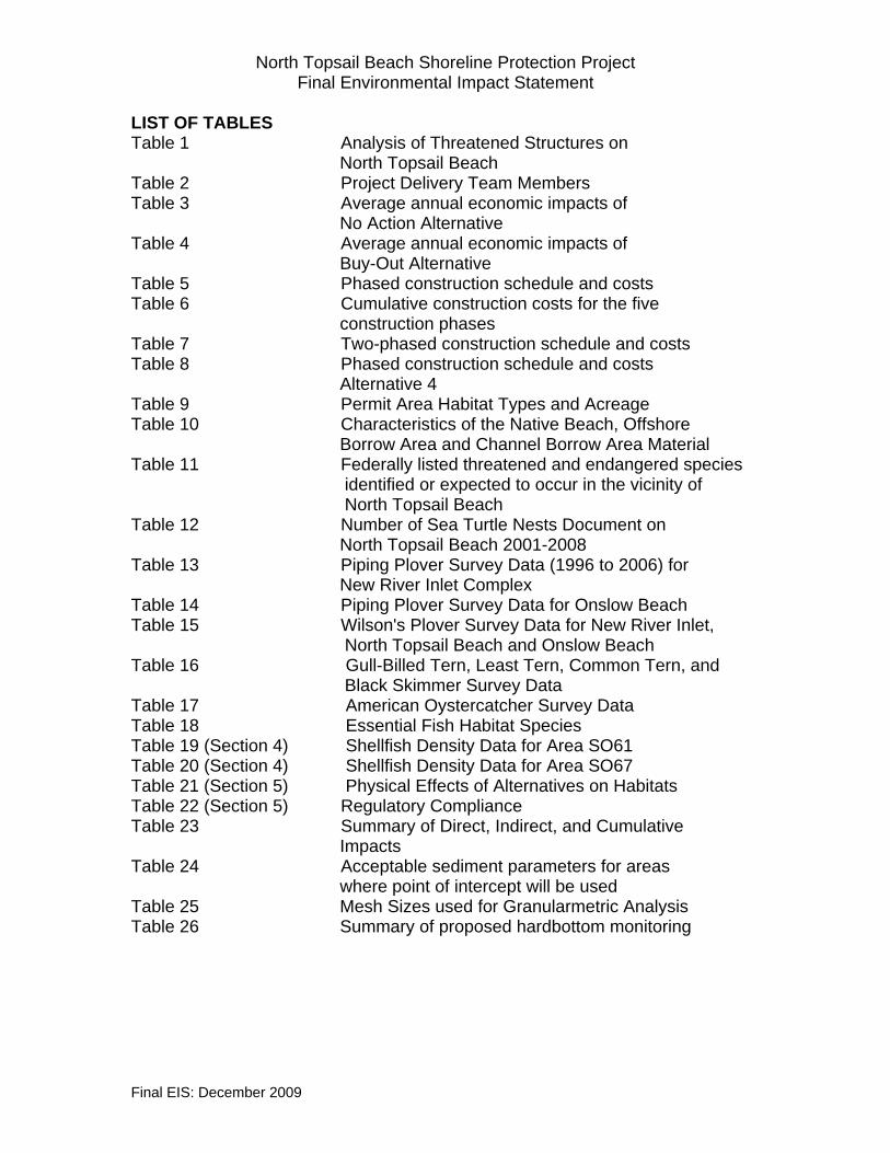
North Topsail Beach Shoreline Protection Project Final Environmental Impact Statement
Final EIS: December 2009
LIST OF TABLES Table 1 Analysis of Threatened Structures on North Topsail Beach Table 2 Project Delivery Team Members Table 3 Average annual economic impacts of No Action Alternative Table 4 Average annual economic impacts of Buy-Out Alternative Table 5 Phased construction schedule and costs Table 6 Cumulative construction costs for the five construction phases Table 7 Two-phased construction schedule and costs Table 8 Phased construction schedule and costs Alternative 4 Table 9 Permit Area Habitat Types and Acreage Table 10 Characteristics of the Native Beach, Offshore Borrow Area and Channel Borrow Area Material Table 11 Federally listed threatened and endangered species identified or expected to occur in the vicinity of North Topsail Beach Table 12 Number of Sea Turtle Nests Document on North Topsail Beach 2001-2008 Table 13 Piping Plover Survey Data (1996 to 2006) for New River Inlet Complex Table 14 Piping Plover Survey Data for Onslow Beach Table 15 Wilson's Plover Survey Data for New River Inlet, North Topsail Beach and Onslow Beach Table 16 Gull-Billed Tern, Least Tern, Common Tern, and Black Skimmer Survey Data Table 17 American Oystercatcher Survey Data Table 18 Essential Fish Habitat Species Table 19 (Section 4) Shellfish Density Data for Area SO61 Table 20 (Section 4) Shellfish Density Data for Area SO67 Table 21 (Section 5) Physical Effects of Alternatives on Habitats Table 22 (Section 5) Regulatory Compliance Table 23 Summary of Direct, Indirect, and Cumulative Impacts Table 24 Acceptable sediment parameters for areas where point of intercept will be used Table 25 Mesh Sizes used for Granularmetric Analysis Table 26 Summary of proposed hardbottom monitoring

North Topsail Beach Shoreline Protection Project Final Environmental Impact Statement
Final EIS: December 2009
LIST OF APPENDICES Appendix A – Subpart 1 Scoping Meeting and PDT Meeting Minutes Appendix A – Subpart 2 Pertinent Correspondence Appendix A - Subpart 3 Notice of Intent and Public Notice(s) Appendix A- Subpart 4 Response To Comments Appendix B Engineering Analysis Appendix C Geotechnical Investigations Appendix D Nearshore Sidescan Sonar Mapping Report Appendix E New River and New River Inlet Cultural Resource Remote Sensing Survey
Appendix F Cumulative Effects Assessment Appendix G Sea Turtle, Shorebird, and Seabeach Amarnath Data Appendix H Nearshore and Offshore Hardbottom Investigation Results

North Topsail Beach Shoreline Protection Project Final Environmental Impact Statement
APPENDIX B
Engineering Analysis
Final EIS: December 2009

Final Engineering Analysis Shoreline Protection Project
Town of North Topsail Beach, North Carolina
Prepared for:
North Topsail Beach, North Carolina
Prepared by:
Coastal Planning & Engineering of North Carolina, Inc. 4038 Masonboro Loop Rd.
Wilmington, NC 28409
July 2009

i COASTAL PLANNING & ENGINEERING OF NORTH CAROLINA, INC.
Executive Summary North Topsail Beach has an 11.1 mile ocean shoreline that occupies the north end of Topsail Island. The Town is bordered on the south by the Town of Surf City and on the north by New River Inlet. Development and infrastructure within the corporate limits of the North Topsail Beach have been damaged during recent storm events and remain vulnerable to damage associated with coastal storms. The north end of the Town is the most vulnerable area due to erosion and shoreline fluctuations caused by uncontrolled changes in position and alignment of the New River Inlet ocean bar channel. The Town is seeking Federal and State permits to allow implementation of a non-Federally funded shoreline and inlet management project that would preserve the Town’s tax base, protect its infrastructure, and maintain its tourist oriented economy. Most of the northern 7.25 miles of the town’s shoreline (shoreline north of baseline station 785+00) lies within the Coastal Barrier Resource System (CBRS) and is not eligible for federal storm damage protection. The southern 3.85 miles is presently being evaluated for a possible federal storm damage reduction project. Seven alternatives were considered and the applicant’s preferred alternative is Alternative 3: Implementation of an Inlet Management Plan for New River Inlet and construction of a beach fill along 11.1 miles of the Town’s shoreline. The design template for the beach fill within the CBRS includes an artificial dune with a crest elevation of +14.0 feet above NAVD fronted by a variable width horizontal beach berm at elevation +6.0 feet NAVD. The dune feature of the template would only be constructed in areas where the existing dune is inadequate. The beach fill proposed for the southern 3.85 miles is only intended to provide interim projection until such time the federal storm damage reduction project is implemented. The design template for the beach fill along the southern 3.85 miles consists of a horizontal berm at elevation +6.0 feet NAVD. The inlet management plan includes repositioning the of the main ocean bar channel to a more southerly alignment and periodic maintenance of the preferred position and alignment. The new channel would be constructed to a bottom width of 500 feet and a depth of -18 feet NAVD. Construction of the new channel would require the removal of 635,800 cubic yards of material based on the most recent survey of New River Inlet. Of this total volume 544,400 cubic yards is compatible with the native beach and 91,400 cubic yards incompatible. The incompatible material, which would be deposited in an upland disposal area, consists of a mixture of clay and shells. The compatible inlet material has an average mean grain size of 0.39 mm and would be used to initially construct the beach fill portion of the project along the northern 1.7 miles (9,000 feet) of the project area. Maintenance of the new channel in the preferred position and along the preferred alignment is critical for the recovery of the extreme northern end of the town’s shoreline. Therefore, the inlet management plan includes two channel thresholds which could trigger channel maintenance. The first threshold is based on shoaling of the new channel while the second is based on the position and orientation of the channel. For the shoaling threshold, channel maintenance would

ii COASTAL PLANNING & ENGINEERING OF NORTH CAROLINA, INC.
be required when shoaling of the new channel reaches 85% of the initial dredge volume. The position threshold would be exceeded when the channel migrates outside the preferred channel corridor established during initial construction. The time required for the channel to migrate out of the preferred corridor is not known, however; channel shoaling is expected to reach the 85% threshold within 3 to 4 years after construction. Accordingly, formulation of the inlet management plan portion of the project assumed channel maintenance would be required at least every 4 years. An offshore borrow area has been identified to provide beach fill for the remaining 9.4 miles of the North Topsail Beach shoreline. The borrow area is horseshoe shaped and located between 1 and 2 miles offshore, due south of the Town Hall. The borrow area contains approximately 6,551,000 cubic yards, 357,000 cubic yards of which is coarse material with a mean grain size of 0.33 mm and the balance composed of finer material with a mean grain size of 0.21 mm. The native beach has a mean grain size of 0.23mm. Hardbottoms exist offshore of North Topsail Beach with some hardbottom areas located approximately 900 to 3,600 ft from the baseline stations. In order to avoid direct impacts on these relatively close hardbottom areas, coarse fill material from the offshore borrow area or from the construction and/or maintenance of the new channel in New River Inlet will be placed in these areas. The use of coarser fill material will require less volume to construct the design beach fill template and will move the point of intercept of the fill with the existing beach profile well landward of the nearshore hardbottom areas. The point of intercept is the seaward most point where the beach fill would ultimately tie into the existing bottom following post-construction adjustments. The Town of North Topsail Beach proposes to construct the project in 5 phases based on its anticipated funding stream. The first phase of construction would occur between 16 November 2010 and 31 March 2011 (environmental dredging window) and would involve the relocation of the New River Inlet channel. Material from the channel relocation would be used to construct 9,000 feet of the beach fill from baseline station 1160+00, located next to New River Inlet, to 1070+00. Phase II would occur during the November 2012 to March 2013 dredging window and would cover 10,120 feet of shoreline between baseline stations 968+80 to 1070+00. Material for Phase II would come from the offshore borrow area. Coarse material from the offshore borrow area would be placed between baseline stations 1020+00 and 1070+00 (nearshore hardbottom areas) with the balance of the area constructed with material from the northeast portion of the borrow area. Phase III would be scheduled for the November 2014 to March 2015 dredging window or 4 years after the initial channel relocation and would cover the shoreline between baseline stations 785+00 and 900+00. This is an area that includes hardbottoms approximately 900 to 2,700 ft from the baseline stations and would be constructed using coarse material from either the offshore borrow area or coarse shoal material removed to reestablish the position and alignment of the inlet bar channel. Based on shoaling predictions in the new channel, the 85% shoaling threshold would be exceeded within the first four years following channel relocation which would trigger the first channel maintenance operation. The predicted shoaling of the new

iii COASTAL PLANNING & ENGINEERING OF NORTH CAROLINA, INC.
channel would be sufficient to initially construct the beach fill in Phase III and provide periodic nourishment for the beach fill constructed during Phase I. Phase IV, which would be scheduled for the 2016 to 2017 environmental dredging window, would be constructed using material from the offshore borrow area and would cover the shoreline north of station 900+00 to 968+80. Phase IV would complete the beach fill within the North and Central Sections of North Topsail Beach. Construction of Phase IV would also correspond to the time nourishment could be required along the Phase II shoreline (968+80 to 1070+00). Since channel maintenance would not be scheduled at this time, nourishment of Phase II would be accomplished using coarse material from the offshore borrow area. Phase V, the final initial construction phase, would occur during the 2018 to 2019 environmental dredging window and would provide an interim beach fill along the southern 20,320 feet of the town’s shoreline. Phase V would also be constructed using material from the offshore borrow area. Construction of Phase V would be scheduled 8 years after initial construction of the new bar channel in New River Inlet and, based on the theoretical shoaling predictions, could occur at the same time maintenance of the new channel is required. By this time, all or portions of the shoreline segments constructed during Phases I to IV would be in need of periodic nourishment, therefore, the inlet channel maintenance material could be deposited between the inlet and baseline station 785+00. The exact location of disposal would depend on the performance of the fill placed in the four segments. Following initial construction of the beach fill portion of the project, material removed to maintain the preferred channel position and alignment would be used to provide periodic nourishment of the beach fill between station 785+00 and New River Inlet.

Morphis
Typewritten Text
Morphis
Typewritten Text
Morphis
Typewritten Text
Morphis
Typewritten Text
Morphis
Typewritten Text
Morphis
Typewritten Text
Morphis
Typewritten Text
Morphis
Typewritten Text
Morphis
Typewritten Text
Morphis
Typewritten Text
Morphis
Typewritten Text
Morphis
Typewritten Text
Morphis
Typewritten Text
Morphis
Typewritten Text
Morphis
Typewritten Text
Morphis
Typewritten Text
Morphis
Typewritten Text
Morphis
Typewritten Text
ATTACHMENT C


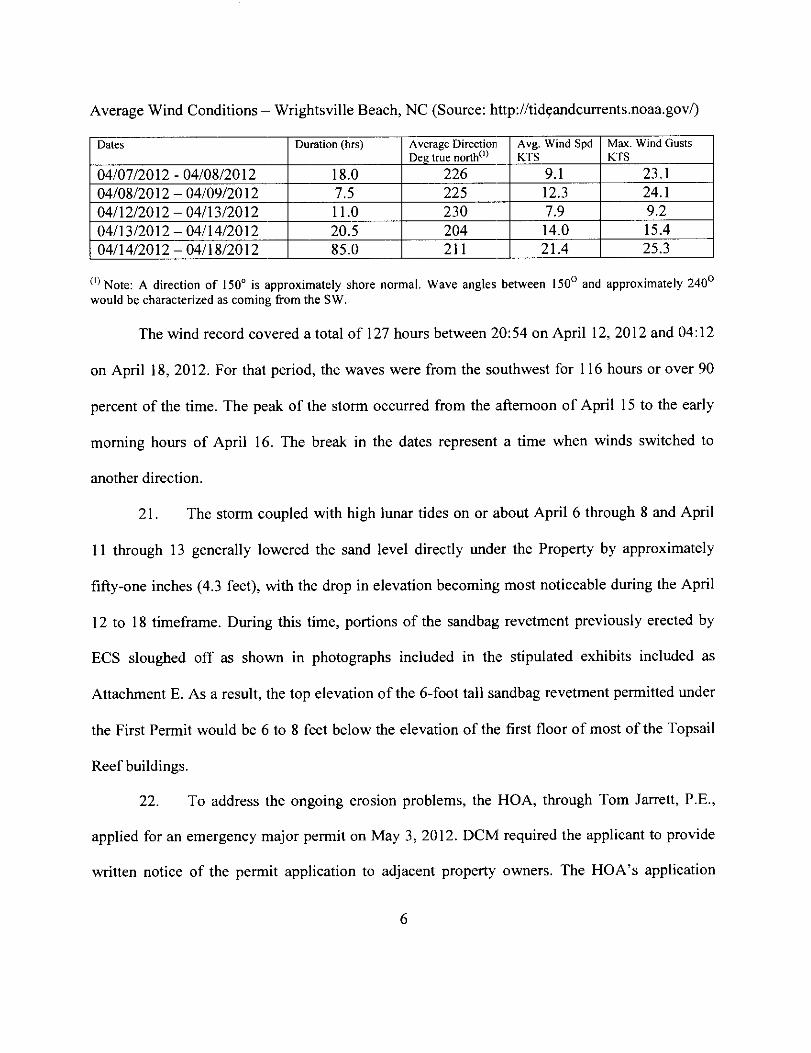


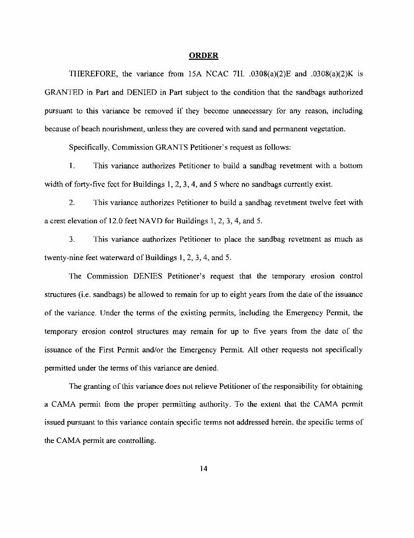


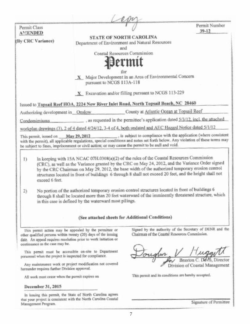
7

8

9


PUBLIC NOTICE
Issue Date: March 15, 2021 Comment Deadline: April 14, 2021
Corps Action ID #: SAW-2016-02091
All interested parties are hereby advised that the Wilmington District, Corps of Engineers (Corps) is holding a scoping meeting for proposed work within jurisdictional waters of the United States by the Town of North Topsail Beach in Onslow County, North Carolina. The proposal is to implement a New River Inlet Management Master Plan for shoreline protection in the northern section of the Town and includes the construction of a terminal groin along the southwest shoulder of New River Inlet. Specific plans and location information are described below and shown on the attached plans. Due to COVID-19 restrictions, the scoping meeting will not be an open public meeting, but will be presented in the Facebook Live forum on March 25, 2021 at 6:00 P.M. and can be viewed at the following link, https://fb.me/e/5B7NV8EgY. A recording of this event will be available at https://www.facebook.com/USACE.Wilmington for further viewing. This Public Notice and all attached plans are also available on the Wilmington District Web Site at https://www.saw.usace.army.mil/Missions/Regulatory-Permit-Program/Public-Notices/ .
Applicant: Town of North Topsail Beach C/o: Mr. David Gilbride, Town Manager 1000 Hwy 210 Sneads Ferry, North Carolina 28460
AGENT (if applicable): Dail Cordy and Associates, Inc. C/o: Mr. Steve Dail 201 N. Front St., Ste 307 Wilmington, North Carolina 28401
Authority
The Corps will evaluate this project pursuant to applicable procedures to Section 404 of the Clean Water Act and Section 10 of the Rivers and Harbor; and will develop an Environmental Impact Statement (EIS) to assess the proposal. Additionally, the Corps will coordinate with North Carolina Division of Coastal Management and North Carolina Division of Water Quality in the development of the Environmental Impact Statement (EIS) to ensure the process complies with all State Environmental Policy Act (SEPA) requirements.
US Army Corps Of Engineers Wilmington District

Location
The project site is located at 34.526763, -77.337396, adjacent to the New River Inlet, at the end of New River Inlet Road (SR 1568) and encompasses approximately 5,100 linear feet of inlet and oceanfront shoreline in North Topsail Beach, Onslow County, North Carolina.
Existing Site Conditions
North Topsail Beach is located on Topsail Island, a 22-mile long barrier island situated in both Onslow and Pender Counties, and encompasses approximately 11 miles at northeastern tip of the island. This portion of the island is generally low and narrow with elevations ≤10 ft MSL and subaerial widths range from approximately 400 to 1,000 ft. The oceanfront beach is backed by a low and discontinuous line of narrow dunes, and the majority of the subaerial island interior has been developed for residential use. The proposed project area comprises of New River Inlet and approximately 5,100 linear-ft of oceanfront shoreline at the most northern end of North Topsail Beach. This section of the island contains several oceanfront multi-family condominiums and apartments, with single-family residential structures closet to the inlet.
The New River Inlet channel is a designated federal navigational channel that is federally maintained via periodic dredging. In addition to this dredging, the Corps’ Regulatory Division issued a 30-year authorization on May 27, 2011 to the Town to maintain the ebb tide channel within a specific location. This permit allows the Town to conduct a maintenance dredging event if specific thresholds are triggered and has an expiration date of December 31, 2041. The Town’s reevaluation of the original alignment led to development of a modified “pivot channel” alignment that was authorized through a 2017 permit modification of the original 2011 authorization. Within the vicinity of the project area, other authorizations have been granted to the Town and separate individual property owners to provide protection along the parking lot at the inlet shoulder, dune construction and dune plantings along the oceanfront shoreline, and the installation of sand bags.
Applicant’s Stated Purpose
The Town’s stated purpose for the New River Inlet Management Master Plan is to mitigate ongoing severe and chronic shoreline erosion in order to protect structures and infrastructure located on the north end of North Topsail Beach. The inlet management component of the Town’s currently authorized shore protection project is a long-range strategy that may not provide significant north end protection for 15 to 20 years. North end erosion rates have accelerated during the early phases of that project, with rates as high as 100 feet/year occurring in the vicinity of the Topsail Reefs condominium complex. As stated by the Town, the extreme severity of the erosional threat necessitates the need for immediate action to supplement the Town’s existing shore protection project with the proposed terminal groin structure.

Project Description
Under the May 27, 2011 authorization, the Town conducted the initial 2012/2013 channel realignment and north end oceanfront nourishment event. After the channel dredging, the north end shoreline experienced higher than expected erosion rates, resulting in the rapid loss of the placed beach fill material. During the initial post-construction year (2013), essentially all of the material placed on approximately 3,700 linear feet of the northern most end eroded and returned to the inlet. Additionally, ebb channel shoaling and thalweg migration exceeded the established thresholds in just 18 to 24 months. By August 2014, accelerating north end erosion led the Town to seek an emergency permit for construction of a sandbag revetment to protect threatened homes and infrastructure on the north end. In February 2015, the Town completed construction of an approximate 2,000 linear-ft sandbag revetment that extends north from the existing Topsail Reefs revetment to New River Inlet. In total, the north end is currently protected by an approximate 3,600 linear-ft sandbag revetment.
With the channel realignment not protecting the northern end as expected and the sandbag revetment being a more short-term alternative, the Town reevaluated other protection options and have determined that a terminal groin would provide supplemental protection at this location. This project alternative would involve the construction of a 2,021 ft-long terminal groin on the north end ocean beach at New River Inlet and recurring beach nourishment of the adjoining approximate 5,100 linear-ft north end shoreline using sand derived from the inlets outer bar channel realignment dredging events. The proposed terminal groin would consist of three main sections: anchor section, upland section, and in-water section. Although the in-water section and most of the upland section would require immediate construction, the anchor section would be constructed at a later date as a cost-saving measure. As proposed, the landward-most approximate 500-ft section of the terminal groin would only be constructed when the receding shoreline contacts an established threshold for a specified buffer distance from the anchor footprint. Beach nourishment events would place approximately 310,000 cy of sand along the northernmost approximate 5,100 linear-ft reach of the north end shoreline (average of 61 cy/ft). Nourishment events would occur approximately every four years in conjunction with outer bar channel realignment/maintenance events. The Town’s existing May 27, 2011 permit authorizes dredging of the outer bar channel to a depth of 16 ft and width of 500 ft. Inlet channel dredging events are expected to yield approximately 600,000 cy of beach-compatible material (based on recent sedimentation and pre-project bathymetries). The volume of dredged material in excess of that required for the approximate 5,100 linear-ft project shoreline reach will be placed to the southwest on the remainder of the Phase 1 reach and/or the Phase 2-4 shoreline reaches in accordance with the Town’s existing permit. Assuming the long-term success of the New River Inlet ebb channel realignment project, the terminal groin may eventually be modified (e.g., shortened, lowered) or removed completely (based on monitoring data and project performance).

Several alternatives are being considered for the shoreline protection in the northern end of the island. These alternatives will be further formulated and developed during the scoping process and an appropriate range of alternatives, including the no federal action alternative, will be considered in the development of the EIS and review of the Town’s permit request.
The scheduled public scoping meeting will be held on March 25, 2021 at 6:00 P.M. As stated above, the scoping meeting will not be an open public meeting, but will be presented in the Facebook Live forum and can be viewed at the following link, https://fb.me/e/5B7NV8EgY. A recording of this event will be available at https://www.facebook.com/USACE.Wilmington for further viewing.
The scoping meeting is designed to provide information in order to solicit comments from the public; Federal, State and local agencies and officials; and other interested parties to incorporate in the Draft EIS document. The purpose of these comments concerning public interest factors, ranging from navigation to biological resources to private and public lands, will identify issues to be addressed in the Draft EIS.
Written comments pertinent to the proposed work, as outlined above, must be submitted to this office, Attention: Mr. Jordan Jessop, at [email protected], no later than 5:00 p.m. on April 14, 2021. Questions can be directed to Mr. Mickey Sugg at telephone (910) 251-4811, Wilmington Regulatory Field Office.


GENERAL ASSEMBLY OF NORTH CAROLINA
SESSION 2021
S D
SENATE BILL DRS45031-MH-4B*
Short Title: Clarify Terminal Groin Definition. (Public)
Sponsors: Senators Steinburg and Lazzara (Primary Sponsors).
Referred to:
*DRS45031-MH-4B*
A BILL TO BE ENTITLED 1 AN ACT TO CLARIFY THAT A TERMINAL GROIN IS NOT AN EROSION CONTROL 2
STRUCTURE AND THEREFORE IS NOT SUBJECT TO LIMITATIONS ON THOSE 3 STRUCTURES. 4
The General Assembly of North Carolina enacts: 5 SECTION 1. G.S. 113A-115.1(a) reads as rewritten: 6
"(a) As used in this section:The following definitions apply in this section: 7 (1) "Erosion control structure" means a Erosion control structure. – A breakwater, 8
bulkhead, groin, jetty, jetty (other than a jetty that is a terminal groin or a 9 portion of a terminal groin), revetment, seawall, or any similar structure. 10
(1a) "Estuarine shoreline" means all Estuarine shoreline. – All shorelines that are 11 not ocean shorelines that border estuarine waters as defined in 12 G.S. 113A-113(b)(2). 13
(2) "Ocean shoreline" means the Ocean shoreline. – The Atlantic Ocean, the 14 oceanfront beaches, and frontal dunes. The term "ocean shoreline" includes 15 an ocean inlet and lands adjacent to an ocean inlet but does not include that 16 portion of any inlet and lands adjacent to the inlet that exhibits characteristics 17 of estuarine shorelines. 18
(3) "Terminal groin" means one Terminal groin. – One or more structures 19 constructed at the terminus of an island or on the side of an inlet, with a main 20 stem generally perpendicular to the beach shoreline, that is primarily intended 21 to protect the terminus of the island from shoreline erosion and inlet migration. 22 A "terminal groin" shall be pre-filled with beach quality sand and allow sand 23 moving in the littoral zone to flow past the structure. A "terminal groin" may 24 include other design features, such as a number of smaller supporting 25 structures, that are consistent with sound engineering practices and as 26 recommended by a professional engineer licensed to practice pursuant to 27 Chapter 89C of the General Statutes. A "terminal groin" is not a jetty." 28
SECTION 2. This act is effective when it becomes law. 29
FILED SENATEJan 28, 2021
S.B. 26PRINCIPAL CLERK


Mr. Brian Edes
Page 2 of 8
APPLIED TECHNOLOGY & MANAGEMENT, INC.
P.O. BOX 20336 • CHARLESTON, SC 29413-0336 • 843.414.1040
The following is a brief timeline of events involving the reach of shoreline in front of the Reefs since 2014: 2016 – Cedar Bush Cut dredging and beach placement just north of Topsail Reef Complex.
Only 130,000 cy placed. 2016 – Hurricane Matthew makes landfall. 2018 – Hurricane Florence makes landfall. 2018 – The Town of North Topsail Beach and the USACE commence the Long-term Inlet and
Shoreline Management Environmental Impact Statement (EIS) Investigation (including evaluating the use of a terminal groin).
2019 – Hurricane Dorian makes landfall. 2020 – Hurricane Isaias makes landfall. 2021 – USACE Intracoastal waterway crossing and Jacksonville channel dredging with beach
disposal (presently ongoing). Although dune pushes (aka beach scraping) were performed within the Town of North Topsail Beach following Hurricanes Matthew and Florence, a dune push could not occur in front of the Reefs Complex because there was no dune in front of the Reefs to push, rather the shoreline in that area consist of solely of intertidal beach. This condition in and of itself demonstrates that the sandbags present in front of the Reefs are the Reefs sole source of protection from becoming completely inundated by tides. Figures 2 and 3 present photos from Matthew and Florence impacts on the sandbags:
Figure 2: Hurricane Matthew impacts on sandbag revetment just to the north of Topsail Reef Villas.

Mr. Brian Edes
Page 3 of 8
APPLIED TECHNOLOGY & MANAGEMENT, INC.
P.O. BOX 20336 • CHARLESTON, SC 29413-0336 • 843.414.1040
Figure 3: Hurricane Florence impacts on Topsail Reef Villas.
In my professional opinion removal of the sandbags at this time would present a significant health and safety risk as the Reefs would be in imminent danger of collapsing, would be uninhabitable, and their collapse would pose a significant health and safety risk to the environment as the ocean would inevitably overcome the contents of the structures and carry those contents to the surrounding area and beyond.

Mr. Brian Edes
Page 4 of 8
APPLIED TECHNOLOGY & MANAGEMENT, INC.
P.O. BOX 20336 • CHARLESTON, SC 29413-0336 • 843.414.1040
Figure 4 presents a 2020 aerial of the Topsail Reef Villas with a dune line parallel with the existing dunes on either side of the Topsail Reef Villas. The dashed red line in Figure 4 shows that the majority of all the Topsail Reef structures would be out on the beach (seaward of the dune line) almost immediately if the sandbags were removed:
Figure 4: 2020 aerial with red dashed line showing where dune line would be without the sandbag protection.
The Town’s “Terminal Groin” Project The Town of North Topsail Beach (NTB) has begun the process to develop a long-term solution to mitigate erosion for the Phase 1 reach of shoreline which includes the area of shoreline in front of the Reefs. The Town’s long-term inlet and shoreline management plan includes the development of an Environmental Impact Statement (EIS) to determine a feasible means of providing a long-term solution to mitigate erosion in that area. A terminal groin is included as an alternative in this EIS process. While this EIS project is commonly referred to as the “terminal groin” project, it is important to note that no final alternative has been selected and other alternatives will be vetted during the EIS process. Figure 5 depicts an overview of the terminal groin, beach nourishment, and New River Inlet channel borrow area:
Dune Line Without Sandbags

Mr. Brian Edes
Page 5 of 8
APPLIED TECHNOLOGY & MANAGEMENT, INC.
P.O. BOX 20336 • CHARLESTON, SC 29413-0336 • 843.414.1040
Figure 5: Proposed beach fill and terminal groin plan for the project area (including Topsail Reef Villas).
In terms of timing, a public scoping meeting is planned for March 25, 2021 for this EIS process. According to the Corps announcement: “The scoping meeting is designed to provide information in order to solicit comments from the public; Federal, State and local agencies and officials; and other interested parties to incorporate in the Draft EIS document.” The EIS process is projected to last approximately 3 years. At the end of this process, the preferred long-term management alternative will be implemented by the Town. It is anticipated that this will alleviate the need for sandbags along this section of shoreline. Present Conditions Figures 6 and 7 present photos of the sandbags protecting Topsail Reef Villas on March 16, 2021 during high tide conditions. Without the sandbags, high tides and wave runup would inundate and undermine the Topsail Reef structures. These water and wave effects would damage the
Topsail Reef Villas Complex

Mr. Brian Edes
Page 6 of 8
APPLIED TECHNOLOGY & MANAGEMENT, INC.
P.O. BOX 20336 • CHARLESTON, SC 29413-0336 • 843.414.1040
structural integrity of the foundations. In addition to foundation damage, debris and potentially hazardous material would be swept back into the sea and litter the nearby shorelines.
Figure 6: March 16, 2021 photo of the sandbags protecting the Topsail Reef Villas at high tide (looking south).
Figure 7: March 16, 2021 photo of the sandbags protecting the Topsail Reef Villas at high tide (looking north).
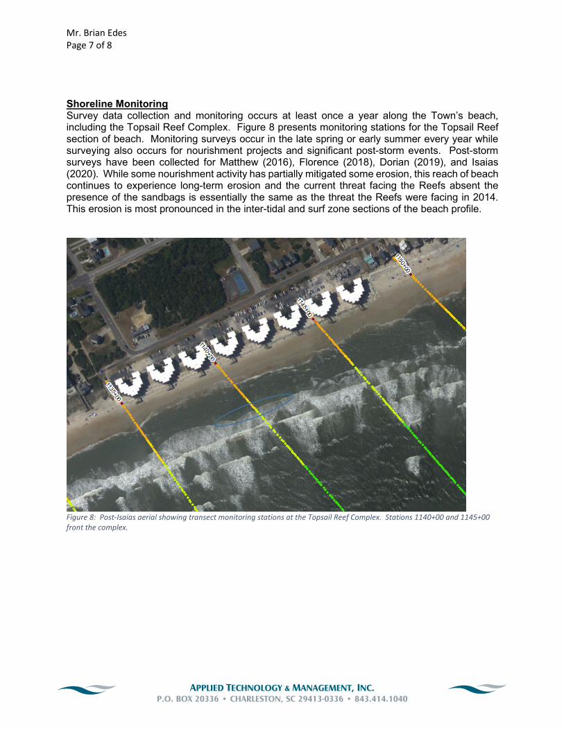
Mr. Brian Edes
Page 7 of 8
APPLIED TECHNOLOGY & MANAGEMENT, INC.
P.O. BOX 20336 • CHARLESTON, SC 29413-0336 • 843.414.1040
Shoreline Monitoring Survey data collection and monitoring occurs at least once a year along the Town’s beach, including the Topsail Reef Complex. Figure 8 presents monitoring stations for the Topsail Reef section of beach. Monitoring surveys occur in the late spring or early summer every year while surveying also occurs for nourishment projects and significant post-storm events. Post-storm surveys have been collected for Matthew (2016), Florence (2018), Dorian (2019), and Isaias (2020). While some nourishment activity has partially mitigated some erosion, this reach of beach continues to experience long-term erosion and the current threat facing the Reefs absent the presence of the sandbags is essentially the same as the threat the Reefs were facing in 2014. This erosion is most pronounced in the inter-tidal and surf zone sections of the beach profile.
Figure 8: Post-Isaias aerial showing transect monitoring stations at the Topsail Reef Complex. Stations 1140+00 and 1145+00
front the complex.

Mr. Brian Edes
Page 8 of 8
APPLIED TECHNOLOGY & MANAGEMENT, INC.
P.O. BOX 20336 • CHARLESTON, SC 29413-0336 • 843.414.1040
Conclusion In summary, it is my professional opinion that if the sandbags in front of the Reefs are removed the structures would almost immediately become uninhabitable and would be in imminent threat of collapsing, and ultimately would collapse, into the Atlantic Ocean. This would present a tremendous life, public health, and environmental risk. Although a few smaller scale nourishments in 2016 and the ongoing Corps placement projects have helped to mitigate the threat presented by erosion in this area they have by no means prevented the erosion issues facing the Reefs from worsening. The Town’s ongoing EIS process is anticipated to provide a long-term solution to this section of shoreline. I estimate that process will take approximately 3 years based on the information presently available to me. The opinions and conclusions stated in this letter are based on my personal observation of the Reefs as well as my experience as a costal engineer as stated in my CV, a copy of which is attached to this letter.
Sincerely,
Fran Way, P.E. Coastal Engineer

Francis J. Way, PE Senior Professional Engineer
SUMMARY OF QUALIFICATIONS
Mr. Way specializes in coastal, environmental and water resources
engineering. He applies his background in coastal and water
resources to flood hazard risk assessments, wave and current
modeling, beach nourishment, dredging and navigation studies,
alternatives analyses, as well as shoreline stabilization projects. Mr.
Way provides hydrodynamic, water quality, flushing, watershed,
sedimentation, acoustic, artificial neural network, shoreline, and wave
modeling and completes field data collection, data mining, statistical,
and time series analyses. He is proficient in various surface water
hydrodynamic, hydrologic, hydraulic, and water quality models.
Mr. Way has provided services on more than 40 FEMA letters of map
revision (LOMRs) and flood insurance rate map (FIRM) appeals. Mr.
Way provides expert witness testimony on coastal engineering and
FEMA-related issues.
PROJECT EXPERIENCE
WATERFRONT AND COASTAL – U.S.
Central Reach Reimbursement Nourishment Project, Holden Beach,
NC: Project manager responsible for the FEMA-sponsored
engineered beach mitigation project. This FEMA-sponsored
“Category G” project is related to hurricane damages from Hurricane
Florence (2018) and Hurricane Dorian (2019). An offshore borrow
area search was conducted to identify over 1 million cubic yards of
material. Once a suitable sand source and volume was identified, a
permit application was developed and submitted. Bid package
development is currently ongoing and project construction is slated
for winter 2021/2022. Coordination with FEMA and the Town has
been consistent during this process to ensure mitigation funding.
Holden Beach Nourishments, Holden Beach, NC: Project manager
responsible for the design, permitting and overseeing borrow area
and beach nourishment construction activities in 2008, 2009, 2014,
2017 and 2019. Nourishments vary in size and shoreline reach
placement. 2008 and 2009 nourishments were truck hauls of 200,000
cubic yards, 2014 and 2019 projects used an inlet shoal as a borrow
source while the 2017 nourishment utilized an offshore borrow area
and was 1.31 million cubic yards. The 2009 project was a FEMA
mitigation project due to Hurricane Hanna. The 2017 project also
included some FEMA mitigation from Hurricane Matthew (2016).
Interacted with state and federal regulatory agency personnel on a
weekly basis and ensured the project complied with all permit and
monitoring conditions. Developed bid documents and oversaw
bidding process. Performed construction administration and
PROFESSIONAL EXPERIENCE
Total Years: 22
Years with ATM: 20
AREAS OF SPECIALIZATION
• Coastal and Ocean Engineering
• Coastal Processes and Sediment
Transport Modeling
• Wave Modeling
• Shoreline Erosion Modeling
• Hydrodynamic Modeling
• Water Quality Modeling
• FEMA Flood Zone Analysis and
Remapping
• Permitting and Comprehensive
Environmental Studies
• EIS and NEPA support
• Endangered Species Formal
Consultations
• Fisheries, Wetland and Biological
Studies
• Physical and Biological
Oceanography
• Data Collection and Statistical
Analysis
• Data Mining
EDUCATION
• MS, Ocean Engineering, Texas
A&M University, 2000
• BS, Biology, Boston College,
1993
PROFESSIONAL
REGISTRATIONS
• Prof. Engineer, SC, No. 27831,
2009
• Prof. Engineer, NC, No. 044849,
2017
PROFESSIONAL AFFILIATIONS
• Member, FEMA Scientific
Resolution Panel
• SC Beach Advocates

Page 2 Francis J. Way, PE
reviewed all payment/volume data. Coordinated all post-project monitoring requirements. Borrow areas
included upland, nearby sections of the Atlantic Intracoastal Waterway (AIWW), and offshore. Currently
working on designing and permitting a nourishment project related to FEMA mitigation from Hurricanes
Florence and Michael. This project will use an offshore borrow area.
Post-Hurricane Florence Assessment and Mitigation, North Topsail Beach, NC: Performed post-hurricane
support and evaluations for the Town following one of the most destructive hurricanes to hit since
Hurricane Fran in 1996. Worked with the Town and FEMA to construct emergency dunes (Category B) and
engineered beach (Category G) mitigation. Developed an estimate of probable costs for FEMA to get the
mitigation/recovery projects obligated for FEMA reimbursement. Permitted, bid, and constructed an
upland truck haul project for the Category B section of shoreline in spring 2021. This truck haul project
placed ~150,000 cy of sand over 4 miles of shoreline. Worked with the Town to ensure FEMA funding as
well as acquire some additional state funding for additional work. The Category G project for 600,000 cy
is currently in permitting with construction to occur in the winter/spring environmental window of
2021/2022.
Topsail Beach Dune Development Litigation, Topsail Beach, NC: Worked with an attorney representing a
group of homeowners opposed to a recent local ordinance change that will result in the residential
development of a dune system that has only been in existence for the last decade. Applied my experience
with FEMA regulations as well as coastal risk analyses to identify several potential issues with the
proposed local ordinance change. Provided a sworn affidavit.
Crab Bank Sedimentation Study, Mount Pleasant, SC: Worked with the Town of Mount Pleasant to ensure
that the Crab Bank Island bird habitat restoration was designed and constructed as to not detrimentally
impact the mouth of Shem Creek from a navigational and recreational perspective. Developed several
numerical models: wave model, hydrodynamic model and sedimentation model to evaluate several
different placement locations and volumes. Met with the Town, USACE, SCDNR and other stakeholders
frequently to optimize the habitat restoration effort.
Barnard Expert Witness Testimony, James Island, SC: Provided attorney support for a lawsuit related to
tidal creek erosion and damage to docks and upland decks. Visited site, reviewed erosion and
currents/waves, and all relevant materials. Provided coastal engineering technical expertise regarding
erosion and potential mitigation. Provided technical review and reviewed potential cost estimates. Case
was successfully settled.
Coastal Engineering for a Seawall Repair at 2881 Marshall Blvd., Sullivan's Island, SC: Assessed an existing
steel sheet pile seawall and developed a repair plan. Developed cost estimates and obtained necessary
town and state permits. Worked with contractors to repair the sheet pile wall and to truck haul ~300 cubic
yards of sand behind the wall and on its flanks due to hurricane related erosion.
Long Island Bridge Access, Folly Beach, SC: Performed an analysis related to constructing a bridge to
access a coastal island. State regulations limit coastal bridges and the analysis developed a strategy to
permit the bridge.
Topsail Beach Terminal Groin Analysis and Modeling, Topsail, NC: Project manager who developed
alternative analysis and subsequent studies to determine the feasibility of a terminal groin and
nourishment project along the erosive north end. Used the DELFT3D numerical sediment transport model
which considers inlet and nearshore currents, tides and waves.

Page 3 Francis J. Way, PE
Shipyard Creek Mooring Dolphin Design and Permitting, Charleston, SC: Lead in the design and
permitting of 10 mooring dolphins. The primary use of the dolphins is to berth two dredge scows.
Negotiation with regulatory agencies was required to minimize monitoring conditions. Following the
successful design and permitting of the mooring dolphins, a permit modification was successfully
obtained that was related to a change in construction materials and methods.
Grand Marina Basin Construction Feasibility and Dredge Disposal Analysis, Mount Pleasant, SC: Developed
an analysis related to a potential marina basin in an old dredge disposal area along the intracoastal
waterway. Also developed a cost estimate for the project, recommendations to ensure adequate flushing,
and long-term dredged material management costs and alternatives.
Boat Ramp and Jetty/Groin Design and Numerical Modeling, Biloxi, MS: Developed sediment transport
model for the project site, a Gulf of Mexico oceanfront location, and evaluated several different boat
ramp and jetty/groin protection alignments. Also developed report documenting potential updrift and
downdrift effects as well as recommendations.
Municipal Memorial Waterfront Park Phase 2, Pier Wave, Water Level, Current, And Flushing Analysis,
Mount Pleasant, SC: Developed design forces for the pier related to waves, water levels, currents. Also
developed a wave screen design to maximize operations for the marina component of the pier. Assisted
in permitting and evaluating flushing as well as scour.
Belle Isle Yacht Club Marina Sedimentation Assessment, Georgetown, SC: Reviewed existing and historical
sedimentation issues at the marina. This included reviewing hydrodynamic and environmental
data/reports. Developed several options to reduce sedimentation including entrance reconfiguration,
additional sheet piling, moving freshwater inputs, and dredge footprint alterations. Developed a numerical
model to quantify sedimentation minimization alternatives and worked with the client to permit and
implement these solutions.
Bay Point Island Dock Master Plan, Bay Point Island, SC: Developed a dock master plan for two
undeveloped islands along the coast. Dock master planning included identifying all lots/parcels that can
accommodate docks and then designing centralized community docks based on this analysis to reduce
the total number of docks needed.
Cape Fear River Sedimentation Study, Wilmington, NC: Collected wave, water level, current, and flow data
as well as bottom sediment and suspended sediment to assess potential sedimentation issues at
proposed marina site. Used desktop empirical models as well as collected data to establish sedimentation
patterns in the project area. Also evaluated marina tranquility alternatives related to wave exposure.
Marina Basin Wave Tranquility Assessment, Wave Modeling and Wave Screen Design, Bay St. Louis, MS:
Evaluated wave basin agitation and tranquility of an existing wave basin. Utilized the CGWave model to
assess existing conditions as well as proposed alterations/additions to enhance basin tranquility under
operational and extreme conditions.
Marina Wave Modeling and Design Alternatives Review, Burlington, VT: Performed limited wave modeling
and interacted with design team related to a marina development project on Lake Champlain.
Coastal Island Resort Feasibility and Alternatives Assessment of Dredging, Vessel Docking, and Island
Access Options, Bay Point Island, Beaufort County, SC: Collected bathymetry and sediment data in support

Page 4 Francis J. Way, PE
of dredging feasibility. Characterized sediment material and potential uses. Designed channel and
developed several island access alternatives. Developed cost estimates for each alternative.
Dock Master Plan Development, Bay Point Island, Beaufort County, SC: Developed a conceptual dock
master plan for coastal island development purposes and interaction with state regulatory agencies.
Wake, Wave/Current Data Collection and Wave Modeling, Manhattan, NY: Collected wake, wave, and
current data on the East River in support of a marina project. Also applied the CMS-Wave model to assess
marina tranquility, entrance opening configuration, and breakwater/wave fence/floating breakwater
needs. Developed wave fence loads based on model and data collection.
Recreational Yacht Dock Design, Permitting and Construction, Sea Island, GA: Project manager responsible
for design, permitting, bid, and assisted in construction oversight of large residential dock capable of
handling a 70-foot yacht. Dock included electrical and low-profile platform for 30-foot vessel.
Transient Vessel Funding Boating Infrastructure Grant (BIG) Application, Brunswick, GA: Project manager
responsible for working with the City of Brunswick to submit the necessary information to receive federal
funding for waterfront improvements along Brunswick’s historic district. Funding is for transient vessels
longer than 26 feet and encourages travel up and down the eastern seaboard.
Marina Basin Excavation and Beneficial Uses Study, Daufuskie Island, SC: Worked with client and
regulatory agencies to develop a resort marina basin. Dredged material disposal (including beneficial
uses) and water quality modeling were two primary studies conducted.
Liberty Harbor Wave and Current Study, Brunswick, GA: Performed a physical analysis of the wind and
wave environment in support of a marina project. Tasks included current, flow, wind-wave, and vessel
wake data collection as well as wave and current modeling. Several different wave attenuation layouts
were modeled, and a final design was developed.
Arlington Marina Environmental Studies, Pamlico County, NC: Performed water quality and flushing
analysis and modeling in support of an environmental assessment and marina village development
project.
Commercial Dock Design, Permitting, and Construction Oversight, Village Creek Landing, St. Simons
Island, GA: Project manager responsible for the redesign of a commercial dock and performed all
permitting. Developed bid documents, evaluated bids, coordinated with contractor throughout the
construction process.
Harbor Station Marina Wave Design and Flushing Analysis, Harbor Station, VA: Developed extreme water
level and wave forces for a proposed marina development on the Potomac River. Assessed existing water
quality and potential project impacts. Performed flushing analysis and established marina
entrances/openings based on this analysis.
Ingleside Marina Alternatives Analysis, Corpus Christi, TX: Performed an alternatives analysis in support of
a marina village. Tasks included locating and assessing several potential locations and creating and
evaluating several onsite designs based on project purpose and need. Water quality, wetland impacts and
economics evaluations were all performed.

Page 5 Francis J. Way, PE
Village Creek Landing Dredge and Disposal Analysis, St. Simons Island, GA: Project manager responsible
for designing of a shallow-draft channel dredge project and researched disposal alternatives in the area.
Also provided cost estimates and long-term management issues.
Nordic Aquafarms Coastal Conditions Analysis and Pipeline Anchoring/Armoring Design, Belfast, ME:
Developed a coastal conditions analysis for the intake and discharge pipelines for an upland aquaculture
facility. Intake and discharge pipeline anchoring and armoring design was required to ensure successful
facility operation. Pipelines extended from the upland out to 50 feet deep and required different
techniques based on depth and energy exposure (waves, currents, sediments, etc.) Worked with the
project team to develop seismic and geotechnical sampling plans.
Charleston Harbor Marina Living Shoreline Grant Funding Application, Charleston, SC: Developed and
submitted a living shoreline application for an erosive section of shoreline along the clients' shoreline on
Charleston Harbor. The proposed living shoreline solution is a rock sill approximately 200 feet long.
Patriots Point Living Shoreline Breakwater Analysis, Mount Pleasant, SC: Developed a living shoreline
breakwater to protect an eroding section of marsh that was contributing to the sedimentation problem in
the adjacent marina. The project was designed to minimize shoreline erosion to the lee of the living
shoreline and to reduce maintenance dredging in the marina. A comprehensive coastal analysis was
performed, and a wave model was used to assess breakwater size and shoreline response. Developed cost
estimates for the alternatives proposed.
Patriots Point Oceanfront Bulkhead Design and Permitting, Debidue, SC: Worked for a group of 20
oceanfront homeowners to design and permit a timber bulkhead that would replace an existing 1,800 feet
of timber bulkhead that is beyond its design life. The permit was obtained but appealed. Provided expert
witness testimony and technical support to attorneys to defend the permit.
Breakers/Clarke Ave Numerical Modeling and Breakwater Analysis, Palm Beach, FL: Responsible for
development and review of a state-of-the-art sediment transport numerical model. The CMS model used
waves, water levels, currents/flows to model the project area shoreline and nearshore areas. Several hard
structures (groins, revetments, bulkheads, breakwaters) were included in the modeling. Several
alternatives were modeled.
Hurricane Damage Analysis, FEMA Coordination, and Beach/Dune Mitigation/Restoration, Holden Beach,
NC: Assisted the Town in recovery from Hurricanes Florence and Michael. Performed beach and dune
surveying and loss calculations; developed necessary documents for FEMA mitigation and reimbursement;
and identified several alternatives for restoring beach and dune system (upland, nearshore, offshore sand
sources, etc.).
Residential Homeowner Erosion Analysis and Recommendations, Sullivan’s Island, SC: Provided a review of
recent oceanfront erosion at the subject site and provided several recommendations to mitigate the
erosion. Recommendations need to comply with town, state and federal restrictions.
Crab Bank Island Mitigation, Restoration Modeling and Coastal Analysis, Mount Pleasant, SC: Reviewed
proposed mitigation plans for Crab Bank, an eroding island that is an important seabird rookery. Modeled
and analyzed the proposed mitigation plans and developed recommendations and technical comments
on how to make project more successful from a coastal engineering perspective (erosion, coastal
processes, island movement, etc.)

Page 6 Francis J. Way, PE
South Carolina State Ocean Baseline Line Revised Map Review and Appeal, Hilton Head, SC: Reviewed
newly released South Carolina state ocean baseline and setback lines at the project site and all
background materials. Found several technical items for an appeal (based on incorrect analysis) of the
new maps and appealed the proposed changes. Worked with an attorney and provided technical support.
South Carolina State Ocean Baseline Line Revised Map Review and Appeal, Garden City, SC: Reviewed
newly released South Carolina state ocean baseline and setback lines at the project site and all
background materials. Found several technical items for an appeal (based on incorrect analysis) of the
new maps and appealed the proposed changes. Worked with an attorney and provided technical support.
South Carolina State Ocean Baseline and Setback Line Revised Map Review and Appeal, Sullivan’s Island,
SC: Reviewed newly released South Carolina state ocean baseline and setback lines at the project site and
all background materials. Found several technical items for an appeal (based on incorrect analysis) of the
new maps and appealed the proposed changes. Worked with an attorney and provided technical support.
South Carolina State Ocean Baseline and Setback Line Revised Map Review and Appeal, Isle of Palms, SC:
Reviewed newly released South Carolina state ocean baseline and setback lines at the project site and all
background materials. Found several technical items for an appeal (based on incorrect analysis) of the
new maps and appealed the proposed changes. Worked with an attorney and provided technical support.
Ocean Rock Revetment Design, Hilton Head Island, SC: Designed a rock revetment for 500 feet of
shoreline. Developed forces, erosion, wave heights, wave periods for rock sizing and dimensioning with a
focus on Hurricane Matthew impacts. Worked with contractor to optimize protection with project costs.
Coastal Erosion and Stormwater System Review, Isle of Palms, SC: Performed a site visit and developed an
assessment related to a change in the stormwater system that resulted in coastal erosion on the active
beach which also created beach access issues. Worked with the City, homeowners, and attorney to
mitigate the problem.
Dune Restoration Design and Permitting, Sullivan’s Island, SC: Worked with a homeowner along Sullivan's
Island oceanfront to design and permit a dune restoration project in response to Hurricanes Matthew and
Joaquin. Revegetation and truck access restoration were also included in the effort. Coordinated with
truck haulers and obtained cost estimates.
Post-Hurricane Matthew Timber Bulkhead "Damage Beyond Repair" Inspections, Daufuskie, Garden City
and Harbor Island, SC: Performed lot by lot timber bulkhead inspections to determine level of damage to
each structure. The state (OCRM) assigned ATM several beaches to perform these independent
inspections to determine if these structures were “destroyed beyond repair" as determined by state
regulations. Worked with the state in contested cases.
Groin Rehabilitation, Folly Beach, SC: Designed, permitted and bid the rehabilitation and reconstruction of
nine groins along a 5,000-foot section of beach. The existing groins had deteriorated significantly over the
last few decades. Developed cost estimates for the groin rehabilitation.
Pine Island Shoreline Stabilization, Hilton Head Island, SC: Worked with property owner association to
stabilize 1,000 feet of shoreline that connects to the Pine Island natural area. Nourishment and a rock
revetment were initially proposed; however, the rock revetment was removed due to natural resource
agency objections and state precedents. A dune walkover/access feature was ultimately permitted and
constructed along with a beach nourishment.

Page 7 Francis J. Way, PE
Comprehensive Beach Management Plan Update, Isle of Palms, SC: Worked with the City to update its
local comprehensive beach management plan. Updated all beach-related and beach-adjacent structures
(erosion control features, walkovers, pools within setback lines, historical erosion, houses/gazebos/decks
on active beach, etc.)
Vegetation/Shoaling Analysis and Expert Witness Support, Beaufort, SC: Provided expert witness support
to a homeowner that was contesting a state permit decision regarding a dock application. Evaluated
sedimentation rates at the site and provided erosion and accretion/shoaling estimates.
Ocean Club Villas Bulkhead Violation Expert Witness Support, Isle of Palms, SC: Provided expert witness
and coastal engineering support to a condo association that was contesting a state enforcement fine for
an unpermitted bulkhead on the oceanfront. Successfully worked with the attorney and condo association
to significantly reduce the fine.
Expert Witness Testimony, Sullivan’s Island, SC: Provided expert witness support to a homeowner that was
contesting a state permit decision. Developed written reports, coordinated with attorneys and provided
advice/strategizing. Depositions and testimony were involved.
Attorney Support, Various Sites in SC: Worked with several area attorneys in support of challenges to state
permitting regulations, proposed projects and baseline/setback line delineations. Project locations include
Edingsville Beach, Sullivan’s Island, Capt. Sam’s Inlet, and Hunting Island.
Coastal Erosion and Mitigation for Individual Homeowners, Sullivan’s Island, SC: Assessed erosion and
mitigation options (nourishment, bulkhead, revetment, geotextile, etc.) for homeowners experiencing
significant erosion that threatened habitable structures. Designed, permitted, and selected contractor(s).
Coastal Due Diligence of Resort Property, Isle of Palms, SC: Performed coastal due diligence for a
potential buyer of a coastal resort with a history of erosion problems. Reviewed the causes of the erosion
(hurricanes, nor’easters, inlet-shoal bypassing, etc.) and developed an annual estimate of future costs and
recommendations.
3025 Marshall Boulevard Coastal Engineering, Dune Restoration Bidding and Construction Phase Support,
Sullivan’s Island, SC: Assisted homeowner with construction of a dune restoration truck haul project.
Coordinated with several truck and sand hauling companies and ensured the project met all regulatory
permit conditions and restrictions.
Terminal Groin Analysis and Modeling, Holden Beach, NC: Developed alternative analysis and subsequent
studies to determine the feasibility of a terminal groin and nourishment project along the erosive east
end. Applied the CMS numerical sediment transport model which considers inlet and nearshore currents,
tides and waves.
Terminal Groin Environmental Impact Statement (EIS) Development, Holden Beach, NC: Worked with the
USACE and their third-party independent contractor to develop a draft and final EIS for a terminal groin
and nourishment project along the erosive east end. Developed an inlet management plan and performed
a 30-year economic cost analysis for several alternative beach management strategies.

Page 8 Francis J. Way, PE
Holden Beach FEMA Mitigation, Holden Beach, NC: Responsible for coordination with FEMA on Hurricane
Hanna impacts related to dune and engineered beach restoration activities. Successfully performed post-
mitigation work with FEMA funding participation.
Borrow Area Search and Analysis, Holden Beach, NC: Conducted a search for beach nourishment sand
offshore. Bathymetry, side-scan sonar, seismic imaging, live hardbottom and vibracore data were all
analyzed in order to establish feasible, permittable borrow areas.
Terminal Beach Groin Feasibility, Pawley’s Island, SC: Developed a comprehensive analysis for several
beach management alternatives and evaluated long-term effectiveness of alternatives to minimize a ‘hot-
spot’ erosion area. Designed and permitted one rubble mound groin as well as a small beach nourishment
to complement the groin. Developed post-project monitoring plans and coordinated all necessary studies.
DeBordieu Colony Beach Nourishment Bidding, Contracting and Construction Oversight, Debidue, SC:
Responsible for the design and permitting of the 650,000-cubic-yard nourishment project. Developed
comprehensive bid package utilizing hopper dredge and borrow area three miles offshore. Negotiated
and contracted with winning bidder. 2015 project oversight and coordination. Conducted post-project
related monitoring in 2016 and 2017.
Groin Feasibility, Design and Permitting, Debidue Island, SC: Developed a comprehensive cost analysis for
several beach management alternatives and evaluated long-term effectiveness of alternatives to minimize
a hot spot erosion area. Designed and permitted three sheet pile groins.
Borrow Area Search and Analysis, Debidue, SC: Conducted a search for beach nourishment sand offshore.
Bathymetry, side-scan sonar, seismic imaging, live hardbottom and vibracore data were all analyzed in
order to establish feasible, permittable borrow areas.
DeBordieu Beach Nourishment Alternatives, Debidue, SC: Performed alternative analysis using the
GENESIS shoreline change model to maximize nourishment efficiency and permitting for project.
Borrow Area Wave Impact Study, Indian River County, FL: Performed wave modeling and applied littoral
transport equations to determine the effects of two proposed borrow areas on incoming waves and any
resulting impacts on sediment transport and coastal erosion.
Mitigation/Physical Monitoring of Beach Nourishment, Indian River County, FL: Performed alternative
analysis using the GENESIS shoreline change model for three different areas of the county coastline. Also
developed toe intersection post-processing model using FORTRAN and Matlab and developed model
animation.
Tybee Beach Erosion Study, Savannah, GA: Conducted an evaluation of potential impacts of Savannah
Harbor Expansion Project on shoreline erosion. The study included assessment of historical dredging
operations and historical geomorphologic changes, and hydrodynamic, wave, and sediment transport
modeling to predict impacts. Performed sediment budget and sediment transport studies from Hilton
Head to Little Tybee Island.
Holiday Inn Dune Restoration Plan, Hilton Head Island, SC: Project manager responsible for the design of
a large dune enhancement project to responsibly increase development density.
FLOOD ZONE ANALYSIS AND REMAPPING - FEMA

Page 9 Francis J. Way, PE
FEMA Map Appeal, Jacksonville, NC: Led a review of the City’s preliminary FEMA maps and developed a
technical strategy for appeal. Several items related to storm surge modeling as well as riverine modeling
were identified for appeal. This project has been delayed but is ongoing, and ATM continues to work with
Jacksonville staff while FEMA and NC FEMA mapping partners review and update the mapping per ATM
modeling and analysis issues identified.
FEMA Preliminary Flood Zone Map Appeal, Wrightsville Beach, NC: Led the Town’s appeal of the
preliminary FEMA maps from beginning to end. Reviewed the FEMA maps and developed a technical
strategy for appeal. Worked with FEMA mapping partners during the project to ensure project success.
Moved 175 acres of VE zone into AE zone.
Liberty Hill Farm FEMA Trip Wall Design, Permitting and Construction to Move from VE to AE Zone,
CLOMR, Mount Pleasant, SC: To maximize AE zone acreage for development and reduce VE zone
construction restrictions, an aluminum sheet-pile trip wall was designed, permitted and constructed.
FEMA’s Conditional Letter of Map Revision (CLOMR) process was utilized for this purpose. The trip wall
was installed along 2,000 feet of estuarine shoreline to convert 50 acres of VE to AE zone. Performed wave
modeling and trip wall sheet pile design loads. Worked with geotechnical and structural engineers to
design a trip wall to 100-year storm conditions. Worked with owner to ensure a smooth FEMA
certification and LOMR process.
FEMA LOMR for 55 Romney Street, Charleston, SC: Developed a LOMR to remap the Limit of Moderate
Wave Action (LiMWA) line from the latest FIRMs. The LiMWA line delineates the coastal A zone where V
zone construction is required. The commercial development planned for the site required a lower first
floor elevation to more accessible to tourism and foot traffic.
Seaside Landing Condominium FEMA Flood Zone Support, Ocean Isle Beach, NC: Resolved a potential
FEMA VE flood zone development violation for the Seaside Landing HOA and submitted a LOMR to FEMA
to remove the entire property from the Special Flood Hazard Area (SFHA). Performed a site assessment
and analysis to determine if past construction activities at the property, which had taken place in a FEMA
VE flood zone, had potentially increased flood hazard risks to theirs and/or their neighbor’s properties.
Reviewed FEMA flood maps and flood study data/information, and created a CMS-Wave model grid to
establish 100-year conditions at the site shoreline. Ran the FEMA coastal/wave model CHAMP and
conducted FEMA transect analysis under pre- and post-construction conditions to determine the effects
of the site’s construction. Reviewed the results and determined the past VE zone construction did not
increase flood hazards and coordinated a submittal with the County and FEMA to resolve the issue and
demonstrate that the past development is not in violation. Developed and coordinated a FEMA LOMR
application and submittal to reflect the property’s removal from the Special Flood Hazard Area.
FEMA LOMR for Burton Oceanfront Residence on 55th Ave, Isle of Palms, SC: Performed a site assessment
and analysis to evaluate the potential for remapping the oceanfront site into a less hazardous FEMA flood
elevation zone. Conducted a review of the existing FEMA FIRM and reran the FEMA wave models and
analysis based on updated topography and site survey data. Analyzed these results to determine which
portions of the subject property could be remapped from the VE zone into the less hazardous AE flood
zone, then developed and coordinated a FEMA LOMR application and submittal to reflect the proposed
flood zone changes.
FEMA LOMR for Lamach Oceanfront Residence on 51st Avenue, Isle of Palms, SC: Responsible for
performing a site assessment and analysis to evaluate the potential for remapping the site into a less

Page 10 Francis J. Way, PE
hazardous FEMA flood elevation zone. Conducted a review of the existing FEMA FIRM and reran the FEMA
wave models and analysis based on updated LiDAR topography and site survey data. Analyzed these
results to determine which portions of the subject property could be remapped from the VE zone into the
less hazardous AE flood zone, then developed and coordinated a FEMA LOMR application and submittal
to reflect the proposed flood zone changes.
FEMA LOMR for Heirloom Landing, Mount Pleasant, SC: Performed a site assessment and analysis to
evaluate the potential for remapping the site into a less hazardous FEMA flood elevation zone. The
Conducted a review of the existing FEMA FIRM and reran the FEMA wave models and estuarine analysis
based on updated topography and site survey data. Also evaluated the strategic use of fill in the LiMWA
zone to lessen flood risk. Developed and coordinated a FEMA LOMR application and submittal to reflect
the proposed flood zone changes.
FEMA Flood Zone Support for Holmes Residence at 3193 Waterway Drive, Supply, NC: Resolved a
potential FEMA VE flood zone development violation for the property along the intracoastal waterway in
Supply, NC. Performed a site assessment and analysis to determine if the site’s fill and retaining wall,
having been constructed in a VE zone, potentially increased flood hazard risks to theirs and/or their
neighbor’s properties. Reviewed FEMA flood maps and flood study data/information, and created a CMS-
Wave model grid to assess wave reflection/deflection to other properties and to establish 100-year
conditions at the site shoreline. Conducted FEMA transect wave runup analysis under pre- and post-
construction conditions to determine the effects of the site’s construction. Reviewed the results and
determined the past VE zone construction did not increase flood hazards, and coordinated a submittal
with the County and State to resolve the issue and demonstrate that the construction at the site is not in
violation.
Ferry Wharf Flood Zone Variance, Mount Pleasant, SC: Conducted an analysis related to the placement of
fill in a FEMA VE zone. The fill placement was adjacent to an under-construction hotel and analysis was
needed to show no adverse flooding or wave effects to adjacent properties. Developed a numerical wave
model to show negligible wave reflection and refraction effects under 100-year storm conditions.
Developed a memo as required by the Town Flood Plain Manager.
Canaveral Port Authority Flood Insurance Rate Map (FIRM) Appeal, Brevard County, FL: Assisted the
Canaveral Port Authority (CPA) in an appeal of the FEMA preliminary flood maps. The appeal was based
on updated topography and site-specific analysis. Worked with CPA and FEMA subcontractors to
successfully change the FEMA preliminary flood maps.
DeBordieu Colony Beach Club FEMA LOMR, Georgetown County, SC: Performed a FEMA Letter of Map
Revision (LOMR) near a dune system. Analysis was based on updated topography and site-specific coastal
analysis/modeling to remap an area landward of the current dune from VE to AE. This change allowed AE
zone construction to the beach club restaurant which is much less restrictive than VE zone construction
requirements.
FEMA LOMR on Two Properties, Isle of Palms, SC: Performed LOMRs for two separate homeowners to
reflect current conditions at the site. Performed dune erosion and dune removal evaluation scenarios as
required by FEMA. These LOMRs also allowed for swimming pool construction which were level with the
existing elevated back porches and first floor. Worked with contractor, City and FEMA subcontractors.
2407 Atlantic Avenue FEMA Letter of Map Revision (LOMR), Sullivan’s Island, SC: Remapped existing FEMA
flood zones at the project site to move the property from a VE to an AE zone (providing significant

Page 11 Francis J. Way, PE
insurance premium savings). Analysis included review of existing FEMA data, running FEMA wave model at
the site based on updated topography, and performing dune erosion/removal according to FEMA
guidance. Developed and submitted LOMR application to FEMA.
130 Ocean Boulevard FEMA Letter of Map Revision (LOMR), James Island, SC: Remapped existing FEMA
flood zones at the project site to move the property from a VE to an AE zone (providing significant
insurance premium savings). Analysis included review of existing FEMA data, running FEMA wave model at
the site based on updated topography, and performing dune erosion/removal according to FEMA
guidance. Developed and submitted LOMR application to FEMA.
FEMA Map Appeal, Johns Island, SC: Reviewed proposed FEMA preliminary maps at project site and the
proposed increases to VE zones; reviewed all relevant FEMA work material regarding modeling and
methods; developed an appeal based on updated topography and site-specific coastal analysis; and
updated all modeling adhered to FEMA guidelines and methods.2907 Ion Avenue Letter of Map Revision
Development (LOMR), Sullivan’s Island, SC: Reanalyzed and remapped existing FEMA flood zones at the
project site to move the property from a VE to an AE zone (providing significant insurance premium
savings). Analysis included review of existing FEMA data, running FEMA wave model at the site based on
updated topography, and performing dune erosion/removal according to FEMA guidance. Developed and
submitted LOMR application to FEMA.
2302 Ion Avenue FEMA Letter of Map Revision (LOMR), Sullivan’s Island, SC: Remapped existing FEMA
flood zones at the project site to move the property from a VE to an AE zone (providing significant
insurance premium savings). Analysis included review of existing FEMA data, running FEMA wave model at
the site based on updated topography, and performing dune erosion/removal according to FEMA
guidance. Developed and submitted LOMR application to FEMA.
1009 Middle Street FEMA Letter of Map Revision (LOMR), Sullivan’s Island, SC: Remapped existing FEMA
flood zones at the project site to move the property from a VE to an AE zone (providing significant
insurance premium savings). Analysis included review of existing FEMA data, running FEMA wave model at
the site based on updated topography, and performing dune erosion/removal according to FEMA
guidance. Developed and submitted LOMR application to FEMA.
Palmetto Fort FEMA Trip Wall Design, Permitting and Construction to Move from VE to AE Zone, CLOMR,
Mt Pleasant, SC: To maximize AE zone acreage for development and reduce VE zone construction
restrictions, a trip wall was designed and permitted. FEMA’s Conditional Letter of Map Revision (CLOMR)
process was utilized for this purpose. The trip wall will be placed along 2,000 feet of estuarine shoreline to
convert 50 acres of VE to AE zone. Performed wave modeling and trip wall sheet pile design loads.
Worked with geotechnical and structural engineers to design a trip wall to 100-year storm conditions.
Downtown Charleston East Bay Letter of Map Revision (LOMR), Charleston, SC: Reanalyzed and remapped
existing FEMA flood zones at the project site to move a hotel structure from VE to AE zone (allowing for
desired reconstruction which was not allowed in the VE zone). Analysis included review of existing FEMA
FIRM, running FEMA wave model at the site based on updated topography. Developed and submitted
LOMR application to FEMA.
Ravens Run Letter of Map Revision (LOMR), Mount Pleasant, SC: Reanalyzed and remapped existing FEMA
flood zones at the project site to move properties from VE to AE zones (providing significant insurance

Page 12 Francis J. Way, PE
premium savings). Analysis included review of existing FEMA FIRM, running FEMA wave model at the site
based on updated topography. Developed and submitted LOMR application to FEMA.
Toler’s Cove Letter of Map Revision (LOMR), Mount Pleasant, SC: Reanalyzed and remapped existing
FEMA flood zones at the project site to move properties from VE to AE zones (providing significant
insurance premium savings). Analysis included review of existing FEMA FIRM, running FEMA wave model
at the site based on updated topography. Developed and submitted LOMR application to FEMA.
Review and Appeal of Preliminary FEMA Maps, Jupiter Island, FL: Reviewed FEMA preliminary maps related
to the Coastal High Hazard Area (CHHA) along the beach and the proposed increases to VE zones.
Reviewed all relevant FEMA work materials regarding modeling and methods. Proposed several areas
where an appeal (based on incorrect analysis) of the new maps would likely be successful.
Review and Appeal of Preliminary FEMA Maps, Kiawah, SC: Reviewed FEMA preliminary maps related to
the Coastal High Hazard Area (CHHA) along the beach and the proposed increases to VE zones. Reviewed
all relevant FEMA work material regarding modeling and methods. Proposed several areas where an
appeal (based on incorrect analysis) of the new maps would likely be successful so that less developable
area is in the CHHA.
Headquarters Island Plantation Letter of Map Revision (LOMR), Charleston, SC: Project manager, met with
the HOA board to discuss FEMA mapping and LOMR process. Developed the wave analysis transects and
digital elevation model. Worked with other ATM staff to develop the numerous submittals (maps, coastal
analysis report, application forms, etc.). Met with the City Floodplain Manager to discuss the LOMR and
have it signed by the local FPM prior to FEMA submittal. Coordinated and responded to technical
requests by FEMA during the LOMR review. Worked with the HOA board and homeowners in navigating
the insurance process to lower insurance premiums from the changed flood zones.
Home Farm HOA Letter of Map Revision (LOMR), Mount Pleasant, SC: Reanalyzed and remapped existing
FEMA flood zones at the project site to move the property from a VE to an AE zone (providing significant
insurance premium savings). Analysis included review of existing FEMA FIRM, running FEMA wave model
at the site based on updated topography. Developed and submitted LOMR application to FEMA.
Rushland Plantation Letter of Map Revision (LOMR), St. Johns Island, SC: Project manager, performed an
initial site visit and met with the HOA board to discuss FEMA mapping and the LOMR process. Developed
the wave analysis transects and digital elevation model. Worked with other ATM staff to develop the
numerous submittals (maps, coastal analysis report, application forms, etc.) required. Met with the City
Floodplain Manager to discuss the LOMR and have it signed by the local FPM prior to FEMA submittal.
Coordinated and responded to technical requests by FEMA during the LOMR review. Worked with the
HOA board and homeowners in navigating the insurance process to lower insurance premiums from the
changed flood zones.
Dolphin Adventure FEMA Primary Frontal Dune (PFD) Appeal, Marineland, FL: Provided coastal
engineering services to assess the potential to appeal the proposed updated FEMA Flood Insurance Rate
Map. This work entailed reviewing FEMA supporting data including the FEMA Wave model, LiDAR/DEM
data, revetment design, PFD occurrence and available topographic information to identify potential items
of appeal. Prepared all necessary appeal documents and maps and worked with FEMA and its
subcontractors to successfully move the PFD and the VE zone to create more AE zone on the subject
property.

Page 13 Francis J. Way, PE
FEMA Flood Zone Remapping, Several Sites in SC: Reanalyzed and remapped existing FEMA flood zones
at a specific project site to move the property from a VE zone to an AE zone. Analysis included review of
existing FEMA FIRM, rerunning FEMA wave model based on updated topography. Developed and
submitted LOMR application. Successful LOMR sites include:
• CHS Townehomes LOMR, Charleston, SC
• Ilderton Tip Lane, Mt. Pleasant, SC
• James Island LOMR Application, James Island,
SC
• Fort Lamar LOMR Feasibility, James Island, SC
• Reverie on the Ashley LOMR, North Charleston,
SC
• LOMR 250 N. Hwy 17, Mt. Pleasant, SC
• Awendaw LOMR Feasibility, Awendaw, SC
• Hamlin Flood Zone LOMR, Mt. Pleasant, SC
• Sweetwater Apts SC LOMR Feasibility, Daniel
Island, SC
• Country Club II LOMR Feasibility, James Island,
SC
• Hindman Tract LOMR Feasibility and App, Mt.
Pleasant, SC
• Factors Walk LOMR Feasibility Study,
Charleston, SC
• Cathedral Oaks FEMA LOMR, Mt. Pleasant, SC
• Marais Feasibility & Application, Mt. Pleasant,
SC
Construction Support Related to FEMA Flood Zone Regulations, Sullivan’s Island, SC: Worked with
architects during reconstruction of a large residence with an accessory structure in a VE flood zone.
Provided advice and assistance on complying with FEMA regulations while adhering as closely as possible
to client’s desired design. Submitted LOMR application to move a VE zone structure into an AE zone to
avoid costly VE zone construction restrictions. Utilized the SWAN 1-D wave model to simulate wave setup
and site included both ocean and estuarine wave exposure analysis.
VE Flood Zone Technical Support, Mount Pleasant, SC: Worked with Town building and floodplain staff to
develop forms and guidelines that the Town could use for VE zone developments. Forms included
specifications for fill in VE zones, which are vague in FEMA publications.
Flood Zone Mapping, St. Kitts, West Indies: Applied FEMA guidelines and protocols in developing
setbacks, finished floor elevations, base flood elevations, etc., for coastal resort developments along
different bays. Conducted coastal wave analysis and FEMA-style wave modeling.
PORTS AND HARBORS
Ripley Light Yacht Club Dredging, Charleston, SC: Project Manager overseeing the latest dredging effort
for Ripley Cove which includes the yacht club and a slip-owner POA. Evaluated disposal alternatives and
options including mechanical and hydraulic excavation methods as well as disposal options (pipeline,
truck haul, offshore disposal, etc.) Updated and submitted permit modification, coordinated with disposal
area owners, and designed a cost-effective dredging approach to remove 50,000 cy of material.
Plastic Pellet Remediation SELC Attorney Support, Charleston, SC: Worked as an expert witness for the
SELC related to the plastic pellet (nurdle) spill and ongoing operations at the plastic pellet site. Developed
a monitoring and mitigation plan, discussed remediation alternatives, and reviewed/commented on
previous cleanup efforts and made recommendations going forward. Currently working with SELC on a
mitigation/remediation plan.
Grand Port Cruise Facility Environmental Impact Assessment (EIA), Grand Bahamas: Performed wave and
sedimentation modeling for a planned cruise ship docking facility. Modeled several potential alternative
Page 14 Francis J. Way, PE
Coastal, Waterfront & Water Resources Engineering
layouts and designs in order to minimize sedimentation impacts while also ensuring safe berthing
operations. Also reviewed shoreline processes and habitats.
Cruise Siting Study, Lelepa, Vanuatu: Performed wave and sedimentation modeling for a planned cruise
ship docking facility. Modeled several potential alternative layouts and designs to minimize sedimentation
impacts while also ensuring safe berthing operations.
South Carolina Ports Authority (SCSPA) Mitigation Marsh Design Review and Improvement
Recommendations, Charleston, SC: Reviewed a 22-acre marsh mitigation design and developed several
improvements and recommendations to "value engineer" and control costs. Recommendations saved
costs, improved design and ensured the projects long-term success. Shoreline armoring was also revised
and redesigned to improve the overall project.
South Carolina Ports Authority (SCSPA) Harbor Expansion, Charleston USACE District NEPA Support,
Charleston, SC: Managed water resources and natural resources elements of environmental impact studies
for the proposed SCSPA port expansion. Key tasks included development of hydrodynamic and
sedimentation models to evaluate impacts to water resources; stormwater modeling assessment;
wetlands, threatened and endangered species, and essential fish habitat evaluations; coastal erosion
impacts assessment; impacts to storm surge and flooding.
SCSPA Sedimentation Modeling, Charleston, SC: Applied EFDC hydrodynamic and sedimentation model to
evaluate proposed container berth alignments. Deployed 3-D ADCP and performed data analysis on TSS
and water quality samples.
Hugh K. Leatherman Container Berth Terminal Sedimentation Assessment, Data Collection and Modeling,
Charleston, SC: Collected flow, current, and sediment data at the Hugh Leatherman Terminal in support of
a sedimentation study to minimize maintenance dredging. Developed the sedimentation model and
provided several minimization alternatives.
TraPac Berth Sedimentation Modeling, Jacksonville, FL: Conducted data collection that included tide gage
deployment and current collection to calibrate a hydrodynamic and sedimentation model. The
sedimentation model was then used to analyze several proposed design alternatives and to assess
changes in hydrodynamics and minimize maintenance dredging. Project successfully minimized berth
sedimentation and dredging. Modeling occurred in several phases based on client’s needs.
Commercial Port Berth Modeling and Design, Lautoka, Fiji: Performed wave and storm surge studies to
design a new berth to accommodate a handymax class vessel for break-bulk materials. The SWAN and
COBRAS wave models were used. Berth and turning basin dredging footprints were also analyzed and
designed.
Breakwater Design and Wave Modeling, Kiyanly, Turkmenistan: Performed a wave modeling analysis using
CGWAVE to assess breakwater effectiveness under operational and extreme wave conditions. Compared
results to tranquility and damage criteria within the basin and provided additional design
recommendations.
Cruise Ship Berthing Current Analysis, Castaway Cay, Bahamas: Conducted data collection that included
short- and long-term current monitoring. Correlated the current data with winds, tides, and ocean
currents to develop a comprehensive characterization of the factors affecting cruise ship berthing at the
site. Also designed a real-time current monitoring system for cruise ships to access.

Page 15 Francis J. Way, PE
Coastal, Waterfront & Water Resources Engineering
Hydrodynamic and Sedimentation Modeling, Kings Bay, GA: Conducted data collection that included tide
gage deployment and current data to calibrate a hydrodynamic model. The model was used to analyze
several proposed design alternatives and to assess changes in hydrodynamics and sedimentation.
Provided several recommendations and design changes to minimize maintenance dredging.
Sedimentation Study, Georgia Port Authority Container Berths 2, 3, 8, and 9, Savannah Harbor, GA:
Conducted an analysis of historic sedimentation of the upper Savannah Harbor focusing on Georgia Port
Authority berths. Evaluated existing maintenance dredging techniques and costs. Developed costs and
efficiency of proposed sedimentation suspension system in comparison to traditional techniques.
Bulk Cargo Terminal Expansion, Jacksonville, FL: Collected current and flow data at the project site to
characterize conditions and calibrate a hydrodynamic and sedimentation model. Evaluated pre- and post-
project conditions with several different alignments to optimize navigation while also minimizing future
maintenance dredging.
Savannah Harbor Expansion Design, Savannah, GA: Assisted in the application and calibration of a 3-D
hydrodynamic, salinity and temperature model to the Savannah River Estuary. Performed analysis of
salinity, salinity gradients, water surface elevation, temperature gradients, currents, salt flux, and volume
flux for modeled and measured data. Performed water quality modeling with WASP to predict changes in
dissolved oxygen and establish a total maximum daily load (TMDL) for the Savannah River. Developed a
marsh succession model. Also performed a tidal harmonic analysis of historic water levels and quantified
effects of sea level rise, land subsidence, and tidal amplification near the city of Savannah. Collected
salinity, water quality, and marsh data. Developed Artificial Neural Network (ANN) that linked river model
output to marsh data and future impacts.
Kinder Morgan Energy Bulk Cargo Terminal Expansion, Charleston, SC: Project manager who provided
comprehensive permitting support and expertise for a proposed terminal expansion that included the
following reports: environmental assessment, wetland mitigation, sediment and water quality sampling
and analysis plan, Right Whale Section 7 Consultation, alternatives analysis.
Evaluation of Underwater Noise Impacts Related to Pile-Driving for Container Berth 8, Savannah, GA:
Project manager responsible for applying a 3-D hydrodynamic model, a 2-D acoustic model (MMPE), and
collecting extensive underwater noise from pile-driving, ships, tugs, and dredges to evaluate sound
transmission near container berth on the Savannah River and subsequent impacts on the endangered
short nose sturgeon. Data analysis included establishing peak and root-mean-squared decibel levels and
evaluating sound wave propagation into the Middle River, where a documented short nose sturgeon hole
existed. Met with NOAA representatives to develop adequate mitigation.
Southern Liquefied Natural Gas (LNG) Berth Expansion and Shoreline Stabilization, Savannah, GA:
Analyzed shoreline erosion causes (wind-waves, ships, currents) and designed and permitted an
articulated concrete block revetment to protect a mitigation marsh. Also performed storm surge, fisheries,
and other environmental studies in support of terminal expansion.
WATERFRONT AND COASTAL – INTERNATIONAL
Little Thatch Cay Marina Wave Modeling, British Virgin Islands: Conducted wave modeling in support of
marina basin development, provided recommendations to improve tranquility under operational and
extreme conditions, and produced a deliverable for use with regulatory agencies.

Page 16 Francis J. Way, PE
Coastal, Waterfront & Water Resources Engineering
Marina Feasibility Analysis, Wave Modeling and Coastal Analysis, Paradiso, MX: Developed a siting analysis
for a marina in the Sea of Cortez. Several breakwater layouts and protection schemes were modeled.
Wave modeling using CGWave and CMS Wave was conducted to assess marina tranquility as well as
potential changes to the regional sediment transport system. An overtopping and extreme storm analysis
was also conducted to optimize structure/resort layout.
Hydrodynamic, Wave, and Sediment Transport Modeling and Analysist, Abu Dhabi, UAE: Performed
comprehensive coastal analysis related to shoreline stabilization, base flood elevations, and finished floor
elevations for an island resort along a large estuary off the Persian Gulf. Protected perched beaches were
designed with the necessary adjacent armoring. An extensive modeling effort was conducted for the
entire island for the basis of design.
Water Level and Wave Assessment, Grand Cayman Island: Performed water level and wave assessment
related to deployed gages as well as available buoy/model data to support mangrove mapping and
impact minimization related to resort development.
Marina Basin Wave Tranquility/Agitation Assessment and Wave Modeling, Palmas Del Mar, Puerto Rico:
Evaluated wave basin agitation and tranquility of an existing marina basin. Utilized the CGWave model to
assess existing conditions as well as proposed changes to enhance basin tranquility under operational and
extreme conditions. A wave fixed panel/screen was identified as the most practical, economical, and
effective solution. Assisted client with developing wave forces for panel design.
Boating Infrastructure Grant (BIG) Application Development and Submittal, Palmas Del Mar, Puerto Rico:
Developed a BIG application for the client related to wave screen construction. This represented the first
BIG application submitted by Puerto Rico, which was successfully obtained.
Marina Site Data Collection and Coastal Condition Assessment, Egg Island, Bahamas: Analyzed and
documented coastal and environmental conditions necessary for marina development at a remote island
location. Analyzed wave, water level, current, and previous modeling to establish 25-year and 50-year
design conditions.
Marina Flushing Analysis, Grand Turk, Turks and Caicos: Conducted water quality and flushing analysis and
modeling in support of marina basin development. Provided recommendations to improve flushing and
water quality. Produced a deliverable for use with regulatory agencies.
Marina Entrance Alternatives Analysis, Baha Mar, Nassau, Bahamas: Utilized NOAA WaveWatch3 wind and
wave data to assess navigability of three potential marina inlet entrances. Developed operational and
extreme conditions and percent occurrence for each alternative. Recommended alignments that
minimized breakwater length.
Skydive Dubai Marina Breakwater Design and Wave Modeling, Dubai, UAE: Developed several floating
and fixed breakwater alternatives to provide marina tranquility under operational and extreme conditions.
Performed wave modeling of each alternative to recommend final layouts.
Post-Hurricane Marina and Shoreline Damage Assessment and Support, Cabo San Lucas, Mexico:
Provided coastal engineering support and analysis following passage of Hurricane Odile in 2014.
Reviewed damage at site as well as storm conditions during landfall. Worked on behalf of the client with
the insurer to maximize insurance benefits.

Page 17 Francis J. Way, PE
Coastal, Waterfront & Water Resources Engineering
Ferry Berthing and Maneuvering Assessment, Bermuda: Collected wake, wave, and current data on the
west end of Bermuda for a planned marina that included berthing for several local ferries. Developed wind
and wave analysis and conducted wave modeling to assess operational and extreme conditions. Reviewed
ferry dimensions and existing berths to compare with planned project.
Marina Basin Wave Tranquility Assessment and Wave Modeling, West Caicos, Turks and Caicos: Evaluated
wave basin agitation and tranquility of an existing wave basin. Utilized the CGWave model to assess
existing conditions as well as proposed changes to enhance basin tranquility under operational and
extreme conditions.
Wave, Water Level, and Current Data Collection, Harvest Caye, Belize: Deployed gages and collected
marine data related to the development of a resort. Data was analyzed and included in a feasibility report
that provided recommendations to the developer related to wave exposure, water quality, erosion
potential, etc.
Marina Design and Wave Attenuation at Yacht Haven Grande, St. Thomas, USVI: Lead responsible for
support of Phase II marina developments, deployed several wave and current gages near the project site
to assess site conditions and to calibrate wave model. Assessed wave energy during normal operating
conditions and during extreme events and developed several wave attenuation alternatives (floating
breakwater, rubble-mound breakwater, etc.). Evaluated seiching problems.
Open Coast Docking Pier and Marina Evaluation, Guacalito, Nicaragua: Analyzed the operational and
extreme offshore wave conditions, then used the CMS wave model to propagate the conditions to the
site. Evaluated many conditions under varying water level, wave height, wave period, wave direction to
optimize pier and marina location and dimensions. Also evaluated breakwater alternatives to enhance
marina tranquility.
North Sound Yacht Club Modeling and Design of Marina and Heli-Pad Coastal Protection, Oil Nut Bay,
British Virgin Islands: Performed coastal analysis and modeling related to a proposed marina. In addition
to assessing the need for a breakwater, a helicopter landing pad on the shoreline required adequate rock
armoring and elevation siting.
Bimini Bay Modeling Study, Bimini Bay, Bahamas: Applied SSFATE suspended sediment model to evaluate
short-term dredging impacts. Applied a 2-D hydrodynamic and flushing model to evaluate proposed
development impacts to the Bimini Bay system. Analyzed measured hydrodynamic, water quality, and
sediment samples in order to calibrate models and characterize existing conditions.
Rodney Bay Dredging and Disposal Study, St. Lucia: Worked with client and regulatory agency to develop
a dredged material disposal plan and protocol. Several alternatives were assessed and presented to the
public in an environmental impact assessment. Also oversaw design and construction of confined disposal
facility.
Environmental Impact Assessment (EIA) for Coastal Resort Development, Bock Cay, Bahamas: Developed
an EIA for a coastal resort that included a golf course, a marina, guest houses, and a beach renourishment.
This assessment included a marina flushing analysis, the determination of upland and water-related
biological potential effects, ands economic effects.

Page 18 Francis J. Way, PE
Coastal, Waterfront & Water Resources Engineering
Arabian Canal Navigation Study, Dubai, UAE: Analyzed typical and extreme environmental conditions that
affect the engineering, excavation, and operation of a 75-kilometer-long inland canal. Earthquakes,
tsunamis, sea level rise, seiching, and currents/flushing were assessed.
Inlet Jetty Optimization Study, Grand Bahamas Island, Bahamas: Assessed wave energy during normal and
extreme events to develop design criteria (rock size and structure length) for jetties protecting an inland
marina basin. Applied two wave models (SWAN and BOUSS2D) and also evaluated marina basin
tranquility.
Marina and Breakwater Studies, Al Harf, Oman: Developed data collection program to evaluate project site
environmental conditions and to calibrate hydrodynamic and wave models. Data and model output were
used to optimize offshore breakwater design for marina protection as well as water quality (i.e., flushing).
Marina Basin Feasibility and Design, St Kitts, West Indies: Assessed wave energy and coastal processes
during normal and extreme events to develop design criteria (rock size and structure length) for jetties
protecting an inland marina basin. Applied two wave models (SWAN and CGWAVE) and also evaluated
marina basin tranquility.
Environmental Impact Assessment (EIA), Royal Island, Bahamas: Developed an EIA to evaluate the impacts
to local circulation, currents, and flushing from a proposed marina basin and excavation of a new channel.
Data collection and modeling was performed in support of this task. Stormwater management and other
best management practices were also developed.
Beef Island Environmental Impact Assessment (EIA), British Virgin Islands: Developed a comprehensive EIA
a golf course and resort project. This entailed describing existing and proposed conditions for a complete
spectrum of issues (natural, physical, human, economic, etc.). Golf course management concerns (runoff,
pesticides, fertilizer, etc.) were emphasized.
Athol Island Land Reclamation Analysis, Nassau, Bahamas: Performed comprehensive evaluation of
existing environment and identified potential impacts pertaining to water quality, shorelines, and the
nearshore region. Applied a flushing model (WQMAP) and performed a borrow area study using STWAVE
and ACES. Collected ADCP current and flow data and analyzed sediment and water quality sample results.
Marina Expansion and Breakwater Study and Design Support, British Virgin Islands: Updated existing wave
flushing models to simulate proposed marina expansion and breakwater. Evaluated marina basin
tranquility under operational and extreme conditions. Evaluated flushing and assessed the number of
flushing culverts required. Developed wave loads for final design.
Coastal Vulnerability Study and Mapping, Barbuda, West Indies: Developed flood zone maps for two
vulnerable low-lying sections of Barbuda hit by Hurricane Irma. Mapping followed FEMA methods and
guidelines. 100-year wave, water level, and wind conditions were developed based on data and modeling.
FEMA models were used to map the areas following prescribed dune removal/erosion processes.
Bac Cai Bau Coastal Conditions Assessment, Vietnam: Developed a preliminary coastal conditions analysis
for a design charette. Waves, water levels, winds, and tsunamis were included in the analysis. Wave
protection structures were also recommended.

Page 19 Francis J. Way, PE
Coastal, Waterfront & Water Resources Engineering
Seven Mile Beach Shoreline Analysis, Grand Cayman Island: Developed a wave and sediment transport
model to assess existing and post-project coastal conditions for a proposed rock removal project that
would enhance the recreational resort beach.
Caye Chapel Master Plan Coastal Risk Analysis, Belize: Performed a coastal risk analysis for the proposed
resort development and marina. Ran wave models as well as the FEMA wave/erosion model and the
SBEACH shoreline erosion model. Developed base flood elevations and coastal setbacks based on FEMA
and coastal engineering standards to ensure safe and resilient structure locations. 25-year, 50-year, and
100-year storm event conditions were analyzed while sea level rise was also considered.
Cabo Blanco Yacht Club Pier, Marina and Breakwater Analysis, Peru: Developed a siting analysis for a
marina and pier along the Pacific Ocean coast. Several breakwater layouts and protection schemes were
modeled. Wave modeling using CGWave and CMSWave was conducted to assess marina tranquility as
well as potential changes to the regional sediment transport system. Siting also included avoiding any
potential changes to nearby popular surfing spots. A downdrift impact assessment was developed to
permit the project.
Normans Cay Marina Coastal Risk Analysis, Bahamas: Performed a coastal risk analysis for the proposed
resort development and marina. Ran wave models as well as the FEMA wave/erosion model and the
SBEACH shoreline erosion model. Developed base flood elevations and coastal setbacks based on FEMA
and coastal engineering standards to ensure safe and resilient structure locations. 25-yr, 50-yr, and 100-yr
storm event conditions were analyzed while sea level rise was also considered.
Coastal Erosion and Wave Impact Assessment, Anguilla, West Indies: Conducted a coastal erosion
assessment for a 5-star hotel, which was experiencing beach erosion as well as wave damage to structures
built proximal to the coast on Ironshore. Deployed a nearshore wave gage to assess wave energy and
developed several alternatives to prevent future structure damage, also conducted a sand search for
nearby compatible material for beach nourishment and developed environmental impact assessment and
assisted in permitting and construction/monitoring.
Gold Rock Creek Shoreline Modeling Impact Study, Grand Bahama Island, Bahamas: Performed wave
(STWAVE) and shoreline (GENESIS) modeling to evaluate impacts of a basin excavation. Study assessed
updrift and downdrift impacts as well as future maintenance dredging quantities.
Bimini Dune Restoration Design, Bahamas: Lead responsible for the development of a dune and upper
beach restoration to offset erosion impacts and to provide additional storm protection. Used the SBEACH
model to analyze storm surge impacts and dune responses in response to 25-year and 50-year storm
conditions.
Wave and Sediment Transport Modeling to Support Port Development, Cabinda, Angola, Africa: Lead
responsible to perform wave (STWAVE) and shoreline (GENESIS) modeling to evaluate several possible
port terminal sites along the coastal region of Cabinda, Angola.
Marina Basin Flushing Analysis, Exuma, Bahamas: Developed an EFDC numerical model for pre- and post-
project conditions in order to assess flushing characteristics of a proposed marina basin. Model was
calibrated to gage data that were also deployed by ATM.
Marina Flushing Study, Grand Bahama Island, Bahamas: Performed hydrodynamic and water quality
analyses of proposed inland cut marina basin. Analyzed collected flow, tide, and water quality data;
Page 20 Francis J. Way, PE
Coastal, Waterfront & Water Resources Engineering
hydrodynamic and water quality modeling of the proposed basin; analysis of hydraulic pumps to increase
circulation and flushing.
Tidal Harmonics Analysis, Long Island, Bahamas: Processed and analyzed several tide gage records within
an inland canal system to develop tidal phasing, estimate flushing, and correlate with nearby long-term
stations. Also analyzed measured temperature fluctuations in support of the water quality modeling effort.
Open Ocean Cobia Aquaculture Environmental Impact Assessment (EIA), Salt Cay, Bahamas: Developed an
EIA for the installation and operation of an open ocean aquaculture facility for cobia. Water quality,
currents, and navigation impacts as well as design forces were determined.
Paradise Island Project Environmental Impact Assessment (EIA), Nassau, Bahamas: Performed
hydrodynamic and water quality analyses of proposed lagoon modifications and proposed artificial fish
habitats for an EIA associated with development of a resort facility. Analyzed collected flow, tide, and
water quality data; hydrodynamic and water quality modeling of the proposed lagoon modifications;
analysis of a tide gate structure with hydraulic pumps to increase circulation and flushing within the
lagoon. Hydrodynamic model (WQMAP), water quality model (WASP5) and surface water model (PLUMES)
were applied.
WATER RESOURCES
Ocklawaha River Modeling for Rodman Dam Removal, Marion County, FL: Developed an EFDC
hydrodynamic model for a 30-mile reach of the Ocklawaha River where overbank flooding occurs
regularly. Modeled existing conditions as well as proposed restoration conditions that include dam
removal.
Tidal Caloosahatchee TMDL Review and Model Verification, Lee County, FL: Provided detailed technical
review of the model used by FDEP to develop the Tidal Caloosahatchee nutrient TMDL. Verified model
input and output and prepared a detailed report on model deficiencies.
NPDES Technical and Permitting Support, Spartanburg County, SC: Lead responsible for response to a
proposed stricter copper discharge limit by the state. A detailed review and analysis of the state’s data
and methods was conducted. This review and analysis proved successful in maintaining the copper limit
and in removing this area as an impaired water for copper.
Mixing Zone Establishment, Hillsborough County, FL: Provided mixing zone modeling and analysis for the
River Oaks Advanced Wastewater Treatment Facility (AWWTF) for bromodi-chloromethane (a byproduct
of disinfection). The mixing zone report was submitted to FDEP and allows the AWWTF to maintain
existing levels of treatment and prevent major capital expenditures for upgrades.
McKay Bay TMDL Support and Water Quality Standards Review, Hillsborough County, FL: Provided
analysis and support regarding EPA proposed water quality restrictions. This included analysis of water
body data to determine impairment level and, if required, amount of nutrient reductions. Review of EPA
models and assumptions to determine impairment assessments.
Tampa Bay TMDL Analysis and Support, Hillsborough County, FL: Worked with the County to develop
technical comments to draft TMDLs. Successful in putting in abeyance rulemaking by FDEP for a TMDL on
Baker Creek/Mill Creek that identified unreasonable load reductions that would have impacted the
County.
Page 21 Francis J. Way, PE
Coastal, Waterfront & Water Resources Engineering
TMDL Support for Pasco County, FL: Developed technical comments on draft TMDLs. Successful in putting
in abeyance rulemaking by FDEP for a TMDL on Trout Creek which identified unreasonable load
reductions that would have impacted the county.
Numeric Nutrient Criteria (NNC) Comments, Tallahassee, FL: Provided support on EPA and FDEP NNC
proposed rules that would affect many Florida water bodies. The NNC rules were primarily targeted to
reducing total nitrogen and total phosphorous; and the underlying analysis and application of the
proposed NNC rules required extensive technical review and commenting. Commenting focused on
technical flaws and deficiencies in the data and analysis.
FDOT Statewide TMDL Support, FL: Provided support on TMDL issues on a statewide TMDL plan that was
developed to identify actions to be taken by FDOT over a two-year window to assure that TMDLs
proposed and load allocations assigned to FDOT are fair and equitable. Developed technical comments
on draft TMDLs proposed by FDEP and EPA.
Gills Creek TMDL Technical Review and Analysis, Forest Acres, SC: Lead responsible for providing TMDL
support to the City by reviewing and commenting on all TMDL documents, modeling, and supporting
information.
Ashley River Water Quality Study, Summerville, SC: Ran a previously developed BLTM water quality model
to evaluate sensitivity to different inputs. Analyzed and measured DO, temperature, flow, BOD, NH3, ON,
etc. during dry and wet conditions in order to evaluate point and non-point impacts. Also evaluated
watershed delineations.
Seagrass Monitoring Statistical Analysis, Lake Worth, FL: Performed statistical analyses (ANOVA,
correlations, and regressions) to quantitatively describe annual seagrass transects based on established
environmental variables (depth, number of species, macroalgae, etc.).
PAPERS AND PRESENTATIONS
Barotropic Tides in the South Atlantic Bight. Blanton B. O., F. E. Werner, H. E. Seim, R. A. Luettich Jr., D. R.
Lynch, K. W. Smith, G. Voulgaris, F. M. Bingham, F. Way (2004), Journal of Geophysical Research, 109,
C12024, doi:10.1029/2004JC002455.
Holden Beach Piggyback Lockwood Folly Inlet Nourishment. Fran Way. Fall 2014 N.C. Beaches, Inlets and
Waterways (NCBIWA) Conference. Wilmington, NC
FEMA Letter of Map Revision (LOMR) process and examples. Fran Way. Fall 2013 N.C. Beaches, Inlets and
Waterways (NCBIWA) Conference. Wilmington, NC.
Terminal Groin Analysis and Modeling, Lockwoods Folly Inlet. Fran Way. Fall 2012 N.C. Beaches, Inlets and
Waterways (NCBIWA) Conference. Wilmington, NC.
Beach Management Case Study: Holden Beach 2000-2010. Proceedings of 2010 American Shore and
Beach Preservation Association Annual Conference, Charleston, SC.

Page 22 Francis J. Way, PE
Coastal, Waterfront & Water Resources Engineering
Effects of Agitation Dredging in Savannah Harbor. Fran Way, Chris Ahern, Jack Ellis, Matt Goodrich.
Proceedings of 2007 Western Dredging Association WODCON XVIII Annual Dredging Seminar, Orlando,
FL.
3-D Hydrodynamic, Salinity, Dissolved Oxygen and Sediment Transport Modeling of The Savannah River
Estuary. Way, F., Goodrich, M. and D. Mendelsohn, Applied Technology and Management, Inc.
Proceedings of the 13th Biennial Coastal Zone Conference Baltimore, MD, July 2003.
Evaluating Beach and Nearshore Sediment Transport Impacts from the Proposed Deepening of the
Savannah Harbor. Way, F., Goodrich, M. and H. Liu. 2003 Georgia Water Resources Conference
Proceedings, Athens, GA.

From: Ashley Ford <[email protected]> Date: April 15, 2021 at 5:02:47 PM EDT To: Brian Edes <[email protected]> Subject: Topsail Reef for the Terminal Groin
Dear Mr. Edes, The Topsail Reef HOA has actively worked with the Town for several years to combat the accelerated erosion problems faced by the North end of the Town. We have cooperated with and assisted the Town when it constructed a sandbag revetment to the North of the Reef property. Our former President, Jeremy Groves, was so active in Town affairs he was appointed to fill a vacant seat on the Town Board of Aldermen in August of 2018. Just over a year later, our current President, Susan Meyer was likewise appointed to fill a vacant seat on the Town Board of Aldermen. Our officers actively attend and provide comment at the Town Board meetings. Many of our homeowners do the same. Our HOA has always actively supported the Town’s projects at the North end. We supported both the inlet realignment project as well as the subsequent sandbag revetment project. Unfortunately, neither of those projects have provided a long-term solution to the rapid erosion we face. The Topsail Reef community adamantly supports the Town in the Town’s pursuit of a terminal groin. Once we learned of that the EIS scoping meeting is the next step in the terminal groin project we monitored the Town meetings closely to ensure we were aware when the scoping meeting was scheduled to be held. We were made aware early on after the COVID-19 State of Emergency was declared that that the EIS scoping meetings was being placed on hold due to COVID-19. We are excited that the scoping and other EIS related meetings are now being conducted. The first scoping meeting was announced to our homeowners on our Facebook page and many of our owners tuned in online to participate. Our owners encouraged their fellow homeowners to start an email campaign to Jordan Jessop with the Army Corp of Engineers. We have also appointed a representative to attend all EIS meetings and to report back to the HOA. The HOA Board of Directors has a resolution that will be ratified at our owners meeting on April 24th in support of the Town’s pursuit of the terminal groin. We would very much appreciate being able to keep our sandbags until this groin is installed. Even with the bags in place the Reef suffered in excess of $6,339.736 worth of damage as a result of Hurricane Florence based on the insurance adjusters’ reports. The sandbags have seen us through at least 3 hurricanes and we do not believe our buildings will be safe without the sandbags until the groin is a reality. Kind Regards, Ashley Ford Topsail Reef HOA - Secretary

By Jannette Pippin Daily News StaffPosted Oct 20, 2019 at 4:49 PM
NORTH TOPSAIL BEACH — A shoreline project in North Topsail Beach that was interrupted by HurricaneFlorence is now set to begin within the next month.
The town’s project to haul in sand to repair some of the beach and dune system that has been battered by hurricanesis expected to begin by the end of November, said Town Manager Bryan Chadwick.
Progress on efforts to restore the beach in the area of the Phase 5 Beach Restoration Project after HurricaneMatthew in 2016 was destroyed by Hurricane Florence in 2018.
“About a week before Hurricane Florence we got the bid specifications for the Hurricane Matthew project, and onceFlorence hit we couldn’t do anything at that point,” Chadwick said.
Now, he said, the contractor is getting ready to haul in sand for the beach from their sand mine in the Wilmingtonarea.
“They’ll bring in about 156,000 cubic yards of sand for a cost of about $5.4 million dollars,” Chadwick added.
The project will stretch from the Surf City limits north about 3.5 miles along the North Topsail Beach shoreline.
The project cost is covered by Federal Emergency Management Agency.
Another project that is expected to begin soon to bring additional help for the town’s shoreline restoration efforts isa federal dredge project at New River Inlet. Chadwick said sand pumped to clear out the inlet will be pumped ontothe north end of the beach.
An overview of the various shoreline protection projects in North Topsail Beach was given during a special meetingof the Board of Aldermen on Thursday, Oct. 17.
Chadwick said the board also discussed how best to use approximately $1.6 million is state funds received afterlegislation was passed in July diverting $5 million in funds to be split evenly among the Topsail Island towns forhurricane recovery.
During the meeting, the board approved the staff’s recommendation to apply the $1.6 million appropriated by thestate to haul sand for shoreline projects Phase 2-4.
NTB shoreline projects proceed

In other action the board appointed Susan Meyer as the town’s at-large representative on the Topsail IslandShoreline Protection Commission and directed staff to proceed with a grant application for funds from the CoastalStorm Damage Mitigation Fund.
The board also directed staff to prepare and present a formal proposal for a shoreline protection officer.
Reporter Jannette Pippin can be reached at 910-382-2557 or [email protected].

By Maxim Tamarov The Daily NewsPosted Aug 16, 2018 at 8:23 PMUpdated Aug 17, 2018 at 12:34 PM
Jeremy Grove was sworn in as the newest alderman for the North Topsail Beach Board of Aldermen on Thursdayevening, filling a seat left vacant by the mid-term departure of Walter Yurek.
Yurek announced his plans to step down at a July 5 meeting of the board, effective as of Aug. 3, after getting marriedearlier this year. He will be spending most of his time in Ocean City, Maryland where his wife owns a business.
Four people were considered as replacements for Yurek, according to Laura Oxley, NTB town clerk. They were:Grove, Edward Wirtz, Mia Green and Kevin Finger. Grove received two votes for the position, as did Finger. NTBMayor Dan Tuman cast the deciding vote in favor of Grove. Grove will serve on the Board of Aldermen untilNovember 2019.
“He has a really good energy,” Oxley said of Grove. “When something’s going on, he’s not shy about commenting inour public comment section.”
The Daily News sat down with Grove for a brief Q&A.
Can you tell me a little about yoursel�?
I changed companies about seven years ago, and ended working at Camp Lejeune. When I started looking forhouses, I found a place on North Topsail Beach and fell in love with it instantly. I have been living down here eversince.
What do you like about North Topsail Beach?
The sense of community. It’s small and everyone kind of knows each other. It’s not overgrown like a lot of placeslike Myrtle Beach. The beaches are beautiful. The locals are great. It’s got a small town feel, but it’s still close to a lotof things. I love the blue collar atmosphere. I just really, really love the island.
What inspired you to run?
I consistently attended all the meetings most of the time I’ve lived here. I’m the president of my HOA (Homeowners’Association) at Topsail Reef. I’m involved with other community associations. I volunteered for the Karen BeasleySea Turtle Hospital (sic). So when this opened up I never really thought about running for office, but when theother alderman decided to leave and the position became available, I just felt that it was my civic duty to try to helpout and try to do the best that I can for the town that I love and try to give back a little bit to the community.
Q&A with new NTB alderman: Jeremy Grove

You’ve been a pretty active member at board meetings.
Particularly during any beach projects or major projects in the town that are going on I usually stand up and speakand give my opinion and advice. I’ve always tried to be as active as possible.
What projects are you most passionate about?
The most I’m passionate about is the beach. The name of the town is North Topsail Beach, if we don’t have a beachwe might as well be North Topsail. So we obviously have many projects going on, not only on the north end butthroughout the island, with erosion problems. It’s not unique to hear. All of the east coast is having those types ofissues. So I think it requires thinking outside of the box. I have some experience with CAMA and beach projects.We did two major projects on North Topsail Beach over the time I’ve been there. So I have some experience withthat. I think I bring that knowledge to the board. It’s probably the thing I’m most passionate about, beyond theoverall financial health of the town.
What do you hope to accomplish?
I hope to be able to help create a long-term plan that keeps us financially healthy while still being able to do thenecessary projects that we need to do to save the beach and keep our biggest tourist attraction safe and healthy andnice looking ... There’s several projects. There’s one project with the revampment up there with the sandbag linethat the town built. And then they’re also working on the terminal groin. I haven’t gotten all the information fromthem yet other than what I’ve witnessed at the meetings. I know some of the permits have been applied and they’relooking at some of the engineering companies and drawing their plans. I really want to deep dive into that and lookat what’s going on and where we’re at with it.
What topics have you been most outspoken about during meetings?
One was Marsy’s Law that we got passed that we were very passionate about. I know there’s some discussioncoming up about a multi-use bike path. That’s a major project. Different ideas they’ve had with parking over theyears. Things like that.
You have until next November to cover Yurek’s seat. Have you thought about running for re-election when Yurek’s term
expires?
No. I never thought about running for office. I have a very busy job on base, plus being involved in my HOA. Thatwas never really on my radar, but we’ll see how it goes. It was never something I really thought about beforehand.
Can you give me more background history?
I moved down to North Carolina in 2008 from Stamford, Connecticut. I bought a house in the High PointGreensboro area and I worked up there for one company doing food service for High Point University and thenWake Forest University. Then I decided to leave that company and go to our competitor and I took the position

here at Camp Lejeune. We operate all of the mess halls on base. I’m general manager. I run Camp Geiger and AirStation areas. Our company, we run 15 mess halls in total throughout Camp Lejeune.
What makes you quali�ied for this position?
I had a 20-year career in food service and business in general. I bring a lot of management experience, a lot of fiscalresponsibility and financial acumen. I’ve run budgets that are larger than the entire town budget. So I bring thatexperience to be able to look at long-term projects, budgeting, finance. From my time being on boards up at thereef, I have learned more about beach projects than I ever thought I would know about in my lifetime. I bring thatexperience with me, as well as being involved with those condo associations and being out and about in thecommunity. I know a large portion of the people that I’m serving. If you look at the voting history, typically themayor is going win with maybe 110 votes. I probably know every single one of those people. I interact with peopledaily, so if there’s concern in the community I think people are going to be comfortable coming to me and bringingthat up to me so we can work together.