Timingandeast ...people.geo.su.se/barbara/pdf/lundqvist_wohlfarth_qsr.pdf · 12,175...
22
* Corresponding author. Tel.: #46-46-2224656; fax: #46-46- 2224830. E-mail address: Barbara.Wohlfarth@geol.lu.se (B. Wohlfarth). Quaternary Science Reviews 20 (2001) 1127}1148 Timing and east}west correlation of south Swedish ice marginal lines during the Late Weichselian Jan Lundqvist, Barbara Wohlfarth* Department of Quaternary Research, Stockholm University, S-106 91 Stockholm, Sweden Department of Quaternary Geology, Lund University, Tornava ( gen 13, S-223 63 Lund, Sweden Abstract The retreat of the Late Weichselian ice sheet over the southern part of Sweden is marked along the southwest coast by distinct marginal moraine ridges. Their timing can directly and indirectly be assessed based on a number of radiocarbon dates and pollen stratigraphic investigations on lake sediment sequences adjacent to the ice marginal lines. Along the southeastern side of the peninsula, the ice recession has been reconstructed based on a combination of clay-varve chronology, pollen and radiocarbon stratigraphy. A morphological correlation of ice marginal lines between the west and east coast is problematic since the distinct west-coast moraines cannot be followed through the central part of the peninsula towards the east coast. This paper is an attempt to reconstruct an age-equivalent west}east extension of the ice-recession lines on the basis of existing data sets. For our correlation we use calibrated radiocarbon ages for ice marginal deposits on the west coast and compare these with a partly radiocarbon-dated clay-varve chronology on the east coast. We conclude that the two oldest moraines on the west coast formed at &18,000}16,000 and &15,400}14,500 cal yr BP, respectively. During the following rapid deglaciation, which may have coincided with the beginning of the B+lling pollen zone, large parts of southernmost Sweden became ice free, except for higher elevated areas, where stagnant ice remained for another 400}500 yr. A best guess is that the formation of the next younger ice marginal lines may have occurred at &14,400}14,200, &14,200 and &13,400 cal yr BP and during the Younger Dryas cold event. 2001 Elsevier Science Ltd. All rights reserved. 1. Introduction The southernmost part of Sweden is a slightly undula- ting highland reaching altitudes of between 350 and 400 m a.s.l. in its central part. From there it slopes regu- larly towards the Baltic Sea in the east and south, and to the Kattegat of the North Sea in the west. Southern Sweden became gradually ice free during the Late Weich- selian, but due to isostatic land uplift, large areas along the east and west coast became only gradually isolated from the sea. The retreat of the last Weichselian ice sheet, as it is commonly illustrated in overviews such as e.g. Nilsson (1968), Berglund (1979), Berglund and Mo K rner (1984), Bjo K rck et al. (1988) and Lagerlund et al. (1983), and lately in the National Atlas of Sweden (Lundqvist, 1994), shows an ice margin extending east}west across southern Sweden and the Baltic Sea and receding northwards. It is depicted with a convex front over the South Swedish highland and in the Baltic with either ice lobes extending southwards, or calving bays over the deeper parts of the sea and zones of stagnant ice in northern Blekinge and southern Sma land (Bjo K rck and Mo K ller, 1987; Bjo K rck et al., 1988). Since the publication of these reconstructions new data sets have become available, which were used to revise the age and extension of the ice marginal lines in the new edition of the National Atlas (Frede H n, 1998). Compared to earlier ice marginal reconstructions, the recent illustra- tion attempted to assign radiocarbon years, calibrated years and clay-varve years to the di!erent ice marginal lines. However, at the same time it became evident that a realistic geographical reconstruction of the timing of the ice recession and a correlation between the ice margins in southwestern and southeastern Sweden is more complex and still hampered by a number of problems. In southwestern Sweden more or less continuous moraines show the extension of the di!erent ice margins 0277-3791/01/$ - see front matter 2001 Elsevier Science Ltd. All rights reserved. PII: S 0 2 7 7 - 3 7 9 1 ( 0 0 ) 0 0 1 4 2 - 6
Transcript of Timingandeast ...people.geo.su.se/barbara/pdf/lundqvist_wohlfarth_qsr.pdf · 12,175...
*Corresponding author. Tel.: #46-46-2224656; fax: #46-46-2224830.E-mail address: [email protected] (B. Wohlfarth).
Quaternary Science Reviews 20 (2001) 1127}1148
Timing and east}west correlation of south Swedish ice marginal linesduring the Late Weichselian
Jan Lundqvist�, Barbara Wohlfarth��*�Department of Quaternary Research, Stockholm University, S-106 91 Stockholm, Sweden
�Department of Quaternary Geology, Lund University, Tornava( gen 13, S-223 63 Lund, Sweden
Abstract
The retreat of the Late Weichselian ice sheet over the southern part of Sweden is marked along the southwest coast by distinctmarginal moraine ridges. Their timing can directly and indirectly be assessed based on a number of radiocarbon dates and pollenstratigraphic investigations on lake sediment sequences adjacent to the ice marginal lines. Along the southeastern side of thepeninsula, the ice recession has been reconstructed based on a combination of clay-varve chronology, pollen and radiocarbonstratigraphy. A morphological correlation of ice marginal lines between the west and east coast is problematic since the distinctwest-coast moraines cannot be followed through the central part of the peninsula towards the east coast. This paper is an attempt toreconstruct an age-equivalent west}east extension of the ice-recession lines on the basis of existing data sets. For our correlation weuse calibrated radiocarbon ages for ice marginal deposits on the west coast and compare these with a partly radiocarbon-datedclay-varve chronology on the east coast. We conclude that the two oldest moraines on the west coast formed at&18,000}16,000 and&15,400}14,500cal yr BP, respectively. During the following rapid deglaciation, which may have coincided with the beginning of theB+lling pollen zone, large parts of southernmost Sweden became ice free, except for higher elevated areas, where stagnant ice remainedfor another 400}500 yr. A best guess is that the formation of the next younger ice marginal lines may have occurred at&14,400}14,200, &14,200 and &13,400 cal yr BP and during the Younger Dryas cold event. � 2001 Elsevier Science Ltd. Allrights reserved.
1. Introduction
The southernmost part of Sweden is a slightly undula-ting highland reaching altitudes of between 350 and400m a.s.l. in its central part. From there it slopes regu-larly towards the Baltic Sea in the east and south, and tothe Kattegat of the North Sea in the west. SouthernSweden became gradually ice free during the LateWeich-selian, but due to isostatic land uplift, large areas alongthe east and west coast became only gradually isolatedfrom the sea.The retreat of the last Weichselian ice sheet, as it iscommonly illustrated in overviews such as e.g. Nilsson(1968), Berglund (1979), Berglund and MoK rner (1984),BjoK rck et al. (1988) and Lagerlund et al. (1983), and latelyin the National Atlas of Sweden (Lundqvist, 1994), showsan ice margin extending east}west across southern
Sweden and the Baltic Sea and receding northwards. It isdepicted with a convex front over the South Swedishhighland and in the Baltic with either ice lobes extendingsouthwards, or calving bays over the deeper parts of thesea and zones of stagnant ice in northern Blekinge andsouthern Sma� land (BjoK rck and MoK ller, 1987; BjoK rcket al., 1988).Since the publication of these reconstructions new datasets have become available, which were used to revise theage and extension of the ice marginal lines in the newedition of the National Atlas (FredeH n, 1998). Comparedto earlier ice marginal reconstructions, the recent illustra-tion attempted to assign radiocarbon years, calibratedyears and clay-varve years to the di!erent ice marginallines. However, at the same time it became evidentthat a realistic geographical reconstruction of the timingof the ice recession and a correlation between the icemargins in southwestern and southeastern Sweden ismore complex and still hampered by a number ofproblems.In southwestern Sweden more or less continuousmoraines show the extension of the di!erent ice margins
0277-3791/01/$ - see front matter � 2001 Elsevier Science Ltd. All rights reserved.PII: S 0 2 7 7 - 3 7 9 1 ( 0 0 ) 0 0 1 4 2 - 6
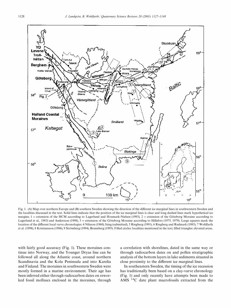
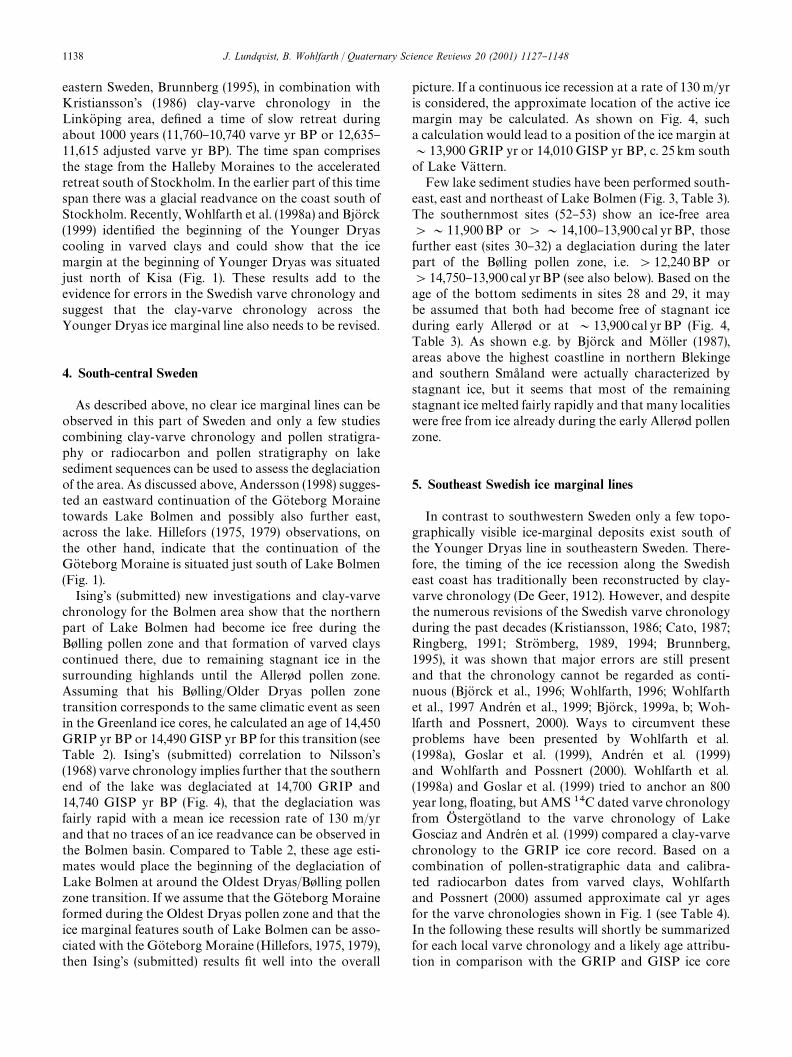
Fig. 1. (A) Map over northern Europe and (B) southern Sweden showing the direction of the di!erent ice marginal lines in southwestern Sweden andthe localities discussed in the text. Solid lines indicate that the position of the ice marginal lines is clear and long dashed lines mark hypothetical icemargins; 1"extension of the HCM according to Lagerlund and Houmark-Nielsen (1993), 2"extension of the GoK teborg Moraine according toLagerlund et al., 1983) and Andersson (1998), 3"extension of the GoK teborg Moraine according to Hillefors (1975, 1979). Large squares mark thelocation of the di!erent local varve chronologies: 4 Nilsson (1968); Ising (submitted), 5 Ringberg (1991), 6 Ringberg and Rudmark (1985), 7 Wohlfarthet al. (1998), 8 Kristiansson (1986), 9 StroK mberg (1994), Brunnberg (1995). Filled circles: localities mentioned in the text; "lled triangles: elevated areas.
with fairly good accuracy (Fig. 1). These moraines con-tinue into Norway, and the Younger Dryas line can befollowed all along the Atlantic coast, around northernScandinavia and the Kola Peninsula and into Kareliaand Finland. The moraines in southwestern Sweden weremostly formed in a marine environment. Their age hasbeen inferred either through radiocarbon dates on rewor-ked fossil molluscs enclosed in the moraines, through
a correlation with shorelines, dated in the same way orthrough radiocarbon dates on and pollen stratigraphicanalysis of the bottom layers in lake sediments situated inclose proximity to the di!erent ice marginal lines.In southeastern Sweden, the timing of the ice recessionhas traditionally been based on a clay-varve chronology(Fig. 1) and only recently have attempts been made toAMS ��C date plant macrofossils extracted from the
1128 J. Lundqvist, B. Wohlfarth / Quaternary Science Reviews 20 (2001) 1127}1148
varved clays (Wohlfarth et al., 1995, 1998a). Based onmajor revisions by Cato (1987) and StroK mberg (1989),it has been assumed, that the Swedish varve chonologycan be regarded as a continuous annual chronology(Wohlfarth et al., 1995). However, it has become evidentthat major problems still exist and that several hundredyears are still missing (Wohlfarth et al., 1997, 1998a;AndreH n et al., 1999; Goslar et al., 1999), which makes itimpossible at present to assign calendar years to the LateWeichselian part of the chronology.In the interior of southern Sweden the situation is evenmore complex. Moraine ridges are often di$cult to traceor not developed, because large parts of the area appearto have been covered by stagnant ice (e.g. BjoK rck andMoK ller, 1987). Radiocarbon dates are not available forthe glacial deposits and lake sediments have been studiedat only a few sites in order to determine the date ofdeglaciation.Here, we attempt, based on a number of di!erent datasets, to discuss the age of the ice marginal deposits insouthwestern Sweden and their likely age-equivalent cor-relation with ice recession lines on the east coast. In thefollowing, uncalibrated radiocarbon dates are given asBP. These measurements have been corrected for a mar-ine reservoir e!ect (!400 ��C years) and ���C. Whenstandard error is shown, it is always 1�. Clay-varve yearsare designated varve yr BP according to StroK mberg's(1989) revision of the Swedish Time Scale and Cato's(1987) extension of the chronology up to the present.However, following the errors inherent in the Swedishvarve chronology (Wohlfarth, 1996; Wohlfarth et al.,1997, 1998a; AndreH n et al., 1999), the varve years havebeen adjusted by 875 varve years and are expressed as&adjusted varve yr BP'. Radiocarbon dates with knownstandard errors were either calibrated or wiggle-matched(Bronk Ramsey, 1995) and other less precise radiocarbondate estimates were compared to the radiocarboncalibration curve (Stuiver et al., 1998). Both results areexpressed as calibrated years (cal yr BP), but only thecalibrated/wiggle-matched radiocarbon dates are shownwith 2�. Comparisons to the Greenland ice cores aredenoted as either GRIP or GISP yr BP.
2. Southwest Swedish moraines
A series of well-developed moraines, together forminga zone of some 100km in width extend along the westcoast of Sweden and inland to the area of the great lakesVaK nern and VaK ttern (Fig. 1). These well-de"ned andpartly glaciomarine ice marginal formations can be fol-lowed as continuous ridges over long distances, and evenwhere they are discontinuous their correlation is clear.Towards the southeast, however, they gradually becomedivided into more than one ridge and are "nally replacedby landscapes of hummocky moraine, indicating areal
downwasting of stagnant ice, that was in#uenced by thelocal topography (cf. Gillberg, 1956).The marginal ridges consist of sorted sediments as wellas of diamictons. The moraines are shown on many mapsand summaries on their chronology and eastward exten-sion and correlation have been given by Berglund (1979),Hillefors (1975, 1979), Johansson (1982), BjoK rck et al.(1988) and Berglund (1995). Since these papers were pub-lished, several additional studies have been made by oneof the authors (J. L.). In the following we shall brie#ydiscuss the di!erent moraines from the Kattegat coast tothe Younger Dryas (YD) moraines in south centralSweden, starting with the oldest deposits in the southwest(see Fig. 1 and Table 1).
2.1. Halland coastal moraines (HCM)
These moraines, which were referred to as the HoK noK -GroK toK line by Hillefors (1975), form a series of smallmoraines and, in the eastern part of the zone, deltas. Theyhave been described and studied by Caldenius (1942),then more in detail in a number of papers by Fernlund(e.g. 1988, 1993). The outer, westernmost moraines formstraight ridges, which can be a few kilometres in length.According to MoK rner (1969) and FaK lt (1982), they con-tinue also westwards on the Kattegat #oor. In the easternpart of the zone the ridges are shorter and often situatedupon drumlins. There, they are also more curved and assuch similar to small end moraines in front of valleys. Atsome localities they may be combined with deltas. Theinternal structures of the ridges are complex. Many of thesections shown by Fernlund (1988, 1993) show complic-ated stratigraphies where diamictons alternate withsorted sediments, which range from silt to gravel. Inclu-sions of marine clay occur and mollusc shells are com-mon. The structures indicate a glacial readvance overpreviously deposited ridges.The HCM can be traced from the GoK teborg area (seeThormark, 1949) southward to the region of Hallandsa� s(Fig. 1). According to Lindekrantz (1944) there are evena few ridges on the southern side of the BjaK re Peninsula.Their further continuation is not well known. FollowingLagerlund and Houmark-Nielsen (1993), they maycontinue in a North}South direction through Ska� ne.Duphorn et al. (1979) and Ringberg (1989) correlatedthem with the so-called Low Baltic readvance dated tosometime between 13,300 and 12,800BP. In Lundqvist(1994), the continuation of the outermost HCM isassumed to be towards the SE, while the innermostmoraines continue towards the East and are correlatedwith the ice recession lines de"ned by clay-varve chrono-logy (Antevs, 1915; Ringberg, 1991).Di!erent opinions exist about the age of the HCM (seeTable 1), which have mainly been dated by radiocarbondeterminations on fossil mollusc shells. According to therevised chronology by Berglund (1979) the HCM were
J. Lundqvist, B. Wohlfarth / Quaternary Science Reviews 20 (2001) 1127}1148 1129
Table 1Age assignment of the di!erent ice marginal lines in south western Sweden according to di!erent authors and the present study. See text and Table2 for a detailed discussion
Ice marginal line Age assignment Refs. This summary��C yr BP
Halland Coastal 13,000}13,500 Berglund (1979) &14,100}14,000 ��C yrBP orMoraines (HCM) '12,900 BjoK rck et al. (1988) &18,000}16,000 cal yrBP;
'14,100 and &14,000 Pa� sse (1992); Lagerlund andHoumark-Nielsen (1993)
areas ice free '12,800}12,750 ��C yrBP or15,550}14,550cal yr BP;
?13,400}13,000 Berglund (1995) &Oldest Dryas'
GoK teborg Moraine 12,800}12,600 Hillefors (1975, 1979) ice front position at &12,700}12,600 ��C yrBP or&15,400}14,500 cal yrBP;
12,800}12,600 Berglund (1979)12,650 BjoK rck et al. (1988)12,700}12,500 Berglund (1995) &Oldest Dryas'
Berghem Moraine '11,100 Hillefors (1975) '12,350}12,250 ��C yrBP&12,400 Berglund (1979) or '14,400}14,200cal yr BP12,350 BjoK rck et al. (1988) &B+lling'12,350}12,250 FredeH n (1988); Pa� sse (1992)&12,000 Berglund (1995)
TrollhaK ttan Moraine &12,200 Berglund (1979) '&11,900}11,800 ��C yrBP12,175 BjoK rck et al. (1988) or '&14,200 cal yrBP;11,930 Pa� sse (1987) &Older Dryas'11,900}11,800 FredeH n (1988)11,700}11,600 Berglund (1995)
Levene Moraine 12,000}11,800 Berglund (1979) '&13,400 cal yrBP11,400}11,300 FredeH n (1988)12,050 BjoK rck et al. (1988)
formed around 13,000}13,500BP. Several radiocarbondates on shells published by Pa� sse (1992) indicate adeglaciation and age of the outermost moraines of'14,100 BP and of the inner moraine of &14,000BP,which corresponds to&18,000}16,000 cal yrBP (Figs. 3,4, Table 1). Fernlund (1988, 1993) presented a number ofradiocarbon dates on shells from these moraines withages ranging between c. 12,000}12,700BP and concludedthat the ridges are younger than 12,400BP. Such an ageis younger than that generally assumed for the morainessituated farther inland and formed later and illustratesone of the problems connected with the interpretation ofthe west coast moraines. In order to solve the problem,Fernlund (1993) had to assume an initial formation of theHCM at an earlier stage, followed by a long readvanceat least from the position of the Berghem Moraine(cf. Fig. 1). From a glaciological point of view sucha scenario seems less plausible, because the ice in thesubaquatic environment of most of the area must havebeen warm-based, which is indicated by the depositionof till. Based on pollen stratigraphy and ��C dateson lake sediment sequences, which are situated betweenthe outermost and innermost moraines and slightly eastof the innermost moraine (Fig. 3, Table 3), Berglund(1995) showed that deposition commenced before
12,800}12,750 BP, that is before and during the B+llingpollen zone (Table 1) or &'15,550}14,550 cal yr BP(Table 3). Following Lagerlund and Houmark-Nielsen(1993) and Berglund (1995), we may conclude that theHCM were likely formed at &18,000}16,000 cal yr BPand that the area occupied by the morainesbecame deglaciated between '12,800}12,750BP or'&15,550}14,550 cal yrBP (Fig. 4, Table 1). Comparedto the age estimates shown in Table 2, this time periodwould fall within the Oldest Dryas pollen zone.
2.2. GoK teborg Moraine
Some 10km east of the easternmost HCM (Fig. 1) isthe large and well-de"ned GoK teborg Moraine (Wenner,1951; Wedel, 1971; Hillefors, 1975, 1979), which is alsoknown as the FjaK ra� s line (MoK rner, 1969). It extends asdiscontinuous hills and ridges from the island of Orust inthe north to GoK teborg (BjoK rsjoK , 1949). For some 35}40kmsouthward fromGoK teborg it is more continuous, formingup to 50m high ridges across valleys as well as on higherground. Further toward the southeast the line is markedby deltas and other isolated smaller accumulations.However, the zone is quite distinctive for another 40km.The southward extension of the line is more debatable
1130 J. Lundqvist, B. Wohlfarth / Quaternary Science Reviews 20 (2001) 1127}1148

Table 2Age estimates used in the text
South Swedish ��C-yr BP� Local varve Adjusted GRIP GISP IntCal98Pollenstratigraphy� yr varve yr BP yr BP� yr BP� cal yr BP�
Holocene/ 10,300}10,000 10,740� 11,525� &11,500 11,640 *
Younger Dryas 10,630�Younger Dryas/ 11,000}10,800 2000� 12,650 12,650 12,890 &12,900}13,050Aller+dAller+d/ 12,000 2550 * 13,900 14,010 &13,900}14,100Older DryasOlder Dryas/ 12,200 #300� * 14,040 14,090 &14,200B+llingB+lling/ &12,500}12,700 * * 14,700 14,670 &14,500}15,500Oldest Dryas
�According to BjoK rck and MoK ller (1987) and Berglund et al. (1994).�BjoK rck et al. (1998a).�Stuiver et al. (1995).�Stuiver et al. (1998). Cal yr BP were obtained by comparing the ��C ages in column 2 with the radiocarbon calibration curve.�StroK mberg (1994), Brunnberg (1995) and BjoK rck (1999b).�AndreH n et al. (1999).�AndreH n et al. (1999).�Wohlfarth et al. (1998a).Goslar et al. (1999).Kristiansson (1986).�Ising (1998).
and based mainly on scattered glacio#uvial deposits andstriae. Instead of a clear moraine ridge the landcapechanges into a zone with hummocky moraine indicatingstagnant ice in front of an active margin. The southern-most position of the GoK teborg Moraine, according toNilsson (1968) and BjoK rck et al. (1988), may extendtowards the southern coast of Blekinge, i.e. among therecession lines of Antevs (1915) and Ringberg (1991).On the other hand, Johnsson (1956) and recentlyAndersson (1998) proposed that the line turns east,towards the central part of Lake Bolmen (Fig. 1).Lundqvist (1994) gave two alternative positions for aneastward extension of the GoK teborg Moraine, one ac-cording to Andersson (1998) and a more southerlyposition, south of Lake Bolmen, which has been sugges-ted by Hillefors (1975, 1979). The moraine ridges alongthe west coast are generally composed of till beds restingupon marine sediments, indicating oscillations of the icemargin.Based on radiocarbon dates the age of the GoK teborgMoraine is traditionally given with &12,800 to&12,500BP (Table 1). Hillefors (1975, 1979) assumed aninitial deglaciation at &12,800BP, a readvance at&12,700BP and a "nal deglaciation at &12,600BP.The combination of radiocarbon dates, pollen stratigra-phy and shoreline development (Table 3, Fig. 3), ledBerglund (1995) to conclude that the formation of theGoK teborg Moraine may have occurred &12,600BP(Table 1). Compared to the calibration curve, whichshows a complicated structure during the time period
12,500}12,900BP, radiocarbon ages of &12,500BPcould correspond to &14,400 or to &14,800}15,100 cal yr BP, ages of 12,600BP to 14,500}14,650or 15,300 cal yr BP and ages of &12,800BP to&15,500 cal yr BP. If we accept Hillefors' (1975, 1979)and Berglund's (1995) assumptions for an ice front posi-tion some time between 12,700}12,600BP and comparethese age estimates with the radiocarbon calibrationcurve, the GoK teborg Moraine could have been formedany time between 15,400 and 14,500 cal yrBP (Table 1)and would thus, following Table 2, correspond to theOldest Dryas pollen zone.
2.3. Berghem Moraine
East of the northerly extension of the GoK teborgMoraine, numerous moraines and deltas form a distinc-tive ice-margin, named the Berghem line (Caldenius,1942; Ronnert, 1989). The larger deposits, which pass themouth of Byfjorden at Uddevalla (Fig. 1), appear as awell-de"ned landform, which was originally correlatedby BjoK rsjoK (1949) with the GoK teborg Moraine. However,new mapping indicates that these features should, mostprobably, be referred to a stage later than the GoK teborgMoraine. The position of this ice margin can be followednorthward across the Koster Islands (Johansson, 1982),and southeastward as the Berghem Moraine (HilldeH n,1979) (Fig. 1). In many places the line is marked bya double series of ridges and is consequently called theBerghem-MoslaK tt line (MoK rner, 1969).
J. Lundqvist, B. Wohlfarth / Quaternary Science Reviews 20 (2001) 1127}1148 1131

In general, it is represented by smaller accumulationsthan the GoK teborg Moraine, but nevertheless it mustrepresent some readvance or oscillation of the ice margin(BjoK rsjoK , 1949; HilldeH n, 1979). From the detailed descrip-tions of the readvances, especially in the valleys, one getsthe impression that the local topography had a largein#uence on the dynamics of the ice margin (Johansson,1982). Such a conclusion is also supported by strati-graphic observations (Ronnert, 1989), which showed thata readvance only took place in the valleys, while the icemargin was stationary on high ground above sea level.A minor climatic #uctuation could, therefore, have beenenough to trigger a reaction of the ice margin, whichcould then have become enhanced by the local topo-graphic situation.The radiocarbon dates assigned to the BerghemMoraine vary considerably and range between&12,400}'11,100BP (Hillefors, 1975; Berglund, 1979;Pa� sse, 1987, 1992; FredeH n, 1988; S+rensen, 1992; Be-rglund, 1995) (Table 1). Basal lake sediments in sites eastof the moraine had initially been interpreted as belongingto the B+lling pollen zone (HilldeH n, 1979; Svedhage, 1985)(sites 13}18 in Fig. 3). However, a reinterpretation of thepollen stratigraphy by Berglund (1995) demonstratedthat the basal layers should rather be attributed to theOlder Dryas pollen zone. BjoK rck and Ha� kansson's (1982)evaluation of radiocarbon dates on bulk sediments pub-lished by HilldeH n (1979) showed furthermore, that themost likely age of the sediments should range between&11,800}12,150BP or &13,900}14,100 cal yrBP, whichwould in turn correspond to Berglund's (1995) re-evalu-ation of the pollen zone assignment (Table 3). Theseradiocarbon dates give a minimum age for the deglaci-ation of the area and indicate that the BerghemMorainemust have been formed earlier. FredeH n (1988) and Pa� sse(1992) cite radiocarbon dates of 12,350}12,250BP onmollusc shells, which were deposited in marine clays infront of the delta deposits, which are associated with theBerghem Moraine (Table 1). They are thus either con-temporaneous or slightly younger than the ice marginalformations and could indicate an approximate minimumage of &14,400}14,200 cal yr BP for the BerghemMoraine. Taken together, the Berghem Moraine mayhave been formed &14,400}14,200 cal yrBP and thearea east of these deposits probably became ice-free'14,100 cal yrBP (Table 1). Compared to Table 2,these age estimates would place the Berghem Morainesometime during the B+lling pollen zone.
2.4. TrollhaK ttan Moraine
East of the Berghem Moraine scattered moraines andglacio#uvial accumulations occur in many places (Fig. 1).The main deposits form together a distinctive ice-mar-ginal line, but several smaller moraines can also beobserved outside of it. Johansson (1982) studied the
ridges west of River GoK ta AG lv in detail and concludedthat the main line ressembles the large moraines dis-cussed above. In areas where the topography had a greatin#uence, the moraine is represented by narrow ridges,while in other places the deposits may be more spreadout. Disturbed sediments within the ridges indicate sev-eral short readvances or oscillations of the ice margin.East of GoK ta AG lv the extension of the TrollhaK ttan Mo-raine is somewhat uncertain. FredeH n (1984) and BjoK rckand Digerfeldt (1991) considered e.g. also a southerlyextension as possible (Fig. 2). One likely northern con-tinuation of the line, east of the well-established moraineand west of the river, is through some large glacio#uvialaccumulations north of TrollhaK ttan and along a ridge onthe western side of Hunneberg, which had earlier beeninterpreted as a drumlin (FredeH n, 1984). According toinformation from the Geological Survey of Sweden thisridge consists of up to 28m of till. If we assume that thenortherly extension is correct, then the southern line maybelong to one of a series of moraine ridges parallel to theTrollhaK ttan Moraine (FredeH n, 1984). Further eastward,the most likely extension of the northern line is througha series of small moraines (MohreH n and Larsson, 1974)and large glacio#uvial deposits at right angles to theeskers SE of Hunneberg. It continues through glaciotec-tonically disturbed glacial clay and glacio#uvial depositsat Ta� lanna } Bitterna (FredeH n, 1990) (Fig. 1). The distri-bution of these deposits would indicate a lobate shape ofthe ice margin with embayments around higher groundand could be taken as evidence for an active ice margin.Together with the inferred northerly position, this couldindicate that the hills Halleberg and Hunneberg formedsuch an embayment along the ice margin.The TrollhaK ttan Moraine is developed below, as wellas above, the corresponding coastline. It can even betraced on the present-day sea #oor, and thus a directconnection with the Norwegian Hvaler Moraine isobtained. The Hvaler Moraine is the outermost datedmoraine on the eastern side of the Oslofjord and has anestimated age of 11,800}12,000BP (S+rensen, 1992).Radiocarbon ages for the TrollhaK ttan Moraine range at12,200BP (Berglund, 1979; BjoK rck et al., 1988),11,900}11,800BP (e.g. Dennega� rd, 1984; Pa� sse, 1987;FredeH n, 1988) or 11,700}11,600BP (Berglund, 1995)(Table 1). Indirect age estimates for the TrollhaK ttanMoraine can be obtained from lake sediments, whichwere studied in sites located at an altitude of 119}129ma.s.l. on the southern part of Hunneberg (Fig. 1; sites19}21 in Fig. 3). These sites became ice-free during theearly Aller+d pollen zone and the lowermost dated sedi-ment layers indicate an age of '11,900}11,800BP(BjoK rck and Digerfeldt, 1982) or '&14,200}13,450 cal yr BP (Table 3). Compared to the radiocarbonage estimates for the TrollhaK ttan Moraine presented inTable 1, the lake-sediment studies would indicate that thesedimentation in the basins (i.e. the sea) started at about
1132 J. Lundqvist, B. Wohlfarth / Quaternary Science Reviews 20 (2001) 1127}1148
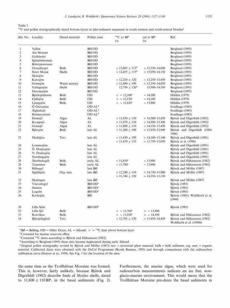
Table 3��C and pollen stratigraphically dated bottom layers in lake-sediment sequences in south-western and south-central Sweden�
Site No. Locality Dated material Pollen zone ��C yr BP cal yr BP Ref.1� 2�
1 Vallen B"/OD Berglund (1995)2 Ala Mossen B"/OD Berglund (1995)3 Gyllebolet B"/OD Berglund (1995)4 IglasjoK nmossen B"/OD Berglund (1995)5 BoK larpamossen B"/OD Berglund (1995)6 Ormaberget Bulk B"/OD '12,805$115� '15,550}14,600 Berglund (1995)7 Store Mosse Shells B"/OD '12,455$115� '15,050}14,150 Berglund (1995)8 SkaK rsjoK n B"/OD Berglund (1995)9 KalvsjoK n B"/OD '12,210$320 '15,250}13,450 Berglund (1995)10 GrimsjoK n Water mosses B"/OD '12,490$190 '15,350}14,050 Berglund (1995)11 ValingesjoK n Shells B"/OD 12,750$120� 15,500}14,550 Berglund (1995)12 DeromesjoK n B"/OD Berglund (1995)13 BjoK rksjoK damm Bulk OD '&12,100� &14,100 HilldeH n (1979)14 FjaK llsjoK n Bulk OD '&12,150� &14,100 HilldeH n (1979)15 LjungsjoK n Bulk OD '&11,810� &13,900 HilldeH n (1979)16 OG OG revatten OD-AL� Svedhage (1985)17 AG lghultsjoK OD-AL� Svedhage (1985)18 Holmevattnet OD-AL� Svedhage (1985)19 DomsjoK Algae AL '11,830$130 '14,200}13,450 BjoK rck and Digerfeldt (1982)20 KroppsjoK Algae AL '11,870$110 '14,200}13,500 BjoK rck and Digerfeldt (1982)21 GransjoK Algae AL '11,800$110 '14,150}13,450 BjoK rck and Digerfeldt (1982)22 BjaK rsjoK n Bulk late AL '11,260$100 '13,430}12,940 BjoK rck and Digerfeldt (1984;
1986)23 MadtjaK rn Terr. late AL '11,630$190 '14,100}13,100 BjoK rck and Digerfeldt (1991)
'11,470$135 '13,750}13,050 BjoK rck et al. (1998)24 LommesjoK n late AL BjoK rck and Digerfeldt (1991)25 OG . DrakesjoK n late AL BjoK rck and Digerfeldt (1991)26 N. DrakesjoK n late AL BjoK rck and Digerfeldt (1991)27 NordaK ngsjoK n late AL BjoK rck and Digerfeldt (1991)28 As kerhultagoK l Bulk early AL &11,810� &13,900 BjoK rck and Ha� kansson (1982)29 Trummen Bulk early AL &11,780� &13,900 BjoK rck and Ha� kansson (1982)30 HaK lsegyl late B" BjoK rck and MoK ller (1987)31 SpjaK llsjoK n Org. mat. late B" '12,240$110 '14,750}13,900 BjoK rck and MoK ller (1987)
'11,740$220 '14,350}13,15032 Skulingen late B" BjoK rck and MoK ller (1987)33 Vitavattsgyl B"-OD� BjoK rck (1981)34 SaK nnen B"-OD� BjoK rck (1981)35 Logylet B"-OD� BjoK rck (1981)36 KroksjoK n B" BjoK rck (1981); Wohlfarth et al.
(1994)
38 Lilla SjoK n B"-OD� BjoK rck (1981)52 Lilla SjoK Bulk '&11,760� '&13,90053 Ranviken Bulk '&11,920� '&14,100 BjoK rck and Ha� kansson (1982)54 BjaK rsjoK laga� rd Terr. '12,705$130 '15,450}14,450 BjoK rck and Ha� kansson (1982)
Wohlfarth et al. (1998b)
�B""B+lling, OD"Older Dryas, AL"Aller+d;'"��C date above bottom layer.�Corrected for marine reservoir e!ect.�Corrected ��C dates according to BjoK rck and Ha� kansson (1982).�According to Berglund (1995) these sites became deglaciated during early Aller+d.�Original pollen stratigraphy revised by BjoK rck and MoK ller (1987); terr."terrestrial plant material, bulk"bulk sediment, org. mat."organicmaterial. Calibrated dates were obtained with the OxCal Programme (Bronk Ramsey, 1995) and through comparisons with the radiocarboncalibration curve (Stuiver et al., 1998). See Fig. 3 for the location of the sites.
the same time as the TrollhaK ttan Moraine was formed.This is, however, fairly unlikely, because BjoK rck andDigerfeldt (1982) describe "nds of Mytilus shells, datedto 11,800$110BP, in the basal sediments (Fig. 2).
Furthermore, the marine algae, which were used forradiocarbon measurements indicate an ice free, non-glacio-marine environment. This would mean that theTrollhaK ttan Moraine pre-dates the basal sediments in
J. Lundqvist, B. Wohlfarth / Quaternary Science Reviews 20 (2001) 1127}1148 1133
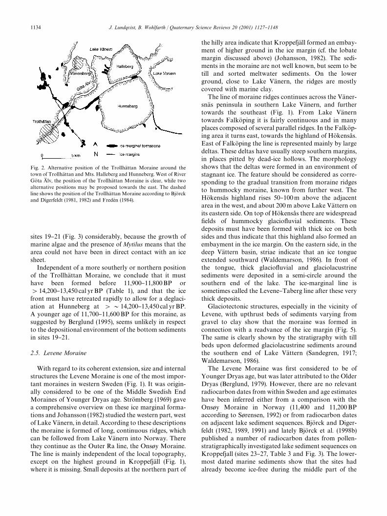
Fig. 2. Alternative position of the TrollhaK ttan Moraine around thetown of TrollhaK ttan and Mts. Halleberg and Hunneberg. West of RiverGoK ta AG lv, the position of the TrollhaK ttan Moraine is clear, while twoalternative positions may be proposed towards the east. The dashedline shows the position of the TrollhaK ttan Moraine according to BjoK rckand Digerfeldt (1981, 1982) and FredeH n (1984).
sites 19}21 (Fig. 3) considerably, because the growth ofmarine algae and the presence of Mytilus means that thearea could not have been in direct contact with an icesheet.Independent of a more southerly or northern positionof the TrollhaK ttan Moraine, we conclude that it musthave been formed before 11,900}11,800BP or'14,200}13,450 cal yrBP (Table 1), and that the icefront must have retreated rapidly to allow for a deglaci-ation at Hunneberg at '&14,200}13,450 cal yr BP.A younger age of 11,700}11,600BP for this moraine, assuggested by Berglund (1995), seems unlikely in respectto the depositional environment of the bottom sedimentsin sites 19}21.
2.5. Levene Moraine
With regard to its coherent extension, size and internalstructures the Levene Moraine is one of the most impor-tant moraines in western Sweden (Fig. 1). It was origin-ally considered to be one of the Middle Swedish EndMoraines of Younger Dryas age. StroK mberg (1969) gavea comprehensive overview on these ice marginal forma-tions and Johansson (1982) studied the western part, westof Lake VaK nern, in detail. According to these descriptionsthe moraine is formed of long, continuous ridges, whichcan be followed from Lake VaK nern into Norway. Therethey continue as the Outer Ra line, the Ons+y Moraine.The line is mainly independent of the local topography,except on the highest ground in KroppefjaK ll (Fig. 1),where it is missing. Small deposits at the northern part of
the hilly area indicate that KroppefjaK ll formed an embay-ment of higher ground in the ice margin (cf. the lobatemargin discussed above) (Johansson, 1982). The sedi-ments in the moraine are not well known, but seem to betill and sorted meltwater sediments. On the lowerground, close to Lake VaK nern, the ridges are mostlycovered with marine clay.The line of moraine ridges continues across the VaK ner-snaK s peninsula in southern Lake VaK nern, and furthertowards the southeast (Fig. 1). From Lake VaK nerntowards FalkoK ping it is fairly continuous and in manyplaces composed of several parallel ridges. In the FalkoK p-ing area it turns east, towards the highland of HoK kensa� s.East of FalkoK ping the line is represented mainly by largedeltas. These deltas have usually steep southern margins,in places pitted by dead-ice hollows. The morphologyshows that the deltas were formed in an environment ofstagnant ice. The feature should be considered as corre-sponding to the gradual transition from moraine ridgesto hummocky moraine, known from further west. TheHoK kensa� s highland rises 50}100m above the adjacentarea in the west, and about 200m above Lake VaK ttern onits eastern side. On top of HoK kensa� s there are widespread"elds of hummocky glacio#uvial sediments. Thesedeposits must have been formed with thick ice on bothsides and thus indicate that this highland also formed anembayment in the ice margin. On the eastern side, in thedeep VaK ttern basin, striae indicate that an ice tongueextended southward (Waldemarson, 1986). In front ofthe tongue, thick glacio#uvial and glaciolacustrinesediments were deposited in a semi-circle around thesouthern end of the lake. The ice-marginal line issometimes called the Levene}Taberg line after these verythick deposits.Glaciotectonic structures, especially in the vicinity ofLevene, with upthrust beds of sediments varying fromgravel to clay show that the moraine was formed inconnection with a readvance of the ice margin (Fig. 5).The same is clearly shown by the stratigraphy with tillbeds upon deformed glaciolacustrine sediments aroundthe southern end of Lake VaK ttern (Sandegren, 1917;Waldemarson, 1986).The Levene Moraine was "rst considered to be ofYounger Dryas age, but was later attributed to the OlderDryas (Berglund, 1979). However, there are no relevantradiocarbon dates from within Sweden and age estimateshave been inferred either from a comparison with theOns+y Moraine in Norway (11,400 and 11,200BPaccording to S+rensen, 1992) or from radiocarbon dateson adjacent lake sediment sequences. BjoK rck and Diger-feldt (1982, 1989, 1991) and lately BjoK rck et al. (1998b)published a number of radiocarbon dates from pollen-stratigraphically investigated lake sediment sequences onKroppefjall (sites 23}27, Table 3 and Fig. 3). The lower-most dated marine sediments show that the sites hadalready become ice-free during the middle part of the
1134 J. Lundqvist, B. Wohlfarth / Quaternary Science Reviews 20 (2001) 1127}1148
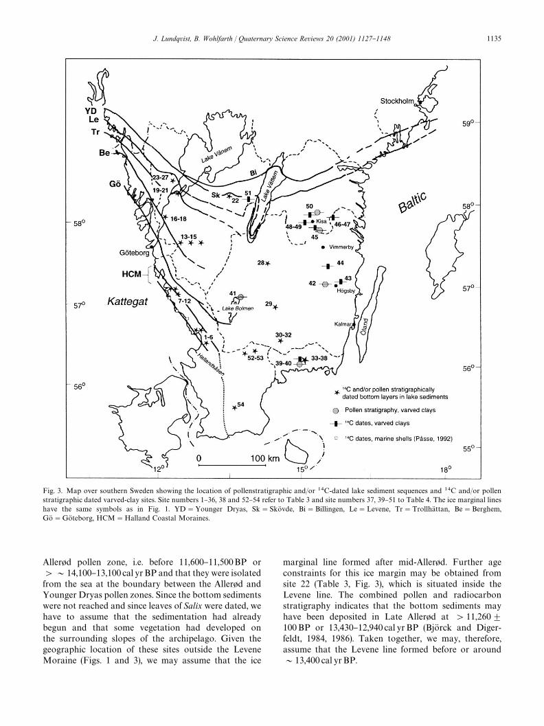
Fig. 3. Map over southern Sweden showing the location of pollenstratigraphic and/or ��C-dated lake sediment sequences and ��C and/or pollenstratigraphic dated varved-clay sites. Site numbers 1}36, 38 and 52}54 refer to Table 3 and site numbers 37, 39}51 to Table 4. The ice marginal lineshave the same symbols as in Fig. 1. YD"Younger Dryas, Sk"SkoK vde, Bi"Billingen, Le"Levene, Tr"TrollhaK ttan, Be"Berghem,GoK"GoK teborg, HCM"Halland Coastal Moraines.
Aller+d pollen zone, i.e. before 11,600}11,500BP or'&14,100}13,100 cal yr BP and that they were isolatedfrom the sea at the boundary between the Aller+d andYounger Dryas pollen zones. Since the bottom sedimentswere not reached and since leaves of Salix were dated, wehave to assume that the sedimentation had alreadybegun and that some vegetation had developed onthe surrounding slopes of the archipelago. Given thegeographic location of these sites outside the LeveneMoraine (Figs. 1 and 3), we may assume that the ice
marginal line formed after mid-Aller+d. Further ageconstraints for this ice margin may be obtained fromsite 22 (Table 3, Fig. 3), which is situated inside theLevene line. The combined pollen and radiocarbonstratigraphy indicates that the bottom sediments mayhave been deposited in Late Aller+d at '11,260$100BP or 13,430}12,940 cal yrBP (BjoK rck and Diger-feldt, 1984, 1986). Taken together, we may, therefore,assume that the Levene line formed before or around&13,400 cal yrBP.
J. Lundqvist, B. Wohlfarth / Quaternary Science Reviews 20 (2001) 1127}1148 1135
3. Younger Dryas Moraines
The SkoK vde and Billingen Moraines are the two mainmoraine lines in Sweden, which can be followed almostaround the entire Scandinavian Peninsula and Finland.Generally, they belong to a series of moraines, whichrepresent the stillstand of the ice margin during theYounger Dryas cold event. The line discussed here hasbeen described in many papers, and here a general refer-ence is made to StroK mberg (1969) and Lundqvist andSaarnisto (1990).The two moraines, which are separated at LakeVaK nern and eastwards (Fig. 1), adjoin each other west-wards and continue in Norway as the big Ra Moraine.According to Lundqvist (1988a), the ice margin retreatedfrom the Ra Moraine to the next younger As s Moraine,while it was still at the Billingen Moraine. This westernpart of the Swedish line consists of scattered smallmoraines and two large delta complexes, Dal's Ed andOG dskoK lt's Moar (Fig. 1), which are important for theinterpretation of readvances and isostatic rebound. Thedelta at Dal's Ed consists of one big plateau and a smallerone just north of it (De Geer, 1909), which are separatedby a dead-ice hollow, today occupied by a small lake.Often, these two units are interpreted as two separatedelta generations, but an alternative interpretationwould be that they represent one unit with a centralhollow of a type common in the northern part of Sweden.In case they are two di!erent units they may representthe two moraines, SkoK vde and Billingen. The delta levelis approximately 158m a.s.l., and most important, at thenorthern margin of the delta, beach marks show thatthe corresponding sea-level dropped by about 10m.This indicates an isostatic uplift of that amount, andconsidering the shore displacement curve of BjoK rck andDigerfeldt (1991), corresponds to a time of perhaps500 radiocarbon years. Nothing is known about a retreatof the ice margin north of the delta, but the drop in sealevel makes a retreat and a following readvance possible.Johansson (1982) has described the delta complexOG dskoK lt's Moar, 15 km SE of Dal's Ed. According to himthe main components are delta plateaus, a supraglacialoutwash plain and end-moraine ridges. There is a di!er-ence in altitude between the oldest part of the complex(the deltas) and the youngest (the plain) of at least 20m.Since the outwash plain is underlain by clay, formed indeep water some distance away from the ice margin,Johansson's (1982) conclusion is that there has beena considerable retreat and readvance of the margin. Theextent of these events is unknown, but the correspondingtime is estimated at 600}800 radiocarbon years (BjoK rckand Digerfeldt, 1991) or &500}600 calendar yr (BjoK rckpers. comm.). Assuming that the retreat comprised half ofthis time with a rate similar to the rate found farther east(StroK mberg, 1994; see below), the extent can be estimatedto some 4 km, at the most.
East of OG dskoK lt's Moar the combined moraine passesthe northern part of the KroppefjaK ll highland. Notably,huge moraines, often formed of very large bouldersoccur, even on this high ground and at elevations, wellabove the corresponding sea -level (Gustafson, 1977). Theboulder ridges have been interpreted as redepositedfrost-shattered material formed during the cold YoungerDryas climate. From KroppefjaK ll eastward across thesouthern part of Lake VaK nern, the SkoK vde-Billingen linesare developed as big moraines. Towards Mt. Billingenthe line widens to a 10 km wide zone of well-developedend moraines. Their interior shows glaciotectonic struc-tures and complex bedding with tills and waterlaid sedi-ments, including marine clay (e.g., Munthe, 1928; BjoK rckand Digerfeldt, 1984). The latter authors interpretedthese features as an e!ect of a considerable readvance ofthe ice margin. The margin retreated from the Levene linepast the SkoK vde line and past the northern end ofMt. Billingen. The e!ect was a "rst catastrophic drainageof the Baltic Ice Lake, ponded up in the Baltic basin eastof Mt. Billingen. Marine clays and other sediments weredeposited in front of the margin, and during the followingreadvance they became reworked and partly covered bythe moraines. The water in the Baltic basin was againponded up as a lake. After a further retreat the marginonce again passed the northern end of Mt. Billingen, andthe Baltic Ice Lake was "nally drained. The drainage wasa complicated event, including #ow over the ice marginand through marginal crevasses. A key point is the sur-vival of stagnant ice on the western side of Mt. Billingen,preventing the water taking the shortest way to the sea.This idea was long ago proposed by Ramsay (1924),Gavelin (1926), and Munthe (1928), but demonstratedconclusively by StroK mberg (1992).Several authors (e.g. Ahlmann, 1910; Munthe, 1928;BjoK rck and Digerfeldt, 1984) have studied the moraineson both sides of Mt. Billingen. Although evidence ofa readvance is clear on the western side, its exact timingcannot be assessed due to the lack of suitable clay varvedeposits. On the eastern side a detailed varve chronologyhad been established (Caldenius, 1944; StroK mberg, 1994)(Fig. 1), but showed no evidence of a readvance. Accord-ing to StroK mberg (1994) the ice margin retreated slowly,but continuously, during the entire cold event. On theother hand, glaciotectonic structures and till-coveredsediments in the moraines indicate that the ice-marginoscillated. The groups of moraines on the eastern side ofMt. Billingen continue towards Lake VaK ttern as twozones, corresponding to the SkoK vde and Billingen lines(HedstroK m, 1901; StroK mberg, 1969, 1977, 1994) (Fig. 1).The Billingen line turns northwards towards thePerstorp delta deposits (Bergsten, 1943), which corres-pond to the water level in the Baltic basin before andafter the "nal drainage, and show that this position of theice margin should be correlated with the position at thenorthern end of Mt. Billingen.
1136 J. Lundqvist, B. Wohlfarth / Quaternary Science Reviews 20 (2001) 1127}1148
Both the SkoK vde and the Billingen lines show a broadestuary in the basin of Lake VaK ttern during the deglacialphase. However, the conditions in the basin itself, asdescribed by Waldemarson (1986), imply two distinctreadvances, during which the margin formed a tonguein the basin. The readvances are not dated, but itis reasonable to assume that the older one correspondsto the Levene Moraine, as described above, and theyounger one to the moraine which formed during theYounger Dryas period (SkoK vde Moraine) (Fig. 1).According to BjoK rck and Digerfeldt (1989), Wohlfarthand Possnert (2000), BjoK rck et al. (2001), site 51 (Fig. 3)became ice-free during Younger Dryas and was neveroverridden by the advancing Younger Dryas ice. Conse-quently, the advancing ice in the VaK ttern basin possiblyformed a narrow lobe, extending from what may beconsidered an interlobe area north of the basin. The lobemust have been higher than in the surroundings, eitherduring the SkoK vde or Levene stage (Norrman, 1963,1971).East of Lake VaK ttern moraines corresponding to theSkoK vde and BillingenMoraines are well marked by seriesof deltas and a zone with thicker till cover (Lundqvist,1988b). On geological maps, zones corresponding tothese moraines are easily distinguished. The bestdeveloped of them can be followed as deltas and kame"elds from the vicinity of Lake VaK ttern towards the ENEpast LinkoK ping. East of LinkoK ping there are two closelyspaced lines. One of them, which can be considered as themain line consists of deltas and other glacio#uvial accu-mulations, while the southern line is formed of moraineridges (BergstroK m, 1992). This southern landform, some-times called the Halleby Moraine is often consideredas belonging to the main line, but Kristiansson (1986)has shown, based on clay-varve correlations, that it wasformed 150}200 years earlier. The Halleby Moraineapproaches the main line in the vicinity of Ljungstorp,where a well-developed kame "eld can be observed. Fur-ther north, SE of Omberg till-covered glacio#uvialdeposits occur. According to striae, the ice margin ransoutheastwards to join the southern line after 5}10 km. Itseems to cross the main line in the vicinity of the Ljun-gstorp kame "eld. The impression is that this line is thecontinuation of the Halleby Moraines. If so, the Hallebyline was formed after an initial recession and was, in itswestern part overrun by the ice margin forming the mainline.A northern line parallel to the line at Mt. Omberg isformed by several large deltas and other glacio#uvialdeposits running from the Motala region southeastwardto the LinkoK ping area. Among these deposits is the largeDjurkaK lla Plateau (Bergsten, 1943). This line can be fol-lowed southeastward towards the area east of LinkoK pingwhere it seems to join the main line. There is some doubtabout the continuation eastward of the combined line,but in general it continues past NorrkoK ping across the
Kolma� rden upland to the line of partly till-covered deltasalong the coast south of Stockholm. Glaciotectonicallydeformed glacial clay at NorrkoK ping indicates oscilla-tions of an active ice margin.What was considered the main line above correspondsobviously to the SkoK vde Moraine, although the connec-tion across the VaK ttern basin is not clear. The most likelyconnection is through the younger lobe in the basin,representing a readvance (Waldemarson, 1986). The fol-lowing line, passing just south of Mt. Omberg, representsa retreat of the ice margin close to the basin. The deltasare almost everywhere till-covered and other till-coveredsediments are common in the area (Svantesson, 1981).Consequently, there has been a readvance of the icemargin from the Omberg area to the main line. Thisreadvance comprised only the region close to the VaK tternbasin. East of Ljungstorp only a slow-down of the reces-sion occurred, which is marked by the HallebyMoraines.According to Kristiansson (1986) and Brunnberg (1995)there was no readvance in the LinkoK ping area.The northern line, extending from the DjurkaK lla Pla-teau, should obviously be correlated with the recessionline through the Perstorp delta west of Lake VaK ttern. Theextension across the lake is not clear, but possibly someof the glacio#uvial accumulations north of the lakedescribed by Bergsten (1943) belong to the line.The important conclusion of these correlations is thata considerable retreat and readvance of the ice marginoccurred west of Lake VaK nern and west of Mt. Billingenat around the AlleroK d/Younger Dryas transition.Between Mt. Billingen and Lake VaK ttern there are notraces of such a readvance, just oscillations and a slow-down of the rate of recession. In the basin of LakeVaK ttern a pronounced readvance may have occurred,which a!ected only the nearest environment. Ice growthnorth of the lake, possibly in an interlobe area, becameconcentrated as a lobe in the deep basin. East of thislobe there does not seem to have been a major readvance,but strongly glaciotectonized clays (Lundqvist, 1989;Kristiansson, 1986) indicate a very active ice front withlimited readvances.There is hardly any doubt about an attribution of theSkoK vde-Billingen Moraines to the Younger Dryas coldphase. The details, however, o!er some problems.According to Andersen et al. (1995) the age of the correla-tive Ra Moraine in Norway is 10,600}10,700BP. If,following Lundqvist (1988a), the ice margin was still atthe BillingenMoraine after the retreat to the As s Morainein the Oslofjord region (10,300}10,200BP; Andersenet al., 1995) we have to consider the whole time span upto 10,300BP, i. e. about 300}400 radiocarbon years.On the eastern side of Mt. Billingen, StroK mberg (1994)could show that a very slow ice recession occurred be-tween 11,600 and 10,740 varve yr BP, which correspondsto 12,475}11,615 adjusted varve yr BP (AndreH n et al.,1999) or to a time period of about 900 varve years. In
J. Lundqvist, B. Wohlfarth / Quaternary Science Reviews 20 (2001) 1127}1148 1137
eastern Sweden, Brunnberg (1995), in combination withKristiansson's (1986) clay-varve chronology in theLinkoK ping area, de"ned a time of slow retreat duringabout 1000 years (11,760}10,740 varve yr BP or 12,635}11,615 adjusted varve yr BP). The time span comprisesthe stage from the Halleby Moraines to the acceleratedretreat south of Stockholm. In the earlier part of this timespan there was a glacial readvance on the coast south ofStockholm. Recently, Wohlfarth et al. (1998a) and BjoK rck(1999) identi"ed the beginning of the Younger Dryascooling in varved clays and could show that the icemargin at the beginning of Younger Dryas was situatedjust north of Kisa (Fig. 1). These results add to theevidence for errors in the Swedish varve chronology andsuggest that the clay-varve chronology across theYounger Dryas ice marginal line also needs to be revised.
4. South-central Sweden
As described above, no clear ice marginal lines can beobserved in this part of Sweden and only a few studiescombining clay-varve chronology and pollen stratigra-phy or radiocarbon and pollen stratigraphy on lakesediment sequences can be used to assess the deglaciationof the area. As discussed above, Andersson (1998) sugges-ted an eastward continuation of the GoK teborg Morainetowards Lake Bolmen and possibly also further east,across the lake. Hillefors (1975, 1979) observations, onthe other hand, indicate that the continuation of theGoK teborg Moraine is situated just south of Lake Bolmen(Fig. 1).Ising's (submitted) new investigations and clay-varvechronology for the Bolmen area show that the northernpart of Lake Bolmen had become ice free during theB+lling pollen zone and that formation of varved clayscontinued there, due to remaining stagnant ice in thesurrounding highlands until the Aller+d pollen zone.Assuming that his B+lling/Older Dryas pollen zonetransition corresponds to the same climatic event as seenin the Greenland ice cores, he calculated an age of 14,450GRIP yr BP or 14,490 GISP yr BP for this transition (seeTable 2). Ising's (submitted) correlation to Nilsson's(1968) varve chronology implies further that the southernend of the lake was deglaciated at 14,700 GRIP and14,740 GISP yr BP (Fig. 4), that the deglaciation wasfairly rapid with a mean ice recession rate of 130 m/yrand that no traces of an ice readvance can be observed inthe Bolmen basin. Compared to Table 2, these age esti-mates would place the beginning of the deglaciation ofLake Bolmen at around the Oldest Dryas/B+lling pollenzone transition. If we assume that the GoK teborg Moraineformed during the Oldest Dryas pollen zone and that theice marginal features south of Lake Bolmen can be asso-ciated with the GoK teborgMoraine (Hillefors, 1975, 1979),then Ising's (submitted) results "t well into the overall
picture. If a continuous ice recession at a rate of 130 m/yris considered, the approximate location of the active icemargin may be calculated. As shown on Fig. 4, sucha calculation would lead to a position of the ice margin at&13,900 GRIP yr or 14,010 GISP yr BP, c. 25 km southof Lake VaK ttern.Few lake sediment studies have been performed south-east, east and northeast of Lake Bolmen (Fig. 3, Table 3).The southernmost sites (52}53) show an ice-free area'&11,900BP or '&14,100}13,900 cal yrBP, thosefurther east (sites 30}32) a deglaciation during the laterpart of the B+lling pollen zone, i.e. '12,240BP or'14,750}13,900 cal yrBP (see also below). Based on theage of the bottom sediments in sites 28 and 29, it maybe assumed that both had become free of stagnant iceduring early Aller+d or at &13,900 cal yr BP (Fig. 4,Table 3). As shown e.g. by BjoK rck and MoK ller (1987),areas above the highest coastline in northern Blekingeand southern Sma� land were actually characterized bystagnant ice, but it seems that most of the remainingstagnant ice melted fairly rapidly and that many localitieswere free from ice already during the early Aller+d pollenzone.
5. Southeast Swedish ice marginal lines
In contrast to southwestern Sweden only a few topo-graphically visible ice-marginal deposits exist south ofthe Younger Dryas line in southeastern Sweden. There-fore, the timing of the ice recession along the Swedisheast coast has traditionally been reconstructed by clay-varve chronology (De Geer, 1912). However, and despitethe numerous revisions of the Swedish varve chronologyduring the past decades (Kristiansson, 1986; Cato, 1987;Ringberg, 1991; StroK mberg, 1989, 1994; Brunnberg,1995), it was shown that major errors are still presentand that the chronology cannot be regarded as conti-nuous (BjoK rck et al., 1996; Wohlfarth, 1996; Wohlfarthet al., 1997 AndreH n et al., 1999; BjoK rck, 1999a, b; Woh-lfarth and Possnert, 2000). Ways to circumvent theseproblems have been presented by Wohlfarth et al.(1998a), Goslar et al. (1999), AndreH n et al. (1999)and Wohlfarth and Possnert (2000). Wohlfarth et al.(1998a) and Goslar et al. (1999) tried to anchor an 800year long, #oating, but AMS ��C dated varve chronologyfrom OG stergoK tland to the varve chronology of LakeGosciaz and AndreH n et al. (1999) compared a clay-varvechronology to the GRIP ice core record. Based on acombination of pollen-stratigraphic data and calibra-ted radiocarbon dates from varved clays, Wohlfarthand Possnert (2000) assumed approximate cal yr agesfor the varve chronologies shown in Fig. 1 (see Table 4).In the following these results will shortly be summarizedfor each local varve chronology and a likely age attribu-tion in comparison with the GRIP and GISP ice core
1138 J. Lundqvist, B. Wohlfarth / Quaternary Science Reviews 20 (2001) 1127}1148

Fig. 4. Ages estimates for the deglaciation of the di!erent sites shown in Fig. 3. See Tables 3 and 4 for details on the radiocarbon and calibrated dates.
records (BjoK rck et al., 1998a; Stuiver et al., 1995) and theIntCal98 calibration curve (Stuiver et al., 1998) will bediscussed (Tables 2 and 4).
5.1. Blekinge and southern Sma� land
The varve chronology in Blekinge and southernmostSma� land had been established by Ringberg (1991) andRingberg and Rudmark (1985) and covers the local varveyears }325 to#314 (Fig. 1). Later the chronology couldbe extended to the year#368 with additional clay-varvecorrelations (Wohlfarth et al., 1994; Ising, 1998). AMS
��C dates covering the varve years#108 to#226 rangebetween c. 12,300 and 12,700 BP and at c. 12,100 BPfor the varve years#266 to#299. A calibration ofthese radiocarbon dates results in age estimates of&15,000$550}14,425$475 cal yr BP and 14,150$600 cal yrBP, respectively (Table 4). According to pollenstratigraphy, the boundary between the BoK lling andOlder Dryas pollen zones (Ising, 1998) is situated aroundthe varve year #300. Compared to ice core strati-graphies, this transition has an age of 14,040 GRIP yr BP(BjoK rck et al., 1998a) or 14,090 GISP yr BP (Stuiver et al.,1995) and, compared to the calibration curve, an age of
J. Lundqvist, B. Wohlfarth / Quaternary Science Reviews 20 (2001) 1127}1148 1139
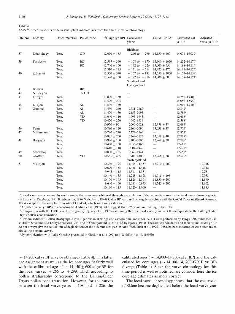
Table 4AMS ��C measurements on terrestrial plant macrofossils from the Swedish varve chronology
Site No. Locality Dated material Pollen zone ��C age (yr BP) Localvarveyears�
Cal yr BP 2� Estimated calyr BP
Adjustedvarve yr BP�
Blekinge37 DoK nhyltagyl Terr. OD 12,090$185 #266 to #299 14,150$600 14,074}14,039�
39 Farslycke Terr. B" 12,595$360 #108 to #170 14,900$1050 14,232}14,170�Terr. B" 12,740$150 #142 to #226 15,000$550 14,198}14,114�Terr. 12,310$145 #171 to #214 14,425$475 14,169}14,126�
40 SkaK lgylet Terr. 12,330$370 #167 to #181 14,550$1050 14,173}14,159�Terr. 12,590$130 #182 to #216 14,800$500 14,158}14,124�
Sma� land andOstergoK tland
41 Bolmen B"42 N LeksjoK n 'OD *
43 ToregoK l Terr. 11,820$150 * 14,250}13,400Terr. 11,520$225 * 14,050}12,950
44 LillsjoK n Terr. AL 11,539$130 * 13,900}13,20045 Gummet. Terr. AL 11,450$240 2231}2167� * 12,849�
Terr. AL 11,470$130 2153}2093 * 12,788�Terr. YD 11,040$110 1993}1943 * 12,618�Terr. YD 10,420$220 1942}1934 * 12,588�
10,970$90 2060}2028 12,958$38 12,694�46 Tynn Terr. 10,890$120 2160}2090 13,038$38 12,775�47 N Emmaren Terr. 10,740$240 2273}2169 * 12,871�
Terr. 10,885$250 2169}2123 13,058$40 12,769�48 HargsjoK n Terr. 10,980$100 2105}2005 12,968$38 12,705�
Terr. 10,480$150 2055}1965 * 12,660�Terr. 10,610$110 2004}1942 * 12,623�
49 Adlerskog Terr. 10,830$165 2062}1944 * 12,650�50 Glottern Terr. YD 10,585$465 1906}1806 12,768$38 12,506�
VaK stergoK tland51 MullsjoK n Terr. 10,330$175 11,485}11,457 12,210$200 12,346
Terr. 10,620$155 11,456}11,418 * 12,312Terr. 9,945$115 11,381}11,331 * 12,231Terr. 10,140$155 11,228}11,128 11,915$195 12,053Terr. 10,170$195 11,126}11,104 11,850$200 11,990Terr. 9,640$190 11,081}10,973 11,745$205 11,902Terr. 10,160$115 11,020}11,000 * 11,885
�Local varve years covered by each sample; the years were obtained through a correlation of the varve diagrams to the local varve chronologies ineach area (i.e. Ringberg, 1991; Kristiansson, 1986; StroK mberg, 1994). Cal yr BP are based on wiggle-matching with the OxCal Program (Bronk Ramsey,1995), except for the samples from sites 43 and 44, which were only calibrated.�Adjusted varve yr BP are according to AndreH n et al. (1999), who suggest that 875 years are missing in the STS.�Comparison with the GRIP event stratigraphy (BjoK rck et al., 1998a) assuming that the local varve year #300 corresponds to the B+lling/OlderDryas pollen zone transition.�Bottom sediment. Pollen stratigraphic investigations in Blekinge and eastern Sma� land (sites 39, 41) were performed by Ising (1998; submitted), insouthern Sma� land (site 42) by Svensson (1989) and in OG stergoK tland (sites 45, 50) by BjoK rck (1999). The radiocarbon dates and their estimated cal yr BPdo not always give the actual time of deglaciation for the di!erent sites (see text andWohlfarth et al., 1995, 1998a, b), because samples were often takenabove the bottom varves.�Synchronization with Lake Gosciaz presented in Goslar et al. (1999) and Wohlfarth et al. (1998b).
&14,200 cal yr BPmay be obtained (Table 4). This latterage assignment as well as the ice core ages "t fairly wellwith the calibrated age of &14,150$600 cal yr BP forthe local varves #266 to #299, which according topollen stratigraphy correspond to the B+lling/OlderDryas pollen zone transition. However, for the varvesbetween the local varve years #108 and #226, the
calibrated ages (&14,900}14,800 cal yrBP) and the cal-culated ice core ages (&14,100}14, 200 GRIP yr BP)diverge (Table 4). Since the varve chronology for thistime period is well established, we consider here the icecore age estimates as more correct.The local varve chronology shows that the east coastof Ska� ne became deglaciated before the local varve year
1140 J. Lundqvist, B. Wohlfarth / Quaternary Science Reviews 20 (2001) 1127}1148
}300 and that the coast up to the southeastern corner ofSma� land was ice free around the local varve year }100(Ringberg, 1991) (Fig. 4). This would then, according tothe assumptions outlined above correspond to 14,650GRIP yr BP/14,690 GISP yr BP/&14,800 cal yr BP and14,450 GRIP yr BP/14,490 GISP yr BP/14,600 cal yr BP,respectively. The calculated cal yr age estimates indicatethat, due to the complicated structure of the calibrationcurve between 12,500 and 12,800BP, the calibrated agesof the older radiocarbon dates mentioned above must beoverestimated.Investigations on lake sequences situated above thehighest coastline by BjoK rck (1981) and BjoK rck andMoK ller(1987) show that several of these sites had become ice-freeduring the later part of the B+lling pollen zone or at thetransition between the B+lling and Older Dryas pollenzones (Figs. 3 and 4), which is in accordance with theclay-varve chronology. However, BjoK rck and MoK ller(1987) also concluded that stagnant ice remained in areasabove the highest coastline until about the beginning ofthe Aller+d pollen zone.Based on the above outlined arguments, we can con-clude that the coastal area of Blekinge and southeasternSma� land up to the highest shoreline became deglaciatedduring the B+lling pollen zone, i.e. between 14,650GRIP/14,690 GISP/14,800 cal yr BP and 14,350GRIP/14,390 GISP/&14,500 cal yr BP (Fig. 4).
5.2. Sma� land and southern OG stergoK tland
Unfortunately, no reliable varve chronology exists thatallows linking the local varve chronologies in Blekingeand Sma� land to each other (Fig. 1). Furthermore, thecorrelation between the varve diagrams on which thevarve chronology in Sma� land is based (Kristiansson,1986) is fairly poor and shows several major errors(Holmquist and Wohlfarth, 1998). The "rst continuousand well-established varve chronology comprises onlythe area north and south of Kisa in OG stergoK tland (Woh-lfarth et al., 1998a). The timing of the ice recessionbetween Blekinge and Sma� land can, therefore, only beestimated based on a combination of radiocarbon datesand single #oating varve diagrams.The oldest AMS ��C dates, which could be obtainedon varved clays from the Sma� land chronology are fromsite 43, and give an age of c. 11,500}11,800BP (Table 4). Ifthe weighted mean of these radiocarbon ages(&11,700BP) is compared to the calibration curve anage of &13,900 cal yr BP can be obtained. The varvediagram from ToregoK l cannot be directly correlated tothe oldest diagrams in the Sma� land chronology. How-ever, based on the transition from thin to thick varves,which is characteristic for the oldest diagrams aroundHoK gsby (Kristiansson, 1986), the ToregoK l diagram can betentatively linked to the neighbouring diagrams (Woh-lfarth et al., 1998a). Following Kristiansson (1986), the
area became deglaciated 265 varve years before thetransition to the thicker varves. Assuming a deglaciationage of&13,900 cal yrBP for site 43 and a correlation toKristiansson's varve diagrams, we may conclude thatthe HoK gsby area became ice free at &14,250 cal yr BP(Fig. 4). Such an age estimate corresponds to&14,040}14,090 ice yr BP (see Table 2) and compares also well withpollen stratigraphic investigations by Svensson (1989)(site 42 in Fig. 3), who concluded that the area became icefree before the Older Dryas pollen zone. If these ageassignments are correct, then the area between Kalmarand HoK gsby must have become deglaciated during thelater part of the B+lling pollen zone.One radiocarbon date on varved clays from site 44gave an age of 11,530BP (Table 4) or 13,550$350 cal yrBP. The correlation of the varve diagram toclose-by varve diagrams shows that the area becamedeglaciated c.130 years earlier. During recent "eld obser-vations a section comprising thick proximal varved clays,which is overlain by a diamicton, was discovered south-west of site 44 (S. BjoK rck, pers. communication). Al-though it is not clear if the overlying diamicton is a realtill, it is evident that some oscillations of the ice marginmust have occurred in this area.Compared to the Sma� land chronology, the clay-varvechronology in southern OG stergoK tland is well establishedand could, through numerous radiocarbon measure-ments, be synchronised with the calendar-year chrono-logy established at Lake Gosciaz in Poland (Wohlfarthet al., 1998a; Goslar et al., 1999). The Gosciaz varvechronology compares well with the GRIP ice core recordand in the following, we therefore equal the estimatedcalendar years according to the Gosciaz chronology withGRIP yr BP. The varve chronology established byWohlfarth et al. (1998a) ranges between 2475 and 1700local varve years or c. 13,200 and 12,350 GRIP yr BP andcovers the end of the AlleroK d and the early part of theYounger Dryas pollen zones. Pollen-stratigraphic invest-igations on the radiocarbon-dated clay varves (BjoK rck,1999a) showed that the transition between the AlleroK dand Younger Dryas pollen-zones occurred at the localvarve year 2000 or 12,650 GRIP yr BP.Table 4 shows the age estimates, which were obtainedby synchronizing the clay-varve chronology with LakeGosciaz (Goslar et al., 1999) and those obtained througha calibration of the radiocarbon dates according toStuiver et al. (1998). The o!set between the two ageassignments is due to a di!erent estimate for the length ofthe Younger Dryas (see Table 2), which is 1150 yr inGosciaz and the GRIP ice core (BjoK rck et al., 1998a), but&1250 in the GISP ice core (Stuiver et al., 1995) and&1500 years in IntCal98 (Stuiver et al., 1998). In Fig. 4we have taken into account these di!erent age estimatesand present GRIP yr BP, as well as the correspondingGISP yr BP and cal yr BP. The timing of the deglaciationof the individual sites follows Wohlfarth et al. (1998a)
J. Lundqvist, B. Wohlfarth / Quaternary Science Reviews 20 (2001) 1127}1148 1141
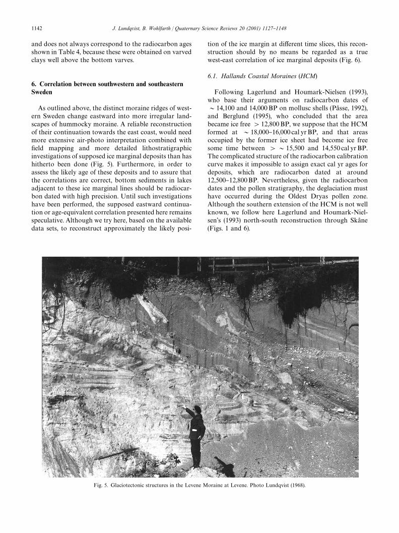
Fig. 5. Glaciotectonic structures in the Levene Moraine at Levene. Photo Lundqvist (1968).
and does not always correspond to the radiocarbon agesshown in Table 4, because these were obtained on varvedclays well above the bottom varves.
6. Correlation between southwestern and southeasternSweden
As outlined above, the distinct moraine ridges of west-ern Sweden change eastward into more irregular land-scapes of hummocky moraine. A reliable reconstructionof their continuation towards the east coast, would needmore extensive air-photo interpretation combined with"eld mapping and more detailed lithostratigraphicinvestigations of supposed ice marginal deposits than hashitherto been done (Fig. 5). Furthermore, in order toassess the likely age of these deposits and to assure thatthe correlations are correct, bottom sediments in lakesadjacent to these ice marginal lines should be radiocar-bon dated with high precision. Until such investigationshave been performed, the supposed eastward continua-tion or age-equivalent correlation presented here remainsspeculative. Although we try here, based on the availabledata sets, to reconstruct approximately the likely posi-
tion of the ice margin at di!erent time slices, this recon-struction should by no means be regarded as a truewest-east correlation of ice marginal deposits (Fig. 6).
6.1. Hallands Coastal Moraines (HCM)
Following Lagerlund and Houmark-Nielsen (1993),who base their arguments on radiocarbon dates of&14,100 and 14,000BP on mollusc shells (Pa� sse, 1992),and Berglund (1995), who concluded that the areabecame ice free'12,800BP, we suppose that the HCMformed at &18,000}16,000 cal yrBP, and that areasoccupied by the former ice sheet had become ice freesome time between '&15,500 and 14,550 cal yr BP.The complicated structure of the radiocarbon calibrationcurve makes it impossible to assign exact cal yr ages fordeposits, which are radiocarbon dated at around12,500}12,800BP. Nevertheless, given the radiocarbondates and the pollen stratigraphy, the deglaciation musthave occurred during the Oldest Dryas pollen zone.Although the southern extension of the HCM is not wellknown, we follow here Lagerlund and Houmark-Niel-sen's (1993) north-south reconstruction through Ska� ne(Figs. 1 and 6).
1142 J. Lundqvist, B. Wohlfarth / Quaternary Science Reviews 20 (2001) 1127}1148
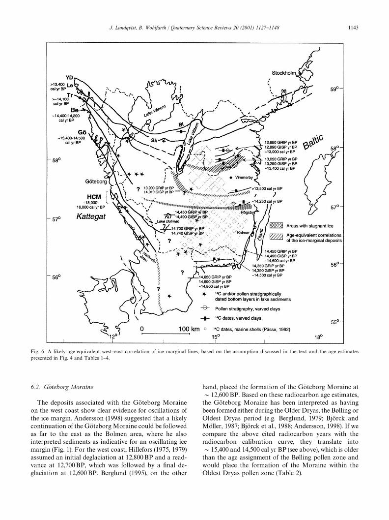
Fig. 6. A likely age-equivalent west}east correlation of ice marginal lines, based on the assumption discussed in the text and the age estimatespresented in Fig. 4 and Tables 1}4.
6.2. GoK teborg Moraine
The deposits associated with the GoK teborg Moraineon the west coast show clear evidence for oscillations ofthe ice margin. Andersson (1998) suggested that a likelycontinuation of the GoK teborgMoraine could be followedas far to the east as the Bolmen area, where he alsointerpreted sediments as indicative for an oscillating icemargin (Fig. 1). For the west coast, Hillefors (1975, 1979)assumed an initial deglaciation at 12,800BP and a read-vance at 12,700BP, which was followed by a "nal de-glaciation at 12,600BP. Berglund (1995), on the other
hand, placed the formation of the GoK teborg Moraine at&12,600BP. Based on these radiocarbon age estimates,the GoK teborg Moraine has been interpreted as havingbeen formed either during the Older Dryas, the B+lling orOldest Dryas period (e.g. Berglund, 1979; BjoK rck andMoK ller, 1987; BjoK rck et al., 1988; Andersson, 1998). If wecompare the above cited radiocarbon years with theradiocarbon calibration curve, they translate into&15,400 and 14,500 cal yr BP (see above), which is olderthan the age assignment of the B+lling pollen zone andwould place the formation of the Moraine within theOldest Dryas pollen zone (Table 2).
J. Lundqvist, B. Wohlfarth / Quaternary Science Reviews 20 (2001) 1127}1148 1143

Recently, Ising (submitted) has shown, based on pollenstratigraphy and clay-varve chronology, that the deglaci-ation of Lake Bolmen had started aby the very beginningof the B+lling pollen zone (&14,700 GRIP yr BP) andthat the whole lake had become ice-free within a periodof 250 years (Fig. 6). This age estimate could compare to&14,800 cal yrBP, if we assume &14,200 cal yr BP forthe B+lling/Older Dryas transition and a length of&600 yr for the B+lling period (Table 2). The deglaci-ation of the coastal area of NE Ska� ne and southernBlekinge, which is reconstructed based on a clay-varvechronology, combined with pollen and radiocarbonstratigraphy, occurred during the B+lling pollen zone, i.e.between 14,650}14,350GRIP yr BP or &14,800}&14,600 cal yrBP (Fig. 6). An ice marginal line, extend-ing west}east towards Lake Bolmen during the B+llingpollen zone (Andersson, 1998) is fairly di$cult to recon-cile given these records. The picture presented byHillefors (1975, 1979), i.e. an ice marginal line south ofLake Bolmen, combined with the age estimates of&15,400}14,500 cal yrBP (see above), seem to "t wellwith Ising's (submitted) results for the timing of thedeglaciation of Lake Bolmen and could be taken asevidence that the GoK teborg Moraine was formed duringthe later part of Oldest Dryas. There are no morphologi-cal features that would allow the GoK teborg Moraine tobe traced towards the coast of Ska� ne and Blekinge. Anage estimate of&14,800 cal yrBP or 14,650 GRIP yr BPfor the start of the deglaciation in NE Ska� ne may indicatethat an age-equivalent to the GoK teborg Moraine couldbe situated somewhere south or among the oldest icerecession lines in NE Ska� ne and Blekinge.
6.3. Berghem Moraine
The Berghem line, which forms a distinct ice marginalline along the west coast, has been radiocarbon dated to&12,350}12,250BP (i.e. &14,400}14,200 cal yrwBP)(FredeH n, 1988; Pa� sse, 1992). Indirect age estimates onlake sediments show an ice-free area east of the BerghemMoraine'12,150BP (i.e.'14,100 cal yr BP) or duringthe Older Dryas pollen zone. Taken together, this indi-cates that the formation of the ice marginal line pre-datesthe Older Dryas pollen zone and that the most likely agefor its deposition would range within the B+lling pollenzone (see Table 2). An age-equivalent eastward correla-tion should be situated somewhere north of LakeBolmen, whose northern end had become ice-free at14,450 GRIP yr BP, which may correspond to&14,600cal yr BP. Further east, an age-equivalent may be foundin a zone, which extends south of HoK gsby (Fig. 6). Thecoastal area of Blekinge and southern Sma� land up toHoK gsby was rapidly deglaciated after 14,450 GRIP yr BP(&14,600 cal yr BP) and indications of a B+lling age caneven be inferred from lake sediments close to HoK gsby(Svensson, 1989).
6.4. TrollhaK ttan Moraine
The extension of the TrollhaK ttan line is clear only inthe northwestern part of the area and its southern exten-sion around Lake VaK ttern (Fig. 2, which is still uncertain,was discussed above. The timing of the formation of thisice marginal line is, based on a combination of lakesediment studies (BjoK rck and Digerfeldt, 1982) andradiocarbon dates on mollusc shells (FredeH n, 1988), esti-mated at '11,900}11,800 BP or '&14,200 cal yr BP(Table 1). Corresponding age equivalents of this linecould be situated somewhere south of Lake VaK ttern andfurther east, south of the ice recession line given for site44 (Figs. 3 and 6). The varve chronology in this area isuncertain and radiocarbon dates are too scarce to allowthe position of the ice margin at that time to be deter-mined with any con"dence. However, a section compris-ing proximal varves overlain by diamict material wasobserved recently southeast of site 44 and this could bean indication for some oscillations of the ice margin(BjoK rck, pers. communication). If the estimated timeperiod is correct this would imply that the TrollhaK ttanMoraine was formed during the Older Dryas pollen zone(Table 2).
6.5. Levene Moraine
The extension of the Levene line was described aboveas far to the east as the basin of Lake VaK ttern. However,east of Lake VaK ttern its extension is rather unclear andseveral di!erent locations have been proposed. Persson(1983) favoured a northerly position, east of NorrkoK ping.This, however, coincides with what is described below asthe southernmost position of the Younger Dryas line.According to most authors, the continuation of theLevene line is considered to be located further to thesouth, extending eastward from the southern end of LakeVaK ttern (Agrell et al., 1976; Berglund, 1979). Nilsson(1968), on the other hand, proposed an intermediateposition.As shown in Table 1 and outlined above, the approx-imate age for the formation of the Levene line on the westcoast may range between 11,600 and 11,200 BP or&13,400 cal yrBP. Age equivalents for this time periodon the east coast may be found around site 45, whichgave radiocarbon ages of 11,400}11,500BP for its bot-tom sediments (Figs. 3 and 6). The site became ice free at&12,800 GRIP or &13,200 cal yr BP. Some 10 kmsouth of the recession line 2400 (&13,000 GRIP or&13,400 cal yrBP), strongly tectonised clay varves havebeen observed at several localities. These features,together with the age estimates, could point to anage-equivalent correlation of the Levene line withapproximately the local varve years &2400}2200 (i.e.13,040}12,840 GRIP or &13,400}13,200 cal yr BP(Fig. 6). With some speculation, this time period could
1144 J. Lundqvist, B. Wohlfarth / Quaternary Science Reviews 20 (2001) 1127}1148
correspond to the so-called GI-1b event in the GRIP icecore (BjoK rck et al., 1998a).
6.6. The Younger Dryas Moraines
The general west}east continuity of the SkoK vde-Billin-genMoraines is good, but we do not know yet if the linesin the east and west are exactly contemporaneous. Thepresent correlation is based mainly on morphology andon the clay-varve chronology presented by Perhans(1981). Some problems still exist, and the connectionsacross the line itself, e.g. by Kristiansson (1986), are notentirely convincing. We know from Finland that theretreat from the two SalpausselkaK arcs was not contem-poraneous (Donner, 1978), and the same might apply tothe Scandinavian Peninsula. For instance, the beginningof the formation of the southernmost moraines, atHalleby, took place at Kristiansson (1986) local varveyear 1760, which according to him corresponds to theAlleroK d/Younger Dryas boundary. According to therevision by Goslar et al. (1999) and Wohlfarth et al.(1998a) this boundary is some 200}240years older thanpreviously anticipated and corresponds to the localvarve year 2000 or to about 12,650 GRIP yr BP. Onepossibility is that the ice recession line at the varve year2000 represents the beginning of the Younger Dryas coldphase, and that the ice continued to recede for another200}240years, before it started to stagnate and/or read-vance. Disturbed varved clay sequences just south of theeastern part of the SkoK vde line, east of Lake VaK ttern, maybe an indication for this. On the other hand, the o!setbetween the Swedish varve chronology and other calen-dar-year time scales is 875 years at the YoungerDryas/Holocene boundary (AndreH n et al., 1999), butonly 650 years at the Aller+d/Younger Dryas transition(Wohlfarth et al., 1998a; Wohlfarth and Possnert, 2000).This could in turn indicate, that Kristiansson (1986) andBrunnberg (1995) correlations across the Younger DryasMoraines need revision.
7. Conclusions
The timing of the deglaciation of southern Sweden, inparticular the age assigned to the distinct ice marginalfeatures on the Swedish west coast and their correlationwith the features formed during the ice recession on theeast coast has been a matter of debate for more than100 years (see summary in Berglund, 1979). Previously,correlations have been mainly based on morphology, butclay-varve chronological studies, radiocarbon measure-ments and pollen stratigraphic investigations have nowresulted in a more di!erenciated picture. However, theissue remains complicated as the chronology of the icemarginal landforms and sediments on the west coast isbased mainly on radiocarbon dated mollusc shells and
the ice recession along the east coast has been reconstruc-ted mainly by clay-varve chronology.The likely scenario, which is presented here, takes intoaccount new pollen stratigraphic investigations on lakesediment sequences adjacent to the ice marginal lines onthe west coast, pollen stratigraphic studies on varvedclays in the central part and radiocarbon measurementsand pollen stratigraphic investigations, combined witha varve chronology on the east coast. Furthermore, allage assignments were converted into cal yr BP accordingto IntCal98 (Stuiver et al., 1998), to allow age-equivalentcomparisons on the same type of time scale.Our reconstruction assumes that both the HallandCoastal Moraines (HCM) and the GoK teborg Morainewere formed around&18,000}16,000 and'&15,400}14,500 cal yr BP, respectively or during the Oldest Dryaspollen zone. Such an age assignment is in accordancewith Lagerlund and Houmark-Nielsen (1993) for theHCM and BjoK rck et al. (1988) for the GoK teborgMoraine.It also compares well with investigations by Sandgren etal. (1999), who showed that areas in NW Ska� ne were icefree as early as &17,000 cal yr BP, with deglaciationages of '15,450}14,450 cal yr BP for a site in southernSka� ne (Wohlfarth et al., 1998b) and the start of thedeglaciation of Lake Bolmen at 14,700 GRIP yr BP(Ising, submitted). While we adopted Lagerlund andHoumark-Nielsen's (1993) suggestion for a north}southextension of the HCM, we place the southeastern exten-sion of the GoK teborg Moraine as far as to the southernend of Lake Bolmen. Its continuation further to thesoutheast or east remains unclear.The next younger BerghemMoraine has a likely age of
&14,400}14,200 cal yrBP, which places its formationduring the later part of the B+lling pollen zone andcorresponds thus to the age assumed by BjoK rck et al.(1988). An age-equivalent ice margin could have beensituated more or less west}east across central Sweden,from north of Lake Bolmen towards the town of HoK gsbyon the east coast (Fig. 6). This reconstructed extension ofa likely ice margin is slightly di!erent than the oneassumed by BjoK rck et al. (1988). While the ice marginreceded only slowly along the west coast, large areas inthe western part of the central highland and along thesoutheastern and eastern coast were rapidly deglaciatedbetween&15,000 and&4,400 cal yrBP. However, stag-nant ice remained in higher elevated areas and did notmelt until &13,900 cal yrBP. The TrollhaK ttan Moraineis assumed to have been formed around&14,200 cal yrBP, which we parallel with the OlderDryas pollen zone in accordance with BjoK rck et al.(1988). The age-equivalent ice margin on the east coastcould have been situated in a zone north of HoK gsby, butits position in the central part is not clear (Fig. 6). A rapiddeglaciation along the east coast, which was followed bya more complicated deglaciation pattern between&14,400 and &14,100 cal yrBP, would explain why it
J. Lundqvist, B. Wohlfarth / Quaternary Science Reviews 20 (2001) 1127}1148 1145
has been di$cult to construct a clay-varve chronologyfor this part of Sweden. The ice recession on the eastcoast is in general regarded as having been continuous.However, the thin varves, which were deposited north ofHoK gsby, may indicate a slow-down of the ice recessionand the diamicton observed NE of HoK gsby may point toan oscillating ice margin.The formation of the Levene Moraine likely occurredat around 13,400 cal yr BP, or during the upper part ofthe Aller+d pollen zone. This estimate is considerablyyounger than assumed by BjoK rck et al. (1988). Althoughits exact position in the Lake VaK ttern region is uncertain,an age-quivalent ice margin could have extended fromthe southern end of Lake VaK ttern towards the northeast(Fig. 6). Indications for oscillations of the ice margin onthe east coast may be found in slightly tectonised varvedclays, which were deposited south of the recession line2400. Although speculative, the Levene Moraine mayhave been formed during the so-called GI-1b event orGerzensee-Oscillation (BjoK rck et al., 1998a). During theAller+d pollen zone large areas, which had previouslybeen covered by stagnant ice became gradually ice free,both in the southern and northern part of the centralhighland.
Acknowledgements
We are indebted to Svante BjoK rck, Per MoK ller andErik Lagerlund for discussions and comments. Construc-tive citicism from the referees Jonas BjoK rck, JoakimDonner and Jan Mangerud is gratefully acknowledged.The Swedish Natural Science Research Council and theGeological Survey of Sweden "nanced Wohlfarth'sresearch on varved clays.
References
Agrell, H., Friberg, N., Oppga� rden, R., 1976. The Vimmerby line } anice-margin zone in north-eastern Sma� land. Svensk Geogra"sk As r-sbok 52, 71}91.
Ahlmann, H.W:son, 1910. Studier oK fver de medelsvenska aK n-dmoraK nerna. Arkiv foK r kemi, mineralogi och geologi utgifvet af K.Svenska Vetenskapsakademien i Stockholm 3:29, 15 pp.
Andersen, B.G., Mangerud, J., S+rensen, R., Reite, A., Sveian, H.,Thoresen, M., BergstroK m, B., 1995. Younger Dryas ice marginaldeposits in Norway. Quaternary International 28, 147}169.
Andersson, G., 1998. Deglaciation pattern and dynamics in the Bolmenarea, southwestern Sweden. LUNDQUA Thesis, Vol. 42, pp. 1}22.
AndreH n, T., BjoK rck, J., Johnsen, S., 1999. Correlation of the Swedishglacial varves with the Greenland (GRIP) oxygen isotope stratigra-phy. Journal of Quaternary Science 14, 361}371.
Antevs, E., 1915. Landisens recession i nordoK stra Ska� ne. GeologiskaFoK reningens i Stockholm FoK rhandlingar 37, 353}366.
Berglund, B.E., 1979. The deglaciation of southern Sweden13,000}10,000B.P. Boreas 8, 89}117.
Berglund, M., 1995. The Late Weichselian deglaciation, vegetationaldevelopment and shore displacement in Halland, southwesternSweden. LUNDQUA Thesis, Vol. 35, pp. 1}115.
Berglund, B.E., BjoK rck, S., Lemdahl, G., Bergsten, H., Nordberg, K.,Kolstrup, E., 1994. Late Weichselian environmental changes insouthern Sweden and Denmark. Journal of Quaternary Science 9,127}132.
Berglund, B.E., MoK rner, N.A., 1984. Late Weichselian deglaciation andchronostratigraphy of Southern Scandinavia: problems and present`state of the arta. In: MoK rner, N.-A., KarleH n, W. (Eds.), ClimaticChanges on a Yearly to Millennial Basis. Reidel Publishing Com-pany, Dordrecht, pp. 17}24.
Bergsten, K.E., 1943. IsaK lvsfaK lt kring norra VaK ttern. Fysisk-geogra"skastudier. Meddelanden fra� n Lunds Universitets Geogra"ska Institu-tion, Avhandlingar VII, 245 pp.
BergstroK m, R., 1992. The Fennoscandian End Moraine Zone in easternSweden. Sveriges Geologiska UndersoK kning Ca 81, 43}50.
BjoK rck, J., 1999a. Event stratigraphy for the Last Glacial-Holocenetransition in eastern middle Sweden. Quaternaria, StockholmUniversity, Series A 6, 1}48.
BjoK rck, J. 1999b. The Aller+d-Younger Dryas pollen zone boundary inan 800 year varve chronology from southeastern Sweden. GFF,121, 287}292.
BjoK rck, J., Possnert, G., Schoning, K. 2001. Early Holocene deglaci-ation chronology in VaK stergoK tland and NaK rke, Sweden * bio-stratigraphy, clay varve, ��C and calendar year chronology.Quaternary Science Reviews, in press.
BjoK rck, S., 1981. A stratigraphic study of LateWeichselian deglaciation,shore displacement and vegetation history in south-eastern Sweden.Fossils and Strata 14, 1}93.
BjoK rck, S., Berglund, B.E., Digerfeldt, G., 1988. New aspects on thedeglaciation chronology of South Sweden. Geographica Polonica55, 37}49.
BjoK rck, S., Digerfeldt, G., 1981. New ��C dates from Hunneberg sup-porting the revised deglaciation chronology of the Middle Swedishend moraine zone. Geologiska FoK reningens i Stockholm FoK rhan-dlingar 103, 395}404.
BjoK rck, S., Digerfeldt, G., 1982. Late Weichselian shore displacementat Hunneberg, southern Sweden, indicating complex uplift.Geologiska FoK reningens i Stockholm FoK rhandlingar 104,131}155.
BjoK rck, S., Digerfeldt, G., 1984. Climatic changes at Pleistocene/Holo-cene boundary in the Middle Swedish endmoraine zone, mainlyinferred from stratigraphic indications. In: MoK rner, N.-A., KarleH n,W. (Eds.), Climatic Changes on a Yearly to Millennial Basis. ReidelPublishing Company, Dordrecht pp. 37}56.
BjoK rck, S., Digerfeldt, G., 1986. Late Weichselian-Early Holocene shoredisplacement west of Mt. Billingen within the Middle Swedishend-moraine zone. Boreas 15, 1}18.
BjoK rck, S., Digerfeldt, G., 1989. Lake MullsjoK n } a key site for under-standing the "nal stage of the Baltic Ice Lake east of Mt. Billingen.Boreas 18, 209}219.
BjoK rck, S., Digerfeldt, G., 1991. Aller+d-Younger Dryas sea level cha-nges in southwestern Sweden and their relation to the Baltic IceLake development. Boreas 20, 115}133.
BjoK rck, S., Ha� kansson, S., 1982. Radiocarbon dates from Late Weich-selian lake sediments in South Sweden as a basis for chronostrati-graphic subdivision. Boreas 11, 141}150.
BjoK rck, S., MoK ller, P., 1987. Late Weichselian environmental history insoutheastern Sweden during the deglaciation of the Scandinavianice sheet. Quaternary Research 28, 1}37.
BjoK rck, S., Bennike, O., Possnert, G., Wohlfarth, B., Digerfeldt, G.,1998b. A high-resolution ��C dated sediment sequence from south-west Sweden: age comparisons between di!erent components of thesediment. Journal of Quaternary Science 13, 85}89.
BjoK rck, S., Walker, M., Cwynar, L., Johnsen, S., Knudsen, K.-L., Lowe,J., Wohlfarth, B., INTIMATEMembers, 1998a. An event stratigra-phy for the Last Termination in the North Atlantic region based onthe Greenland ice-core record: a proposal by the INTIMATEgroup. Journal of Quaternary Science 13/4, 283}292.
1146 J. Lundqvist, B. Wohlfarth / Quaternary Science Reviews 20 (2001) 1127}1148
BjoK rck, S., Kromer, B., Johnsen, S., Bennike, O., Hammarlund, D.,Lemdahl, G., Possnert, G., Lander Rasmussen, T., Wohlfarth, B.,Hammer, C.U., Spurk, M., 1996. Synchronized Terrestrial-atmo-spheric deglacial records around the North Atlantic. Science 274,1155}1160.
BjoK rsjoK , N., 1949. Israndstudier i soK dra BohuslaK n. Sveriges GeologiskaUndersoK kning C 504, 321.
Bronk Ramsey, C., 1995. Radiocarbon calibration and analysis ofstratigraphy. Radiocarbon 37 (2), 425}430.
Brunnberg, L., 1995. Clay-varve chronology and deglaciation duringthe Younger Dryas and Preboreal in the easternmost part of theMiddle Swedish Ice Marginal Zone. Quaternaria, StockholmUniversity, A, Vol. 2, 94 pp.
Caldenius, C., 1942. Gotiglaciala israndsstadier och joK kelbaK ddar i Hal-land. FoK reloK pande meddelande. Geologiska FoK reningens i Stock-holm FoK rhandlingar 64, 163}183.
Caldenius, C., 1944. Baltiska issjoK ns saK nkning till VaK sterhavet.En geokronologisk studie. Geologiska FoK reningens i StockholmFoK rhandlingar 66, 366}382.
Cato, I., 1987. On the de"nitive connection of the Swedish Time Scalewith the present. Sveriges Geologiska UndersoK kning Ca, Vol. 68, 55pp.
De Geer, G., 1909. Dal's Ed. Some stationary Ice-borders of the lastGlaciation. Geologiska FoK reningens i Stockholm FoK rhandlingar 31,511}556.
De Geer, G., 1912. A geochronology of the last 12,000 years.XI Congres Geologique Internationale, Stockholm 1910. ComptesRendues, pp. 241}253.
Dennega� rd, B., 1984. Late Weichselian and Early Holocene stratigra-phy in southwestern Sweden with emphasis on the Lake VaK nernarea. Chalmers Tekniska HoK gskola } GoK teborgs Universitet, Geol-ogiska Institutionen Publ. A, Vol. 48, 187 pp.
Donner, J., 1978. The dating of the levels of the Baltic Ice Lake and theSalpausselkaK moraines in South Finland. CommentationesPhysico-Matematicae 48, 11}38.
Duphorn, K., Stay, B., Stiller, D., 1979. Deglaciation of the Bara Basinnear MalmoK , Sweden. Boreas 8, 141}144.
FaK lt, L.-M., 1982. Late Quaternary sea-#oor deposits o! the Swedishwest coast. Chalmers Tekniska HoK gskola/GoK teborgs Universitet,Geologiska Institutionen Publ. A, Vol. 37, 259 pp.
Fernlund, J.M.R., 1988. The Halland Coastal Moraines: are they endmoraines or glaciotectonic ridges? In: Croot, D.G. (Ed.), Glaciotec-tonics. Forms and Processes. A.A. Balkema, Rotterdam, pp. 77}90.
Fernlund, J.M.R., 1993. The long-singular ridges of the HallandCoastalMoraines, south-western Sweden. Journal of Quaternary Science 8,67}78.
FredeH n, C., 1984. Beskrivning till jordartskartan VaK nersborg SO.Sveriges Geologiska UndersoK kning Ae 48, 90 pp.
FredeH n, C., 1988. Marine life and deglaciation chronology of theVaK nern basin, southwestern Sweden. Sveriges Geologiska Under-soK kning Ca, Vol. 71, 80 pp.
FredeH n, C., 1990. Beskrivning till jordartskartan Bora� s NO. SverigesGeologiska UndersoK kning Ae 107, 90 pp.
FredeH n, C. (Ed.), 1998. Berg och Jord, Sveriges Nationalatlas, pp. 1}208.Gavelsin, A., 1926. Comments on lecture by S. Johansson: `BaltiskaissjoK ns tappninga. Geologiska FoK reningens i Stockholm FoK rhan-dlingar 48, 292}294.
Gillberg, G., 1956. Den glaciala utvecklingen inom Sydsvenska hoK glan-dets vaK stra randzon. III. IssjoK ar och isavsmaK ltning. GeologiskaFoK reningens i Stockholm FoK rhandlingar 78, 357}458.
Goslar, T., Wohlfarth, B., BjoK rck, S., Possnert, G., BjoK rck, J., 1999.Variations of atmospheric ��C concentrations over the Aller+d} Younger Dryas transition. Climate Dynamics 15, 29}42.
Gustafson, G., 1977. Norra israndstra� ket i Mellansvenska israndzonenoK ver KroppefjaK lls-massivet i Dalsland. Chalmers Tekniska HoK g-skola } GoK teborgs Universitet, Geologiska Institutionen Publ. B,Vol. 81, 66 pp.
HedstroK m, H., 1901. Om aK ndmoraK ner och strandlinier i trakten afVaberget. Geologiska FoK reningens i Stockholm FoK rhandlingar 23,163}179.
HilldeH n, A., 1979. Deglaciationen i trakten av BerghemsmoraK nen oK sterom GoK teborg. University of Lund, Department of QuaternaryGeology, Thesis Vol. 6, 130 pp.
Hillefors, As ., 1975. Contribution to the knowledge of the chrono-logy of the deglaciation of western Sweden with special refer-ence to the Gothenburg moraine. Svensk Geogra"sk As rsbok 51,70}81.
Hillefors, As ., 1979. Deglaciation models from the Swedish West Coast.Boreas 8, 153}169.
Holmquist, B., Wohlfarth, B., 1998. An evaluation of the Late Weich-selian Swedish varve chronology based on cross-correlation analy-sis. GFF 120, 35}46.
Ising, J., 1998. LateWeichselian pollen stratigraphy, clay-varve chrono-logy, radiocarbon chronology and palaeomagnetic secular vari-ations in Farslycke, central Blekinge, south Sweden. GFF 120,321}332.
Ising, J. Late Weichselian pollen stratigraphy, clay varve chronologyand palaeomagnetic secular variations, in Lake Bolmen, Sma� land,south Sweden. Boreas, submitted for publication.
Johansson, B.T., 1982. Deglaciationen av norra BohuslaK n och soK draDalsland. Chalmers Tekniska HoK gskola } GoK teborgs Universitet,Geologiska Institutionen Publ. A, Vol. 38, 180 pp.
Johnsson, G., 1956. Glacialmorfologiska studier i soK dra Sverige. MedsaK rskild haK nsyn till glaciala riktningselement och periglaciala fros-tfenomen. Meddelanden fra� n Lunds Universitets Geogra"ska Insti-tution, Avhandlingar, Vol. 31, 407 pp.
Kristiansson, J., 1986. The ice recession in the south-eastern part ofSweden. A varve-chronological time scale for the latest part of theLate Weichselian. University of Stockholm, Department of Quater-nary Research, Report 7, 149 pp.
Lagerlund, E., Houmark-Nielsen, M., 1993. Timing and pattern of thelast deglaciation in the Kattegat region, southwest Scandinavia.Boreas 22, 337}347.
Lagerlund, E., Knutsson, G., As mark, M., Hebrand, M., JoK nsson, L.-O.,Karlgren, B., Kristiansson, J., MoK ller, P., Robison, J.M., Sandgren,P., Terne, T., Waldemarsson, D., 1983. The deglaciation pattern anddynamics in South Sweden. A preliminary report. LUNDQUAReport 24, 7 pp.
Lindekrantz, G., 1944. Submarina aK ndmoraK nstra� k. En granskning avna� gra vaK stkustsjoK kort. Geologiska FoK reningens i Stockholm FoK r-handlingar 66, 761}773.
Lundqvist, J., 1988a. Younger Dryas-Preboreal moraines anddeglaciation in southwestern VaK rmland, Sweden. Boreas 17,301}316.
Lundqvist, J., 1988b. Late glacial ice lobes and glacial landforms inScandinavia. In: Goldthwait, R.P., Matsch, C.L. (Eds.), GeneticClassi"cation of GlacigenicDeposits. A.A. Balkema, Rotterdam, pp.217}225.
Lundqvist, J., 1989. Late glacial ice lobes and glacial landforms inScandinavia. In: Goldthwait, R.P., Matsch, C.L. (Eds.), GeneticClassi"cation of Glacigenic Deposits. A.A.Balkema, Rotterdam, pp.217}225.
Lundqvist, J., 1994. The deglaciation. In: FredeH n, C. (Ed.), 1994: Geol-ogy. National Atlas of Sweden. pp. 124 }133.
Lundqvist, J., Saarnisto, M., (Eds.), 1990. Termination of the Pleis-tocene. Field Conference Norway}Sweden}Finland May 9 } 16,1990. Excursion and abstracts. Geological Survey of Finland, Guide31, 163 pp.
MohreH n, E., Larsson, W., 1974. Beskrivning till kartbladet Levene.Sveriges Geologiska UndersoK kning Aa, Vol. 201, 156 pp.
MoK rner, N.-A., 1969. The Late Quaternary History of the Kattegatt Seaand the SwedishWest Coast. Deglaciation, shorelevel displacement,chronology, isostasy and eustasy. Sveriges Geologiska UndersoK kn-ing C, Vol. 640, 487 pp.
J. Lundqvist, B. Wohlfarth / Quaternary Science Reviews 20 (2001) 1127}1148 1147
Munthe, H., 1928. Drag ur den senglaciala utvecklingen av Billingen-Falbygden med omnejd. Geologiska FoK reningens i Stockholm FoK r-handlingar 50, 233}286.
Nilsson, E., 1968. SoK dra Sveriges senkvartaK ra historia. Geokronologi,issjoK ar och landhoK jning. Kungl. Svenska VetenskapsakademiensHandlingar IV, 12(1) 117 pp.
Norrman, J.O., 1963. Tida-VaK tterissjoK ns foK rbindelse oK ver HoK kensa� s.Geologiska FoK reningens i Stockholm FoK rhandlingar 85, 145}155.
Norrman, J.O., 1971. Skallhultsplata� n, en supraakvatisk deltayta bi-ldad innanfoK r inlandsisens rand under isavsmaK ltningen i VaK tter-baK ckenet. Geologiska FoK reningens i Stockholm FoK rhandlingar 93,215}224.
Pa� sse, T., 1987. Shore displacement during the Late Weichselian andHolocene in the SandsjoK backa area, SW Sweden. Geologiska FoK re-ningens i Stockholm FoK rhandlingar 109, 197}210.
Pa� sse, T., 1992. Erratic #int along the Swedish west coast. GeologiskaFoK reningens i Stockholm FoK rhandlingar 114, 271}278.
Perhans, K.-E., 1981. Lervarvskronologin mellan Borensberg och Vin-ga� ker. IGCP project 73/1/24, Quaternary Glaciations in the North-ern Hemisphere, Symposium 12 } 13 Januari 1981: Den senastenedisningens foK rlopp med saK rskild haK nsyn till deglaciationeni Sverige. Sammanfattningar av foK redragen, Stockholm, pp. 66 } 68.
Persson, C., 1983. Glacial deposits and the Central Swedish end mo-raine zone in eastern Sweden. In: Ehlers, J. (Ed.), Glacial deposits inNorth-West Europe. Balkema, Rotterdam, pp. 131}140.
Ramsay, W., 1924. Den baltiska issjoK ns tappning. Lecture at the Geo-logical Society of Finland 17th April 1923. Forssan Kirjapaino O.Y.6 pp.
Ringberg, B., 1989. Upper Late Weichselian lithostratigraphy in west-ern Ska� ne, southernmost Sweden. Geologiska FoK reningens i Stock-holm FoK rhandlingar 111, 319}337.
Ringberg, B., 1991. Late Weichselian clay-varve chronology and gla-ciolacustrine environment during deglaciation in southeasternSweden. Sveriges Geologiska UndersoK kning Ca, Vol. 79, 42 pp.
Ringberg, B., Rudmark, L., 1985. Varve chronology based upon glacialsediments in the area between Karlskrona and Kalmar, south-eastern Sweden. Boreas 14, 107}110.
Ronnert, L., 1989. The deglaciation of the Berghem area, south-westernSweden. Chalmers Tekniska HoK gskola } GoK teborgs Universitet,Geologiska Institutionen Publ. A 64, 1}14.
Sandegren, R., 1917. En pro"l fra� n issjoK a#agringarna vid JoK nkoK ping.Geologiska FoK reningens i Stockholm FoK rhandlingar 39, 700}708.
Sandgren, P., Snowball, I.F., Hammarlund, D., Risberg, J., 1999. Strati-graphic evidence for a high marine shore-line during the LateWeichselian deglaciation on the Kullen Peninsula. Journal of Quat-ernary Science 14, 223}237.
S+rensen, R., 1992. The physical environment of Late Weichseliandeglaciation of the Oslofjord region, southeastern Norway. SverigesGeologiska UndersoK kning Ca 81, 339}346.
StroK mberg, B., 1969. Den mellansvenska israndzonen. OG versiktlignaturva� rdsinventering med haK nsyn till kvartaK rgeologisk-naturgeog-ra"ska vaK rden. Stockholms Universitet, Naturgeogra"ska Institu-tionen, Forskningsrapport 6. 56 pp.#app.
StroK mberg, B., 1977. Einige Bemerkungen zumRuK ckzug des Inlandeisesam Billingen (VaK stergoK tland, Schweden) und dem Ausbruch desBaltischen Eisstausees. Zetschrift fuK r Geomorphologie, N.F.Suppl.-Bd. 27, 89}111.
StroK mberg, B., 1989. Late Weichselian deglaciation and clay varvechronology in East-Central Sweden. Sveriges Geologiska Under-soK kning Ca, Vol. 73, 70 pp.
StroK mberg, B., 1992. The "nal stage of the Baltic Ice Lake. SverigesGeologiska UndersoK kning Ca 81, 347}353.
StroK mberg, B., 1994. Younger Dryas deglaciation at Mt. Billingen, andclay varve dating of the Younger Dryas/Preboreal transition.Boreas 23, 177}193.
Stuiver,M., Grootes, P.M., Braziunas, T., 1995. The GISP ���O climaterecord of the past 16,500years and the role of the sun, ocean, andvolcanoes. Quaternary Research 44, 341}354.
Stuiver,M., Reimer, P.J., Bard, E., Beck, J.W., Burr, G.S., Hughen, K.A.,Kromer, B., McCormac, G., van der Plicht, J., Spurk, M. 1998.INTCAL98 Radiocarbon age calibration, 24,000-0 cal BP.Radiocarbon 40/1, 1041}1083.
Svantesson, S.-I., 1981. Beskrivning till jordartskartan Hjo SverigesGeologiska UndersoK kning Aa 44, 101.
Svedhage, K. 1985. Shore displacement during Late Weichselian andearly Holocene in the Risveden area, SW Sweden. Publication A 51,University of GoK teborg, pp. 1}111.
Svensson, N.O., 1989. Late Weichselian and early Holocene shoredisplacement in the central Baltic, based on stratigraphical andmorphological records from eastern Sma� land andGotland, Sweden.Lunqua Thesis, Vol. 25, pp. 1}195.
Thormark, M., 1949. Om landisens roK relser och avsmaK ltning oK verOnsalalandet. Geologiska FoK reningens i Stockholm FoK rhandlingar71, 513}524.
Waldemarson, D., 1986. Weichselian lithostratigraphy, deposit-ional processes and deglaciation pattern in the southernVaK ttern basin, south Sweden. LUNDQUA Thesis, Vol. 17,128 pp.
Wedel, P.O., 1971. The Gothenburg moraine. Geologiska FoK reningensi Stockholm FoK rhandlingar 93, 525}536.
Wenner, C.-G., 1951. FjaK ra� s braK cka. Sveriges Geologiska UndersoK kn-ing C, Vol. 519, 16 pp. FoK reningens i Stockholm FoK rhandlingar 77,478}480.
Wohlfarth, B., 1996. The Chronology of the Last Termination: A reviewof radiocarbon-dated, high-resolution terrestrial stratigraphies.Quaternary Science Reviews 15, 267}284.
Wohlfarth, B., BjoK rck, S., Lemdahl, G., Ising, J., 1994. Ice recession anddepositional environment in the Blekinge archipelago of the BalticIce Lake. GFF 116, 3}12.
Wohlfarth, B., BjoK rck, S., Possnert, G., 1995. The Swedish Time Scale- a potential calibration tool for the radiocarbon time scale duringthe Late Weichselian. Radiocarbon 37, 347}360.
Wohlfarth, B., BjoK rck, S., Cato, I., Possnert, G., 1997. A new middleHolocene varve diagram from the river As ngermanaK lven, northernSweden: indications for a possible error in the Holocene varvechronology. Boreas 26, 347}353.
Wohlfarth, B., BjoK rck, S., Possnert, G., Holmquist, B., 1998a. A 800-year long, radiocarbon-dated varve chronology from south-easternSweden. Boreas 27, 243}257.
Wohlfarth, B., Skog, G., Possnert, G., 1998b. Pitfalls in AMS radiocar-bon-dating of terrestrial macrofossils. Journal of QuaternaryScience 13, 137}146.
Wohlfarth, B., Possnert, G. 2000. AMS ��C measurements from theSwedish varved clays. Radiocarbon, in press.
1148 J. Lundqvist, B. Wohlfarth / Quaternary Science Reviews 20 (2001) 1127}1148