Thomas Township - saswa.org Twp SWMP.pdf · Thomas Township is a member of the Saginaw Area Storm...
65
STORM WATER MANAGEMENT PLAN General Compliance Standards and NPDES Phase II Requirements FOR STORM WATER DRAINAGE SYSTEM DESIGN FOR DEVELOPMENT AND REDEVELOPMENT PROJECTS WITHIN THOMAS TOWNSHIP Prepared By: REVISED – 2006 Project I.D. Number 111003.05 Plans Included DR - 1827 D - 2989 Thomas Township
Transcript of Thomas Township - saswa.org Twp SWMP.pdf · Thomas Township is a member of the Saginaw Area Storm...
STORM WATER MANAGEMENT PLAN
General Compliance Standards and NPDES Phase II Requirements
FOR STORM WATER DRAINAGE SYSTEM DESIGN FOR DEVELOPMENT AND REDEVELOPMENT PROJECTS
WITHIN THOMAS TOWNSHIP
Prepared By:
REVISED – 2006
Project I.D. Number 111003.05
Plans Included DR - 1827 D - 2989
Thomas Township
TABLE OF CONTENTS
I. INTRODUCTION ........................................................................................................................... 3
II. DEFINITIONS................................................................................................................................. 5
III. REVIEW PROCESS AND PROCEDURES ................................................................................... 9
IV. STORM DRAINAGE SYSTEMS WITHIN THOMAS TOWNSHIP .......................................... 14
V. DESIGN CALCULATIONS ......................................................................................................... 15
VI. DESIGN STANDARDS................................................................................................................ 20
VII. DETAILED DESCRIPTION OF ESTABLISHED COUNTY DRAINS IN THOMAS
TOWNSHIP................................................................................................................................... 26 APPENDIX A
1. Thomas Township Storm Water Permit Application Form 2. Thomas Township Drainage Plan Checklist 3. Typical Daily Inspection Report Form 4. NPDES Soil Erosion Sediment Control Permit procedure for construction sites 5. Township Engineer Final Inspection Checklist 6. Site Report Visits Procedure 7. Storm Water Management Site Review Agreement
APPENDIX B
1. Saginaw County Land Development Advisory Committee Meetings 2. Michigan Department of Transportation Permit Application for Use of Right-of-Way 3. Michigan Department of Transportation Storm Water Discharge Permit Application 4. Michigan Department of Environmental Quality Joint Permit Application.
• Notice of Coverage Form if construction site is over 5 acres • Notice of Termination for construction sites
5. Saginaw County Road Commission Permit Application 6. Saginaw County Soil Erosion and Sedimentation Control Permit Application 7. Saginaw County Public Works form to work in Drain Right-of-Way
APPENDIX C
1. Thomas Township Storm Water Management Ordinance
APPENDIX D 1. Runoff Coefficients

STORM WATER MANAGEMENT PLAN Revised February 2006 THOMAS TOWNSHIP
3
I. INTRODUCTION
A. Objective of the Storm Water Management Plan
The purpose of developing this plan is to aid developers in the design of their storm water runoff collection and detention systems. Current storm water management requirements are in the form of Township policies as related to the Township’s existing storm water management ordinance. This Storm Water Management Plan establishes the framework through which detention measures and the design of storm water collection systems will be implemented and details the process that must be followed to gain approval for new developments or redevelopment projects. The plan requires storm water management design practices, which will help to minimize the impacts of proposed development or redevelopment projects on the existing drainage system. In addition, these guidelines will help to insure adequate drainage systems are being constructed for future development in the Township. The Storm Water Management Plan provides detailed information about the Township’s storm drainage system and explains the Township’s proactive approach to managing storm water. The Storm Water Management Ordinance defines the means of implementing the Plan. The Storm Water Management Plan includes: 1. A summary of the administrative procedures to be followed to comply with the
plan, including meeting requirements, review procedures, inspection requirements, fee schedule, issuance of the permit, penalties and enforcement, and other agency requirements.
2. A summary of existing drainage conditions within the Township.
3. A description of design calculations.
4. A description of design standards and guidelines.
5. The Township’s Storm Water Management Ordinance.
B. Previous Drainage Studies/ Existing Drainage Conditions Several drainage studies have been conducted in the past outlining proposed improvements that can be made to solve many of the existing drainage problems in the Township. This Storm Water Management Plan does not re-address the current storm water problems; the plan is designed to assure that these existing problems are not made worse and that new storm water problems are not created due to development within the Township.
STORM WATER MANAGEMENT PLAN Revised February 2006 THOMAS TOWNSHIP
4
Existing drainage conditions were reviewed and are summarized for the several drainage districts that were either defined in a previous drainage study or were part of an established county drainage district. Review of the existing conditions of the several drainage districts was based upon both the existing land use and on the future proposed zoning/land use of the area. The need for additional drainage development in Thomas Township has been reviewed several times over the years. Spicer Group has conducted several studies in the past, which have outlined alternative ways to alleviate drainage problems in Thomas Township. In 1983, a study evaluated the use of the Companion Drain as a means of relief for the Monk Tile Drain. Two alternatives were proposed to provide relief to the Monk Tile Drain as a result of that study. Also, in 1992, a report by SEC detailed several improvements that would help alleviate the drainage problems that were being experienced in the Shields area of Thomas Township. These studies can be obtained from the Township or from the office of Spicer Group.
C. Administration of the Storm Water Ordinance and Management Plan The Storm Water Management Plan will be implemented and operated by Thomas Township. The Township will be responsible for the review of new development and redevelopment plans and for the installation and maintenance of measures within the Township to accomplish the plan. The Department will work in conjunction with Township Administration, the County Public Works Commissioner, the County Road Commission, architectural and engineering consultants, landowners, and developers within the Township.
D. Review/Design Criteria for Existing and Proposed Storm Water Collection Proper sizing of storm sewers and open drains is accomplished by examining past rainfall data and projecting the amount of surface water runoff that can be expected from a rain storm. In this study, the design rainstorm was chosen with a recurrence frequency of 10 years. The amount of surface water runoff to be collected in storm sewers and open drains will be estimated using the Rational Method. The existing drainage districts described in this report were reviewed individually to determine the adequacy of their outlets. This review was done by comparing the flow rate value, Q, calculated by the rational method with the maximum flow rate available from the existing outlet culvert and/or storm sewer in each district.
E. NPDES Phase II Requirements for Storm Water Thomas Township is a member of the Saginaw Area Storm Water Authority (SASWA). The Authority was developed to assist the 19 members to attain compliance with the National Pollutant Discharge Elimination System (NPDES) Phase II requirements as they relate to storm water discharge in the jurisdictional areas of its members. With the implementation of Watershed Management Plans for the Lower Tittabawassee Watershed and Swan Creek Watershed there will be specific best management practices (BMPs) that developers may be required to implement to assure that the storm water that is discharged from a sight is clean to the maximum extent practicable.

STORM WATER MANAGEMENT PLAN Revised February 2006 THOMAS TOWNSHIP
5
To accomplish this goal of clean storm water discharges BMPs such as bio-swales, rain gardens, bio-infiltration, sediment forebays, catch basin inserts and other BMPs may be required on specific sites. The design engineers must make every attempt to use appropriate BMPs to clean the storm water runoff as it is collected by the storm sewer system, properly detained, and ultimately discharged into an established county drain, road commission drain, or natural waterway within the jurisdictional area of Thomas Township. Furthermore, it is the responsibility of the owners of private storm sewer systems to maintain these systems properly to assure they are discharging storm water runoff that is as clean as possible and only storm water is discharged by the private on-site storm sewer system. Storm sewer outfalls into public systems are subject to inspection and if pollutants are being discharged from a private site into a public system or waters of the state of Michigan it is the responsibility of the owner of the private system to clean up any spill or discharge from their site into a public system.
F. Tampering or Removal of Storm Water Controls or Best Management Practices No property owner or other party shall remove or modify a catch basin restrictor or any storm water device or best management practice designed to restrict the flow of storm water into a storm water conveyance system. The removal or modification of a device or best management practice to restrict flows of storm water can only be performed if the party responsible for the removal has had a detailed hydrology & hydraulic study done that provides proof of no significant impact on neighboring properties upstream or downstream of the site. The Township Engineer must approve this study. The party removing such a restrictor will be held liable for any water damage incurred on neighboring properties. No property owner or other party shall remove or modify a best management practice that protects, preserves, or improves storm water quality. The owner or their designee must obtain permission from the Township to remove or modify a best management practice. If permission is not received in writing from the Township, the owner or other party must replace the best management practice at their expense. It is the responsibility of every parcel owner to discharge the cleanest possible storm water from their site as this water drains to our area rivers and streams and ultimately the Great Lakes, and we all must take care to protect this water resource to the maximum extent possible.
II. DEFINITIONS For the purpose of this Storm Water Management Plan, the following definitions are adopted:
1. Allowable Discharge: The maximum flow rate that can be discharged from a site, as calculated for design criteria in accordance with this Storm Water Management Plan.
2. Base Flood Elevation: The 100-year flood elevation as determined from Flood Insurance Rate Maps (FIRMs) or the best available information.

STORM WATER MANAGEMENT PLAN Revised February 2006 THOMAS TOWNSHIP
6
3. Best Management Practices (BMPs): Structural, vegetative or managerial practices used to protect and improve the quality of surface water and groundwater.
4. Bio-filtration: a system comprised of native plants and amended soils with an underdrain that goes to a detention area. The system is designed to receive storm water runoff and clean it via a filtration process and slow the runoff by letting it percolate through the amended soils to reach an underdrain, which then conveys it to a detention area. The system is designed to remove sediment and pollutants from storm water before discharge.
5. Bio-swales: vegetated swales with specified native species and amended soils that is sloped and graded to provide conveyance of storm water runoff on a site. The system is designed to remove sediment and pollutants from storm water before discharge.
6. Conduit: Any channel, pipe, sewer or culvert used for the conveyance or movement of water, whether open or closed.
7. Control Elevation: Contour lines and points of predetermined elevation used to denote a detention storm area on a plat or site drawing.
8. Detention Facility: A facility constructed to provide detention storage.
9. Detention Storage: The temporary detaining or storage of storm water in a storage basin, on rooftops, in streets, parking lots, school yards, parks, open space, or other areas under predetermined and controlled conditions, with the rate of drainage regulated to the allowable discharge by appropriately installed devices. These detention storage areas shall not be considered regulated wetlands.
10. Developer/Owner Engineer: The engineering company formally designated by the Developer/Owner to act as their Engineer.
11. Development: The construction of a building, parking lot, structure, etc. on a piece of land or otherwise changing the use of a piece of land.
12. Discharge: The release or outflow of water from any source.
13. Drainage Area: The area from which storm water runoff is conveyed to a single outlet (i.e. a watershed or catchment area).
14. Easement: A parcel of land on which the owner has granted rights-of-way to make surveys, construct, maintain, operate, alter, replace, repair, and remove at any time that part of the storm drainage system located within the easement. The landowner will not be allowed to construct buildings or other structures on said easement without the written consent of the easement grantee.
15. Excess Storm Water Runoff: The volume and rate of flow of storm water discharged from a drainage area, which is in excess of the allowable discharge.

STORM WATER MANAGEMENT PLAN Revised February 2006 THOMAS TOWNSHIP
7
16. Floodplain: The special flood hazard lands adjoining a watercourse, the surface elevation of which is lower than the Base Flood Elevation and is subject to periodic inundations determined from Flood Insurance Rate Maps (FIRMs) or the best available information. A parcel of land can be located within a floodplain without being shown on a FIRM map.
17. First Flush: Is the volume of 0.5 inch of rain over the area of a site. The first flush of a rain event typically carries the most pollutants to our storm sewer system and ultimately to our rivers, lakes and streams. The first flush volume must be discharge over a 24-hour period of time to settle out pollutant loads.
18. Impervious Factor (IF): The percentage of impervious surface specific to a site that the existing storm drain outlet has been historically designed to convey. The IF is used to calculate the allowable discharge from a site. Proposed developments or redevelopments will not be allowed to discharge storm water at a rate, which is greater than the runoff that would occur from the site with the percentage of impervious surfaces defined by the impervious factor. IF’s have been established for the existing drains and storm sewer systems located within the Township (See Table I, Page 23).
19. Impervious Surface: A surface that does not easily allow the infiltration or penetration of water. During rainstorm events, a large percentage of water will runoff. (Typically considered as rooftops, paved walks, roadways, driveways, sidewalks, parking lots, etc.)
20. NPDES: National Pollutant Discharge Elimination System. In 1987 the Clean Water Act was amended and required to implement a program that would address pollutants being discharged to the nation’s waters. This now includes storm water discharges into waters of the nation/state.
21. Peak Flow: The maximum rate of flow of storm water runoff at a given location.
22. Percent Imperviousness (IMP): The actual proposed percentage of impervious surface for a proposed development or redevelopment. The IMP is used to calculate the design discharge (Qd). The design discharge is used to determine storm sewer sizes and required detention volumes. Minimum impervious factors have been established for various zoned land uses (See Table II, Page 16).
23. Pervious Surface: A surface that allows infiltration or penetration of water. During rainstorm events, a percentage of water will infiltrate into the surface with the remaining storm water running off. The percentage of runoff is dependent on the type, slope, percent saturation, etc. of the surface. (i.e. lawns, farm fields, parks, wooded areas, golf courses, etc.). Design personnel should attempt to maximize these surfaces as much as possible.

STORM WATER MANAGEMENT PLAN Revised February 2006 THOMAS TOWNSHIP
8
24. Rain Gardens: A depressed area of a size that is determined by specified engineering guidelines with amended soils and specific plants, shrubs, and trees that have a specific volume to store storm water runoff. The site can be underdrained to increase performance.
25. Rear lot drainage: A storm water system designed to provide drainage in rear lot areas to prevent water from ponding for extended periods of time. It must be noted that these systems are not designed to convey storm water in a rapid manner. It is a deliberately designed system that can provide additional detention capabilities during severe runoff conditions. It is a system that in condos or subdivisions is the responsibility of the owner to maintain. It is not the townships responsibility. The township may repair the system if necessary to prevent damage to neighboring properties, but all associated repair costs, plus a 20% administrative fee will be passed on to the owner.
26. Redevelopment: Altering, improving, reconstructing or otherwise changing the use of an existing developed property. A site will be considered a redevelopment for this Storm Water Management Plan when an area greater than or equal to 5% of the existing developed portion of the site (i.e. roof, gravel, & paved surfaces) or, an area greater than 20,000 square feet is increased or reconstructed with roof, pavement, or any other impervious surface. NOTE: this percentage is cumulative. If redevelopment is 2% one year and 3% at another time, this will meet the 5% rule. Also, at times, less than 5% can create drainage problems, and the Township Engineer may require additional detention or storage based on historical or anecdotal problems on a site.
27. Retention Storage: The permanent retaining or storage of storm water in a storage basin, on rooftops, in streets, parking lots, schoolyards, parks, open space, or other areas under predetermined and controlled conditions. The only discharge of storm water from the retention storage area is by ground infiltration, evaporation, etc. An emergency overflow must be provided in the event the capacity of the retention facility is exceeded. These retention storage areas shall not be considered regulated wetlands.
28. Saginaw County Land Development Advisory Committee: The advisory committee shall include a member of the Saginaw County Road Commission, Saginaw County Public Works Commission, and the municipality involved. The goal of the committee is to arrive at a mutual understanding of the procedures, standards, and/or requirements as they may apply to the proposed development. Refer to Saginaw County Advisory Committee Policy Statement at the website listed in Appendix B.
29. Storm Water Runoff: The water from a rainstorm or snowmelt, which flows over the surface of the ground or is collected in a drainage system.

STORM WATER MANAGEMENT PLAN Revised February 2006 THOMAS TOWNSHIP
9
30. Ten-Year Design Storm: A precipitation event with a duration equal to the time of concentration, having a ten percent probability of occurring in any given year or occurring once every 10 years on average. This amounts to approximately 3.05 inches of rain in 24 hours. But, brief, intense storms of 10-year design can range from 1.5 inches in 1 hour to 2.87 inches in 18 hours. (Source: Bulletin 71, Rainfall Frequency Atlas of the Midwest, F.A. Huff & J.R. Angel, 1992).
31. Time of Concentration (Tc): The elapsed time for storm water runoff to flow from the most hydraulically distant point in a drainage area to the outlet or other predetermined point.
32. Township Engineer: The engineering firm formally designated by Kochville Township to act as their Engineer.
33. Upland Area: Land located in the upper portion of a watershed whose surface drainage flows toward the area being considered for development.
34. Urbanization: The development, change, or improvement of any parcel of land consisting of one or more lots for residential, commercial, industrial, institutional, recreational, or public utility purposes.
35. Urbanized Area: An area designated by the US Census Bureau, which has specific rules and regulations concerning storm water under the NPDES Phase II regulations. This regulated area may require adherence to specific water quality standards.
36. Watercourse: Any natural or artificial stream, river, creek, channel, ditch, canal, conduit, culvert, drain, waterway, gully, ravine, street, roadway, swale, or wash in which water flows in a definite direction, either continuously or intermittently.
III. REVIEW PROCESS AND PROCEDURES A. Review Procedures
Thomas Township shall review all plans for development of subdivisions, multiple family projects, commercial, and industrial sites for compliance with the Township's regulations for storm water management, as recommended in the Storm Water Management Plan and required by adoption of the Storm Water Runoff Regulation and Control Ordinance. The Community Development Director shall designate a review Engineer who will provide the services required to assure the Township that all the requirements of the plan and the ordinance are being met. The Engineer shall review the Developer’s plan and submit a report to the Township showing the acceptance or rejection of the proposed site drainage plans, calculations and best management practices for discharge of clean storm water.

STORM WATER MANAGEMENT PLAN Revised February 2006 THOMAS TOWNSHIP
10
A site will be considered in compliance with the Storm Water Runoff Regulation and Control Ordinance when an approval of the site’s Storm Water Management Plan has been completed. The Township will not accept runoff into drainage systems located within the Township from newly developed or redeveloped sites without compliance with the Storm Water Management Plan and Control Ordinance. To comply with the Storm Water Management Plan and Storm Water Runoff Regulation and Control Ordinance, complete the following process and deliver or mail all submittals to THOMAS TOWNSHIP, COMMUNITY DEVELOPMENT DEPARTMENT, c/o STORM WATER DISCHARGE PERMIT, 249 N. Miller Road, Saginaw, MI 48608-6400. A complete submittal package for a storm water review consists of:
• A completed Drainage Checklist • 4 sets of Site Plans • 2 sets of calculations
1. Pre-design Meeting/ Conceptual Review
This meeting, at a minimum, shall consist of the Developer’s Engineer and the Township’s Engineer. The purpose of the meeting is to address the various storm water management proposals of the developer. Conceptual storm water management alternatives can be discussed and potential problems addressed prior to the design phase of the project. The goal of the meeting is to eliminate potential problems up front and reduce the time and costs needed for the design and review of the project. This meeting will be required for all platted developments, condominium projects, and site developments larger than five (5) acres. It is recommended other site development projects have this meeting or at a minimum correspond with the Township’s Engineer by phone, e-mail, and/or facsimile regarding conceptual design alternatives prior to submitting for formal review. The Developer’s Engineer and/or Township’s Engineers should have in his possession or have an understanding of the following information prior to attending the pre-design meeting. a. The drainage district in which the proposed development is located and
the design impervious factor for the proposed development. This information can be obtained from the Township Engineer.
b. Small location map showing the section and part of the section in which the site is situated.
c. Location and description of activities that may impact or be impacted by the proposed development or redevelopment both on and off the site.
d. Acreage of the total site and an estimate of the area tributary to the proposed storm drainage system, including offsite runoff.

STORM WATER MANAGEMENT PLAN Revised February 2006 THOMAS TOWNSHIP
11
e. The size and location of the proposed storm drainage outlet.
f. If known, a conceptual layout of the proposed storm drainage system for the development or redevelopment.
If required, the Owner/Developer and his/her technical consultant shall attend a land development advisory committee meeting. The intention of this meeting is to obtain uniform direction and communication to minimize misdirection of early construction and minimize financial losses to proprietors, developers, and consultants. If the conceptual layout of the storm drainage system is agreed upon by the Township’s Engineer and the Developer’s Engineer, the Owner/Developer shall begin completing plans and calculations for formal review by the Township.
2. Formal Review a. The Owner/Developer or representative shall submit three sets of plans,
three sets of calculations, a copy of the completed checklist (Appendix A), and any other supporting information for the site to the Township Engineer. The plans and calculations shall comply with the requirements of this Storm Water Management Plan. The checklist, design calculations, and design standards that will be used during the formal review process are established by this Storm Water Management Plan.
b. Submit deposit/fee for storm water management plan review and inspection to the Community Development Department in accordance with the fee schedule herein shown.
c. Formal review and approval will not begin until all items required for application have been received. The proposed drainage system will be either approved or rejected with reason and returned to the owner/ developer.
d. The Township Engineer will review all plans, calculations, and other information for compliance with the Township’s Storm Water Management Plan. All materials will be reviewed for completeness. Calculations will be checked. The minimum design calculations and design standards outlined in this document will be used for review. The drainage plan checklist will be reviewed.
e. A typical review will take approximately three (3) weeks to complete from the date the plan is submitted in complete form.

STORM WATER MANAGEMENT PLAN Revised February 2006 THOMAS TOWNSHIP
12
f. If the proposed drainage system is rejected, three (3) sets of plans and calculations will need to be resubmitted with the appropriate revisions. A completed checklist will also have to be resubmitted.
B. Plan Approval Once the storm water management plan has been recommended for approval by the Township Engineer a recommendation for approval letter will be sent to the Township. A copy of the letter will be forwarded to the Developer. Three sets of plans will be stamped approved: one set will be forwarded each to the Township and the applicant, and one set will be kept on file with the Township Engineer. The approval letter will include, if necessary, inspection and compliance requirements.
C. Changes to Plan after Approval 1. Any changes made to the approved plan after issuance of the storm water permit
shall require three sets of plans are submitted to the Township for review and approval.
2. Upon receipt of this information, it will be determined if additional information, such as calculations, revised checklist, etc. will be required.
3. The fee for review of any changes to the plan after approval will be billed on an hourly basis. An occupancy permit will not be issued until all changes have been approved and the Township has received all review fees.
D. Inspection/Letter of Certification Requirements Inspection of storm sewer systems and/or detention facilities will be required on all development and redevelopment projects. The extent of the inspection will depend on the size and type of the development or redevelopment. Descriptions of these inspection requirements are outlined below. Specific inspection requirements, including the frequency of inspections, will be outlined on the approval letter. The fees associated with this inspection are included in the original deposit as outlined in Section E. 1. Small Developments/ Redevelopments (Less than 3 acres) – A general site
inspection of the restrictor and the detention storage areas by the Township Engineer will be required. This one-time inspection will be performed at the completion of the project. Subsequent inspections may be required if deficiencies exist. The fees for subsequent inspections will be based on an hourly basis. A letter of certification will have to be completed by the developer’s engineer indicating the storm drainage system has been constructed as shown on the approved storm water management plans. An occupancy permit will not be issued until a letter of certification has been received by the Township and the final approved inspection of the site has been completed by the Township Engineer.
STORM WATER MANAGEMENT PLAN Revised February 2006 THOMAS TOWNSHIP
13
2. Large Developments/ Redevelopments (3 acres and greater) - Periodic Site inspections of the storm sewer, outlet, restrictors, and detention storage areas may be required by the Township Engineer. Specific items needing inspection prior to the completion of the project will be identified in the approval letter (i.e. installation of restrictors, restricting pipes, etc.). The Township Engineer shall be informed 24 hours in advance of the placement of items requiring inspection as outlined on the storm water management permit. A final inspection of the restrictor and the detention storage areas by the Township Engineer will be required. This one-time inspection will be performed at the completion of the project. Subsequent inspections may be required if deficiencies exist. A letter of certification will have to be completed by the developer’s engineer indicating the storm drainage system has been inspected during construction and the drainage system was constructed as shown on the approved storm water management plans. An occupancy permit will not be issued until the Township has received a letter of certification and the Township Engineer has completed the final approved inspection of the site.
3. Any Single Family, Two Family, or Multi-family Development Projects -Daily inspections of the storm sewer and drainage system construction will be required. This inspection shall be performed by the Owner/Developers Engineer or by the Township Engineer. Daily Inspection reports shall be completed for all days on which construction of the storm drainage system occurs. At a minimum, the daily inspection reports shall include the information shown on the sample daily inspection report included in Appendix A. These daily inspection reports do not have to be submitted to the Township. However, they should be on file with the Engineer and made available upon request. A final inspection of the restrictor and the detention storage areas by the Township Engineer will be required. This one-time inspection will be performed at the completion of the project. Subsequent inspections may be required if deficiencies exist. A letter of certification will have to be completed by the developer’s engineer indicating the storm drainage system has been constructed as shown on the approved storm water management plans. An occupancy permit will not be issued until the Township has received a letter of certification and the Township Engineer has completed the final approved inspection of the site.
E. Fee Schedule The fee schedule for reviewing storm drainage submittals and performing inspections of drainage system construction shall conform to the current Thomas Township Resolution Regarding Fees. This resolution will be reviewed on an annual basis and fees may be adjusted if determined necessary.

STORM WATER MANAGEMENT PLAN Revised February 2006 THOMAS TOWNSHIP
14
IV. STORM DRAINAGE SYSTEMS WITHIN THOMAS TOWNSHIP Within the Township, there are drains that fall under several different agencies' jurisdictions. These include the following: A. Established County Drains - Work done directly on or connected to these drains falls
under the jurisdiction of the Saginaw County Drain Commissioner. Preliminary and final plat approval requires a signature and review from the Drain Commissioner. However, many site plan developments, condominiums, etc. that impact established county drains are not submitted for review to the Drain Commissioner. These established county drains cover most of the Township and are specifically addressed in section VII.
B. County Roadside Drains - There are many drains that fall under the jurisdiction of the Saginaw County Road Commission. When a crossing is installed over a county roadside drain, a permit must be obtained from the County Road Commission.
C. Michigan Department of Transportation (MDOT) - There are several drains that are located along M-46 and M-52 that fall under the jurisdiction of MDOT. Any development that proposes to use these drains for a storm water outlet must get a permit from MDOT. As part of this permit, storm water detention may be required. A copy of this permit application is available at the website address located in Appendix B of this document.
D. Michigan Department of Environmental Quality (MDEQ) - The MDEQ regulates any work done within the 100-year floodplain and/or any inland lakes or streams. Specifically in Thomas Township, any work done within the floodplain, floodway and/or channels of the Tittabawassee River and Swan Creek requires a Joint Permit from MDEQ. Also, there are several wetland areas within the Township that are regulated by the MDEQ. A copy of the Joint Permit application for any work in the floodplain or within 500 feet of inland lakes or streams, as well as wetlands, is provided from a website address that can be found in Appendix B.
E. Thomas Township Drains - There are several areas within the Township that have drainage swales, open channel drains and/or tile drains that are not regulated by any of the above referenced agencies. In these areas, it is the sole responsibility of the Township to manage the storm water. This storm water management plan will provide for the management of those areas. Proposed storm water management in these areas is explained in more detail later in this section.
Each of the agencies listed previously have their own design criteria for reviewing proposed developments and drainage improvements. These criteria are not always consistent with the storm water requirements of the Township as a whole. For example, the Road Commission is concerned about the proper drainage of the roadway and sub-base of the road; a permit may be obtained to discharge a large quantity of water to a road side drain not causing a problem now but may not leave any additional storm water outlet capacity for future development upstream. For these reasons, it is very important that the Township review all proposed developments/ improvements to assure that the proposed storm water management is consistent with the future plans of the Township.
STORM WATER MANAGEMENT PLAN Revised February 2006 THOMAS TOWNSHIP
15
V. DESIGN CALCULATIONS A. Allowable Discharge Rate (Qa) and 10-Year Design Discharge (Qd10)
The storm water discharge rate from any proposed development or redevelopment site shall be restricted to an allowable discharge (Qa). This allowable discharge shall be the most restrictive discharge (smallest discharge) from the site as determined by one of the following three (3) design approaches. The 10 Year design discharge (Qd10) for the proposed site development or redevelopment to be used for storm sewer sizing shall include the discharge from all development upstream of the proposed site fully developed to current zoning requirements.
1. Rational Method using predetermined Impervious Factors (IF) and actual percent
imperviousness (IMP). The allowable discharge rate and 10 Year design discharge for a site is calculated using the Rational Method.
Q = (C)(I)(A) Q is the runoff rate in cubic feet per second (cfs). C is the coefficient of runoff. I is the intensity of rainfall in inches per hour (in/hr). A is the area of the site in acres (ac).
The rational method will be used to calculate allowable discharge (Qa) and 10-year design discharge (Qd10). The allowable discharge (Qa) is calculated using the impervious factor (IF) for the site. The IF for the proposed site development or redevelopment can be obtained from the Township Engineer or from within this document.
The 10-year design discharge (Qd10) is calculated using the actual percentage of imperviousness (IMP) for the entire drainage district when fully developed to the zoned land usage. The IMP for the Township’s zoned land uses can be obtained from the Township Engineer or from within this document. The actual proposed and/or existing amount of impervious surface shall be used when designing the storm sewer system. The minimum IMP shall not be less than the values defined in Table II of this document. If an IMP lower than the minimum values is used, the basis for determining the proposed and/or existing amount of impervious surface shall be submitted with calculations.
All of the contributing area to the site shall be considered when determining the 10 Year design discharge (Qd10), including any existing offsite drainage coming onto the site. Sizing the proposed drainage system based on the entire contributing drainage area will minimizes potential impacts to upstream property owners.
STORM WATER MANAGEMENT PLAN Revised February 2006 THOMAS TOWNSHIP
16
The actual area of the site development, excluding runoff from surrounding lands, shall be used when determining the allowable discharge from the site (Qa). Using only the runoff from within the proposed site development to determine the allowable discharge minimizes impacts to the existing downstream outlet. The allowable discharge or 10 year design discharge will be determined by summing the calculated runoff from impervious surfaces and pervious surfaces based on the required IF. Qi is the runoff rate from the impervious surfaces of a site and Qp is the runoff rate from the pervious surfaces of a site. The total runoff rate for a site is the sum of Qi and Qp.
Q = Qi + Qp = (Ci)(Ai)(I) + (Cp)(Ap)(I) Qa = (Ci)(I)[(IF)/100](A) + (Cp)(I)[(100-IF)/100](A) Qd = (Ci)(I)[(IMP)/100](A) + (Cp)(I)[(100-IMP)/100](A)
To calculate Qa or Qd the values for Ci, Cp, I, IMP, IF, and A must be determined. The percent impervious (IMP) are obtained from the Township, Township Engineer, from within this document, or measured from the site plan. The impervious factor (IF) is a design value obtained from the Township Engineer or from within this document. The Area (A) is determined based on measurements of the entire area contributing to the storm sewer or detention area. The impervious area runoff coefficient (Ci), the pervious area runoff coefficient (Cp), and the rainfall intensity (I) are calculated values based on the time of concentration (tc).
Time of concentration (tc) is the time it will take for runoff from the most hydraulically distance point (i.e. high elevation) to reach the design point (i.e. low elevation such as a catch basin or an outlet sewer). The following can be used to calculate time of concentration:
tc (min) = length (ft) of runoff / avg. vel. (fps) * 60 (sec/min) + lag time (min)
The average velocity for overland drainage in Thomas Township will range between 1.0 fps and 2.5 fps based on overland slope and land use. Lag time will range between 15 min and 20 min. When calculating time of concentration (tc), include all assumptions with calculations.
When the time of concentration (tc) is found to be greater than 30 minutes calculate the runoff coefficients (Ci, Cp) and rainfall intensities (I) according to the following equations:
impervious area (Ci) = 0.70 pervious area (Cp)= 0.10 I10 = 175 / (25 + tc) NOTE: I100 = 275/ (25 + tc)
STORM WATER MANAGEMENT PLAN Revised February 2006 THOMAS TOWNSHIP
17
When the time of concentration (tc) is found to be less than 30 minutes calculate the runoff coefficients (Ci, Cp) and rainfall intensities (I) according to the following equations. If tc is calculated to be less than 15 minutes, use tc equal to 15 minutes.
impervious area (Ci) = tc / (8 +tc) pervious area (Cp) =tc / (80 + 4 tc) I = 136 / (20 + tc)
2. The allowable discharge may need to be restricted further based on the capacity
of the downstream storm sewer or drainage system. To minimize impacts downstream, the maximum capacity of the existing storm sewer or drain without surcharging or flooding shall be determined at the controlling downstream restriction. The drainage area contributing at this restriction shall be determined. Based on the area of the proposed development, the area upstream of the restriction, and the outlet capacity at the restriction, an allowable discharge shall be determined by the following method.
Qa = Qr(Ad/Ac)
Qa = Allowable discharge from proposed development or redevelopment.
Qr = Maximum capacity of downstream storm sewer/drain at the controlling restriction.
Ad = Area of the proposed site development or redevelopment. Ac = Total area of watershed contributing upstream of the restriction.
3. If it is determined the existing runoff from the drainage district is at or exceeding
the capacity of the downstream storm sewer or drain the proposed development or redevelopment will, at a minimum, have to be restricted to existing conditions. The allowable discharge from the site shall not exceed the runoff from the site during the 10-year storm event under existing conditions. This discharge can be determined using the rational method previously identified and the existing percentage of impervious surface on the site.
B. Storm Water Detention Requirements
The storm water detention storage required for a site is calculated as follows:
Calculate the maximum flow rate per acre of impervious surfaces, Qo.
Qo = Qa / CwA A = Area of the site in acres. Cw = Weighted Coefficient for runoff for the proposed development.
Calculate the storage time (T) in minutes at which the maximum volume of storage will occur on site for the 10-year design storm.
T = (4080/Qo)1/2-20

STORM WATER MANAGEMENT PLAN Revised February 2006 THOMAS TOWNSHIP
18
Calculate the maximum volume of storage per acre of impervious surfaces, Vs. The units of Vs are cubic feet per acre of impervious surface (cu. ft / ac).
Vs = [(8160)(T) / (T + 20)] – (40)(Qo)(T)
Finally, calculate the total volume of storage required for the site, Vt. The units of Vt are cubic feet.
Vt = (Vs) (A*Cw) Discharge Restrictor Requirements
Restrictors are required to regulate the discharge of storm water to the allowable discharge rate established for a site. The circular in-line restrictor is sized based on the orifice formula.
a = Qa/[ 0.62 (64.4(Δh)) 1/2] a = area of orifice (sq. ft.)
Δh = head differential from center of orifice to Hydraulic Grade Line of detention pond at maximum capacity, (ft).
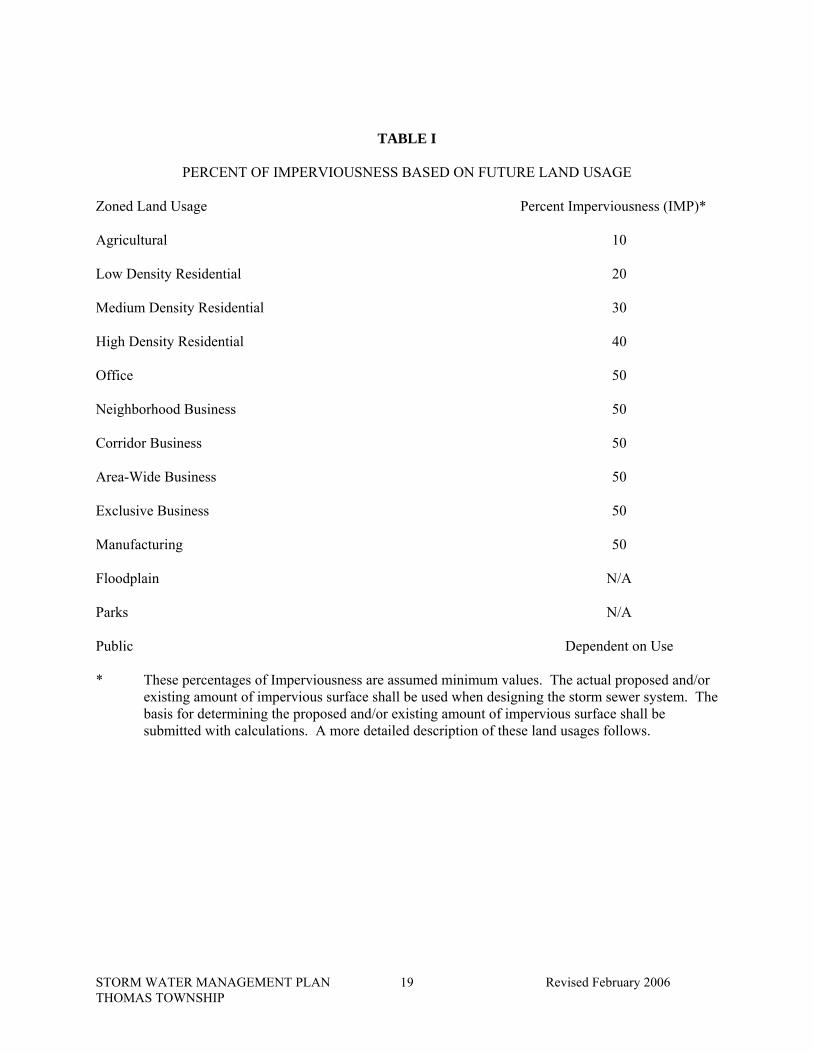
C. Future Land Uses/Percent Imperviousness (IMP)
An estimate of the future percent of impervious surface has been made for all of the zoned land uses shown on the Thomas Township Future Land Use Map (D-2989). The percent of imperviousness is based on the proposed land usage as required by the Township’s zoning ordinance. The future land use and their estimated percent imperviousness (IMP) are summarized in Table I. The IMP will be used for the design of storm drainage systems that will be maintained by the Saginaw County Public Works Commissioner after construction of the storm drainage system is complete.
STORM WATER MANAGEMENT PLAN Revised February 2006 THOMAS TOWNSHIP
19
TABLE I
PERCENT OF IMPERVIOUSNESS BASED ON FUTURE LAND USAGE Zoned Land Usage Percent Imperviousness (IMP)* Agricultural 10 Low Density Residential 20 Medium Density Residential 30 High Density Residential 40 Office 50 Neighborhood Business 50 Corridor Business 50 Area-Wide Business 50 Exclusive Business 50 Manufacturing 50 Floodplain N/A Parks N/A Public Dependent on Use * These percentages of Imperviousness are assumed minimum values. The actual proposed and/or
existing amount of impervious surface shall be used when designing the storm sewer system. The basis for determining the proposed and/or existing amount of impervious surface shall be submitted with calculations. A more detailed description of these land usages follows.
STORM WATER MANAGEMENT PLAN Revised February 2006 THOMAS TOWNSHIP
20
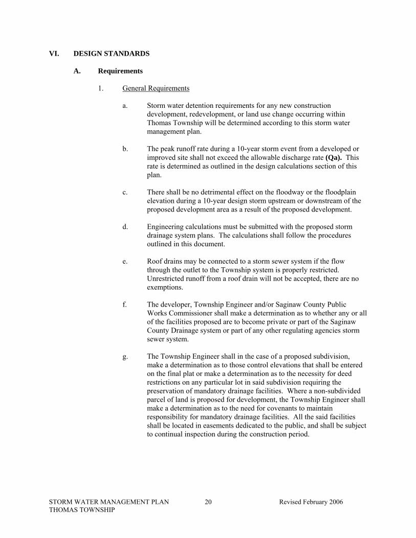
VI. DESIGN STANDARDS A. Requirements
1. General Requirements
a. Storm water detention requirements for any new construction
development, redevelopment, or land use change occurring within Thomas Township will be determined according to this storm water management plan.
b. The peak runoff rate during a 10-year storm event from a developed or improved site shall not exceed the allowable discharge rate (Qa). This rate is determined as outlined in the design calculations section of this plan.
c. There shall be no detrimental effect on the floodway or the floodplain elevation during a 10-year design storm upstream or downstream of the proposed development area as a result of the proposed development.
d. Engineering calculations must be submitted with the proposed storm drainage system plans. The calculations shall follow the procedures outlined in this document.
e. Roof drains may be connected to a storm sewer system if the flow through the outlet to the Township system is properly restricted. Unrestricted runoff from a roof drain will not be accepted, there are no exemptions.
f. The developer, Township Engineer and/or Saginaw County Public Works Commissioner shall make a determination as to whether any or all of the facilities proposed are to become private or part of the Saginaw County Drainage system or part of any other regulating agencies storm sewer system.
g. The Township Engineer shall in the case of a proposed subdivision, make a determination as to those control elevations that shall be entered on the final plat or make a determination as to the necessity for deed restrictions on any particular lot in said subdivision requiring the preservation of mandatory drainage facilities. Where a non-subdivided parcel of land is proposed for development, the Township Engineer shall make a determination as to the need for covenants to maintain responsibility for mandatory drainage facilities. All the said facilities shall be located in easements dedicated to the public, and shall be subject to continual inspection during the construction period.
STORM WATER MANAGEMENT PLAN Revised February 2006 THOMAS TOWNSHIP
21
h. Proposed storm sewer enclosures must be designed so they will not adversely impact any adjacent properties, upstream or downstream, and must be designed to the impervious factors of the lands based upon zoning, not necessarily existing conditions.
i. Soil erosion and sedimentation control measures must be implemented.
2. Storm Sewer Piping Requirements a. Proposed storm sewer shall be designed to have capacity to pass 10-year
design storm runoff rate (Qd) Refer to Design Calculations section of this document.
b. Class III or IV concrete pipe must be used for the following: i. Combined sewers (Combined sewers must have premium joints) ii. Storm Sewers within Township, county, and state right-of-way
c. Provide 2' Minimum cover with minimum 5' cover in M.D.O.T. R.O.W.
d. Provide 18" Vertical separation between all other utilities including,
sanitary sewers and water mains. Provide 10' Horizontal separation from other utilities.
e. A minimum of four inches of sand bedding is required beneath the pipe and a minimum of 6 inches of sand backfill is required above the pipe.
f. Manhole/catch basin shall be placed at a maximum distance of 300' from any other manhole/catch basin for access/maintenance purposes.
g. Provide a sump discharge outlet for each individual property/lot in all developments. Sump leads shall not be connected to rear lot drainage systems. This outlet shall be a catch basin (minimum 3' diameter) or a storm sewer lead extended to the Right-of-Way/Property line of each lot (minimum 6").
h. Place a catch basin (minimum 3' diameter) between each pair of driveways, if curb and gutter, driveway culverts, and/or valley shaped ditches are not proposed.
i. Minimum pipe grades must be such to produce minimum scouring velocity of 2.5 ft/sec when pipe is flowing full without surcharging.
j. Concrete pipe (C-76-III, IV) shall have fabric wrapped joints.
k. For private storm sewer systems Plastic pipe may be used. This plastic pipe shall be either smooth walled HDPE or SDR 35 P.V.C. Pipe. If pipe is perforated a manufacturer’s “Sock” shall be used over the pipe.
l. Minimum pipe diameter for catch basin leads is 10".
STORM WATER MANAGEMENT PLAN Revised February 2006 THOMAS TOWNSHIP
22
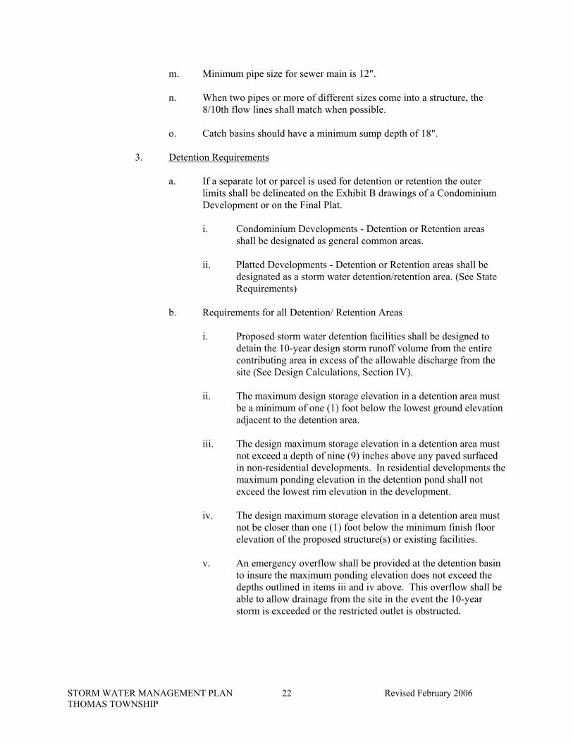
m. Minimum pipe size for sewer main is 12".
n. When two pipes or more of different sizes come into a structure, the 8/10th flow lines shall match when possible.
o. Catch basins should have a minimum sump depth of 18".
3. Detention Requirements a. If a separate lot or parcel is used for detention or retention the outer
limits shall be delineated on the Exhibit B drawings of a Condominium Development or on the Final Plat. i. Condominium Developments - Detention or Retention areas
shall be designated as general common areas.
ii. Platted Developments - Detention or Retention areas shall be designated as a storm water detention/retention area. (See State Requirements)
b. Requirements for all Detention/ Retention Areas i. Proposed storm water detention facilities shall be designed to
detain the 10-year design storm runoff volume from the entire contributing area in excess of the allowable discharge from the site (See Design Calculations, Section IV).
ii. The maximum design storage elevation in a detention area must be a minimum of one (1) foot below the lowest ground elevation adjacent to the detention area.
iii. The design maximum storage elevation in a detention area must not exceed a depth of nine (9) inches above any paved surfaced in non-residential developments. In residential developments the maximum ponding elevation in the detention pond shall not exceed the lowest rim elevation in the development.
iv. The design maximum storage elevation in a detention area must not be closer than one (1) foot below the minimum finish floor elevation of the proposed structure(s) or existing facilities.
v. An emergency overflow shall be provided at the detention basin to insure the maximum ponding elevation does not exceed the depths outlined in items iii and iv above. This overflow shall be able to allow drainage from the site in the event the 10-year storm is exceeded or the restricted outlet is obstructed.
STORM WATER MANAGEMENT PLAN Revised February 2006 THOMAS TOWNSHIP
23
vi. Designs of detention facilities shall incorporate safety features, particularly at inlets, outlets, on steep slopes, and at any attractive nuisances. These features may include, but not be limited to, fencing, handrails, lighting, steps, grills, signs, and other protective or warning devices so as to restrict access as required by township engineer.
vii. Side slopes and the bottom of detention basins shall be top soiled, to a minimum of 3 inches, and seeded.
viii. The side slopes and bottom of the basins shall be shaped with maximum slopes of 1 vertical to 4 horizontal to allow mowing of these surfaces.
ix. Detention basins with bottom slopes less than 1% shall be underdrained.
x. Detention basins shall be constructed with the top of banks a minimum of 5 feet from any pedestrian walkway (i.e. public and private sidewalks/ bike paths).
xi. If a “Wet” detention pond is proposed the bottom of the pond shall be a minimum of 5 feet below the proposed pond’s outlet elevation. Item ix. Shall not apply to “Wet” detention facilities.
4. Rear Lot Drainage Requirements a. Minimum rear lot tile drain sizes and slopes have been determined
assuming ponding will occur in rear yards for a duration 4 times the duration of a given 10-year design storm event. This time may range from 4 to 24 hours depending on drainage conditions. The following minimum pipe sizes and slopes apply: i. Rear lot tile drains with contributing drainage areas up to 2 acres
will have a minimum diameter of 6 inches and a minimum slope of 0.5 %.
ii. Rear lot tile drains with contributing drainage areas greater than 2 and less than 3 acres shall have a minimum diameter of 8 inches and a minimum slope of 0.4%.
iii. Rear lot tile drains with contributing drainage areas greater than 3 and less than 4 acres shall have a minimum diameter of 10 inches and a minimum slope of 0.32%.

STORM WATER MANAGEMENT PLAN Revised February 2006 THOMAS TOWNSHIP
24
b. Rear lot tile drains with a contributing area greater than 4 acres shall be considered main line storm sewer and shall be designed according to corresponding storm sewer requirements (See design calculations section of this report). Calculations shall be submitted to verify that rear lot drains have the capacity to pass the 10-year design storm event. Plastic pipe is acceptable for rear lot drainage systems draining more than 4 acres provided it is installed in landscaped/ lawn areas.
c. Rear lot tile drains cannot connect to road underdrains.
d. Rear lot drainage tiles shall have a minimum cover of 2 feet. A minimum of four inches of sand bedding is required beneath the pipe and a minimum of 6 inches of sand backfill is required above the pipe.
e. Rear lot catch basins shall have a minimum diameter of 2 feet. Plastic structures may be used for rear lot drainage systems. Concrete structures are required for storm sewer systems. The catch basins shall not be placed at spacing greater than 300 feet. Any bends, turns, or dead ends shall require a structure.
f. If pipe is perforated, a manufacturer’s “Sock” shall be used over the pipe.
g. A 20-foot easement will be required for all rear lot drainage systems. This easement should be centered along lot lines to allow for a 10-foot easement along adjacent lots and to provide access to the rear lot drainage system from either adjacent property owners. Said easements shall be written as to permit neighboring property and/or condominium owners to maintain the rear lot drainage system as it may affect their property.
h. Rear lot drainage shall be large enough to convey all contributing area to the rear lot system, including off site drainage if it is not diverted around the development.
i. Existing rear lot drainage systems abutting a proposed development may be used for the new development provided: i. The existing rear lot drainage system has the capacity to convey
storm water runoff from the proposed rear lot drainage areas.
ii. A signed agreement is obtained from property owners located within the existing subdivision allowing the proposed subdivision’s rear lot storm water runoff to pass through their existing system.
STORM WATER MANAGEMENT PLAN Revised February 2006 THOMAS TOWNSHIP
25
j. Phased developments owned by the same proprietor may utilize proposed rear lot drainage for a current development phase on future phases of the development provided: i. Covenants shall be recorded into the deeds of the property
owners affected in the current phase allowing for future phases of the development to drain into the current phase’s rear lot drainage system.
ii. If covenants are not made as outlined above, future phases will require separate rear lot drainage systems or agreements from the current land owners allowing for the use of their rear lot drainage system.
iii. The rear lot drainage system shall be constructed to convey rear lot drainage from both the existing and proposed rear lot drainage areas.
iv. Easements shall be provided allowing for maintenance by both abutting landowners in current and proposed phases of development.
k. Rear lot drainage shall be shown on the preliminary plat (subdivisions) or site plan (condominiums).
l. All rear lot drains shall connect to an approved storm water drainage system.
B. General Compliance Guidelines The following guidelines are recommended, but are not a requirement of this plan. These guidelines are provided for reference. 1. The minimum surface slopes for overland drainage are as follows:
a. For bituminous paved surfaces, 1%. b. For concrete paved surfaces, 0.5%. c. For concrete curb and gutter, 0.32%. d. For drainage swales and valley shaped ditches, 0.5%. e. For rear lot drainage swales and valley shaped ditches, 0.5%. f. Landscape grading, 2%.
2. The maximum surface slopes for overland drainage are as follows:
a. For bituminous, concrete paved surfaces, 5%. b. For concrete curb and gutter, 5%. c. For drainage swales and valley shaped ditches, 5%. d. For rear lot drainage swales and valley shaped ditches, 5%.

STORM WATER MANAGEMENT PLAN Revised February 2006 THOMAS TOWNSHIP
26
e. Drainage swales and valley shaped ditches shall have maximum side slopes of 3 horizontal to 1 vertical.
f. Landscape grading, 4 horizontal to 1 vertical.
C. Variances from Requirements The Township may waive allowable discharge requirements and or detention requirements. All variances will be reviewed under the appeal procedures established in the current storm water management ordinance. Variances from these requirements shall require the approval of Thomas Township whose actions shall be conditioned upon the following: 1. A petition shall be submitted describing in detail the rationale for the proposed
design changes including hydraulic and or hydrologic computations.
2. Special circumstances or conditions exist which will affect the property under consideration such that strict compliance with the provisions of the storm water discharge permit would deprive the applicant of the reasonable use of their land.
3. A variance is necessary for the preservation and enjoyment of a substantial property right of the proprietor.
4. Granting of the variance will not be detrimental to the public health, safety or welfare, or injurious to other property in the territory in which said property is located.
5. An affirmative recommendation must be received from the Township Engineer supporting such variance. In the event that the Township Engineer does not submit an affirmative recommendation, a recommendation shall be received from Thomas Township.
VII. DETAILED DESCRIPTION OF ESTABLISHED COUNTY DRAINS IN THOMAS TOWNSHIP This section identifies the existing established County drains that fall under the jurisdiction of the Saginaw County Drain Commissioner and their runoff districts throughout the Township and presents criteria for an engineering design. Most of the drainage infrastructure of Thomas Township is dependent on these drainage districts. The outlet capacity for these areas was evaluated based upon the 10-year design storm and the proposed land use. The Thomas Township drainage system that is under the control of the Saginaw County Drain Commissioner is separated into 25 drainage districts. The need for updating the system has come about due to increased development. As development occurs within the district, the changes in storm water volumes and flow rates need to be properly managed. The following is a description of each County drain within the Township, the present drainage problems, and recommendations for future land use and development within the district.

STORM WATER MANAGEMENT PLAN Revised February 2006 THOMAS TOWNSHIP
27
Table I is a summary of the impervious factors (IF) to be used when determining the allowable discharge to Established Saginaw County Drains from site developments or redevelopments. A more detailed description of each county drain and the associated design requirements follows in Table II and in the Engineering Calculations section of this plan.
TABLE II
SAGINAW COUNTY DRAINAGE DISTRICTS WITHIN THOMAS TOWNSHIP BOUNDARIES
DESIGN IMPERVIOUS FACTORS Drain District Name Impervious Factor (IF) A. Companion Drain 30% - 50% (see description) B. Metzler Drain 0% C. Reineke Drain 0% C1. Rambling Acres Branch of Reineke Drain 30% D. Union Drain 10% E. Garey Drain 10% F. Scholtz and O'Hearn Drain 10% G. Wolgast Drain and Branch 10% H. Liskow Drain and Liskow Tile Drain 0% I. Hagerl Tile Drain 0% J. Hoffman Drain and Branches 10% K. Wurtzel Drain 0% L. Wiltse Drain, Alney Branch of Wiltse Drain and Dice Drain 10% M. Macomber Drain 10% N. Hatch Run Drain and Vasold Drain 10% O. Hubbell Drain and Orr Road Branch 10% P. Whitney Drain and Branches 10% Q. Whelton Drain and Branches 10% R. McClellan Run Drain and Branches 10% S. Wurtzel Tile Drain 10% T. Williams Creek Drain and Branches 10% U. No. 3 Drain and Branches 10% V. Oldenburg Drain 0% W. Schomaker Drain 10% X. Hall Drain 10%
These impervious factors apply to all parcels within the respective drainage districts, unless otherwise noted. These impervious factors are used in only one of the methods for determining the allowable discharge from a site development or redevelopment. Other methods addressing downstream conditions will also need to be considered as outlined in the Engineering Calculations section of this report. Variances from these required design impervious factors may be allowed if supporting information is provided for the variances and the variance is determined acceptable by the Township Engineer. A more detailed description of each drain is provided on the following pages.

STORM WATER MANAGEMENT PLAN Revised February 2006 THOMAS TOWNSHIP
28
A. Companion Drain
The area served by the Companion Drain is shown on the study map and is approximately bounded by the South line of Metzler Drain, Miller Road, the North 1/8 line of Section 36 and the Tittabawassee River. The zoning in this drainage area consists of single-family dwellings, two family dwellings, commercial, and agricultural land use. The present system was built in the late 1990’s and is adequate for drainage of this district. The future land use map of this drainage area indicates a medium density residential and multiple-family residential use that requires future drainage be designed to a minimum impervious factor of 50 percent. All parcels north of Gratiot Road should use a design impervious factor of 50%, all parcels abutting the south side of Gratiot Road use 50% impervious factor. Any remaining parcel is to use a design impervious factor of 30%.
B. Metzler Drain
The area served by the Metzler Drain is shown on the study map and is approximately bounded by the North line of the Gratiot Road Drain. Miller Road, the East line of Rambling Acres Subdivision and the North line of Section 25. The zoning in this drainage area consists of single-family dwelling, two family dwelling, multiple-family, and commercial land use. The present storm sewer and drainage outlets are restrictive and need updating by installation of larger sewers as recommended in the 1992 Storm Sewer Study. Any property development proposed in the Gratiot Road Branch of the Monk Drain and the Metzler Drain drainage district shall be restricted to an impervious factor of 0 percent until such time as the recommended storm sewers have been completed and are in service. The future land use map of this drainage area indicates a medium density residential, multiple density residential, and commercial land use that requires future drainage be designed to a minimum impervious factor of 50 percent.
C. Reineke Drain
The area served by the Reineke Drain Improvement System is shown on the study map and is approximately bounded on the West by Consumers Power Company right-of-way and Miller Road, on the South by Plainfield Acres No. 2 and Rambling Acres Subdivision, on the East by the North and South 1/4 line of Section 24, and on the North by State Road. The zoning in this drainage district area consists of single family, two family, agricultural, and commercial land use. The present storm sewers and drainage outlets are restrictive and need updating by installation of larger sewers and/or drainage culverts as recommended in the 1992 Storm Sewer Study. Any property development in the Reineke Drain Improvement System drainage area shall be restricted to an impervious factor of 0 percent until such time as the recommended storm water drainage improvements have been completed and are in service.
The future land use map of this drainage area indicates a low-density residential and medium density residential land use that requires future drainage be designed to a minimum impervious factor of 40 percent.
STORM WATER MANAGEMENT PLAN Revised February 2006 THOMAS TOWNSHIP
29
C1. Rambling Acres Branch of the Reineke:
The area served by the Rambling Acres Branch of the Reineke Drain is shown on the Thomas Township Drainage District Base Map and is approximately bounded by North Miller Road on the west, Chalet Drive on the North, Sue Street and Rambling Drive on the East, and Abbe Court on the South. The present system was built in the late 1990’s and is adequate for drainage of this district. Any property development proposed in the Rambling Acres Branch of the Reineke Drain System shall be restricted to an impervious factor of 30%. The future land use map of the drainage area indicates low density residential land use that requires future drainage be designed to a minimum impervious factor of 30%.
D. Union Drain
The area served by the Union Drain is shown on the study map for that portion in Thomas Township only. The drainage district affecting Thomas Township storm sewer management is part of Sections 35 and 36 of Thomas Township lying South of the C.S.X.R.R. tracks and also part of Sections 1 and 2 of James Township lying North of the Penn Central R.R. tracks. The zoning in this drainage area consists of single-family dwellings and agricultural land use. The present drain is an open drain with roadway and driveway culverts that allows limited drainage at the present time. Any property development proposed in the Union Drain drainage district shall be restricted to an impervious factor of 10 percent. The future land use map of this drainage area indicates a rural estate residential land use that requires future drainage be designed to a minimum impervious factor of 15 percent.
E. Garey Drain
The area served by the Garey Drain is shown on the study map for that portion in Thomas Township only. The drainage district affecting Thomas Township Storm Sewer management is part of Section 36 lying North of the C.S.X.R.R. tracks and South of the North 1/8 line of said section. The zoning in this drainage area consists of single-family dwelling and agricultural land use. The present drain is an open drain with roadway and driveway culverts that allows limited drainage at the present time. Any property development proposed in the Garey Drain district shall be restricted to an impervious factor of 0 percent. The future land use map of this drainage area indicates a medium density residential land use that requires future drainage be designed to a minimum impervious factor of 30 percent.
STORM WATER MANAGEMENT PLAN Revised February 2006 THOMAS TOWNSHIP
30
F. Scholtz and O'Hearn Drain
The area served by the Scholtz and O'Hearn Drain is shown on the study map. The drainage district affecting Thomas Township Storm Sewer Management is part of Sections 35 and 26, generally between VanWormer and Miller Roads from the South Township line to the North line of Section 26. The zoning in this drainage area consists of single family, two family, multiple family, commercial and agricultural land use. The present drain is mostly an open drain with certain sections enclosed with tile that allows limited drainage at the present time. Any property development proposed in the Scholtz and O'Hearn Drain drainage district shall be restricted to an impervious factor of 10 percent. The future land use map of this drainage area indicates a agricultural, rural estate residential, low density and medium density residential, multiple family residential, and commercial land use that requires future drainage be designed to a minimum impervious factor of 50 percent.
G. Wolgast Drain and Branch
The area served by the Wolgast Drain and Branch is shown on the study map. The drainage district is in Sections 23 and 26 lying Easterly of Kennely Road and North of Gratiot Road (M-46). The zoning in this drainage area consists of agricultural, commercial and multiple family use. The present drain is an open drain with parts enclosed with tile that provide limited drainage at the present time. Any property development proposed in the Wolgast Drain and Branch drainage district shall be restricted to an impervious factor of 10 percent. The future land use map of this drainage area indicates a low-density residential, multiple-family residential and commercial land use that requires future drainage to be designed to a minimum impervious factor of 50 percent.
H. Liskow Drain and Liskow Tile Drain
The area served by the Liskow Drain and Liskow Tile Drain is shown on the study map. The drainage district is in Sections 22 and 23, centered on Geddes Road, West of Miller Road. The zoning in this drainage area consists of agricultural, single family, two family, and agricultural land use. The present tile drain is a 21", 18", 15" and 12" diameter tiles that are inadequate to drain the district. Any property development proposed in the Liskow Tile Drain drainage district area shall be restricted to an impervious factor of 0 percent until such time as larger storm sewer improvements have been completed and are in service. The future land use map of this drainage area indicates a low density residential land use that require future drainage be designed to a minimum impervious factor of 30 percent.
STORM WATER MANAGEMENT PLAN Revised February 2006 THOMAS TOWNSHIP
31
I. Hagerl Tile Drain
The area served by the Hagerl Tile Drain is shown on the study map. The drainage district is in Section 14 and is West of Miller Road and 1/8 mile South of Summerfeldt Road to River Road. The zoning in this drainage district area is single-family dwelling and agricultural land use. The present drain is a tile drain and a ravine outlet to the river that provides inadequate drainage. Any property development in the Hagerl Tile Drain drainage district area shall be restricted to an impervious factor of 0 percent until such time as larger storm sewer improvements have been completed and are in service. The future land use map of this drainage area indicates a low density residential land use that requires future drainage be designated to a minimum impervious factor of 30 percent.
J. Hoffman Drain and Branches
The area served by the Hoffman Drain and Branch is shown on the study map. The drainage district is in Sections 11, 14, and 15 and is located East of Thomas Road to West of Miller Road and centered on Summerfeldt Road. The zoning in this drainage district area is agricultural and single family dwelling land use. The present drain is an open ditch with roadway cross-culverts that provide limited drainage at the present time. Any property development proposed in the Hoffman Drain and Branch drainage district shall be restricted to an impervious factor of 10 percent. The future land use map for this drainage area indicates a low density residential land use that requires future drainage be designed to a minimum impervious factor of 30 percent.
K. Wurtzel Drain
The area served by the Wurtzel Drain is shown on the study map. The drainage is in Sections 10 and 15 and is located between Thomas Road and Kennelly Road along Frost Road. The present zoning in this drainage district area is agricultural, single family, and two family dwelling land use. The present drain is a tile drain that consists of 8" and 10" diameter tile and is inadequate in providing drainage. Any property development proposed in the Wurtzel Drain drainage district shall be restricted to an impervious factor of 0 percent until such time as larger storm sewer improvements have been completed and are in service. The future land use map of this drainage area indicates low residential density land use that requires future drainage be designed to a minimum impervious factor of 30 percent.
L. Wiltse Drain, Alney Branch of Wiltse Drain and Dice Drain
The area served by the Wiltse Drain and Branches is shown on the study map. The drainage district is in Sections 3, 4, 9 and 10 and is located East of Lone Road to the East line of Section
STORM WATER MANAGEMENT PLAN Revised February 2006 THOMAS TOWNSHIP
32
10 and from Tittabawassee Road to Frost Road. The present zoning in this drainage district area is agricultural and single-family dwelling land use. The present drains are open drains with roadway cross-culverts and tile drains in the existing subdivisions that provide limited drainage. Any property development proposed in the Wiltse Drain, Alney Branch of Wiltse Drain and Dice Road Drain drainage district shall be restricted to an impervious factor of 10 percent until such time as storm sewer improvements are completed and are in service. The future land use map of the drainage area indicates a low density residential use that requires future drainage be designed to a minimum impervious factor of 30 percent.
M. Macomber Drain
The area served by the Macomber Drain is shown on the study map. The drainage district is in Sections 3 and 4 and is located from Tittabawassee Road to the North side of Dice Road and West of Lone Road to the Tittabawassee River. The present zoning in this drainage district is agricultural and single-family land use. The present drain is an open ditch with roadway cross-culverts that provide limited drainage. Any property development proposed in the Macomber Drain drainage district shall be restricted to an impervious factor of 10 percent. The future land use map of this drainage area indicates a low density residential land use that requires future drainage be designed to a minimum impervious factor of 30 percent.
N. Hatch Run Drain and Vasold Drain
The area served by the Hatch Run Drain and the Vasold Drain is shown on the study map. The drainage district is in Sections 4, 5, and 9 and is located from Tittabawassee Road to North of Frost Road and East of the Swan Creek to Lone Road. The present zoning in this drainage district area is single family and agricultural land use. The present drains are open drains with roadway cross-culverts and tile drains in the existing subdivisions that provide limited drainage. Any property development proposed in the Hatch Run Drain and Vasold Drain drainage district shall be restricted to an impervious factor of 10 percent. The future land use map of this drainage area indicates a rural estate residential land use that requires future drainage be designed to a minimum impervious factor of 15 percent.
STORM WATER MANAGEMENT PLAN Revised February 2006 THOMAS TOWNSHIP
33
O. Hubbell Drain and Orr Road Branch
The area served by the Hubbell Drain and Orr Road Branch is shown on the study map. The drainage district is in Sections 5, 6, and 7 and is located from Tittabawassee Road to North of Frost Road and Orr Road to East of Gleaner Road. The present zoning in this drainage district area is single family, agricultural, and commercial. The present drain is an open ditch with roadway cross-culverts that provides limited drainage. Any property development proposed in the Hubbell Drain and Orr Road Branch drainage district shall be restricted to an impervious factor of 10 percent. The future land use map of this drainage district area indicates an agricultural land use that requires future drainage be designed to a minimum impervious factor of 5 percent.
P. Whitney Drain and Branches
The area served by the Whitney Drain and Branches is shown on the study map. The drainage district is in Sections 5, 6, 7, and 8 and is located North and South of Dice Road and from West of Gleaner Road to West of Graham Road. The present zoning in this drainage district areas is single family and agricultural land use. The present drain is an open ditch with roadway cross-culverts that provides limited drainage at the present time. Any property development proposed in the Whitney Drain and Branches drainage district shall be restricted to an impervious factor of 10 percent. The future land use map of this drainage area indicates low density residential and agricultural land use that requires future drainage be designed to a minimum impervious factor of 5 percent.
Q. Whelton Drain and Branches
The area served by the Whelton Drain and Branches is shown on the study map. The drainage district is in Sections 8, 9, 16, and 17 and is located North and South of Frost Road and from the West line of Section 17 to East of Lone Road. The present zoning in this drainage district is single family and agricultural land use. The present drain is an open ditch with roadway cross-culverts that provide limited drainage. Any property development proposed in the Whelton Drain and Branches drainage district shall be restricted to an impervious factor of 10 percent. The future land use map of this drainage area indicates agricultural land use that requires future drainage be designed to a minimum impervious factor of 5 percent.
STORM WATER MANAGEMENT PLAN Revised February 2006 THOMAS TOWNSHIP
34
R. McClellan Run Drain and Branches
The area served by the McClellan Run Drain and Branches is shown on the study map. The drainage district is in Sections 16, 17, 18, 19, 20, and 21 and is located from South of Frost Road to South of Geddes Road and Orr Road to West of Thomas Road. The zoning in this drainage district is agricultural, single family, industrial, and public/semi-public land use. The present drain is an open ditch with roadway bridges and cross-culverts that provides adequate drainage. Any property development proposed in the McClellan Run Drain and Branches drainage district shall be restricted to an impervious factor of 10 percent. The future land use map of this drainage area indicates agricultural, rural estate residential, industrial, and public/semi-public land use that requires future drainage be designed to a minimum impervious factor of 40 percent.
S. Wurtzel Tile Drain
The area served by the Wurtzel Tile Drain is shown on the study map. The drainage district is in Section 16 and is located South of Frost Road from Swan Creek to Thomas Road. The zoning in this drainage district is single family and agricultural land use. The present drain is an 18" and 15" diameter tile drain that provides adequate drainage. Any property development proposed in the Wurtzel Tile Drain drainage district shall be restricted to an impervious factor of 10 percent. The future land use map of this drainage area indicates low density residential land use that requires future drainage be designed to a minimum impervious factor of 30 percent.
T. Williams Creek Drain and Branches
Branches include:
1. Kiefer Tile Drain 2. Faucher Tile Drain 3. Abbey Drain and Branch 4. Kamfert Drain 5. Badgero Drain and Branch 6. Beebe Drain and Branch
The area served by the Williams Creek Drain and Branches is shown on the study map. The drainage district is in Sections 19, 20, 21, 27, 28, 29, 30, 31, 32, 33, and 34 and is located from Geddes Road to the South Township line and from Orr Road to Leddy Road. The zoning in this drainage district is agricultural, single family, commercial, industrial, mobile home park, and public/semi-public land use. The present drain and branches are open ditches with roadway cross-culverts and bridges that provide limited drainage.
STORM WATER MANAGEMENT PLAN Revised February 2006 THOMAS TOWNSHIP
35
Any property development proposed in the Williams Creek Drain and Branches drainage district shall be restricted to an impervious factor of 10 percent. The future land use map of this drainage area indicates agricultural, rural estate residential, low density residential, mobile home park, open space conservation, commercial, and industrial land use that requires future drainage be designed to a minimum impervious factor of 40 percent.
U. No. 3 Drain and Branches
The area served by the No. 3 Drain and Branches is shown on the study map. The drainage district is in Section 32 and 33 and is located from West of South Graham Road (M-52) to Thomas Road and North of the South Township line. The zoning in this drainage district is single-family land use. The present drain is an open ditch that provides limited drainage. Any property development proposed in the No. 3 Drain and Branches drainage district shall be restricted to an impervious factor of 10 percent. The future land use map of this drainage district indicates low density residential that requires future drainage be designed to a minimum impervious factor of 30 percent.
V. Oldenburg Drain
The area served by the Oldenburg Drain is shown on the study map. The drainage district is in Sections 27, 28, and 33 and is located North and South of M-46 and East and West of Thomas Road. The zoning in this drainage district is single family, agricultural, and public/semi-public land use. The present drain is an open ditch and 18" diameter tile that provides restrictive drainage. Any property development proposed in the Oldenburg Drain drainage district shall be restricted to an impervious factor of 0 percent. The future land use map of this drainage district area indicates rural estate residential, low-density residential, and public/semi-public land use that requires future drainage be designed to a minimum impervious factor of 30 percent.
W. Schomaker Drain
The area served by the Schomaker Drain is shown on the study map. The drainage district is in Section 33 and 34 and is located from West of Thomas Road to the Swan Creek and from Schomaker Road to the South Township line. The zoning in this drainage district is single family and agricultural land use. The present drain is an open ditch that provides limited drainage. Any property development proposed in the Schomaker Drain drainage district shall be restricted to an impervious factor of 10 percent. The future land use map of this drainage area indicates rural estate residential that requires future drainage be designed to a minimum impervious factor of 15 percent.

STORM WATER MANAGEMENT PLAN Revised February 2006 THOMAS TOWNSHIP
36
X. Hall Drain
The area served by the Hall Drain is shown on the study map. The drainage district is in Section 7 and 18 and is located east of Orr Road and South of Dice Road. The zoning in this drainage district is single family and agricultural land use. The present drain is a tile drain was improved in 2000 and is adequate in providing drainage and branches are open drains and 36” and 42” tile with roadway and driveway cross culverts that provide adequate drainage. Any property development proposed in the Hall Drain drainage district shall be restricted to an impervious factor of 10 percent. The future land use map of this drainage district area indicates an agricultural land use that requires future drainage be designed to a minimum impervious factor of 15 percent.
Y. Areas Only Under Jurisdiction of Thomas Township
There are many agencies that currently review storm water discharges within Thomas Township, these include the Michigan Department of Natural Resources, Saginaw County Road Commission, Saginaw County Drain Commissioner and the Michigan Department of Transportation. However, each of these agencies review proposed storm water discharge under specific criteria that may or may not be consistent with the storm water management requirements of Thomas Township. For example, the Saginaw County Road Commission is concerned about the proper drainage of the roadway and sub-base of the road; a permit may be obtained to discharge a large quantity of water to a road side drain which will not cause a problem at this time. However, the proposed storm water discharge may not leave any additional storm water outlet capacity for future development upstream. For these reasons, it is very important that the Township review all proposed developments/improvements to assure that the proposed storm water management plan is consistent with the future plans of the Township. Several areas within Thomas Township are not incorporated into established county drain drainage districts and storm water flows are not regulated by MDNR, MDOT, or the Saginaw County Road Commission within these areas. These areas can be located on the Township drainage district base map. Most parcels bordering the Tittabawassee River and the Swan Creek are not part of any drainage district. The zoning in these areas is diverse. Any property development proposed in these undrained areas shall be restricted to an impervious factor established for the area that the proposed development is within (i.e. Parcel zoned Low Medium Density Residential shall have an IF = 30%). Additionally, it must be shown that proposed property development will not significantly alter storm water flows from current conditions upstream or downstream of the property.
The future land use map of these areas indicates several types of uses. Future drainage must be designed to a minimum imperviousness matching the future land use for the area that the proposed development is within including the area of the development and other contributing areas beyond the limits of the proposed development.
APPENDIX A
1. THOMAS TOWNSHIP DRAINAGE PLAN APPLICATION & CHECKLIST
2. THOMAS TOWNSHIP STORM WATER MANAGEMENT SITE REVIEW AGREEMENT PROCEDURE & FORM
3. TYPICAL DAILY INSPECTION REPORT FORM
4. SOIL EROSION AND SEDIMENT CONTROL FOR CONSTRUCTION SITES PROCEDURE
5. TOWNSHIP ENGINEER FINAL INSPECTION FORM
6. SITE VISIT AND INSPECTION REPORT PROCEDURE
7. STORM WATER MANAGEMENT SITE REVIEW AGREEMENT

THOMAS TOWNSHIP STORM WATER DISCHARGE PERMIT APPLICATION
PROJECT NAME:
Property Tax Identification #:
Site Plan Review Date:
Date Applied:
Deposit Amount Submitted:
NAME OF DEVELOPER/OWNER: ENGINEER/ARCHITECT:
Contact Person: Contact Person:
Street Address: Street Address:
City, State, Zip: City, State, Zip:
Telephone: Telephone:
Fax: Fax:
PROJECT LOCATION:
Street Address:
Name of Subdivision/Plat:
Drainage District:
STORM WATER DESIGN INFORMATION (*Calculation must be submitted for verification. Calculations must have clearly labeled headings, clearly labeled formulas, and clearly labeled units.) Type of Development (Circle): COMMERCIAL SITE, INDUSTRIAL SITE, RESIDENTIAL PLATTED, RESIDENTIAL CONDOMINIUM, OTHER *AREA OF DEVELOPMENT (acres): *AREA OF CONTRIBUTING DRAINAGE DISTRICT (acres): *AREA OF EXISTING IMPERVIOUS SURFACE (acres): *AREA OF PROPOSED IMPERVIOUS SURFACE (acres): *ALLOWABLE DISCHARGE RATE (Qa) (cfs): *TOTAL VOLUME OF STORAGE REQUIRED (cu. ft.) *TOTAL VOLUME OF STORAGE DESIGNED (cu. ft.) 10 YR DESIGN STORM WATER DETENTION STORAGE ELEVATION: EMERGENCY OVERFLOW/MAXIMUM STORAGE ELEVATION: LOWEST FINISHED FLOOR ELEVATION: OUTLET DRAIN SIZE AND DESIGN FLOW CAPACITY: OUTLET DRAIN INVERT ELEVATION: DESIGN IMPERVIOUS FACTOR (IMP): *10 YEAR DESIGN DISCHARGE (cfs): *HEAD DIFFERENTIAL THROUGH RESTRICTOR (ft.): *DIAMETER OF PROPOSED RESTRICTOR (in): *ACTUAL RESTRICTED DISCHARGE (cfs):
AUTHORIZED SIGNATURE DATE
PLEASE DRAINAGE PLAN CHECKLIST TO ASSURE ALL INFORMATION IS PRESENT FOR
REVIEW
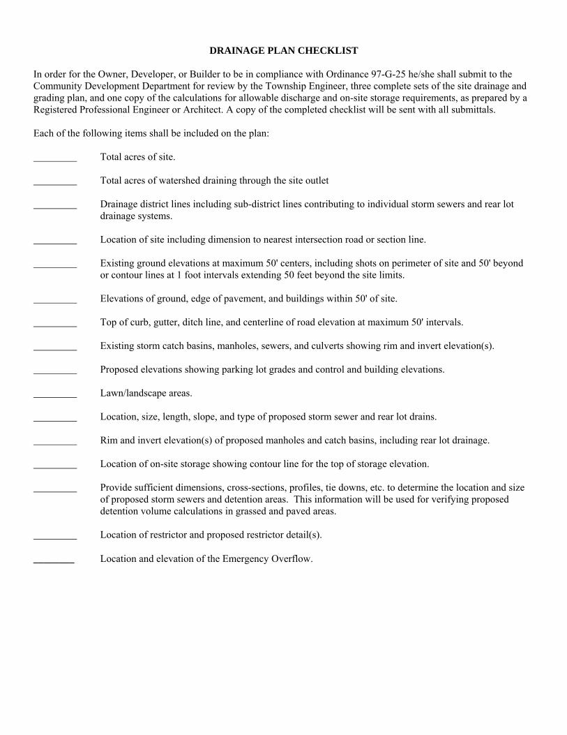
DRAINAGE PLAN CHECKLIST
In order for the Owner, Developer, or Builder to be in compliance with Ordinance 97-G-25 he/she shall submit to the Community Development Department for review by the Township Engineer, three complete sets of the site drainage and grading plan, and one copy of the calculations for allowable discharge and on-site storage requirements, as prepared by a Registered Professional Engineer or Architect. A copy of the completed checklist will be sent with all submittals. Each of the following items shall be included on the plan: Total acres of site. Total acres of watershed draining through the site outlet Drainage district lines including sub-district lines contributing to individual storm sewers and rear lot
drainage systems. Location of site including dimension to nearest intersection road or section line. Existing ground elevations at maximum 50' centers, including shots on perimeter of site and 50' beyond
or contour lines at 1 foot intervals extending 50 feet beyond the site limits. Elevations of ground, edge of pavement, and buildings within 50' of site. Top of curb, gutter, ditch line, and centerline of road elevation at maximum 50' intervals. Existing storm catch basins, manholes, sewers, and culverts showing rim and invert elevation(s). Proposed elevations showing parking lot grades and control and building elevations. Lawn/landscape areas. Location, size, length, slope, and type of proposed storm sewer and rear lot drains. Rim and invert elevation(s) of proposed manholes and catch basins, including rear lot drainage. Location of on-site storage showing contour line for the top of storage elevation. Provide sufficient dimensions, cross-sections, profiles, tie downs, etc. to determine the location and size
of proposed storm sewers and detention areas. This information will be used for verifying proposed detention volume calculations in grassed and paved areas.
Location of restrictor and proposed restrictor detail(s). ________ Location and elevation of the Emergency Overflow.
DRAINAGE PLAN - CHECKLIST (Continued) Each of the following items shall be included in the submitted calculations: Drainage District and impervious factor. Calculation of maximum allowable discharge (Obtain impervious factor from the Township Engineer). Calculation of on-site storage required. Calculation of storage volume provided. Calculation of restrictor size. Hydrologic & Hydraulic Calculations for sizing storm sewer systems, which will be maintained by a
public agency. Hydrologic and Hydraulic calculations showing there will be no adverse impacts upstream or downstream
of the proposed development. Beyond Thomas Township requirements, the Developer must submit applications for permit with all agencies that regulate storm water within the area of development. These may include Michigan Department of Transportation, Michigan Department of Environmental Quality, Saginaw County Public Works Commissioner, or the Saginaw County Road Commission. Revised February, 2006

DAILY INSPECTION REPORT FORM PROJECT NAME:
WORK ORDER NO.:
CONTRACTOR:
REPORT NO.:
SUPERINTENDENT:
DATE:
WEATHER (CLEAR, CLOUDY, RAIN, SNOW):
TEMPERATURE:
INSPECTOR:
WORK FORCE ON SITE: NUMBER: TRADE: NUMBER: TRADE:
EQUIPMENT IN USE (Number and Type): WORK DONE (Location, Amount, and Type): (Be Specific)
TYPE OF UTILITY INSTALLED (Water, Sewer, Pavement, size, Class, Description, Source):
GROUND CONDITIONS ENCOUNTERED (Clay, Sand, Wet, Dry, Good Poor, or Other & Detail Further):
BACKFILL INSTALLED:
EXISTING UTILITIES ENCOUNTERED:
RELOCATION OF PROPOSED UTILITIES AND REASON NECESSARY:
MATERIAL DELIVERED TO SITE (Size, Class, Description, Source):
VISITORS TO WORK SITE (Name, Affiliation):
REMARKS:
NOTE: Complete in ink each day. Use reverse side if necessary.
By: Date:
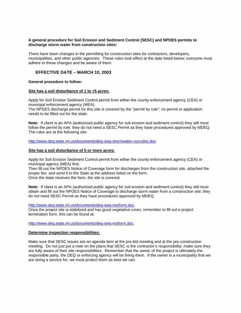
A general procedure for Soil Erosion and Sediment Control (SESC) and NPDES permits to discharge storm water from construction sites: There have been changes in the permitting for construction sites for contractors, developers, municipalities, and other public agencies. These rules took effect at the date listed below; everyone must adhere to these changes and be aware of them.
EFFECTIVE DATE – MARCH 10, 2003 General procedure to follow: Site has a soil disturbance of 1 to <5 acres: Apply for Soil Erosion Sediment Control permit from either the county enforcement agency (CEA) or municipal enforcement agency (MEA). The NPDES discharge permit for this site is covered by the “permit by rule"; no permit or application needs to be filled out for the state. Note: If client is an APA (authorized public agency for soil erosion and sediment control) they still must follow the permit by rule, they do not need a SESC Permit as they have procedures approved by MDEQ. The rules are at the following site: http://www.deq.state.mi.us/documents/deq-swq-stormwater-nocrules.doc. Site has a soil disturbance of 5 or more acres: Apply for Soil Erosion Sediment Control permit from either the county enforcement agency (CEA) or municipal agency (MEA) first. Then fill out the NPDES Notice of Coverage form for discharges from the construction site, attached the proper fee, and send it to the State at the address listed on the form. Once the state receives the form, the site is covered. Note: If client is an APA (authorized public agency for soil erosion and sediment control) they still must obtain and fill out the NPDES Notice of Coverage to discharge storm water from a construction site; they do not need SESC Permit as they have procedures approved by MDEQ. http://www.deq.state.mi.us/documents/deq-swq-nocform.doc. Once the project site is stabilized and has good vegetative cover, remember to fill out a project termination form, this can be found at: http://www.deq.state.mi.us/documents/deq-swq-notform.doc. Determine inspection responsibilities: Make sure that SESC issues are an agenda item at the pre-bid meeting and at the pre-construction meeting. Do not just put a note on the plans that SESC is the contractor’s responsibility; make sure they are fully aware of their site responsibilities. Remember that the owner of the project is ultimately the responsible party, the DEQ or enforcing agency will be fining them. If the owner is a municipality that we are doing a service for, we must protect them as best we can.

THOMAS TOWNSHIP DETENTION AND RESTRICTION
FINAL INSPECTION REPORT FORM Name of Site Development:
Planning Commission Approval Number:
Location:
Type of Development:*
Size of Restrictor:
Type of Restrictor:**
Location of Restrictor:
Required Detention (ft³):
Type of Detention:***
Location of Detention:
Do As-builts Conform To Present Site Conditions?
Inspection Comments:
Date of Inspection:
Inspector’s Name and Affiliation:
* - Residential, Commercial, Subdivision, Etc. ** - Orifice in Outlet Pipe, Metering Outlet Pipe, Square Orifice, Etc. *** - Parking Lot Ponding, Detention Basin, Etc.

Thomas Township Storm Water Management Plan Site Report Visits Procedure & Deposit
All site development projects are subject to a storm water management plan site visits after construction has been completed. There are two distinct types of Site Visits:
1. Commercial / Business sites 2. Subdivision, Condominium, Manufactured home sites
COMMERCIAL & BUSINESS SITES For Commercial / Business sites the following inspection procedure will be in place to assure compliance with the approved storm water management plan for the site and to assure that all best management practices for water quality related to storm water are in place and functioning properly. To assure compliance with Ordinance 97-G-25 there will be two site report visits by the Township Engineer: One visit will take place as soon as site construction is completed. The storm sewer system will be inspected for pipe sizes, structure layout, detention basin / area, and flow restrictor as it relates to the approved storm water management plan. A letter report will be generated to document the visit and sent to the owner and the Township. Second visit will take place no sooner than 6-12 months after occupancy to assure that any best management practices are functioning and are being maintained properly. A letter report will be generated to document the visit and sent to the owner and the Township. A cash deposit for these site visits will be $750.00 minimum. Any costs incurred by the Township associated with inspections or administrative efforts for repair, replacement, or deficiency reconciliation will be deducted from this deposit. Any remaining deposit balance after successful completion of the site visit and report process will be refunded to the owner/developer who paid the deposit. SUBDIVISIONS, CONDOMINIUMS & MANUFACTURED HOME SITES For Subdivision, Condominium, & Manufactured Home sites the following procedure will be in place for inspections and deposit. The site must conform to the original reviewed plans that have been stamped “Approved” by the Township engineer. Any changes that are necessary based on field conditions during construction that change the approved plan must be documented in a letter and a copy provided to the Township and the Township’s engineer. This will assure that the site visits are as efficient as possible. To calculate the deposit, it will be $50.00 per lot or unit for the site, or a minimum of $2,000.00. This deposit will be in a suitable or acceptable deposit payable to Thomas Township. The developer will be responsible for any additional fees above and beyond the deposited fee. The deposit will be returned to the proprietor provided that all storm water facilities and best management practices are clean, unobstructed and in good working order and that the Township’s Director of Community Development has received all required documents, certificates, copies of covenants, maintenance plans, and as-built drawings. It is the proprietor’s responsibility to request final site visit. The site will be inspected to assure compliance with the approved storm water management plan. Any costs incurred by the Township associated with subsequent visits or Thomas Township administrative efforts for repair, replacement, or deficiency reconciliation will be deducted from this deposit. Any
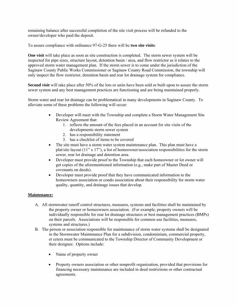
remaining balance after successful completion of the site visit process will be refunded to the owner/developer who paid the deposit. To assure compliance with ordinance 97-G-25 there will be two site visits: One visit will take place as soon as site construction is completed. The storm sewer system will be inspected for pipe sizes, structure layout, detention basin / area, and flow restrictor as it relates to the approved storm water management plan. If the storm sewer is to come under the jurisdiction of the Saginaw County Public Works Commissioner or Saginaw County Road Commission, the township will only inspect the flow restrictor, detention basin and rear lot drainage system for compliance. Second visit will take place after 50% of the lots or units have been sold or built upon to assure the storm sewer system and any best management practices are functioning and are being maintained properly. Storm water and rear lot drainage can be problematical in many developments in Saginaw County. To alleviate some of these problems the following will occur:
• Developer will meet with the Township and complete a Storm Water Management Site Review Agreement that:
1. reflects the amount of the fees placed in an account for site visits of the developments storm sewer system
2. has a responsibility statement 3. has a checklist of items to be covered
• The site must have a storm water system maintenance plan. This plan must have a plat/site layout (11” x 17”), a list of homeowner/association responsibilities for the storm sewer, rear lot drainage and detention area.
• Developer must provide proof to the Township that each homeowner or lot owner will get copies of the aforementioned information (e.g., make part of Master Deed or covenants on deeds).
• Developer must provide proof that they have communicated information to the homeowners association or condo association about their responsibility for storm water quality, quantity, and drainage issues that develop.
Maintenance:
A. All stormwater runoff control structures, measures, systems and facilities shall be maintained by the property owner or homeowners association. (For example, property owners will be individually responsible for rear lot drainage structures or best management practices (BMPs) on their parcels. Associations will be responsible for common use facilities, measures, systems and structures.)
B. The person or association responsible for maintenance of storm water systems shall be designated in the Stormwater Maintenance Plan for a subdivision, condominium, commercial property, et cetera must be communicated to the Township Director of Community Development or their designee. Options include:
• Name of property owner • Property owners association or other nonprofit organization, provided that provisions for
financing necessary maintenance are included in deed restrictions or other contractual agreements.

• Public Works Commissioner, in accordance with provisions of the Michigan Drain Code (Public Act 40 of 1956, as amended).
C. Maintenance agreements shall specify responsibilities for financing maintenance and emergency
repairs, including but not limited to the maintenance and repair of:
• Detention / Retention basins (wet or dry) • Best Management Practices implemented on the site to address water quality. • Flow restriction structures
• Rear Lot drainage systems
• Storm sewer structures, pipes as required by type of system and ownership of such a
system. (For example if the system is under control of the Public Works Commissioner, they will maintain the system, if a private owner or association, then they have responsibility.)
D. If necessary to protect public health, safety, welfare, or water resources, including lakes,
rivers, streams, protected wetlands, county drains or other receiving bodies of water, the Township may initiate emergency action to abate imminent and substantial danger and risk. Any costs incurred will be the responsibility of the owner or association responsible for maintenance of the storm water system.
February, 2006
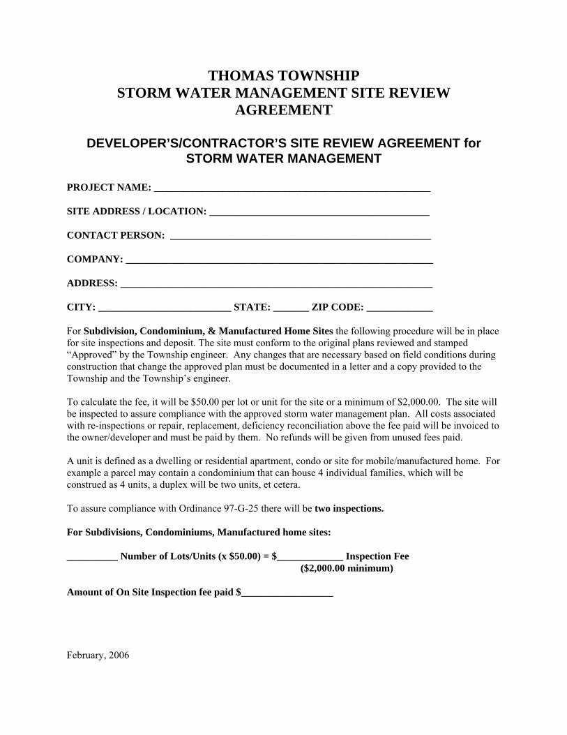
THOMAS TOWNSHIP STORM WATER MANAGEMENT SITE REVIEW
AGREEMENT
DEVELOPER’S/CONTRACTOR’S SITE REVIEW AGREEMENT for STORM WATER MANAGEMENT
PROJECT NAME: ______________________________________________________ SITE ADDRESS / LOCATION: ___________________________________________ CONTACT PERSON: ___________________________________________________ COMPANY: ____________________________________________________________ ADDRESS: _____________________________________________________________ CITY: __________________________ STATE: _______ ZIP CODE: _____________ For Subdivision, Condominium, & Manufactured Home Sites the following procedure will be in place for site inspections and deposit. The site must conform to the original plans reviewed and stamped “Approved” by the Township engineer. Any changes that are necessary based on field conditions during construction that change the approved plan must be documented in a letter and a copy provided to the Township and the Township’s engineer. To calculate the fee, it will be $50.00 per lot or unit for the site or a minimum of $2,000.00. The site will be inspected to assure compliance with the approved storm water management plan. All costs associated with re-inspections or repair, replacement, deficiency reconciliation above the fee paid will be invoiced to the owner/developer and must be paid by them. No refunds will be given from unused fees paid. A unit is defined as a dwelling or residential apartment, condo or site for mobile/manufactured home. For example a parcel may contain a condominium that can house 4 individual families, which will be construed as 4 units, a duplex will be two units, et cetera. To assure compliance with Ordinance 97-G-25 there will be two inspections. For Subdivisions, Condominiums, Manufactured home sites: __________ Number of Lots/Units (x $50.00) = $_____________ Inspection Fee ($2,000.00 minimum) Amount of On Site Inspection fee paid $__________________
February, 2006

THOMAS TOWNSHIP
STORM WATER MANAGEMENT SITE REVIEW AGREEMENT
I hereby certify that to the best of my knowledge, information and belief, the storm water system will be constructed in general conformance to the approved plans and specifications delivered to me by the design engineer. I accept the responsibility that the storm water system will be in compliance with Thomas Township Ordinance No. 97-G-25 and the design guidelines of Thomas Township’s Storm Water Management Plan. I understand that if deficiencies are discovered during inspections that I am responsible for correction of those deficiencies within a prescribed time frame. _______________________________ ___________________________________ Printed Name Signature _______________________________ Date Items to cover: _______ Review of SWMP inspection procedure and copy to developer / contractor _______ Deposit of funds for inspections of storm water system _______ Developer / Contractor to notify Township Planner (or Engineer) for first inspection _______ Developer / Contractor to notify Township Planner (or Engineer) for second inspection _______ Developer / Contractor has a set of plans marked “Approved” by the Township engineer from the storm water review process _______ Storm Water System maintenance plan submitted _______ Developer / Contractor provides documentation that homeowners association, condo association, or property owners have a copy of maintenance plan, easements, plat layout, and property owner’s responsibility for rear lot drainage. February, 2006
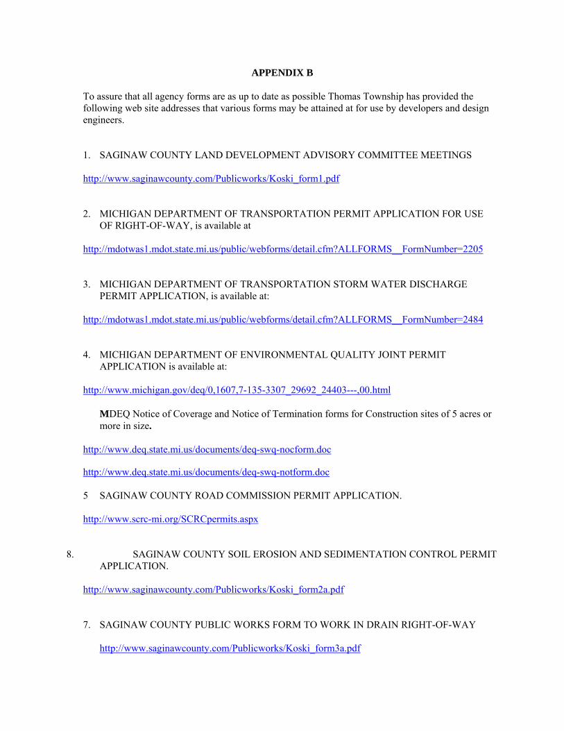
APPENDIX B To assure that all agency forms are as up to date as possible Thomas Township has provided the
following web site addresses that various forms may be attained at for use by developers and design engineers.
1. SAGINAW COUNTY LAND DEVELOPMENT ADVISORY COMMITTEE MEETINGS http://www.saginawcounty.com/Publicworks/Koski_form1.pdf 2. MICHIGAN DEPARTMENT OF TRANSPORTATION PERMIT APPLICATION FOR USE
OF RIGHT-OF-WAY, is available at http://mdotwas1.mdot.state.mi.us/public/webforms/detail.cfm?ALLFORMS__FormNumber=2205 3. MICHIGAN DEPARTMENT OF TRANSPORTATION STORM WATER DISCHARGE
PERMIT APPLICATION, is available at: http://mdotwas1.mdot.state.mi.us/public/webforms/detail.cfm?ALLFORMS__FormNumber=2484 4. MICHIGAN DEPARTMENT OF ENVIRONMENTAL QUALITY JOINT PERMIT
APPLICATION is available at: http://www.michigan.gov/deq/0,1607,7-135-3307_29692_24403---,00.html
MDEQ Notice of Coverage and Notice of Termination forms for Construction sites of 5 acres or more in size.
http://www.deq.state.mi.us/documents/deq-swq-nocform.doc
http://www.deq.state.mi.us/documents/deq-swq-notform.doc 5 SAGINAW COUNTY ROAD COMMISSION PERMIT APPLICATION. http://www.scrc-mi.org/SCRCpermits.aspx
8. SAGINAW COUNTY SOIL EROSION AND SEDIMENTATION CONTROL PERMIT APPLICATION.
http://www.saginawcounty.com/Publicworks/Koski_form2a.pdf
7. SAGINAW COUNTY PUBLIC WORKS FORM TO WORK IN DRAIN RIGHT-OF-WAY
http://www.saginawcounty.com/Publicworks/Koski_form3a.pdf

APPENDIX C
THOMAS TOWNSHIP ORDINANCE NO. 97-G-25
ORDINANCE NO. 97-G-25TOWNSHIP OF THOMAS
SAGINAW COUNTY, MICHIGAN
AN ORDINANCE RELATED TO STORM WATER RUNOFF REGULATION ANDCONTROL AND TO REPEAL ORDINANCE 94-Z0-02.
The Township of Thomas, Saginaw County, Michigan ordains:
Section 1. General Purpose and General Requirements
A Purpose: The purpose of this ordinance is to diminishthreats to the public health and safety caused by therunoff of excess storm waters, to reduce thepossibilities of hydraulic overloading of the storm sewersystem, to reduce economic losses to individuals and thecommunity at large as a result of excess runoff of stormwater, and to protect and conserve land and waterresources, while at the same time ensuring orderlydevelopment. The provisions of the ordinance arespecifically intended to regulate the following:
1 The subdivision, layout, and improvement of landslocated within Thomas Township. '
2. The excavating, filling and grading of lots andother parcels or areas, including any fill placedgreater than six (6) inches deep within the 100year floodplain.
3. The construction of buildings, including relatedparking ana other parcel areas and the drainage ofthe sites on which those structures and theirrelated parking and other paved areas are located.
4. The design, construction, and maintenance of stormwater drainage facilities and systems.
B~ Definitions: For the purpose of this ordinance and theTownship's current Storm Water Management Plan, thefollowing definitions are adopted:
~. Allowable Discharge: The restricted discharge froma site after development or redevelopment ascalculated in accordance with the current StormWater Management Plan.
2 Base Flood Elevation: The elevation delineatingthe flood level having a one-percent probability ofbeing equaled or exceeded in any given year (alsoknown as the IOO-year flood elevation), asdetermined from Flood Insurance Rate Maps (FIRMs)or the best available information.

3 Conduit: Any channel, pipe, sewer or culvert usedfor the conveyance or movement of water, whetheropen or closed.
4 Control Elevation: Contour lines and points ofpredetermined elevation used to denote a detentionstorm area on a plat or site drawing.
5. Detention Facility: A facility constructed ormodified to restrict the flow of storm water to aprescribed maximum rate and to concurrently detainthe excess waters that accumulate behind theoutlet.
6 Detention Storage: The temporary detaining orstorage of storm water in storage basin, onrooftops, in streets, parking lots, school yards,parks, open space, or other areas underpredetermined and controlled conditions, with therate of drainage therefrom regulated byappropriately installed devices.
Developer/Owner Engineer: The engineering companyformally designated by the Developer/Owner to actas their Engineer.
1.2
8. Development: The construction of a building,parking lot, structure, etc. on a piece of land orotherwise changing the use of a piece of land.
Discharge:any source
9. The release or outflow of water from
Drainage Area: The area from which storm waterrunoff is conveyed to a single outlet (i.e. awatershed or catchment area).
Easement: A parcel of land on which the owner hasgranted rights-of-way to make surveys, lay,construct, maintain, operate, alter, replace,repair, and remove at any time that part of thestorm drainage system located within the easement.The landowner will not be allowed to constructbuildings or other structures on said easementwithout the written consent of the easementgrantee.
Excess Storm Water Runoff: The volume and rate offlow of storm water discharge from a drainage areawhich is in excess of the allowable discharge.
13(, Floodplain: The special flood hazard landsadjoining a water-course, the surface elevation ofwhich is lower than the Base Flood Elevation and is

subject to periodic inundations determined fromFlood Insurance Rate Maps (FIRMs) or the bestavailable information. A parcel of land can belocated within a floodplain without being shown ona FIRM map.
Impervious Factor (IF): Is the percentage ofimpervious surface used in the previous design ofan existing storm drainage outlet. The IF is usedto calculate the allowable discharge from a site.Proposed developments or redevelopments will not beallowed to discharge storm water at a rate which isgreater than the runoff that would occur from thesite with the percentage of impervieus surfacesdefined by the impervious factor. IF's have beenestablished for the existing drains and storm sewersystems located within the Township (See thecurrent Storm Water Management Plan on file in theClerk's Office).
14.
15 Impervious Surface: A surface which does noteasily allow the infiltration or penetration ofwater. During rainstorm events a large percentageof water will runoff. (i.e. roof tops, paved walks,roadways, driveways, sidewalks, etc.)
16. Peak Flow: The maximum rate of flow of storm waterrunoff at a given location.
Percent Imperviousness (IMP): The actual proposedpercentage of impervious surface for a proposeddevelopment or redevelopment. The IMP is used tocalculate the design discharge (0 ). The designdischarge is used to determine storm sewer sizesand required detention volumes. Minimum imperviousfactors have been established in the current StormWater Management Plan for various zoned land uses.
Pervious Surface: A surface which allowsinfiltration or penetration of water. Duringrainstorm events a percentage of water willinfiltrate into tRe surface with the remainingstorm water running off. The percentage of runoffis dependent on the type, slope, percentsaturation, etc. of the surface. (i.e. lawns, farmfields, parks, wooded areas, golf courses, etc.)
19, Redevelopment: Altering, improving, or otherwisechanging the use of an existing developed property.A site will be considered a redevelopment for thecurrent Storm Water Management Plan when an areagreater than or equal to 5% of the existingdeveloped portion of the site (i.e. roof, gravel, &paved surfaces) or an area greater than 20,000
square feet is increased with additionalpavement, or any other impervious surface.
roof,
20. Retention Storage: The permanent retaining orstorage of storm water in a storage basin, onrooftops, in streets, parking lots, school yards,parks, open space, or other areas underpredetermined and controlled conditions. The onlydischarge of storm water from a retention storagearea is by ground infiltration, evaporation, etc.An emergency overflow must be provided in the eventthe capacity of the retention facility is exceeded.
2~ Saginaw County Land Development Advisory Committee:The advisory committee shall include a member ofthe Saginaw County Road Commission, and themunicipality involved. The goal of the committeeis to arrive at a mutual understanding of theprocedures, standards, and/or requirements as theymay apply to the proposed development. Refer toSaginaw County Advisory Committee Policy Statementin Appendix B of the current Storm Water ManagementPlan.
22 Storm Water Runoff: The water from a rain storm orsnow melt which flows over the surface of theground or is collected in a drainage system.
Ten-Year Design Storm: A precipitation event witha duration equal to the time of concentration,having a ten percent probability of occurring inany given year or occurring once every 10 years onaverage.
23
Time of Concentration: The elapsed time for stormwater runoff to flow from the most distant point ina drainage area to the outlet or otherpredetermined point.
24
Township Engineer: The engineering firm formallydesignated by Thomas Township to act as theirEngineer.
25
Upland Area: Land located in the upper portion ofa watershed whose surface drainage flows toward thearea being considered for development.
26.
27 Urbanization: The development, change, orimprovement of any parcel of land consisting of oneor more lots for residential, commercial,industrial, institutional, recreational, or publicutility purposes.
28. Watercourse: Any natural or artificial stream,river, creek, channel, ditch, canal, conduit,culvert, drain, waterway, gully, ravine, street,roadway, swale, or wash in which water flows in adefinite direction, either continuously orintermittently.
Before initiating any activity regulated by thisordinance, an applicant shall a. in compliance withTownship's current Storm Water Management Plan. Beforeinitiating any activity regulated by this ordinance, anapplicant shall be in compliance with the Township"scurrent Storm Water Management Plan and pay fees asestablished by resolution of the Township Board.Certificates of Occupancy will not be issued until allfees owed the township are paid, letter of compliancefrom developer's engineer is received and Townshipengineer's final approved inspection is completed.
c
Section 2. Specific Requirements.
A General: Excess storm water runoff shall either bedetained in connection with any new constructiondevelopment, redevelopment, or land use change occurringwithin Thomas Township in accordance with therequirements set forth in this ordinance and theTownship's current Storm Water Management Plan, or anadequate outlet shall be provided. All developments thatrequire site plan review in accordance with the Townhip'szoning ordinance must comply with this ordinance with thefollowing exceptions:
The construction of any single-family or two-familydwelling on any parcel of one acre or less in size.The Township may require side lot or rear lotdrainage to be installed if the Township determinesit necessary. This activity will be regulatedunder the building permit.
1
2 A determination by the Township that the excessrunoff from the proposed construction, development,redevelopment, or land use change will beinsufficient to adversely effect the carryingcapacity of the receiving body or watercourse. Inthis connection, should the Township determinationof insufficient adverse effect be sought, theDeveloper shall make available such hydraulic orhydrologic computations to support the requestedexception.
.3} The area of additional impervious surfaces e.g.roof, paved, and gravel surfaces is less than 5% ofthe existing impervious surfaces at the site andless than 20,000 square feet.

Example: Existing 1 acre site with .75 acres ofdeveloped property plans to add 3,000square feet of paved surface to theexisting development. .05*(.75 *43560) =1633.5 sq. ft. 3,000 > 1633.5 thereforeproject will need to follow storm watermanagement plan.
8 Discharge Rate: The peak discharge rate after fulldevelopment resulting from the proposed development shallnot exceed the corresponding peak discharge rate prior todevelopment during all storms up to and including a 10-year design storm unless it is shown that an adequateoutlet exists. The discharge may be further restrictedto minimize impacts to the existing storm drainage systemas outlined in the requirements of the Township's currentStorm Water Management Plan.
c Flood Elevation: There shall be no detrimental effect onthe floodway or the floodplain elevation during a la-yeardesign storm upstream or downstream of the proposeddevelopment area as a result of the proposed development.
D Allowable Detention Facilities: The increased stormwater runoff resulting from the proposed developmentshall be managed by providing for appropriate detentionstorage as required by this section. In no case shallthe design maximum water elevation of a detentionfacility be less than one (1) foot below the lowestground elevation adjacent to, or opening into an existingor future structure. Also, in no case shall the designmaximum water elevation ofa detention facility begreater than nine (9) inches above any drainage structurewithin a hard surfaced parking area.
E Design Requirements for Detention Storage and Outlet:
The drainage area used in computation will be thetotal area tributary to the detention storageoutlet.
2. The Developer will be required to submit detailedhydrologic and hydraulic calculations to show thatthe requirements of this ordinance will be met.The calculations shall be based on the RationalMethod of Site Drainage Discharge and StorageFormula as depicted in Section 2F. Thesecalculations must be included in the Developer'ssubmittal.
F. Site Drainage Discharge and Storage Formula - Allowabledischarge and storage required can be computed using theformulas outline in the Township's current Storm Water

Management Plan
sewer: All proposedto have capacity to
G New stormconstructedstorm.
storm sewer shall bepass la-year design
Section 3. AdditionalRegulations
Subdivision Buildingand Improvement
A Preliminary Plat Review Requirements:
1 .. A description of the manner in which the provisionsof the Township Zoning Ordinance are to be metshall be submitted with all preliminary plats.
2. Sufficient details of the proposed storm waterrunoff controls (not necessarily final engineeringplans) shall be provided to enable the Township todetermine if they will be in conformance withdesign standards for public improvements in ThomasTownship.
B. Site Plan, PlanFinal Plat,Requirements
Improvement Reviewor
A description of the manner in which the provisionsof the Township Zoning Ordinance are to be metshall be submitted with all plans which fall underthe requirements of Section 2A.
1.
Drainage and Detention Design Requirements: Allsubdivisions and other proposed improvements which aresubj ect to the provisions of Section 2A shall incorporatesuch design features as are required in this ordinance.Variation from these requirements shall require theapproval of the Thomas Township Board whose actions shallbe conditioned upon the following:
(:.
That a petition be submitted describing in detailthe rationale for the proposed design changes.
1
That there are special circumstances or conditionsaffecting the property under consideration suchthat strict compliance with the provisions of thisordinance would deprive the applicant of thereasonable use of their land.
2
That the variance is necessary for the preservationand enjoyment of a substantial property right ofthe proprietor.
That the granting ofdetrimental to thewelfare, or injurious
beor
the
4. the variance will notpublic health, safety
to other property in
territory in which said property is located
s. That an affirmative recommendation be received fromthe Township Engineer supporting such variance. Inthe event that the Township Engineer does notsubmit an affirmative recommendation, arecommendation shall be received from the SewerBoard of Appeals as authorized by Section 4C ofthis ordinance.
D. Detention Storage: Designs for detention storage andrelated appurtenances shall be submitted to the CommunityDevelopment Department for approval. Upon receipt ofdesigns for detention storage, the Township Engineershall make a determination as to whether any or all ofthe facilities proposed are to become part of the CountyDrain system. The Township Engineer shall in the case ofa proposed subdivision, make a determination as to thosecontrol elevations that shall be entered on the finalplat or make a determination as to the necessity for deedrestrictions on any particular lot in said subdivisionrequiring the preserv~!on of mandatory drainagefacilities. Where a non-subdivided parcel of land isproposed for development, the Township Engineer shallmake a determination as to the need for covenants tomaintain responsibility for mandatory drainagefacilities. All the said facilities shall be designedand constructed in accordance with Thomas Townshipspecifications, shall be located in easements dedicatedto the public, and shall be subject to continualinspection during the construction period.
E. Maintenance: Designs of detention facilities willincorporate features which facilitate their inspectionand maintenance. The designer shall submit an Operationand Maintenance (O&M) Plan for any detention facilityprior to its acceptance by the Township. All privatelyowned detention facilities may be inspected byrepresentatives of Thomas Township at such times as theydeem necessary. If deficiencies or conditions creatingnuisances are found or the detention facility does notmeet the requirements of the Township's current StormWater Management Plan, the Owner shall be required tomake the necessary corrections within a reasonable periodof time provided, however, such period of time shall notexceed thirty (30) days.
Detention basins and restrictors shall bemaintained as necessary. If a detention basin isfound not be maintained or a restictor is removedor not maintained the owner will have 30 days tocomplete the necessary maintenance.
1

2 Condominium Projects - If the detention/retentionfacility areas are designated as general commonelement, the Master Deed will set up a mechanism bywhich the ponds will be maintained by theCondominium Association.
3.. Platted Developments - An association for thesubdivision will need to be established. TheCounty Department of Public Works will require aneasement be established that will enable theiroffice to repair any problems associated with thesystem and assess the charges back to thesubdivision. This will only occur if theassociation does not properly maintain thedetention/retention area.
Maintenance shall include: mowing of the basinbottom and side slopes, removal of excess spoilsfrom the basin, removal of debris and sediment fromthe outlet, repair of fencing, spraying for plants,brush, and cattails, and any other maintenancenecessary to insure the basin remains functionaland is aesthetically pleasing to surroundinglandowners.
4
Safety Features: Designs of detention facilities shallincorporate safety features, particularly at inlets,outlets, on steep slopes, and at any attractivenuisances. These features shall include, but not belimited to, fencing, hand rails, lighting, steps, grills,signs, and other protective or warning devices so as torestrict access.
F
Storm Sewer Enclosures: Proposed storm sewer enclosuresmust be designed so they will not adversely impact anyadjacent properties, upstream or downstream, and must bedesigned to the impervious facto~ of the lands basedupon zoning, not necessarily existing conditions.
G
AdministrativeSection 4.
The administration ofresponsibility of the
this ordinanceThomas Township
A Responsibilityshall be theManager.
Interpretation: In the interpretation and application ofthis ordinance, the provisions expressed herein shall beheld to be minimum requirements and shall be liberallyconstructed in favor of Thomas Township.
~
,c. Appeals and Variance Requests: Appeals relating to theenforcement of this ordinance and the accompanying planand requests for variances from their provisions may bemade in writing to the Community Development Director.
The Director shall render a decision within five (5)
business days and shall respond to the applicant inwriting. An appeal from that decision may be made in asimilar manner to the Township Manager. The Managershall render a decision within five (5) business days andshall respond to the applicant in writing. The decisionof the Manager can be appealed to the Township Board whoshall hear the appeal at the first regular meetingfollowing receipt of the request to appeal by theTownship Clerk's office. Any further appeal shall bemade to a court of competent jurisdiction.
Section 5. Penalties for Violation.
1.. General: Any person, firm, organization,association, or corporation violating any of theprovisions of this ordinance, including violationof any variance granted under the authority of thisordinance, shall be deemed guilt of a misdemeanorand each such person or other entity shall bedeemed guilty of a separate offense for each andevery day or portion thereof that any violation ofany of the provisions of the ordinance iscommitted, continued or permitted.
Upon conviction of such violation, such person orother entity shall be punished by fine of not morethan five hundred dollars ($SOO.OO) or imprisonmentfor not more than ninety (90) days or by both suchfine and imprisonment.
2 Additional Corrective Actions: Any building orstructure constructed in violation of theprovisions of this ordinance, or any use carried onin violation of this ordinance, is hereby declaredto be a nuisance per se, with any court ofcompetent jurisdiction having the authority todetermine that the Owner or Developer is guilty ofmaintaining a nuisance per se and to order suchnuisance abated. In this connection, the Townshipis hereby authorized to institute any appropriateaction or preceding in any appropriate court toprevent, restrain, correct, or abate any violationsof this ordinance.
Section 6. Severability
If any section, subsection, clause, paragraph, phrase orprovision of this ordinance shall be adjudged invalid, suchadjudication shall only apply to the section, subsection,clause, paragraph, phrase or provision as adjudged invalid andthe rest of the ordinance shall remain valid and effective.

Section 8. Effective Date.
That this Ordinance, or a summary thereof, is hereby orderedto be published in The TownshiQ Times. a newspaper of generalcirculation within the Township of Thomas on
.' 19_, and shall become effective thirty (30) daysfrom the date of said publication. All ordinances or parts ofordinances in conflict herewith are hereDY repealed.
Morrison Stevens, supervisor
Edward Brosofski, clerk
CERTIFICATE
I, EDWARD BROSOFSKI, the duly qualified Clerk of the Townshipof Thomas, Saginaw County, Michigan, do hereby certify that theforegoing is a true and complete copy of Ordinance No.
adopted at a regular meeting held on , 1997and that public notice of said meeting was given pursuant to Act.No. 267, PA of 1976. I further certify that said ordinance will bepublished in The TownshiD Times on the day of ,1997.
Edward BrosofskiThomas Townshio Clerk

Appendix D
Runoff Coefficients
Table 1

TABLE 1. Runoff Coefficients
Urban areas The use of average coefficients for various surface types, which are assumed not to vary through the duration of the storm, is common. The range of coefficients, classified with respect to the general character of the tributary reported in use is: Description of area Runoff coefficients
Business Downtown areas 0.70 to 0.95 Neighborhood areas 0.50 to 0.70
Residential Single-family areas 0.30 to 0.50 Multi-units, detached 0.40 to 0.60 Multi-units, attached 0.60 to 0.75
Residential (suburban) 0.25 to 0.40
Apartment dwelling areas 0.50 to 0.70
Industrial Light areas 0.50 to 0.80 Heavy areas 0.60 to 0.90
Parks, cemeteries 0.10 to 0.25
Playgrounds 0.20 to 0.35
Railroad yard areas 0.20 to 0.35
Unimproved areas 0.10 to 0.30
Note: It is often desirable to develop a composite runoff coefficient based on the percentage of different types of surface in the drainage area. This procedure is often applied to typical ‘sample’ blocks as a guide to selection of reasonable values of the coefficient for an entire area. Coefficients with respect to surface type currently in use are: Character of surface Runoff coefficients
Streets Asphaltic and concrete 0.70 to 0.95 Brick 0.70 to 0.85
Roofs 0.75 to 0.95
Lawns, sandy soil Flat, 2% 0.05 to 0.10 Average, 2 to 7% 0.10 to 0.15 Steep, 7% 0.15 to 0.20
Lawns, heavy soil Flat, 2% 0.13 to 0.17 Average, 2 to 7% 0.18 to 0.22 Steep, 7% 0.25 to 0.35
Note: The coefficients in these two tabulations are applicable for storms of 5-year to 10-year frequencies. Less frequent higher intensity storms will require the use of higher coefficients because infiltration and other losses have a proportionally smaller effect on runoff. The coefficients are based on the assumption that the design storm does not occur when the ground surface is frozen.
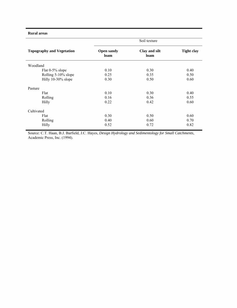
Rural areas
Soil texture
Topography and Vegetation Open sandy loam
Clay and silt loam
Tight clay
Woodland Flat 0-5% slope 0.10 0.30 0.40 Rolling 5-10% slope 0.25 0.35 0.50 Hilly 10-30% slope 0.30 0.50 0.60 Pasture Flat 0.10 0.30 0.40 Rolling 0.16 0.36 0.55 Hilly 0.22 0.42 0.60 Cultivated Flat 0.30 0.50 0.60 Rolling 0.40 0.60 0.70 Hilly 0.52 0.72 0.82
Source: C.T. Haan, B.J. Barfield, J.C. Hayes, Design Hydrology and Sedimentology for Small Catchments, Academic Press, Inc. (1994).