1 Overview of Co-located Soil Chemical Sampling Approach Stephie Jennings, DOE October 12, 2010.


This page intentionally left blank.

Site Environmental Report for Calendar Year 2011
DOE Operations at The Boeing Company Santa Susana Field Laboratory, Area IV
Prepared by the Staff of
The Boeing Company Santa Susana Field Laboratory
September 2012

ii
This page intentionally left blank.

iii
CERTIFICATE OF ACCURACY
I certify that I have personally examined and am familiar with the information submitted herein
and, based on inquiry of those individuals immediately responsible for preparing this report, I
believe that the submitted information is true, accurate, and complete.
Phil Rutherford
Manager, Health, Safety & Radiation Services
The Boeing Company
Santa Susana Field Laboratory
September, 2012

iv
This page intentionally left blank.

Energy Technology Engineering Center
5800 Woolsey Canyon Road Canoga Park, CA 91304
September 21, 2012
Subject: 2011 Site Environmental Report for the Energy Technology Engineering Center (ETEC) Dear Sir or Madam: The Boeing Company has prepared the subject report for the U.S. Department of Energy (DOE). It is a comprehensive summary of the Department’s environmental protection activities at ETEC in Canoga Park, California for Calendar Year 2011. Site Environmental reports are prepared annually for all DOE sites with significant environmental activities and distributed to external regulatory agencies, interest organizations, and individuals. To the best of my knowledge, this report accurately summarizes the results of the 2011 environmental monitoring and restoration program at ETEC for DOE. This statement is based on reviews conducted by DOE-ETEC staff and by the staff of the Boeing Company. A reader survey form is provided with this report to provide comments. Write directly to: U.S. Department of Energy Energy Technology Engineering Center P.O. Box 10300 Canoga Park, CA 91309 Questions may also be directed to me at (818) 466-8959
Sincerely,
John B. Jones Federal Project Director
cc: Jack Craig, DOE EMCBC Ralph Holland, DOE EMCBC Stephie Jennings, DOE ETEC Jazmin Bell, DOE ETEC Tom Gallacher, Boeing Phil Rutherford, Boeing Dave Dassler, Boeing

vi
This page intentionally left blank.

vii
ACKNOWLEDGMENTS
Preparation of this report has been a collaborative effort of many members of Boeing’s
Environment, Health and Safety (EHS) Department.
Principal technical contributors are:
Radiological Topics: Ning Liu
Phil Rutherford
Groundwater: Art Lenox
Surface Water: Deborah Taege
Waste Management: Ning Liu
RCRA Facility Investigation: Art Lenox
David Dassler
Air: Paul Costa
ISMS: Bob Mako
Training: Lydia Galvez
Public Outreach: Kamara Sams
Agency Inspection Lydia Galvez
Editing and review were performed by Ning Liu, Phil Rutherford, and David Dassler.
The staff of the Boeing Creative Services group provided publication assistance. The
staff of Haley & Aldrich, Inc. and MWH Global, Inc. provided technical contribution for
this report.

viii
This page intentionally left blank.
ix
TABLE OF CONTENTS
CERTIFICATE OF ACCURACY ........................................................................................... iii
DOE CERTIFICATION LETTER ........................................................................................... v
ACKNOWLEDGMENTS ...................................................................................................... vii
TABLE OF CONTENTS ......................................................................................................... ix
LIST OF TABLES ................................................................................................................... xi
LIST OF FIGURES ................................................................................................................ xii
1. EXECUTIVE SUMMARY .............................................................................................. 1-1
2. INTRODUCTION ............................................................................................................ 2-1
2.1 SITE LOCATION AND SETTING ........................................................................... 2-1
2.2 OPERATIONAL HISTORY ...................................................................................... 2-4
2.3 FACILITY DESCRIPTIONS ..................................................................................... 2-4
2.3.1 Radiological Facilities ......................................................................................... 2-4
2.3.2 Former Sodium Facilities ..................................................................................... 2-7
2.4 ASER CONTENTS .................................................................................................... 2-7
3. COMPLIANCE SUMMARY ........................................................................................... 3-1
3.1 COMPLIANCE STATUS .......................................................................................... 3-1
3.1.1 Radiological ......................................................................................................... 3-1
3.1.2 Chemical .............................................................................................................. 3-4
3.1.3 Permits and Licenses (Area IV) ........................................................................... 3-7
3.2 CURRENT ISSUES AND ACTIONS........................................................................ 3-8
3.2.1 Area IV Environmental Impact Statement ........................................................... 3-8
3.2.2 Radiological Decommissioning and Decontamination ........................................ 3-8
3.2.3 Disposal of Non-radiological Waste .................................................................... 3-9
3.2.4 Administrative Order of Consent (AOC) ............................................................. 3-9
3.2.5 EPA Background Study and Characterization Survey of Area IV ...................... 3-9
3.2.6 DOE CleanUpdate ............................................................................................. 3-11
4. ENVIRONMENTAL PROGRAM INFORMATION ...................................................... 4-1
4.1 ENVIRONMENTAL PROTECTION AND REMEDIATION.................................. 4-1
4.2 ENVIRONMENTAL MONITORING PROGRAM .................................................. 4-3
4.2.1 Historical Radiological Monitoring ..................................................................... 4-3
4.2.2 Nonradiological Monitoring ................................................................................ 4-4

x
4.4 ENVIRONMENTAL TRAINING.............................................................................. 4-5
4.5 WASTE MINIMIZATION AND POLLUTION PREVENTION .............................. 4-6
4.5.1 Program Planning and Development ................................................................... 4-6
4.5.2 Waste Minimization and Pollution Prevention Activities ................................... 4-6
4.5.3 Tracking and Reporting System ........................................................................... 4-6
4.5.4 Low Level Waste Shipment ................................................................................. 4-7
4.6 PUBLIC PARTICIPATION ....................................................................................... 4-7
5. ENVIRONMENTAL RADIOLOGICAL MONITORING .............................................. 5-1
5.1 AIR EFFLUENT MONITORING .............................................................................. 5-1
5.2 ENVIRONMENTAL SAMPLING ............................................................................ 5-2
5.2.1 Ambient Air ......................................................................................................... 5-2
5.2.2 Groundwater ........................................................................................................ 5-5
5.2.3 Surface Water....................................................................................................... 5-6
5.2.4 Soil ....................................................................................................................... 5-6
5.2.5 Vegetation ............................................................................................................ 5-6
5.2.6 Wildlife ................................................................................................................ 5-6
5.2.7 Ambient Radiation .............................................................................................. 5-6
5.3 ESTIMATION OF RADIATION DOSE ................................................................... 5-8
5.3.1 Individual Dose .................................................................................................... 5-8
5.3.2 Population Dose ................................................................................................... 5-8
5.4 PROTECTION OF BIOTA ........................................................................................ 5-9
6. ENVIRONMENTAL NON-RADIOLOGICAL MONITORING .................................... 6-1
6.1 SURFACE WATER ................................................................................................... 6-4
6.2 AIR .............................................................................................................................. 6-5
6.3 GROUNDWATER ..................................................................................................... 6-5
6.4 SOIL .......................................................................................................................... 6-10
7. ENVIRONMENTAL MONITORING PROGRAM QUALITY CONTROL .................. 7-1
7.1 PROCEDURES........................................................................................................... 7-1
7.2 RECORDS .................................................................................................................. 7-1
8. REFERENCES ................................................................................................................. 8-1
APPENDIX A ACRONYMS ............................................................................................... A-1
DISTRIBUTION................................................................................................................... D-1

xi
LIST OF TABLES
Table 3-1. 2011 Agency Inspections/Visits Related to DOE Operations ............................. 3-1 Table 3-2. SSFL Permits ....................................................................................................... 3-7 Table 5-1. Sampling Location Description ........................................................................... 5-4 Table 5-2. Ambient Air Specific Isotopes – 2011 ................................................................ 5-5
Table 5-3. Ambient Air Gross Alpha and Gross Beta—2011 .............................................. 5-5 Table 5-4. 2011 SSFL Ambient Radiation Dosimetry Data ................................................. 5-7 Table 5-5. Public Exposure to Radiation from DOE Operations at SSFL............................ 5-9 Table 5-6. Terrestrial Biota Radiation Exposure as a Fraction of Dose Limit ................... 5-11 Table 6-1. Groundwater Monitoring at Area IV in 2011 ...................................................... 6-5
Table 6-2. Ranges of Detected Non-Radiological Analytes in 2011 Groundwater .............. 6-6 Table 6-3. Surficial Media Sampling Summary ................................................................. 6-10

xii
LIST OF FIGURES
Figure 2-1. Map Showing Location of SSFL........................................................................ 2-2 Figure 2-2. Santa Susana Field Laboratory Site Arrangement ............................................. 2-3 Figure 2-3. Santa Susana Field Laboratory Site, Area IV (2005) ......................................... 2-5 Figure 2-4. Map of Prior and Current Radiological Facilities in Area IV ............................ 2-6
Figure 3-1. Conceptual Model of Potential Pathways .......................................................... 3-3 Figure 5-1. Map of Santa Susana Field Laboratory Area IV Sampling Stations .................. 5-3 Figure 6-1. Locations of Surface Water Runoff Collectors ................................................... 6-2 Figure 6-2. Well and Piezometer Locations ......................................................................... 6-3 Figure 6-3. TCE Occurrences in Groundwater at SSFL, Area IV ....................................... 6-9

1-1
1. EXECUTIVE SUMMARY
This Annual Site Environmental Report (ASER) for 2011 describes the environmental
conditions related to work performed for the Department of Energy (DOE) at Area IV of
Boeing’s Santa Susana Field Laboratory (SSFL). The Energy Technology Engineering Center
(ETEC), a government-owned, company-operated test facility, was located in Area IV. The
operations in Area IV included development, fabrication, operation and disassembly of nuclear
reactors, reactor fuel, and other radioactive materials. Other activities in the area involved the
operation of large-scale liquid metal facilities that were used for testing non-nuclear liquid metal
fast breeder reactor components. All nuclear work was terminated in 1988, and all subsequent
radiological work has been directed toward environmental restoration and decontamination and
decommissioning (D&D) of the former nuclear facilities and their associated sites. Liquid metal
research and development ended in 2002. Since May 2007, the D&D operations in Area IV have
been suspended by the DOE, but the environmental monitoring and characterization programs
have continued.
Results of the radiological monitoring program for the calendar year 2011 continue to
indicate that there are no significant releases of radioactive material from Area IV of SSFL. All
potential exposure pathways are sampled and/or monitored, including air, soil, surface water,
groundwater, direct radiation, transfer of property (land, structures, waste), and recycling.
Due to the suspension of D&D activities in Area IV, no effluents were released into the
atmosphere during 2011. Therefore, the potential radiation dose to the general public through
airborne release was zero. Similarly, the radiation dose to an offsite member of the public
(maximally exposed individual) due to direct radiation from SSFL is indistinguishable from
background.
All radioactive wastes are processed for disposal at DOE disposal sites and/or other licensed
sites approved by DOE for radioactive waste disposal. No liquid radioactive wastes were
released into the environment in 2011.
During 2011, seven regulatory agency inspections, audits, and visits were conducted in Area
IV. These inspections and visits were carried out by the California Department of Public Health,
Radiologic Health Branch (DPH/RHB), County of Ventura Environmental Health Division
(EHD), and Ventura County Air Pollution Control District (VCAPCD).
In summary, this Annual Site Environmental Report provides information to show that there
are no indications of any potential impact on public health and safety due to the DOE-sponsored
operations conducted at Area IV of SSFL. The report summarizes the environmental and effluent
monitoring results for the responsible regulatory oversight agencies.

1-2
This page intentionally left blank.

2-1
2. INTRODUCTION
This annual report describes the environmental monitoring programs related to the
Department of Energy’s (DOE) activities at the Santa Susana Field Laboratory (SSFL) facility
located in Ventura County, California during 2011. Part of the SSFL facility, known as Area IV,
had been used for DOE’s activities since the 1950s. A broad range of energy related research and
development (R&D) projects, including nuclear technology projects, were conducted at the site.
All the nuclear R&D operations in Area IV ceased in 1988, and the efforts were directed toward
environmental restoration decontamination and decommissioning (D&D). By 2007, all the D&D
that remained to be completed were two former nuclear facilities and two liquid metal facilities.
In May 2007, the D&D operations in Area IV were suspended until DOE completes the SSFL
Area IV Environmental Impact Statement (EIS). The environmental monitoring and
characterization programs were continued throughout 2011.
As required by DOE Order 231.1B, “Environment, Safety and Health Reporting,” this report
is used to communicate internally to DOE, and externally to the public, the environmental
monitoring results and the state of environmental conditions related to DOE activities at SSFL.
The report summarizes:
Environmental management performance for DOE activities (e.g., environmental
monitoring of effluents and estimated radiological doses to the public from releases of
radioactive materials)
Environmental occurrences and responses reported during the calendar year
Compliance with environmental standards and requirements
Significant programs and efforts related to environmental management.
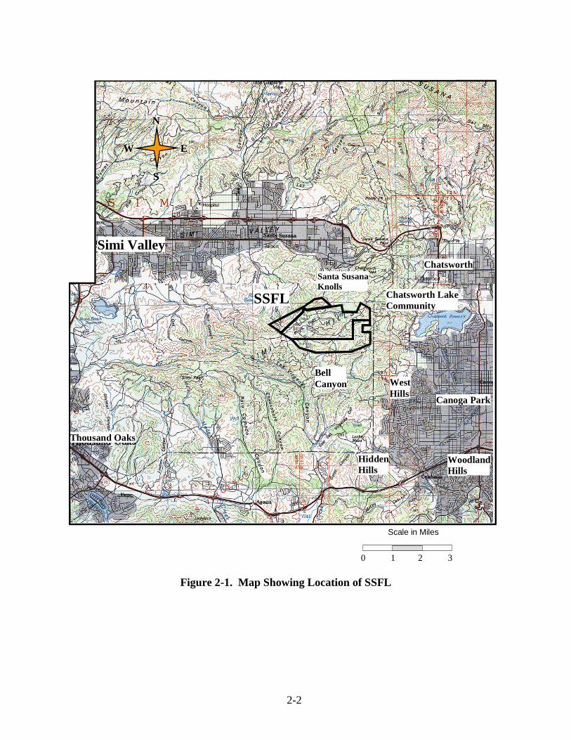
2.1 SITE LOCATION AND SETTING
The SSFL site occupies 2,850 acres located in the Simi Hills of Ventura County, California,
approximately 48 km (30 miles) northwest of downtown Los Angeles. The SSFL is situated on
rugged terrain with elevations at the site varying from 500 to 700 m (1,650 to 2,250 ft) above sea
level (ASL). The location of the SSFL site in relation to nearby communities is shown in Figure
2-1. No significant agricultural land use exists within 30 km (19 miles) of the SSFL site.
Undeveloped land surrounds most of the SSFL site.
The site consists of four administrative areas and undeveloped land. Figure 2-2 illustrates the
arrangement of the site. Area IV has an area of about 290 acres. Boeing and DOE-operated
facilities (Figures 2-3 and 2-4) share the Area IV portion of this site. While the land immediately
surrounding Area IV is undeveloped, suburban residential areas are at greater distances. The
community of Santa Susana Knolls lies 4.8 km (3.0 miles) to the northeast, the Bell Canyon area
begins approximately 2.3 km (1.4 miles) to the southeast, and the Brandeis-Bardin Institute is
adjacent to the north. Except for the Pacific Ocean, which is approximately 20 km (12 miles)
south, no recreational body of water of noteworthy size is located in the surrounding area. Four
major reservoirs providing domestic water to the greater Los Angeles area are located within 50
km (30 miles) of SSFL; the closest one to SSFL (Bard Reservoir, near the west end of Simi
Valley) is more than 10 km (6 miles) from Area IV.
2-2
Figure 2-1. Map Showing Location of SSFL
SSFL
Simi Valley
Santa Susana
Knolls
Hidden
Hills
Thousand Oaks
Chatsworth Lake
Community
Chatsworth
Canoga Park
West
Hills
Woodland
Hills
Bell
Canyon
N
E
S
W
Scale in Miles
0 1 2 3

2-3
Subdivisions
Owner Jurisdiction Acres Subtotals
Boeing Boeing--Area IV Boeing—Area I and III Boeing (Undeveloped land)
289.9 784.8
1,324.6
2,399.3
Government NASA (former AFP 57) NASA (former AFP 64)
409.5 41.7
451.2
Total Acres 2,850.5
Figure 2-2. Santa Susana Field Laboratory Site Arrangement
U.S. Government (NASA)
41.7 acres Boeing
Undeveloped land 182.0 acres
Undeveloped Land
U.S. Government (NASA) Area II
409.5 acres Boeing Area IV
289.9 acres Area IV
Area IV
289.9 acres
Boeing Area I
670.6 acres
Boeing Undeveloped Land 1,142.6 acres
To Susana Knolls
To Valley Circle Blvd.
Ventura County
Los Angeles County
N
E
S
W
Boeing Area III
Area III
114.2 acres
acres
9964-1

2-4
2.2 OPERATIONAL HISTORY
The SSFL has been used for various research, development, and test projects funded by
several U.S. government agencies, including DOE, Department of Defense (DOD), and National
Aeronautics and Space Administration (NASA). Since 1956, various R&D projects had been
conducted in Area IV, including small tests and demonstrations of reactors and critical
assemblies, fabrication of reactor fuel elements, and disassembly and declading of used fuel
elements. These projects were completed and terminated in the course of the next 30 years.
Details about these projects can be found in the DOE website devoted to the Energy Technology
Engineering Center (ETEC) closure (http://www.etec.energy.gov).
All the nuclear R&D operations in Area IV ceased in 1988. The only work related to the
nuclear operations after 1988 was the cleanup and decontamination of the remaining inactive
radiological facilities and the off-site disposal of radioactive waste. In 1998, DOE awarded
Boeing a contract for the closure of all DOE facilities in Area IV. Boeing performs the
environmental remediation and restoration activities at SSFL for the DOE. In May 2007, the
D&D activities in Area IV were suspended by the DOE, pending completion of an
Environmental Impact Statement (EIS).
2.3 FACILITY DESCRIPTIONS
There were 27 radiological facilities that operated in Area IV (See Figure 2-4). As of the end
of 2011, twenty of them have been released for unrestricted use, four have been declared suitable
for unrestricted release by DOE, and one (the Building 4059 site) is pending release for
unrestricted use. Demolition is pending for two facilities, Building 4024 and the RMHF. Six
remaining former radiological facilities have been declared free of contamination; they are 4009,
4100, 4019, 4055, 4011 and 4029.
In addition to radiological facilities, two sodium and related liquid metal test facilities remain
in Area IV. They are the Sodium Pump Test Facility (SPTF) and the Hazardous Waste
Management Facility (HWMF). These were constructed at SSFL to support development testing
of components for liquid metal electrical power production systems. The facilities are no longer
needed, and the objective is to dismantle the structural steel, concrete and utilities, and restore
the land to previous conditions.
2.3.1 Radiological Facilities
Radioactive Materials Handling Facility (RMHF)
The RMHF complex consists of Buildings 4021, 4022, 4034, 4044, 4075, 4563, 4621, 4658,
4665 and 4688. Sump 4614 was a holdup pond located at the base of the drainage channel west
of the RMHF complex. The use of the pond was discontinued, and the pond was excavated in
2006. The drainage channel and pond have been replaced with an above ground storage tank, and
the tank receives storm water runoff from the RMHF via a drainage pipe.
Operations at RMHF included processing, packaging, and temporary storage of radioactive
waste materials for offsite disposal at DOE approved facilities. The radioactive waste included

2-5
uranium, plutonium, mixed fission products such as cesium-137 (Cs-137) and strontium-90 (Sr-
90), and activation products such as cobalt-60 (Co-60), europium-152 (Eu-152), and tritium (H-
3).
Since May 2007, the D&D operations at the RMHF have been suspended. In 2011, no
effluents were released into the atmosphere through the stack at the RMHF, and no radioactive
liquid effluents were released from the facility
Figure 2-3. Santa Susana Field Laboratory Site, Area IV (2005)

2-6
Figure 2-4. Map of Prior and Current Radiological Facilities in Area IV
Building 4024
Building 4024, the SNAP Environmental Test Facility, housed four experimental reactor
systems in the 1960s. Following termination of the experimental projects, all equipment and fuel
were removed from the facility. The shielding concrete in the vaults has low levels of activation
products including cobalt-60 and europium-152. Remediation of the building started in 2004: the
portions of the building used to support the office space and the mechanical ventilation systems
were demolished, the ventilation stack was removed, and a geophysical study supporting final
building demolition was completed. In 2007, demolition of the building was put on hold by the
DOE.
4055
4020
OCY
4373
4073
4030 4064
4029 4093
4023 4005
4363
4011 17th Street Drainage Area
4886
4009 4100
4059 4019
4010 4028
4024 RMHF
4654
SRE
4003
4012
Legend Facilities Already Remediated Facilities to Be Remediated
Undeveloped Area
9964-5

2-7
Building 4059
Building 4059 is the former Systems for Nuclear Auxiliary Power (SNAP) reactor ground
test facility. The demolition of the entire building was completed in 2004, and radioactively
contaminated building debris was shipped to the Nevada Test Site. In 2005, site backfill was
completed, and the final status MARSSIM survey was completed. Both DPH and ORISE have
completed their verification surveys at the Building 4059 site. Currently, the site is pending
release for unrestricted use.
2.3.2 Former Sodium Facilities
Sodium Pump Test Facility (SPTF)
All utility connections to the facility buildings were severed in 2007. Demolition of building
4461 was completed in early 2007. In May 2007, DOE halted demolition of the SPTF, and the
remaining buildings (4462 and 4463) were placed into a safe shutdown condition.
Hazardous Waste Management Facility (HWMF)
The Hazardous Waste Management Facility, a permitted facility consisting of buildings 4133
and 4029, was approved for closure and demolition by the DTSC in 2006. In May 2007, DOE
halted plans for demolition. This facility is maintained in a safe shutdown mode.
2.4 ASER CONTENTS
This ASER provides the following information related to ensuring protection of human
health and the environment for DOE’s operations at Area IV:
Section 3 “Compliance Summary”, identifies and provides status for applicable permits
and other regulatory requirements for DOE’s closure mission.
Section 4 “Environmental Program Information” summarizes the DOE and Boeing
programs that are in place to institutionalize the identification, monitoring and response
to known or potential releases to the environment that may pose a threat to human health
and the environment.
Section 5 “Environmental Radiological Monitoring” summarizes the data collection
activities and associated results for radiological contaminants.
Section 6 “Environmental Non-Radiological Monitoring” summarizes the data collection
activities and associated result for non-radiological contaminants.
Section 7 “Environmental Monitoring Program Quality Control” summarizes the quality
assurance/quality control elements incorporated into the Boeing data analysis program.

2-8
This page intentionally left blank.

3-1
3. COMPLIANCE SUMMARY
This section summarizes Boeing’s compliance with federal, state, and local environmental
regulations. Two main categories are presented: Section 3.1 discusses compliance status, and
Section 3.2 discusses current issues and actions.
3.1 COMPLIANCE STATUS
During 2011, seven regulatory agency inspections, audits, and visits were conducted in Area
IV. These inspections and visits were carried out by the California Department of Public Health
(DPH), County of Ventura Environmental Health Division (EHD), and Ventura County Air
Pollution Control District (VCAPCD).
A list of inspections, audits, and site visits by the various agencies overseeing the SSFL sites
is given in Table 3-1.
Table 3-1. 2011 Agency Inspections/Visits Related to DOE Operations
Date (2011) Agency Subject Area Results
January State of CA, DPH Quarterly Environmental TLD Exchange Compliant
February Ventura County VCAPCD
Inspect permit to Operate #00232 (for DOE operations in Area IV)
Compliant
February Ventura County EHD
CUPA Program Inspection (Annual Business Plan and Hazardous Waste Inspection
Compliant
April State of CA, DPH Inspection of Radioactive Material License (0015-19) activities
Compliant
April State of CA, DPH Quarterly Environmental TLD Exchange Compliant
June State of CA, DPH Quarterly Environmental TLD Exchange Compliant
September State of CA, DPH Quarterly Environmental TLD Exchange Compliant
3.1.1 Radiological
The radiological monitoring programs at the SSFL comply with the applicable federal, state,
and local environmental regulations. The monitoring results indicate that the SSFL does not pose
any significant radiological impact on the health and safety of the general public. All potential
pathways, as illustrated in Figure 3-1, are monitored. These include airborne, direct exposure,
groundwater, surface water, waste disposal, and recycling.

3-2
3.1.1.1 Airborne Activity
Due to the suspension of all DOE’s Decontamination and Decommissioning (D&D)
operations at SSFL, no effluents from the RMHF stack were released into the atmosphere in
2011. As a result, the potential radiation exposure dose from the airborne release was zero.
For the airborne releases from the RMHF exhaust stack, the maximum radiation exposure
dose to an offsite individual is limited to 10 mrem/yr or less, as specified in 40 CFR 61, the
National Emission Standards for Hazardous Pollutants (NESHAPs), Subpart H (DOE facilities).
3.1.1.2 Groundwater
There are 11 DOE-sponsored near-surface groundwater wells and 50 DOE-sponsored
Chatsworth Formation wells in and around Area IV. Groundwater is sampled and analyzed
periodically for radiological constituents, which include gross alpha, gross beta, tritium (H-3),
potassium-40 (K-40), strontium-90 (Sr-90), isotopic uranium, and man-made beta/gamma
emitters. Annual Groundwater Reports are presented online when they become available.
http://www.etec.energy.gov/Char_Cleanup/Groundwater.html
3.1.1.3 Surface Water
Surface water is regulated under the Los Angeles Regional Water Quality Control Board (LA
RWQCB) National Pollutant Discharge Elimination System (NPDES). The existing NPDES
Permit (CA0001309) for SSFL allows the discharge of storm water runoff, treated groundwater
and fire suppression water into Bell Creek, a tributary to the Los Angeles River. The permit also
regulates the discharge of storm water runoff from the northwest slope (Area IV) locations into
the Arroyo Simi, a tributary of Calleguas Creek. Discharge along the northwest slope (RMHF:
Outfall 003, SRE: Outfall 004, FSDF #1: Outfall 005, FSDF #2: Outfall 006, and Building 4100:
Outfall 007) generally occurs only during and immediately after periods of heavy rainfall. The
permit applies the numerical limits for radioactivity established for drinking water supplies to
discharges through these outfalls. The permit requires radiological measurements of gross alpha,
gross beta, tritium, strontium-90, total combined radium-226 and radium-228, potasium-40,
cesium-137 and uranium isotopes. Detailed monitoring results are provided in the 2011 Annual
NPDES Discharge Monitoring Report (Boeing, 2012). The report may also be viewed at:
http://www.boeing.com/aboutus/environment/santa_susana/ents/monitoring_reports.html
3.1.1.4 Direct Radiation
The external exposure rate at Boeing SSFL’s northern property boundary, the closest
property boundary to the RMHF, was indistinguishable from natural background. This property
line is approximately 300 meters from the RMHF and separated by a sandstone ridge, effectively
shielding the boundary from any direct radiation from the RMHF. Dosimeters placed on the
RMHF side of this sandstone ridge, approximately 150 meters from the RMHF, read an average
of 8.8 mrem/year above local background. This is considerably below DOE’s 100 mrem/year
limit.

3-3
Figure 3-1. Conceptual Model of Potential Pathways
Facility
Transport to
RMHF for
solidification
Sta
ck
Offsite/Onsite
Deposition
Disposed offsite
Emissions/exhaust
passed through HEPA
filters and monitored for
gross alpha and beta
and isotopic specific
content
Following solidification, waste
leaving RMHF is disposed of at
radioactive waste disposal
facilities
Air Emissions
Soil samples collected
and ambient radiation is
monitored to determine if
there has been
deposition
Onsite Soil
During leachfield remediation
soil samples were collected to
confirm soil was not impacted
Retention Pond R-2A
Water samples taken
at retention pond
outfalls following
precipitation
Sanitary Leachfields (pre-1961)
Sitewide Sanitary Sewer System (post-1961)
Non-
Radioactive
Drains
Radioactive
Drains
Radioactive
Waste Holding
Tank
Discharged offsite
Overflow from the R-2A pond is
discharged to Bell Creek in
accordance with NPDES permits.
Area III
Sewer Pond
The Area III sewage
pond was equipped
with a real time
radiation detector
Groundwater
Wells
On- and Off-Site
Monitoring
Groundwater monitoring
wells exist on and off-site
and samples are collected
on a quarterly basis
Several sampling
locations where
surface water collects
exist across the site
NPDES Sampling
LocationsSurface Water Drainage
Runoff from precipitation
events and facility
operations

3-4
3.1.1.5 Protection of Biota
There is no aquatic system in the Area IV of SSFL. Storm water discharge from the site is
monitored in accordance with the NPDES permit (see Section 3.1.1.3 above).
The terrestrial biota, i.e., vegetation and small wild animals, are abundant at SSFL. They are
subject to potential exposure to the radioactivity in soil. Screening analysis indicates that the
potential radiation exposure is less than the dose limit recommended by the DOE. Section 5.4
provides detailed information on biota protection.
3.1.2 Chemical
3.1.2.1 Resource Conservation and Recovery Act
The Resource Conservation and Recovery Act (RCRA) gives the Environmental Protection
Agency (EPA) broad authority to regulate the handling, treatment, storage, and disposal of
hazardous wastes. This authority has been delegated to the California EPA and DTSC. DOE
owns and co-operates two RCRA-permitted Treatment, Storage, and Disposal Facilities within
ETEC. Permit numbers are listed in Section 3.1.3.
Radioactive Materials Handling Facility (RMHF)
In 2011, the RMHF continued to be permitted as an Interim Status (Part A) facility. This
facility is used primarily for the handling and packaging of low-level radioactive and mixed
wastes. Interim status is required for the storage and treatment of the small quantities of mixed
waste (waste containing both hazardous and radioactive constituents) resulting from D&D
activities at ETEC. The final disposition of mixed waste is addressed under the DOE and DTSC-
approved Site Treatment Plan, which is authorized by the Federal Facilities Compliance Act
(FFCAct). Currently there is no mixed waste at RMHF. The RMHF is in a safe shutdown mode
since May 2007.
Hazardous Waste Management Facility (HWMF)
The Hazardous Waste Management Facility (HWMF) includes an inactive storage facility
(Bldg 4029) and an inactive treatment facility (Bldg 4133) that was utilized for reactive metal
waste such as sodium. The facility is no longer in operation and is awaiting final closure.
RCRA Facility Investigation
Under the Hazardous and Solid Waste Amendments of 1984, CRA facilities can be brought
into the corrective action process when an agency is considering any RCRA permit action for the
facility. The SSFL was initially made subject to the corrective action process in 1989 by EPA,
Region IX. The EPA has completed the Preliminary Assessment Report and the Visual Site
Inspection portions of the RCRA Facility Assessment (RFA) process. ETEC is now within the
RCRA Facility Investigation (RFI) stage of the RCRA corrective action process under DTSC
oversight for investigation of groundwater.

3-5
During 2011, 82 near-surface groundwater and 16 spring/seep samples were collected within
or near Area IV. Data review and validation were completed in 2011.
Administrative Order on Consent (AOC)
In December 2010, DOE and DTSC signed an Administrative Order on Consent (AOC),
which outlines a specific soil investigation and remediation program for all of Area IV.
Groundwater investigation and remediation is still being conducted under RCRA Corrective
Action requirements specified in the 2007 Consent Order between DTSC, Boeing and DOE.
Sampling in Area IV Subarea 5C commenced in October 2010, and included surface soils,
drainages, and subsurface borings. During 2011, soil sampling was conducted in Subareas 5A,
5B, 5C, 5D, 6, 7, and 8, and in the Northern Buffer Zone (NBZ).
During 2011, 2,092 soil matrix samples were collected within Area IV and the NBZ.
Samples collected and analyses performed to date at DOE locations are summarized in Section 6
(Table 6-3). Data review and validation were completed in 2011. These sampling results, along
with previous sampling results, are undergoing a data gap evaluation and additional soil samples
are being proposed to complete characterization during 2012 and 2013.
Groundwater
Characterization of the groundwater at the site continues. Five distinct areas of TCE-
impacted groundwater have been delineated inside the northwestern property boundary of Area
IV, as shown in the shaded areas in Figure 6-3. In 2011, high concentrations of TCE continued to
be detected in or near four of these areas. TCE was not analyzed for the fifth area. Detailed TCE
results are provided in Section 6.3.
3.1.2.2 Federal Facilities Compliance Act
Boeing manages DOE’s RCRA mixed wastes in accordance with FFCAct-mandated Site
Treatment Plan (STP) approved in October 1995. All mixed wastes that require extended on-site
storage are managed within the framework of the STP. Characterization, treatment, and disposal
plans for each of several different waste streams are defined in the STP with enforceable
milestones. Management of the mixed wastes has been in full compliance with the STP. In 2011
there were no mixed wastes in the inventory, and there were no additions or removals.
3.1.2.3 National Environmental Policy Act
The National Environmental Policy Act (NEPA) establishes a national policy to ensure that
consideration is given to environmental factors in federal planning and decision-making. For
those projects or actions expected to either affect the quality of the human environment or create
controversy on environmental grounds, DOE requires that appropriate NEPA actions
(Categorical Exclusion [CX], Environmental Assessment [EA], Finding of No Significant Impact
[FONSI], or Notice of Intent [NOI], draft Environmental Impact Statement [EIS], final EIS,
Record of Decision [ROD]) have been incorporated into project planning documents.
The DOE issued a Finding of No Significant Impact and the final EA report on March 31,
2003. Subsequently, the Natural Resources Defense Council, City of Los Angeles, and the

3-6
Committee to Bridge the Gap filed a lawsuit in federal court, claiming DOE had violated NEPA,
CERCLA and the ESA. Pursuant to a court order, an EIS is being prepared to comply with
NEPA.
3.1.2.4 Clean Air Act
The original 1970 Clean Air Act (CAA) authorized the Federal EPA to establish National
Ambient Air Quality Standards (NAAQS) to limit the levels of pollutants in the air. EPA has
promulgated NAAQS for six criteria pollutants: sulfur dioxide, nitrogen dioxide, carbon
monoxide, ozone, lead, and particulate matter. All areas of the United States must maintain
ambient levels of these pollutants below the ceilings established by the NAAQS; any area that
does not meet these standards is considered a “non-attainment” area (NAA). Under this law,
states are required to develop state implementation plans (SIPs) that explain how each state will
carry out its responsibilities under the CAA. However, the EPA must approve each SIP, and it
may enforce the CAA itself if it deems a state’s SIP unacceptable. Other requirements include
National Emissions Standards for Hazardous Air Pollutants (NESHAPs), New Source
Performance Standards (NSPSs), and monitoring programs established to achieve air quality
levels beneficial to the public health and environment.
Area IV of the SSFL is regulated by the Ventura County Air Pollution Control District
(VCAPCD) and must comply with all applicable rules, regulations, and permit conditions. DOE
previously operated under Permit to Operate No.00271. In 2008, this Permit was consolidated
with the existing permit No. 00232. As a result, DOE currently operates under Permit to Operate
No. 00232. The VCAPCD performed its annual inspection of Area IV on February 23, 2011. No
violations or compliance issues were identified.
3.1.2.5 Clean Water Act
The Clean Water Act (CWA) is the primary authority for water pollution control programs,
including the National Pollutant Discharge Elimination System (NPDES) permit program. The
NPDES program regulates point source discharges of surface water and the discharge of storm
water runoff associated with industrial activities.
Surface water discharges from SSFL are regulated under the California Water Code
(Division 7) as administered by the Los Angeles Regional Water Quality Control Board
(LARWQCB). The existing NPDES Permit (CA0001309) for SSFL was revised on June 16,
2010, and became effective on July 19, 2010. The 2010 NPDES Permit incorporated the General
Permit (No. CA0001309) for storm water, which includes the requirement for a site-wide Storm
Water Pollution Prevention Plan (SWPPP). The SWPPP is revised as needed and includes by
reference many existing pollution prevention plans, policies, and procedures implemented at the
SSFL site. Several key elements of the plan, including maps, are continually updated. Another
key element is the Boeing procedure "SSFL Storm Water Pollution Prevention Requirements."
The Spill Prevention Control and Countermeasure (SPCC) plan serves to identify specific
procedures for handling oil and hazardous substances to prevent uncontrolled discharge into or
upon the navigable waters of the State of California or the United States. The U.S. EPA requires
the preparation of an SPCC plan by those facilities that, because of their locations, could
reasonably be expected to discharge oil in harmful quantities into or upon navigable waters. A

3-7
revised SPCC plan was submitted as a part of the revised Hazardous Materials Release Response
Business Plan to the County of Ventura Environmental Health Division in March 2012.
3.1.3 Permits and Licenses (Area IV)
Listed below are the permits and licenses applicable to activities in Area IV.
Table 3-2. SSFL Permits
Permit/License Facility Valid
Air (VCAPCD)
Permit 00232 Combined permit renewed
Current
Ventura County
Grading Permit 9225/CUP 02488
Soil Borrow Area Current
Treatment Storage (EPA)
CAD000629972 (93-3-TS-002)
Hazardous Waste Management Facility(Bldg/133 and Bldg/029)
Inactive. The closure plan was approved on 12/22/06, but demolition has been suspended based on the DOE stop work order and DTSC direction.
CA3890090001 Radioactive Materials Handling Facility (RMHF)
Draft closure plan submitted in 2007.
NPDES (LARWQCB)
CA0001309 Santa Susana Field Laboratory
Current
State of California
Radioactive Materials License(0015-19)
All Boeing SSFL facilities Current
Storm Water Pollution Prevention Plan56C312650
Area IV Current

3-8
3.2 CURRENT ISSUES AND ACTIONS
3.2.1 Area IV Environmental Impact Statement
Pursuant to a federal court order issued in May 2007, the DOE is preparing an
Environmental Impact Statement (EIS) for Area IV. Activities conducted in support of this EIS
during 2011 are described below.
In October 2010, DOE initiated a “chemical co-located sampling” program. This program
leverages the ongoing EPA radiological soil sampling initiated in October. DOE initiated the co-
located sampling program in October 2010 and completed it in November 2011, including
northern drainages co-located sediment sampling. The program involved co-located sampling
and analysis for chemical constituents at a majority of the same locations at which EPA collected
soil samples for radiological analysis. Thus, the co-located sampling program benefitted from the
extensive “Historical Site Assessment” document review, geophysical surveys and aerial
photograph interpretation, conducted by EPA to target sampling locations in areas of suspected
contamination.
DOE completed a road conditions analysis for potential transportation routes to and from the
SSFL property. The transportation study will be used in preparation of the EIS and in remedial
planning for soil cleanup.
DOE conducted monthly community site visits and bi-monthly community meetings in
conjunction with the US EPA and California DTSC. The tours included inspection of ongoing
field activities and areas of interest to stakeholders involved in the site investigation.
Stakeholders also provided input to planning for co-located soil sampling described above.
3.2.2 Radiological Decommissioning and Decontamination
Since May 24, 2007, the decommissioning and decontamination of the remaining DOE
facilities in Area IV is on hold following the federal court order to conduct an EIS.
3.2.2.1 Radioactive Materials Handling Facility
During 2011, the RMHF remained in a safe shutdown mode with operations limited to
routine inspections and surveys.
Rainwater infiltrated into the Building 4022 vaults and sumps during the 2009-2010 rain
seasons and was found to have low levels of cesium-137 and strontium-90 as a result of
interaction with the vault floors. This water was stabilized (solidified) and shipped to the Nevada
National Security Site (formally Nevada Test Site) as LLW in March 2011.
The status of the D&D at the Radioactive Materials Handling Facility (RMHF) may be found
at:
http://www.etec.energy.gov/Operations/Support_Ops/RMHF.html
http://www.etec.energy.gov/Library/RMHFDocRecord.html
3-9
3.2.2.2 SNAP Environmental Test Facility
During 2011, the SNAP Environmental Test Facility (Building 4024) remained in a safe
shutdown mode with operations limited to routine inspections and surveys.
The status of the D&D of the Building 4024 may be found at:
http://www.etec.energy.gov/Operations/Major_Operations/SNAP.html
http://www.etec.energy.gov/Library/Building24DocRecord.html
Groundwater that infiltrates into the cells and French drain of Building 4024 is routinely
pumped out into Baker tanks. This water is sampled for radionuclides, and periodically for
chemicals, prior to being shipped off-site as non-hazardous waste water. No nuclear by-product
materials have been detected in this groundwater.
3.2.3 Disposal of Non-radiological Waste
In 2011, miscellaneous equipment, debris, purge water and rinse water was surveyed and
released for disposal.
In 2011, no metal from DOE radiological facilities was recycled.
3.2.4 Administrative Order of Consent (AOC)
In December 2010, the DTSC and DOE signed an Administrative Order of Consent for
Remedial Action (AOC) that defines the process for characterization and the cleanup end-state
for Area IV of the Santa Susana Field Laboratory (SSFL). As defined in the AOC, the end state
of the site (Area IV and the Northern Buffer Zone) after cleanup will be background (i.e., at the
completion of the cleanup, no contaminants will remain in the soil above local background
levels). The EPA radionuclide background study (Section 3.2.5) will provide data sufficient
for DTSC to determine “background threshold values” (BTV) for use in a look-up table to be
used in making radiological remedial decisions following completion of the EPA Area IV
Radiological Characterization Survey (Section 3.2.5). Likewise, the DTSC Chemical
Background Study will provide data sufficient for DTSC to determine “background threshold
values” (BTV) for use in a look-up table to be used in making remedial decisions for chemical
contaminants.
http://www.etec.energy.gov/Char_Cleanup/AOC.html
3.2.5 EPA Background Study and Characterization Survey of Area IV
In July 2008, the DOE and EPA signed an inter-agency agreement, making available $1.5M
for the EPA to conduct a radionuclide background study. Subsequently, the EPA published a
“statement of work” describing the scope of this work and hosted a public meeting on December
11, 2008.

3-10
In April 2009, DOE and EPA signed a second interagency agreement, making available
$38.3M for the EPA to conduct “Radiological Characterization of Area IV at SSFL.” EPA
conducted numerous planning and status meetings with DOE, Boeing, community members and
other stakeholders to plan these studies.
In August 2009, Boeing and DOE provided EPA with historical documents in response to a
CERCLA 104(e) document request to support an Area IV Historical Site Assessment (HSA).
Both Boeing and DOE have supplemented this initial document provision with numerous
additional document provisions in 2010 and 2011.
In March 2010, Boeing and EPA signed an Administrative Order of Consent (AOC) that
describes the access agreement and requirements for EPA and its contractors to conduct work in
Area IV.
Thus far, EPA has completed surface gamma scanning of 100% of accessible portions of
Area IV, taken over 2,500 surface and subsurface soil samples, completed two rounds of
groundwater sampling in 2010Q3 and 2011Q1, and completed the Historical Site Assessment
Technical Memos for Subareas 3, 5A, 5B, 5C, 5D, 6, 7, 8 and the NBZ. Numerous public
meetings have been conducted, presenting status and results to the public in a timely fashion.
Results of all background samples have been compiled and presented to the public in March
and May 2011. EPA has proposed to DTSC and other stakeholders that “background threshold
values” (BTV) be chosen for the AOC “look-up table” using the 95% upper simultaneous limit
(USL95). USL95 represents that statistic such that all observations from the "established"
background data set will be less than or equal to USL95 with a confidence coefficient of 95%.
Radiological trigger levels (RTL) were proposed by EPA in December 2011 based on the higher
of the BTVs or the minimum detectable concentrations (MDC).
In their May 2012 Factsheet, EPA stated,
“Less than one percent of radioactive contaminants analyzed exceeded screening tools,
called the Radioactive Trigger Levels (RTLs),used to indicate areas of contamination. So far,
EPA has not found any unexpected radioactive contamination. Radiological contamination
has primarily been limited to locations in the vicinity of the Sodium Reactor Experiment
(SRE), the Radioactive Material Handling Facility (RMHF), and a few other locations, all
onsite.”
“In general, EPA found elevated radiation levels in the areas where we expected to find
them, isolated to a number of former process or disposal areas.”
“Based on these soil studies, we have not found any significant surprises in the soil data.”
In May 2012, EPA released the draft final groundwater report. EPA drinking water MCLs
were only exceeded for anthropogenic radionuclides in one well, RD-98, for Sr-90, and in three
wells, RD-88, RD-90 and RD-95, for tritium. EPA observed that, uranium isotopic ratios, in
samples that exceeded uranium MCLs, were consistent with naturally occurring (non-enriched)
uranium, and the few gross alpha/beta exceedances were due to high suspended solids.

3-11
Work plans, schedules, meeting materials, status reports, etc. may be found on the EPA
website at,
http://www.epa.gov/region09/santasusana
3.2.6 DOE CleanUpdate
DOE continued its quarterly newsletters called “CleanUpdate” to provide stakeholders with
an update on its activities on the ETEC Closure Project. In 2011, three CleanUpdates were
published in February, June and October. In 2012, one CleanUpdate has so far been published in
March.
These CleanUpdates may be found at:
http://www.etec.energy.gov/Community_Involvement/Newsletters.html

This page intentionally left blank.

4-1
4. ENVIRONMENTAL PROGRAM INFORMATION
At SSFL, the DOE Site Closure Program Office has programmatic responsibility in
accordance with Boeing contract for the former radiological facilities, former sodium test
facilities, and related cleanup operations. DOE Site Closure is responsible for environmental
restoration and waste management operations in Area IV, where DOE funded programs
conducted energy related research and development. Environmental restoration activities include
decontamination and decommissioning (D&D) of radioactively contaminated facilities, building
demolition, treatment of sodium, assessment and remediation of soil and groundwater,
surveillance and maintenance of work areas, and environmental monitoring. Waste management
activities include waste characterization and certification, storage, treatment, and off-site
disposal. Waste management activities are performed at the Radioactive Materials Handling
Facility (RMHF) for radioactive and mixed waste. The Hazardous Waste Management Facility
(HWMF) has been used to handle alkali metal waste, but it is now inactive and awaiting closure
pending completion of the EIS.
4.1 ENVIRONMENTAL PROTECTION AND REMEDIATION
Oversight of environmental protection at SSFL is the responsibility of Boeing’s
Environment, Health and Safety (EHS) department. This department provides support for
environmental management and restoration. The stated policy of EHS is “To support the
company’s commitment to the well-being of its employees, community, and environment. It is
Boeing’s policy to maintain facilities and conduct operations in accordance with all federal,
state, and local requirements and contractual agreements.” Responsibilities for environmental
protection at Boeing SSFL fall under four sub-departments: Environmental Protection (EP),
Environmental Remediation (ER), Radiation Safety (RS), and the ETEC Closure Program
Office. The responsibilities for each are listed below.
Environmental Protection (EP) is responsible for developing and implementing cost-
effective and efficient programs designed to ensure achievement of the policy objectives related
to environmental protection. The EP responsibilities include:
Ensuring compliance with applicable federal, state, and local rules and regulations,
including maintaining a working knowledge of applicable environmental laws,
performing compliance audits, reviewing new and modified facility projects,
coordinating solid and hazardous waste disposal, maintaining required records, preparing
and submitting required regulatory reports, applying for and maintaining permits,
assuring compliance with permit conditions, and performing sampling and analysis.
Responding to uncontrolled releases and reporting releases as required by law and
contractual requirements.
Suspending operations determined to be in violation of environmental regulations.
Providing a program, in conjunction with Technical Skills and Development, for
motivating, informing, and training employees about their duties to comply with
environmental regulations and protect the environment.
Recognizing and responding to the community’s concerns regarding the environmental
impact of operations, including escorting and cooperating with regulatory officials
4-2
interested in environmental matters and responding to requests for information referred to
Communications.
Working with customers and suppliers to minimize the use of materials and processes
that impact the environment while maintaining product quality and competitive pricing.
Making environmental concerns, including energy and raw material conservation, a
priority when evaluating new and existing operations and products or when making
decisions regarding land use, process changes, materials purchases, and business
acquisitions.
The Radiation Safety (RS) function of Health, Safety & Radiation Services is responsible for
providing radiological support for the D&D of radiological contamination at all Boeing SSFL
facilities. The RS responsibilities include:
Compliance with all federal, state, and local regulations pertaining to occupational and
environmental radiation protection.
Provision of health physics oversight of D&D and radioactive waste management
activities.
Performance of final surveys of D&D’d buildings and facilities to demonstrate
acceptability for release for unrestricted use.
Response to employee and public concerns regarding radiological activities and the
impact of these activities on the health and safety of the community.
Environmental Remediation (ER) is responsible for remedial actions to clean up historical
chemical contamination at all SSFL facilities. The ER responsibilities include:
Compliance with all federal, state, and local regulations pertaining to environmental
remediation.
Implementation of groundwater monitoring and treatment.
Implementation of RCRA soil sampling and cleanup activities.
ETEC Closure is responsible for managing the D&D of former DOE nuclear, liquid metal
test, and other (e.g., office and warehouse) facilities in support of the ETEC Closure program.
ETEC Closure responsibilities also include:
Responsibility for the management and shipment to DOE-approved disposal sites of
radioactive waste generated during the D&D operations.
Operation of the Radioactive Materials Handling Facility (RMHF) under an interim
status Part A permitted facility for the management of mixed (radioactive and hazardous)
wastes.
Performance of the routine Surveillance and Maintenance (S&M) activities for DOE-
owned facilities to ensure that the buildings are properly maintained such that the
buildings do not create personnel or environmental safety hazards.

4-3
Responsibility for identifying, removing, staging, and initiating documentation for DOE
equipment being divested.
4.2 ENVIRONMENTAL MONITORING PROGRAM
The purpose of the environmental monitoring program is to detect and measure the presence
of hazardous and radioactive materials, maintain compliance with federal, state, and local laws
and regulations, and identify other undesirable impacts on the environment. It includes
remediation efforts to correct or improve contaminated conditions at the site and prevent off-site
impact. For this purpose, the environment is sampled and monitored, and effluents are analyzed.
A goal of this program is to demonstrate compliance with applicable regulations and protection
of human health and the environment. Environmental restoration activities at the SSFL include a
thorough review of past programs and historical practices to identify, characterize, and correct all
areas of potential concern. The key requirements governing the monitoring program are DOE
Order 5400.5 (DOE, 1993), DOE Order 458.1 (DOE, 2011b), and DOE Order 231.1B (DOE,
2011a). Additional guidance is drawn from California regulations and licenses, and appropriate
standards.
The basic policy for control of radiological and chemical materials requires that adequate
containment of such materials be provided through engineering controls, that facility effluent
releases be controlled to federal and state standards, and that external radiation levels be reduced
to as low as reasonably achievable (ALARA) through rigid operational controls. The
environmental monitoring program provides a measure of the effectiveness of these operational
procedures and of the engineering safeguards incorporated into facility designs.
4.2.1 Historical Radiological Monitoring
Monitoring the environment for potential impact from our past nuclear operations has been a
primary focus of Boeing and its predecessors.
In the mid 1950s, Atomics International (AI), then a Division of North American Aviation
(NAA), began initial plans for nuclear research at its facilities in the west San Fernando Valley.
In 1955, prior to initial operations, it started a comprehensive monitoring program to sample and
monitor environmental levels of radioactivity in and around its facilities.
During the half century history of nuclear research and later environmental restoration, on-
site and off-site environmental monitoring and media sampling have been extensive. In the early
years, soil/vegetation sampling was conducted monthly. Sampling locations extended to the
Moorpark freeway to the west, to the Ronald Reagan freeway to the north, to Reseda Avenue to
the east, and to the Ventura freeway to the south. Samples were also taken around the Canoga
and De Soto facilities as well as around the Chatsworth Reservoir. This extensive off-site
sampling program was terminated in 1989 when all nuclear research and operations (except
remediation) came to an end.
During the 1990s, extensive media sampling programs were conducted in the surrounding
areas, including the Brandeis-Bardin Institute and the Santa Monica Mountains Conservancy to

4-4
the north, Bell Canyon to the south, the Rocketdyne Recreation Center in West Hills to the east,
and various private homes in the Chatsworth and West Hills areas. Samples were also taken from
such distant areas as Wildwood Park and Tapia Park. In addition, monitoring of off-site
radiation, groundwater, and storm water runoff from the site were routinely performed during
this time.
Boeing’s ongoing radiological environmental monitoring ensures that activities at the SSFL,
including cleanup, do not adversely affect either its employees or its neighbors.
Additional details about onsite and offsite monitoring are available at:
http://www.etec.energy.gov/Environmental_and_Health/Enviro_Monitoring.html
4.2.2 Nonradiological Monitoring
Extensive monitoring programs for chemical contaminants in air, soil, surface water, and
groundwater are in effect to assure that the existing environmental conditions do not pose a
threat to the public welfare or the environment. Extensive soil sampling is being performed
under the Resource Conservation and Recovery Act Facility Investigation and other site-specific
remedial programs. Groundwater beneath Area IV was extensively monitored for chemical
groundwater conditions in Area IV. Groundwater analyses were conducted by MWH using a
DTSC-approved sampling and analysis plan and EPA-approved analytical methods and
laboratories.
All surface water discharges were monitored as specified in the National Pollutant
Discharge Elimination System (NPDES) permit, which was most recently revised on June 16,
2010. All sources of air emissions were monitored as required by the Ventura County Air
Pollution Control District (VCAPCD).
In addition to the environmental monitoring and restoration programs, current operational
procedures reflect Boeing’s commitment to a clean and safe environment. For example, solvents
and oils are collected and recycled rather than being discarded. A comprehensive training and
employee awareness program is in place. All employees working with hazardous materials are
required to attend a course on hazardous materials waste management. Environmental bulletins
are available on the Boeing website to promote environmental awareness among all employees.
4.3 INTEGRATED SAFETY MANAGEMENT SYSTEMS (ISMS)
The “ETEC Closure Contract, Integrated Safety Management System Description” details
how the ISMS guiding principles and the core functions are met by utilizing documents such as
Enterprise Policies (POL), Procedures (PRO), Business Process Instructions (BPI), Guides and
site procedures contained in specific ETEC Closure Program documents. General ISMS
guidelines are tailored specifically for the ETEC Closure work. The tailored ISMS integrates
safety, health, and environmental protection into management and work practices at all levels so
the ETEC Closure Contract work is accomplished while protecting the worker, the public, and
the environment. The ISMS Annual Report reviews performance, accomplishments, and

4-5
improvements to the site Integrated Safety Management System. The CY 2011 Annual ISMS
Report submittal was submitted in July 2012.
During 2011, Boeing & CDM continued implementing ISMS principles and participated in
an ISMS Effectiveness Review during November 15-16, 2011. The ISMS Effectiveness Review
report identified no Significant Deficiencies, two Deficiencies and one Area for Improvement.
Deficiencies were associated with (1) the provision of independent QA oversight and (2) QA
records protection. The Area for Improvement recommended improvement to detect and prevent
quality problems. Each of these is being addressed and is expected to be resolved in time for the
2012 ISMS Effectiveness Review. The site ISMS self-assessment plan incorporates monthly
program assessments, site audits, and the review and distribution of DOE Lessons Learned,
Occurrence Reports, and Operating Experience Reports.
To ensure that the ISMS continues to reflect current policies, procedures, processes and
business organization within the context of the ISMS principles, related program documents
continue to be regularly reviewed and updated. Updates for the following documents were
completed in 2011:
ETEC Closure Contract Integrated Safety Management System Description (EID- 04694,
6/13/2011)
Health & Safety Plan for DE-AC03-99SF21530 (EPA-00060, 6/17/2011)
10 CFR 851 Compliance Plan (EPA-00062, 6/17/2011)
ETEC Closure Training Plan (EID-04450, 10/10/2011)
Occurrence Reporting (QA-00003, 4/26/2011)
Demolition Subcontractor General Requirements (PB 08-009, 5/4/2011)
4.4 ENVIRONMENTAL TRAINING
Boeing conducts training and development programs as an investment in human resources to
meet both organizational and individual goals. These programs are designed to improve
employee performance, ensure employee proficiency, prevent obsolescence in employee
capability, and prepare employees for changing technology requirements and possible
advancement.
The Human Resources organization is responsible for the development and administration of
formal training and development programs. Process managers are responsible for individual
employee development through formal training, work assignments, coaching, counseling, and
performance evaluation. Process managers and employees are jointly responsible for defining
and implementing individual training development goals and plans, including on-the-job
training.
The Boeing Santa Susana Environment, Health and Safety (EHS) organization currently
maintains a list of 65 EHS courses for Boeing Santa Susana personnel. Classes are available as
both computer-based training and instructor-lead training. Training is available to employees
through Boeing’s “My Learning” website. Specialized training programs on new technological
developments and changes in regulations are provided, as needed, to ensure effective

4-6
environmental protection and worker health and safety. Additional off-site courses are also
encouraged.
4.5 WASTE MINIMIZATION AND POLLUTION PREVENTION
4.5.1 Program Planning and Development
A Waste Minimization and Pollution Prevention Awareness Plan is in place and serves as a
guidance document for all waste generators at ETEC. The plan emphasizes management’s
proactive policy of waste minimization and pollution prevention, and outlines goals, processes,
and waste minimization techniques to be considered for all waste streams generated at the former
ETEC. The plan requires that waste minimization opportunities for all major restoration projects
be identified and that all cost-effective waste reduction options be implemented.
The majority of waste currently generated at the former ETEC results from environmental
restoration of surplus facilities (now on hold pending completion of EIS) and characterization of
contaminated sites from previous programs. The typical wastes generated at ETEC in 2011 were:
Investigation-Derived Waste (IDW)
Divestment of equipment and supplies
Spill cleanup
Solidified contaminated rain water from RMHF (LLW)
Infiltrated groundwater from Building 4024
Waste minimization is accomplished by evaluating the waste generating processes, identifying
waste minimization options, and finally conducting technical and economic evaluations to
determine the best approach.
4.5.2 Waste Minimization and Pollution Prevention Activities
The following are some significant activities related to waste minimization and pollution
prevention:
Oils used in motor vehicles and compressors are shipped to vendors who recycle them.
Hazardous waste containers in acceptable condition are reused to the maximum extent
possible.
Empty product drums returned to the vendor for reuse when practical.
4.5.3 Tracking and Reporting System
Various categories of materials from procurement to waste disposal are tracked. Radioactive
and mixed wastes are transferred to the RMHF, logged, characterized, and stored at the RMHF.
Documents that accompany the wastes are verified for accuracy and completeness, and filed at
the RMHF. Hazardous waste tracking and verification procedures (from generator to final off-
site disposal) are followed by the EHS department.

4-7
4.5.4 Low Level Waste Shipment
Rainwater infiltrated into the Building 4022 vaults and sumps during the 2009-2010 rain
seasons and was found to have low levels of cesium-137 and strontium-90 as a result of
interaction with the vault floors. The waste water was absorbed in diatomaceous earth, packaged
in 55-gallon drums, and shipped to the Nevada National Security Site (formally Nevada Test
Site) as LLW in March 2011. Also included in the shipment was Personal Protective Equipment
(PPE), such as gloves and protective clothing. The waste was non-hazardous and was slightly
contaminated with radiological constituents.
4.6 PUBLIC PARTICIPATION
Throughout 2011, DOE interacted frequently with community members at public meetings
and on tours, to inform them of plans and progress, to involve them in ongoing planning, and to
educate interested people about highly technical topics. At an average of three meetings per
month, DOE participated in or attended meetings of the SSFL Workgroup, SSFL Public
Participation Group, US EPA's Technical Work Group, DTSC/DOE stakeholder meetings
on characterization and sampling, DTSC's chemical background study updates, community-
sponsored meetings, and other topical meetings.
In September, 2011,prior to proposed trenching activities, DOE hosted a meeting and tour
for representatives from the nearby Chumash and Fernandeno-Tataviam tribes to inform them of
the planned trenching and to ensure them that the trenching activities would be conducted in a
manner that would not disturb Native American artifacts or sacred locations.
In addition to hosting monthly public visitation days, DOE participated in 13 Boeing
sponsored SSFL community bus tours over several Saturdays in 2011 for approximately 600
individuals.
DOE continued its participation in bi-weekly meetings with NASA, Boeing, US EPA, DTSC,
and the Los Angeles Regional Water Quality Board staff to coordinate public outreach efforts.
During 2011, 8 informational email announcements and 3 CleanUpdate Newsletters were
sent to DOE's electronic mailing list of over 2,300 individuals and also in hard copy via regular
mail to an additional 4,300 interested parties.
From March through June of 2011, DOE, along with NASA and Boeing in cooperation with
DTSC, sponsored "Groundwater U" - a series of educational seminars on groundwater, both in
general and specific to SSFL. The series consisted of 7 seminars led by groundwater and
remediation experts, as well as expert panel members. The series concluded with an SSFL field
trip for over 100 of the participations.
Following DOE’s August 2009 community workshop on the Sodium Reactor Experiment
(SRE), DOE committed to interview a broad spectrum of former workers. The objective was to
ensure we have a fully informed history of Area IV operations, including any records that may
exist relevant to the Area IV cleanup. Over 130 former SSFL workers were interviewed in 2010
and 2011. A report was published in November 2011 (P2 Solutions, 2011).

4-8
This page intentionally left blank.

5-1
5. ENVIRONMENTAL RADIOLOGICAL MONITORING/CHARACTERIZATION
The environmental radiological monitoring program at SSFL started before the first
radiological facility was established in 1956. The program has continued with modifications to
suit the changing operations. The selection of monitoring locations was based on several site-
specific criteria such as topography, meteorology, hydrology, and the locations of the nuclear
facilities. The prevailing wind direction for the SSFL site is generally from the northwest, with
some seasonal diurnal shifting to the southeast quadrant. Most rainfall runoff at the SSFL site
flows through several natural watercourses and drainage channels and is collected in two large-
capacity retention ponds. This water may be discharged off-site into Bell Creek to the south. The
storm water from Area IV also flows to the northwest, which is monitored through five NPDES
sampling locations.
Ambient and ventilation exhaust air samples are measured for gross alpha and gross beta for
screening purposes. These screening measurements can quickly identify any unusual release and
provide long-term historical records of radioactivity in the environment. At the end of each year,
the air samples for the entire year are combined and analyzed for specific radionuclides. The
isotopic analysis results are used for estimating the potential off-site dose from air pathway.
Groundwater and surface water samples are analyzed for radioactivity, and the results are
compared with the limits established by the EPA for suppliers of drinking water. The analyses
include gross alpha and gross beta, tritium, Sr-90, radium-226, radium-228, isotopic thorium,
isotopic uranium, and gamma emitters.
Direct radiation is monitored by the thermoluminescent dosimeters (TLDs) located on the
site boundary and throughout the site. To accurately measure low-level ambient radiation,
“sapphire” TLDs, which are very sensitive to low-level radiation, are used. These TLDs are
complemented by TLDs installed by the State of California Department of Health Services
Radiologic Health Branch for independent surveillance.
5.1 AIR EFFLUENT MONITORING
The only potential emission source at the DOE facility at SSFL is the exhaust stack at the
Radioactive Materials Handling Facility (RMHF). In May 2007, DOE suspended all
Decontamination and Decommissioning (D&D) operations at SSFL. As a result, the entire
facility was placed into a safe shutdown mode, and no effluents were released to the atmosphere
through the stack in 2011.
The EPA limit for a DOE site is 10 mrem/yr, as specified in 40 CFR 61, Subpart H. The
regulation also specifies that radiation exposure dose to the Maximally Exposed Individual
(MEI) be calculated using the EPA’s CAP88PC computer model. Due to the fact that no
effluents were released to the atmosphere from the DOE facility at SSFL in 2011, the potential
radiation exposure dose to the MEI was zero.

5-2
5.2 ENVIRONMENTAL SAMPLING
5.2.1 Ambient Air
Due to the temporary suspension of D&D operations at SSFL, the number of environmental
stations was reduced in 2009. The sampling locations, both operating and discontinued, are
shown in Figure 5-1 and listed in Table 5-1.
During 2011, ambient air sampling was performed continuously at SSFL with air samplers
operating on 7-day sampling cycles. Airborne particulate radioactivity was collected on glass
fiber (Type A/E) filters that were changed weekly. The samples were counted for gross alpha and
beta radiation following a minimum 120-hour decay period to allow the decay of short-lived
radon and thoron daughters. The volume of a typical weekly ambient air sample was
approximately 50.4 m3.
Weekly ambient air samples were counted for gross alpha and beta radiation with a low-
background, thin-window, gas-flow proportional-counting system. The system is capable of
simultaneously counting both alpha and beta radiation. The sample-detector configuration
provides a nearly hemispherical (2 ) geometry. The thin-window detector is continually purged
with argon/methane counting gas. A preset time mode of operation is used for counting all
samples.
Counting system efficiencies were determined routinely with Technetium-99 (Tc-99) and
Thorium-230 (Th-230) standard sources. The activities of the standard sources are traceable to
the National Institute of Standards and Technology (NIST).
Filter samples for each ambient air sampling location were combined annually and analyzed
for isotopic-specific activity. The ambient air sampling results, as shown in Table 5-2, had
radionuclide concentrations far below the Derived Concentration Guide (DCG) values. The
variability in the measurements was primarily due to weather effects, as well as analytical and
background variations.
It should be noted that these measurements determine only the long-lived particulate
radioactivity in the air and, therefore, do not show radon (Rn-222) and most of its progeny.
Polonium-210 is a long-lived progeny and is detected by these analyses.
The gross radioactivity guidelines for SSFL site ambient air are based on the reference values
specified in DOE Order 458.1 Chg 1 (DOE, 2011b) and DOE Order 5400.5 (DOE, 1993). The
conservative guide value for alpha activity is 2 x10-14
Ci/mL, and the value for beta activity is 9
x 10-12
Ci/mL. These values are the most restrictive airborne limits for plutonium-239 and
strontium-90 respectively. A complete list of the results from the gross alpha and gross beta
counting of the ambient air samples is given in Table 5-3.

5-3
886
Rete
ntion
Pond R
-2A
020059
RM
HF
064
AR
EA
IV
024
100
SR
E
009
3
4
6
11
EM
B-2
04
00
800
120
0
Scale
in F
ee
t
#T
LD
Do
sim
ete
r
Am
bie
nt
Air
Sam
ple
r
N
E
S
W
Silv
ern
ale
Rete
ntio
n
Pond
14
12
Unde
velo
ped
Lan
d
EM
B-1
Figure 5-1. Map of Santa Susana Field Laboratory Area IV Sampling Stations

5-4
Table 5-1. Sampling Location Description
Station
Location Sampling
Frequency
Ambient Air Sampler Locations A-2 A-3 A-4 A-5 A-6
SSFL Site, 4020, northeast of former 4020 site SSFL Site, RMHF Facility, next to 4034 SSFL Site, 4886, Former Sodium Disposal Facility SSFL Site, RMHF Pond, north side SSFL Site, 4100, east side
(W) (W) Discontinued Discontinued Discontinued
On-site - SSFL - Ambient Radiation Dosimeter Locations SS-3 (CA) SS-4 (CA) SS-6 (CA) SS-7 (CA) SS-8 (CA) SS-9 (CA) SS-11 (CA) SS-12 (CA) SS-13 (CA) SS-14 (CA) SS-15 (CA) EMB-1 (CA) EMB-2 (CA)
SSFL Site, Electric Substation 719 on boundary fence SSFL Site, west boundary on H Street SSFL Site, northeast corner of 4353 SSFL Site, 4363, north side SSFL Site, Former Sodium Disposal Facility north boundary SSFL Site, RMHF northeast boundary at 4133 SSFL Site, 4036, east side SSFL Site, RMHF northwest property line boundary SSFL Site, RMHF northwest property line boundary SSFL Site, RMHF northwest property line boundary SSFL Site, RMHF northwest property line boundary SSFL Site, SRE area north of 4003 SSFL Site, south of Silvernale retention pond, off Test Area Road
(Q) (Q) (Q) Discontinued Discontinued Discontinued (Q)
(Q) Discontinued (Q) Discontinued Discontinued Discontinued
Off-site Ambient Radiation Dosimeter Locations OS-1 (CA) BKG-11 BKG-12 BKG-13
BKG-15 BKG-18 BKG-19 BKG-22
SSFL Front Gate Background Location, West Hills Background Location, Somis Background Location, Hollywood
Background Location, Calabasas Background Location, Agoura Background Location, Westlake Village Background Location, Saugus
(Q) (Q) Discontinued Discontinued
Discontinued Discontinued (Q) Discontinued
Codes Locations A Air Sampler Station W Weekly Sample Q Quarterly Sample
CA State Confirmatory Location
SS SSFL OS Off-site BKG Background
EMB Environmental Management Branch

5-5
Table 5-2. Ambient Air Specific Isotopes – 2011
Radionuclide
Derived Conc. Guide (DCGs)
RMHF
4020
Average
(% of DCGs) ( Ci/mL)
H-3 1E-07 NA NA NA
Be-7 natural ND ND NA
K-40 natural ND ND NA
Mn-54 2E-9 ND ND NA
Co-60 8E-11 ND ND NA
Sr-90 9E-12 ND ND NA
Cs-137 4E-10 ND ND NA
Po-210 natural 9.78E-17 ND 4.89E-17(NA)
Th-228 4E-14 ND ND NA
Th-230 4E-14 ND 4.91E-16 2.45E-16 (0.6%)
Th-232 7E-15 ND ND NA
U-234 9E-14 ND ND NA
U-235 1E-13 5.06E-17 ND 2.53E-17(0.03%)
U-238 1E-13 1.41E-16 1.90E-16 1.66E-16 (0.2%)
Pu-238 3E-14 ND ND NA
Pu-239/240 2E-14 ND ND NA
Pu-241 1E-12 ND ND NA
Am-241 2E-14 ND ND NA
NA = Not applicable
ND = Not detected
Table 5-3. Ambient Air Gross Alpha and Gross Beta—2011
Area Activity Number of Samples
Gross Radioactivity
Average Concentrations
a
( Ci/mL)
Average Percent of
Guideb
SSFL Area IV 4020
Alpha 52
3.68E-15 18.40%
Beta 5.54E-15 0.06%
SSFL Area IV RMHF
Alpha 52
5.78E-15 28.91%
Beta 4.90E-15 0.05% aValues include natural background.
bGuidelines for SSFL site: 2E-14 Ci/mL alpha, 9E-12 Ci/mL beta, DOE Order 5400.5 (01/07/93).
5.2.2 Groundwater
Both Chatsworth Formation wells and shallow wells are utilized to monitor groundwater
conditions in Area IV. The locations of these wells are shown in Figure 6-2. The purpose of
these wells is to monitor concentrations of chemicals and/or radioactivity released by DOE
operations. Water samples from these wells are periodically analyzed for gross alpha, gross beta,

5-6
H-3, K-40, Sr-90, Ra-226, Ra-228, isotopic thorium, isotopic uranium, and man-made
beta/gamma emitters. Complete sampling schedule and analytical results are presented in the
2011 Annual Groundwater Report, which can be found at:
http://www.etec.energy.gov/Char_Cleanup/Groundwater.html
5.2.3 Surface Water
Most of Area IV slopes toward the southeast, and rainfall runoff is collected by a series of
drainage channels and accumulates in the R2A Pond. Water from this pond is eventually released
to Bell Creek under the NPDES permit. Some of Area IV slopes to the northwest, and a small
amount of rainfall drains toward the northwest ravines, which lead into Meier Canyon. To permit
sampling of this runoff, five catch basins were installed in 1989 near the site boundary to
accumulate runoff.
The NPDES Permit No. CA0001309 requires that a discharge monitoring report (DMR) for
the Santa Susana Field Laboratory (SSFL) be published annually. This annual DMR provides
information and data, including summary tables of surface water sample analytical results,
rainfall summaries, liquid waste shipment summaries, and analytical laboratory QA/QC
procedures and certifications. For the period of January 1, 2011 through December 31, 2011, the
NPDES discharge data are provided in the 2011 Quarterly and Annual NPDES Discharge
Monitoring Report (Boeing, 2012).
The 2011 Quarterly and Annual NPDES Discharge Monitoring Reports are also available at:
http://www.boeing.com/aboutus/environment/santa_susana/ents/monitoring_reports.html
5.2.4 Soil
All of the radiological environmental soil sampling was conducted by USEPA in Area IV
during 2011. See Section 3.2.5 for a discussion of the soil sampling conducted by EPA as part of
the Area IV Characterization Survey.
5.2.5 Vegetation
No vegetation samples were collected in 2011.
5.2.6 Wildlife
No animal samples were collected in 2011.
5.2.7 Ambient Radiation
Boeing deploys environmental TLDs that use an aluminum oxide (“sapphire”) chip. These
TLDs are capable of determining doses in increments of 0.1 mrem. Proper use of the control
badges supplied with these dosimeters allows elimination of the natural and transportation
exposure that occurs before, during, and after the deployment of the environmental dosimeters to

5-7
measure the ambient radiation. This usage permits accurate determination of the net exposure
received while the environmental TLDs are in the field, exposed to the ambient radiation.
The State DPH/RHB deploys calcium sulfate (CaSO4) dosimeters for independent
monitoring of radiation levels at SSFL and in the surrounding area. These dosimeters are placed
at specific locations by DPH/RHB along with the Boeing TLDs. The State dosimeters are
collected by the Radiologic Health Branch for evaluation each quarter. Data obtained in 2011 on
these Boeing and State TLDs, are shown in Table 5-4. The small differences between the
Boeing and State results are mainly due to the fact that two different types of TLDs were used in
the measurement.
The natural background radiation level as measured by the off-site TLDs ranges from 57 to
74 mrem/yr. At SSFL, the local background ranges from 64 to 85 mrem/yr, based on the data
from dosimeters SS-3, -4, -6, and -11 as shown in Table 5-4. The variability observed in these
values can be attributed to differences in elevation and geologic conditions at the various sites.
The altitude range for the dosimeter locations is from approximately 260 m (850 ft) ASL at two
off-site locations ( BKG-11 and BKG-19) to a maximum of approximately 580 m (1,900 ft) ASL
at SSFL. Many of the SSFL TLD locations are also affected by proximity to sandstone rock
outcroppings, a condition that results in elevated exposure levels. Radiation doses measured at
locations SS-12 and -14, north of the RMHF are similar to those measured at other locations on-
site.
Table 5-4. 2011 SSFL Ambient Radiation Dosimetry Data
TLD-Locations Annual Exposure (mrem)
By Boeing Average Exposure Rate ( R/h)
Boeing State DPH
SSFL SS-3
SS-4
SS-6
SS-11
SS-12
SS-14
64.3
81.3
84.9
79.7
88.8
83.8
7.3
9.3
9.7
9.1
10.1
9.6
7.3
10.3
8.2
8.2
9.4
8.6
Mean Values 80.4 9.2 8.9
Off-site OS-1
BKG-11
BKG-19
74.1
57.0
57.3
8.5
6.5
6.5
8.2
Mean Values 62.8 7.2 8.2
The external exposure rate at Boeing SSFL’s northern property boundary, the closest
property boundary to the RMHF, is indistinguishable from natural background. This property
line is approximately 300 meters from the RMHF and separated by a sandstone ridge that
effectively shields the boundary from direct radiation from the RMHF. Dosimeters placed on the
RMHF side of this sandstone ridge (SS-12 and –14), approximately 150 meters from the RMHF,

5-8
read an average of 8.8 mrem/year above the local background. This amount is considerably
below the 100 mrem/year limit specified in DOE Order 458.1, Radiation Protection of the Public
and the Environment. The TLD results demonstrate that the potential external exposure at the
site boundary is below the DOE’s dose limit.
The SSFL local background, calculated as the average of all onsite TLDs (excluding SS-12
and SS-14), is 76 mrem/year. This value is 13 mrem/year higher than the average of offsite
background of 63 mrem/year. This result can be attributed to the contribution of higher elevation
and different geology. Offsite TLDs are located in Boeing staff members’ backyards, surrounded
by natural soil. In contrast, SSFL lies atop the Chatsworth Formation. The Chatsworth Formation
is composed of arkosic sandstone, rich in feldspar. Arkosic rocks are often high in uranium
content. As a result, the Chatsworth Formation rocks produce higher radiation exposure than the
soil of the surrounding valleys.
5.3 ESTIMATION OF RADIATION DOSE
5.3.1 Individual Dose
In accordance with regulations, the total effective dose equivalent (TEDE) to any member of
the public from all pathways (combining internal and external dose) shall not exceed 100
mrem/yr (above background) for DOE facilities. Although the two TLD monitoring stations to
the north of the RMHF, namely SS-12 and –14, recorded an external dose level at 8.8 mrem
above the local background, the actual dose at the property boundary is likely to be
indistinguishable from the natural background. This is because the high rocky terrain between
the actual property line and the TLD monitoring stations acts as an effective shield and makes
the exposure from direct radiation at the property line indistinguishable from background.
Exposure from direct radiation at the nearest residence would also be indistinguishable from
background for the same reason.
Due to the fact that no effluents were released to the atmosphere through the RMHF stack in
2011, the potential internal dose from airborne releases is zero mrem. For DOE operations, the
air pathway standard is 10 mrem/yr (CEDE), as established by EPA.
Public exposure to radiation and radioactivity is shown in Table 5-5. The table presents the
estimated exposures in comparison to the regulatory standards. Dose values in the tables
represent both internal and external exposures.
5.3.2 Population Dose
Since no effluents were released to the atmosphere during 2011, the potential collective dose
to the general population was zero person-rem.

5-9
Table 5-5. Public Exposure to Radiation from DOE Operations at SSFL
1. All pathways
1. Maximum estimated external dose to an individual from direct 0 mrem/yr radiation 2. Maximum estimated internal dose to an individual 0 mrem/yr Limit 100 mrem/yr (“Radiation Protection of the Public and the Environment” DOE Order 458.1)
2. Air pathway (reported in NESHAPs report) 0 mrem/yr
Limit (40 CFR 61, Subpart H) 10 mrem/yr
5.4 PROTECTION OF BIOTA
DOE Order 458.1, "Radiation Protection of the Public and the Environment", requires that
populations of aquatic organisms be protected using a dose limit of 1 rad/day. While there is no
formal DOE dose limit for terrestrial biota, DOE strongly recommends that its site activities
meet the internationally recommended dose limits for terrestrial biota, which are:
the absorbed dose to aquatic animals will not exceed 1 rad/day (10 mGy/day) from
exposure to radiation or radioactive material,
the absorbed dose to terrestrial plants will not exceed 1 rad/day (10 mGy/day) from
exposure to radiation or radioactive material, and
the absorbed dose to terrestrial animals will not exceed 0.1 rad/day (1 mGy/day) from
exposure to radiation or radioactive material.
There is no aquatic system in the Area IV of SSFL. Therefore, the protection of aquatic
organisms on-site is not an issue.
The terrestrial biota, i.e., vegetation and small wild animals, are abundant at SSFL. They are
subject to exposure to the radioactivity in soil. The DOE Technical Standard, A Graded
Approach for Evaluating Doses to Aquatic and Terrestrial Biota (DOE, 2002), provides a
methodology for demonstrating compliance with the requirement for protection of biota.
RESRAD-BIOTA, a computer program developed by DOE, implements the graded approach for
biota dose evaluation. There are three levels of dose evaluations in RESRAD-BIOTA. The first
level is a conservative screening tool for compliance demonstration. Once the screening test in
Level 1 is passed, no further action is necessary.
In the Level 1 dose evaluation, measured radionuclide concentrations in environmental media
are compared with the biota concentration guides (BCGs). Each radionuclide-specific BCG

5-10
represents the limiting concentration in environmental media that would not cause the biota dose
limits to be exceeded.
Soil concentrations in Area IV are used for the Level 1 dose evaluation. During the past
decades, thousands of soil samples were collected and analyzed, and the results were entered into
the RESRAD-BIOTA to compare against the BCGs. Table 5-6, summarizes the comparison
results. The total BCG fraction at SSFL, as shown in Table 5-6, is less than 1, indicating that the
potential exposure is less than the dose limit recommended by the DOE.

5-11
Table 5-6. Terrestrial Biota Radiation Exposure as a Fraction of Dose Limit
Nuclide
Soil
BCG Limit
(pCi/g)
Soil Concentration
(pCi/g)
Partial Fraction
Am-241 3.89E+03 2.27E-02 5.83E-06
Cm-242
2.05E+03
5.64E-03
2.75E-06
Cm-244
4.06E+03
2.27E-03
5.59E-07
Co-58
1.80E+03
4.79E-02
2.67E-05
Co-60
6.92E+02
2.85E-02
4.12E-05
Cr-51
5.34E+04
2.51E-01
4.70E-06
Cs-134
1.13E+01
2.37E-02
2.10E-03
Cs-137
2.08E+01
2.24E-01
1.08E-02
Eu-152
1.52E+03
6.73E-02
4.42E-05
Eu-154
1.29E+03
0.00E+00
0.00E+00
Eu-155
1.58E+04
6.33E-02
4.00E-06
H-3
1.74E+05
8.63E+00
4.96E-05
K-40
1.19E+02
1.96E+01
1.65E-01
Pb-210
1.39E+03
1.46E+00
1.05E-03
Po-210
4.33E+03
1.32E+00
3.05E-04
Pu-238
5.27E+03
1.04E-02
1.97E-06
Pu-239
6.11E+03
9.70E-03
1.59E-06
Ra-226
5.06E+01
1.18E+00
2.33E-02
Ra-228
4.39E+01
1.24E+00
2.82E-02
Sr-90
2.25E+01
2.22E-01
9.87E-03
Th-228
5.30E+02
1.26E+00
2.38E-03
Th-230
9.98E+03
1.05E+00
1.05E-04
Th-232
1.51E+03
1.16E+00
7.70E-04
Th-234
2.16E+03
1.11E+00
5.13E-04
U-233
4.83E+03
7.78E-01
1.61E-04
U-234
5.13E+03
8.77E-01
1.71E-04
U-235
2.77E+03
7.54E-02
2.72E-05
U-238
1.58E+03
8.50E-01
5.39E-04
Zn-65
4.13E+02
7.84E-02
1.90E-04
Sum 2.46E-01

5-12
This page intentionally left blank.

6-1
6. ENVIRONMENTAL NON-RADIOLOGICAL MONITORING/CHARACTERIZATION
Boeing SSFL maintains a comprehensive environmental program to ensure compliance with
all applicable regulations, to prevent adverse environmental impact, and to restore the quality of
the environment from past operations.
The discharge of surface water at SSFL results from storm water runoff or excess treated
groundwater. The Los Angeles Regional Water Quality Control Board regulates discharges
through a National Pollutant Discharge Elimination System (NPDES) permit. Most surface water
runoff drains to the south and is collected in the water reclamation/pond system. Discharges from
this system are subject to effluent limitations and monitoring requirements as specified in the
NPDES permit. A small portion of the site within Area IV discharges storm water runoff to five
northwest runoff channels where sampling locations (Figure 6-1) have been established and
sampling is conducted in accordance with the northwest slope monitoring program. All
discharges are regularly monitored for various constituents, including: volatile organics, heavy
metals, and applicable radionuclides as well as other parameters necessary to assess water
quality.
The major groundwater contaminants in Area IV are TCE and its degradation products.
Three interim groundwater extraction systems were installed in Area IV between 1994 to 1998.
The Building 4059 (B/059) interim system was turned off in 2005 following Building 4059
demolition. The FSDF interim system was shut off in 2003 to facilitate aquifer testing and to
support the ongoing CFOU characterization program. The RMHF interim system was
deactivated in September 2006. Since all interim groundwater extraction systems have been
deactivated, further reporting has been suspended.
The overall annual groundwater monitoring program at SSFL addresses collection and
analysis of groundwater samples and measurement of the water levels. The locations of the wells
and piezometers within and around DOE areas in Area IV are shown in Figure 6-2. Groundwater
quality parameters and sampling frequency have been determined on the basis of historical water
quality data, location of known or potential sources of groundwater contamination, operational
requirements of groundwater extraction and treatment systems, and regulatory direction. The
groundwater monitoring program includes the following parameters, which are analyzed using
the appropriate EPA methods: volatile organic constituents, base/neutral and acid extractable
organic compounds, petroleum hydrocarbons, trace metals, and common ion constituents.
Radiological analyses are performed on groundwater samples from DOE areas in Area IV and
off-site (see Section 5.2.2).

6-2
Figure 6-1. Locations of Surface Water Runoff Collectors

6-3
Figure 6-2. Well and Piezometer Locations
6-4
6.1 SURFACE WATER
The Los Angeles Regional Water Quality Control Board (LA RWQCB) has granted Boeing
SSFL a discharge permit pursuant to the National Pollutant Discharge Elimination System and
Section 402 of the federal Water Pollution Control Act. The permit to discharge, NPDES No.
CA0001309, initially became effective on September 27, 1976, and was most recently renewed
on June 16, 2010 and became effective on July 19, 2010.
The permit allows the discharge of storm water runoff from retention ponds into Bell Creek,
a tributary of the Los Angeles River. Storm water from the southeastern portion of Area I is
permitted to discharge to Dayton Creek and from the Northeastern locations of Area II into the
Arroyo Simi, a tributary of Calleguas Creek. The permit also allows for the discharge of storm
water runoff from the northwest slope (Area IV) locations into the Arroyo Simi, a tributary of
Calleguas Creek. Discharge along the northwest slope (RMHF: Outfall 003, SRE: Outfall 004,
FSDF #1: Outfall 005, FSDF #2: Outfall 006, and T100: Outfall 007) generally occurs only
during and immediately after periods of heavy rainfall. As of March 8, 2006 all rocket engine
testing has ceased. No waste water currently generated from site operations is discharged.
Discharges consist only of treated groundwater, storm water runoff and fire suppression water.
There is no sanitary sewer connection to a publicly owned treatment works from SSFL.
Domestic sewage is temporarily stored in three inactive Sewage Treatment Plants (STP) and then
trucked offsite for treatment and disposal, as summarized in the monthly Discharge Monitoring
Reports (DMR) reports to the RWQCB. Boeing SSFL does not anticipate future use of any of the
STPs. Area IV sewage is piped directly to the Area III Sewage Treatment Plant (STP III).
Of the two retention ponds at SSFL that discharge via the NPDES permit, only one, the R-2A
Pond, receives influent from Area IV. Influent to the pond is from storm water runoff only.
When there is discharge from either the Perimeter or R-2 ponds grab and composite samples are
collected and sent to a California State certified testing laboratory for analysis. Analyses include
chemical constituents such as heavy metals, volatile organics, base/neutral and acid extractables,
general chemistry, E. Coli and Fecal Coliform, and specified radionuclides. Toxicity testing is
also conducted in the form of acute and chronic toxicity bioassays.
In November 1989, a storm water runoff-monitoring program was developed and
implemented in Area IV for runoff from the northwest portion of the site. The five monitoring
locations selected include: the Radioactive Materials Handling Facility watershed (Outfall 003),
Sodium Reactor Experiment watershed (Outfall 004), the Former Sodium Disposal Facility
watershed (Outfalls 005 and 006), and the Building T100 watershed (Outfall 007). Runoff
monitoring is currently conducted as set forth by the NPDES permit referenced above.
Furthermore, all surface water program activities for the SSFL, including Area IV, have been
addressed and incorporated into the current NPDES permit. A Storm Water Pollution Prevention
Plan was prepared in accordance with the current federal and state regulations.
Details on the NPDES discharge from the SSFL for the period of January 1, 2010 through
December 31, 2010 are available in 2011 Annual NPDES Discharge Monitoring Report (Boeing,
2012). This annual report provides information and data, including summary tables of surface

6-5
water sample analytical results, rainfall summaries, liquid waste shipment summaries, and
analytical laboratory QA/QC procedures and certifications. The report may also be viewed at:
http://www.boeing.com/aboutus/environment/santa_susana/ents/monitoring_reports.html
6.2 AIR
The SSFL is regulated by the VCAPCD and must comply with all permit conditions set forth
in the air permit and applicable VCAPCD rules and regulations. During 2008, the former Permit
to Operate No.00271 for DOE was consolidated into SSFL Permit to Operate No. 00232. As a
result, the current Permit is No. 00232. No changes or modifications from the previous permit
were made as a result of the permit consolidation. However, as equipment has been removed
from the site, it is taken off the permit. Permit to Operate No.00232 covers all areas of the
SSFL, which is inspected annually by VCAPCD. On February 23, 2011, the annual
inspection was performed. No issues or violations were identified. Likewise, air emissions
associated with this operating permit have continued to remain under the threshold limits
contained the permit conditions. This area is not considered a major source and therefore is not
captured under Title-V or the Aerospace NESHAP. Area IV, as well as the entire SSFL, did not
meet the reporting threshold under SARA 313 Toxic Release Inventory Reporting in 2011.
6.3 GROUNDWATER
A groundwater monitoring program has been in place at the SSFL site since 1984. Currently,
the monitoring system includes 273 Boeing SSFL installed on-site and off-site wells and 20
private off-site wells. An additional 162 piezometers are installed on- and off-site. As part of the
Groundwater Remedial Investigation Data Gap Sampling and Analysis Plan (MWH,
2010), a pair of cluster wells (SP-19A and SP-19B) were installed north of Area IV during
2011. The locations of these wells will be reported in 2012. Routine semi-annual chemical and
radiological monitoring of the wells is conducted according to the monitoring plan submitted to
DTSC for the groundwater program. Quarterly reports are submitted to the regulatory agencies at
the end of the first three quarters. An annual report is submitted to the lead agencies after the
monitoring for the fourth quarter is completed. Summaries of groundwater monitoring activities
and sampling results for Area IV during 2011 are presented in Tables 6-1 and 6-2.
Table 6-1. Groundwater Monitoring at Area IV in 2011
Item
Remediation
Waste Management
Environmental Surveillance
Other Drivers
Number of active wells monitored 0 0 27 0
Number of samples taken 0 0 53 0
Number of analyses performed 0 0 365 0
% of analyses that are non-detect NA NA 50 NA

6-6
Table 6-2. Ranges of Detected Non-Radiological Analytes in 2011 Groundwater Samples
Analytes Ranges of Results for
Positive Detections
Fluoride (mg/L) 0.12 J to 0.76
Metals (mg/L) 0.000082 J to 0.48
Perchlorate (ug/L) 0.81 J to 6.3
1,1-Dichloroethane (μg/L) 0.42 J to 52 J
1,1-Dichloroethene (μg/L) 0.38 J to 120 J
1,4-Dioxane (μg/L) 0.8 J to 1.2 J
Acetone (μg/L) 2.1 J to 4.5 J
Benzene (μg/L) 0.55 J to 1.1
cis-1,2-Dichloroethene (cis-1,2-DCE) (μg/L) 0.53 J to 50 J
Tetrachloroethene (PCE) (μg/L) 0.98 J
Toluene (μg/L) 0.56 J to 2.5
trans-1,2-Dichloroethene (μg/L) 0.76 J to 1.2
Trichloroethene (TCE) (μg/L) 0.28 J to 890 J
Other Volatile Organic Compounds (μg/L) 0.18 J to 18 J
J = Estimated value. Analyte detected at a level less than the reporting limit and greater than or equal to the MDL.
Groundwater occurs at SSFL in the alluvium, weathered bedrock, and unweathered bedrock.
First-encountered groundwater may be observed in any of these media under water table
conditions. For regulatory purposes, “near-surface groundwater” is defined to occur within the
site’s unconsolidated deposits (e.g., alluvium) and shallow weathered bedrock, where as deep
groundwater, referred to as “Chatsworth Formation groundwater,” occurs in the unweathered
bedrock. The near-surface groundwater may be perched or vertically continuous with deeper
groundwater. The alluvium is indicated to generally consist of unconsolidated sand, silt, and
clay. Some portions of the alluvium and upper weathered Chatsworth Formation are saturated
only during and immediately following a wet season. Within Area IV, there are 11 DOE-
sponsored near-surface groundwater wells, 28 DOE-sponsored near-surface groundwater
piezometers, three Boeing-sponsored near-surface groundwater piezometers, and one NASA-
sponsored near-surface groundwater piezometer (Figure 6-2). The principal water bearing system
at the Facility is the fractured Chatsworth Formation, predominantly composed of weak- to well-
cemented sandstone with interbeds of siltstone and claystone. Several hydraulically significant
features such as fault zones and shale beds are present at SSFL and may act as aquitards or
otherwise influence the groundwater flow system. There are 50 DOE-sponsored Chatsworth
Formation wells and 3 private off-site wells in and around Area IV (Figure 6-2).
The solvents found in Area IV groundwater include trichloroethene (TCE) and its family of
degradation products. The results of the 2011 analyses of the Area IV wells were documented in
the 2011 Annual Groundwater Monitoring Report (MWH, 2012). Boeing initiated a voluntary
site-wide program to assess the occurrence and distribution of perchlorate in 1997. This
assessment identified a limited area of groundwater in the vicinity of the FSDF that has been
impacted by perchlorate. Historical perchlorate concentrations in FSDF-area groundwater ranged
from an estimated 1.6 μg/L (RD-65) to 56 μg/L (RD-54A).
6-7
The Draft Site-Wide Groundwater Remedial Investigation Report (MWH, 2009) identified
five distinct areas of TCE-impacted groundwater in Area IV. These areas include the drainage
below RMHF, the Hazardous Materials Storage Area (HMSA), the FSDF area, an area near
former Building 4373, and in the northeastern corner of Area IV (Figure 6-3). These areas are
roughly defined by the locations of monitor wells where results of laboratory analyses of water
samples collected in 2011 or past years indicate concentrations of TCE equal to or above the
MCL of 5 μg/L.
RMHF: The TCE occurrence associated with the RMHF canyon (the northern occurrence)
has historically been detected in shallow wells and Chatsworth Formation wells. TCE was not
sampled for in the groundwater samples collected from shallow wells in 2011. In 2011,
maximum TCE concentrations exceeded the MCL at one Chatsworth Formation well: RD-63
(5.7 J µg/L). RD-63 was installed in 1994 in the Chatsworth Formation for the pilot extraction
test in the area. TCE was detected below the MCL in the groundwater samples collected from
wells RD-34A (4.4 µg/L) and RD-34B (0.7 J µg/L) during 2011. Each of these concentrations
was less than the historical maximum TCE concentration for its respective location. No TCE
samples were collected from piezometers from this area in 2011.
HMSA: TCE was detected in groundwater collected from piezometer PZ-108 at a
concentration of 57 μg/L. This concentration was less than the historical TCE concentrations,
which ranged from 75 to 160 μg/L at this location.
FSDF: TCE was detected in groundwater collected from wells located near the FSDF area
during the year. TCE was detected above the MCL at shallow well RS-18 (890 µg/L) and at
Chatsworth Formation well RD-07 (1.4 J μg/L). The RD-07 samples were collected from a
discrete interval groundwater monitoring system installed in April 2002. Since its construction in
1986, RD-07 generally contained TCE concentrations in the 1.5 to 81 μg/L range with a
maximum TCE concentration of 130 μg/L. Historical TCE concentrations in RS-18 have ranged
from 2 to 3,200 µg/L. TCE was detected below the MCL in groundwater collected at Chatsworth
Formation well RD-54A (3.8 µg/L). Historical TCE concentrations in RD-54A have ranged
from 2.1 to 580 µg/L. No TCE samples were collected from piezometers from this area in 2011.
Former Building 4373 Area: No TCE samples were collected from this area in 2011.
Northeastern Corner of Area IV: No TCE samples were collected from this area in 2011.
However, since TCE was detected at 220 µg/L in Area III well RD-60 which is located
approximately 100 feet east of Area IV, the 2011 Annual Groundwater Monitoring Report
(MWH, 2012) indicated that groundwater in the northeastern corner of Area IV likely exceeds
the 5 µg/L MCL.
Other Areas: TCE was detected in several wells outside of the five concentrated areas of
TCE-impacted groundwater. TCE was detected below the MCL in groundwater collected at
Chatsworth Formation wells RD-13, which is located in the central part of Area IV near Burro
Flats. Occurrence of TCE in RD-13 was determined to be the result of improperly
decontaminated sampling equipment temporarily installed during the fourth quarter of 2000.
TCE was detected in RD-13 groundwater at an estimated 0.28 µg/L in 2011. RD-14 contained

6-8
TCE at 5.9 µg/L. This result was within the historical detection range of 0.6 to 13 µg/L in RD-
14.
The extraction activity at the FSDF occurred between 1995 and 2003. The groundwater
extraction system at FSDF included extraction of impacted groundwater from wells RD-21 and
RS-54 and treatment of the extracted groundwater in a GAC adsorption treatment unit. The
FSDF system also used ion exchange resin in series to treat perchlorate-impacted groundwater
prior to discharge. Groundwater has not been extracted from FSDF interim extraction wells RS-
54 and RD-21 since 2003 in order to accommodate FSDF-area groundwater investigations.
In addition to groundwater monitoring activities, additional characterization efforts
conducted in the FSDF area of Area IV during 2011 included the collection of continuous water
level data from transducer data loggers installed in eight FSDF-area groundwater wells.
The 2011 Annual Groundwater Monitoring Report may be found at:
http://www.etec.energy.gov/Char_Cleanup/Groundwater.html

6-9
Figure 6-3. TCE Occurrences in Groundwater at SSFL, Area IV

6-10
6.4 SOIL
The soils investigation program started at the SSFL site in 1996 and is currently ongoing. In
2011, potential chemically contaminated soils in Area IV were assessed under the DTSC/DOE
Administrative Order on Consent (AOC) co-located sampling program. This agreement between
the DOE and DTSC outlines an approach to investigate and clean up soil contamination in Area
IV under DTSC oversight, with the objective of determining the nature and extent of chemicals
in soil and to assess the potential threat to groundwater quality in Area IV and in contiguous
areas where soil contamination has migrated. Prior to the signing of the AOC on December 6,
2010, investigation of chemical contamination in soil was performed as part of the RFI program
under DTSC oversight. Per the AOC and as described above, investigation and cleanup of
groundwater is continuing under the RCRA Corrective Action program under DTSC oversight.
The first of three phases to characterize chemical contaminants in Area IV was largely
completed in 2011. Phase 1 soil sampling within Area IV was completed in 2011, with Phase 1
and Phase 2 sampling in the NBZ planned for 2012. Preparation for Phase 3 began in late 2011
and sampling is scheduled to begin in April 2012. In Phase 1, chemical soil sampling is being
co-located with the United States Environmental Protection Agency (EPA) radiological
sampling. Field methodologies for the Phase 1 soil investigation includes soil matrix sampling
with additional soil matrix, soil vapor, and trench investigation sampling planned for Phase 3.
DTSC is onsite during much of the fieldwork to observe sampling protocols and select sampling
locations and depths.
During 2011, a total of 2,092 soil matrix samples were collected in Area IV and the NBZ as a
part of the Phase 1 co-located sampling effort. Data review and validation for these samples are
ongoing, with data being published in technical memoranda as work gets completed.
Samples collected and analyses performed as part of the RFI and AOC programs to date at DOE
locations are included in Table 6-3.
Table 6-3. Surficial Media Sampling Summary
Date
Soil Matrix
Soil Vapor
Surface Water
Sample
Analysis
Sample
Analysis
Sample
Analysis
1/1/11 to 12/31/11
2,092
31,324
0
0
2
30
Total to date
4,371
48,495
470
470
20
66
Key activities completed in the year 2011 included the following:
In conjunction with the EPA radiological sampling effort, over 2,000 co-located chemical
samples were collected in 2011 within seven Area IV Subareas 5A, 5B, 5C, 5D 6, 7, and 8.
Chemical co-located sediment sampling was also performed in the drainages in the undeveloped

6-11
land to the north of Area IV (Northern Buffer Zone). Soil vapor probes were installed in HSA
Subarea 8 North at select EPA sites at the Former Sodium Disposal Facility (FSDF).
DOE continued to develop site-specific analytical method reporting limits for DTSC’s
review that will serve as a foundation for the DOE characterization of Area IV, and provide input
for DTSC’s determination of the Lookup Table values to be used for soils cleanup pursuant to
the AOC.
A site-wide information database and document compilation was developed and submitted to
DTSC to address the agency’s comments on previous RFI reports. This site-wide deliverable
includes compilation of all analytical data, field and laboratory information, agency
correspondence, and presentation of historical aerial photographic review findings, surface water
flow, and infrastructure systems (wastewater, natural gas pipelines, sewer system, tanks) in a
geographic information system (GIS). This information will be used to identify chemical data
gap investigation needs during AOC Phase 3 sampling.
DOE provided input and information support for DTSC’s implementation of the Chemical
Soil Background Study Work Plan. Chemical background sampling by DTSC was completed in
2011. To support onsite characterization requirements, soil samples for n-Nitrosodimethylamine
(NDMA) and polychlorinated biphenyls (PCBs0 were collected by DOE from background
locations at China Flat in October.
Preparation for Phase 3 chemical data gap sampling began, including identification of
interim screening levels until DTSC Lookup Tables values are established, and development of
soil sampling data quality objectives and planning documents.
With assistance from Sandia National Laboratory, DOE established a Soil Treatability
Investigation Group (STIG) involving interested stakeholders to begin evaluation of soil
remediation methods per AOC requirements. Several public meetings were conducted in 2011
and potential treatment technologies identified for further evaluation.
Work planned for 2012 includes completion of Phase 1 and 2 co-located sampling,
preparation of technical memoranda presenting sampling results, and planning and conducting
Phase 3 chemical data gap sampling. Phase 3 sampling will complete chemical soil
characterization in Area IV and the NBZ so that remedial planning may be completed. Phase 3
planning documents will be finalized and approved by DTSC prior to initiation of Phase 3
sampling (anticipated for April 2012). DOE will continue STIG soil remedial technology
evaluations and begin the Environmental Impact Statement (EIS) scoping process. Efforts will
also continue in 2012 to address additional DTSC requirements for the site-wide database
information, to evaluate laboratory capability for analytical reporting limits for DTSC
consideration during Lookup Table development, and to finalize risk-based screening levels.
Additional details on previous RFI and AOC soil sampling may be found at:
http://www.boeing.com/aboutus/environment/santa_susana/groundwater_soil.html
Recent information regarding the 2010 AOC requirements and AOC soil sampling efforts
may be found at:

6-12
http://www.etec.energy.gov/char_cleanup/AOC.html
http://www.etec.energy.gov/char_cleanup/Co-located.html

7-1
7. ENVIRONMENTAL MONITORING PROGRAM QUALITY CONTROL
This section describes the quality assurance (QA) elements incorporated into the Boeing
SSFL radiological monitoring program. The following elements of quality control are used for
the Boeing SSFL program:
Reagent Quality—Certified grade counting gas is used.
Laboratory Ventilation—Room air supply is controlled to minimize temperature variance
and dust incursion.
Laboratory Contamination—Periodic laboratory contamination surveys for fixed and
removable surface contaminations are performed. Areas are cleaned routinely and
decontaminated when necessary.
Control Charts—Background and reference source control charts for counting equipment
are maintained to evaluate stability and response characteristics.
Calibration Standards—Counting standard radioactivity values are traceable to NIST
primary standards.
Co-location of State DPH thermoluminescent dosimeters.
7.1 PROCEDURES
Procedures followed include those for selection, collection, packaging, shipping, and
handling of samples for off-site analysis; sample preparation and analysis; the use of radioactive
reference standards; calibration methods, and instrument QA; and data evaluation and reporting.
7.2 RECORDS
Records generally cover the following processes: field sample collection and laboratory
identification coding; sample preparation method; radioactivity measurement (counting) of
samples, instrument backgrounds, and analytical blanks; and data reduction and verification.
Quality control records for laboratory counting systems include the results of measurements
of radioactive check sources, calibration sources, backgrounds, and blanks as well as a complete
record of all maintenance and service.

7-2
This page intentionally left blank.

8-1
8. REFERENCES
Boeing, 2012. 2011 Annual NPDES Discharge Monitoring Report. The Boeing Company,
Santa Susana Field Laboratory, Ventura County, California. February 27, 2012.
DOE (U.S. Department of Energy), 1993. Radiation Protection of the Public and the
Environment. DOE Order 5400.5. U.S. Department of Energy. Washington, D.C.
DOE (U.S. Department of Energy), 2002. A Graded Approach for Evaluating Doses to Aquatic
and Terrestrial Biota (DOE-STD-1153-2002). U.S. Department of Energy. Washington,
D.C.
DOE (U.S. Department of Energy), 2011a. Environment, Safety and Health Reporting. DOE
Order 231.1B. U.S. Department of Energy. Washington, D.C. February 15, 2011.
DOE (U.S. Department of Energy), 2011b. Radiation Protection of the Public and the
Environment. DOE O 458.1. Change 1. U.S. Department of Energy. Washington, D.C.
February 11, 2011.
EPA (U.S. Environmental Protection Agency), 1992. Users Guide for CAP88-PC, Version 1.
EPA/402-B-92-001. U.S. Environmental Protection Agency, Office of Radiation
Programs. Las Vegas, NV.
MWH, 2009. Draft Site-wide Groundwater Remedial Investigation Report, Santa Susana Field
Laboratory. MWH. Walnut Creek, California. December 14, 2009.
MWH, 2012. 2011 Annual Groundwater Monitoring Report, Santa Susana Field Laboratory.
MWH. Arcadia, California. February 29, 2012.
P2 Solutions, 2011. Santa Susana Field Laboratory Former Worker Interviews. P2 Solutions,
Idaho Falls, ID. November 2011.
8-2
This page intentionally left blank.

A-1
APPENDIX A ACRONYMS
AI Atomics International
ALARA As Low As Reasonably Achievable ASER Annual Site Environmental Report
ANL Argonne National Laboratory
AOC Administrative Order on Consent
ASL Above Sea Level
BCG Biota Concentration Guides
CAA Clean Air Act
CAL/OSHA California Occupational Safety and Health Administration
CEQA California Environmental Quality Act
CERCLA Comprehensive Environmental Response, Compensation, and Liability Act
CFR Code of Federal Regulations
CWA Clean Water Act
D&D Decontamination and Decommissioning
DCG Derived Concentration Guideline
DCGL Derived Concentration Guideline Level
DPH/RHB Department of Public Health/Radiologic Health Branch
DMR Discharge Monitoring Report
DOD Department of Defense
DOE Department of Energy
DTSC Cal-EPA Department of Toxic Substances Control
EA Environmental Assessment
EEOICPA Energy Employees Occupational Illness Compensation Program Act
EHS Environment, Health and Safety
EIS Environmental Impact Statement
EP Environmental Protection
EPA Environmental Protection Agency
ER Environmental Remediation
ETEC Energy Technology Engineering Center
FFCAct Federal Facilities Compliance Act
FONSI Finding of No Significant Impact

A-2
FSDF Former Sodium Disposal Facility
GRC Groundwater Resources Consultants, Inc. (Tucson, AZ)
HEPA High-Efficiency Particulate Air
HPGe High-Purity Germanium (Detector)
HWMF Hazardous Waste Management Facility
IDW Investigation-Derived Waste
ISMS Integrated Safety Management System
LARWQCB Los Angeles Regional Water Quality Control Board
LLNL Lawrence Livermore National Laboratory
LLW Low Level Waste
MARSSIM Multi-Agency Radiation Survey and Site Investigation Manual
MCA Multichannel Analyzer
MCL Maximum Contamination Level
MDA Minimum Detectable Activity
MEI Maximally Exposed Individual
MLLW Mixed Low-level Waste
NASA National Aeronautics and Space Administration
ND Not Detected
NEPA National Environmental Policy Act
NESHAPs National Emission Standards for Hazardous Air Pollutants
NIST National Institute of Standards and Technology
NPDES National Pollutant Discharge Elimination System
NRC Nuclear Regulatory Commission
ORAU Oak Ridge Associated Universities
ORISE Oak Ridge Institute for Science and Education
ORPS Occurrence Reporting and Processing System
PCB Polychlorinated Piphenyl
PCE Perchloroethene
PEIS Programmatic Environmental Impact Statement
QA Quality Assurance
QAP Quality Assessment Program
R&D Research and Development
RCRA Resource Conservation and Recovery Act

A-3
RESL Radiological and Environmental Sciences Laboratory
RFA RCRA Facility Assessment
RFI RCRA Facility Investigation
RFP Request for Proposal
RMHF Radioactive Materials Handling Facility
ROD Record of Decision
RS Radiation Safety
RWQCB Regional Water Quality Control Board
SARA Superfund Amendments and Reauthorization Act
SIPs State Implementation Plans
S&M Surveillance and Maintenance
SNAP Systems for Nuclear Auxiliary Power
SPCC Spill Prevention Control and Countermeasure
SPTF Sodium Pump Test Facility
SRAM Standardized Risk Assessment Methodology
SRE Sodium Reactor Experiment
SSFL Santa Susana Field Laboratory
SWPPP Storm Water Pollution Prevention Plan
STP Sewage Treatment Plant or Site Treatment Plan
SWMU Solid Waste Management Unit
TCE Trichloroethylene
TEDE Total Effective Dose Equivalent
TLD Thermoluminescent Dosimeter
UST Underground Storage Tank
VCAPCD Ventura County Air Pollution Control District
WVN Water Vapor Nitrogen

A-4
This page intentionally left blank.
.
D-1
DISTRIBUTION
(single enclosure unless otherwise noted)
U.S. Department of Energy
Office of Scientific and Technical Information
P.O. Box 62
Oak Ridge, TN 37831
Bradley A. Peterson
Office of Independent Oversight
U.S. Department of Energy, HS-60
1000 Independence Ave., S.W.
Washington D.C. 20585
John Jones (5 copies)
Energy Technology Engineering Center
U. S. Department of Energy
P.O. Box 10300
Canoga Park, CA 91309
Kathy Setian
U.S. Environmental Protection Agency
Region 9
75 Hawthorne Street
San Francisco, CA 94105
Ross Natoli (3 copies) Office of Analysis
U.S. Department of Energy, HS-32
1000 Independence Ave., S.W.
Washington D.C. 20585
Steve Baker
County of Ventura, Fire Protection District
Hazardous Materials Section
165 Durley Ave. Camarillo, CA 93010
David Huzienga
Office of Environmental Management
U.S. Department of Energy
1000 Independence Ave., SW
Washington, DC 20585
Ventura County Board of Supervisors
800 South Victoria Blvd.
Ventura, CA 93009
Glenn S. Podonsky
Chief Health, Safety and Security Officer
U.S. Department of Energy, HS-1
1000 Independence Ave., S.W.
Washington D.C. 20585
John Beach
U.S. Environmental Protection Agency
Region 9
75 Hawthorne Street
San Francisco, CA 94105
Andrew C. Lawrence
Office of Nuclear Safety and Environment
U.S. Department of Energy, HS-20
1000 Independence Ave., S.W.
Washington D.C. 20585
Gregg Dempsey
Center for Environmental Restoration,
Monitoring and Emergency Response U.S.
Environmental Protection Agency
944 E. Harmon Street
Post Office Box 98517
Las Vegas, NV 89193
Charles B. Lewis
Office of Corporate Safety Analysis
U.S. Department of Energy, HS-30
1000 Independence Ave., S.W.
Washington D.C. 20585
Gonzalo Perez
California State Department of Public Health
Radiologic Health Branch (MS 7610)
1500 Capital Ave.
Sacramento, CA 95899-7414
Steve Hsu
California State Department of Public Health
Radiologic Health Branch (MS 7610)
1500 Capital Ave.
Sacramento, CA 95899-7414
Simi Valley Public Library
Attention: Gabriel Lundeen
2969 Tapo Canyon Road
Simi Valley, CA 93063

D-2
James Thomas
California State Department of Public Health
1500 Capital Ave.
Sacramento, CA 95814
Platt Branch Library
Attn: Lynn Light
23600 Victory Blvd.
Woodland Hills, CA 91367
C. J. Salgado
California State Department of Public Health
Radiological Health Branch
10605 Balboa Blvd., # 315
Granada Hills, CA 91344
The Honorable Elton Gallegly
United States House of Representatives
24th District
2829 Townsgate Road, Suite 315
Thousand Oaks, CA 91361
Walter Bahm
California Environmental Protection Agency
Department of Toxic Substances Control Region 2
Facility Permitting Branch
700 Heinz Avenue, Suite 300
Berkeley, CA 94710-2736
Dan Hirsch
Committee to Bridge the Gap
1637 Butler Street
Los Angeles. CA 90027
Debbie Raphael
Director
Department of Toxic Substances Control
1001 “I” Street
P.O. Box 806
Sacramento, CA 95812-0806
Sheldon Plotkin
3318 Culbert Avenue
Los Angeles, CA 90066
Peter Raftery
Regional Water Quality Control Board
Los Angeles Region
320 West 4th St, Suite 200
Los Angeles, CA 90013
Barbara Johnson
6714 Clear Spring Road
Simi Valley, CA 93063
City Manager of Simi Valley
2929 Tapo Canyon Road
Simi Valley, CA 93063
Mountains Recreation & Conservation Authority
Attn: Rorie Skei
5750 Ramirez Canyon Road
Malibu, CA 90265
California State University, Northridge
Attn: Robert Marshall
Urban Archives Center
Oviatt Library - Basement, Room 4
18111 Nordhoff Street
Northridge, CA 91330
Mr. Daniel Maccabee
The American Jewish University
Brandeis-Bardin Campus
1101 Pepper Tree Lane
Simi Valley, CA 93064
The Honorable Diane Feinstein
United States Senate
Hart Senate Office Building
Washington, DC 20510
The Honorable Barbara Boxer
United States Senate
Hart Senate Office Building, Suite 112
Washington, DC 20510
The Honorable Steven Chu
Secretary
Department of Energy
1000 Independence Avenue, SW
Washington, DC 20585
The Honorable Kathleen Sebelius
Secretary
Department of Health and Human Services
200 Independence Avenue, SW
Washington, DC 20201

D-3
The Honorable Lisa Jackson
Administrator
Environmental Protection Agency
1200 Pennsylvania Avenue, NW
Washington, DC 20460
The Honorable Jerry Brown
Governor
State of California
State Capitol
Sacramento, CA 95814
The Honorable Fran Pavley
State Senator,
23rd District State Capital, Room 4035
Sacramento, CA 95814
The Honorable Julia Brownley
State Assembly Women, 41st District
State Capital, P.O. Box 942849
Sacramento, CA 94249-0041
Jared Blumenfeld
Regional Administrator
U.S. Environmental Protection Agency
Region IX
75 Hawthorne Street
San Francisco, CA 94105-3901
Jeff Scott
Director, Waste Management Division U.S.
Environmental Protection Agency Region IX
75 Hawthorne Street
San Francisco, CA 94105-3901
Burt Cooper
Chief, Energy Section
Federal Facilities Assessment Branch Agency for
Toxic Substances and Disease Registry
Executive Park, Building 33
1600 Clifton Road NE, E-56
Atlanta, GA 30333
Kerry Cavanaugh
Los Angeles Daily News
P.O. Box 4200
Woodland Hills, CA 91365

D-4
This page intentionally left blank.

Site Environmental Report Reader Survey--2011
To Our Readers:
The Annual Site Environmental Report publishes the results of environmental monitoring in support of DOE-
sponsored programs at Boeing’s Santa Susana Field Laboratory, and documents our compliance with federal, state, and local
environmental regulations. In providing this information, our goal is to give our readership—regulators, scientists, and the
public—a clear understanding of our environmental activities, the methods we use, how we can be sure our results are
accurate, the status of our programs, and significant issues affecting our programs.
It is important that the information we provide is easily understood, of interest, and communicates DOE’s efforts
to protect human health and minimize our impact on the environment. We would like to know from you whether we
are successful in achieving these goals. Your comments are appreciated and will help us to improve our communications.
1
.
1. Is the writing too concise? too wordy? uneven? just right?
2
.
2. Is the technical content too concise? too wordy? uneven? just right?
3
.
3. Is the text easy to understand? yes no
If you selected “no,” is it: too technical too detailed other:
Yes No
4. Is the report comprehensive?
(please identify issues you believe are missing in the comments section) 5. Do the illustrations help you understand the text better?
Are the figures understandable?
Are there enough?
Too few?
Too many?
6. Are the data tables of interest?
Would you prefer short summaries of data trends instead?
7. Is the background information sufficient?
Are the methodologies described reasonably understandable?
8. Are the glossaries and appendices useful?
Other comments:
Please return this survey to U. S. Department of Energy, Energy Technology Engineering Center, PO Box 10300, Canoga
Park, CA 91309.
OPTIONAL INFORMATION
Name: Occupation:
Address: _____________________________________________________________________________________

This page intentionally left blank.