THIRD YEAR ASSESSMENT REPORT - Newfoundland...
14
Transcript of THIRD YEAR ASSESSMENT REPORT - Newfoundland...


THIRD YEAR ASSESSMENT REPORT
OF
PROSPECTING
ON
LICENCES 13908M
MIZZAN TOPSAIL, CENTRAL NFLD. NTS 12H/02
BY
NATHANIEL NOEL MSc.
FOR
61716 NEWFOUNDLAND AND LABRADOR LTD.
MINERAL LICENCES: 13908M
WORK CONDUCTED: AUGUST 2010
TOTAL EXPENDITURES: 13908M 7367.00
TOTAL CLAIMS: 13908M (4)

Table of Contents Page Summary 1 Introduction 1 Location and Access 2 Physiography 3 Property Summary and License Status 4 Previous Work 4 Geology 5 General Geology 5 Detailed Geology 6 Current Program 7 Work Done 7 Results 7 Conclusions and Recommendations 9 List of Expenditures 10 References 10 List of Figures Figure 1 Project Location Map 1 Figure 2 Claims Location Map 2 Figure 3 Access Map 3 Figure 4 Looking E across the project area from Gaffe Topsail. Hodges Hill NE of Badger is in the distance 65Km away. 3 Figure 5 Looking W towards Gaffe Topsail (left) and
Main Topsail (right) from Hodges Hill. Distance to Gaffe Topsail is approximately 65Km. 4
Figure 6 Granite Quarry at Quarry Station 5 Figure 7 Geological map showing project location 6 Figure 8 Gary Butler of 61716 Newfoundland and Labrador Limited gets ready to do some prospecting 7 Figure 9 Google image showing location of mauve/burgundy Granite outcrops 8 Figure 10 Mauve coloured weathering surface of burgundy granite 8 Figure 11 Sample of fresh burgundy coloured granite 9

SUMMARY A property visit and prospecting in August 2010 Nathaniel Noel and Gary Butler of 61716 Newfoundland and Labrador Limited identified the source of mauve coloured granite which had been previously found in erratic form. A closer examination determined that the mauve color was actually the result of the weathering of unusual burgundy coloured granite. This granite was found to be limited in extent. INTRODUCTION This report covers mineral licence 13908m (4 claims) located adjacent to the Newfoundland Trailway in the Gaff Topsails area (Figures 1 and 2) These claims were staked to cover ground prospective for several colours of dimension stone quality granite.
Figure 1 Project Location Map

2
Figure 2 Claims location map LOCATION AND ACCESS The claim block is located halfway between Badger and Howley and lies approximately 1 kilometer east of the old Newfoundland rail bed. (Figures 2 and 3) The rail bed from Millertown Junction to the project area allows easy access by either pick up truck or ATV. The distance to the project area from Millertown Junction is about 40 km one way and takes about 2 hours by ATV.

3
PHYSIOGRAPHY The area consists primarily of a large, relatively barren plateau which averages an elevation of 1500 feet. (Figure 4) Several large Tors rise up to 300 feet above the plateau. These include the Mizzen Topsail, Foretopsail, Main Topsail and Gaffe Topsail (figure 5) Evidence of glaciation is everywhere and the landscape is covered in large erratics (most local and angular) or well-formed roches moutonees.
Figure 3 Access map
Figure 4 Looking E across the project area from Gaffe Topsail.
Hodges Hill NE of Badger is in the distance 65 km away.

4
Figure 5 Looking W towards Gaffe Topsail (left) and Main Topsail (right) from Hodges Hill. Distance to Gaffe Topsail is approximately 65 km. PROPERTY SUMMARY AND LICENCE STATUS The project area comprises a total of 4 claims covered by licence 13908m (See figure 2). These claims were staked by E. Michele Noel in September of 2007. They were transferred to 61716 Newfoundland and Labrador Limited in the summer of 2010 and are in good standing. PREVIOUS WORK (From MODS 12H/02/Stn001 Granite was quarried from Quarry Station (Figure 6) by the Reid Newfoundland Company Limited in the 1890's for railway bridge abutments, (Martin, 1983). Stone from there was also used in building the railway station in St. John's (Baird, 1953). Fee Simple Grant - Reid Lot 48 was reverted to Crown Land, May 24, 1983.

5
Figure 6 Granite Quarry at Quarry Station
Numerous other granite quarries were operated in this general area of the Topsails. Some consisted of little more than small pits or split boulders; but others were substantial excavations, where large surface 'benches' were quarried. The reason for these quarries may have been the ease of extracting small to medium sized blocks or cobble stones, due to surface jointing and/or fracturing. In the early 90’s a new quarry (Summit Quarry) was opened by Classic Stone. Test blocks were taken by Stoneworks Inc. and processed by Imported Stone in Boston using Pedrini equipment. Stoneworks reported a positive response to the tiles (Stone World, March, 1993). GENERAL GEOLOGY The entire area is underlain by granitic rocks of the Topsails Intrusive Suite. (Figure 7) In this area these rocks consist of medium grained granite which can be found in various colors including, green, red, orange, yellow, and mauve. Kerr 1994 deduced that the base color of the granites was green. The yellow color was a surficial weathering cap which extended downwards for several meters. All other colours were considered to be the location of fluid conduits created during degassing episodes.

6
Figure 7 Geological map showing project location DETAILED GEOLOGY For a detailed description of the geology of the project area the reader is referred to Kerr 1994.

7
CURRENT PROGRAM The current program consisted of a site visit to, and limited prospecting conducted on license 13908m. Gary Butler (figure 8) of 61716 Newfoundland and Labrador Limited accompanied Nathaniel Noel to view the property and attempt to find the source of a mauve coloured erratic which was located on the property during previous work.
Figure 8 Gary Butler of 61716 Newfoundland and Labrador Limited
gets ready to do some prospecting WORK DONE A total of 7 man days was spent travelling to and from and prospecting on the project area in August of 2010 as part of a larger program being conducted in the general area at the time. This included 2 travel days and two days in the field for the 13908m claims. Work was conducted from Grand Falls. RESULTS
13908m Prospecting located several outcrops of mauve weathering granite identical to the previously mentioned erratic. (Figures 9, 10 and 11) The mauve coloration was found to be the result of weathering of a burgundy coloured granite. Prospecting also showed that

8
the colouration formed a narrow zone approximately 30 meters wide in what was otherwise orange granite. The burgundy granite was also found to be relatively more fractured compared to the dominant orange version. This is similar to that described in Kerr 1994 in which he recognized that the narrow zones possessing unusual colours possibly represented alteration and fracturing caused during degassing of the solidifying magma.
Figure 9 Google image showing location of mauve/burgundy granite outcrops
Figure 10 Mauve coloured weathering surface of burgundy granite
9
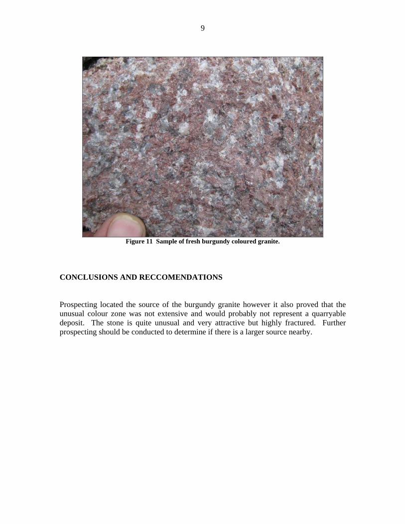
Figure 11 Sample of fresh burgundy coloured granite.
CONCLUSIONS AND RECCOMENDATIONS Prospecting located the source of the burgundy granite however it also proved that the unusual colour zone was not extensive and would probably not represent a quarryable deposit. The stone is quite unusual and very attractive but highly fractured. Further prospecting should be conducted to determine if there is a larger source nearby.