TheVegetation ofRobinson Crusoe Island (Isla Masatierra...
22
Pacific Science (2002), vol. 56, no. 3:263-284 © 2002 by University of Hawai'i Press All rights reserved The Vegetation of Robinson Crusoe Island (Isla Masatierra), Juan Fernandez Archipelago, Chile 1 Josef Greimler,2,3 Patricio Lopez 5., 4 Tod F. Stuessy, 2 and Thomas Dirnbiick 5 Abstract: Robinson Crusoe Island of the Juan Fernandez Archipelago, as is the case with many oceanic islands, has experienced strong human disturbances through exploitation of resources and introduction of alien biota. To understand these impacts and for purposes of diversity and resource management, an accu- rate assessment of the composition and structure of plant communities was made. We analyzed the vegetation with 106 releves (vegetation records) and subsequent Twinspan ordination and produced a detailed colored map at 1: 30,000. The resultant map units are (1) endemic upper montane forest, (2) endemic lower montane forest, (3) Ugni molinae shrubland, (4) Rubus ulmifolius- Aristotelia chilensis shrubland, (5) fern assemblages, (6) Libertia chilensis assem- blage, (7) Acaena argentea assemblage, (8) native grassland, (9) weed assemblages, (10) tall ruderals, and (11) cultivated Eucalyptus, Cupressus, and Pinus. Mosaic patterns consisting of several communities are recognized as mixed units: (12) combined upper and lower montane endemic forest with aliens, (13) scattered native vegetation among rocks at higher elevations, (14) scattered grassland and weeds among rocks at lower elevations, and (15) grassland with Acaena argentea. Two categories are included that are not vegetation units: (16) rocks and eroded areas, and (17) settlement and airfield. Endemic forests at lower elevations and in drier zones of the island are under strong pressure from three woody species, Aristotelia chilensis, Rubus ulmifolius, and Ugni molinae. The latter invades native forests by ascending dry slopes and ridges. It successfully outcompetes endemic taxa, including its congener Ugni selkirkii. The aggressive herb Acaena argentea severely threatens to overtake native grassland. 1 This research was supported by the National Geo- OCEANIC ISLANDS ARE fragile ecosystems graphic Society (grant no. 6399-99); the University of that are easily modified through natural Vienna, Faculty of Natural Sciences (additional travel and human disturbance (e.g., Carlquist 1965, support); and CONAF (Corporaci6n Nacional Forestal), 1974, 1980, Nurm 1994, Kirch and Hunt through permitting fieldwork and supplying guides in 1997, Whittaker 1998). The eventual fate of Robinson Crusoe National Park. Manuscript accepted 2 January 2002. such archipelagoes is disappearance under the 2 Department of Higher Plant Systematics and Evo- surface of the sea after millions of years of lution, Institute of Botany, University of Vienna, Renn- erosion through wind and rain and the re- weg 14, A-1030, Vienna, Austria. lentless pounding of the sea. Combined with 3 Corresponding author (phone: 43 1 4277 54145; fax: 43 1 4277 9541; E-mail: [email protected]). these natural impacts on oceanic islands are 4 Department of Botany, University of Concepci6n, the more recent, and often severe, human -- Casilla 1 - ---- --_. -impacts.-Easter IslanoproVioesan - - 5 Department of Conservation Biology, Vegetation though tragic case study of the negative ef- Ecology, and Ecology, Institute of Ecology fects of intervention in an island eco- and ConservatIon, Urnverslty of VIenna, Althanstrasse (H d W 1989 Z' k 1991) B th 14, A-1090, Vienna, Austria. system eyer a ,1Z a . 0 - -- - - natural -and human lmIJa-cts nnnmly moclify the surface of an island itself, but they also bring about changes in the environment. These changes are mirrored in the plants and animals that inhabit the archipelagoes and 263
Transcript of TheVegetation ofRobinson Crusoe Island (Isla Masatierra...

Pacific Science (2002), vol. 56, no. 3:263-284© 2002 by University of Hawai'i PressAll rights reserved
The Vegetation of Robinson Crusoe Island (Isla Masatierra),Juan Fernandez Archipelago, Chile1
Josef Greimler,2,3 Patricio Lopez 5.,4 Tod F. Stuessy,2 and Thomas Dirnbiick5
Abstract: Robinson Crusoe Island of the Juan Fernandez Archipelago, as is thecase with many oceanic islands, has experienced strong human disturbancesthrough exploitation of resources and introduction of alien biota. To understandthese impacts and for purposes of diversity and resource management, an accurate assessment of the composition and structure of plant communities wasmade. We analyzed the vegetation with 106 releves (vegetation records) andsubsequent Twinspan ordination and produced a detailed colored map at1: 30,000. The resultant map units are (1) endemic upper montane forest, (2)endemic lower montane forest, (3) Ugni molinae shrubland, (4) Rubus ulmifoliusAristotelia chilensis shrubland, (5) fern assemblages, (6) Libertia chilensis assemblage, (7) Acaena argentea assemblage, (8) native grassland, (9) weed assemblages,(10) tall ruderals, and (11) cultivated Eucalyptus, Cupressus, and Pinus. Mosaicpatterns consisting of several communities are recognized as mixed units: (12)combined upper and lower montane endemic forest with aliens, (13) scatterednative vegetation among rocks at higher elevations, (14) scattered grassland andweeds among rocks at lower elevations, and (15) grassland with Acaena argentea.Two categories are included that are not vegetation units: (16) rocks and erodedareas, and (17) settlement and airfield. Endemic forests at lower elevations andin drier zones of the island are under strong pressure from three woody species,Aristotelia chilensis, Rubus ulmifolius, and Ugni molinae. The latter invades nativeforests by ascending dry slopes and ridges. It successfully outcompetes endemictaxa, including its congener Ugni selkirkii. The aggressive herb Acaena argenteaseverely threatens to overtake native grassland.
1 This research was supported by the National Geo- OCEANIC ISLANDS ARE fragile ecosystemsgraphic Society (grant no. 6399-99); the University of that are easily modified through naturalVienna, Faculty of Natural Sciences (additional travel and human disturbance (e.g., Carlquist 1965,support); and CONAF (Corporaci6n Nacional Forestal), 1974, 1980, Nurm 1994, Kirch and Huntthrough permitting fieldwork and supplying guides in 1997, Whittaker 1998). The eventual fate ofRobinson Crusoe National Park. Manuscript accepted 2January 2002. such archipelagoes is disappearance under the
2 Department of Higher Plant Systematics and Evo- surface of the sea after millions of years oflution, Institute of Botany, University of Vienna, Renn- erosion through wind and rain and the reweg 14, A-1030, Vienna, Austria. lentless pounding of the sea. Combined with
3 Corresponding author (phone: 43 1 4277 54145;fax: 43 1 4277 9541; E-mail: [email protected]). these natural impacts on oceanic islands are
4 Department of Botany, University of Concepci6n, the more recent, and often severe, human-- Casilla 1OU:C,-2'f07;-Concepcioii~-Clille. - - - - - --_. -impacts.-Easter IslanoproVioesan -excellerit~ -
5 Department of Conservation Biology, Vegetation though tragic case study of the negative efEcology, and ~andsca~e Ecology, Institute of Ecology fects of hum~ intervention in an island eco-and ConservatIon, Urnverslty of VIenna, Althanstrasse (H d W 1989 Z' k 1991) B th14, A-1090, Vienna, Austria. system eyer a ,1Z a . 0
- -- - - natural -and human lmIJa-cts nnnmly moclifythe surface of an island itself, but they alsobring about changes in the environment.These changes are mirrored in the plants andanimals that inhabit the archipelagoes and
263

264
reflected by the vegetation at any point intime. Water, soil characteristics, and erosionpatterns are all important abiotic factors thatinteract with the plants to yield the resultant
c .vegetatlon.
PACIFIC SCIENCE· July 2002
patterns of phylogeny, theoretical islandbiogeography, chromosomal evolution, andadaptive radiation. Still lacking, however, aregood analyses of the vegetation against whichdata from such evolutionary and biogeographic studies can be correlated.
The Problem
Study of patterns and processes of evolution The Study Areain island ecosystems requires a good under-standing of the underlying vegetation. It is The Robinson Crusoe Islands are situateddifficult to understand modes of speciation 667 km west of continental Chile in the Pawithout viewing this process in the context of cific Ocean, 33° 40' Sand 79° 00' W; theyenvironmental parameters. Reproductive iso- were discovered in 1574 by the Spanish sailorlation, an important aspect ofspeciation, often Juan Fernandez. The archipelago compriseshas an ecological component. Further, adap- two large islands, Robinson Crusoe (Masative radiation, so prevalent in oceanic islands, tierra) and Alejandro Selkirk (Masafuera),is driven in large measure by adaptations plus a smaller island, Santa Clara, near Robto the rapidly changing island environment inson Crusoe. The archipelago is of volcanic(Schluter 2000). origin and has never been connected to the
A number of studies of the vegetation of continent (Baker 1967). Radiometric dataPacific oceanic islands have already been have revealed the age of Robinson Crusoe ascompleted. The most recent summary is approximately 4 million yr and that of Aleprovided by Mueller-Dombois and Fosberg jandro Selkirk as 1-2 million yr (Stuessy et al.(1998). Through detailed descriptions of the 1984). Politically the archipelago belongs tovegetation, plus photographs of many of Chile, administratively attached to the fifththe dominant associations and endemic rep- region (Valparaiso), and it is also a nationalresentatives of these fragile floras, a good park.understanding of the basic aspects of the The climate of the archipelago has beenvegetation can be obtained. This represents a described in different ways by various augood beginning for more detailed studies on thors. Fuenzalida (1965) treated it as warmthese Pacific island archipelagoes, especially temperate, with equivalent dry and moistmore precise vegetation mapping. Detailed seasons; Hajek and Espinoza (1987) describedvegetation maps of islands provide patterns of it as a Mediterranean climate with oceanicdiversity that serve to stimulate evolutionary influence; and Novoa and Villaseca (1989)and biogeographic questions. They also allow deemed it as warm-marine with mild winters.more realistic assessment of conservation im- The annual mean temperature is 15.18°C andpacts and possible remedies. total precipitation is 922.10 mm (Novoa and
Of the many oceanic island systems of the Villaseca 1989), but these data were takenPacific Ocean, the Robinson Crusoe (Juan from the station on Robinson Crusoe at a lowFernandez) Archipelago (Figure 1) is impor- altitude of 5 m and do not describe conditionstant for evolutionary and biogeographic rea- in the native forest at higher altitudes. The
----sons.-Tliis-Hora or-42f1 total species Ccmtams--data mSKottsoerg (t953atrrom 3£\:5 m giving -125 endemic vascular plants, including the 12.9°C and 1081.2 mm may come closer toendemic family Lactoridaceae, which is of conditions in the native forest, but the highestsignificance in the context of early angio- parts of the island above 600 m are oftensperm evolution(Sroessy -et -a1: -l()()8r):-mve-s=----Iriuuen- in--the-douds-;-surely-receiving-much--tigations in the archipelago over the past 20 more precipitation and having longer periodsyr have resulted in numerous papers, espe- of humidity. Kunkel (1957), in describing thecially of the endemic taxa, that examine quebradas (ravines) leading from the summitaspects of speciation, genetic differentiation, to the south of the island, reported high hu-

The Vegetation of Robinson Crusoe Island· Greimler et al. 265
RobinsonCrusoe
KILOMETERS~
o 200 400
800 W ~Santa Clara+3305
AlejandroSelkirk
FIGURE 1. Map showing the location of Robinson Crusoe Island (Juan Fernandez Archipelago, Chile).
midity in the air, swampy soils, and water to the archipelago, there is an even greaterdripping constantly from leaves and twigs. need for a new map of the vegetation that
As a Chilean national park (established in clearly highlights the areas of rich taxonomic1935) and biosphere reserve (designated in diversity in contrast to the degraded areas.1977), preservation of the native and endemic Although a national park, Robinson Cruspecies of the Robinson Crusoe Islands is a soe Island houses (and has housed since thepriority, and this also involves habitat con- early 1700s [Woodward 1969]) a permanentservation (Corporaci6n Nacional Forestal population of approximately 500 people in1976). Recent positive activities of the park the village of San Juan Bautista. The inhabiservice (Corporaci6n Nacional Forestal . tants live mainlL~!lf~s_he!y, som~ toUljsmL _
- - - -[CDNAF]pn: COlliiooratloIi-WitlltlieDutcn-- -ana- the management and administration ofgovernment have resulted in construction of the national park. Through the past cennumerous fences to contain domestic animals turies, human impact through cutting of treesplus barriers for stemming soil erosion, among for home and ship construction, and accidennumerous valuaole-projects~-FUffaamerlfal-for t:atfireshave-gfeatly-feaucedtfie exfeIifoftnethese activities and for a better conservation endemic forest. Further, direct cutting of themanagement program is an accurate map endemic palm Juania australis (the "cabbageof the extant vegetation. Because Robinson tree") for food substantially reduced its popCrusoe Island receives the majority of tourists ulations, and commercial exploitation of the

266 PACIFIC SCIENCE· July 2002
endemic sandalwood (Santalum fernandezianum) for Asian markets led to the extinctionof that species early in the twentieth century(Skottsberg 1953a, Woodward 1969). Introduced feral and domestic animals as well asintroduced fruit and ornamental plants plusnumerous weeds have also been and still area menace to the island's native and endemicflora (Sanders et al. 1982, Wester 1991,Swenson et al. 1997). Proper education ofthe townspeople, therefore, especially schoolchildren, is obviously fundamental for properspecies and habitat preservation in the future.A vegetation map, with accompanying descriptions and explanations, would be mostvaluable in this regard.
complete previous mapping effort of the vegetation of the entire archipelago was done byOrtiz-Riveros and coworkers (1982). Working from aerial photographs taken in 1980 bythe Chilean Air Force, detailed maps of thevegetation of all the Islands were published.Although extremely helpful, the methods ofanalysis yielded more than 120 different categories of vegetation, many based upon dominance of single species, providing an overlycomplex evaluation of the vegetational diversity. The practical result of these analyses isthat the maps are not useful as a guide forcorrelation with evolutionary and biogeographic concepts, nor are they suitable as apractical aid for conservation of the nativeand endemic flora.
MATERIALS AND METHODS
Specift: Objectives
In this paper, therefore, we aim to (1) usequantitative reieve data, with aerial photographs and computer algorithms, to provide anew classification of vegetation of RobinsonCrusoe Island at a scale useful for resourcemanagement; (2) analyze composition anddynamics in the designated plant communities; (3) summarize these data in a large-scalecolored map; and (4) comment on hazardsto vegetation types that still contain concentrations of native and endemic species.
Literature Review
There have been several previous investigations of the vegetation of the RobinsonCrusoe Archipelago. The early floristic analyses of Johow (1896) contained good summaries of the general vegetation, but withouta map. Based on field studies in 1916-1917,Skottsberg (1953a) directly addressed specificvegetation types using Hult-Sernander methods (Braun-Blanquet 1964). This valuablework yielded many informative detailed descriptions of the vegetation, but the onlygraphic summary was a simple sketch map.Although helpful, it was based on inaccuratebase maps of the Islands and had no supportfrom comprehensive aerial photos. Kunkel Field sampling of 106 releves (Figure 2, de(1957) gave a detailed report of the vegetation tails in Appendix 1) was carried out 1-17on and around the summit of the highest February 1999 and 3-18 February 2000 (Tamountain on the island, El Yunque (916 m). ble 1). Releves were taken in places where aSchwaar (1979) carried out a detailed transect substantial change in floristic assemblages wasanalysis of vegetation on Robinson Crusoe observed during field excursions in differentIsland, but no comprehensive assessment of parts of the island. Each releve contains a rec-the vegetation of the entire island was at- ord of all vascular plant species seen. Site data
___ J:empted. R~centlY.LfIahn (12,~~lprovided~__~~~_de elevation, aspect, slope, area (betweenfew very detailed releves (vegetation records), 100 and 400-riiT lor--forest ancfsnnili com:;--'which gave good insight into the vegetation munities and between 100 and 300 m2 forstructure, but coverage of the island was grassland), estimated coverage of trees, shrubs,limited. herbs, and mosses, and observations on soil--'-A--reV1se"d map-oaseo--on -SKottsberg's conaitions'-alia'clismroance.- The numoers(1953a) map and new observations from 1976 and symbols in Appendix 2 represent countsand 1979 was provided by Nishida and Nishi- (abundance) and estimates of dominanceda (1981). Resolution, however, in that map, (coverage) according to the cover-abundancedisplaying only six units, is poor. The most scale of Braun-Blanquet (1964). We modified

iII Melcrs
~
IFIGURE 2. Locations of releves on Robinson Crusoe Island.
I
o

268 PACIFIC SCIENCE· July 2002
RESULTS AND DISCUSSION
rearranged by stronger weighting of thedominant species and grouping of reIeves accordingly. Because it proved impracticable tosort out releves representing mixed units (1217) (with high presence of invasive species orlow vegetation cover in eroded areas), we keptthem within the units to which they show thehighest affinities. The species are ordered inthree groups: (1) dominant and differentiating;(2) common; and (3) those occurring rarely inreleves (but some of them locally common).
Field mapping was also carried out duringthe periods mentioned using aerial black andwhite photographs (from flyovers in 1980 bythe Chilean Air Force), as well as photographs and hand drawings made during theexcursions. Due to lack of orthophotographs,delineation of the field maps was transferredto a geocoded digital elevation model (DEM).The DEM was derived using 50-m contoursof a topographic map of the island (copy ofthe municipal map) and breaklines for abruptrelief discontinuities (e.g., coastal rock faces).For spatial data handling and management aswell as map drawings we used the geographical information system ARC-Info.
South
33' 39' 40"33' 38' 08"33' 39' 32"33' 39' 49"33' 38' 08"33' 39' 49"33' 39' 27"33' 39' 23"33' 38' 13"33' 39' 26"33' 39' 29"33' 38' 34"33' 39' 09"33' 38' 26"33' 38' 26"33° 38' 26"33° 38' 44"33° 38' 30"33' 36' 24"33' 36' 20"33' 39' 23"33' 38' 35"33' 39' 34"33' 39' 29"33' 39' 02"33° 39' 37"33° 40' 26"33° 40' 36"33° 42' 14"33° 42' 29"33' 38' 58"33' 39' 33"33' 38' 09"33' 40' 01"33' 37' 57"33' 37' 56"33' 38' 04"
West
TABLE 1
78° 48' 19"78°51'03"78° 47' 57"78° 48' 07"78' 51' 03"78' 47' 58"78' 47' 25"78' 47' 25"78' 52' 23"78' 47' 46"78' 47' 22"78' 51' 28"78' 47' 28"78' 51' 30"78' 51' 31"78' 51' 30"78' 48' 07"78' 52' 12"78' 52' 00"78' 52' 05"78° 46' 57"78°37'51"78° 46' 32"78° 46' 46"78' 47' 14"78' 46' 31"78' 56' 16"78' 56' 20"78' 56' 33"78' 56' 33"78' 46' 48"78' 46' 28"78' 52' 08"78' 55' 59"78' 50' 09"78' 50' 05"78' 50' 16"
GPS Longitudes and Latitudes for Releves of theSecond Excursion (3-18 February 2000)
Releve No.
68
1112182128293134384351616263646570717475777880889091939495969798
104105106
Classification of Vegetation, Description ofPlantCommunities, and Comments on SpeciesComposition
Based on analysis of 106 vegetation releves,the vegetation units, the communities theycompose, and the species found in them withtheir code of abundance and/or dominanceare given in Appendix 2 (on back of the map
this scale slightly using six classes: +, 0-10 insert). The vegetation units themselves areindividuals; 1, 11 individuals to 5% coverage; plotted graphically on a map of the island2, 6-25% coverage; 3, 26-50% coverage; (Figure 3, folded and inserted in this issue).4, 51-75% coverage; 5, 76-100% coverage. In Appendix 2, changing floristic composition
-Coverage was--estl.mated--foy-tfees ana-tall---(te., vegetation-change) rouglliy-follows a:I1-
shrubs even if they were fewer than 11 in elevational gradient from top left in the tablenumber. Taxonomy and nomenclature follow to bottom right, representing upper and lowMarticorena et al. (1998), and the status of er sites, respectively. More than one environeach-taxon--terrclemic; rrative,adventive/nanr-o----mental-gradient obviouslY--1s-responsible -for-ralized) is given. species and community distribution, however,
The releves were processed and classified and associated with a drop in elevation is ausing the Twinspan algorithm (Hill 1979). notable decrease in moisture. A general inThe resulting table (Appendix 2) was slightly crease of soil erosion and disturbance, due to

The Vegetation of Robinson Crusoe Island . Greimter et at. 269
boring archipelagoes along the Tropic ofCapricorn is, of necessity, limited by severaldifferent factors. Vegetation of the Desventurada Islands does not include real trees andis, therefore, physiognomically very differentfrom that of Robinson Crusoe, the formerbeing composed mainly of endemic dwarfshrubs and herbs, and a few small rosettetrees. The small island Sala-y-G6mez doesnot bear any closed vegetation (MuellerDombois and Fosberg 1998), and Easter Island is dominated by a higWy altered mixedherbaceous grassland of a few native butmany introduced species (which Skottsberg[1928] named the "tropical facies of oceanicgrassland"; see also Zizka [1991] for morerecent descriptions).
introduced plants and animals and direct human impact, also correlates with decreasingelevation.
In general, our results are largely compatible with previously published analyses, withsome exceptions. Nearly all work points tothe very dominant role of Myrceugenia fernandeziana, as stated in Johow (1896), Skottsberg (1953a), Ortiz-Riveros (1982), and Hahn(1998). The only exception is Schwaar (1979),who did not report this taxon in 32 releves ofthe lower montane forest, giving instead Fagara mayu and Coprosma pyrifolia as dominants. We, and also Skottsberg (1953a), regardFagara mayu as certainly a common, but not adominant, element. Coprosma pyrifolia, foundwith low abundance in 2 of 10 releves inlower elevations by Skottsberg, was not foundthere by us, which might be a sampling effector a consequence of enhanced disturbance by Vegetation Map
~~)d:~:~ P~~~-~:1 ft~ls J:d~;:c~tc:~~ Classification of vegetation for the purpose of1982, Stuessy et al. 1998a,b). We found this mapping in any terrestrial region is always
a compromise between scale, accuracy, andtaxon to be rather abundant in the upper practicability for the desired map. In a veg-montane forest (see also Skottsberg 1953a, etation survey of Chile, Gajardo (1993)Kunkel 1957). distinguished only three vegetation units
We restrict comparisons of the vegetationof Robinson Crusoe Island with that of other on Robinson Crusoe: Nothomyrcia-Drimys,
Cuminia-Azara, and Stipa-Polypogon. ThesePacific archipelagoes to only selected aspects units constitute his "Bosque y Matorral(the reader may wish to consult Mueller-Dombois and Fosberg [1998] for an overview Laurifolio de Mas a Tierra." In general
terms, the vegetation on Robinson Crusoeof Pacific vegetation), in part because the Island is composed rougWy of upper andcomposition is often quite different. In east- lower montane forests of endemics as wellern Polynesian archipelagoes, lowland and as grassland, dry land with mostly aliens, cul-montane forest below 500 m is largely re- tivated areas, and two types of shrublandoplaced by secondary vegetation and planta- dtions (Mueller-Dombois and Fosberg 1998). Skottsberg's (1953a) map gave a istributionMontane rain forest and cloud forest can also of some basic vegetation units, but native
grassland and other assemblages were mergedbe found in some islands with high moun- into one group. Skottsberg's vegetation unitstains, especially the Society Islands (e.g., Ta- h b d 01 tl ( b Hahnh
o.) AI th T 0 f C . ave een use untl recen y e.g., yItl . ong e roplc 0 ancer, vegetatlon [1998]) r h b O 1 0 0 tud· b· df th H .0 Ar hi 1 . 11 d lOr a ltat ana YSIS m s ymg lr s
- -- --~eift;Q-(:'i~ll~arlq~isl-~ ;~~; l~u~~ihy-~:c1-- _QL*~jslan~I>-. 0 - - • - 0-- --ili ---- -- --~( ----- 0 _
Stone 1990, Gagne and Cuddihy 1990, Wag- . ~ uruts, d!Pven md
h e ~ap'dan 01 cO~th-1 1990) hi h alth h d·Ir d murutles are Iscusse ere m eta! WI
ner et a . , w c oug l11erent an 0 f li· ..hi W al d thr h h . 0 compansons 0 ear er mvestlgatlons.
g y tere oug uman mterventlon,dues-provide -detailed-information for discus=-----I-;- ENDEM-IC UPPER MONTANE -FORESTsing some parallels with Robinson Crusoe's The endemic trees Drimys confertifolia andvegetation. Myrceugenia fernandeziana are of high abun-
Further, comparison of vegetation of the dance and dominance, and most tree fernsRobinson Crusoe Islands with that of neigh- and Gunnera bracteata are confined to this es-

270
sentially upper montane forest. It consists ofseveral different communities, mostly above400 m along the main ridges, around and onEl Yunque and, due to the island's topology,in the high regions of the eastern part of theisland. These communities often replace eachother depending on microrelief, slope, andaspect, and thus often form a mosaic patternthat is not practicable for resolution on thevegetation map. In the cloud zone of thehighest altitudes above 500 m, the soil is richin organic components. Moisture is maintained constantly in the litter and in old leafbases/scales of the trunks, which are oftencovered by epiphytes, especially mosses.
It is important to mention that we use theterm "upper montane forest" in a broadersense, deviating from Skottsberg (1953a),who restricted it only to communities ofhighest elevations, the "principal home ofthe Robinsonia assemblage," as he called it onhis map. The criteria we used in delimitingupper from lower montane forest are highfrequency and abundance of the tall fernsThyrsopteris elegans and Dicksonia berteroanaplus other taxa typical for the endemic assemblage of higher elevations (see Appendix2).
PACIFIC SCIENCE· July 2002
mznza eriantha, Robinsonia gracilis, R. evenia,and Asplenium macrosorum. Drimys confertifoliaand Myrceugenia fernandeziana in most casesplay a minor role on the very steep slopes.Skottsberg (1953a), giving examples for thiscommunity in his releves of different Dicksonia associations, also pointed out the steepslopes on which this forest type is usuallyfound. Kunkel (1957) reported similar assemblages from the highest location on theisland, the summit region of El Yunque(916 m).
In a similar upper montane. forest ofMasafuera Island, the endemic Dicksonia externa is the dominant tree fern mixed withMyrceugenia schulzei and Drimys confertifolia(Skottsberg 1953a). Physiognomically theThyrsopteris-Dicksonia community, togetherwith the following Drimys confertifoliaMyrceugenia fernandeziana community, maymost closely resemble upper montane forestsrich in tree ferns of other archipelagoes (e.g.,the Hawaiian wet forest [Carlquist 1980] orthe cloud forest of Tahiti [Mueller-Domboisand Fosberg 1998]). The Cyathea and Cibotium tree ferns in these archipelagoes, however, can grow much taller, and there areobviously no species nor even genera incommon.
1.1. Thyrsopteris elegans-Dicksoniaberteroana Community 1.2. Drimys confertifolia-Myrceugenia
Releves: 1-8; elevation: 460-630 m; all as- fernandeziana Communitypects; slope: very steep, 30-500, mainly 40- Releves: 9-17; elevation: 335-550 m,500; soil: black to slightly brownish, rich in mainly above 450 m; all aspects; slope: 15fine organic material, covered by organic lit- SOD, mainly 20-400; soil: black to brownish,ter. rich in fine organic material, covered by a
Coverage of trees is mainly below 50%, dense layer of organic litter.whereas the tree ferns and Gunnera cover 80- The trees cover 70-100%. Altogether the100%, some shrubs included. The herb layer tree fern and shrub layer is considerablyis poorly developed, mostly below 20%, but variable, with coverage between 10 and 85%.mosses are higWy abundant. In the upper parts of the valley (Valle Colo-
This type of upper montane forest is dom- nial) containing the village (San Juan Bauina:t~d-by~t:h<: -tn:e~f~ms- -Vtcksonta -berteroana ---meatme-introQuced-snruo -AnrrotelUqjaffIyand Thyrsopteris elegans, which either solitarily replaces the tree ferns. Coverage of herbs isor in combination (occasionally together with usually higher than in the dense tree fernBlechnum cycadifolium) form a dense cover community: 10-80%. Mosses again play an
- usually reaching~3~m~in-height;--8ther-ferns,--important-role,--in--some-releves- coveringincluding mostly epiphytic species of Hyme- about 50%.nophyllum, add to the high fern diversity. In this community Drimys, Myrceugenia,Gunnera bracteata has its optimal distribution Fagara, and Juania reach heights up to 15 min this community as do Coprosma oliveri, Cu- on considerably steep slopes (30-500), and up

The Vegetation of Robinson Crusoe Island . Greimler et al. 271
to 25 m on moderate slopes (15-300). The
tree ferns also reach heights of 5 m. Nearly allthe ferns present in the Thyrsopteris-Dicksoniacommunity (Ll) can be found in this forest,but additional ones are more frequent here:Lophosoria quadripinnata, Megalastrum inequalifolium, Polystichum tetragonum, to mentionjust the tallest ones. Rhaphithamnus venustus, asmall tree, and Dysopsis hirsuta, an herb, arefound mainly in this forest. Altogether, thiscommunity contains the highest species diversity among native island plant communities, except for some high-elevational variants of the Blechnum cycadifolium community.This upper montane forest community occursin many variants and corresponds to whatSkottsberg (1953a) called Drimys-Nothomyrciaassociations, Nothomyrcia-Dicksonia and Drimys-Blechnum cycadifolium, as well as DrimysDicksonia associations. Kunkel (1957) foundsimilar assemblages in the quebradas of the ElYunque summit but without Myrceugenia andFagara (missing from the highest elevations).In this Drimys-Myrceugenia forest slightlymore invasions by the introduced shrubsAristotelia chilensis and Rubus ulmifolius occurthan in the tree fern community (Ll). Insector Villagra we made two releves from thelowest sites, both of which are highly threatened by these taxa; even though they are notyet present within the forest, they occurabundantly nearby in the quebradas, forestclearings, landslide areas, and along the central path.
In Masafuera some elements (e.g., Juaniaaustralis, Dysopsis hirsuta) of this communityare missing. According to Skottsberg (1953a),Dicksonia externa indicates a similar type ofupper montane forest together with Drimysconfertifolia and Myrceugenia schulzei.
1.3. Gunnera peltata CommunityReleves: 18, ·19; elevation: 300, Z!-50 ill;
aspect: variable; slope: 10-200; soil: black
brown and partly loamy patches among rocks.In the bottom of the quebradas Gunnera
peltata -oft~- forms-a- monuuuminant-shrublayer nearly excluding the trees. Below thebroad leaves of Gunnera are found ferns suchas Megalastrum inequalifolium, Blechnum chilense, B. schotti, and Thyrsopteris elegans. Due to
the high amount of Gunnera litter and the tallferns, the herb layer is very poor. Mosses canbe abundant on the rocks and trunks. Skottsberg (1953a) reported two Gunnera peltataassociations from rather low elevations. Kunkel (1957) indicated that G. peltata on ElYunque is found exclusively in the bottoms ofthe quebradas, whereas G. bracteata is alsocommon in the forest on the slopes. Thecommunity can be seen as a linear extensionof the upper montane floristic elements following the watercourses downward into thelower montane zone and even lower, wherethey meet the aliens Aristotelia chilensis andRubus ulmifolius.
In Masafuera, Gunnera masafuerae similarlygrows along streams (Skottsberg 1953a) andin deep canyons. Species of Gunnera are alsopresent in deep valleys of other archipelagoes(e.g., in Maui [Hawaiian Islands] a similarGunnera community is built up around G.petaloidea [Carlquist 1980]).
1.4. Blechnum cycadifolium CommunityReleves: 20, 21; elevation: 460, 550 m; as
pect: S, SE; slope: 40, 75 0; soil: ±degraded,
brownish gray, organic layer often eroded.The tree layer is missing; the few Myrceu
genia trees remain shrub-sized. The typical B.cycadifolium community is densely closed, withthis tree fern covering about 100%, so it isdifficult to move about. Releves were taken,therefore, from accessible areas that were notquite so closed.
Blechnum cycadifolium is the tree fern withthe highest abundance and the broadest altitudinal and ecological amplitude on the island. It forms huge and rather pure stands onthe slopes of higher elevations. Releve 21from La Pilla is located at the edge of such acommunity. At this open edge there is alsospace for the grass Megalachne berteroana andthe-smal1--slrrub f.7lctl5ris !efflan7:leziana,·wrnch .is an endemic (representing the endemic family Lactoridaceae) found now only in refugialareas on Robinson Crusoe Island (Stuessy etal. 1998c)~·Releve-20-was recorded while- wewere climbing down the steep slope of LaPilla toward the sea, where Blechnum as wellas scattered Myrceugenia and Pernettya arevery short in stature. Blechnum cycadifolium is

272 PACIFIC SCIENCE· July 2002
well as the aggressive alien Acaena argentea.This community more or less comprises allthe lower montane Nothomyrcia associationsreported by Skottsberg (1953a). He alsoreported some rare plants (Robinsonia macrocephala, Dendroseris micrantha, Sophora fernandeziana) in some of his releves, but we sawonly one D. micrantha in the lower montaneforest. This is to some extent a random sampling effect, because this is the most widelydistributed species of Dendroseris (of 11 species total) in the archipelago (Crawford et al.1998) although still rare. It is also likely aneffect of shrinking population sizes of thesetaxa since the time of Skottsberg's field observations more than 80 yr ago. In general,the presence of Aristotelia chilensis, Acaena argentea, Ugni molinae, and Rumex acetosella indicate increased disturbance from aliens.
In the lower montane forest of Masafueraa similar composition of tree species, of theendemics Myrceugenia schulzei, Fagara externa,and many other taxa present on both islands,can be found (Skottsberg 1953a).
2.2. Boehmeria excelsa CommunityReleve 31; elevation: 220 m; aspect: S;
slope 15°; soil: black brown, mixed withrocks.
Boehmeria often becomes dominant in thevalley bottoms and quebradas of the loweraltitudes. In this releve the only other tree is asingle small Myrceugenia. The understory isvery poor due to the dense cover of Boehmeriaand the feeding and trampling by cows.Skottsberg (1953a) described a similar Boehmeria association but also a BoehmeriaNothomyrcia association mixed with othertrees, many ferns, and some grasses.
very abundant in the upper montane forest; itis also often a codominant in the Pernettyaand Ugni shrub areas on the higher ridges.Skottsberg (1953a) described three associations with different combinations of trees,shrubs, and B. cycadifolium on Masatierra, anda Dicksonia externa-Blechnum cycadifolium association on Masafuera.
2. ENDEMIC LOWER MONTANE FOREST
The lower montane forest is found mostlybelow 400 m, especially on the dry northwestern and southeastern higher regions ofRobinson Crusoe Island. Myrceugenia fernandeziana is the dominant tree, often accompanied by Drimys confertifolia and Fagara mayu.In general there is less moisture in the blackor brownish soil due to lower precipitationand higher incoming radiation. On slopesadjacent to the bottoms of the quebradas,Boehmeria excelsa is a common tree. Disturbance by cattle and by alien plants is ratherhigh, and for this reason a high proportion ofthe lower montane forest can be found as acomponent of the mixed unit 12 (endemicforest with aliens).
2.1. Myrceugenia fernandeziana CommunityReleves: 22-30; elevation: 250-410 m; all
aspects, but predominantly N; soil: black,brownish, often very dry, powderlike, coveredby dry litter.
The trees, with dominant Myrceugenia,cover between 50 and 100%. Tree ferns, withthe exception of scattered Blechnum cycadifolium, are missing, and shrubs usually play aminor role. The herb layer usually is poor,but ferns can be abundant. Cryptogams alsoplaya minor role, but in some releves lichensand liverworts formed a crust covering thesoil.
Species diversity in this forest is much 3. Ugni molinae SHRUBLAND
lower than in the upper montane Drimys- These hard-leaved shrub communities oc-- - - -- -Myrceugeni-aforest~Myrceugenilt, -Brimys; -Ftz:'--Tur-along---nages anil wino-exposeoslopes
gara mayu, and near the bottoms of the (e.g., near the village [San Juan Bautista] onvalleys Boehmeria excelsa compose the tree Cordon Salsipuedes and Cordon Central). Inlayer, occasionally accompanied by Aristotelia lower elevations introduced Ugni molinae ischilensis - (as--t:rees- anclJ0f-- shrubs); --In- -the- -dominant,along-with--endemic -Pernetty-arig=understory the more drought-resistant ferns ida (disappearing at the lowest elevations).Rumohra berteroana, Adiantum chilense, and At higher elevations Blechnum cycadifolium isBlechnum hastatum are very common, with highly abundant, and above 600 m the enHistiopteris incisa occurring occasionally, as demic U. selkirkii becomes a codominant.
The Vegetation of Robinson Crusoe Island Greimler et al. 273
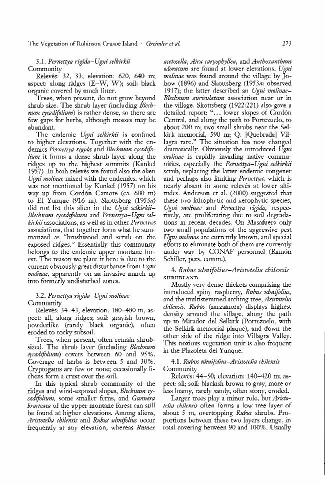
3.1. Pernettya rigida-Ugni selkirkiiCommunity
Releves: 32, 33; elevation: 620, 640 m;aspect: along ridges (E-W, W); soil: blackorganic covered by much litter.
Trees, when present, do not grow beyondshrub size. The shrub layer (including Blechnum cycadifolium) is rather dense, so there arefew gaps for herbs, although mosses may beabundant.
The endemic Ugni selkirkii is confinedto higher elevations. Together with the endemics Pernettya rigida and Blechnum cycadifolium it forms a dense shrub layer along theridges up to the highest summits (Kunkel1957). In both releves we found also the alienUgni molinae mixed with the endemics, whichwas not mentioned by Kunkel (1957) on hisway up from Cordon Camote (ca. 600 m)to El Yunque (916 m). Skottsberg (1953a)did not list this alien in the Ugni selkirkiiBlechnum cycadifolium and Pernettya-Ugni selkirkii associations, as well as in other Pernettyaassociations, that together form what he summarized as "brushwood and scrub on theexposed ridges." Essentially this communitybelongs to the endemic upper montane forest. The reason we place it here is due to thecurrent obviously great disturbance from Ugnimolinae, apparently on an invasive march upinto formerly undisturbed zones.
acetosella, Aira caryophyllea, and Anthoxanthumodoratum are found at lower elevations. Ugnimolinae was found around the village by J0
how (1896) and Skottsberg (1953a: observed1917); the latter described an Ugni molinaeBlechnum auriculatum association near or inthe village. Skottsberg (1922 :221) also gave adetailed report: " ... lower slopes of CordonCentral, and along the path to Portezuelo, toabout 200 m; two small shrubs near the Selkirk memorial, 590 m; Q. [Quebrada] Villagra rare." The situation has now changeddramatically. Obviously the introduced Ugnimolinae is rapidly invading native communities, especially the Pernettya-Ugni selkirkiiscrub, replacing the latter endemic congenerand perhaps also limiting Pernettya, which isnearly absent in some releves at lower altitudes. Anderson et al. (2000) suggested thatthese two lithophytic and xerophytic species,Ugni molinae and Pernettya rigida, respectively, are proliferating due to soil degradations in recent decades. On Masafuera onlytwo small populations of the aggressive pestUgni molinae are currently known, and specialefforts to eliminate both of them are currentlyunder way by CONAF personnel (RamonSchiller, pers. comm.).
4. Rubus ulmifolius-Aristotelia chilensisSHRUBLAND
Mostly very dense thickets comprising theintroduced spiny raspberry, Rubus ulmifolius,
3.2. Pernettya rigida-Ugni molinae and the multistemmed arching tree, AristoteliaCommunity d 1 h h
Releves: 34-43; elevation: 180-480 m; as- chilensis. Rubus (zarzamora) isp ays ig estdensity around the village, along the path
pect: all, along ridges; soil: grayish brown, up to Mirador del Selkirk (Portezuelo, withpowderlike (rarely black organic), often the Selkirk memorial plaque), and down theeroded to rocky subsoil. other side of the ridge into Villagra Valley.
Trees, when present, often remain shrub- This noxious vegetation unit is also frequentsized. The shrub layer (including Blechnum in the Plazoleta del Yunque.cycadifolium) covers between 60 and 95%.Coverage of herbs is between 5 and 30%. 4.1. Rubus ulmifolius-Aristotelia chilensisCrypfOgaiffsafe few ofiioife;-occasional1y-li.:.-Commuifity---- ------ -- .. --- -- ---chens form a crust over the soil. Releves: 44-50; elevation: 140-420 m; as-
In this typical shrub community of the pect: all; soil: blackish brown to gray, more orridges and wind-exposed slopes, Blechnum cy- less loamy, rarely sandy, often stony, eroded.Tadifoiium,--some smaller ferns, and-Gunnera ---]jarger trees-playarnirrorrole;-bun4risto"bracteata of the upper montane forest can still telia chilensis often forms a low tree layer ofbe found at higher elevations. Among aliens, about 5 m, overtopping Rubus shrubs. ProAristotelia chilensis and Rubus ulmifolius occur portions between these two layers change, infrequently at any elevation, whereas Rumex total covering between 90 and 100%. Usually

274 PACIFIC SCIENCE· July 2002
6. Libertia chilensis ASSEMBLAGE
This assemblage of introduced and nativeplants is found on eroded slopes close to thevillage.
5.1. Histiopteris incisa CommunityReleves: 51-53; elevation: 270-410 m;
all aspects; soil: usually degraded, brownishto gray brownish, powderlike or aggregated,often eroded zones.
The shrub layer occasionally contributesup to 10% of coverage. The ferns (assigned tothe herb layer because they are not tree ferns)usually cover between 90 and 100%; lowerherbs and mosses playa minor role.
The huge clonal systems built up by thenative Histiopteris incisa often cover some 100or even up to 1000 m2
• This fern, as wellas the occasionally accompanying Rumohraberteroana, Adianthum chilense, and Blechnumhastatum, seems more drought resistant thanBlechnum chilense and Lophosoria quadripinnata,which are usually found in the forests. Theshrub Ugni molinae also invades this community, together with another alien of theground layer, Acaena argentea.
Histiopteris incisa also occurs in Masafueraand is widely distributed in the SouthernHemisphere. It is not known to form uniquecommunities on Pacific islands near the Robinson Crusoe Archipelago (Mueller-Domboisand Fosberg 1998), but it is found among theprincipal species of fern bush communitieson Gough Island of the Tristan da CunhaArchipelago of the southern Atlantic (Wace1960).
These groups of ferns are found on edges offorests and on drier or eroded slopes.
5. FERN ASSEMBLAGES
The dominant tall fern, Histiopteris incisa,forms large clonal patches through rhizomes.
there is limited space for herbs (mostly below10%, once 40%); mosses vary between 0 and50%.
In lower altitudes and closer to the village,the introduced taxa Aristotelia and Rubus oftenform a mixed scrub. In more remote andhigher elevations, Aristotelia is more abundant, which may be a consequence of beingintroduced earlier. Johow (1896) stated thatAristotelia was the most common plant amongintroduced woody taxa, forming conspicuousshrub communities. Johow did not mentionRubus ulmifolius, but in a list of fruit treesand shrubs he mentioned the introductionin 1892 of a number of Rubus idaeus plantsfor cultivation. In a supplement to the flora,Skottsberg (1953b) classified Rubus ulmifolius,first recorded by Looser (1927), as a verydangerous weed. Obviously, Rubus is a similarly rapid and dangerous invader, as are Ugnimolinae and Aristotelia chilensis. Rubus and Aristotelia were not seen by Kunkel (1957) on ElYunque. He wrote "... dafi der Gipfel diesesBerges absolut frei von eingescWepptenPflanzen angetroffen wurde." This has nowchanged for the worse, however, because arecent expedition to the summit of El Yunquein 1999 recorded single individuals of Aristotelia and Rubus (Philippe Danton, pers. comm.,1999).
In Masafuera Aristotelia is also rathercommon, distributed throughout the entireisland, especially in ravines and areas difficultof access. Control of this pest, therefore, isdifficult. Rubus, however, is less widely distributed and has been detected at approximately nine spots on the island (RamonSchiller, pers. comm.), such as in the surroundings of the nonpermanent settlement atthe mouth of Quebrada Casas. The park management (CONAF) is attempting to eliminatethese populations before they spread even 6.1. Libertia chilensis Community
-fuftlrer.------------ - - - --- ------ - ---Re-leves:-54; 55;-elev:rtion:-HO;-LCJO-m; as-The genus Rubus causes similar troubles pect: S, exposed; soil: grayish brown, pow
in other archipelagoes (e.g., in the Hawaiian derlike or sandy, dry.Islands, where at least three introduced taxa Libertia chilensis is locally abundant eitherffrom Asia--and-North-America]- are-invasive --- in small- groups or covering larger areas of[Cuddihy and Stone 1990]). eroded slopes close to San Juan Bautista. Be-
cause it does not form a distinct community,we considered the possibility of including thisunit elsewhere. We decided to keep it separate, however, because we suspect it to be

The Vegetation of Robinson Crusoe Island . Greimler et al. 275
from further erosion. On the other hand, itnot only outcompetes native taxa but also invades natural communities, predominantly inthe native Nassella grassland.
8. NATIVE GRASSLAND
The tussock-forming grasses Nassella laevissima and Piptochaetium bicolor are dominantsin this native "steppelike" grassland extendingfrom dry lower areas up to medium elevations. This grassland is absent in the westernmost part of the island.
a remnant of a nativ.e floristic assemblageon eroded slopes before massive invasion ofthese areas by Ugni, Acaena, and other introduced herbs and grasses. According toSkottsberg (1922), L. chilensis (= L. formosa)was not uncommon on barren slopes androcky ridges in Masatierra and common oncliffs near the sea and in canyons of Masafuera.
7. Acaena argentea ASSEMBLAGE
The stolons of A. argentea form a densecarpetlike herbaceous thicket. This almostmonodominant herb community comprisesonly a few other species with low abundanceand is present everywhere from lower to medium elevations except in the very dry andwindy westernmost part of Robinson CrusoeIsland.
8.1. Piptochaetium bicolor-Nassella laevissimaCommunity
Releves: 59-72; elevation: 20-460 m; allaspects; soil: grayish brown, stony, dry, oftencovered by much dry grass litter.
The grasses together with some herbsoften cover between 90 and 100% and at least
7.1. Acaena argentea Community 50%; mosses are missing or playa minor role.Releves: 56-58; elevation: 200-390 m; as- Nassella laevissima is the most common
pect: various; soil: gray or brown, stony, partly species of the native tussock-forming grasses.with boulders. These usually compose the steppelike grass-
On the eroded slopes, especially of the lands, which thousands or millions of yearswestern part of the island, Acaena argentea ago must have covered most of the dry westforms dense carpets that leave little space for ern part, and more recently the lower easternother taxa. Only a few introduced grasses and parts, of the island. In a few releves the tallerherbs are scattered within this matrix. Of Piptochaetium bicolor is more abundant thanthe native and endemic taxa, only Blechnum N laevissima. Nassella neesiana (= Stipa ferhastatum and Haloragis masatierrana can be nandeziana) occurs occasionally but is neverfound frequently in low abundance. These abundant. The native grassland is higWy distaxa, as well as occasional native grass species turbed by aliens, the most serious pressureof Nassella and Piptochaetium, obviously point coming from Acaena argentea, which appearsto very dramatic vegetational changes in to be invading the few remaining "pure"lower elevations. According to Johow (1896), steppes. But many of the Euro-MediterraneanA. argentea more than 100 yr ago already had weeds (e.g., Rumex acetosella, Anthoxanthumbeen "la maleza mas comun de la isla" and a odoratum, Bromus hordeaceus, Aira caryophyllea,serious pest in pastureland (most likely com- Briza minor, B. maxima, Vulpia spp., Avenaprising much of the Nassella grassland with barbata, Dipsacus sativus, and Anagallis arvensome additional introduced grasses and herbs). sis) are present in many releves and must alsoSkottsberg (1922) judged this taxon as "one of be considered a threat. Skottsberg (1953a)-die -m6st-wtde- spreaa-ana ]iOxlOUS weeds";-tf - -re15Otfechw6 releve-s-ofa correspondill-g-3tipa u
was doubtless inadvertently introduced from laevissima association, indicating that this puremainland South America (Matthei 1995). It community only covers small areas (back inis also a serious weed on Masafuera (Ortiz- 1917!) and that some weeds are also usuallyRiveros 19821~- -- - present-(e.g., Acaena argenteaand- most of the
The success of A. argentea represents a taxa just mentioned).main act in the tragedy of the island flora. The native grassland is higWy impacted byOn one hand, this taxon builds large and large rabbit populations and other introducedrather dense "carpets" covering deforested foraging animals. In addition to foragingand eroded slopes, protecting those areas pressure, these animals help disperse weedy

276 PACIFIC SCIENCE· July 2002
found there. It is rich in other introducedherbs and grasses, and might have been usedas pasture in earlier historical periods, whenmore cattle were present near the village.Acaena argentea, too, is present in one case ingreat abundance.
9.3. Vulpia CommunityReleves: 85-92; elevation: 20-130 m; all
aspects; soil: brown or gray, often aggregatedpowder, more or less stony.
Coverage of grasses and herbs is between60 and 100%; mosses are absent or in lowabundance.
We found this annual grassland in the drylower and western parts of the island. Dueto recording in late summer, we found theplants mostly with only glumes left in the inflorescences; this made it difficult to discriminate among the three species. As far as wecould estimate, especially in the western partof the island, Vulpia bromoides is the dominanttaxon. In this same dry western region, manyof the ruderals are absent, but Hordeum murinum is abundant.
species even more broadly over the island(e.g., as with the hooked fruits of Acaena).In maps prepared by Ortiz-Riveros and coworkers (1982), nearly all grassland areaswere classified as degraded or severely degraded.
8.2. Juncus capillaceus CommunityReleves: 73, 74; elevation: 290, 325 m; as
pect: SE, NNE; soil: grayish brown, dry, clay.The graminoids and herbs cover between
75 and 80%; mosses are absent.This community never covers large areas,
but it locally replaces the Piptochaetium bicolor-Nassella laevissima grassland on concaveslopes, flat depressions, and other placeswhere moisture can accumulate. Disturbancein this community is also great due to invasion by the aliens Aira caryophyllea, Rumexacetosella, and Anthoxanthum odoratum.
9. WEED ASSEMBLAGES
These include grasslands dominated byintroduced (mostly European) taxa, as well asseveral other herbaceous weedy communitiesin the drier and lower parts of the island.
9.1. Rumex acetosella-Aira caryophylleaCommunity
Releves: 75-81; elevation: 15-440 m; aspect: mostly Sand E; soil: brownish, oftenaggregated powder.
Coverage of grasses and herbs is usuallybelow 50%; cryptogams, especially lichens,are often very abundant.
This community is often found on erodedslopes, which seem to be devoid of vegetation)when first observed from a distance. In somereieves we found dense crusts of lichens andliverworts protecting the powderlike soil fromsurface erosion.
9.4. Avena barbata CommunityReleves: 93, 94; elevation: 160,210 m; as
pect: NNE, NE; soil: gray brown, dry, stony(at 210 m).
The grasses cover between 50 and 100%.This is the typical steppelike grassland of
the small island, Santa Clara, dominated byAvena barbata and Bromus hordeaceus in thehuge tableland area. These two taxa producea large amount of litter, which cover the gapsbetween grasses. That our recordings weremade in late summer might be one reason nodicot herbs were found except Rumex crispus.On the more open slope Hordeum murinumand H. secalinum become codominant. Al-
9.2. B~iza maxima Co~munity ready in 1917 Skottsberg (1953a) noticed the
- -1Je:-=-~~~:-S~~~il~;;;~~~~~=~~~o~d;;~- -~~h,.ifid~1~~~th!ri1~,~~tq;rtil~dn~~et~;---like. of Santa Clara.
Coverage of grasses and herbs is between50 and 95%; mosses are absent or in low 9.5. Ruderal Communities; Mixed Rock
--abundance;-- - - -------- -- - --- .. ·-and-EoastalEommunities-We found this community close to the Releves: 95-99; elevation: 2-230 m; all as-
village, where it seems to represent a transi- pects; between stones, on wet rock faces, andtion from native Nassella grassland to alien on brownish, sandy soil.communities, as both species of Nassella are These communities occur near the village

The Vegetation of Robinson Crusoe Island . Greimler et al. 277
(no releve from there), near huts and landingplaces, and very often on steep, rocky slopes,especially on the coast. Species compositioncan vary. For instance, Ruta chalepensis onsteep faces of the coastal rocks in the northeast part of the island (as judged from boatobservations only) appears to form communities similar to those in releve 95.
10. TALL RUDERALS
This unit includes tall (1-2 m) ruderals,which form occasionally large patches (Conium maculatum, Silybum marianum, Centaureamelitensis, Papaver somniferum) and occur inflat areas and valley bottoms at lower elevations.
10.1. Mixed Tall Ruderal CommunityReleves: 100-103; elevation: 110-220 m;
aspect: N to SE; soil: gray, brownish.The tall annuals or biannuals, forming a
tall herblike community, cover between 60and 100%. The lower boundary in coveragecertainly is strongly biased by our observations being taken in late summer (plants werealready dry). They are mostly found at thebases of slopes, in depressions, and in flattened areas. In addition to Conium, Silybum,and Centaurea, Papaver somniferum contributes to similar mixed communities near theairfield (no releve taken). Other introducedtall weeds (e.g., the perennial Lobelia tupa)often form large groups on eroded slopes.
11. CULTIVATED Eucalyptus, Cupressus,AND Pinus
Cultivated areas of Eucalyptus globulus, Cupressus goveniana, and Pinus radiata cover theeroded slopes around the village of San JuanBautista. These were deliberately planted tohelp stem soil erosion and to provide neededwood for boats, homes, cooking, and heating. These trees, however, are now maintain-
___ ing---.iliemselve}LtbLOJlglLnanrraLs.eedling_establishment.
11.1. Forest PlantationsReleves: 104-106; elevation: 110-170 m;
aspect: NE-- to ESE; subsoi1:-grayish-brown(soil eroded).
All tree layers together cover between 80and 90%. The shrub layer covers 10 to 20%,with usually young trees present, as well as an
herb layer, which in general is poorly developed (1-10%). The introduced trees Eucalyptus globulus, Cupressus goveniana, and Pinusradiata form either pure or mixed stands, depending mostly on initial planting. But theyalso regenerate abundantly, in some placesclimbing up adjacent slopes. Groups of Eucalyptus (Cordon Salsipuedes) and Cupressus(ridge to Damajuana) were found up to 400m. Eucalyptus has some features (allelopathy,dense stands with much litter) that can affector exclude other taxa (Swenson et al. 1997).This species may first have been planted in1884 (Johow 1896). At least two taxa of Cupressus are present on Robinson Crusoe Island(Swenson et al. 1997), where C. goveniana ismore abundant (c. macnabiana was not foundon releve sites). Acacia dealbata and A. melanoxylon were apparently introduced more recently because they were not mentioned byJohow (1896) nor Skottsberg (1922, 1953a,b).
12. ENDEMIC FOREST WITH ALIENS
In this unit we could not distinguish between the upper and lower montane forestcomponent in this mixed assemblage of endemic forest and aliens in every part of theisland, although it is possible to do so in certain areas or in single releves (Appendix 2). Sothis unit contains both the upper montaneforest, higWy disturbed, and the lower montane forest, higWy disturbed by the invasiveshrubs Arisotelia chilensis, Rubus ulmifolius,Ugni molinae, and in the herbaceous layer byAcaena argentea. Often a small-scale mixturecan be found of pure native forest with theinvading shrubs on landslides and erodedpatches. Releves 16, 17, 19, and 28 might beclassified in this unit.
13. SCATTERED NATIVE VEGETATION
AMONG ROCKS
Found at higher elevations, on steep slop.es; _comprises essentially elements of the uppermontane forest. This unit includes somepatches of single Myrceugenia trees in erodedareas above Puerto Frances.
14. SCATTERED GRASSLAND AND WEEDS
AMONG ROCKS
This unit comprises a mixture of nativeand alien grasses, plus different weedy as-
278 PACIFIC SCIENCE· July 2002
semblages, which can homogeneously coversomewhat less than 50% of the ground ormay occur in patches. It occurs in lower areas,on eroded slopes and coastal rocks amongothers.
15. GRASSLAND WITH Acaena argenteaMosaic patterns of dense Acaena argentea
and mostly native grasses formed in the drierparts of Robinson Crusoe Island, especiallyon the westernmost portion. Releves 60, 61are examples of this unit.
Although the following two categories are notplant communities, they are also presented onthe vegetation map because they have highconservation importance.
16. ROCKS AND ERODED AREAS
This unit has no vegetation or only scattered plants that cover less than 10% of theground surface. Because our data were recorded and the aerial photographs (from theChilean Air Force) taken in late summer, it ispossible that we have overestimated the proportion of these areas. Nonetheless, the greatextent of these eroded, bare areas cannot beoveremphasized.
17. SETTLEMENT, AIRFIELD
This unit includes the area of the village(San Juan Bautista) with buildings, construction sites, dirt roads, footpaths, horticulturalareas, plus the airfield environs in the westernmost part of the island.
tributed over the island, is able to quicklycolonize gaps opened by landslides, dyingtrees, and other causes. Rubus, still less frequent in remote areas (concentrated at present in Valle Colonial near the village andalong paths), can proliferate from its edgesby rapid clonal growth. Ugni molinae has invaded Blechnum cycadifolium and Ugni selkirkiicommunities. Unless these pests can be controlled, the future of the endemic forest andshrub communities on Robinson Crusoe Island is uncertain.
Recruitment of native trees also seems lowin comparison with some aliens and cultivatedtrees. Young plants of Myrceugenia can befound occasionally to frequently in someplaces, but we rarely found seedlings or smallplants in the dry, lower montane forest. Inthis lower and dryer Myrceugenia forest, regeneration seems to be hindered, an observation compatible with that of Skottsberg(1953a), who rarely found young plants ofMyrceugenia and no other young trees in whathe called the "field layer." This might be dueto local trampling and grazing by cows andis probably a consequnce of the high rabbitpopulation also (Sanders et al. 1982, Stuessyet al. 1998a). In the often dense upper montane forest, young plants are difficult to see,but we observed occasional higher proportions of young trees there. Recruitment ofsome taxa of the rare endemic genus Robinsonia" which often occur as epiphytes on thetrunks of tree ferns, seems to be good inhigher elevations.
Among herbs, the mat-forming Acaena ar-Conservation gentea is the most serious pest, reproducing
prodigiously through fruits that are easilyThe vegetation map shows the spatial distri- dispersed by animals (and humans!), as well asbution of the vegetation units, which reflect, by spreading clonally through its long stoin descending order, undisturbed as well as Ions. The native Nassella grassland is underhigWy disturbed plant communities. The map great pressure from this species, plus from
-~sllowsclearly ttlafehoemic·ancl-nanveveg-e.: -·ot:l.1er-ahell-he-rbs~arrd-grasses;-such -as--Rumex·tation is endangered at least potentially acetosella, Aira caryophyllea, and Anthoxanthumeverywhere on the island except at very high odoratum (the highest general frequencies),elevations. The most dangerous aliens among followed by Briza minor, Geranium core-core,th-ewoody sp-ecies-are Aristotelia chilensis, Ru= -Avena-barbata,-and-species0fVulpia·m0stly-inbus ulmifolius, and Ugni molinae (Sanders et al. lower and drier parts of the island.1982, Swenson et al. 1997, Stuessy et al. Because the map outlines the distribution1998a,b), all with fruits dispersed by birds. of the vegetation units, we hope that it willAristotelia, long established and evenly dis- prove useful as an educational tool for eco-

The Vegetation of Robinson Crusoe Island . Greimter et at. 279
ACKNOWLEDGMENTS
Literature Cited
tourism and for information on plant resources for current and future generations ofislanders. We also hope that the map will aidconservation efforts by CONAF personnel.At its large scale of 1: 30,000 it will be usefulin completing many projects, such as removing cattle from most sectors, advising touristguides of ecologically sensitive areas, buildingsoil retention barriers, and propagation ofrare and endangered species as outlined in theCONAF Plan for Development and Conservation (1976).
We are most grateful for help from the following: Ivan Leiva, the director of RobinsonCrusoe National Park, who facilitated ourwork in every positive way, arranging resources, assigning guides, and so forth; theCONAF guides, who have always been instrumental in our work in the archipelago andwithout whom this study would not havebeen possible; M. Carlos Baeza for help withlogistic preparations before the two expeditions; Juanita Lopez for providing outstanding dinners in the village, much appreciatedafter long hours in the field; and for friendship from the townspeople of San Juan Bautista, who have always taken a great positiveinterest in our work in the archipelago.
Geology, climate, native flora and faunaabove the shoreline, 2nd ed. Pacific Tropical Botanical Garden, Honolulu.
Corporaci6n Nacional Forestal. 1976. Plande Manejo Parque Nacional Juan Fernandez. CONAF, FAO, Santiago.
Crawford, D. J., T. Sang, T. F. Stuessy, S.-c.Kim, and M. Silva O. 1998. Dendroseris(Asteraceae: Lactuceae) and Robinsonia (Asteraceae: Senecioneae) on the Juan Fernandez Islands: Similarities and differencesin biology and phylogeny. Pages 97-119 inT. F. Stuessy and M. Ono, eds. Evolutionand speciation of island plants. CambridgeUniversity Press, Cambridge.
Cuddihy, L. W., and C. P. Stone. 1990. Alteration of Native Hawaiian vegetation:Effects of humans, their activities and introductions. Coop. Natl. Park Resour.Stud. Unit, Univ. Hawaii, Honolulu.
Fuenzalida, H. P. 1965. Clima: Geografiaeconomica de Chile, 2nd ed. Corporacionde Fomento de la Produccion (CORFO),Santiago de Chile.
Gagne, W. c., and L. W. Cuddihy. 1990.Vegetation. Pages 45-114 in W. L. Wagner, D. R. Herbst, and S. H. Sohmer.Manual of the flowering plants of Hawai'i.University of Hawai'i Press and BishopMuseum Press, Honolulu.
Gajardo, R. 1993. La vegetacion natural deChile: Clasificacion y distribucion geografica. Editorial Universitaria, Santiagode Chile.
Hahn, 1. 1998. Untersuchungen zur Okolo-Anderson, G. J., G. Bernardello, P. Lopez, gie und zum Lebensraum der Land-
T. F. Stuessy, and D. J. Crawford. 2000. vogelgemeinschaften des Juan Fernandez-Dioecy and wind pollination in Pernettya Archipels (Chile). Ph.D. diss., West-rigida (Ericaceae) of the Juan Fernandez fiilische Wilhelms-Universitiit, Miinster,Islands. Bot. J. Linn. Soc. 132:121-141. Germany.
Baker, P. E. 1967. An outline of the geology Hajek, E., and G. A. Espinoza. 1987. Mete-of the Juan Fernandez Archipelago. Geol. orologia, climatologia y bioclimatologia de
- -~ Mag;-104:l-l-0~I-I-5-. --------------I-as -Ishrs-()ceIDricas-ehihonas-:-Pages- y)'-~)- -
Braun-Blanquet, J. 1964. Pflanzensoziologie. in J. c. Castilla, ed. Islas oceanicas Chile-Grundziige der Vegetationskunde, 3rd ed. nas. Ediciones Universitad Catolica deSpringer, Vienna. Chile, Santiago de Chile.
-Cal"lquist, S. --I-90".~Island -life.- The-Natural -Heyerdahl,-T-1989. Easter Island: Themys~History Press, New York. tery solved. Random House, New York.
---. 1974. Island biology. Columbia Uni- Hill, M. O. 1979. Twinspan-a Fortran pro-versity Press, New York. gram for arranging multivariate data in an
---. 1980. Hawaii, a natural history: ordered two-way table by classification of

280 PACIFIC SCIENCE· July 2002
the individuals and attributes. Ithaca, New Schwaar, J. 1979. Feuchtwiilder aufJuan Fer-York. nandez. Phytocoenologia 6:514-523.
Johow, F. 1896. Estudios sobre la flora de las Skottsberg, C. 1922. The phanerogams of theislas de Juan Fernandez. Government of Juan Fernandez Islands. Pages 95-240 inChile, Santiago. C. Skottsberg, ed. The natural history of
Kirch, P. v., and T. L. Hunt. 1997. Histori- Juan Fernandez and Easter Island. Vol. 2.cal ecology in the Pacific Islands: Prehis- Botany, Part 2. Almqvist and Wiksells,toric environmental and landscape change. Uppsala.Yale University Press, New Haven. ---. 1928. The vegetation of Easter Is-
Kunkel, G. 1957. Beobachtungen tiber die land. Pages 487-502 in C. Skottsberg, ed.Vegetation auf demYunque-Massiv. Bot. The natural history ofJuan Fernandez andJahrb.77:149-157. Easter Island. Vol 2. Botany, Part 4.
Looser, G. 1927. La zarzamora (Rubus ulmi- Almqvist and Wiksells, Uppsala.filius Schott) en Juan Fernandez. Rev. ---. 1953a. The vegetation of the JuanChil. Rist. Nat. 31:85-86. Fernandez Islands. Pages 793-960 in C.
Marticorena, c., T. F. Stuessy, and C. M. Skottsberg, ed. The natural history ofBaeza. 1998. Catalogue of the vascular Juan Fernandez and Easter Island. Vol. 2.flora of the Robinson Crusoe or Juan Fer- Botany, Part 6. Almqvist and Wiksells,nandezIslands, Chile. Gayana Bot. 55:187- Uppsala.211. ---. 1953b. A supplement to the pter-
Matthei, O. 1995. Manual de las Malezas que idophytes and phanerogams of Juan Fer-Crecen en Chile. Published by the author, nandez and Easter Island. Pages 763-792Santiago de Chile. in C. Skottsberg, ed. The natural history of
Mueller-Dombois, D., and F. R Fosberg, Juan Fernandez and Easter Island. Vol. 2.eds. 1998. Vegetation of the tropical Pa- Botany, Part 6. Almqvist and Wiksells,cific Islands. Ecological Studies, vol. 132. Uppsala.Springer, New York. Stuessy, T. F., K. A. Foland, J. F. Sutter, R
Nishida, H., and M. Nishida. 1981. The veg- W. Sanders, and M. Silva O. 1984. Botan-etation of Mas a Tierra (Robinson Crusoe) ical and geological significance of potas-Island, Juan Fernandez. Pages 41-48 in sium-argon dates from the Juan FernandezM. Nishida, ed. A report of the paleo- Islands. Science (Washington, D.C.) 225:botanical survey to southern Chile by a 49-51.grant-in-aid for overseas scientific survey, Stuessy, T. F., U. Swenson, D. J. Crawford,1979. Faculty of Science, Chiba University, G. Anderson, and M. Silva O. 1998a. PlantChiba, Japan. conservation in the Juan Fernandez Archi-
Novoa, R, and C. Villaseca. 1989. Mapa pelago, Chile. Aliso 16:89-101.agroclimatico de Chile. Instituto de Inves- Stuessy, T. F., U. Swenson, C. Marticorena,tigaciones Agropecuarias, INIA, Minis- O. Matthei, and D. J. Crawford. 1998b.terio de Agricultura, Santiago de Chile. Loss of plant diversity and extinction on
Nunn, P. D. 1994. Oceanic islands. Black- Robinson Crusoe Island, Chile. Pageswell, Oxford. 243-257 in c.-I. Peng and P. P. Lowry II,
Ortiz-Riveros, A., ed. 1982. Estudio de los eds. Rare, threatened, and endangered.... - tecursos-ftsicos-Archipiehrgojuan-Ferrran=-·· - floras·-of-Asia--and-the-Pacific-rim.--Aca~--
dez. Instituto Nacional de Investigacion de demia Sinica Monograph Series No. 16.Recursos Naturales, Valparaiso. Taipei.
Sanders, R W., T. F. Stuessy, and C. Marti- Stuessy, T. F., D. J. Crawford, G. Anderson,-- corena.-198~·; -Recentchangesin--t:he-flora and RJ. Jensen. -1-998c.-£ystematiGS,.big-
of the Juan Fernandez Islands. Taxon geography and conservation of Lactor-31:284-289. idaceae. Perspect. Plant Ecol. Evol. Syst.
Schluter, D. 2000. The ecology of adaptive 1/2:267-290.radiation. Oxford University Press, Oxford. Swenson, U., T. F. Stuessy, M. Baeza, and D.

The Vegetation of Robinson Crusoe Island' Greimier et ai. 281
J. Crawford. 1997. New and historicalplant introductions, and potential pests inthe Juan Fernandez Islands, Chile. Pac.Sci. 51:233-253.
Wace, N. M. 1960. The botany of southernoceanic islands. Proc. R. Soc. Lond. BBioI. Sci. 152:475-490.
Wagner, W. L., D. R. Herbst, and S. H.Sohmer. 1990. Manual of the floweringplants of Hawai'i. 2 vols. University ofHawai'i Press and Bishop Museum Press,Honolulu.
Wester, L. 1991. Invasions and extinctions on
Masatierra (Juan Fernandez Islands): Areview of early historical evidence. J. Rist.Geogr. 17:18-34.
Whittaker, R. J. 1998. Island biogeography:Ecology, evolution, and conservation. Oxford University Press, Oxford.
Woodward, R. C. 1969. Robinson Crusoe'sIsland: A history of the Juan FernandezIslands. University of North CarolinaPress, Chapel Hill.
Zizka, G. 1991. Flowering plants of EasterIsland. Palmarum Hortus Francofurtensis,Wissen. Berichte 3.

Appendix 1
Locations of Releves and Additional Site Data
Releve Altitude AreaUnit Commupity No.. Locality (m) Aspect Slopeo (m2) CTot CT CS CH CM
1.1 1 1 , Cerro Agudo, second quebrada, facing south 610 S 40 400 100 10 90 10 many2 Cerro Agudo, down to south, bottom of quebrada 580 S 30 300 90 0 80 10 many3 Cerro Agudo, up to ridge 580 S 50 400 5 90 10 many4; Mirador Selkirk, western flank 560 WSW 40 400 100 25 100 10 many5 ; Corrales de Molina, contact to Cordon Chumacera 620 S 40 200 100 80 80 20 506 ' La Pilla, W farthest parts of Valle Frances, root of small 630 NE 30 200 100 70 80 10 20
quebrada7 : Cordon Salsipuedes 580 NNE 40 300 100 20 100 5 508; Quebrada Villagra, bend of road into ravine, opposite 460 N 45 200 100 30 80 20 few
slope1.2: 9 Villagra, orogr. right of screefield 395 SSW 30 400 100 100 10 80 20
10 Villagra, road farther down, just below road 335 SSW 25 300 95 95 25 70 1011: Cordon Chifladores, inner part, E ridge 460 SE 20 200 90 90 85 30 5012 ! La Pilla, W farthest parts of Valle Frances, root of small 550 NNW 15 300 100 90 70 10 20
quebrada13 Road from Mirador to Villagra 510 S 40 400 95 30 30 5014 . Quebrada Pangal, above rocks, orogr. right of ridge 490 ESE 35 300 100 90 70 10 5015 Between Cerro Centinela and next to the east 460 E 40 200 100 100 20 20 5016 Cordon Salsipuedes 480 NW 40 300 100 70 20 30 1517 ' Road to Mirador, upper part, along both sides 510 E 50 400 100 70 85 10 many
1.3 18 : Quebrada Villagra, curva del camino en la quebrada 450 NNW 10 200 100 0 100 10 few19 Quebrada, near road down Mirador-Villagra 360 S 20 200 100 30 60 10 50
1.4 20 i La Pilla, steep slope down to sea 550 S 75 100 70 0 50 30 few21 : La Pilla, W farthest parts of Valle Frances 460 SE 40 100 80 80 10 30
2 2.1 22 Road Mirador-Villagra 360 S 30 300 80 10 80 none23 i Puerto Frances, Cerro Pascua, rounded ridge close to 410 NE 10 400 100 100 0 2 none
sea24 Below Puerta Tranca, down to Vaqueria 360 W 20 400 100 100 10 5 few25 i Puerto Frances, above southeastern quebrada 350 NW 45 200 80 60 30 5 few26 Above huts in Villagra 250 SW 25 400 90 90 5 5 none27 La Vaqueria, rear upper part, slightly below ridge 410 E 30 300 95 90 20 70 6028 Cordon del Nispero, just below ridge 360 NW 20 200 50 40 40 few29 Cordon del Nispero, slope 325 NNE 20 200 60 50 10 30 none30 Puerto Frances, southeastern quebrada 290 NE 25 400 80 10 5 none
2.2 31 Quebrada Manzano W Cordon La Punta Galpon 220 S 15 100 95 95 0 10 none

3 3.1 32, Corrales de Molina, along ridge, slightly down SW 640 W 15 100 100 0 100 10 5033 Cerro Agudo, along ridge 620 EIW 0 300 100 0 100 5 none
3.2 34' Cordon Pesca de los Viejos, down the ridge 480 NNE 10 200 100 50 70 10 few35 : Ridge to Cerro Agudo, eastern flank 460 E 40 300 80 0 70 10 few36 : Road to Mirador, along the ridge 420 E 20 400 100 15 95 5 none37 : Road down to Villagra, upper part 460 SW 30 200 100 0 90 10 none38; Cordon Chifladores, WValle Frances 400 SE 5 100 0 90 30 539 I Road to Mirador, wind-exposed slope to village 180 NE 20 300 80 0 80 5 none40 I Cordon Salsipuedes, flank to the village, just below ridge 430 SSE 35 200 80 0 60 30 many41 i E near the huts ofVillagra 260 SE 30 300 0 95 10 many42 ! Cerro Centinela, eastern slope below ruin 330 SE 30 300 0 70 10 3043 : La Campana, Villagra toward south of El Yunque, above 230 S 30 150 80 0 70 20 50
road4 4.1 44 Cordon Pangal, S ridge, facing Bahia Cumberland 220 SW 45 200 90 65 15 40 few
45 Cordon Central, orogr. left of ridge 420 NNE 50 300 95 55 40 20 3046 Road to Mirador, crossing huge Rubus thicket 250 NW 25 300 100 50 70 5 none47 Near Plazoleta del Yunque 250 W 10 300 90 70 70 5 2048 Road to Plazoleta del Yunque 140 NE 15 200 100 50 60 5 5049 Road to Plazoleta del Yunque 200 N 10 200 100 0 100 5 many50 Valle Ingles, NW part 220 SSE 20 400 100 0 1 none
5 5.1 51 ' Cordon Pesca de los Viejos, slope just below ridge 270 NW 35 100 100 0 5 100 none52 ! Puerta Tranca (ridge between Valle Ingles and Vaquerfa) 410 S 25 100 100 0 10 90 1053 ! Cordon Salsipuedes, flank down to quebrada 390 NE 30 200 0 5 95 none
6 6.1 54 ! Path to Salsipuedes, ridge over village 290 S 40 400 80 0 30 60 few55 : Cordon Salsipuedes, above cultivated forest 250 S 50 200 0 0 60 20
7 7.1 56 Cordon Salsipuedes, flank down to quebrada 390 NE 30 200 0 5 100 none57 ' La Vaquerfa, rear part, near La Cachota 200 ENE 10 200 100 0 0 100 none58 : Above Punto Blanco, above road 210 SW 0 100 0 0 50 few
8 8.1 59 ' Puerto Frances, saddle under Histiopteris patch 460 SSE 15 300 0 0 100 none60 SE Tres Puntos, above road 180 SE 30 200 0 0 95 none61 Villagra, E big eastern quebrada 180 W 25 150 100 0 0 100 562 : Villagra, E big eastern quebrada 130 W 25 100 90 0 0 90 few63 Villagra, E big eastern quebrada 150 W 25 100 80 0 0 80 few64 : Ravanal, 2nd quebrada E Cerro Centinella, slope 360 WNW 30 100 70 0 20 60 none65 Cordon La Punta Galpon, slope to Villagra 240 NE 30 100 95 0 0 95 few66 Above the huts in Villagra 200 SW 20 200 0 0 100 none67, Cerro Centinela, steep slope to the coast 280 NE 25 300 0 0 70 none68 ! Cordon Pangal, E Grat, hacia Bahia Cumberland 280 N 50 200 0 5 60 3069 La Cachota, rear part of La Vaqueria 165 E 10 200 95 0 0 95 none70 La Vaqueria, outer part 65 SW 30 100 100 0 0 100 2071 La Vaquerfa, outer part, close to shore 20 NNW 10 100 90 0 0 90 none72, Puerto Frances, Cerro Pascua, close to sea 420 E 25 150 0 0 50 few
8.2 73 Cerro Centinela, broad slope down to sea 290 NE 10 300 0 0 75 none74 Puerto Frances: just below ridge, near first trees on ridge 325 NNE 20 100 0 0 80 none
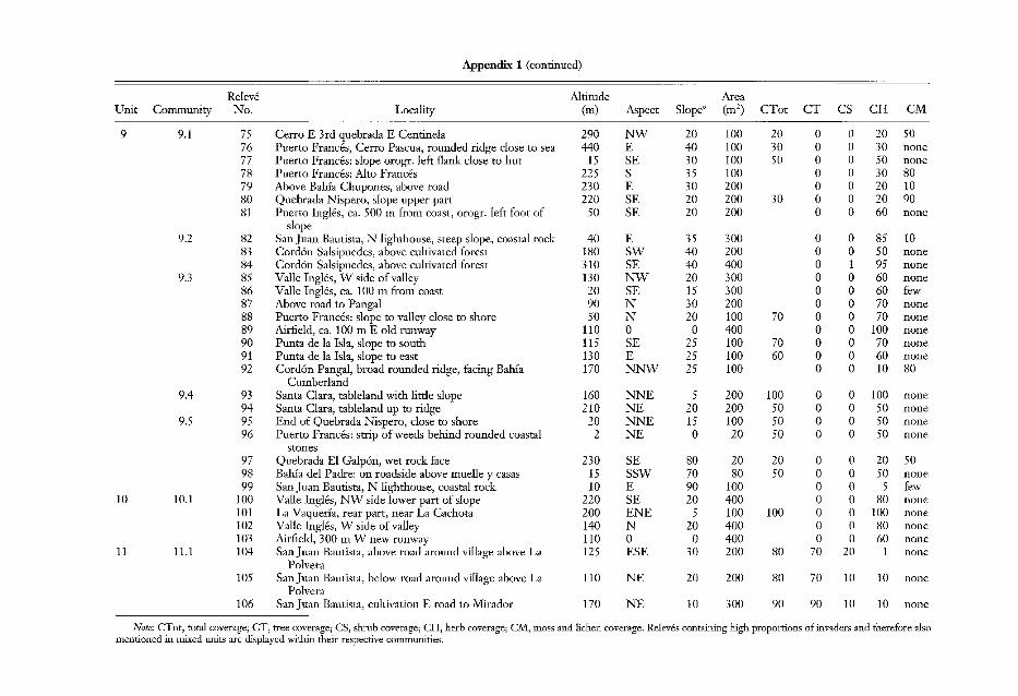
Appendix 1 (continued)
,
Releve Altitude AreaUnit Commt/nity No.! Locality (m) Aspect Slope' (m2) CTot CT CS CH CM
9 9.~ 75 i Cerro E 3rd quebrada E Centinela 290 NW 20 100 20 0 0 20 5076 Puerto Frances, Cerro Pascua, rounded ridge close to sea 440 E 40 100 30 0 0 30 none77 Puerto Frances: slope orogr. left flank close to hut 15 SE 30 100 50 0 0 50 none78 Puerto Frances: Alto Frances 225 S 35 100 0 0 30 8079 Above Bahia Chupones, above road 230 E 30 200 0 0 20 1080 Quebrada Nispero, slope upper part 220 SE 20 200 30 0 0 20 9081 Puerto Ingles, ca. 500 m from coast, orogr. left foot of 50 SE 20 200 0 0 60 none
slope9.2 82 : San Juan Bautista, N lighthouse, steep slope, coastal rock 40 E 35 300 0 0 85 10
83 : Cordon Salsipuedes, above cultivated forest 180 SW 40 200 0 0 50 none84 Cordon Salsipuedes, above cultivated forest 310 SE 40 400 0 1 95 none
9.3 85 Valle Ingles, W side of valley 130 NW 20 300 0 0 60 none86 Valle Ingles, ca. 100 m from coast 20 SE 15 300 0 0 60 few87 Above road to Panga! 90 N 30 200 0 0 70 none88 Puerto Frances: slope to valley close to shore 50 N 20 100 70 0 0 70 none89 Airfield, ca. 100 m E old runway 110 0 0 400 0 0 100 none90 Punta de la Isla, slope to south 115 SE 25 100 70 0 0 70 none91 Punta de la Isla, slope to east 130 E 25 100 60 0 0 60 none92 Cordon Pangal, broad rounded ridge, facing Bahia 170 NNW 25 100 0 0 10 80
Cumberland9.4 93 Santa Clara, tableland with little slope 160 NNE 5 200 100 0 0 100 none
94 Santa Clara, tableland up to ridge 210 NE 20 200 50 0 0 50 none9.~ 95 End of Quebrada Nispero, close to shore 20 NNE 15 100 50 0 0 50 none
96: Puerto Frances: strip of weeds behind rounded coastal 2 NE 0 20 50 0 0 50 nonestones
97: Quebrada El Galpon, wet rock face 230 SE 80 20 20 0 0 20 5098 Bahia del Padre: on roadside above muelle y casas 15 SSW 70 80 50 0 0 50 none99 San Juan Bautista, N lighthouse, coastal rock 10 E 90 100 0 0 5 few
10 10.t 100 Valle Ingles, NW side lower part of slope 220 SE 20 400 0 0 80 none101 La Vaquerfa, rear part, near La Cachota 200 ENE 5 100 100 0 0 100 none102 Valle Ingles, W side of valley 140 N 20 400 0 0 80 none103 Airfield, 300 m W new runway 110 0 0 400 0 0 60 none
11 11.1 104 San Juan Bautista, above road around village above La 125 ESE 30 200 80 70 20 1 nonePolvera
1051 San Juan Bautista, below road around village above La 110 NE 20 200 80 70 10 10 nonePolvera
106j San Juan Bautista, cultivation E road to Mirador 170 NE 10 300 90 90 10 10 none
Note: CTot, ~otal coverage; dr, tree coverage; CS, shrub coverage; CR, herb coverage; CM, moss and lichen coverage. Releves containing high proportions of invaders and therefore alsomentioned in miJied units are di~played within their respective communities.
1