The West Andean Thrust, the San Ramón Fault, and the ...lacassin/papers/Armijo_et_al...
34
Click Here for Full Article The West Andean Thrust, the San Ramón Fault, and the seismic hazard for Santiago, Chile Rolando Armijo, 1 Rodrigo Rauld, 2 Ricardo Thiele, 2 Gabriel Vargas, 2 Jaime Campos, 3 Robin Lacassin, 1 and Edgar Kausel 3 Received 22 November 2008; revised 22 July 2009; accepted 7 October 2009; published 27 March 2010. [1] The importance of west verging structures at the western flank of the Andes, parallel to the subduction zone, appears currently minimized. This hampers our understanding of the Andes‐Altiplano, one of the most significant mountain belts on Earth. We analyze a key tectonic section of the Andes at latitude 33.5°S, where the belt is in an early stage of its evolution, with the aim of resolving the primary architecture of the orogen. We focus on the active fault propagation–fold system in the Andean cover behind the San Ramón Fault, which is critical for the seismic hazard in the city of Santiago and crucial to decipher the structure of the West Andean Thrust (WAT). The San Ramón Fault is a thrust ramp at the front of a basal detachment with average slip rate of ∼0.4 mm/yr. Young scarps at various scales imply plausible seismic events up to M w 7.4. The WAT steps down eastward from the San Ramón Fault, crossing 12 km of Andean cover to root beneath the Frontal Cordillera basement anticline, a range ∼5 km high and >700 km long. We propose a first‐order tectonic model of the Andes involving an embryonic intracontinental subduction consistent with geological and geophysical observations. The stage of primary westward vergence with dominance of the WAT at 33.5°S is evolving into a doubly vergent configuration. A growth model for the WAT‐Altiplano similar to the Himalaya‐Tibet is deduced. We suggest that the intracontinental subduction at the WAT is a mechanical substitute of a collision zone, rendering the Andean orogeny paradigm obsolete. Citation: Armijo, R., R. Rauld, R. Thiele, G. Vargas, J. Campos, R. Lacassin, and E. Kausel (2010), The West Andean Thrust, the San Ramón Fault, and the seismic hazard for Santiago, Chile, Tectonics, 29, TC2007, doi:10.1029/2008TC002427. 1. Introduction [2] The Andean orogeny is considered the paradigm for mountain belts associated with subduction plate boundaries [e.g., Dewey and Bird, 1970; James, 1971]. Yet, no mechanical model can explain satisfactorily the Andean mountain building process as a result of forces applied at its nearby subduction margin, along the western flank of the South America conti- nent [e.g., Lamb, 2006]. Part of the problem arises from a geometric ambiguity that is readily defined by the large‐scale topography (Figure 1): the Andes mountain belt is a doubly vergent orogen that has developed a large back thrust margin at its eastern flank, with opposite (antithetic) vergence to the subduction margin. To avoid confusion, the tectonic concept of subduction margin used here is equivalent to the proflank (or prowedge) concept used for collisional belts [Malavieille, 1984; Willett et al., 1993; Adam and Reuther, 2000; Vietor and Oncken, 2005] and is preferred to the magmatic con- cept of fore arc, which has nearly coincident horizontal extent (Figure 1). Similarly, the notion of back thrust margin is used as an equivalent to that of retroflank (or retrowedge) in col- lisional belts. [3] The doubly vergent structure of the Andes mountain belt is defined by distinct orogenic thrust boundaries at the East and West Andean fronts (Figure 1). While the East Andean Front coincides with the basal thrust of the back thrust margin over the eastern foreland (the South America continent), the orogenic West Andean Front is located at significant distance from the basal megathrust of the sub- duction margin. There is a wide western foreland (∼200 km wide horizontally) separating the orogenic West Andean Front from the subduction zone, which is designated here as the Marginal (or Coastal) Block. Consequently, a fundamental mechanical partitioning occurs across the subduction margin and the marginal block, between the subduction interface, a megathrust that is responsible of significant short‐term strains and the occurrence of repeated large earthquakes, and the West Andean Front thrust that appears important in regard to the long‐term cumulative deformation and other processes associated with the Andean orogeny. However, very few specific observations are available at present to describe and to model this fundamental partitioning. [4] It is generally admitted that the high elevation of the Andes and of the Altiplano Plateau result from crustal thickening (up to ∼70 km thickness), which is associated with significant tectonic shortening (up to ∼150–300 km shortening) and large‐scale thrusting of the Andes over the South America continent (the South America craton plus other terrane accreted to the western margin of Gondwana in the Late Paleozoic), at the back thrust margin [Wigger et al., 1994; Allmendinger et al., 1997; Kley and Monaldi, 1998; Kley, 1999; Kley et al., 1999; Coutand et al., 2001; ANCORP Working Group, 2003; Oncken et al., 2006]. On the other hand, the role of the subduction margin and of the West Andean Front in the thickening processes is often considered 1 Institut de Physique du Globe de Paris, Université Paris Diderot, CNRS, Paris, France. 2 Departamento de Geología, Universidad de Chile, Santiago, Chile. 3 Departamento de Geofísica, Universidad de Chile, Santiago, Chile. Copyright 2010 by the American Geophysical Union. 0278‐7407/10/2008TC002427 TECTONICS, VOL. 29, TC2007, doi:10.1029/2008TC002427, 2010 TC2007 1 of 34
Transcript of The West Andean Thrust, the San Ramón Fault, and the ...lacassin/papers/Armijo_et_al...
ClickHere
for
FullArticle
The West Andean Thrust, the San Ramón Fault, and the seismichazard for Santiago, Chile
Rolando Armijo,1 Rodrigo Rauld,2 Ricardo Thiele,2 Gabriel Vargas,2 Jaime Campos,3
Robin Lacassin,1 and Edgar Kausel3
Received 22 November 2008; revised 22 July 2009; accepted 7 October 2009; published 27 March 2010.
[1] The importance of west verging structures at thewestern flank of the Andes, parallel to the subductionzone, appears currently minimized. This hampers ourunderstanding of the Andes‐Altiplano, one of the mostsignificant mountain belts on Earth. We analyze a keytectonic section of the Andes at latitude 33.5°S, wherethe belt is in an early stage of its evolution, with theaim of resolving the primary architecture of the orogen.We focus on the active fault propagation–fold system inthe Andean cover behind the San Ramón Fault, which iscritical for the seismic hazard in the city of Santiago andcrucial to decipher the structure of the West AndeanThrust (WAT). The San Ramón Fault is a thrust rampat the front of a basal detachment with average slip rateof ∼0.4 mm/yr. Young scarps at various scales implyplausible seismic events up to Mw 7.4. The WAT stepsdown eastward from the San Ramón Fault, crossing12 km of Andean cover to root beneath the FrontalCordillera basement anticline, a range ∼5 km high and>700 km long. We propose a first‐order tectonic modelof the Andes involving an embryonic intracontinentalsubduction consistent with geological and geophysicalobservations. The stage of primary westward vergencewith dominance of the WAT at 33.5°S is evolving intoa doubly vergent configuration. A growth model forthe WAT‐Altiplano similar to the Himalaya‐Tibet isdeduced.We suggest that the intracontinental subductionat theWAT is a mechanical substitute of a collision zone,rendering the Andean orogeny paradigm obsolete.Citation: Armijo, R., R. Rauld, R. Thiele, G. Vargas, J. Campos,R. Lacassin, and E. Kausel (2010), The West Andean Thrust, theSan Ramón Fault, and the seismic hazard for Santiago, Chile,Tectonics, 29, TC2007, doi:10.1029/2008TC002427.
1. Introduction[2] The Andean orogeny is considered the paradigm for
mountain belts associated with subduction plate boundaries[e.g.,Dewey andBird, 1970; James, 1971].Yet, nomechanicalmodel can explain satisfactorily the Andeanmountain building
process as a result of forces applied at its nearby subductionmargin, along the western flank of the South America conti-nent [e.g., Lamb, 2006]. Part of the problem arises from ageometric ambiguity that is readily defined by the large‐scaletopography (Figure 1): the Andes mountain belt is a doublyvergent orogen that has developed a large back thrust marginat its eastern flank, with opposite (antithetic) vergence to thesubduction margin. To avoid confusion, the tectonic conceptof subduction margin used here is equivalent to the proflank(or prowedge) concept used for collisional belts [Malavieille,1984; Willett et al., 1993; Adam and Reuther, 2000; Vietorand Oncken, 2005] and is preferred to the magmatic con-cept of fore arc, which has nearly coincident horizontal extent(Figure 1). Similarly, the notion of back thrust margin is usedas an equivalent to that of retroflank (or retrowedge) in col-lisional belts.[3] The doubly vergent structure of the Andes mountain
belt is defined by distinct orogenic thrust boundaries at theEast and West Andean fronts (Figure 1). While the EastAndean Front coincides with the basal thrust of the backthrust margin over the eastern foreland (the South Americacontinent), the orogenic West Andean Front is located atsignificant distance from the basal megathrust of the sub-duction margin. There is a wide western foreland (∼200 kmwide horizontally) separating the orogenic West AndeanFront from the subduction zone, which is designated here asthe Marginal (or Coastal) Block. Consequently, a fundamentalmechanical partitioning occurs across the subduction marginand the marginal block, between the subduction interface, amegathrust that is responsible of significant short‐term strainsand the occurrence of repeated large earthquakes, and theWest Andean Front thrust that appears important in regard tothe long‐term cumulative deformation and other processesassociated with the Andean orogeny. However, very fewspecific observations are available at present to describe andto model this fundamental partitioning.[4] It is generally admitted that the high elevation of the
Andes and of the Altiplano Plateau result from crustalthickening (up to ∼70 km thickness), which is associatedwith significant tectonic shortening (up to ∼150–300 kmshortening) and large‐scale thrusting of the Andes over theSouth America continent (the South America craton plusother terrane accreted to the western margin of Gondwana inthe Late Paleozoic), at the back thrust margin [Wigger et al.,1994; Allmendinger et al., 1997; Kley and Monaldi, 1998;Kley, 1999; Kley et al., 1999; Coutand et al., 2001; ANCORPWorking Group, 2003; Oncken et al., 2006]. On the otherhand, the role of the subduction margin and of the WestAndean Front in the thickening processes is often considered
1Institut de Physique du Globe de Paris, Université Paris Diderot,CNRS, Paris, France.
2Departamento de Geología, Universidad de Chile, Santiago, Chile.3Departamento de Geofísica, Universidad de Chile, Santiago, Chile.
Copyright 2010 by the American Geophysical Union.0278‐7407/10/2008TC002427
TECTONICS, VOL. 29, TC2007, doi:10.1029/2008TC002427, 2010
TC2007 1 of 34

Figure 1
ARMIJO ET AL.: WEST ANDEAN THRUST AND SAN RAMÓN FAULT TC2007TC2007
2 of 34

negligible [e.g., Isacks, 1988]. Yet the Andean SubductionMargin stands as one of the largest topographic contrasts onEarth (up to ∼12 km), substantially larger than its backthrust counterpart (Figure 1). The present study is aimed atrevising our knowledge of the large‐scale tectonics of theAndes and its interaction with subduction processes. So wespecifically deal with the overlooked West Andean Frontassociated with the subduction margin and we attempt toreassess its relative importance during the Andean orogeny.Purposefully, we choose the region of the Andes facingSantiago, because it includes a key section of the Andescrossing a key structure: the San Ramón Fault.[5] We analyzed and revised critically the Geomorphology
and the Geology of the Andes covering the region nearSantiago between ∼33°S and ∼34°S (Figures 1 and 2a) andfocusing onmorphologically active tectonic features to assessthe seismic hazard associated with the West Andean Front.Santiago nestles in the Central Depression, which for long hasbeen described as an extensional graben, bounded to the eastand west by normal faults [Brüggen, 1950; Carter andAguirre, 1965; Thiele, 1980]. In our work, we show that theSan Ramón Fault, crossing the eastern outskirts of Santiago,is a major active fault with many kilometers of thrust slip[Rauld, 2002; Rauld et al., 2006; Armijo et al., 2006]. TheWest Andean Front as defined by the San Ramón Fault isprecisely where the Quaternary and older sediments of theCentral Depression are overthrusted by the deformed rocks ofthe Andes Principal Cordillera.[6] Our study of the San Ramón Fault aims at describing
fault scarps at a range of scales (meters to kilometers) alongwith uplift of datable morphological surfaces to determineslip rates over a range of ages (103 to 107 years). We combinehigh‐resolution air photographs and digital topographic datawith a detailed field survey to describe the morphology of thepiedmont and fault scarps across it. Large cumulative scarpsand single event scarps can be identified and mapped withgood accuracy. Fault parameters (length of segments, faultdip, and possible fault slip rate) can be discussed with a viewto assess seismic hazard. The multikilometric‐scale foldingof the San Ramón structure during the past tens of millionyears can be used to constrain the thrust geometry to depthsdown to ∼10 km and more.[7] At the large scale, key tectonic observations were
gathered and analyzed critically throughout the study region,to incorporate our observations of the San Ramón Fault into
a complete tectonic section across the Andes, from the ChileTrench to the stable basement of South America (see locationin Figures 1, 2a, and 2b). This unifying approach allows us toset together, strictly to scale, the most prominent Andeantectonic features, specifically the West Andean Front, whichas we show, appears associated with the large‐scale WestAndean Thrust (WAT). We discuss the main results emergingfrom this study, particularly the true geometry and possibletectonic evolution of this segment of the Andes, which allowus to reassess the role of the subduction margin and to sug-gest a broad range of implications that challenge the Andeanorogeny paradigm.
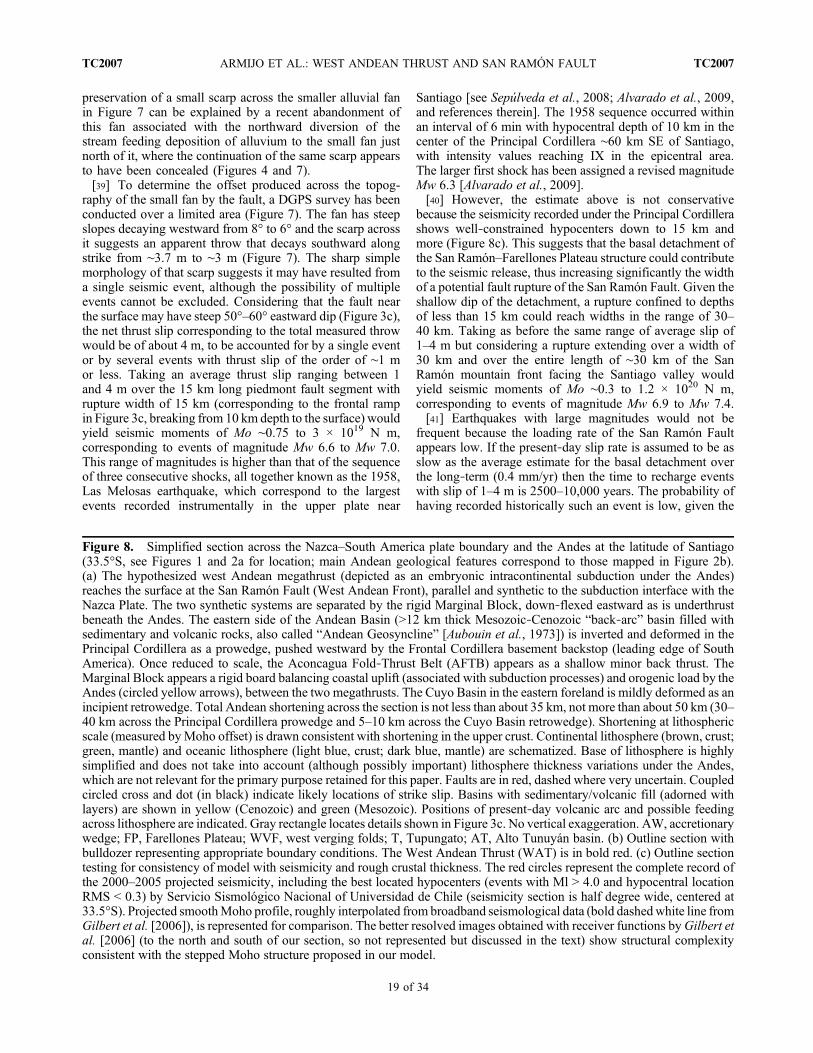
2. Tectonic Framework[8] The deformation styles generally described along the
Andes are based almost exclusively on the structure of itsback thrust margin [Kley et al., 1999; Ramos et al., 2004].Two different large‐scale sections can be used to charac-terize the doubly vergent margins of the Andes; one at 20°Slatitude crossing where the belt is largest and its structurefully developed, the other at 33.5°S where the belt is rela-tively narrow and less developed (Figure 1). The first section(profile A) crosses the largest Andean back thrust, namely,the sub‐Andean Belt, which is a thin‐skinned thrust beltdetached over the basement of stable South America [e.g.,Mingramm et al., 1979; Allmendinger et al., 1983; Kley,1996; Schmitz and Kley, 1997]. Clearly, the basal detach-ment of the sub‐Andean Belt (reaching the surface at the EastAndean Front, Figure 1) is very distant from the trench(850 km), thus also from forces applied across the subductionplate boundary. The second section (profile B, Figure 1; seealso Figures 2a and 2b for location of tectonic elements)includes another classical example of Andean back thrust,which is the thin‐skinned Aconcagua Fold‐Thrust Belt(AFTB) [Ramos, 1988; Ramos et al., 1996b; Giambiagi etal., 2003; Ramos et al., 2004]. However, this belt is notlocated along the eastern flank of the Andes Mountains,but right in the middle of them (see profile B in Figures 1,2a, and 2b). The basal detachment of the AFTB is shallow(∼2–3 km depth) and its front found at high elevation(∼4000 m), atop a huge basement high of the Andes (theFrontal Cordillera). So at present there is no clear flexuralforeland basin directly in front of the basal detachment[Polanski, 1964;Ramos, 1988;Ramos et al., 1996b;Giambiagi
Figure 1. Topography and very rough geology of the central Andes. Red box locates Figure 2. Square marked with S locatesSantiago. The main tectonic features are identified on two selected profiles (A and B, traces marked in red at 20°S and 33.5°S).Vertical black arrows indicate the present‐day volcanic arc. The subduction margin (synthetic to subduction) coincides withfore‐arc extent. The sub‐Andean Belt in profile B is part of the back thrust margin, (antithetic to subduction). The PrincipalCordillera (PC) includes the Aconcagua Fold‐Thrust Belt (AFTB), both made of volcanic/sedimentary rocks of the AndeanBasin (AB) overlying basement of the Frontal Cordillera (FC). The relatively shallow Cuyo Basin (CB) overlies the basementstructure of the Hidden Precordillera (HP). Themarginal block is formed of Central Depression (CD), Coastal Cordillera (CC),and continental margin (CM). Profile B depicts major crustal features deduced from the geology in light colors: Triassic andpre‐Triassic continental basement (brown), post‐Triassic basins (yellow) and oceanic crust (blue). The deep basin representedin the two profiles (A and B) is the Andean Basin (AB) that is crossed by the trace of theWest Andean Front. VP is ValparaísoBasin. Vertical exaggeration (VE) in profiles is 10. Map and profiles are based on topographic data from the NASA ShuttleRadar Topography mission (SRTM) and the global grid bathymetry of Smith and Sandwell [1997] (available at http://topex.ucsd.edu/WWW_html/srtm30_plus.html).
ARMIJO ET AL.: WEST ANDEAN THRUST AND SAN RAMÓN FAULT TC2007TC2007
3 of 34
et al., 2003]. Therefore, identifying the AFTB with the mainback thrust margin of the Andes is problematic. Mitigating thisproblem, a late thick‐skinned basement thrusting at the easternflank of the Frontal Cordillera is proposed [Giambiagi et al.,2003; Ramos et al., 2004].[9] In contrast with back thrusts, synthetic thrusts along
the western flank of the Andes are poorly known. However,the two sections used for comparison (profiles A and B,Figure 1) reveal a clear, continuous West Andean Front thatis expressed in the topography at ∼200 km distance from thetrench and which appears larger and sharper than features atthe same latitude along the back thrust margin. The paucityof seismic activity associated with this major syntheticcontact may be a real feature, but may also result, at least inthe region south of 33°, from lack of an appropriate localnetwork [Pardo et al., 2002; Barrientos et al., 2004]. Themost studied part of the West Andean Front is in northernChile (along profile A, Figure 1), where large volumes of
Neogene volcanic rocks blanket its structure and obscure itstectonic significance, remains under debate [Isacks, 1988;Muñoz and Charrier, 1996; Victor et al., 2004; Farías et al.,2005; García and Hérail, 2005; Hoke et al., 2007]. Bycontrast, the West Andean Front is particularly well exposedby the tectonic section at the latitude of Santiago, capital ofChile (profile B in Figure 1), which is the region retained forthis study. The physiographic map in Figure 2a displays themain tectonic belts in that region and the structural map ofthe Andes in Figure 2b focus on its fundamental elements,as defined at 33°S–34°S latitude.[10] Some characteristic elements of the central Andean
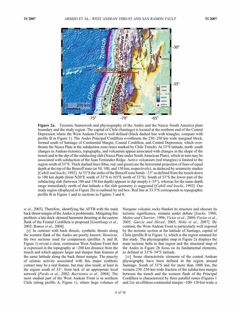
physiography have been defined in the region aroundSantiago. South of 33°S and for more than 1000 km, thewestern 230–250 km wide fraction of the subduction marginbetween the trench and the western flank of the PrincipalCordillera is characterized by three parallel zones (Figures 1and 2a): an offshore continental margin ∼100–130 kmwide; a
Figure 2a. Tectonic framework and physiography of the Andes and the Nazca–South America plateboundary and the study region. The capital of Chile (Santiago) is located at the northern end of the CentralDepression where the West Andean Front is well defined (black dashed line with triangles, compare withprofile B in Figure 1). The Andes Principal Cordillera overthrusts the 230–250 km wide marginal block,formed south of Santiago of Continental Margin, Coastal Cordillera, and Central Depression, which over-thrusts the Nazca Plate at the subduction zone (trace marked by Chile Trench). At 33°S latitude, north–southchanges in Andean tectonics, topography, and volcanism appear associated with changes in the shape of thetrench and in the dip of the subducting slab (Nazca Plate under South American Plate), which in turn may beassociated with subduction of the Juan Fernandez Ridge. Active volcanism (red triangles) is limited to theregion south of 33°S. Thick dashed lines (blue, red, and green) are the horizontal projection of lines of equaldepth at the top of the Benioff zone (at 50, 100, and 150 km, respectively), as deduced by seismicity studies[Cahill and Isacks, 1992]. At 33°S the strike of the Benioff zone bends ∼15° as defined from the trench downto 100 km depth (from N20°E south of 33°S to N5°E north of 33°S). South of 33°S the lower part of thesubducting slab (between 100 and 150 km depth) appears to dip steeply (∼35°), whereas for the same depthrange immediately north of that latitude a flat slab geometry is suggested [Cahill and Isacks, 1992]. Ourstudy region (displayed in Figure 2b) is outlined by red box. Red line at 33.5°S corresponds to topographicprofile B in Figure 1 and to sections in Figures 3 and 8.
ARMIJO ET AL.: WEST ANDEAN THRUST AND SAN RAMÓN FAULT TC2007TC2007
4 of 34
Figure
2b
ARMIJO ET AL.: WEST ANDEAN THRUST AND SAN RAMÓN FAULT TC2007TC2007
5 of 34

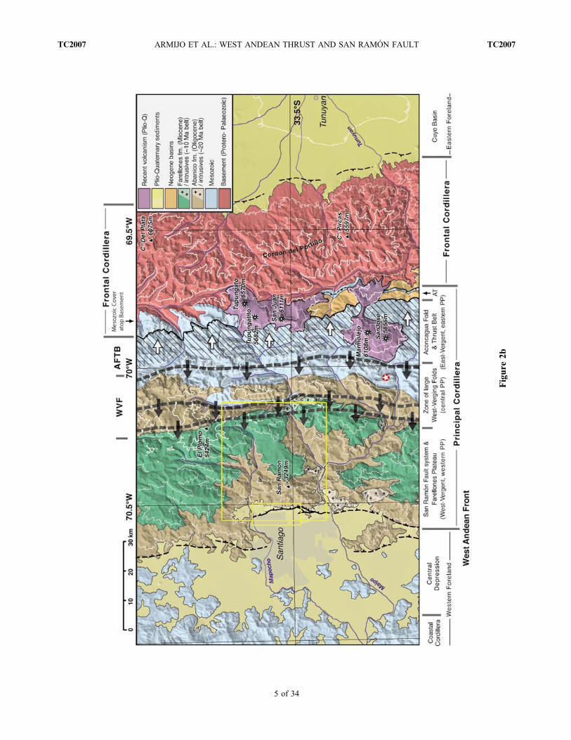
coastal cordillera ∼30–60 km wide, made of mature land-forms peaking at more than 2000 m elevation; and a flatcentral depression ∼30–60 km wide and averaging ∼500 m inelevation near Santiago, which is filled with less than 1 km ofquaternary sediments. Structurally those three zones togetherrepresent the western foreland of the Andes (the marginal orcoastal block). East of the marginal block, a large region withelevation over 1 km associated with the Andes extends at thislatitude over a total width of ∼200 km. However, the Andesmountain belt strictly, with elevation >2 km, is restricted to anarrower western belt, which is only about 100 km wide,including the Principal Cordillera (which in turn includes theAFTB) and the Frontal Cordillera (Figures 1, 2a, and 2b).Santiago is located in the Central Depression facing the WestAndean Front of the Principal Cordillera where it is particu-larly well defined by the topography (profile B, Figure 1).Despite its accepted designation, the “Frontal” Cordillera isflanked to the west by the Principal Cordillera and to the east(north of 33°S) by the Precordillera (Figure 2a), so it appearslocated far from any major structural front (i.e., the East andWest Andean fronts; profile B, Figure 1). The tectonic sig-nificance of the Frontal Cordillera appears capital and thusis addressed along with discussions in this section and insections 4 and 5.[11] The study region is immediately south of 33°S latitude
(Figures 2a and 2b) where significant lateral (along‐strike)changes in the Andean tectonics, topography and volcanismappear associated with changes in the shape of the trench andin the dip of the subducting slab, i.e., the Nazca Plate underthe South American Plate [Isacks, 1988, Cahill and Isacks,1992]. Those changes may in turn be associated with sub-duction of the Juan Fernandez Ridge [von Huene et al., 1997;Gutscher et al., 2000; Yañez et al., 2001]. At 33°S, theaverage strike of the Benioff zone bends ∼15° as definedfrom the trench down to 100 km depth (from N20°E southof 33°S to N5°E north of 33°S). South of 33°S, the lowerpart of the subducting slab (between 100 and 150 km depth)appears to dip steeply (∼35°) whereas for the same depthrange a flat slab geometry is suggested immediately north ofthat latitude [Cahill and Isacks, 1992]. This change in thesubduction geometry would explain the presence of activevolcanism to the south of 33°S and its absence north of 33°S,
where volcanism has ceased at ∼10 Ma [Kay et al., 1987;Isacks, 1988].[12] The physiography of the west Andean flank also
changes to some extent in front of the “flat slab” segment(between 33°S and 27°S). The western boundary of thePrincipal Cordillera shifts westward, the Central Depressiondisappears and the West Andean Front is expressed by awide, gradual topographic contrast. North of 27°S the WestAndean Front is again very sharp in the topography (profileA, Figure 1). Changes of the physiography in front of the“flat slab” segment are more significant along the easternflank of the Andes, where the Precordillera and the SierrasPampeanas are defined (Figure 2a). The Precordillera is abelt located to the east of the Frontal Cordillera and separatedfrom it by a narrow depression (Uspallata‐Iglesia basin). Itis described as a thin‐skinned back thrust belt involvingPaleozoic rocks (Paleozoic cover of Cuyania terrane [Ramos,1988]) and absorbing significant tectonic shortening, similarto the sub‐Andean Belt [Allmendinger et al., 1990]. Eastfrom the Precordillera are found the thick‐skinned SierrasPampeanas, which correspond to several thrust blocks withinthe basement of Gondwanan South America [Allmendingeret al., 1990; Ramos et al., 2002; Ramos, 1988] (seeFigure 2a for location of these belts).[13] Geologically, the front of the Principal Cordillera east
of Santiago crosses the deep, very long (several 103 kmlong) and relatively narrow (of the order of 102 km wide)Andean Basin that can be followed nearly parallel to theAndes between the equator and latitude 48°S [Mpodozis andRamos, 1989; Vicente, 2005]. This huge feature (in yellowand labeled AB in profiles A and B, Figure 1) has earlierbeen called the Andean “Geosyncline” [e.g., Aubouin et al.,1973] and appears closely associated with subduction andAndean cycle orogenic processes operating continuouslyalong the western margin of the South America continentsince the Jurassic. The Andean Basin is formed of EarlyJurassic to Miocene volcanics, volcanic‐derived rocks,clastics and some marine rocks with an overall thickness of∼12–15 km or more [Mpodozis and Ramos, 1989; Robinsonet al., 2004] (for a thorough stratigraphical review, seeCharrier et al. [2007]). Those rocks have been depositedover the pre‐Andean basement assemblage consisting of
Figure 2b. Structural map of the Andes in the study region compiled from geological information at diverse scale, in Chile[from Thiele, 1980; Gana et al., 1999; Sellés and Gana, 2001; Fock, 2005], in Argentina [from Polanski, 1964, 1972;Giambiagi et al., 2001; Giambiagi and Ramos, 2002], and our own observations. The Principal Cordillera is subdivided inthree units (western PP, central PP, and eastern PP) according to vergence of observed structures (discussed in the text). Thethin‐skinned Aconcagua Fold‐Thrust Belt (AFTB) is hatched with frontal fault trace in black, adorned with triangles. Its maineastward vergence is indicated by white arrows. The zone of large west verging folds (WVF) is illustrated by dashed blackstripes adorned with westward directed arrows, indicating the approximate position of basal layers of main nearly verticallimbs (with top‐to‐the‐west geometry). The red‐circled white star indicates location of Neocomian beds in Figure 9. Theshallow westward dipping basal contact of the Mesozoic cover (eastern side of Andean Basin) is clearly seen atop the FrontalCordillera basement anticline (towering at more than 6000 m) in the northern half of the map. Two outcrops of the relativelysmall intermontane Alto Tunuyán basin (AT) are seen in the southern half of the map (consistent with maps byGiambiagi et al.[2001] and Giambiagi and Ramos [2002]). The San Ramón Fault marks the synthetic West Andean Front, at the contactbetween the Principal Cordillera and the Central Depression (western foreland). At this latitude, the east verging, thick‐skinnedback thrust that disrupts the contact of the Frontal Cordillera with the Cuyo basin (eastern foreland) is mostly hidden. Elevationcontours (white, each 1000 m; thicker contour for 4000 m) derived from SRTM data. The yellow rectangles locate maps inFigures 3b (larger rectangle) and 4 (smaller rectangle).
ARMIJO ET AL.: WEST ANDEAN THRUST AND SAN RAMÓN FAULT TC2007TC2007
6 of 34

magmatic and metamorphic rocks amalgamated, during theEarly to Middle Paleozoic, with the western margin ofGondwana (south of 15°S under the Andean Basin are foundspecifically the Arequipa‐Antofalla, the Mejillonia and theChilenia terranes [e.g., Hervé et al., 2007; Charrier et al.,2007; Lucassen et al., 2000; Ramos, 2008; Vaughan andPankhurst, 2008]). At the latitude of Santiago, the westernside of the Andean Basin along the Coastal Cordillera over-lays the extreme west margin of the pre‐Andean Gondwanabasement (west margin of the Chilenia terrane), which ismade of a metamorphic accretionary prism system (involvingrocks of Paleozoic and possibly Late Proterozoic age [seeHervé et al., 2007, and references therein]), intruded by agranitoid batholith of Late Paleozoic age [e.g.,Mpodozis andRamos, 1989;Hervé et al., 2007]. The thick rock pile that hasaccumulated in the Andean Basin has undergone extensiveburial metamorphism with low‐grade, subgreenschist facies[e.g., Levi et al., 1989; Aguirre et al., 1999; Robinson et al.,2004, and references therein]. The Andean Basin started toform in a back‐arc environment, which lasted stable until theend of the Mesozoic [Mpodozis and Ramos, 1989; Charrieret al., 2007]. Then progressive eastward migration of themagmatic arc during the Late Cretaceous and Cenozoic,which may be associated with subduction erosion processes[Coira et al., 1982; Scheuber et al., 1994; Kay et al., 2005;Charrier et al., 2007], has ultimately put most of the basin inits present fore‐arc position (see profiles A and B, Figure 1).[14] The first‐order structure of the Andean Basin in our
study region is simple, but with a clear asymmetry. In itswestern (external or coastal) flank, the Jurassic rocks at thebase of it rest unconformably, with relatively shallow east-ward dip (∼25° on the average, but increasing eastward tomaximum values of ∼40°), on top of the pre‐Andean base-ment rocks of the marginal block, which crop out at relativelylow elevation (no more than ∼300m) in the Coastal Cordillera.In its eastern (internal or Andean) flank, the equivalent Jurassicrocks at the base of the Andean Basin rest unconformably ontop of basement rocks of similar pre‐Jurassic age, but situatedin a structural high cropping out at more than 5 km elevationin the Frontal Cordillera (Figures 1 and 2b). The FrontalCordillera high is a large arched ridge elongated in N–Sdirection, of which the top surface is made of the Permian‐Triassic Choiyoi Group. These rocks overly the magmaticand metamorphic, Protero‐Paleozoic, Gondwana basement(considered as Chilenia terrane in the Frontal Cordillera [seeMpodozis and Ramos, 1989; Heredia et al., 2002; Llambíaset al., 2003]). The basal sedimentary contact of the AndeanBasin rocks over Triassic and basement rocks of the FrontalCordillera has shallow westward dip (Figure 2b). However,west of the Frontal Cordillera, the sediments of the Andeanbasin in the high Principal Cordillera (which includes theAFTB) are strongly deformed with dominant very steepwestward dip across most of the AFTB. That steep westwarddip appears the main characteristic of the eastern flank of theAndean Basin (Figure 2b) and a result of strong pervasiveshortening across the whole Principal Cordillera. Hence,overall the Andean Basin emerges as a crustal‐scale asym-metric syncline inclined westward, located west of the mainbasement high of the Andes (the Frontal Cordillera) and thusstructurally constituting the original basin formed in the
western foreland, west of the Andean belt. However, thepresent‐day mountain front of the Principal Cordillera inter-sects that large syncline in the middle, so reducing the actualwidth of the foreland (profile B, Figure 1). The same tectonicconfiguration is observed 800 km northward along strikefor the subduction margin of the Andean belt (profile A,Figure 1).[15] Summarizing the foregoing, the West Andean Front
near Santiago appears as a major tectonic contact between thePrincipal Cordillera, which corresponds to the pervasivelyshortened eastern side of the Andean Basin, with significantwestward dip, and the marginal block, which constitutes therelatively shallow dipping western side of the Andean Basinand is devoid of significant Andean deformation [Thiele,1980] (Figure 1). It has been shown recently that this fun-damental contact is not a normal fault as stated by the generalbelief for more than half a century [Brüggen, 1950; Carterand Aguirre, 1965; Thiele, 1980; Nyström et al., 2003], butan important thrust system [Rauld, 2002; Rauld et al., 2006;Armijo et al., 2006]. The observations of the San RamónFault along the West Andean Front in section 3 defineconstraints on the tectonic mechanisms by which the signif-icantly shortened Principal Cordillera overthrusts the rela-tively rigid western foreland represented by the marginalblock, which in turn overthrusts the even stiffer NazcaPlate at the subduction zone.
3. San Ramón Fault3.1. Basic Observations
[16] Cerro San Ramón is the 3249 m high peak on themountain front that overlooks the city of Santiago from theeast and gives the name to the fault at its base (Figure 3a).The corresponding west vergent San Ramón frontal structure,which is interpreted and discussed hereafter, is determined bystructural elements mapped accurately in Figure 3b, whichare displayed in an E–W section constructed below thestructural map in Figure 3b and extended for tectonic inter-pretation in Figure 3c. The trace of the San Ramón Faultbears a morphological scarp that is readily visible across thepiedmont in the outskirts of the city [Tricart et al., 1965;Borde, 1966]. However, the detailed mapping of the SanRamón Fault has been prompted only once it was recentlyidentified as an active thrust representing seismic hazard forSantiago [Rauld, 2002; Rauld et al., 2006; Armijo et al.,2006] (Figure 4) (see the auxiliary material).1 Techniquesused to describe the San Ramón Fault include satelliteimagery, high‐resolution air photographs and digital eleva-tion models (DEMs) at three different scales, which werecombined systematically with published geological maps[Thiele, 1980; Gana et al., 1999; Sellés and Gana, 2001;Fock, 2005] and detailed field observations (e.g., Figure 5).Various sources of accurate digital topography (particularlySRTM with 90 m horizontal resolution and a DEM with∼30 m resolution derived from 1:25,000 scale local maps)and imagery (Landsat 7, ortho‐rectified georeferenced SPOTimages with resolution of 5 m, and aerial photographs) have
1Auxiliary materials are available in the HTML. doi:10.1029/2008TC002427.
ARMIJO ET AL.: WEST ANDEAN THRUST AND SAN RAMÓN FAULT TC2007TC2007
7 of 34

Figure
3a.
Morph
olog
yandstructureof
theWestAndeanFront
andthewestern
Principal
Cordillerafacing
Santiago
.Three‐dim
ensionalview
ofDEM
with
Landsat7im
ageryoverlaid.O
blique
view
toNE.T
hemostfrontalSan
Ram
ónFault
reachesthesurfaceat
thefoot
ofCerro
San
Ram
ón,across
theeasterndistrictsof
Santiago.Rectangle
show
sapproxim
ate
area
mappedin
Figure4,
which
givesdetails
ofthefaulttrace.
Totheeast
ofCerro
San
Ram
ón,FarellonesPlateau
isincised∼2
kmby
rios
Molina‐Mapocho
andColorado‐Maipo,w
hich
gradeto
theCentralDepression(Santiago
basin).R
edlin
emarks
approxim
atetraceof
sectionshow
nin
Figures
3band3c.
ARMIJO ET AL.: WEST ANDEAN THRUST AND SAN RAMÓN FAULT TC2007TC2007
8 of 34
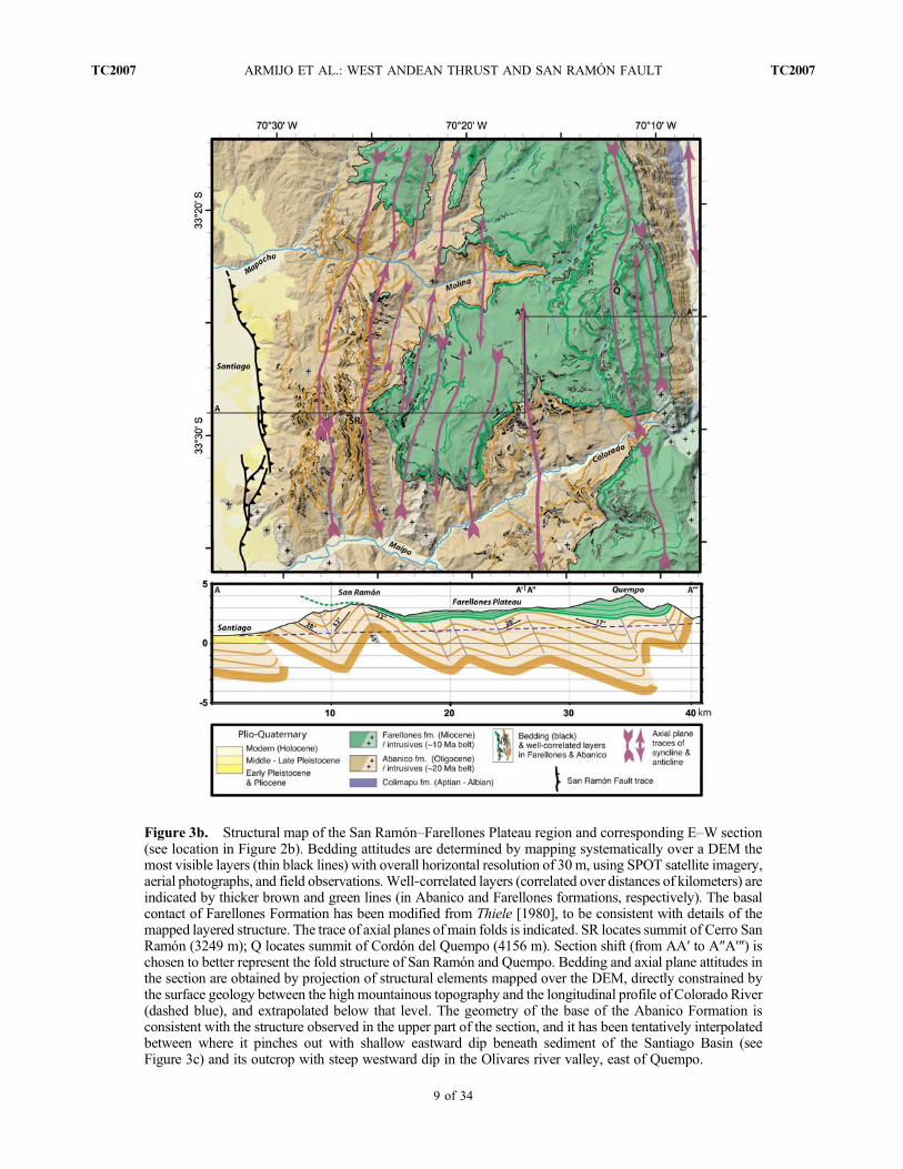
Figure 3b. Structural map of the San Ramón–Farellones Plateau region and corresponding E–W section(see location in Figure 2b). Bedding attitudes are determined by mapping systematically over a DEM themost visible layers (thin black lines) with overall horizontal resolution of 30 m, using SPOT satellite imagery,aerial photographs, and field observations. Well‐correlated layers (correlated over distances of kilometers) areindicated by thicker brown and green lines (in Abanico and Farellones formations, respectively). The basalcontact of Farellones Formation has been modified from Thiele [1980], to be consistent with details of themapped layered structure. The trace of axial planes ofmain folds is indicated. SR locates summit of Cerro SanRamón (3249 m); Q locates summit of Cordón del Quempo (4156 m). Section shift (from AA′ to A″A′″) ischosen to better represent the fold structure of San Ramón and Quempo. Bedding and axial plane attitudes inthe section are obtained by projection of structural elements mapped over the DEM, directly constrained bythe surface geology between the high mountainous topography and the longitudinal profile of Colorado River(dashed blue), and extrapolated below that level. The geometry of the base of the Abanico Formation isconsistent with the structure observed in the upper part of the section, and it has been tentatively interpolatedbetween where it pinches out with shallow eastward dip beneath sediment of the Santiago Basin (seeFigure 3c) and its outcrop with steep westward dip in the Olivares river valley, east of Quempo.
ARMIJO ET AL.: WEST ANDEAN THRUST AND SAN RAMÓN FAULT TC2007TC2007
9 of 34

been used to constrain the morphology and the structure at thescale of kilometers (Figures 3a and 3b). For the piedmontscarp, a DEM based on photogrammetry (horizontal resolu-tion of 10 m; vertical precision of 2.5 m) (Figure 6) andvarious sets of aerial photographs were used (ServicioAerofotogramétrico (SAF) Fuerza Aérea de Chile, scales1:70,000 (1995) and 1:50,000 (1997)). Because large parts ofthe piedmont scarp are now obliterated by human settlement,old air photographs (taken in 1955 by Instituto GeográficoMilitar, scale 1:50,000) were used to determine the exactposition of the fault trace. So the morphological and tectonicfeatures could be mapped at 1:5000 scale, then the overallinformation compiled in a map at 1:25,000 scale (Figure 4).To characterize a smaller‐scale fault scarp across youngalluvium, a higher‐resolution DEM (horizontal resolutionof 2 m; vertical precision of 10 cm) was created over anarea of ∼400 × 300 m2 using a DGPS survey (Figure 7).
3.2. Multikilometric Frontal Thrust: ShallowStructure, Morphology, and Stratigraphy
[17] The shortening structures affecting the Cenozoicsequences of the western Principal Cordillera are very well
defined and well exposed in the San Ramón massif and theFarellones Plateau, which are located immediately eastwardof the San Ramón Fault (Figure 3b). That frontal short-ening appears associated with significant structural uplift ofthe Principal Cordillera relative to the Central Depression.A first‐order measure of that uplift is given by the recentmorphological evolution, in particular, the incision of deepcanyons across the Farellones Plateau by ríos Mapocho andMaipo, and their tributaries Molina and Colorado, respec-tively (Figure 3a). The reasoning behind the foregoing is asfollows. The total incision observed at the present is of theorder of ∼2 km and it has necessarily occurred since thetime the Farellones Plateau formed as a continuous andrelatively flat surface (now at elevation of ∼2200–2500 m)atop a pile of Miocene volcanic lava flows (Figure 5a).Mostly coevally with the incision of the canyons, the ríosMapocho and Maipo appear to have discharged sediment inthe Santiago basin (Central Depression), where a maximumof ∼500 m of alluvium and colluvium of Quaternary andpossibly late Neogene age has accumulated [Araneda et al.,2000]. The Central Depression therefore represents a rela-tive base level where at least part of the sediment supply
Figure 3c. Interpreted structure of the western Principal Cordillera associated with the east dippingramp flat geometry of the San Ramón Fault. Box with plain colors shows surface geology, exactly asin the structural section constructed to −4 km in Figure 3b. Geology inferred farther downward andobserved sideward is shown in opaque colors. Our interpretation implies that the western Andean front ischaracterized by the west vergent fold thrust structure of the >12 km thick volcanic‐sedimentary cover ofthe Andean Basin (Jurassic‐Cenozoic), which is pushed over the eastward tilted Marginal Block (orcoastal block, formed of Central Depression warp atop Coastal Cordillera basement) by the (backstop or“bulldozer‐like”) the West Andean Basement Thrust System (involving magmatic rocks of Triassic andolder age). A low‐angle basal decollement would be localized at the ductile evaporitic layers of LateJurassic age (Río Colina Formation; “Yeso principal del Malm”). The San Ramón Fault alone has netthrust slip of ∼5 km (red half arrow), corresponding to the offset of the base of the Oligocene–earlyMioceneAbanico Formation. The total horizontal shortening by folding and thrusting across the San Ramón–Farellones Plateau structure (between the two red triangles) results from ∼10 km westward transport of thevolcanic‐sedimentary pile relative to the underlying basement (bold double arrows). The larger overallshortening associated with the West Andean Thrust (>30 km) must be rooted in a major east dipping rampcrossing the basement and deep crust underneath the high Andes (to the east, outside of the shown section,see Figure 8). Main Miocene plutons are indicated: La Obra (LO, ∼20 Ma) and La Gloria (LG, ∼10 Ma).
ARMIJO ET AL.: WEST ANDEAN THRUST AND SAN RAMÓN FAULT TC2007TC2007
10 of 34

Figure 4
ARMIJO ET AL.: WEST ANDEAN THRUST AND SAN RAMÓN FAULT TC2007TC2007
11 of 34

provided by erosion of the Andes Principal Cordillera istrapped. However, most of that sediment supply transitsthrough the Central Depression and Coastal Cordillera to bedeposited on the continental margin and ultimately in thetrench [e.g., vonHuene et al., 1997]. Conversely, there is verylittle recent incision in the Central Depression, which behavesmostly as a sedimentary basin. A mature relief with relativelyminor young incision by rivers characterizes the rest of theeastward tilted marginal block, formed by the eastward dip-ping edge of the Andean Basin on top of Coastal Cordillerabasement rocks (Figure 3c). This structure suggests thatthe whole marginal block has experienced moderate, non-uniform, uplift associated with the eastward tilt, and gradualerosion, possibly throughout a significant part of the Ceno-zoic. Hence, the cause of the vigorous young incision of theFarellones Plateau and more generally of the whole PrincipalCordillera must be a relative base level drop localized at itsboundary with the Central Depression, so associated withthrusting and relative uplift at theWest Andean Front, deducedonly from the morphology, of at least ∼2 km.[18] The young uplift across the West Andean Front can
be explained by some fault geometry and kinematics, whichevolve during a certain time span. The relatively simple foldthrust structure of the San Ramón massif–Farellones Plateau,representative of the western Principal Cordillera (Figure 2b),is particularly fitted to the purpose, because it can be readilyinterpreted as a growing west vergent fault propagation foldsystem (Figures 3b and 3c). Kinematic models describingfaults propagating through layered rocks and generatingfolds ahead of their tip lines [e.g., Suppe and Medwedeff,1990] can be applied to the San Ramón structure. So ifthe geometry and the timing of the deformation are suffi-ciently constrained, then deformation rates can be derived.[19] The simplified structure depicted to 4 km depth in the
San Ramón section (in Figure 3b, below, and in the boxwith plain colors in Figure 3c) is well reconstructed from thedirect observations of the surface geology reported in ourstructural map (Figure 3b). Uncertainties remain because notall the layers in the volcanic sequences can be followedcontinuously, but we are confident that the overall geometryconstrained by the elements of our map is accurate, and inany case, correct enough for the first‐order estimates that wemake in section 3.3. This superficial part of the section spansmostly continental deposits of Paleogene‐Neogene age, withthe Farellones Formation on top of the Abanico Formation[Thiele, 1980;Vergara et al., 1988,Nyström et al., 2003]. TheAbanico and Farellones formations are regionally mapped oneover the other for more than ∼300 km along the strike of theAndes (for thorough descriptions and discussions of these two
formations, see Charrier et al. [2002, 2005]). They representthe uppermost units deposited in the Andean Basin syncline.Folding in the Abanico Formation is significant and itdecreases gradually upward into the Farellones Formation,so the contact between these two units is described asprogressive, with no clear time hiatus and no developmentof a regional unconformity [Godoy et al., 1999; Charrier etal., 2002, 2005]. The elusive definition of this contact hascreated confusion and inconsistencies between the differentpublished sections and maps [e.g., Kay et al., 2005]. How-ever, pronounced angular unconformities with the overlyingFarellones Formation are visible where localized deforma-tion and erosion in the Abanico Formation is more intense, asit can be appreciated in some spots along the San Ramónsection (Figure 3b, bottom). Folding appears to have con-tinued throughout and after deposition of the FarellonesFormation, so this unit is syntectonic. As a result the twoformations (Abanico and Farellones) form a progressivelyfolded asymmetric synclinorium ∼30 kmwide at the center ofthe Andean Basin (Figure 3c).[20] The Abanico Formation consists of volcaniclastic
rocks, tuffs, basic lavas, ignimbrites and interbedded alluvial,fluvial and lacustrine sediments [Charrier et al., 2002, 2005,and references therein], with aminimum exposed thickness of∼3 km in the western flank of Cerro San Ramón (Figure 3b).The maximum age range compiled regionally for theAbanico Formation is from 36 Ma to 16 Ma, indicating alate Eocene–late early Miocene age [Charrier et al., 2002].More precisely, the K/Ar and 40Ar/39Ar dates in the hugestratified pile of volcanic rocks of the Abanico Formationclose to Santiago range from 30.9 to 20.3Ma, and are intrudedby stocks, porphyry dikes and volcanic necks as young as16.7 Ma [Gana et al., 1999; Nyström et al., 2003; Vergaraet al., 2004]. The more prominent pluton named La Obraleucogranodiorite intruding the San Ramón massif (Figure 3c)has a 40Ar/39Ar biotite age of 19.6 ± 0.5Ma [Kurtz et al., 1997].[21] The Farellones Formation as defined at its type section
east of Santiago consists of a thick series of intermediateand basic lava flows with volcaniclastic rocks and minorignimbritic flows [Beccar et al., 1986; Vergara et al., 1988].Its thickness there is variable, of 1–2 km (Figure 3b). Thepublished K/Ar and 40Ar/39Ar dates as well as U‐Pb zirconanalyses in the Farellones Formation east of Santiago rangefrom 21.6 to 16.6 Ma [Beccar et al., 1986; Nyström et al.,2003; Deckart et al., 2005]. Elsewhere the Farellones For-mation may exceed thicknesses of 2 km and span ages frommiddle to late Miocene [Charrier et al., 2002]. The age ofthe Farellones Formation is also variable at the regionalscale. Unconformable volcanic rocks as old as 25.2 Ma are
Figure 4. Map, satellite SPOT image and sections describing the San Ramón Fault and its piedmont scarp in the easterndistricts of Santiago. Map and SPOT images covering the same area (shown in Figures 2b and 3a). Sections tentativelyinterpreted across the fault (labeled A and B) are located in the map. The San Ramón Fault trace is at the foot of a con-tinuous scarp east of which the piedmont is uplifted and incised by streams. The more incised Cerros Calán, Apoquindo, andLos Rulos (to the north) expose an anticline made of early Quaternary sediments, cored by bedrock of the Abanico Formationand possibly cut by subsidiary thrusts, as those better exposed and mapped in Cerro Los Rulos (illustrated in section A). Thegently sloping piedmont that is uplifted in the central part of the segment (section B) is covered with middle‐late Pleistocenealluvium containing lenses of volcanic ash correlated with Pudahuel ignimbrites (see text). The map has been compiled andgeoreferenced at 1:25,000 scale, from original mapping on a DEM at 1:5,000 scale (shown in Figure 6).
ARMIJO ET AL.: WEST ANDEAN THRUST AND SAN RAMÓN FAULT TC2007TC2007
12 of 34
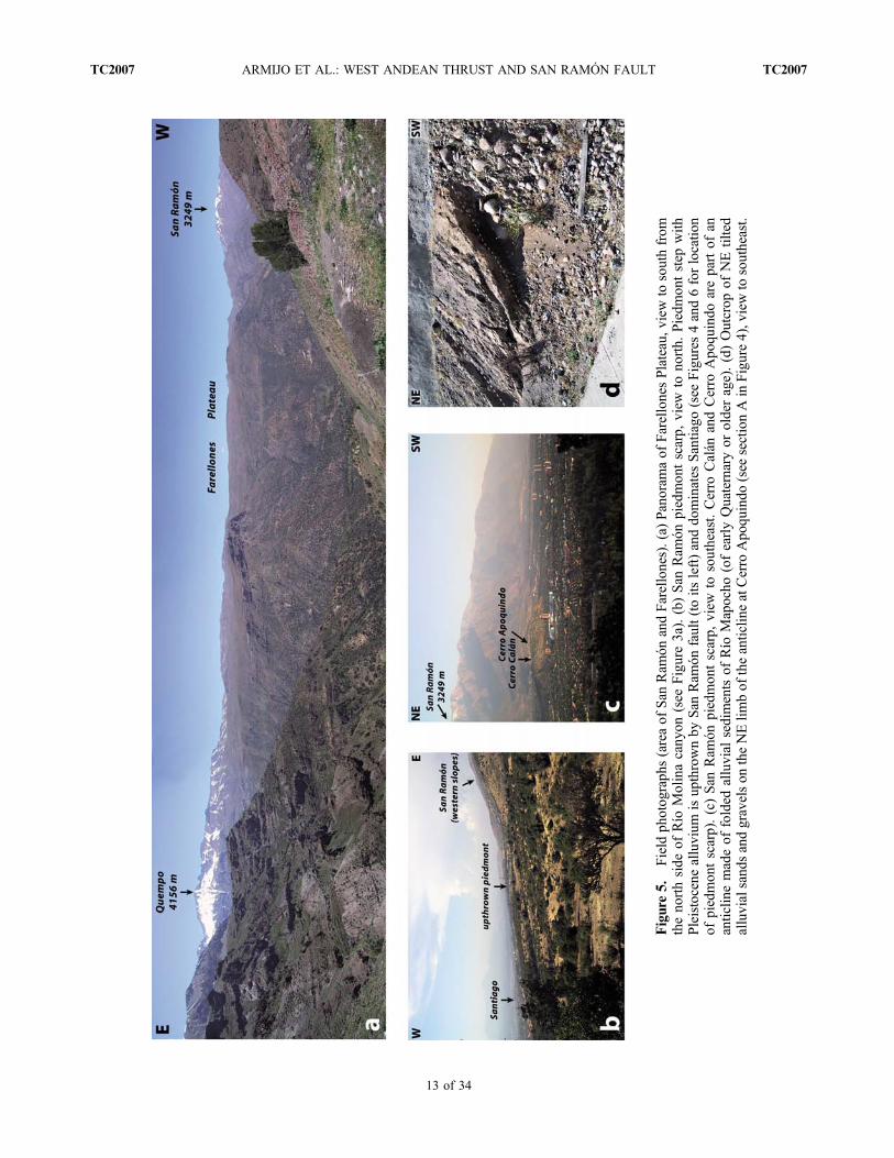
Figure
5.
Field
photographs(areaof
San
Ram
ónandFarellones).(a)
Panoram
aof
FarellonesPlateau,v
iewto
southfrom
thenorthside
ofRío
Molinacanyon
(see
Figure3a).(b)San
Ram
ónpiedmontscarp,
view
tonorth.
Piedm
ontstep
with
Pleistocene
alluvium
isupthrownby
San
Ram
ónfault(toits
left)anddominates
Santiago
(see
Figures
4and6forlocatio
nof
piedmontscarp).(c)San
Ram
ónpiedmontscarp,
view
tosoutheast.Cerro
Calán
andCerro
Apoquindo
arepartof
ananticlin
emadeof
folded
alluvial
sediments
ofRío
Mapocho
(ofearlyQuaternaryor
olderage).(d)Outcrop
ofNEtilted
alluvialsandsandgravelson
theNElim
bof
theanticlin
eatCerro
Apoquindo
(see
sectionAin
Figure4),viewto
southeast.
ARMIJO ET AL.: WEST ANDEAN THRUST AND SAN RAMÓN FAULT TC2007TC2007
13 of 34

Figure
6
ARMIJO ET AL.: WEST ANDEAN THRUST AND SAN RAMÓN FAULT TC2007TC2007
14 of 34
attributed to the Farellones Formation to the north of Santiago,at 32°S–33°S [Munizaga and Vicente, 1982]. The FarellonesFormation is also correlated southward with rocks of theTeniente Volcanic Complex (at ∼34°S latitude), which haveK/Ar ages ranging from 14.4 to 6.5 Ma [Kay et al., 2005].The large uncertainties on the age of the Farellones Forma-tionmay stem fromdiachronism concomitant with progressionof unconformities, suggesting a north‐to‐south propagationof the onset of shortening deformation [Charrier et al., 2005].[22] The section in Figures 3b and 3c suggests that the
shortening deformation in the western Principal Cordillerahas occurred after deposition of most, but perhaps not all, ofthe Abanico Formation. However, it could not have startedafter the deposition of the basal layers of the FarellonesFormation. So conservatively the onset of the shorteningdeformation is probably in the late Oligocene to the earlyMiocene (∼25–22 Ma) and strictly not later than 21.6 Ma,consistent with the age inferred by Charrier et al. [2002] forthe onset of the regional shortening (interpreted by theseauthors as tectonic inversion) in the Abanico Formation.Besides, most of the incision of the Farellones Plateau by theMapocho‐Molina and Maipo‐Colorado rivers has occurredafter the Farellones Formation has been entirely deposited,so significantly later than the initiation of the shortening.
However, assigning a precise age for the inception of thisincision from the published data is difficult, because of thestratigraphic uncertainty associated with the top of theFarellones Formation. Besides, apatite fission track agesdocumented the western Principal Cordillera provide nofurther constraint, because they fit well with depositionalages of the Abanico and Farellones formations [Farías et al.,2008]. However, the young ages of lavas and plutons inthe high‐elevation mining districts of Los Bronces and ElTeniente (porphyry copper deposits intruding the FarellonesFormation) suggest that significant river incision has occurredafter 5Ma [Farías et al., 2008]. So, conservatively, the incisionof the Farellones Plateau could not have started earlier than∼16 Ma and it is still in progress, so occurring at a minimumlong‐term average rate of 0.125 mm/yr. Regardless of itsrate, the young spectacular incision of the Farellones Plateausuggests that the shortening process associated with the WestAndean Front has continued until the present.
3.3. Multikilometric Frontal Thrust: Deeper Structure,Kinematics, and Evolution
[23] The section in Figure 3c suggests that the San RamónFault has reached the surface with steep eastward dip and
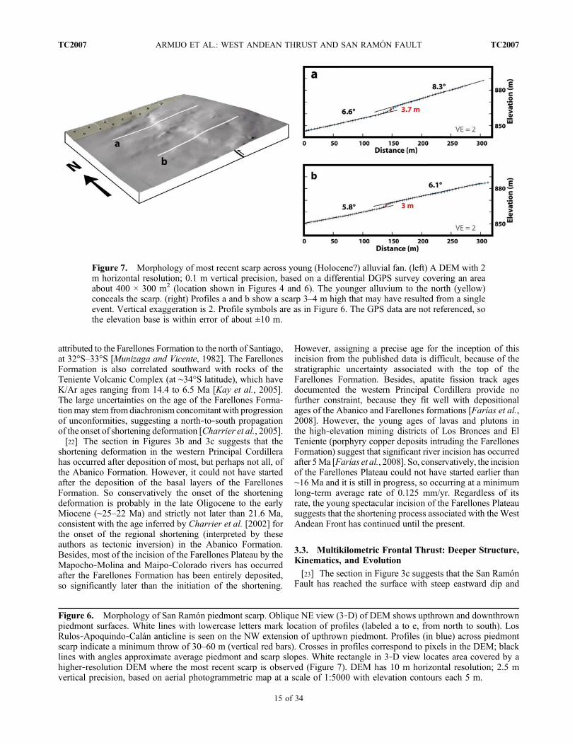
Figure 6. Morphology of San Ramón piedmont scarp. Oblique NE view (3‐D) of DEM shows upthrown and downthrownpiedmont surfaces. White lines with lowercase letters mark location of profiles (labeled a to e, from north to south). LosRulos‐Apoquindo‐Calán anticline is seen on the NW extension of upthrown piedmont. Profiles (in blue) across piedmontscarp indicate a minimum throw of 30–60 m (vertical red bars). Crosses in profiles correspond to pixels in the DEM; blacklines with angles approximate average piedmont and scarp slopes. White rectangle in 3‐D view locates area covered by ahigher‐resolution DEM where the most recent scarp is observed (Figure 7). DEM has 10 m horizontal resolution; 2.5 mvertical precision, based on aerial photogrammetric map at a scale of 1:5000 with elevation contours each 5 m.
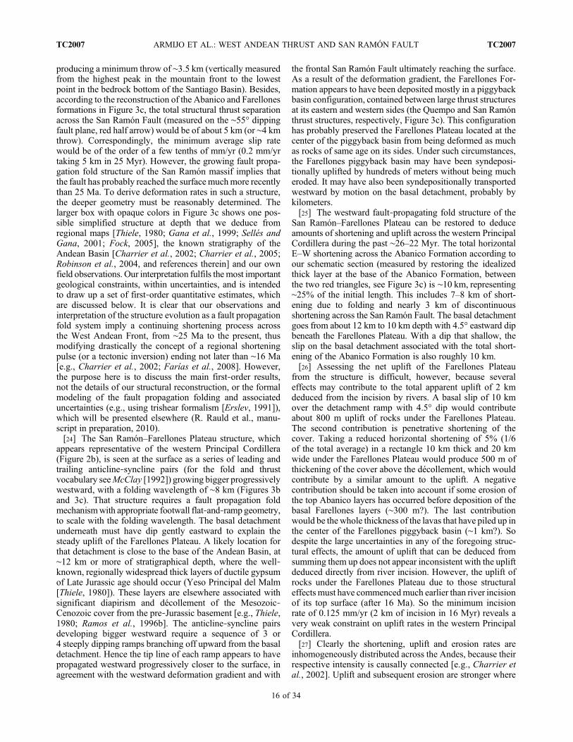
Figure 7. Morphology of most recent scarp across young (Holocene?) alluvial fan. (left) A DEM with 2m horizontal resolution; 0.1 m vertical precision, based on a differential DGPS survey covering an areaabout 400 × 300 m2 (location shown in Figures 4 and 6). The younger alluvium to the north (yellow)conceals the scarp. (right) Profiles a and b show a scarp 3–4 m high that may have resulted from a singleevent. Vertical exaggeration is 2. Profile symbols are as in Figure 6. The GPS data are not referenced, sothe elevation base is within error of about ±10 m.
ARMIJO ET AL.: WEST ANDEAN THRUST AND SAN RAMÓN FAULT TC2007TC2007
15 of 34
producing a minimum throw of ∼3.5 km (vertically measuredfrom the highest peak in the mountain front to the lowestpoint in the bedrock bottom of the Santiago Basin). Besides,according to the reconstruction of the Abanico and Farellonesformations in Figure 3c, the total structural thrust separationacross the San Ramón Fault (measured on the ∼55° dippingfault plane, red half arrow) would be of about 5 km (or ∼4 kmthrow). Correspondingly, the minimum average slip ratewould be of the order of a few tenths of mm/yr (0.2 mm/yrtaking 5 km in 25 Myr). However, the growing fault propa-gation fold structure of the San Ramón massif implies thatthe fault has probably reached the surface muchmore recentlythan 25 Ma. To derive deformation rates in such a structure,the deeper geometry must be reasonably determined. Thelarger box with opaque colors in Figure 3c shows one pos-sible simplified structure at depth that we deduce fromregional maps [Thiele, 1980; Gana et al., 1999; Sellés andGana, 2001; Fock, 2005], the known stratigraphy of theAndean Basin [Charrier et al., 2002; Charrier et al., 2005;Robinson et al., 2004, and references therein] and our ownfield observations. Our interpretation fulfils the most importantgeological constraints, within uncertainties, and is intendedto draw up a set of first‐order quantitative estimates, whichare discussed below. It is clear that our observations andinterpretation of the structure evolution as a fault propagationfold system imply a continuing shortening process acrossthe West Andean Front, from ∼25 Ma to the present, thusmodifying drastically the concept of a regional shorteningpulse (or a tectonic inversion) ending not later than ∼16 Ma[e.g., Charrier et al., 2002; Farías et al., 2008]. However,the purpose here is to discuss the main first‐order results,not the details of our structural reconstruction, or the formalmodeling of the fault propagation folding and associateduncertainties (e.g., using trishear formalism [Erslev, 1991]),which will be presented elsewhere (R. Rauld et al., manu-script in preparation, 2010).[24] The San Ramón–Farellones Plateau structure, which
appears representative of the western Principal Cordillera(Figure 2b), is seen at the surface as a series of leading andtrailing anticline‐syncline pairs (for the fold and thrustvocabulary seeMcClay [1992]) growing bigger progressivelywestward, with a folding wavelength of ∼8 km (Figures 3band 3c). That structure requires a fault propagation foldmechanismwith appropriate footwall flat‐and‐ramp geometry,to scale with the folding wavelength. The basal detachmentunderneath must have dip gently eastward to explain thesteady uplift of the Farellones Plateau. A likely location forthat detachment is close to the base of the Andean Basin, at∼12 km or more of stratigraphical depth, where the well‐known, regionally widespread thick layers of ductile gypsumof Late Jurassic age should occur (Yeso Principal del Malm[Thiele, 1980]). These layers are elsewhere associated withsignificant diapirism and décollement of the Mesozoic‐Cenozoic cover from the pre‐Jurassic basement [e.g., Thiele,1980; Ramos et al., 1996b]. The anticline‐syncline pairsdeveloping bigger westward require a sequence of 3 or4 steeply dipping ramps branching off upward from the basaldetachment. Hence the tip line of each ramp appears to havepropagated westward progressively closer to the surface, inagreement with the westward deformation gradient and with
the frontal San Ramón Fault ultimately reaching the surface.As a result of the deformation gradient, the Farellones For-mation appears to have been deposited mostly in a piggybackbasin configuration, contained between large thrust structuresat its eastern and western sides (the Quempo and San Ramónthrust structures, respectively, Figure 3c). This configurationhas probably preserved the Farellones Plateau located at thecenter of the piggyback basin from being deformed as muchas rocks of same age on its sides. Under such circumstances,the Farellones piggyback basin may have been syndeposi-tionally uplifted by hundreds of meters without being mucheroded. It may have also been syndepositionally transportedwestward by motion on the basal detachment, probably bykilometers.[25] The westward fault‐propagating fold structure of the
San Ramón–Farellones Plateau can be restored to deduceamounts of shortening and uplift across the western PrincipalCordillera during the past ∼26–22 Myr. The total horizontalE–W shortening across the Abanico Formation according toour schematic section (measured by restoring the idealizedthick layer at the base of the Abanico Formation, betweenthe two red triangles, see Figure 3c) is ∼10 km, representing∼25% of the initial length. This includes 7–8 km of short-ening due to folding and nearly 3 km of discontinuousshortening across the San Ramón Fault. The basal detachmentgoes from about 12 km to 10 km depth with 4.5° eastward dipbeneath the Farellones Plateau. With a dip that shallow, theslip on the basal detachment associated with the total short-ening of the Abanico Formation is also roughly 10 km.[26] Assessing the net uplift of the Farellones Plateau
from the structure is difficult, however, because severaleffects may contribute to the total apparent uplift of 2 kmdeduced from the incision by rivers. A basal slip of 10 kmover the detachment ramp with 4.5° dip would contributeabout 800 m uplift of rocks under the Farellones Plateau.The second contribution is penetrative shortening of thecover. Taking a reduced horizontal shortening of 5% (1/6of the total average) in a rectangle 10 km thick and 20 kmwide under the Farellones Plateau would produce 500 m ofthickening of the cover above the décollement, which wouldcontribute by a similar amount to the uplift. A negativecontribution should be taken into account if some erosion ofthe top Abanico layers has occurred before deposition of thebasal Farellones layers (∼300 m?). The last contributionwould be the whole thickness of the lavas that have piled up inthe center of the Farellones piggyback basin (∼1 km?). Sodespite the large uncertainties in any of the foregoing struc-tural effects, the amount of uplift that can be deduced fromsumming them up does not appear inconsistent with the upliftdeduced directly from river incision. However, the uplift ofrocks under the Farellones Plateau due to those structuraleffects must have commencedmuch earlier than river incisionof its top surface (after 16 Ma). So the minimum incisionrate of 0.125 mm/yr (2 km of incision in 16 Myr) reveals avery weak constraint on uplift rates in the western PrincipalCordillera.[27] Clearly the shortening, uplift and erosion rates are
inhomogeneously distributed across the Andes, because theirrespective intensity is causally connected [e.g., Charrier etal., 2002]. Uplift and subsequent erosion are stronger where
ARMIJO ET AL.: WEST ANDEAN THRUST AND SAN RAMÓN FAULT TC2007TC2007
16 of 34

shortening has been more intense, creating a structural high.For example, since deposition of the Farellones Formationthe incision rate of the ríos Maipo and Mapocho across theintensely folded and faulted San Ramón frontal range wouldbe of 0.25 mm/yr (4 km of incision in 16Myr), twice as muchas across the piggyback Farellones Plateau, where folding isless intense (Figure 3c). So the variation in the degree oferosion in the Principal Cordillera appears intimately corre-lated with the structure wavelength, which is relatively short.Under such conditions, no regional erosion surface (orpeneplain) can develop. This observation casts a seriousdoubt on the validity of the approach used by Farías et al.[2008], who have identified a high elevated peneplain inthis region, used to describe quantitatively the Andean upliftand morphologic evolution.[28] The minimum average shortening rate across the San
Ramón–Farellones Plateau structure and the slip rate on itsbasal detachment since the inception of shortening are bothof the order of 0.4 mm/yr (10 km in 25 Myr). In principle,the slip rate on the San Ramón Fault can be estimated for thetime elapsed since its propagating tip line has crossed thebase of the Abanico Formation, but no direct observation isavailable to constrain that time. Assuming the geometry inour section is valid (Figure 3c), the westernmost ramp of thepropagating thrust system has formed after deposition of theFarellones Formation. Then the minimum long‐term aver-age slip rate on the San Ramón Fault would be of about0.3 mm/yr (5 km in 16 Myr), or a throw rate of ∼0.25 mm/yr(4 km in 16 Myr). This inference is consistent with mostof the slip on the basal detachment being transferred since16 Ma to the San Ramón Fault, making of it the frontalramp of the Principal Cordillera.
3.4. Piedmont Scarp
[29] The San Ramón mountain front was first interpretedas the expression of a normal fault and the sediments on itspiedmont identified as mostly glacial in origin [Brüggen,1950]. Recently compiled geological maps still miss thepiedmont scarp and interpret the piedmont sediments asmostly derived frommassive gravitational sliding [e.g.,Ganaet al., 1999]. However, the geomorphology of the piedmontscarp was recognized long since [Tricart et al., 1965; Borde,1966], but as yet ignored by geologists. Here we make asynthetic quantitative description of the San Ramón piedmontscarp, building on previous work that to our knowledge is thefirst attempt to elucidate the faulting processes behind thatscarp [Rauld, 2002; Rauld et al., 2006; Armijo et al., 2006]. Amore detailed analysis will be presented elsewhere (R. Rauldet al., manuscript in preparation, 2010).[30] The best surface expression of the San Ramón Fault
is found along the 14–15 km long segment with a sharp faulttrace at elevation between 800 and 900 m, approximatelybetween Cerro Calán and Quebrada Macul, so covering alarge part of the 25 km separating ríos Mapocho and Maipoalong the San Ramón mountain front (Figures 3a, 4, and 6).The quality of the exposure stems from the occurrence of a∼3 km wide piedmont (roughly between 700 and 1000 melevation) formed by rough stratified alluvium and colluvium,which is clearly cut by the trace of the fault. The exposure of
structural features in that rough and little dissected materialis not only poor and scarce, but also heavily hampered byurbanization. So most of the information described herederives from the morphology, which is well constrained bythe accurate digital topography and imagery. The piedmonthas generally regular slopes, reaching a maximum of ∼7°by the mountain front and decaying gradually downward,away from it (Figure 6). Those relatively gentle slopes aresharply cut and offset by the scarp, creating an upthrownpiedmont balcony that overlooks Santiago (Figure 5b; thecenter of Santiago is at ∼550 m elevation).[31] The southern part of the scarp has a N5°W strike on
the average, but approximately from Quebrada San Ramónnorthward, toward the Río Mapocho, it turns into a N25°Wstrike (Figure 4). That northern part of the fault scarp ischaracterized by a string of three arch‐shaped hills (Los Rulos,Apoquindo and Calán hills; Figures 4, 5c, and 6) overhangingby 100–300m the rest of the upthrownpiedmont. So sedimentscropping out in those hills appear stratigraphically older thanthose in the gently sloping piedmont. The hills correspond toeroded remnants of a gentle NW striking anticline structuredeforming the Quaternary sediments, particularly the alluviumdeposited by Río Mapocho. Layers of fluvial sands andgravels are tilted northeastward (so toward the mountain side,opposite to the drainage direction of the Río Mapocho)reaching dips up to 30° along the northeast limb of the anti-cline (Figure 5d). Development of stepped terraces in thevalleys that cross the fold structure (like in QuebradaApoquindo; see map in Figure 4), suggests that those terraceshave formed during alternating periods of erosion andaggradation, which have occurred syntectonically across theforming anticline. Subsidiary reverse faulting is observed inthe anticline (Figure 4, map and section A). However, thefolding of the 5 km long, 1.5 km wide anticline appears toinvolve folding at the same scale of the underlying bedrock(Abanico Formation), which forms the core of Los Rulosand Apoquindo hills (Figure 4, section A). So the presenceof the Los Rulos‐Apoquindo‐Calán bedrock anticline maybe indicative of some near‐surface complexity in the processof fault propagation in this area, as is tentatively illustrated insection A (Figure 4).[32] Between the prominent Quebradas San Ramón and
Macul is the younger, most regular part of the piedmont,where only minor streams traverse its surface (Figure 4).Unlike the arched northern part of the piedmont fault scarp,the gently inclined piedmont here expresses no surface folding,suggesting that no significant near‐surface complexity of thefault plane occurs in the bedrock behind (Figure 4, map andsection B). However, the piedmont sediments cover an ero-sion surface at the foot of the mountain front, so if an earlierbedrock structural complexity had occurred, it has beenerased by that erosion. The piedmont surface is made of aseries of contiguous alluvial fans forming a bajada. Modernstreams have caused fan head entrenchment across the bajadaon the upthrown block. The lower end of entrenchmentreveals clearly the trace of the piedmont fault, because themodern streams incising the bajada grade to the top surfaceof the downthrown block, west of the fault scarp, where themodern alluvial fans are being deposited (Figure 4). Betweenthe streams on the upthrown block, the top surface of the
ARMIJO ET AL.: WEST ANDEAN THRUST AND SAN RAMÓN FAULT TC2007TC2007
17 of 34

bajada is abandoned and well preserved from surface erosion.However, the continuation of that top surface on the down-thrown block is partly covered by the modern alluvium.The modern deposition of alluvium by recent fans on topof that older piedmont surface appears modest, within map-ping uncertainties of the modern fans on top of the olderpiedmont surface. May be not more than ∼20 m sedimentthickness have been accumulated by the small alluvial fansfed by the small streams in this part of the piedmont, while∼100 m thickness of recent alluvium may have been accu-mulated by the fault scarp by the larger fans in front ofQuebradas San Ramón and Macul.[33] The morphology of the San Ramón piedmont bajada
is well determined by the DEM (Figure 6). Profiles acrossthis topography provide a precise measure of the piedmontfault scarp (profiles labeled a to e). Then, the apparent com-ponent of vertical slip (throw) derived from the topographyvaries between a minimum of 30 m and a maximum of 60 mwithin an uncertainty of ∼10%. Strictly, these are minimumestimates for the piedmont offset. However, because erosionof the piedmont surface on the upthrown block is negligibleand the thickness of modern deposition of alluvium in thispart of the downthrown block appears modest, then retaininga minimum average throw of 60 m as an estimate of thepiedmont offset appears reasonable.[34] To date the rough heterogeneous material of the
offset piedmont is difficult. The alluvium of the piedmont isformed of a poorly layered and poorly sorted sequence ofboulders and angular pebbles embedded in a matrix com-posed of silts and clays, locally including layered gravels,sand lenses of fluvial origin and conspicuous lenses ofvolcanic ash. Hence a significant part of the piedmont sedi-ment appears to have been deposited by debris flows andmudflows. A modern example is the catastrophic mudflow of1993, triggered by a flash flood rain in the nearby slopes ofthe San Ramón massif, which contributed with up to ∼5 mthickness of new sediment over an area of ∼3–4 km2 on thelarge fans at the exit of Quebradas San Ramón and Macul(Figure 4, map).[35] However, the frequent occurrence of ash lenses
exposed in the upthrown block of the San Ramón piedmontmay provide us with an accurate stratigraphical mark[Brüggen, 1950; Tricart et al., 1965; Rauld, 2002] (Figure 4,map). The ash lenses of the San Ramón piedmont can becorrelated with the pumice deposits called Pudahuel ignim-brites, found extensively in the Santiago valley [Gana et al.,1999] and with lithologically similar rhyolitic pyroclasticflow deposits that occur more discretely on terraces of sev-eral rivers and are distributed at a broad regional scale, onboth the east and the west flanks of the Andes [Stern et al.,1984]. Stern et al. [1984] dated those pyroclastic flows at450 ka ± 60 ka (with zircon fission tracks) and suggested thattheir deposition may have followed large eruptions (volumeerupted estimated as ∼450 km3) associated with the collapseof the noticeable Maipo volcano caldera. If the correlationof ash lenses embedded in the San Ramón piedmont withthe Pudahuel ignimbrites and their inferred ages are correct,then the top surface of the San Ramón bajada is younger than450 ka and a minimum throw rate of ≥0.13 mm/yr (≥60 min ≤450 kyr) can be deduced for the San Ramón Fault.
This represents about half the minimum throw rate deducedover the long term. Conversely, taking the long‐term estimateof average slip rate on the San Ramón basal detachment(0.4 mm/yr), the abandoned bajada surface of the upliftedpiedmont would have an age of 150 ka, consistent with theinferred age of the ashes. Alluvial sediments and fluvialterraces in the Maipo and Mapocho river valleys can beunambiguously correlated with the uplifted San Ramónpiedmont. Unpublished age determinations of these deposits(Ar‐Ar ages from pumice rhyolitic pyroclastic deposits andoptically stimulated luminescence (OSL) ages of alluvialsediments (G. Vargas et al., manuscript in preparation, 2010))suggest that the younger age estimate (∼150 ka) consistentwith the long‐term slip rate of the San Ramón detachment isclose to the age of the bajada abandonment.
3.5. Scarp Corresponding to the Last Event (s)and the Seismic Hazard
[36] To find well‐preserved small‐scale scarps is nowdifficult in the densely urbanized outskirts of Santiago.Hereafter we describe what appears to be the last testimonyto late scarp increments left for study along the San RamónFault.[37] The 15 km long piedmont fault segment discussed in
section 3.4 has a simple trace and is well preserved overmost of its length, so it crosses the stream drainage close tothe apexes of the modern alluvial fans (Figure 4). In thoseplaces the stream power is high and no scarp increment hasapparently survived to persisting erosion in the streamchannel and to rapid knickpoint headward retreat. The traceof the piedmont fault is more complex near its two ends,near Cerro Apoquindo and near Quebrada de Macul. Theresignificant fault branches cross the modern alluvial fansurfaces, offering opportunities for preservation of youngscarp increments. Unfortunately, the young scarps crossingthe small modern alluvial fans to the west and south ofCerro Apoquindo (which are readily detected in the high‐resolution DEM and in old aerial photographs; see locationof those scarps in Figure 4) are now out of reach for studybecause of the rapid urbanization of the city.[38] To the south of the piedmont scarp one scarp is still
preserved, which we have been able to describe in the field.Two branches about 300 m apart make echelons in themorphology over a length of about 3–4 km near Quebradade Macul (see Figure 4). The westernmost fault branch isonly 1 km long and it splays northward and southward,entering into the downthrown piedmont. There it crosses thesmall modern alluvial fans being deposited in front of themain piedmont scarp, which at those places follows the faultbranch located eastward. A clear fault scarp can be followedacross one of those small fans, for no more than ∼300 m,where the preservation conditions appear to have beenexceptionally favorable (Figures 4 and 7). South of this fanalong the fault branch no scarp is visible across the largefan at the exit of Quebrada de Macul. This absence may bedue to the relatively rapid modern accumulation of alluviumon this fan during repeated catastrophic mudflow events likethat in 1993, which can conceal any young fault scarp[Naranjo and Varela, 1996; Sepúlveda et al., 2006]. The
ARMIJO ET AL.: WEST ANDEAN THRUST AND SAN RAMÓN FAULT TC2007TC2007
18 of 34
preservation of a small scarp across the smaller alluvial fanin Figure 7 can be explained by a recent abandonment ofthis fan associated with the northward diversion of thestream feeding deposition of alluvium to the small fan justnorth of it, where the continuation of the same scarp appearsto have been concealed (Figures 4 and 7).[39] To determine the offset produced across the topog-
raphy of the small fan by the fault, a DGPS survey has beenconducted over a limited area (Figure 7). The fan has steepslopes decaying westward from 8° to 6° and the scarp acrossit suggests an apparent throw that decays southward alongstrike from ∼3.7 m to ∼3 m (Figure 7). The sharp simplemorphology of that scarp suggests it may have resulted froma single seismic event, although the possibility of multipleevents cannot be excluded. Considering that the fault nearthe surface may have steep 50°–60° eastward dip (Figure 3c),the net thrust slip corresponding to the total measured throwwould be of about 4 m, to be accounted for by a single eventor by several events with thrust slip of the order of ∼1 mor less. Taking an average thrust slip ranging between 1and 4 m over the 15 km long piedmont fault segment withrupture width of 15 km (corresponding to the frontal rampin Figure 3c, breaking from 10 km depth to the surface) wouldyield seismic moments of Mo ∼0.75 to 3 × 10¹⁹ N m,corresponding to events of magnitude Mw 6.6 to Mw 7.0.This range of magnitudes is higher than that of the sequenceof three consecutive shocks, all together known as the 1958,Las Melosas earthquake, which correspond to the largestevents recorded instrumentally in the upper plate near
Santiago [see Sepúlveda et al., 2008; Alvarado et al., 2009,and references therein]. The 1958 sequence occurred withinan interval of 6 min with hypocentral depth of 10 km in thecenter of the Principal Cordillera ∼60 km SE of Santiago,with intensity values reaching IX in the epicentral area.The larger first shock has been assigned a revised magnitudeMw 6.3 [Alvarado et al., 2009].[40] However, the estimate above is not conservative
because the seismicity recorded under the Principal Cordillerashows well‐constrained hypocenters down to 15 km andmore (Figure 8c). This suggests that the basal detachment ofthe San Ramón–Farellones Plateau structure could contributeto the seismic release, thus increasing significantly the widthof a potential fault rupture of the San Ramón Fault. Given theshallow dip of the detachment, a rupture confined to depthsof less than 15 km could reach widths in the range of 30–40 km. Taking as before the same range of average slip of1–4 m but considering a rupture extending over a width of30 km and over the entire length of ∼30 km of the SanRamón mountain front facing the Santiago valley wouldyield seismic moments of Mo ∼0.3 to 1.2 × 10²⁰ N m,corresponding to events of magnitude Mw 6.9 to Mw 7.4.[41] Earthquakes with large magnitudes would not be
frequent because the loading rate of the San Ramón Faultappears low. If the present‐day slip rate is assumed to be asslow as the average estimate for the basal detachment overthe long‐term (0.4 mm/yr) then the time to recharge eventswith slip of 1–4 m is 2500–10,000 years. The probability ofhaving recorded historically such an event is low, given the
Figure 8. Simplified section across the Nazca–South America plate boundary and the Andes at the latitude of Santiago(33.5°S, see Figures 1 and 2a for location; main Andean geological features correspond to those mapped in Figure 2b).(a) The hypothesized west Andean megathrust (depicted as an embryonic intracontinental subduction under the Andes)reaches the surface at the San Ramón Fault (West Andean Front), parallel and synthetic to the subduction interface with theNazca Plate. The two synthetic systems are separated by the rigid Marginal Block, down‐flexed eastward as is underthrustbeneath the Andes. The eastern side of the Andean Basin (>12 km thick Mesozoic‐Cenozoic “back‐arc” basin filled withsedimentary and volcanic rocks, also called “Andean Geosyncline” [Aubouin et al., 1973]) is inverted and deformed in thePrincipal Cordillera as a prowedge, pushed westward by the Frontal Cordillera basement backstop (leading edge of SouthAmerica). Once reduced to scale, the Aconcagua Fold‐Thrust Belt (AFTB) appears as a shallow minor back thrust. TheMarginal Block appears a rigid board balancing coastal uplift (associated with subduction processes) and orogenic load by theAndes (circled yellow arrows), between the two megathrusts. The Cuyo Basin in the eastern foreland is mildly deformed as anincipient retrowedge. Total Andean shortening across the section is not less than about 35 km, not more than about 50 km (30–40 km across the Principal Cordillera prowedge and 5–10 km across the Cuyo Basin retrowedge). Shortening at lithosphericscale (measured byMoho offset) is drawn consistent with shortening in the upper crust. Continental lithosphere (brown, crust;green, mantle) and oceanic lithosphere (light blue, crust; dark blue, mantle) are schematized. Base of lithosphere is highlysimplified and does not take into account (although possibly important) lithosphere thickness variations under the Andes,which are not relevant for the primary purpose retained for this paper. Faults are in red, dashed where very uncertain. Coupledcircled cross and dot (in black) indicate likely locations of strike slip. Basins with sedimentary/volcanic fill (adorned withlayers) are shown in yellow (Cenozoic) and green (Mesozoic). Positions of present‐day volcanic arc and possible feedingacross lithosphere are indicated. Gray rectangle locates details shown in Figure 3c. No vertical exaggeration. AW, accretionarywedge; FP, Farellones Plateau; WVF, west verging folds; T, Tupungato; AT, Alto Tunuyán basin. (b) Outline section withbulldozer representing appropriate boundary conditions. The West Andean Thrust (WAT) is in bold red. (c) Outline sectiontesting for consistency of model with seismicity and rough crustal thickness. The red circles represent the complete record ofthe 2000–2005 projected seismicity, including the best located hypocenters (events with Ml > 4.0 and hypocentral locationRMS < 0.3) by Servicio Sismológico Nacional of Universidad de Chile (seismicity section is half degree wide, centered at33.5°S). Projected smoothMoho profile, roughly interpolated from broadband seismological data (bold dashedwhite line fromGilbert et al. [2006]), is represented for comparison. The better resolved images obtained with receiver functions byGilbert etal. [2006] (to the north and south of our section, so not represented but discussed in the text) show structural complexityconsistent with the stepped Moho structure proposed in our model.
ARMIJO ET AL.: WEST ANDEAN THRUST AND SAN RAMÓN FAULT TC2007TC2007
19 of 34

Figure
8
ARMIJO ET AL.: WEST ANDEAN THRUST AND SAN RAMÓN FAULT TC2007TC2007
20 of 34

short period of settlement in the Santiago valley (the city wasfounded by the Spanish in 1541). However, the earthquakethat destroyed most of the city in May 13, 1647 was probablynot a subduction interface event [Barrientos, 2007]. Thehistorical accounts suggest that the destructive source couldhave been either a slab‐pull event in the subducting plate atintermediate depth (∼100 km depth, similar to the 2005Tarapacá earthquake [Peyrat et al., 2006]) or a shallow
intraplate event close to Santiago in the nearby Andes[Lomnitz, 2004]. Only a paleoseismological study of the SanRamón Fault could prove or disprove the second hypothesis.
4. Discussion[42] The foregoing description of the San Ramón thrust
front has significant consequences on our understanding of
Figure 8. (continued)
ARMIJO ET AL.: WEST ANDEAN THRUST AND SAN RAMÓN FAULT TC2007TC2007
21 of 34
the large‐scale Andean architecture, thus implying sub-stantial changes from the currently accepted interpretations.It is generally accepted that shortening in the PrincipalCordillera is due to a process of inversion of the AndeanBasin associated with dominant large‐scale east vergentthrusts extending downward to the west, specifically beneaththe Andean Basin [Ramos, 1988; Mpodozis and Ramos,1989; Ramos et al., 1996b; Godoy et al., 1999; Cristalliniand Ramos, 2000; Charrier et al., 2002, 2005; Fock, 2005;Farías et al., 2008; Giambiagi et al., 2003; Ramos et al.,2004; Kay et al., 2005]. The ultimate consequence of thoseinterpretations is that the east vergent thrust system wouldstep deeper and deeper down westward, beneath the CentralDepression and the Coastal Cordillera, to meet the subductioninterface [Farías, 2007] (for a similar interpretation fornorthern Chile, see also Farías et al. [2005]). Our resultssuggest that those large‐scale geometries are mechanicallyinconsistent with the observed present‐day architecture ofthe Andes at the latitude of Santiago, which clearly indicatesa primary westward vergence.[43] The following discussion is intended to explain briefly
the first‐order arguments, constraints and uncertaintiesunderlying our new interpretation of the Andean tectonicsat this latitude. The most relevant structural elements thatwe use for this discussion are represented in map view(Figures 2b and 3b) and in section (Figures 3c and 8a). Amore complete development discussing details of the Andeanevolution in space (comparison with other tectonic sectionslocated northward and southward from the one discussed here)and time (propagation of deformation) is out of the scope ofthis paper and will be provided elsewhere (R. Lacassin etal., manuscript in preparation, 2010).
4.1. Crustal Structure Asymmetry and the Scaleof the Mechanical Problem
[44] The observations of wholesale uplift, shortening anddécollement of the thick Andean Basin deposits throughoutthe Principal Cordillera imply an overall Andean fold‐thrust belt ∼80 km wide, which requires appropriate struc-ture geometry at crustal‐scale depth, associated with rea-sonable kinematics and boundary conditions. The source ofmechanical energy supplied to that large Andean fold‐thrustbelt needs to be explained. In other words, a rigid buttress(or bulldozer) must be found at the appropriate scale, in theinner thicker part of the orogen [Davis et al., 1983; Dahlen,1990]. Such boundary conditions appear sound and gener-ally accepted for orogenic wedges like the Alps and theHimalayas [e.g., Bonnet et al., 2007; Bollinger et al., 2006].Clearly, there is no such a basement buttress west of thePrincipal Cordillera in the region of the Central Depressionand the Santiago Valley (or more westward, in the CoastalCordillera or Continental Margin), capable of pushing east-ward a Coulomb wedge made of Andean Basin deposits,as suggested earlier [e.g., Giambiagi, 2003; Giambiagi etal., 2003; Farías, 2007]. Similar mechanisms, which wefind improbable, are required by all tectonic models of thePrincipal Cordillera based on large‐scale eastward vergence[Ramos, 1988; Mpodozis and Ramos, 1989; Ramos et al.,1996b; Godoy et al., 1999; Cristallini and Ramos, 2000;
Charrier et al., 2002, 2005; Fock, 2005; Farías, 2007; Faríaset al., 2008; Giambiagi et al., 2003; Ramos et al., 2004; Kayet al., 2005].[45] Besides, the propagating West Andean Front as
inferred from the observed structure of the San Ramón–Farellones Plateau must be rooted in downward to the east,beneath the higher Principal Cordillera. Thus, the basaldetachment under the Farellones Plateau and the thickMesozoic‐Cenozoic cover (shown in Figure 3c) must ulti-mately step down into the Andean hinterland basement, i.e.,penetrating deeply into the basement of the Frontal Cordilleraand into the Andean crust. That large‐scale west vergentthrust system (designated hereafter as the West AndeanThrust, or WAT), which would be the main deep‐seatedfeature responsible of the present‐day architecture of theAndean fold‐thrust belt, may have a complicated staircasetrajectory consisting of multiple flats and ramps. As first‐order approximation, however, the simple geometry illus-trated in Figure 8a is consistent with the main structuralfeatures of the surface geology (Figures 2b and 3b), as dis-cussed gradually from one stage to the next below. We alsodiscuss the apparent consistency of that geometry with theavailable geophysical data. Clearly, however, the details ofthe present architecture of the WAT need to be refined andconstrained further with the rapidly growing set of geo-physical data (e.g., gravity, GPS and seismological data). Ithas been shown that the well‐established chronostrati-graphical constraints available for the region [e.g., Charrieret al., 2002; Giambiagi et al., 2003 and references therein]fit well tectonic interpretations very different from the onepresented here [e.g., Giambiagi et al., 2003; Farías et al.,2008]. Alternatively, however, these data can also be usedto constrain the possible evolution of main structures takingas final stage the present‐day architecture proposed inFigure 8a. We discuss (in section 4.8) some of the alternativeinterpretations, along with the chronology and shorteningestimates.
4.2. Frontal Cordillera Bulldozing Westwardthe Whole Andean Fold‐Thrust Belt
[46] The Frontal Cordillera is the only Andean basementhigh to scale with the mechanical function of a rigid buttressthat backstops the shortening and the high elevation of thePrincipal Cordillera. This function is represented in Figure 8bby a bulldozer. The Frontal Cordillera forms a huge basementanticline (30–50 km wide) that elongates probably more than∼700 km along the grain of the Andes (at least between 28°Sand 34.5°S [e.g.,Mpodozis and Ramos, 1989]) and is locatedside by side, east of the similarly long Andean fold‐thrustbelt represented by the Principal Cordillera (Figure 2b).The anticline shape of the Frontal Cordillera is outlined insection (Figure 8a) by the unconformable basal contact of theChoiyoi Group rocks (Permian‐Triassic) over the PaleozoicGondwanan basement, which includes Proterozoic meta-morphic rocks [Polanski, 1964, 1972; Ragona et al., 1995;Heredia et al., 2002; Giambiagi et al., 2003]. The FrontalCordillera appears thus as a crustal‐scale ramp anticlineproviding the necessary boundary conditions to maintain thehigh elevation in the Principal Cordillera and to produce the
ARMIJO ET AL.: WEST ANDEAN THRUST AND SAN RAMÓN FAULT TC2007TC2007
22 of 34

westward propagation the San Ramón thrust system. Similarfold‐thrust structures reaching the surface northward orsouthward from the San Ramón system along the WestAndean Front have probably the same origin and relationwith the Frontal Cordillera. Therefore, the main crustal‐scaleramp under the Frontal Cordillera anticline must dip neces-sarily eastward and the overall Andean structure at the lati-tude of Santiago has a decided westward vergence. Albeitmuch less pronounced, the localized westward dippingthrust features described to the east of the Frontal Cordillera(Figures 2b and 8a) must also be of crustal scale [Ramos et al.,1996b] and are discussed in section section 4.5.
4.3. Aconcagua Fold‐Thrust Belt: A SecondaryFeature
[47] The Aconcagua Fold‐Thrust Belt (which is conven-tionally limited to the eastern ∼30 km wide part of thePrincipal Cordillera, where Mesozoic sediments crop out)appears to be a shallow secondary feature, structurallyoverlying the Frontal Cordillera basement, thus located wellabove the main ramp of the WAT beneath the FrontalCordillera anticline. As depicted in Figures 2b and 8a, theAFTB is a shallow back thrust décollement (at ∼2–3 kmdepth below the high Cordillera surface) that detaches mostof the Mesozoic platform sediments deposited at the easternmargin of the Andean Basin from its basement (specificallythe Frontal Cordillera; e.g., see the classical section at 33°Sby V. A. Ramos and collaborators, reproduced by Ramos etal. [2004, Figure 8]). The décollement appears to be local-ized at the Jurassic gypsum layers [e.g., Ramos et al.,1996b] and is associated with significant diapirism andkilometer‐scale disharmonic folding [Thiele, 1980]. In factthe AFTB displays both, an eastward vergence on its easternside and a westward vergence on its western side. To the east,the shallowAFTB detachment ramps up to the surface, wherea back thrust front associated with relatively modest dis-placement (generally less than about 3 km) generally sepa-rates the detached layers of the Mesozoic cover from similarlayers, stratigraphically at the very base of the same Andeanplatform cover, which have remained undetached from theirbasement [Polanski, 1964, 1972] (see Figure 2b). Those basallayers, rest with shallow westward dip (∼20°–25°), on thewestern limb of the Frontal Cordillera anticline [Polanski,1964, 1972; Ramos et al., 1996a]. That basal contact appearsnearly conformable over the Choiyoi Group rocks (Permianand Triassic age), but is regionally unconformable over olderrocks of the Gondwana basement. In some places along theeastern front of the AFTB, small intermontane basins (<10 kmwide and <2 km thick) that are filled with continental con-glomerates of late early Miocene (∼18 Ma) to late Mioceneage (so mostly coeval with the Farellones Formation) arespectacularly involved in the back thrust deformation (SantaMaría andAlto Tunuyán basins; see location of Alto Tunuyanbasin (AT) in Figures 2b and 8a) [Ramos, 1988; Ramos et al.,1996b; Giambiagi et al., 2001, 2003]. However, it is clearthat for most of its length the back thrust front of theAFTB is a shallow detachment mechanically supportedalmost directly by the basement structure, not by any sig-
nificant foreland basin of flexural origin. Thus the AFTBappears a relatively minor feature of the Andean tectonics,which is passively transported westward, atop the basementramp anticline forming the Frontal Cordillera. Another sec-ond‐order feature of the regional tectonics is the present‐dayvolcanic arc, which appears to cross both, the basement andthe AFTB, without any significant structural modification(Figures 2b and 8a).
4.4. Large West Verging Folds Ahead of the WestAndean Basement Thrust Wedge
[48] The central Principal Cordillera, at the western sideof the AFTB (between the AFTB and the Farellones Plateau)is characterized by a 20 km wide zone of strong deformation,consisting of a cascading sequence of two or three verylarge asymmetric west verging folds (Figures 2b and 3c andWVF in Figure 8a). Those features include an impressive∼5 km wide vertical limb (dip varying from steep westwardto vertical, or even overturned locally to steep eastward dip)exposing a complete section of the Mesozoic sequence (top‐to‐the‐west geometry). That large limb is outlined in thetopography by the massif continental conglomerates, andesiticlavas and breccias constituting the ∼3000 m thick Río DamasFormation (Kimmeridgian: Late Jurassic), which arises as analmost continuous structural ridge with the same geometryover more than ∼250 km along strike (from 33°S to 35°S).Westward alongside of that continuous wall, the vertical bedsof the calcareous Lo Valdés Formation (Neocomian: LateJurassic–Early Cretaceous) are characterized by a weakpenetrative cleavage that dips steeply eastward (∼70°E,Figure 9), consistent with the dominant westward vergence.Farther west alongside of the Mesozoic sequence, there is aprominent syncline system with an overturned eastern limb,topped by rocks of the Abanico Formation (Coironal inFigure 3c), which can be easily followed for about 100 kmalong strike (roughly between 33°S and 34°S [González‐Ferrán, 1963; Thiele, 1980; Baeza, 1999; Fock, 2005]).The steeply eastward dipping (or vertical) Chacayes‐Yesillofault disrupts the steep eastern limb of the syncline near33.8°S, and similar faults are described extending tens ofkilometers southward [Baeza, 1999; Fock, 2005; Charrieret al., 2005]. To the west of the Cerro Coironal synclineare found the Río Olivares anticline, then the Quemporidge at the eastern edge of the Farellones Plateau, wherethe top of the Mesozoic sequence continues the cascade ofwest verging folds, plunging westward under the Cenozoicsequence (Abanico and Farellones formations, Figures 2band 3c). Taken as a whole, that 20 km wide zone of westverging folds with large vertical limbs must be associatedwith a vertical structural separation comparable with itswidth. In our sections, the vertical separation of the base ofthe Abanico Formation across this zone (similarly as thatof the other Mesozoic formations below), as deduced fromthe published stratigraphy and maps [Thiele, 1980; Fock,2005], is at least of ∼15 km (Figures 3c and 8a). Theimportance of vertical limbs in this zone of the PrincipalCordillera is precisely what determines the crustal‐scalewestward inclination and overall wedged asymmetry of the
ARMIJO ET AL.: WEST ANDEAN THRUST AND SAN RAMÓN FAULT TC2007TC2007
23 of 34
Figure
9
ARMIJO ET AL.: WEST ANDEAN THRUST AND SAN RAMÓN FAULT TC2007TC2007
24 of 34

Andean Basin, as discussed in section 2 (profiles A and Bin Figure 1).[49] However, the main consequences of the foregoing
concern the deeper structure. The prominent zone of westverging folds of the Andean cover in the middle of thePrincipal Cordillera, as well as its apparent continuity overhundreds of kilometers along strike strongly suggest acrustal‐scale fault propagation fold structure involving theAndean basement to significant depth. Consequently, thesection in Figure 8a suggests the zone of west verging folds isahead of the tip line of the propagatingmain thrust ramp of theWAT, extending from beneath the Frontal Cordillera anti-cline across the cover to the surface. Similar steep limbs inthe cover above basement‐involved structures have beendescribed elsewhere and their relatively complex kinematicsformalized [Narr and Suppe, 1994]. It is thus reasonable tointerpret the western leading edge of the Frontal Cordillera asa hidden west vergent thrust wedge, characterized by kine-matic complexity (West Andean Basement Thrust Wedge inFigure 3c). Then the main cascading west verging folds seenin the thick Andean Basin sediment pile may be the result of aseries of (2–3) westward propagating ramps, thrusting west-ward, at the western side of the basement wedge. Conversely,the detachment of the cover at the base of the AFTB appearsthe result of a shallow back thrust on top of the gentle westernslope of the rigid wedge, in a similar situation as that ofthe excess of material pushed by a bulldozer, which canovertop the bulldozer’s hoe and flow backward on top of it(Figure 8b). As a consequence, all the shortening observedacross Andean Basin cover in the Principal Cordillera (i.e.,the overall ∼80 km wide Andean fold‐thrust belt, specificallyincluding the San Ramón–Farellones Plateau frontal system,the west verging folds and the AFTB; see Figure 2b) has tobe accounted for by basement shortening across the crustalramp of the WAT beneath the Frontal Cordillera. The detailsof those mechanisms deserve an extended discussion that isbeyond the scope of the present paper and will be providedelsewhere (R. Lacassin et al., manuscript in preparation,2010).
4.5. Eastern Foreland: Hidden Back Thrust Marginand the Incipient East Andean Front Beneaththe Cuyo Basin
[50] The changes proposed here for the tectonic interpre-tation of the Andes at 33.5°S latitude need to be confrontedwith our knowledge of structures in the eastern back thrustmargin. East of the Frontal Cordillera is the eastern forelandof the Andes, represented by the Cuyo Basin (Figures 2band 8a), which is a wide, relatively shallow Cenozoicbasin, founded on the basement of the San Rafael block(Permian‐Triassic Choiyoi Group over Cuyania terranedeformed during the Early Permian San Rafael orogenicphase [e.g., Llambías et al., 2003; Mpodozis and Ramos,
1989]). The Cuyo Basin is very well studied becausebeneath the overlapping units of Andean synorogenicdeposits it also contains some valuable Late Triassic oil‐richrocks which are interpreted to have been deposited in aPre‐Andean continental rift system (which alone is alsocalled “Cuyo Basin” by petroleum geologists [e.g., Irigoyenet al., 2000]). The structures formed during that TriassicPre‐Andean extensional phase are described as being wide-spread over the Late Paleozoic Gondwanan margin of SouthAmerica [e.g., Charrier et al., 2007, and references therein].Indeed, those structures are interpreted to have played avery significant role in the subsequent basin inversionprocesses during the Andean cycle [e.g., Ramos et al., 1996b;Giambiagi et al., 2003; Charrier et al., 2002, 2007]. TheAndean eastern foreland deposits in the Cuyo Basin have beendated with magnetostratigraphy calibrated with 40Ar‐39Ardates from interbedded tephra [Irigoyen et al., 2000].According to these results, the deposition of the mainsynorogenic units, reaching a total thickness of ∼2–4 km,has occurred since ∼16 Ma, the early middle Miocene[Irigoyen et al., 2000].[51] The structures represented in Figure 8a under the
synorogenic Cuyo Basin are inspired from published sec-tions in the area [Ramos et al., 1996b; Brooks et al., 2003].Our section at latitude 33.5°S (Figure 8a) cuts the hiddensouthward extension of the Precordillera structures, whichattenuate rapidly southward [Ramos et al., 1996b]. Thus,according to Ramos et al. [1996b], at this latitude little finiteshortening has occurred across the Cuyo Basin and the bulkof the shortening appears restricted to the Principal Cordillera(across the AFTB), as the Frontal Cordillera has been upliftedas a (single) rigid block. Admittedly, the finite shortening isgenerally poorly constrained in the eastern foothills of theFrontal Cordillera [Ramos et al., 2004]. In our cross section(Figure 8a), all the shortening across the Principal Cordillerais accounted for by the West Andean Thrust under theFrontal Cordillera. However, it seems improbable that thehidden back thrust at the eastern flank of the Frontal Cordilleraand the hidden, attenuated Precordillera structures at thislatitude (southward extension of Chacheuta–La Pilona–Tupungato and Barrancas anticlines [e.g., Irigoyen et al.,2000]), which possibly correspond to inversion of struc-tures in the Cuyo Basin [Giambiagi and Ramos, 2002], mayrepresent an amount of finite shortening comparable withthat in the Principal Cordillera. It is probably much less fortwo reasons.[52] 1. The overall geometry and the relative shallowness
of the synorogenic Cuyo Basin over its relatively flat rigidbasement (Figure 8a) preclude any significant foreland flex-ure at the east flank of the Frontal Cordillera. Thus, a largehidden back thrust at this boundary appears unlikely.[53] 2. The top of the basement flooring the Cuyo Basin
appears only mildly affected by the Andean deformation,
Figure 9. Photographs of the structure in the zone of large west verging folds (WVF, represented in Figures 2b and 8a; seeprecise location of photograph in Figure 2b). (a) In the largest vertical limb (∼5 km wide, top‐to‐the‐west geometry), ridgesof limestone beds of Neocomian Lo Valdés Formation (locally dipping ∼80°W) bearing weak cleavage dipping steeplyeastward (∼70°E). (b) Detail showing S1/S0 relation.
ARMIJO ET AL.: WEST ANDEAN THRUST AND SAN RAMÓN FAULT TC2007TC2007
25 of 34

and the topography of the surface landscape is modest, so theactual finite shortening across the foreland east of the FrontalCordillera must be relatively small.[54] Therefore, in contrast with earlier interpretations sug-
gesting a large east vergent shallow dipping detachment inthe basement under the Frontal Cordillera (which signifi-cantly maximize the shortening estimates [e.g., Ramos et al.,1996b; Brooks et al., 2003; Giambiagi and Ramos, 2002;Ramos et al., 2004]), our interpretation in Figure 8a suggeststhat a series of steep crustal‐scale ramps (which moderate theshortening estimates) may have developed on the back ofthe Frontal Cordillera anticline. Such an incipient easternAndean Back Thrust Margin (see also profile B in Figure 1)cannot compare with the WAT at this latitude.
4.6. Western Foreland: Marginal Block as a BalanceBetween the Andes and the Subduction Zone
[55] The large‐scale monocline architecture of themarginalblock in front of the Principal Cordillera is illustrated in thesection at 33.5°S (Figure 8a) and is defined, at least over themore than 1500 km separating sections A and B in Figure 1,by the western, eastward dipping contact of the Andean Basinon top of the Coastal Cordillera basement. That architecturestrongly suggests overall crustal‐scale flexure of the westernAndean foreland, partly explained by its eastward under-thrusting beneath the Andes and its loading by the advancingthrusting under the Frontal Cordillera (Figure 8a). Further-more, the eastward tilt of the marginal block appears alsoassociated with uplift and substantial erosion of the CoastalCordillera. The overall upward bulging of the Coastal Cor-dillera is documented by the observation of erosion surfacesbeveling the east dipping Andean Basin sequence as well asCretaceous granite intrusions. Relicts of such surfaces arepreserved at high elevation (up to 2200 m) in the easternCoastal Cordillera [Brüggen, 1950; Borde, 1966; Farías etal., 2008]. Therefore, a long‐lasting erosion process ap-pears to have gradually reduced the relief created at thewestern edge of the Andean Basin by the bulging of theCoastal Cordillera, as illustrated in Figure 8a. It follows thatthe uplift of the Coastal Cordillera could be interpreted simplyas elastic fore‐bulging ahead of the foreland flexure. How-ever, the proximity of the Coastal Cordillera with the sub-duction zone suggests that mechanical coupling across thesubduction interface is the leading boundary condition. Thefollowing is an attempt to settle some basic features of thatboundary condition, in view of the published observations.[56] The current mechanical processes described along the
Chilean subduction zone appear to change significantly northand south of 33°S [von Huene et al., 1997; Yañez et al., 2001;Laursen et al., 2002; Ranero et al., 2006]. North of 33°S, alimited amount of sediment (<1 km thickness) accumulated ina narrow trench is associated with a dominantly erosivemargin, which has substantially receded landward over thelong term. South of 33°S, a trench 40 km wide flooded by a2.5 km thick pile of turbidites is associated with a marginwhere active accretion of recent sediment dominates, butwhere episodes of accretion and erosion may have alternatedover the long term [Bangs and Cande, 1997; Kukowski andOncken, 2006]. The present‐day point of intersection of the
Juan Fernandez Ridge (a hot spot seamount chain) with thefront of the subduction zone is at 33°S. That collision pointappears to have migrated southward along 1400 km of themargin since 20 Ma [Yañez et al., 2001]. South of the JuanFernandez Ridge, the south central Chile margin (between33°S and 45°S) is characterized by a string of discrete,shelf to subshelf, margin‐parallel basins of differing size,tapering toward the slope and the coast, separated fromeach other by subtle basement knolls [González, 1989;Melnick and Echtler, 2006]. Those basins are filled withCretaceous and mostly Cenozoic sequences with thicknessesof up to ∼3 km and appear to be “fore‐bulge” basins, ratherthan “fore‐arc” basins, because their structural developmenthas no direct relation with the present‐day volcanic arc andappears clearly confined to the western margin of the CoastalCordillera bulge (Figure 8a).[57] The accretionary nature of basins south of the Juan
Fernandez Ridge is substantiated by the occurrence of clearaccretionary wedge structures in the frontal ∼25 km of themargin, which may also be the site of some right‐lateraldecoupling [González, 1989; Laursen et al., 2002; Ranero etal., 2006]. The Valparaíso Basin (illustrated schematicallyin Figure 8a) can be considered as the northernmost basin ofthe south central Chile margin. It has been suggested that thesediment in the Valparaíso Basin might have been depositedand shortened at the back of a growing frontal accretionarywedge, against a continental backstop [Ranero et al., 2006].However, the Valparaíso Basin appears to be modified byyoung extensional faulting associated with the recent arrivalof the Juan Fernandez Ridge, which marks the end of thedominant accretionary regime and the onset of dominant tec-tonic erosion [Ranero et al., 2006]. Those incipient extensionalfeatures are not represented in Figure 8a. The removal ofmaterial from the upper plate by basal erosion may have alsocontributed to thinning and overall subsidence of the margin,putting the Valparaíso Basin into somewhat deeper waterthan other basins located southward (its present‐day averagedepth of ∼2400 m [Laursen et al., 2002; Laursen andNormark, 2003; Ranero et al., 2006]).[58] The late Miocene–early Pliocene sediments in the
Navidad Basin, which is located immediately south of theValparaíso Basin, contain benthic foraminifers and ostracodesthat indicate deposition at lower bathyal depths (>2000 m[Encinas et al., 2006, 2008; Finger et al., 2007]). The land-ward side of the Navidad Basin sediments are now foundforming cliffs along the coast at elevations reaching 200 m.Based on the stratigraphical and sedimentological evidencecollected in the Navidad Basin and in similar basins locatedsouthward, so overall between 34°S and 45°S, Encinas et al.[2006, 2008], Finger et al. [2007], and Melnick and Echtler[2006] suggest rapid margin subsidence of >1.5 km in thelate Miocene (starting at ∼11 Ma), followed by rapid upliftby nearly the same amount since the early Pliocene (∼3.6 Ma).Clearly, those features may be neither uniform, nor strictlysynchronous along strike, but they indicate that the marginhas probably undergone both, substantial subduction erosion[Encinas et al., 2008] and tectonic uplift. Thus, the long‐termuplift process of the Coastal Cordillera bulge may be punc-tuated by significant episodes of subsidence, suggesting theunderlying dynamics is governed by alternating cycles of
ARMIJO ET AL.: WEST ANDEAN THRUST AND SAN RAMÓN FAULT TC2007TC2007
26 of 34

accretion and erosion as deduced independently earlier[Bangs and Cande, 1997; Kukowski and Oncken, 2006]. Wesuspect, again as previously suggested [Adam and Reuther,2000], that large‐scale underplating of crustal rocks associ-ated with basal erosion may have also occurred under theCoastal Cordillera, thus contributing to sustain the uplift.[59] The foregoing suggests that the evolution of the
margin adjacent to the Coastal Cordillera has involved overthe long term a southward decreasing degree of subductionerosion for nearly 3000 km between ∼18°S and ∼45°S,apparently paralleling the southward decreasing degree ofdevelopment of the Andes. Despite local changes associatedwith collision and migration of oceanic ridges, the erosivecharacter of subduction appears to have been particularlyintense and a permanently dominant feature during thewhole Andean cycle (since the Jurassic) between ∼18°S and∼33°S, parallel to where the Andes orogen is fully developed.On the average, subduction erosion of the margin appears tohave been less intense and episodic between ∼33°S and∼45°S, thus paralleling the region where the development ofthe Andes orogen tapers gradually southward.[60] Summarizing, the marginal block in our section at
33.5°S (including the eroding/accreting margin, the base-ment of Coastal Cordillera and the undeformed part of theAndean Basin, see Figure 8a) may be seen as a large rigidboard that is progressively inclined landward by the in-creasing Andean orogenic load over the long term, coevallywith shortening (roughly ∼2.5 × 10⁷ yr), while it may alsoswing gently as a seesaw over shorter periods of time (some106 yr), as a response to alternating cycles of subductionerosion and accretion at the continental margin. Withinvariations (which are not discussed here), this view of themarginal block appears to be valid for thousands of kilo-meters along the Andes.
4.7. Primary Vergence of the Andean Orogenand Its Possible Evolution
[61] Our complete tectonic section across the Andes(Figure 8a) emphasizes the west vergent structure and theprimary asymmetry of the orogen at this latitude. That isexpressed in the Principal Cordillera by the asymmetricdeformation of the Andean Basin, west of the Frontal Cor-dillera backstop, and by the west propagating Andean fold‐thrust system, with clear prowedge geometry (synthetic withthe subduction zone, compare Figure 8a with sections inFigure 1). The prowedge geometry of the Andean Basin iscomparable to the prowedge geometry of the continentalmargin, suggesting processes of similar scale may occur onthe two leading edges of the marginal block. In our tectonicsection (Figure 8a), we suggest that the West Andean Thrustmay involve the lithospheric mantle and interpreted as anembryonic intracontinental subduction.[62] On the back of the Frontal Cordillera there is a sig-
nificant, albeit incipient, back thrust margin, which is knownto be progressively more developed northward of 33.5°S (inthe Precordillera, the Eastern Cordillera and the sub‐AndeanBelt [e.g., Ramos et al., 2004]). This suggests that the Andeansystem at 33.5°S latitude may be evolving into a wider andmore symmetric, doubly vergent orogen, as deformation
propagates both eastward into the eastern foreland, andsouthward alongside the more developed back thrust system.The growth of an efficient back thrust margin should causethe relaxation of stresses across the WAT (the embryonicwest vergent subduction), which could then decay or abort.As a consequence, progression of deformation across theback thrust margin should be further increased, in positivefeedback. This very simple evolution scenario of the Andeanorogen, derived from our section, predicts progressivethickening and widening eastward, and appears consistentwith the occurrence of the Altiplano. A double‐vergentgrowth process of the Altiplano, widening eastward byprogressive back thrusting behind the West Andean Thrustwould thus appear comparable to that proposed for the TibetPlateau, widening north and northeastward by north vergingprogressive thrusting behind the Himalaya thrust system[e.g., Tapponnier et al., 2001].[63] Therefore, the architecture depicted in our tectonic
section appears a fundamental stage of the Andean evolution(west vergent stage with dominance of the WAT). If thisinference is correct, then a similar west vergent stage mayhave occurred in the past in the regions where the Andeanorogen is more developed and where the rigid marginalblock is identified, as in northern Chile (see profile A,Figure 1). So, building further on our evolutionary model,we anticipate that some features of a WAT stage of probable“Incaic” age (Paleogene age; after the name of a tectonic“phase” of the classical Andean geology, so older than thewest vergent stage at 33.5°S) are preserved along the WestAndean Front of northern Chile (studied among others byMuñoz and Charrier [1996], Victor et al. [2004], Farías etal. [2005], and García and Hérail [2005]), specifically inthe Cordillera Domeyko, beneath the blanket of Neogenevolcanic rocks. We also note that the occurrence of giantporphyry deposits in Chile (in a specific association withmagmatism [e.g., Maksaev et al., 2007]) are correlated withtectonic thickening during the Paleogene “Incaic” and theNeogene “Quecha” “phases” in northern and central Chile,respectively. So the hypothesis of propagation of both, theemplacement of porphyry deposits and the shortening seemsattractive, and challenges the commonly used concept ofsynchronous tectonic “phase,” particularly in the Andeangeology. Altogether the foregoing arguments suggest thatdeformation would have propagated diachronically south-ward along the West Andean Thrust, and eastward to theEastern Cordillera and the sub‐Andean Belt.[64] Finally, if our evolutionary model is correct, then the
origin of the Andes is intrinsically associated with initiation,then propagation of the crustal‐scale West Andean Thrust,so with the ripping apart by tectonic shear of the rigidmarginal block from the main Gondwanan basement ofSouth America. However, concerning the cover, the Andeanorogenic cycle is closely associated with formation of theback‐arc Andean Basin since the Jurassic, then during theCenozoic with its deformation in the Principal Cordillera asa prowedge thrust over the down‐flexed marginal block.Taken together, the two arguments suggest that the WAThas formed during the Cenozoic in a preexistent zone ofweakness of the Mesozoic back arc. That zone of weaknessmay correspond to mechanical damage at crustal or litho-
ARMIJO ET AL.: WEST ANDEAN THRUST AND SAN RAMÓN FAULT TC2007TC2007
27 of 34

spheric scale, by intense fracturing, stretching and thinning.In other words, the Andean orogenic cycle, characterized bylong‐lasting subduction processes, has first prepared bydamaging the region where subsequent localized rupture ofthe West Andean Thrust has produced the orogenic short-ening and thickening.
4.8. Impact of Measurable Constraints
4.8.1. Chronology[65] The best chronostratigraphical constraints come from
absolute dates of volcanic rocks in the Andean Basin andmagnetostratigraphy calibrated with 40Ar‐39Ar dates of tephrain the Cuyo Basin, as described by Charrier et al. [2002] andIrigoyen et al. [2000], respectively. According to our inter-pretation, on the one hand, the thick infill of the AndeanBasin in the Principal Cordillera has started to deform bywestward fault propagation folding in the late Oligoceneto the early Miocene (∼25–22 Ma), strictly not later than21.6 Ma [Charrier et al., 2002], and the shortening processhas continued throughout to the present time by westwardpropagation of theWAT up to the surface at theWest AndeanFront. On the other hand, synorogenic deposition on the backof the Frontal Cordillera ramp anticline (in the easternforeland Cuyo Basin) appears to have commenced since theearly middle Miocene (∼16Ma) [Irigoyen et al., 2000]. Thus,the orogenic uplift of the Principal Cordillera (pushed by theFrontal Cordillera anticline, above the WAT) would havebeen followed by a sedimentary response in the easternforeland with a delay of about 8–11 Myr. Results in the smallintermontane Alto Tunuyán basin are less well constrained bydirect geochronology than in the larger Andean and Cuyobasins [Giambiagi et al., 2001]: Deposition of synorogenicunits there appear bracketed between a maximum age pro-vided by a sample of volcanic rock dated at 18.3 Ma (base)and the minimum age of an andesitic flow dated by K/Ar at5.8 Ma (top). So according to these observations, the shallowback thrust deformation associated with the Aconcagua Fold‐Thrust Belt would have started in the late early Miocene(∼18 Ma). The tectonic model in Figure 8a is basicallyconsistent with all these information.[66] The differences between available ages are relatively
small, reducing the resolution of detailed scenarios for theprogression of deformation, but it is not unreasonable toenvision the following one.[67] 1. By ∼25 Ma, onset of the Andean deformation with
the growth process and the upward propagation of the WestAndean Thrust beneath the Frontal Cordillera.[68] 2. By ∼18 Ma, the basement‐involved ramp would
have already produced ahead of it a significant amount ofdeformation in the Andean Basin cover. As a result, thezone of west verging folds and large vertical limbs wouldhave generated there the first upheaval of kilometric‐scaletopographic relief of the Andes at this latitude (in the centraleastern Principal Cordillera), the erosion of which havingprovided the first important source of new sediment (seeFigure 8a). This is consistent with the clast composition(dominance of Cenozoic volcanic clasts) and paleocurrentobservations (dominantly eastward transport) in the oldestunit (Tunuyán Conglomerate) of the Alto Tunuyán basin,
immediately east of the AFTB (see location in Figure 2b)[Giambiagi et al., 2001].[69] 3. By ∼16 Ma, the upbulging of the Frontal Cordillera
ramp anticline would have been enough to create topo-graphic relief and to start providing sediment to the CuyoBasin (eastern foreland). This issue deservesmore discussion.According to sedimentary evidence, the Alto Tunuyán basin(located to the west of the Frontal Cordillera, see Figure 2b)would have started to record the uplift of the FrontalCordillera with the deposition of the Palomares Formation[Giambiagi et al., 2001]. A maximum age of ∼12 Ma hasbeen attributed to those deposits, based on a correlation withdated distant sediments deposited on the other flank of theFrontal Cordillera (the eastern foreland properly), in the CuyoBasin [Giambiagi et al., 2001]. This combined argument is atthe origin of the generally accepted inference that the FrontalCordillera is a very late feature of the Andes [e.g., Giambiagiet al., 2003; Ramos et al., 2004; Farías et al., 2008]. In turn,that inference is difficult, although not impossible, to recon-cile with the architecture of the Andes depicted in Figure 8a.Alternatively, in the absence of more precise age constraints,the Palomares Formation could be as old as ∼16 Ma (con-sistent with the ages obtained directly in the Alto Tunuyánbasin) and the gradual upbulging of the Frontal Cordillerawould have been recorded on its two flanks roughly the sametime.[70] 4. The occurrence of discrete “out‐of‐sequence” thrust
faults within the Principal Cordillera has been proposed [e.g.,Ramos et al., 2004; Farías et al., 2008]. Our model describesa large prowedge associated with the WAT, producingshortening throughout the Principal Cordillera, from thefrontal San Ramón Fault to the AFTB, so explaining anydiscrete thrust within that region. The evolution of that sys-tem may include the proposed “out‐of‐sequence” thrusts.Our model is also consistent with a late propagation ofdeformation into the eastern foreland, on the back of theFrontal Cordillera, so present‐day shortening may occur aswell throughout the hidden back thrust margin beneath theCuyo Basin (Figure 8a).4.8.2. Cumulative Shortening, Shortening Rates,and GPS Velocities[71] Our section at 33.5°S implies shortening of about
30–40 km throughout the Principal Cordillera prowedgethat deforms the Andean Basin, west of the Frontal Cordillerabackstop (so associated with the WAT, Figure 8a). Spe-cifically, those rough minimum and maximum shorteningestimates result from adding the shortening of 10 kmobserved across the San Ramón – Farellones Plateau (westernPrincipal Cordillera), to a minimum‐maximum of 15–20 kmshortening across the zone of large west verging folds (centralPrincipal Cordillera), and a minimum‐maximum of 5–10 kmshortening across the AFTB (eastern Principal Cordillera).By contrast, deformation across the Cuyo Basin, corre-sponding to the retrowedge east of the Frontal Cordilleraimplies probably no more than ∼10 km shortening. Thus ourmodel suggests overall cumulative shortening of 35–50 kmthroughout the Andes at this latitude. The correspondingaverage shortening rate across the Andes over the past25Mawould be quite slow, of ∼1.4–2mm/yr (consistent withthe 0.4 mm/yr slip rate on the San Ramón basal detachment).
ARMIJO ET AL.: WEST ANDEAN THRUST AND SAN RAMÓN FAULT TC2007TC2007
28 of 34
[72] For comparison, Giambiagi and Ramos [2002] esti-mated for the same transect of the Andes a total shorteningof 70 km (47 km across the Principal Cordillera, 16 km inthe Frontal Cordillera and 7 km across the Cuyo Basin),which over their suggested maximum age of 17 Ma yieldsan average shortening rate of ∼4 mm/yr. Their estimate ofshortening across the Principal Cordillera is not very muchhigher than ours, so the two estimates could be consideredconsistent with each other. However, the structural inter-pretation of the AFTB and the Frontal Cordillera is radicallydifferent in the two models. We do not believe that thelarge‐scale, east verging, very complex, system of thrusts(and duplexes) involving deeply the basement (thick‐skinned thrusting), which Giambiagi and Ramos [2002] andGiambiagi et al. [2003] propose under the AFTB and theFrontal Cordillera are directly justified by any compelling(geological or geophysical) evidence. Therefore, even if thathypothetical, nonunique structure (among many other pos-sible complex structures) may appear plausible (and wecannot rule it out), we prefer to keep our more conservativeestimate based on the structural evidence and argumentspresented in sections 2, 3, and 4.[73] Regardless of the foregoing discussion, significantly
higher values of shortening (∼300 km) and shortening rates(6–7 mm/yr) have been found in the Andes northward ofthe transect at 33.5°S, specifically localized at the easternAndean back thrust margin [e.g., Kley and Monaldi, 1998;Ramos et al., 2004].[74] The interpretation of the velocity field deduced from
available GPS measurements across the Andes appearscontroversial [e.g., Khazaradze and Klotz, 2003; Brooks etal., 2003; Kendrick et al., 2006; Norabuena et al., 1998;Vigny et al., 2009]. There are two main reasons for dis-crepancies. On the one hand, the sparse coverage of stationswithin the Andes generally does not allow for resolvinglocal deformation. On the other hand, on the regional scale,the strong interseismic signal produced by the coupling atthe subduction interface appears dominant over distances ofseveral hundreds kilometers from the trench. Therefore, theimportant subduction signal, which is transient, has to beremoved from the total velocity field. Then a residual velocityfield (supposed to be less transient and more permanent) isrecovered, from which the “permanent” shortening rates inthe Andes are inferred. Given the uncertainties concerningthe degree of coupling across the subduction interface, it isclear that any inference on shortening rates in the Andes ismodel‐dependent. Between 30°S and 34°S latitude, underthe maximizing hypothesis of a fully locked subductioninterface and a three‐plate model (a third microplate isintroduced between Nazca and South America), shorteningrates of 4.5 mm/yr and less than ∼3 mm/yr are obtained byBrooks et al. [2003] and Kendrick et al. [2006], respectively.Conversely, as shown by Vigny et al. [2009], the subductionis only partially locked between 30°S and 32°S, implyingthat the “permanent” shortening in the Andes at these lati-tudes would bewithin the error of the interseismic models andtherefore unresolved by the present GPS network. This sug-gests that the transient character of the interseismic loadingalong the subduction zone may seriously alter the image of
the subtler permanent Andean strain, as deduced from theGPS data on hand.[75] We conclude that the shortening rates throughout the
Andes at 33.5°S latitude, as determined with the availablegeological and geodetic observations, are very slow on theaverage (no more than ∼2–4 mm/yr), compared to the muchfaster convergence rates at the subduction zone (in the rangeof 63–68 mm/yr [Norabuena et al., 1998; Brooks et al.,2003; Vigny et al., 2009]). Shortening rates in the Andesare also possibly nonuniform in space and time. It is pos-sible that episodes of relatively accelerated rates might beassociated with particular stages of the faulting evolution.An efficient and well‐localized back thrust margin, such asthat observed north of 33°S in the Precordillera and thesub‐Andean Belt [e.g., Allmendinger et al., 1997; Kley andMonaldi, 1998; Ramos et al., 2004], could represent afavorable boundary condition for such an acceleration.4.8.3. Seismicity[76] The shallow seismicity associated with the western
flank of the Andes and the WAT is poorly known, mainlybecause of its poor record by local networks [Barrientos etal., 2004]. The recent deployment of instruments in theregion of the present study by the Chilean ServicioSismológico Nacional (with good resolution near Santiago,between 33°S and 35°S) provides the image of the 2000–2005 seismicity with local magnitude Ml > 4.0 illustrated inFigure 8c. Beside the seismicity associated with the sub-duction zone, there is significant shallow seismicity (depth of<20 km) under the Principal Cordillera, which is consistentwith our west vergent thrust model. However, the data are notaccurate enough to discriminate between a variety of modelsincluding the alternative east vergent thrust model. In ourmodel, the shallow seismicity is mostly concentrated ahead ofthe Frontal Cordillera ramp anticline and apparently abovethe basal detachment. It may thus be associated with defor-mation of the Andean Basin cover, and more precisely, withthe westward fault‐propagating fold structure behind the SanRamón Fault.[77] The Principal Cordillera region has been the site of
significant shallow earthquakes with M > 6.0, like the 1958Las Melosas sequence discussed in section 3.5 [Barrientos,2007; Alvarado et al., 2009]. All these events occurredbeneath the zone of west verging folds, thus probably asso-ciated with the ramp system beneath the Frontal Cordilleraanticline. Fault plane solutions obtained for six M ≥ 5.0events are consistent with P axes oriented NE–SW toNW–SE[Barrientos et al., 2004; Barrientos, 2007; Alvarado et al.,2009]. The three (or four) larger events discussed byBarrientos [2007] and by Alvarado et al. [2009] are strike‐slip events. All but one of these events are consistent withE–W compression, thus with the Andean shortening. Theremaining one is the Las Melosas main shock, indicatingNW–SE compression, which is inconsistent with the right‐lateral component of the Nazca–South America plate motion.The complex kinematics of events occurring in this regionmay be due to the complexity expected for the basement‐involved structures that have propagated beneath [Narr andSuppe, 1994]. In particular, the steep front of the basementwedge appears a likely place for lateral decoupling (Figure 8a).
ARMIJO ET AL.: WEST ANDEAN THRUST AND SAN RAMÓN FAULT TC2007TC2007
29 of 34

4.8.4. Crustal Structure[78] Crustal thickness estimates in the region come from
studies of gravity data [Introcaso et al., 1992; Tassara et al.,2006] and from studies using various seismological tech-niques [Fromm et al., 2004; Gilbert et al., 2006; Alvarado etal., 2007]. Along the section at 33.5°S, the crustal thicknessreaches a maximum of ∼50–60 km beneath the high Andesand diminishes both eastward and westward. This is roughlyconsistent, within uncertainties, with the structure we sug-gest, as shown in Figure 8c. To test further the consistencyof the west vergent thrust model requires a better resolvedimage of the deep Andean structure. Broadband data andreceiver functions have been used to that purpose [Gilbert etal., 2006]. Cross sections at 30.5°S and 35.5°S establishedby Gilbert et al. [2006], so to the north and south of oursection in Figure 8, show a clear Moho recorded by a strongsimple signal at ∼40 km depth, by stations located far intothe eastern foreland of the Andes. As noted by the authors,that signal cannot be followed westward when looking atstations close to the main Andes. The clear Moho arrivalsdisappear, or appear interrupted, possibly by crustal‐scalefaults. Gilbert et al. [2006] show that stations in the Andesdo not record Moho arrivals that appear coherent on themultiple traces. Interestingly, the thickest crust of 64 km isfound in the stacked receiver function at one of those stationswith incoherent arrivals (USPA, located precisely at theeastern flank of the Frontal Cordillera). Thus this stationrecords also significant arrivals above the inferred Moho,which are therefore interpreted as midcrustal arrivals [Gilbertet al., 2006]. We suspect that the image of structural com-plexity given by the receiver functions beneath the easternflank of the Andes (giving the impression of more than oneMoho) probably reveals the superposition, by thrusting, oftwo crustal‐scale units. This inference is consistent withthe ∼30–40 km shortening of the Andean prowedge, and,as suggested in Figure 8a, with the West Andean Thrustinvolving the lithospheric mantle and interpreted as intra-continental subduction.
5. Conclusions[79] Our purpose was to show that the San Ramón thrust
system is an active fault that is critical for the seismic hazardin the city of Santiago and also a key structure to describethe primary architecture of the Andes and its possible evo-lution. So, our conclusions are twofold.
5.1. Concerning the San Ramón Fault
[80] The San Ramón Fault is a multikilometric frontalthrust at the western front of the Principal Cordillera andinterpreted as a growing west vergent fault propagation foldsystem. Its basal detachment is close to the base of theAndean Basin at ∼12 km or more of stratigraphical depthand probably localized at ductile layers of gypsum of LateJurassic age.[81] The fault‐propagating fold structure associated with
the San Ramón Fault is well constrained by the mappedsurface geology and can be restored to deduce amounts ofshortening and uplift. Total shortening across the frontalsystem is ∼10 km. It has occurred since ∼25 Ma, according
to precise dates in the Abanico and Farellones formations.The shortening, uplift and erosion rates across the PrincipalCordillera are inhomogeneously distributed and the degreeof erosion appears correlated with structure wavelength. So,no extensive erosion surface has developed.[82] The San Ramón Fault reaches the surface with steep
eastward dip, producing a probable total throw of ∼4 km(net thrust slip of ∼5 km), according to the apparent struc-tural thrust separation across the Abanico and Farellonesformations. The minimum average slip rate on the SanRamón Fault would be of the order of 0.2 mm/yr (5 km in25 Myr) and the slip rate on the basal detachment of thefrontal system of the order of 0.4 mm/yr (10 km in 25 Myr).However, the growth process of the thrust front suggeststhat the most of the slip on the basal detachment haslocalized since 16 Ma in the San Ramón Fault, making of itthe frontal ramp of the Principal Cordillera. Thus, the actuallong‐term average slip rate on the San Ramón Fault would beof ∼0.3 mm/yr (throw rate of ∼0.25 mm/yr).[83] The San Ramón piedmont scarp of Pleistocene age
has been mapped in detail along a 15 km long fault segmentfacing Santiago, despite structural complexities in thenorthern sector (Cerros Calán, Apoquindo and Los Rulos)and rapid urbanization of the eastern districts of the city,obliterating the fault trace. The younger, most regular part ofthe piedmont scarp reveals minimum average throw of∼60 m. The occurrence in the piedmont of ash lensescorrelated with the Pudahuel ignimbrites yields a strictlyminimum throw rate of 0.13 mm/yr (≥60 m in ≤450 kyr).[84] Throw of about 4 m was measured across a well‐
preserved scarp that appears to be the last testimony to latescarp increments left for study along the San Ramón Fault.This feature is to be accounted for by a single event or byseveral events with thrust slip of the order of ∼1 m or less. Aconservative estimate using a range of average slip of 1 to4 m, consistent with rupture of the entire length of the SanRamón mountain front facing the Santiago valley (∼30 km)and with the well‐constrained hypocenters down to 15 kmdepth under the Principal Cordillera, yields seismic momentsof Mo ∼0.3 to 1.2 × 10²⁰ N m, corresponding to events ofmagnitude Mw 6.9 to Mw 7.4. Events that large could not bedisregarded for seismic hazard assessment in the Santiagoregion. Recurrence time for such events would be very long,of the order of 2500–10,000 years.
5.2. Concerning the Primary Large‐Scale Tectonicsof the Andes
[85] The present study of the San Ramón Fault uncoversthe primary importance of the propagating West AndeanFront, interpreted as the tip of the West Andean Thrust(WAT), so implying substantial changes from the currentlyaccepted interpretations. Our tectonic section at the latitudeof Santiago synthesizes the main results (Figure 8), whichare summarized hereafter step by step:[86] We show that the West Andean Front must be rooted
in downward to the east, beneath the high Principal Cordilleraand probably beneath the basement of the Frontal Cordillera.The Frontal Cordillera is a huge basement anticline ∼5 kmhigh and more than ∼700 km long, located side by side with
ARMIJO ET AL.: WEST ANDEAN THRUST AND SAN RAMÓN FAULT TC2007TC2007
30 of 34

the Principal Cordillera. The thick Andean Basin (12 kmthick or more), which constitutes the bulk of the Andeanfold‐thrust belt in the Principal Cordillera, appears clearlydeformed as a west verging prowedge, ahead of the FrontalCordillera. We infer that the Frontal Cordillera is the crustal‐scale ramp anticline that, as a bulldozer, provides the nec-essary boundary conditions to maintain the high elevation inthe Principal Cordillera and to cause the westward propa-gation of the San Ramón thrust system. So, the primaryAndean structure at the latitude of Santiago has a decidedwestward vergence.[87] A prominent zone of west verging folds of the thick
Andean cover in the middle of the Principal Cordilleraappears to mark at the Earth’s surface the tip of the propa-gating main west vergent thrust ramp system associatedwith the Frontal Cordillera anticline. Huge vertical limbs(implying an overall ∼15 km vertical separation of theAndean Basin infill) and a complex kinematics are observedat these basement‐involved structures. The Aconcagua Fold‐Thrust Belt (eastern part of the Principal Cordillera) appearsto be a shallow subsidiary back thrust on top of the FrontalCordillera anticline. On the back of the Frontal Cordillera isthe eastern foreland of the Andes, represented by the rela-tively modest Cuyo Basin (no more than ∼2–4 km thickness),which cannot be interpreted as a large flexural basin. Anincipient back thrust margin probably including a series ofsteep crustal‐scale ramps on the back of the Frontal Cordilleraanticline appears hidden beneath the Cenozoic sediments ofthe Cuyo Basin. So, the structure of the Andes at this latitudeis strongly asymmetric and its doubly vergent character veryincipient.[88] At the subduction margin, the rigid marginal block
appears to act as a balance between forces applied by theAndes across the WAT and the subduction zone. Theextensively eastward dipping Andean Basin on top ofthe Coastal Cordillera basement indicates crustal‐scale flex-ure of the western foreland associated with eastward under-thrusting of the marginal block beneath the WAT, and itsconsequent loading by the weight of the Andes. Alternatingcycles of subduction erosion and accretion at the continentalmargin punctuate the long‐term uplift process of the CoastalCordillera. The marginal block has similar characteristicsfor thousands of kilometers alongside the Andes, sug-gesting it is a fundamental feature of the mechanical par-titioning between orogenic and subduction processes.[89] The chronostratigraphic constraints suggest slow
deformation processes across the Andes. Orogenic uplift ofthe Principal Cordillera would have been followed by asedimentary response in the eastern foreland with a relativelylong delay of about 8–11 Myr. Cumulative shortening of
35–50 km throughout the Andes at this latitude implies amodest average shortening rate of the order of ∼2 mm/yr,consistent with GPS results. Shallow seismicity under thePrincipal Cordillera apparently ahead of the WAT is signif-icant, but its record hampered by insufficient instrumentalcoverage. Maximum crustal thickness of ∼50–60 km beneaththe high Andes is consistent with our suggested structure.The complex image of the deep Andean structure given byreceiver functions reveals interruption of Moho arrivals,suggesting to us superposition by the West Andean Thrust ofcrustal‐scale units and involvement of the lithosphericmantle in an embryonic intracontinental subduction.[90] We note that the stage of primary westward vergence
with dominance of the WAT at 33.5°S is evolving into adoubly vergent configuration, consistent with the overalleastward and southward propagation of deformation in thecentral Andes and the Altiplano (south of 18°S). A growthmodel for the WAT‐Altiplano similar to the Himalaya‐Tibetis suggested. We anticipate that the west vergent stage isubiquitous in the central Andes and that it should haveoccurred earlier in the regions where the Andean orogen ismore developed (specifically in northern Chile between18°S and 26°S). It is deduced that the shear on the WAT haslocalized during the Cenozoic in a preexistent zone ofweakness of the Mesozoic back arc, characterized by damageat crustal or lithospheric scale. The thrusting of the marginalblock by Gondwanan South America has given way to theinception of partitioning between subduction and orogenicprocesses. So, the origin of the Andes appears intrinsicallyassociated to the occurrence and propagation of the WestAndean Thrust, improving our mechanical understandingof the Andean orogenic cycle and its specific associationwith a long‐lasting subduction. The occurrence of the WATreduces the differences between the Andean orogen andother doubly vergent orogens associated with continentalcollision, like the Himalayas: The intracontinental subduc-tion at the West Andean Thrust may act as a mechanicalsubstitute of the collision zone. In any case, the Andeanorogeny paradigm may be considered obsolete.
[91] Acknowledgments. Our work has been supported by the bina-tional French‐Chilean ECOS‐Conicyt program (project C98U02), theFrench Agence Nationale pour la Recherche, Project Sub Chile (ANR‐05‐CATT‐014), and the Chilean ICM project “Millennium Science Nucleusof Seismotectonics and Seismic Hazard,” We have benefited from fruitfuldiscussions with P. Alvarado, S. Barrientos, R. Charrier, B. Meyer,O. Oncken, A. Tassara, P. Victor, and C. Vigny and from inspiration frommany others, including J. Malavieille, V. Ramos, and P. Tapponnier. Wethank two anonymous reviewers and the Associate Editor for their criticaland constructive remarks. This is IPGP contribution 2582.
ReferencesAdam, J., and C.‐D. Reuther (2000), Crustal dynamics
and active fault mechanics during subduction ero-sion. Application of frictional wedge analysis on tothe North Chilean Forearc, Tectonophysics, 321,297–325, doi:10.1016/S0040-1951(00)00074-3.
Aguirre, L., G. Féraud, D. Morata, M. Vergara, andD. Robinson (1999), Time interval between volca-nism and burial metamorphism and rate of basinsubsidence in a Cretaceous Andean extensional set-
ting, Tectonophysics, 313, 433–447, doi:10.1016/S0040-1951(99)00217-6.
Allmendinger, R.W., V. Ramos, T. Jordan,M. A. Palma,and B. L. Isacks (1983), Paleogeography andAndeanstructural geometry, northwest Argentina, Tectonics,2, 1–16, doi:10.1029/TC002i001p00001.
Allmendinger, R. W., D. Figueroa, D. Snyder, J. Beer,C. Mpodozis, and B. L. Isacks (1990), Forelandshortening and crustal balancing in the Andes at
30°S latitude, Tectonics, 9, 789–809, doi:10.1029/TC009i004p00789.
Allmendinger, R. W., T. Jordan, S. Kay, and B. L.Isacks (1997), The evolution of the Altiplano‐PunaPlateau of the central Andes, Annu. Rev. EarthPlanet. Sci., 25, 139–174, doi:10.1146/annurev.earth.25.1.139.
Alvarado, P., S. Beck, and G. Zandt (2007), Crustalstructure of the south‐central Andes Cordillera and
ARMIJO ET AL.: WEST ANDEAN THRUST AND SAN RAMÓN FAULT TC2007TC2007
31 of 34

backarc region from regional waveform modelling,Geophys. J. Int., 170, 858–875, doi:10.1111/j.1365-246X.2007.03452.x.
Alvarado, P., S. Barrientos, M. Saez, M. Astroza, andS. Beck (2009), Source study and tectonic implica-tions of the historic 1958 Las Melosas crustal earth-quake, Chile, compared to earthquake damage,Phy s . Ea r t h P l ane t . I n t e r . , 175 , 2 6–36 ,doi:10.1016/j.pepi.2008.03.015.
ANCORP Working Group (2003), Seismic imaging of aconvergent continental margin and plateau in thecentral Andes (Andean Continental Research Project1996 (ANCORP’ 96), J. Geophys. Res., 108(B7),2328, doi:10.1029/2002JB001771.
Araneda, M., M. Avendaño, and C. Merlo (2000), Modelogravimétrico de la cuenca de Santiago, etapa III final,paper presented at IX Congreso Geológico Chileno,Soc. Geol. de Chile, Puerto Varas, Chile.
Armijo, R., R. Rauld, R. Thiele, G. Vargas, J. Campos,R. Lacassin, and E. Kausel (2006), Tectonics of thewestern front of the Andes and its relation with sub-duction processes: The San Ramón Fault and asso-ciated seismic hazard for Santiago (Chile), paperpresented at International Conference Montessusde Ballore—1906 Valparaiso Earthquake Centennial,Univ. of Chile, Santiago. (Available at http://www.dgf.uchile.cl/montessus/abstract/Armijo.htm)
Aubouin, J., A. V. Borrello, G. Cecioni, R. Charrier,P. Chotin, J. Frutos, R. Thiele, and J.‐C. Vicente(1973), Esquisse paléogéographique et structuraledes Andes Méridionales, Rev. Geogr. Phys. Geol.Dyn., 15, 11–72.
Baeza, O. (1999), Análisis de litofacies, evolucióndepositacional y análisis estructural de la FormaciónAbanico en el área comprendida entre los ríos Yeso yVolcán, Región Metropolitana, Memoria para optaral título de Geólogo, thesis, 119 pp., Dep. de Geol.,Univ. de Chile, Santiago.
Bangs, N. L., and S. C. Cande (1997), Episodic devel-opment of a convergent margin inferred from struc-tures and processes along the southern Chilemargin, Tectonics, 16, 489–503, doi:10.1029/97TC00494.
Barrientos, S. (2007), Earthquakes in Chile, in TheGeology of Chile, edited by T. Moreno andW. Gibbons, pp. 263–287, Geol. Soc., London.
Barrientos, S., E. Vera, P. Alvarado, and T. Monfret(2004), Crustal seismicity in central Chile, J. SouthAm. Earth Sci., 16, 759–768, doi:10.1016/j.jsames.2003.12.001.
Beccar, I., M. Vergara, and F. Munizaga (1986), EdadesK‐Ar de la formación Farellones, en el cordón delcerro La Parva, Cordillera de Los Andes de Santiago,Rev. Geol. Chile, 28–29, 109–113.
Bollinger, L., P. Henry, and J. P. Avouac (2006),Mountain building in the Nepal Himalaya: Thermaland kinematic model, Earth Planet. Sci. Lett., 244,58–71, doi:10.1016/j.epsl.2006.01.045.
Bonnet, C., J. Malavieille, and J. Mosar (2007), Interac-tions between tectonics, erosion, and sedimentationduring the recent evolution of the Alpine orogen:Analogue modeling insights, Tectonics , 26 ,TC6016, doi:10.1029/2006TC002048.
Borde, J. (1966), Les Andes de Santiago et leur avant‐pays. Etude de Geómorphologie, Doctorate thesis,599 pp., Univ. Bordeaux 1, Talence, France.
Brooks, B. A., M. Bevis, R. Smalley, E. Kendrick,R. Manceda, E. Lauría, R. Maturana, and M. Araujo(2003), Crustal motion in the southern Andes(26°–36°S): Do the Andes behave like a micro-plate?, Geochem. Geophys. Geosyst., 4(10), 1085,doi:10.1029/2003GC000505.
Brüggen, J. (1950), Fundamentos de la Geología deChile, Inst. Geogr. Militar, Santiago.
Cahill, T., and B. L. Isacks (1992), Seismicity andshape of the subducted Nazca Plate, J. Geophys.Res., 97, 17,503–17,529, doi:10.1029/92JB00493.
Carter, W., and L. Aguirre (1965), Structural geologyof Aconcagua province and its relationship to theCentral Valley graben, Chile, Geol. Soc. Am. Bull.,76, 651–664, doi:10.1130/0016-7606(1965)76[651:SGOAPA]2.0.CO;2.
Charrier, R., O. Baeza, S. Elgueta, J. J. Flynn, P. Gans,S. M. Kay, N. Muñoz, A. R. Wyss, and E. Zurita(2002), Evidence for Cenozoic extensional basindevelopment and tectonic inversion south of theflat‐slab segment, southern central Andes, Chile(33°–36° S.L.), J. South Am. Earth Sci., 15,117–139, doi:10.1016/S0895-9811(02)00009-3.
Charrier, R., M. Bustamante, D. Comte, S. Elgueta,J. J. Flynn, N. Iturra, N. Muñoz, M. Pardo, R. Thiele,and A. R. Wyss (2005), The Abanico extensionalbasin: Regional extension, chronology of tectonicinversion and relation to shallow seismic activityand Andean uplift, Neues Jahrb. Geol. Palaeontol.Abh., 236, 43–77.
Charrier, R., L. Pinto, and M. P. Rodríguez (2007), Tec-tonostatigraphic evolution of the Andean Orogen inChile, in The Geology of Chile, edited by T. Morenoand W. Gibbons, pp. 21–114, Geol. Soc., London.
Coira, B., J. Davidson, C. Mpodozis, and V. A. Ramos(1982), Tectonic and magmatic evolution of theAndes of northern Argentina and Chile, EarthSci. Rev., 18, 303–332, doi:10.1016/0012-8252(82)90042-3.
Coutand, I., P. R. Cobbold, M. de Urreiztieta, P. Gautier,A. Chauvin, D. Gapais, E. A. Rossello, and O. López‐Gamundí (2001), Style and history of Andeandeformation, Puna plateau, northwestern Argentina,Tectonics, 20, 210–234, doi:10.1029/2000TC900031.
Cristallini, E. O., and V. A. Ramos (2000), Thick‐skinned and thin‐skinned thrusting in the La Ramadafold and thrust belt: Crustal evolution of the HighAndes of San Juan, Argentina (32°SL), Tectonophy-sics, 317, 205–235, doi:10.1016/S0040-1951(99)00276-0.
Dahlen, F. A. (1990), Critical taper model of fold‐and‐thrust belts and accretionary wedges, Annu. Rev.Earth Planet. Sci., 18, 55–99, doi:10.1146/annurev.ea.18.050190.000415.
Davis, D., J. Suppe, and F. A. Dahlen (1983), Mechanicsof fold‐and‐thrust belts and accretionary wedges,J. Geophys. Res., 88(B2), 1153–1172, doi:10.1029/JB088iB02p01153.
Deckart, K., A. H. Clark, C. Aguilar, R. Vargas,A. Bertens, J. K. Mortensen, and M. Fanning(2005), Magmatic and hydrothermal chronologyof the giant Río Blanco porphyry copper deposit,central Chile: Implications of an integrated U‐Pband 40Ar/39Ar database, Econ. Geol., 100, 905–934,doi:10.2113/100.5.905.
Dewey, J. F., and J. M. Bird (1970), Mountain belts andthe new global tectonics, J. Geophys. Res., 75,2625–2627, doi:10.1029/JB075i014p02625.
Encinas, A., J. P. Le Roux, L. A. Buatois, S. N. Nielsen,K. L. Finger, E. Fourtanier, and A. Lavenu (2006),New stratigraphic scheme for the Mio‐Pliocenemarine deposits of the Navidad area (33°00′–34°30′S), central Chile, Rev. Geol. Chile, 33,221–246.
Encinas, A., K. L. Finger, S. N. Nielsen, A. Lavenu,L. A. Buatois, D. E. Peterson, and J. P. Le Roux(2008), Rapid and major coastal subsidence duringthe late Miocene in south‐central Chile, J. South Am.Earth Sci., 25, 157–175, doi:10.1016/j.jsames.2007.07.001.
Erslev, E. A. (1991), Trishear fault‐propagation folding,Geology, 19, 617–620, doi:10.1130/0091-7613(1991)019<0617:TFPF>2.3.CO;2.
Farías, M. (2007), Tectónica y erosión en la evolucióndel relieve de los Andes de Chile central duranteel Neógeno, Tésis para optar al grado de Doctoren Ciencias, Mención Geología thesis, 194 pp.,Univ. de Chile, Santiago.
Farías, M., R. Charrier, D. Comte, J. Martinod, andG. Hérail (2005), Late Cenozoic deformation anduplift of the western flank of the Altiplano: Evidencefrom the depositional, tectonic, and geomorphologicevolution and shallow seismic activity (northernChile at 19°30 ′S), Tectonics , 24 , TC4001,doi:10.1029/2004TC001667.
Farías, M., R. Charrier, S. Carretier, J. Martinod,A. Fock, D. Campbell, J. Cáceres, and D. Comte(2008), Late Miocene high and rapid surface uplift
and its erosional response in the Andes of centralChile (33°–35°S) , Tectonics , 27 , TC1005,doi:10.1029/2006TC002046.
Finger, K. L., S. N. Nielsen, T. J. Devries, A. Encinas,and D. E. Peterson (2007), Paleontologic evidencefor sedimentary displacement in Neogene forearcbasins of central Chile, Palaios , 22 , 3–16,doi:10.2110/palo.2005.p05-081r.
Fock, A. (2005), Cronología y tectónica de la exhumaciónen el Neógeno de los Andes de Chile central entre los33° y los 34° S, Tésis para optar al grado de MagísterenCiencias,MenciónGeología,Memoria para optar altítulo deGeólogo, thesis, 179 pp., Dep. deGeol., Univ.de Chile, Santiago.
Fromm, R., G. Zandt, and S. Beck (2004), Crustalthickness beneath the Andes and Sierras Pampeanasat 30°S inferred from Pn apparent phase velocities,Geophys. Res. Lett., 31, L06625, doi:10.1029/2003GL019231.
Gana, P., D. Sellés, and R. Wall (1999), Mapa geológicoarea Tiltil‐Santiago, región metropolitana, MapasGeol.11, scale 1:100,000, Serv. Nac. de Geol. yMiner., Santiago.
García, M., and G. Hérail (2005), Fault‐related folding,drainage network evolution and valley incision dur-ing the Neogene in the Andean Precordillera ofnorthern Chile, Geomorphology, 65, 279–300,doi:10.1016/j.geomorph.2004.09.007.
Giambiagi, L. B. (2003), Deformación cenozoica de lafaja plegada y corrida del Aconcagua y CordilleraFrontal, entre los 33°30′ y 33°45′S, Asoc. Geol.Argent. Rev., 58, 85–96.
Giambiagi, L. B., and V. A. Ramos (2002), Structuralevolution of the Andes in a transitional zone betweenflat and normal subduction (33°30′–33°45′S),Argentina and Chile, J. South Am. Earth Sci., 15,101–116, doi:10.1016/S0895-9811(02)00008-1.
Giambiagi, L. B., M. Tunik, and M. Ghiglione (2001),Cenozoic tectonic evolution of the Alto Tunuyánforeland basin above the transition zone betweenthe flat and normal subduction segment (33°30′–34°S), western Argentina, J. South Am. Earth Sci.,14, 707–724, doi:10.1016/S0895-9811(01)00059-1.
Giambiagi, L. B., V. A. Ramos, E. Godoy, P. P. Alvarez,and S. Orts (2003), Cenozoic deformation and tec-tonic style of the Andes, between 33° and 34° southlatitude, Tectonics, 22(4), 1041, doi:10.1029/2001TC001354.
Gilbert, H., S. Beck, and G. Zandt (2006), Lithosphericand upper mantle structure of central Chile andArgentina, Geophys. J. Int., 165, 383–398,doi:10.1111/j.1365-246X.2006.02867.x.
Godoy, E., G. Yáñez, and E. Vera (1999), Inversion ofan Oligocene volcano‐tectonic basin and uplift ofits superimposed Miocene magmatic arc, Chileancentral Andes: First seismic and gravity evidence,Tectonophysics, 306, 217–236, doi:10.1016/S0040-1951(99)00046-3.
González, E. (1989), Hydrocarbon resources in thecoastal zone of Chile, in Geology of the Andesand Its Relations to Hydrocarbon and MineralResources, Earth Sci. Ser., vol. 11, edited by G. E.Ericksen,M. T. Cañas Pinochet, and J. A. Reinemund,pp. 383–404, Circum‐Pac. Counc. Energy and Miner.Resour., Houston, Tex.
González‐Ferrán, O. (1963), Observaciones geológicasen el valle del río Volcán, Publ. 3, pp. 20–61,Soc. Geol. de Chile, Santiago.
Gutscher, M. A., W. Spakman, H. Bijwaard, and E. R.Engdahl (2000), Geodynamics of flat subduction:Seismicity and tomographic constraints from theAndean margin , Tec tonics , 19 , 814–833 ,doi:10.1029/1999TC001152.
Heredia, N., L. Rodríguez Fernández, G. Gallastegui,P. Busquet, and F. Colombo (2002), Geologicalsetting of the Argentine Frontal Cordillera in theflat‐slab segment (30°00′–31°30′S latitude), J. SouthAm. Earth Sci., 15, 79–99, doi:10.1016/S0895-9811(02)00007-X.
Hervé, F., V. Faundez, M. Calderón, H.‐J. Massone,and A. P. Willner (2007), Metamorphic and plutonicbasement complexes, in TheGeology of Chile, edited
ARMIJO ET AL.: WEST ANDEAN THRUST AND SAN RAMÓN FAULT TC2007TC2007
32 of 34
by T. Moreno andW. Gibbons, pp. 5–19, Geol. Soc.,London.
Hoke, G. D., B. L. Isacks, T. E. Jordan, N. Blanco, A. J.Tomlinson, and J. Ramezani (2007), Geomorphicevidence for post‐10 Ma uplift of the western flankof the central Andes 18°30′–22°S, Tectonics, 26,TC5021, doi:10.1029/2006TC002082.
Introcaso, A., M. C. Pacino, and H. Fraga (1992), Gravity,isostasy and Andean crustal shortening betweenlatitudes 30 and 35°S, Tectonophysics, 205(1–3),31–48, doi:10.1016/0040-1951(92)90416-4.
Irigoyen, M. V., K. L. Buchan, and R. L. Brown (2000),Magnetostratigraphy of Neogene Andean foreland‐basin strata, lat 33°S, Mendoza Province, Argentina,Geol. Soc. Am. Bull., 112, 803–816, doi:10.1130/0016-7606(2000)112<0803:MONAFB>2.3.CO;2.
Isacks, B. L. (1988), Uplift of the central Andeanplateau and bending of the Bolivian orocline, J. Geo-phys. Res., 93(B4), 3211–3231, doi:10.1029/JB093iB04p03211.
James, D. E. (1971), Plate tectonic model for the evolu-tion of the central Andes, Geol. Soc. Am. Bull., 82,3325–3346, doi:10.1130/0016-7606(1971)82[3325:PTMFTE]2.0.CO;2.
Kay, S. M., V. Maksaev, R. Moscoso, C. Mpodozis,and C. Nasi (1987), Probing the evolving Andeanlithosphere: Mid‐late Tertiary magmatism in Chile(29°–30°30′) over the modern zone of subhorizontalsubduction, J. Geophys. Res., 92, 6173–6189,doi:10.1029/JB092iB07p06173.
Kay, S. M., E. Godoy, and A. Kurtz (2005), Episodicarc migration, crustal thickening, subduction ero-sion, and magmatism in the south‐central Andes,Geol. Soc. Am. Bull., 117, 67–88, doi:10.1130/B25431.1.
Kendrick, E., B. Brooks, M. Bevis, R. Smalley, E. Lauria,M. Araujo, and H. Parra (2006), Active orogeny ofthe south‐central Andes studied with GPS geodesy,Asoc. Geol. Argent. Rev., 61, 555–566.
Khazaradze, G., and J. Klotz (2003), Short‐ and long‐term effects of GPS measured crustal deformationrates along the south central Andes, J. Geophys.Res., 108(B6), 2289, doi:10.1029/2002JB001879.
Kley, J. (1996), Transition from basement‐involved tothin‐skinned thrusting in the Cordillera Oriental ofsouthern Bolivia , Tectonics , 15 , 763–775,doi:10.1029/95TC03868.
Kley, J. (1999), Geologic and geometric constraints ona kinematic model of the Bolivian orocline, J. SouthAm. Earth Sci., 12, 221–235, doi:10.1016/S0895-9811(99)00015-2.
Kley, J., and C. Monaldi (1998), Tectonic shorteningand crustal thickness in the Central Andes: Howgood is the correlation?, Geology, 26, 723–726,doi:10.1130/0091-7613(1998)026<0723:TSACTI>2.3.CO;2.
Kley, J., C. Monaldi, and J. Salfity (1999), Along‐strikesegmentation of the Andean foreland: Causes andconsequences, Tectonophysics , 301 , 75–94,doi:10.1016/S0040-1951(98)90223-2.
Kukowski, N., and O. Oncken (2006), Subductionerosion—The “normal” mode of fore‐arc materialtransfer along the Chilean Margin?, in The Andes,Active Subduction Orogeny, edited by O. Onckenet al., 217–236, doi:10.1007/978-3-540-48684-8_10,Springer, Berlin.
Kurtz, A., S. Kay, R. Charrier, and E. Farrar (1997),Geochronology of Miocene plutons and exhumationhistory of the El Teniente region, central Chile(34–35°S, Rev. Geol. Chile, 24, 75–90.
Lamb, S. (2006), Shear stresses on megathrusts: Implica-tions for mountain building behind subductionzones, J. Geophys. Res., 111, B07401, doi:10.1029/2005JB003916.
Laursen, J., and W. R. Normark (2003), Impact of struc-tural and autocyclic basin‐floor topography on thedepositional evolution of the deep‐water Valparaisoforearc basin, central Chile, Basin Res., 15, 201–226,doi:10.1046/j.1365-2117.2003.00205.x.
Laursen, J., D. W. Scholl, and R. von Huene (2002),Neotectonic deformation of the central Chile margin:Deepwater forearc basin formation in response to hot
spot ridge and seamount subduction, Tectonics,21(5), 1038, doi:10.1029/2001TC901023.
Levi, B., L. Aguirre, J. Nyström, H. Padilla, andM. Vergara (1989), Low‐grade regional metamor-phism in theMesozoic‐Cenozoic volcanic sequencesof the central Andes, J. Metamorph. Geol., 7,487–495, doi:10.1111/j.1525-1314.1989.tb00611.x.
Llambías, E. J., S. Quenardelle, and T. Montenegro(2003), The Choiyoi Group from central Argentina:A subalkaline transitional to alkaline association inthe craton adjacent to the active margin of theGondwana continent, J. South Am. Earth Sci., 16,243–257, doi:10.1016/S0895-9811(03)00070-1.
Lomnitz, C. (2004), Major earthquakes of Chile: A his-torical survey, 1535–1960, Seismol. Res. Lett., 75,368–378, doi:10.1785/gssrl.75.3.368.
Lucassen, F., R. Becchio, H. G. Wilke, G. Franz, M. F.Thirlwall, J. Viramonte, and K. Wemmer (2000),Proterozoic‐Paleozoic development of the basementof the central Andes (18–26°S)—A mobile belt ofthe South American craton, J. South Am. Earth Sci.,13, 697–715, doi:10.1016/S0895-9811(00)00057-2.
Maksaev, V., B. Townley, C. Palacios, and F. Camus(2007), Metallic ore deposits, in The Geologyof Chile, edited by T. Moreno and W. Gibbons,pp. 179–199, Geol. Soc., London.
Malavieille, J. (1984), Experimental model for imbricatedthrusts—Comparison with thrust‐belts, Bull. Soc.Geol. Fr., 26, 129–138.
McClay, K. R. (1992), Glossary of thrust tectonicsterms, in Thrust Tectonics, edited by K. R. McClay,pp. 419–433, Chapman and Hall, London.
Melnick, D., and H. P. Echtler (2006), Inversion offorearc basins in south‐central Chile caused by rapidglacial age trench fill, Geology, 34, 709–712,doi:10.1130/G22440.1.
Mingramm, A., A. Russo, and A. Pozzo (1979), SierrasSubandinas, in Geologia Regional Argentina, vol. 1,edited by J. C. M. Turner, pp. 95–138, Acad. Nac. deCienc., Cordoba, Argentina.
Mpodozis, C., and V. A. Ramos (1989), The Andes ofChile and Argentina, inGeology of the Andes and ItsRelation to Hydrocarbon and Mineral Resources,Earth Sci. Ser., vol. 11, edited by G. E. Ericksen,M. T. Cañas Pinochet, and J. A. Reinemund,pp. 59–90, Circum‐Pac. Counc. for Energy and MinerResour., Houston, Tex.
Munizaga, F., and J.‐C. Vicente (1982), Acerca de lazonación plutónica y del volcanismo Miocénicoen los Andes de Aconcagua (lat. 32°–33°S): Datosradiométricos K‐Ar, Rev. Geol. Chile, 16, 3–21.
Muñoz, N., and R. Charrier (1996), Uplift of the westernborder of the Altiplano on a west‐vergent thrustsystem, northern Chile, J. South Am. Earth Sci., 9,171–181, doi:10.1016/0895-9811(96)00004-1.
Naranjo, J. A., and J. Varela (1996), Flujos de detritos ybarro que afectaron el sector oriente de Santiago el 3 demayo de 1993, report, Serv. Nac. de Geol. y Miner.,Santiago.
Narr, W., and J. Suppe (1994), Kinematics of basement‐involved compressive structures, Am. J. Sci., 294,802–860.
Norabuena, E., L. Leffler‐Griffin, A. Mao, T. H. Dixon,S. Stein, I. S. Sacks, L. Ocola, and M. Ellis (1998),Space geodetic observations of Nazca–South Americaconvergence across the central Andes, Science, 279,358–361, doi:10.1126/science.279.5349.358.
Nyström, J. O., M. Vergara, D. Morata, and B. Levi(2003), Tertiary volcanism during extension in theAndean foothills of central Chile (33°15′–33°45′S),Geo l . S o c . Am . Bu l l . , 11 5 , 1 5 23 –1 53 7 ,doi:10.1130/B25099.1.
Oncken, O., J. Kley, K. Elger, P. Victor, and K. Schem-mann (2006), Deformation of the central Andeanupper plate system—Facts, fiction, and constraintsfor plateau models, in The Andes, Active SubductionOrogeny, edited by O. Oncken et al., pp. 3–27,doi:10.1007/978-3-540-48684-8_1, Springer, Berlin.
Pardo, M., D. Comte, and T. Monfret (2002), Seismo-tectonics and stress distribution in the central Chilesubduction zone, J. South Am. Earth Sci., 15, 11–22,doi:10.1016/S0895-9811(02)00003-2.
Peyrat, S., et al. (2006), Tarapacá intermediate‐depthearthquake (Mw 7.7, 2005, northern Chile): A slab‐pull event with horizontal fault plane constrainedfrom seismologic and geodetic observations,Geophys.Res. Lett., 33, L22308, doi:10.1029/2006GL027710.
Polanski, J. (1964), Carta geológico económica de laRepública Argentina escala 1:200000, Hoja 25 a‐b‐Volcán de San José, provincia de Mendoza. Descrip-ción geológica de la hoja, Bol. 98, pp. 1–92, Dir. Nac.de Geol. y Min., Buenos Aires.
Polanski, J. (1972), Carta Geológico Económica de laRepública Argentina escala 1:200,000, Hoja 24 a‐b‐Cerro Tupungato, provincia de Mendoza. Descripcióngeológica de la hoja, Bol. 128, pp. 1–110, Dir. Nac. deGeol. y Min., Buenos Aires.
Ragona, D., G. Anselmi, P. Gonzalez, and G. Vujovich(1995), Mapa geológico de la Provincia de SanJuan, República Argentina, Serv. Geol. y MineroArgent, Buenos Aires.
Ramos, V. A. (1988), The tectonics of the centralAndes; 30° to 33° latitude, in Processes in ContinentalLithospheric Deformation, edited by S. Clark, C.Burchfiel, and J. Suppe, Spec. Pap. Geol. Soc. Am.,218, 31–54.
Ramos, V. A. (2008), The basement of the central Andes:The Arequipa and related terranes, Annu. Rev. EarthPlanet. Sci., 36, 289–324, doi:10.1146/annurev.earth.36.031207.124304.
Ramos, V. A., M. B. Aguirre‐Urreta, P. P. Alvarez,M. I. Cegarra, E. O. Cristallini, S. M. Kay, G. L.Lo Forte, F. X. Pereyra, andD. J. Pérez (1996a),Geo-logía de la Región del Aconcagua, Provincias de SanJuan y Mendoza, 510 pp., Subsecr. de Miner. de laNac., Direc. Nac. del Serv. Geol., Buenos Aires.
Ramos, V. A., M. L. Cegarra, and E. Cristallini(1996b), Cenozoic tectonics of the High Andes ofwest‐central Argentina (30°–36°S latitude), Tecto-nophysics, 259, 185–200, doi:10.1016/0040-1951(95)00064-X.
Ramos, V. A., E. Cristallini, and D. J. Pérez (2002), ThePampean flat‐slab of the central Andes, J. SouthAm. Earth Sci., 15, 59–78, doi:10.1016/S0895-9811(02)00006-8.
Ramos, V. A., T. Zapata, E. Cristallini, and A. Introcaso(2004), The Andean thrust system—Latitudinal var-iations in structural styles and orogenic shortening,in Thrust Tectonics and Hydrocarbon Systems, edi-ted by K. R. McClay, AAPG Mem., 82, 30–50.
Ranero, C., R. von Huene, W.Weinrebe, and C. Reichert(2006), Tectonic processes along the Chile Conver-gent Margin, in The Andes, Active Subduction Orog-eny, edited by O. Oncken et al.91–121, doi:10.1007/978-3-540-48684-8_5, Springer, Berlin.
Rauld, R. A. (2002), Análisis morfoestructural delfrente cordillerano: Santiago oriente entre el ríoMapocho y Quebrada de Macul, Memoria para optaral título de Geólogo, thesis, 57 pp., Dep. de Geol.,Univ. de Chile, Santiago.
Rauld, R. A., G. Vargas, R. Armijo, A. Ormeño,C. Valderas, and J. Campos (2006), Cuantificaciónde escarpes de falla y deformación reciente en elfrente cordillerano de Santiago, paper presented atXIth Congreso Geológico Chileno, Univ. Católicadel Norte, Antogafasta, Chile.
Robinson, D., R. Bevins, L. Aguirre, and M. Vergara(2004), A reappraisal of episodic burial metamor-phism in the Andes of central Chile, Contrib. Min-eral. Petrol., 146, 513–528, doi:10.1007/s00410-003-0516-4.
Scheuber, E., T. Bogdanic, A. Jensen, and K.‐J. Reutter(1994), Tectonic development of the north ChileanAndes in relation to plate convergence and magma-tism since the Jurassic, in Tectonics of the SouthernCentral Andes, edited by K.‐J. Reutter, E. Scheuber,and P. Wigger, pp. 121–140, Springer, Berlin.
Schmitz, M., and J. Kley (1997), The geometry of thecentral Andean backarc crust: Joint interpretationof cross‐section balancing and seismic refractiondata, J. South Am. Earth Sci. , 10 , 99–110,doi:10.1016/S0895-9811(97)00009-6.
Sellés, D., and P. Gana (2001), Geología del AreaTalagante–San Francisco de Mostazal, Regiones
ARMIJO ET AL.: WEST ANDEAN THRUST AND SAN RAMÓN FAULT TC2007TC2007
33 of 34
Metropolitana de Santiago y del Libertador GeneralBernardo O’Higgins, Carta Geológica de Chile,Ser. Geol. Básica 74, scale 1:100,000, 30 pp., Serv.Nac. de Geol. y Miner., Santiago.
Sepúlveda, S. A., S. Rebolledo, and G. Vargas (2006),Recent catastrophic debris flows in Chile: Geologicalhazard, climatic relationships and human response,Quat. Int., 158, 83–95, doi:10.1016/j.quaint.2006.05.031.
Sepúlveda, S. A., M. Astroza, E. Kausel, J. Campos,E. A. Casas, S. Rebolledo, and R. Verdugo(2008), New findings on the 1958 Las Melosasearthquake sequence, central Chile: Implicationsfor seismic hazard related to shallow crustal earth-quakes in subduction zones, J. Earthquake Eng.,12(3), 432–455.
Smith, W. H. F., and D. T. Sandwell (1997), Global seafloor topography from satellite altimetry and shipdepth soundings, Science, 277(5334), 1956–1962,doi:10.1126/science.277.5334.1956.
Stern, C., H. Amini, R. Charrier, E. Godoy, F. Hervé,and J. Varela (1984), Petrochemistry and age ofrhyolitic pyroclastic flows of the Río Maipo andRío Cachapoal (Chile) and the Río Yaucha andRío Papagayos, Rev. Geol. Chile, 23, 39–52.
Suppe, J., and D. A. Medwedeff (1990), Geometry andkinematics of fault propagation folding, EclogaeGeol. Helv., 83, 409–454.
Tapponnier, P., X. Zhiqin, F. Roger, B. Meyer, N.Arnaud, G. Wittlinger, and Y. Jingsui (2001),Oblique stepwise rise and growth of the TibetPlateau, Science, 294, 1671–1677, doi:10.1126/science.105978.
Tassara, A., H.‐J. Götze, S. Schmidt, and R. Hackney(2006), Three‐dimensional density model of theNazca plate and the Andean continental margin,J. Geophys. Res., 111, B09404, doi:10.1029/2005JB003976.
Thiele, R. (1980), Geología de la hoja Santiago, RegiónMetropolitana, Carta Geológica de Chile, scale1:250,000, pp. 51, Inst. de Invest. Geol., Santiago.
Tricart, J., A. R. Hirsch, and J. C. Griesbach (1965),Geomorphologie et eaux souterraines dans le basinde Santiago du Chili, Bull. Fac. Lett. Strasbourg,7, 605–673.
Vaughan, A., and R. Pankhurst (2008), Tectonic over-view of the West Gondwana margin, GondwanaRes., 13, 150–162, doi:10.1016/j.gr.2007.07.004.
Vergara, M., R. Charrier, F. Munizaga, S. Rivano,P. Sepulveda, R. Thiele, and R. Drake (1988),Miocene volcanism in the central Chilean Andes(31°30′S–34°35′S), J. South Am. Earth Sci., 1,199–209, doi:10.1016/0895-9811(88)90038-7.
Vergara, M., L. López‐Escobar, J. L. Palma, R. Hickey‐Vargas, and C. Roeschmann (2004), Late tertiaryvolcanic episodes in the area of the city of Santiagode Chile: New geochronological and geochemicaldata, J. South Am. Earth Sci. , 17, 227–238,doi:10.1016/j.jsames.2004.06.003.
Vicente, J. C. (2005), Dynamic paleogeography of theJurassic Andean Basin: Pattern of transgressionand localisation of main straits through the magmaticarc, Asoc. Geol. Argent. Rev., 60, 221–250.
Victor, P., O. Oncken, and J. Glodny (2004), Uplift ofthe western Altiplano plateau: Evidence from thePrecordillera between 20° and 21°S (northernChile), Tectonics, 23, TC4004, doi:10.1029/2003TC001519.
Vietor, T., and O. Oncken (2005), Controls on the shapeand kinematics of the central Andean plateau flanks:Insights from numerical modeling, Earth Planet.Sci. Lett., 236, 814–827, doi:10.1016/j.epsl.2005.06.004.
Vigny, C., A. Rudloff, J.‐C. Ruegg, R. Madariaga,J. Campos, and M. Alvarez (2009), Upper platedeformation measured by GPS in the Coquimbo
Gap, Chile, Phys. Earth Planet. Inter., 175, 86–95,doi:10.1016/j.pepi.2008.02.013.
von Huene, R., J. Corvalan, E. Flueh, K. Hinz, J.Korstgard, C. Ranero, and W. Weinrebe (1997),Tectonic control of the subducting Juan FernandezRidge on the Andean margin near Valparaiso, Chile,Tectonics, 16, 474–488, doi:10.1029/96TC03703.
Wigger, P., et al. (1994), Variation of the crustal struc-ture of the southern Central Andes deduced fromseismic refraction investigations, in Tectonics of theSouthern Central Andes, edited by K.‐J. Reutter,E. Scheuber, and P. Wigger, pp. 23–48, Springer,Berlin.
Willett, S., C. Beaumont, and P. Fullsack (1993),Mechanical model for the tectonics of doublyvergent compressional orogens, Geology, 21,371–374, doi:10.1130/0091-7613(1993)021<0371:MMFTTO>2.3.CO;2.
Yañez, G., C. Ranero, R. von Huene, and J. Diaz(2001), Magnetic anomaly interpretation across thesouthern central Andes (32°–34°S): The role of theJuan Fernandez Ridge in the late Tertiary evolutionof the margin, J. Geophys. Res., 106, 6325–6345,doi:10.1029/2000JB900337.
R. Armijo and R. Lacassin, Institut de Physique duGlobe de Paris, Université Paris Diderot, CNRS, 4,Place Jussieu, F‐75252 Paris CEDEX 05, France.([email protected])
J. Campos and E. Kausel, Departamento deGeofísica, Universidad de Chile, Blanco Encalada2085, Santiago, Chile.
R. Rauld, R. Thiele, and G. Vargas, Departamentode Geología, Universidad de Chile, Casilla 13518‐Correo 21, Santiago, Chile.
ARMIJO ET AL.: WEST ANDEAN THRUST AND SAN RAMÓN FAULT TC2007TC2007
34 of 34