The use of the Otto Driving Companion (a portable GPS ...
43
Testing the practicality of a GPS-based device (the Otto-Driving Companion ® ) to record roadside moose and deer locations for use in road safety planning A report of the Wildlife Collision Working Group for the Insurance Corporation of British Columbia and the RoadHealth Regional Task Force by Gayle Hesse Roy V. Rea Nicole Klassen January 2008 Gayle Hesse, Wildlife Collision Prevention Program British Columbia Conservation Foundation 4155 Montgomery Crescent, Prince George, BC, Canada. V2K 2E4 Email: [email protected] Roy V. Rea, University of Northern British Columbia Ecosystem Science and Management Program 3333 University Way, Prince George, BC, Canada. V2N 2K4 Email: [email protected] Nicole Klassen, University of Northern British Columbia 3333 University Way, Ecosystem Science and Management Program, Prince George, BC, Canada. V2N 2K4 Email: [email protected] 1 of 43
Transcript of The use of the Otto Driving Companion (a portable GPS ...

Testing the practicality of a GPS-based device (the Otto-Driving Companion®) to record roadside
moose and deer locations for use in road safety planning
A report of the Wildlife Collision Working Group
for
the Insurance Corporation of British Columbia and the RoadHealth Regional Task Force
by
Gayle Hesse Roy V. Rea
Nicole Klassen
January 2008
Gayle Hesse, Wildlife Collision Prevention Program British Columbia Conservation Foundation 4155 Montgomery Crescent, Prince George, BC, Canada. V2K 2E4 Email: [email protected] Roy V. Rea, University of Northern British Columbia Ecosystem Science and Management Program 3333 University Way, Prince George, BC, Canada. V2N 2K4 Email: [email protected] Nicole Klassen, University of Northern British Columbia 3333 University Way, Ecosystem Science and Management Program, Prince George, BC, Canada. V2N 2K4 Email: [email protected]
1 of 43

Testing the practicality of a GPS-based device (the Otto-Driving Companion®) to record roadside moose and deer locations for use in road safety planning
Abstract Wildlife vehicle collisions present a serious challenge to road safety. Spatially accurate wildlife collision data is necessary to identify high collision zones and implement appropriate mitigation. Historically, the existing Wildlife Accident Recording System in BC has not provided consistently spatially accurate locations for road killed carcasses. A pilot study was conducted to: modify an existing GPS based device (Otto-Driving Companion®) to record roadside points of interest (POI) including sightings of live moose and deer and road killed moose and deer carcass locations in northern British Columbia, Canada; to evaluate the functionality of the modified device; to add real-time POI sightings to the existing carcass location data set; and to assess the feasibility of the device to quickly and reliably collect data in an operational setting. Ten Otto® Wildlife GPS devices (hereafter referred to as Otto® Wildlife) were placed in commercial semi-trailer trucks stationed in Prince George BC, which traveled regularly scheduled highway routes in northern BC. Truck drivers recorded roadside POI between July 2006 and May 2007. Otto® Wildlife was easy to install and operate and functioned reliably. Data transfers from the units to the researchers were simple and fast. Maps were generated showing POI for live sightings and carcass locations. Changes in truck driver, driver participation, and truck schedules and routes meant that data were collected opportunistically rather than systematically. Therefore, we draw no conclusions regarding relationships involving sighting times, sighting locations, species sightings and collision clusters. However, some POI clusters did correspond to “hot spots” previously identified in other companion studies. Methodologies still need to be developed to normalize the data and minimize temporal bias. The Otto® Wildlife demonstrated that it is well suited to the collection of roadside wildlife POI by road maintenance contractors, planners, researchers and other transportation agencies. Further modifications could increase its versatility for a variety of additional operational and research purposes. Key Words Animal, carcass, collision mitigation, highways, road ecology, wildlife, wildlife vehicle collision
2 of 43

Acronyms ACSII American Standard Code for Information Interchange: the universal standard
for representing text letters, numerals, punctuation marks and control instructions in computer storage and communication.
BC MoT British Columbia Ministry of Transportation. CSV Comma Separated Value File: Text files which can be opened by any
spreadsheet or editing program. GIS Geographic Information System: Mapping system that uses computers to
collect, store, manipulate, analyze, and display spatial data. GPS Global Positioning System: Satellite-based navigation system that uses
transmitted signals and mathematical triangulation to pinpoint location. ICBC Insurance Corporation of British Columbia. KML Keyhole Markup Language: Language for managing three-dimensional
geospatial data in the program Google EarthTM. LED Light Emitting Diode: Display technology that uses a semiconductor diode that
emits light when charged. LKI Landmark Kilometer Inventory: Listing of landmarks and feature data with
kilometers driven in relation to the landmarks. The road network is divided into segments defined mainly on road junctions.
Otto® Otto-Driving Companion®: a portable, GPS based road safety device. Otto® Wildlife Otto® specifically modified for use in UNBC wildlife research pilot project. Otto® Wildlifev2 Second version of Otto ® Wildlife modified with an external 19 button key pad
for multi-species recording. OttoLogTM Software that imports Otto-Driving Companion® data and uses it as a KML
files. PDA Personal Digital Assistant: Handheld device that combines computing,
telephone/fax, internet and networking features, generally using a stylus for data entry.
POI Point of Interest: Location of live deer or moose sightings, or dead deer or
moose carcass locations, as recorded by the Otto® Wildlife.
3 of 43
ROCS Roadkill Observation and Collection System: PDA with associated GPS unit developed to collect road killed carcass information.
RFI Road Features Inventory: Inventory that assigns features and structures a
unique identifier rather than a driven distance, although every feature in the RFI has an LKI associated with it.
UNBC University of Northern British Columbia. USB Universal Serial Bus or Port: Connection port on a computer that is universally
compatible with many types of devices, such as, printers, speakers etc WARS Wildlife Accident Reporting System: Data collection system for recording road
killed carcasses, used by the BC MoT. WCPP Wildlife Collision Prevention Program.
4 of 43

Executive Summary
Collisions with wildlife have been noted by various road safety agencies as a significant contributing factor to vehicle crashes in north central British Columbia, Canada. Currently, no data collection system in BC uses global positioning system (GPS) technology to record data on wildlife collisions on an operational basis. The RoadHealth University of Northern British Columbia (UNBC) Wildlife Collision Mitigation Research Team partnered with three trucking companies based in Prince George, BC, to conduct a pilot study testing the functionality and feasibility of the Otto-Driving Companion® (Otto®), a portable GPS based road safety device, as a tool to collect live animal sighting and carcass location data along highways in north central BC.
The Otto® device was modified according to UNBC research team requirements and is hereafter referred to as Otto® Wildlife. One alteration allowed the use of existing buttons on the Otto® to record points of interest (POI) for live deer and moose sightings and to record POI for road killed moose and deer carcasses. Pushing the moose and deer buttons records the POI and simultaneously provides visual (momentary coloured LED illumination) and auditory (device annunciates moose or deer) feedback to the driver. Another alteration allowed for direct uploading of memory log files to the trucking company computers and then email transfer of the files to UNBC for analysis in spatial and non spatial computer programs. Live animal sightings and carcass locations were counted, summarized and mapped. Ease of use and functionality of the Otto® Wildlife was assessed.
Upon completion of the study, exit interviews with the trucking companies were conducted. The trucking companies reported that: the Otto® Wildlife was easy to install in the trucks; easy to operate as long as it was fastened to the dash of the vehicle; and the data transfer process was quick and intuitive. Challenges were encountered with power supply to some of the units, and noise in the cab of the truck occasionally resulted in the driver not hearing the audible feedback provided during the recording of the POI. The trucking company partners were pleased to participate in this study, but generally, driver interest and participation in the project eventually waned. The voluntary nature of the partnership meant that there was no way to ensure that data were collected consistently. If similar volunteer partnership projects were to be undertaken in the future, we recommend that the units be placed in owner-operated trucks where the driver has a key interest in wildlife or is in some way remunerated for consistent participation. Bigger buttons, an erase or back button in case of data entry error, and having more buttons for multi species recording would improve the operability of the unit.
Data analysis was problematic because the data were collected opportunistically based on truck schedules, rather than in a systematic way. This precluded comprehensive and systematic analyses of relationships involving sighting times, sighting locations, species sightings and collision clusters because researchers could not correct the data recordings to POI per truck hour driven or per route driven. However, some POI clusters did correspond to hot spots previously identified in other companion studies.
This pilot study of the Otto® Wildlife demonstrated it is functionally well suited to collection of roadside wildlife POI and could be used in a variety of operational settings. Road maintenance contractors are now able to use the GPS capabilities to record carcass locations for
5 of 43

wildlife collision reporting or other roadside points of interest. If data are collected systematically, researchers could use POI records to identify times of day when animals are active, critical areas where live animals are sighted frequently, and collision hot spots. Road managers, planners and researchers can use both carcass reports and live animal sightings as a tool to complement other collision reporting data bases to prioritize high collision areas and ultimately determine appropriate mitigation methods.
6 of 43

Introduction
Wild animals have been noted as the fourth highest contributing factor to vehicle crashes in north central British Columbia during 2005 and 2006 (Bowering, 2007). Both the Insurance Corporation of British Columbia (ICBC) and the Royal Canadian Mounted Police (RCMP) considered the reduction of wildlife collisions in north central BC as one of their highest priorities during 2006 (pers comm. Sgt. G. Flewelling, Operations NCO, North District Traffic Services, RCMP) and 2007 (pers comm. David Dickson, Provincial Manager, Commercial Vehicle Road Safety, ICBC). In BC, on average, 4 people are killed (pers comm. David Dickson, Provincial Manager, Commercial Vehicle Road Safety, ICBC), 380 people are injured (pers comm. David Dickson, Provincial Manager, Commercial Vehicle Road Safety, ICBC) and an estimated 19,600 wild animals are killed every year (Sielecki, 2004) due to collisions with wildlife. In 2006, ICBC spent $34 million dollars on animal related crashes in BC (pers comm. David Dickson, Provincial Manager, Commercial Vehicle Road Safety, ICBC).
In order to reduce the number of wildlife vehicle collisions, develop site-specific wildlife
collision mitigation methods, and prioritize high wildlife collision areas for mitigation, transportation agencies need to be able to quantify the issue and identify with confidence the areas where wildlife collisions take place. The British Columbia Ministry of Transportation (BC MoT) maintains a comprehensive data base of wildlife collision information using the Wildlife Accident Reporting System (WARS), which provides a count of carcasses removed from numbered highways in BC using the Landmark Kilometer Inventory (LKI) system to plot carcass location.
Under WARS, road maintenance contractors in BC are contractually obligated to record
locations and remove animal carcasses that pose a hazard to motorists. The road maintenance contractors regularly report these data to BC MoT. The following information is collected for each animal found dead along numbered highways: date; estimated time of kill; location; presence/absence of wildlife warning signs and/or reflectors; number of animals killed in the incident; species and sex. BC MoT analyses these data and periodically publishes WARS provincial summary reports. The most recent WARS report covers the years 1983 to 2002 and was published in 2004 (Sielecki, 2004).
The WARS system, in operation since 1978, is widely acknowledged as one of the most
comprehensive systems in the world for recording wildlife vehicle collision data, but it has some limitations. It is not used on all roads and highways within the province; it is only used to record carcasses that the road maintenance contractors judge as posing a hazard to motorists; it is only used to record medium sized (e.g., beaver and porcupine) to large-sized mammals (e.g., moose, deer and bears); it uses the BC MoT LKI system as a reference for carcass locations and therefore is not based on a geographic information system (GIS) model; and the LKI location data recorded by field crews may not always correspond to the exact location of the carcass. WARS is a record of carcass locations only and contains no information on live animal sightings along the road.
Using WARS, the location of the animal carcass is recorded using the LKI system
supplemented by references to the Road Features Inventory (RFI). However, transferring LKI location data to a GIS program is a tedious and time consuming process (pers comm. Alim Karim, Programmer Analyst, Geoborealis). LKI location and other data for WARS reporting are captured in a variety of pen and paper methods. Data may be radioed to the office from field staff, written in
7 of 43

a field book and then transcribed onto the WARS form H 107 (2001/06) when the crew returns to the office; written on a crew time sheet and then transcribed onto the WARS form at the end of the shift; recorded on a WARS form on site, or not recorded at all due to other work priorities.
The historical accuracy of the WARS collision location data has been variable, although it
has improved due to consultation with road maintenance contractors and the introduction of a revised WARS form in 1999 (Sielecki, 2001). In earlier studies, MOT officials had noted that a program default to “zero” kilometers (the beginning of the road segment) was used in WARS records if kilometer data were missing from the data collected. In some cases, it was also noted that commonly known structural features such as road/highway junctions, bridges, etc. were noted as locations of animal carcasses in the reporting more often than might be expected. The implication being that in some cases, road maintenance crews may be generalizing the carcass location information to the closest known LKI reference point, rather than specifically pinpointing the location using appropriate LKI methodology.
The National Cooperative Highway Research Program, administered by the Transportation
Research Board of the National Academies in the United States, conducted a survey of professionals experienced in road ecology and wildlife collision reduction initiatives and determined that the top research priority for transportation and wildlife in BC was to “standardize spatially accurate road kill carcass and animal-vehicle collision data collection” (Cramer and Bissonette, 2006). In BC, GPS has not been used to record road killed animal carcasses or to record the location of live animal sightings along roads for comparison to road killed carcass locations. A recent survey of all US states and Canadian provinces by the Western Transportation Institute of Montana State University found that 89% of transportation agencies do not use GPS in animal carcass location reporting. Conversely, most of those agencies believe that animal carcass reporting could be improved by the use of field computers integrated with GPS units that allow for digital data entry in the field (Huijser et al., 2007). Many animals show high fidelity to trails and other habitat features that are spatially concentrated. Consequently, the most accurate location data on animal strikes that can be acquired should be used when delineating countermeasure installation locations.
Responding to a lack of spatially accurate wildlife collision data in the United States, a
“proof of concept” design for a RoadKill Observation Collection System (ROCS) was developed at the Western Transportation Institute. ROCS integrates a personal digital assistant (PDA) with a GPS unit, and utilizing custom developed software, collects spatially accurate wildlife collision data (Huijser et al., 2006). Further field testing and development of ROCS was documented by Ament et al., 2007. Concurrently, the RoadHealth University of Northern British Columbia Wildlife Collision Mitigation Research Team were, with the help of Persen Technologies Inc., (PERSENTECH) of Winnipeg, Manitoba, developing a new application for a portable GPS road safety device already on the market using the trade name Otto-Driving Companion® (Otto®). The Otto® was designed to promote safe driving by complementing existing roadway signage. Using GPS technology, Otto®
can calculate the speed and location of a vehicle. Otto® references a digital map of the posted speed limits and speed limit signs in various Canadian communities along with a number of designated safety zone points of interest including red light, camera-controlled intersections. When the vehicle exceeds the posted speed limit, approaches a change in speed zone, or approaches a potentially hazardous location, Otto® alerts the driver through a voice prompt and an indicator light. This information translates into timely voice alerts that are intended to offer greater personal safety while
8 of 43

driving. Otto® is also a “black box” recording device, and can record where the vehicle was driven and velocity data for each trip. This information can be used to track vehicle use, either for business purposes or for personal interest (Otto-Driving Companion® website, 2007a).
Although requiring some modifications, the Otto® device offered the potential to overcome
two shortcomings of the existing BC MoT WARS data collection system. Otto® uses GPS technology to record points of interest with accuracy to within ten metres and could be used to record both live animal sightings as well as carcass locations. Therefore, the RoadHealth UNBC Wildlife Collision Mitigation Research Team undertook a pilot study into the feasibility of using Otto® for data collection of roadside live animal and carcass sightings.
The project had three phases. The first phase was to work with PERSENTECH to modify Otto® according to the desired specifications and trial its use with community partners. The second phase was to use the data obtained from Otto® Wildlife road trials to add to the understanding of wildlife collisions in north central BC. The third phase was to determine the potential of Otto® Wildlife for use by wildlife collision mitigation researchers, planners, managers and other agencies responsible for road safety.
Specific study objectives were to:
Phase I. Otto® Wildlife development, functionality and community partnership • Work with PERSENTECH to modify Otto® for use in roadside data collection • Evaluate the functionality of the newly developed Otto® Wildlife for use in the
collection of roadside data • Work with community partners to trial Otto® Wildlife on an operational basis.
Phase II. Analysis and mapping of Otto® Wildlife road test data
• Use road killed carcass locations collected by community partners employing Otto®
Wildlife to complement existing wildlife collision data and analysis systems • Use real-time animal sightings collected by community partners employing Otto®
Wildlife to incorporate into wildlife collision mitigation planning
Phase III. Assess the feasibility of using Otto® Wildlife as an operational tool • Evaluate the potential of Otto® Wildlife as a quick and reliable tool for wildlife
collision mitigation researchers, planners and managers Methods Phase I Otto® Wildlife development, functionality and community partnership Otto® Wildlife development
The UNBC research team partnered with PERSENTECH to modify their commercially available Otto-Driving Companion® model OM0405 (Otto®) in order to explore the potential for Otto® to be used to collect and record specific wildlife points of interest (POI) such as live and dead moose and deer along the roadside
The first proposal from PERSENTECH suggested modifications to add an external key pad with additional buttons for wildlife species; upload data through a web browser using the existing
9 of 43

OttoLog® application software; modify POI markers on a Google EarthTM map; and then tie the POI markers to specific latitudes and longitudes. This was not implemented because the external keypad was considered to be too cumbersome.
The second proposal from PERSENTECH was to utilize the three existing buttons (volume, power, and speed) on the Otto® to mark POI. This obviated the need for an additional keypad. Only one button was proposed to mark the species, and the length of time between pushes of the button would designate different species. Data would be uploaded by connecting the device to a USB port on a PC connected to the internet, and then accessing the OttoLog® website, allowing uploading of the data and storing the file to the PC. The information extracted from the data logs would be saved in a KML (Keyhole Markup Language) file format that included Date-Time-Latitude-Longitude-POI for each recorded sighting. The data could be viewed on a program such as Google Earth™ or other similar application programs that could read KML formatted data files (pers comm. Frank Franczyk, President, Persen Technologies Inc.). The use of only one button was considered to be too confusing, and a simpler method of data transfer was requested.
The third proposal from PERSENTECH dedicated one button for deer and one button for
moose, and the ability to count individual animal sightings by pushing the button the appropriate number of times to correspond to the number of animals seen. The capability to export the logged data points for use by Microsoft Excel or Access, as a CSV (comma separated value) file in the format: Date, Time, Latitude, Longitude, Deer Sighting, Moose Sighting was added (pers comm. Frank Franczyk, President, Persen Technologies Inc.). The device would be connected via USB cable to a PC, the user would browse to the OttoLog® website, upload the log file, export the log file in a CSV format to the end user’s PC for processing by another application such as Excel, Access, or the data could be displayed on a mapping application such as Google EarthTM (pers comm. Frank Franczyk, President, Persen Technologies Inc.). This version was not implemented because the ability to record carcass locations was necessary and a method to allow export of the raw data file directly to an end user’s PC in a CSV format was requested.
The final proposal satisfied all the UNBC research team requirements. The modified device was called the Otto® Wildlife UNBC Location Application Device (hereafter referred to as the Otto® Wildlife) and contained special-purpose WindowsTM-based software applications, firmware and hardware in order to record POI for both live wildlife and carcass sightings. Pressing the volume button records moose, pressing the speed button records deer and briefly pressing the power on/off button records carcass sightings. A software application was developed specifically for UNBC by PERSENTECH to allow users to upload POI in a CSV format from the device to their computers without an internet connection, and then email the data to the end user’s PC.
The Otto® Wildlife (Figure 1) consists of a GPS receiver and the original simple user interface with three buttons reconfigured from their original functions (PERSENTECH, 2006). Technical specifications for the Otto® Wildlife are contained in Appendix 1. Figure 1. Otto® Wildlife
10 of 43

Otto® Wildlife can store approximately 10,000 POI. In our study, approximately 5 POI per day were collected and stored. At that rate of data collection, the Otto® Wildlife could store data for approximately 2,000 days of operation before data downloads were required.
Otto® Wildlife is not compatible with the commercial functions of the Otto-Driving Companion® website or the OttoLogTM website, and the Wildlife Application software is not compatible with any other Otto® device. Community partner road testing of Otto® Wildlife
Three trucking companies: Excel Transportation Inc., Grandview Transport Ltd., and Lomak Bulk Carriers Corp., in Prince George, BC, partnered with the UNBC research team in the pilot study to trial the Otto® Wildlife device. Three Otto® Wildlife units were installed in Excel trucks and Grandview trucks while 4 units were installed in Lomak trucks. Excel and Grandview trucks ran two 12 hour shifts per day, spending 24 hours on the road. Lomak trucks ran two 10 hour shifts, spending 20 hours on the road. Data were collected only on weekdays. The hours of operation for each Otto® Wildlife unit per route varied, and due to truck scheduling there was no assurance that any Otto® Wildlife stayed on the same route for the duration of the study. Excel planned to use the unit in 3 trucks with 3 drivers. Due to holiday scheduling and truck maintenance, the unit was likely deployed in 8 or 9 trucks with 8 or 9 drivers. Grandview deployed the Otto® Wildlife in 3 trucks using between 3 to 6 drivers. Due to the variability of scheduling and route changes, Lomak deployed the Otto® Wildlife in many trucks using many different drivers. The truck routes all originated from Prince George, BC, and traveled along the 4 major highways leading out of Prince George (Figure 2). Start and stop dates for data collection, and estimated number of days that data was collected on each route is shown in Table 1.
11 of 43

Figure 2. Overview of Otto® Wildlife road test area in north central British Columbia
12 of 43

Table 1. Trucking company routes and dates of data collection
Trucking Company
Route Origin
Route
Destination
Highway & Direction
Start
mm/dd/yy
Stop
mm/dd/yy
# Days Otto® Wildlife
in use/route
(minimum)*Excel Transportation Inc.
Prince George
McBride Fraser Lake Bear Lake
Hwy 16 E Hwy 16 W Hwy 97 N
08/09/06 08/01/06 08/02/06
11/21/06 12/08/06 05/11/07
93 days 45 days 64 days
Grandview Transport Ltd.
Prince George
Mackenzie Vanderhoof
Dunkley
Hwy 97 N Hwy 16 W Hwy 97 S
07/11/06 07/12/06 07/10/06
09/14/06 09/07/06 07/12/06
* We were not able to guarantee that each unit stayed on the same route at all times. It was not possible to determine the actual number of days each Otto® Wildlife was in operation per route, because drivers did not keep records of how many days the unit was in the truck, ready for operation, but no live sightings or carcasses were encountered.
34 days 17 days 2 days
Lomak Bulk Carriers Corp.
Prince George
Williams Lake Ootsa Lake
Quesnel Vanderhoof
Hwy 97 S Hwy 16 W Hwy 97 S Hwy 16 W
Data not separated by route 07/13/06
Data not separated by route
09/11/06 34 days
Protocol for point of interest entry using Otto® Wildlife
We trained the trucking company managers on the operation of Otto® Wildlife and the criteria for identifying POI. Truck drivers received their instructions from their respective managers. Drivers were instructed to record the sightings of all live deer and moose and carcasses that they encountered on their routes. If the animal or carcass was unidentifiable as a moose or deer it was not recorded. The unit was intended to be used without interrupting driver operation of the truck. Drivers did not stop the truck to press the buttons. If the driver felt that he could not safely continue driving and enter the data for a particular carcass or live animal sighting due to road or weather conditions, ongoing traffic or other reasons, then that POI was not recorded.
While driving on their regular routes, if the truck driver sighted a live moose or deer or carcass on the road or in the road corridor, the operator pressed the appropriate moose or deer button. If the animal was dead, the driver subsequently pressed the dead button. When the button was pressed the date, time, latitude and longitude of that POI was recorded in the Otto® Wildlife
memory. When the buttons were pressed, the driver received both auditory and visual feedback. If more than one animal was sighted, the appropriate species button was pressed for the corresponding number of times. Data transfer from Otto® Wildlife
On a regular schedule, usually once or twice per month, the Otto® Wildlife memory logs were retrieved. The unit was removed from the truck and connected to the trucking company PC via a USB cable and port and the POI log file was uploaded from the device to the trucking company PC and then transferred via email to the UNBC research team.
13 of 43

Through the downloading application associated with the Otto® Wildlife, a log file is exported to an American Standard Code for Information Interchange (ASCII) file in a comma separated value (CSV) format (Table 2). These data were then taken into a spreadsheet program (Excel) for further cleaning and sorting before being imported (also as a CSV file) into ArcMap. This GIS software was used for spatial analysis as well as for producing resultant maps.
Table 2. An example of Otto® Wildlife CSV file data after transfer to an Excel spreadsheet
Date Time Latitude °N Longitude °W Deer Dead Moose
9/11/2006 9:11:23 53.86455 -123.341 1 0 0
9/11/2006 9:25:34 53.82111 -123.092 0 0 1
9/11/2006 9:25:36 53.82094 -123.091 0 1 0
9/11/2006 9:25:39 53.82071 -123.09 0 0
1
Evaluation of Otto® Wildlife road testing and community partnerships In order to determine the successes and challenges of using the Otto® Wildlife from the user’s
point of view, exit interviews were conducted with the trucking companies after the data collection was complete. Interviews lasted from 45 minutes to one hour and covered all aspects of the project. Phase II Analysis and mapping of road test Otto® Wildlife data
Data was uploaded from the Otto® Wildlife to the trucking companies’ PCs, and transferred via email to UNBC GIS department. The data were exported into an Excel spreadsheet and carefully inspected visually and through the use of sorting methods to detect any data recording abnormalities. Simple counts and summaries of live moose, deer and carcasses were produced.
In order to record a carcass location, two buttons (species and dead) were pressed one after
the other, which incurred a time delay between the two POI. A correct carcass POI entry was defined as a dead POI recording occurring within one minute of a deer or moose POI recording. A delay of one minute or less between a species button press and a dead button press was considered sufficient for the driver to record a carcass. Generally, the time delay was less than 20 seconds.
The data were vetted to remove double-counted carcasses and false dead POI. Double
counting of carcasses could occur when a truck passed a carcass both coming and going on its route, or when two trucks drove the same route on the same day and both recorded the same carcass before it was removed by the road maintenance contractor. POI with similar or identical latitude and longitude notations recorded within a 24 hour period were defined as double counted dead carcasses. Double counted dead carcasses were not considered to be a result of operator error
A false dead POI was defined as any dead entry that did not have a species POI with similar
or identical latitude and longitude references associated with it. The button used to record dead POI is also the button used to power up and power down the Otto® Wildlife. A false dead POI could be accidentally recorded if the driver intended to turn the unit off but the on/off/dead button was not depressed long enough (> three seconds) to fully cut the power supply. Dead POI with no associated
14 of 43

species that occurred at the beginning or end of a truck run were assumed to be the result of improper unit shut off. False dead POI were considered to be a result of either operator or device design error.
ArcMap was used to produce maps showing POI locations for live and dead moose and deer
sightings. Results Phase I Otto® Wildlife development and functionality Otto® Wildlife functionality
Two of the trucking companies were in agreement that Otto® Wildlife was easy to operate and straight forward to use. No difficulties in operating the unit were encountered. The drivers felt that operating the unit while driving posed no safety hazard to their driving. The units were subjected to reasonable wear and tear during operations and very few operational difficulties were encountered aside from the power supply problems discussed below. Several units were used during the winter months in northern BC and no difficulties were encountered due to extreme weather conditions.
One trucking company experienced considerable difficulty in operating the device. This was the direct result of the company’s decision not to secure the unit to the dash. In this company, for logistical and scheduling reasons, trucks and operators were frequently changed along the routes designated for Otto® Wildlife data collection. In this case, the company decided that it was impractical to fasten down the Otto® Wildlife for what might be only a short period of time until the truck was moved to a different route. Because the device was not fastened down, two separate issues were encountered. Firstly, the device slid around on the dash-board, and when the driver sighted an animal or carcass, the device was not always within easy reach. Secondly, because the device was not securely in place, pushing the buttons using only one hand was not successful because the unit slid away under pressure. Often, the drivers had to hold the unit in one hand and then press the buttons, leaving the steering and control of the vehicle in jeopardy. The consequences of these problems were that the buttons may not have been pushed in a timely manner after the animal or carcass was sighted, leaving the accuracy of the location data in question, or in fact, the operator decided he could not reach the unit safely, and the animal or carcass was not recorded at all. This trucking company said that if it were possible to fasten down the units then using the Otto® Wildlife would be simpler to operate and considerably safer for the driver. Otto® Wildlife power supply
The Otto® Wildlife can be powered by batteries or via a power cable to the vehicle accessory socket. Accessory power cables were supplied to the truckling companies to reduce battery usage and associated battery costs. However, drivers often had other devices (cell phone or satellite phone) plugged into the accessory power outlet of the vehicle, so splitters were purchased and provided by the research team in order to run both devices. Some splitters protruded into the working space in the cab and kept getting knocked out of the accessory socket.
15 of 43

In several instances, truckers reported that the units were not working. The Otto® Wildlife would emit the start-up noise continually or the power on/off button would not work. In all cases, when the batteries were replaced, or the unit plugged into the vehicle accessory socket, the unit functioned properly. Some older units did become less efficient and consumed batteries more quickly than expected.
Otto® Wildlife cab noise
One trucking company experienced issues with noise in the cab of the truck. Average sound levels for heavy truck operators range between 78 and 89 decibels (Seshagiri, 1998), and therefore it was sometimes hard for drivers to hear the audible feedback from the unit and confirm that the POI had been entered successfully. Otto® Wildlife data transfer and uploading functionality
All the trucking companies agreed that uploading the data was a quick and easy process. No problems were encountered. The software was simple, self explanatory and intuitive. Trucking companies could store the data on their PC hard drive with a user-selectable file name. The main issue encountered by managers was the difficulty in keeping track of when the trucks were in the yard so that the unit could be retrieved, the data uploaded and the units positioned back in the trucks before they went back out onto the road.
PHASE II Analysis and mapping of road test Otto® Wildlife data
Once at UNBC, the data were vetted to remove all double counted carcasses and false dead
POI. Double counted dead carcasses were not considered to be a result of operator error. False dead POI were considered to be a result of either operator or device design error.
Simple count summaries of live moose, live deer, and moose and deer carcasses were
obtained. 165 dead POI were recorded for all routes during the study period. Of these 165 POI, 37 POI (22.4%) were entered incorrectly, defined as false dead POI, and excluded from the final analysis. The remaining 128 POI (77.5%) were entered correctly by the drivers, and included 12 POI (7.2%) which were determined to be double counted carcasses, leaving 116 true dead carcasses (70.3%). Of the 116 true dead carcasses, 65 (56%) were deer, and 51 (44%) were moose.
1380 total live sightings of deer and moose were recorded on all routes during the study period. 901 (65%) were deer and 479 (35%) were moose.
POI for live deer and moose were summarized by month (Table 5). Most data collection occurred in the months of July through December 2007. Data collection was infrequent from January through May 2008. Drivers did not keep records of the number of days when no live animals or carcasses were encountered on their routes; therefore, we do not know the total number of days that Otto® Wildlife was in use. Consequently, we have recorded the number of days that Otto® Wildlife recorded data as the minimum number of days that the unit was employed.
16 of 43

Table 5. Totals and percentages of live deer and moose sightings per month for all routes during the study period
Month and Year
# Days Otto® Wildlife in use/month
(minimum)*
Number of live deer
encountered
% of live ungulates
encountered
Number of live moose
encountered
% of live ungulates
encountered
17
24
21
23
21
14
10
5
2
5
69
242
229
202
134
2
0
1
4
14
69 %
70.1%
83.9%
82.5%
44.5%
3.4%
0%
50%
57.1%
77.8%
31
103
44
43
167
56
9
1
3
4
July 2007
Aug 2007
Sept 2007
Oct 2007
Nov 2007
Dec 2007
Jan 2008
Feb 2008
Mar 2008
Apr 2008
May 2008 8 4 18.2% 18
31%
29.9%
16.1%
17.6%
55.5%
96.6%
100%
50.0%
42.9%
22.2%
81.8%
Total 901 479 * It was not possible to determine the actual number of days each Otto® Wildlife was in operation per month, because drivers did not keep records of how many days the unit was in the truck, ready for operation, but no live sightings or carcasses were encountered.
POI for dead deer and moose carcasses were summarized by month (Table 6).
17 of 43

Table 6. Totals and percentages of deer and moose carcass sightings per month for all routes during the study period
Month and Year
# Days Otto® Wildlife in use/month
(minimum)*
Number of dead deer
encountered
% of dead ungulates
encountered
Number of dead moose encountered
% of dead ungulates
encountered
July 2007 17 9 81.8% 2 18.2%
Aug 2007 24 19 63.3% 11 36.7%
Sept 2007 21 8 66.7% 4 33.3%
Oct 2007 23 15 65.2% 8 34.8%
Nov 2007 21 5 25% 15 75%
Dec 2007 14 2 25% 6 75%
Jan 2008 10 0 0% 3 100%
Feb 2008 5 3 100% 0 0%
Mar 2008 2 2 10% 0 0%
Apr 2008 5 2 100% 0 0%
May 2008 8 0 0% 2 100%
Total 65 51 * It was not possible to determine the actual number of days each Otto® Wildlife was in operation per month, because drivers did not keep records of how many days the unit was in the truck, ready for operation, but no live sightings or carcasses were encountered. Maps showing POI for all live deer, live moose, dead deer and dead moose sightings on Highway 97 north and south of Prince George, Highway 16 east and west of Prince George, and Highways 97 and 16 within the Prince George city boundaries are found in Appendices 2 – 11 (summarized in Table 7). Maps of live and dead deer and moose POI need to be viewed and interpreted with caution for the reasons described in the data quality constraints discussion below.
18 of 43

Table 7. Appendix legend for POI maps
Appendix Area POI sightings, both alive and dead
2 Highway 97 north Deer
3 Highway 97 north Moose
4 Highway 97 south Deer
5 Highway 97 south Moose
6 Highway 16 west Deer
7 Highway 16 west Moose
8 Highway 16 east Deer
9 Highway 16 east Moose
10 Prince George city limits & surrounding area Deer
11 Prince George city limits & surrounding area Moose
No mathematical definition of a wildlife mortality hot spot, high risk collision zone or high
frequency live animal sighting zone was defined for the reasons described in the data quality constraints discussion below. Closely associated POI on the maps in Appendices 2 through 11 have been called clusters. A cluster was loosely defined as more than four POI occurring within approximately 10 kilometers, and was determined by visual inspection of the maps.
Highway 97 north of Prince George has clusters of live deer sightings (Appendix 2) south of
Hart Lake, and clusters of dead deer (Appendix 2) between Salmon River Bridge and Salmon Valley Forest Service Road. Highway 97 north of Prince George has fairly continuous live moose sightings (Appendix 3) from the city limits to Salmon Valley, and, from Salmon Valley to Summit Lake, there are clusters of dead moose and fairly continuous live moose sightings (Appendix 3).
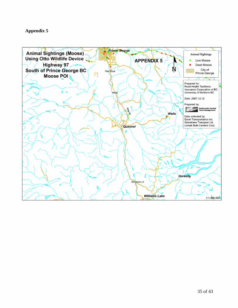
Highway 97 south of Prince George was likely traveled the least of all the routes. Live deer sightings (Appendix 4) are fairly evenly distributed between Prince George and McLeese Lake, with one cluster north of the Cottonwood River. Only a very few live moose sightings (Appendix 5) were noted between Prince George and Quesnel, and none were noted between Quesnel and McLeese Lake.
Highway 16 west of Prince George show clusters of live deer sightings (Appendix 6) near Bednesti Lake Resort, and from the Cluculz Creek BC MoT rest stop area west to Mapes Road. There is a cluster of dead deer (Appendix 6) just east of the Chilako River. Highway 16 west of Vanderhoof has a cluster of live deer sightings (Appendix 6) between Willowvale Road and Nautley Road. Highway 16 west of Prince George show 2 clusters of live moose sightings (Appendix 7) between the Cluculz Creek BC MoT rest stop area and just west of Sob Lake Road.
The most traveled stretch of road was Highway 16 east of Prince George. Most clusters of live deer sightings (Appendix 8) are east of the Walker Creek Forest Service Road and occurred
19 of 43
frequently all the way along Highway 16 to McBride. There was a cluster of live deer sightings extending both east and west of the Willow River Bridge. POI for both live and dead moose (Appendix 9) occurred in a cluster near Bowes Creek, and in another cluster near Wasno Creek. From Dome Creek along Highway 16 east to McBride, live moose sightings occurred very frequently.
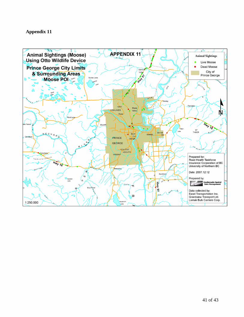
Within the Prince George city limits, a cluster of live deer sightings (Appendix 10) was located along Highway 97 north of the Nechako River, from Hofercamp Road to Prince George Pulpmill Road. A cluster of dead deer occurred just outside the city limits where Beaverley Creek crosses Highway 16, west of the Chilako River. A cluster of live moose sightings (Appendix 11) occurred along Highway 97, just north of the North Kelly Road junction with Highway 97. Discussion Phase I Otto® Wildlife development, functionality and community partnerships Otto® Wildlife development and functionality
The UNBC research team and PERSENTECH successfully worked together to develop the Otto® Wildlife with the ability to record roadside POI. From this pilot study, it appears that using Otto® Wildlife is a reliable, rapid and effective way to collect information on live animal sightings and concurrently record carcass locations. The unit is easy to install and functioned reliably during the pilot project. Otto® Wildlife does not impede the driver’s ability to operate the vehicle if the device is fastened securely to the dash board of the vehicle. Although some units tended to quickly deplete double A battery power when accessory power cables were not used, there were no known instances of lost data due to Otto® Wildlife malfunction. One company noted that cab noise made it difficult to hear the auditory feedback when the buttons were pressed, but the other two companies did not report any uncertainty over whether or not the POI were entered correctly. Data is easily downloaded from the Otto® Wildlife into secondary spatial and non spatial programs for analysis and no data transfer issues were encountered. The spatial components of the data were considered accurate as stated in the Otto® technical specifications because there were no issues associated with the functionality of the GPS receiver, and recorded POI overlaid the GIS road layers consistently. The twelve carcasses that were double counted also served to verify the GPS location accuracy because the unchanged position of the carcass should result in the same latitude and longitude recording (barring the driver pressing the button at a slightly different location relative to the carcass). Community partnerships
All three community partners were pleased to participate in this pilot study. Avoiding wildlife collisions is important to their business due to the costs and time loss associated with these collisions. At a corporate level, interest in the pilot study was maintained throughout the project. However, for the drivers, the novelty of participating in the project decreased over time. Since there was no way to monitor whether data were being accurately entered or entered in a timely manner relative to when the POI was noticed by the trucker, participation in the project was essentially based on the honour system, with no way to monitor consistent use of the units and compliance to protocols. However, this volunteerism provided a cost-effective method to gather data and test Otto® Wildlife functionality without having to hire drivers to survey roadsides and record POI.
20 of 43
During exit interviews at the end of the project, company personnel were asked questions about costs associated with wildlife collisions, and how their company covers costs incurred from collisions (Table 8). The companies were asked how they would define a “major” collision with wildlife in terms of cost. For one company over $5,000 in material damages was considered a major collision. A major collision for the other two companies was defined as $10,000 and $15,000 respectively. Table 8. Some insurance statistics from the participating trucking companies including costs, insurance coverage and in-house repairs associated with wildlife collisions
Trucking Company
Number of
trucks
Major Collision
Cost?
Basic Coverage
ComprehensiveCoverage
Windshields or Glass Repairs
Low costs repairs
Lomak Bulk Carriers Corp.
150-200 $15,000 ICBC ICBC Costs
covered in house
Grandview
Transport Ltd.
16 $10,000 ICBC Only on newer trucks
Excel Transportation
Inc. 70 $5,000
Under $15K covered in
house
Cost covered in house
ICBC ICBC
All three companies carried basic insurance through ICBC. Two companies carried
comprehensive coverage through ICBC, and the third carried ICBC comprehensive coverage only on the newer vehicles. Two of the three companies covered the costs of collisions in house if the costs were below a certain threshold.
The company representatives had over 55 years of collective experience in the trucking industry. In the businesses that they had been involved with during their careers, there had not been a human injury or fatality due to wildlife collisions within their time of employment. However, during the time of this study, there was a wildlife collision that resulted in the death of a semi-trailer truck driver. A deer was struck by a passenger vehicle and launched into the air, hitting the windshield of the oncoming semi-trailer truck. The truck involved was not associated with any of our trucking company community participants.
All three companies noted that participating in the project did not really increase awareness of wildlife on the roads with their drivers. Their reasoning was that drivers are already very aware of wildlife hazards as part of their normal operations.
The voluntary nature of the community partnership presented both opportunities and
challenges. The units could be deployed quickly using the trucker’s network, but the research team had limited input into travel routes, times of travel and other factors affecting data collection and analysis. Some drivers were keen to participate and took their roles seriously as project participants, while others were less enthusiastic. Consequently, the lack of systematic data collection greatly restricted the types of analyses of temporal data and live animal counts that we were able to
21 of 43

perform. Finally, enthusiastic driver participation in the project did not last as long as was originally intended by the research team, shortening the life span of the project. Phase II Analysis and mapping of Otto® Wildlife road test data Data quality constraints
Data were collected opportunistically rather than systematically and our findings must be interpreted within these confines.
Collecting data along roads and roadsides is similar to collecting data along very long linear
transects that traverse many different ecosystems, terrains, and habitats. However, in this pilot study, points along the linear transect were not traversed randomly, but rather traversed at times predetermined by the commercial schedules of the trucking company.
When trucks were traveling and collecting data during hours of dusk or dark, the drivers’
ability to see live animals or carcasses was generally limited to the area illuminated by the vehicle headlights. This likely resulted in the data over-representing the animal sightings in the daylight hours, when in fact the increased counts were simply a consequence of improved visibility.
Similarly, data from certain days of the week or times of the day may be over- or under-
represented in the data set due to driving schedules. These commercial schedules posed constraints on when the routes were traveled and, consequently, posed constraints on when the linear transect was sampled. For example, the road adjacent to a particular wetland complex may have been traversed most often between 11:00 am and noon, with few animal sightings recorded, relative to the number of animal sightings which may have been recorded had the road section been traversed at dusk or dawn. Thus, the temporal components of the data need to be interpreted with caution. The temporal sighting data are biased towards times of day when the trucks were operating and therefore do not provide a complete picture of animal presence and activity in the roadside corridor.
Multiple return trips along the same route could result in double counting of the same
animal, usually a carcass, if the carcass was not removed in a timely fashion by the road maintenance contractors. Careful data checking can usually highlight this type of occurrence, but there is a potential for data duplication. Only seven percent (12 POI) of the total dead POI in our study appear to have been double counted (Table 3).
Occasionally, the species of animal could not be verified by the driver. A live animal may have been too far from the road when observed, or obscured by brush, trees or a passing vehicle. Additionally, a carcass may be obscured in the ditch, by a passing vehicle or may be too damaged to identify from within the cab of a moving truck. If the species could not be verified, the POI was not to be recorded.
Ultimately, there was no way to ensure quality control of the data. Participation in the road
test was based on the honour system, and if POI were missed, or recorded inaccurately, there was no way to check or ensure compliance with data collection protocols.
22 of 43
Neither conclusions nor comparisons can be made regarding the frequency of live or dead sightings per trip because the total number of trips could not be determined.
The number of trips taken along the different highway corridors varied, and we were
therefore unable to ensure that each Otto® Wildlife unit remained on the route to which it was originally assigned. Therefore, the data for animal sightings along each highway corridor can not be directly compared, because the data cannot been corrected for the number of trips taken.
Phase II Analysis and mapping of Otto® Wildlife road test data
The collection of POI for live animal sightings and carcass locations has proven to be only a
very preliminary indicator of type and quality of data that can be collected with the Otto® Wildlife. Despite the above listed constraints on the data, some general conclusions about live animal sightings and carcass locations can be made.
116 dead carcasses were recorded in 11 months of data collection. This number is likely lower than the actual number of road killed animals since POI were not recorded on weekends, recorded infrequently from January to May 2008 and obviously not collected at all by truck drivers whose participation waned in the later stages of the study. Most carcasses recorded in July through October 2007 were deer, and then the majority of carcasses shifted to moose for December and January 2008 (Table 6). This trend corresponds with data collected in other studies which show that most deer vehicle collisions are in October and November and that moose vehicle collisions are more common in December and January in northern BC (RoadHealth-University Wildlife Collision Mitigation Research Team, 2006 and Sielecki, 2004).
The percentages of live moose (35%) and deer (65%) differ slightly from those found in previous studies by the Road Health-University Wildlife Collision Mitigation Research Team, 2006, (moose 25.4%, deer 61.1%) and Sielecki, 2004 (moose 30%, deer 50%), but provide confidence that the data collected corresponded with other findings from the same region. However, both the Road Health-University Wildlife Collision Mitigation Research Team, 2006, and Sielecki, 2004, have included additional species in their total species counts.
Maps of live and dead deer and moose sightings need to be viewed and interpreted with caution. The number of trips traversed on each stretch of highway out of Prince George was not equal and the data were not corrected for number of trips. Nevertheless, some clusters of both live and dead POI reflect what is already known about various sections along these highways.
Live sighting clusters occurred on all highways leading out of Prince George. On Highway 97 north, from the Prince George city limits to Summit Lake, there are numerous moose sightings, and, around Hart Lake, there is a cluster of deer sightings. Dead deer and moose carcasses were commonly recorded from the Prince George city limits to the North Fraser Road junction with Highway 97. On Highway 97 south, just north of the Cottonwood River Bridge, there was a cluster of deer sightings. On Highway 16 west, from Cluculz Creek rest stop area to the Mapes Road junction, there were frequent moose and deer sightings. East of the Chilako River bridge was a cluster of dead deer sightings. On Highway 16 east, around Bowes Creek and Wanso Creek bridges there were frequent moose sighting locations, and on both sides of the Willow River Bridge there
23 of 43

were deer sightings. On Highway 16, from the Walker Creek Forest Service Road to just west of McBride, there were almost continuous moose and deer sightings.
The dead moose sighting clusters near Bowes Creek corresponds to one of the collision hot
spots identified through WARS data analysis in a companion study by the University RoadHealth Research Team.
The clusters of live deer and moose sightings between the Cluculz Lake rest stop area and
Mapes Road correspond to several high risk collision hot spots identified in an expert opinion survey of people knowledgeable about wildlife collision and road safety (highway maintenance contractors, Conservation Officers, RCMP members, Ministry of Transportation staff, Vanderhoof Fire Department automobile extrication staff and ambulance staff) on Highway 16 between Vanderhoof and Prince George (Road Health-University Wildlife Collision Mitigation Research Team. Chapter 4. 2006). The expert opinion hot spots were defined on the basis of relative risk associated with the experts recollections of highway segments with frequent wildlife collisions as well as visual sightings of animals in the highway corridor.
Phase III Otto® Wildlife feasibility for operational use
Feedback from the trucking companies indicated that the device was easy to use in the trucks, and the data was easy to transfer to the agency conducting the analysis. The data files are easy to work with and to transfer into a variety of analysis programs. Through this pilot study, Otto® Wildlife has demonstrated its potential and readiness for use in a variety of operational capacities. PERSENTECH has indicated that it is willing to produce more Otto® Wildlife devices at an estimated cost of $200/unit for 100 units.
Using the Otto® Wildlife as a data collection method for carcass locations and carrying out
the subsequent mapping and analysis of collision hot spots has virtually no impediments and can be carried out using the existing units. The data quality constraints requiring systematic data collection apply only to the collection of live animal POI. Recording carcass location POI requires only regular inspections of the highway and collection and recording of the carcass POI prior to removal by road maintenance contractors. It is not dependent upon a systematic sampling methodology.
Once a data normalization method is determined, and a more systematic method of data
collection implemented, live sighting POI data will more accurately reflect roadside occurrence of animals. Subsequently, more site- and time-specific conclusions regarding the presence of live animal populations and their movements within the road corridor can be drawn.
Results from this pilot study data and maps indicate that the device can be used to produce
maps and counts both of carcass locations and animal sightings with reliability. Data can be used to complement the information collected by the WARS system and other wildlife collision data sets. Road and wildlife ecology researchers, road safety managers, road engineers, and biologists will find a variety of operational and research uses for the Otto ® Wildlife.
24 of 43

Recommendations Phase 1 Otto® Wildlife development, functionality and community partnerships Recommendations: Otto® Wildlife development and functionality
1. All users recommended bigger buttons which are easier to locate and use while driving. 2. A remote link between the Otto® Wildlife and the base PC would allow remote uploading of
data log files. Operators would not have to manually retrieve the unit to access the data. 3. An application should be developed to allow the data to be uploaded directly to the receiving
agency’s web browser and subsequently into any web-based mapping system. This way, drivers can see their data mapped upon uploading.
4. Otto® Wildlife users should use the accessory vehicle power supply, not batteries, to power the unit.
5. A methodology to record a variety of species as well as a “herd” button to record the presence of five or more animals at one time at one location should be added to the Otto® Wildlife for areas where high numbers of wildlife species may be encountered.
6. A “go back” or “erase last keystroke” button should be added to provide the ability to delete entries made in error.
7. A button to record animal behaviour should be added. For example, “0” could indicate standing at roadside, and “1” could indicate crossing. Highway segments could then be potentially classified as high crossing areas, high observation zones and high collision zones (Lee, 2006).
8. High observation zones with low collision rates should be compared with high collision zones to determine site characteristics such as visibility, road profile, and number of traffic lanes that may be influencing successful crossings.
Recommendations: Community partnerships
1. If similar projects are to be undertaken, the Otto® Wildlife units should be placed in operator owned trucks or vehicles where the owner has a specific interest in wildlife or is in some way compensated and contractually obligated to collect data systematically. This would ensure the best compliance with project data collection goals and consistency of data collection.
2. More feedback should be provided to the trucking companies and drivers to enable them to see the value of this study to their work environment.
3. There is no way to ensure that POI are being accurately and consistently entered or entered in a timely manner, therefore good relationships need to be developed and fostered with volunteer partners in an effort to ensure reliable collection of the data.
Phase II Analysis and mapping of Otto® Wildlife road test data Recommendations: Data quality constraints
1. The physical area in which the driver sees and then records a live animal sighting needs to be carefully defined in order to minimize data concentrations of sightings during the daylight hours. One way to compensate for this is to record POI for sightings only on the road or shoulder, within a distance which would approximate the area illuminated by headlights at night. Animals outside this headlight illuminated zone (ditch, right of way or too far down the road) would not be recorded.
25 of 43

2. Data need to be vetted prior to analysis to discard double counted carcasses and false dead POI records.
3. A systematic methodology of sampling along a linear corridor needs to be developed to “normalize” the data to take into account any missing temporal data. For example, random start times over a 24 hour period to traverse the route would result in a more complete representation of animal temporal patterns of behaviour near roads. This would avoid data gaps on weekends or at certain times of the day.
4. If a route traverse occurs and there are no POI recorded, the fact that a traverse took place on a particular date needs to be documented so that absence of animal activity can be incorporated into the data set.
5. Similar numbers of route traverses need to be completed along each highway corridor in order to compare, in a relative manner, the wildlife populations and frequency of wildlife use on highway corridors.
6. Similar numbers of route traverses need to be completed in each season in order to determine seasonal trends in wildlife movement and activity in roadside corridors.
Phase II Analysis and mapping of Otto® Wildlife road test data Recommendations: Use of existing data
1. Maps of live and dead animal sighting POI should be provided to all volunteer participants involved in data collection on an ongoing basis both for education and awareness as well as to demonstrate the potential and practical uses of the data collection project.
2. Existing wildlife warning sign locations should be compared with the critical areas of live and dead animal sightings identified in this report, in conjunction with the ongoing wildlife signage work of the UNBC research team.
3. Increased public awareness about critical areas should be carried out in the local communities of Bear Lake, Vanderhoof, Cluculz Lake, McBride and Prince George.
4. Maps and count summaries can be used with specific caveats to supplement existing wildlife collision prevention projects and research on wildlife mortality within highway corridors in north central BC.
Phase III Otto® Wildlife feasibility for operational use Recommendations: Future operational use
1. Develop a version of the Otto® Wildlife with capability to record POI for more than two species, simple behavioural information and herd POI. Most jurisdictions have more than two large species that are involved in wildlife vehicle collisions. Ungulate species such as deer, elk, caribou and bison are social animals and are frequently encountered in herds or groups.
2. Utilize the POI recording capabilities of the Otto® Wildlife in a variety of operational settings.
a. Road maintenance contractors would have a quick and accurate method of recording road killed carcass locations to supplement or replace existing paper recording methods used on numbered highways in BC.
b. Other jurisdictions or agencies within BC that currently collect road killed carcass location data using pen and paper methodology, such as National Parks, the Alaska
26 of 43

Highway, within municipal boundaries, and on Forest Service Roads would have a quick and accurate method of data collection.
c. Mapping and analysis of data can be carried out quickly and supplement or replace less timely methods of data analysis.
d. The motoring public, trucking companies, courier companies and other frequent road user groups would benefit from timely production of maps of live animal sightings enabling drivers to be aware of areas with high wildlife use and therefore reduce their risk of having a wildlife collision.
e. Other agencies whose business is affected by wildlife collisions such as the RCMP, Ministry of Environment and the Conservation Officer Service would benefit from timely information on this issue.
f. Road safety planners, engineers, managers and biologists can use spatially accurate data to help prioritize high collision zones and locate appropriate mitigation measures.
g. Carcass mortality numbers recorded by Otto® Wildlife could be used for WARS reporting and quality control checks on road maintenance contractors, providing carcass data was collected on a similar schedule.
3. Use the Otto® Wildlife for research. a. Wildlife and road ecology researchers and biologists can use a GPS system for POI
recording. Recommendations Already in Progress
Since the completion of the data collection phase of this project, several agencies have initiated projects using the Otto® Wildlife for their specific purposes and situations. Otto® Wildlife Multi Species Version
In collaboration with PERSENTECH and ICBC, the UNBC research team spearheaded the development of a second version of the Otto® Wildlife referred to hereafter as Otto® Wildlifev2 (Figure 3). It provides for the connection of an external 19 button key pad where the keys are programmed to record POI for 16 different species, carcass location and a herd button for animal groups more than a predetermined number. The original three buttons on the device are no longer used for the wildlife recording functionality (PERSENTECH, 2007).
Figure 3. Otto® Wildlife version 2
27 of 43

Operational Use Several Otto® Wildlifev2 devices are now in use on the Alaska Highway. Public Works and
Government Services Canada (PWGSC) staff and RCMP members from Fort Nelson are recording both live animal sightings and carcass locations (pers comm. Colin Leake, Resident Supervisor, Alaska Highway Maintenance Program, Public Works and Government Services Canada). Data is being warehoused by ICBC’s Road Safety Business Intelligence Unit. The information will be incorporated into the road conditions bulletins for the Alaska Highway. Previous to this, road killed animal data collection on the Alaska Highway was collected by PWGSC using a paper form and data tracking and analysis was difficult and time consuming.
The original Otto® Wildlife devices from this pilot study and several Otto® Wildlifev2
devices are being used by a road maintenance contractor in the central interior of BC. ICBC has partnered with Interior Roads Ltd., to use the devices in their vehicles to record live animal sightings and carcass locations. Data are being warehoused and analyzed by ICBC’s Road Safety Business Intelligence Unit. Plans are to produce maps for use on the Interior Roads Ltd., website, and to utilize the information to develop timely wildlife hazard warnings on the Government of BC website for motorists at www.drivebc.ca (pers comm. David Dickson, Provincial Manager, Commercial Vehicle Road Safety, Insurance Corporation of British Columbia). Research Use
The Miistakis Institute for the Rockies, an applied research institute affiliated with the University of Calgary, Alberta, has received funding to purchase several Otto® Wildlifev2 devices, modified for their needs, for use in an ongoing research project called “Road Watch in the Pass” to study wildlife observations and movement along Highway 3 in the Crowsnest Pass area of the Rocky Mountains in AB and BC. The device will be used to collect data in a systematic way to complement the data set previously collected opportunistically by volunteers (pers comm. Tracy Lee, Senior Project Manager, Miistakis Institute for the Rockies.).
28 of 43

Appendices
29 of 43
Appendix 1 Otto Technical Specifications Otto® Wildlife (Otto-Driving Companion® website, 2007b)
• Dimensions: 12.8 cm x 7 cm x 3.2 cm • Weight: 320 g • Operating temperature: -20 C to +40 C • Power source: +5 VDC at 350 mA through USB connector or two AA batteries • Battery Operation: 8 hours continuous use (NiMH 2200 mA) • PC interface: USB 1.1 mini-B type connector • GPS receiver: 12-channel, 1575 MHz with built-in omni-directional antenna • GPS Position Accuracy: 10 meters, updated once per second • GPS Speed Accuracy: 1.0 km/hr, updated once per second • GPS Satellite Acquisition Time: less than 2 seconds (hot start); approximately 15 seconds
(warm start); approximately 3 minutes (cold start) Data Upload Application
• A software application was developed specifically for UNBC by PERSENTECH to allow users to upload POI from the device to their computers without an internet connection.
• The software application was compiled and runs on a WindowsTM-based operating system supporting USB connectivity.
• The software application includes a volume selection to set volume to "Mute, Low or High". The default sound level setting on the unit is “High".
• The software application recognizes the device and allows the operator to upload the stored data to a local directory on the PC's hard drive with a user-selectable filename.
• A CSV file can be saved on the local PC’s hard drive and includes the following fields: Date, Time, Latitude, Longitude, Moose, Dead, Deer (a "1" will populate the Moose, Deer or Dead fields, corresponding to the button push).
Installation and Operation
• The device is placed on the dash board. (Two of the three trucking companies attached the Otto® Wildlife to the dash-board with Velcro or tape, and the third company let the unit sit on the dash unsecured.)
• Otto® Wildlife can be plugged into the accessory socket of the vehicle and the USB mini-B port on the side of the unit or powered with 2 AA batteries.
• Otto® Wildlife annunciates “Logging Enabled”, locks onto the GPS satellite signals and is then ready to record.
• Otto® Wildlife is turned on by pressing the middle button (Power on/off) for at least three seconds. Shorter pushes correspond to the POI markers described below.
• Pushing the Moose button: The user receives audible feedback "Moose" and visual feedback with a momentary Blue LED light.
• Pushing the Dead button: The user receives audible feedback "Dead" and visual feedback with a momentary Red LED light.
• Pushing the Deer button: The user receives audible feedback "Deer" and visual feedback with a momentary Yellow LED light.
• An animal is marked dead by depressing the middle button after the initial "Moose" or "Deer" marker.
30 of 43

• The device records the following data when the user interface buttons are pressed; date, time, latitude, longitude, deer sighting (1 = sighting, 0 = no sighting); moose sighting (1 = sighting, 0 = no sighting); sighting status (1 = dead, 0 = alive). A “1” corresponds to the button being pressed.
31 of 43

Appendix 2
32 of 43

Appendix 3
33 of 43

Appendix 4
34 of 43
Appendix 5
35 of 43

Appendix 6
36 of 43

Appendix 7
37 of 43

Appendix 8
38 of 43

Appendix 9
39 of 43

Appendix 10
40 of 43
Appendix 11
41 of 43

Acknowledgements Nicole Klassen was the project manager for this project and deserves much credit for project successes. Roy Rea and Dexter Hodder advanced the original concept of using vehicle GPS devices to record wildlife collision data. Gayle Hesse made the link between that idea and the Otto-Driving Companion®. The authors thank Frank Franczyk of Persen Technologies Ltd., for working with the UNBC research team, particularly Scott Emmons of UNBC’s GIS lab. We thank Excel Transportation Inc., Grandview Transport Ltd., Lomak Bulk Carriers Corp., and their managers, dispatchers, and drivers who logged many hours on the highway counting animals and carcasses and in the office transferring data files. Dave Dickson, Gordon Wagner, Daryl Nolan, Ryan Spillet and Gord Flewelling of the Wildlife Collision Working Group offered valuable advice and support during this project. Dr. Eric Rapaport and Michael Hurley reported on some of the preliminary findings for this project. Major funding for this study was provided by the Insurance Corporation of British Columbia and the RoadHealth Regional Task Force. References Ament, R., D. Galarus, H. Richardson, and A. Hardy. Roadkill Observation Collection System (ROCS) Development of an Integrated Personal Assistant (PDA) with a Global Positioning System (GPS) to Gather Standardized Digital Information. 2007. Bozeman, Montana. 65 p. Bowering, D. 2007. CrossRoads 2007 Update on Motor Vehicle Crashes and Crash Prevention in Northern BC. Northern Health Authority. Prince George, B.C. 38 p. Cramer, P.C., and J.A Bissonette. 2006. North American Priorities for Transportation and Wildlife Research and Practice. In: J. Bissonette (ed.) Evaluation of the Use and Effectiveness of Wildlife Crossings: Interim Report, Prepared for the National Cooperative Highway Research Program, Transportation Research Board, National Research Council. Huijser, M.P., D.E. Galarus and A. Hardy. 2006. Software for Pocket PC to Collect Road-Kill Data. P. 640, in: Proceedings of the 2005 International Conference on Ecology and Transportation. Centre for Transportation and the Environment. 29 August-2 September 2005, North Carolina State University, Raleigh, NC, USA. Huijser, M.P., Fuller, J., Wagner, M.E., Hardy, and A.P. Clevenger, A.P. 2007. Animal-Vehicle Collision Data Collection: A Synthesis of Highway Practice. NCHRP Synthesis 370. Western Transportation Institute – Montana State University. Prepared for the Transportation Research Board of the National Academies. Washington, D.C. 117 p. Lee, T., M.S. Quinn, and D. Duke. 2006. Citizen Science, Highways and Wildlife: Using a Web-based GIS to Engage Citizens in Collecting Wildlife Information. Ecology and Science 11(1):11. [online] URL: http://www.ecologyandsociety.org/vol11/iss1/art11/ Otto-Driving Companion website, 2007a. < http://www.myottomate.com/index.asp > Accessed Nov. 1, 2007.
42 of 43

Otto-Driving Companion website, 2007b. < http://www.myottomate.com/techspecs.asp > Accessed Nov. 27, 2007. PERSENTECH. 2006. OttoLogTM UNBC: Wildlife Location Application Version 0.1. Winnipeg, MA. 6 p. PERSENTECH. 2007. OttoLogTM UNBC: Wildlife Location Application Version 0.2. Winnipeg, MA. 11 p. Road Health-University Wildlife Collision Mitigation Research Team. 2006. Using Collision Data, GPS Technology and Expert Opinion to Develop Strategic Countermeasure Recommendations for Reducing Animal-Vehicle Collisions in Northern British Columbia. Unpublished Report. Prince George, B.C.145 p. Seshagiri, B. 1998. Occupational Noise Exposure of Operators of Heavy Trucks. American Industrial Hygiene Association Journal. 59(3) 205-213. Sielecki, L.E. 2001. Evaluating the Effectiveness of Wildlife Accident Mitigation Installations with the Wildlife Accident Reporting System (WARS) in British Columbia. Pages 473 – 489 in Proceedings of the 2001 International Conference on Ecology and Transportation, Eds. Irwin, C.L., Garrett, P., McDermott, K.P. Centre for Transportation and the Environment, 24 September-28 September 2001, North Carolina State University, Raleigh, NC, USA. Sielecki, L.E. 2004. WARS 1983 – 2002. Wildlife Accident Reporting and Mitigation in British Columbia: Special Annual Report. Environmental Management Section, Engineering Branch, British Columbia Ministry of Transportation. Victoria, BC. 222 p.
43 of 43