The Use of Geophysical Surveys for Enhanced Environmental ...
8
Vol 25, 2 2020 Page 118 The Use of Geophysical Surveys for Enhanced Environmental Characterization in Karst Terranes John A. Mundell, P.E., L.P.G., P.G. President/Senior Earth Consultant Mundell & Associates, Inc. 110 South Downey Avenue Indianapolis Indiana, USA 46219 [email protected] Ryan Brumbaugh Mundell & Associates, Inc. 110 South Downey Avenue Indianapolis Indiana, USA 46219 [email protected] Bio Bio Introduction Many underground storage tank (UST) sites in the midwestern United States are located in identified karst regions that present unique challenges to effectively characterize historical chemical release areas and determine the severity of soil and groundwater impacts arising from the complex interplay between these releases and the typical subsurface groundwater flow dynamics. Traditional characterization of UST releases using initial soil and groundwater sampling followed by monitoring well installation and monitoring are often undertaken without adequate knowledge of the unique geomorphology and hydrogeologic characteristics at each location and, as a result, yield insufficient information regarding the contaminant mass present, the geometric orientation of the top of bedrock surface and solution-enhanced flow pathways, and the nature of any well-developed karst conduits. The use of surface and borehole geophysical methods offers a means to dramatically impact the development of accurate conceptual site models to address these deficiencies and support the development of more effective remedial programs. Site Characteristics The Site is located northeast of the intersection of South Wilderness Road and Richmond Street in Mt. Vernon, Rockcastle County, Kentucky (see Figure 1), and was formerly a B&F Gulf service station. At some point in the past, a petroleum hydrocarbon release occurred from an existing UST located beneath the Site. Figure 1 Site Map Consequently, the on-site soil and on- and off-site groundwater have been impacted with petroleum hydrocarbons. The Kentucky Department for Environmental Protection (KDEP) Division of Waste Management Underground Storage Tank Branch requested the development of a geophysical survey scope of work in 2013 to 1) gain a better understanding of the subsurface conditions for the purpose of designing a corrective action plan (CAP) and/or risk assessment strategy (RA), and 2) provide insight into the geology, hydrogeology, distribution of preferential transport pathways, and any notable subsurface anomalies that might be indicative of potential contaminant mass or any remaining UST and product piping systems. As such, this geophysical investigation was to assist the environmental consultants and KDEP in gaining an enhanced understanding of the bedrock surface in order to identify and map out potential subsurface features such as weathered or fractured zones acting as potential groundwater flow pathways and bedrock topographic low areas or valleys where subsurface hydrocarbon pools may tend to accumulate. Site Geology The Site has been mapped by the Kentucky Geologic Survey (KGS) as being underlain by the Mississippian-aged Ste. Figure 2 Geologic Site Map
Transcript of The Use of Geophysical Surveys for Enhanced Environmental ...
Vol 25, 2 2020 Page 118
The Use of Geophysical Surveys for Enhanced Environmental Characterization in Karst TerranesJohn A. Mundell, P.E., L.P.G., P.G.
President/Senior Earth Consultant
Mundell & Associates, Inc.
110 South Downey Avenue
Indianapolis
Indiana, USA [email protected]
Ryan Brumbaugh
Mundell & Associates, Inc.
110 South Downey Avenue
Indianapolis
Indiana, USA [email protected]
Bio
Bio
IntroductionMany underground storage tank (UST) sites in the midwestern United States are located in identified karst regions that present unique challenges to effectively characterize historical chemical release areas and determine the severity of soil and groundwater impacts arising from the complex interplay between these releases and the typical subsurface groundwater flow dynamics. Traditional characterization of UST releases using initial soil and groundwater sampling followed by monitoring well installation and monitoring are often undertaken without adequate knowledge of the unique geomorphology and hydrogeologic characteristics at each location and, as a result, yield insufficient information regarding the contaminant mass present, the geometric orientation of the top of bedrock surface and solution-enhanced flow pathways, and the nature of any well-developed karst conduits. The use of surface and borehole geophysical methods offers a means to dramatically impact the development of accurate conceptual site models to address these deficiencies and support the development of more effective remedial programs.
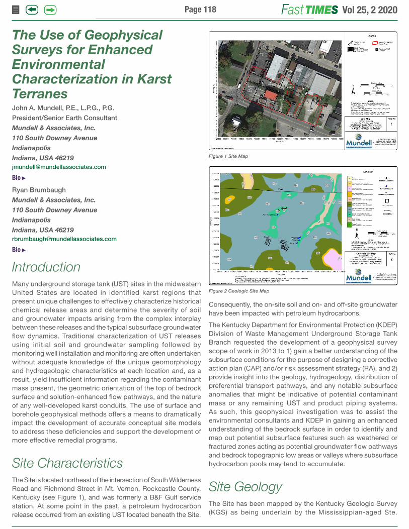
Site CharacteristicsThe Site is located northeast of the intersection of South Wilderness Road and Richmond Street in Mt. Vernon, Rockcastle County, Kentucky (see Figure 1), and was formerly a B&F Gulf service station. At some point in the past, a petroleum hydrocarbon release occurred from an existing UST located beneath the Site.
Figure 1 Site Map
Consequently, the on-site soil and on- and off-site groundwater have been impacted with petroleum hydrocarbons.
The Kentucky Department for Environmental Protection (KDEP) Division of Waste Management Underground Storage Tank Branch requested the development of a geophysical survey scope of work in 2013 to 1) gain a better understanding of the subsurface conditions for the purpose of designing a corrective action plan (CAP) and/or risk assessment strategy (RA), and 2) provide insight into the geology, hydrogeology, distribution of preferential transport pathways, and any notable subsurface anomalies that might be indicative of potential contaminant mass or any remaining UST and product piping systems. As such, this geophysical investigation was to assist the environmental consultants and KDEP in gaining an enhanced understanding of the bedrock surface in order to identify and map out potential subsurface features such as weathered or fractured zones acting as potential groundwater flow pathways and bedrock topographic low areas or valleys where subsurface hydrocarbon pools may tend to accumulate.
Site GeologyThe Site has been mapped by the Kentucky Geologic Survey (KGS) as being underlain by the Mississippian-aged Ste.
Figure 2 Geologic Site Map

Vol 25, 2 2020 Page 119
Genevieve Limestone (Schlanger and Weir, 1971), which typically exhibits a very high karst potential. However, the mapped contact with the Upper Part of the Slade Formation (with a high karst potential) is in close proximity to the south, and the mapped contact with the Burnside Member of the Slade Formation is to the northeast and northwest (see Figure 2). The Upper Part of the Slade Formation overlies the Ste. Genevieve and the Burnside Member underlies the Ste. Genevieve. An east-west trending fault is within about a half mile to the north of the Site.
The Site is located within the Eastern Pennyroyal karst region of Kentucky (see inset Diagram 1), where most groundwater basins, and subsequently caves, occur along the flanks of ridges. The floors of the valleys separating the ridges are largely underlain by silty dolomites that are only slightly soluble (Currens, 2001). The headward area of the valleys may be underlain by limestone, and when this happens, the valleys are typically karst. Cave passages closer to the middle of the ridges are protected from erosion by the nonsoluble rocks topping the ridges. As erosion progresses over geologic time, the major streams draining the karst terrane cuts its channel deeper. As a result, flow increases through conduits to the major streams, and new springs develop at lower elevations along the stream banks.
Prior to the geophysical survey completion, Mundell & Associates geophysicists, together with representatives of Shield Environmental and the Kentucky DEP, mapped nearby sinkholes, surface depressions and spring locations northeast and north of the site (see Figure 2). These nearby locations indicate the very high potential for significant karst development beneath the site.
Prior to the geophysical survey, thirty-six (36) shallow soil borings had been advanced from 2.0 to 17.5 ft below the ground surface, with nine (9) soil/bedrock borings for monitoring wells drilled from depths of 58 to 77.5 ft at the Site. These borings had encountered relatively thin fill materials (mixed aggregate/clayey-silts) and fine-grained silty clay soils underlain by light to dark gray weathered and fractured to competent limestone with shale partings, clay intervals and chert nodules at depths of 3.0 to 11.0 ft below ground surface.
Diagram 1. Generalized Block Diagram of the Eastern Pennyroyal Karst Area (from Currens, 2001)
Geophysical MethodsKarst features can be mapped by measuring contrasts in physical properties of the subsurface soil and bedrock. Geophysical mapping of karst features can range from a relatively rudimentary task of defining variations in apparent resistivity to the technically complex task of mapping the three-dimensional characteristics of the soil and bedrock. Given the desired depth of penetration (approximately 20 to 50 feet), and the desire to image both the lateral and vertical extent of possible subcutaneous features, terrain conductivity and two-dimensional electrical resistivity imaging (2-D ERI) were selected as the methods of choice to characterize the bedrock beneath the site, with ground-penetrating radar (GPR) as a supplementary method.
Frequency Domain Electromagnetic Conductivity
Mapping with Frequency Domain Electromagnetic Conductivity (FDEM) was accomplished using a GEM-2 broadband electromagnetic sensor manufactured by Geophex Ltd. The GEM-2 is a hand-held, digital, multi-frequency sensor capable of transmitting and receiving a digitally-synthesized arbitrary waveform containing multiple frequencies. The depth of exploration for a given earth medium is determined by the operating frequency of the sensor. By utilizing multiple frequencies to measure the earth response from several depths, an image of the three-dimensional distribution of subsurface objects can be created. The GEM-2 quad-phase and in-phase instrument response values were acquired at three frequencies (47.01, 13.60 and 3.93 kHz) and subsequently processed, gridded, contoured and interpreted using Surfer by Golden Software. The GEM-2 data was acquired throughout most of the site except for obstructions due to buildings, heavily brushed and wooded areas, dumpsters, and motor vehicles.
Ground Penetrating Radar
GPR data were collected using a Sensors and Software Noggin Plus System equipped with a Smart Cart and shielded 250 megahertz antennae. The GPR data provide focused, detailed cross-sectional characterization of selected study areas along profile lines. These data and subsurface reflections can yield useful information about horizontal layering and changes in soil and bedrock conditions (e.g., bedding, cementation, moisture and clay content and voids), limits of historical excavations and the approximate depth, position, size and orientation of discrete objects such as USTs, utilities, waste/fill and reinforced concrete.
Two-Dimensional Electrical Resistivity Imaging (2-D ERI)
Resistivity data were collected with an AGI SuperSting R8 earth resistivity meter using a dipole-dipole array of 51 to 56 electrodes, based on site limitations, along seven (7)

Vol 25, 2 2020 Page 120
individual profile lines. Once the data were collected, they were downloaded to a computer and subsequently inverse-modeled using the software Advanced Geosciences EarthImager to obtain a resistivity cross-section of the subsurface. This is obtained through the process of generating a model resistivity cross-section, calculating the apparent resistivity pseudo-section that would result from such a model, and comparing the calculated pseudo-section to the one collected in the field.
Survey Results FDEM ResultsThe 13.60 kHz. terrain conductivity map is shown in Figures 3 and displays the terrain conductivity in milliSiemens per meter (mS/m). Lower terrain conductivity values, up to approximately 20 to 25 mS/m, are indicative of more granular material, whereas intermediate values between 20 and 50 mS/m are characteristic of material that has a higher clay content, higher fluid content, and increased weathering. Metallic objects will exhibit values above 85 mS/m, depending on depth and size.
In general, the terrain conductivity maps were difficult to interpret based on the significant abundance of near surface metal present at the Site and other cultural features such as cars, a metal dumpster, utility poles, water meters, reinforced concrete slabs and walls, and a canopy. Where metallic debris did not appear to be present, the terrain conductivity reflected the presence of fine-grained clayey soils in the near surface (generally green in color). A terrain conductivity anomaly (Anomaly A) was further scanned with the GPR and it appears to be associated with miscellaneous metallic debris or remnant pieces of reinforced concrete. No apparent orphan underground storage tanks (USTs) were observed in the areas that did not exhibit cultural interferences. Some areas of higher conductivity along the roadway likely represent existing utility lines (water), while some are likely the presence of remaining reinforced slab or foundation remnants.
GPR ResultsFor data control purposes, the GPR profiles were collected collinear with all seven (7) 2DERI profiles as well as over
Figure 3 13.6 kHz Terrain Conductivity Map Figure 4 GPR Profiles 8 to 12
anomalies observed in the GEM-2 data. DGPS technology was used to obtain GPS coordinates for all start and end points along the various GPR lines, ensuring the data is accurately displayed in a geo-referenced manner. Five (5) individual GPR profiles are presented as Figure 4 to further characterize anomalies of interest observe in the data. As indicated in the figures, the linear outline of a former excavation can be observed by significant reflection signatures. The increased depth of penetration within the excavation area is indicative of granular fill. GPR Line 10 shows what appears to be either a liquid interface or a previously graded surface, which is evidenced by a strong horizontally continuous reflection surface. There are multiple reflections of interest within the formerly excavated area.
2-D ERI Profile Line Results
A total of seven (7) 2-D ERI resistivity profiles were collected for this project (see Figure 1). Lines 1 and 3 through 6 utilized an electrode spacing of 4 feet (approximately 1.2 meters) while Lines 2 and 7 utilized an electrode spacing of 3.28 feet (1.0 meters), and 2 feet (0.6 meters), respectively. Lines 1 through 3 were oriented west to east and Lines 4 through 7 were oriented south to north. Example profile Lines 2 and 5 are shown in Figures 5 and 6.
Figure 5 Resistivity and GPR Profile Line 2

Vol 25, 2 2020 Page 121
The modeled resistivity values range from 1 (purple in color) to 4,900 Ohm-meters (dark green). The lowest range of values, i.e., less than 90 ohm-meters, (purple to dark red in color) is interpreted to be materials consisting of fine-grained soils with a high clay content (purple in color) in the upper subsurface, and weathered shale, interbedded shale and limestone or severely-weathered limestone bedrock zones in the deeper subsurface with the potential for soil-filled voids. Midrange resistivity values (90 to 724 ohm-meters, light red to light green in color) are interpreted to be bedrock residuum, slightly weathered to competent shale bedrock or slightly- to moderately-weathered limestone bedrock (with fractures and/or solutioned features). The higher range of resistivity values, i.e., greater than 724 ohm-meters (light green to dark green in color) is interpreted as dense, competent limestone bedrock.
In general, all seven (7) resistivity profiles showed a highly variable limestone bedrock surface (generally between 2 to 36 ft below the ground surface (BGS)) overlain by fine-grained silty clay/clay soils beneath the area. The predicted depth of the bedrock surface is consistent with the depths observed at the monitoring well boring logs in which rock cores were obtained. Several local, low-resistivity zones are present within the limestone bedrock, mainly in the central and western portions of the Site, likely indicating an increased degree of bedrock fracturing/weathering indicative of karst development with preferential groundwater flow pathways. The following two profile lines near the former UST are described in greater detail:
Profile Line 2 - shows a highly variable bedrock surface at depths of 6 to 20 ft that appears to be moderately to severely weathered based on low resistivity values (purple to red in color), as seen in Figure 5. The top-of-bedrock slopes downward toward the east, and there appears to be three local low topographic zones in the upper bedrock beneath Electrode Nos. 14 to 17, 26 to 29 and 36 to 40 associated with an increase in bedrock weathering and the potential for vertically-oriented flow pathways (red to purple in color). These bedrock topographic lows could locally direct groundwater toward them, and also be potential areas of free product accumulation, depending on the thickness of the saturated zone above the bedrock surface. An apparent more granular shallow zone is present beneath Electrode Nos. 21 through 31 (yellow to light green) and is oriented slightly northeast from the likely former excavation observed in the GPR data. This zone could potentially be controlling groundwater flow towards MW-15 to the northeast, which has been observed to be impacted by elevated benzene concentrations. The aforementioned granular zone appears to be located over a more highly conductive (low resistivity) zone overlying a bedrock depression beneath Electrode Nos. 21 through 31, which tends to direct local fluid flow towards it.
Profile Line 5 - shows a gently undulating bedrock surface sloping overall downward to the North, with several localized bedrock topographic lows along the profile line (see Figure 6). The depth to bedrock (about 6.5 ft to 12 ft BGS) is greater within the southern half of the profile, with more competent limestone bedrock in the northern half where the bedrock surface is
Figure 6 Resistivity and GPR Profile Line 5
shallower (about 3.5 to 7 ft BGS). The local bedrock troughs beneath Electrode Nos. 15 to 17, 20 to 24 and 26 to 30 could potentially be controlling localized fluid transport from the prior excavation or acting as a ‘pooling’ area for product, if any is present. There is one significant vertically-oriented bedrock weathering feature beneath about Electrode Nos. 28 through 31 that grows horizontally extensive at depth below about Elevation 1156. This deeper severely-weathered limestone bedrock zone appears to be related to and connected with several other severely-weathered features noted at depth (see Figures 7 and 8).
3-D ERI ‘Slice’ Results
Since significant interest is the orientation of any weathered bedrock or potential karst development features at varying depths below the ground surface and their degree of inter-connectivity, another analysis method was utilized to enhance the visualization of these features. Figures 7 and 8 display the subsurface resistivity properties at “constant elevations” of EL 1165 and 1160, respectively. These are referred to as “slice maps”. With high enough data density, which was achieved in this study, constant elevation “slices” can be used to connect the data from multiple profile lines and interpret large scale karst features.
Figure 7 Resistivity Slice at 1165 Ft. Elevation

Vol 25, 2 2020 Page 122
Figure 8 Resistivity Slice at 1160 Ft. Elevation
A review of all slice maps shows that, overall, the limestone bedrock is most competent and least weathered near and below a county nursing building located in the northern study area. Conversely, the limestone bedrock appears to be the most severely weathered south, southwest and west of the county nursing building. The resistivity slice at the highest elevation (i.e., Elevation 1165 in Figure 7) shows low-resistivity, weathered bedrock channels (purple to red in color) present in the central part of the Site along profile Lines 2 and 3, with other low-resistivity zones near the western and eastern property boundaries. The presence of these channels in the vicinity of the mapped former excavation area (based on the GPR data) likely helped direct fluid flow northward toward MW-15 where benzene impacts have been detected and potentially to the northwest and northeast site perimeters as well.
It should be noted that, as the resistivity slice maps goes deeper (see Figure 9, representing EL 1150), a higher resistivity competent limestone (dark green in color) becomes arealy extensive in the eastern, northern, and northeastern portions of the Site, with low-resistivity channels more apparent along the western Site boundary, and in an area to the northeast of the former apparent tank pit excavation. As can be observed by noting the likely direction of groundwater flow at each elevation, these karst weathering patterns within the bedrock suggest complex potential vertical and horizontal preferential groundwater flow pathways through the severely-weathered bedrock areas. Based on vicinity mapping of
Figure 9 Resistivity Slice at 1150 Ft. Elevation
known karst features near the site to the northwest and northeast (i.e., the sink holes, surface depressions, and springs observed by Mundell, Shield and Kentucky DEP personnel), the observed karst development patterns observed on site appear to be consistent with potential groundwater flow directed in the same direction away from the likely former excavation area. As such, further delineation of petroleum hydrocarbon impacts may be completed in these directions and within these weathered bedrock zones.
Bedrock Topography Map Results
The bedrock topography as determined from the 2-D ERI profile lines as well as previous boring logs from the monitoring well network is presented in Figure 10. As indicated, the bedrock surface is generally the highest in the southwest corner of the Site, and dips downward toward the east, northeast and north. Troughs or depressions in the bedrock surface are evident at several locations, and likely exert some local control over horizontal and vertical groundwater flow direction. Potential shallow preferential groundwater flow pathways downgradient of the previous excavation (as indicated by GPR data) would be directed downslope to the northeast and southeast based on this bedrock topography map. Used in conjunction with the slice maps, the bedrock topography map suggests potential locations of further investigation and delineation of hydrocarbon impacts.
Figure 10 Final Bedrock Topographic Map
Figure 11 Downhole Logging Locations

Vol 25, 2 2020 Page 123
With seamless integration of surface and borehole geophysical imaging into environmental and engineering applications, Mundell & Associates’ innovative, project-tailored approach can solve your most challenging subsurface problems.
FAST. ACCURATE. COST-EFFECTIVE.
Geophysical Surveys for applications such as:+ Depth to bedrock & rippability+ Buried waste & UST studies+ Fracture/fault & aquifer mapping+ Stratigraphic investigations+ Archaeological explorations+ Contaminant transport pathways & remediation+ Engineering seismic hazard classification
Indianapolis, IN USA | 317-630-9060
www.mundellassociates.com
Crystal clear solutions are no longer beneath the surface.
Terrain Conductivity Map with 2D electrical resistivity profiles of a proposed airport runway extension.
Celebrating years25
Easting: 3128674 ft.Northing: 1214098 ft.
Easting: 3129191 ft.Northing: 1213932 ft.
0 20 40 60 80 100 120 140 160 180 200 220 240 260 280 300 320 340 360 380 400 420 440 460 480 500 520 540Distance Along Profile (ft)
Electrode Number
590
610
630
650
670
690
710
730
750
Elev
atio
n (ft
)
Elev
atio
n (m
)
Distance Along Profile (m)
180
190
200
210
220
230
0 1 2 3 4 5 6 7 8 9 10 11 12 13 14 15 16 17 18 19 20 21 22 23 24 25 26 27 28 29 30 31 32 33 34 35 36 37 38 39 40 41 42 43 44 45 46 47 48 49 50 51 52 53 54 55 56
0 10 20 30 40 50 60 70 80 90 100 110 120 130 140 150 160
ProposedB-4
Projection ofB-5
Projectionof SinkholeLine "PAM"
CrossingLine "PAE"Crossing
Severely WeatheredLimestone and/orWater/Clay-FilledVoid
CompetentLimestone
Weathered Limestone
WeatheredLimestoneLimestone
WeatheredLimestone
Line "PAW"Crossing
1 1.42 2.84 5.78 11 16 23 32 45 64 90 1281812563625127241024145020482896409620000
Moist, Clayey Soil(Shallow);Moderately toSeverely Weathered/Fractured/SolutionedLimestone withSoil-or-Water-Filled Voids,or WeatheredShale/Siltstone(Deeper)
Slightly toModeratelyWeathered,Fractured, orSolutionedLimestone;RelativelyCompetentShale/Siltstone
Dense,CompetentLimestoneBedrock;Air-FilledVoid(ExtremelyHigh Values)
Clay
PossibleVoid
KarstFeature Karst
Feature
WeatheredLimestone
KarstFeature
2D-Electrical Resistivity Imaging Profile of a proposed airport runway extension indicating the presence of highly-weathered and solutioned limestone bedrock zones.
Mundell & Associates

Vol 25, 2 2020 Page 124
Geophysical Borehole LoggingIn October 2016 and May 2018, geophysical logging was performed on a total of seven boreholes advanced near the B&F Gulf site. These drilling locations (see Figure 11) were determined from the surface geophysical survey in 2015. Geophysical logging tools utilized for both events included an optical televiewer probe (Advanced Logic Technology Model OBI40), natural gamma probe (Mount Sopris HLP 2375/S), three-arm caliper probe (Model CLP-2492), and electromagnetic resistivity probe (Geonics EM39). These tools were selected to identify and characterize the karst features and flow regimes underlying the site and adjacent properties.
The results shown in Figure 12 indicated:
Solution enhanced fractures and bedding planes are acting as both reservoirs and conduits for contaminant transport.
Historical petroleum vapor intrusion in adjacent structures is likely caused by the presence of LNAPL at the soil/bedrock interface and in shallow interface features.
ConclusionsBased on the results of the study including the completion of terrain conductivity, GPR, 2-D ERI and downhole geophysical logging, it can be concluded that:
Numerous karst features (sinkholes, springs, etc.) were identified in the vicinity during the field reconnaissance.
Several clay and residuum-filled karst features are present beneath the site.
Figure 12 Downhole Logging Results
Several vertically-aligned low-resistivity zones present within the limestone bedrock are likely acting as preferential flow paths, both vertically and horizontally.
Solution-enhanced fractures and bedding planes are likely acting as reservoirs and conduits for contaminant transport.
Subsequent monitoring well installation and borehole geophysical logging confirmed the interpretations made from the surface geophysical surveys.
The bedrock surface is topographically highest in the southwest corner of the Site, and dips downward toward the east, northeast and north. Troughs or depressions in the bedrock surface are evident at several locations, and likely exert some local control over horizontal and vertical groundwater flow direction.
Potential shallow preferential groundwater flow pathways downgradient of the previous excavation (as indicated by GPR data) would be directed downslope to the northeast, northwest and southeast based on bedrock topography and weathering patterns.
The terrain conductivity results indicate a significant abundance of near surface metallic debris and cultural noise at the Site. Where metallic debris did not appear to be present, the terrain conductivity reflected the presence of fine-grained clayey soils in the near surface, consistent with the soil borings and electrical resistivity measurements.
The terrain conductivity and GPR results indicated the presence of a former excavation area adjacent to the west wall of the former B&F Gulf building. Deeper GPR reflections taken in this area are indicative of granular backfill. No indications of orphan USTs were observed in the data in areas not obstructed by cultural debris.
AcknowledgementsThe authors would like to acknowledge Steven Moyer of Shields Environmental Associates, Inc. and Michael Albright of the Kentucky Underground Storage Tank Branch for their assistance and valuable input on this project.
ReferencesCarey, D. I., Generalized Geologic Map for Land-Use Planning: Rockcastle, Kentucky, Map and Chart 184, Series XII, Kentucky Geological Survey, Lexington, Kentucky, 2007.
Currens, J. C., 2001, Generalized Block Diagram of the Eastern Pennyroyal Karst, Map and Chart 17, Series XII, Kentucky Geological Survey, Lexington, Kentucky.
“Kentucky Geologic Map Information Service.” Kentucky Geological Survey. University of Kentucky. Web. 5 Setpember 2015. http://kgs.uky.edu/kgsmap/kgsgeoserver/viewer.asp.
Schlanger, S. O. and Weir, G. W., 1971, Geologic Map of the Mount Vernon Quadrangle, Rockcastle County, Kentucky, 0Q-902, Kentucky Geological Survey, Lexington, Kentucky.

Vol 25, 2 2020 Page 125
Mr. Mundell is president and chief technology officer for Mundell & Associates, an earth science, environmental and water resources consulting firm based in Indianapolis. He is a professional engineer and professional geologist with 40 years of diversified consulting experience in environmental, geotechnical and water resource engineering. John has a B.S. and M.S. in Civil Engineering from Purdue University, with groundwater and contaminant transport modeling specialties picked up during further environmental engineering graduate work at the University of Notre Dame. John has been involved in the investigation and remediation of industrial sites and contaminant plumes throughout the United States, South America and Europe. He specializes in the active capture or in-situ treatment of very large and long plumes that threaten natural resources and drinking water supplies.
Since 1976, Mr. Mundell has completed over 600 studies that have specifically used geophysical survey data collection for the purpose of characterizing sites for the improved understanding of environmental impacts, geotechnical data evaluation, site development, remediation and archaeological assessment. He has been active in incorporating geophysical techniques in the evaluation of brownfield properties and site remedial approaches. Specialized geophysical survey technique expertise includes resistivity, seismic, electromagnetic and magnetic, ground-penetrating radar, gravity and microgravity, surface and downhole data collection, and thermal-imaging. These techniques have been applied to site development costing, preferential migration pathway analysis, remedial design modification based on variations in geophysical measurements, and statistical soil sampling strategies based on stratified, geophysical anomalous areas.
Mr. Brumbaugh is senior project geophysicist with Mundell & Associates, with over 13 years of professional experience managing and implementing engineering, environmental and geoscience projects. During this period, he has acquired expertise in subsurface characterization, site assessment, non-destructive testing techniques, and project management. He has applied geophysical techniques to large and small construction projects, engineering studies, pavement evaluations, environmental assessment and remediation, water resource evaluations, karst delineation, and geological investigations. Mr. Brumbaugh has directed the design, acquisition, processing and interpretation of a variety of geophysical methods, including two-dimensional electrical resistivity imaging (2D-ERI), magnetic, electromagnetic (E/M), ground penetrating radar (GPR), parallel seismic, inductive tracing, seismic surface wave, seismic refraction, downhole geophysical logging, and acoustic and vibration compliance monitoring for construction and mining activities.
His geological experience includes bedrock mapping, aquifer delineation and characterization, rock-slope stability analysis, remote sensing/lineament analysis, and karst mapping. Additionally, he has mapped seepage through earthen dams, mapped historic landfill extents, and has mapped other subsurface features including utilities, UST’s, piping, voids and mine passageways.
John A. Mundell, P.E., L.P.G., P.G.
President/Senior Earth ConsultantMundell & Associates, Inc. 110 South Downey Avenue Indianapolis, Indiana [email protected]
Ryan Brumbaugh, L.P.G.
Senior Geologist / GeophysicistMundell & Associates, Inc. 110 South Downey Avenue Indianapolis, Indiana [email protected]
Author Bios