The USAF GeoBase - National Defense Industrial...
45
As of: 1 Lt Col Tom Laffey HAF Geo Integration Office (AF/ILEI) GeoBase 101 Introduction to GeoBase Concepts
Transcript of The USAF GeoBase - National Defense Industrial...

As of: 1
Lt Col Tom LaffeyHAF Geo Integration Office
(AF/ILEI)
GeoBase 101
Introduction to GeoBase Concepts

A GIS Links Graphical Features (EntitiesEntities)to Tabular Data (AttributesAttributes)
Geographic InformationGeographic InformationSystems (GIS)Systems (GIS)

TImage
Ground TruthGround TruthNaturalNatural
ResourceResourceMgtMgt
BaseImagery
T3
SecuritySecurityForcesForces
BaseImagery
T4
GIS “Black Hole” Behaviors GIS “Black Hole” BehaviorsTIME
Commander’sSituational Awareness
TPresent
Sample
“Notional Maps”
Obsolete Data Obsolete Data
Current Data Current Data Data Stewardship Data Stewardship
Real Real PropertyProperty
BaseImagery
T1
Process Breakdown Process Breakdown
BaseImagery
WeaponsWeaponsSafetySafety
T2
BaseImagery

Communications WeaponsSafety
SecurityPolice
BioEnvironmentalManagement
CivilEngineers
EnvironmentalManagers
One Installation…One Installation…Many Missions with GIS ‘Projects’Many Missions with GIS ‘Projects’

One Installation…One Installation…Many Systems Needing a MapMany Systems Needing a Map
TBMCS-UL
FPC2/IBDSS
ASHS
ACES IRPIMS
Map v 1.0
Map v 2.0
CITS/CIPS
Map v 3.0
Map v 4.0
Map v 5.0
Map v 6.0

One Installation…One Installation…Why Not Share a Map?Why Not Share a Map?
TBMCS-UL
FPC2/IBDSS
ASHS
ACES
CITS/CIPS
IRPIMS
COMMAND & CONTROL
FORCE PROTECTION
SAFETY
CIVIL ENGINEER
COMMUNICATIONS
ENVIRONMENTAL

Command & Control
Communications WeaponsSafety
AirfieldManagers
LogisticsPlans
BioEnvironmentalManagement
SecurityPolice
CivilEngineers
EnvironmentalManagers
One Installation…One MapOne Installation…One Map

BattlespaceBattlespace Intelligence IntelligenceParallelsParallels
ImageryImagery
Terrain Elevation Terrain Elevation DataData
Feature DataFeature Data
Transportation Transportation VegetationVegetationDrainageDrainageBoundariesBoundariesPopulationPopulationElevationElevation
WGS-84 DatumWGS-84 Datum
Battlespace Battlespace Geospatial InformationGeospatial Information
& Services (GI&S)& Services (GI&S)
Mission Specific Data SetsMission Specific Data Sets
++ Feature DataFeature Data
TransportationTransportationVegetationVegetationHydrographyHydrographyBoundariesBoundariesBuildingsBuildings
Local DatumLocal Datum
InstallationInstallationGeospatial Information Geospatial Information
& Services (IGI&S)& Services (IGI&S)
Mission Specific Data SetsMission Specific Data Sets
++
Terrain Elevation Terrain Elevation DataData
ImageryImagery

The USAF GeoBase LogoThe USAF GeoBase Logo

Assembling a NewAssembling a NewInformation CultureInformation Culture
Information Resource Principles
Syst
ems
Arch
itec
ture
Syst
ems
Arch
itec
ture
Fina
ncia
l Man
agem
ent
Polic
y, &
Gui
danc
e
Educ
atio
n &
Tra
inin
g
Peop
le &
Wor
kflo
w
Info
rmat
ion
Arc
hite
ctur
eIn
form
atio
n A
rchi
tect
ure
Information Resource‘Process Change Pillars’
Mission Impacts
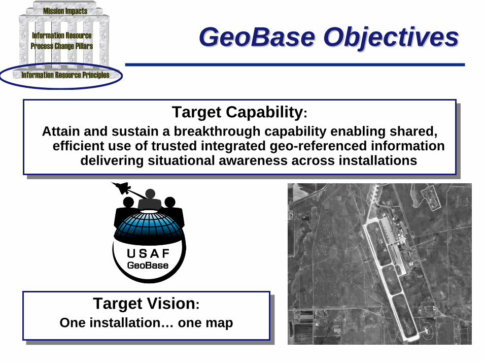
GeoBase ObjectivesGeoBase Objectives
Target Capability:Attain and sustain a breakthrough capability enabling shared,
efficient use of trusted integrated geo-referenced informationdelivering situational awareness across installations
Target Capability:Attain and sustain a breakthrough capability enabling shared,
efficient use of trusted integrated geo-referenced informationdelivering situational awareness across installations
Target Vision:One installation… one map
Target Vision:One installation… one map
Information Resource Principles
Syst
ems
Arch
itect
ure
Syst
ems
Arch
itect
ure
Fina
ncia
l Man
agem
ent
Polic
y, &
Gui
danc
e
Educ
atio
n &
Tra
inin
g
Peop
le &
Wor
kflo
w
Info
rmat
ion
Arc
hite
ctur
eIn
form
atio
n A
rchi
tect
ure
Information ResourceProcess Change Pillars
Mission Impacts

GeoBase ‘Doctrine’GeoBase ‘Doctrine’
USAF GeoBase Foundations
Value GeoBase resources as vital mission assetsRetain skilled, full-time manpower to lead the effort
Focus on culture change, not technologyPlan your GeoBase investment strategy
Evaluate current GeoBase assets before buying ‘new’Adhere to USAF GeoBase architecture standards
Spiral your GeoBase development effortHold GeoBase data stewards accountable
Catalog your GeoBase data investmentProtect your GeoBase resources
Information Resource Principles
Syst
ems
Arch
itect
ure
Syst
ems
Arch
itect
ure
Fina
ncia
l Man
agem
ent
Polic
y, &
Gui
danc
e
Educ
atio
n &
Tra
inin
g
Peop
le &
Wor
kflo
w
Info
rmat
ion
Arc
hite
ctur
eIn
form
atio
n A
rchi
tect
ure
Information ResourceProcess Change Pillars
Mission Impacts

GARRISON BASE MAPPING
EXPEDITIONARYBASE MAPPING
SITE PLANNING DEPLOYED BASE
SIPRNet NIPRNet
STRATEGIC INSTALLATIONVISUALIZATION
GeoBase Across theGeoBase Across theUSAF MissionUSAF Mission
Information Resource Principles
Syst
ems
Arch
itect
ure
Syst
ems
Arch
itect
ure
Fina
ncia
l Man
agem
ent
Polic
y, &
Gui
danc
e
Educ
atio
n &
Tra
inin
g
Peop
le &
Wor
kflo
w
Info
rmat
ion
Arc
hite
ctur
eIn
form
atio
n A
rchi
tect
ure
Information ResourceProcess Change Pillars
Mission Impacts

Sustaining GeoBaseSustaining GeoBaseMission NeedsMission Needs
USAF GeoBase Foundations
Syst
ems
Arch
itec
ture
Syst
ems
Arch
itec
ture
Syst
ems
Arch
itec
ture
Syst
ems
Arch
itec
ture
Info
rmat
ion
Arc
hite
ctur
eIn
form
atio
n A
rchi
tect
ure
Info
rmat
ion
Arc
hite
ctur
eIn
form
atio
n A
rchi
tect
ure
Strategic Base VisualizationGarrison Base Mapping
Expeditionary Site/Base Mapping
Information Resource Principles
Syst
ems
Arch
itect
ure
Syst
ems
Arch
itect
ure
Fina
ncia
l Man
agem
ent
Polic
y, &
Gui
danc
e
Educ
atio
n &
Tra
inin
g
Peop
le &
Wor
kflo
w
Info
rmat
ion
Arc
hite
ctur
eIn
form
atio
n A
rchi
tect
ure
Information ResourceProcess Change Pillars
Mission Impacts

Systems ArchitectureSystems ArchitecturePillarPillar
Sets IT standards for acquiring and deploying GeoBasecapabilities
The architecture will allow other IT systems to tap into GeoBasecapabilities… more than 40 systems have expressed interest!
AF Chief Information Officer (CIO) approved GeoBaseArchitecture in Oct 02 and re-distributed it to all MAJCOM CIOs
Responds to the:Clinger-Cohen Act of 1996, Information TechnologyManagement Reform Act (ITRMA) andGovernment Accounting Office (GAO) Report 02-6 of 2002,Enterprise Architecture Use Across the FederalGovernment can be Improved

Information ArchitectureInformation ArchitecturePillarPillar
Information architecture includes:
ImageryDataMetadataApplications
Imagery architecture published Sep 03Satellite Imagery sources/handlingAirborne Imagery sources/handling

Capacity
Age
Composition
AttributesEntity Sets
Utilities Water System
Natural Gas
Wastewater
Entity Classes
Drain Sump
Grease Trap
Septic Tank
Entity Types
Concrete
Fiberglass
Steel
Domains18126 1,006 25,844 21,542
SDSFIE Example: SDSFIE Example: Septic TanksSeptic Tanks
Spatial Data Standard for Facilities,Spatial Data Standard for Facilities,Infrastructure, and EnvironmentInfrastructure, and Environment

Common Installation PictureCommon Installation Picture
GeoBaseReference Framework
Integrated SituationalKnowledge
SCSC
CECE
SFSF
SVSSVS
SGSG
TRANS
SESE
MUNSMUNS
SSUURRRROOUUNNDDIINNGG
RREEGGIIOONN
AARRCCHHIITTEECCTTUURREE
TTOOOOLLSS
SSTTAANNDDAARRDDSS
GeoBaseMission Data
Sets(MDS)
XPXP
IGIG
JAGJAG

IntegratedSituational Awareness
CECIP CIP is shared widely across the
base LAN
CE
SE
SF
SG
EM…
MD
S
MDS are stored, where possible,with the CIP and are shared on aneed-to-know basis asdetermined by functional datasteward
Func
tiona
l dat
a st
ewar
ds
Functional communities generatefused installation pictures with CIPand select MDS in functional ITsolutions
FusedFusedPicturesPictures
Classified orunclassified asdetermined by
functional user

Exploiting OneExploiting One GeoBase ‘Service’ GeoBase ‘Service’
CIP / MDS
GeoBase Service
GeoBase Application(e.g., Base Map Viewer)
GeoBase-EnabledSystem
e.g.ACES
GeoBase-EnabledSystem
e.g.TBMCS-UL
GeoBase-EnabledSystem
e.g.ASHS
Centrally-Managed,Functionally-Specific
Automated Information Systems (AIS)

Sizing the GarrisonSizing the GarrisonCIP FootprintCIP Footprint
• Anti-Terrorism/Force Protection• Critical Infrastructure Protection• Urban Encroachment
•Dependent on Installation Mission Site & Situation
• Accident Potential Zones• Noise Contours• Common Civil-Military Concerns• Installation Commander Approval

Information TechnologyInformation TechnologyCan’t Do It AloneCan’t Do It Alone
USAF GeoBase Foundations
Syst
ems
Arch
itec
ture
Syst
ems
Arch
itec
ture
Syst
ems
Arch
itec
ture
Syst
ems
Arch
itec
ture
Info
rmat
ion
Arc
hite
ctur
eIn
form
atio
n A
rchi
tect
ure
Info
rmat
ion
Arc
hite
ctur
eIn
form
atio
n A
rchi
tect
ure
USAF GeoBase Mission Needs
Information Resource Principles
Syst
ems
Arch
itect
ure
Syst
ems
Arch
itect
ure
Fina
ncia
l Man
agem
ent
Polic
y, &
Gui
danc
e
Educ
atio
n &
Tra
inin
g
Peop
le &
Wor
kflo
w
Info
rmat
ion
Arc
hite
ctur
eIn
form
atio
n A
rchi
tect
ure
Information ResourceProcess Change Pillars
Mission Impacts
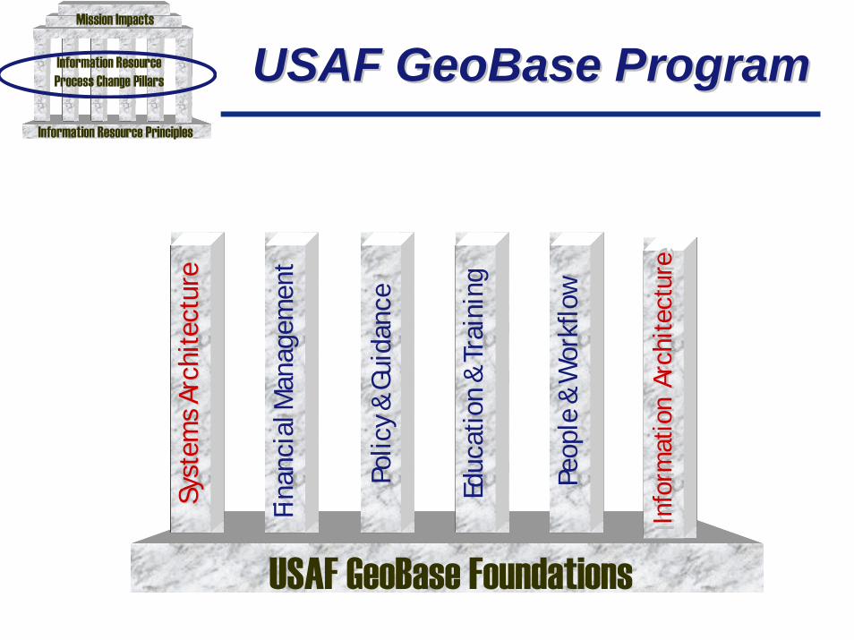
USAF GeoBase ProgramUSAF GeoBase Program
USAF GeoBase Foundations
Syst
ems
Arch
itec
ture
Syst
ems
Arch
itec
ture
Syst
ems
Arch
itec
ture
Syst
ems
Arch
itec
ture
Fina
ncia
l Man
agem
ent
Fina
ncia
l Man
agem
ent
Polic
y, &
Gui
danc
ePo
licy
& G
uida
nce
Educ
atio
n &
Tra
inin
gEd
ucat
ion
& T
rain
ing
Peop
le &
Wor
kflo
wPe
ople
& W
orkf
low
Info
rmat
ion
Arc
hite
ctur
eIn
form
atio
n A
rchi
tect
ure
Info
rmat
ion
Arc
hite
ctur
eIn
form
atio
n A
rchi
tect
ure
Information Resource Principles
Syst
ems
Arch
itect
ure
Syst
ems
Arch
itect
ure
Fina
ncia
l Man
agem
ent
Polic
y, &
Gui
danc
e
Educ
atio
n &
Tra
inin
g
Peop
le &
Wor
kflo
w
Info
rmat
ion
Arc
hite
ctur
eIn
form
atio
n A
rchi
tect
ure
Information ResourceProcess Change Pillars
Mission Impacts

Financial ManagementFinancial ManagementPillarPillar
Evaluate Evaluate
Select Select
Control Control
••Develop Formal ProgrammingDevelop Formal ProgrammingStrategy for GeoBaseStrategy for GeoBase
••Link GeoBase Investments to POMLink GeoBase Investments to POM
••Annual CycleAnnual Cycle
••Investment Discipline EmphasizedInvestment Discipline Emphasized
••Enables Rapid GeoBase AlignmentEnables Rapid GeoBase Alignmentwith Enterprise Architecturewith Enterprise Architecture

Organizing GeoBaseOrganizing GeoBaseInvestments via InventoryInvestments via Inventory

GeoBase Investment GeoBase InvestmentPhasesPhases
Evaluate Evaluate
Select Select
Control Control
GeoBase Management Reviews Held Jan-Mar 03- Compliance with GeoBase CONOPS & Architecture
- Low Risk, High Return with Expeditionary Priority- Conservative, Achievable, Sustainable Strategy
- Challenge New Application Development- Seek Fiscal Economies of Scale
Controlling GeoBase Investments- GeoBase Website Provides Latest Updates
- Monitor GeoBase Inventory Via Website- GeoBase Policies Guide Investments
- Quarterly Investment Reports- Worldwide Monthly Telecons
- Portfolio Management- GIS Software Inventory
- Accountability is the Aim
Evaluating GeoBase Investments- Annual GeoBase Management Review- Assess Expected Versus Real Impacts of Architecture- Identify Necessary Investment Plan Changes- Revise GeoBase Investment Management Process Based on Lessons Learned

Policy and GuidancePolicy and GuidancePillarPillar
GeoBase CONOPSInterim version published Jan 02Version 2.0 published June 03 (GeoBase Website)
GeoBase ArchitectureSets IT standards for acquiring, deploying, and assuring common GeoBasecapabilitiesThe Common Installation Picture (CIP) is the focal componentVersion 1.0 distributed 10 Jan 03 across ALMAJCOM GIO/CIOVersion 1.1 to be distributed Dec 04
GeoBase Policy MemoAF/CV Memo – May 01AF/IL Memo -- Key Responsibilities – Oct 02
Coordinated through AF CIO with AF/IL signaturePolicy memo tasked ALMAJCOM/DRUs to “implement a strategic planningprocess to guide GeoBase investment
AFCS/SECAF Memo: “All AF Installations Mapping to be GeoBase Compliant” -- Dec 03

Education and TrainingEducation and TrainingPillarPillar
Education and Training Venues UnderwayGeoBase Integrated into 3E5X1 Tech Training (Ft Leonardwood)Defense Mapping School incl Expeditionary Site Mapping (Ft Belvoir)Silver Flag, Eagle Flag Ex Sites Expose Prime BEEF to GeoBase ToolsGeoBase Concepts Shared in AFIT Civil Engineer CoursesUS Air Force Academy – In Curriculum and Field ExercisesAF SNCOA/ABC/On-Scene CC Course/SOS (working)ANG Regional Trainers (6 Sites)
Outreach Sessions with Private Sector Companies Ongoing (eg. ESRI)

People and WorkflowPeople and WorkflowPillarPillar
Greatest Challenge Today Given Manpower TurbulenceOutsourcing and PrivatizationDownsizing of Military ForcesCivil Service System Not Responsive to Needs
Intent is to Assimilate GeoBase CapabilitiesNear-term solution requires outsourced contract supportMid-term goals include government assuming more responsibilities
Civil Service Program Becoming EngagedPrecedents for Civil Service GeoBase Managers ExistHAF GIO Seeking to Aggressively Expand OpportunitiesCivilian GS Series Core Docs Completed (GS-14, 13, 12, 11, 9)XP Coordination and approval process for Civilian and FTE positions

USAF GeoBase ProgramUSAF GeoBase Program
USAF GeoBase Foundations
Syst
ems
Arch
itec
ture
Syst
ems
Arch
itec
ture
Syst
ems
Arch
itec
ture
Syst
ems
Arch
itec
ture
Fina
ncia
l Man
agem
ent
Fina
ncia
l Man
agem
ent
Polic
y, &
Gui
danc
ePo
licy
& G
uida
nce
Educ
atio
n &
Tra
inin
gEd
ucat
ion
& T
rain
ing
Peop
le &
Wor
kflo
wPe
ople
& W
orkf
low
Info
rmat
ion
Arc
hite
ctur
eIn
form
atio
n A
rchi
tect
ure
Info
rmat
ion
Arc
hite
ctur
eIn
form
atio
n A
rchi
tect
ure
Strategic Base VisualizationGarrison Base Mapping
Expeditionary Site/Base Mapping
Strategic GeoBaseGarrison GeoBase
Expeditionary GeoBase

Expeditionary GeoBaseExpeditionary GeoBase
USAF GeoBase FoundationsUSAF GeoBase Foundations
Strategic GeoBaseGarrison GeoBase
Syst
ems
Arch
itect
ure
Syst
ems
Arch
itect
ure
Syst
ems
Arch
itect
ure
Syst
ems
Arch
itect
ure
Fina
ncia
l Man
agem
ent
Fina
ncia
l Man
agem
ent
Polic
y, &
Gui
danc
ePo
licy,
& G
uida
nce
Educ
atio
n &
Trai
ning
Educ
atio
n &
Trai
ning
Peop
le &
Wor
kflo
wPe
ople
& W
orkf
low
Info
rmat
ion
Arc
hite
ctur
eIn
form
atio
n A
rchi
tect
ure
Info
rmat
ion
Arc
hite
ctur
eIn
form
atio
n A
rchi
tect
ure
Expeditionary GeoBase
Expeditionary GeoBase providesforward operating locations withvital situational awarenessIntelligence, logistics and civilengineer sectors teaming to betterplan forward base layouts
More than 200 forward siteshave been mapped byGeoReach teams in theCombat Air ForcesExpeditionary Site Mapping(ESM) Conops Approved byGen Jumper, Apr 04

Garrison GeoBaseGarrison GeoBase
USAF GeoBase FoundationsUSAF GeoBase Foundations
Strategic GeoBaseGarrison GeoBase
Syst
ems
Arch
itect
ure
Syst
ems
Arch
itect
ure
Syst
ems
Arch
itect
ure
Syst
ems
Arch
itect
ure
Fina
ncia
l Man
agem
ent
Fina
ncia
l Man
agem
ent
Polic
y, &
Gui
danc
ePo
licy,
& G
uida
nce
Educ
atio
n &
Trai
ning
Educ
atio
n &
Trai
ning
Peop
le &
Wor
kflo
wPe
ople
& W
orkf
low
Info
rmat
ion
Arc
hite
ctur
eIn
form
atio
n A
rchi
tect
ure
Info
rmat
ion
Arc
hite
ctur
eIn
form
atio
n A
rchi
tect
ure
Expeditionary GeoBase
Traditional employment of geospatialtechnologies for mapping
AF major installations
Unprecedented service-wide programacknowledging the unique value of
geospatial information resources
Critical training groundfor expeditionary basing
“One installation… one map… forward & rear!!”

The Jan 02 Origins
Driven by AF Secretariat (I&E)
BRAC 2005 Requirements
Originally Included 91 Major Bases
Lower 48 States Hawaii and Alaska
Guam
Expanded to Worldwide Scope in Feb 03
Unprecedented Geospatial Technology Initiative
Strategic GeoBaseStrategic GeoBaseBackgroundBackground
USAF GeoBase FoundationsUSAF GeoBase Foundations
Strategic GeoBaseGarrison GeoBase
Syst
ems
Arch
itect
ure
Syst
ems
Arch
itect
ure
Syst
ems
Arch
itect
ure
Syst
ems
Arch
itect
ure
Fina
ncia
l Man
agem
ent
Fina
ncia
l Man
agem
ent
Polic
y, &
Gui
danc
ePo
licy,
& G
uida
nce
Educ
atio
n &
Trai
ning
Educ
atio
n &
Trai
ning
Peop
le &
Wor
kflo
wPe
ople
& W
orkf
low
Info
rmat
ion
Arc
hite
ctur
eIn
form
atio
n A
rchi
tect
ure
Info
rmat
ion
Arc
hite
ctur
eIn
form
atio
n A
rchi
tect
ure
Expeditionary GeoBase
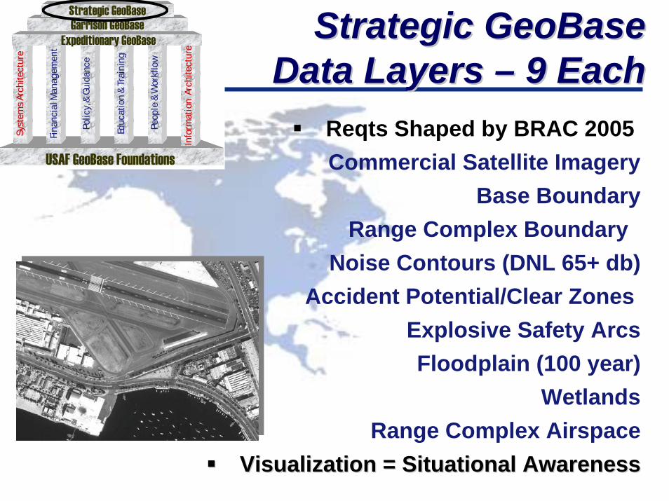
Strategic GeoBaseStrategic GeoBaseData Layers – 9 EachData Layers – 9 Each
Reqts Shaped by BRAC 2005 Commercial Satellite Imagery
Base BoundaryRange Complex Boundary
Noise Contours (DNL 65+ db)Accident Potential/Clear Zones
Explosive Safety ArcsFloodplain (100 year)
WetlandsRange Complex Airspace
Visualization = Situational AwarenessVisualization = Situational Awareness
USAF GeoBase FoundationsUSAF GeoBase Foundations
Strategic GeoBaseGarrison GeoBase
Syst
ems
Arch
itect
ure
Syst
ems
Arch
itect
ure
Syst
ems
Arch
itect
ure
Syst
ems
Arch
itect
ure
Fina
ncia
l Man
agem
ent
Fina
ncia
l Man
agem
ent
Polic
y, &
Gui
danc
ePo
licy,
& G
uida
nce
Educ
atio
n &
Trai
ning
Educ
atio
n &
Trai
ning
Peop
le &
Wor
kflo
wPe
ople
& W
orkf
low
Info
rmat
ion
Arc
hite
ctur
eIn
form
atio
n A
rchi
tect
ure
Info
rmat
ion
Arc
hite
ctur
eIn
form
atio
n A
rchi
tect
ure
Expeditionary GeoBase


GeoBase IntegrationGeoBase IntegrationStrategyStrategy
HQ PACAF GIO
HQ ACC GIO
HQ AMC GIO
HQ AFMC GIO
HQ USAFE GIO
HQ AFRC GIO
HQ AFSPC GIO
HQ AETC GIO
HQ ANG GIO
HQ AFSOC GIO
HQ USAFA GIO
11th WG GIO
MAJCOM MAJCOM GIOsGIOs Guide GuideAcquisition and Acquisition and SustainmentSustainment of ofCommon Installation Pictures Common Installation Pictures
Per GeoBase Architecture Per GeoBase Architecture For All USAF/DOD MissionsFor All USAF/DOD Missions

GeoBase IntegrationGeoBase IntegrationStrategyStrategy
HQ PACAF GIO
HQ ACC GIO
HQ AMC GIO
HQ AFMC GIO
HQ USAFE GIO
HQ AFRC GIO
HQ AFSPC GIO
HQ AETC GIO
HQ ANG GIO
HQ AFSOC GIO
HQ USAFA GIO
11th WG GIO
C2AFC2ISRC GIO
ENV MGTAFCEE GIO
SAFETYAFSC GIO
COMM38EIG GIO
CIVIL ENGRAFCESA GIO
AF/XI AF/ILEAF/SEAF/XOF AF/XIC AF/ILE
FOA GeoBase Contractor Teams withFOA GeoBase Contractor Teams withFunctional IT Implementation Staff toFunctional IT Implementation Staff toInterface with GeoBase ArchitectureInterface with GeoBase Architecture
TBM
CS
– U
L…
FPC
2/IB
DSS
…
ASH
S…
CIT
S/G
CSS
…
AC
ES…
IRPI
MS…
AT/FPAT/FPAFSFC GIO AFSFC GIO

GeoBase IntegrationGeoBase Integration Strategy Strategy
C2AFC2ISRC GIO
ENV MGTAFCEE GIO
SAFETYAFSC GIO
COMM38 EIG GIO
CIVIL ENGRAFCESA GIO
AF/XI AF/ILEAF/SEAF/XOF AF/XIC AF/ILE
SECURITYAFSFC GIO
HQ PACAF GIO
HQ ACC GIO
HQ AMC GIO
HQ AFMC GIO
HQ USAFE GIO
HQ AFRC GIO
HQ AFSPC GIO
HQ AETC GIO
HQ ANG GIO
HQ AFSOC GIO
HQ USAFA GIO
11th WG GIO
MAJCOM and FOAMAJCOM and FOA GIOs GIOsTeam to Implement an EnterpriseTeam to Implement an Enterprise
GeoBase Capability IAWGeoBase Capability IAWArchitectureArchitecture
FPC
2/IB
DSS
…
ASH
S…
CIT
S/C
IPS…
AC
ES…
IRPI
MS…
TBM
CS
– U
L…

Geo Integration OfficeGeo Integration OfficeOrganizational ChartOrganizational Chart
ACC GIOInstallation GIOs
USAFE GIOInstallation GIOs
AMC GIOInstallation GIOs
AFMC GIOInstallation GIOs
AETC GIOInstallation GIOs
11 WG GIOBolling AFB
CENTAF GIOShaw AFB
PACAF GIOInstallation GIOs
ANG GIOInstallation GIOs
AFSPC GIOInstallation GIOs
AFSOC GIOHurlburt Field
AFRC GIOInstallation GIOs
USAFA GIOUSAFA, IITA
7 AF GIOOsan AB
AFCEE GIO AFCESAGIO
AFC2ISRCGIO 38 EIG GIO
AFSFC GIO AFSC GIO
HAF GIO
Civil Engineering(AF/ILE)
Communications(HQ AFMC)
Safety(AF/SEW)
Environmental(AF/ILE)
Command andControl (AF/XI)
Force Protection(AF/XOF)
(AF/ILE) HQ USAF GIO (HAF GIO)Policy and guidanceGeoBase Enterprise ArchitectureProgram oversight and requirementsProgram investment strategy
MAJCOM/DRU GIOsGuide acquisition and sustainment ofGeoBase capabilities across respectiveinstallationsProgram for GeoBase resourcesInstallation/DRU GIOsMaintain the CIP and GeoBase serviceCoordinate MDS maintenance withfunctional communities
FOA GIOsDiscover functional requirements forexploitation of GeoBase capabilitiesAssist functional communities tointerface mission processes and ITsolutions with GeoBase capabilities
AFRPA GIO AFRPA

GeoBase Web SiteGeoBase Web Sitewww.www.geobasegeobase..hqhq..afaf.mil.mil

Air Force PortalAir Force PortalGeoBase Community of InterestGeoBase Community of Interest

GeoBase NewsletterGeoBase Newsletter

• GeoBase Orientation -101• GeoBase Workshops/Seminars
• GeoBase and DISDI Plenary Sessions• MAJCOM Sessions
• Vendor Workshops/Exhibits
USAF GeoBaseUSAF GeoBaseCommunityCommunity
Compass Conference FlowCompass Conference Flow
DoDDoDGeoBaseGeoBase
CommunityCommunity
DoDDoDGeoBaseGeoBase
CommunityCommunity
DoDDoDGeoBaseGeoBase
CommunityCommunity
MAJCOMMAJCOMGeoBaseGeoBase
CommunitiesCommunities
MAJCOMMAJCOMGeoBaseGeoBase
CommunitiesCommunities

As of: 45
Lt Col Tom LaffeyHAF Geo Integration Office
(AF/ILEI)
GeoBase 101
Introduction to GeoBase Concepts