Presenting OpenStreetMap in Ghana during Project Flood Risk Accra Workshop

Master’s Thesis 2019 30 ECTS
Faculty of Landscape and Society
The Urban Political Ecology of
Flood Occurrences in Accra, Ghana
Nelson O. Amesimeku
International Environmental Studies (Msc.)


iii
ABSTRACT
This study explores how human-nature interactions, socio-political relations and ecological
conditions create and shape natural disasters in Accra, Ghana. It aids the understanding of the
impacts of floods and governmental responses to floods in the urban space of Accra. The study
area consisted of few suburbs of Accra namely, Odawna, Dome, Kissieman, Kwabenya, Madina,
and communities in Tema, all located in the Greater Accra region of Ghana. Employing the urban
political ecology theory, this study argues that the factors causing urban floods are compound, not
just climate change and nature. Thus, it looks at the power play between both government and non-
government actors that create and shape floods, the consequences of floods on the poor and the
types of government responses needed to reduce future vulnerabilities to disasters. The outcomes
of the study revealed that after a heavy downpour which may be caused by climate change or
variability, a number of factors interact with this heavy downpour to cause floods in the city. As
found, the uncoordinated physical planning of the city, improper waste disposal and management,
uncontrolled human settlements on flood prone zones, limited capacity of state institutions
governing land use and water management, and overreliance on antiquated and poorly maintained
infrastructure were among the factors creating and shaping floods. The impacts of floods in Accra,
just as it is in any other places have always been loss of properties, lives and livelihoods. Flooding
has resulted in the destruction of buildings and vehicles, rendering a lot of people homeless. In all
these, the poorest have suffered the most due to their living in slums, low-lying and flood prone
zones where government services do not reach.
In order to reduce the vulnerability to future flooding, government officials have planned to desilt
water channels as well as improve on their qualities. In addition, some experts suggest that the
metropolitan authorities must begin to plan and coordinate the physical expansion of the cities so
that people would no longer build on flood prone zones. Apart from these, the government have
established that safety tips, early warning signs and safety shelters be provided in order to help
reduce the impacts of floods in the future.
Overall, the vulnerability of the urban poor was compounded by virtue of their living in slums
located in flood-prone zones with uncoordinated physical planning, lack drainage systems and
unbridled littering everywhere.

iv

v
DEDICATION
To
Madam Esther Ablah Domeh;
My mother, a petty trader who did not go far in education but always wanted her children and
everyone else to climb high on the educational ladder; is this work dedicated.
Mama, mo tsumi! Mo nԑ O baa nↄyi!

vi

vii
ACKNOWLEDGEMENTS
I thank God Almighty who freely gave me life, wisdom and the knowledge to accomplish this
work successfully.
My sincere gratitude goes to Jill Tove Buseth whose encouragement and assistance had produced
this work. Indeed, she had been untiring and unflagging supervisor whose wise guidance and
constructive criticisms have made this work a complete success.
My sincere thanks also go to Esther Domeh (my mother) and Jemimah Dede Agbenyoh (my sister),
who through their constant checks on me though from afar, conferred on me a feeling of obligation
and an inspiration to go through the most challenging times.
Last but certainly not the least I thank every friend, God had brought my way through my
educational journey in the Norwegian University of Life Sciences (NMBU). A special thanks goes
to those friends who in one way or the other had contributed to the success of this work.
To you all I sincerely say;
Akpe na mi katã! Nyԑ tsumi! Tusen Takk! Thank you

viii

ix
LIBRARY SIDE
The Department of International Environment and Development Studies, Noragric, is the
international gateway for the Norwegian University of Life Sciences (NMBU). Established in
1986, Noragric’s contribution to international development lies in the interface between research,
education (Bachelor, Master and PhD programmes) and assignments.
The Noragric Master theses are the final theses submitted by students in order to fulfil the
requirements under the Noragric Master programme “International Environmental Studies”,
“International Development Studies” and “International Relations”. The findings in this thesis do
not necessarily reflect the views of Noragric. Extracts from this publication may only be
reproduced after prior consultation with the author and on condition that the source is indicated.
For rights of reproduction or translation contact Noragric.
DECLARATION
I, Nelson Amesimeku, declare that this thesis is a result of my research investigations and findings.
Sources of information other than my own have been acknowledged and a reference list has been
appended. This work has not been previously submitted to any other university for award of any
type of academic degree.

x

xi
TABLE OF CONTENTS
ABSTRACT ............................................................................................................................. iii
DEDICATION ............................................................................................................................ v
ACKNOWLEDGEMENTS.......................................................................................................vii
LIBRARY SIDE ........................................................................................................................ ix
DECLARATION ....................................................................................................................... ix
TABLE OF CONTENTS ........................................................................................................... xi
LIST OF FIGURES ................................................................................................................ xiii
LIST OF ABBREVIATIONS AND ACRONYMS .................................................................. xiv
CHAPTER 1: INTRODUCTION ................................................................................................ 1
1.4 Objectives, research questions ........................................................................................... 2
1.2 Problem Statement and Justification of the Study ............................................................... 3
1.3 Scope and Limitation of the Study ..................................................................................... 3
1.5 Organization of Study ........................................................................................................ 4
CHAPTER 2: BACKGROUND OF THE STUDY ...................................................................... 6
2.1 Urbanization in Ghana ....................................................................................................... 6
2.1.1 Causes ......................................................................................................................... 6
2.1.2 Growth and Physical Expansion of Cities .................................................................... 6
2.2 Historical Roots of Accra ................................................................................................... 8
2.2.1 Accra’s Expansion ....................................................................................................... 9
2.2.2 Physical Planning of Accra ........................................................................................ 10
2.2.3 Impetus to Accra’s Growth ........................................................................................ 10
2.3 The Physical Environment and Infrastructure of Accra .................................................... 11
2.3.1 The Physical Environment ......................................................................................... 11
2.3.2 Housing and Infrastructure ........................................................................................ 13
2.4 Population Growth of Accra ............................................................................................ 14
2.4.1 Population Growth Factors ........................................................................................ 15
2.5 Administration and Governance System in Ghana ............................................................ 16
2.6 Historical Overview of Natural Disasters and Hazards in Ghana ...................................... 17
2.7 Causes of Floods and Floods-Prone Areas in Ghana ......................................................... 18
CHAPTER 3: CONCEPTUAL AND THEORETICAL CHAPTER .......................................... 20

xii
3.1 Political Ecology.............................................................................................................. 20
3.2 Urban Political Ecology (UPE) ........................................................................................ 21
3.3 Power .............................................................................................................................. 23
3.3.1 Actor-oriented Power Perspectives ............................................................................ 23
3.3.2 Neo-Marxist Power Perspectives ............................................................................... 23
3.3.3 Poststructuralist Power Perspectives .......................................................................... 24
3.4 Environmental Governance .............................................................................................. 26
3.4.1 Governance Structures ............................................................................................... 27
3.5 Political Ecology, Urban Political Ecology, Power, Environmental Governance and Their
Relationships with Floods ...................................................................................................... 28
CHAPTER 4: METHODOLOGY ............................................................................................. 31
4.1 Research Design .............................................................................................................. 31
4.2 Sampling Technique, Procedures and Criteria .................................................................. 31
4.3 Research Sample and Size ............................................................................................ 33
4.4 Data collection ................................................................................................................. 34
4.4.1 Summary of Pre-data collection Activities ................................................................. 34
4.4.2 Qualitative interviews ................................................................................................ 35
4.4.3 Non-participant Observation ...................................................................................... 36
4.5 Data Analysis .................................................................................................................. 38
4.6 Ethics, Knowledge and Power Relations .......................................................................... 39
4.7 Researcher’s Reflexivity and Positionality ....................................................................... 40
4.8 Reliability, Validity and Generalization ........................................................................... 41
4.9 Challenges of the Study ................................................................................................... 42
CHAPTER 5: FINDINGS AND DISCUSSIONS ...................................................................... 43
5.1 Impacts of Accra floods ................................................................................................... 43
5.1.1 Why it hits hard ......................................................................................................... 45
5.2 Creation of Floods in Accra ............................................................................................. 46
5.2.1 Poor management of surface waters, urban land, and land-use planning..................... 46
5.2.2 Illegal and irresponsible behaviors of residents .......................................................... 50
5.2.3 Focusing on the rich rather than the poor .............................................................. 55
5.3 Reducing future vulnerabilities ........................................................................................ 58
5.4 Depoliticizing natural disasters through discursive power ................................................ 62
CHAPTER 6: SUMMARIES, CONCLUSIONS AND CONSIDERATIONS ............................ 64

xiii
6.1 Considerations and Recommendations ............................................................................. 65
REFERENCES ......................................................................................................................... 66
APPENDIX A: Interview Guides .............................................................................................. 75
A. Flood-Affected Households .............................................................................................. 75
B. Government Officials and Experts..................................................................................... 78
APPENDIX B: Field Photos...................................................................................................... 80
LIST OF FIGURES
Figure 1 Regional Map of Ghana Showing Greater Accra Metropolitan Assembly ...................... 9
Figure 2 Map of Accra, Ghana's Capital .................................................................................... 12
Figure 3 Basins in Accra, Ghana's Capital ................................................................................. 13
Figure 4 Flow map of Ghana showing North-South migration ................................................... 16
Figure 5 A Framework for Analyzing Floods in Urban Centers ................................................. 30
LIST OF TABLES
Table 1 Population Growth Trends in Greater Accra Metropolitan Assembly ............................ 14
Table 2 Natural Disasters in Ghana from 1900 to 2014 .............................................................. 18
xiv
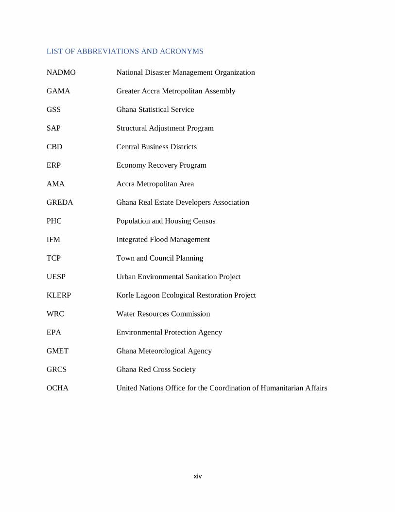
LIST OF ABBREVIATIONS AND ACRONYMS
NADMO National Disaster Management Organization
GAMA Greater Accra Metropolitan Assembly
GSS Ghana Statistical Service
SAP Structural Adjustment Program
CBD Central Business Districts
ERP Economy Recovery Program
AMA Accra Metropolitan Area
GREDA Ghana Real Estate Developers Association
PHC Population and Housing Census
IFM Integrated Flood Management
TCP Town and Council Planning
UESP Urban Environmental Sanitation Project
KLERP Korle Lagoon Ecological Restoration Project
WRC Water Resources Commission
EPA Environmental Protection Agency
GMET Ghana Meteorological Agency
GRCS Ghana Red Cross Society
OCHA United Nations Office for the Coordination of Humanitarian Affairs

1
CHAPTER 1: INTRODUCTION
In the past eight years or more, Ghana has suffered a lot of natural disasters in different forms ranging
from droughts in 2006 to floods in 2007, 2010, 2012, 2015 and 2018. The ‘goil’ station explosion in
2015 was both a flood and fire disaster which took many lives, properties and livelihoods. Whenever
floods occur, people are quick to attribute the cause to the effects of climate change and variability.
According to Okyere et al. (2013), the increasing intensity and erratic nature of rainfall caused by climate
change could make it is easier to forecast natural disasters and hazards that would happen in the near
future. However, climate change and variability are not enough explanations for the occurrences of
floods in most urban spaces. Marks (2015) argued that the causes of floods in urban spaces are
compound be limited to climate change and nature. He holds that they are as a result of human-nature
interactions. So, while a city may receive a heavy downpour, a lot of human activities interact with the
heavy downpour to create the floods.
For the past five decades, the Ghanaian population has become increasingly urban. The percentage of
urban population increased from 23.1 percent in 1960 to about 43.8 percent in 2000 (GSS 2002). This
figure further increased to about 51 percent in 2010 (GSS 2012). Accra is one of the fastest growing
cities in West Africa (Yankson and Bertrand, 2012) and this presents some challenges. First, it is liable
to frequent floods and second, there is difficulty in the provision of basic infrastructure causing
overreliance on already existing ones. Therefore, urbanization has an effect on the national development
agenda in terms of disaster management and the provision of basic infrastructure to contain the impacts
of floods (Okyere et al. 2013).
Urbanization and its activities do not only change the physical environment of cities but also increase
the vulnerability of the urban residents (Murray 2009; Marks 2015). Decades ago there was no extensive
development in Accra, so when it rained, the water could flow freely through the natural water systems:
streams and wetlands without any impediments (Darteh and Adank 2011). Also, water could permeate
into the groundwater system through the soil. However, as the city is developing and expanding the
permeability of water into the groundwater system is lost. This resulted in the increase in stormwater
flows, capable of increasing the rate of flooding and the subsequent damage to infrastructure, the
economy and human lives. In other instances, construction of roads has not only increased runoff but
also prevented water from being carried over from one point to the other.
2
Unfortunately, there fear of losing natural drainage systems especially in areas where wetlands are
being changed residential houses (Darteh and Adank 2011). Power, which is perceived to be the
driving force behind the urbanization of towns and cities has resulted in these massive land use
changes and concretization thereby causing run-offs, over-pumping of groundwater and the filling
of canals (Marks 2015).
Apart from the problems urbanization has caused, the low institutional capacity of the National
Disaster Management Organization (NADMO) most often leads to poor, ineffective and at times
delayed responses to flooding victims during the floods and the aftermath of it. Between 2006 and
2018 the responses by NADMO was reported by the media to be inadequate and also ineffective
(Okyere et al. 2013).
Floods have both negative and positive impacts. Positive impacts of floods, in general, include
sedimentation, increased amount of water of dams for irrigation and drinking purposes (Okyere et
al. 2013). On the other hand, the negative impacts are mostly in the loss of lives, livelihoods,
infrastructure, and properties. Thus, in light of the problems mentioned above, analyses of disasters
in urban areas need to consider how discourses, socio-political relations, and ecological conditions
shape the governance practices of disasters. This study will focus on the human-nature interactions,
socio-political relations and ecological conditions that create and shape natural disasters in Accra,
Ghana.
1.4 Objectives, research questions
This study broadly aims at the human-nature interactions, socio-political relations and ecological
conditions that create and shape natural disasters in Accra, Ghana. It will, therefore, aid the
understanding of impacts of floods and governmental responses to floods in the urban space of
Accra.
Specific objectives:
➢ To describe how power play between government and non-government actors create and
shape floods in Accra
➢ To highlight the consequences of floods for the poor and their severity
➢ To identify which types of responses are needed to reduce future vulnerabilities to disasters

3
Thus, three research questions guided the study:
➢ How does power play between government and non-government actors create and shape
floods in Accra?
➢ What are the consequences for the poor?
➢ Which types of governmental responses are needed to reduce future vulnerabilities to
disasters?
1.2 Problem Statement and Justification of the Study
The practice of governance may form an essential component of compound disasters, not just
natural forces, and technical failures. Based on the World Bank’s definition of governance, good
disaster governance would be exercising power to successfully and fairly reduce vulnerabilities
and exposures to disasters (Marks 2015). However, poor disaster governance by African states,
often characterized by a low institutional capacity can cause disasters to be more damaging with
unequal effects. The effect for the poor may be more severe than for the rich.
Further, certain discourses used by government actors turn to depoliticize natural disasters by
placing emphasis on natural causes and technical failures. By stating that Accra, by its
geographical location these things are bound to happen, is a way the government uses to shirk its
responsibilities thereby hiding the socio-economic processes that place vulnerable populations at
risk. Consequently, such processes are hardly regarded as policy issues because ‘natural’ hazards
become the policy problem to solve (Aragón-Durand 2009). This misplaced analysis of floods in
Ghana is what this study seeks to deal with. By including power relations between government
and individual actors, we should be able to ascertain practices of both government and non-
government actors that put people at risk.
1.3 Scope and Limitation of the Study
There are different dimensions of undertaking disaster studies but the focus of this study is on the
creation and shaping of floods by government and non-government actors. It uses political
ecology, urban political ecology, environmental governance and the concept of power to analyze
the frequent occurrence of floods in the urban space. Though the study employs environmental
governance as a conceptual tool, interest is not so much in the actual performance of environmental
governance in the urban space. Instead, the focus is on the practices that connect institutions to the

4
actors and the physical environment of the urban space which help to understand the occurrence
of floods.
The study will lead to a better understanding of the consequences for the urban poor, the severity
of the impacts and the identification of the types of governmental responses needed to reduce
vulnerabilities to disaster in the future. The study will provide further suggestive information on
steps to take and the pitfalls to avoid in managing natural disasters. The aftermath will inform
policy decisions that will go a long way in changing political discourses used to govern disasters
in Ghana.
1.5 Organization of Study
The organizational structure of the thesis is such that chapter 1 introduces the problem, and gives
an overview of major floods that have occurred in Ghana. It also describes the need to focus on
socio-political relations to better understand the creation and shape of floods in urban spaces. This
chapter also introduces the objectives, the scope, and limitation of the study.
Chapter 2 covers the background of the study by reviewing extensively the relevant literature and
sets the context for the whole study. Within the same chapter, the historical overview of Ghana’s
urbanization with respect to causes have been described. Attention was given to the historical roots
of Accra, its social and demographic features. Ghana’s natural disaster history is reviewed with
emphasis on the causes and effects.
Chapter 3 describes the theoretical foundation of the study. It describes extensively the urban
political ecology theory and its relationship with floods. It goes on to offer a critique of the theory
emphasizing the methodological questions, challenges, and significance.
Chapter 4 outlines the methodological framing for this study. A review of the appropriate methods
adopted for data collection and analysis was made, followed by a step-by-step account of the
sampling procedure as it happened on the field. The chapter also describes issues related to ethics,
power, knowledge, reflexivity, positionality, reliability, validity and reliability. The chapter then
closes by pointing out the challenges faced in the study.
Chapter 5 presents and discusses the findings of the study. The findings and discussions were made
in accordance with the objectives of the study.

5
Finally, Chapter 6 concludes the whole study by looking at the possible implications of the findings
to the theoretical foundation and later recommendations for future research are made.

6
CHAPTER 2: BACKGROUND OF THE STUDY
2.1 Urbanization in Ghana
Ghana is a nation on the West African Gulf of Guinea with a population of about twenty-nine
million people (World Bank, 2018). Since the middle of the twentieth century, the country has
experienced a very rapid population growth rate. Over the years, the population growth rate has
increased from 9 percent in 1931 to 31.3 percent in 1984 and 43.8 percent in 2000 (Yankson and
Bertrand 2012). Ghana’s urbanization is focused mainly on Accra due to its population size, its
political, economic and cultural characteristics. However, the concentration of urban population
in other urban centers in the country are on the increase. Interestingly, places in the metropolis of
Tema, Accra, and Kumasi are fast-growing into peripheral towns.
2.1.1 Causes
Rapid urbanization in Ghana is caused by both natural increase of the national populations and
internal migration to the urban areas. Natural increase and internal migration reinforce each other,
although their relative importance has varied over the years. A high level of internal migration, i.e.
migration from rural to urban areas, particularly to the cities but lately from small towns to the
cities, was the dominant factor in the early phase of urbanization. This is caused by differences in
the development gap between rural and urban areas.
Since 1970, however, a high rate of natural increase in the cities of Ghana has assumed a more
important role than migration in accounting for rapid population increases (Yankson and Bertrand
2012). Though fertility levels are higher by about 15 percent in rural areas (GSS 1988), mortality
and morbidity rates are much lower in the urban than the rural areas, in spite of presence of modern
health facilities in the cities, particularly in the Greater Accra Metropolitan Area (GAMA).
2.1.2 Growth and Physical Expansion of Cities
Ghana has experienced the physical expansion of cities, particularly the metropolitan areas of the
country, beyond their official boundaries (Yankson and Bertrand 2012). In the past, there was the
need to adjust the legal boundaries of the major cities to allow for the extension of infrastructure
and services to the newly urbanized cities.
One important process occurring in Ghana is sub-urbanization. It is a major feature of modern
urbanization in advanced as well as the less advanced countries. Sub-urbanization is a process

7
which involves a population shift from central urban areas to suburbs. It is the reverse of
urbanization which involves a population shift from rural to urban areas. Two major factors explain
the process of sub-urbanization: The first factor is described as demand-pull caused by rapid urban
population growth and increasing disposable income (Knox 1994). The second is central urban-
suburb migration driven by fiscal and social problems imminent in the central urban areas such as
high taxes, low-quality public schools, and other poor government services, racial tensions, crime,
overcrowding and low environmental quality Mieszowski and Mills (1993). According to
McGrath (1992), such factors operate differently between and within cities in both the industrially
advanced and the less industrially advanced countries.
The physical expansion of Accra could be explained by the government’s adoption of the
economic liberalization program in the 1980s (Grant and Yankson 2003). The economic
liberalization program was dubbed the Structural Adjustment Program (SAP). The program has
caused two prominent effects on the urban housing market. First, the number of expatriates and
their communities in Accra had increased. Together with increasing middle-class, pressure on
housing units increased. Second, the liberalization of the financial sector has opened up the
economy for investments in real estates. Remittances made these investments possible. Briggs
and Yeboah (2001) found that in 1996, the amount of remittances sent by Ghanaians living abroad
amounted to USD 276 million (p.23).
Another factor that explains the expansion of Accra is house building. Individuals usually build in
areas where services are yet to be provided because perhaps, they expect that services will be
extended in the near future, or the land currently costs less (Briggs and Yeboah 2001). This has
resulted in the erection of buildings without permits (Yeboah 2000). In addition, the residential
developments occurring in the urban fringes of Accra are not only rapid but are also largely
uncontrolled coupled with serious problems. Scholars such as Yankson and Gough (1999; 2000),
and Kasanga et al. (1996) have found that the livelihoods of indigenous residents are seriously
threatened as agricultural land are continually converted to residential lands.

8
2.2 Historical Roots of Accra
Accra is a coastal settlement to the south-eastern part of Ghana. It was founded by the Gas, as a
small coastal fishing village in the sixteenth century (Yankson and Bertrand 2012). At that period,
mercantilism was occurring in Europe and it was not long before Europeans arrived in Ghana and
set the foundation for urban growth by building trading forts and castles on the coast (Ibid). Three
were built in Accra: Ussher Fort was built by the Dutch in 1650, Christianborg Castle was built by
the Danes in 1651, and James Fort built by the British in 1673. At the same time, the slave trade
was on the increase, where many of the men and women were sold to Europeans. However, when
the slave trade declined the development of Accra faced stagnation. As a result, the focus of export
has shifted to agricultural produce. This strengthened the ports of Ada and Prampram, to the east
of Accra, which had better access to the main source regions for palm oil, rubber, and kola
(Yankson and Bertrand 2012). But Accra was revived after it had been chosen as the seat of Britain
administration on the Gold Coast. Despite the setbacks, activities were still transferred from Cape
Coast to Christianborg, Accra.
Accra has many advantages including its drier climate and nearness to Aburi, which proved more
congenial to Europeans. Accra was malaria-free and its low incidence of sleeping sickness made
it a healthy climate for horses (Amoah 1964; Dickson 1969). This decision consolidated and
secured Accra’s future development. It guaranteed, for example, the choice of Accra as the
seaward terminus of the eastern railway. Later, it became the center for the road system in the east,
thus strengthening its position as a port. It also became the location of the only international port
in Ghana. Accra then became more accessible to both internal and international migrants and
hence, stimulated its growth. Since then, Accra has experienced a rapid rate of growth and it is one
of the fastest-growing cities in West Africa (Yankson and Bertrand 2012).
9
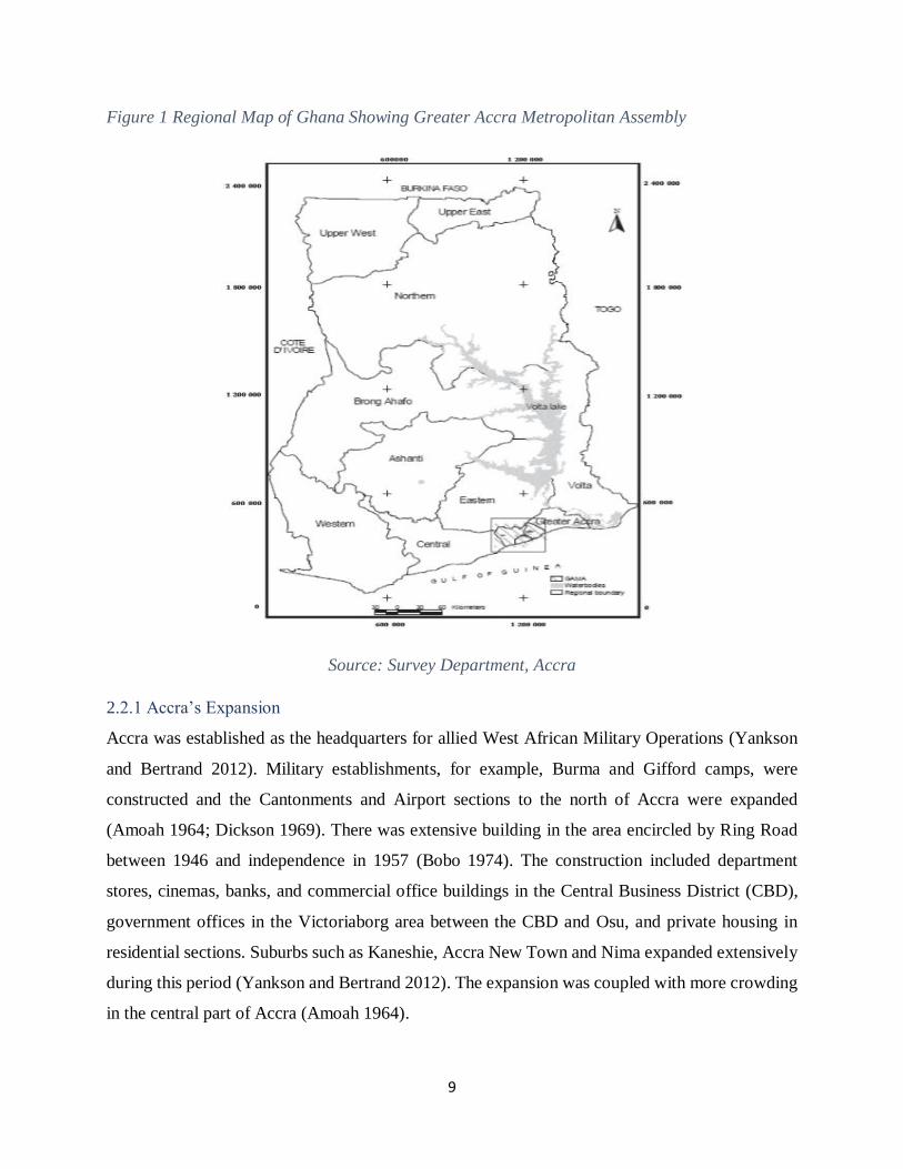
Figure 1 Regional Map of Ghana Showing Greater Accra Metropolitan Assembly
Source: Survey Department, Accra
2.2.1 Accra’s Expansion
Accra was established as the headquarters for allied West African Military Operations (Yankson
and Bertrand 2012). Military establishments, for example, Burma and Gifford camps, were
constructed and the Cantonments and Airport sections to the north of Accra were expanded
(Amoah 1964; Dickson 1969). There was extensive building in the area encircled by Ring Road
between 1946 and independence in 1957 (Bobo 1974). The construction included department
stores, cinemas, banks, and commercial office buildings in the Central Business District (CBD),
government offices in the Victoriaborg area between the CBD and Osu, and private housing in
residential sections. Suburbs such as Kaneshie, Accra New Town and Nima expanded extensively
during this period (Yankson and Bertrand 2012). The expansion was coupled with more crowding
in the central part of Accra (Amoah 1964).

10
The growth of central Accra caused other coastal towns to be absorbed, including Labadi, Teshie,
Nungua, and others (Acquah 1958). By then, the Korle Bu Hospital and Achimota School were
the major establishments. More roads and houses were also constructed, which led to the
establishment of Tudu and Adabraka as commercial and residential districts to the north of the
original settlements of Ussher Town and James Town (Amoah 1964). Mamprobi, Korle Gonno
and Korle Bu were developed to the western part of the two towns in central Accra. The further
expansion of the municipality was as a result of deliberate government housing policy occasioned
by natural disasters, the bubonic plague and the earthquake of 1939 (Aryeetey and Anipa 199).
Industrial and economic activities also contributed to the growth of the metropolitan area,
attracting people to settle and work in Accra.
2.2.2 Physical Planning of Accra
Accra’s growth and expansion occurred without any consistent and coordinated planning resulting
in an unstructured and largely inefficient urban form (Larbi 1996). There are no clear boundaries
between AMA and the surrounding districts of Accra. The Strategic Plan for GAMA, developed
in the early 1990s (Ministry of Local Government 1992) with assistance from the World Bank, has
not been fully implemented. The current administrative division of GAMA into three separate and
independent districts has further impeded spatial planning. Much of the development in peri-urban
Accra was taking place before any planning scheme has been prepared (Yankson and Gough
1999).
The uncoordinated physical planning of Accra has led to the establishment of a series of compact
masses of thatched buildings arranged in a disorganized manner and separated by narrow crooked
lanes. However, the European residential area was well-planned and was surrounded by a cluster
of houses belonging to a few wealthy Accra merchants.
2.2.3 Impetus to Accra’s Growth
The year 1898 saw the formation of the Accra Municipal Council under the Town Council
Ordinance of 1894 (Yankson and Bertrand 2012). Unfortunately, the council was weak in
providing adequate municipal services due to financial limitation resulting from refusals to pay tax
by the people. However, the bubonic plague of 1907 had raised awareness in the inhabitants and
they began to appreciate the need for municipal services by paying taxes. This together with the
country’s independence in 1957 provided the biggest impetus to Accra’s growth and development

11
(Yankson and Bertrand 2012). In the early years of independence, a modernization strategy based
on import-substitution industrialization led to several initiatives, which positively influenced the
development of Accra, which created employment opportunities within Accra-Tema. These
processes within Accra, together with the creation of the satellite industrial township of Tema,
generated a new and intensified cycle of rural-urban and urban-urban migration into Accra-Tema
(Plan Consult 1989). This resulted in the rapid expansion of the population of Accra and Tema, as
shown in table 1.
The country experienced an economic malaise between the early 1970s and the mid-1980s which
affected Accra in many respects but was arrested by the implementation of Economic Recovery
Program (ERP) and Structural Adjustment Program (SAP). Since then, new life was injected into
the economy of Accra in both the formal and informal sectors.
2.3 The Physical Environment and Infrastructure of Accra
2.3.1 The Physical Environment
The Greater Accra region is the smallest region of the ten regions of Ghana with a total land size
of about 3,245 square kilometers. AMA covers an area of about 240 square kilometers. The region
is politically divided into 16 districts.
12
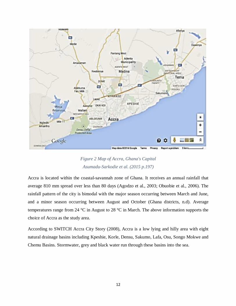
Figure 2 Map of Accra, Ghana's Capital
Asumadu-Sarkodie et al. (2015 p.197)
Accra is located within the coastal-savannah zone of Ghana. It receives an annual rainfall that
average 810 mm spread over less than 80 days (Agodzo et al., 2003; Obuobie et al., 2006). The
rainfall pattern of the city is bimodal with the major season occurring between March and June,
and a minor season occurring between August and October (Ghana districts, n.d). Average
temperatures range from 24 °C in August to 28 °C in March. The above information supports the
choice of Accra as the study area.
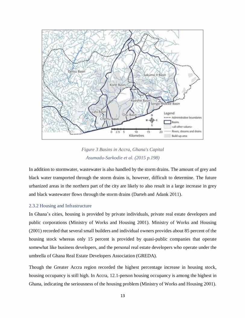
According to SWITCH Accra City Story (2008), Accra is a low lying and hilly area with eight
natural drainage basins including Kpeshie, Korle, Densu, Sakumo, Lafa, Osu, Songo Mokwe and
Chemu Basins. Stormwater, grey and black water run through these basins into the sea.
13
Figure 3 Basins in Accra, Ghana's Capital
Asumadu-Sarkodie et al. (2015 p.198)
In addition to stormwater, wastewater is also handled by the storm drains. The amount of grey and
black water transported through the storm drains is, however, difficult to determine. The future
urbanized areas in the northern part of the city are likely to also result in a large increase in grey
and black wastewater flows through the storm drains (Darteh and Adank 2011).
2.3.2 Housing and Infrastructure
In Ghana’s cities, housing is provided by private individuals, private real estate developers and
public corporations (Ministry of Works and Housing 2001). Ministry of Works and Housing
(2001) recorded that several small builders and individual owners provides about 85 percent of the
housing stock whereas only 15 percent is provided by quasi-public companies that operate
somewhat like business developers, and the personal real estate developers who operate under the
umbrella of Ghana Real Estate Developers Association (GREDA).
Though the Greater Accra region recorded the highest percentage increase in housing stock,
housing occupancy is still high. In Accra, 12.1-person housing occupancy is among the highest in
Ghana, indicating the seriousness of the housing problem (Ministry of Works and Housing 2001).
14
Thus, a significant portion of the urban poor population lives largely in temporary, unauthorized
and unsafe housing units, with the attendant health and other related problems (Ministry of Works
and Housing 2001). Examples include tents, kiosks, containers, and attachment to shops or offices.
The greater Accra region has about 6.2 percent of these temporary housing units (GSS, 2012).
2.4 Population Growth of Accra
Accra has a population of about two million and it is the largest and fastest growing metropolis in
Ghana with an annual population growth rate of 4.3% (National Population Census, 2000).
Between 1984 and 2000, the population grew at 4 percent per annum as against national population
growth of about 2.6 per cent per annum (GSS 2002). Before the country’s independence in 1957,
the population of Accra was only about 190,000 (Yankson and Bertrand 2012). It has increased to
1,658,937 in 2000 from just under a million (969,195) in 1984. Accra Metropolitan Area together
with the adjoining Ashaley Botwe New Town and the Ga District, which constitute the Greater
Accra Metropolitan Area, had a population of almost 2.8 million people in 2000 (Yankson and
Bertrand 2012; GSS 2002).
Table 1 Population Growth Trends in Greater Accra Metropolitan Assembly
Districts 1960 1970 1984 2000
Accra 388,396 636,667 969,195 1,658,937
Tema 27,127 102,431 190,917 506,400
Ga 33,907 66,336 132,786 550,468
Total GAMA 449,430 805,434 1,922,898 2,715,805
Source: Ghana Statistical Services, Census Reports: 1960, 1970, 1984, and 2000
The sub towns of Accra also grew in population. Ashaiman, a suburb of Tema, now has more
inhabitants than Tema (141,479). Madina, another dormitory town of Accra city and lying to the
north, is now the tenth largest settlement in the country. Between the period 1970 and 2000,
Madina has experienced rapid growth in population from 7,480 to 76,697. There are emerging two
very fast-growing townships: Kasoa, which in 1970 had only 863 people, had a population of
34,719 in 2000, while Buduburam, a well-known refugee camp, had as few as 40 persons in 1984
but as many as 18,713 in 2000 (Yankson and Bertrand 2012). The 2010 Population and Housing
Census (PHC) indicated that only the Greater Accra region has a population of 4,010,054;
representing about 16.3 percent of the national population (GSS, 2012).

15
In the Greater Accra region, about 90.5 percent of the population lives in urban areas while 9.5
percent lives in rural areas. This makes the region the most populated urban setting in Ghana.
Within a space of ten years (200 – 2010) Greater Accra region had about 38 percent increase in its
population with an annual population growth rate of about 3.1 percent. According to Obuobie et
al. (2006), a large proportion of the city's population lives in informal settlements or slums in the
center of the city while the middle and upper class moves to its outskirts.
The population density of Ghana increased from 79 persons per square kilometer in 2000 to 103
persons per square kilometer in 2010 (GSS, 2012). At the regional level, Greater Accra has the
highest person per square kilometer with a density of approximately 1,236 persons per square
kilometer compared to 895.5 persons per square kilometer in 2000. The proportion of the
population considered to be extremely poor decreased from 13.0 percent in 1991/1992 to 6.4
percent in 2005/2006. At the same time, the number of people below the poverty line had decreased
from 26.0 percent to 11.8 percent (refer to Ghana Statistical Service, 2007).
2.4.1 Population Growth Factors
The major factor which explains Accra’s population growth is migration. The growth of Accra as
a center of political activities during the period prior to independence, the presence of employment
opportunities and the availability of educational facilities in Accra compared to other areas, offered
additional incentives to the migration of people from all over the country (Caldwell 1969).
Accra’s population growth benefited from a pattern of migration which emerged in Ghana called
the ‘North-South’ migration. ‘North-South’ involves the movements of people from the Northern
parts of Ghana to the southern parts of the country for mining and cocoa farming related activities
(Awumbila et al., 2008). In figure 4, there is an indication that the two (2) Upper regions (Wa and
Bolgatanga) continue to send migrant workers to the coastal regions. It also depicts the fact that
Accra welcomes most of these migrants than any other city. Thus the Southern part of the country
attracted migrants the most (Amin, 1974). North-South migrations were initially seasonal but in
contemporary times they turned out to be all-year round and involves young females moving to
the South to engage in menial jobs such as ‘Kayaye’ 1 as a means of survival (see Awumbila and
Ardayfio-Schandorf, 2008).
1 Kayaye is a local term in Ghana which denotes porting luggage of travelers to transport stations in exchange for a
payment.

16
Though migration was an impetus for the growth of Accra, the concentration of ethnic groups is
rather identified in only a few areas (Yankson and Bertrand 2012). The native Gas who were the
earliest settlers, predominate in the ancient parts of the city namely: Ussher Town, James Town,
Tudu, Christianborg, and Labadi. In the 1950s Sabon Zongo and Nima had become two areas of
immigrant quarters. Though these areas were considered as Hausa strongholds, they contained
other tribes from the north who also settled there. The Hausas were originally moved out of James
Town and Ussher Town, as those areas became increasingly congested, and were given the land
where Sabon Zongo and Nima now stand (Bobo 1974).
Figure 4 Flow map of Ghana showing North-South migration
Source: Adaween & Owusu (2014, p. 31)
2.5 Administration and Governance System in Ghana
A weak urban administration and governance system has been the bane of urban development in
Ghana (Yankson and Bertrand 2012). This is due to the inadequate local government system
passed on by the colonial masters. The current municipal and metropolitan assemblies have proved
incapable of providing and managing adequate levels of services and infrastructure in their areas

17
of jurisdiction coupled with their inefficient ways of carrying out these services. This has worsened
the problem of poor urban households in their attempt to access adequate and decent
accommodation in the cities. To a great extent, housing deficits have largely been tackled through
the development of unauthorized housing. The lack of secure wage employment and the increased
levels of unemployment and under-employment in urban areas have worsened the poverty
situation of poor households in terms of their access to housing.
2.6 Historical Overview of Natural Disasters and Hazards in Ghana
The first ever earthquake in Ghana was recorded in 1615 and later, three major earthquake events
were recorded in 1862, 1906 and 1939 (Amponsah 2004). The 6.4 magnitude earthquake that
occurred in June 1939 claimed 22 lives, injured about 130 people, and massive destruction of
properties and infrastructure. Moreover, other natural disasters and hazards, for example, droughts,
bush fires, and floods have occurred in the 1980s. Floods affect many people in Ghana than any
other natural disaster and hazard and also are the most frequently occurring natural disasters and
hazards in Ghana. In terms of the number of lives lost, floods come second to the rest of the
disasters. In most cases of natural disasters and hazards reported in Ghana, floods have killed and
affected a lot more people. Cumulatively, major flood events have affected a total of about 3.81
million people and have killed about 298 people (refer to Tables 1 and 2), from 1968 to 2011.
Due to the severity of floods in August and September 2007, the Government of Ghana (GoG)
pronounced the three Northern regions (Northern, Upper East, and Upper West regions) as disaster
zones on September 12, 2007 (Government of Ghana, 2007). Floods in August and September
2007 in the three Northern regions of Ghana claimed 56 lives: 31 in the Upper East region, 15 in
the Northern region and 10 in the Upper West region. Further, the intensity of the destruction based
on available data showed that over 500 kilometers of the road were affected, 69 bridges were
destroyed, 634 water bodies and dams were affected, and 332,548 people were reported to be
internally displaced. Also, 34,337 houses, about ten schools; 51 health facilities, among thousands
of hectares of farms were severely affected by the floods (Yankson and Bertrand, 2012).
The 2010 reports by the United Nations Office for the Coordination of Humanitarian Affairs
(OCHA) and the Ghana Red Cross Society (GRCS), showed massive destructions at various levels
as a result of the floods which occurred in June 2010. Among the regions affected, Greater Accra,
Volta, Central, Western and Eastern Regions affected the most. As of July 2010, floods had

18
affected about 33,602 people with up to 15,000 people living in temporary shelters and 36 dying
(ONCHA, 2010; GRCS, 2010). The floods washed away roads, houses, bridges, cars, among
others. According to Amidu (2010), the 2010 floods in Ghana claimed a total of 57 lives of which
33 are children, 13 women and 11 men.
The United Nations report on the October 2011 floods that occurred in Accra summarized its
impact as follows: "About 43,000 people affected by the flooding, about 17,000 people lost their
homes, 14 people have died, some infrastructural damage on roads, waterways, and bridges have
been silted, and finally about 100 incidents of cholera have been identified during the last week
after the flooding" (UNEP/OCHA, 2011).
Table 2 Natural Disasters in Ghana from 1900 to 2014
Source: EM-DAT: The OFDA/CRED International Disaster (Adapted)
2.7 Causes of Floods and Floods-Prone Areas in Ghana
A review of the literature revealed a combination of factors that causes floods in Ghana. According
to Amidu (2010), the National Hydro-Meteorological Technical Committee and the National
Platform on Disaster Risk Reduction and Climate Change Adaptation conducted an evaluation of
all flood-prone areas in Ghana and identified several factors causing floods in Ghana. The
identified causes included: faulty engineering works, building on waterways, land use changes due
to urbanization, poor land management and planning, poor waste management and lack of drain
maintenance, disruptive activities by utility agencies, the tidal influence of the sea, and inadequate
funding for flood mitigation (Amidu 2010). Similar studies were conducted to ascertain flood
impacts along major rivers and their tributaries in order to provide the needed strategies in dealing
with floods disasters. The studies found that 774,766 persons were affected while 468,370 persons
were displaced in a total of 1,191 communities nationwide (Amidu, 2010).

19
According to Karley (2009), the causes of floods in Accra could be lack of, drainage facilities to
collect the stormwater for safe disposal. These could in turn be attributed to the ineffective
planning regulations which either ignore or even condone the illegal erection of buildings and
other structures on floodplains, and the uncontrolled dumping of wastes in the usually open
channel drainage systems. The study recommended that a long-term solution to the annual
occurrences of floods in Accra could be the provision of sustainable urban drainage systems.
According to Rain et al., (2011), the massive growth of the city of Accra has caused impervious
surfaces. Thus, as rain falls the discharge increases to cause overflow of the drainage channels.
Rapid urbanization had caused drainage network to be undersized and unconnected to the river
basins. In addition, a field inspection conducted revealed an extensive uncontrolled development
occurring in risky areas which provide an impetus for flooding (Rain et al., 2011).

20
CHAPTER 3: CONCEPTUAL AND THEORETICAL CHAPTER
3.1 Political Ecology
Political ecology emerged in the 1970s and 1980s principally to offer explanations for
environmental degradation (Offen, 2004). It was broadly defined by geographers Blaikie and
Brookfield as “… the concerns of ecology and the broadly defined political economy. Together,
this encompasses the constantly shifting dialectic between society and land-based resources, and
also within classes and groups within society” (Walker, 2005 p.74). Political ecology differs from
apolitical ecological studies by politicizing environmental issues and phenomena (Robbins, 2012).
Political ecology is a multidisciplinary field with various scholars drawn from a variety of
academic disciplines, including geography, anthropology, development studies, forestry,
environmental sociology, and environmental history (Robbins, 2012). This makes the field broad
in scope with multiple definitions and understandings. However, the three fundamental
assumptions of Raymond L. Bryant and Sinéad Bailey give the field relevance (Robbins, 2012):
First, costs and benefits associated with environmental change are distributed unequally as a result
of political, social, and economic differences. Second, the uneven distribution certainly reinforces
or reduces existing social and economic inequalities. And third, the uneven sharing of costs and
benefits has political implications in terms of the altered power relationships.
From the assumptions above, political ecology can be used to inform policymakers and
organizations of the complexities surrounding environment and development, thereby contributing
to better environmental governance. It aids the understanding of the decisions that communities
make about the natural environment in the context of their political environment, economic
pressure, and societal regulations. In addition, it looks at how unequal relations in and among
societies affect the natural environment, especially in the context of government policy.
To sum up, unlike the biophysical perspective of how natural processes work to create certain
environmental changes, political ecology has brought all-together a different way of looking at
environmental problems, that, in their essence environmental problems are problems of
distribution and problems of the exercise of political and economic power. There are always
winners and losers in environmental change (Robbins, 2012). Thus, political ecology has to
address three problems: scarce environmental resources and their distribution, expansion of
national economies and effects on the environment, and finally, the problem of pollution and

21
waste. Political conflicts over environmental resources may occur due to failure or inability to
address any of these problems. Political ecology thus helps to look at how politics and
governmental practices shape environmental problems like floods and natural disasters. Political
ecology is never a new concept but offers a new approach to looking at environmental problems.
As a branch of knowledge, it produces a complex set of knowledge and understanding into the
relationships between political, economic and social environments and the consequences thereof
on environmental development and protection, developing common ground where disciplines can
intersect (Greenburg and Park 1994). It is also notably an interdisciplinary approach to
understanding environmental and development issues, whose conceptualization has always been
constantly changing and which has allowed its researchers to avoid old fixed scientific truths in
order to better understand society-nature relations.
3.2 Urban Political Ecology (UPE)
Urban political ecology (UPE) is a subfield of broadly political ecology which combines “concerns
of ecology and a broadly defined political economy” (Blaikie and Brookfield 1987). It provides a
suitable framework for thinking about the creation and shape of disasters, particularly in an urban
context. It asserts that political processes give rise to environmental change and ecological
conditions. Before 1987, both academics and policymakers often sought to address environmental
problems with technical or management solutions that did not tackle the political economy
dimensions of these problems. It was Blaikie who pioneered the argument that environmental
problems cannot be solved unless these dimensions are addressed (Blaikie 1985). In “The Political
Economy of Soil Erosion in Developing Countries”, he argues that soil erosion is a socio-political
problem because of the involvement of a number of key stakeholders who live outside the affected
areas, and of the state, which is never a neutral actor. Together with Bloomfield, Blaikie continued
to analyze environmental problems through a political economy lens in “Land Degradation and
Society” (Blaikie & Brookfield 1987), arguing that not only was the state biased but also that it
often bestows its power to the dominant group and classes while marginalizing the least powerful.
Influenced by Marxism, political ecology focuses on unequal power relations and examines control
over access to natural and social environments and to natural resources, thereby making conflict
and contestation over resources central to most analyses.

22
Only in the last fifteen years have studies in UPE taken off. Before, most political ecology studies
were conducted in rural areas. With a strong Marxist leaning, UPE developed from the work of
Harvey (and Lefebvre). In his seminal work, Social Justice and the City, Harvey begins with the
position that the city is a tangible, built environment, but also a social product (Harvey 1973).
Cities are built for the purpose of circulating capital, including human, commodities or finance.
Using this Marxist framework, he argues that “cities are founded upon the exploitation of the many
by the few” (Ibid) and posits that the roots of urban inequality are the scarcity and high value of
land in good locations.
Urban political ecologists expand upon Harvey’s theory of the city, perceiving landscapes and
urban infrastructures of cities as hybrids and “historical products of human-nature interaction”
(Keil 2003). Thinking of the city as a socio-spatial hybrid enables us to see how the “social
production of urban space unevenly spreads the vulnerability to hazards, exposure to risk and
ecological breakdown” (Murray 2009). For example, they argue that the spaces of environmental
degradation and high exposure to hazards as well as those of protection to hazard threats are
unevenly distributed over the topography of the city. Thus, this thesis aims to study these processes
in order to fully understand floods from an urban perspective.
Urban political ecology is criticized on many grounds. First, Robbins and Sharp (2006) criticized
that the agency of nature remains unnoticed and it is unable to explain the emotional needs of the
actors. According to (Keil and Boudreau 2006) the introduction of various types of interactions
has led to local discourses being legitimized or delegitimized by those held at higher authority.
Second, it has been criticized that there is too much focus on the cities of industrialized countries
(Keil 2005). It is in the growing mega-cities, small and medium towns, and large peri-urban areas
of the global south that environmental problems are happening at a frequent rate, and call for
scientific analysis (Pelling 2003; Swyngedouw 2004; Véron 2006; Myers 2008; Marshall et al.
2009; Zimmer 2009). Last but certainly not the least, political-ecological studies of cities
acknowledge the fact that not all actors can mobilize metabolisms in the same way. Yet, scholars
should demonstrate more clearly the diversity of societal relationships with ‘nature’ in order to
identify winners and losers at the urban level.
Despite these challenges, the introduction of the concepts of hybridity and metabolism and the
research interest for the urban environment enrich and enlarge political ecology. Most importantly,
23
the concepts permit problematizing the seemingly unproblematic term ‘nature’, while at the same
time opening seemingly ‘unnatural’ cities to the study of political-ecological questions. Hybridity
and metabolism underline the processual and historical character of the city, and its analysis gains
a dynamic perspective.
3.3 Power
In political ecology, three different theoretical perspectives exist namely the actor-oriented
perspectives, the neo-Marxist perspectives, and the poststructuralist power perspectives.
3.3.1 Actor-oriented Power Perspectives
The actor-oriented perspectives see power as a resource in the hands of actors who exercise it using
such resource (Benjaminsen et al, 2018). Actors are seen to exercise power in a strong sense
through actions to achieve specific intentions, that the actions take place between two or more
actors, and that the actions produce intended results (Benjaminsen et al. 2018; Ahlborg &
Nightingale 2017). This way of understanding power provides a clear theoretical boundary to
apply in political ecology. First, actors exercise power in different ways, and second, actors face
various resistance and opposition. More powerful actors may restrict less powerful actors from
fulfilling their own intentions. Actors may also face structural limitations from institutions to stop
these kinds of intentions. In the actor-oriented power perspectives, two types of actors are
distinguished by scholars (Bergius et al. 2018; Brockington 2002; Hall et al. 2015). First, those
who carry out environmental interventions (companies, government agencies or NGOs), and
second, those who resist them through adaptation or pragmatic engagements (peasants, fishers,
pastoralists, etc.).
The actor-oriented approach is useful in studying the agency of individual actors in order to explain
injustice and a lack of environmental sustainability (Benjaminsen et al. 2018)
3.3.2 Neo-Marxist Power Perspectives
These perspectives hold the assertion that human agency is constrained and to a large extent
produced by historically established social structures (Benjaminsen et al. 2018). In his study of
small-scale farming in northern Nigeria, Michael Watts provides how historically produced social
structures determine the agency of individual smallholders (Watts 1983). He summarized that as
a result of progressive commodification, problems such as starvation and economic
marginalization emerged among a peasantry who became increasingly dependent on an unstable
24
market. This structure transformed the status of the peasants from previously self-sufficient to
underpaid farm laborers. As a result, they were no longer investing in labor on their own lands,
causing the degradation of soils on land where food crops were grown. This is an important
structural explanation of processes of deprivation and soil degradation.
3.3.3 Poststructuralist Power Perspectives
The poststructuralist power perspectives are highly inspired by Michael Foucault and applied in
political ecology (Benjaminsen et al. 2018). Here, three perspectives are distinguished namely;
discursive power, governmentality. And biopower.
3.3.3.1 Discursive Power
Before defining discursive power, it is important to understand what “discourse” means.
Benjaminsen et al. (2018 p.356) defined discourse as “a socially shared perspective on a topic”.
Discursive power is exercised when actors such as government agencies, NGOs, or corporations
socially construct knowledge and succeed to get other groups to adopt and contribute to the
reproduction of their knowledge or discourse. Thus, discursive power consists of discourse and
narrative analysis and shows how some actors exercise power through the establishment of
discourses on issues and narratives of specific cases in ways that are suitable to themselves. Among
the three poststructuralist power perspectives, it is only discursive power that is exercised by a
large variety of actors.
The concept of ‘discursive field’ was developed by Foucault as an attempt to understand the
relationship between language, social institutions, subjectivity, and power (Benjaminsen et al.,
2018). Discursive fields, such as the law or the family, contain a number of competing and
contradictory discourses with varying degrees of power to give meaning to and organize social
institutions and processes. Discursive fields also offer a “range of modes of subjectivity” (Weedon,
1987, p. 35). It follows then that,
if relations of power are dispersed and fragmented throughout the social field, so
must the resistance to power be (Diamond & Quinby, 1988, p. 185).
Thus, two types of discourses exist. First, discourses that constrain the production of knowledge,
dissent, and difference and second, some that enable 'new' pieces of knowledge and difference(s)
(Benjaminsen et al., 2018). But how some discourses maintain their authority, how some 'voices'
25
get heard whilst others are silenced, who benefits and how are all questions that address issues of
power, empowerment, or disempowerment (Muller 2011).
3.3.3.2 Governmentality
Governmentality as a term was coined by Michel Foucault and refers to the way in which the state
exercises control over, or governs, the body of its populace (Muller 2011). Governmentality can
be seen as ways in which governments administer citizens to act in accordance with their priorities
(Foucault 1991). Drawing on a notion of government defined as the “conduct of conduct,”
governmentality asks questions beyond simply “who governs” or how and seeks to expose the
relationship between the government of the state, the governing of ourselves, and of others
(Dean 1999:2). The “conduct of conduct” refers to the means by which governance is focused on
directing how subjects of government act and behave.
Fletcher (2010) distinguishes between four different governmentalities that are relevant to
environmental governance. First, disciplining which defines how the government instills in people
certain attitudes in line with social norms and ethical standards. Second, truth defines how religion
or other predominant principles are used to rule over people. Third, neoliberal rationality implies
the establishment of a structure that incentivizes the maximization of results and fourth, sovereign
power which means using rules and sanctions to govern people. Each of these governmentalities
may work alone, overlap or conflict with any of the other forms (Fletcher 2010).
3.3.3.3 Biopower
According to Foucault, biopower refers to the “management of the population” (Muller 2011)
However, in Foucault (1990) the specific shift from the preoccupation of governing with power
over death to power over life is noted. Biopower implies that “in order to secure lives,
governmental concerns have emerged about various populations' qualities such as health and
opportunities for improvement. These concerns are addressed in academic disciplines such as
demography, public health, and the social sciences more generally. An important point to note is
how Foucault normatively prescribe the behavior of individuals and populations (Benjaminsen et
al. 2018).
In political ecology, the use of biopower can be seen in the regulation of non-human environments
and populations. The global search for solutions for global environmental problems such as
deforestation, desertification, rapid population growth, food insecurity, ozone depletion, ocean

26
pollution, acid rain, and loss of biodiversity made it necessary to create international environmental
agreements to regulate these non-human environments and populations.
3.3.3.4 Conclusion
The three power perspectives have a common understanding that power relations work to shape
the practices of environmental governance and for that matter, disaster governance. In as much as
government actors may manage to win the citizens to follow a specific path of behavior in order
to achieve their priorities, they may face opposition and resistance. Moreover, it may seem difficult
to get other actors to join in the reproduction of a particular discourse because of individual
affiliations to different worldviews or paradigms.
While urbanization activities may benefit the local political actors because changing economic
structures may provide opportunities for capital accumulation for them (according to the Neo-
Marxist power perspectives) others may become more vulnerable to the changes, urbanization
makes to the physical environment of cities. When government actors allocate landed properties
based on how much individual actors can pay there would always be massive land-use change and
concretization that may increase run-off, over-pumping of groundwater, and the filling of canals.
A city’s vulnerability depends on whether its infrastructure is in good or bad states. When actors
with power are supposed to act in order to correct anomalies in a city’s infrastructure base fail to
do so, the outcome will be poor maintenance of infrastructure. This may increase the
vulnerabilities of people living on these poor infrastructure base. In addition, institutional capacity,
which aims to enhance the capacity of governments, business, non-governmental groups and
communities to plan and manage the city efficiently and effectively is sometimes low. The city
may suffer from many disasters if the institutional capacity of the flood-control organization in a
country is low.
Power, therefore, provides a suitable conceptualization for thinking about the creation and shaping
of disasters. It presents the thinking that the causes of disasters are compound, arising also from
social-political processes created by power and not just climate change and nature.
3.4 Environmental Governance
In order to understand environmental governance, it is important to understand what governance
means. Governance is defined as the “processes that shape social priorities, how human
coordination is facilitated and how conflicts are acknowledged and possibly resolved” (Vatn
27
2011). Environmental governance focuses on the use and protection of environmental resources.
It is more of action ‘on the ground’ where humans use environmental resources and may
themselves define local institutions regulating access to them. While it is at this level that the direct
interactions between humans using various resources take place, the actual use of resources will
be very much influenced by institutions formulated at higher levels including the national and
international ones.
The above understanding implies that four core factors important for studying environmental
governance are the institutions, the actors, the environmental resources, and the technologies used.
It is the relationships between these factors that are key to understanding what kind of
environmental challenges will be faced and how successful one may be in remedying the problems
(Vatn 2011). While technologies form the means for humans regarding their actions towards the
environment, it is the institutions that regulate the relationship between humans and nature. In
doing so, they also influence the relationships between humans (Bromley, 2006; Schmid, 2004;
Vatn, 2005). This follows from the fact that environmental resources are interlinked systems of
processes, by necessity creating a set of interdependencies among humans using or operating
‘within’ these resources. As the actions of one, therefore, must influence the opportunities for
others, the institutions that structure these actions are at the core of the problem.
3.4.1 Governance Structures
Governance structures are systems of Actors with their interests, rights & responsibilities, and
capacities (Vatn 2011). Different categories of actors can be distinguished namely political actors,
economic actors, and civil society actors. These different actors have their own roles they play.
The political actors, also known as government actors define the rules for the economic. The
economic actors have access rights to productive resources and the civil society actors define the
cultural basis of a society
Institutions are the rules governing economic and political processes. In the economy, institutions
govern access to resources and the transfer of goods, services and their side-effects on the
environment. In the political system, institutions take the form of constitutional rules and
collective- choice rules which govern the political process regarding the forming of the rules of
the resource regime (Vatn 2011). Institutions generally define and influence the rights and
responsibilities of actors; the distribution of resources and power between actors. They define who

28
gets access to resources and who can change the law. Not only do institutions define rights and
responsibilities but they also shape the perceptions (how issues are viewed and understood)
between actors. There is sometimes complexity which results in competing ways of presenting and
or understanding a problem (Vatn 2011). Moreover, institutions also influence actors’ motivations
– for example, the will to cooperate or compete; more generally, the kind of preferences or goals
that dominate a certain context or institutionalized arena. In relation to this, one may distinguish
not least between individual and social rationality i.e. between competition and cooperation.
Institutions also influence the costs of interaction between actors, that is, the transaction costs
(Vatn, 2005).
It is very important at this point to mention that, the focus of this study is not in the actual
performance of environmental governance. Instead, more attention is placed on how the practices
of political actors cause cultural behaviors as adaptations to the environment which further create
and shape environmental problems. The application of environmental governance will then
concern how environmental problems come about; how the problems are viewed and understood
(perception); states or municipal government setting standards to reduce or prevent another
occurrence of the problems. These framings will aid the analysis of floods in the urban context.
3.5 Political Ecology, Urban Political Ecology, Power, Environmental Governance and Their
Relationships with Floods
Power and urban political ecology present an understanding of the city as an ever-changing
landscape of power. Swyngedouw (1997) argues that urbanization is a contested political-
economic process of exclusion and marginalization, creating new landscapes of power, rather than
manifestations of existing ones. Therefore, there is a focus on power relations and social actors
who carry them out (Swynedouw 2004). These two factors largely determine who can access and
mobilize scarce resources or other components of the environment and who are marginalized by
being forced to live in spaces of high vulnerability. The so-called “local vulnerability” is produced
by processes operating at the national scale. National political economy including internal trade,
national policies, etc. create winners and losers producing uneven internal patterns of vulnerability.
Urban political ecology creates an area of thinking that people are differentially vulnerable to
multiple stressors (for example, poor city governance, social processes, unequal power relations,
29
etc.) not just climate change and nature. Vulnerability is historically and socially produced in the
global political economy such as the state, market institutions, national and international policies.
The frequent occurrences of floods demand response measures to adapt (in this case, reduce the
vulnerability) to it. Through the lens of power, adaptation programs will themselves create winners
and losers. Uneven distribution of response measure may both cost and benefit people differently.
This creates governance issues such as: whose voices, choices, values, interests are represented;
and are benefits distributed to the vulnerable; by whom? Power and politics in adaptation
programs pose struggles over authority and recognition within a state. Assessments of biophysical
hazards and who is most at risk from them can be difficult to reach let alone to talk of the
development of institutions to govern and respond to changes. Where those institutions are
developed, they may not be able to function well due to their low institutional capacity which
rather places people at risk. As Eriksen et al. (2015) put it, adaptation is part of the dynamics of
societies (for instance the city) rather than a technical adjustment to biophysical change by society.
Yet, a positive adaptation for one group may be maladaptation for the other. Meanwhile, power
determines which view is considered more important at different scales and to different people.
Therefore, as Pelling argues, while floods are physical occurrences, their form, magnitude, and
location, and the people they affect are the outcome of ongoing and past socio-economic and
political processes (Pelling 1997).
Following from the above, a framework is designed to aid the analysis of flood occurrences in the
city. The framework takes inspiration from the theoretical assumptions outlined in the theory
chapter. The UPE gives the understanding that the drivers of natural disasters in urban settings are
not to be limited to natural causes because socio-political factors also work behind the scene to
create and shape these disasters. Having this in mind, I was motivated to design a framework which
takes into consideration this line of thinking. That is why in the framework below, the drivers
included both natural and socio-political causes. It also links the compound causes of floods and
other disasters to their effects and adaptation responses. It highlights the most likely victims of
flood disasters and the need to adopt an integrated approach in dealing with the annual occurrences
of floods in Accra.

30
Drivers/ Causes Outcomes Impacts/ responses
Source: (Author, 2019)
Power, politics
National policies
contestations
Climate change and
nature
Floods
Other disasters
Consequences
Loss of homes,
livelihoods, and lives
Governmental
Responses
Residents’
Responses
Figure 5 A Framework for Analyzing Floods in Urban Centers

31
CHAPTER 4: METHODOLOGY
This study explores broadly and qualitatively the lived experiences of 28 sampled participants in
Accra, Ghana; to better understand the power relations between government actors and urban
dwellers that create and shape floods in the city. A combination of techniques such as semi-
structured interview and non-participant observation were used.
4.1 Research Design
The overall research design employed in this study is qualitative methodology. It seeks to “explore
the meanings, emotions, intentions, and values that make up our taken-for-granted life worlds”
(Clifford et. al., 2010 p. 5). I picked the qualitative method not because it is “easy” but it is the
most appropriate in connection to the information the study seeks to gather (Kitchin & Tate, 2013).
The choice of design was influenced by a concern for the feelings and lived experiences of the
participants (Neuman, 2006). I am much interested in a flexible approach that allows for a
subjective viewpoint, and a procedural description of lived experiences and perceptions of
respondents in relation to the topic. The fact that a qualitative method explains into detail the what,
how and why of a phenomenon informed the choice (Creswell 2007). Considering the goal of the
research qualitative procedures would deal with it more significantly than a quantitative approach.
According to Creswell (2004), a quantitative method would have merely generated frequency
distributions with no in-depth information. Therefore, the study aims to qualitatively explore and
assess the power relations between different actors that create and shape disasters in Accra, Ghana.
More specifically, it focuses on compound causes, consequences and governmental responses to
floods.
4.2 Sampling Technique, Procedures and Criteria
This study dwells on two types of non-probability sampling techniques: purposive sampling and
Convenience Sampling techniques. Purposive sampling is a technique that selects a sample based
on the strategic choices of a researcher (Ted, 2008). Such strategic choices involve a variety of
criteria that a researcher may consider. Purposive sampling may be tied to research objectives,
researcher’s knowledge of a place and people, and its elements. Sometimes it may be based on the
willingness of participants to partake in a study (Oliver, 2006). Sample selectivity based on
research objectives and accessibility are what this study considers. Thus, purposive sampling has
been used for authorities in the National Disaster Management Organization in Ghana (NADMO)

32
and some flood-affected households. Participants have been selected also based on their
willingness to participate in the study. Purposive sampling is suitable for this study because the
workers in NADMO have handled many cases involving natural disasters in Ghana and for that
matter, Accra, the setting for the current study. Thus, their responses were very much important in
answering the research questions.
A potential threat of purposive sampling to this study is that the researcher is the sole determiner
of the sample selected though it may be highly subjective. According to Berg and Lune (2012), it
should be considered whether the sample is representative enough. In as much as the sampled
population may be too narrow and may not be selected correctly, it would also have been
practically impossible to engage everyone in the target population. This though presents a
challenge in making inferences, still, the aim of the research is not to study a representative sample
rather an illustrative sample to help in thinking through the creation and shape of natural disasters
in Accra. To minimize consistency and validity issues, the researcher had tied-up the selection
criteria to the research objectives, which are connected also to the theoretical assumptions used.
In addition to the purposive sampling procedure, convenience sampling procedure was employed
in this study. This method was used for residents who were once or as many times affected by
natural disasters. I believed it will be a great mix of sampling procedures as the convenience
sampling procedure will compensate for any difficulty in obtaining participants using the
purposive sampling technique. It involves finding those parts of a population that is close at hand
to participate in a study. In this case, the residents of Accra were close at hand. Although
convenience sampling procedure helps to identify participants close by, it does not make for
scientific generalization about the population from which the sample is drawn (Michael, 2011 cited
in Wanjohi, 2012). However, the convenience sampling procedure was respectable for this study
due to time constraints.
Purposive sampling allowed the use of different cases that have the required information with
respect to frequent flood occurrences. Before I went to the field, a friend who is a student from the
University of Ghana was informed to visit households based on the characteristics outlined above.
Thus, approval and informed consent were already gained from the participants. On the days of
the interview, I made a personal visit to each household to seek permission. Upon granting
33
permission, I made a general introduction to cover myself (as the researcher), the research topic
and the reason why their responses were much needed for this study.
4.3 Research Sample and Size
The different cases used were participants from the National Disaster Management Organization
(NADMO), which is the main government agency in charge of managing disasters in Ghana,
experts who are well vexed in flood issues, the Ministry of Water and Resources, the Ministry of
Works and Housing and flood-affected households. Based on Berg and Lune (2012)’s
recommendations: accessibility, availability of participants, ability to research and effectively
address the research questions, 35 respondents including flood-affected households, experts and
government officials were given invitations to participate in the study. Out of the 35 participants
reached, 28 replies were received with 3 declines. The sampling frame, therefore, included 20
flood-affected households, 3 experts and 5 government officials from the NADMO office,
Ministry of Water Resources and the Ministry of Works and Housing.
In selecting the household participants attention was given to those who were affected by floods,
experts in flood issues and government agency who is charged with the responsibility to manage
floods. the flood-affected household participants can better explain the consequences of the floods
especially the reasons why it hits so hard on them. Experts were also chosen because they have the
theoretical understandings of flood occurrences. The government agencies were approached not
only to seek explanations of the frequent occurrences of floods but also to give an account of the
management they have done so far. According to (Black, 2010, p. 225), qualitative methodologists
often attain a “representative sample by using a sound judgment which will result in saving time
and money”. In order to ensure the effectiveness of these sampling techniques I engaged in semi-
structured interviews with the above-mentioned category of participants. In the field, I purposively
selected this number of households for three reasons; first, the researcher cannot reach out to every
single flood-affected household considering the large nature of Accra; second, time was woefully
inadequate due to the scattered nature of the suburbs and third, the purpose of the study is to
illustrate with a selected few flood-affected households, how floods have affected them, their
economic and physical capacities to deal with the immediate effects of floods.
In qualitative research, it is difficult to give the exact number of interviews needed to achieve
saturation but it is believed a number of factors can affect the sample size. Apart from the nature

34
and scope of the research, other factors such as quality of interviews, number of interviews per
participants, sampling procedures and the researcher’s experience can greatly influence sample
size (Marshall et al., 2013). In this study, the researcher intends to make an in-depth analysis of
the topic under study but not to study a representative sample of the population. Thus, this sample
not being a representative of the population of Accra is an illustrative sample to show how the
urbanization of Accra has created uneven vulnerabilities to flood occurrences.
4.4 Data collection
Researchers have the choice between primary or secondary data sources, or use both. In this study,
both primary and secondary data sources are used. Primary data formed a greater proportion of the
study while secondary data only served reference purposes and support the findings that were
collected. The secondary data comprises mainly document reviews that reinforced the participants’
verbal accounts and triangulated data. The semi-structured open-ended questions guided the
interviews and have generated subjective and interesting responses from the participants. Thus,
the data collection was aided by semi-structured open-ended questions, memoing and personal
observations which captured the non-verbal communication, and secondary data sources. The
above-mentioned data collection methods will be elaborated on in subsequent sections of the
chapter.
4.4.1 Summary of Pre-data collection Activities
Before I went to Ghana for fieldwork, two semi-structured open-ended interview guides were
prepared. These comprised of an interview guide for flood-affected households and interview
guide for officials including experts and workers from the disaster management organization (see
appendix). A day after my arrival in the field, a pilot study was conducted. The pilot study was
done with two flood-affected households in the research area. The purposes of the pilot study were:
first, to test the procedures; second, to give information about response unpredictability, and third,
to test the flow of information prior to carrying out the full study. The responses, therefore, have
helped in practicing my interviews as participants provided feedback and useful suggestions about
the methods and what it was really like to be a participant. Also, my assumptions about this
experience were tested. According to Turner (2010), a pilot study helps to refine research
questions. Thus, after the pilot study, I thought it necessary to revise my interview guide by adding
issues that I had not realized at the designing stage. The pilot study revealed possible causes of

35
floods, the consequences, and its severity. I also discovered additional useful questions, for
instance, asking participants about certain “environmental unsustainable practices” that could
contribute to flood occurrences. This question was necessary as disasters do not simply occur
because of a one-time phenomenon, such as a heavy rainfall event, but also because of
“environmental unsustainable development projects over time (Pelling and Dill 2010). For these
experiences, the pilot study aided in evaluating each response’s alignment with the research
questions. After the pilot study, the actual interviews began and data was collected with the
instruments considered.
4.4.2 Qualitative interviews
An interview is a primary data collection technique that involves a conversation between a
researcher and participant(s) (Flowerdew & Martin, 2005). Different from an interrogation,
interviews are conversations with a purpose (Berg & Lune, 2012). Though, many kinds of
interviews exist, Cohen et al., (1994), grouped interviews into four types, including structured
interview, unstructured interview, non-directive interview, and focused interview. To Cohen et al
(1994), interviews can be completely unstructured where participants are allowed to freely give an
account on experiences by describing and explaining their lives in relation to a phenomenon under
study; semi-structured where the researcher partially controls the conversations; and highly
structured where conversation is based on a well-defined set of questions regarding a phenomenon.
This study adopts the semi-structured interview to gather information on the frequent occurrences
of floods in Accra. The semi-structured interview in the study context is based on pre-constructed
flexible questions to guide the interviews, to allow for further probing questions to be asked during
the conversations, and also to keep the participants on the focus (Creswell, 2007). Semi-structured
open-ended questions guided the interviews which allowed for the subjective viewpoints and a
procedural description of the lived experiences and perceptions of the respondents. More so, it
allowed follow-up questions that clarified and probed interesting responses that emerged in the
course of the interview.
The researcher conducted the interview in the local dialect (Ga) for several reasons; first, to aid
the understanding of the questions to the household participants and second, for participants to
explain in detail their opinions and experiences regarding the phenomenon. Even though a handful

36
of participants could speak English, they opted Ga because, with it, they could express themselves
very well. For the officials, the English language was used.
Before each interview was conducted, I engaged participants in general discussions on issues
concerning their work, health, and general well-being. This was done in order to gain their attention
and to know how best they can express themselves when answering questions. Interviews probed
such issues as their perspectives on how fast Accra is growing in terms of urbanization, how this
has affected the physical environment, the creation of uneven vulnerabilities to flooding, major
floods they have experienced in their lifetime, and the consequences. Interviews also probed into
some of the adaptation responses adopted by the affected communities or people. This was also
necessary because the short-term and long-term measures taken to deal with the occurrences of
floods influence the perennial occurrence of floods in a particular community. Considering the
sensitive nature of some of the questions, most of the interviews were conducted with privacy. The
interviews with the households lasted between 30 minutes and an hour but because I had to conduct
the interviews in the workplaces of some participants, they lasted close to an hour and a half. The
reason is that I had to pause many times so they could attend to other equally important matters.
Most sessions of my interviews were digitally audio-recorded based on the permission of the
participants. Notes were carefully and appropriately taken from the participants who gave rich
information that can answer the research problem. These advantages of the semi-structured
interview technique helped to solicit data that is needed for this study.
Few challenges faced during the interviews were that in a few instances, some participants
allocated inadequate time for the interviews. The other challenge has to do with households
refraining from being interviewed when seeking their concern for the audio recording of their
responses. They thought their voices would be heard on the radio and in the newspapers while the
other two were simply not in the mood to respond to the questions. These challenges could affect
the amount of information gathered.
4.4.3 Non-participant Observation
Observation allows researchers to systematically collect data by using all of their senses to study
people in natural settings or naturally occurring situations. Observation is not just seeing things
but it concerns carefully watching things to get some information about them (Kitchin and Tate

37
2013; Creswell 2007). Researchers should consider the objectives of their research before
employing observation as a key technique in a qualitative study (Bryman, 2016).
Two main types of observation namely participant observation and non-participant observation are
distinguished (Kitchin and Tate 2013). In participant observation, the researcher acts as a member
in ongoing activity and records as he or she observes. On the other hand, in non-participant
observation, the researcher observes without participating actively in the occurring situation.
Kitchin and Tate (2013) noted that a researcher is only noticeable and disengages him/herself of a
phenomenon under study but whichever type of observation, being it participant or non-participant
observation, both seek answers to what is going on in a setting.
When a researcher considers using observation as a method, it is necessary that he/she ensure that
it is compatible with the research aims, questions, and paradigmatic approach. The researcher
ought to see how the observation technique can add value in addition to or in place of other
methods. More importantly, the researcher must deal with any ethical, access or other issues that
might make observation difficult. When observation is not the sole method of data collection and
the researcher seeks to triangulate, he/she must probe compatibility issues (Bryman 2016).
The observation technique was used primarily to complement the semi-structured interview. With
observation, I would be better able to understand both the natural and socio-political contexts in
which floods occur in Accra (Bryman, 1998). Rather than guessing what the context is like, I will
want to gain firsthand experience with the setting. By doing so, I hope to see things that routinely
escape the awareness of researchers who use different methods (Bryman, 2016b).
On the field, useful observations were made. Before the interviews, I spent quality time visiting
the communities where the interviews were to be conducted to familiarize myself with the places
and also to observe some economic activities and some physical structures that might explain not
just the living conditions in the area but also, how those structures have exposed the area to floods.
I observed carefully that most households are nearly empty throughout the week except on
Thursdays. When asked, I was told Thursdays are off days from most of their works. This then
informed me the day to conduct the interview. I also observed the landscape as I moved from one
community to the other, stretches of land covered with infrastructure. I also took the time to
observe some assets present in the households. For instance, electricity, poultry, goats, sheep, pig,
drinking spots, food joints and many more were observed which at least explain the living

38
conditions of the households. The conditions in those houses gave me the opportunity to observe
as well some sources of their livelihoods. There are many commercial stores but also private shops
by the roadsides where daily businesses take place.
The observation employed in the study has the ability to influence the results in one way or the
other. It gave a clear hint of how busy the town is and also, depicting a clear picture of the ongoing
interaction between the people, the economy and the environment. Whereas some of the
interactions are environmentally friendly, others are environmentally harmful like noise and land
pollution, improper waste disposal, siltation of drainage systems, etc.
The study also made use of secondary data obtained from various sources including internet search,
journal publications, reports, and other sources (e.g. newspaper publication). These secondary data
sources provide necessary support to the primary data collected, aid the comparison of trends in
flood phenomena and help explain the major findings in this study.
4.5 Data Analysis
Data for this study is analyzed qualitatively based on the field notes and audio recordings. During
the analysis, the factors that individuals perceive to be creating and shaping floods in the urban
context were identified. Some broad headings were taken into consideration in the design of the
interview guides and these broad headings were in accordance with the objectives set for the
research. Data processing for this study began with the transcription of the data gathered. Data was
manually transcribed immediately after every interview session. Next, a thorough reading of the
interview transcripts and observational notes was done in order to aid the rewriting and
reorganization of the data. I later cross-referenced the transcribed scripts with the interview
transcripts just to ensure that the original context is not lost. I then categorized data into broader
themes to connect and link responses in accordance with the research objectives. With this data
was sorted on the basis of similarities and relationships between the broader themes to achieve a
systematic discovery of patterns, themes, constructs, and meanings in the participants’ responses.
The study used several data analysis approaches which included literature review, desktop review,
and descriptive statistics represented by tables depending on the specific objective the analysis
seeks to achieve. Also, other materials were obtained on the typography of the study area and areas
vulnerable to floods in Accra. The political-related issues were analyzed mainly through desktop

39
review/literature review. The desktop review was mainly in narratives to present the picture of
urbanization, social conflicts and class contradictions in Accra and Ghana which have led to the
creation and shaping of floods in Accra and Ghana.
Secondary data collected were used mainly for reference purposes. Some were reported in their
original formats as pieces of evidence for most arguments for the present study. They also formed
a baseline with which the findings were compared. It is believed that to prevent a researcher from
becoming overwhelmed with the vast array of secondary data that might be available, there must
be a clear understanding of why the data is collected and of what kind of data is required and
analyzed (McCaston, 1998). These guiding principles were carefully taken into consideration and
most of these data were carefully scrutinized at the very beginning of the research.
4.6 Ethics, Knowledge and Power Relations
Research is inherently political with regards to issues of ethics, power, and knowledge (Crang
&Cook, 2007). As a researcher is obligated to his or her research sponsor, so is he or she also
obligated to the participants (Payne & Payne, 2007). In the absence of a formal licensing
institution, a researcher should be able to set for him/herself some guiding principles in the
conduction of research. Despite the fact that there exist several ethical issues Clifford et al. (2010)
identified confidentiality and anonymity as two important ethics. In this study, the issues of
confidentiality and anonymity were taken very seriously.
As a qualitative researcher, I sought permission from the participants before interviewing them. I
also employed the ‘do-no-harm’ principle and created an environment that was trustworthy for the
interviews. I also remained as neutral as possible without showing any strong emotional reactions
to their responses (McNamara, 2009). In terms of confidentiality and anonymity, I assured
participants that no information of theirs will be disclosed to any third party without their
permission. Their names will also not be disclosed or used in any part of the data presentation and
discussion.
When it comes to data interpretation, I wish to avoid misstatements or misinterpretation of
responses from the participants. Thus, in the field, I made sure my lenses focused on the
information I heard and things I observed. I must say with some level of confidence that, data in
this study illustrate what I heard and saw as a qualitative researcher about the phenomenon under
study.

40
In conducting the research, the researcher had at the back of his mind that it is answers that
participants will give that will form the majority of the data to use. Since they have power to or
not to give out information, I solicited, rather than forcing them. More importantly, the issue of
power was overcome when I made my research mission known to them and introduced myself as
one of their own.
On the whole, any problem that might exist with the data collected should not be blamed on
inappropriateness or inadequate observance of ethical considerations because ethics was
practically and strictly observed in the field. Power was appropriately balanced as well.
4.7 Researcher’s Reflexivity and Positionality
Reflexivity is a process of self-examination to explore one’s assumptions, emotional reactions,
and cultural positioning through specific actions (Probst, 2015). In doing this, the researcher ought
to be aware of the influences he or she might have on the participants or the phenomenon under
study and how such experiences affect him or her (Ibid). In the present study reflexivity was
engaged in three distinct yet interrelated activities: planning, conducting, and writing the research.
In planning the research, I was convinced the outcome of the study will be based on the co-
production of knowledge involving the researcher and the participants (Ben-Ari & Enosh, 2011).
The researcher carefully scrutinized the methods employed to make sure they are the right methods
to find solutions to the research questions. Where necessary, the researcher applied the methods
systematically in order not to lose focus in the field. There were constant forth and back
movements between the theoretical assumptions, research objectives and the problem statement to
ensure that there are no discrepancies before setting off to the field. In planning for the research, I
aimed that participants will be very objective in their responses (Finlay, 2002). Thus, the planning
stage was carried out with high professionalism.
At the conducting stage, in order that none of the methods poses a threat to the study, the researcher
constantly reviewed each stage of the research and set performance standards to himself.
Reflexivity is also “a process of constant, self-conscious scrutiny of the self as a researcher and of
the research process” (Dowling hay in Hay, 2010, p.31). The researcher constantly evaluated
himself and the successes in order to measure the progress of the work done. During the conduction
stage, the researcher had always reviewed the research objectives to suit the responses the
participants gave. Reflexivity should be seen as an “intellectual resource rather than defensive

41
audit” (Payne & Payne, 2004, p. 192). The knowledge obtained from the methodological studies,
as well as pieces of advices from supervisors, constantly served as a powerful resource which the
researcher used to appropriately take field notes. This has helped in converting the responses of
the participants into reliable and constructive text (Lynch, 2000).
Finally, at the writing stage, the analysis relied heavily on the objective responses of the
participants. The researcher ensured that the interpretations of the responses did not change the
realities told by the participants. The researcher also kept the field notes under review in order not
to pass misinformation to the public.
As a researcher, there were assumptions I made with regard to access and positionality that relate
to the concepts of insider and outsider. In this study, the researcher made the research mission
known to the participants ahead of time so there was no challenge of access except one household
where the participants denied being interviewed. In this case, the ethical issues were observed. As
a researcher, I was very conscious not to let the experiences I share with the participants influence
the study. I foresaw in the research the usage of words like “me” and “them” simply because I see
myself as an insider who shares similar experiences and socio-economic background with the
participants. I kept my eyes open while I assumed that I know nothing about the phenomenon
under study. I maintained equal status as the participants and did not take any interest in taking
sides (Crang & Cook, 2007).
4.8 Reliability, Validity and Generalization
Reliability refers to the extent to which the same responses can be obtained using the same data
collection instruments more than one time (Cohen et al. 2007). It is noted that reliability problems
crop up in many forms (Babbie 2010; Wilson 2010). Reliability is a concern every time the source
of data comes from a single observer because we have no certain guard against the impact of that
observer’s subjectivity” (Babbie, 2010, p.158). According to Wilson (2010), reliability issues are
most of the time closely associated with subjectivity and once a researcher adopts a subjective
approach towards the study, then the level of reliability of the work is going to be compromised.
The validity of research can be explained as an extent at which requirements of the scientific
research method have been followed during the process of generating research findings. Oliver
(2010) considers validity to be a compulsory requirement for all types of studies. Cohen et al
(2007) identified the main forms of validity as content validity, criterion-related validity, construct

42
validity, internal validity, external validity, concurrent validity and face validity. In this study,
measures to ensure validity were taken into consideration. The appropriate time scale for the study
was chosen. The appropriate methodology was chosen, taking into account the characteristics of
the study that allowed for a subjective viewpoint and a procedural description of the lived
experiences of the respondents in relation to flood occurrences. More so, the methods chosen
allowed for flexibility so the key informants were not pressured in any ways to respond to the
interview questions.
It is important to understand that although threats to research reliability and validity can never be
totally eliminated, however in this study, I endeavored to minimize this threat as much as possible.
At this point, I must say that any generalization of these research findings must be done with
caution. The research findings are only peculiar to the research area thus, they may not be
transferable to other situations or cases (Neuman 2006). The drivers behind the phenomenon may
differ from one setting to another. Likewise, the consequences and governmental responses may
differ.
4.9 Challenges of the Study
Apart from the generalization problem mentioned above, the study method may have left room for
personal influence and bias on part of both the researcher and the participants. Also, the unique
experiences of the 28 participants might not represent all lived experiences and consequences
floods had caused over the years. Due to time constraints and the fact that some participants have
allocated inadequate time for the interviews, the few participants interviewed may result in data
inadequacy and richness. It is therefore hoped that secondary data sources will both reinforce and
supplement the primary data sources.

43
CHAPTER 5: FINDINGS AND DISCUSSIONS
This chapter presents and discusses the findings of this study. By drawing on theory and literature,
the chapter sets the scene by discussing the impacts of flooding to indicate why flooding is such a
big problem in the research area. Then the causes of the floods will then follow. The findings
regarding the causes are in connection to human-nature interactions, socio-political relations and
ecological conditions that create and shape floods in the urban context of Accra. There is also an
exposition on governmental responses to preventing future vulnerabilities to floods. After that, a
more theoretical discussion will be presented. All the findings draw on empirical data taken from
the participants (government agencies, experts and flood-affected households) in the research
setting. The findings contribute to answering the questions; how do government and civil society
actors create and shape floods in Accra? What are the impacts of floods in Accra? And which types
of governmental responses are needed to reduce future vulnerabilities to disasters?
5.1 Impacts of Accra floods
Floods can affect individuals, as well as communities at large, and have social, economic, and
environmental consequences. The consequences of floods, both negative and positive, vary greatly
depending on the location and extent of flooding, and the vulnerability and value of the natural
and constructed environments they affect. In Accra, floods have social, economic, and
environmental consequences.
Participants from flood-affected households during the interview shared useful knowledge on how
they have become victims of the Accra floods. They as well explained in detail the economic costs
of the floods they experienced. These responses were very much useful as it gives a hint to how
the flood hits hard on them. Participants as well reflected on the emotional trauma they went after
flood occurrences.
The findings from this study show that the most major impacts of flooding are the destruction of
lives, properties, infrastructure, and livelihoods. Informants have experienced buildings and
vehicles being destroyed which have rendered some of the residents homeless and jobless. Poor
households lose several animals such as cattle, sheep, goats, fowls, and dogs during floods. Many
farmlands also become destroyed. A respondent who been affected by the impacts of the floods,
said:

44
“There was a time the floods have washed and destroyed everything I worked for on
my farm. Since then, agricultural production has been low, without having enough to
feed on. To get the same food from the market, I have to pay more” (Interview with
flood-affected households, 07.01.19).
The response above also indicates that flooding has rendered some agricultural lands useless due
to soil erosion caused by floods. In most cases, when the floods occur, the topsoil which contains
most of the nutrients for plant growth and development is washed and carried away making the
soil infertile. Soil erosion not only renders farmlands useless but also buildings weak, eventually
leading to their collapse. Some streets become impassable due to the creation of channels and
gullies by floods.
In Accra, floods do live hundreds trapped in traffic chaos, and also destroyed buildings and washed
away cars. It also destroyed lives and livelihoods. Government officials, eyewitnesses, and victims
confirmed that “many victims drowned in resultant floods”, although no official figures have been
given in their narrations.
Comparing the impacts of floods in Accra now and before, there has not been any change in the
impacts. The impacts have remained the same except the number of death tolls and costs of the
impacts on infrastructure and properties that do change. In 1955 when the first flood event was
recorded, there was massive destruction in Accra (Twumasi & Asomani-Boateng 2002).
According to these researchers, between 1955 and 1997 property worth over USD30 million was
destroyed, 100 lives were lost and 10,000 people rendered homeless. In July 1995, the flood that
occurred in Accra had led to several fatalities, damage to properties, infrastructures and affected
several communities like; Nima, Abelemkpe, Labadadi, Alajo, Chorkor, Kaneshie, South
Industrial Area, Achimota, Adabraka, Laterbiorkoshie, Agbogbloshie and Asylum Down
(Asumado-Sarkodie et al. 2015). In 2015, the number of people believed to have died in the fuel
station explosion at the GOIL service station during the floods has reached over 150, with as many
as 60 people injured. The flood had left many homeless and thousands of the residents without
power according to the press. The press further highlighted that the spokesman for Ghana national
fire service told the media that during the flood residents have evacuated their homes to search for
a safer place (Floodlist 2015).

45
5.1.1 Why it hits hard
The discourses used and solutions proposed by these leaders, and the statements they made in
interviews, suggest that they believe the risks of the floods were distributed equally across different
socio-economic groups of the urban population. However, while certainly many middle-class and
wealthy households were adversely affected, the poorest suffered the most from the floods. This
is because they have the fewest assets to cope with the floods and the majority live in low-lying
areas, sometimes near canals, in the areas which have the lowest level of flood infrastructure and
where these infrastructures since they were built had not had any improvement in size and quality.
The vulnerability of the poorest was compounded by virtue of their living in slums located in flood-
prone zones characterized by uncoordinated physical planning, lack drainage systems, unbridled
littering everywhere and uncontrolled human settlements in these areas. Low-income communities
often sustain more damage in floods because they tend to be built on cheaper land that is often
more flood-prone. The theory of urban political ecology sees this, as human cultural adaptations
to the environment because of the irresponsible actions of the government.
During floods, it can also be harder for poorer people who may not have cars, maybe more afraid
to leave their possessions and source of livelihoods, and may not evacuate ahead of disasters. In
the words of a key informant;
“the reason why the poor suffer most is that during the floods, they tend to protect their
properties and livelihoods first before their own lives. Instead of them to evacuate ahead
of disasters, they get trapped in the water and get injured or even die” (Interview with
NADMO, 14.01.19)
It then suggests that the poor get smacked again when it is time to rebuild. They lack vital resources
such as financial resources, information resources, and social resources that will help them escape
flood events. While floods can worsen the poverty of the poor, it can take a longer time to return
to pre-flood statuses. That's not to say that only the poor have suffered in the floods. As many
major disasters do, floods have assaulted the homes of the middle class and the wealthy as well.
But the collected data revealed that part of the problem has been a lack of attention from authorities
and helpers or even more so, late deliveries of assistance. This finding further supports the work
of Okyere et al. (2013) who found out that the impacts from floods which hit Accra after 2006
could have been prevented or better still lessened, if not that relief systems supplied by NADMO,

46
the main organization in charge of managing floods and other disasters, were reported to have
arrived late. This also explains the low institutional capacity of the organization in responding to
flood situations.
However, it might be that the residents are not educated properly on evacuation procedures during
floods which might explain why they focus on their properties and livelihoods and end up losing
their lives. Moreover, the impacts, in my opinion, are sometimes worsened because there had not
been any warning signs or announcement coming from trusted state institutions that would help
residents prepare well ahead of time. Thus, many of the flood-affected victims consequently did
not protect their houses and possessions as much as they would have if they had been warned
earlier that their communities would be flooded.
The impacts highlighted so far explains that the flood issue in Accra is such a serious problem.
Since the flood situation in Accra had become a yearly phenomenon, residents would continue to
suffer the impacts if measures are not taken to deal with the root causes. This brings the discussion
to the causes of Accra’s floods.
5.2 Creation of Floods in Accra
Here, I discuss the factors that create and shape floods in Accra as the findings reveal. It is easy to
believe that rainfall is the most important factor in creating floods but as the findings reveal, when
it rains, it is the poor management (of the surface waters, and of urban land and land-use planning),
the illegal and irresponsible behaviors of some residents, and the ineffective housing systems of
the urban poor that interact with the rain to create floods. Thus, according to the theory of urban
political ecology, it is not enough for rainfall to cause floods because different factors come into
play with the rainfall to eventually cause floods. This further establishes that the causes of floods
are compound, not just long, heavy rain that might have been triggered by climate change and
variability.
5.2.1 Poor management of surface waters, urban land, and land-use planning
My findings reveal that one of the factors creating and shaping floods in the urban space of Accra
is poor management of surface waters that flow through the city. The Ghana Meteorological
Agency (GMET) reports that:

47
Accra experiences a bimodal rainfall regime, which occurs from March to July
(major rainy season) and from September to November (minor rainy season).
Average annual rainfall is about 810 mm. Rainfall is regularly severe with
short storms, giving rise to annual local flooding where drainage channels are
lacking or blocked. (Interview with GMET, 10.01.19)
Long intensive rainfall events are mostly observed to have been causing flooding especially if the
stormwater or surface run-off that follows them are not properly managed or drained out of the
various flood-prone communities. After a heavy downpour, the amount of rainwater that flows
into the waterways depends on the size and shape of the catchment, as well as land use features.
Some rainfall is captured by soil and vegetation, and the remainder flows into the waterways. In a
similar study conducted by Amoako and Boamah (2014), they found out that river characteristics
such as size and shape, the vegetation in and around the river, and the presence of structures in and
adjacent to the waterway all affect the level of water in the waterway. Other factors such as low-
lying topography, presence of rivers and their encroachments especially by slum populations,
present flood vulnerability to slum and informal settlements in the affected areas serve as the
impetus for flooding to occur.
The finding of this study also revealed a counter-narrative to the heavy intensive rain some
informants claimed has been causing the floods. This finding indicates that it is not the duration
that counts but even the smallest amount of rain can flood the city of Accra. A GMET official has
a different take on the rainfall issue and narrated that:
“These days the slightest rainfall causes flood in many communities due to
poor planning, choked drains and lack of storm drains … Rain duration;
anything above an hour of even moderate rainfall is most likely to cause
major flood hazards. However, the rainfall figures vary…” (Interview with
GMET Informant, 10.01.19).
The theory of urban political ecology supports this finding that different factors interact with
rainfall to create floods. This then means that there can be a period of long, heavy rain without
flooding if there is good planning and proper and clean drains that effectively can manage the
surface waters. However, the absence of these things in the urban space of Accra has increased the
exposure of the residents to floods as indicated by the GMET official. Urban political ecology

48
represents an understanding of the city as an ever-changing landscape of power (Swyngedouw
1997). Poor planning, choked drains, and lack of storm drains are among the factors that has
subjected the city’s landscape to floods, which are affected by power. Also, political actors who
make decisions regarding where to direct and block water, are mostly influenced by power
structures, including money, and which produces more vulnerabilities for the poor (Marks 2015).
The poor management of surface water was also pointed out by the Head of Natural Resources
Department of the Environmental Protection Agency (EPA):
“Accra has four major surface water resources. The Densu River Basin
which runs into the Sakumono Lagoon and into the sea at the Gulf of Guinea;
Odaw-Korle-Chemu catchment which runs through the middle of Accra with
multiple tributaries; the Kpeshie and Songo-Mokwe catchments to the far
east of the city. Their periodic overflow during and after heavy rainfall
causes floods in Accra” (Interview with EPA, 11.01.19).
When asked how these surface water resources are managed, the EPA official in charge of the
Natural Resource Department replied that:
“The fact that they are encroached and polluted is a clear indication that
they are hardly managed. If they were managed, they will not be polluted
as such” (Interview with EPA, 11.01.19).
According to the EPA informant, only the Densu Basin is somewhat managed by the Water
Resources Commission (WRC) but the rest of Accra’s river catchments are completely unmanaged
and as a result, their banks have been heavily invaded by unapproved residential and commercial
development activities. Informants believed that the growth of commercial, industrial and
residential activities along major river catchments like the Odaw-Korle basin, makes it one of the
most polluted water bodies in the whole of Greater Accra region. This finding is supported by the
work of Boadi and Kuitunen (2002) that in recent times, the intensities of these activities are
responsible for the substantial amount of solid wastes deposited along the Odaw-Korle river basin.
Rain et al. (2011) also found out that the massive developments that have occurred in Accra in
order to keep pace with the rapid urbanization are responsible for the creation of the impervious
surfaces such that they easily get flooded with intensive rainfalls. Again, they noted that the
49
massive developments have disconnected drainage systems from major river basins that collect
the surface waters and channel them into the sea.
Several of these activities were observed during the fieldwork in some of the communities along
the lagoon. The disgusting odor from the polluted parts of the Odaw River and Korle lagoon has
entered all the communities within their environs in the southern part of the city. Residents of the
city refer to the area around the Korle lagoon as the ‘Lavender Hill’ of Accra, a description of the
area made for fun. Officials of AMA under whose jurisdiction the Odaw river, Korle lagoon’s
management falls, indicated that the Odaw-Korle catchment has been the most difficult surface
water resource to manage due to the number of stakeholders involved and their different views on
its management. The main attempts to manage the Odaw-Korle basin were under the Korle Lagoon
Ecological Restoration Project (KLERP) and the Odaw drainage improvement works under the
Urban Environmental Sanitation Project (UESP). These two projects have been unsuccessful
owing to financial constraints, lack of political will and the continuous dispute between the city
authorities and residents within the catchment of the proposed projects.
Presently, the city of Accra has no comprehensive plan for stormwater management. Mostly, the
basins that collect the surface waters and channel them into the sea are obstructed with wastes and
sand so water overflows their borders during and after heavy or moderate rainfall. The theory of
urban political ecology asserts that it is not enough to say that it is the heavy rainfalls that result in
frequent floods in urban areas. However, a number of factors like this interact with the heavy
rainfalls to cause the floods. It is noted in this finding that it is the blocking of the water channels
that causes the overflow to cause floods. If the basins, that collect all the surface waters that run
through the city, are free from waste and sand, there would be free flow and the water would hardly
overflow to cause floods. This obviously must change if urban water is to be managed and the
resources harnessed to ensure healthy living for city dwellers, especially residents within the
Odaw-Korle catchment.
Interviews with key informants hold a general opinion that climate change plays a minimal role in
the frequent floods of Accra. The findings indicated that to tell that climate change is responsible
for the floods is to neglect the actual causes of flooding in Accra. Key informants also noted that
climate change is most at times exaggerated but the actual cause is in the poor urban land

50
management and failed land use planning. According to the head of the Built Environment
Department of the Environmental Protection Energy,
“I don’t think climate change and variability plays any major role in the
flooding… Well let’s say along the western shores of Accra there could be storm
surges relative to changing sea levels … but flood hazards in Accra could be
attributed mainly to poor planning and solid waste management” (Interview
with EPA, 14.01.19).
Officials of AMA and the Metro Town and Council Planning Department also hold similar views
that even if the impact of climate change is at play it would not lead to such devastating flood
hazards. Unlike the biophysical perspective of how natural processes work to create certain
environmental changes, urban political ecology has brought all-together a different way of looking
at environmental problems, that, in their essence, environmental problems are problems of
distribution and problems of the exercise of political and economic power. Political ecology thus
helps to look at how politics and governmental practices shape environmental problems like floods
and natural disasters. Thus, when unplanned urban growth, unclear land management structure and
a weak institutional framework interact with erratic rainfall events triggered by climate change,
only then that devastating floods would be experienced.
5.2.2 Illegal and irresponsible behaviors of residents
One main finding of this research shows that the creation of floods is blamed on the illegal and
irresponsible behaviors of some residents. In the course of the interviews, key informants
mentioned irresponsible behavior by individuals, such as uncontrolled littering, the establishment
of housing units in illegal spaces, and not following government instructions. The informants have
a general assertion that there is no evidence of late to believe that it is long, heavy rain that causes
Accra’s floods. However, the cause is the improper management of waste settling on flood plains.
Other studies support the illegal and irresponsible behaviors of residents as the main cause of flood
in Accra. For example, the informal urbanization and occupation in flood plains were noted by
researchers such as Afeku (2005) and Karley (2009). Informal housing development practices
were found by Ayeetey-Attoh (2001) while poor waste management practices were mentioned by
Karley (2009).
According to a NADMO official,

51
“Drainage systems are often blocked by trash and debris. The illegal building on
flood plains, resistance to government instructions and irresponsible behaviors are
aggravating the city’s flood problems” (Interview with NADMO, 14.01.19).
The director of the Research Department at NADMO’s headquarters indicated that:
“Almost all informal settlements are located at hazardous and flood-prone areas’
of the metropolis. These settlements are usually located on unapproved, unplanned
or illegally acquired parcels of land not recognized by the city authorities”
(Interview with NADMO, 14.01.19).
A NADMO official opined that:
“Heavy downpour lasting for at least three days causes ground saturation, together
with human activity such as unbridled littering and building in waterways has resulted
in impeding the flow of these rivers and streams into the sea and thereby caused
unprecedented flooding in several parts of the capital city” (Interview with NADMO,
14.01.19).
The interviews with the officials of Ghana’s National Disaster Management Organization
(NADMO) identified three areas of flood vulnerability: areas of frequent flooding due to
insufficient drainage network, blocked drains and overflow of lagoons/rivers; low-lying flood-
prone areas yet to experience flood hazards; and wetlands or swampy areas. The flood-prone areas
in the city have increased over the years, according to some researchers (Nyarko 2002; Twumasi
and Asomani-Boateng 2002). Data obtained from NADMO headquarters revealed that over 90
percent of the list of flood-prone communities is made of informal settlements arranged in a
disorganized manner. Such settlements are usually regarded as informal settlements ranging from
rental, squatting to informal land security. Findings from this study, based on observations from
the field sites, also reveal that dwellers of these informal settlements live in very poor and
vulnerable physical and socio-economic conditions. More so, the vulnerabilities of the residents
are caused by living along banks of major river catchments and the lagoon in the city, peripheries
of industrial sites no more in use, fringes of waste disposal sites and other unused public spaces,
among others.
52
According to the findings of this study, the capacities of the constructed drains are limited; by
their size and also by the fact that they are sometimes silted or choked with refuse. According to
Anomanyo (2004), about 60 to 75 percent of the solid waste generated in the city is collected. The
solid waste that remains uncollected often finds its way into open drains, blocking them and
creating a breeding ground for mosquitoes and flies but also for foul smells (Fobil, 2007).
But blaming the irresponsible actions of some residents of Accra for the floods is not new. Blaming
the poor for environmental degradation has never been new, and often wrong, particularly
according to political ecology. Even the Brundtland Commission (WCED 1987) blamed the poor
for environmental degradation. But political ecology challenges this assertion. According to
Robbins (2012), the environmental crisis happening throughout the world are the result of poor
management, exploitation, and conservation techniques leading to the perverse influence of strong
state bureaucracies over the environment. Indeed, many of the respondents see this blaming as a
way for the government to shirk its responsibility and also run away from blame. A resident opined
that:
“There are many who would argue that some of the causes of the floods have
got to do with irresponsible behaviors on the part of some citizens who throw
garbage into the drains. Whilst we admit these things go on, we wish to put the
blame squarely at the doorstep of government. In fact, the government is
responsible for the poor planning of the city, less drainage capacity,
congestion in our markets, inability to collect and dispose of garbage
effectively, congested roads, wastage of our city funds for billboards, poor
supply of utility and poor housing. If the government is not responsible for
these then who is?” (Interview with flood-affected households, 16.01.19).
The relevance for urban political ecology here, is that people are differentially vulnerable to
multiple stressors, for example, poor city governance, social processes, and unequal power
relations, not just climate change, and nature. According to Schipper and Pelling (2006), the
vulnerability of people to environmental change is most felt in tropical and subtropical regions
where people are poor with inadequate governance capacity. Beg et al. (2002) as well noted that
the impacts on developing countries can be very serious because their populations are most

53
vulnerable and least capable of easily adapting to environmental change. In this instance, it can
be said that the vulnerability of the residents is historically and socially rooted in the local political
economy such as local institutions and national policies of the government. These factors largely
determine who has access to which scarce resources such as urban lands or other components of
the environment, and who are marginalized by being forced to live in spaces of high vulnerability
such as flood-prone zones in Accra. Political ecology presents an understanding that such factors
as poor city governance, social processes, and unequal power relations result in the creation of
winners and losers in environmental change (Robbins, 2012). This, therefore, produces uneven
internal patterns of vulnerability to environmental problems like floods.
A leader of who is involved in a movement called “fixing the urban mess campaign” shared his
opinion that:
“We’ve seen it happen several times, it’s not like the warning has not been there, just
about six or so hours of heavy rains over two days and the whole place is flooded.
It’s not just flooded but also, millions of people are displaced and we have 150 people
and more dying needlessly” (Interview with movement leader, 17.01.19).
This response also is an assertion of bad environmental governance because he maintained that
floods have happened several times without any fix to the root causes. He went on to say that
though negligence of the citizens, as well as the government is a contributing factor to the deadly
floods that took away many lives, he aired that the creation and shape of floods start from the
government especially the local government entities. They have been appointed by the President
and paid to fix things like these yet they do less than expected of them. The President do not place
checks and balances on the appointees to ensure that District Chief Executives (DCEs) and Mayors
do their work.
The vulnerability of the residents is further compounded by the fact that the government pays little
or no attention to settlements located in illegal urban spaces. Such places have very little or no
access to basic household and community infrastructure such as water, sanitation, waste disposal,
drainage systems, road networks, to mention a few. The Accra Metropolitan Assembly (AMA),
the city’s highest authority, with the support of the local office of UN-Habitat has identified 82
such informal communities within the city (AMA & UN-Habitat 2011). These communities are
home to over 1million people representing 38.4 percent of the city’s population. According to
54
NADMO, a little above 350,000 residents of informal settlements forming about 22.2 percent are
living in flood-prone zones and are therefore vulnerable to flood hazards (NADMO 2010).
Again, a non-government actor reiterated that unbridled littering of drainage systems or gutters is
among the causes of floods in Accra. He said:
“In Accra, there is no strict law or punishment for those who litter around and due
to that, gutters are choked everywhere on a daily basis. When it rains the water
diverts by flooding its boundaries” (Interview with flood-affected households,
17.01.19)
This is another area where the blame for the creation of floods is apportioned to the government.
Urban political ecology believe that environmental knowledge is shaped by power relations, so
does Foucault also (see Foucault 1991), and cause human cultural behaviors as cultural adaptations
to the environment.
Through the concept of governmentality, governments can administer citizens to act in accordance
with government priorities (Foucault 1991; 2008). The “conduct of conduct” principle refers to
the means by which governance is focused on directing how subjects of government act and
behave. Fletcher (2010) distinguishes between four of these means as first, ‘disciplining’ which
defines how the government instills in people certain attitudes in line with social norms and ethical
standards. Second, ‘truth’ defines how religion or other predominant principles are used to rule
over people. Third, ‘neoliberal rationality’ implies the establishment of a structure that incentivizes
the maximization of results and fourth, ‘sovereign power’ which means using rules and sanctions
to govern people.
Thus, from Fletcher’s four different governmentalities, it can be said that the lack of ‘disciplining’,
incentives, rules, and sanctions to govern residents’ behavior towards the urban space could be the
reasons why their irresponsible environmentally-unfriendly behaviors are causing frequent floods
in Accra. The irresponsible behaviors of the residents towards the urban environment are rooted
in the inabilities of the government and local municipal authorities to administer citizens to act in
accordance with priorities. Political ecology has deepened this understanding, and offer a line of
explanation that actions and inactions of city governments can shape aspects of people’s relations
with the environment by residents choosing to litter everywhere and building on hazardous places

55
because there is no enforcement agency to ensure compliance to obligations. Thus, agreeing with
one of the assumptions of urban political ecology, the government has to address three problems:
scarce environmental resources and their distribution, expansion of national economies and effects
on the environment, and finally, the problem of pollution and waste in order to prevent future
vulnerabilities of residents to flood.
5.2.3 Focusing on the rich rather than the poor
The findings of this study indicate that the government focuses more on the rich than the poor in
carrying out distributional justice. The allocation of environmental resources and flood planning
are geared towards the rich while the poor are neglected. Bryant and Bailey (1997)’s assumptions
support this finding. First, costs and benefits associated with environmental change are distributed
unequally due to political, social, and economic differences. So are the differences between the
politicians (mostly the rich) and the urban poor. Political power, therefore, plays an important role
in such inequalities. Second, this unequal environmental distribution inevitably reinforces or
reduces existing social and economic inequalities, changing also the political and economic status
quo (Robbins 2012). In the case of Accra, the rich who has flood defence mechanisms built in and
around their homes, are well protected from the impacts of floods whereas the poor, who lack these
things, suffer from the same impacts of floods. When it comes to recovery from the impacts of
floods, the rich recover quicker than the poor due to income inequalities. In most cases, the poor
remain affected for life.
From the findings collected, the issues of social and environmental injustice have their roots in the
failure of the government to realize citizenship rights for all. This finding also establishes that the
bias of government towards the rich is rooted in the inability of the government to realize basic
citizenship rights to all. Urban dwellers are part of the urban populace, with the same democratic
rights to having access to good environmental health and basic living conditions as all residents.
These rights are often limited by a government’s ability to realize them. According to a community
leader in one of the flood-prone areas indicated that:
“the inability of the government to realize basic citizenship rights to all, always
focusing on the rich than the poor could explain all these woes befalling the
city” (Interview with a community leader, 21.01.19)

56
When asked how, he further explained that if the government is able to provide cheap
accommodation for the urban poor population in as much as they provide expensive ones for the
rich, there would not be the establishment of human settlements in unauthorized places in the city
that would serve as the impetus for floods. The response again put blame on the government for
the creation and shaping of Accra’s floods. So, the urban poor are left to sort out things for
themselves rather than been guided and provided for. As a way of adapting, they are forced to
reside in dangerous zones of the city indicating a clear illustration of environmental injustice. This
is part of the many reasons why slums are growing in the fringes of Accra as the poor cannot afford
accommodation in the inner city.
The findings also revealed that slum dwellers lack active engagement with the government. It is a
question of creating a space where slum dwellers and the government can engage in a dialogue
about slums and upgrading their communities, but it seems the government has totally neglected
them. A woman lamented that:
“We have called on the government to come to our aid many times after many
flood occurrences but they didn’t show up” (Interview with a woman, 15.01.19).
The response also reveals that slums develop because of poor environmental governance. The
practice of environmental governance focuses on the use and protection of environmental
resources (Vatn 2011). It is true that institutions define rights and responsibilities regarding who
gets access to resources, but they also shape the perceptions on how issues are viewed and
understood between actors. Thus, key informant such as the community leader, viewed and
understood the issue of Accra floods by the failure of the government to recognize the rights of
the urban poor and incorporate them into urban planning. Hence, slums in the urban space of Accra
are on the increase in producing vulnerabilities to floods.
Another area of poor governance is ineffective housing for the poor, a finding that buttresses the
government’s focus on the rich more than the poor. In the past, state housing agencies had tried to
serve low-income households, but it has failed due to increasing population numbers (Owusu
1993). In addition, providing land for low-income groups to provide their own housing is perhaps
the most difficult issue (Asiama, 1985). The viability of the housing delivery system to meet
effective demand has created strains on existing housing stock and infrastructure in Accra. The

57
resultant problems arising are increasing overcrowding, declining building quality and declining
access to services characterize much of the housing stock in the research area.
Much of the housing stock provided by the state and private corporations are found in the urban
central mostly to target the middle- and upper-income group. But for the urban poor, there is a lack
of effective housing system resulting in their living in unauthorized places of higher vulnerability
to flood and other natural disasters. This is another area to believe that the government pays less
attention to the urban poor leaving their basic community needs unfulfilled.
Also, it is important to think that not only has poor governance put a lot of pressures on the urban
environment of Accra in the face of rapid urbanization but asking if the governance structures of
Accra are well adapted to handle these pressures on the environment. Hence, there has been in
motion a system that divides decision making over naturally occurring processes. Companies who
have very transformative capacities have gained exclusive power to decide where to locate their
establishments (places considered by them as a convenience but blocking waterways), including
also the right to emit the wastes created. Hence, the governance system fits very badly into the
dynamics of the environment on which the economy so fundamentally rests (Vatn 2011). This
could have been a minor problem when the economic activity was small compared to the volume
of environmental processes. This is no longer the case as economic activities have been expanded
by the process of urbanization. Through rapid urbanization and its attendant expansion of local
markets, the structure of divided decision-making creates enormous challenges for the
maintenance of key processes. According to Swyngedouw and Kaika (2014), the ‘sustainability’
of contemporary urban life is responsible for most of the world’s waste.
Some key informants hold the opinion that the lack of monitoring on part of the government is
also an issue to be tackled. The country simply cannot respond to rapid urbanization quickly
enough because migrants are coming to cities far faster than the planning process can incorporate
them. Often, they find their own land and build a tent, or kiosk before the government has a chance
to learn of their existence. The low institutional capacity of the government agencies such as the
Town and Council Planning authorities take more of a passive approach to urbanization. They
either do not have the planning tools to deal with the rapid urbanization that is happening, or the
tools in place are not sufficiently responsive to the reality on the ground.

58
Moreover, the uncontrolled building on flood plains in the city is common on the peripheries due
to inappropriate land tenure systems. In a broader sense, one could cast mind back very far and
find that politics, economics, societal structure, policies, rules, etc. (including land tenure systems)
were meant to enforce some code of practice to save humanity from environmental dangers,
ecological disasters, diseases, etc. but they now do the reverse: throw people out of access to
shelter, rob them of nutritious foods, and clean drinking water, just to mention a few. According
to political ecology, certain environmental problems such as growth management, residential
sprawl, and slums have proved intractable to existing political processes like land tenure systems
(Brogden and Greenberg 2003). This case of Accra floods demonstrates that intractable
environmental problems may actually be emergent properties of complex systems. So, the growth
of slums in Accra is emergent in the land arrangement systems which favor the rich than the poor.
This has crowded the poor in slums they have created, for their inabilities to secure expensive
lands in the inner-core of Accra. According to a resident,
“I don’t have that kind of money to purchase land in the inner city. Even if I have,
it is very difficult to obtain clear information about the legality of the lands”
(Interview with flood-affected households, 15.01.19).
The issue of slum is compounded by lack of a legal framework for land rights. Often, slum dwellers
face significant obstacles to owning or obtaining the rights to land. Land markets are frequently
characterized by inappropriate standards so local authorities cannot find enough lands for the
residents of overcrowded slum settlements. As a result, control of land is often connected to
political patronage and corruption, making it difficult to get clear information. This again favors
the rich than the poor, as they are willing to pay more to get the desired lands which the poor
cannot compete with.
Thus, Accra floods are created and shaped by a variety of factors that interact with rainfall. These
factors can be summarized as the poor management of surface waters, and of urban land and land-
use planning, the illegal and irresponsible behaviors of residents, ineffective housing systems of
the urban poor, and poor environmental governance.
5.3 Reducing future vulnerabilities
Biopower implies that “in order to secure lives, governmental concerns have emerged about
various populations' qualities such as health and opportunities for improvement. Again, agreeing
59
with the assumption that the unequal distribution of costs and benefits, and the reinforcing or
reducing of pre-existing inequalities (Bryant and Bailey 1997), there holds political implications
in terms of the altered power relationships that are produced. First, it implies that the unequal
relations in and among societies affect the natural environment, especially in the context of
government policy. Second, the devastating impacts of many floods that have hit Accra are
supposed to inform policymakers (for example, Parliament) and organizations (for example,
NADMO, GMET and the Ghana National Fire Service) of the complexities surrounding the urban
environment and development, in order to contribute to better environmental governance. And
third, it supposed to convey an understanding of the decisions that communities or individual
residents make about the natural environment in the context of the political environment, economic
pressure, and societal regulations. From the findings, key informants and the flood-affected
households share the same opinion that the experiences from major devastating floods like the
flood and fire disaster should raise concerns about the need to do something to prevent a repeat of
the deadly incident that happened on 4 June 2015.
Interviews with the NADMO officials pointed out specific flood prevention plans for the city. The
director of the research department at NADMO said that in a statement made after the flood in
2015, the President, John Mahama, set out flood prevention and disaster risk reduction plans in
Accra in the hope of avoiding a repeat of the disaster in the future. He continued by saying that
GH¢50 million (USD12 million equivalence) was allocated to cover relief and humanitarian
operations, repair of damaged public infrastructure, and desilting and clearing of waterways. This
is a step in the right direction towards good environmental governance.
The findings from this study, reveals that flood-affected households generally believe flooding, as
a natural disaster cannot be eliminated totally. However, its impacts can be minimized by a
collective effort on by government and non-government stakeholders. The findings first suggest
an improvement in the management of waste collection and disposal in Accra. For example, a
man interviewed suggested that:
“the government can respond to the floods by putting mechanisms in place to
ensure that drainage systems are cleaned always. This will allow the free flow of
the water into the sea” (Interview with flood-affected households, 15.01.19)

60
It is a way of also establishing that choking of basins, rivers, and waterways are among the causes
of floods in the city. Therefore, de-silting gutters, river channels, and culverts that are frequently
taken up by solid waste will provide additional storage which will improve the hydraulic
performance of drains and increase the carrying capacities that will directly reduce peak discharge
during long, heavy rain. Apart from this, the findings also revealed useful recommendations
contained in the following residents’ opinion:
“During the floods, people were seeking refuge under the fuel station. Little did they
know that fire was breaking out on them…. By the time they realized, they were burnt
into ashes. So, in my opinion I think and is the right thing for the government to
provide safe shelter for people during floods” – referring to the 2015 floods and fire
disaster (Interview with flood-affected households, 15.01.19).
“Whenever floods occur, and especially the one which occurred in 2015 where flood
and fire destroyed many lives, properties and livelihoods, we called on the
government to take immediate steps to establish warning signs or alerts for people
living in flood-prone areas” (Interview with flood-affected households, 15.01.19).
During interviews, I realized that the responses from the residents focused much on what the
government actors must do. So, I usually asked what the residents can do to help prevent or
minimize the impacts of floods. A woman, who was greatly enthused by the question quickly
responded that:
“Always, we want the government to do this and that but when we are told not to
litter around or manage our wastes very well, we never listened. What I am trying
to say is that, in as much as the government has a responsibility to do certain things,
we as citizens also have a role to play” (Interview with flood-affected household,
15.01.19).
Interestingly, the respondent is raising awareness or a call to duty, of the co-citizens to play a role
to support government responsibility. In addition, she is sending a message to all the residents to
at least obey the government in matters that matter most. In the same vein, a NADMO official
urges citizens to support the organization in carrying out disaster management by paying critical
attention to warning signs and safety tips as contained in the response below:

61
“Yes, NADMO is the only institution charged with the mandate to manage
disasters in the country but in order for the organization to deal with issues
of disasters or reduce their impacts, we need the assistance of the citizens.
Thus, we will urge them to observe warning signs and safety tips in the event
of future flooding” (Interview with NADMO, 14.01.19).
Again, a NADMO official opined that enforcement of building regulations that prevent people
from building in flood-prone areas and floodplains will help to reduce flood frequencies in Accra.
The responses of the government officials point out the fact that this is difficult to deal with due
to the number of people seeking and not getting accommodation in the center of Accra. Thus, they
had to move to the peripheries to establish one.
An institutional participant indicated that we need to deal with the social causes and adapt to
natural causes. He narrated that:
“Natural causes of floods such as high rainfall intensities cannot be prevented.
However, we can adapt the people to it in order to reduce the impacts of frequent
flooding. We need to teach them practicalities on the ground i.e. running to
safety shelters or even alerting residents ahead of time through short message
services (SMS) or text messages on early warning signs through weather
forecasts” (Interview with NADMO, 14.01.19).
Accra Meteorological Agency confirmed that in the month of May rainfall intensity reaches its
highest in Accra. Scholars have established that as a catchment area increases peak discharge also
increases (Asumado-Sarkodie et al. 2015). This is because large drainage basins catch more
precipitation and so, have a higher peak discharge compared to smaller basins. Smaller basins
generally have shorter lag time as rain does not travel far distance. According to the scholars, this
is the reason why Middle Sakumo basin continues to experience that highest flood events in Accra.
Increasing urbanization will only increase the surface run-off and the peak run-off to cause more
flood events in Accra. Thus, there is the need to adapt to the heavy storms by constantly desilting
and clearing waterways, avoiding building on flood-prone areas, and expanding already existing
drainage systems as the findings in this study had revealed. A resident’s response supports this
adaptation approach. She suggested that:
62
“we need a bigger… longer drainage systems. They should be enlarged to carry
enough water as possible” (Interview with flood-affected households, 17.01.19)
The findings of this study further indicate that the flood management authorities will soon carry
out the establishment of shelter zones across the country’s capital. It has been observed that during
floods, residents, and non-residents of Accra seek shelter to hide from the overwhelming floods.
A NADMO official commented that:
“the President had charged the organization to provide emergency shelter zones
to provide refuge for persons displaced” (Interview with NADMO, 14.01.19)
According to the NADMO officials, the importance of providing safe shelter for those displaced
was demonstrated by the fuel station explosion in 2015 where over 70 people died and as many as
60 injured (Floodlist 2015). Many of the victims were taking refuge from the torrential rain and
floods when the explosion happened. He went on to say that there would be emergency national
call center will be made available for the public to call to report emergencies, provide information
and send out alerts on weather warnings, safety tips and promotion of the national emergency call
center number, 112 and other emergency lines. The citizens especially those residents in flood-
prone areas are to observe these warnings and safety tips to minimize casualties in event of future
flooding.
Thus, from this section, the findings had revealed that actions from both government and residents
are required to reduce future vulnerabilities to flood. Accepting that natural causes of flood such
as long, heavy rain that cause overflow of water basins cannot be totally dealt with, key informants
understand we need to deal rather with the social causes as poor management of waste, desilting
and expanding drainage systems (and building new ones where necessary), establishment of safety
zones, and avoiding building on risky areas. In all these, the support of the citizens to adhere to
early warning signs and safety tips are key as the findings have revealed.
5.4 Depoliticizing natural disasters through discursive power
How the causes of floods would be narrated and explained have become a subject of national
contestation; the Ghanaian state has claimed that the floods have been caused not by failures of
urban environmental governance nor climate change as others have suggested, but by the virtue of
Accra’s geographical location (Interviews with NADMO, 2019). The government officials pointed

63
out that Accra’s location in the flood plain of several rivers and streams that take their sources
from the Akwapim Mountain Range makes it susceptible to flooding. Others claimed it is a
problem of law enforcement or the lack of it (Interviews with Accra municipal authorities, 2019).
Sometimes, the failures of urban environmental governance are covered by discourses to further
justify their inactions. Discursive power holds that some actors exercise power through the
establishment of discourses on issues and narratives of specific cases in ways that are suitable to
themselves (Benjaminsen et al. 2018). Many residents shared their views such that the discursive
power exercised by the state government is seen as a way to run away from blame (Interviews with
flood-affected households, 2019).
Political ecology is a “science of complexity” (Brogden and Greenberg 2003 p.289), so are the
explanations for environmental problems such as urban floods. The analysis of urban floods using
UPE, a subfield of political ecology, rather than a more traditional politics is important in two
ways. First, it revealed that the geographical exposure to Accra floods is both uneven and unjust.
The peripheries of the Accra Metropolitan Areas were the ones which received heavy immigrants
from the countryside. Thus, residents have become more vulnerable to floods due to poor
management of land, poor land use planning, and their location in flood-prone areas of the city.
Second, the UPE draws attention to multiple ways in which ecological conditions and socio-
political relations interacted to create and shape the urban space of Accra, making it susceptible to
the floods. In reality, power geometries and discourses constructing the environment have shaped
the way natural resources are used and how the environment is controlled (Marks 2015). For
example, poor waste management, the filling of canals by real estate developers to build housing
estates, the inability to improve upon water infrastructure to absorb surface run-offs during long,
heavy downpours, and distributional injustice against the poor, are among the causes that make
people more vulnerable to floods in Accra as the findings of the study had indicated.

64
CHAPTER 6: SUMMARIES, CONCLUSIONS AND CONSIDERATIONS
So far, the thesis made use of urban political ecology analysis to explain the causes of urban floods
in Accra, Ghana. It has challenged the discourses used by Ghana government leaders about the
causes of urban floods in order to ascertain the types of responses needed to prevent future
vulnerabilities. Rather than saying urban floods are caused by climate change and nature, the
findings of this study indicate that the causes of the floods comprised of multiple stressors. They
are a result of human-nature interactions over time, particularly in the last ten years. While Accra
received heavy downpours within this period, a number of activities emanating from both
government and non-government actors interacted with these heavy downpours to create the
floods. The period had experienced rapid urbanization causing chaotic and environmentally
degrading behaviors such as uncontrolled littering, land use changes, obstruction of waterways
that collect surface waters from the inner city, and the uncontrolled building on flood-prone areas.
These illegal and irresponsible behaviors of the residents are labeled as cultural adaptation to the
failure of government to ensure proper waste management, the provision of, and improvement in
drainage facilities, the management of surface waters, and land-use planning.
The failures of urban environmental governance are covered by discourses to further justify their
inactions. Discursive power holds that some actors exercise power through the establishment of
discourses on issues and narratives of specific cases in ways that are suitable to themselves
(Benjaminsen et al. 2018). Urban political ecology aided the analysis by depoliticizing Accra flood
through discursive power. In many ways, the causes of Accra floods have become a subject of
national contestation with government and non-government actors blaming each other. As a major
finding of this study, many residents generally asserted that the government often addresses and
interpret floods using strong narratives in order to run away from responsibilities. However, using
the concept of governmentality, a general understanding will be that the government is not able to
make the citizens get to do their priorities due to the lack of ‘disciplining’, incentives, rules, and
sanctions to govern residents’ behavior towards the urban space.
The major impacts of Accra floods are loss of properties, lives, infrastructure, and livelihoods.
Flooding has resulted in the destruction of buildings and vehicles, rendering a lot of people
homeless. Several animals such as cattle, sheep, goats, fowls and dogs have died during the floods.
Sources of livelihoods such as shops, cars and tents for selling in the open markets have been

65
pulled down and carried away by running water. In all these, the poorest have suffered the most
due to their living in slums, low-lying and flood-prone zones where government services do not
reach.
In order to reduce the vulnerability to future flooding, government officials have planned to desilt
water channels as well as improve on their qualities. Some experts suggested that the metropolitan
authorities must begin to plan and coordinated the physical expansion of the cities so that people
would no longer build on flood prone zones. Apart from these, the government have established
that safety tips, early warning signs and safety shelters be provided in order to help reduce the
impacts of floods in the future.
6.1 Considerations and Recommendations
By using the UPE analysis, this research suggests a more inclusive and more comprehensive
approach to urban disaster governance in Africa than conventional disaster risk management
approaches. Such an approach should take into consideration the multiple stressors, both social
and environmental and multifaceted nature of disasters. More specifically, disaster governance
needs to consider how human-nature interactions, socio-political relations and discourses used to
interpret and address natural disasters shape governance practices (Tierney 2012). When
understood, they provide insight into how, where, and for how long disasters are likely to occur
and the governmental responses that are needed to reduce the vulnerability of the poor. In Accra,
where power structures and assets are still highly unequal, and where urbanization has been
affecting the environment negatively, there is the need to strengthen urban environmental
governance so that they are more ecologically sustainable with equal sharing of benefits and costs.
In all one thing is clear that there is the need for a collective action in order to fight the
vulnerabilities to the frequent floods in Accra. By taking drastic measures we can permanently
address the perennial problem of flooding. Sometimes, the government needs to increase the
institutional capacities of NADMO, the Hydrology Department of the Ministry of Water
Resources, Works and Housing and the AMA Authorities in order to work and coordinate the
clearing of the waterways as well as the de-silting of drains. There is also the need to intensify
efforts to expand and modernize the drainage systems.

66
REFERENCES
Acquah, I. (1958). Accra survey; a social survey of the capital of Ghana, formerly called the Gold
Coast, undertaken for the West African Institute of Social and Economic Research, 1953-
1956.
Adank, M., Darteh, B., Moriarty, P., Osei-Tutu, H., Assan, D., & van Rooijen, D. (2011). Towards
integrated urban water management in the Greater Accra Metropolitan Area: current status
and strategic directions for the future. Resource Centre Network Ghana, Accra.
Afeku, K. (2005). Urbanization and flooding in Accra, Ghana(Doctoral dissertation, Miami
University).
Agodzo, S. K., Huibers F. P., Chenini F., van Lier J. B., Duran A. (2003). Use of Waste Water in
Irrigated Agriculture. Country studies from Bolivia, Ghana and Tunisia, 2, Wageningen.
Available at: www.dow.wau.nl/iwe
Ahlborg, H. (2017). Towards a conceptualization of power in energy transitions. Environmental
Innovation and Societal Transitions, 25, 122-141.
Amidu, M. A. B. K. (2010). Meet the Press Statement of the Ministry of the Interior, Minister for
the Interior, 30th November, Accra, Ghana. Available at https://www.mint.gov.gh/ Last
accessed on 10/11/2012.
Amin, S. (1974). Modern Migrations in Western Africa. Studies presented and discussed at the
11th International African Seminar. Dakar, Senegal.
Amoah, F. E. (1964). Accra: A Study of the Development of a West African City. Unpublished
MA thesis, Institute of African Studies, University of Ghana.
Amponsah, P. E. (2004). Seismic Activity in Ghana: Past, Present and Future. Annals of
Geophysics, 47 (2/3), pp.539-543.
Aragón-Durand, F. (2009). Unpacking the social construction of'natural'disaster through policy
discourses and institutional responses in Mexico: the case of Chalco Valley's floods, State
of Mexico (Doctoral dissertation, UCL (University College London).
Asumadu-Sarkodie, S., Owusu, P. A., & Rufangura, P. (2015). Impact analysis of flood in Accra,
Ghana. Advances in Applied Science Research.

67
Awumbila, M., & Ardayfio-Schandorf, E. (2008). Gendered poverty, migration and livelihood
strategies of female porters in Accra, Ghana. Norsk Geografisk Tidsskrift-Norwegian
Journal of Geography, 62(3), 171-179.
Awumbila, M., Manuh, T., Quartey, P., Tagoe, C. A., & Bosiakoh, T. A. (2008). Migration country
paper (Ghana). Centre for Migration Studies, University of Ghana, Legon.
Becker, E. and Jahn, T. (eds.) (2006): Soziale Ökologie. Grundzüge einer Wissenschaft von den
gesellschaftlichen Naturverhältnissen. Frankfurt, New York.
Ben-Ari, A., & Enosh, G. (2011). Processes of reflectivity knowledge construction in qualitative
research. Qualitative Social Work, 10(2), 152-171.
Berg, L., & Lune, H. (2012). Qualitative Research Methods for the Social Sciences. USA: Pearson.
8th edition, international.
Bergius, M., T.A. Benjaminsen and M. Widgren. 2018. Green economy, Scandinavian investments
and agricultural modernization in Tanzania. Journal of Peasant Studies 45(4): 825-852.
Blaikie, P. (1985). The political economy of soil erosion in developing countries. London:
Longman.
Blaikie, P. and Brookfield, H. (1987) Land and Degradation and Society. Methuen & Co Inc.,
London, 284.
Blaikie, P., & Brookfield, H. (Eds.). (2015). Land degradation and society. Routledge.
Bobo, F. (1974). Economic Factors Influencing the Growth of Accra (Doctoral dissertation, Ph.
D. Thesis. University of).
Briggs, J. and Yeboah, I., 2001, ‘Structural Adjustment and the Contemporary Sub-Saharan
African City’, Area, Vol. 33, pp. 18-26.
Briggs, J., & Yeboah, I. E. (2001). Structural adjustment and the contemporary sub‐Saharan
African city. Area, 33(1), 18-26.
Brockington, D. 2002. Fortress conservation: the preservation of the Mkomazi game reserve,
Tanzania. Oxford: James Currey.
Brogden, M. J., & Greenberg, J. B. (2003). The fight for the west: A polit ical ecology of land use
conflicts in Arizona. Human Organization, 289-298.
Bromley, D.W., 2006. Sufficient Reason: Volitional Pragmatism and the Meaning of Economic
Institutions. Princeton: Princeton University Press
Bryman, A. (2016). Social Research Methods. Oxford University Press. 5th edition.

68
Caldwell, J.C., 1969, Rural–Urban Migration: The Movement to Ghanaian Towns, Canberra:
Australian National University Press
Centre for Research on the Epidemiology of Disasters (CRED) (2012). EM-DAT: The
OFDAICRED International Disaster Database. Available at www.em-dat.net - Universite
Catholique de Louvain Brussels - Belgium, Created on: Oct-27.
Collins, T. W. (2010). Marginalization, facilitation, and the production of unequal risk: The 2006
Paso del Norte floods. Antipode, 42(2), 258-288.
Crang, M., & Cook, I. (2007). (Eds.). Doing Ethnographies. London, England: SAGE Publications
Ltd.
Dickson, K. B. (1969). A historical geography of Ghana. CUP Archive.
Dowling, R. (2000). "Power, Subjectivity, and Ethics in Qualitative Research". In Hay (Ed.) 2010.
Qualitative research methods in human geography. Ontario : OUP Canada: Don Mills.
Dreyfus, H. and Rabinow, P. (1986): Michel Foucault: Beyond structuralism and hermeneutics.
With an afterword by Michel Foucault. Brighton
Eriksen, S. H., Nightingale, A. J., & Eakin, H. (2015). Reframing adaptation: The political nature
of climate change adaptation. Global Environmental Change, 35, 523-533.
Finlay, L. (2002). “Outing” the researcher: The provenance, process, and practice of reflexivity.
Qualitative health research, 12(4), 531-545.
Fletcher, R. 2010. Neoliberal environmentality: towards a poststructuralist political ecology of the
conservation debate. Conservation and Society 8(3): 171-181.
Floodlist (2015). “Flood and Fire Disasters in Accra, Ghana”. Accessed on 10 May 2019 at
http://floodlist.com/africa/flood-accra-ghana-fire-explosion
Flowerdew, R., & Martin, D. (2005). Methods in human geography: a guide for students doing a
research project (2nd Ed.): Pearson Education Limited, England.
Forsyth, T., Leach, M., & Scoones, I. (1998). Poverty and environment: Priorities for research and
policy. Prepared for the United Nations Development Programme and European
Commission, Institute of Development Studies, UK.
Foucault, M. 1991. Governmentality. In Burchell, G., C. Gordon and P. Miller (eds.) The Foucault
effect: studies in governmentality. Chicago: University of Chicago Press.

69
Ghana Red Cross Society (GRCS) (2010). Disaster Relief Emergency Fund (DREF) Operation
Update: Ghana- Floods. The International Federation's Disaster Relief Emergency Fund
(DREF), Accra, Ghana.
Ghana Statistical Service (2012). 2010 Population and Housing Census. Summary Report of Final
Results. Ghana Statistical Service, Accra.
Ghana Statistical Service, 1988, Ghana Demographic and Health Survey, Accra
Ghana Statistical Service, 2002, Population and Housing Census – Special Report on Urban
Localities, Housing, Accra.
Gough, K. V., & Yankson, P. W. (2000). Land markets in African cities: the case of peri-urban
Accra, Ghana. Urban studies, 37(13), 2485-2500.
Grant, R., & Yankson, P. (2003). City profile. Elsevier Science Ltd, 20, 65-74.
Hall, R., M. Edelman, S.M. Borras Jr, I. Scoones, B. White and W. Wolford. 2015. Resistance,
acquiescence or incorporation? An introduction to land grabbing and political reactions
'from below'. Journal of Peasant Studies 42(3-4): 467-488.
Harvey, D. (1973). Social Justice and the City (London: Edward Arnold, 1973). Athens, 290-2.
Hitchcock, G., & Hughes, D. (1989). Interviewing, asking questions, and conversations. G.
Hitchcock, & D. Hughes (Éds), Research and the teacher: a qualitative introduction to
school-based research., 153-183. London: Routledge.
Joint United Nations Environment Programme (UNEP)/Office for the Coordination of
Humanitarian Affairs (OCHA) Environment Unit (2011). Rapid Disaster Waste
Management Assessment of 26 October Flash Flooding, Central Accra - Ghana. Geneva,
Switzerland.
Karley, N. K. (2009). Flooding and Physical Planning in Urban Areas in West Africa: Situational
Analysis of Accra, Ghana. Theoretical and Empirical Researches in Urban Management, 4
(13), pp. 25-41
Keil, R. (2003). Urban political ecology1. Urban Geography, 24(8), 723-738.
Keil, R. (2005). Progress report—urban political ecology. Urban Geography, 26(7), 640-651.
Keil, R., & Boudreau, J. A. (2006). Metropolitics and metabolics: Rolling out environmentalism
in Toronto. In In the nature of cities (pp. 56-77). Routledge.
Kitchin, R., & Tate, N. (2013). Conducting research in human geography: theory, methodology
and practice. New York: Routledge.
70
Knox, P., 1994, Urbanization, Englewood Cliffs, NJ: Prentice Hall.
Korboe, D., 1992, ‘The Family Houses in Ghanaian Cities: To Be or Not To Be’, Urban Studies,
Vol. 29, No. 7, pp. 1159-72.
Krings, T. (2007b): Analysekonzept Politische Ökologie. In: Böhn, D. and Rothfuss, E. (eds.):
Handbuch des Geographieunterrichts. Band 8 I. Köln, 79–87
Larbi, W. O. (1996). Spatial planning and urban fragmentation in Accra. Third World Planning
Review, 18(2), 193.
Latour, B. (1993): We have never been modern. Cambridge, Mass.
Latour, B. (2004): Politics of nature. How to bring the sciences into democracy. New Delhi
Leach, M.; Mearns, R. and Scoones, I. (1999): Environmental entitlements: dynamics and
institutions in communitybased natural resource management. In: World Development 27
(2), 225–247.
Lemke, T. (1997): Eine Kritik der politischen Vernunft. Foucaults Analyse der modernen
Gouvernementalität. Berlin, Hamburg.
Lynch, M. (2000). Against reflexivity as an academic virtue and source of privileged
knowledge. Theory, Culture & Society, 17(3), 26-54.
Marks, D. (2015). The urban political ecology of the 2011 floods in Bangkok: The creation of
uneven vulnerabilities. Pacific Affairs, 88(3), 623-651.
Marshall, F.; Waldman, L.; MacGregor, H.; Mehta, L. and Randhawa, P. (2009): On the edge of
sustainability: perspectives on peri-urban dynamics. Brighton
Marvin, S. and Medd, W. (2006): Metabolism of obe-city: flows of fat through bodies, cities and
sewers. In: Heynen, N.; Kaika, M. and Swyngedouw, E. (eds.): In the nature of cities. Urban
political ecology and the politics of urban metabolism. London, New York, 143–156.
McGrath, B., 1992, ‘Sub-Urban Development in Ireland, 1960–80’, Planning Perspectives, No. 7,
pp. 27-46.
McNamara, C. (2009). General guidelines for conducting interviews. Retrieved February15 2019,
from http://managementhelp.org/evaluatn/intrview.htm.
Mieszkowski, P. and Mills, E., 1993, ‘The Causes of Metropolitan Sub-Urbanisation’, Journal of
Economic Perspectives, No. 7, pp. 135-47.

71
Muller, B. (1999b): Goldgräbergeschichte. Eine politisch-ökologische Betrachtung des Gold- und
Diamantenabbaus in den Wäldern Südost-Venezuelas. In: Zeitschrift für
Wirtschaftsgeographie 43 (3-4), 229–244.
Murray, M. J. (2009). Fire and Ice: Unnatural Disasters and the Disposable Urban Poor in Post‐
Apartheid Johannesburg. International Journal of Urban and Regional Research, 33(1),
165-192.
Myers, G. A. (2008): Peri-urban land reform, political-economic reform, and urban political
ecology in Zanzibar. In: Urban Geography 29 (3), 264-288. DOI: 10.2747/0272-
3638.29.3.264
Obuobie, E., B. Keraita, G. Danso, P. Amoah, 0. 0. Cofie, L. Raschid-Sally and P. Drechsel (2006).
Irrigated Urban Vegetable Production in Ghana: Characteristics, Benefits and Risks. IWMI-
RUAFIDRC-CPWF, Accra, Ghana: IWMI.
Okyere, C. Y., Yacouba, Y., & Gilgenbach, D. (2013). The problem of annual occurrences of
floods in Accra: an integration of hydrological, economic and political perspectives.
Theoretical and Empirical Researches in Urban Management, 8(2), 45-79.
Oliver, P. (2006). "Purposive Sampling" In Jupp V (Ed.) The SAGE Dictionary of Social Research
Methods. London: SAGE Publications, Ltd., pp. 3-5. .
Oliver, S. (2006): The desire to metabolize nature. Edward Loveden Loveden, William
Vanderstegen, and the disciplining of the river Thames. In: Heynen, N.; Kaika, M. and
Swyngedouw, E. (eds.): In the nature of cities. Urban political ecology and the politics of
urban metabolism. London, New York, 93–109.
Ozo, A.O., 1986, ‘Residential Location and Intra-Urban Mobility in a Developing Country: Some
Empirical Observations from Benin City, Nigeria’, Urban Studies, No. 23, pp. 457-70.
Payne, G., & Payne, J. (2004). Secondary Analysis. Key Concepts in Social Research. London,
England: SAGE Publications, Ltd.
Peet, R. and Watts, M. (1996): Liberation ecologies. Environment, development, social
movements. London, New York.

72
Pelling, M. (1997). A political ecology of urban flood hazard and social vulnerability in Guyana
(Doctoral dissertation, University of Liverpool).
Pelling, M., & Dill, K. (2010). Disaster politics: tipping points for change in the adaptation of
sociopolitical regimes. Progress in human geography, 34(1), 21-37.
Plan Consult, 1989, Economic and Employment Study of the Accra Metropolitan Area, Final
Report, Accra: Accra Planning and Development Programme.
Probst, B. (2015). The eye regards itself: Benefits and challenges of reflexivity in qualitative social
work research. Social Work Research, svu028.
Rain D., Engstrom R, Ludlow C., and Antos S. (2011). Accra Ghana: A City Vulnerable to
Flooding and Drought-Induced Migration. Case study prepared for Cities and Climate
Change: Global Report on Human Settlements 2011, pp.1-21 Available from
http://www.unhabitat.org/grhs/2011
Reuber, P. and Pfaffenbach, C. (2005): Methoden der empirischen Humangeographie
Robbins, P. (2011). Political ecology: A critical introduction(Vol. 16). John Wiley & Sons.
Robbins, P., & Sharp, J. (2006). Turfgrass subjects: the political economy of urban monoculture. In
the nature of cities: urban political ecology and the politics of urban metabolism, 110-28.
Schmid, A.A., 2004. Conflict and Cooperation. Institutional and Behavioral Economics. Oxford:
Blackwell Publishing
Svarstad, H., Benjaminsen, T. A., & Overå, R. (2018). Power theories in political ecology. Journal
of Political Ecology, 25(1), 350-363.
SWITCH Accra City Story (2008). Stormwater Solutions in Ghana. Accessed on 24th October,
2014. Available at: http://www.waterworld.com/articles/2011/09/stormwater-
solutions.html.
Swyngedouw, E. (1997). Power, nature, and the city. The conquest of water and the political
ecology of urbanization in Guayaquil, Ecuador: 1880–1990. Environment and planning A,
29(2), 311-332.
Swyngedouw, E., & Swyngedouw, E. (2004). Social power and the urbanization of water: flows
of power. Oxford: Oxford University Press.
73
Ted, P. (2008). Purposive Sampling. In Lisa M. Given (Ed.) The Sage Encyclopedia of Qualitative
Research Methods: Sage: Los Angeles. CA, Vol.2 pp.697-698
Tierney, K. (2012). Disaster governance: Social, political, and economic dimensions. Annual
Review of Environment and Resources, 37, 341-363.
Tipple, A.G. and Korboe, D., 1995, ‘Housing Poverty in Ghana’, in B.C. Aldrich and R.S. Sandhu
(eds.), Housing the Poor: Policy and Practice in Developing Countries, London: Zed
Books.
United Nations Office for the Coordination of Humanitarian Affairs (OCHA) (2010). A
consolidated report on flood situation in Southern Ghana - June 2010 Floods. Report by
UNFPA, WFP, WHO, IOM, UNESCO, OCHA, World Vision, Presbyterian Relief Service
and Development, and Ghana Red Cross, Ghana, July. Available at
http://reliefweb.int/sites/reliefweb.int/files/resources/7C0465B033F05F8D8525776D0069
9FE5Full_Report.pdf, Accessed on 10/11/2012
Vatn, A., 2005. Institutions and the Environment. Cheltenham, UK and Northampton, MA, USA:
Edward Elgar Publishing
Vatn, A., 2011. Environmental governance: A conceptualization. In D. Kjosavik and P. Vedeld
(eds): The Political Economy of Environment and Development in a Globalized World.
Exploring the Frontiers. Trondheim: Tapir Academic Press, pp. 131–52.
Véron, R. (2006): Remaking urban environments: the political ecology of air pollution in Delhi.
In: Environment and Planning A 38, 2093–2109. DOI: 10.1068/a37449
Walker, P. A. (2005). Political ecology: where is the ecology?. Progress in human
geography, 29(1), 73-82.
Watts, M.J. 1983. Silent violence: food, famine and peasantry in Northern Nigeria. Berkeley:
University of California Press.
World Bank In Ghana, W.B.G. (2019). The Overview of The Country Ghana. Accessed [April 8,
2019] on http://www.worldbank.org/en/country/ghana/overview
Yankson, P. W. K., & Gough, K. V. (1999). The environmental impact of rapid urbanization in
the peri-urban area of Accra, Ghana. Geografisk Tidsskrift-Danish Journal of
Geography, 99(1), 89-100.
74
Yankson, P. W.K., and Bertrand, M. (2012). Challenges of Urbanization in Ghana. In: Schandorf,
EA, Yankson, P. W.K., Bertrand, M.: The Mobile City of Accra: Urban Families, Housing
and Residential Practices. Edited by Dakar, CODESRIA.
Yeboah, I., 2000 ‘Structural Adjustment and Emerging Urban Form in Accra, Ghana’, Africa
Today, Vol. 7, pp. 61-89.
Zimmer, A. (2009): Social relations in the waste waterscapes: the case of Delhi’s informal
settlements. In: UGEC Viewpoints 2009 (09), 9–12.

75
APPENDIX A: Interview Guides
Responses from the interview will help identify, evaluate and resolve flood issues in Accra.
A. Flood-Affected Households
Date of Interview:
Name of Town:
Name of Respondent:
Religion:
1. Household History
• What is the size of your household?
• Is the household headed by a male or female?
• If a female, what could be the possible reason? Death of husband? Or other reasons?
• Does your household own any means of transport? (Car, Bicycle, motorbike)
• Does your household have any animal? (cattle, goats, sheep, poultry)
• Does your household have electricity?
• Does your household have television?
• Does your household have a fridge?
• Does your household have a toilet?
• Is any household member currently attending schools?
(If yes, which schools?)
2. Household Type
• Is your household made of;
a. Single person living alone?
b. Immediate/single family living alone?
c. Multiple families living together?
(If yes, what is the number of families present?)
• Are you living with dependent children?
(If yes, are they your biological children, step, adoptive, foster?)
• Do you live with visitors or non-family members? (Tenants, friends, etc.)
• Do you have household members living in nearby houses?
• Do you have other members living in other places in the same town?
76
3. Present Household Relationships/Composition
Please indicate those who usually live with you.
For persons above
age 6
For persons
above age 17
a:
Number in
Household
b:
Relationship
to
Respondent
c:
Gender
M/F
d:
Age
e:
Place
of
birth
f:
highest
level of
education
of X:
g:
is X
learning
any form
of
vocation
h:
Marital
status
of X
i:
What
does X
do for
living?
1. Respondent
2.
3.
4.
5.
6.
7.
8.
9.
10.
4. Livelihood
• Do your household engage in farming?
If yes: a. do you own the land or you hire the land for that purpose?
b. how big is the farmland?
• Do your household engage in fishing?
If yes do they work for others or for themselves?
• Do you have household members engage in any form of business?
If yes: a. what is the nature of the business?
b. are they self-employed or they work for others?
c. is it permanent or casual?

77
• Do you have assets that you rent? (land, building)
• Do some household members work for the government?
• Is any of your household members a pensioner?
• Do the household receive remittances internally or from abroad?
• Do the household have joint ventures it engages in?
• Do household members engage in any savings program?
If yes: a. which savings program?
b. for how long?
c. how reliable is the savings program?
• Has any household member started a new income generating activity for the past years?
If yes please specify.
• How many years have you lived or conducted business at this location?
• What is your current arrangement at this location?
➢ Own
➢ Rent or lease
➢ Other, please explain
5. Flooding Information
• What type(s) of flooding have you experienced?
➢ Business or home flooding?
➢ Severe yard flooding of extended duration
➢ Severe street flooding of extended duration
➢ Other? can you please describe?
• To the best of your knowledge, what would you say about the depths & locations of the
flooding that occurred? Briefly describe.
• Can you recall specific dates of major flood events in Accra?
• What were the causes of the flooding? What types of rain events led to these major floods?
➢ Short, intense rain
➢ Long, moderate rain
➢ Long heavy rain
➢ Other? please specify

78
• Can you describe the types of flooding which occurred in the rain events above?
• Where did the flooding originate from? Are there any adjacent land features such as
wetlands, lakes, ponds, roadway or adjacent properties which may have contributed to your
flooding?
• Did your neighbors or others in your area experience flooding?
• In your opinion what do you think can be done to reduce future vulnerabilities to floods?
• Do you have any other comments to make regarding the flooding issue in Accra?
Thank you!!
B. Government Officials and Experts
Date of Interview:
Name of Organization:
Name of Respondent:
Religion:
1. As a worker in NADMO, can you tell what you do?
2. In your experience so far, what type(s) of flooding have you tried to manage in Accra?
➢ Business or home flooding?
➢ Severe yard flooding of extended duration
➢ Severe street flooding of extended duration
➢ Other? can you please describe?
3. To the best of your knowledge, what would you say about the depths & locations of the flooding
that occurred? Briefly describe.
4. Can you recall specific dates of major flood events in Accra?
5. What were the causes of the flooding? What types of rain events led to these major floods?
➢ Short, intense rain
➢ Long, moderate rain
➢ Long heavy rain
➢ Other? please specify
6. Can you describe the types of flooding which occurred in the rain events above?
79
7. As a worker in NADMO, what do you think is necessary to be done to reduce future impacts of
floods?
➢ Is it the responsibility of the government or the residents of Accra as well?
8. Do you have any comment to make regarding the flooding issue in Accra?
Thank you!!
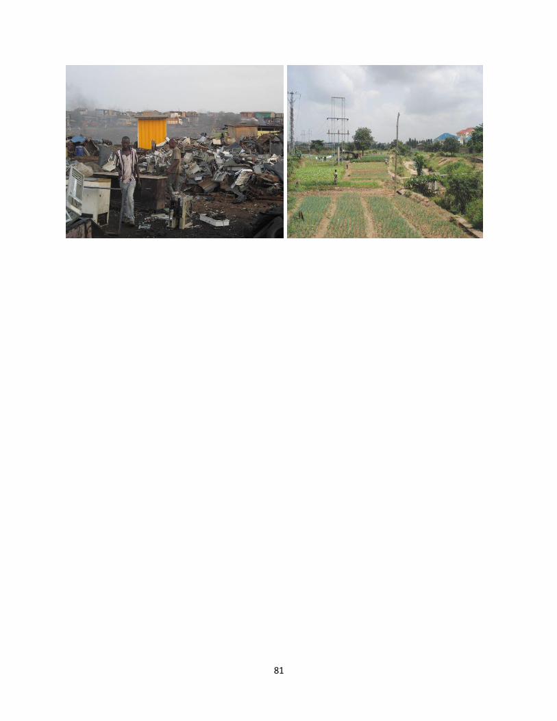
81