The Urban and Regional Analysis The Lab for Urban and Regional Analysis Jointly by Business School,...
23
The Urban and Regional Analysis The Urban and Regional Analysis The Lab for Urban and Regional Analysis Jointly by Business School, East China University of Science and Technology China Data Center, the University of Michigan
-
Upload
franklin-mckenzie -
Category
Documents
-
view
216 -
download
2
Transcript of The Urban and Regional Analysis The Lab for Urban and Regional Analysis Jointly by Business School,...

The Urban and Regional AnalysisThe Urban and Regional Analysis
The Lab for Urban and Regional AnalysisJointly by
Business School, East China University of Science and TechnologyChina Data Center, the University of Michigan

BackgroundBackground
Previous and current works:– China data projects (statistics, Census, GIS)– China Geo-explorer and DemographicsNowChina: the web
based platforms for spatial intelligence and learning (CDC, WU, SRC)
– The urban and rural studies (CDC, ECUST, ECNU)– Population and migration studies (CDC, FU)– Public health (SUFE)– Annual reports of Shanghai socioeconomic development
(SASS, SUFE)
Demands for urban analysis:Demands for urban analysis:– Data integration– New methodology– Toolkits with advanced functions
Related projects:• China 2049 Urban project• Urbanism Review Project by World Bank

ObjectivesObjectives - To build an infrastructure for - To build an infrastructure for urban and regional studiesurban and regional studies
• To build the information infrastructure for urban and regional analysis (statistical index systems, spatial-temporal relational database, and the web based toolkits)
• To develop the methodology for urban and regional analysis (defining metropolitan area, urban-rural spatial structure, urban clusters)
• To promote international and interdisciplinary collaborations in urban studies
• To provide the information and infrastructure support for research, education, government and business decision-making
focus on the Fundamental Development: focus on the Fundamental Development:
Information – methodology - Information – methodology - technologytechnology

China Urban Project: Comparative Studies China Urban Project: Comparative Studies on Shanghai-New Yorkon Shanghai-New York • MEASURING LIVABILITY
• THE FUTURE CITY DEMOGRAPHIC
• THE FUTURE OF "HISTORY“
• THE FUTURE OF URBAN PRODUCTION
• THE FUTURE OF CONSUMPTION
• THE FUTURE OF INFRASTRUCTURE
• THE FUTURE OF THE CITY OF HEALTH
• THE FUTURE OF EDUCATION FOR THE CITY
• THE FUTURE OF THE NATIONAL URBAN CONTEXT
• URBAN IMPLOSION
• URBAN EQUILIBRIUM
• URBAN FABRIC
• CULTURAL TRANSFORMATION
• URBAN DIVERSITY

Urbanism Review – The World Bank Urbanism Review – The World Bank ProjectProject
Phase One - Feeling the ‘pulse‘ of urbanization.This will include estimates of:
a. Economic gains associated with concentration of people and firmsb. Extension of basic services and connectivity across a portfolio of settlements consisting of rural areas, towns, cities and metropolises; and
c. Magnitude and types of negative externalities (slums, crime and violence, traffic congestion, and environment degradation).
Phase Two - Identifying roadblocks at different stages of urbanization. a. Regulations that slow down the fluidity of factor markets (land, labor, and products)b. Unmet demand for infrastructure and basic servicesc. Government and market failures that generate negative social and environmental externalities.
Phase Three – Agenda for Action.a. Identify trade-offs across policy objectives and strategies, as well as highlight opportunities for reaping ‗double dividends‘ across objectives – such as rapid urbanization and climate change mitigation.b. Assessing the political feasibility of undertaking pressing policy reformsc. Estimating costs of high priority investments and options for how these can be financed
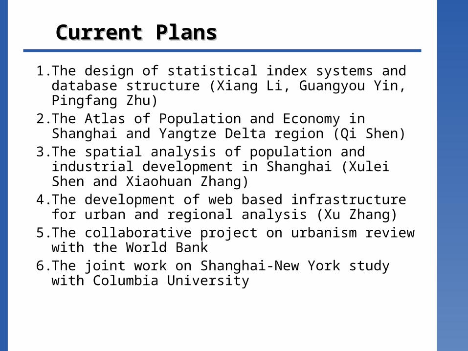
Current PlansCurrent Plans
1. The design of statistical index systems and database structure (Xiang Li, Guangyou Yin, Pingfang Zhu)
2. The Atlas of Population and Economy in Shanghai and Yangtze Delta region (Qi Shen)
3. The spatial analysis of population and industrial development in Shanghai (Xulei Shen and Xiaohuan Zhang)
4. The development of web based infrastructure for urban and regional analysis (Xu Zhang)
5. The collaborative project on urbanism review with the World Bank
6. The joint work on Shanghai-New York study with Columbia University

I. Data SourcesI. Data Sources
Economic Census
City Statistics
Enterprises database
Population Census
Market Database
Information infrastructure for urban and
regional analysis
Custom Database
Financial Database
Geography
Environment
Household Surveys
Macro Data Micro Data

Data Sources
• Government statistics
– monthly, quarterly and yearly data
– Province, city, county, township levels
• Statistical yearbooks
• Census data
– 1995 industrial Census (company and ZIP levels)
– 2001 Basic Unit Census (company and ZIP levels)
– 2004 Economic Census (company and ZIP levels)
– 1953, 1964, 1982, 1990 Population Census (Province, city, county levels)
– 2000 Population Census (Province, city, county, and township levels)
• Custom data (import and export)
• Finance (listed and non-listed companies, stock market)
• Enterprise data (large-mid size companies)
• Market data (local retail sales)
• Household surveys
• Geographical data
– elevation, roads, rivers, lakes
• Environmental data
– Land use and land cover, climate, pollutions,…

II. The Design of the Index Systems
The Degree of Development – Urban scale (population, spatial extent)– Economy scale (GDP, Per capita GDP, Investment, revenue)– Public service (schools, hospitals, culture and social service)– Infrastructure (transportation, facilities)
The Potential of Development– Economic structure (agriculture, industries, service, finance, …)– Financial support– Education and research (colleges, R&D centers)– Local resources and amenities (climate, land, water, cultural and
historical resources, …)
The Balance of Development– Costs (pricing indices)– Government budget balance (revenue and expenditure)– Environment (water, air, noise, …)– Social security (retirement, unemployment, and public health)– Public safety

The Diagnostic System of Urban HealthThe Diagnostic System of Urban Health
Options:
Medicine
Surgery
Exercise
Urban Urban SystemSystem
Economic sub-systemEconomic sub-system
Social sub-systemSocial sub-systemEnvironmental sub-systemEnvironmental sub-system
Healthy indicators of Healthy indicators of urban systemurban system
DiagnosticDiagnosticOptions: Options: PoliciesPolicies
Development strategiesDevelopment strategies
Human Human SystemSystem

III. Spatial Analysis of Population and Economy
Identify the spatial pattern and growth trend of urban population and economy (concentration and linkages
of population and industrial clusters)
Identifying factors and roadblocks of urban growth
The impact analysis of different policy options and strategies
Population Density and Distance in Shanghai
Manufacture in ShanghaiChanges in Population Distribution in
Shanghai
0
10
20
30
40
50
60
70
80
0 10000 20000 30000 40000 50000 60000 70000 80000 90000

IV. Spatial Intelligence for Urban and IV. Spatial Intelligence for Urban and Regional AnalysisRegional Analysis
Objectives:• To provide a web-based platform for data integration and urban analysis • To provide spatial decision support• To facilitate multidisciplinary studies and applicationsFeatures:• Identify spatial patterns of urban clusters • Identify the changes in the urban structure and spatial patterns• Identify the driving factors and roadblocks of urban development• Estimate and project the urban growth• Compare and evaluate different urban modelsFunctions:• Data integration (spatial and non-spatial, time and space data)• Exploratory spatial data analysis (spatial pattern detection, outliers detection, …)• Spatial data extraction for modeling (space-time data, neighborhood data)• Data analysis and simulation• Various outputs for urban analysis (reports, charts, and maps)Advanced plans for urban and regional analysis:• Identify urban clusters on the space• Identify spatial linkages between urban units (cities, towns and townships)• Identify the changing patterns of urban areas on space and time • Identify the driving factors for urban growth• Compare the degree of urban development for selected cities• Evaluate the potentials of urban development• Diagnostic of urban health• Advanced analysis with urban survey data

Current Work: China Geo-Explorer
Report Map ChartData Selection
Data Integration & Analysis
Geo
Glo
be
Go
og
le Map
WM
S
WF
S
Ob
servation
Raster Time-SeriesVector
Statistics
Oth
er

China Geo-Explorer: China Geo-Explorer: FunctionalityFunctionality
Summary, Comparison, Rank
Predefined/Customized Template
Output (Word, Excel, PDF)
Observation
Statistics
Report
Map
Chart
Data Selection
Raster Images (Street/Satellite/Terrain)
Geographic Reference Map
Thematic Map (Design, Publish)
District Selection
Graphic Selection
Range Selection
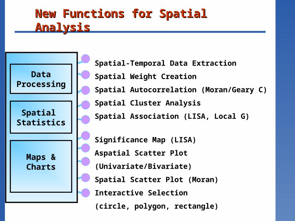
New Functions for Spatial AnalysisNew Functions for Spatial Analysis
Significance Map (LISA)
Aspatial Scatter Plot (Univariate/Bivariate)
Spatial Scatter Plot (Moran)
Interactive Selection
(circle, polygon, rectangle)
Spatial-Temporal Data Extraction
Spatial Weight Creation
Spatial Autocorrelation (Moran/Geary C)
Spatial Cluster Analysis
Spatial Association (LISA, Local G)
Maps &Charts
DataProcessing
Spatial Statistics

Project Demo: China Geo-ExplorerProject Demo: China Geo-Explorer
China Data and Maps
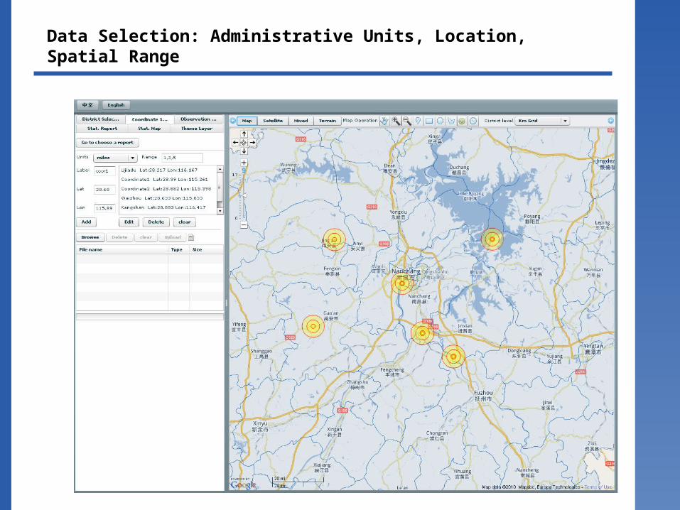
Data Selection: Administrative Units, Location, Spatial Range

The Analysis and Visualization of Space-Time DataThe Analysis and Visualization of Space-Time Data
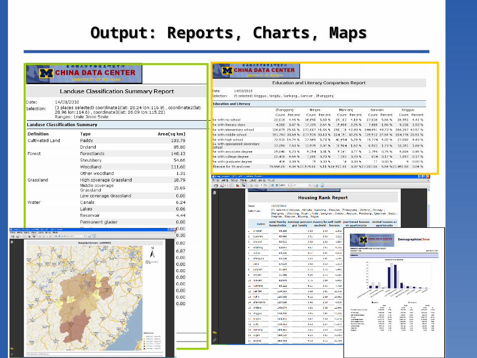
Output: Reports, Charts, MapsOutput: Reports, Charts, Maps

Participating Institutions Participating Institutions 参与参与机构机构
• University of Michigan• Columbia University• University of Utah• The World Bank• East China University of Science and
Technology• Shanghai Academy of Social Sciences• Fudan University• East China Normal University• Shanghai University of Finance and Economics• Wuhan University• Jilin University• Annpro Analytic Technologies

Lab Associates
21
姓名 Name Organization鲍曙明 Shuming Bao UM/ECUST吴柏均 Baijun Wu ECUST钱世超 Shichao Qian ECUST沈琪 Qi Shen ECUST
杨上广 Shangguang Yang ECUST
殷广伟 Guangwei Yin ECUST林赛 Sai Lin ECUST李宏辉 Honghui Li ECUST邓兰 Lan Deng University of Michigan 赵强孙 Edward Chao Annpro Analytic Technologies魏也华 Yehua Wei University of Utah李响 Xiang Li East China Normal University王桂新 Guixing Wang Fudan Universiy张伊娜 Yina Zhang Fudan Universiy沈续雷 Xulei Shen Fudan University俞卫 Wei Yu Shanghai University of Finance and Economics王振 Zheng Wang Shanghai Academy of Social Sciences朱平芳 Pingfang Zhu Shanghai Academy of Social Sciences张振宇 Zhengyu Zhang Shanghai Academy of Social Sciences朱欣焰 Xinyan Zhu Wuhan University苏科华 Kehua Su Wuhan University张晓欢 Xiaohuan Zhang Jilin University/University of Michigan张旭 Xu Zhang Wuhan University佘兵 Bing She Wuhan University
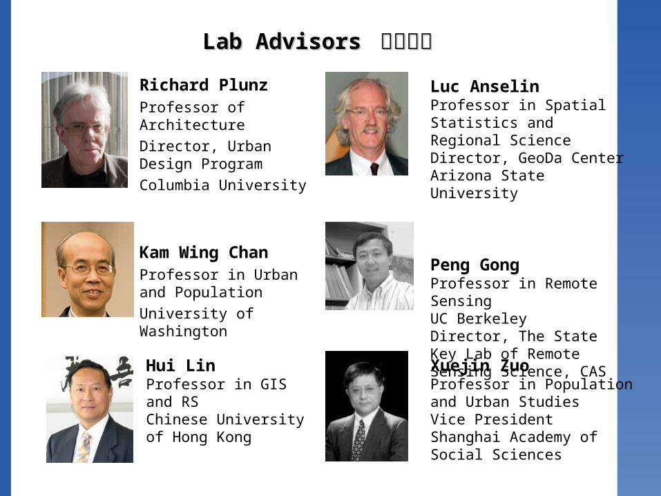
Lab Advisors Lab Advisors 学术顾问学术顾问
Richard PlunzProfessor of ArchitectureDirector, Urban Design ProgramColumbia University
Kam Wing ChanProfessor in Urban and PopulationUniversity of Washington
Xuejin ZuoProfessor in Population and Urban StudiesVice PresidentShanghai Academy of Social Sciences
Luc AnselinProfessor in Spatial Statistics and Regional ScienceDirector, GeoDa CenterArizona State University
Peng GongProfessor in Remote SensingUC BerkeleyDirector, The State Key Lab of Remote Sensing Science, CAS
Hui LinProfessor in GIS and RSChinese University of Hong Kong

Incoming Events
• The Advanced Workshop on “Spatial Statistics and Spatial Intelligence”, Wuhan, June 22-23, 2010
• Shanghai-New York Roundtable Meeting, Shanghai, July 2-3, 2010
• The International Conference on “China Regional Development Model: Ten Years of Western China Development”, Chengdu, Sichuan, July 5-6, 2010
23