The United States Geological Survey in Alaska ...
78
GEOLOGICAL SURVEY CIRCULAR 733 The United States Geological Survey in Alaska: Accomplishments During 1975
Transcript of The United States Geological Survey in Alaska ...

GEOLOGICAL SURVEY CIRCULAR 733
The United States Geological Survey
in Alaska: Accomplishments During 1975

The United States Geological Survey
in Alaska: Accomplishments During 1975
Edward H. Cobb, Editor
GEOLOGICAL SURVEY CIRCULAR 733
7976

United States Department of the Interior
THOMAS S. KLEPPE, Secretary
Geological Survey V. E. McKelvey, Director
Library of Congress Cataloging in Publication Data
Cobb, Edward H.The United States Geological Survey in Alaska.
(Geological Survey Circular 733)Supt.ofDocs.no.: 119.4/2:7331. United States Geological Survey 2. Geological research-Alaska. 3. Geology-Alaska-
Bibliography. I. Cobb, Edward Huntington, 1916- II. United States Geological SurveyHI. Series: United States Geological Survey Circular 733.
QE75.C5no. 733[QE74] 557.3'08s[557.98] 76-608093
Free on application to Branch of Distribution, U.S. Geological Survey, 1200 South Eads Street, Arlington, VA 22202

CONTENTS
Abstract _________________Summary of important results, 1975
Introduction ____________Statewide __________.
Page
_ 1
_ 1
_ 1
_ 1
Computer files of Alaskan data, by M. Elizabeth Yount _________________________ 1
Mineral resources of Alaska, by Edward H. Cobb ___________________________ 2
New gravity map of Alaska, by David F. Bames ______________________ 2
Exploration geochemistry in Alaska, by G. C. Curtin, G. W. Day, C. L. Forn, T. D. Hessin, J. D. Hoffman, S. P. Marsh, R. M. O'Leary, and R. B. Tripp___________________________ 5
Alaskan quality-of-water network (NASQAN), by R. J. Madison______________________ 7
Streamflow, channel erosion, and icings along TAPS route, by J. M. Childers ____________ 8
Water quality and benthic invertebrates along the TAPS route, by J. W. Nauman and D. R. Kernodle __________________________ 8
Investigations of impact on hydrologic features by construction and operation of TAPS, by C. E. Sloan _______________________ 8
Arctic water resources and environmental stu dies, by J. M. Childers_______________ 9
Hydrologic reconnaissance of TAPS haulroad, by S. H. Jones ___ _________ ________ 9
Surficial geologic mapping in the Philip Smith Mountains and Chandalar quadrangles, Brooks Range, by Thomas D. Hamilton and Robert M. Thorsen _______________________ 9
Displacement of Yukon-derived sediment from northern Bering Sea to southern Chukchi Sea during the Holocene, by C. Hans Nelson and Joe S. Creager ________________________ 10
"New" volcanoes in the Aleutian volcanic arc, by Thomas P. Miller and Robert L. Smith ___ 11
Reconnaissance geochemistry and tectonics of Gulf of Alaska greenstones, by Gary R. Winkler ________________________ 11
Uplift rates of marine terrace sequences in the Gulf of Alaska, by Travis Hudson, George Plafker, and Meyer Rubin __________ 11
Structural style of part of the Outer Continental Shelf in the Gulf of Alaska Tertiary Province, by Terry R. Bruns and George Plafker ____ 13
The Border Ranges fault system in the Saint Elias Mountains and Alexander Archipelago, by George Plafker, D. L. Jones, Travis Hudson, and H. C. Berg __________________ 14
PageSummary of important results, 1975 Continued
Northern Alaska __________________________ 16Seabed morphology adjacent to an "island" of
grounded ice in the Arctic Ocean northwest of Point Barrow, by L. J. Toimil and Arthur Grantz _______________________ 16
Possible solid gas hydrate and natural gas de posits beneath the continental slope of the Beaufort Sea, by Arthur Grantz, GaryrBoucher, and Olive Therese Whitney _____________ 17
Sediment-ice interaction in the Beaufort Sea, by Peter W. Bames and Erk Reimnitz________ 17
Study of the gravity field of the Beaufort shelf, north coast of Alaska, by Gary Boucher____ 21
Environmental data collection along proposed Canadian gas pipeline along coastal route in Alaska, by J. P. Meckel _______ J'_-____ 23
Arctic hydrology studies, by C. E. Sloan _____ 23North Slope water resources studies, by Gordon L.
Nelson ______________________ 23North Slope petroleum program, by Robert D.
Carter _________________________ 23New structural and stratigraphic interpretations,
central and western Brooks Range and Arctic Slope, by C. G. Mull, I. L. Tailleur, C. F. Mayfield, and G. H. Pessel ___________ 24
Petroleum potential of the Lisbume Group, by Kenneth J. Bird __________________ 26
Need to revise and test estimates of northern Alaska coal resources, by I. L. Tailleur and W. P. Brosge_____________________ 26
Informal cooperation between U.S. Geological Survey and State of Alaska, Division of Geolog ical and Geophysical Surveys in the Brooks Range, by I. L. Tailleur, G. H. Pessel, W. P. Brosge, and C. F. Mayfield______!:_____ 27
Northern Alaska coal investigations, western Naval Petroleum Reserve No. 4, by James E. Callahan _____ _________________ 30
Hydrological studies for the Alaskan Air Com mand, by R. J. Madison ______________ 30
Interpretation of depositional environments in the Fortress Mountain Formation, central Arc tic Slope, by R. E. Hunter and J. E. Fox __ 30
Metamorphism in the southwestern Brooks Range, by C. F. Mayfield ___._______ 31
Biostratigraphy of the Permian and Lower Trias- sic rocks in the Philip Smith Mountains quad rangle, by Robert L. Detterman ____________ 32
East-central Alaska ______ ___ 33Geochemical reconnaissance of the Chandalar
quadrangle, by Sherman P. Marsh _ __ 33
III

PageSummary of important results,1975 Continued
East-central Alaska ContinuedGeohydrology of the Fairbanks North Star
Borough, by Gordon L. Nelson _______ 34Reconnaissance geologic mapping in the eastern
Big Delta quadrangle, by Helen L. Foster and Florence R. Weber _______________ 34
West-central Alaska__________________ 36Trace-element composition of biotite from a tin-
granite complex, Seward Peninsula, by Travis Hudson and R. E. Mays ____________ 36
Revised interpretation of regional geological con trols of mineralization in southwest Seward Peninsula, by C. L. Hummel--________ 37
Uranium and thorium content of radioactive phases of the Zane Hills pluton, by Mortimer H. Staatz and Thomas P. Miller__________ 39
Progress report on new geologic mapping in the Ruby quadrangle, by Robert M. Chapman __ 41
Newly discovered Upper Triassic and Lower Cre taceous strata in the northern Kuskokwim Mountains, by William W. Patton, Jr. ___ 42
Sedimentary facies and structure of the northern Bering epicontinental shelf, by C. Hans Nelson, Robert W. Roland, and Sam W. Stoker ____ 43
Southwestern Alaska _______-__________Water-resources reconnaissance of St. George Is
land, Pribilof Islands, by G. S. Anderson __ 43Mercury dispersal in Kuskokwim River and Bay,
by C. Hans Nelson, Everett A. Jenne, and Dennis H. Sorg _________________ 43
Atomodesma in southwestern Alaska, by Joseph M. Hoare and Warren L. Coonrad ______ 44
The Togiak tuya, by Warren L. Coonrad and Joseph M. Hoare ____ ___________ 44
Two caldera-forming eruptions on Umnak Island, eastern Aleutian Islands, by Thomas P. Miller and Robert L. Smith _________ ___ 45
Southern Alaska _____________________ 45Hydrologic investigations related to coal re
sources, by D. R. Scully -_____________ 45Alaska glaciology studies, by D. C. Trabant __ 45Glaciers along TAPS route, by D. C. Trabant __ 47Water-resources investigations of the Valdez-
Delta Junction area, by C. E. Sloan ______ 47Reconnaissance geology of the western Talkeetna
Mountain quadrangle, by W. H. Nelson, Bela Csejtey, Jr., and R. M. Dean __________ 47
Geochemical anomalies in the Willow Creek min ing district, Talkeetna Mountains, by M. L. Sil- berman and R. M. O'Leary___________ 48
LANDSAT data interpretation of the Nabesna and McCarthy quadrangles, by Nairn R. D. Al bert _____.________ __________ 49
Relations between Triassic carbonate sabkhas and Kennecott-type copper deposits, Wrangell Mountains, by A. K. Armstrong and E. M. MacKevett, Jr. __________________ 50
Stable isotope, sulfide mineralogy, fluid inclusion, and K-Ar age study of the massive sulfide de posits at Kennecott, by M. L. Silberman, R. W. Potter II, and Arie Nissenbaum _______ 51
Page
Summary of important results, 1975 Continued Southern Alaska Continued
Ash flows associated with Wrangell Volcano, by Thomas P. Miller and Robert L. Smith ___ 52
Engineering geology of the Greater Anchorage Area Borough, by Ernest Dobrovolny and Henry R. Schmoll ________._____ 52
Geohydrology of the Anchorage area, by Chester Zenone ___________________ 52
Estimate of time required for natural restoration of the effects of the 1964 earthquake at Portage, by A. T. Ovenshine and Reuben Kachadoorian________________ __ 53
Lake-level fluctuations, North Kenai area, by G. S. Anderson ________________ 54
Summary of the geology and coal resources of the Bering River Coal Field, by R. B. Sanders __ 54
Reconnaissance engineering geology and geologic hazards of the Yakutat area, by L. A. Yehle 54
Gulf of Alaska seismicity, by John C. Lahr and Michael Blackford____________ 54
Submarine mass movement of Holocene sedi ments seaward of the Copper River, by Paul R. Carlson and Bruce F. Molnia _________ 55
Surface sedimentary units of the northern Gulf of Alaska continental shelf, by Bruce F. Molnia and Paul R. Carlson______________ 56
Southeastern Alaska ___________ _ 57Late Holocene offset features along the Fair-
weather fault, by George Plafker, Travis Hud son, and Meyer Rubin ______________ 57
Miocene mollusks from the Topsy Formation, Lituya district, by Louie Marincovich_____ 58
Glacier Bay National Monument mineral- resource studies recommenced, by David A. Brew, Donald Grybeck, B. R. Johnson, and Con stance J. Nutt __-__-____ -__ 58
Apparent pre-middle Tertiary right-lateral offset on Excursion Inlet fault, Glacier Bay National Monument, by David A. Brew, Christine Carlson, and Constance J. Nutt __ __ 59
Key foliated quartz diorite sill along southwest side of Coast Range complex, northern south eastern Alaska, by David A. Brew, A. B. Ford, Donald Grybeck, Bruce R. Johnson, and Con stance J. Nutt ______________ 60
Aquifer investigations in Mendenhall Valley near Juneau, by Gary O. Balding 60
Automated observatory system installed at Sitka Observatory, by Willis T. Osbakken ____ 60
Limnological investigations in southeastern Alaska, by G. A. McCoy _____________ 61
Progress report on geologic investigations in the Craig quadrangle, by G. Donald Eberlein and Michael Churkin, Jr. ____________ 61
Progress report on geology and mineral resources of the Ketchikan quadrangle, by H. C. Berg, R. L. Elliott, and R. D. Koch ___________ 62
Reports on Alaska published by members of the U.S. Geological Survey in late 1974 and 1975, compiled by M. E. Tailleur __________________________ 65
IV

ILLUSTRATIONS
Page
FIGURE 1. Regions of Alaska used in this report _________________________________ 22. Location map, studies discussed in summary of important results __________________________ 33. Location map, studies discussed in summary of important results _______________________ ____ 44. Sketch map showing preliminary interpretations from new gravity map of Alaska _____________ 65. Photograph of Trans-Alaska Pipeline System crossing of the Tonsina River, March 27, 1975____ __ 96. Chart of preliminary results of radiocarbon dating of marine terrace sequences between Cape Yakataga and Icy
Bay, in the vicinity of Lituya Bay, and on Middleton Island _____________________ ____ 127. Index map showing the location of the Border Ranges Fault and its major segments in the Saint Elias
Mountains and Alexander Archipelago, other major faults, and important fossil localities ____ ___ 158. Aerial photograph of "Katies's Floeberg" as viewed from the northeast from an altitude of about 500 m __ 189. Schematic representation of ice-bottom interactions on the shelf north of Alaska ____________ __ 20
10. Conceptual model relating intensity of agent (ice and water) to water depth, and seasonal changes in ice-waterregime _____________________________________________________________ 21
11. Profiles of free-air and Bouguer anomalies and regional correction, Beaufort shelf _ _ _ _ _ _ _ _ _ __ 2212. Section and index map, central Brooks Range transect __________________________-___ 2413. Photograph of a Lower Cretaceous olistostrome in the western Brooks Range _ __ ___ _ _ _ ___ _ __ 2514. Reconnaissance geologic map of the eastern Big Delta quadrangle _____________________ __ 3515. Map showing major structures and mineralized areas in southwest Seward Peninsula___________ 3816. Geologic sketch map of the Ruby quadrangle _____________________________________ 4117. Aerial photograph of Sanford Glacier with Mount Drum in the background, Wrangell Mountains, April, 1974 4618. Curve depicting the rate of build-up of the intertidal sediment surface at Portage--_______ __ 5319. Orthographic drawing of large submarine slide on Holocene sediment into Kayak Trough __________ 5620. Index map, aeromagnetic coverage for the State of Alaska ___________________________________ 64
TABLES
Page
TABLE 1. Average range of trace-element abundances in biotites from some felsic intrusive rocks in the western UnitedStates and from the Serpentine Hot Springs area ____________________ _________ ___ 36
2. Uranium, thorium and potassium content of selected grab samples from the radioactive phases of the Zane Hillspluton ____________________________________________________________ 40
V

The United States Geological Survey in Alaska: Accomplishments during 1975
Edward H. Cobb, Editor
ABSTRACT
This report of accomplishments of the U.S. Geological Survey in Alaska during 1975 is organized in two chapters. The first consists of short summaries of the important results of research projects and the second lists those reports and maps covering various phases of the geology and mineral and water resources of the State that were prepared by Geological Survey personnel and published in late 1974 and 1975.
SUMMARY OF IMPORTANT RESULTS
INTRODUCTION
Significant new scientific and economic geologic information has resulted from many topical and field investigations of the Geological Survey in Alaska during the past year. Discussions of the findings, or, in some instances, narratives of the course of the investigations, are grouped under seven subdivisions corresponding to six major geographic regions (fig. 1) and a general, statewide category, which includes discussions that fall in more than one of the regional subdivisions. Loca tions of the study areas are shown on the accom panying index maps (figs. 2 and 3).
STATEWIDE
Computer files of Alaskan data By M. Elizabeth Yount
The Branch of Alaskan Geology, as part of an effort to make the information in its technical data files more accessible, has built or cooperated in building several computer-based files containing Alaska data. The first file to be built was a joint effort of the Alaskan Branch and the Office of Re source Analysis. A manual card file of Alaskan mineral occurrences, created and maintained by Edward H. Cobb, was keypunched for entry into the Computerized Resources Information
Bank CRIB (Calkins and others, 1973). Because the file was then in machine-readable form, the Office of Resource Analysis fed the data into a sophisticated, but simple-to-use, interactive com puter storage and retrieval system for testing from remote locations. Observations of users' interac tion with the data base were made using terminals located in U.S. Geological Survey offices in Fair banks, Anchorage, Juneau, and Spokane. The file is maintained by the Office of Resource Analysis and updated by the Alaskan Branch. Updating is now progressing to incorporate annotations on the citations and a summary on each occurrence.
A second file was initially conceived as a com panion file to contain the complete citations which appear in abbreviated form in the mineral occurr ences file. It has since grown to include any U.S. Geological Survey, U.S. Bureau of Mines, or State of Alaska publication pertinent to the geology of Alaska. It includes these classes of publications through 1974, and is expected to contain the 1975 citations by late Spring 1976. The file is indexed primarily by 1:250,000 quadrangle. Plans are to augment the bibliography with citations to non government literature on a gradual basis as the quadrangle indexing is volunteered by file users. To attempt to include all possible nongovernment literature is beyond the resources of this project.
The Alaskan Branch is helping to complete Alaskan coverage in a file of fossil reports main tained by the Branch of Paleontology and Stratig raphy in Washington, B.C. That branch routinely inputs new reports and as time allows is working back in historic reports. The Alaskan Branch started with its earliest reports, working forward in time. Old reports are typed in Menlo Park, mailed to Washington, B.C., and added to the data
base via an optical scanner. Reports to 1911 have been included.
Visitors to the Alaskan Technical Data Unit, Menlo Park, are welcome to search the bibliog raphy and mineral occurrence file from the termi nal located there. To assure wider distribution of the material in these two files, plans are being made to publish both computer output microfiche and a computer tape copy of each of the files through the National Technical Information Ser vice. For further information about the fossil re ports file, contact the Branch of Paleontology and Stratigraphy, National Museum, Washington, B.C. 20244.
REFERENCE CITED
Calkins, J. A., Kays, Olaf, and Reefer, E. K., 1973, CRIB The mineral resources data bank of the U.S. Geological Survey: U.S. Geol. Survey Circ. 681, 39 p.
Mineral resources of Alaska By Edward H. Cobb
Products of this office project during 1975 com prised 10 published maps (scale 1:2,500,000), each showing the distribution in Alaska of occurrences of a metallic mineral commodity; an open-filed list
of recent Federal and State reports on the geology and mineral resources of Alaska, indexed by topo graphic mapping quadrangle (scale 1:250,000); and open-filed summaries of references to indi vidual mineral occurrences (other than mineral fuels and construction materials) in 18 quad rangles in west-central and northern Alaska. Pre viously compiled bibliographic and mineral- resource reference material was made available to the Alaskan Branch information processing proj ect for entry into computerized storage and re trieval banks.
New gravity map of Alaska By David F. Barnes
A new Bouguer gravity map of Alaska at a scale of 1:2,500,000 (1 inch equals about 40 miles) pre pared by D. F. Barnes will be released during the calendar year 1976. The map was compiled from about 30,000 Alaska land-gravity measurements plus approximately 40,000 kilometers of surface- ship gravimeter traverses over the bordering con tinental shelves. More than a third of the land stations were obtained between 1958 and 1974 during small-boat traverses along rivers and shorelines. The basic data consist of a skeletal
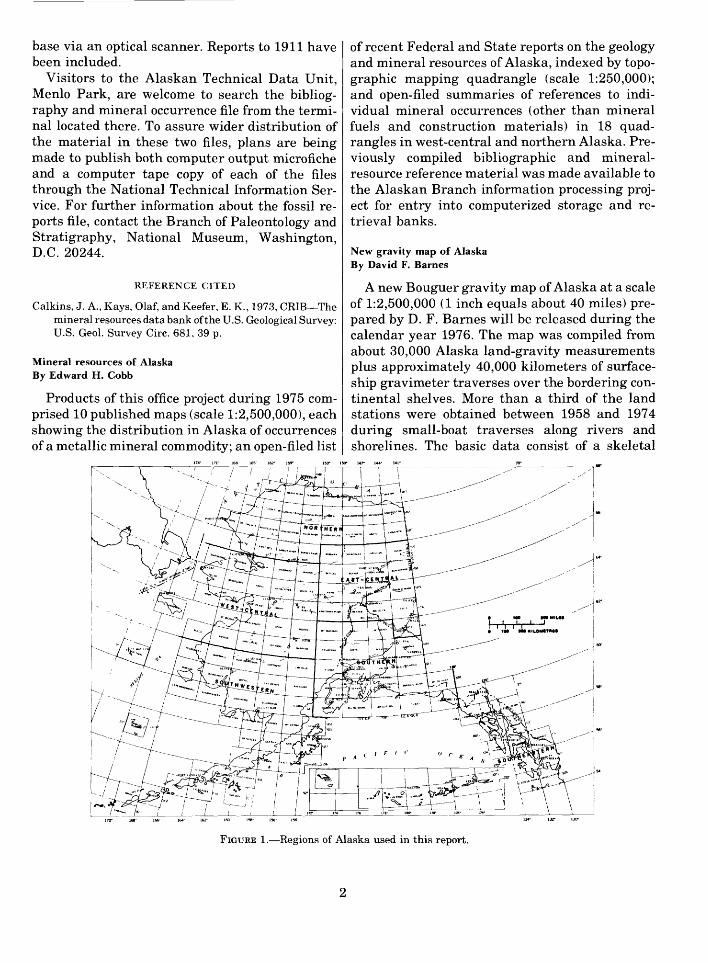
FIGURE 1. Regions of Alaska used in this report.

174°
171°
168"
165°
162°
1S9°
153°
ISO"
147°
14
4°
141"
0
100
200 M
ILE
SIII
I I
I I
I 0
100
200 K
ILO
ME
TR
ES
176°
17
8°
180°
17
8'
176°
17
4
134"
13
2°
130°
FIG
UR
E 2. L
oca
tion o
f stu
dies
dis
cuss
ed in
sum
mar
y of
import
ant r
esult
s, 1
975
(see
als
o fi
g. 3
). N
umbe
rs k
ey to
pro
ject
dis
cuss
ions
in
text
.

17*°
171°
16
8°
16B°
162°
13
9°
170°
16
8°
166°
16
4°
162°
18
0°
158°
156°
15
4°13
4"
132°
13
0°
FIG
UR
ES.
Loc
atio
n of
stud
ies
disc
usse
d in
sum
mar
y of
impo
rtan
t re
sult
s, 1
975
(see
als
o fig
. 2)
. N
umbe
rs k
ey t
o pr
ojec
t di
scus
sion
s in
tex
t.

network of widely spaced traverses along which stations are separated by distances of 2 to 5 km. Additional measurements by float-plane, ski- plane, and helicopter landings and a few detailed surveys provide a more systematic coverage, best developed in the northern and eastern parts of the State. Much of the data reduction was performed by desk calculators, and most contouring was done by hand at a scale of 1:250,000 so that available geologic and aeromagnetic maps could be used as supplemental data. Gravity datum for the map was obtained from the 1971 International Gravity Standardization Net; the reductions employed the 1967 International Reference Ellipsoid and a den sity of 2,670 kg/m3 .
The map may eventually aid the solution of sev eral types of problems in different physical sci ences such as geodesy, geophysics and geology. It provides a method for calculating the gravita tional acceleration in various parts of Alaska, for estimating the deflection of the vertical, and for removing regional gradients from local gravity surveys. Figure 4 shows some of the preliminary geologic interpretations which have been made from the map and which are discussed in greater detail in a brief text that will accompany the map.
The contours of estimated crustal thickness were generalized from the gravity contours by" using the empirical relations between Bouguer gravity and crustal thickness derived from worldwide data by Woollard and Strange (1962) and converted to the new datum and ellipsoid for Alaskan latitudes. Both those workers and Barnes (1969, 1971) have shown that these empirical re lations are not accurate in areas where tectonic processes predominate over processes of isostatic adjustment. Such tectonic activity controls gravity anomalies in island arcs and other areas of plate convergence such as the Gulf of Alaska coastal region. The northern boundary of the gravita tional effects of this tectonic activity and the southern limit of possible usefulness of the empiri cal relation is somewhat arbitrarily placed as shown on the sketch map by the heavy dotted line. The contours do, however, suggest a crust that is thinner than that in most of western North America and show the probable increase in thick ness beneath the interior mountain ranges.
Several small gravity lows have been inter preted as Cenozoic basins filled with low-density sediments and sedimentary rocks. In the illustra tion, these lows are shown as hachured closures,
other lows better interpreted as low-density intru sions are left off. Most of the Cenozoic-basin grav ity lows are close to large faults and are within topographic basins of much larger area. The struc tural basins, filled primarily by pre-Cenozoic rocks, are better adjusted isostatically and are less clearly defined as gravity lows. Delineation of such basins generally requires more detailed gravity data, and such sedimentary basins have been left off the preliminary interpretation map (fig. 4).
Much of the map compilation involved the rec ognition of several linear or arcuate gravity highs, shown as heavy dashed lines or dashes on the il lustration. The highs are indicated either by adequate gravity data or by a few gravity meas urements suggesting characteristic association of high gravity anomalies with either elongate rock outcrops or elongate aeromagnetic anomaly pat terns. The limited evidence for some of the features and the variable causes of the highs are discussed in greater detail in a text that accompanies the gravity map. The features are shown on figure 4 because they may represent former plate or tec tonic boundaries, because many of the highs seem to be associated with mineralization, and because they are such prominent features of the Alaskan gravity map.
REFERENCES CITED
Barnes, D. F., 1969, Lack of isostatic adjustment on two Alas kan continental margins: Geol. Soc. America Abs. with Programs, 1969, Ann. Mtgs., V. 1, no. 7, p. 254-256.
1971, Gravitational evidence concerning the thickness of the Alaskan crust: Internat. Symposium on Arctic Geol ogy, 2d, Program Abs., Am. Assoc. Petroleum Geologists, p. 59.
Woollard, G. P., and Strange, W. E., 1962, Gravity anomalies and the crust of the earth in the Pacific basin, in Mac- Donald, G. A., and Kuno, Hisaki, eds., The crust of the Pacific basin: Am. Geophys. Union Geophys. Mon. no. 6, p. 60-80.
Exploration geochemistry in AlaskaBy G. C. Curtin, G. W. Day, C. L. Fora, T. D. Hessin, J. D.Hoffman, S. P. Marsh, R. M. O'Leary, and R. B. Tripp
During the 1975 field season, the Branch of Ex ploration Research participated in the Alaskan Mineral Resource Appraisal Program (PAMRAP-AMRAP) and Wilderness Studies in various parts of Alaska. About 8,000 samples were collected by Branch geochemists during PAMRAP-AMRAP reconnaissance geochemical studies and by Branch of Alaskan Geology geologists in nine l:250,000-scale quadrangles:

Prob
able
lim
it of
are
a in
whi
ch g
ravi
ty
may
indi
cate
cru
stal
thi
ckne
ss
Con
tour
s of
crus
tal t
hick
ness
est
imat
ed
from
gra
vity
Gra
vity
low
s w
hich
sug
gest
C
enoz
oic
basin
s
16
0°
13
0°
FIG
UR
E 4
. P
reli
min
ary
in
terp
reta
tio
ns
from
new
gra
vity
map
of
Ala
ska.

Big Delta, Blying Sound, Chandalar, Goodnews, Hagemeister Island, Ketchikan, Seward, Tal- keetna, and Talkeetna Mountains. More than 4,000 of these samples were analyzed in the An chorage Laboratory during the field season. In ad dition, about 1,500 samples were analyzed in mobile laboratories stationed at the Bureau of Mines facility in Juneau in support of Wilderness Studies in the Tracy Arm-Fords Terror and Glacier Bay National Monument Wilderness Study Areas.
Besides aiding in the mineral-resource assess ment of the above-named quadrangles, prelimi nary results of the PAMRAP-AMRAP studies indicate that separate sampling programs are nec essary to describe adequately the areas of mineral potential in at least two kinds of Alaskan ter- raines: rugged mountainous terrains such as the Brooks and Alaska Ranges and maturely dissected terrains such as the Yukon-Tanana Upland and the area of the Goodnews and Hagemeister Island quadrangles. The results indicate that more than one sample medium is required in reconnaissance geochemical surveys in these environments in order to define adequately areas of mineral potential.
Because the primary weathering process in the rugged mountainous terrains is mechanical rather than chemical, relatively fresh fragments from both country rock and mineralized zones are de posited in the streams to produce a mineralogy that reflects the mineralogy of the bedrock in the drainage basins. The collection of stream sedi ments and panned concentrates from streams draining areas of 5-15 km2 is therefore adequate, on a reconnaissance basis, to define areas of min eral potential. Analysis of bedrock collected at a somewhat lower sampling density aids in defining the chemical composition of the bedrock and in interpreting geochemical results of the stream- sediment and panned-concentrate sampling.
Chemical weathering apparently plays an im portant role in the weathering processes in ma turely dissected terrains. In this environment, elements probably migrate in solution from bed rock and colluvium and eventually infiltrate streams. The elements are then scavenged by materials such as secondary Fe-Mn oxides and re lated materials in stream sediment, streambank sod (mixed organic and inorganic material) be neath the water level, and aquatic bryophytes
(mosses). Analyses of these media show that the hydromorphic anomalies produced by the scaveng ing processes define both known mineralized zones and potential areas of concealed mineralized rock. Analyses of clastic stream-sediment material, on the other hand, reveal only relatively weak, iso lated anomalies that do not adequately define areas of mineral potential. The weak anomalies may be the result of dilution by barren material that constitutes the bulk of the stream sediment and by the selective destruction or alteration by weathering of sulfides and other ore minerals. The effects of weathering and dilution are reversed, however, through concentration of the heavy- mineral fraction of the stream sediment by pan ning. The high metal content, especially of Sn and W, in heavy-mineral concentrates defines areas similar to those outlined by high metal content in the scavenging agents. The results indicate that panned concentrates and scavenging agents such as oxalic-acid-leachable Fe-Mn oxides and related materials of the stream sediment and the stream- bank sod are sample media useful for reconnais sance geochemical exploration in this environ ment.
Alaskan quality-of-water station network (NASQAN) By R. J. Madison
Six new monitoring stations were established under the Geological Survey's National Stream Quality Accounting Network (NASQAN) (Ficke and Hawkinson, 1975). The program was designed to measure a range of water quality characteristics and to provide information to those involved in planning or managing water resources. Objectives of the program are to account for amount and qual ity of water, to show variability, to detect stream- water quality changes, and provide data from which future assessments may be made. The NASQAN sites in Alaska are: Stikine River near Wrangell (fig. 2 (45)), Susitna River at Susitna Station (fig. 2 (24)), Kuskokwim River at Crooked Creek (fig. 2 (21)), Yukon River at Pilot Station (fig. 2 (20)), Kobuk River near Kiana (fig. 2 (11)), and Kuparuk River near Deadhorse (fig. 2 (1)).
REFERENCE CITED
Ficke, J. F., and Hawkinson, R. O., 1975, The National Stream Quality Accounting Network (NASQAN) Some ques tions and answers: U.S. Geol. Survey Circ. 719, 23 p.

Streamflow, channel erosion, and icings along TAPS route By J. M. Childers
Stream-discharge and water-quality records from 10 gaging stations established along TAPS route (fig. 2 (3-5)) during 1970-73 provided new hydrologic data, especially in the Arctic, and baseline data for evaluating environmental impacts. Channel erosion and the causative fac tors floods, ice, and construction disturbance were resurveyed and aerial photography retaken at 25 pipeline stream-crossing sites. Aerial photo- grammetry was advantageously used at selected broad, braided channel sites.
An aerial reconnaissance of icings along the pipeline route was made in May 1975. Photo graphs of significant icings were made and the location and extent of icings plotted on 1:250,000 scale maps. Icings were a significant problem for road maintenance between Prospect Camp and Galbraith Lake Camp through the Brooks Range. The impacts of icings on erosion and flooding during breakup will increase as construction pro gresses.
Water quality and benthic invertebrates along the TAPS route By J. W. Nauman and D. R. Kernodle
Streams along the TAPS route (fig. 2 (3-5)) can be classified as glacial and nonglacial. These stream types reflect the cold Alaskan climate; summer water temperatures are low. High dis charge rates occur during late spring and early summer; winter ice cover, lasting .more than 6 months, results in prolonged low flow.
Nonglacial streams with high snowmelt con tributions generally have peak flows during spring breakup. These streams tend to be clear and have low turbidity except during spring breakup and after summer rainstorms. In glacial streams, glacier melt water sustains summer runoff levels. The streams are milky and turbid from large amounts of suspended inorganic sediment. Water in both types of streams becomes clear during winter. Low flows at that time are due to reduced surface runoff.
Peak suspended-sediment loads range from 0 to 4,000 mg/1 for nonglacial streams and 1 to 9,300 mg/1 in glacial streams. Similarly, turbidity is much greater in glacial streams than in nonglacial waters, ranging from 0 to 510 JTU in glacial streams and from 0 to 270 JTU in nonglacial streams. Total organic carbon values are slightly higher for nonglacial streams, ranging from 0.5 to
60 mg/1, and from 0.5 to 14 mg/1 in glacial streams. Correspondingly, ammonia (as N) ranges from 0.01 to 0.88 mg/1 for nonglacial streams, 0.01 to 0.08 mg/1 in glacial streams.
The higher turbidity and suspended-sediment loads in glacial streams as well as their lower total organic carbon and ammonia contents seem to ex plain the difference in abundance of benthic or ganisms noted in the two stream types. During the summer, benthic invertebrate average abundance is approximately 2,800 organisms per square metre for nonglacial streams and 550 organisms per square metre in glacial streams. The major benthic invertebrate groups are also represented by increased numbers of genera in nonglacial streams. Chironomidae (midges), Simuliidae (blackflies), and Ephemeroptera (mayflies) genera were approximately twice as abundant in nongla cial streams. There seems to be, however, little difference in the abundance of Plecoptera (stoneflies) in these two stream types.
In the three climatic zones (Arctic, Continental, and Maritime) crossed by the pipeline route, gla cial stream benthic invertebrates were more abundant, on the average, in the Maritime zone, whereas nonglacial streams had greater numbers of organisms in the Continental climatic zone.
Investigations of impact on hydrologic features by construc tion and operation of TAPS By C. E. Sloan
The Tonsina River (fig. 2 (26)) near Glennallen was the site of the first river crossing by the trans-Alaska pipeline (fig. 5) on March 27, 1975. The Tonsina River is a glacier-fed coarse-bed stream that flows through a large lake upstream from the site. Natural turbidity in the stream im mediately upstream from the crossing zone was about 30 JTU at a stream-flow rate of about 70 ft3/s and a velocity of about 2 ft/s (0.61 m/s). Turbidity increased to about 400 JTU immediately downstream from the crossing during excavation of the pipeline trench. Turbidity as high as 135 JTU was observed 5 miles (8 km) downstream from the crossing. The river cleansed itself rapidly after ditching was completed and within 12 hours was approaching natural background levels. The tur bidity resulting from construction disturbance had no measurable effect on specific conductance or concentration of dissolved oxygen in the river.
The Little Tonsina River (fig. 2 (26)) was crossed on April 12 and backfilling began on April 13. The
8

FIGURE 5. Trans- Alaska Pipeline System crossing of the Ton- sina River, March 27, 1975.
Little Tonsina is a clear-water, salmon-spawning stream tributary to the Tonsina River. Background turbidity above the crossing was 5 JTU; downstream maximum during backfilling was 1,500 JTU. Discharge was about 8 ft3/s and most of the sediment introduced into the stream appeared to settle out within half a mile (800 m) of the crossing. Chironomid larvae, stonefly, and mayfly nymphs were found on stream-bottom sub strates upstream from the crossing, but no benthic invertebrates were found a short distance downstream from the crossing, even though an equal sampling effort was expended. Benthic studies in late July 1975 in the Little Tonsina indicated that a healthy benthic community had repopulated the stream substrate in the affected reach.
A study of the hydrology of treated sewage ef fluent at selected pipeline camps found only one site where there was evidence of impact on a re ceiving water. The Jim River at Prospect Camp (fig. 2 (13)) receives dilute sewage effluent as ground-water seepage along the left bank; this results in low dissolved oxygen and relatively high total organic carbon, chloride and sulfate contents. However, this effect is quite localized and does little to impair the quality of water in the main channel downstream from the camp.
Arctic water resources and environmental studies By J. M. Childers
Channel surveys at 25 stream crossing sites along TAPS route (fig. 2 (3-5)) during 1975 have been compared with preconstruction surveys at the sites to measure erosion. Aerial photogram- metry was used advantageously at broad, braided stream crossing sites for the channel erosion sur vey. Boat surveys were made at selected sites dur ing significant flooding to measure local scour. Flood scour measured at the Salcha River in 1975 resulted in design revision requiring deeper burial of the pipeline than originally planned. These channel erosion surveys are part of a continuing study of the interactions of floods, ice, and con struction on stream channels along TAPS route.
Hydrologic reconnaissance during April and August 1975 provided data to help evaluate hazards from floods, ice, and channel erosion along the proposed Arctic Gas Pipeline (fig. 2 (2)) coastal route. Quality and availability of water at selected streams, lakes and springs were measured to help evaluate potential developmental impacts on water resources.
Hydrologic reconnaissance of selected large streams (including the Colville River) has pro vided information for planning stream-gaging and water-quality sampling stations. Data from these stations could be used in defining important streamflow characteristics of the central and east ern North Slope of Alaska.
Hydrologic reconnaissance of TAPS haulroad By S. H. Jones
A hydrologic reconnaissance of the TAPS haul- road (fig. 2 (3)) during breakup in May 1975 found no notable floods or erosion at bridges and culverts. Severe icings occurred at numerous culverts and bridges, causing local erosion and flooding, how ever. Significant erosion at the embankment slopes occurred between the South Fork, Koyukuk River, and Coldfoot Camp where frozen silts were exposed to thawing and runoff.
As snowmelt runoff was relatively low in 1975, another attempt to observe flooding will be made during spring breakup of 1976 if snow accumula tion is high.
Surficial geologic mapping in the Philip Smith Mountainsand Chandalar quadrangles, Brooks RangeBy Thomas D. Hamilton and Robert M. Thorson
Reconnaissance mapping of surficial geologic
deposits has been completed for about 70 percent of the Philip Smith Mountains quadrangle (fig. 3 (6)) and 50 percent of the Chandalar quadrangle (fig. 3 (7)). The most extensive units mapped in each quadrangle include glacial drift sheets and out- wash trains, postglacial alluvial and lacustrine deposits, and solifluction sheets. Talus cones and aprons, alpine fans, landslide deposits, rock glaciers, and cirque-glacier moraines predominate at higher altitudes with the Brooks Range.
Glacial drift sheets of the Philip Smith Moun tains and Chandalar quadrangles are divisible into six units of progressively younger age. The two oldest drifts, which extend tens of kilometers beyond the range flanks, are assigned to the Anak- tuvuk and Sagavanirktok Glaciations of Det- terman and others (1958). Three younger drifts (Itkillik I, Itkillik II, and late Itkillik) represent substages of Wisconsin or late Wisconsin glacia- tion (Hamilton and Porter, 1975). The youngest drift, which occupies valley heads at altitudes gen erally above 1,500 m, represents ice advances of Neoglacial age.
Physical characteristics of the glacial drifts were measured at 52 field localities where the fol lowing information was obtained: (1) frequency, size, and lithology of surface boulders; (2) depth of etching, pitting, and oxidation rinds on surface boulders; (3) widths of moraines, angles of flanking slopes, and relief along crests; (4) size, frequency, and stability of kettles; (5) development of solifluc tion sheets, patterned ground, and vegetation cover; (6) width, depth, and character of axial stream incision; and (7) depth and intensity of soil formation. Preliminary analyses of our data show that the physical character of the drifts is strongly affected by local loess history in addition to rela tive age. Moraines of the oldest Itkillik substage (Itkillik I) show the differential effects of loess deposition most strongly. These moraines tend to be sharp crested and bouldery along valley flanks, but are traceable into progressively more subdued features toward valley centers. Soil pits and bor ings show that thick loess blankets overlie the Itkillik I deposits along the floors of many valleys. Pre-Itkillik drifts tend to have relatively uniform loess cover; drifts younger than Itkillik I usually lack appreciable loess blankets.
All of the physical parameters listed above are useful indicators of relative age and hence valu able for correlation of drifts within this part of the Brooks Range. Some properties such as develop
ment of solifluction sheets and etching of surface boulders change relatively rapidly and hence are valuable for distinguishing substages of Itkillik glaciation. Other characteristics such as width of axial stream incisions and depth of oxidation rinds on resistant clasts change more slowly and are useful for distinguishing between the Anaktuvuk, Sagavanirktok, and Itkillik Glaciations. Certain characteristics such as large nonsorted polygons on Itkillik II deposits appear to be diagnostic of specific drifts.
Landslide deposits at higher altitudes within the Brooks Range are far more extensive than hitherto reported, but many of the landslides appear to be of late-glacial age and are inactive today. In several cases, landslide deposits are markedly kamelike in character and probably were deposited atop stagnating glacial ice during latest Itkillik time. Other landslides have been dissected by early Holocene stream downcutting. Assessment of the origin and history of high- altitude glacial, landslide, and talus features in this part of the Brooks Range is complicated by widespread rock glacier activity that has signifi cantly altered their positions and surface charac ter.
REFERENCES CITED
Detterman, R. L., Bowsher, A. L. and Dutro, J. T., Jr., 1958, Glaciation on the Arctic Slope of the Brooks Range, north ern Alaska: Arctic, v. 11, no. 1, p. 43-61.
Hamilton, T. D., and Porter, S. C., 1975, Itkillik glaciation in the Brooks Range, northern Alaska: Quaternary Research, v. 5, no. 4 (in press).
Displacement of Yukon-derived sediment from northern Ber ing Sea to southern Chukchi Sea during the Holocene By C. Hans Nelson and Joe S. Creager1
From the time Shpanberg Strait (between St. Lawrence Island and the Yukon Delta) opened about 12,000 B.P. until Norton Sound was flooded by rising sea level about 9,500 B.P., as much as 63 percent of the sediment load of the Yukon River bypassed northern Bering Sea to be deposited in the southern Chukchi Sea (fig. 3 (4), (5), (26)). After flooding, Yukon sediment began accumulat ing in Norton Sound, but significant deposition may not have begun until the present Yukon sub- delta began to form in southern Norton Sound about 5,000 B.P. Even now, 17-41 percent of the Yukon load appears to leave northern Bering Sea as the continual strong northward circulation of Alaskan Coastal Water advects some of the Yukon
'Department of Oceanography, University of Washington.
10

sediment plume and carries masses of sediment intermittently resuspended by storms to the Chukchi Sea. Since Shpanberg Strait opened, about 40-50 percent of the Yukon sediment ap pears to have accumulated in a thick blanket of Holocene sediment found in the southern Chukchi Sea. This major displacement of sediment has im portant implications for models of advective transport on shelves, for paleogeographic recon structions of sedimentary environments in epicon- tinental seas and for development of nonsubsiding deltas."New" volcanoes in the Aleutian volcanic arc By Thomas P. Miller and Robert L. Smith
Two previously unreported volcanoes in the Aleutian volcanic arc were found this past summer (1975) during geothermal reconnaissance investi gations. The first discovered, Mount Kialagvik (fig. 2 (35)), located on the Alaska Peninsula about 130 km east-northeast of Port Heiden, appears to be a dacitic dome with associated dacitic ash flows. The relative lack of erosion of the unconsolidated ash flows suggests a very young age, perhaps a few thousand to a few tens of thousands of years, simi lar to the age of other nearby dacitic volcanoes with associated ash flows.
The other volcano, herein named Hayes Volcano (fig. 2 (22)), is at the foot of Mount Gerdine 150 km west of Anchorage in the Tordrillo Mountains about 90 km north of Mount Spurr, which had been considered the easternmost volcano in the 2,600- km-long Aleutian volcanic arc. The original vent appears to be mostly covered by the Hayes Glacier and only a remnant of unconsolidated ash fall and avalanche deposits can still be found along the margin of the glacier. Most of this material is of hornblende-biotite dacite composition. This vol cano is the probable source of the air-fall ash that immediately underlies surface vegetation in the upper Susitna River drainage and may be the source of some of the air-fall ash found in the general Anchorage area. The volcano is thought to be very young because the unconsolidated av alanche deposits occur in an environment where a considerable amount of erosion takes place and the associated air-fall ash occurs close to the surface.
Reconnaissance geochemistry and tectonics of Gulf of AlaskagreenstonesBy Gary R. Winkler
Major oxide and minor element abundances demonstrate that greenstones within Mesozoic
and Paleogene flyschlike terranes along 1,500 km of the Gulf of Alaska continental margin are al most entirely tholeiitic basalt. From Sanak Island (False Pass quadrangle) on the west to Yakutat (Yakutat quadrangle) on the east (fig. 1), the greenstones are nearly indistinguishable chemi cally and have compositional characteristics of ocean-floor basalt. Volumetrically minor alkalic basalts are limited to Oligocene intrusive and pyroclastic phases of volcanic activity that appear to be generated from an unrelated magma suite.
Discrimination between Gulf of Alaska basalt types by major oxide percentages or ratios is equivocal, perhaps partly owing to the range in analyzed samples from nearly fresh basalt to zeo lite and greenschist facies metavolcanic rocks. The minor elements, Ti, Y, and Zr, are less sensitive to changes imposed by alteration or metamorphism. Their abundances in Gulf of Alaska greenstones are comparable to those of basalts known to have been erupted in oceanic tectonic settings.
Intercalation of oceanic tholeiites and terrigen ous sedimentary rocks in the Mesozoic and Paleogene terranes of coastal southern Alaska suggests that oceanic crust repeatedly was ac creted to the continent along with prisms of flysch perhaps partly as a detached substrate for flysch sequences, but more typically within them. Widely variable basalt thicknesses may indicate that local edifices in particular were subject to detachment from oceanic crust and incorporation into the accretionary continental margin. The younger alkalic basalts may reflect local oceanic island formation subsequent to tectonic thicken ing of the continental margin.
Uplift rates of marine terrace sequences in the Gulf of Alaska By Travis Hudson, George Plafker, and Meyer Rubin
Work on Middleton Island (fig. 3 (18)) after the Alaska Earthquake of March 27, 1964, revealed that the sequence of marine terraces that were related to Holocene tectonic uplifts that probably accompanied major earthquakes. Radiocarbon dating of driftwood and peat from five of these terraces established an average uplift rate of 1 cm/yr for about the past 4,500 years and that the interval between major earthquake-related uplifts was 500 to 1,300 years (Plafker and Rubin, 1967, 1969, and unpublished data). The results from Middleton Island suggested that geochronologic studies of other marine terraces in the Gulf of Alaska could provide significant new quantitative
11
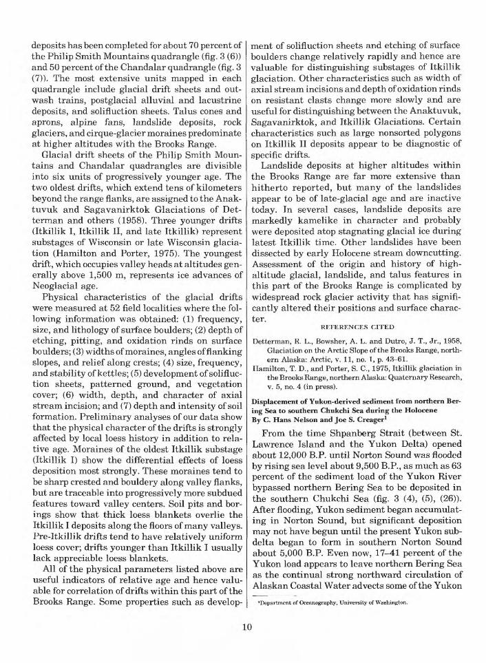
data on the Holocene tectonic history of this part of the State.
The new studies reported on here are the results of radiocarbon dating of material from two addi tional marine terrace sequences that are located between Cape Yakataga and Icy Bay (fig. 3 (20)) and in the vicinity of Lituya Bay (fig. 3 (22)). Most of the radiocarbon dating is of peat accumulations on the raised surfaces; a few age determinations are of wood. The peat accumulations were sampled with a modified Livingston corer and the deepest peat recovered, which is assumed to be the oldest material from each core, has been dated. The biggest problem in this approach to dating of the surfaces is the unknown nature of the peat stratig raphy. Not only is it uncertain whether or not the peat began accumulating soon after emergence of the terrace but it is also uncertain whether or not the deepest peat recovered is actually the basal peat in the sampled section. By taking many cores at many different localities, these difficulties are partially overcome, and it appears that the actual age of many of the terraces has been approximated by the oldest dated peat samples.
The preliminary results of the radiocarbon dat ing are summarized in figure 6. The data for the Lituya Bay terraces indicate an uplift rate (0.9 cm/yr) close to that determined at Middleton Is land (1 cm/yr). The data for the terraces between Cape Yakataga and Icy Bay are much less satisfac tory, but suggest an uplift rate (0.5 cm/yr) about half of that in the other two areas. All of these uplifts are relative to present mean sea level and no adjustments for eustatic or possible isostatic changes have yet been made. The isostatic adjust ments are expected to be small, if any, but eustatic changes would appreciably affect the height of the older terraces (>6,000 years). If the elevations of these older terraces were adjusted for Holocene sea level changes, the calculated uplift rates would be even greater than that determined from the data summarized in figure 6 and the Yakataga-Icy Bay uplift rate might be roughly comparable to that in the other two areas. In any case, the observed rates are exceptionally high when compared with up lifted marine terrace sequences elsewhere in the world.
All of the areas studied are presently tectoni- cally active and have been so throughout Pliocene-Pleistocene time but the general tectonic regimes differ: Middleton Island is near the east ern termination of the Aleutian Trench, the
250
200
150
< 100
50
//ss///
Inadequately dated surface levels
I I I I I I01 234567 89 10 11 12
YEARS (X10 3 )
FIGURE 6. Preliminary results of radiocarbon dating of marine terrace sequences between Cape Yakataga and Icy Bay ( D), in the vicinity of Lituya Bay ( A ), and on Middleton Island ( O ). Middleton Island data from Plafker and Rubin (1967 and unpublished).
Lituya Bay area is adjacent to the active strike- slip Fairweather fault, and the Yakataga-Icy Bay area is in a transition zone between these two different tectonic provinces. Because of these dif ferences in tectonic regime, it seems unlikely that the uplift in each of the areas is due solely to regional tectonic deformation. This conclusion is supported by the general lack of correlation of ter race heights between the three areas (fig. 6). But because documented historical earthquakes have always been accompanied by vertical displace ments in all these areas (Tarr and Martin, 1912; Tocher, 1960; and Plafker and Rubin, 1967), it does appear that diastrophism plays a major role in the origin of the raised surfaces. The most obvious similarity in tectonic setting between the three areas is that each is located on the flank of a grow ing anticlinal structure. It is therefore possible that the development of the raised surfaces is ac tually related to the growth of these relatively local structures. If this is so, marine terrace de velopment in the Gulf of Alaska is a rather local phenomenon dependent chiefly upon the coinci dental location of an actively growing fold in or near the eroding coastal zone. As a consequence, neither lateral continuity nor height correlation is to be expected between terrace sequences.
The linear trends of radiocarbon dates (fig. 6) show that a relatively constant rate of uplift has affected at least the Middleton Island and Lituya
12

Bay areas during the past several thousand years, but that the rate for the most recent wave-cut surfaces diverges from the longer term trends in both cases. This divergence from the linear age relative to elevation trends may provide important clues to the nature and present status of diastro- phism in the vicinity of the terrace sequences. The existence of the terraces alone indicates that uplift over the short term is somewhat spasmodic. The data for Middleton Island could be interpreted to mean that the most recent uplift in that area has not kept pace with the longer term rates and that further uplift is overdue (Plafker, 1972, p. 916- 917). The data for the Lituya Bay area could indi cate just the opposite relation; uplift of the younger terraces has exceeded the longer term rate and either the overall uplift rate is increasing or rela tive stability is to be expected in this area.
REFERENCES CITED
Plafker, George, 1972, Alaskan Earthquake of 1964 and Chil ean Earthquake of 1960; Implications for arc tectonics: Jour. Geophys. Research, v. 77, no. 5, p. 901-925.
Plafker, George, and Rubin, Meyer, 1967, Vertical tectonic displacements in south-central Alaska during and prior to the great 1964 earthquake: Jour. Geosciences, Osaka City Univ., v. 10, art. 1-7, p. 53-66.
1969, Tectonic implications of Late Cenozoic uplift and deformation at Middleton Island, Alaska: Paper presented at Internat. Quaternary Assoc. Gong., Paris.
Tarr, R. S., and Martin, Lawrence, 1912, The earthquakes at Yakutat Bay, Alaska in September, 1899: U.S. Geol. Sur vey Prof. Paper 69, 135 p.
Tocher, Don, 1960, The Alaska Earthquake of July 10, 1958; Movement on the Fairweather fault and field investigation of southern epicentral region: Seismol. Soc. America Bull., v. 50, no. 2, p. 267-292.
Structural style of part of the Outer Continental Shelf in theGulf of Alaska Tertiary ProvinceBy Terry R. Bruns and George Plafker
During September and October of 1974, the U.S. Geological Survey collected 6,575 km of marine single-channel seismic reflection data in the eastern Gulf of Alaska between Yakutat Bay and Montague Island (fig. 3 (19)). Preliminary in terpretation of the data indicates that the Outer Continental Shelf (OCS) of the eastern Gulf of Alaska Tertiary Province (GATP) is geologically complex, being constituted of several areas of markedly different structural styles. Approxi mately 30 structural highs have been delineated on the OCS, with an apparent increase in complex ity from east to west across the GATP (Bruns and Plafker, 1975).
Between Cross Sound and Icy Bay (fig. 3 (21)), there is only one structural high, the Fairweather Ground, a large shelf-edge arch that roughly parallels the coast. Hard deformed rocks, probably of Late Cretaceous to early Tertiary age, crop out in the core of the arch. The rest of the area is underlain by a broad basin whose axis lies near the coast. Between Icy Bay and Kayak Island the shelf is underlain by two types of structures. The first type is a series of large asymmetric linear folds as much as 38 km long by 6.5 km wide that trend obliquely across the shelf, roughly from northeast to southwest. These structures are apparently more open and less complex than those on the adjacent land areas, although some of the offshore anticlines are bounded on the southeast by northwest-dipping overthrust faults. The second type is a broad shelf-edge arch between Kayak Island and the Bering Trough, trending parallel to the coast and with very gentle surface dip. Be tween this arch and the coast is a broad basin as much as 95 km wide within which there may be some local unwarped areas. The OCS in a zone extending from Kayak Island to Middleton Island consists of complex structures trending roughly northeast-southwest, subparallel to these two is lands and to the Aleutian Trench. Structural highs tend to be asymmetric and bounded by thrust faults on their southeast limbs. Uplift and defor mation are greater than on the Icy Bay structural trend features, and the crests of many of the highs appear to have undergone extensive erosion and truncation exposing complexly deformed Tertiary rocks at the sea floor. Northwest of Middleton Is land there are two large northwest-southeast- trending structural highs separated by a deep ba sin. These structures, which are divergent from the Icy Bay and Kayak-Middleton trends, show severe deformation on the flanks, and no structure is resolvable within the cores. Middleton Island lies on the northwest flank of a large northeast- trending anticline and appears to be separated from the northwest-trending structures by a rela tively deep basin. Shoreward of the Kayak- Middleton structural zone, acoustic basement ap pears to be high, and structure is not well defined with the marine geophysical data. This area in cludes much of the Hinchinbrook Seavalley, Tarr Bank, and the Copper River Delta.
Sound penetration on the seismic reflection profiles is generally less than 1 s (one-way time) and is probably largely within late Miocene and
13

younger rocks. By analogy with the adjacent on shore geology, the deeper structure offshore may be markedly more complex than observed surface structure.
REFERENCE CITED
Bruns, T. R., and Plafker, George, 1975, Preliminary structural map of part of the offshore Gulf of Alaska Tertiary Prov ince: U.S. Geol. Survey open-file map 75-508.
The Border Ranges fault system in the Saint Elias Mountainsand Alexander ArchipelagoBy George Plafker, D. L.Jones, Travis Hudson, and H. C. Berg
The Border Ranges fault (BRF), one of the major fault systems in southern Alaska, represents a late Mesozoic plate boundary that juxtaposes region ally metamorphosed upper Paleozoic rocks on the north against predominantly upper Mesozoic deep marine rocks for more than 1,000 km in the north ern Kodiak, Kenai, and Chugach Mountains (MacKevett and Plafker, 1974). New data suggest that the BRF system continues an additional 700 km southeastward from the Chugach Mountains to Chatham Strait, where it consists of two major segments, the Fairweather segment in the Saint Elias Mountains and the Archipelago segment be tween Cross Sound and Chatham Strait (fig. 7).
The Fairweather segment of the BRF, which coincides in Alaska with the Fairweather fault (Plafker, 1967), is linear and probably nearly ver tical. It is marked by broad shear zones containing abundant breccia and gouge along which a promi nent linear topographic trough has been de veloped. The Archipelago segment of the BRF has a more variable dip than the Fairweather segment as indicated by its irregular trace and by geologic relations across the fault, including: (1) direct ob servation of the fault zone at two localities on northern Baranof Island, where low dips were ob served; (2) the occurrence of possible windows of Lower Cretaceous rocks at and near Emmons Is land; and (3) the distribution of enormous al- lochthonous blocks that could be klippen on the Khaz Peninsula and other areas west of the fault. The linear southern part of the fault trace partly coincides with the topographically prominent trench along the younger Peril Strait fault and probably dips steeply.
Rocks above the BRF make up a thick sequence of Paleozoic mafic volcanic rocks, pyroclastic rocks, and clastic sediments with sporadic chert and marble that range from greenschist to amphibolite
facies in metamorphic grade. This sequence has been extensively intruded by foliated diorite to quartz diorite plutons of Middle Jurassic age, granodioritic plutons of Early Cretaceous age, and Tertiary plutons of diverse, but dominantly felsic, composition.
On western Chichagof Island, the crystalline rocks of the upper plate are associated with, and probably overlain by, a weakly metamorphosed sequence of greenstone, limestone, chert and sandstone that crops out as a narrow band along the inferred contact of the BRF for approximately 60 km (fig. 7). This sequence includes the Croon Dip Greenstone and Whitestripe Marble of Triassic(?) age (Loney and others, 1975), which we suggest are correlative with the strikingly similar upper Triassic subaerial Nikolai Greenstone and near- shore marine Chitistone Limestone of the Wrangell Mountains (Armstrong and others, 1970).
Rocks below the BRF comprise a highly de formed complex of graywacke, pelite, tuffaceous pelite, and massive or pillowed greenstone, subor dinate radiolarian ribbon cherts and conglomer ate, and rare pods of limestone, gabbro, and thin selvages of serpentinite. Interspersed with the bedded rocks are melanges composed of blocks of competent rocks to several kilometres in greatest dimension enclosed in a pervasively sheared ma trix of pelite or tuffaceous pelite. Most of these rocks are of deep marine origin and are weakly metamorphosed to grades ranging from zeolite to low greenschist facies. The sequence is cut by widespread dioritic to granitic plutons of Creta- ceous(?) and Tertiary age. The age of the bedded sequence probably ranges from Valanginian to Campanian based on the occurrence of upper Val anginian radiolarians in the pelagic chert (Emile Pessagno, written commun., 1975) and sparse Hauterivian and Campanian megafossils in the clastic sequence at localities shown on figure 7. Known or suspected "exotic" or externally derived blocks in the melange have yielded older fossil and radiometric ages that range from late Triassic(?) to Berriasian. The lower plate complex includes all of the Yakutat Group and unnamed volcanic rocks (Mzv) on the mainland (Plafker, 1967), and the Kelp Bay Group, Khaz Formation, Waterfall Greenstone, Sitka Graywacke, and related rocks of the Alexander Archipelago (Loney and others, 1975).
14

^
EXPLANATION
Border Ranges Fault (BRF)
Peril Strait (PSF) and Chatham Strait (CSF) Faults
Goon Dip Greenstone and Whitestripe Marble
Valanginian radiolarian locality
U. Valanginian-L. Hauterivian megafossil locality
Campanian megafossil locality
1 I50 KILOMETRES
138° 136°
FIGURE 7. Index map showing the location of the Border Ranges Fault (BRF) and its major segments in the Saint Elias Mountains and Alexander Archipelago, other major faults, and important fossil localities.
15

Rocks below the BRF in the Saint Elias Moun tains and Alexander Archipelago are interpreted to include dismembered fragments of oceanic crust, pelagic sediments, and a turbidite sequence that were deformed by subduction that probably commenced during Early Cretaceous time and continued at least into the Campanian. Concur rently, an andesitic arc contributed abundant vol- caniclastic detritus to the sequence. Extensive granitic batholiths of Early Cretaceous age in the southeastern part of the area (Loney and others, 1975) may be remnants of that arc. Large "exotic" melange clasts might have been incorporated by tectonic disruption and submarine sliding of older rocks exposed along the inner wall of the trench. The entire complex below the BRF was welded to the continental margin by widespread deforma tion, metamorphism, and plutonism in the Late Cretaceous(?) and Tertiary.
During the Cenozoic, the linear topographically prominent parts of the BRF thrust system, includ ing all of the Fairweather segment and the south ern part of the Archipelago segment, have been reactivated as dominantly right-lateral strike-slip faults. Qffset of the BRF contact by the younger Peril Strait fault in Lisianski Inlet indicates that there has been no more than 11 km net right- lateral strike-slip displacement on the Peril Strait fault since the Late Cretaceous; total right-lateral slip on the Fairweather fault is not known, but is undoubtedly much greater.
REFERENCES CITED
Armstrong, A. K., MacKevett, E. M., Jr., and Silberling, N. J., 1970, the Chitistone and Nizina Limestones of the south ern Wrangell Mountains, Alaska in Geological Survey re search 1969: U.S. Geol. Survey Prof. Paper 650-D, p. D49-D62.
Loney, R. A., Brew, D. A., Muffler, L. J. P., and Pomeroy, J. S., 1975, Reconnaissance geology of Chichagof, Baranof, and Kruzof Islands, southeastern Alaska: U.S. Geol. Survey Prof. Paper 792, 105 p.
MacKevett, E. M., Jr., and Plafker, George, 1974, The Border Ranges fault in south-central Alaska: U.S. Geol. Survey Jour. Research, v. 2, no. 3, p. 323-329.
Plafker, George, 1967, Geologic map of the Gulf of Alaska Tertiary province, Alaska: U.S. Geol. Survey Misc. Geol. Inv. Map 1-484, scale 1:500,000.
NORTHERN ALASKA
Seabed morphology adjacent to an "island" of grounded ice in the Arctic Ocean northwest of Point Barrow By L. J. Toimil and Arthur Grantz
The seafloor adjacent to the grounded ice forma
tion known as "Katie's Floeberg," located some 160 km northwest of Point Barrow, was investi gated utilizing side-scan sonar, precision fathome ter, and seabed sediment samplers. The survey was conducted in August 1974 from the U.S. Coast Guard Cutter BURTON ISLAND. Aerial observa tions made during the survey confirmed previous satellite image interpretations by Stringer and Barrett (1975) and Kovacs and others (1975) that the formation was not an "ice island," that is, a large tabular iceberg of glacial shelf ice, but rather an assemblage of linear and curvilinear pressure ridges and ice floes some 15 km long and 5% km wide (fig. 8). The floeberg, centered at 72°03'N., 162°50' W., grounded on or near the apex of a broad regional shoal that extends over much of the northeastern Chukchi Shelf.
Facsimile side-scan sonar and bathymetric records obtained in a narrow lead along the floeberg's southwest-to-northeast-trending west ern margin show extensive modification of the seabed sediments by currents and gouging by deep keels of moving ice. Water depths along the survey varied between 27 and 31 m, the bottom gradually shoaling to the northeast. Distinct facies changes, defined by sand ripple fields and contrasts in acoustic reflectivity, show the influence of bottom currents and imply a general coarsening of sedi ments toward the floeberg's northern end. Here, disruption of the seabed by ice gouging is most intense. The gouges characteristic of those plowed by multikeeled pressure ridges (Reimnitz and Barnes, 1974), are more numerous, wider, and more complex than to the south. Some are more than 100 m wide and cut as deeply as 1.5 m into the seafloor sediments.
Ice gouging of the seafloor sediments tends to resuspend the finer sediment fractions, making them available for transport by bottom currents. This process tends to concentrate the coarser frac tions as lag deposits. The sharp decrease in the intensity and depth of ice gouging and in the width of individual gouges to the southwest along the survey track, where water depths exceed 29 m, may reflect the predominant southwest drift of the winter ice pack past the floeberg and across the regional shoal upon which it rests. The direction of predominant drift was inferred from ice pack de formation recorded on ERTS I imagery. In this setting, deep drift ice in the pack and any deep- keel pressure ridges that may have formed along the stoss side of the floeberg would be held on the
16

crest or on the northeast side of the shoal until sufficiently thinned by ablation or abrasion to scrape or float across it. The keels would then float over the southern part of the shoal (water depth > 29 m) without extensively raking the seafloor. The depth, width, and frequency of gouges can be expected to be anomalously high on the north side of the floeberg, and probably everywhere along the crest and north side of the shoal. The results of our preliminary analysis, and the recognition that similar ice formations occur on shoals elsewhere in the Chukchi Sea and vicinity (Kovacs and others, 1975), suggest that the anomalously coarse sedi ments found on many shoals on the Chukchi Shelf (Creager and McManus, 1967) may in part be the result of winnowing initiated by the seafloor goug ing produced by massive ice groundings.
REFERENCES CITED
Creager, J. S., and McManus, D. A., 1967, Geology of the floor of Bering and Chukchi Seas American studies, in Hopkins, D. M., ed., The Bering Sea land bridge: Stanford, Calif., Stanford Univ. Press, p. 7-31.
Kovacs, Austin, Gow, A. J., and Dehn, W. F., 1975, Islands of grounded sea ice: Internat. Conf. on Port and Ocean En gineering under Arctic Conditions, 3d, Fairbanks, Alaska, Aug. 1975, (in press).
Reimnitz, Erk, and Barnes, P. W., 1974, Sea ice as a geologic agent on the Beaufort Sea Shelf of Alaska, in Reed, J. C., and Sater, J. E., eds., The coast and shelf of the Beaufort Sea: Arctic Inst. North America, p. 301-351.
Stringer, W. J., and Barrett, S. A., 1975, Katie's Floeberg: The Northern Engineer, v. 7, no. 1, p. 26-30.
Possible solid gas hydrate and natural gas deposits beneath thecontinental slope of the Beaufort SeaBy Arthur Grantz, Gary Boucher, and Olive Therese Whitney
The continental slope north of Alaska (fig. 3 (1), (2), (4)) is underlain by an unusually strong seis mic reflector that crosses local bedding planes at many places and that mimics, or simulates, the bathymetry of the seafloor, yet lies some 100-300 m beneath it. This bottom simulating reflector (BSR) occurs only where the sea is deeper than 400-600 m and extends beneath the deepest wat ers traversed at 2,500+ m. The BSR was identified beneath some 60 percent of our seismic lines (Grantz and others, 1974) in waters deeper than 400-600 m, an area of continental slope greater than 7,500 km2 . Its total extent is of course much greater, and it may well encompass the entire Arc tic basin where it is deeper than 400-600 m.
The BSR is most strongly developed beneath bathymetric highs and weakest, and indeed often
absent, beneath bathymetric lows. In a few places where it is particularly well developed beneath highs, the underlying reflectors are bowed down ward. Preliminary analysis of seismic signatures suggests that reflections from the BSR are re versed in polarity. Taken together, these observa tions suggest that the BSR is produced by a zone of free gas in the sediments immediately beneath an impervious cap. Because the BSR lies at the ap proximate pressure-temperature boundary at which solid gas hydrates of methane and some multicomponent natural hydrocarbon gases are in equilibrium with these gases in water, we postu late that the putative free gas is trapped beneath an impermeable cap of sediment cemented with hydrate.
The BSR is thought to mimic the seafloor, which is essentially an isothermal surface, because the stability field of solid gas hydrate is more strongly a function of temperature than of pressure under the prevailing conditions. This relation is thought to account for the fact that the base of the BSR is structurally high beneath bathymetric highs. These highs apparently acted as structural traps for free hydrocarbon gases generated by biologic or thermal processes from organic matter in the sub- sea sediments, or leaked from deeper reservoirs. Such trapping could explain the fact that the BSR is most strongly developed beneath bathymetric highs.
The possibility exists that very extensive de posits of natural gas underlie the shallow BSR beneath Alaska's Arctic continental slope. Much additional data, including conclusive proof that solid gas hydrate and free gas are indeed present, will be needed before we can even guess at the magnitude of the natural gas resource that may be present.
REFERENCE CITED
Grantz, Arthur, McHendrie, A. G., Nilsen, T. H., and Yorath, C. J., 1974, Seismic reflection profiles on the continental shelf and slope between Bering Strait and Barrow, Alaska, and Mackenzie Bay, Canada: U.S Geol. Survey open-file report, 49 sheets.
Sediment-ice interaction in the Beaufort Sea By Peter W. Barnes and Erk Reimnitz
The geologic action of ice is a major factor in the marine geologic and sedimentologic environment of the Beaufort Sea shelf (fig. 3 (2)). Erk Reimnitz and Peter Barnes working together over the past 5 years have developed a basic framework for
17

*" *Sfc***^«SSt»»-'-., --s.V -" ... -riSS*^ l"-.'f?>.^BB
FIGURE 8. "Katie's Floeberg," a complex assemblage of grounded pressure ridges and intervening ice floes in the Arctic Oceansemblage, elongate in the view direction, was approximately 15 km long and 5% km wide. Photo-
geologic processes and the related sedimentologic record over the entire shelf width (Barnes and Reimnitz, 1974; Reimnitz and Barnes, 1974). The processes are related to both the hydrologic regime and the ice dynamics. Drifting and stationary ice interacts with the surface sediments and currents of the arctic shelf, forming a series of morphologies and sedimentary structures that are related to water depth, ice type, and distribution, and to the season of the year.
The shear zone between the fast ice covering the inner shelf and the pack ice on the Arctic Ocean
imposes severe restrictions to the offshore de velopments on the Beaufort Sea shelf. Processes acting within this zone, and factors controlling its location, are of great concern to industry. Reimnitz and Barnes have utilized ERTS-1 and NOAA satellite imagery in a study of this major ice fea ture over several seasons. The mid-winter shear line, marking the seaward boundary of the rela tively undisturbed fast-ice belt, was found to form between the 10- and 20-m depth contours along the north coast of Alaska (fig. 9), that is apparently not controlled by concentrations of large grounded ice

160 km northwest of Point Barrow, as viewed from the northeast from an altitude of about 500 m on August 21,1974. The as- graph by Capt. Robert G. Moore, Commanding Officer, U.S. Coast Guard Cutter BURTON ISLAND.
during the preceding freeze-up but by shoals and coastal configuration. Seaward of this initial shear line is the "shear zone" in which the ice is intensely deformed, showing a dense pattern of major pres sure ridges. The "shear zone" is characterized by periods of relative stability interrupted by events during which ice is moving westward at rates as high as 20 km per day. Major pressure ridges form during such movements, and their keels in many cases extend to the seafloor, plowing the bottom. Eventually the pressure ridges become so firmly grounded that the ice in the shear zone is strongly
resistant to further deformation, thereby causing a seaward extension of the fast ice during the course of the winter. Along relatively straight stretches of coastline this seaward extension may cover a zone 20-25 km wide, with new shear lines forming farther seaward. In monitoring several periods of ice deformation, it was found that the shear zone concept, which implies a gradual in crease in rates of ice movement from the fast ice seaward across the continental shelf, does not apply to this area. The ice along the shear line active during any particular event is moving at
19

152° 150° 148°
FIGURE 9. Schematic representation of ice-bottom interactions on the shelf north of Alaska. Ice lineations are derived from 1973 ERTS-1 imagery. A concordance exists between ice lineation, drift vectors, and bathymetric shoals.
similar or even faster rates than the ice seaward of the continental shelf.
Ice within the 20-km-wide zone through which the fast ice is extended by pressure ridge accretion remains in place well into the period of general sea ice breakup during the following summer, appar ently owing to the existence of firmly grounded pressure ridges in this zone.
Bottom surveys made after the sea-ice breakup show a dense pattern of seafloor gouges produced by ice in the zone of major pressure ridges on the central shelf, and a remarkably smooth bottom in the area landward of the midwinter shear line. Box cores from the same zone show that sediments are intensely mixed. Thus, the nature of the bottom deposits reflect deformational processes within the winter ice canopy above.
Close inshore the seasonal fast ice at the end of the winter is relatively undisturbed, even where in contact with the beaches. Except at shoreline promontories, the beach face after ice melt shows little evidence of winter deformation by ice. All evidence therefore indicates that most of the
energy generated over the Arctic Ocean is ex pended on the seafloor seaward of the 10-m-depth contour off northern Alaska, not within the surf zone as on lower latitude shelves. The belt of in tense ice deformation and seafloor gouging would indeed present a formidable barrier to offshore construction and shipping.
Clearly the ice action described should leave a record in the sediments that is related to both the ice regime and the hydrologic regime of the open- water summer season (fig. 10). Surface samples, diving observations, TV observations, and box- core radiographs support this. Four fades that re late to differing dynamic environments on the shelf can be defined: i
(1) Inshore (2-10 m.). River water drainage through strudel (Reimnitz and others, 1974) in the shore fast ice scours the bottom during the spring, creating circular depressions rimmed by leveelike deposits. This drainage process re works inshore sediments. During the summer, currents and drifting ice rework the sediments along the nearshore, resulting in the develop-
20

.Shear.
DEPTH
FIGURE 10. Conceptual model relating intensity of agent (ice and water) to water depth, and seasonal changes in ice-water regime (after Barnes and Reimnitz, 1974).
ment of ripples, sediment ponding in scour de pressions, ice gouge depressions, and grooves. Ice plowed sediments commonly are observed as metastable sediment ridges.
(2) Inner shelf (10-25 m). Inside the "shear zone" between shore fast ice and pack ice, sedi ments are protected from extensive ice rework ing and hydrologic processes are dominant. Horizontal layering of graded sandy silts inter- bedded with silty clays are common in the upper meter of sediment of this depth zone. Crosslami- nation is notably absent, but biologic activity is abundantly evident at the sediment-water in terface.
(3) Midshelf (20-40 m). Within the "shear zone," ice gouging creates large channellike fea tures. Benthic fauna is absent or patchy. Cores, photographs, seismic data, and diving observa tions in this zone display displaced blocks of sediment, small slump features, disrupted layering, and an absence of small-scale bedding structures. Box-core and seismic data suggest a complete and total reworking of the Holocene section by ice gouging.
(4) Outer shelf (40-130 m). Near the shelf break older ice-gouged and ice-rafted mor- phologic-sedimentologic features are pres
ent. The disrupted relief is more commonly sub dued, the benthic fauna is better developed, there is a fairly well-defined surface gravel layer, and the near-surface sediments are stratified.There are many aspects of arctic shelf processes
that still remain enigma. In particular, the rates of the marine geologic process and the seasonal in tensity are not understood at this time and are the subject of our continuing studies.
REFERENCES CITED
Barnes, P. W., and Reimnitz, Erk, 1974, Sedimentary processes on arctic shelves off the northern coast of Alaska, in Reed, J. C., and Sater, J. E., eds., The coast and shelf of the Beaufort Sea: Arctic Inst. North America, p. 439-476.
Reimnitz, Erk, and Barnes, P. W., 1974, Sea ice as a geologic agent, in Reed, J. C., and Sater, J. E., eds., The coast and shelf of the Beaufort Sea: Arctic Inst. North America, p. 301-351.
Reimnitz, Erk, Rodeick, C. A., and Wolf, S. C., 1974, Strudel scour; a unique arctic marine geologic phenomenon: Jour. Sed. Petrology, v. 44, no. 2, p. 409-420.
Study of the gravity field of the Beaufort shelf, north coast ofAlaskaBy Gary Boucher
The gravity data (Hanna and others, 1974; raw data supplied by B. D. Ruppel) of the Beaufort shelf north of Alaska (fig. 3 (D) have been studied to determine the most appropriate treatment of free-air gravity anomaly data to aid correlation between gravity data and submarine geologic structures. A regional correction, generalized from Bouguer anomaly profiles normal to the coastline, was determined in an analytic form. The regional Bouguer anomaly is attributed primarily to thin ning of the earth's crust at the transition from continental Alaska to the Arctic Ocean basin (Hunkins, 1962; Worzel, 1968).
The most striking gravity feature on the conti nental shelf of the Beaufort Sea is a large free-air gravity high, parallel to the coastline, that extends from about 139° W. to at least 160° W., and prob ably to the west of that. In general the axis of this free-air gravity high is located near the 200-m isobath. Features of the gravity high and interpre tations of the deep structure related to it have been discussed in the literature in a generalized fashion by Hunkins (1966) and by Wold and others (1970).
In order to remove from the gravity anomaly field the effects of variations in water depth, it is common to correct marine free-air gravity obser-
21

vations by adding a Bouguer correction for water depth. In the Beaufort shelf area, unfortunately, the application of the Bouguer correction replaces a 50-100 mgal negative free-air contribution from water depth with an equally large positive Bouguer anomaly. Interpretation of local struc tures from the gravity data remains obscured by deep-seated effects that may be of little particular interest.
The present investigation was aided by recogni tion of a simplifying geometric relation between the gravity field and the bathymetry of the Beaufort shelf. On a polar stereographic map pro jection, the 200-m isobath, the axis of the maximum free-air anomaly and the trend of the prominent Bouguer anomaly contours can all be closely approximated by circular arcs centered near 78° N., 135° W. This forms the basis for a polar coordinate system used to subtract the regional Bouguer anomaly from the local Bouguer anomaly data. The regional Bouguer anomaly was deter mined from a series of Bouguer anomaly profiles projected onto planes normal to the coastline and then superimposed using the generalized 200-m isobath as the spatial reference. An approximation to the shape of the largest positive profile was obtained in the form of a half cycle of a sine wave with a wavelength of 400 km. An arbitrarily cho sen density value of 2.56 g/cm3 was used for the Bouguer gravity correction. A two-dimensional in tegration was used to compute the Bouguer anom aly profiles. The gravity anomaly field resulting from subtracting the regional Bouguer correction has considerably less relief than either the free-air or Bouguer anomaly fields. The superimposed profiles for free-air and Bouguer anomalies shown in figure 11 with the shape chosen for the regional correction reveal a remarkably large variation even after the corrections for water depth have been made.
Interpretation of the gravity map obtained is not yet complete, but a number of interesting results have been obtained. It appears to be confirmed, for example, that the shorter wavelength components of the shelf-edge gravity high are produced by fea tures substantially shallower than the crust- mantle boundary, possibly partly within the sedimentary section. One of the advantages of re moving the large gravitational effects of the conti nental margin transition zone is that individual features in the gravity field having relatively low relief can be located in their proper positions for
150
EXPLANATION
Bouguer anomaly
100
-50
KILOMETRES
FIGURE 11. Profiles for free-air and Bouguer anomalies and regional correction, Beaufort shelf.
correlation with subsurface geology. As an exam ple, the apparent axis of a particular linear gravity feature, a WNW-striking gravity trough north of Camden Bay, is displaced several kilometres to the north of its location on the free-air anomaly map. It is concluded that this type of analysis, though sub ject to further modifications and refinements, will be of great value in the interpretation of other geologic and geophysical data in terms of the grav ity field. Merely by more accurately locating the sources of gravity features, the technique is ex pected to contribute significantly to the proper choice of locations for future data collection.
REFERENCES CITED
Hanna, W. F., Ruppel, B. D., McHendrie, A. G., and Sikora, R. F., 1974, Residual magnetic anomaly and free-air gravity profiles, 1973, on continental shelf and slope between Ber ing Strait and Barrow, Alaska, and MacKenzie Bay, Canada: U.S. Geol. Survey open-file report 74-6, scale 1:1,000,000.
Hunkins, Kenneth, 1962, Submarine structure of the Arctic Ocean from earthquake surface waves: Arctic Basin Sym posium Proc., Arctic Inst. North America.
1966, The Arctic continental shelf north of Alaska:Canada Geol. Survey Paper 66-15, p. 197-205.
22

Wold, R. J., Woodzick, T. L., and Ostenso, N. A., 1970, Structureof the Beaufort Sea continental margin: Geophysics, v. 35,p. 849-861.
Worzel, J. L., 1968, Advances in marine geophysical research ofcontinental margins: Canadian Jour. Earth Sci., v. 5, p.963-983.
Environmental data collection along proposed Canadian gas pipeline along coastal route in Alaska By J. P. Meckel
Streamflow measurements were attempted along the Arctic Gas Pipeline prime route from Prudhoe Bay to the Yukon Territory-Alaska boundary (fig. 2 (1)) November 7 to December 2. Measurable flow exists in most major streams and in many springs near the route. In some streams (Sagavanirktok, Kavik, Jago Rivers) bodies of water were found but velocity could not be meas ured with instruments available. Several streams were found to be frozen to the bottom.
By the data collected earlier (April and August 1975), the flow of most springs will decline throughout the winter. The Sadlerochit Springs however, appear to flow at a steady rate.
A number of lakes along the route and a few along the coast were visited to measure ice thick ness and maximum depth. Total depth (ice surface to lake bottom) ranged from 10 feet to 3.8 feet (3 m to 1.2 m); with ice thickness averaging 2.7 feet (0.8 m).
Arctic hydrology studies By C. E. Sloan
Analysis of LANDSAT band 7 (near infrared) imagery of the eastern Arctic Slope disclosed major icings during snow-covered periods in late winter and early spring. Remnants of the same icings could be seen in band 5 (visible spectrum) imagery during the summer when there was no snow background. This information was used to plan a water-resources reconnaissance of the east ern Arctic Slope during April 1975. Ground water, discharging as springs, flowed in open channels at the upstream edge of the large icings and could be easily measured and sampled. Measured dis charge ranged from 0.85 fts/s at Red Hill Spring at the west end of the Sadlerochit Mountains to 37.0 ft3/s at the Kongakut Delta icing near Demarca tion Bay. Water temperature ranged from near 0°C at most springs to 32.8°C at Red Hill Spring. Except for Red Hill Spring, most of the spring water was high in dissolved oxygen, ranging from 60 to 98 percent saturation. Specific conductance of
spring water was in the range 215 to 380 micromhos/cm2 , except for Red Hill Spring, where conductance was 1,000 microhos/cm2 . The waters sampled were clear with essentially no turbidity. A followup reconnaissance in August 1975 indi cated that conductance and turbidity were close to values measured in April even though streamflow regime had changed radically.
North Slope water resources studies By Gordon L. Nelson
Inquiries by Geological Survey hydrologists in dicate that industries operating on the North Slope during the winter of 1974-75 experienced critical water shortages. Pumping for construction camps and for industrial use dewatered several large pools in main channels of the Sagavanirktok and Kuparuk Rivers (fig. 2 (1)), causing serious doubt as to whether any surface-water flow exists during late winter.
North Slope petroleum program By Robert D. Carter
Studies of the North Slope regional petroleum geology utilizing geophysical and geologic surface and subsurface methods were initiated in 1975 by Branch of Alaskan Geology and Branch of Oil and Gas Resources personnel. Important results of the studies to date are described in detail in other summary contributions in this report (Mull and others; Bird; Tailleur and others; Hunter and Fox; and Mayfield.)
Scattered seismic data including digital tapes and processed record sections were obtained and are being processed and interpreted by B. A. Kososki. Gravity stations were established in sev eral different areas during the summer field sea son and these data are being reduced. In general all geophysical data were acquired in north-south transects and in proximity to other surface or sub surface information. A subsurface map folio sum marizing present knowledge of the North Slope prepared by I. L. Tailleur and G. H. Pessel is being revised to reflect new well information. A prelimi nary study of the reservoir potential of the Lis- burne Group carbonates was completed by K. J. Bird and will be published in 1976. Field studies by C. G. Mull, I. L. Tailleur, C. F. Mayfield, G. H. Pessel, R. E. Hunter, and J. E. Fox included struc tural, stratigraphic, and depositional environ ment investigations in the central and western
23

Brooks Range and foothills. P. J. Swetland and G. W. Newman collected shale and oil-seep samples for hydrocarbon source potential analysis and shallow cores for paleomagnetic analysis.
New structural and stratigraphic interpretations, central andwestern Brooks Range and Arctic SlopeBy C. G. Mull, I. L. Tailleur, C. F. Ma\ field, and G. H. Pessel2
During the 1975 field season a structural tran sect of the central Brooks Range (fig. 12) was made from the Schwatka Mountains across the Endicott Mountains in the Killik River area. The transect provides evidence that the northern Endicott Mountains are allochthonous. North-dipping metamorphosed clastic and carbonate rocks of the Devonian and Mississippian Endicott and Lisburne Groups in the northern Schwatka Moun tains are concordantly overlain by a north- dipping, largely coeval, thrust sequence. This ap parently allochthonous complex that forms most of the Endicott Mountains consists mainly of the De vonian Hunt Fork Shale and Kanayut Conglom erate, the Mississippian Kayak Shale and Lis burne Group, and the Permian Siksikpuk Forma tion. The interpretation of these relation is similar to an interpretation of the structural and strati-
2 State of Alaska, Division of Geological and Geophysical Surveys.
graphic relation in the Mount Doonerak area to the east (Brosge and Reiser, 1971; Dutro, Brosge, Lanphere, and Reiser, 1976). A distance of 80 km (50 mi) between the subthrust Lisburne in the south and the northern limit of allochthonous Lis burne outcrops in the Killik River area represents the minimum tectonic transport of the allochthon. Regional stratigraphic relations date the large- scale thrust transport as Early Cretaceous. Late Cretaceous granitic intrusions and accompanying uplift in the Schwatka Mountains to the south are inferred to have caused the prevailing north dip of the allochthonous complex and probably resulted in erosion of the roots of the allochton somewhere to the south. The Laramide style of tectonic short ening and folding previously recognized in the En dicott Mountains (Tailleur and Brosge, 1970, p. E6) probably accompanied the later uplift. The allochthonous nature of the Endicott Mountains was suspected by Tailleur, Brosge, and Reiser (1967, p. 1159) from study of the De Long Moun tains to the west. Evidence that the rocks of the northern Endicott Mountains are allochthonous and originally lay south of the subthrust rocks in the middle of the Brooks Range will result in sub stantial alteration of current isopach and fades maps of many of the rock units of the central Arctic Slope.
South NorthSchwatfcj Mountains \\ Endicott Mountains
Arctic slop*
Diagrammatic section of the Brooks Range and Arctic slope
EXPLANATION
ALLOCHTHONOUS'COMPLEX AUTOCHTHONOUS ROCKS
Ko Okpikruak Formation (Neocomian) Kg granitic rocks, Albian and youngerPit Siksikpuk and Shublik FormationMl Lisburne Group and Kayak ShaleOk Kanayut ConglomerateDhf Hunt Fork ShaleLPzl Lower Paleozoic limestone
Ku post-Neocomian undifferentiated FT! J Sadlerochit Group, Shublik, and
Kingak Formations PMI Lisburne GroupMk Kayak Shale and Kekiktuk Conglomerate Lft Lower Paleozoic
Approximate line of transect and diagrammatic section
FIGURE 12. Section and index map, central Brooks Range transect.
24
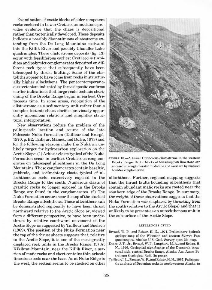
Examination of exotic blocks of older competent rocks enclosed in Lower Cretaceous mudstone pro vides evidence that the chaos is depositional rather than tectonically developed. These deposits indicate a possibly discontinuous olistostrome ex tending from the De Long Mountains eastward into the Killik River and possibly Chandler Lake quadrangles. These olistostrome deposits (fig. 13) occur with fossiliferous earliest Cretaceous turbi- dites and polymict conglomerates deposited on dif ferent rock types that subsequently have been telescoped by thrust faulting. Some of the olis- toliths appear to have come from rocks in structur ally higher allochthons. The penecontemporane- ous tectonisni indicated by these deposits confirms earlier indications that large-scale tectonic short ening of the Brooks Range began in earliest Cre taceous time. In some areas, recognition of the olistostrome as a sedimentary unit rather than a complex tectonic chaos clarifies previously appar ently anomalous relations and simplifies struc tural interpretation.
New observations reduce the problem of the palinspastic location and source of the late Paleozoic Nuka Formation (Tailleur and Brosge, 1970, p. E2; Tailleur, Mamet, and Dutro, 1973) and for the following reasons make the Nuka an un likely target for hydrocarbon exploration on the Arctic Slope: (1) Arkosic clasts typical of the Nuka Formation occur in earliest Cretaceous conglom erates on telescoped allochthons in the De Long Mountains. These conglomerates contain basaltic, gabbroic, and sedimentary clasts typical of al- lochthonous rocks extensively exposed in the Brooks Range to the south. Numerous clasts of granitic rocks no longer exposed in the Brooks Range are found in the conglomerates. (2) The Nuka Formation occurs near the top of the stacked Brooks Range allochthons. These allochthons can be demonstrated regionally to have been thrust northward relative to the Arctic Slope or, viewed from a different perspective, to have been under- thrust by relative southward movement of the Arctic Slope as suggested by Tailleur and Snelson (1969). The position of the Nuka Formation near the top of the thrust sheets suggests that, relative to the Arctic Slope, it is one of the most greatly displaced rock units in the Brooks Range. (3) At Kikiktat Mountain, near the Killik River, a sec tion of mafic rocks and chert contains thin arkosic limestone beds near the base. As at Nuka Ridge to the west, the section seems to be stacked on other
FIGURE 13. A Lower Cretaceous olistostrome in the western Brooks Range. Exotic blocks of Mississippian limestone are encased in conglomeratic mudstone and overlain by massive boulder conglomerate.
allochthons. Further, regional mapping suggests that the thrust faults bounding allochthons that contain abundant mafic rocks are rooted near the southern edge of the Brooks Range. In summary, the weight of these observations suggests that the Nuka Formation was emplaced by thrusting from the south (relative to the Arctic Slope) and that it unlikely to be present as an autochthonous unit in the subsurface of the Arctic Slope.
REFERENCES CITED
Brosge, W. P., and Reiser, H. N., 1971, Preliminary bedrock geology map of the Wiseman and eastern Survey Pass quadrangles, Alaska: U.S. Geol. Survey open-file map.
Dutro, J. T., Jr., Brosge, W. P., Lanphere, M. A., and Reiser, H. N., 1976, Geological significance of the Doonerak struc tural high, central Brooks Range, Alaska: Am. Assoc. Pe troleum Geologists Bull, (in press).
Tailleur, I. L., Brosge, W. P., and Reiser, H. N., 1967, Palinspas tic analysis of Devonian rocks in northwestern Alaska, in
25

Oswald, D. H., ed., International Symposium on the Devo nian System, Calgary, Alberta, 1967, Proceedings, Volume 2: Alberta Soc. Petroleum Geologists, p. 1345-1361.
Tailleur, I. L., and Snelson, Sigmund, 1969, Large scale thrust ing in northwestern Alaska possibly related to rifting of the Arctic Ocean: Geol. Soc. America Spec. Paper 121, p. 569.
Tailleur, I. L., Mamet, B. L., and Dutro, J. T., Jr., 1973, Revised age and structural interpretation of Nuka Formation at Nuka Ridge, northwestern Alaska: Am. Assoc. Petroleum Geologists Bull., v. 57, p. 1348-1352.
Petroleum potential of the Lisburne Group, eastern ArcticSlopeBy Kenneth J. Bird
Preliminary results from a subsurface study (fig. 3 (3)) of the Lisburne Group indicate that the Lisburne has all the geologic characteristics favorable for a primary objective for oil and gas exploration: porous reservoir rock, sealing beds, hydrocarbon source rocks, oil and gas shows (in cluding one oil field), and a variety of structural and stratigraphic traps.
Porous dolomite, the most important reservoir rock, is widespread south and west of Prudhoe Bay. It thins northward by a combination of internal thinning and truncation at the top by the Permian unconformity. This reservoir rock is so widespread and consistent in the study area that its presence northward in the offshore and westward in Naval Petroleum Reserve No. 4 is predicted with a fairly high degree of confidence. However, the areal ex tent of the dolomite in these areas is unknown and it may be quite limited. Sandstone in the middle and upper Lisburne in two coastal wells suggests that perhaps larger areas of sandstone may be present offshore and may compensate for the very thin or absent dolomite reservoir. Oil shows are common in the dolomite and oil is present in the Prudhoe Bay structure beneath the Sadlerochit field.
Mudstone and shale of the Kavik Member of the Ivishak Formation is the most widespread and ef fective seal for the Lisburne. Lower Cretaceous shales unconformably overlying the Lisburne pro vide the seal northeast of Prudhoe Bay. Thin shales and impermeable limestones within the Lisburne may have sealing capabilities and may provide internal seals.
Early Cretaceous shales in contact with the Lis burne northeast of Prudhoe Bay have been inter preted by Morgridge and Smith (1972) as the source of Lisburne oil at Prudhoe Bay based on geochemical analyses and geologic relations.
Elsewhere the relation of source to reservoir is uncertain and will be critical to predicting hy drocarbon occurrence. Coal in the underlying En- dicott Group is a probable source for natural gas. It is speculated that source-rock-quality shales may be present within the Lisburne south of the area of subsurface data and that these shales may be simi lar to those observed in outcropping thrust se quences.
The potential for structural and strat igraphic traps occurs over most of the area studied. Stratigraphic traps may result from the Permian unconformity south and west of Prudhoe Bay, the Early Cretaceous unconformity east of Prudhoe Bay, and possibly by local internal unconformities. Structural traps related to normal faulting may be present in a broad belt along the trend of the Bar row Arch and traps related to large faulted anti clines are present in the foothills of the Brooks Range. As the areas of potential structural and stratigraphic traps overlap, traps formed by com bination of the two mechanisms may occur. The Prudhoe Bay field is an example of a combination trap (Morgridge and Smith, 1972).
REFERENCE CITED
Morgridge, D. L., and Smith, W. B., 1972, Geology and discov ery of Prudhoe Bay field, eastern Arctic Slope, Alaska, in Stratigraphic oil and gas fields classification, exploration methods, and case histories: Am. Assoc. Petroleum Geologists Mem. 16, p. 489-501.
Need to revise and test estimates of northern Alaska coal re sources By I. L. Tailleur and W. P. Brosge
Current speculation on the potential contribu tion to the national energy flow from northern Alaska coals is based on an estimated 120 billion tons of identified coal resources (Barnes, 1967a, b) calculated in 1965 largely from the indirect evi dence of cuttings and electric logs in two wells drilled for oil, and partly from outcrop data, and an equal amount yet to be discovered in known coal- bearing areas (Averitt, 1973, p. 137; 1975, p. 14). Review of the basic data and increased knowledge of regional geology have shown that the estimated total resources should be several times, rather than only twice, the amount of the identified re sources.
The areas for which Barnes calculated the coal within 3,000 feet of the surface and within 6 miles of outcrop- or well-control points aggregate only 7,200 of the 30,000 mi2 of prospective coal lands in
26

the western and central Northern Foothills and Coastal Plain physiographic subdivisions of northern Alaska. The same types of rocks extend westward under the shallow Chukchi Sea (Grantz and others, 1975) and underlie at least another 10,000 mi2 . Recent drilling in northeastern Alaska has penetrated near-surface coal-bearing, though younger, rocks beneath about 10,000 mi2 in that region as well.
The randomness of Barnes's control points suffices for predicting gross hypothetical resources of the 23,000 mi2 he did not assess. However, an average 20-fold difference between concentrations of coal measured in outcrops and in wells makes detailed prediction uncertain. Calculated coal re sources average 5 million tons/mi2 from surface data, 17 million tons/mi2 from surface and subsur face data together, and 100 million tons/mi2 from subsurface data alone. With these figures, hypothetical resources would approximate 120, 390, or 2,300 billion tons and the speculative re sources of the offshore and eastern regions would range from 50-1,000 billion tons each. Based on a brief examination of logs of wells in the eastern region, J. E. Callahan (oral commun., 1975) suggested that the lower figure was the better es timate of the coal there. Without new information, an estimate of total undiscovered resources is at least 220 billion tons, possibly 3,300 billion tons.
The larger, extraordinary figure focuses atten tion on the importance of information from the subsurface it suggests that an area about the size of New York State could contain more coal than the rest of the country put together (Averitt, 1975, p. 15) and on the critical fact that few well data are direct. Concentrations of about 10 percent of the rock column or 340 million tons/mi2 for the Kaolak and Meade wells, the two which are the bases of 76 of the 120 billion tons identified by Barnes, are even more impressive. They suggest that a half century's national energy supply could be recovered from a 12-mile-wide strip along the 65 miles of coastal plain separating the two wells. Such concentrations and quantities seem incredi ble and they may well be excessive. The relatively low cost of a 1,500-3,000-foot hole, between the Kaolak and Meade wells, perhaps concurrently with oil exploration in Naval Petroleum Reserve No. 4, seems a modest investment compared with the value of the information that would to ob tained. Optimistically, it would show trillion-ton total resources, enough to challenge technology to
make use of this storehouse of energy as it has done successfully in the case of huge stores of oil and gas in the same remote and inhospitable physical set ting. Pessimistically, the hole would about halve the identified resource and make the total re sources (280 billion tons) comparable to or less than the estimated in-the-ground resources (Av eritt, 1975, p. 14 and 15) of Colorado, Illinois, Mon tana, North Dakota, or Wyoming, where accessi bility and environment seem generally less ad verse. Either result would significantly alter the basis for speculating how northern Alaska coal could add to the national energy supply in the future.
REFERENCES CITED
Averitt, Paul, 1973, Coal, in Brobst, D. A., and Pratt, W. P., eds., United States mineral resources: U.S. Geol. Survey Prof. Paper 820, p. 133-142.
1975, Coal resources of the United States, January 1, 1974: U.S. Geol. Survey Bull. 1412, 130 p.
Barnes, F. F., 1967a, Coal resources of Alaska: U.S. Geol. Sur vey Bull. 1242-B, p. B1-B36.
1967b, Coal resources of the Cape Lisburne-Colville River region, Alaska: U.S. Geol. Survey Bull. 1242-E, p. E1-E37.
Grantz, Arthur, Holmes, M. L., and Kososki, B. A., 1975, Geologic framework of the Alaskan continental terrace in the Chukchi and Beaufort Seas, in Yorath, C. J., Parker, E. R., and Glass, D. J., eds., Canada's continental margins and offshore petroleum exploration: Canada Soc. Pe troleum Geologists Mem. 4, p. 669-700.
Informal cooperation between U.S. Geological Survey and State of Alaska, Division of Geological and Geophysical Sur veys, in the Brooks Range. By I. L. Tailleur, G. H. Pessel,3 W. P. Brosge, and C. F. Mayfield
Timely completion of projects of both the U.S. Geological Survey and the Alaska Division of Geological and Geophysical Surveys in the Brooks Range is being advanced through informal, but organized, cooperation. In 1975 such cooperation included: Pessel's participation in fieldwork con ducted as part of the North Slope Petroleum pro gram; short visits by Mayfield and E. M. Mac- Kevett, Jr., to prospects on the south flank of the western Brooks Range along the "copper belt" being studied by M. A. Wiltse (Wiltse, 1975; Wiltse and others, 1975); a workshop on dislocated rocks, foreshortening, and geologic history of the north western and north-central Brooks Range foldbelt; and a workshop on framework geology, metamorphism, glaucophane rocks, isotopic dat ing, geophysics (Hackett, 1975), detailed structure
3Alaska Division of Geological and Geophysical Surveys.
27
(Gilbert and others, 1975), and ore deposits of the southwestern Brooks Range.
The Alaska Division of Geological and Geophys ical Surveys has made substantial amounts of geochemical and geophysical data available to the public. Preliminary comparisons of analyses of more than 900 geochemical samples (mainly of stream sediments) collected in 1971-72 from the southwestern and south-central Survey Pass quadrangle (Garland and others, 1975a-g) with draft geologic maps show: (1) correlation of copper and other (locally including antimony, molyb denum, barite, tin, or tungsten) anomalies with the Picnic Creek copper prospect (now undergoing intense private exploration), with a galena pros pect discovered in 1973 (Alaska Division of Geological and Geophysical Surveys, 1973), with the belt of metafelsic and other rocks associated with the massive sulfide deposits, and with the eastward extension of the belt beyond Walker Lake; and (2) numerous anomalies (other than copper anomalies) related to plutonic bodies and associated altered rocks across the central part of the quadrangle.
The Alaska Division of Geological and Geophys ical Surveys (1975a-d) open-filed aeromagnetic maps of the eastern two-thirds of the Baird Moun tains, western two-thirds of the Ambler River, and the adjoining northern part of the Selawik and Shungnak quadrangles. High, south-sloping magnetic relief occurs over the mafic and subordi nate ultramafic rocks along the south edge of the mountains and bordering lowlands (Patton and Miller, 1968; Patton and others, 1968). Lower Cre taceous conglomerate with clasts of igneous rocks produces high magnetic relief over some of its out crop area as mapped by Patton and Miller (1968) in the Waring Mountains, Selawik quadrangle, and what is probably an eastward extension under the Kobuk valley fill. A belt of moderately high magnetic relief in the southeastern Baird Moun tains quadrangle follows the outcrop of low-grade, sparsely fossiliferous pelitic strata and subordi nate mafic igneous bodies that trend northeast ward from the Omar River. Low magnetic relief over the main mass of the Baird Mountains does not discriminate between the rock units recog nized there, nor does the magnetic pattern reflect annular bands of rock units around Hub Mountain in the northeastern Baird Mountains and north western Ambler River quadrangles. An area of relatively high magnetic relief in the north-
central Ambler River quadrangle may outline a body of mafic rocks covered by glacial deposits.
Preparation of an open-file report on analyses of more than 550 geochemical samples collected in 1974 from the eastern Baird Mountains and west ern Ambler River quadrangles is nearly complete. Compilation of 1:63,360- and l:250,000-scale re connaissance geologic mapping in the Ambler River quadrangle is nearly complete. Aeromag netic surveying in 1975 nearly completed cover age of the Brooks Range in the Ambler River, Shungnak, Survey Pass, and Hughes quadran gles; initial printouts (S. W. Hackett, oral com- mun., 1975) show additional features correlative with surface geology.
The U.S. Bureau of Mines contributed signifi cantly to resource knowledge of Brooks Range lands withdrawn under Section 17.d.2 of the Alaska Native Claims Settlement Act of 1971 (T. C. Mowatt, oral commun., 1975). Geological con sultants under contract to the Bureau of Mines to perform mineral evaluations reported (U.S. Bureau of Mines press release, Sept. 2, 1975) im pressive amounts of barite and sulfides at an oc currence, noted during 1968 Geological Survey re connaissance mapping (Tailleur, 1970) in the western De Long Mountains. The prospect has be come known as the Red Dog and lies within a chert-carbonate terrane of Mississippian and Permian-Triassic age, exhumed from beneath a folded stack of allochthonous (thrust) sheets of nearly contemporaneous rocks. The announce ment stimulated late-season examinations by companies but withdrawal restrictions preclude prospecting methods that would test the promise of mineralization away from surface indications.
Until recently, the broad areas of deformed, largely unaltered sedimentary rocks that make up most of the northwestern and north-central Brooks Range were considered to have a low poten tial for introduced concentrations of valuable min erals because similar terranes elsewhere are un common hosts for epigenetic mineral deposits. The discovery of the Red Dog prospect, together with the observations noted below, indicate that the resource potential of the Brooks Range should be assessed by direct means. The following findings may indicate that mineralization took place at other localities as far east as Anaktuvuk Pass:
(1) Localities in the Red Dog area withbrightly stained scars and limonite-staineddrainage channels similar to those produced by
28
weathering of the sulfides at the prospect.(2) Northeastward extensions of this terrane
where erosion along anticlines has breached the overlying allochthonous strata. One small valley (at approx. 68°29' N., 161°44' W.) noted on a helicopter flight in 1975 more than 40 miles northeast of Red Dog exhibited the same discol oration.
(3) Discovery of substantial fluorite in a thin section of fragmented chert collected in 1975 on the south flank of, but at least three allochthon ous sheets higher than, the extension mentioned above.
(4) An incidental report by company geolo gists several years ago of a fist-sized block of fluorite in Mississippian limestone talus on Mount Bupto, north of the main Brooks Range in the Howard Pass quadrangle.
(5) Several large iron-stained zones in a belt of Kanayut Conglomerate along and north of the mountain front between the Kurupa and Anak- tuvuk Rivers. Analyses of geochemical samples from two of these have not been completed. Mobil Oil Corp. released current-direction and
clast-size determinations made by T. J. Donovan (now a member of the U.S. Geological Survey) at outcrops of the Endicott Group (Devonian and Mississippian). These data made possible the prep aration of a map (Donovan and Tailleur, 1975) that quantitatively corroborates an earlier qual itative and empirical assessment of the northerly provenance of these clastic-wedge deposits. Dis persal patterns suggest derivation of the Devonian Kanayut Conglomerate, the dominant clastic unit in the central and eastern Brooks Range, from a westward or northwestward-trending source area and of the Kekiktuk Conglomerate, the basal Mis sissippian formation that transgressed northward onto the provenance of the Kanayut, from a more restricted source near the present International Boundary. Abrupt decrease in clast size within the Kanayut probably reflects structural shortening.
REFERENCES CITED
Alaska Division of Geological and Geophysical Surveys, 1973, Lead-silver occurrence in southwestern Brooks Range: Alaska Div. Geol. Geophys. Surveys, Mines Bull., v. 22, no. 11, p. 3-4.
1975a, Aeromagnetic map, western two-thirds of Am bler River quadrangle, Alaska: Alaska Div. Geol. Geophys. Surveys open-file report no. 76, 3 p., map scale 1:250,000.
1975b, Aeromagnetic map, eastern two-thirds of Baird Mountains quadrangle, Alaska: Alaska Div. Geol.
Geophys. Surveys open-file report no. 77, 3 p., map scale 1:250,000.
1975c, Aeromagnetic map, northeastern part of Selawik quadrangle, Alaska: Alaska Div. Geol. Geophys. Surveys open-file report no. 78, 3 p., map scale 1:250,000.
-1975d, Aeromagnetic map, northwestern part ofShungnak quadrangle, Alaska: Alaska Div. Geol.Geophys. Surveys open-file report no. 79, 3 p., map scale1:250,000.
Donovan, T. J., and Tailleur, I, L., 1975, Map showing paleocur-rent and clast-size data from the Devonian-MississippianEndicott Group, northern Alaska: U.S. Geol. Survey Misc.Geol. Field Studies Map MF-692, scale 1:1,000,000.
Garland, R. E., Eakins, G. R., and Trible, T. C., 1975a,Geochemical analysis of stream-sediment samples frompart of the Survey Pass A-2 quadrangle, Alaska: AlaskaDiv. Geol. Geophys. Surveys open-file report no. 61, 2 p.,map scale 1:63,360.
1975b, Geochemical analysis of stream-sediment sam ples from part of the Survey Pass B-3 quadrangle, Alaska: Alaska Div. Geol. Geophys. Surveys open-file report no. 62, 2 p., map scale 1:63,360.
1975c, Geochemical analysis of stream-sediment sam ples from part of the Survey Pass C-4 quadrangle, Alaska: Alaska Div. Geol. Geophys. Surveys open-file report no. 63, 2 p., map scale 1:63,360.
1975d, Geochemical analysis of stream-sediment sam ples from part of the Survey Pass C-5 quadrangle, Alaska: Alaska Div. Geol. Geophys. Surveys open-file report no. 64, 2 p., map scale 1:63,360.
1975e, Geochemical analysis of stream-sediment sam ples from part of the Survey Pass C-6 quadrangle, Alaska: Alaska Div. Geol. Geophys. Surveys open-file report no. 65, 2 p., map scale 1:63,360.
1975f, Geochemical analysis of rock and stream- sediment samples from the Survey Pass A-3 quadrangle, Alaska: Alaska Div. Geol. Geophys. Surveys open-file re port no. 66, 2 p., map scale 1:63,360.
-1975g, Geochemical analysis of rock and stream-sediment samples from the Survey Pass A-4, A-5, A-6, B-4, B-5, and B-6 quadrangles, Alaska: Alaska Div. Geol. Geophys. Surveys open-file report no. 67. 2 p., map scale 1:63,360.
Gilbert, W. G., Wiltse, M. A., Henning, M. W., Buza, J. W., and Kline, J. T., 1975, Structural geology of Ruby Ridge, Am bler River A-2, B-2 quadrangles, Alaska: Alaska Div. Geol. Geophys. Surveys, Mines and Geol. Bull., v. 24, no. 5, p. 2.
Hackett, S. W., 1975, Regional gravity surveys: Alaska Div. Geol. Geophys. Surveys, Mines and Geol. Bull., v. 24, p. 1-2.
Patton, W. W., Jr., and Miller, T. P., 1968, Regional geologic map of the Selawik and southeastern Baird Mountains quadrangles, Alaska: U.S. Geol. Survey Misc. Geol. Inv. Map 1-530, scale 1:250,000.
Patton, W. W., Jr., Miller, T. P., and Tailleur, I. L., 1968, Regional geologic map of the Shungnak and southern part of the Ambler River quadrangles, Alaska: U.S. Geol. Sur vey Misc. Geol. Inv. Map 1-554, scale 1:250,000.
Tailleur, I. L., 1970, Lead-zinc- and barite-bearing samples from the western Brooks Range, Alaska, with a section on Petrography and mineralogy, by G. D. Eberlein and Ray Wehr: U.S. Geol. Survey open-file report, 12 p., illus., table.
29

Wiltse, M. A., 1975, Geology of the Arctic Camp Prospect, Ambler River, Alaska: Alaska Div. Geol. Geophys. Sur veys open-file report no. 60, 41 p.
Wiltse, M. A., Marsh, S. P., Henning, M. W., and Buza, J. W., 1975, Brooks Range copper belt, southern Ambler River and Survey Pass quadrangles: Alaska Div. Geol. Geophys. Surveys, Mines and Geol. Bull., v. 24, no. 5, p. 2-3.
Northern Alaska coal investigations, western Naval PetroleumReserve No. 4By James E. Callahan
Approximately 46 mi2 in the Oxbow and Look out Ridge synclinal basins (fig. 2 (6) ) were mapped geologically, with composite stratigraphic sections measured along Kokolik River across the Oxbow syncline. Nineteen coal samples were taken from outcrops on Kokolik River and Elusive Creek and along two large tributaries of Avingak Creek. Analyses of the samples by the Bureau of Mines indicate a fairly consistent rank of high volatile B or C bituminous coal in the Oxbow-Lookout Ridge synclinal trend (the two synclines have an echelon relation separated by a small syncline). Analyses of samples taken farther north, along the south flank of the Norseman anticline, suggest a north ward decrease in rank. Relation between weath ered and unweathered samples from equivalent coals farther west indicate that weathering has a significant effect on coking properties in these coals. It is expected that unweathered samples from many of the oxidized beds sampled in 1975 would exhibit coking properties as well as a sig nificant increase in rank over the surface samples.
Hydrological studies for the Alaskan Air Command By R. J. Madison
Results of geophysical surveys made in August 1975 at Cape Lisburne (fig. 2(7)) indicate that the area beneath the water-collection gallery has thawed to a depth of between 40 and 50 feet. This area is suggested as the best potential for future water supply development at the Cape Lisburne facility.
Interpretation of depositional environments in the Fortress Mountain Formation, central Arctic Slope By R. E. Hunter and J. E. Fox
Middle Cretaceous clastic rocks shed northward from the Brooks Range erogenic belt may contain a substantial amount of the hydrocarbon potential of Naval Petroleum Reserve No. 4 (NPR-4) and adjacent areas of the Arctic Slope and Chukchi Sea. Effective exploration of this potential may
depend strongly on assessing environments of deposition and distribution of potential reservoir facies in terms of modern concepts of clastic sedimentation. In order to begin this type of as sessment, J. E. Fox, of the Reservoir Studies Group, Branch of Oil and Gas Resources, and R. E. Hunter, of the Coastal Processes Group, Office of Marine Geology, joined I. L. Tailleur and C. G. Mull on the North Slope Petroleum field party for 2 weeks in late July 1975. A number of exposures of the Fortress Mountain Formation and related rocks were examined, and a preliminary recon naissance was made of representative exposures of other middle Cretaceous rocks on the central and western Arctic Slope.
The Fortress Mountain Formation of Albian age crops out extensively on Ekakevik Mountain (fig. 2 (8) ) very close to the source area, the Brooks Range erogenic belt. A detailed stratigraphic sec tion was not measured, but three distinctly differ ent clastic facies were recognized.
The uppermost part of the formation at Ekake vik Mountain is less than 35 m thick and is domi- nantly medium- to coarse-grained sandstone. Conglomerate beds make up less than 10 percent of the unit. The depositional environment of the uppermost part of the formation is probably shal low marine and wave-worked. This interpretation is based on the predominant low-angle, gently len ticular cross-bedding (Imbrie and Buchanan, 1965; Goldring and Bridges, 1973; Harms, 1975, p. 87-88), high degree of pebble segregation (Clifton, 1973), and presence of marine pelecypods. A flu vial origin seems unlikely because of the marine pelecypods and the absence of steeply dipping cross-bedding. A turbidite origin seems unlikely because of the absence of grading or other evidence of rapid deposition by waning currents of high density.
The middle part of the formation at Ekakevik Mountain makes up the bulk of the formation and consists largely of conglomerate; sandstone and pebbly sandstone make up less than 10 percent of the exposed rocks. The clasts of the conglomerates range from pebble to cobble size; some beds contain boulders. The beds are relatively tabular and are mostly less than 1 m thick. This main part of the formation was deposited by currents containing sediment moved largely by traction, probably in a braided stream or alluvial fan environment. This interpretation is based on the thinness of the con glomerate beds and the steepness of the crossbed-
30

ding that occurs in many of the sandstone beds. A meandering stream origin seems unlikely because of the absence of extensive channeling or fining- upwards sequences and because of the overall coarseness of the deposit. The segregation of clasts of different sizes into discrete beds is not distinct enough to suggest a wave-worked environment (Clifton, 1973). Evidence for deposition by turbid ity currents or by other kinds of sediment gravity flows is lacking. None of the types of internal or ganization typical of "resedimented" conglomer ate beds (Walker, 1975) were noted, and re sedimented conglomerate beds are generally thicker than beds in this outcrop.
The lower part of the formation is exposed on the north side of Ekakevik Mountain. Only the most resistant units, forming about half of the total section, are exposed. These units are composed of conglomerate, are tabular in form, and range in thickness from about 3 to 6 m. The conglomerate units differ from those higher in the sequence on the south side of the mountain (stratigraphic in terpretation of Tailleur) by the poorer develop ment of bedding within the lower units, by their coarser clast size, and by their poorer sorting. These conglomerates have characteristics ap proaching those of Walker's (1975) disorganized- bed model. The chaotic nature of disorganized-bed deposits suggests very rapid deposition from a dense sediment gravity flow, such as a debris flow. As debris flows occur on alluvial fans and on sub marine slopes, the environmental implications of such deposits are not very restrictive.
In summary, the Fortress Mountain Formation at Ekakevik Mountain is interpreted as represent ing initial very rapid deposition of gravels in an unknown environment, followed by the deposition of braided stream and (or) alluvial fan gravels and sands, followed in turn by a transgression of the sea and deposition of nearshore marine sands. In this area the formation as a whole fines upward.
Characteristics of the sandstones in the upper part of the Fortress Mountain Formation exposed on Castle Mountain (fig. 2 (10)) indicate slow dep osition in a dominantly fluvial or shallow marine environment, whereas on the East Fork of the Etivluk River (fig. 2 (9)), the exposed Fortress Mountain Formation consists of graded conglom erate beds deposited by turbidity currents.
The occurrence in close geographic proximity of facies of one formation ranging from undoubted turbidites to a facies that is either shallow marine
or nonmarine is not surprising in an active tec tonic setting. Similar juxtapositions of facies are common in Upper Cretaceous deposits along the California and Oregon coasts (see, for example, Lowe, 1972). Changes in depositional environ ment in such settings can come about by tectonic movements, by large-scale slumping, by rapid in filling of basins, or by rapid progradation of shelves.
REFERENCES CITED
Clifton, H. E., 1973, Pebble segregation and bed lenticularity in wave-worked versus alluvial gravel: Sedimentology, v. 20, p. 173-187.
Goldring, Roland, and Bridges, Paul, 1973, Sublittoral sheet sandstones: Jour. Sed. Petrology, v. 43, no. 3, p. 736-747.
Harms, J. C., 1975, Stratification and sequence in prograding shoreline deposits, in Harms, and others, Depositional en vironments as interpreted from primary sedimentary structures and stratification sequences: S.E.P.M. Short Course No. 2, Lecture Notes, p. 81-102.
Imbrie, John, and Buchanan, Hugh, 1965, Sedimentary struc tures in modern carbonate sands of the Bahamas: Soc. Econ. Paleontologists Mineralogists Spec. Pub. No. 12, p. 149-172.
Lowe, D. R., 1972, Submarine canyon and slope channel sedimentation model as inferred from Upper Cretaceous deposits, western California, in Stratigraphy and sedimen- tology, Section 6: Internat. Geol. Cong., Proc., no. 24, p. 75-81.
Walker, R. G., 1975, Generalized facies models for re sedimented conglomerates of turbidite association: Geol. Soc. America Bull., v. 86, p. 737-748.
Metamorphism in the southwestern Brooks Range By C. F. Mayfield
Preliminary results of a continuing examina tion of field and petrologic data from rocks col lected in the Baird Mountains and Ambler River quadrangles (fig. 3 (8)) indicate a belt of sedimen tary, volcanic, and plutonic rocks along the south edge of the Brooks Range (Alaska Division of Geological and Geophysical Surveys, 1973, p. 6-8) as much as 40 km wide that has been regionally metamorphosed to the greenschist facies. Typical pelitic schists contain quartz, muscovite, albite, chlorite, ±chloritoid, ±calcite, ±tourmaline, ± magnetite, ±carbon. Metamafic rocks most com monly contain albite, chlorite, sphene, ±am- phibole, ±epidote, ±quartz, ±pyrite, or magnetite. Granitic orthogneisses contain quartz, potassium feldspar, albite, muscovite, ±biotite, ±zircon, ±py- rite, or magnetite. Garnet-bearing zones occur dis- continuously in the southeastern Ambler River and northeastern and central Baird Mountains
31

quadrangles. Retrograded glaucophane, suggest ing an early stage of high-pressure metamor- phism, occurs in some metamafic and a few pelitic layers (Alaska Division of Geological and Geophysical Surveys, 1973, p. 34-36) within the garnet zone in the southeastern Ambler River quadrangle and is preserved only in metamafic bodies from the garnet zones of the central and northeastern Baird Mountains quadrangle. A gradual decline of metamorphic grade occurs both north and south of the schist belt with scattered mafic rocks showing pumpellyite grade metamorphism trailing off to a terrane composed of virtually unmetamorphosed basaltic and sedimentary rocks.
Although the petrofabrics have not been studied extensively, the belt appears to be polymetamor- phic. At least two superimposed and widely diver gent planes of schistosity commonly occur both in outcrop and thin section. Folding as well appears to be highly complex. Lack of comprehensive data over the wide geographic area prevents further generalizations.
Light-colored orthogneisses scattered through out the metamorphic belt have a wide variety of compositions ranging from quartz-microcline- albite-muscovite gneisses to quartz-albite- muscovite or albite-muscovite gneisses. Alkalic metaigneous rocks occur as small stocks, plugs, and dikes exclusively in the Kallarichuk Hills of the central Baird Mountains quadrangle, and partly metamorphosed granitic rocks of the larger plutons north of the schist belt in the Ambler River country are believed to be late-stage synkinematic intrusions (90-100 m.y.) in the metamorphic terrane.
Potentially significant sulfide mineralization of high-grade copper, lead, zinc, and silver occurs within the garnet zone in the eastern Ambler River quadrangle. Proven reserves are estimated to exceed $2 billion (Hawley, 1973, talk before Alaska Geological Society), with continuing ex ploration holding good prospect for finding addi tional reserves. Most geologists consider the sulfides to be of volcanogenic origin (Wiltse, 1975).
REFERENCES CITED
Alaska Division of Geological and Geophysical Surveys, 1973, Annual report: Alaska Div. Geol. Geophys. Surveys, 57 p.
Wiltse, M. A., 1975, Geology of the Arctic Camp prospect, Ambler River quadrangle, Alaska: Alaska Div. Geol. Geophys. Surveys open-file report 60, 41 p.
Biostratigraphy of the Permian and Lower Triassic rocks in the Philip Smith Mountains quadrangle. By Robert L. Detterman
The Permian and Lower Triassic rocks of the Sadlerochit Group are the main reservoir beds at Prudhoe Bay. For this reason, detailed strati- graphic studies of these rocks are of significance to the country. Many exposures in the Mount Michel- son and Demarcation Point quadrangles were in vestigated between 1969 and 1971; some of the results have been published (Detterman, 1970, 1974; Detterman and others, 1975).
In 1975 the investigations were continued in the Philip Smith Mountains quadrangle (fig. 3 (6)) in an attempt to see if a correlation could be made between the Sadlerochit Group and the Siksikpuk Formation (Patton, 1957) or to determine if the two sequences were entirely different and had been juxtaposed by thrust faults within the Brooks Range. Fourteen sections were measured and sampled in detail and some preliminary conclu sions can be made at this time.
(1) There is no significant change in lithology between sections in adjacent thrust blocks which would indicate either that there was only minor dislocation or that the beds are remarka bly uniform over a wide area.
(2) Beds within some of the thrust blocks pre viously mapped as Siksikpuk Formation (Lath- ram, 1965) contain rocks that are the time equivalent of the Siksikpuk but have few lithologic characteristics of that formation. They are perhaps best considered as a new, as yet unnamed, member of the Echooka Forma tion of the Sadlerochit Group.
(3) The first evidence of Permian volcanic rocks in northern Alaska was found. Two localities were investigated, one near Porcupine Lake in the Arctic quadrangle, the other near the Ivishak River in the Sagavanirktok quad rangle. Flows with some pillow structures, tuffs, and volcanic breccia were identified. These rocks locally contain an Early Permian brachiopod fauna.Lithologically the Permian strata in the Philip
Smith Mountains quadrangle can be divided into a lower and upper part that can be correlated with the Echooka and Ivishak Formations of the Sad lerochit Group (Detterman and others, 1975). The lower part is about 250-700 feet (76-213 m) thick and contains massive limestone, a yellowish weathering sequence of thin calcareous siltstone
32

and shale with thin limestone interbeds, and in the northeastern part of the quadrangle, a dark quartzite and quartzitic siltstone. The massive limestone with an Early Permian fauna is believed to be correlative with the Joe Creek Member of the Echooka Formation and the dark quartzite and quartzitic siltstone are considered part of the Ikiakpaurak Member. The yellow-weathering cal careous siltstone and shale with limestone inter beds is probably the time-equivalent of the Siksik- puk Formation but should be considered a new member of the Echooka Formation. Locally the siltstone and shale sequence has a slight red and green cast, but the bright variegated shale and chert of the Siksikpuk are missing. Fossils found at the base and throughout this lower part are mainly of Early Permian age and include the brachiopods Attenuatella sp., Chonetes sp., Anidanthus sp., and the gastropod Straparollus sp., according to J. T. Dutro, Jr. (oral commun.). Other forms are probably present but the collec tions are not completely identified at this time. The early middle Permian (Kazanian) suite of fos sils characteristic of the Echooka Formation in the northeast was found overlying the Early Permian fossils in a section measured on a tributary of the Saviukviayak River.
The upper part of the sequence in the Philip Smith Mountains quadrangle is primarily dark thin-bedded siltstone and shale commonly lami nated and containing concretions. These strata are believed to correlate with both the Kavik and Fire Creek Siltstone Members of the Ivishak Forma tion. The Ledge Sandstone is present between the two shaly units in the northeastern part of the quadrangle but pinches out southwestward. This part of the section is about 800-2,000 feet (244- 610 m) thick. The few fossils found in these rocks have not been identified but appear to be Early Triassic forms similar to those found in the type area.
The contact between the lower part of the Sadle- rochit Group and the underlying Lisburne Group is disconformable. The Ivishak Formation rests disconformably to unconformably on the Echooka Formation and is overlain disconformably to un conformably by the Shublik Formation.
The Permian volcanic sequence is not clearly understood. At the locality near the Ivishak River a section of thin, silty, rusty weathering limestone and tuff apparently conformably overlies the Lis burne Group. A 4-foot (1.22 m) bed of limestone
with brachiopods,and coral overlies this unit and in turn is overlain by light- to dark-green, fine grained flows with amygdules, and pillows. The Lisburne is thrust over the Permian volcanics. The section at Porcupine Lake is allochthonous on Lower Cretaceous (Neocomian) beds. It consists mainly of about 200 feet (61 m) light-grayish- green, fine- to medium-grained flows, a thin unit of volcaniclastic rock, and limestone containing vol canic debris and Permian fossils. The sequence includes some pillow structures.
REFERENCES CITED
Detterman, R. L., 1970, Sedimentary history of Sadlerochit and Shublik Formations in northeastern Alaska, in Adkison, W. L., and Brosge, M. M., eds., Proceedings of the geologic seminar on the North Slope of Alaska: Los Angeles, Pacific Sec. Am. Assoc. Petroleum Geologists, p. 01-013.
1974, Fence diagram showing lithologic facies of the Sadlerochit Formation (Permian and Lower Triassic), northeastern Alaska: U.S. Geol. Survey Misc. Field Studies Map MF-584.
Detterman, R. L., Reiser, H. N., Brosge, W. P., and Dutro, J. T., Jr., 1975, Post-Carboniferous stratigraphy, northeastern Alaska: U.S. Geol. Survey Prof. Paper 886, p. 46.
Lathram, E. H., 1965, Preliminary geologic map of northern Alaska: U.S. Geol. Survey open-file report, 2 sheets, scale 1:1,000,000.
Patton, W. W., Jr., 1957, A new Upper Paleozoic formation, central Brooks Range, Alaska: U.S. Geol. Survey Prof. Paper 303-B, p. B41-B43.
EAST-CENTRAL ALASKA
Geochemical reconnaissance of the Chandalar quadrangle By Sherman P. Marsh
Geochemical investigations in the Chandalar quadrangle (fig. 3 (7)) were made during the 1975 summer field season to aid in the appraisal of the resource potential of the quadrangle under the AMRAP program. Fine-grained stream-sediment and pan-concentrate samples were taken at 845 localities; bryophyte samples were collected at more than 400 of the stream sites. In addition, rocks were sampled at 89 localities. With the 365 sites sampled previously, almost 1,300 locations constitute the sample population.
Semiquantitative spectrographic analyses and atomic absorption analyses for zinc have been completed for all stream-sediment samples. Pre liminary examination of these data indicate the following:
(1) A potential molybdenum resource is nearthe head of Geroe Creek in the north-centralportion of the quadrangle. Rocks in this area,
33

underlain mainly by metamorphosed Paleozoic and Mesozoic granitic rocks, are highly altered and contain abundant sulfide minerals. Streams draining this area contain from 5 to 15 parts per million (ppm) molybdenum and a series of rock samples from the main altered area contain as much as 700 ppm molybdenum. Rock specimens from the most highly altered and sulfide-bearing area appear to be quartz-white mica-sericite schists. Most of the altered area is stained red and brown from weathering sulfides.
(2) Two zinc belts are clearly denned. One, in the northern part of the quadrangle, is as sociated with Devonian metasediments, mainly black slate, phyllite, and phyllitic siltstone; the other, in the south-central part of the quad rangle, is apparently associated with dark-grey to black quartz-muscovite schist, also of Devo nian age. These lithologies are similar to lithologies associated with volcanogenic min eral deposits farther west in the Ambler River quadrangle. The northern belt has small areas of greenstone in its eastern half.
(3) A belt of previously known skarn deposits was extensively sampled in a cooperative pro gram with the State of Alaska. These skarns trend northeast, form a discontinuous belt ap proximately 40 km long, and appear to be as sociated with a sill-like intrusive. Geochemical sampling of several of the skarns indicates high copper and molybdenum contents at the south west end of the belt trending to high lead and silver contents at the northeast extension.
(4) Streams in the Chandalar quadrangle have a relatively low pH, between 4.5 and 5.5. This is significant in relation to copper, as copper will remain in solution under these somewhat acid conditions, which may account for the somewhat low copper values in the stream- sediment samples.
(5) Rock sampling of a small ultramafic body near Boatman Pass in the southwest corner of the quadrangle showed no platinum group metals.
Geohydrology of the Fairbanks North Star Borough By Gordon L. Nelson
Observation well data from the floodplain indi cate that major recharge of the alluvial aquifers is from the Tanana River (fig. 2 (15)). Sparse data from wells in the fractured schist aquifer of the uplands indicate water level declines of 2-5 feet
(0.6-1.5 m) over the summer and as much as 15 feet (4.6 m) during the past 3 years. Aerial photog raphy taken during May delineates several major surface icings on small streams in the area.
Reconnaissance geologic mapping in the eastern Big DeltaquadrangleBy Helen L. Foster and Florence R. Weber
Reconnaissance geologic mapping and geochem- ical sampling have now been completed for approx imately the eastern half of the Big Delta quad rangle (fig. 3 (12)) and a reconnaissance geologic map of the Big Delta A-l and B-l quadrangles published (Weber and others, 1975). Analyses of the geochemical samples are not yet complete.
Several groups of metamorphic rocks have been identified and mapped (fig. 14). The largest group extends southeast into the Eagle and Tanacross quadrangles. It consists primarily of quartz-biotite gneiss and schist metamorphosed to epidote- amphibolite and amphibolite facies. Feldspathic augen gneiss is abundant, and some amphibole gneiss and schist is included. Many rocks are gar- netiferous. The protoliths for this group of metamorphic rocks were dominantly sedimentary and very quartzitic. Carbonate layers are rare and fossils have not been found. These rocks may have been part of the late Precambrian Windermere Formation. The very quartzitic composition of this group of rocks is more like that of the Windermere Formation than the known Paleozoic rocks to the north or to the east in Canada.
A second major group of rocks is dominantly greenschist. The rocks are mostly quartz-mica schist with chlorite and(or) epidote imparting a green color. Metamorphic grade is greenschist facies. Coarse- to fine-grained metamorphosed grit, a common rock type throughout the unit, is used to identify the unit. Marble, quartzite, and schistose greenstone are other interlayered rock types. This metamorphic unit may be allochtho- nous as it seems to be bordered on the north by an irregular fault contact. The greenschist unit may extend eastward into the Eagle quadrangle and southeastward into the Yukon Territory. The age of the protoliths of the greenschist unit is unknown in the Big Delta quadrangle. In the Eagle quad rangle and in the Yukon Territory, rocks that may be correlative are probably of Paleozoic age.
At least two additional groups of greenschist facies rocks were distinguished in the northern part of the quadrangle (not differentiated in fig.
34

EXPLANATION
Holocene
Felsic intrusive and extrusive rocks
Paleozoic and (or) Precambrian
64 C 15' Quartz-biotite gneiss and schist, augen gneiss, and amphibolite gneiss. Symbols indicates altered gneiss
Faults and suspected faults
A,B,C
Mineralized localities
144° 0 10 KILOMETRES
FIGURE 14. Reconnaissance geologic map of the eastern Big Delta quadrangle.
14). They are identified by characteristic black and maroon quartzites, abundant carbonate layers, lack of grit layers, and some structural charac teristics. These rocks may be allochthonous.
Serpentinized ultramafic masses are associated primarily with the greenschist unit and are tecton- ically emplaced. Some masses may be in thrust contact with the greenschist unit. The largest of these ultramafic bodies was examined by Alien L. Clark several years ago (oral commun., 1972; writ ten commun., 1975). These rocks are essentially structureless masses of almost completely serpen- tinized peridotite. They are cut by numerous diabase dikes and bordered in places on the south and southeast sides by amphibole gneiss. On the
north and northeast sides is an orange-brown quartz-carbonate zone, the most extensive and most continuous zone of quartz-carbonate rock known to be associated with any of the ultramafic bodies of the Tanana Upland. In the southeastern part of the quadrangle, several small masses of ultramafic rocks are enfolded in the amphibolite facies rocks. They are well foliated and are be lieved to have a different history than the large structureless masses to the north.
Examination of the Shaw Creek fault confirmed data obtained from the study of air photographs and information derived from a previous recon naissance flight that there has been recent move ment along it in the northwest corner of the Eagle
35

quadrangle and in the northeast corner of the Big Delta quadrangle. A small pingo and sag ponds are present along the trace of the fault where it is active. To the southwest, the fault is less conspicu ous and no indications of any recent movement were observed.
Preliminary geochemical results and mapping suggest that the eastern part of the Big Delta quadrangle is mineralized to some extent, but not enough data are yet available to determine whether or not there are promising exploration targets. A fairly extensive altered zone has been mapped around a biotite-quartz monzonite intru sion. Locally, anomalous values in copper, lead, tin, antimony, silver, and zinc were found in the rocks (A, fig. 14).
Another zone of alteration is found to the north in association with a small pluton. Anomalous values for gold, silver, tin, lead, zinc, copper, and antimony were found in some of these altered rocks (B, fig. 14).
One area (C, fig. 14) is cut by a number of small mineralized quartz veins carrying silver and as much as 2 percent copper.
REFERENCE CITED
Weber, F. R., Foster, H. L., Keith, T. E. C., and Cantelow, A. L., 1975, Reconnaissance geologic map of the Big Delta A-l and B-l quadrangles, Alaska: U.S. Geol. Survey Misc. Field Studies Map MF-676.
WEST-CENTRAL ALASKA
Trace-element composition of biotite from a tin-granite com plex, Seward Peninsula By Travis Hudson and R. E. Mays
One of the Late Cretaceous granite plutons of northwestern Seward Peninsula that is spatially and genetically associated with tin mineralization (a tin-granite) is the biotite granite complex ex posed in the Serpentine Hot Springs (fig. 2 (14)) area. This complex is an epizohal composite stock in which several textural facies have been iden tified and mapped (Hudson, 1975). The textural facies were sequentially developed during frac tional crystallization of the pluton and even though several mineralogic and chemical varia tions are related to the facies sequence, one dis tinctive general characteristic of the complex is the average trace-element composition of biotite.
The results of semiquantitative spectrographic analyses of 15 separates of unaltered primary bio tite, including representative materials from each
textural facies, are summarized in table 1. For purposes of comparison, this table includes the calculated averages and the ranges of trace- element concentrations reported by Lovering (1972) for biotites separated from some western United States granites and quartz monzonites. Compared with the data reported by Lovering, the biotites from the granite complex in the Serpen tine Hot Springs area have a distinct trace- element composition that is characterized by two different element suites. The first suite includes those elements with high (enriched) concentra tions Be, Nb, Pb, Sn, Zn, and Li the second those with low (depleted) concentrations Ba, Co, Cr, Ni, Sc, V, and Y. Zirconium appears to be part of the depleted suite but since zircon inclusions may play a role in the distribution of this element, the data in table 1 are inconclusive without addi tional petrographic information. The copper aver ages are about the same for the two different bio tite groups but the range of values for the biotites from the Serpentine Hot Springs area is narrower. The degree of enrichment for some of the elements is spectacular: the lowest values for tin, zinc, and lithium in biotites from the Serpentine Hot Springs area are equal to, or greater than, the highest values for these elements in biotites studied by Lovering.
TABLE 1. Average and range of trace-element abundances in biotites from some felsic intrusive rocks in the western United States and from the Serpentine Hot Springs area (all data in ppm)
Western United States 1 Serpentine Hot Springs area
Element Average Range Average Range
Concentration
factor2
Ba__1,925 Be_____0.5 Co ____50 Cr___120CuNbNiPbSc_SnSrV _Y__ZnZr_Li
39 _46
.170
__64 _313
__75 .190 __34
300-5,000 0-2
20-100 7-300 5-200 0-150
15-500 0-70 0-150 0-50
10-300150-700
0-3000-500
15-500 0-300
2852
201436
1759
5217
1751071
9920
22,000
70-3000-105-303-20
10-7070-5000-15
15-20015-3050-50010-150-1000-50
700-1,0000-30
1,000-3,000
0.1484
.4
.12
.923.8
.15.2
.1018
.16
.27
.212
.0160
'Calculated from data reported by Lovering (19721 for 28 biotites separated from seven intrusive complexes of quartz monzonite and granite composition.
2Average Serpentine Hot Springs area/average western United States.
36

Much work has been done to clarify the trace- element geochemistry of tin-granites and their constituent minerals; the data of table 1 help to confirm many general relations identified by other workers (for example, Bradshaw, 1967; Odikadze, 1967; Sainsbury and others, 1968; Stemprok, 1971; and Groves, 1972). But because the calcu lated averages in table 1 characterize the trace- element composition of the granite complex of the Serpentine Hot Springs area as a whole and the data are for a relatively large suite of elements, they provide the basis for making some interpreta tions concerning the origin of the tin-granite magma. In this regard, the important aspect of the trace-element data is the nature of the enriched and depleted element suites. The enriched suite, for the most part volatiles, are those elements that can be considered fugitive; they are not readily incorporated in mineral structures during mag- matic crystallization. The depleted suite, on the other hand, includes those elements that readily enter mineral structures, in particular mafic min eral structures, during magmatic crystallization. The fact that the granite complex is intrinsically rich in fugitive elements and depleted in the other element suite indicates that it was originally emplaced as a highly fractionated residual magma developed by fractional crystallization of a larger batholith. After emplacement of this "first-order" residual magma, it underwent its own episode of fractional crystallization and generated "second- order" residual melts, a separated aqueous phase, and tin mineralization (Hudson, 1975, and unpub lished data). With respect to tin-granites in gen eral, the proposed first (batholithic) fractionation stage in the evolution of tin-granite magmas is distinctly separate from the final fractionation stage that develops composite plutons such as that of the Serpentine Hot Springs area and leads di rectly to tin mineralization. This complex, two- cycle magma generation-fractionation process, is a feasible origin for the tin mineralized areas of the Seward Peninsula and may help explain critical regional relations in other parts of the world where tin mineralization is associated with felsic mag matic processes.
REFERENCES CITED
Bradshaw, P. M. D., 1967, Distribution of selected elements in feldspar, biotite, and muscovite from British granites in relation to mineralization: Inst. Mining and Metallurgy Trans., v. 76B, p. 137-148.
Groves, D. I., 1972, The geochemical evolution of tin-bearing granites in the Blue Tier Batholith, Tasmania: Econ. Geol ogy, v. 67, p. 445-457.
Hudson, Travis, 1975, The granite complex of the Serpentine Hot Springs area, Seward Peninsula, Alaska: Geol. Soc. America Abs. with Programs, v. 7, no. 3, p. 327-328.
Levering, T. G., 1972, Distribution of minor elements in biotite samples from felsic intrusive rocks as a tool for correlation: U.S. Geol. Survey Bull. 1314-D, 29 p.
Odikadze, G. L., 1967, Distribution of tantalum, niobium, tin, and fluorine in micas from granitoids of the greater Caucausus and the Dzirula Crystalline Massif: Geochem. Internat., v. 4, p. 754-763.
Sainsbury, C. L., Hamilton, J. C., and Huffman, Claude, Jr., 1968, Geochemical cycle of selected trace elements in the tin-tungsten-beryllium district, western Seward Penin sula, Alaska A reconnaissance study: U.S. Geol. Survey Bull. 1242-F, 42 p.
Stemprok, Miroslav, 1971, Petrochemical features of tin- bearing granties in the Krusnee Hory Mountains, Czech oslovakia: Japan Soc. Mining Geologists, Spec. Issue 2, p. 112-118.
Revised interpretation of regional geological controls ofmineralization in southwest Seward Peninsula, west-centralAlaskaBy C. L. Hummel
Southwest Seward Peninsula (fig. 3 (9)) has yielded three-fourths of the placer gold produced from the peninsula and contains most of the known lodes from which it was derived (Hummel, 1975). -The distribution of nearly all of the primary and secondary mineral deposits in the region can now be correlated with major structures; this provides the basis for reinterpretation of the regional geological controls of the primary mineralization and reevaluation of the potential for both types of deposits in it.
Elements of nearly all of the major aspects of the geology of Seward Peninsula occur in the south west part, and those most closely associated with the gold-bearing deposits are best represented and exposed there. Current investigations comprise topical studies throughout the region and compila tion of the bedrock geology of a large part of it. The results of the work which are most concerned with regional geologic controls of the primary minerali zation are summarized below and depicted in figure 15.
Nearly all of the bedrock of southwest Seward Peninsula is composed of regionally metamor phosed rocks which can be readily divided into lower and higher grade terranes. The lower grade rocks reflect both older and younger structures, whereas the higher grade rocks reflect only the younger structures. Most of both the higher and
37

EXPLANATION
YOUNGER STRUCTURES OLDER STRUCTURES
1. Kigluaik Uplift and Arch2. Kigluaik boundary faults3. Anvil-Hunker fault4. California Creek fault
5. Solomon River antiform6. Bonanza River synform7. Snake River antiform8. Teller antiform
I I I I40 KILOMETRES
FIGURE 15. Major structures and mineralized areas (stippled) in southwest Seward Peninsula.
lower grade metamorphites are metasediments. Those of higher grade include orthogneiss bodies from which whole-rock Rb-Sr ages of 750 m.y. have been obtained (Sainsbury, 1975, p. 16-17) and are probably the oldest rocks on Seward Peninsula. On the basis of gross composition, phys ical character, and regular metamorphic transi tion, they can be correlated with a thick suite of metasedimentary schist that constitutes the basal portion of the lower grade sequence. These basal rocks are overlain by thick sections of schist and marble that differ markedly from them in bulk composition and, in addition, contain abundant metamafic bodies. Like their higher grade coun terparts, the basal metasediments are inferred to be among the oldest of the peninsula. The ages of the overlying metalayered rocks and their in cluded greenstone masses have not been deter mined; however, some, perhaps much, of the metacarbonate may be of Paleozoic age (Sainsbury, 1975, p. 20).
On the basis of the distribution, configuration, and attitude of the basal and overlying rocks mak ing up the lower grade metamorphites, deformed remnants of four northward-trending major folds have been delineated in southwest Seward Penin sula. Of particular importance for this purpose are
three northward-trending belts of basal rocks; in the absence of adequate information concerning the true stratigraphic relation of these and the overlying rocks, the folds have been designated antiforms with axes near Teller and along the Snake and Solomon Rivers, respectively near Nome and Solomon (fig. 15). For the same reason, the fold between the last two antiforms has been named the Bonanza River synform.
A variety of evidence indicates that the contact between the basal, lower grade metamorphites and those overlying them is a major zone of move ment, probably the principal and most widespread of numerous thrust faults in the lower grade ter- rane. From the same evidence, it is clear that this thrust fault, together with others in the rocks above and below it has been folded and regionally metamorphosed along with, and to the same de gree, as the lower grade rocks in which it lies. The basic geologic framework of the lower grade bed rock of southwest Seward Peninsula thus consists of thick sequences of basal and overlying, mainly metalayered rocks, and more or less extensive thrust sheets of them, all of which have been folded and regionally metamorphosed along northward trends. The only indication of an age for the defor mation that produced these older structures is a date of 100 m.y. obtained from K-Ar determina tions on biotite (Sainsbury, 1975, p. 6-7). This probably represents only a phase of a long-lived sequence of events.
The older structures of southwest Seward Peninsula were subsequently strongly deformed and, in part, destroyed by later tectonic activity that produced the youngest geologic features in the region. The dominant of these is the eastward- trending welt marked by the Kigluaik and Ben- deleben mountain ranges, especially the normal- fault-bounded Kigluaik Uplift, which constitutes the most recent tectonic feature in the region. Sub ordinate structures of the uplift include the eastward-trending Kigluaik Arch in it and the belt of lower grade metamorphites along its southern margin (Hummel, 1960, p. B33-B35) that consti tutes the most strongly deformed portion of the northward-trending fold relicts south of the uplift. From the size and breadth of the older fold rem nants, it is safe to assume that they once extended northward entirely across central Seward Pen insula and that their medial portions were up lifted and destroyed over the eastward-trending Kigluaik-Bendeleben welt. The duration of the de-
38

formation that produced the younger structures is not known; all that can be said with certainty is that Pleistocene glacial deposits have been cut by the north boundary fault of the Kigluaik Uplift, and so manifests it as still active.
The older folds and thrust sheets are also cut and deformed by another system of younger structures, major northeast-striking and subordinate northwest-striking transcurrent faults and frac tures. The Anvil-Hunker fault and California Creek en echelon faults are the principal features of the system (fig. 15). On the basis of similarity of trend and regional proximity, the system is thought to be related to the Kaltag Fault; assum ing this relation, the age of the deformation that produced them has been dated as Late Cretaceous to Tertiary (Patton and Hoare, 1968, p. D152- D153.
The occurrence of gold-bearing placers in southwest Seward Peninsula is sporadic; their areal association with certain types of rocks was established in an empirical fashion during the first geological investigations there (Collier and others, 1908, p. 113), and confirmed by the results of the recent mineral survey of the region by Sainsbury (1975, p. 68). Both the earlier and the later work ers inferred possible syngenetic and epigenetic origins for the deposits from which the gold was derived, a syngenetic origin from the rocks with which the deposits were associated and an epigenetic origin through their localization along contacts between rock units. The same general relations have been reconfirmed during the cur rent investigations and several additional factors can now be integrated with them: (1) lodes and altered rocks of two ages in the region, (2) the association of these and the gold placers with rocks now known to make up the basal part of the lower grade metamorphites, and (3) the distribution of most of both the primary and secondary mineral deposits, and the basal rocks along the axes of major antiforms. Additional information indicates that the preferential regional distribution of all of the mineral deposits results from the combined effects of several primary and many of the sec ondary factors: (1) many of the known lodes occur along the principal, folded thrust zone between the basal and overlying lower grade rocks and were regionally metamorphosed with them; (2) nearly all of the remaining lodes occur in and along the northeast-striking transcurrent faults or with the subordinate northwest-striking faults and frac
tures related to them; (3) later tectonic activity destroyed parts of the older folds, thrusts, and mineral deposits over the Kigluaik Uplift; (4) older lodes were first exposed along antiforms and gold from them was reworked in trunk drainage sys tems with northward trends inherited from them; (5) most gold placers first formed in these drain ages were destroyed by glaciation and those formed since are the result of glacial, alluvial, and marine processes; and (6) the richest placers repre sent the combined effects of both primary and sec ondary geologic controls, the most productive hav ing been those at Nome where gold derived from both bedrock sources was reworked from glacial and alluvial deposits into beach placers. The Snake River antiform and Anvil-Hunker fault constitute the maximum regional controls of lode mineralization, in conjunction with the best com bination of secondary processes. In marked con trast, along the portion of this fault away from the antiform and along the California Creek faults, the gold placers are derived from deposits formed only during the later mineralization, and at most places these are too lean to be mined.
REFERENCES CITED
Collier, A. J., Hess, F. L., Smith, P. S., and Brooks, A. H., 1908, The gold placers of parts of Seward Peninsula, Alaska, including the Nome, Council, Kougarok, Port Clarence, and Goodhope precincts: U.S. Geol. Survey Bull. 328,343 p.
Hummel, C. L., 1960, Structural geology and structural control of mineral deposits near Nome, Alaska in Geological Sur vey research 1960: U.S. Geol. Survey Prof. Paper 400-B, p. B33-B35.
1975, Mineral deposits and occurrences, and associated altered rocks in southwest Seward Peninsula, west-central Alaska: U.S. Geol. Survey open-file map 75-2.
Patton, W. W., Jr., and Hoare, J. M., 1968, The Kaltag Fault, west-central Alaska in Geological Survey research 1968: U.S. Geol. Survey Prof. Paper 600-D, p. D147-D153.
Sainsbury, C. L., 1975, Geology, ore deposits, and mineral potential of the Seward Peninsula, Alaska: U.S. Bur. Mines open-file report, 73-75, 108 p.
Uranium and thorium content of radioactive phases of the ZaneHills plutonBy Mortimer H. Staatz and Thomas P. Miller
The Zane Hills pluton (fig. 2 (12)) underlies a mountainous area of about 460 km2 in west- central Alaska. The pluton is composed chiefly of granodiorite and quartz monzonite; monzonite and syenite occur as border phases along the southern and southeastern contacts. Earlier reconnaissance mapping and sampling had indicated that these
39

border phases are much more radioactive than other parts of the pluton (Miller, 1970; Miller and Ferrians, 1968). Samples collected during this ear lier work and during a brief visit in 1974 have been analyzed for their uranium and thorium content by gamma-ray spectrometry methods. The results presented here confirm the high uranium and thorium content of these border phases and suggest a favorable area for exploration. It should be emphasized that the distribution of uranium and thorium is erratic in these rocks and that detailed studies of the area have not been made.
The hornblende-biotite granodiorite that forms most of the pluton is a medium-grained equigranu- lar rock. The hornblende-pyroxene monzonite and syenite of the border phases are generally coarse grained rocks with a characteristic porphyritic to gneissic texture. The country rock is Lower Cre taceous andesitic flows and tuffs and the pluton has been assigned a Late Cretaceous age based on a K-Ar age determination of 80 m.y. (Patton and Miller, 1966). Contacts between the border phase rocks and the granodiorite that forms most of the pluton appear to be abrupt. Contacts between the border phase monzonite and syenite and the an desitic country rock, however, are somewhat less sharp and some K-metasomatism appears to have taken place in the andesite. Both the granodiorite and the border phase units are cut by alaskite and aplite dikes. Known mineralization in the area includes copper and molybdenum (Miller and Fer
rians, 1968) and a placer gold mine is operated in the lowlands east of the southeastern border phase.
The southeastern radioactive phase underlies an area of about 13 km2 . Eleven samples collected from this area yielded from 11 to 129.5 ppm uranium and 46 to 269 ppm thorium with the highest uranium values found in an aplitic dike (table 2).
Allanite, the most abundant uranium and thorium mineral, was found in all but one sample. Less common uranium and thorium minerals in clude small amounts of black uranothorianite cubes, bright orange thorite, and dark brown oc- tahedra of betafite. In addition, uranium and thorium are found in the ubiquitous sphene and zircon. The thorium content of two samples of sphene from this unit was 760 and 8,900 ppm and of one zircon, 5,200 ppm. Other accessory minerals found in at least some of the samples include py- rite, geothite, lepidocrocite, chlorite, garnet, and molybdenite.
Samples from the southern radioactive phase, which underlies an area of about 25 km2 and in cludes hybrid diorite as well as monzonite and syenite, contained 14.5 to 33 ppm uranium and 75 to 135 ppm thorium. All of these samples con tained moderate amounts of allanite; other uranium and thorium-bearing minerals included sphene and zircon.
These values are high relative to the 7 ppm
TABLE 2. Uranium, thorium and potassium content of selected grab samples from the radioactive phases of theZane Hills pluton
[Analyses by Carl M. Bunker Precision of RaeU and Th analyses is 0.05 ppm plus 2 percent of stated value Precision of K analyses is 0.03 percent plus 1 percent of stated value]
Sample No. RaeU (ppmI Thlppml K( percent I Description
Southeastern phase
A-l-74__ ___ _ ___A-2-74 __ _ __
A-4-74 ______ . __A-5-74 ___ _ _
67AMml50 ___ ___67AMml50 ___ __-_67AMml50 _ _ __67AMml51 _____ _67AMml51 ___ _
67AMm246_ ____ _.67AMm256____ ___67AMm259
___ _ _ .23.12
1109__ __ 40.25
___ _ 47.79__ __.__98.50_ __ _ 26.07
__ ____ 45.06
_ __ 25.08.__ __ - 33.68
. ___ 22.47
. _ 32.94
117.3188.8
81 Q4
83.23100.617Q 8
46.10268.85
69.93106.82167.86
117.6175.17
135.0
6.114.406.435.417.8'34.965.675.944.915.145.51
Southern phase
4.864.014.65
Coarse-grained gneissic monzonite
(rneissir mnnznnit.e
40

uranium and 25.6 ppm thorium reported (Miller and Bunker, 1975) for a sample from the granodiorite that forms the major part of the Zane Hills pluton.
REFERENCES CITED
Miller, T. P., 1970, Petrology of the plutonic rocks of west- central Alaska: U.S. Geol. Survey open-file report, 132 p.
Miller, T. P., and Bunker, C. M., 1975, U, Th, and K analyses of selected plutonic rocks from west-central Alaska: U.S. Geol. Survey open-file report 75-217, 5 p.
Miller, T. P., and Ferrians, O. J., Jr., 1968, Suggested areas for prospecting in the central Koyukuk River region, Alaska: U.S. Geol. Survey Circ. 570, 12 p.
Patton, W. W., Jr., and Miller, T. P., 1966, Regional geologic map of the Hughes quadrangle, Alaska: U.S. Geol. Survey Misc. Geol. Inv. Map 1-459, scale 1:250,000.
Progress report on new geologic mapping in the Ruby quad rangle By Robert M. Chapman
Reconnaissance geologic mapping of the Ruby quadrangle (fig. 3 (10)) was begun in the area south of the Yukon River by R. M. Chapman and W. W. Patton, Jr., in 1975 to augment original mapping by J. B. Mertie, Jr., and G. L. Harrington (1924), and H. M. Eakin (1914, 1918), and the recompiled map, extended by photointerpretation, of J. T. Cass (1959). Most of the unmapped areas and many areas previously mapped by widely spaced foot traverses were examined briefly (14 days) to establish a base for extending recent map ping in adjacent quadrangles and to expand cover age of the Ruby Geanticline. Bedrock and uncon- solidated deposits are concealed by a thick vegeta tion cover over large areas; considerable work still remains to be done on available exposures.
The individual and relative ages of most of the 12 generalized mapping units (fig. 16) are tenta tive and largely inferred from lithologic correla tions with similar units in the surrounding quad rangles. The only direct age evidence is from two meager fossil collections described by Mertie and Harrington (1924, p. 21-24).
Unit OCas, exposed on one isolated hill, includes maroon and green, banded and mottled argillite and slate with minor amounts of chert, quartzitic sandstone, and basalt which are similar to the Nilkoka Group section. The probable age is Or- dovician or Cambrian, possibly Precambrian. Unit Oc, a medium- to dark-gray chert with some thin shale beds, is provisionally assigned an Ordovi- cian age because of its similarity to known or prob-
30 MILES I I
1 I30 KILOMETRES
FIGURE 16. Geologic sketch map of the Ruby quadrangle. Map units are described in text.
able Ordovician chert units in the Kantishna River, Tanana, and Livengood quadrangles. Unit DO1, closely associated with unit Oc, is medium- gray limestone and some dolomite, which locally are slightly foliated but generally are little metamorphosed. The unit is believed to be mainly of Ordovician age, but may include some Devonian and Silurian rocks; more work is needed to estab lish correlations with similar carbonate rocks in the Medfra and Kantishna River quadrangles.
Unit Pzsl, coestensive with unit Pzsl of the Kan tishna River quadrangle (Chapman and others, 1975), includes schist, phyllite, limestone, greenstone and greenschist, and some very fine grained quartzite. These rocks are more highly metamorphosed than those in unit DO1, and pre sumably are of early Paleozoic (pre-Middle Devo nian) and, in part, possibly Precambrian ages.
The greatly deformed, banded chert and argil lite, unit MPzc, in the Poorman area was tenta tively assigned a Mesozoic(?) age by Mertie and Harrington (1924, p. 22-24). Pending additional work, a correlation with unit Ta Pv is suggested, but conceivably these rocks could be correlative with unit Oc.
Unit Pzu includes a structurally complex, undif- ferentiated assemblage of schists, greenstone, limestone, phyllite, slate, quartzite, and chert. The stratigraphic relations and ages are uncertain, mainly owing to structural complexity and discon tinuous exposures. Devonian limestone, identified by one meager fossil collection (Mertie and Har-
41

rington, 1924, p. 21) and possibly some Permian and Triassic rocks (unit "E Pv), are included, but most of the rocks probably are of early Paleozoic (pre-Devonian) and possibly in part Precambrian, in part correlative with rocks in unit Pzsl.
Large areas in the western and northeastern parts of the quadrangle are underlain by basalt, diabasic rocks, chert, shale, and tuffaceous rocks of unit Ti Pv. This assemblage is typical of the Ram part Group and associated mafic rocks in the Tanana (Chapman and others, 1975) and Nulato quadrangles. The belt of these rocks north and east of the Nowitna River was first identified in 1975. Within this belt, phyllitic schists, apparently un derlying and older than unit Ti Pv rocks, occur in small isolated outcrops.
Unmetamorphosed graywacke, shale, siltstone, grit, and small-pebble conglomerate, unit Kgs, were discovered in 1975 at several sites west of the upper Nowitna River. This unit was mapped in part and identified as Cretaceous by Mertie (1937) and Cass (1959), and one poorly preserved ammo nite imprint, possibly a Cretaceous or Jurassic type, was found (Mertie and Harrington, 1924, p. 24). These rocks resemble Cretaceous rocks in ad jacent areas, but some poorly indurated, tuffa- ceous(?) clastic rocks included here possibly could be Tertiary. Coal, reportedly found beneath muck and gravel in prospect shafts near Poorman and Long, may belong in this unit.
The intrusive granitic rocks, unit TKg, range from granite to diorite and are assumed to be Ter tiary and/(or) Cretaceous in age. Three granitic bodies were discovered in 1975: the large pluton in the southeast corner of the quadrangle, a small stock just east of the Nowitna River, and one of unknown size 10 km upriver from Ruby. The boundaries of the pluton on the Sulatna River are uncertain as they are interpreted from one river- bluff outcrop, the only rock visible.
Unit TKrt includes light-colored rhyolitic vol canic rocks, some andesite, and tuff. These rocks cap the hills and extend 16-32 km northward and southward into the adjoining quadrangles. A Ter tiary (in part Cretaceous?) age is inferred because of the lack of deformation and the close association with the granitic rocks. Unit TKem consists chiefly of extrusive basalt and andesite but in cludes some diabasic and rhyolitic rocks. Age rela tions and structure within the unit are poorly known, but these rocks apparently cap the hills and overlie unit Kgs and therefore probably are
Tertiary.Alluvial, colluvial, and eolian unconsolidated
deposits of Pleistocene and Holocene ages are mapped as unit Q. Additional work is needed to differentiate these deposits.
REFERENCES CITED
Cass, J. T., 1959, Reconnaissance geologic map of the Ruby quadrangle, Alaska: U.S. Geol. Survey Misc. Geol. Inv. Map 1-289.
Chapman, R. M., Yeend, W. E., Brosge, W. P., and Reiser, H. N., 1975, Preliminary geologic map of the Tanana and north east part of the Kantishna River quadrangles, Alaska: U.S. Geol. Survey open-file map 75-337.
Chapman, R. M., Yeend, W. E., and Patton, W. W., Jr., 1975, Preliminary reconnaissance geologic map of the western half of Kantishna River quadrangle, Alaska: U.S. Geol. Survey open-file map 75-351.
Eakin, H. M., 1914, The Iditarod-Ruby region, Alaska: U.S. Geol. Survey Bull. 578, 45 p.
1918, The Cosna-Nowitna region, Alaska: U.S. Geol. Survey Bull. 667, 54 p.
Mertie, J. B., Jr., 1937, The Kaiyuh Hills, Alaska: U.S. Geol. Survey Bull. 868-D, p. 145-178.
Mertie, J. B., Jr., and Harrington, G. L., 1924, The Ruby- Kuskokwim region, Alaska: U.S. Geol. Survey Bull. 754, 129 p.
Newly discovered Upper Triassic and Lower Cretaceous strata in the northern Kuskokwim Mountains By William W. Patton, Jr.
A heretofore unreported section of Upper Trias sic and Lower Cretaceous strata was discovered in the northern Kuskokwim Mountains by W. W. Patton, Jr., J. T. Dutro, Jr., and R. M. Chapman during 3 weeks' field mapping in the Medfra quad rangle (fig. 3(11). The Upper Triassic and Lower Cretaceous section is exposed in a narrow band around the eastern and northern perimeter of the Kuskokwim geosyncline. It overlies Paleozoic car bonate and clastic rocks of the Kuskokwim geosyncline. The Upper Triassic sequence is 100- 150 m thick and composed of calcareous sandstone, limestone, conglomerate, and chert with abundant Monotis. The Lower Cretaceous sequence con formably overlies the Upper Triassic and consists of about 100 m of calcareous sandstone, grit, shale, and coquinoidal limestone with Buchia.
This newly discovered Mesozoic section appears to have significant implications for the tectonic history of central Alaska. Lithologically, it has strong affinities for coeval rocks in northern Alaska but contrasts sharply with the Permian to Lower Cretaceous island arc and oceanic volcanic assemblages that lie immediately to the north in
42

the Yukon-Koyukuk province (Patton, 1973). The high content of carbonate and quartz detritus and the absence of volcanogenic debris suggest that the provenance of these strata was confined to the carbonate-quartzite-pelitic schist terrane of the Ruby geanticline.
It has been suggested that the Paleozoic and Precambrian(?) terrane of the Ruby geanticline represents a sliver of the Brooks Range-Seward Peninsula continental crust that was rifted away at the end of the Paleozoic (Patton, 1970). From late Paleozoic to Early Cretaceous, the wedge- shaped Yukon-Koyukuk province, situated be tween the Brooks Range-Seward Peninsula and the Ruby geanticline, was a marginal sea or mini- ocean basin. Following this model, the nonvolcanic Upper Triassic and Lower Cretaceous section in the northern Kuskokwim Mountains may be in terpreted as a clastic wedge which was deposited along the trailing edge of the rifted fragment.
REFERENCES CITED
Patton, W. W., Jr., 1970, A discussion of "Tectonic history of northern Alaska" by I. L. Tailleur and W. P. Brosge, in Proceedings of the geological seminar on the North Slope of Alaska: Am. Assoc. Petroleum Geologists, Pacific Sec., p. E20.
1973, Reconnaissance geology of the northern Yukon- Koyukuk province, Alaska: U.S. Geol. Survey Prof. Paper 774-A, 17 p.
Sedimentary facies and structures of the northern Beringepicontinental shelfBy C. Hans Nelson, Robert W. Rowland and Sam W. Stoker*
Distinctive Holocene transgressive sands and posttransgressive muds with attendant physical and biological structures can be defined on the shallow «60 m) shelf of northern Bering Sea (fig. 3 (5)). Exposed glacial moraines typically are ve neered with a thin gravel lag layer deposited by the Holocene shoreline transgression. Buried thin layers of transgressive beach sand and gravel re tain rare medium-scale cross and flat lamination. Where exposed, ancient submerged beach ridges contain faint rippling that probably is caused by modern current reworking. An offshore fine grained sand facies was deposited by the Holocene transgression; it makes up a thin layer over the central area and is without physical structures mainly because of ampelicid amphipod bioturba- tion.
Post-transgressive silty mud from the Yukon
4Institute of Marine Science, University of Alaska.
River blankets the shallow (=£20 m) Norton Sound. In places it contains thin horizons of shells and pebbles and thin lenticular sand interbeds that exhibit cross and flat lamination and rippling. The coarse-grained interbeds are interpreted to be lag deposits of modern storm waves and associated storm surge currents that have reworked the shal low sea floor. Well-preserved physical sedimen tary structures occur only near the delta fringe, where frequency of physical reworking is highest and low salinity may inhibit benthic faunal activ ity that usually destroys physical structures.
The predominance of bieturbation on this shelf results from: (1) surface-distributing and shallow-burrowing (0-5 cm) organisms such as brittle stars, crabs, snails, sand dollars, and perhaps large mammals; (2) shallow- and intermediate-burrowing (0-10 cm) amphipods, clams, and polychaete worms; and (3) deep- burrowing (>10 cm) clams, polychaete worms, and holothurians.
SOUTHWESTERN ALASKA
Water-resources reconnaissance of St. George Island, PribilofIslandsBy G. S. Anderson
A hydrologic reconnaissance of St. George Is land (fig. 2 (37)) was made in May 1974 to deter mine the feasibility of locating a source of water containing less sodium chloride than the present supply. Existing wells may be either too deep rela tive to sea level or too close to the ocean; they may be pumping from a transition zone between the freshwater and saltwater bodies. Surface-water availability is limited. Several freshwater springs suggest the presence of ground water of good qual ity. The island is relatively narrow, the rate of recharge is low, and the rocks are permeable; it is therefore concluded that the freshwater lens is thin. Fresh ground water should be obtainable near the center of the island, but production wells should be designed so as to skim fresh water off the top of the salt water.
Mercury dispersal in Kuskokwim River and BayBy C. Hans Nelson, Everett A. Jenne, Bradley R. Larsen, andDennis H. Sorg
Analyses of mercury in suspended sediments of the Kuskokwim River and Bay system (fig. 3 (5), (26)) detected normal values of 0.1-5 ppm in most places, and anomalies reaching more than 500 ppm near cinnabar lode deposits along the middle
43

Kuskokwim River and its tributaries. As did val ues in bottom sediments, suspended-sediment values dropped to normal within about 20 km of lode sources. This again emphasizes the signifi cant difference between naturally contaminated systems and polluted systems where anomalies may extend downstream for hundreds of kilome tres.
Atomodesma in southwestern AlaskaBy Joseph M. Hoare and Warren L. Coonrad
Atomodesma is an uncommon but geographi cally widespread Permian bivalve. It has long been recognized as a valuable Permian guide fossil in Australia, New Zealand, and elsewhere in the world but has only recently been identified in North America (Kauffman and Runnegar, 1975). During the field season of 1975 we collected Atomodesma at 25 localities in southwest Alaska in the Goodnews, Hagemeister Island, and Bethel 1:250,000 scale quadrangles. We also obtained specimens collected by William Polski of the Shell Oil Co. from a locality in the Taylor Mountains quadrangle.
The specimen suites range in size from only one or two tiny fragments to many large fragments 8-15 cm in size. Only two essentially complete shell molds were found. From the standpoint of shell morphology and classical paleontology, probably only two of the collections have any val ue, but from the standpoint of geologic mapping they are all equally valuable because they extend the known stratigraphic and geographic range of Permian strata in southwestern Alaska.
Most of the fossils were found in fetid limestones that range in thickness from a few metres to 300 m. They were found in argillite, graywacke, and coarse conglomerate. At several localities Atomodesma are associated with other fossils (brachiopods, bryozoa, corals, and crinoid colum- nals) of Permian age, but at most localities other fossil forms are rare, absent, or too fragmentary to be identified. Atomodesma fragments as small as 2-3 mm were readily identified, with the help of a hand lens, by their rectangular shape and fibrous texture. The detrital nature of Atomodesma shell fragments makes their occurrence highly erratic. They may be concentrated in one or more horizons or thinly disseminated throughout large expo sures. Whether concentrated or disseminated, it is commonly necessary to spend considerable time looking for them.
Although the aggregate thickness of fossilifer- ous rocks of Permian age in southwestern Alaska is relatively small, these rocks indicate the geologic age of a much thicker sequence of nonfos- siliferous strata, as they are interbedded with sev eral thousand metres of largely volcanogenic rocks consisting of pillow basalts, tuffs, siliceous argil lite, and chert. These and younger rocks of Mesozoic age are isoclinally folded and cut by many low-angle thrust faults. The widespread oc currence of Atomodesma has been helpful in un raveling certain aspects of the structure and stratigraphy.
REFERENCE CITED
Kauffman, E. G., and Runnegar, Bruce, 1975, Atomodesma (Bivalvia), and Permian species of the United States: Jour. Paleontology, v. 49, no. 1, p. 23-41.
The Togiak tuyaBy Warren L. Coonrad and Joseph M. Hoare
Flat-topped volcanoes formed by subglacial eruptions originally were defined as "tuyas" by W. H. Mathews (1947). During the 1975 field sea son, W. L. Coonrad and J. M. Hoare, who had long speculated about the origin of the isolated volcanic butte (fig. 2 (34)) in Togiak Valley, finally recog nized that it was a typical tuya. The lower Togiak Valley is 25-30 km wide and is considered to be a graben or half-graben. The last glacial advance occurred 12,000-15,000 years ago and the valley was filled with ice to a depth of 500-650 m (1,500- 2,000 ft).
The tuya erupted on or near the Togiak-Tikchik fault about 3 km from the east valley wall. It rises at least 330 m (1,000 ft) above the valley floor to a flat summit that slopes slightly southward. The ground plan is an oval about 6 km (3.5 miles) from north to south and 3 km (1.5 miles) wide. The slopes are steep to precipitious except at the south end, where they are moderate.
The north end of the tuya is a cone made up largely of fragmented yellow, brown, and black glassy foam. The foamy material is apparently mostly hydrated basaltic glass (palagonized sideromelane). It exhibits a crude bedding and crops out in the broken rim of a shallow saucer- shaped depression. The dip of the bedding indi cates that the depression is a remnant crater in the top of the cone. To the south, the cone is overlain by flows of olivine basalt. The flows dip gently south ward and extend only a short distance south of the
44

tuya. The flows are fine grained, with considerable interstitial glass, and exhibit small poorly defined columns and apparently cooled and froze quickly after they were extruded.
The construction of the tuya is visualized as follows: It began with the subaqueous eruption of basalt beneath a lake that melted out of the Togiak glacier. The subaqueous eruption continued until a cone consisting largely of hydrated sideromelane breccia at least 330 m (1,000 ft) high had been built. The cone-building stage ceased when the lake drained and the eruption continued with the effusion of olivine basalt lava flows from the south side of the cone. The Togiak glacier apparently overrode the tuya after volcanic activity ceased because the tuya is littered with glacial erratics and the north side of the cone at the north end of the tuya was truncated by glacial abrasion.
The Togiak tuya is the first such feature recog nized in Alaska (R. R. Coats, oral commun., 1975). There should be others on the Alaska Peninsula or in the Alaska Range.
REFERENCE CITED
Mathews, W. H., 1947, "Tuyas," flat-topped volcanoes in north ern British Columbia: Am. Jour. Sci., v. 245, no. 9, p. 560-570.
Two caldera-forming eruptions on Umnak Island, easternAleutian IslandsBy Thomas P. Miller and Robert L. Smith
The existence of two ash-flow sheets surround ing Okmok caldera (fig. 2 (36)) on Umnak Island in the eastern Aleutians has been documented. The relation between the ash-flow sheets can best be seen on the northwest side of the island, where they are locally separated by a basalt flow 6-9 m thick. A hiatus between the extrusion of the basalt and the deposition of the upper ash-flow sheet is suggested by a well-developed erosional surface on the basalt; in places, stream channels were cut through the basalt and later filled by the younger ash flow. The occurrence of two ash-flow units indi cates at least two major caldera-forming eruptions at Okmok caldera, a possibility first raised by Byers (1959), who suggested Okmok might be a double caldera.
REFERENCE CITED
Byers, F. M., Jr., 1959, Geology of Umnak and Bogoslof Islands, Aleutian Islands, Alaska: U.S. Geol. Survey Bull. 1028-L, p. 267-369.
SOUTHERN ALASKA
Hydrologic investigations related to coal resources By D. R. Scully
Beluga area (fig. 2 (23)) water-discharge, suspended-sediment, and water-quality data were collected at six stream locations in August 1975 and at eight stream locations in October 1975. Discharges were in the medium-flow range (1.3 to 6.1 [(ft3/s) /mi2)]. Specific conductance ranged from 25 to 50 Siemens, pH from 6.9 to 7.5, and dissolved oxygen was at or near saturation. Water was sam pled at two springs in October 1975.
Peters Creek area (fig. 2 (19)) water-discharge, suspended-sediment, and water-quality data were collected at two stream locations in August and October 1975. Discharges were in the medium- flow range (2.1 to 3.2 [(ft3/s) /mi2 ]). Specific conduc tance ranged from 45 to 55 Siemens, pH from 6.5 to 7.7, and dissolved oxygen was at or near satura tion.
Healy area (fig. 2 (16)) water-discharge, suspended-sediment, and water-quality data were gathered at three stream locations in July 1975 and at one stream location in September 1975. Specific conductances were in the 400 to 500 Siemens range, whereas pH ranged from 7.8 to 8.6. Waters in four wells were sampled in September 1975.
Alaska glaciology studies By D. C. Trabant
The long-term monitoring programs at Wol verine and Gulkana Glaciers, though considerably reduced in intensity from the level of activity dur ing the International Hydrologic Decade, continue with the gathering of continuously recorded air temperature and precipitation data and summer stream stage data from both glacier basins. Mass balance and ice motion measurements were made at three points on Wolverine Glacier (fig. 2 (31)) in February, June, August, and October of 1975. The development and implementing of a routine ice kinematics monitoring program has resulted in the first year of data being collected at Wolverine Glacier. Mass balance measurements at three points on Gulkana Glacier (fig. 2 (18)) were made in February, June, and August of 1975. The first ice movement measurements were made during the August trip.
Aerial photography in May, the first of the sea son, covered the central Alaska Range. June aerial
45

photography included glaciers in the central and eastern Alaska Range and the central Chugach and Wrangell Mountains. Special attention was given to Mount Wrangell (fig. 2 (27)) and its sum mit area to detect changes in the glaciers and glacier activity (fig. 17) that may be related to
increased heat flow. August photography of the Alaska Range, Tordrillo, Wrangell (including Mount Wrangell), and Chugach Mountains was the most extensive reconnaissance of the season. Two flights in October again documented snow lines and glacier activity in the central Alaska
FIGURE 17. Sanford Glacier with Mount Drum in the background, Wrangell Mountains, April 1974. The increased activity of the glaciers around Mount Wrangell is evident in the photograph. The tributary on the left is on the flanks of Mount Wrangell and is seen here pushing strongly into the main stream of the glacier that heads on Mount Sanford. (USGS photo graph 74M1-75.)
46

Range and Wrangell Mountains.Increasing iceberg hazard in front of Columbia
Glacier (fig. 2 (32)) was assessed in August and October during aerial photography flights. This photography will be cataloged and a listing pub lished in Glaciological Notes, World Data Center A: Glaciology U.S. Geological Survey, 1305 Tacoma Avenue South, Tacoma, Wash. 98402.
Glaciers along TAPS route By D. C. Trabant
The Black Rapids Glacier (fig. 2 (17)) surge hazard to the trans-Alaska pipeline continued to be monitored. Ice balance and motion measure ments were made in February and August of 1975. In August a survey net was established that will permit rapid analysis of ice kinematic data and the integration of mass balance and ice kinematic data for an analysis of the glacier's activity.
Gulkana Glacier (fig. 2 (18)) serves as the best monitor of climatically induced glacier advances in the Alaska Range. Ice mass balance was meas ured in February, June, and August of 1975. A survey net was established in the Gulkana basin in August and the first ice kinematic measure ments have been made.
Aerial photography reconnaissance of glacier and glacier-related hazards to the pipeline were made in May, June, August, and October of 1975. The October photography shows an iceberg plume coming from Columbia Glacier (fig. 2 (32)) that may prove a hazard to tanker traffic in and out of Port Valdez. A listing of the aerial photography will be published in Glaciological Notes, World Data Center A: Glaciology U.S. Geological Sur vey, 1305 Tacoma Avenue South, Tacoma, Wash. 98402. An analysis of the glacier and glacier- related hazards along the trans-Alaska pipeline will be completed.
Water-resources investigations of the Valdez-Delta JunctionareaBy C. E. Sloan
Fieldwork in the last year of this project was done along the trans-Alaska pipeline through the Alaska Range from Summit Lake to Delta Junc tion (fig. 2 (5)). Streamflow in this area is highly seasonal, being low in the major streams and nonexistent in the smaller streams through most of the winter. Summer flow is dominated by a breakup peak in the nonglacial streams.
Reconnaissance geology of the western Talkeetna MountainsquadrangleBy W. H. Nelson, Bela Csejtey, Jr., and R. M. Dean
By the end of the 1975 field season, reconnais sance geologic mapping was completed in most of the western half of the Talkeetna Mountains 1:250,000 quadrangle (fig. 3 (13)).
The oldest rocks in the quadrangle are a se quence of basaltic to andesitic volcanic and vol- caniclastic rocks more than 5,000 m thick, with argillite and limestone interbeds (Csejtey, 1974). Most of these rocks are metamorphosed, commonly to greenschist facies, although locally near plutons they attain amphibolite grade. Several of the metamorphosed limestones yielded identifiable marine faunal assemblages of Early Permian age (Csejtey, 1976). The volcanogenic rocks of this Paleozoic are interpreted to be the remnants of a volcanic arc system.
Probably the next oldest rocks consist of a unit of vescicular basalt and intercalated argillite, a few hundred metres thick, in the northwest part of the quadrangle. These rocks probably correlate with the Nikolai Greenstone of eastern Alaska.
Lower Jurassic rocks constitute a thinly bedded sequence, at least a few hundred metres thick, of layered tan to black chert and tan siliceous argil lite in the extreme northwest corner of the quad rangle. The age of these rocks was determined by newly found ammonite fragments (R. W. Imlay, written commun., 1975).
Rocks, determined to be Cretaceous on the basis of a single Inoceramus sp. fragment (D. L. Jones and A. T. Ovenshine, oral commun., 1974) make up a thick and monotonous sequence of black slates and graywackes in the northern half of the quad rangle.
All the Paleozoic and Mesozoic rocks are in tensely deformed, and all their major units are in tectonic contact with each other.
Little altered Cenozoic volcanic rocks cap ridges and mountain tops in the central part in the quad rangle. In the western part of their extent, these volcanic rocks consist mostly of gently dipping brown andesitic flows interlayered with minor amounts of tuff. In the eastern part of their known extent, they consist of tan volcaniclastic rocks that contain lenticular brown flows; these eastern vol canic rocks have steeper, irregular attitudes, and seem to be in part at least somewhat more felsic than the volcanic rocks to the west. They contain numerous dikes that locally make up more than
47

half the volume of the bedrock. The abundance of dikes, irregularity of attitudes, lenticular nature of flows, and abundance of pyroclastic material suggest deposition near the vent of a stratovol- cano, whereas the gentle dipping more widespread flows to the west suggest deposition on gentler slopes on the flank of a strato volcano or on a shield volcano that formed near the stratovolcano. The eastern and western volcanic rock types in- terfinger at least in part. These volcanic rocks are fresh and little deformed; most of their structure seems to be depositional. E. M. MacKevett, Jr. (oral commun., 1975) has stated that these rocks seem to be identical with the Wrangell Lava, which ranges from Miocene to Holocene in age. These volcanic rocks provide a link between the andesitic volcanos of the Aleutians and the Wrangell Mountains.
Middle Jurassic to early Tertiary plutonic rocks ranging in composition from diorite to granite occur throughout the quadrangle. The oldest plutonic rocks, tonalites and granodiorites about 165 to 145 m.y. old, underwent strong cataclastic deformation. These old plutonic rocks include one large pluton and several smaller ones associated with intricately migmatized schists and amphibo- lites derived from the Paleozoic volcanics. The migmatites and associated plutonic rocks are in turn intruded by little-deformed two-mica gra nites between 140 and 120 m.y. old. As none of the young granites are appreciably deformed, the most intensive metamorphism, accompanied by plutonism, apparently occurred in the quadrangle during Jurassic time.
The Talkeetna Mountains quadrangle lies just south of the arcuate Denali fault system and a southwest-trending Cretaceous suture zone (Csej- tey, 1976; Jones and others, 1976). Many of the structures in the quadrangle can be related to these features. Large-scale structures in the quad rangle are isoclinal folds and high- to intermediate-angle faults, probable thrusts; they all parallel the southwest-trending suture zone to the north. These structures, which determine the distribution of the major sedimentary units in the quadrangle, seem to have originally developed in the Cretaceous when an allochthonous continental block, now the terrane south of the suture zone, collided with the North American plate. The southwesterly regional structural trend of the quadrangle is thought to reflect the shape of the North American continent against which the
rocks in the quadrangle have been molded.There is a fairly sharp bend in the course of the
Denali fault system just north of the mapped area. The part of the system east of this bend has been interpreted by Richter and Jones (1973) to be an active dextral strike-slip fault, caused by north westward subduction and underthrusting by the Pacific plate since the Miocene. Mechanically, it is not possible for strike-slip movement alone to take place along a fault with nonuniform radius of cur vature. Csejtey (1974; 1976) has argued that while strike-slip movement is dominant along the east ern Denali fault, west of the sharp bend the Denali is but one strand of a not yet fully known zone of overthrusts and underthrusts. The great height of the Alaska Range northwest of the quadrangle could be the result of this thrusting. Several newly discovered steep thrusts, with apparent recent movement near the northern part of the quad rangle, may be part of the postulated thrust zone.
REFERENCES CITED
Csejtey, Bela, Jr., 1974, Reconnaissance geologic investiga tions in the Talkeetna Mountains, Alaska: U.S. Geol. Sur vey open-file report 74-147, 48 p.
1976, Tectonic implications of a late Paleozoic volcanic arc in the Talkeetna Mountains, south-central Alaska: Geology, v. 4, no. 1, p. 49-52.
Jones, D. L., Pessagno, E. A., Jr., and Csejtey, Bela, Jr., 1976, Significance of the Upper Chulitna ophiolite for the late Mesozoic evolution of southern Alaska: Geol. Soc. America Abs. with Programs, v. 8, no. 3, p. 385-386.
Richter, D. H., and Jones, D. L., 1973, Structure and stratig raphy of eastern Alaska Range, Alaska: Am. Assoc. Pe troleum Geologists Mem. 19, p. 408-420.
Geochemical anomalies in the Willow Creek mining district,Talkeetna MountainsBy M. L. Silberm and R. M. O'Leary
A geochemical reconnaissance was carried out for 2 weeks in the Willow Creek mining district (fig. 2 (25)) in the southern Talkeetna Mountains. Willow Creek was a lode-gold mining district that produced ore valued at $18 million from quartz veins in Mesozoic granodiorite. The geology and mineral deposits were described by R. G. Ray (1954).
Several sets of quartz veins, including the gold bearing, occur in the granodiorite. Ray (1954) re ported the occurrence of copper, lead, and zinc sulfides in both barren and gold-bearing veins. Northeast of the Talkeetna Mountains in the east ern Alaska Range many disseminated copper- porphyry deposits occur in batholithic granitic
48

rocks similar to those in the Talkeetna Mountains. Levels of erosion are deeper in those batholithic complexes than in the southern Talkeetna Moun tains. The gold deposits and presence of base-metal sulfides in the veins indicate the possibility of dis seminated copper at depth, with the gold occurring in a shallow, zoning relation to deeper base-metal mineralization.
To evaluate this possibility, a sampling program was started in the summer of 1975, when 100 sam ples were collected from about 50 locations. Sam ples consisted of quartz veins, shear-zone material, and altered rocks from mines, prospects, and out crops. Preliminary results indicate:
(1) Copper content of the samples varies from 0 to 1 percent and tends to be highest in an area of approximately 1 mi2 in the northern part of the mining district, just north of several of the major gold mines.
(2) Lead content varies from 0 to about l/2 percent and is highest in the center of the min ing district, in the high-gold-producing area. Zinc is generally very low and follows the dis tribution of lead. The Pb and Zn high values do not overlap those of copper.
(3) By a copper enrichment factor we define as the ratio Cu/Cu+Pb+Zn, a 2 mi2 area of strong copper enrichment, values greater than 0.75, occurs in the northern part of the mining district and includes the area of highest copper values. Areas of Pb and Zn enrichment tend to occur peripheral to the area of copper enrichment. We plan on continuing the study, as we have not
yet completely denned the areas of copper enrich ment, particularly in the northern part of the dis trict. Our preliminary results do indicate that further evaluation of copper mineralization at depth should be made.
REFERENCE CITED
Ray, R. G., 1954, Geology and ore deposits of the Willow Creek mining district, Alaska: U.S. Geol. Survey Bull. 1004,86 p.
LANDSAT data interpretation, Nabesna and McCarthy quad rangles By Nairn R. D. Albert
Recent work in the Nabesna and McCarthy quadrangles (fig. 3 (14)) under the Alaskan Min eral Resource Assessment Program (AMRAP) in dicates that LANDSAT data can help detect and predict mineral occurrences and provide addi tional information on geology and structure rele
vant to mineral-resource assessment that may not be acquired by other methods. Visual analysis of false color, "simulated natural color," color ratio, and other computer-enhanced products, in addi tion to a black and white, single-band photomosaic of Alaska, proved useful when used in conjunction with geologic mapping, geochemical sampling, and aeromagnetic and gravimetric data.
Three nearly orthogonal sets of linears were identified. The predominant set trends approxi mately N. 43° W. and N. 48° E., the other sets approximately N. 72° W. and N. 20° E. and N. 87° E. and north. Parallel linears trending N. 43° W., N. 48° E. or N. 87° E. are spaced approximately 30-35 km apart. The significance of this regularity is unclear but it may be related to crustal thick ness (Vogt, 1974).
The correspondence of known mineral occur rences to linear features in the Nabesna and McCarthy quadrangles is very good. Of 257 known mineral occurrences (Richter and others, 1975; MacKevett and Cobb, 1972; MacKevett, unpub lished), 141 (55 percent) occur within 1 km of a linear feature. Of these 257 occurrences, 124 are prospects or mines, 78 (63 percent) of which occur within 1 km of a linear feature. Of the 124 pros pects or mines, 17 are mines, 14 (82 percent) of which occur within 1 km of a linear feature.
Circular features identified north of the Denali fault can be correlated with aeromagnetic and geologic data, which suggests that these features may be related to concealed intrusive bodies. Be tween the Denali and Border Ranges faults, circu lar features, some nearly 200 km in diameter, ap pear to be related to volcanic activity. The relation of circular features to mineralization is not yet clear.
Color anomalies in the Nabesna quadrangle identified on LANDSAT imagery correspond well with known mineral deposits and geochemical anomalies. Of 120 color anomalies identified, 56 (47 percent) correlate with known mineralization and(or) geochemical anomalies. Another 27 (22 percent) occur in areas that have not been sampled geochemically and are considered targets for fu ture exploration.
Other computer-enchanced products include: (1) sinusoidally stretched false color that not only en- chances large spectral differences within the im age, but also very subtle differences not usually enhanced by other methods; (2) high- and low- frequency filtration that enhances linear and cir-
49

cular features; and (3) a new technique called a "slope stretch" that enhances linear and circular features. Evaluation of these computer enhance ment techniques is still in the early stages, but preliminary data indicate that they will signifi cantly help in telegeologic interpretations.
REFERENCES CITED
MacKevett, E. M., Jr., and Cobb, E. H., 1972, Metallic mineralresources map of the McCarthy quadrangle, Alaska: U.S.Geol. Survey Misc. Field Studies Map MF-395, scale1:250,000.
Richter, D. H., Singer, D. A., and Cox, D. P., 1975, Mineralresources map of the Nabesna quadrangle, Alaska: U.S.Geol. Survey Misc. Field Studies Map MF-655-K, 1 sheet,scale 1:250,000.
Vogt, P. R., 1974, Volcano spacing, fractures, and thickness ofthe lithosphere: Earth and Planetary Sci. Letters, v. 21, p.235-252.
Relations between Triassic carbonate sabkhas and Kennecott- type copper deposits, Wrangell Mountains By A. K. Armstrong and E. M. MacKevett, Jr.
Recent investigations indicate that sabkha en vironments were important in the genesis of the Kennecott-type copper ores. The massive chalcocite-rich lodes at Kennecott (fig. 2 (28)) and nearby deposits formed in the lower 110 m of the Upper Triassic Chitistone Limestone. The Chiti- stone Limestone, some 700 m thick, disconform- ably overlies Nikolai Greenstone (late Middle and(or) early Late Triassic). The lowermost 110 m of the Chitistone contains three cyclic sequences that consist of shallow subtidal pelecypod lime stones grading upward to intertidal laminated stromatolitic microdolomite. The youngest cycle contains sabkha features, mud cracks, pseu- domorphs of gypsum, and fossil caliches. This is overlain by shallow marine limestones. Under ground studies at the Kennecott mines indicate a stratigraphic relation between ore deposition and the third supratidal cycle. These beds are the zebra horizon of the miners. By certain features, we in terpret them as representing sediments that were deposited in a sabkha environment: (1) the sedimentary structures and shape of the dolomite- and calcite-filled vugs, their flat bottom, lenticu lar, enterolithic shape; and (2) the matrix formed by 50- to 200-ju.m dolomite rhombs.
The sequence of events for the formation of the zebra beds, as indicated from the study of the polished slabs and thin sections, is believed to be:
(1) The development of a coastal sabkha car bonate sediment offlap facies during Chitistone
deposition at a stratigraphic level some 100-120 m above the Nikolai Greenstone contact.
(2) Sabkha diagenesis of the carbonate sedi ments of the zebra beds probably included dolomitization of the matrix and the concurrent emplacement of diagenetic gypsum and anhy drite above the saline water table.
(3) The dissolution of the gypsum and anhy drite nodules from the zebra beds. Field and pet- rographic studies do not clearly define when this event occurred. The outcrop sections have a 0.3- to 0.7-m thick caliche or calcrete bed on top of the sabkha facies. The caliche bed represents a re gional development of supratidal vadose weath ering and possibly meteoric ground-water penetration and dissolution of the gypsum- anhydrite nodules within the sabkha sediments and the development of the vugs.
(4) Deposition of coarse-grained, white, zoned, lipid dolomite on the vug walls. Petro- graphic evidence does not define the time of this event. The extensive voids created by the re moval of the gypsum-anhydrite would indicate that a thick section of sediments above this zone would result in the collapse of the dolomite ma trix framework and brecciation of the zebra beds.It can thus be argued that the partial filling of the vugs by lipid dolomite occurred near the surface in a schizohaline sabkha environment.
(5) The fracturing of the zebra beds at a much later date, possibly in the Late Jurassic-Early Cretaceous, and formation of numerous 10- to 100-ju.m-wide fractures. The fractures cut the dolomite matrix and lipid dolomite of the vugs. The deposition of coarse-grained sparry calcite fills the fractures, the remaining central areas within the lipid dolomite-lined vugs, and the intercrystalline porosity between the dolomite rhombs of the matrix.Our favored hypothesis of ore deposition is that
the copper was derived from the subjacent Nidolai Greenstone, a thick, largely subaerial tholeiitic basalt with a high mean copper content of about 160 ppm. In south-central Alaska and adjacent Yukon Territory, the Nikolai underlies several thousand square kilometres. Most of it underwent subaerial weathering in Late Triassic and Juras sic time, when it was only locally covered by a marginal sea. It is postulated that highly oxygen ated meteoric waters leached copper from the ex posed Nikolai terrane and that the copper-rich
50

solutions migrated into the sabkha-vuggy calcrete aquifer, where reducing conditions promoted cop per precipitation. Such a process could have oper ated from Late Triassic to near the close of the Jurassic, when it was terminated by activity of a regional orogeny. Residual gypsum-anhydrite in the sabkha sediments may have provided the sul fur for the ore.
Stable isotope, sulfide mineralogy, fluid inclusion, and K-Arage study of the massive sulfide deposits at KennecottBy M. L. Silberman, R. W. Potter II, and Arie Nissenbaum5
As support for the geologic and stratigraphic studies on the Kennecott massive copper sulfide deposits (fig. 2 (28)) near McCarthy by E. M. Mac- Kevett, Jr., and A. K. Armstrong, detailed studies are deing carried out on stable isotopes, sulfide mineralogy, fluid inclusion, and K-Ar age deter mination. Oxygen and carbon isotopes of carbon ate minerals are being investigated by Nissen baum. Oxygen and deuterium-hydrogen analyses on silicate minerals are being conducted by Alan Mathews of the Hebrew University, Jerusalem, Israel. Sufide mineralogy and fluid inclusion analyses are being done by Silberman.
Twenty-four samples of carbonate minerals from parts of the measured sections of the Chiti- stone Limestone, the host rock for the ore deposits, and calcite and dolomite from wall rocks and cal cite from veinlets that contain disseminated sulfides within and adjacent to the ore bodies, have been analyzed for their isotope compositions of oxgen and carbon. The results indicate that the Chitistone section near the deposits has under gone some depletion of O 18 . Unaltered parts of the Chitistone have a range in .SO 18(SMOW) of+25 to +20 %0 , which overlaps part of the low range of normal marine carbonates. The carbon isotope composition as 8C 13(PDB) ranges from +3.7 to + 1.5 °/00 , which is, in general, slightly heavier than normal marine carbonates as would be expected in a sabkha or lagoonal environment. The high temperatures and consequently high rates of evaporation in this environment would tend to enrich both C 13 and O 18 relative to a normal marine carbonate. Since the altered Chitistone carbonate shows a depletion of O18 of 5 to 10 °/00 , a fluid of low O 18 content and very little carbonate is postulated as the altering agent. Meteoric water similar to the present modern isotopic composition in the region is a good possible candidate.
5Weizmann Institute of Science, Rehovot, Israel.
Samples from the Chitistone Limestone near the ore deposits are further depleted in O 18 , with 8O 18 ranging from +22 to + 17 700 and have the same SC 13 as the unaltered samples. Coarse sparry cal cite, containing disseminated copper sulfides, shows even greater O 18 depletion, with SO 18 of +18 to +9 %0 and, again, about the same SCis as the unaltered samples. On the evidence of the small number of gangue samples analyzed to this time (4), we cannot claim that there is an areal varia tion of the SO 18 relative to the ore bodies. The stable isotope relations do indicate that the copper sulfides were deposited, at least the last time, by a fluid of very low SO18 , probably similar to modern meteoric water.
Sulfide mineralogical analyses by Potter in dicate that the deposit originally formed as a py- rite-chalcopyrite-bornite-covellite-luzonite as semblage, implying a low temperature of forma tion. Textural evidence is suggestive of complex multistage processes in the replacement of the original assemblage by chalcocite, djurleite, dige- nite, anilite, blaubleiblender covellite, and normal covellite. The resulting assemblage indicates temperatures of formation less than 90°C. Fluid inclusions from calcite associated with and includ ing copper sulfides have average homogenization temperatures of about 50°C. In general, the results of both stable isotope and fluid-inclusion studies indicate that cool, relatively dilute waters strongly depleted in O 18 were responsible for at least the last stages of ore deposition.
We have not been successful in obtaining a mineralization age for the ore deposit. No K-bearing phases are present in the ore bodies, nor in the altered wall rocks surrounding them. A sample of K-silicate altered Nikolai Greenstone, caught as a wedge in a thrust fault exposed about half a kilometer from one of the ore bodies, yielded a K-feldspar age of 180 m.y. We tentatively inter pret this as a deuteric alteration age of the greenstone, since the K-silicate assemblage im plies a much higher temperature of alteration than is indicated for the copper sulfide deposition. A mass of rhyolite porphyry as a 2-km-long sub- volcanic intrusive is exposed 2 km south of the ore deposits. Smaller masses of porphyry, some hydro- thermally altered, are exposed regionally. The porphyry 2 km from the ore bodies gave a crystalli zation age of 6.5 ± 0.2 m.y.
A suggestion for the origin of the ore deposits as they are presently constituted is that a meteoric
51
water circulation cell could have been set up by these igneous masses, thereby causing modifica tion of the already present ore deposits localized in the sabkha facies. Stable isotope analyses of al tered porphyry minerals, chlorite, sericite, and K-feldspar, are being done to see if the fluids in volved in altering the igneous rocks can be related to those responsible for the existing ore deposits.
Ash flows associated with Wrangell Volcano. By Thomas P. Miller and Robert L. Smith
Ash-flow tuffs have been found on the southern slopes of Wrangell Volcano (fig. 2 (27)), a snow- covered shield volcano, summit elevation of 4,317m, located about 80 km east of Glennallen in the Wrangell Mountains of east-central Alaska. Wrangell Volcano has a pear-shaped summit cal- dera about 6.5 km x 3.5 km in diameter that is largely filled with ice and snow; intracaldera cones, two of which are in a fumerolic stage, occur in the west and north parts of the caldera.
Ash-flow outcrops were found south of the vol cano in the Kotsina River, the Chetaslina River and its East Fork, and in two unnamed rivers to the west of the Chetaslina at distances as great as 50 km from the caldera rim. The ash-flow sheets, presumably part of the caldera-forming eruption, probably reached as far as the present course of the Copper River, as ash flow tuffs are found within 1.5 km of the river. The ash flows are as much as 20 m thick and in several places are overlain by basalt flows. They range in composition from andesite to dacite and consist of bombs and fragments of scoria, glass, and pumice in a poorly sorted, non- welded ash matrix. A C-14 age of 1,760± 200 years B.P. has been obtained (Meyer Rubin, written commun., 1975) from charcoal in a soil horizon overlying a 60-150-cm-thick mud flow which in turn overlies an ash-flow tuff. This is a minimum age for the ash flow; the actual age is thought to be not much older.
Engineering geology of the Greater Anchorage Area Borough By Ernest Dobrovolny and Henry R. Schmoll
Age determinations by uranium and radiocar bon methods on the same shell samples from the Bootlegger Cove Clay are in substantial agree ment, further confirming a 14,000-year age (Schmoll and others, 1972). It follows that the El- mendorf moraine is latest Wisconsin, and that the older glacial deposits in the lowland represent the main Wisconsin rather than pre-Wisconsin glacia- tion.
Many lakes in the mountain valleys are confined by large landslides and rockslides of Holocene age rather than by moraines.
Reports on geology and water resources pro vided by the U.S. Geological Survey have been utilized by the Planning Department of the Great er Anchorage Area Borough (fig. 3 (16)) in a vari ety of ways ranging from subdivision review and analysis to the preparation of a comprehensive plan for development of the entire Borough. A sub division ordinance on hillside development re quires in-depth review of the effects of topography, geology, hydrology, and engineering where the terrain has slopes exceeding 25 percent. On more gently sloping ground, subdivision development is modified to conform to geologic and hydrologic constraints. Development of the comprehensive plan used the U.S. Geological Survey reports (Schmoll and Dobrovolny, 1972a, b, 1974; Zenone and others, 1974) as guidelines for certain long- range projections of community needs. These in cluded: (1) development of additional water-supply facilities, such as dam-site locations, and reserva tion of land for artificial ground-water recharge, (2) location of sites for waste disposal, and (3) selec tion of open-space areas.
REFERENCES CITED
Schmoll, H. R., Szabo, B. J., Rubin, M., and Dobrovolny, E., 1972, Radiometric dating of marine shells from the Boot legger Cove Clay, Anchorage area, Alaska: Geol. Soc. America Bull., v. 83, p. 1107-1114.
Schmoll, H. R., and Dobrovolny, Ernest, 1972a, Generalized geologic map of Anchorage and vicinity, Alaska: U.S. Geol. Survey Misc. Geol. Inv. Map 1-787-A.
1972b, Slope map of Anchorage and vicinity, Alaska: U.S. Geol. Survey Misc. Geol. Inv. Map I-787-B.
-1974, Foundation and excavation conditions map of Anchorage and vicinity, Alaska: U.S. Geol. Survey Misc. Geol. Inv. Map I-787-D.
Zenone, Chester, Schmoll, H. R., and Dobrovolny, Ernest, 1974, Geology and ground water for land-use planning in the Eagle River-Chugiak area, Alaska: U.S. Geol. Survey open-file report 74-57, 36 p.
Geohydrology of the Anchorage area By Chester Zenone
In the Anchorage area (fig. 3 (16)), artificial re charge studies were continued on the Ship Creek alluvial fan. Recharge rates of 4 to 6 Mgal/d (mil lions of gallons per day) attained in experiments in two previous summers were repeated at the origi nal 11-acre infiltration pond. Materials in a second infiltration basin, where flooding began in mid- August, were coarser and apparently more perme able than at the first site. Over a 1-month test
52

period, recharge rates for the second basin were nearly four times as great as rates for the original basin.
A test-well drilling program and aquifer hy draulics tests were carried out in the lower Ship Creek valley. Proposed expansion of the fish- rearing facilities by Alaska Department of Fish and Game depend on the availability of shallow ground water in this area. The interrelation of the ground water and streamflow is not fully defined.
Electrical earth resistivity surveys were con ducted in the two study areas discussed above. Qualitative evaluation of these resistivity data in dicates the general distribution and extent of shal low alluvial aquifers, critical parameters in hy- drologic studies in areas where surficial deposits are a complex mixture of unconsolidated glacial materials.
Water-quality data collection on lakes and streams were increased in 1975. New well inven tories were made south of Rabbit Creek, where ground-water data were previously lacking.
Estimate of time required for natural restoration of the effectsof the 1964 earthquake at PortageBy A. T. Ovenshine and Reuben Kachadoorian
At Portage (fig. 2 (30)), the land subsided about 2 m during the Alaskan Earthquake of 1964 (Kachadoorian, 1968; McCulloch and Bonilla, 1970), lowering an area of approximately 18 km2 into the intertidal zone of Turnagain Arm (Oven- shine and others, 1976). Marine waters thus intro duced killed forest, shrub, and grassland com munities that the area supported, and caused rapid deposition of silt. By 1974, nearly 20 x 106 m3 of silt had accumulated in a layer averaging 1.5 m thick on the seaward side of the Seward Highway and 0.9 m thick on the landward side (Ovenshine and others, 1976). This change in the environment of the Portage area was dramatic and profound, but in the last few years there have been indications that sedimentation has slowed to the point at which revegetation is beginning; grasses of several types have returned and a few willows thought dead have sprouted new growth.
The sequence of events observed and inferred subsidence -> inundation > vegetation kill » deposition » revegetation suggests that natural processes are restoring the Portage landscape to its pre-1964 condition. Available geologic data on preearthquake sediments suggest that the cycle of subsidence and restoration has occurred at least
twice previously during late Holocene time (Oven- shine and others, 1976, fig. 3D). Our purpose in this note is to develop a minimum estimate of the time required for restoration based on data from the cycle initiated by the 1964 earthquake.
Data available for use in estimating the rate of sedimentation in the Portage area are: (1) the total subsidence that occurred in 1964, 2 m; (2) the rate of sedimentation measured over the interval Au gust 1974-August 1975, 5 cm/yr; and (3) total thickness of sediment accumulated to 1974, 1.55 m. Comparison of the thickness of sediment deposited between March 1964 and August 1974 (1.55 m) and the thickness added during 1974-75 (5 cm) indicates a nonlinear buildup of sediment that we assume will continue until a total of 2 m of sediment has accumulated.
A model for sedimentation derived from these data is shown as figure 18, a curve providing the total thickness of sediment accumulated at any given time after the onset of deposition in 1964. The formula for the curve is:
where: A=total thickness of sediment accumu lated at time t; S= total subsidence, e=2.718; & =0.1492; and £=time in years since 1964. The constant k was determined at S=2 m, A = 1.55 m,
2.0
£-1.0* Qo 2 Eb
1970 1975 1980 1985 1990 1995 2000 2005 2010YEARS,
I 10 20 25 30 35
'YEARS 45 SINCE
1964
t, YEARS AFTER 1964 EARTHQUAKE
FIGURE 18. Curve depicting the rate of buildup of the interti dal sediment surface at Portage. The portion of the curve between years 1974 and 1975 is based on field measure ments; the remainder is calculated from the formula de veloped in this paper. Sedimentation is expected to cease in the early part of the next century as the total thickness of the deposit approaches 2.0 m, the amount the land sub sided during the 1964 earthquake.
53

and £ = 10 years. Using this formula, A for 11 years (1975) is 1.61 m or 6 cm of deposition for the 1-year period 1974-75. This compares favorably with the field measurement of 5 cm for the same 1-year period. The curve of figure 18 indicates that sedimentation in the Portage area will cease by 2014; will be approximately 98 percent complete by 1989.
A better estimate of the time required for sedi ment to accumulate to the preearthquake level would require: (1) determining rates of sedimenta tion at at least 25 additional locations scattered over the Portage area (our estimate of present rates is from measurements at only two sites); (2) considering the effects of increased vegetation density on trapping sediment; (3) evaluating the possibility that depocenters shift landward as fill ing progresses; and (4) further and more refined analysis and modeling. Without these refine ments, we suspect our estimate of 45 years until cessation of sedimentation is correct only within a factor of 2.
Although we can develop only an estimate of the time required for natural restoration of the Por tage area, our analysis clearly shows that the pulse of sedimentation caused by the earthquake will be of very short duration in comparison to the scale of geologic time.
REFERENCES CITED
Kachadoorian, Reuben, 1968, Effects of the Earthquake of March 27,1964, on the Alaska highway system: U.S. Geol. Survey Prof. Paper 545-C, 66 p.
McCulloch, D. S., and Bonilla, M. G., 1970, Effects of the Earthquake of March 27, 1964, on The Alaska Railroad: U.S. Geol. Survey Prof. Paper 545-D, 161 p.
Ovenshme, A. T., Lawson, D. E., and Bartsch-Winkler, Susan, 1976, The Placer River Formation Intertidal sedimenta tion caused by the Alaska Earthquake of March 27, 1964: U.S. Geol. Survey Jour. Research (in press).
Lake-level fluctuations, North Kenai area By G. S. Anderson
In October 1975 the fifth consecutive year of lake level measurements was completed in the North Kenai area (fig. 2 (29)). The lake level of Cabin Lake, one of the two lakes closest to the industrial pumping center, was the only one that in 1975 remained below the 1970 level. A statistical analysis of available data is being performed to determine the correlation between yearly lake level changes, yearly precipitation variability, and proximity of the lakes to the center of indus trial pumping.
Summary of geology and coal resources of the Bering RiverCoal FieldBy R. B. Sanders
Evidence collected from the Kushtaka Moun tain and Cunningham Ridge blocks of the Bering River Coal Field (fig. 2 (33)) indicates that al though large quantities of high-quality coal are present, the coal is so complexly deformed that profitable mining by traditional methods may be difficult. The coal is very low in both sulphur and ash and varies in rank from bituminous B to an- throcite. Locally, it has been "coked" by diabase dikes, but to this time no samples having favorable coking analysis (F.S.I.) have been collected. The coal-bearing Kushtaka Formation has reacted to the extreme regional compression with less com petence than the adjacent units, resulting in chev ron (accordion) folds which are axially thrusted and limbs rotated such that adjacent limbs appear conformable. The coal, being the least competent material present, has tended to flow into the zones of axial dilation along the crests of the folds with such accompanying attenuation of the coal beds along the limbs that it is better described in such terms as pods, wedges, or lenses, rather than as beds.
Reconnaissance engineering geology and geologic hazards of the Yakutat area By L. A. Yehle
In the Yakutat area (fig. 2 (38)), surficial de posits of several types and predominantly of gla cial origin, possibly more than 335 feet (102 m) in average thickness, probably overlie moderately soft sedimentary rocks of Tertiary age. Some of the deposits are potentially hazardous during large earthquakes such as the five of magnitudes be tween 7.0 and 8.6 that shook the area between 1893 and 1974. Local effects included severe ground shaking, liquefaction of some delta- estuarine, alluvial, and fine-grained outwash de posits, and extensive fountaining. Earthquake- related water waves as high as 15 feet (4.6 m) were reported. Landslides and the break-out of glacier- dammed lakes are nonearthquake-related hazards that affect nearby areas. The data on which these conclusions are based are contained in a recent open-file report (Yehle, 1975).
REFERENCE CITED
Yehle, L. A., 1975, Preliminary report on the reconnaissance engineering geology of the Yakutat area, Alaska, with emphasis on evaluation of earthquake and other geologic hazards: U.S. Geol. Survey open-file report 75-529,130 p.
54

Gulf of Alaska seismicityBy John C. Lahr and Michael Blackford
The installation of 12 new seismic stations dur ing the 1974 field season in the coastal zone be tween Prince William Sound and Yakutat Bay, Alaska, provided for the first time data sufficient to investigate the microearthquake activity there. Sykes (1971) and Kelleher and his coworkers (1973) have labeled this zone as a "seismic gap," or region of current low seismicity bounded by the 1964 Alaskan earthquake (M=8.3) rupture on the west and by the 1958 Fairweather fault rupture (M=7.9) on the east. The most recent major (M>8) events within the gap were in 1899 and 1900. The zone therefore is suspected to be an area of high stress concentration.
In April 1970 a sequence of events occurred off the coast of Yakataga. W. H. Gawthrop and R. A. Page relocated these events using a master event technique and found they form a NNE-trending zone 50 km long and 10 km wide. This zone paral lels the fault-bounded Pamplona Ridge. Analysis by L. L. Kay and J. A. Thomas of data from mi- croearthquakes in the coastal zone from Sep tember 1974 through May 1975 indicates that the Pamplona Ridge is seismically quiet at this time.
The most pronounced source of earthquakes we have found forms a northeast-trending zone ex tending inland from Icy Bay approximately 75 km. There is scattered activity along the Chugach Mountains between Cordova and Yakutat Bay. The northern part of the Fairweather fault passes through our network and is not a source of many events.
Fewer earthquakes have been located offshore than onshore, in part because of the onshore loca tion of our seismograph network. The highest con centration of offshore events forms a tight cluster 50 km due south of Yakutat.
The significance of seismicity in the Gulf of Alaska merits close attention in the light of possi ble continental shelf oil leases. Our research is funded in part by NOAA that we may better evaluate the hazards that pose a threat to the safety of petroleum exploration and development.
REFERENCES CITED
Kelleher, John, Sykes, Lynn, and Oliver, Jack, 1973, Possible criteria for predicting earthquake locations and their ap plication to major plate boundaries of the Pacific and the Caribbean: Jour. Geophys. Research, v. 78, p. 2547-2585.
Sykes, L. R., 1971, Aftershock zones of great earthquakes, seismicity gaps, and earthquake prediction for Alaska and the Aleutians: Jour. Geophys. Research, v. 76, p. 8021- 8041.
Submarine mass movement of Holocene sediments seaward ofthe Copper RiverBy Paul R. Carlson and Bruce F. Molnia
High-resolution seismic profiles from the conti nental shelf of the northern Gulf of Alaska show a large submarine slide at the eastern edge of the Copper River (fig. 3 (17)) prodelta. This slide (fig. 19), which has moved down a slope of about 1° to the bottom of Kayak Trough, is 17 km in length, 12 km in maximum width, and has a minimum thickness of 115 m. The estimated volume of mate rial affected is approximately 5.9 x 10¹¹ m3 . In addition to very irregular surface morphology and disrupted internal reflectors, this massive slide has a fairly well preserved pull-apart scarp with a relief of about 10m and a well-developed toe that is 20 m thick about 2 km from the distal end. The toe is partially buried, suggesting a "snowplow" type of movement as the slide moved down the gentle slope into Kayak Trough.
Sediment samples collected with a box corer from the surface of this slide consisted of structure less gray clayey silt of extremely low strength. Laboratory tests with a vane shear apparatus yielded a peak strength of 0.02 kg/cm2 .
Additional evidence of mass movement of Holocene sediment was seen on high-resolution profiles across the entire Copper River prodelta from Kayak Trough to Hinchinbrook Island; the evidence included disrupted bedding and irregular topographic expression. Reimnitz (1972) found similar structures on several profiles obtained from this area shortly after the 1964 Alaskan earthquake. We conclude that these structures were probably caused by the intense ground shaking that accompanied the 1964 Alaskan earthquake.
The Copper River is a major source of Holocene sediment that annually supplies 107 x 106 metric tons of detritus (Reimnitz, 1966). Much of this sed iment has accumulated on the prodelta, reaching a maximum thickness of 355 m southeast of the main channel and averaging about 150 m in thickness across the entire prodelta (Carlson and Molnia, 1975). According to Morgenstern (1967), the lag between accumulation and consolidation in regions such as deltas, which have high rates of sedimentation, gives rise to excess pore pressure.
55

Underconsolidated sediment is prone to sliding; such effects must be considered in the design of offshore facilities that will no doubt follow the oil and gas lease sales of Gulf of Alaska Offshore Con tinental Shelf tracts.
REFERENCES CITED
Carlson, Paul R., and Molnia, Bruce F., 1975, Preliminary isopach map of Holocene sediments, northern Gulf of Alaska: U.S. Geol. Survey open-file report 75-507,1 sheet, scale 1:500,000.
Morgenstern, N. R., 1967, Submarine slumping and the initia tion of turbidity currents, in Richards, A. F., Marine geotechniques: Chicago, Univ. Illinois Press, p. 189-220.
Reimnitz, Erk, 1966, Late Quaternary history and sedimenta tion of the Copper River delta and vicinity, Alaska: California Univ., San Diego, La Jolla, Ph.D. dissert., 160 p.
1972, Effects in the Copper River Delta, in The great Alaska earthquake of 1964; Oceanography and coastal engineering: Washington, D.C., Natl. Acad. Sci., p. 290- 302.
Surface sedimentary units of the northern Gulf of Alaska con tinental shelf By Bruce F. Molnia and Paul R. Carlson
Analyses of seismic and sediment information
collected from the R/V THOMPSON, NOAA SHIP SURVEYER, and FRS CROMWELL by Bruce F. Molnia and Paul R. Carlson indicated the presence of four major sedimentary units on the sea floor of the continental shelf in the northern Gulf of Alaska (fig. 3 (18)). These units, which are charac terized by distinctive morphology in siesmic profile, are: (1) Holocene sediments, (2) Holocene end moraines, (3) Quaternary glacial marine sed iments, and (4) Tertiary and Pleistocene lithified deposits.
The ages used to describe this material are based on relative stratigraphic positions and not on isotopic dates. The term Holocene is applied to sediment accumulating today and to end moraines formed in historic time. The term Quaternary is applied to glacial marine deposits interpreted as having been deposited on the continental shelf during Pleistocene time when sea level was low ered eustatically. This unit may include Holocene ice-rafted sediment. Tertiary and Pleistocene ages are applied to the stratified sedimentary rocks, which are at many places folded, faulted, and trun-
FIGURE 19. Large submarine slide on Holocene sediment into Kayak Trough. Orthographic drawing by Tau Rho Alpha.
56

cated. These rocks are similar in lithology and structure to onshore lithified deposits. Strati- graphically, Holocene sediment overlies Quater nary glacial marine sediment or Tertiary and Pleistocene lithified deposits. Quaternary glacial marine deposits overlie the lithified material.
Holocene sediment blankets the entire near- shore area between Hinchinbrook Island and the south end of Kayak Island. And Holocene sedi ment forms the surface fill in the Hinchinbrook Seavalley and covers the area south of Tarr Bank and north of Middleton Island. East of Kayak Is land, Holocene sediment blankets the nearshore area except for Holocene morainal areas at Icy Bay and the Bering Glacier, and an area of Tertiary and Pleistocene bedrock that crops out southwest of Cape Yakataga between Cape Suckling and Icy Bay. Holocene sediment occurs in a series of iso lated pods toward the outer edge of the continental shelf. Characteristically, Holocene sediment is well stratified with continuous reflectors extend ing for many kilometres. Maximum thicknesses observed are greater than 350 m.
Holocene end moraines are found at the mouth of Icy Bay and south of Bering Glacier and may lie south of the Malaspina Glacier and at the mouth of Yakutat Bay. In seismic profile, end moraines have very irregular surfaces with hummocky lobes exhibiting rapid changes in depth; they typically show discontinuous subbottom reflectors. Pockets of flat-lying sediment are frequently found ponded behind morainal lobes.
Quaternary glacial marine sediments are found in a narrow arc that borders the north and west sides of Tarr Bank and in a large arc 20 km or more offshore that parallels the shoreline between Kayak Island and Yakutat Bay. In profile glacial marine sediments show many hummocky discon tinuous subbottom reflectors. In many places, gla cial marine sediments have filled parts of glacially carved U-shaped bedrock valleys.
Tertiary or Pleistocene stratified sedimentary rocks, in profile commonly folded, faulted, and truncated, crop out on Tarr Bank, offshore of Mon tague Island, and in several localities southeast and southwest of Cape Yakataga.
Five open-file reports dealing with the distri bution of surficial units, thickness of Holocene sediments, structure, bathymetry, and the dis tribution of near-surface faults and slumps were released during 1975.
SOUTHEASTERN ALASKA
Late Holocene offset features along the Fairweather fault By George Plafker, Travis Hudson, and Meyer Rubin
As part of the Alaska geologic earthquake hazards project, detailed studies were made of offset stream courses and lateral moraines along the trace of the Fairweather fault southeast of Lituya Bay (fig. 2 (39)). These studies focused on the few segments along the prominent trench that marks the fault for 230 km from Palma Bay on the southeast to Hubbard Glacier on the northwest, where the trace is not concealed by glacier ice, water, or alluvium. During the Lituya Bay earth quake (M = 7.9) of July 9, 1958, movement proba bly occurred along the entire onshore length of the Fairweather fault with maximum measured dis placements of 6.5 m dextral slip and 1 m dip slip near Crillon Lake (Tocher, 1960). On the basis of geomorphic observations at Crillon Lake and the 1958 displacements, Page (1969) deduced a dextral displacement rate of 4 cm/yr since deglaciation, approximately 1,000 years ago.
Our field studies show that streams near Crillon Lake that flow on glacial till and bedrock have systematic dextral displacements of 50-60 m and that a lateral moraine of Finger Glacier southeast of Crillon Lake appears to have been offset about 50 m in the same sense. Radiometric dating of wood from moraines near Crillon Lake and at Finger Glacier indicates that the offset stream drainages are probably not older than 940 years B.P. and that the offset lateral moraine is about 1,300 years old. These data indicate that the minimum displacement rate along this part of the Fairweather fault for the last millenium was at least 5 cm/yr, an amount approximately equal to the full relative displacement rate of about 5.3 cm/yr between the Pacific and North American plates in the Gulf of Alaska region that has been deduced from deep sea paleomagnetic data (LePichon, 1968).
The new offset data imply that the Fairweather fault is presently a transform boundary along which most, if not all, of the relative motion be tween the Pacific and North American plates is currently being taken up. Major valleys that cross the Fairweather fault and are probably older than Sangamon appear to be systematically offset in a dextral sense approximately 5 km. This suggests that the present high displacement rate was begun only about 100,000 years ago and implies that
57

prior to that time the relative motion between the plates was probably taken up on one or more sub marine faults.
REFERENCES CITED
LePichon, Xavier, 1968, Sea-floor spreading and continental drift: Jour. Geophys. Research, v. 73, no. 12, p. 3661-3697.
Page, Robert, 1969, Late Cenozoic movement on the Fair- weather fault in southeastern Alaska: Geol. Soc. America Bull., v. 80, no. 9, p. 4873-1878.
Tocher, Don, 1960, The Alaska earthquake of July 10, 1960 Introduction: Seismol. Soc. America Bull., v. 50, no. 2, p. 217-220.
Miocene mollusks from the Topsy Formation, Lituya district By Louie Marincovich
The first find of well-preserved fossils from the Topsy Formation of the Lituya district, Gulf of Alaska Tertiary Province, indicates the approxi mate age and depositional environment of the rocks. The fauna, collected from four localities by George Plafker and Louie Marincovich, consists of 22 molluscan taxa, represented by numerous specimens, and one fish vertebra.
The Topsy Formation consists of about 1,200 feet (366 m) of hard calcareous siltstone and sandstone that crops out intermittently for 30 mi (48 km) in coastal mountains from Lituya Bay south to Icy Point (fig. 3 (22)). On the basis of very poorly pre served and fragmental molluscan remains, the strata were thought to be marine and of probable Oligocene or Miocene age (Plafker, 1971). Because the rocks are well indurated, they were thought to be older than the bulk of the middle Miocene to Pleistocene Yakataga Formation and probably in part correlative with the underlying Oligocene to lower Miocene Poul Creek Formation.
Several molluscan species in the Topsy fauna are useful in delimiting age relations, including the gastropods Natica (Cryptonatica) clausa (Eroderip & Sowerby), N. (C.) oregonensis (Con rad), Fusitriton oregonensis (Redfield), and the bivalve Acila (Truncacila) taliaferroi Schenck. Taken together, these suggest a middle Miocene age for the Topsy strata. This age determination places the Topsy beds correlative with the lower most Yakataga Formation, rather than with the underlying Poul Creek rocks. In turn, this refutes the previously considered correlation of the Topsy beds with the Cenotaph Island volcanic sequence, thought to be of early Miocene or possibly Oligocene age.
Bivalves are the dominant element in the Topsy fauna, as they are in many other deposits through out the Gulf of Alaska Tertiary province. Most of the bivalves are articulated, with closed valves, and are generally not broken or badly abraded, strongly suggesting that they were not trans ported any significant distance before final burial. Species in the Topsy fauna that are still living or that have very similar living analogues include the bivalvesPerip/oraa (Aelga) cLP. (A.) besshoen- sis (Yokoyama) and Spisula addicotti Kanno, and the gastropod Fusitriton oregonensis (Redfield). The sum of their known bathymetric ranges suggests deposition of the Topsy beds in depths of 20 to 90 m, within the upper part of the continental shelf. The Topsy fauna is thus equivalent in paleoecology as well as age to the lower Yakataga Formation.
REFERENCE CITED
Plafker, George, 1971, Pacific margin Tertiary basin, in Cram, I. H., ed., Future petroleum provinces of North America: Am. Assoc. Petroleum Geologists Mem. 15, p. 120-135.
Glacier Bay National Monument mineral-resource studies re commencedBy David A. Brew, Donald Grybeck, B. R. Johnson, and Con stance J. Nutt
The mineral-resource potential studies in Glacier Bay National Monument (fig. 3 (23)) re ported on by MacKevett and others (1971) have been recommenced as a result of a U.S. National Park Service plan to include the Monument in the National Wilderness Preservation System. The current project involves both Geological Survey and U.S. Bureau of Mines personnel.
Studies made during summer 1975 were di rected mainly toward resampling of selected areas to test the applicability of previously obtained geochemical data and toward reconnaissance geologic mapping and sampling of previously un- visited areas.
Geologic mapping in the area southeast of the Mount Crillon-La Perouse layered gabbro body (Rossman, 1963) and southwest of the Brady Glacier confirmed Rossman's unpublished descrip tions of metamorphosed graywacke and slate in that area. Rossman (1963) correlated the unit with the Late Jurassic-Early Cretaceous Sitka Graywacke of northeastern Chicagof Island (Rossman, 1959). Our previous studies (Mac Kevett and others, 1971; Brew and Ovenshine,
58
1974) indicate that the unit extends northwest ward throughout the Fairweather Range and that it is unfossiliferous. Travis Hudson (oral commun.,1975) has suggested that the unit correlates with Paleozoic rocks still farther northwest. In the area southeast of the Mount Crillon-La Perouse body, this unit was found to be cut (1) by leucocratic granitic bodies of inferred middle Tertiary age that are surrounded by well-defined low-pressure metamorphic fades series aureoles to a few hundred meters wide, and (2) by at least one newly recognized small layered gabbro body.
Geologic mapping in the upper Wachusett Inlet area exposed by the recent rapid recession of the Plateau Glacier revealed that the highly fractured and altered granitic rocks characteristic of the upper Muir Inlet area extend farther south than previously assumed and that at least one thin (10 m) layered hornblende gabbro sill cuts those rocks. This is the first gabbro sill recognized in this part of the Monument.
REFERENCES CITED
Brew, D. A., and Ovenshine, A. T., 1974, Summary of recent studies in Glacier Bay National Monument, Alaska, in Carter, Claire, ed., U.S. Geological Survey Alaska Pro gram, 1974: U.S. Geol. Survey Circ. 700, p. 53-54.
MacKevett, E. M., Jr., Brew, D. A., Hawley, C. C., Huff, L. C., and Smith, J. G., 1971, Mineral resources of Glacier Bay National Monument, Alaska: U.S. Geol. Survey Prof. Paper 632, 90 p.
Rossman, D. L., 1959, Geology and ore deposits of northwestern Chicagof Island, Alaska: U.S. Geol. Survey Bull. 1058-E, p. 139-216.
1963, Geology and petrology of two stocks of layered gabbro in the Fairweather Range, Alaska: U.S. Geol. Sur vey Bull. 1121-F, 50 p.
Apparent pre-middle Tertiary right-lateral offset on ExcursionInlet fault, Glacier Bay National MonumentBy David A. Brew, Christine Carlson, and Constance J. Nutt
The Excursion Inlet fault (fig. 2 (40)) is one of the complex of faults that make up the Chatham Strait and Fairweather fault systems (Ovenshine and Brew, 1972; Loney and others, 1975). Near the southeastern corner of Glacier Bay National Monument it cuts mainly lower Paleozoic graywacke, slate, and some volcanic and carbon ate rocks (MacKevett and others, 1971; Lathram and others, 1959). The fault has been traced for about 90 km (56 mi) from its northernmost expo sure, where it is apparently truncated by a large granitic body of middle Tertiary age (D. A. Brew
and M. A. Lanphere, unpub. data), south- southeast to the waters of Excursion Inlet and Icy Strait. As the fault apparently does not extend into the lower and middle Paleozoic rocks of Chichagof Island on the south side of the Strait (Loney and others, 1975) it is inferred to be either truncated by another northwest-striking fault beneath Icy Strait (R. W. Couch, unpub. data) or to change strike rather abruptly and continue southeast ward to join the Chatham Strait fault (Ovenshine and Brew, 1972).
The present position of an east-west striking dike swarm exposed to the west on the west side of Excursion Inlet and to the east on the northeast side of Icy Strait in the vicinity of triangulation stations MUD and DAY (Lathram and others, 1959) indicates about 14 km (9 mi) of right-lateral offset. The dikes are 10 cm to 1.3 m wide, occur in thin-bedded graywacke and slate country rock, and consist of locally composite, locally magnetite-bearing, augite-hornblende and hornblende-augite andesite and diabase.
Studies planned or now in progress will reexamine the apparent northward truncation of the fault and date the dikes; they are expected to result in close bracketing of the age of movement on the fault. The available regional and local evi dence suggests that the movement was probably of early Tertiary age (Loney and others, 1967; Oven- shine and Brew, 1972; Brew and Ovenshine, 1974).
REFERENCES CITED
Brew, D. A., and Ovenshine, A. T., 1974, Summary of recent studies in Glacier Bay National Monument, Alaska, 777 Carter, Claire, ed., U.S. Geological Survey Alaska Pro gram, 1974: U.S. Geol. Survey Circ. 700, p. 53-54.
Lathram, E. H., Loney, R. A., Condon, W. H., and Berg, H. C., 1959, Progress map of the geology of the Juneau quad rangle, Alaska: U.S. Geol. Survey Map 1-303.
Loney, R. A., Brew, D. A., and Lanphere, M. A., 1967, Post- Paleozoic radiometric ages and their relevance to fault movements, northern southeastern Alaska: Geol. Soc. America Bull., v. 78, p. 511-526.
Loney, R. A., Brew, D. A., Muffler, L. J. P., and Pomeroy, J. S., 1975, Reconnaissance geology of Chichagof, Baranof, and Kruzof Islands, southeastern Alaska: U.S. Geol. Survey Prof. Paper 792, 105 p.
MacKevett, E. M., Jr., Brew, D. A., Hawley, C. C., Huff, L.-C., and Smith, J. G., 1971, Mineral resources of Glacier Bay National Monument, Alaska: U.S. Geol. Survey Prof. Paper 632, 90 p.
Ovenshine, A. T., and Brew, D. A., 1972, Separation and history of the Chatham Strait fault, southeast Alaska, North America: Internat. Geol. Gong., 24th, Montreal, Proc., sec. 3, p. 245-254.
59

Key foliated quartz diorite sill along southwest side of Coast Range complex, northern southeastern Alaska By David A. Brew, A. B. Ford, Donald Grybeck, Bruce R. Johnson, and Constance J. Nutt
The southwestern boundary of the Coast Range batholithic complex southeast and east of Juneau, Alaska, is marked by a 3- to 8-km- (2- to 5-mile-) wide foliated biotite-hornblende quartz diorite sill now believed to be exposed for at least 225 km (140 miles) along strike (fig. 2 (42)). What are probably the northernmost exposures have been mapped as the Mount Juneau pluton (Ford and Brew, 1973; Sainsbury, 1953); they are inferred to connect southeastward with the Speel River-Fords Terror pluton (Brew, 1974; Brew and others, 1975; Brew and others, unpub. data) and that body may in turn connect with a generally similar body in the Port Houghton-Thomas Bay area (A. L. Clark and others, unpub. data).
The sill is generally bordered on the southwest by amphibolite grade schists that are part of the Barrovian sequence of the Wrangell- Revillagegedo metamorphic belt; their original age is late Paleozoic through Early Cretaceous and the age of metamorphism is probably middle or Late Cretaceous. The sill was metamorphosed along with these rocks and was probably emplaced during the deformation-metamorphism episode. Northeast of the sill are gneiss, schist, and marble of the Coast Range gneiss complex, which are also amphibolite facies. The original age of the rocks of the gneiss complex is uncertain, but sparse evi dence suggests they are at least in part late Paleozoic in age. The age of the metamorphism is uncertain, but lacking contrary evidence, it is ten tatively considered to be Cretaceous.
The studies of the sill and its surroundings completed to this time show that it is close to and consistently parallels the "Coast Range megalinear," an enigmatic, and probably younger, structure that extends the length of southeastern Alaska (D. A. Brew, unpub. data). The association of these two features and the slight contrast in rock units on either side of the sill suggest that the zone they occupy may have been a significant structural discontinuity for a large part of Mesozoic and Cenozoic time.
REFERENCES CITED
Brew, D. A., 1974, Preliminary results of studies in the Tracy Arm-Fords Terror Wilderness Study Area, in Carter, Claire, ed., U.S. Geological Survey Alaska Program, 1974: U.S. Geol. Survey Circ. 700, p. 56.
Brew, D. A., Ford, A. B., Grybeck, Donald, and Nutt, C. J., 1975, Coast Range transect in Tracy Arm-Fords Terror Wilder ness Study Area contains seven major belts of rock, in Yount, M. E., ed., U.S. Geological Survey Alaska Program, 1975: U.S. Geol. Survey Circ. 722, p. 53.
Ford, A. B., and Brew, D. A., 1973, Preliminary geologic and metamorphic-isograd map of the Juneau B-2 quadrangle, Alaska: U.S. Geol. Survey Map MF-527.
Sainsbury, C. L., 1953, Geology of the Olds Mountain-Clark Peak area, Juneau vicinity, Alaska: U.S. Geol. Survey open-file report, 43 p.
Aquifer investigations in Mendenhall Valley near Juneau By Gary O. Balding
An 82-foot- deep (25-m) test well and two obser vation wells (70 and 71 feet (21.3 and 21.6 m) deep) were cased and screened at a potential water bearing zone in the alluvial deposits in Men denhall Valley (fig. 2 (41)). Drill cuttings and water samples were collected and analyzed. Sev eral short-term step-drawdown tests were run, but lack of funding prevented further important aquifer tests.
Automated observatory system installed at Sitka Observatory By Willie E. Osbakken
In an effort to improve geomagnetic recording capabilities at Sitka (fig. 2 (43)), automated elec tronic observatory equipment has been installed. Initial installation was begun in December 1974 by Richard Kuberry aided by Willie Osbakken. In February 1975 Maurice Nelson, of the College Ob servatory, modified the electronics building and installed equipment to furnish uninterrupted power to the automated system. The Storm and Rapid Run Magnetographs were discontinued but the Normal Magnetograph was left in operation to assure continuity of observational baselines and data. The new systems essentials are: two mag netometers, a digital data logger, a magnetic tape recorder, and an analog recorder. A triaxial flux- gate magnetometer monitors the geomagnetic field along orthogonal axes. Total field intensity is provided with a proton resonance magnetometer. Real time analog information is displayed on a strip chart recorder operating directly from the fluxgate magnetometer. The digital output of the proton magnetometer is converted to an analog signal and is displayed on the same recorder. Digi tal data are recorded on magnetic tape in computer-compatible format. The fluxgate mag netometer is a model FM-100 manufactured by EDA Electronics Ltd. of Canada and was modified to give a range of ±1500 gammas. The Geometries
60

Model G826T proton magnetometer is capable of giving l/4 gamma resolution but is currently being operated in the 1-gamma mode. The data logger is a Monitor Labs Model 9400 capable of handling 10 channels of analog input; at present only 4 are being used. A data scan is made every 10 seconds and the data stored on the Digi-Data Model 1337 7-track tape recorder. Analog data is displayed on a Soltec Model B-4061 strip-chart recorder. Except for a few problems caused by lightning and compo nent failure, the system has been operating quite well. Continuity of recording and baseline control are highly acceptable.
Limnological investigations in southeastern Alaska By G. A. McCoy
The water quality of six lakes in southeastern Alaska was tested as part of hydrological studies for fisheries enhancement. Low productivity is in dicated by low specific conductance, the small amounts of suspended chlorophyll and nutrients, and low dissolved-solids contents. The water in all of the lakes except Redoubt circulates to the lake bottoms (holomictic) twice a year (dimictic). Re doubt Lake is meromictic in that it has an isolated anoxic basal zone that does not circulate (monimolimnion). With the exception of Redoubt Lake, all these lakes are well oxygenated to the bottom or to a depth of 100 m in those lakes deeper than 100 m. Redoubt Lake (fig. 2 (44)) is believed to be a relict fiord that was isolated from the sea by uplift about 700 years ago. Two reports on this work will be released in the spring of 1976.
Progress report on geologic investigations in the Craig quad rangle By G. Donald Eberlein and Michael Churkin, Jr.
The 1975 field program of the Craig quadrangle (fig. 3 (24)) geologic mapping project was focused principally upon extending previously obtained detailed and semidetailed shoreline control inland into the remote and commonly poorly exposed parts of Prince of Wales and adjacent islands within the quadrangle boundaries. During the month of July, H. C. Berg, R. L. Elliott, and two assistants extended mapping of the Annette- Gravina Islands belt into the Craig C-l, D-l, and part of the D-2 quadrangle. Their work was facili tated by the use of a helicopter and chartered motor vessel. Using the Survey's R/V DON J. MILLER II as a base for helicopter-supported op
erations from August 18 to September 21, G. Donald Eberlein, Michael Churkin, Jr., and two assistants completed field geologic mapping of the interior areas of Prince of Wales, Suemez, Sukkwan, Noyes, Baker, Lulu, and San Fernando Islands. As a result of these combined efforts, it is felt that field geologic control adequate for the preparation of an up-to-date l:250,000-scale geologic map has now been completed.
The recently completed mapping has resulted in some modification of our earlier views concerning stratigraphic relations among certain previously described units. In the Heceta Island area, along the west coast of Prince of Wales Island, the Upper Silurian through Lower Devonian interval is rep resented by two formations: the Heceta Limestone, a thick biogenic limestone formation; and the over lying Karheen Formation, a predominantly clastic unit with red-bed affinities (Eberlein and Chur kin, 1970). Mapping last season in conjunction with paleontologic studies by N. M. Savage, Uni versity of Oregon, has shown that east of Heceta Island toward the interior of Prince of Wales Is land, the limestone and red-bed lithologies of the Heceta Limestone and Karheen Formation are in- terlayered and fossils characteristic of each occur together in a sequence that is cyclically repeated. This sequence is considered to be a new, as yet unnamed, formation. We believe the indicated dramatic facies change reflects sedimentation in a basin off the flank of a large volcanic center, domi nated by andesitic and basaltic lithologies, that radiometric and paleontologic dating indicate was active during Late Ordovician-earliest Silurian time.
Volcanic rocks identified with the center were first recognized in the nearby Kogish Mountain- Staney Cone area of the Craig C-4 quadrangle (Churkin and Eberlein, 1975) and consist mainly of breccia. The breccia is now known to underlie most of the Craig C-3 and D-3 quadrangle as well as the C-2 quadrangle. In places the breccia is crudely layered and appears to be locally interbed- ded with lithofacies of the Descon Formation (Eberlein and Churkin, 1970). Elsewhere the rocks are more massive and appear to be intrusive.
In addition to supporting the major mapping effort, the availability of the R/V DON J. MILLER II and a helicopter made it possible for Dr. Savage to greatly augment his previously acquired con- donont and brachiopod collections with additional material from stratigraphic units of Silurian and
61

Devonian age. Of particular interest are the pre liminary results from one locality within the Kar- heen Formation that heretofore had been assigned to the Late Silurian on the basis of megafossils collected by Eberlein in 1947 (Kirk and Amsden, 1952). Dr. Savage reports that his new collections have yielded a fauna, including several key forms, that is indicative of a Middle Siegenian (middle Lower Devonian) age. The assemblage is identical to that previously reported in close association with the graptolite Monograptus yukonensis from the Port St. Nicholas slide area approximately 43.5 km to the southeast (Churkin, Jaeger, and Eberlein, 1970). This supports Eberlein's previ ously held view that the Karheen Formation on eastern Heceta Island contains the Silurian/ Devonian systemic boundary.
The summer field program and available logistic support enabled Dr. Rob VanderVoo, University of Michigan, to collect some 300 oriented core sam ples from 44 sites selected to assess the paleomagnetic research potential of dated, un- metamorphosed stratigraphic units that collec tively span the Ordovician to Pennsylvanian time interval. Preliminary results obtained by labora tory demagnetization techniques applied to a few carefully selected samples are encouraging and held promise of yielding useful information on in dicated paleomagnetic pole positions for at least parts of the time span in question. Such informa tion could have an important bearing on the de velopment of an understanding of the tectonic his tory of this area in terms of modern plate tectonic concepts.
REFERENCES CITED
Churkin, Michael, Jr., Jaeger, Herman, and Eberlein, G. D.,1970, Lower Devonian graptolites from southeasternAlaska: Lethaia, v. 3, p. 183-202.
Churkin, Michael, Jr., and Eberlein, G. Donald, 1975, Geologicmap of the Craig C-4 quadrangle: U.S. Geol. Survey Geol.Quad. Map GQ-1169, scale 1:63,360.
Eberlein, G. Donald, and Churkin, Michael, Jr., 1970, Paleozoicstratigraphy in the northwest coastal area of Prince ofWales Island, southeastern Alaska: U.S. Geol. SurveyBull. 1284, 67 p.
Kirk, Edwin, and Amsden, T. W., 1952, Upper Silurianbrachiopods from southeastern Alaska: U.S. Geol. SurveyProf. Paper 233-C, p. 53-66.
Progress report on geology and mineral resources of the Ketch-ikan q ad rangleBy H. C. Berg, R. L. Elliott, and R. D. Koch
The Ketchikan quadrangle (fig. 3 (25)) is divided roughly in half by east Behm Canal, a deep,
north-trending linear fiord that may mark a major fault (Berg and others, 1976). To the west, the quadrangle is underlain mainly by a broad belt of greenschist to epidote-amphibolite-grade region ally metamorphosed upper Paleozoic and Mesozoic sedimentary and volcanic rocks intruded by numerous granitic dikes, sills, and stocks. To the east, it is underlain mainly by sillimanite-grade metamorphic rocks and by massive to gneissic plu- tons of the Coast Range Batholith.
Area west of east Behm Canal. Fieldwork in 1975 consisted of shoreline reconnaissance geologic mapping and geochemical sampling on Cleveland Peninsula and on southwestern Revil- lagigedo and adjacent islands. Near Clarence Strait and Tongass Narrows, the bedded rocks are chiefly pelitic metasedimentary rocks intercalated with subordinate andesitic metatuff and agglom erate and with minor roundstone metaconglomer- ate containing conspicuous granitic clasts. Fossils have not been found in this assemblage; it is infer red to be late Mesozoic in age because it is lithi- cally similar to faunally dated rocks nearby on Annette and Gravina Islands (Berg, 1972, 1973). The strata are faulted, isoclinally folded, and re gionally metamorphosed to phyllite and fine grained schist containing variable amounts of quartz, sodic plagioclase, epidote-clinozoisite, chlorite, muscovite, biotite, garnet, actinolite, cal- cite, and graphite. Near some plutonic contacts the phyllite is thermally metamorphosed to hornfels and schist containing randomly oriented por- phyroblasts of actinolite, muscovite, biotite, gar net, and, rarely, cordierite. The bedded rocks are intruded by stocks, dikes, and sills of quartz dio- rite, granodiorite, and quartz monzonite that range in texture from aplitic to feldspar porphyri- tic and from nonfoliated to gneissic. Many of the stocks are concentrically zoned from a core of non- foliated quartz monzonite to a rim of foliated feldspar porphyritic granodiorite. Many of the in- trusives, particularly the margins of zoned plu- tons, characteristically contain tiny euhedra of pink garnet. Two of the plutons have been dated at about 87 m.y. by potassium-argon methods (Berg, 1972; J. G. Smith, unpub. data).
Northeast of the belt of recrystallized pelitic and andesitic strata near Clarence Strait and Tongass Narrows, the bedded rocks of Cleveland Penin sula and Revillagigedo Island make up a polymetamorphic, structurally complex as semblage of metapelite, felsic to mafic metavol-
62

canic rocks (including pillow flows), marble, and stretched pebble-to-cobble metaconglomerate con taining conspicuous granitic clasts. Upper Paleozoic fossils occur in some of the marble, and Upper Triassic fossils have been found in two small outcrops of marble and metapelite, but the stratigraphic relations among the fossiliferous and unfossiliferous units is uncertain. Prelimi nary lithostratigraphic evidence suggests that at least some of the granite clast-bearing metaconglomerate is intraformational, late Paleozoic in age, and that the granitic clasts are derived from older plutons on Annette (Berg, 1972) or southwestern Revillagigedo Island. The bedded rocks are deformed into isoclinal folds, locally with northeast-dipping semirecumbent and refolded axial surfaces, and cut by numerous faults ranging in dip from shallow northeast to vertical. The re gional metamorphic grade increases irregularly from southwest to northeast with accompanying increase in grain size, fissility, and abundance of such metamorphic minerals as biotite, muscovite, garnet, and actinolite-hornblende. Subsequent thermal metamorphism, primarily in aureoles surrounding stocks and batholiths on interior Re villagigedo Island, commonly produces coarse muscovite schist (garbenshiefer) containing por- phyroblasts of actinolite and garnet. In Carroll Inlet, this schist forms outcrops containing spec tacular rosettes of actinolite crystals to 2 m in diameter and garnet euhedra as much as 3 cm in diameter. The latest metamorphic event is greenschist-facies retrogressive metamorphism. Its distribution is still unknown, but it has been observed in scattered localities in George Inlet and Thorne Arm. The metamorphosed strata are in truded by plutons to batholothic size of quartz dio- rite to quartz monzonite that underlie most of the interior parts of Revillagigedo Island. Preliminary potassium-argon dating indicates that they range in age from about 70 to 80 m.y. (J. G. Smith, unpub. data).
Mineral deposits on Cleveland Peninsula and southwestern Revillagigedo Island include small inactive lode mines that have produced ore con taining gold, zinc, copper, lead and silver (Berg and Cobb, 1967). Numerous other occurrences of these commodities, and one of antimony, have been prospected but not mined. Reconnaissance geochemical investigations in 1975 suggest that these lodes are part of a northwest-trending belt several kilometres wide of sulfide-bearing
metamorphosed sedimentary and igneous rocks containing traces to possibly economically sig nificant amounts of metals. Some of the most con spicuous sulfide deposits are associated with ironstained pyritic quartz-muscovite-carbonate schist that may be recrystallized sills or flows. The possibility that the mineral deposits are locally remobilized stratabound volcanogenic sulfide de posits is being investigated.
A structural feature of possible regional signifi cance discovered in 1975 is an Upper Cretaceous or older fault zone a kilometre or more wide along Revillagigedo Channel that may be the boundary between two major tectonostratigraphic units in southeastern Alaska (Berg and others, 1972, p. D2). The zone trends northwest, dips about 50° NE., and has been mapped discontinuously for about 6 km. In most places it consists of recrystal lized cataclastic to submylonitic quartz diorite ranging from coarse porphyroclastic breccia to fine-grained schist containing minute augen of bluish quartz. Near Bold Island, the zone is in truded by hydrothermally altered, but relatively undeformed dikes and sills of feldspar-porphyritic, locally garnet-bearing granodiorite inferred to correlate with isotopically (K-Ar) dated 80-90 m.y.-old plutons on southwestern Revillagigedo and adjacent islands (Berg, 1972; J. G. Smith, un pub. data).
Area east ofeastBehm Canal. The eastern half of the Ketchikan quadrangle is underlain mainly by metamorphic and plutonic rocks of the Coast Range batholithic complex. Broad structural and lithologic trends are generally north-south throughout much of the area and are similar to those previously mapped in the Granite Fiords area (Berg and others, 1976).
A typical west-east transect from Revillagigedo Channel-east Behm Canal to Portland Canal crosses several characteristic, but irregular and locally discontinuous, belts of rock. The west ernmost belt is characterized by a variety of schists with associated marble, which are similar to the schists and marble of southeastern Revil lagigedo Island. These schists are largely re stricted to the area south of Smeaton Bay and are approximately on trend with their presumed coun terparts on Revillagigedo Island.
A relatively continuous belt of amphibolite and amphibolitic gneiss with minor pelitic gneiss lies to the east of the schists. This predominantly am phibolitic terrane is bordered on the northeast by a
63

153"
15
0°
147-
14
4"
141"
US
GS
cov
erag
e
Deta
iled f
lyin
g
Re
con
na
issa
nce
Not
ye
t p
ub
lish
ed
Sin
gle
flight
line
Sta
te c
ove
rage
100
200 M
ILE
S
I I
I I
A
I I
T0
100
200 K
ILO
ME
TR
ES
170"
16
8°
166°
16
413
4'
132°
13
0"
FIG
URE
20.
Aer
omag
neti
c co
vera
ge f
or t
he S
tate
of A
lask
a.

less regular belt characterized by gneisses of granodioritic to quartz dioritic composition that are gradational with foliated granodiorite and quartz diorite.
A discontinuous belt of amphibolite (sillima- nite)-grade pelitic gneiss and associated foliated granodiorite is lithologically similar to the paragneiss terrane of the western Granite Fiords area, but is less extensive and less continuous.
The easternmost belt of the series consists of a broad terrane of granodiorite and quartz monzo- nite plutons. These plutons intrude the foliated plutons and gneisses which lie to the west, and are markedly less foliated and less mafic. Occasional small pendants and screens of paragneiss in this terrane generally trend northeast.
A few small non-foliated plutons of inferred Ter tiary age crop out within the gneissic belts of the western half of the region. In at least two instances there is notable mineralization associated with these small plutons.
REFERENCES CITED
Berg, H. C., 1972, Geologic map of Annette Island, Alaska: U.S. Geol. Survey Misc. Geol. Inv. Map 1-684, scale 1:63,360.
1973, Geology of Gravina Island, Alaska: U.S. Geol. Sur vey Bull. 1373, 41 p.
Berg, H. C., and Cobb, E. H., 1967, Metalliferous lode deposits of Alaska: U.S. Geol. Survey Bull. 1246, 254 p.
Berg, H. C., Jones, D. L., and Richter, D. H., 1972, Gravina- Nutzotin belt tectonic significance of an Upper Mesozoic sedimentary and volcanic sequence in southern and south eastern Alaska, in Geological Survey research 1972: U.S. Geol. Survey Prof. Paper 800-D, p. D1-D24.
Berg, H. C., Elliott, R. L., Smith, J. G., Pittman, T. L., and Kimball, A. L., 1976, Mineral resources of the Granite Fiords Wilderness Study Area, Alaska: U.S. Geol. Survey Bull. 1403 (in press).
REPORTS ON ALASKA PUBLISHED BYMEMBERS OF
THE U.S. GEOLOGICAL SURVEYIN LATE 1974 AND 1975
Compiled by M. E. Tailleur
Adams, M. V., John, C. B., Kelly, R. F., LaPointe, A. E., and Meurer, R. W., 1975, Mineral resource management of the Outer Continental Shelf: U.S. Geol. Survey Circ. 720,32 p.
Addicott, W. O., 1974, Recognition and distribution oiMytilus condoni: California Malacozoological Soc., The Veliger, v. 16, no. 4, p. 354-358.
Adkison, W. L., Kelley, J. S., and Newman, K. R., 1975, Lithol- ogy and palynology of Tertiary rocks exposed near Capps Glacier and along Chuitna River, Tyonek quadrangle, southern Alaska: U.S. Geol. Survey open-file report 75-21, 58 p., 1 pi.
1975, Lithology and palynologyof the Beluga and Ster ling Formations exposed near Homer, Kenai Peninsula, Alaska: U.S. Geol. Survey open-file report 75-383, 244 p. 1 pi.
Ager, T. A., 1975, Late Quaternary pollen record from Birch Lake, Tanana Valley, Alaska: Geol. Soc. America Abs. with Programs, v. 7, no. 3, p. 289-290.
Albert, N. R. D., 1975, Interpretation of Earth Resources Technology Satellite imagery of the Nabesna quadrangle, Alaska: U.S. Geol. Survey Misc. Field Studies Map MF- 655-J, 2 sheets, scale 1:250,000.
Armstrong, A. K., 1975, Carboniferous corals of Alaska a preliminary report: U.S. Geol. Survey Prof. Paper 823-C,p. 45-57.
1975, Carboniferous tidal flat deposits of the north flank, northeastern Brooks Range, Arctic Alaska, in Ginsburg, Robert, ed., Tidal deposits a casebook of recent examples and fossil counterparts: New York, Springer-Verlag, p. 381-386.
1975, Stratigraphy and paleoecology of Carboniferous corals, Lisburne Group, Brooks Range, arctic Alaska: Bull. Am. Paleontology, v. 67, no. 287, p. 17-35.
-1975, Depositional environments and facies relations ofcarbonate rocks, Arctic Alaska, in Recent and ancient sedimentary environments in Alaska: Alaska Geol. Soc. Symposium, Anchorage 1975, Program and Abs., p. 4.
Armstrong, A. K., and Bird, K. J., 1975, Carboniferous envi ronments of deposition and facies, arctic Alaska, in Recent and ancient sedimentary environments in Alaska: Alaska Geol. Soc. Symposium, Anchorage 1975, Program and Abs., p. 4.
Armstrong, A. K., and MacKevett, E. M., Jr., 1975, Relations between Triassic carbonate sabkhas and Kennecott-type copper deposits, Wrangell Mountains, Alaska: Geol. Soc. America Abs. with Programs, v. 7, no. 7, p. 980.
Armstrong, A. K., and Mamet, B. L., 1975, Carboniferous bio- stratigraphy, northeastern Brooks Range, Arctic Alaska: U.S. Geol. Survey Prof. Paper 884, 29 p.
Averitt, Paul, 1975, Coal resources of the United States, January 1, 1974: U.S. Geol. Survey Bull. 1412, 131 p.
Balding, G. O., 1975, Water-resources data for Skagway, Alaska: U.S. Geol. Survey open-file report, 34 p.
Barnes, D. F., 1975, U.S. Geological Survey Alaskan gravity data maps of the Port Alexander, Sitka, Juneau, Mt. Fair- weather, and Skagway 1:250,000 quadrangles, Alaska: U.S. Geol. Survey open-file report 75-6, 5 sheets, scale 1:250,000.
1975, Features of a new gravity map of Alaska [abs.]: Am. Geophys. Union Trans., EOS, v. 56, no. 11, p. 900.
-1975, Tectonic interpretation of Bouguer gravityanomalies from the Gulf of Alaska coast [abs.]: Am.Geophys. Union Trans., EOS, v. 56, no. 12, p. 1065.
Barnes, D. F., Erwin, M. J., Holden, K. D., and Morin, R. L.,1975, Additional tabulated gravity data from the PortAlexander, Sitka, Juneau, Mt. Fairweather and Skagwayquadrangles, Alaska: U.S. Geol. Survey open-file report75-6, 58 p.
Barnes, D. F., and Morin, R. L., 1975, Gravity map of theNabesna quadrangle, Alaska: U.S. Geol. Survey Misc.Field Studies Map MF-655-I, 1 sheet, scale 1:250,000.
Barnes, Ivan, and Miller, T. P., 1974, Geothermal studies inAlaska: Geol. Soc. America Abs. with Programs, v. 6, no. 7,p. 645-646.
65

Barnes, P. W., 1975, Preliminary results of marine geologic studies of the northern coast of Alaska, in WEBSEC 71 72, An ecological survey in the Beaufort Sea, Aug.- Sept. 1971-1972: U.S. Coast Guard Oceanog. Kept., CG 373-64, p. 183-227.
Barnes, P. W., and Garlow, Richard, 1975, Surface current observations Beaufort Sea, 1972: U.S. Geol. Survey open-file report 75-619, 8 p., 1 sheet.
Barnes, P. W., and Reimnitz, Erk, 1975, Sedimentary processes on arctic shelves off the northern coast of Alaska, in Reed, J. C., and Sater, J. E., eds., The coast and shelf of the Beaufort Sea: Arlington, Va., Arctic Inst. North America, p. 439-476.
Barnwell, W. W., George, R. S., Dearborn, L. L., Weeks, J. V., andZenone, Chester, 1972, Water for Anchorage an atlas of the water resources of the Anchorage area, Alaska: U.S. Geol. Survey open-file report (pub. by the city of Anchorage and the Greater Anchorage Area Borough), 77 p.
Bartsch-Winkler, S. R., and Ovenshine, A. T., 1975, Sedimen- tological maps of the Gird wood Bar, Turnagain Arm, Alaska, for July-August 1974: U.S. Geol. Survey Misc. Field Studies Map MF-712, 1 sheet, scale 1:24,000.
Bartsch-Winkler, S. R., Ovenshine, A. T., and Lawson, D. E., 1975, Sedimentological maps of the Girdwood Bar, Turna gain Arm, Alaska, for July-August 1973: U.S. Geol. Survey Misc. Field Studies Map MF-672, 1 sheet, scale 1:24,000.
Beikman, H. M., 1975, Preliminary geologic map of southeast ern Alaska: U.S. Geol. Survey Misc. Field Studies Map MF-673, 2 sheets, scale 1:1,000,000, prepared in coopera tion with the State of Alaska, Department of Natural Re sources.
1975, Map of the Alaska Peninsula and Aleutian Is lands: U.S. Geol. Survey Misc. Field Studies Map MF-674, 2 sheets, scale 1:1,000,000, prepared in cooperation with the State of Alaska, Department of Natural Resources).
Berg, H. C., and Jones, D. L., 1974, Ophiolite in southeastern Alaska: Geol. Soc. America Abs. with Programs, v. 6, no. 3, p. 144.
Blazer, A. M., 1975, Index of generic names of fossil plants, 1966-1973: U.S. Geol. Survey Bull. 1396, 54 p.
Brew, D. A., 1975, Preliminary report on plutonic rocks of southeastern Alaska: Circum-Pacific Plutonism Project, 4th Mtg., Vancouver, B.C., Canada, Aug. 1975, unnum bered p.
Bruns, T. R., and Plafker, George, 1975, Preliminary structural map of part of the offshore Gulf of Alaska Tertiary Prov ince: U.S. Geol. Survey open-file report 75-508, 7 p., 1 sheet, scale 1:500,000.
Carlson, P. R., 1975, Submarine faults and slides that disrupt surficial sedimentary units, northern Gulf of Alaska: Sym posium on Science, Resources, and Technology in the Gulf of Alaska, Anchorage, Oct. 1975, Program, unnumbered p.
Carlson, P. R., Bruns, T. R., andMolnia, B. F., 1975, Submarine slides and nearsurface faults, northern Gulf of Alaska: U.S. Geol. Survey open-file report 75-504, 1 sheet, scale 1:500,000.
Carlson, P. R., and Molnia, B. F., 1975, Preliminary isopach map of Holocene sediments, northern Gulf of Alaska: U.S. Geol. Survey open-file report 75-507, 1 sheet, scale 1:500,000.
1975, Massive submarine slide in the Gulf of Alaska: Geol. Soc. America Abs. with Programs, v. 7, no. 7, p. 1018.
Carter, Claire, and Laufeld, Sven, 1975, Ordovician and Silu rian fossils in well cores from North Slope of Alaska: Am. Assoc. Petroleum Geologists Bull., v. 59, no. 3, p. 457-464.
Carter, R. D., Denman, J. M., and Pierpoint, J. G., 1975, Geolog ical literature on the North Slope of Alaska, 1969-1974: U.S. Geol. Survey open-file report 75-384, 83 p.
Chapman, R. M., Yeend, W. E. Brosge, W. P., and Reiser, H. N., 1975, Preliminary geologic map of the Tanana and north eastern part of the Kantishna River quadrangles, Alaska: U.S. Geol. Survey open-file report 75-337, 1 sheet, scale 1:250,000.
Chapman, R. M., Yeend, W. E., and Patton, W. W., Jr., 1975, Preliminary reconnaissance geologic map of the western half of Kantishna River quadrangle, Alaska: U.S. Geol. Survey open-file report 75-351, 1 sheet, scale 1:250,000.
Childers, J. M., 1975, Channel erosion surveys along southern segment of the TAPS route, Alaska, 1972 and 1973: U.S. Geol. Survey Basic Data report, 57 p.
1975, Experimental trench in armored riverbed in Alaska: Am. Soc. Civil Engineers Proc., Jour. Hydraulics Div., v. 101, no. HY10, p. 1385-1387.
Churkin, Michael, Jr., 1975, Geologic and paleogeographic set ting of Paleozoic corals in Alaska: U.S. Geol. Survey Prof. Paper 823-A, p. 1-11.
1975, Basement rocks of Barrow arch, Alaska, and circum-Arctic Paleozoic mobile belt: Am. Assoc. Petroleum Geologists Bull., v. 59, no. 3, p. 451-456.
-1975, Paleozoic corals of Alaska their stratigraphic occurrence and correlation, in Sokolov, B. S., ed., AncientCnidaria: Internat. Symposium on Fossil Corals, 1st.Novosibirsk 1971, Proc., v. 2, p. 84-95.
Churkin, Michael, Jr., and Eberlein, G. D., 1975, Geologic mapof the Craig C-4 quadrangle, Alaska: U.S. Geol. SurveyGeol. Quad. Map GQ-1169, 1 sheet, scale 1:63,360.
Clark, A. L., Berg, H. C., Cobb, E. H., Eberlein, G. D., Mac-Kevett, E. M., Jr., and Miller, T. P., 1974, Metal provincesof Alaska: U.S. Geol. Survey Misc. Inv. Map 1-834,1 sheet,scale 1:5,000,000(1975).
Cobb, E. H., 1974, Molybdenum occurrences in Alaska: U.S.Geol. Survey Mineral Inv. Resource Map MR-59, 3 p., 1sheet, scale 1:2,500,000 (1975).
1974, Cobalt occurrences in Alaska: U.S. Geol. Survey Mineral Inv. Resource Map MR-61, 2 p., 1 sheet, scale 1:2,500,000 (1975).
1974, Copper occurrences in Alaska: U.S. Geol. Survey Mineral Inv. Resource Map MR-62, 18 p., 1 sheet, scale 1:2,500,000 (1975).
1974, Nickel occurrences in Alaska: U.S. Geol. Survey Mineral Inv. Resource Map MR-63, 2 p., 1 sheet, scale 1:2,500,000 (1975).
1974, Tin occurrences in Alaska: U.S. Geol. Survey Min eral Inv. Resource Map MR-65, 4 p., 1 sheet, scale 1:2,500,000 (1975).
1975, Occurrences of platinum-group metals in Alaska: U.S. Geol. Survey Mineral Inv. Resource Map MR-64, 2 p., 1 sheet, scale 1:2,500,000.
1975, Tungsten occurrences in Alaska U.S. Geol. Survey Mineral Inv. Resource Map MR-66, 5 p., 1 sheet, scale 1:2,500,000.
1975, Zinc occurrences in Alaska: U.S. Geol. Survey Mineral Inv. Resource Map MR-67, 9 p., 1 sheet, scale 1:2,500,000.
66

1975, Chromite occurrences in Alaska: U.S. Geol. Sur vey Mineral Inv. Resource Map MR-68, 2 p., 1 sheet, scale 1:2,500,000.
1975, Lead occurrences in Alaska: U.S. Geol. Survey Mineral Inv. Resource Map MR-69, 12 p., 1 sheet, scale 1:2,500,000.
1975, Geological Survey and selected U.S. Bureau of Mines and Alaska Division of Geological and Geophysical Surveys reports and maps on Alaska released during 1974, indexed by quadrangle: U.S. Geol. Survey open-file report 75-128, 46 p.
1975, Summary of references to mineral occurrences (other than mineral fuels and construction materials) in the Bendeleben quadrangle, Alaska: U.S. Geol. Survey open-file report 75-429, 122 p. 1975, Summary of references to mineral occurrences (other than mineral fuels and construction materials) in the Teller quadrangle, Alaska: U.S. Geol. Survey open-file report 75-587, 141 p.
1975, Summary of references to mineral occurrences (other than mineral fuels and construction materials) in five quadrangles in west-central Alaska (Hughes, Kot- zebue, Melozitna, Selawik, Shungnak): U.S. Geol. Survey open-file report 75-627, 58 p.
-1975, Summary of references to mineral occurrences(other than mineral fuels and construction materials) innorthern Alaska: U.S. Geol. Survey open-file report 75-628, 106 p.
Cohee, G. V., and Wright, W. R., 1975, Changes in stratigraphicnomenclature by the U.S. Geological Survey, 1973: U.S.Geol. Survey Bull. 1395-A, 68 p.
1975, Changes in stratigraphic nomenclature by theU.S. Geological Survey, 1974: U.S. Geol. Survey Bull.1405-A, 36 p.
Connelly, William, and Moore, J. C., 1975, Tectonic mixingduring subduction, Kodiak Island, Alaska: Geol. Soc.America Abs. with Programs, v. 7, no. 3, p. 306.
Cooper, A. K., and Scholl, D. W., 1975, Regional crustalinhomogeneities Bering Sea marginal basin [abs.]: Am.Geophys. Union Trans., EOS, v. 56, no. 12, p. 1187.
Core, Kenneth, Mattick, Robert, and Bayer, Kenneth, 1975,Seismic refraction records from a survey in the Gulf ofAlaska: U.S. Geol. Survey open-file report 75-283,20 p. (19p. tables).
Dearborn, L. L., and Barnwell, W. W., 1975, Hydrology forland-use planning, the Hillside area, Anchorage, Alaska:U.S. Geol. Survey open-file report 75-105, 46 p.
Detterman, R. L., Reiser, H. N., Brosge, W. P., and Dutro, J. T.,Jr., 1975, Post-Carboniferous stratigraphy, northeasternAlaska: U.S. Geol. Survey Prof. Paper 886, 46 p.
Dobrovolny, Ernest, and Schmoll, H. R., 1974, Slope-stabilitymap of Anchorage and vicinity, Alaska: U.S. Geol. SurveyMisc. Geol. Inv. Map I-787-E, 1 sheet, scale 1:24,000(1975).
Donaldson, D. E., Still, P. J., and Zenone, Chester, 1975,Water-quality data, 1948-1973, Anchorage and vicinity,Alaska: U.S. Geol. Survey open-file report, 59 p.
Donovan, T. J., and Tailleur, I. L., 1975, Map showingpaleocur-rent and clast-size data from the Devonian-MississippianEndicott Group, northern Alaska: U.S. Geol. Survey Misc.Field Studies Map MF-692, 1 sheet, scale 1:2,000,000.
Ferrians, O. J., Jr., 1974, Permafrost in relation to climate:
Geol. Soc. America Abs. with Programs, v. 6, no. 7, p. 733. -1975, Special permafrost-related engineering-geologic
problems posed by a buried, cold pipeline: Assoc. Eng. Geologists 17th Ann. Mtg., Denver, Colo., Oct. 1974, Pro gram with Abs., p. 24.
Ficke, J. F., and Hawkinson, R. O., 1975, The National Stream Quality Accounting Network (NASQAN) Some ques tions and answers: U.S. Geol. Survey Circ. 719, 23 p.
Forbes, R. B., ed., 1975, Contributions to the geology of the Bering Sea Basin and adjacent regions: Geol. Soc. America Spec. Paper 151, 214 p.
Forbes, R. B., Smith, T. E., and Turner, D. L., 1974, Compara tive petrology and structure of the Maclaren, Ruby Range, and Coast Range belts; implications for offset along the Denali fault system: Geol. Soc. America Abs. with Pro grams, v. 6, no. 3, p. 177.
Forbes, R. B., and Weber, F. R., 1974, Progressive metamor- phism of schists recovered from a deep drill hole near Fairbanks, Alaska: U.S. Geol. Survey Jour. Research, v. 3, no. 6, p. 647-657.
Freethey, G. W., 1975, Relative permeability of surficial geologic materials, Anchorage and vicinity, Alaska: U.S. Geol. Survey open-file report 75-338, 1 sheet, scale 1:24,000.
Grantz, Arthur, Holmes, M. E., and Kososki, B. A., 1975, Geologic framework of the Alaskan continental terrace in the Chukchi and Beaufort Seas, in Yorath, C. J., Parker, E. R., and Glass, D. J., eds., Canada's continental margins and offshore petroleum exploration: Canadian Soc. Pe troleum Geologic Mem. 4, p. 669-700.
Grantz, Arthur, and Kirschner, C. E., 1975, Tectonic framework of petroliferous rocks in Alaska: U.S. Geol. Survey open-file report 75-149, 44 p. including figs.
Griscom, Andrew, 1975, Aeromagnetic map and interpretation of the Nabesna quadrangle, Alaska: U.S. Geol. Survey Misc. Field Studies Map MF-655-H, 2 sheets, scale 1:250,000.
Hamilton, T. D., 1974, Geologic setting of early man in Alaska: Geol. Soc. America Abs. with Programs, v. 6, no. 7, p. 773-774.
1974, Radiocarbon chronology of Alaska; a progress re port: Geol. Soc. America Abs. with Programs, v. 6, no. 7, p. 774.
Hawley, C. C., and Clark, A. L., 1974, Geology and mineral deposits of the Upper Chulitna district, Alaska: U.S. Geol. Survey Prof. Paper 758-B, 47 p., plates in pocket (1975).
Hiles, R. M., Gryc, George, Dobey, P. L., and Erwin, M. L, 1975, Developments in Alaska in 1974: Am. Assoc. Petroleum Geologists Bull., v. 59, no. 8, p. 1311-1321.
Hoare, J. M., Coonrad, W. L., Detterman, R. L., and Jones, D. L., 1975, Preliminary geologic map of the Goodnews A-3 quadrangle and parts of the A-2 and B-2 quadrangles, Alaska: U.S. Geol. Survey open-file report 75-308, 15 p., 1 sheet, scale 1:63,360.
Hopkins, D. M., 1975, Time-stratigraphic nomenclature for the Holocene: Geology, v. 3, no. 1, p. 10.
Hopkins, D. M., Rowland, R. W., Echols, R. E., and Valentine, P. C., 1974, Anvilian (early Pleistocene) marine fauna from western Seward Peninsula, Alaska: Quaternary Re search, v. 4, no. 4, p. 441-470.
Hudson, Travis, 1975, The granite complex of the Serpentine Hot Springs area, Seward Peninsula, Alaska: Geol. Soc.
67

America Abs. with Programs, v. 7, no. 3, p. 327-328.Hudson, Travis, Askevold, Gerald, and Plafker, George, 1975,
A computer-assisted procedure for information processing of geologic data: U.S. Geol. Survey Jour. Research, v. 3, no. 3, p. 369-375.
Hudson, Travis, and Plafker, George, 1975, Intrusive rocks of part of the Chugach and St. Elias Mountains, southern Alaska, in Intrusive rocks and related mineralization of the Canadian Cordillera: Geol. Assoc. Canada, Cordilleran Sec., Vancouver, B.C., Feb. 1975, Program and Abs., p. 17-18.
Hummel, C. L., 1975, Mineral deposits, occurrences, and as sociated altered rocks in southwest Seward Peninsula, western Alaska: U.S. Geol. Survey open-file report 75-2,1 sheet, scale 1:125,000.
Imlay, R. W., 1975, Stratigraphic distribution and zonation of Jurassic (Callovian) Ammonites in southern Alaska: U.S. Geol. Survey Prof. Paper 836, 28 p., 6 pis.
Kachadoorian, Reuben, Sainsbury, C. L., and Hummel, C. L., 1975, Analyses of stream sediment samples from the Teller A-3 quadrangle, Seward Peninsula, west-central Alaska: U.S. Geol. Survey open-file report 75-349, 51 p., 1 sheet, scale 1:63,360.
Kirschner, C. E., and Grantz, Arthur, 1974, Tectonic framework of petroliferous rocks in Alaska (abs.): Am. Assoc. Petroleum Geologists Bull., v. 58, no. 7, p. 1446- 1447.
Lanphere, M. A., 1975, Plutonism in western United States and Alaska an overview of geochronology, in Intrusive rocks and related mineralization of the Canadian Cordillera: Geol. Assoc. Canada, Cordilleran Sec., Vancouver, B.C., Feb. 1975, Program and Abs., p. 19-20.
Lathram, E. H., 1974, Aleutian Arc, in Spencer, A. M., ed., Mesozoic-Cenozoic orogenic belts; data for orogenic studies: Geol. Soc. London Spec. Pub. 4, p. 553-561.
Lathram, E. H., Grantz, Arthur, Barnes, D. F., Brew, D. A., Ovenshine, A. T., Plafker, George, Detterman, R. L., Foster, H. L., Churkin, Michael, Jr., Patton, W. W., Jr., Hoare, J. M., Tailleur, I. L., Brosge, W. P., Miller, T. P., and Sainsbury, C. L., 1974, Alaska, in Spencer, A. M., ed., Mesozoic-Cenozoic orogenic belts; data for orogenic studies: Geol. Soc. London Spec. Pub. 4, p. 563-589.
Lemke, R. W., 1975, Reconnaissance engineering geology of the Ketchikan area, Alaska, with emphasis on evaluation of earthquake and other geologic hazards: U.S. Geol. Survey open-file report 75-250, 68 p., 1 sheet, scale 1:4,800.
Loney, R. A., Brew, D. A., Muffler, L. J. P., and Pomeroy, J. S., 1975, Reconnaissance geology of-Chichagof, Baranof, and Kruzof Islands, southeastern Alaska: U.S. Geol. Survey Prof. Paper 792, 105 p., 4 pis., scale 1:250,000.
Luepke, Gretchen, 1975, Heavy mineral trends in the Beaufort Sea: U.S. Geol. Survey open-file report 75-667, 1 sheet, scale 1:700,000.
McCoy, G. A., 1974, Preconstruction assessment of biological quality of the Chena and Little Chena Rivers in the vicin ity of the Chena Lakes flood control project near Fairbanks, Alaska: U.S. Dept. Commerce Natl. Tech. Inf. Service., AD-A005085, 90 p. (1975).
MacKevett, E. M., Jr., 1974, Geologic map of the McCarthy B-5 quadrangle, Alaska: U.S. Geol. Survey Geol. Quad. Map GQ-1146, 1 sheet, scale 1:63,360 (1975).
McManus, D. A., Venkatarathnam, Kolla, Hopkins, D. M., and
Nelson, C. H., 1974, Yukon River sediment on the north ernmost Bering Sea shelf: Jour. Sed. Petrology, v. 44, no. 4, p. 1052-1060.
Magoon, L. B., Hampton, M. A.. Sable, E. G., Smith, R. A., and Chemlik, F. B., 1975, Hydrocarbon potential, geologic hazards, and the technology, time-frame and infra structure for exploration and development of the lower Cook Inlet, Alaska a preliminary assessment: U.S. Geol. Survey open-file report 75-549, 74 p.
Marlow, M. S., Alpha, T. R., Scholl, D. W., and Buffington, E. C., 1975, [Physiographic diagrams of the] Bering Sea Shelf, Alaska: U.S. Geol. Survey open-file report 75-1, 2 sheets.
Marsh, S. P., 1975, Geochemical and generalized geologic map showing distribution and abundance of copper in the Nabesna quadrangle, Alaska: U.S. Geol. Survey Misc. Field Studies Map MF-655-B, 1 sheet, scale 1:250,000.
1975, Geochemical and generalized geologic map show ing distribution and abundance of lead in the Nabesna quadrangle, Alaska: U.S. Geol. Survey Misc. Field Studies Map MF-655-C, 1 sheet, scale 1:250,000.
1975, Geochemical and generalized geologic map show ing distribution and abundance of gold in the Nabesna quadrangle, Alaska: U.S. Geol. Survey Misc. Field Studies Map MF-655-D, 1 sheet, scale 1:250,000.
1975, Geochemical and generalized geologic map show ing distribution and abundance of chromium in the Nabesna quadrangle, Alaska: U.S. Geol. Survey Misc. Field Studies Map MF-655-E, 1 sheet, scale 1:250,000.
1975, Geochemical and generalized geologic map show ing distribution and abundance of cobalt in the Nabesna quadrangle, Alaska: U.S. Geol. Survey Misc. Field Studies Map MF-655-F, 1 sheet, scale 1:250,000.
-1975, Perspective diagrams showing geochemical abundance of silver, lanthanum, molybdenum, nickel, vana dium, yttrium, and zinc in the Nabesna quadrangle, Alaska: U.S. Geol. Survey Misc. Field Studies Map MF- 655-G, 1 sheet, scale 1:250,000.
Miller, B. M., 1975, Undiscovered oil and gas: Geotimes, v. 20, no. 9, p. 23.
Miller, B. M., Thomsen, H. L., Dolton, G. L., Coury, A. B., Hendricks, T. A., Lennartz, F. E., Powers, R. B., Sable, E. G., and Varnes, K. L., 1975, Geological estimates of undis covered recoverable oil and gas resources in the United States: U.S. Geol. Survey Circ. 725, 78 p.
Miller, D. J., 1975, Geologic map and sections of the central part of the Katalla district, Alaska: U.S. Geol. Survey Misc. Field Studies Map MF-722, 2 sheets, scale 1:40,000.
Miller, T. P., Barnes, Ivan, and Patton, W. W., Jr., 1975, Geologic setting and chemical characteristics of hot springs in west-central Alaska: U.S. Geol. Survey Jour. Research, v. 3, no. 2, p. 149-162.
Miller, T. P., and Bunker, C. M., 1975, U, Th, and K analyses of selected plutonic rocks from west-central Alaska: U.S. Geol. Survey open-file report 75-216, 3 p., 1 fig.
1975, A reconnaissance study of the U and Th contents of plutonic rocks of the southeastern Seward Peninsula, Alaska: U.S. Geol. Survey open-file report 75-217, 24 p., 5 figs.
Miller, T. P., and Smith, R. L., 1975, Ash flows on the Alaska Peninsula; a preliminary report on their distribution, composition, and age: Geol. Soc. America, Abs. with Pro grams, v. 7, no. 7, p. 1201.
68
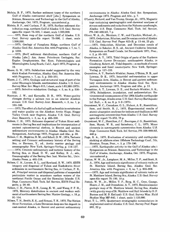
Molnia, B. F., 1975, Surface sediment types of the northern Gulf of Alaska continental shelf [abs.]: Symposium on Science, Resources, and Technology in the Gulf of Alaska, Anchorage, Oct. 1975, Program, unnumbered p.
Molnia, B. F., and Carlson, P. R., 1975, Surface sediment dis tribution map, northern Gulf of Alaska: U.S. Geol. Survey open-file report 75-505, 1 sheet, scale 1:500,000.
1975, Base map of the northern Gulf of Alaska: U.S. Geol. Survey open-file report 75-506, 1 sheet, scale 1:500,000.
1975, Geology of Pamplona Ridge, northern Gulf of Alaska: Geol. Soc. America Abs. with Programs, v. 7, no. 7, p. 1203.
-1975, Shelf sediment distribution; northern Gulf ofAlaska [abs.]: Am. Assoc. Petroleum Geologists, Soc.Explor. Geophysicists, Soc. Econ. Paleontologists andMineralogists, Long Beach, Calif., April 1975, Program, p.19.
Moore, G. W., 1975, Subduction model suggested by the verythick Kodiak Formation, Alaska: Geol. Soc. America Abs.with Programs, v. 7, no. 3, p. 350-351.
Moore, J. C., 1974, Geologic and structural map of part of theouter Shumagin Islands, southwestern Alaska: U.S. Geol.Survey Misc. Inv. Map 1-815,1 sheet, scale 1:63,360 (1975).
1975, Selective subduction: Geology, v. 3, no. 9, p. 530-532.
Nauman, J. W., and Kernodle, D. R., 1975, Water-qualitychanges during a salmon run in an interior Alaskanstream: U.S. Geol. Survey Jour. Research, v. 3, no. 1, p.103-106.
1975, The effect of a fuel oil spill on benthic invertebrates and water quality on the Alaskan Arctic Slope, Happy Valley Creek near Sagwon, Alaska: U.S. Geol. Survey Jour. Research, v. 3, no. 4, p. 495-500.
Nelson, C. H., 1975, Holocene dispersal of Yukon River sedi ments in Bering Sea and implications for interpretation of ancient epicontinental shelves, in Recent and ancient sedimentary environments in Alaska: Alaska Geol. Soc. Symposium, Anchorage 1975, Program and Abs., p. 30.
Nelson, C. H., Hopkins, D. M., and Scholl, D. W., 1974, Tectonic setting and Cenozoic sedimentary history of the Bering Sea, in Herman, Y., ed., Arctic marine geology and oceanography: New York, Springer-Verlag, p. 119-137.
1974, Cenozoic sedimentary and tectonic history of the Bering Sea, in Hood, D. W., and Kelley, E. J., eds., Oceanography of the Bering Sea: Inst. Marine Sci., Univ. Alaska Press, p. 485-516.
Nelson, C. H., Larsen, B. L., and Rowland, R. W., 1975, ERTS imagery and dispersal of Yukon and Kuskokwim River sediments in northeastern Bering Sea, in Carlson, P. R., ed., Principal sources and dispersal patterns of suspended particulate matter in nearshore surface waters of the northeast Pacific Ocean and the Hawaiian Islands: U.S. Dept. Commerce Natl. Tech. Inf. Service, ERTS Final Re ports, p. 26-40.
Nelson, C. H., Pierce, D. E., Leong, K. W., and Wang, F. F. H., 1975, Mercury distribution in ancient and modern sedi ment of northeastern Bering Sea: Marine Geology, v. 18, p. 91-104.
Nilsen, T. H., Brabb, E. E., and Simoni, T. R., 1975, The Nation River Formation, a Late Devonian deep-sea fan deposit in east-central Alaska, in Recent and ancient sedimentary
environments in Alaska: Alaska Geol. Soc. Symposium, Anchorage 1975, Program and Abs., p. 7.
O'Leary, Richard, and Van Trump, George, Jr., 1975, Magnetic tape containing spectrographic and chemical analyses of stream sediments and rocks from the Nabesna quadrangle, Alaska: U.S. Dept. Commerce Natl. Tech. Inf. Service, PB-240 488/AS, 7 p.
Oliver, W. A., Jr., Merriam, C. W., and Churkin, Michael, Jr., 1975, Ordovician, Silurian, and Devonian corals of Alaska: U.S. Geol. Survey Prof. Paper 823-B, p. 13-44, 25 pis.
1975, Ordovician, Silurian, and Devonian corals of Alaska, in Sokolov, B. S., ed., Ancient Cnidaria: Internat. Symposium on Fossil Corals, 1st Novosibirsk 1971, Proc., v. 2, p. 95-103.
Ovenshine, A. T., 1975, Tidal Origin of parts of the Karheen Formation (Lower Devonian), southeastern Alaska, in Ginsburg, Robert, ed., Tidal deposits a casebook of recent examples and fossil counterparts: New York, Springer- Verlag, p. 127-133.
Ovenshine, A. T., Bartsch-Winkler, Susan, O'Brien, N. R., and Lawson, D. E., 1975, Intertidal sedimentation in upper Turnagain Arm, Alaska, in Recent and ancient sedimen tary environments in Alaska: Alaska Geol. Soc. Sym posium, Anchorage 1975, Program and Abs., p. 13.
Ovenshine, A. T., Lawson, D. E., and Bartsch-Winkler, S. R., 1974, Subsidence, inundation, and sedimentation; En vironmental consequences of the 1964 Alaska earthquake in the Portage, Alaska area: U.S. Geol. Survey Earthquake Inf. Bull., v. 6, no. 6, p. 3-9 (1975).
Overstreet, W. C., Crenshaw, G. L., Hubert, A. E., Rosenblum, Sam, and Smith, R. J., 1975, Experimental results of atomic absorption analyses for indium and thallium in 803 nonmagnetic concentrates from Alaska: U.S. Geol. Survey open-file report 75-253, 78 p.
Overstreet, W. C., Hamilton, J. C., Boerngen, J. G., Rosenblum, Sam, Marsh, W. R., and Sainsbury, C. L., 1975, Minor elements in nonmagnetic concentrates from Alaska: U.S. Dept. Commerce Natl. Tech. Inf. Service, PB-238-989/AS, 440 p.
Page, R. A., 1975, Evaluation of seismicity and earthquake shaking at offshore sites: Offshore Technology Conf., 7th, Houston, Texas, Proc., v. 3, p. 179-190.
1975, Earthquake activity in the Gulf of Alaska (abs.): Symposium on Science, Resources, and Technology in the Gulf of Alaska, Anchorage, Alaska, Oct. 1975, Program, unnumbered p.
Patton, W. W., Jr., Lanphere, M. A., Miller, T. P., and Scott, R. A., 1974, Age and tectonic significance of volcanic rocks on St. Matthew Island, Bering Sea, Alaska: Geol. Soc. America Abs. with Programs, v. 6, no. 7, p. 905-906.
1975, Age and tectonic significance of volcanic rocks on St. Matthew Island, Bering Sea, Alaska: U.S. Geol. Survey open-file report 75-150, 18 p.
Patton, W. W., Jr., Miller, T. P., Berg, H. C., Gryc, George, Hoare, J. M., and Ovenshine, A. T., 1975, Reconnaissance geologic map of St. Matthew Island, Bering Sea, Alaska (with gravity map of St. Matthew and Hall Islands by D. F. Barnes and M. B. Estlund): U.S. Geol. Survey Misc. Field Studies Map MF-642, 1 sheet, scale 1:125,000.
Pewe, T. L., 1975, Quaternary stratigraphic nomenclature in unglaciated central Alaska: U.S. Geol. Survey Prof. Paper 862, 32 p.
69

1975, Quarternary geology of Alaska: U.S. Geol. Survey Prof. Paper 835, 145 p., 3 pis., map scale 1:5,000,000.
Pewe, T. L., and Bell, J. W., 1975, Map showing distribution of permafrost in the Fairbanks D-2 SW quadrangle, Alaska: U.S. Geol. Survey Misc. Geol. Inv. Map I-829-B, (Folio), 1 sheet, scale 1:24,000.
1975, Map showing distribution of permafrost in the Fairbanks D-2 NW quadrangle, Alaska: U.S. Geol. Survey Misc. Field Studies Map MF-668-A, 1 sheet, scale 1:24,000.
1975, Map showing groundwater conditions in the Fair banks D-2 NW quadrangle, Alaska: U.S. Geol. Survey Misc. Field Studies Map MF-668-B, 1 sheet, scale 1:24,000.
1975, Map showing construction materials in the Fair banks D-2 NW quadrangle, Alaska: U.S. Geol. Survey Misc. Field Studies Map MF-668-C, 1 sheet, scale 1:24,000.
1975, Map showing foundation conditions in the Fair banks D-2 NW quadrangle, Alaska: U.S. Geol. Survey Misc. Field Studies Map MF-668-D, 2 sheets, scale 1:24,000.
1975, Map showing distribution of permafrost in the Fairbanks D-2 SE quadrangle, Alaska: U.S. Geol. Survey Misc. Field Studies Map MF-669-A, 1 sheet, scale 1:24,000.
1975, Map showing groundwater conditions in the Fair banks D-2 SE quadrangle, Alaska: U.S. Geol. Survey Misc. Field Studies Map MF-669-B, 1 sheet, scale 1:24,000.
1975, Map showing construction materials in the Fair banks D-2 SE quadrangle, Alaska: U.S. Geol. Survey Misc. Field Studies Map MF-669-C, 1 sheet, scale 1:24,000.
1975, Map showing foundation conditions in the Fair banks D-2 SE quadrangle, Alaska: U.S. Geol. Survey Misc. Field Studies Map MF-669-D, 2 sheets, scale 1:24,000.
1975, Map showing distribution of permafrost in the Fairbanks D-2 NE quadrangle, Alaska: U.S. Geol. Survey Misc. Field Studies Map MF-670-A, 1 sheet, scale 1:24,000.
1975, Map showing groundwater conditions in the Fair banks D-2 NE quadrangle, Alaska: U.S. Geol. Survey Misc. Field Studies Map MF-670-B, 1 sheet, scale 1:24,000.
1975, Map showing construction materials in the Fair banks D-2 NE quadrangle, Alaska: U.S. Geol. Survey Misc. Field Studies Map MF-670-C, 1 sheet, scale 1:24,000.
1975, Map showing foundation conditions in the Fair banks D-2 NE quadrangle, Alaska: U.S. Geol. Survey Misc. Field Studies Map MF-670-D, 2 sheets, scale 1:24,000.
1975, Map showing distribution of permafrost in the Fairbanks D-l SW quadrangle, Alaska: U.S. Geol. Survey Misc. Field Studies Map MF-671-A, 1 sheet, scale 1:24,000.
1975, Map showing groundwater conditions in the Fair banks D-l SW quadrangle, Alaska: U.S. Geol. Survey Misc. Field Studies Map MF-671-B, 1 sheet, scale 1:24,000.
1975, Map showing construction materials in the Fair banks D-l SW quadrangle, Alaska: U.S. Geol. Survey Misc. Field Studies Map MF-671-C, 1 sheet, scale 1:24,000.
1975, Map showing foundation conditions in the Fair banks D-l SW quadrangle, Alaska: U.S. Geol. Survey Misc. Field Studies Map MF-671-D, 2 sheets, scale 1:24,000.
Plafker, George, and Addicott, W. O., 1975, Marine glacial deposits of Miocene through Holocene age in the Yakataga Formation along the Gulf of Alaska margin, Alaska, in Recent and ancient sedimentary environments in Alaska: Alaska Geol. Soc. Symposium, Anchorage, 1975, Program and Abs., p. 36.
Plafker, George, and Bruns, Terry, 1975, Tectonic framework and general geology of the Gulf of Alaska Tertiary prov ince, Alaska: Symposium on Science. Resources, and Technology in the Gulf of Alaska, Anchorage, Alaska, Oct. 1975, Program, unnumbered p.
Plafker, George, Bruns, Terry, and Page, Robert, 1975, Interim report on petroleum resource potential and geologic hazards in the outer shelf of the Gulf of Alaska Tertiary province: U.S. Geol. Survey open-file report 75-592, 74 p.
Platt, J. B., 1975, Petrography of University of Washington dredge samples for the central Chukchi Sea: U.S. Geol. Survey open-file report 75-269, 23 p.
Post, A. S., 1975, Preliminary hydrography and historic termi nal changes of Columbia Glacier, Alaska: U.S. Geol. Sur vey open-file report 75-491, 11 p., 2 sheets, scale 1:10,000 and 1:20,000, 1 sheet photos.
Reed, B. L., and Lanphere, M. A., 1974, Offset plutons and history of movement along the McKinley segment of the Denali fault system, Alaska: Geol. Soc. America Bull., v. 85, p. 1883-1892.
Reimnitz, Erk, and Barnes, P. W., 1974, Sea ice as a geologic agent on the Beaufort Sea shelf of Alaska, in Reed, J. C., and Sater, J. E., eds., The coast and shelf of the Beaufort Sea: Arlington, Va., Arctic Inst. North America, p. 301- 351.
Richter, D. H., 1975, Geologic map of the Nabesna quadrangle, Alaska: U.S. Geol. Survey Misc. Field Studies Map MF- 655-A, 1 sheet, scale 1:250,000.
Richter, D. H., Albert, N. R. D., Barnes, D. F., Griscom, An drew, Marsh, S. P., and Singer, D. A., 1975, The Alaskan mineral resource assessment program; background infor mation to accompany folio of geologic and mineral resource maps of the Nabesna quadrangle, Alaska: U.S. Geol. Sur vey Circ. 718, 11 p.
Richter, D. H., and Dutro, J. T., Jr., 1975, Revision of the type Mankomen Formation (Pennsylvanian and Permian), Eagle Creek area, eastern Alaska Range, Alaska: U.S. Geol. Survey Bull. 1395-B, 25 p.
Richter, D. H., Lanphere, M. A., and Matson, N. A., Jr., 1975, Granitic plutonism and metamorphism, eastern Alaska Range, Alaska: Geol. Soc. America Bull., v. 86, no. 6, p. 819-829.
Richter, D. H., and Schmoll, H. R., 1973, Geologic map of the Nabesna C-5 quadrangle, Alaska: U.S. Geol. Survey Geol. Quad. Map GQ-1062, 1 sheet, scale 1:63,360 (1975).
Richter, D. H., Singer, D. A., and Cox, D. P., 1975, Mineral resources map of the Nabesna quadrangle, Alaska: U.S. Geol. Survey Misc. Field Studies Map MF-655-K, 1 sheet, scale 1:250,000.
Rodeick, C. A., 1975, Marine gravel deposits of the Beaufort Sea Shelf [abs.] in Reed, J. C., and Sater, J. E., eds., The coast and shelf of the Beaufort Sea: Arlington, Va., Arctic Inst. North America, p. 511.
70
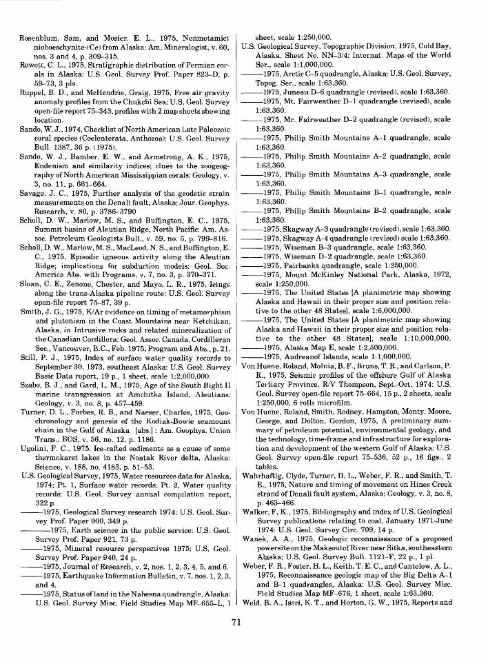
Rosenblum, Sam, and Mosier, E. L., 1975, Nonmetamict nioboeschynite-(Ce) from Alaska: Am. Mineralogist, v. 60, nos. 3 and 4, p. 309-315.
Rowett, C. L., 1975, Stratigraphic distribution of Permian cor als in Alaska: U.S. Geol. Survey Prof. Paper 823-D, p. 59-73, 3 pis.
Ruppel, B. D., and McHendrie, Graig, 1975, Free air gravity anomaly profiles from the Chukchi Sea: U.S. Geol. Survey open-file report 75-343, profiles with 2 map sheets showing location.
Sando, W. J., 1974, Checklist of North American Late Paleozoic coral species (Coelenterata, Anthozoa): U.S. Geol. Survey Bull. 1387, 36 p. (1975).
Sando, W. J., Bamber, E. W., and Armstrong, A. K., 1975, Endenism and similarity indices; clues to the zoogeog raphy of North American Mississippian corals: Geology, v. 3, no. 11, p. 661-664.
Savage, J. C., 1975, Further analysis of the geodetic strain measurements on the Denali fault, Alaska: Jour. Geophys. Research, v. 80, p. 3786-3790
Scholl, D. W., Marlow, M. S., and Buffington, E. C., 1975, Summit basins of Aleutian Ridge, North Pacific: Am. As- soc. Petroleum Geologists Bull., v. 59, no. 5, p. 799-816.
Scholl, D. W., Marlow, M. S., MacLeod, N. S., and Buffington, E. C., 1975, Episodic igneous activity along the Aleutian Ridge; implications for subduction models: Geol. Soc. America Abs. with Programs, v. 7, no. 3, p. 370-371.
Sloan, C. E., Zenone, Chester, and Mayo, L. R., 1975, Icings along the trans-Alaska pipeline route: U.S. Geol. Survey open-file report 75-87, 39 p.
Smith, J. G., 1975, K/Ar evidence on timing of metamorphism and plutonism in the Coast Mountains near Ketchikan, Alaska, in Intrusive rocks and related mineralization of the Canadian Cordillera: Geol. Assoc. Canada, Cordilleran Sec., Vancouver, B.C., Feb. 1975, Program and Abs., p. 21.
Still, P. J., 1975, Index of surface water quality records to September 30, 1973, southeast Alaska: U.S. Geol. Survey Basic Data report, 19 p., 1 sheet, scale 1:2,000,000.
Szabo, B. J., and Gard, L. M., 1975, Age of the South Bight II marine transgression at Amchitka Island, Aleutians: Geology, v. 3, no. 8, p. 457-459.
Turner, D. L., Forbes, R. B., and Naeser, Charles, 1975, Geo- chronology and genesis of the Kodiak-Bowie seamount chain in the Gulf of Alaska [abs.] : Am. Geophys. Union Trans., EOS, v. 56, no. 12, p. 1186.
Ugolini, F. C., 1975, Ice-rafted sediments as a cause of some thermokarst lakes in the Noatak River delta, Alaska: Science, v. 188, no. 4183, p. 51-53.
U.S. Geological Survey, 1975, Water resources data for Alaska, 1974; Pt. 1, Surface water records; Pt. 2, Water quality records: U.S. Geol. Survey annual compilation report, 322 p.
1975, Geological Survey research 1974: U.S. Geol. Sur vey Prof. Paper 900, 349 p.
1975, Earth science in the public service: U.S. Geol. Survey Prof. Paper 921, 73 p.
1975, Mineral resource perspectives 1975: U.S. Geol. Survey Prof. Paper 940, 24 p.
1975, Journal of Research, v. 2, nos. 1, 2, 3, 4, 5, and 6. 1975, Earthquake Information Bulletin, v. 7, nos. 1, 2,3,
and 4. 1975, Status of land in the Nabesna quadrangle, Alaska:
U.S. Geol. Survey Misc. Field Studies Map MF-655-L, 1
sheet, scale 1:250,000.U.S. Geological Survey, Topographic Division, 1975, Cold Bay,
Alaska, Sheet No. NN-3/4: Internat. Maps of the World Ser., scale 1:1,000,000.
1975, Arctic C-5 quadrangle, Alaska: U.S. Geol. Survey, Topog. Ser., scale 1:63,360.
1975, Juneau D-6 quadrangle (revised), scale 1:63,360. 1975, Mt. Fairweather D-l quadrangle (revised), scale
1:63,360. 1975, Mr. Fairweather D-2 quadrangle (revised), scale
1:63,360. 1975,-Philip Smith Mountains A-l quadrangle, scale
1:63,360. 1975, Philip Smith Mountains A-2 quadrangle, scale
1:63,360. 1975, Philip Smith Mountains A-3 quadrangle, scale
1:63,360. 1975, Philip Smith Mountains B-l quadrangle, scale
1:63,360. 1975, Philip Smith Mountains B-2 quadrangle, scale
1:63,360. 1975, Skagway A-3 quadrangle (revised), scale 1:63,360. 1975, Skagway A-4 quadrangle (revised) scale 1:63,360. 1975, Wiseman B-3 quadrangle, scale 1:63,360. 1975, Wiseman D-2 quadrangle, scale 1:63,360. 1975, Fairbanks quadrangle, scale 1:250,000. 1975, Mount McKinley National Park, Alaska, 1972,
scale 1:250,000. 1975, The United States [A planimetric map showing
Alaska and Hawaii in their proper size and position rela tive to the other 48 States], scale 1:6,000,000.
1975, The United States [A planimetric map showing Alaska and Hawaii in their proper size and position rela tive to the other 48 States], scale 1:10,000,000.
1975, Alaska Map E, scale 1:2,500,000. 1975, Andreanof Islands, scale 1:1,000,000.Von Huene, Roland, Molnia, B. F., Bruns, T. R., and Carlson, P.
R., 1975, Seismic profiles of the offshore Gulf of Alaska Tertiary Province, R/V Thompson, Sept.-Oct. 1974: U.S. Geol. Survey open-file report 75-664,15 p., 2 sheets, scale 1:250,000, 6 rolls microfilm.
Von Huene, Roland, Smith, Rodney, Hampton, Monty, Moore, George, and Dolton, Gordon, 1975, A preliminary sum mary of petroleum potential, environmental geology, and the technology, time-frame and infrastructure for explora tion and development of the western Gulf of Alaska: U.S. Geol. Survey open-file report 75-536, 52 p., 16 figs., 2 tables.
Wahrhaftig, Clyde, Turner, D. L., Weber, F. R., and Smith, T. E., 1975, Nature and timing of movement on Hines Creek strand of Denali fault system, Alaska: Geology, v. 3, no. 8, p. 463-466.
Walker, F, K., 1975, Bibliography and index of U.S. Geological Survey publications relating to coal, January 1971-June 1974: U.S. Geol. Survey Circ. 709, 14 p.
Wanek, A. A., 1975, Geologic reconnaissance of a proposed powersite on the Maksoutof River near Sitka, southeastern Alaska: U.S. Geol. Survey Bull. 1121-F, 22 p., 1 pi.
Weber, F. R., Foster, H. L., Keith, T. E. C., and Cantelow, A. L., 1975, Reconnaissance geologic map of the Big Delta A-l and B-l quadrangles, Alaska: U.S. Geol. Survey Misc. Field Studies Map MF-676, 1 sheet, scale 1:63,360.
Weld, B. A., Iseri, K. T., and Horton, G. W., 1975, Reports and
71

maps of the Geological Survey released only in the openfiles, January through April, 1974: U.S. Geol. Survey Circ.706, 10 p.
White, D. F., and Williams, D. L., eds., 1975, Assessment ofgeothermal resources of the United States 1975: U.S.Geol. Survey Circ. 726, 155 p.
Winkler, Gary, 1975, Deep-sea fan deposition of the LowerTertiary Orca Group, eastern Prince William Sound,Alaska, in Recent and ancient sedimentary environmentsin Alaska: Alaska Geol. Soc. Symposium, Anchorage,1975, Program and Abs., p. 37.
Wood, G. V., and Armstrong, A. K., 1975, Diagenesis andstratigraphy of the Lisburne Group Limestones of the Sad-
lerochit Mountains and adjacent areas, northeastern Alaska: U.S. Geol. Survey Prof. Paper 857, 47 p., 12 pis.
Yehle, L. A., 1975, Preliminary report on the reconnaissance engineering geology of the Yakutat area, Alaska, with emphasis on evaluation of earthquake and other geologic hazards: U.S. Geol. Survey open-file report 75-529, 136 p., 2 sheets, scale 1:63,360.
Yount, M. E., ed., 1975, United States Geological Survey Alaska program, 1975: U.S. Geol. Survey Circ. 722, 58 p.
Zenone, Chester, Donaldson, D. E., and Grunwaldt, J. J., 1975, Ground-water quality beneath solid-waste disposal sites at Anchorage, Alaska: Ground Water, v. 13, no. 2, p, 182-190.
frGPO 690« 745-1976
72