The Tabernas Basin - · PDF filej. c. braga - josé m. martín 137 geological...
29
The Tabernas Basin Geological Features
Transcript of The Tabernas Basin - · PDF filej. c. braga - josé m. martín 137 geological...
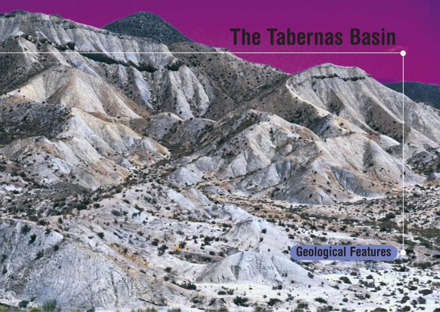
The Tabernas Basin
Geological Features

J. C. Braga - José M. Martín
137
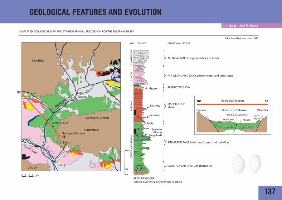
GEOLOGICAL FEATURES AND EVOLUTION
SIMPLIFIED GEOLOGICAL MAP AND STRATIGRAPHICAL SUCCESSION FOR THE TABERNAS BASIN
Taken from Weijermars et al, 1985
PLIO
-PLE
ISTO
CEN
E PL
IOC
ENE
Gypsum
ALLUVIAL FANS. Conglomerates and sands
FAN DELTA and DELTA. Conglomerates and sandstones
FILABRES
ALHAMILLA
Rambla de Tabernas
GÁDOR
RESTRICTED BASIN
MARINE BASINMarls
COASTAL PLATFORM. Conglomerates
BETIC BASEMENTSchists, quartzites, phyllites and marbles
Seismite
Seismite
Seismite(Gordo
Megabed)
Reefs
AGE LITHOLOGY DEPOSITIONAL SETTING
MES
SIN
IAN
SER
REV
ALI
AN
-TO
RTO
NIA
N
Tabernas
Pechina
Baños
Alfaro (742 m)
Geological Section
Geological Section
Río Andarax
SUBMARINE FANS. Marls, sandstones and turbidites
Filabres Desierto de Tabernas Alhamilla
Yesón alto
Rambla de Tabernas
CN-340
CerroAlfaro
NO
SE
Geological Section
138
GEOLOGICAL FEATURES AND EVOLUTION
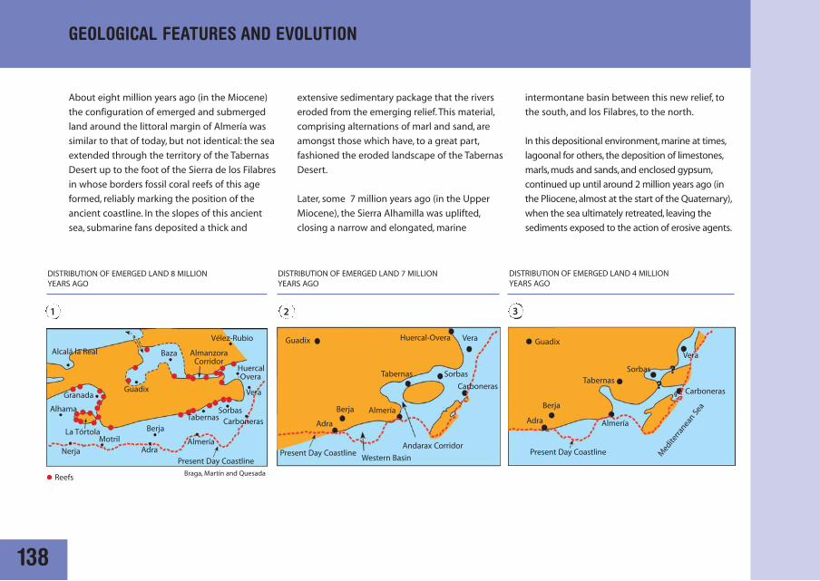
About eight million years ago (in the Miocene)
the configuration of emerged and submerged
land around the littoral margin of Almería was
similar to that of today, but not identical: the sea
extended through the territory of the Tabernas
Desert up to the foot of the Sierra de los Filabres
in whose borders fossil coral reefs of this age
formed, reliably marking the position of the
ancient coastline. In the slopes of this ancient
sea, submarine fans deposited a thick and
DISTRIBUTION OF EMERGED LAND 8 MILLION YEARS AGO
DISTRIBUTION OF EMERGED LAND 7 MILLION YEARS AGO
DISTRIBUTION OF EMERGED LAND 4 MILLION YEARS AGO
Reefs
1 2 3
extensive sedimentary package that the rivers
eroded from the emerging relief. This material,
comprising alternations of marl and sand, are
amongst those which have, to a great part,
fashioned the eroded landscape of the Tabernas
Desert.
Later, some 7 million years ago (in the Upper
Miocene), the Sierra Alhamilla was uplifted,
closing a narrow and elongated, marine
intermontane basin between this new relief, to
the south, and los Filabres, to the north.
In this depositional environment, marine at times,
lagoonal for others, the deposition of limestones,
marls, muds and sands, and enclosed gypsum,
continued up until around 2 million years ago (in
the Pliocene, almost at the start of the Quaternary),
when the sea ultimately retreated, leaving the
sediments exposed to the action of erosive agents.
Alcalá la Real
Granada
Alhama
Nerja
MotrilAdra
Adra AdraBerja
Berja Berja
Almería
Almería
Almería
Medite
rranean
Sea
Present Day Coastline Present Day Coastline Present Day Coastline
Western Basin
Andarax Corridor
Tabernas
TabernasTabernas
Sorbas
SorbasSorbas
Braga, Martín and Quesada
Vélez-Rubio
Vera
Vera
VeraBaza AlmanzoraCorridor
Guadix
Guadix Guadix
Huercal-Overa
Huercal-Overa
Carboneras
CarbonerasCarboneras
La Tórtola
139
GEOLOGICAL FEATURES AND EVOLUTION
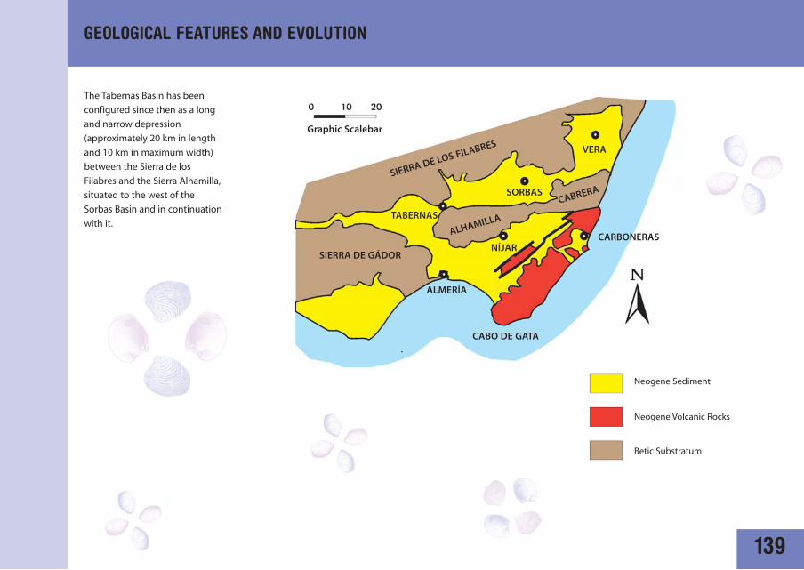
The Tabernas Basin has been
configured since then as a long
and narrow depression
(approximately 20 km in length
and 10 km in maximum width)
between the Sierra de los
Filabres and the Sierra Alhamilla,
situated to the west of the
Sorbas Basin and in continuation
with it.
SIERRA DE LOS FILABRES
SIERRA DE GÁDOR
VERA
TABERNAS
Neogene Sediment
Neogene Volcanic Rocks
Betic Substratum
SORBAS
ALMERÍA
NÍJARCARBONERAS
CABO DE GATA
CABRERA
ALHAMILLA
Graphic Scalebar
140
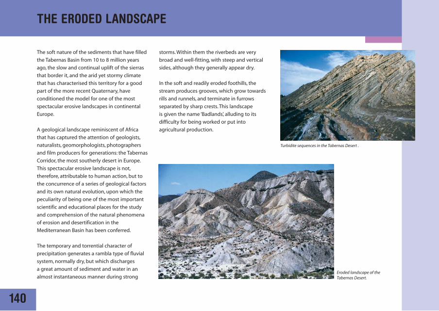
The soft nature of the sediments that have filled
the Tabernas Basin from 10 to 8 million years
ago, the slow and continual uplift of the sierras
that border it, and the arid yet stormy climate
that has characterised this territory for a good
part of the more recent Quaternary, have
conditioned the model for one of the most
spectacular erosive landscapes in continental
Europe.
A geological landscape reminiscent of Africa
that has captured the attention of geologists,
naturalists, geomorphologists, photographers
and film producers for generations: the Tabernas
Corridor, the most southerly desert in Europe.
This spectacular erosive landscape is not,
therefore, attributable to human action, but to
the concurrence of a series of geological factors
and its own natural evolution, upon which the
peculiarity of being one of the most important
scientific and educational places for the study
and comprehension of the natural phenomena
of erosion and desertification in the
Mediterranean Basin has been conferred.
The temporary and torrential character of
precipitation generates a rambla type of fluvial
system, normally dry, but which discharges
a great amount of sediment and water in an
almost instantaneous manner during strong
storms. Within them the riverbeds are very
broad and well-fitting, with steep and vertical
sides, although they generally appear dry.
In the soft and readily eroded foothills, the
stream produces grooves, which grow towards
rills and runnels, and terminate in furrows
separated by sharp crests. This landscape
is given the name ‘Badlands’, alluding to its
difficulty for being worked or put into
agricultural production.
THE ERODED LANDSCAPE
Turbidite sequences in the Tabernas Desert .
Eroded landscape of the Tabernas Desert.
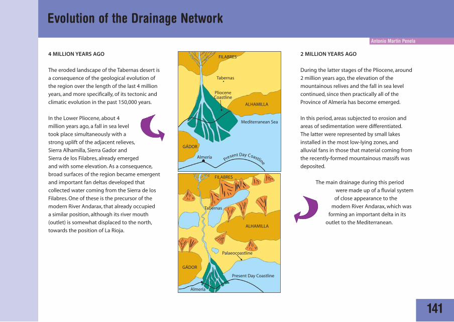
4 MILLION YEARS AGO
The eroded landscape of the Tabernas desert is
a consequence of the geological evolution of
the region over the length of the last 4 million
years, and more specifically, of its tectonic and
climatic evolution in the past 150,000 years.
In the Lower Pliocene, about 4
million years ago, a fall in sea level
took place simultaneously with a
strong uplift of the adjacent relieves,
Sierra Alhamilla, Sierra Gador and
Sierra de los Filabres, already emerged
and with some elevation. As a consequence,
broad surfaces of the region became emergent
and important fan deltas developed that
collected water coming from the Sierra de los
Filabres. One of these is the precursor of the
modern River Andarax, that already occupied
a similar position, although its river mouth
(outlet) is somewhat displaced to the north,
towards the position of La Rioja.
Antonio Martín Penela
141
Evolution of the Drainage Network
2 MILLION YEARS AGO
During the latter stages of the Pliocene, around
2 million years ago, the elevation of the
mountainous relives and the fall in sea level
continued, since then practically all of the
Province of Almería has become emerged.
In this period, areas subjected to erosion and
areas of sedimentation were differentiated.
The latter were represented by small lakes
installed in the most low-lying zones, and
alluvial fans in those that material coming from
the recently-formed mountainous massifs was
deposited.
The main drainage during this period
were made up of a fluvial system
of close appearance to the
modern River Andarax, which was
forming an important delta in its
outlet to the Mediterranean.
FILABRES
FILABRES
ALHAMILLA
ALHAMILLA
Present Day Coastline
Palaeocoastline
GÁDOR
GÁDOR
PlioceneCoastline
Almería
Almería
Tabernas
Tabernas
Mediterranean Sea
Present Day Coastline
142
Evolution of the Drainage Network
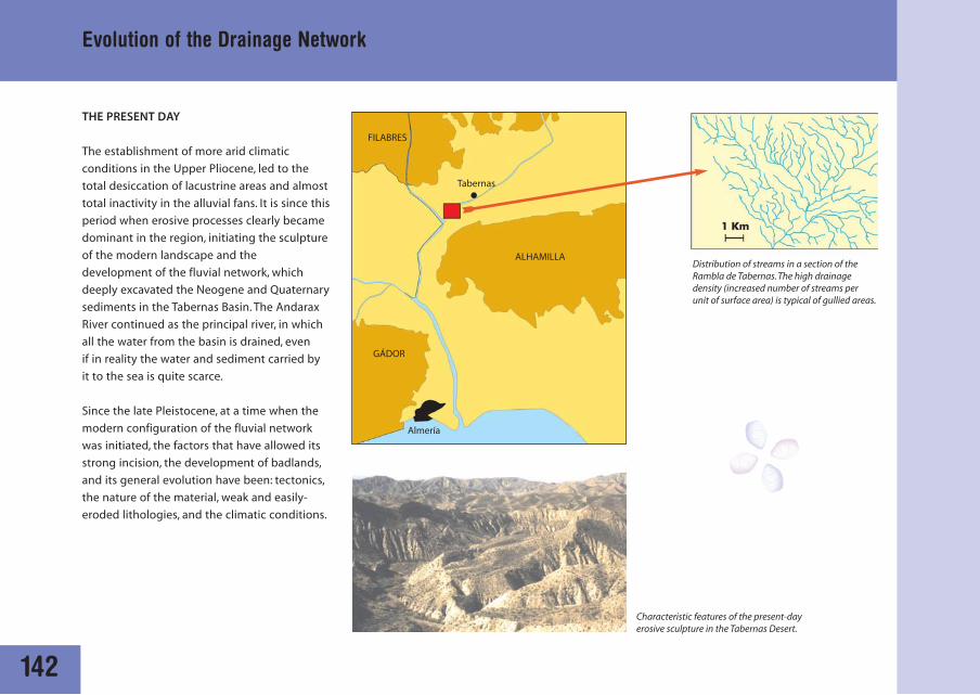
Characteristic features of the present-dayerosive sculpture in the Tabernas Desert.
Distribution of streams in a section of theRambla de Tabernas. The high drainagedensity (increased number of streams perunit of surface area) is typical of gullied areas.
THE PRESENT DAY
The establishment of more arid climatic
conditions in the Upper Pliocene, led to the
total desiccation of lacustrine areas and almost
total inactivity in the alluvial fans. It is since this
period when erosive processes clearly became
dominant in the region, initiating the sculpture
of the modern landscape and the
development of the fluvial network, which
deeply excavated the Neogene and Quaternary
sediments in the Tabernas Basin. The Andarax
River continued as the principal river, in which
all the water from the basin is drained, even
if in reality the water and sediment carried by
it to the sea is quite scarce.
Since the late Pleistocene, at a time when the
modern configuration of the fluvial network
was initiated, the factors that have allowed its
strong incision, the development of badlands,
and its general evolution have been: tectonics,
the nature of the material, weak and easily-
eroded lithologies, and the climatic conditions.
FILABRES
ALHAMILLA
GÁDOR
Almería
Tabernas
Antonio Martín Penela
143
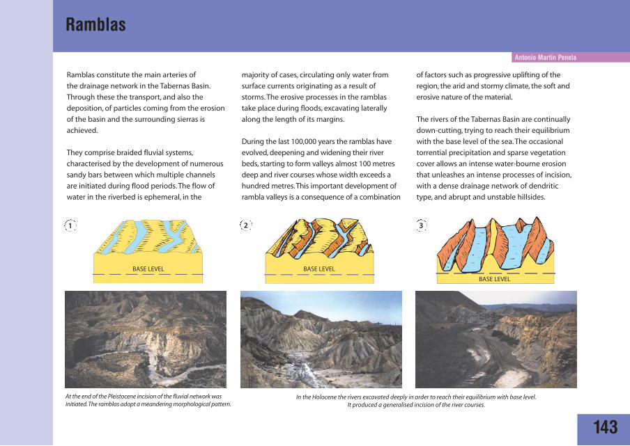
Ramblas
Ramblas constitute the main arteries of
the drainage network in the Tabernas Basin.
Through these the transport, and also the
deposition, of particles coming from the erosion
of the basin and the surrounding sierras is
achieved.
They comprise braided fluvial systems,
characterised by the development of numerous
sandy bars between which multiple channels
are initiated during flood periods. The flow of
water in the riverbed is ephemeral, in the
majority of cases, circulating only water from
surface currents originating as a result of
storms. The erosive processes in the ramblas
take place during floods, excavating laterally
along the length of its margins.
During the last 100,000 years the ramblas have
evolved, deepening and widening their river
beds, starting to form valleys almost 100 metres
deep and river courses whose width exceeds a
hundred metres.This important development of
rambla valleys is a consequence of a combination
of factors such as progressive uplifting of the
region, the arid and stormy climate, the soft and
erosive nature of the material.
The rivers of the Tabernas Basin are continually
down-cutting, trying to reach their equilibrium
with the base level of the sea. The occasional
torrential precipitation and sparse vegetation
cover allows an intense water-bourne erosion
that unleashes an intense processes of incision,
with a dense drainage network of dendritic
type, and abrupt and unstable hillsides.
BASE LEVEL BASE LEVEL
BASE LEVEL
1 32
In the Holocene the rivers excavated deeply in order to reach their equilibrium with base level.It produced a generalised incision of the river courses.
At the end of the Pleistocene incision of the fluvial network wasinitiated.The ramblas adopt a meandering morphological pattern.
144
Antonio Martín Penela
Mechanisms of erosion in the desert: currents
RAINDROP IMPACTS
Raindrops tear away
particles of the ground that
are transported down slope
by saltation. This process
hardens the surface.
SHEET EROSION
Hardened ground
favours the initiation
of sheeted flows,
helped by the slope,
that remove and
entrain the material.
Ground encrusted by the effects of raindrop impacts. Fairy Chimneys : Small mounds of ground protected from sheet erosion by more resistantfragments of rock.
145
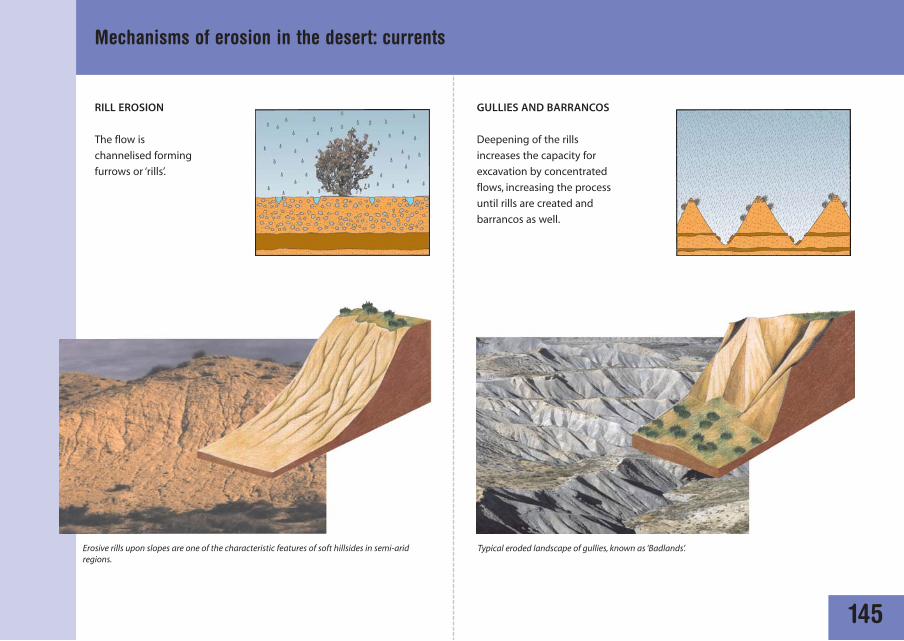
Mechanisms of erosion in the desert: currents
RILL EROSION
The flow is
channelised forming
furrows or ‘rills’.
GULLIES AND BARRANCOS
Deepening of the rills
increases the capacity for
excavation by concentrated
flows, increasing the process
until rills are created and
barrancos as well.
Typical eroded landscape of gullies, known as ‘Badlands’.Erosive rills upon slopes are one of the characteristic features of soft hillsides in semi-aridregions.
A. Martín Penela
146
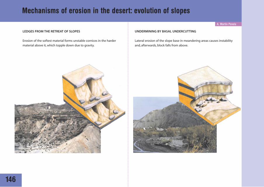
Mechanisms of erosion in the desert: evolution of slopes
LEDGES FROM THE RETREAT OF SLOPES
Erosion of the softest material forms unstable cornices in the harder
material above it, which topple down due to gravity.
UNDERMINING BY BASAL UNDERCUTTING
Lateral erosion of the slope base in meandering areas causes instability
and, afterwards, block falls from above.
147
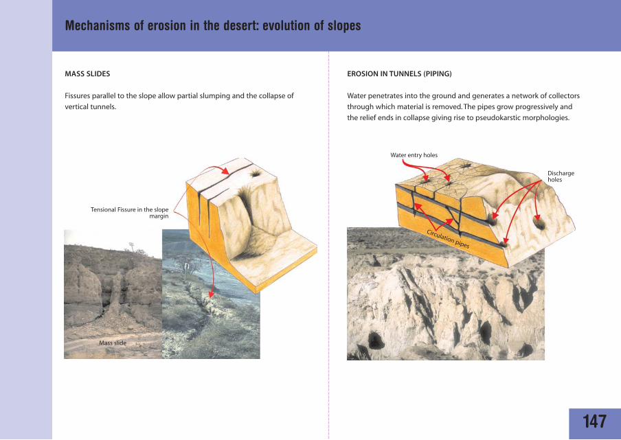
EROSION IN TUNNELS (PIPING)
Water penetrates into the ground and generates a network of collectors
through which material is removed. The pipes grow progressively and
the relief ends in collapse giving rise to pseudokarstic morphologies.
Mechanisms of erosion in the desert: evolution of slopes
MASS SLIDES
Fissures parallel to the slope allow partial slumping and the collapse of
vertical tunnels.
Tensional Fissure in the slopemargin
Water entry holes
Discharge holes
Circulation pipes
Mass slide

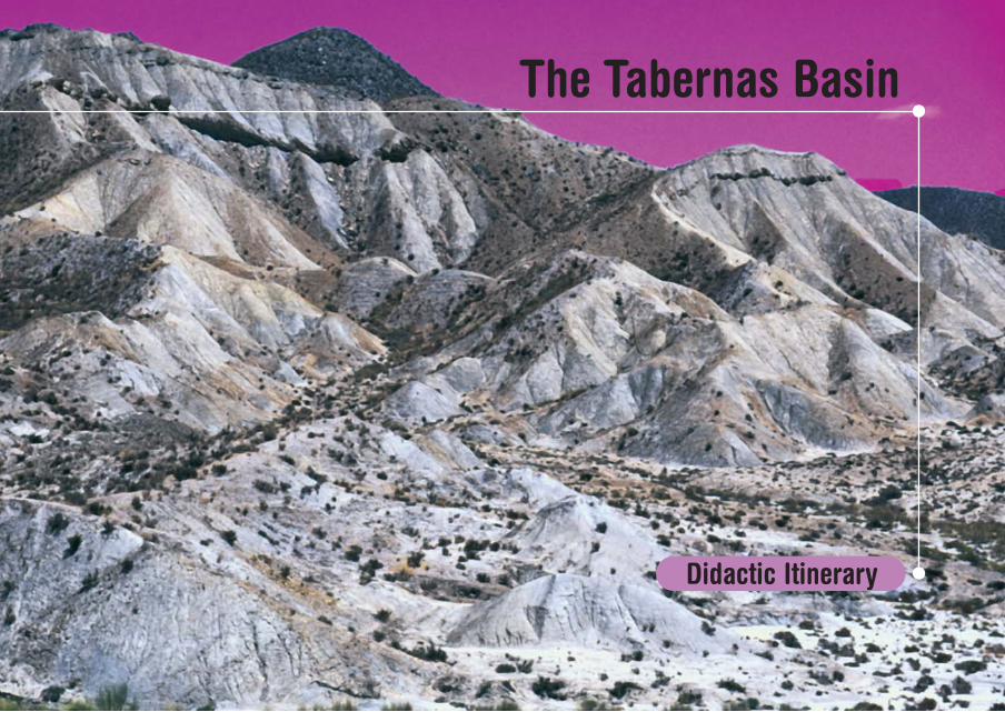
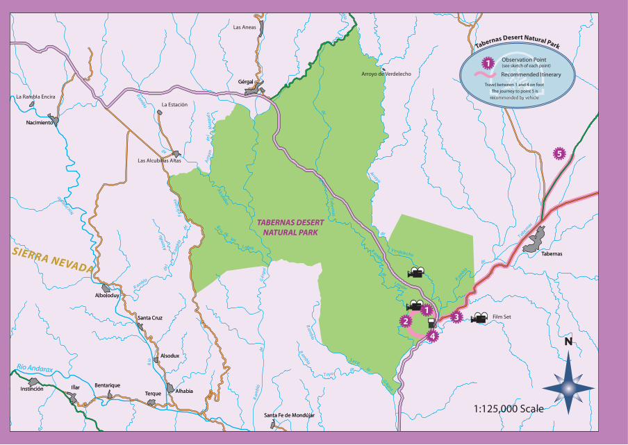
The Tabernas Basin
Didactic Itinerary
Juan C. Braga - José M. Martín
151
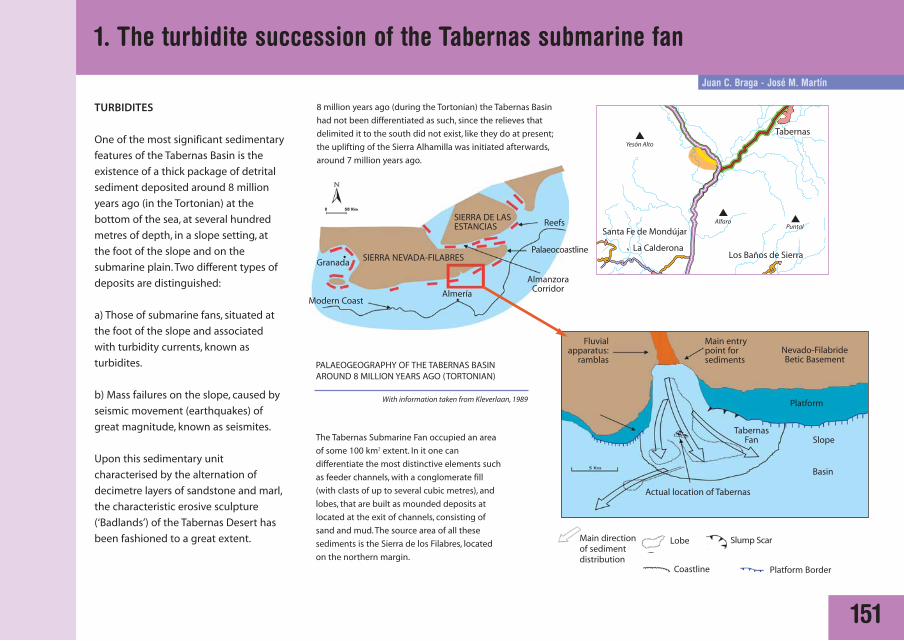
TURBIDITES
One of the most significant sedimentary
features of the Tabernas Basin is the
existence of a thick package of detrital
sediment deposited around 8 million
years ago (in the Tortonian) at the
bottom of the sea, at several hundred
metres of depth, in a slope setting, at
the foot of the slope and on the
submarine plain. Two different types of
deposits are distinguished:
a) Those of submarine fans, situated at
the foot of the slope and associated
with turbidity currents, known as
turbidites.
b) Mass failures on the slope, caused by
seismic movement (earthquakes) of
great magnitude, known as seismites.
Upon this sedimentary unit
characterised by the alternation of
decimetre layers of sandstone and marl,
the characteristic erosive sculpture
(‘Badlands’) of the Tabernas Desert has
been fashioned to a great extent.
The Tabernas Submarine Fan occupied an area
of some 100 km2 extent. In it one can
differentiate the most distinctive elements such
as feeder channels, with a conglomerate fill
(with clasts of up to several cubic metres), and
lobes, that are built as mounded deposits at
located at the exit of channels, consisting of
sand and mud. The source area of all these
sediments is the Sierra de los Filabres, located
on the northern margin.
PALAEOGEOGRAPHY OF THE TABERNAS BASIN AROUND 8 MILLION YEARS AGO (TORTONIAN)
Main directionof sedimentdistribution
Lobe
SIERRA NEVADA-FILABRES
SIERRA DE LASESTANCIAS
Granada
Modern Coast Almería
AlmanzoraCorridor
Reefs
Palaeocoastline
Slump Scar
Coastline Platform Border
8 million years ago (during the Tortonian) the Tabernas Basin
had not been differentiated as such, since the relieves that
delimited it to the south did not exist, like they do at present;
the uplifting of the Sierra Alhamilla was initiated afterwards,
around 7 million years ago.
Actual location of Tabernas
Platform
Slope
Basin
TabernasFan
Nevado-Filabride Betic Basement
Main entrypoint forsediments
Fluvialapparatus:
ramblas
1. The turbidite succession of the Tabernas submarine fan
With information taken from Kleverlaan, 1989
152
1. The turbidite succession of the Tabernas submarine fan
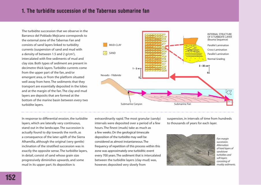
The turbidite succession that we observe in the
Barranco del Poblado Mejicano corresponds to
the external zone of the Tabernas Fan and
consists of sand layers linked to turbidity
currents (suspension of sand and mud with
a density of between 1.5 and 2 g/cm3),
intercalated with fine sediments of mud and
clay size. Both types of sediment are present in
decimetre thick layers. Turbidite currents come
from the upper part of the fan, and/or
emergent area, or from the platform situated
well away from here. The sediments that they
transport are essentially deposited in the lobes
and at the margin of the fan. The clay and mud
layers are deposits that are formed at the
bottom of the marine basin between every two
turbidite layers.
In response to differential erosion, the turbidite
layers, which are laterally very continuous,
stand out in the landscape. The succession is
actually found to dip towards the north, as
a consequence of the later uplift of the Sierra
Alhamilla, although the original (very gentle)
inclination of the stratified succession was in
exactly the opposite sense. The turbidite layers,
in detail, consist of sand whose grain size
progressively diminishes upwards, and some
mud in its upper part. Its deposition is
extraordinarily rapid. The most granular (sandy)
intervals were deposited over a period of a few
hours. The finest (muds) take as much as
a few weeks. On the geological timescale
deposition of the turbidite may well be
considered as almost instantaneous.The
frequency of repetition of this process within this
zone was approximately one turbiditic event
every 700 years.The sediment that is intercalated
between the turbidite layers (clay-mud) was,
however, deposited very slowly from
MUD-CLAY
SAND
INTERNAL STRUCTURE OF A TURBIDITE LAYER(Bouma Sequence)
Nevado - Filábride
Submarine Canyon
Parallel Lamination
Cross-Lamination
Parallel Lamination
Normal Grading
Submarine Fan
suspension, in intervals of time from hundreds
to thousands of years for each layer.
Fan marginsuccession.Alternationof hard layers ofsandstoneturbidites and soft layersconsisting ofmuddy sediments.
153
1. The turbidite succession of the Tabernas submarine fan
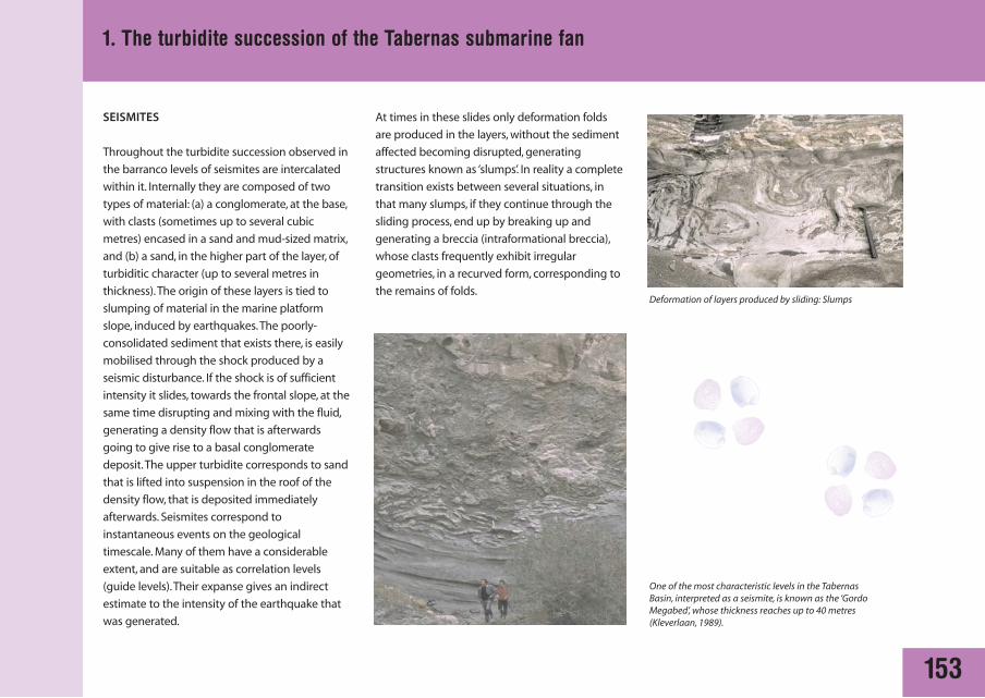
SEISMITES
Throughout the turbidite succession observed in
the barranco levels of seismites are intercalated
within it. Internally they are composed of two
types of material: (a) a conglomerate, at the base,
with clasts (sometimes up to several cubic
metres) encased in a sand and mud-sized matrix,
and (b) a sand, in the higher part of the layer, of
turbiditic character (up to several metres in
thickness).The origin of these layers is tied to
slumping of material in the marine platform
slope, induced by earthquakes.The poorly-
consolidated sediment that exists there, is easily
mobilised through the shock produced by a
seismic disturbance. If the shock is of sufficient
intensity it slides, towards the frontal slope, at the
same time disrupting and mixing with the fluid,
generating a density flow that is afterwards
going to give rise to a basal conglomerate
deposit.The upper turbidite corresponds to sand
that is lifted into suspension in the roof of the
density flow, that is deposited immediately
afterwards. Seismites correspond to
instantaneous events on the geological
timescale. Many of them have a considerable
extent, and are suitable as correlation levels
(guide levels).Their expanse gives an indirect
estimate to the intensity of the earthquake that
was generated.
At times in these slides only deformation folds
are produced in the layers, without the sediment
affected becoming disrupted, generating
structures known as ‘slumps’. In reality a complete
transition exists between several situations, in
that many slumps, if they continue through the
sliding process, end up by breaking up and
generating a breccia (intraformational breccia),
whose clasts frequently exhibit irregular
geometries, in a recurved form, corresponding to
the remains of folds.
One of the most characteristic levels in the TabernasBasin, interpreted as a seismite, is known as the ‘GordoMegabed’, whose thickness reaches up to 40 metres(Kleverlaan, 1989).
Deformation of layers produced by sliding: Slumps
A. Mather - M. Stokes
154
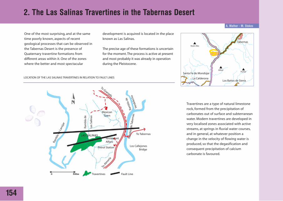
2. The Las Salinas Travertines in the Tabernas Desert
One of the most surprising, and at the same
time poorly known, aspects of recent
geological processes that can be observed in
the Tabernas Desert is the presence of
Quaternary travertine formations from
different areas within it. One of the zones
where the better and most spectacular
MexicanTown
LAS SALINASRestaurantAlfaro
Petrol Station
Travertines Fault Line
Los CallejonesBridge
To Tabernas
To A
lmería
To Granada
Ram
bla
de
Verd
elec
ho
Ram
bla
de
Las
Salin
as
Ram
bla
de L
anúj
ar
Ram
bla
de
Tab
ern
as
LOCATION OF THE LAS SALINAS TRAVERTINES IN RELATION TO FAULT LINES
development is acquired is located in the place
known as Las Salinas.
The precise age of these formations is uncertain
for the moment. The process is active at present
and most probably it was already in operation
during the Pleistocene.
Travertines are a type of natural limestone
rock, formed from the precipitation of
carbonates out of surface and subterranean
water. Modern travertines are developed in
very localised zones associated with active
streams, at springs in fluvial water courses,
and in general, at whatever position a
change in the velocity of flowing water is
produced, so that the degasification and
consequent precipitation of calcium
carbonate is favoured.
155
2. The Las Salinas Travertines in the Tabernas Desert
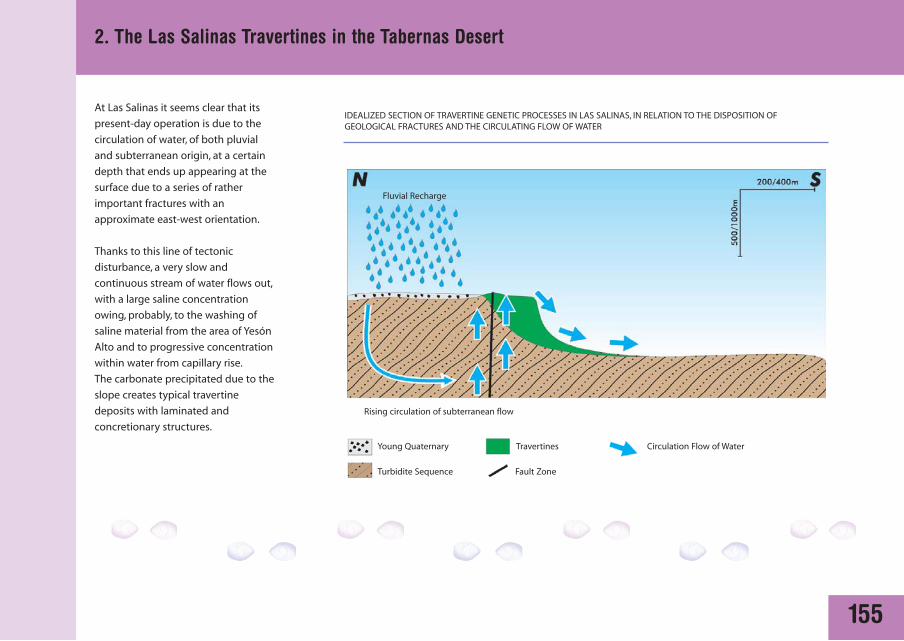
At Las Salinas it seems clear that its
present-day operation is due to the
circulation of water, of both pluvial
and subterranean origin, at a certain
depth that ends up appearing at the
surface due to a series of rather
important fractures with an
approximate east-west orientation.
Thanks to this line of tectonic
disturbance, a very slow and
continuous stream of water flows out,
with a large saline concentration
owing, probably, to the washing of
saline material from the area of Yesón
Alto and to progressive concentration
within water from capillary rise.
The carbonate precipitated due to the
slope creates typical travertine
deposits with laminated and
concretionary structures.
IDEALIZED SECTION OF TRAVERTINE GENETIC PROCESSES IN LAS SALINAS, IN RELATION TO THE DISPOSITION OF GEOLOGICAL FRACTURES AND THE CIRCULATING FLOW OF WATER
Fluvial Recharge
Young Quaternary Travertines Circulation Flow of Water
Turbidite Sequence Fault Zone
Rising circulation of subterranean flow
156
2. The Las Salinas Travertines in the Tabernas Desert
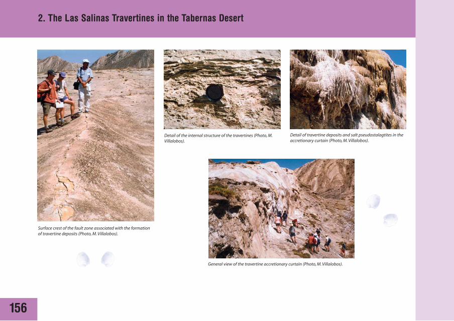
Detail of the internal structure of the travertines (Photo, M.Villalobos).
General view of the travertine accretionary curtain (Photo, M. Villalobos).
Surface crest of the fault zone associated with the formationof travertine deposits (Photo, M. Villalobos).
Detail of travertine deposits and salt pseudostalagtites in theaccretionary curtain (Photo, M. Villalobos).
M. Villalobos
157
3. The Escarpment landforms of the Cerro Alfaro District
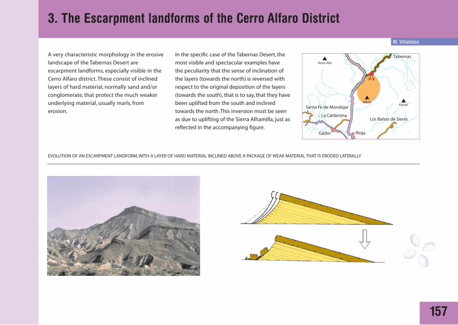
A very characteristic morphology in the erosive
landscape of the Tabernas Desert are
escarpment landforms, especially visible in the
Cerro Alfaro district. These consist of inclined
layers of hard material, normally sand and/or
conglomerate, that protect the much weaker
underlying material, usually marls, from
erosion.
In the specific case of the Tabernas Desert, the
most visible and spectacular examples have
the peculiarity that the sense of inclination of
the layers (towards the north) is reversed with
respect to the original deposition of the layers
(towards the south), that is to say, that they have
been uplifted from the south and inclined
towards the north. This inversion must be seen
as due to uplifting of the Sierra Alhamilla, just as
reflected in the accompanying figure.
EVOLUTION OF AN ESCARPMENT LANDFORM, WITH A LAYER OF HARD MATERIAL INCLINED ABOVE A PACKAGE OF WEAK MATERIAL THAT IS ERODED LATERALLY

158
3. The Escarpment landforms of the Cerro Alfaro District
In the period that existed between15 and 6 million years ago (Serravallian –
Messinian), the sea washed against the foot of the Sierra se los Filabres. Numerous
submarine fans, a continuation of the rivers that drained the sierras, fed sediments
into the marine basin, depositing a thick series of turbidites, alternating layers of
weak, marl sediments and tough sands and conglomerates.
Approximately 7 million years ago, at the end of the Tortonian, tectonic readjustment
had caused emergence of the Sierra Alhamilla block, separating the Tabernas Basin
towards the north of the Sierra Alhamilla from the Almería Basin towards the south.
They continued to be marine for a significant period of time, up until around 4 million
years ago. Uplift of the sierra elevated and brought up turbiditic material already
deposited, reversing the inclination of the layers.The post-Messinian deposits were
markedly different in these basins.
Since 4 million years ago (Upper Pliocene and Pleistocene) the environment in
these basins has been virtually continental. Erosive agents have acted upon
exposed material in the basin, especially in Tabernas, forming the erosive landscape
that we can observe. The harder layers of the turbidite series create the typical
landforms of dipping escarpments, also in a reversed sense to that in which they
were deposited.
INTERPRETATIVE SECTION FOR THE ESCARPMENT LANDFORMS IN THE CERRO ALFARO DISTRICT IN RELATION TO THE EVOLUTIONARY HISTORY OF THE BASIN AND UPLIFT OF THE SIERRAALHAMILLA
Sea Level
AROUND 8 MILLION YEARS AGO
Sierra de los FilabresAlmería-Tabernas Basin
Sea Level
AROUND 2 MILLION YEARS AGO
Sierra de los FilabresSierra de Alhamilla
Almería Basin Tabernas Basin
Nivel del mar
Post-Messinian deposits of the Almería Basin
Post-Messinian deposits of the Tabernas Basin Betic Substratum; Nevado-Filábride and Alpujárride complexes
Serravallian-Messinian deposits of the Almería-Tabernas Basin, hard layers indark green, softer layers in light green
PRESENT DAY
Sierra de los FilabresSierra de Alhamilla
Almería Basin
Tabernas Basin
Cerro de Alfaro, Escarpment landform
Antonio J. Martín Penela
159
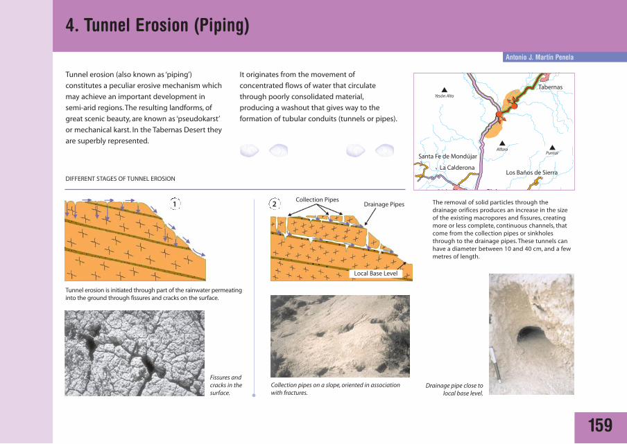
Tunnel erosion (also known as ‘piping’)
constitutes a peculiar erosive mechanism which
may achieve an important development in
semi-arid regions. The resulting landforms, of
great scenic beauty, are known as ‘pseudokarst’
or mechanical karst. In the Tabernas Desert they
are superbly represented.
It originates from the movement of
concentrated flows of water that circulate
through poorly consolidated material,
producing a washout that gives way to the
formation of tubular conduits (tunnels or pipes).
DIFFERENT STAGES OF TUNNEL EROSION
4. Tunnel Erosion (Piping)
1 2
Tunnel erosion is initiated through part of the rainwater permeatinginto the ground through fissures and cracks on the surface.
The removal of solid particles through thedrainage orifices produces an increase in the sizeof the existing macropores and fissures, creatingmore or less complete, continuous channels, thatcome from the collection pipes or sinkholesthrough to the drainage pipes. These tunnels canhave a diameter between 10 and 40 cm, and a fewmetres of length.
Drainage Pipes
Local Base Level
Collection Pipes
Collection pipes on a slope, oriented in associationwith fractures.
Fissures andcracks in thesurface.
Drainage pipe close tolocal base level.
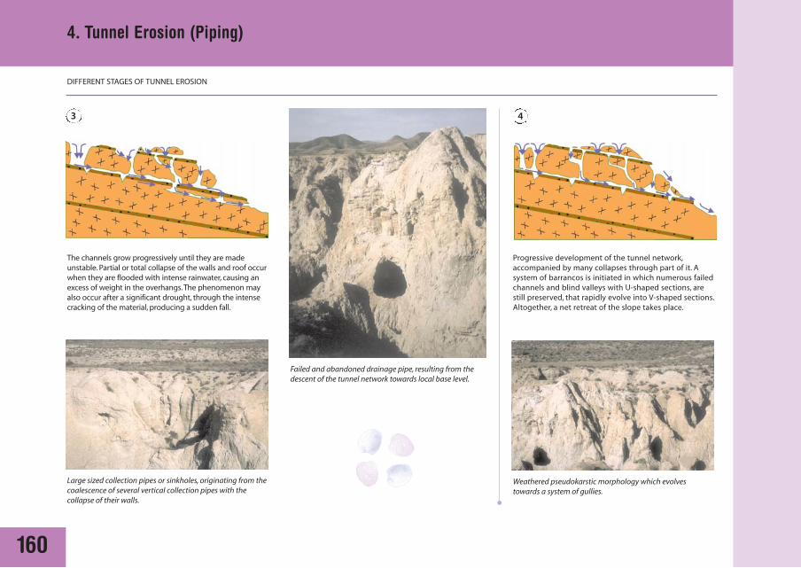
160
4. Tunnel Erosion (Piping)
3 4
The channels grow progressively until they are madeunstable. Partial or total collapse of the walls and roof occurwhen they are flooded with intense rainwater, causing anexcess of weight in the overhangs.The phenomenon mayalso occur after a significant drought, through the intensecracking of the material, producing a sudden fall.
Progressive development of the tunnel network,accompanied by many collapses through part of it. Asystem of barrancos is initiated in which numerous failedchannels and blind valleys with U-shaped sections, arestill preserved, that rapidly evolve into V-shaped sections.Altogether, a net retreat of the slope takes place.
Large sized collection pipes or sinkholes, originating from thecoalescence of several vertical collection pipes with thecollapse of their walls.
Weathered pseudokarstic morphology which evolvestowards a system of gullies.
Failed and abandoned drainage pipe, resulting from thedescent of the tunnel network towards local base level.
DIFFERENT STAGES OF TUNNEL EROSION
A. M. Harvey
161
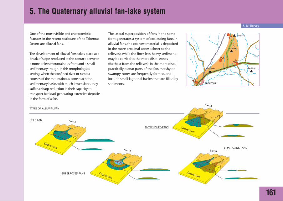
5. The Quaternary alluvial fan-lake system
The lateral superposition of fans in the same
front generates a system of coalescing fans. In
alluvial fans, the coarsest material is deposited
in the more proximal zones (closer to the
relieves), while the finer, less-heavy sediment,
may be carried to the more distal zones
(furthest from the relieves). In the more distal,
practically planar parts of the fan, marshy or
swampy zones are frequently formed, and
include small lagoonal basins that are filled by
sediments.
One of the most visible and characteristic
features in the recent sculpture of the Tabernas
Desert are alluvial fans.
The development of alluvial fans takes place at a
break of slope produced at the contact between
a more or less mountainous front and a small
sedimentary trough. In this morphological
setting, when the confined river or rambla
courses of the mountainous zone reach the
sedimentary basin, with much lower slope, they
suffer a sharp reduction in their capacity to
transport bedload, generating extensive deposits
in the form of a fan.
TYPES OF ALLUVIAL FAN
OPEN FAN
SUPERPOSED FANS
ENTRENCHED FANS
COALESCING FANS
Sierra
DepressionSierra
Depression
Sierra
Depression
Sierra
Depression
162
5. The Quaternary alluvial fan-lake system
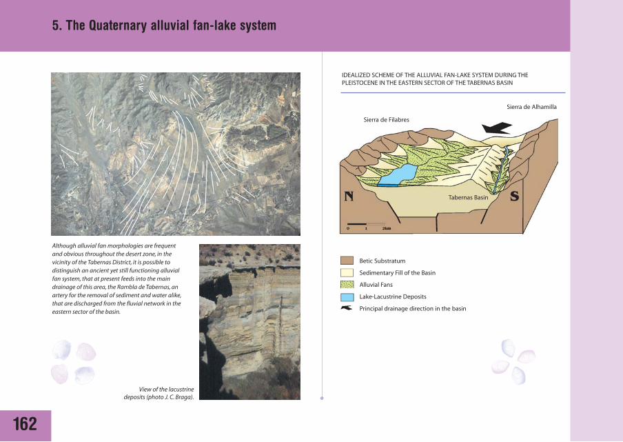
Although alluvial fan morphologies are frequentand obvious throughout the desert zone, in thevicinity of the Tabernas District, it is possible todistinguish an ancient yet still functioning alluvialfan system, that at present feeds into the maindrainage of this area, the Rambla de Tabernas, anartery for the removal of sediment and water alike,that are discharged from the fluvial network in theeastern sector of the basin.
View of the lacustrinedeposits (photo J. C. Braga).
IDEALIZED SCHEME OF THE ALLUVIAL FAN-LAKE SYSTEM DURING THEPLEISTOCENE IN THE EASTERN SECTOR OF THE TABERNAS BASIN
Betic Substratum
Sedimentary Fill of the Basin
Alluvial Fans
Lake-Lacustrine Deposits
Principal drainage direction in the basin
Sierra de Alhamilla
Sierra de Filabres
Tabernas Basin
163
5. The Quaternary alluvial fan-lake system
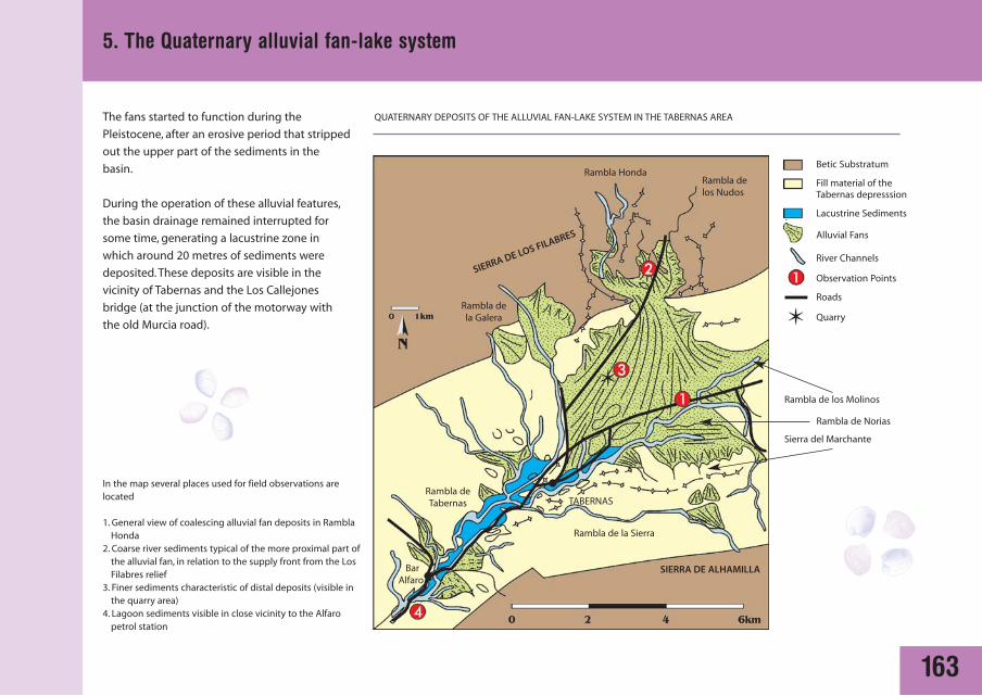
In the map several places used for field observations arelocated
1. General view of coalescing alluvial fan deposits in RamblaHonda
2. Coarse river sediments typical of the more proximal part ofthe alluvial fan, in relation to the supply front from the LosFilabres relief
3. Finer sediments characteristic of distal deposits (visible inthe quarry area)
4. Lagoon sediments visible in close vicinity to the Alfaropetrol station
QUATERNARY DEPOSITS OF THE ALLUVIAL FAN-LAKE SYSTEM IN THE TABERNAS AREA
SIERRA DE LOS FILABRES
SIERRA DE ALHAMILLA
Rambla HondaRambla delos Nudos
Rambla dela Galera
Rambla de los Molinos
Betic Substratum
Fill material of the Tabernas depresssion
Lacustrine Sediments
Alluvial Fans
River Channels
Observation Points
Roads
Quarry
Rambla de Norias
Rambla de la Sierra
Sierra del Marchante
Rambla deTabernas
BarAlfaro
TABERNAS
The fans started to function during the
Pleistocene, after an erosive period that stripped
out the upper part of the sediments in the
basin.
During the operation of these alluvial features,
the basin drainage remained interrupted for
some time, generating a lacustrine zone in
which around 20 metres of sediments were
deposited. These deposits are visible in the
vicinity of Tabernas and the Los Callejones
bridge (at the junction of the motorway with
the old Murcia road).