![[123] Tu Vung Trong p1](https://static.fdocuments.us/doc/165x107/577cc5651a28aba7119c4011/123-tu-vung-trong-p1.jpg)
The Study on the Development Plan of Thakek-Vung Ang ...
119
The Study on the Development Plan of Thakek-Vung Ang Gateway between Lao PDR and Vietnam (The New East-West Corridor for North-Eastern Thailand, Lao PDR, and Vietnam) Study Report March 2010 Engineering and Consulting Firms Association, Japan Japan Development Institute (JDI)
Transcript of The Study on the Development Plan of Thakek-Vung Ang ...

The Study on the Development Plan of Thakek-Vung Ang Gateway between Lao PDR and Vietnam
(The New East-West Corridor for North-Eastern Thailand, Lao PDR, and Vietnam)
Study Report
March 2010
Engineering and Consulting Firms Association, Japan Japan Development Institute (JDI)


Thakek-Vung Ang Gateway The New East-West Corridor for North-Eastern Thailand, Lao PDR, and Vietnam
PICTURES
Plantation Site of Eucalyptus in Central Laos
Plantation Site of Eucalyptus in Central Laos
Agro-Forestry Processing SEZ site
in Thakek
Agro-Forestry Processing SEZ site
in Thakek
The road connecting to SEZ in Thakek
The road connecting to SEZ in Thakek

Thakek-Vung Ang Gateway The New East-West Corridor for North-Eastern Thailand, Lao PDR, and Vietnam
3rd Friendship Bridge Construction Site
Bridging between Nakhon Phanom (Thailand)
and Thakek (Laos)
3rd Friendship Bridge Construction Site
Road 12: Laotian Side
Road 12: Laotian Side
Road 12: Laotian Side
Road 12: Laotian Side

Thakek-Vung Ang Gateway The New East-West Corridor for North-Eastern Thailand, Lao PDR, and Vietnam
Road 12: Laotian Side
Sign board of the future construction plan
Road 12: Laotian Side
Road 12: Laotian Side
Mountaneous area
Road 12: Laotian Side
Agriculture field along Road 12
Road 12: Laotian Side
Houses scattered along the Road
Road 12: Laotian Side
The border control at the Laotian Side

Thakek-Vung Ang Gateway The New East-West Corridor for North-Eastern Thailand, Lao PDR, and Vietnam
The border control at the Vietnamese Side
Section between the border and HCM Hwy
Unpaved road due to be improved
Section between the border and HCM Hwy
HCM Hwy (Road 15)
Intersection of HCM Hwy and Road 12
Road 12: Vietnamese Side

Thakek-Vung Ang Gateway The New East-West Corridor for North-Eastern Thailand, Lao PDR, and Vietnam
Road 12: Vietnamese Side
Road 12: Vietnamese Side
Road 12: Vietnamese Side
Section between the border and HCM Hwy
Road 12: Vietnamese Side
Intersection or Road 12 and Hwy #1
Newly constructed section of Hwy #1
Hwy #1
Near the entrance of the Vung Ang Port

Thakek-Vung Ang Gateway The New East-West Corridor for North-Eastern Thailand, Lao PDR, and Vietnam
Road 12: Vietnamese Side
Agriculture field and houses along the Road
Vung Ang Port (Berth No.1)
Loading woodchips exported to Japan
Vung Ang Port (Berth No.1)
Loading woodchips exported to Japan
Vung Ang Port (Berth No.1)
Loading woodchips exported to Japan
Vung Ang Port (Berth No.2)
Start operating in January, 2010
Vung Ang Port (Berth No.2)
Ware houses

Thakek-Vung Ang Gateway The New East-West Corridor for North-Eastern Thailand, Lao PDR, and Vietnam
Vung Ang Port (Berth No.2)
Vung Ang Port (Berth No.2)
Vung Ang Port (Berth No.2)
Project site for the New Woodchip Yard and
Berth No.3
Son Duong Port under construction
Son Duong Port under construction
Son Duong Port
Oil tanks under construction

Thakek-Vung Ang Gateway The New East-West Corridor for North-Eastern Thailand, Lao PDR, and Vietnam
The Woodchip Storage Yard of a Japanese
trade company near the Vung Ang Port
Woodchip Storage Yard
Preparing to load them to trucks
Woodchip Storage Yard
Collected timbers to be processed
Woodchip Storage Yard
Timbers processed into woodchips
The View of Ha Tinh City
60km from the Vung Ang Port
The Beach Resort near the Vung Ang Port
At the time of off-season

Thakek-Vung Ang Gateway The New East-West Corridor for North-Eastern Thailand, Lao PDR, and Vietnam
ABBREVIATIONS
ADB Asian Development Bank
AFTA ASEAN Free Trade Area
CDF Custom Declaration Form
DOH Department of Highways of Thailand
DWT Dear Weight Tonne
EWEC The East West Economic Corridor
EZ Economic Zone
GDP Gross Domestic Product
GMS Greater Mekong Sub-region
IMF International Monetary Fund
JBIC Japan Bank for International Cooperation
JICA Japan International Cooperation Agency
MOT Ministry of Transport of Vietnam
MPI Ministry of Planning and Investment of Laos/Vietnam
NBCA National Biodiversity Conservation Area
NSEC The North-South Economic Corridor
LPRP Lao people’s Revolutionary Party
SEC The Southern Economic Corridor
SEZ Special Economic Zone
TEDI Transport Engineering Design Inc.
UNDP United Nations Development Programme
UNIDO United Nations Industrial Development Organization
UNLK United Nations Layout Key
VAT Value-Added Tax
WAN Wide Area Network
WMV Woodchip Maximum Vessel
WTO World Trade Organization

Thakek-Vung Ang Gateway The New East-West Corridor for North-Eastern Thailand, Lao PDR, and Vietnam
INDEX
PREFACE.....................................................................................................................................1
1 EXECUTIVE SUMMARY..................................................................................................3
2 BASIC INFORMATION OF LAO PDR AND VIETNAM ..............................................7
2.1 .....Lao PDR ........................................................................................................................7
2.1.1 Geography...............................................................................................................7
2.1.2 Economy.................................................................................................................7
2.1.3 Politics ....................................................................................................................9
2.1.4 Population and Culture ...........................................................................................9
2.2 .....Vietnam .........................................................................................................................9
2.2.1 Geography...............................................................................................................9
2.2.2 Economy...............................................................................................................10
2.2.3 Politics ..................................................................................................................12
2.2.4 Population and Culture .........................................................................................12
3 BACKGROUND AND OBJECTIVE...............................................................................13
3.1 .....The Agro-Forestry Industry and the Woodchip Production in Lao PDR .............13
3.1.1 Overview of the Agro-Forestry Industry in Laos..................................................13
3.1.2 The Development of Agro-Forestry Processing Zone in the Khammouane
Province, Lao PDR ..............................................................................................................14
3.1.3 The Potentiality of Woodchip Production for the Economic Growth of Lao PDR
18
3.2 .....Greater Mekong Subregion (GMS) Economic Corridor Development Program.21
3.3 .....The East-West Corridor and for the Land Locked Country Laos ........................24
3.3.1 Mawlamyine - Dang Nang Gateway ....................................................................24
3.3.2 Thakek-Vung Ang Gateway..................................................................................25
3.3.3 The Advantage of the Thakek-Vung Ang Gateway ..............................................26
3.4 ..... Study Objectives .........................................................................................................27
4 CONDITION AND FUTURE DEVELOPMENT PLAN OF ROAD NO. 12 ...............28
4.1 .....The Existing Transportation Volume and Future Demand Projection..................28
4.1.1 Traffic Count: 2001-2008 .....................................................................................28
4.1.2 The Future Demand from Agro-Forestry Companies in Laos ..............................30
4.1.3 The Future Demand from North-Eastern Thailand...............................................32
4.2 .....The Current Condition of Road No.12 .....................................................................33
4.2.1 At the Lao PDR’s Side..........................................................................................34
4.2.2 At the Vietnam Side..............................................................................................35

Thakek-Vung Ang Gateway The New East-West Corridor for North-Eastern Thailand, Lao PDR, and Vietnam
4.3 .....The Development Plan of the Third Friendship Bridge .........................................37
4.4 .....The Future Development Plan of Road No.12 .........................................................38
4.4.1 The Road Improvement Plan in Two Phases ........................................................38
4.4.2 The Development Plan of Connecting Road No.12 to Vientiane .........................39
4.4.3 Improvement in the Custom Process at the Border ..............................................39
4.4.4 Railway Development Plan from Thakek to Vung Ang .......................................41
5 CONDITION AND FUTURE DEVELOPMENT PLAN OF THE VUNG ANG PORT
42
5.1 .....The Location of the Vung Ang Port ..........................................................................42
5.2 .....The Current Condition and Capacity of the Vung Ang Port..................................42
5.2.1 The Start of the Development in 2001..................................................................42
5.2.2 The Improvement of the Port in 2004...................................................................43
5.2.3 The Current Capacity and Demand of the Vung Ang Port ...................................43
5.2.4 The Development Plan of the Son Duong Port.....................................................44
5.3 ..... Industries in the Vung Ang Port................................................................................46
5.3.1 The Vung Ang Economic Zone.............................................................................46
5.3.2 Woodchip Companies ...........................................................................................47
5.3.3 Thermal Power Plant ............................................................................................47
5.3.4 Industries in the Son Duong Port..........................................................................48
5.4 .....Proposed Concept of the Woodchip based Processing, Storage and Exporting
Terminal: 2010-2020 ..............................................................................................................49
5.4.1 The Role of the Woodchip Company for the Development of Vung Ang Corridor
50
5.4.2 The Future Plan of Expanding the Vung Ang Port ...............................................50
5.4.3 The Development Plan of the Woodchip Storage Yard.........................................50
5.4.4 The Development Plan of Berth No.3 ..................................................................52
6 SOCIO-ECONOMIC AND ENVIRONMENTAL IMPACTS OF THE PROPOSED
DEVELOPMENT PLAN ..........................................................................................................55
6.1 .....The Socio-Economic and Environmental Data of Khammouane Province, Lao
PDR .. 55
6.1.1 Population.............................................................................................................56
6.1.2 Livelihood and Economy......................................................................................57
6.1.3 Education and Health Care ...................................................................................57
6.1.4 Environment .........................................................................................................58
6.2 .....The Environmental Impacts to the Khammouane Province ..................................58
6.3 ..... Socio-Economic Impacts in the Khammouane Province ........................................59

Thakek-Vung Ang Gateway The New East-West Corridor for North-Eastern Thailand, Lao PDR, and Vietnam
6.3.1 Impacts to Income and Livelihood .......................................................................59
6.3.2 Impacts to Education and Health Care .................................................................60
6.4 .....The Socio-Economic Data of the Ha Tinh Province, Vietnam................................60
6.4.1 Population.............................................................................................................61
6.4.2 Livelihood and Economy......................................................................................61
6.4.3 Education and Health Care ...................................................................................62
6.4.4 Environment .........................................................................................................63
6.5 .....The Environmental Impacts to the Ha Tinh Province ............................................64
6.6 .....The Socio-Economic Impacts to the Ha Tinh Province...........................................65
6.6.1 Impacts to the Livelihood and Income .................................................................65
6.6.2 Impacts to Education and Health Care .................................................................66
7 ECONOMIC ANALYSIS OF THE PORT DEVELOPMENT ......................................67
7.1 .....Basic Conditions .........................................................................................................67
7.1.1 Export Volume Forecast of Woodchips.................................................................67
7.1.2 Logistic Plan .........................................................................................................68
7.2 .....Phase One: Vung Ang Port Storage Yard Development Project ............................68
7.2.1 Construction Cost and Engineering/Civil Costs ...................................................68
7.2.2 Operational Costs..................................................................................................70
7.2.3 Expected Revenue Projection from Woodchip Storage Yard Lease and Handling
at the Port .............................................................................................................................71
7.2.4 Financial Internal Rate of Return (FIRR) .............................................................71
7.2.5 Sensitivity Analysis ..............................................................................................74
7.2.6 Implications ..........................................................................................................74
7.3 .....Phase Two: Development Project of Berth No. 3.....................................................75
7.3.1 Financial Internal Rate of Return (FIRR) .............................................................75
7.3.2 Sensitivity Analysis ..............................................................................................77
7.3.3 Cash Flow Analysis ..............................................................................................78
7.3.4 Implications ..........................................................................................................78
8 STAKEHOLDERS ANALYSIS ........................................................................................80
8.1.1 Stakeholder Analysis on National Level...............................................................80
8.1.2 Stakeholder Analysis on Local Level ...................................................................81
9 FUTURE ACTION PLAN ................................................................................................82
9.1 .....Preparation Study Phase: 2010 .................................................................................83
9.2 .....Phase 1 Development Plan: 2011-2012 .....................................................................83
9.2.1 Agro-Forestry Processing SEZ in Thakek, Lao PDR ...........................................83
9.2.2 Woodchip Storage Yard at the Vung Ang Port......................................................84

Thakek-Vung Ang Gateway The New East-West Corridor for North-Eastern Thailand, Lao PDR, and Vietnam
9.3 .....Phase 2 Development Plan: 2020 or after.................................................................84
9.4 .....Possible Funding Scheme...........................................................................................85
9.4.1 Funding for the Woodchip Storage Yard...............................................................85
9.4.2 Funding for Berth No.3 at the Vung Ang Port ......................................................85
9.5 .....Recommendation to the Vietnamese Government ..................................................86
9.6 .....Recommendation to the Lao Government ...............................................................87
10 CONCLUSION...............................................................................................................88

Thakek-Vung Ang Gateway The New East-West Corridor for North-Eastern Thailand, Lao PDR, and Vietnam
LIST OF FIGURES
Figure 2-1: GDP Growth of Lao PDR ...................................................................................8
Figure 2-2: GDP Growth of Vietnam................................................................................... 11
Figure 3-1: Breakdown of the Forestry Use.........................................................................14
Figure 3-2: Potential Locations and Themes for Lao SEZ program in 2010-2025..............15
Figure 3-3: Map of the Agro-Forestry Processing SEZ in the Khammouane Province.......16
Figure 3-4: The Change in Paper Demand in Japan: 1995-2008 .........................................18
Figure 3-5: The Change in Imported Woodchips Volume....................................................19
Figure 3-6: Major Woodchip Import Countries of Japan: 1998 and 2008 ...........................20
Figure 3-7:Greater Mekong Subreagion Economic Corridors..........................................22
Figure 3-8: Map of the East West Corridor in GMS............................................................24
Figure 4-1: Average Annual Daily Traffic on Road No.12 ..................................................29
Figure 4-2: Average Annual Daily Traffic on Road No.12 by Vehicle Type........................30
Figure 4-3: Estimated Average Daily Truck Transportation on the Third Friendship Bridge
.....................................................................................................................................33
Figure 4-4: Route from Thakhek – Lao/Vietnam Border – Vung Ang Port.........................34
Figure 4-5: Road No.12 from Vung Ang to Cha Lo (Border)..............................................36
Figure 4-6: Two Alternative Routes from the Vung Ang Port to Cha Lo ( Border )............37
Figure 5-1: The Layout of the Vung Ang Port (in 2010) .....................................................43
Figure 5-2: Locations of the Vung Ang Port and the Son Duong Port.................................45
Figure 5-3: Location of the 3 Possible Development Sites for a Woodchip Storage Yard...52
Figure 5-4: Location of Breakwaters at the Vung Ang Port.................................................53
Figure 6-1: Map of the Sample Population..........................................................................56
Figure 6-2: Vegetation Type of the Ha Tinh Province .........................................................64
Figure 8-1: Organizational Structure of Maritime Business in Vietnam..............................81
Figure 9-1: The Flow-Chart of Seaport Investment and Development Approval................82

Thakek-Vung Ang Gateway The New East-West Corridor for North-Eastern Thailand, Lao PDR, and Vietnam
LIST OF TABLES
Table 3-1: Change in Forest Coverage.................................................................................13
Table 3-2: Projected Cash Flow by Using Loan for SEZ Development ..............................17
Table 3-3: Schedule of the Woodchip Plantation and Harvesting........................................21
Table 4-1: Required Trucks Per Day to Transport Woodchips from Central Laos ..............31
Table 4-2: Required Trucks Per Day to Transport Other Agro-Forestry Products...............31
Table 4-3: Demand Projection from Agro-Forestry Companies on Road No.12.................32
Table 6-1: Changes of Possessions in 1997/98 to 2006 .......................................................62
Table 7-1: Export Volume Forecast of Woodchips...............................................................67
Table 7-2: Estimated Preparation Cost of EIA.....................................................................68
Table 7-3: Estimated Cost for Civil Engineering Services and Supervision........................69
Table 7-4: Construction Cost for the Woodchip Storage Yard .............................................69
Table 7-5: Total Investment Cost of the Woodchip Storage Yard Development..................70
Table 7-6: Operation Cost of the Woodchip Project Per Year..............................................70
Table 9-1: Rough Development Schedule of the Agro-Forestry SEZ in Thakek.................84


Thakek-Vung Ang Gateway The New East-West Corridor for North-Eastern Thailand, Lao PDR, and Vietnam
1
PREFACE
Japan Development Institute (JDI) is currently leading Lao PDR’s national Special
Economic Zone (SEZ) development plan funded by the Asian Development Bank (ADB). This
project aims to attract sustainable foreign and local investments as the engine of growth and
industrial development of Lao PDR by establishing SEZs in strategic areas. Among the
Laotian economy, recently the agro-forestry industry is growing steadily as several private
companies from China, Vietnam, and Japan have invested in the development of timber and
rubber. Especially woodchip production has been focused in this study in that companies in
central Laos are planning to start processing and exporting large quantity of their agro-forestry
products in immediate future by 2012.
As an export route of woodchips, the corridor starting from Thakek in Laos to the
Vung Ang Port in Vietnam is deemed to be the most advantageous, in terms of the distance
and the availability of a deep sea port. Considering the interest of those agro-forestry
companies in central Laos, it is likely that they would use the getaway route through the Vung
Ang Port once the financial viability and efficiency is assured with utilizing the corridor.
Consequently, it is important to first study as to what is the current conditions of the corridor
in correspondent with critical factors for transporting agro-forestry products, and how to attain
the efficiency of the Thakek-Vung Ang Gateway for agro-forestry companies in central Laos,
especially the woodchip processing and exporting companies. Also to ensure the cooperation
from the Vietnam side on establishing the optimal transportation system at the port, a project
team was formed to fulfill the mission..
Team Members
1) Dr. Shoichi Kobayashi: Project Leader and Chief Economist
2) Mr. Nobuo Kawamura: Port Development Expert
3) Mr. Pisanu Tongtub: Road Construction and Development Expert
4) Mr. Sumiyuki Otsuki: Economic and Financial Analyst
5) Ms. Yumiko Ota: Social and Environmental Analyst
During the study, the team received warm supports from corresponding
governmental and private organizations in Laos and Vietnam. Herewith, we would like to
express our special thanks and gratitude to the following officials:
1) Ministry of Public Works and Transportation of Lao PDR
2) Khammouane Provincial Government of Lao PDR
3) Management Board of Vung Ang Economic Zone
4) Maritime Administration of Ha Tinh, Vietnam

Thakek-Vung Ang Gateway The New East-West Corridor for North-Eastern Thailand, Lao PDR, and Vietnam
2
5) Ha Tinh Port Stock Company of Vietnam
6) Transport Engineering Design Inc. (TEDI)
Finally, we are hoping that this study will be useful for developing the Thakek-Vung
Ang Gateway by means of socio-economic uplift for both Lao PDR and Vietnam.
Sincerely Yours, Shoichi Kobayashi Ph.D.
Chairman of Japan Development Institute (JDI)

Thakek-Vung Ang Gateway The New East-West Corridor for North-Eastern Thailand, Lao PDR, and Vietnam
3
1 EXECUTIVE SUMMARY
Lao PDR, having its capital in Vientiane City, is economically less developed among
the countries in Southeast Asia. However, utilizing the rich natural resources the country has,
the agro-forestry industry, which is growing steadily in recent years, could be the pull to lead
the country to an economic growth. Still, because of its land-locked situation, Laos needs to
identify an advantageous transport route, in terms of cost of money and time. In this manner,
the Thakek-Vung Ang Gateway, connecting the north-eastern Thailand through central Laos to
the South China Sea using the Vung Ang Port in north-central Vietnam, was identified as the
export route for agro-forestry industries in central Laos. This is because with the completion of
Road No. 12 directly connecting central Laos to the Vung Ang Port in June, 2009, the Vung
Ang Port became the closest gateway port for industries in central Laos. For industries in a
land-locked country Laos, which incurs additional transportation cost than industries in a
country equipped with a port, the cost efficiency could better reached through shorter
distances.
Secondly, the Vung Ang Port is known as a natural deep seaport that has little
influence by waves and winds because of the presence of Ron Cape Peninsula which works as
a natural bareakwater. In addition, because the port has not yet densely used, there is a room
for agro-forestry industries to build a storage yard in the vicinity of operating berths. Therefore,
this study was conducted to confirm the financial viability and the efficiency of using the
Thakek-Vung Ang Gateway for agro-forestry industries in central Laos. At the end of the study,
it is our purpose to identify necessary improvements need to be conducted at the Gateway to
attain the efficiency, and to ensure the cooperation from the Vietnam side on establishing the
optimal transportation system at the Vung Ang Port.
In 2005, the total forestry coverage of Laos was about 16,142,000 ha, which is nearly
70% of the total land. Among it, though the production plantation area is still limited to 1.4%
of the total forestry, it is increasing at the rate of 5,500% from 4,000 ha in 1990 to 224,000 ha
in 2005. In central Laos, several private companies from China, Vietnam, and Japan have
invested in the development of timber, rubber, and woodchips. This study particularly focuses
on the woodchip production as the main agro-forestry industry, because it is planned to start
harvesting woodchip materials and process into woodchips from 2012. Though the exporting
volume will be 180,000tons in the first year, considering the plantation area of woodchip trees
completed by 2009, the export volume is projected to grow steadily and reach to 800,000tons
per year between 2014 and 2018. Thus, there is a pressing need for the woodchip industry in
central Laos to identify an economical export route, and prepare necessary infrastructures to
ensure the export start by 2012.
In order to ensure the start of export from 2012, there are two important urgent

Thakek-Vung Ang Gateway The New East-West Corridor for North-Eastern Thailand, Lao PDR, and Vietnam
4
projects that need to be completed by the end of 2011. The first is the completion of the
Agro-Forestry Processing SEZ in Thakek, Laos. In the national SEZ development program
currently conducted under the funding of Asian development Bank (ADB) and United Nations
Industrial Development Organization (UNIDO), a development of an Agro-Forestry
Processing Zone was proposed as one of the 12 SEZs leading the economic development of
Laos. The agro-forestry processing zone is planned to be constructed in the 100ha of the total
of 350ha SEZ, located at the merger point of Road No. 12 and No. 13 in the Khammouane
Province in Laos. By 2010, it is crucial to receive a formal approval from the Laotian National
Government on the development, and conduct a Feasibility Study and Engineering Design
Work of the processing zone. By 2011, the construction of the processing zone should be
completed to be in time of the harvest of woodchip trees in 2012.
The second important project is to develop a woodchip storage yard in the vicinity of
the operating berths at the Vung Ang Port. At March 2010, there are two operating berths at
the Vung Ang Port. The first is Berth No.1 which was constructed in 2001, and upgraded in
2004 to accommodate 45,000DWT vessels. The second is Berth No.2, which was just
completed its construction in 2009, and will be started operating in March, 2010, by the joint
venture company between Laos and Vietnam. Berth No. 2 is able to accommodate vessels upto
50,000DWT. Under the Master Plan organized by three organizations in Ha Tinh
Province—the Vung Ang Economic Zone Authority, Maritime Administration of Ha Tinh, and
Ha Tinh Port Joint Stock Company—where the Vung Ang Port is located, there is a plan to
construct additional berths, from Berth No. 3 to No.6, in the future.
Through the discussions with stakeholders at the Vung Ang Port during the study, it
was generally understood that a feasibility study should be conducted soon to develop a 5 ha
storage yard at the backland of the project site of Berth No.3 and No.4. These two berths are
planned to be constructed next to Berth No.2, thus until Berth No.3 is constructed, the
woodchip industry can utilize Berth No.1 and No.2 as exporting berths. This position of the
woodchip storage yard is especially important to ensure efficiency of exporting woodchips all
the way from central Laos. If the storage yard is constructed close enough from the operating
berths to directly load woodchips from the storage yard to arriving vessels utilizing conveyer
belts, the transportation cost could be cut dramatically to ensure an internationally competitive
price in the market. Therefore, a feasibility study and a detail engineering design should be
conducted within 2010, after receiving an approval from the Prime Minister through a formal
submission of a proposal to the Ministry of Transport (MOT) of Vietnam. Following the study,
the reclamation and the construction of the 5 ha storage yard should start in 2011, and should
be completed within 2011 or early 2012.
The above two development projects are considered as urgent tasks need to be taken

Thakek-Vung Ang Gateway The New East-West Corridor for North-Eastern Thailand, Lao PDR, and Vietnam
5
to ensure the steady growth the agro-forestry industries in Laos to led to the further economic
growth of the country. Suppose the two urgent projects comprises Phase 1, in the long-run, the
following two projects should be conducted as Phase 2 to sustain the increasing volume of
woodchip export through the Vung Ang Port.
1) The Development of Berth No.3
If the woodchip industry succeeds in exporting woodchips through the Thakek-Vung Ang
Gateway, other agro-forestry industries in central Laos, as well as other smaller scale
woodchip companies in central Laos and central Vietnam were to follow the same route, and
gather their products at the Vung Ang Port. Ultimately, this project aims to handle about 1.5
million tons per year of woodchips at the Vung Ang Port. Thus, the Berth No.3 should be
constructed as a specialized port to handle woodchips either when Berth No.1 and No.2 hit the
full capacity, or when the export volume of woodchips reached to 1.5 million tons per year.
Based on the financial analysis, it was also proved that the profitability of developing and
operating Berth No.3 can be attained when the yen loan from the Japan Bank for International
Cooperation (JBIC) was applied as the project financial scheme. The operation of a new
specialized berth for the woodchip industry will benefit both Laos and Vietnam by providing a
stable export route for Laos, and by creating employment and income opportunities for
Vietnam. At the end, this project of utilizing the Thakek-Vung Ang Gateway will improve the
socio-economic condition of both countries.
2) The Improvement of Road No.12
At the current plan, woodchips will be transported using 20 tons size trucks crossing the
Lao/Viet border at Na Phao. Once the transportation of woodchips from central Laos to
Vietnam starts in 2012, not only the traffic volume on the road will increase, but also, there
will be more heavy trucks on the road. Though the current road condition—2 lanes at 3.5
meters—may be enough to hold increased traffic volume at the first several years, a constant
improvement of the road surface as well as the increase of lanes becomes necessary to ensure
a smooth traffic flow in the future when the transport volume of woodchips reaches to 800,000
tons per year between 2014 and 2018. Considering the time left until the volume hits 800,000
tons per year, the improvement of Road No.12 could be approached by using Japanese money,
such as Japan International Cooperation Agency (JICA).
By becoming the second gateway of the East-West Corridor after the gateway
through the Da Nang Port in Vietnam, the Thakek-Vung Ang Gateway possesses a potential of
improving the socio-economic status of central Laos and north central Vietnam, which are
both identified as poorer regions of the country. Therefore, to promote the utilization of the

Thakek-Vung Ang Gateway The New East-West Corridor for North-Eastern Thailand, Lao PDR, and Vietnam
6
gateway, it is important to establish the export route for woodchip industry as the trigger.

Thakek-Vung Ang Gateway The New East-West Corridor for North-Eastern Thailand, Lao PDR, and Vietnam
7
2 BASIC INFORMATION OF LAO PDR AND VIETNAM
2.1 Lao PDR
Lao PDR, having its capital in Vientiane City, is economically less developed among
the countries in Southeast Asia. However, if using the situation and the resources strategically,
there is a chance to improve its economical situation. First, Laos is an important transit route
for neighboring countries exporting goods within and outside the Mekong Region. If Laos can
also use this route as her export route, there is a good chance to connect its economy with the
international market. Secondly, the rich forestry and agricultural resources of Lao PDR has
been attracting foreign and national investors recently. If supported by governmental policies
together with infrastructural development, the industry could grow further to lead the country’s
economic growth.
2.1.1 Geography
The most prominent geographic characteristic of Laos is its landlocked situation,
surrounded by five countries. However, the country is not just landlocked, but in between the
two prominent countries in Southeast Asia—Thailand in the west and Vietnam in the east. The
country is also thickly covered by forests, and consists mostly with rugged mountains, and
some plains and plateaus. The Mekong River works as the boundary with Thailand in the west,
while the mountains of the Annamite Chain form the boundary with Vietnam in the east.
The climate is tropical with monsoon during the rainy season. The rainy season starts
from May and lasts till November, followed by a dry season from December to April. People
have been supporting their lives by mainly growing agricultural and forestry products
adjusting to this climate characteristics. Although the agriculture sector in Laos accounts for
about 50% of the country’s GDP, only 4.01% of the land is arable, and 0.34% among it is used
as permanent crop land. This is the lowest among the Greater Mekong Sub-region (GMS).
2.1.2 Economy
Although the country itself is known as one of the few remaining one-party
Communist states, it began alleviating the control over economy, and encouraging private
enterprise in 1986. After that decentralization over economy, the average Gross Domestic
Product (GDP) growth marked 6% per year from 1988-2008, except for 1997 when the Asian
Financial Crisis occurred. However, the world wide fiscal crisis that started from late 2008
caused a rapid drop in commodity prices. Especially copper, one of the main mining resources
of Lao PDR, has slowed down investments from foreign countries, and thus the economic
growth of the country.
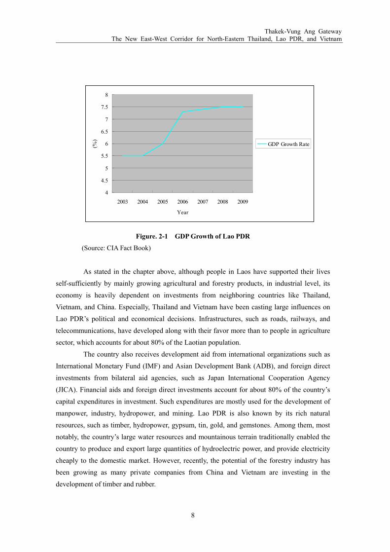
Thakek-Vung Ang Gateway The New East-West Corridor for North-Eastern Thailand, Lao PDR, and Vietnam
8
Figure. 2-1 GDP Growth of Lao PDR
(Source: CIA Fact Book)
As stated in the chapter above, although people in Laos have supported their lives
self-sufficiently by mainly growing agricultural and forestry products, in industrial level, its
economy is heavily dependent on investments from neighboring countries like Thailand,
Vietnam, and China. Especially, Thailand and Vietnam have been casting large influences on
Lao PDR’s political and economical decisions. Infrastructures, such as roads, railways, and
telecommunications, have developed along with their favor more than to people in agriculture
sector, which accounts for about 80% of the Laotian population.
The country also receives development aid from international organizations such as
International Monetary Fund (IMF) and Asian Development Bank (ADB), and foreign direct
investments from bilateral aid agencies, such as Japan International Cooperation Agency
(JICA). Financial aids and foreign direct investments account for about 80% of the country’s
capital expenditures in investment. Such expenditures are mostly used for the development of
manpower, industry, hydropower, and mining. Lao PDR is also known by its rich natural
resources, such as timber, hydropower, gypsum, tin, gold, and gemstones. Among them, most
notably, the country’s large water resources and mountainous terrain traditionally enabled the
country to produce and export large quantities of hydroelectric power, and provide electricity
cheaply to the domestic market. However, recently, the potential of the forestry industry has
been growing as many private companies from China and Vietnam are investing in the
development of timber and rubber.
4
4.5
5
5.5
6
6.5
7
7.5
8
2003 2004 2005 2006 2007 2008 2009
Year
(%)
GDP Growth Rate

Thakek-Vung Ang Gateway The New East-West Corridor for North-Eastern Thailand, Lao PDR, and Vietnam
9
In recent years, Lao PDR has been aiming to join the World Trade Organization
(WTO). By joining WTO and improving trade policies, Laos expects to achieve a better
business environment needed for its economic growth. The government’s effort to improve the
country’s economic prospects among the investors is also likely to contribute in simplifying
the investment procedures. Furthermore, the government’s fiscal resource is also expected to
improve with the introduction of Value-Added Tax (VAT) regime from early 2009. Because of
all these efforts, the World Bank has declared that Laos’s goal of graduating from the United
Nations Development Program’s (UNDP) list of least-developed countries by 2020 is
achievable.
2.1.3 Politics
As it is mentioned above, Lao PDR is a communist single-party socialist republic.
The only legal political party is the Lao people’s Revolutionary Party (LPRP). President of the
country is also the head of the LPRP. Government policies are determined by the party through
the all-powerful nine-member Executive Committee, and the 49-member Central Committee.
The central government in the Vientiane Capital also governs the administrative divisions in
the 16 provinces.
2.1.4 Population and Culture
Compared to the size of the country, the population is relatively small. In July 2009,
there were about 6.9 million people with a 2.3% annual growth. The average median age is
about 19 years, and the average life expectancy at birth is 56 years old between male and
female. There are more than 100 ethnic groups including minor groups, however, 55% can be
counted as Lao, and 11 % is Khmou. The population is also largely dominated by Buddhist,
which accounts about 67% of the population. The average literacy rate between male and
female is 68.7%. The educational expenditures are only about 3% of the GDP.
2.2 Vietnam
Although the country was divided, and experienced a conflict controlled by interests
of the two super powers, namely the United States and the Soviet Union, after the withdrawal
of the U.S. troops in 1973, Vietnam has been experiencing a steady economic growth.
Therefore, together with Thailand, the country is known as a successful country in Southeast
Asia. Following chapters shows the overview of the country.
2.2.1 Geography
Vietnam is known as a gateway country for Southeast Asian nations, bordering the
Thakek-Vung Ang Gateway The New East-West Corridor for North-Eastern Thailand, Lao PDR, and Vietnam
10
Gulf of Thailand, Gulf of Tonkin, and South China Sea in the east. In the west, the country
shares borders with China, Laos, and Cambodia. The total coastline is about 3,500km. The
topography of the country is mostly hills and densely forested mountains, covering just below
20%. The northern part of the country consists mostly of highlands and the Red River Delta.
The south is divided into coastal lowlands, Annamite Chain peaks at the border with Laos,
extensive forests, and poor soil. However, Vietnam has the highest land use for permanent
crops (7%) in any nation in the Greater Mekong Subregion.
Because of these differences in topography, the climate tends to vary considerably
from place to place. However, in general, it is tropical in south, and monsoonal in north with
hot and rainy season from May to September, and warm and dry season from October to
March. The temperatures in the southern plains varies less, going between 21 and 28J. On the
contrary, the temperatures in northern mountains and plateaus vary from 5 to 37J.
2.2.2 Economy
The country experienced a significant shift in the economy from the Communist
government planned economy to the Socialist-oriented market economy since the enactment
of “Doi Moi” (Renovation) policy in 1986. This new policy aimed to increase economic
liberalization and an enactment of structural reforms needed to modernize the economy and to
create more competitive, and export-driven industries. Subsequently, in the past 30 years,
Vietnam is recovering from the ravages of war, and freeing from the rigidities of a
centrally-planned economy. Vietnam achieved around 8% GDP growth from 1990 to 1997,
and continued to grow at around 7% from 2000 to 2008. This made Vietnam the second-fastest
growing economy in the world. Today, Vietnam is one of Asia’s most open economies, of
which two-way trade accounts around 160% of GDP. This is more than twice the ratio for
China, and over four times of India.

Thakek-Vung Ang Gateway The New East-West Corridor for North-Eastern Thailand, Lao PDR, and Vietnam
11
Figure. 2-2: GDP Growth of Vietnam
(Source: CIA Fact Book)
In 2001, Vietnam further increased her presence in the international market by
becoming a member of the ASEAN Free Trade Area (AFTA), and entering into the force of the
US-Vietnam Bilateral Trade Agreement. This partnership with US increased Vietnam’s exports
to the US by 900% from 2001 to 2007, and led to the membership of WTO in 2007. The
elimination of quotas on textiles and clothing of WTO partners through the WTO membership
enabled Vietnam to grow their textile and clothing industries. To the contrary, the share of the
agriculture industry among the country’s economic output has continued to shrink about25%
in 2000 to less than 20% in 2008. Still, Vietnam is the largest producer of cashew nuts (1/3 of
the global share), the largest producer of black pepper (1/3 of the global market), and the
second largest rice exporter after Thailand. Besides rice, the key exports are coffee, tea, rubber,
and fishery products, but the fast-growing part of the economy is manufacturing, information
technology, and high-tech industries. In addition, Vietnam enjoys the position of the
third-largest oil producer in Southeast Asia with an output of 400,000 barrels per day.
The next challenge of the country is to create jobs to meet the demand from a
growing labor force, which is increasing by 1.5 million people per year (the current
unemployment rate is 4.7% in 2008). However, considering the export-oriented
economy—exports account for 68% of the economy in 2007—this initiative is expected to
slow down in the time of the global financial crisis.
5
5.5
6
6.5
7
7.5
8
8.5
9
2003 2004 2005 2006 2007 2008 2009
Year
(%)
GDP Growth Rate

Thakek-Vung Ang Gateway The New East-West Corridor for North-Eastern Thailand, Lao PDR, and Vietnam
12
2.2.3 Politics
The country is a single-party state governed by the Communist Party of Vietnam
(CPV). There are several political groups advocating democracy, but they are not recognized
by the government. However, the socialistic characteristic in politics is diminishing since the
1990s. The President is the titular head of state, and the nominal commander in chief of the
military. The Prime Minister is the head of government, controlling over a council of
ministries composed of three deputy prime ministers, and 26 ministries and commissions. The
administrative divisions are divided into 58 provinces, placing its capital in Hanoi.
2.2.4 Population and Culture
The population of the country amounts to 86 million, which is the 13th largest
population in the world. The population is growing at the rate of 1% in 2009. The average
median age is about 27 years old, and the average life expectancy at birth is 71 years old
between male and female. Female tend to live longer which average is 6 years longer than that
of male. Though there are several ethnic groups, it is largely dominated by Kinh (Viet) which
amounts for 86% of the population. There is no particular religion dominating the population.
Buddhist is the largest but only 9.3% of the population, Catholic is 6.7%. About 80% of the
population belongs to others. As the economy grew, the education level also improved. The
average literacy rate between male and female is 90%. However, the gap in the literacy level
between male (94%) and female (87%) has remained as an issue.

Thakek-Vung Ang Gateway The New East-West Corridor for North-Eastern Thailand, Lao PDR, and Vietnam
13
3 BACKGROUND AND OBJECTIVE
The Greater Mekong Subregion (GMS), comprised by Cambodia, China, Laos,
Myanmar, Thailand, and Vietnam, has been receiving supports financially and technically
from advanced nations and aid agencies in past years, because of its peaceful political climate,
and the potentiality of providing cheap labor source to industries in advanced nations. Among
those countries, Laos had been economically lagging behind because of its land locked
situation. Although this is about to change due to increasing attentions to the country’s
agro-forestry resources, Laos still needs to identify an advantageous transport route, in terms
of cost of money and time. In this chapter, the potential of the agro-forestry industry in Laos,
and possible transport route will be discussed. Then, based on the identified route, the research
objectives will be explained.
3.1 The Agro-Forestry Industry and the Woodchip Production in Lao PDR
3.1.1 Overview of the Agro-Forestry Industry in Laos
In 2005, the total forestry coverage of Laos was about 16,142,000 ha, which is nearly
70% of the total land. The rich forestry resources have been important sources of food or
income for people in Laos for a long time. For example, people eat forestry fruits or plants
when they could not cultivate enough rice, or sold forestry products for cash. However,
recently the forests in Laos are threatened. Slash-and-burn agriculture, uncontrolled fires,
commercial and illegal logging, and fuel wood collection resulted in the loss of 6.8 % of the
country's forests between 1990 and 2005.
Table 3-1: Change in Forest Coverage
1990 2000 2005
Forest Area (ha) 17,314,000 16,532,000 16,142,000
% Change - -0.45% -0.47%
(Source: Mongbay.com)
For Laotian people who have been counting on the forest resources, this lost casts a
serious problem to their lives. People between different villages sometimes fought over the
limited resources for survival. Thus, with the help from international aid organizations and
NGOs, the Lao government started implementing projects to teach farmers how to manage and
conserve forests, and modified her Forestry Law to tighten regulations over forestry
preservation. In areas where forests were cleared, because of agriculture and logging,
plantations for production use have been promoting. By promoting plantations, the

Thakek-Vung Ang Gateway The New East-West Corridor for North-Eastern Thailand, Lao PDR, and Vietnam
14
government seeks to revitalize the forests, and increase employments at the plantation site.
As it is shown in Figure 3-1, though the production plantation area is still limited to
1.4% of the total forestry, it is increasing at the rate of 5,500% from 4,000 ha in 1990 to
224,000 ha in 2005. In fact, a Japanese paper manufacturing company just signed an
agreement with the Lao Government in February, 2010 to plant Eucalyptus and Acacia in
about 25,000 ha unused land.
Figure 3-1: Breakdown of the Forestry Use
(Source: Mongbay.com)
By utilizing the unused empty land that is suitable for forestry plantation, the role of
the agro-forestry industry in Laos is expected to grow larger in the future.
3.1.2 The Development of Agro-Forestry Processing Zone in the Khammouane
Province, Lao PDR
In relation to the increasing commercial plantation, the Lao government is also
seeking to change its agro-forestry industry from a mere material provider to a value-added
processor. This intention is also supported in a project called “Building Lao PDR’s Capacity to
Develop Special Economic Zones (SEZs)”, which was implemented from June, 2009 funded
by ADB/United Nations Industrial Development Organization (UNIDO). This project aims to
attract sustainable foreign and local investments as the engine of growth and industrial
development of Lao PDR. As a driver to reach this aim, the project seeks to establish SEZs in
strategic areas, and provide necessary infrastructures and services to attract investors. A
development of an Agro-Forestry Processing Zone was proposed as one of the 12 SEZs
leading the economic development of Laos.

Thakek-Vung Ang Gateway The New East-West Corridor for North-Eastern Thailand, Lao PDR, and Vietnam
15
Figure 3-2: Potential Locations and Themes for Lao SEZ program in 2010-2025
(Source: JDI Study Team for ADB/UNIDO-Laos SEZ Project)
The Agro-Forestry SEZ proposed in the ADB/UNIDO project is planned to be
developed in Thakek, Khammouane province by using the 350 ha land between Road No.13
and No.12. Because Khammouane is endowed with rich forestry and agricultural land, some
agro-forestry companies invested by China, Vietnam, and Japan have already started planting
trees for woodchips, timber, and rubber, and Cassava in the past. Since the Laotian law
requires investors in Laos to process at least part of their agro-forestry products within Laos to
help create employments, and transfer skills to local people, Laos is seeing a potentiality in the
contribution to the economic development this agro-forestry SEZ can provide.

Thakek-Vung Ang Gateway The New East-West Corridor for North-Eastern Thailand, Lao PDR, and Vietnam
16
Figure 3-3: Map of the Agro-Forestry Processing SEZ in the Khammouane Province
(Source: JDI Study Team)
Based on the discussions with the provincial governor, the study team for the ADB
project agreed that among the 350 ha proposed land, 100 ha will be allocated for industrial
uses, another 100 ha for commercial/residential/hotel, and the remaining 150 ha for golf
course/sport and green zone. A detailed proposal will be submitted within 2010 to the Prime
Minister through the provincial government, and expected to be developed in 2011. The
Detailed plan of the industrial zone is explained below.
1) Development Phase
Phase 1: After the approval from the Prime Minister, 100 ha Industrial Zone shall be
developed from January, 2011, and to be completed by December, 2011. The operation of the
industrial zone completed in Phase 1 shall be started from January, 2012.
Phase 2: The development of the commercial/residential/hotel zone and the golf course/sport
and green zone should start.
Thakek-Vung Ang Gateway The New East-West Corridor for North-Eastern Thailand, Lao PDR, and Vietnam
17
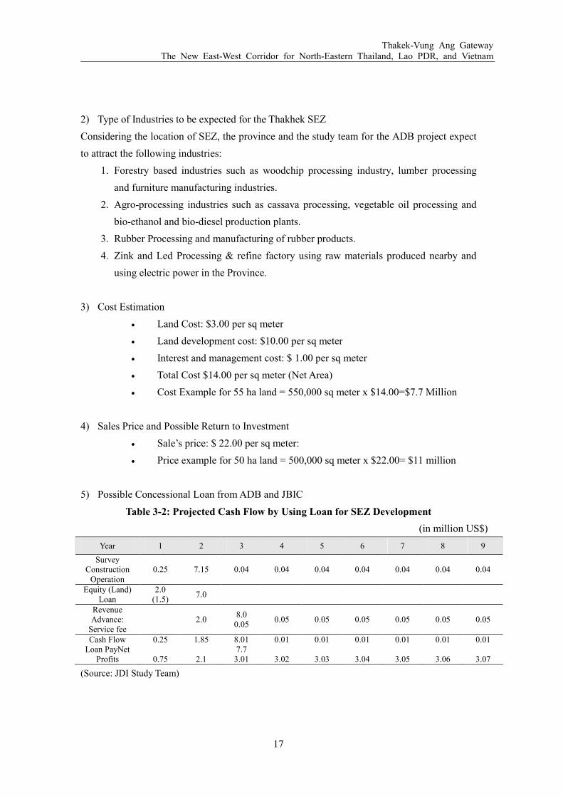
2) Type of Industries to be expected for the Thakhek SEZ
Considering the location of SEZ, the province and the study team for the ADB project expect
to attract the following industries:
1. Forestry based industries such as woodchip processing industry, lumber processing
and furniture manufacturing industries.
2. Agro-processing industries such as cassava processing, vegetable oil processing and
bio-ethanol and bio-diesel production plants.
3. Rubber Processing and manufacturing of rubber products.
4. Zink and Led Processing & refine factory using raw materials produced nearby and
using electric power in the Province.
3) Cost Estimation
• Land Cost: $3.00 per sq meter
• Land development cost: $10.00 per sq meter
• Interest and management cost: $ 1.00 per sq meter
• Total Cost $14.00 per sq meter (Net Area)
• Cost Example for 55 ha land = 550,000 sq meter x $14.00=$7.7 Million
4) Sales Price and Possible Return to Investment
• Sale’s price: $ 22.00 per sq meter:
• Price example for 50 ha land = 500,000 sq meter x $22.00= $11 million
5) Possible Concessional Loan from ADB and JBIC
Table 3-2: Projected Cash Flow by Using Loan for SEZ Development
(in million US$)
Year 1 2 3 4 5 6 7 8 9
Survey Construction Operation
0.25 7.15 0.04 0.04 0.04 0.04 0.04 0.04 0.04
Equity (Land) Loan
2.0 (1.5)
7.0
Revenue Advance: Service fee
2.0 8.0 0.05
0.05 0.05 0.05 0.05 0.05 0.05
Cash Flow Loan PayNet Profits
0.25
0.75
1.85 2.1
8.01 7.7 3.01
0.01
3.02
0.01
3.03
0.01
3.04
0.01
3.05
0.01
3.06
0.01
3.07
(Source: JDI Study Team)

Thakek-Vung Ang Gateway The New East-West Corridor for North-Eastern Thailand, Lao PDR, and Vietnam
18
3.1.3 The Potentiality of Woodchip Production for the Economic Growth of Lao
PDR
Among those agro-forestry companies in the Khammouane Province, the woodchip
production is planned to be the first of processing and exporting in a large volume. The
position of this woodchip production is important in terms of the economic growth of Laos
since the demand for woodchips for paper production has generally kept high, except for 2009
when the world was slowly healing from the economic recession from the end of 2008.
However, seeing the gradual recovery from the economic loss around the world since the end
of 2009, the paper demand is expected to increase again this year. Especially, the paper
demand in countries with a faster economic recovery rate, such as China, ASEAN countries
and India, is expected to grow steadily again. Japan, the main export destination of woodchips
growing in central Laos, is expanding its business in these countries recently. Thus, by
studying the paper demand in Japan, and the volume of paper export from Japan, the future
expectancy for woodchip production in Laos will be known.
The paper demand in Japan itself has been slightly decreasing in these few years
because companies are reserving to spend much on advertising, such as flyers and brochures,
after the economic recession. Still, the demand for paper is kept in a high percentage as shown
in Figure 3-4 below.
Figure 3-4: The Change in Paper Demand in Japan: 1995-2008
* in thousand tons
(Source: Japan Paper Association)
cardboards
For printing

Thakek-Vung Ang Gateway The New East-West Corridor for North-Eastern Thailand, Lao PDR, and Vietnam
19
To meet the demand in and outside the country, Japan has been producing woodchips
among its own land, and importing from other countries. Although the paper demand itself in
Japan is slightly decreasing, the amount of imported woodchips has been growing over the
past years.
Figure 3-5: The Change in Imported Woodchips Volume
(Source: Japan Paper Association)
By countries, Australia and New Zealand have been ranked among the top countries
from where Japan is importing woodchips. However, when studying by the tree type, it can be
seen that volume of imports from Asian countries are increasing in broad-leaf trees. The
Eucalyptus, which is growing in the central Laos, is also listed among the broad-leaf trees.
Therefore, if a cost-effective export route from Laos is established, Laos can also follow the
successful woodchip export model of other Asian countries.
Import Rate
(%)
In million BDT

Thakek-Vung Ang Gateway The New East-West Corridor for North-Eastern Thailand, Lao PDR, and Vietnam
20
U.S.A.
EU
Chile
South Africa
China
Brazil
Others
EU
Chile
South Africa
Vietnam
Brazil
Thailand
Others
Figure 3-6: Major Woodchip Import Countries of Japan: 1998 and 2008
(Source: Japan Paper Association)
Seeing the suitability of land in Laos for woodchip production, a Japanese company
is producing woodchips in central Laos with a planting, harvesting, and exporting plan as
given in Table3-3. The plantation size of woodchip trees in Khammouane Province, and
Bolikamxai Province in the neighbor has reached over 20,000 ha by the end of 2009, and is
planned to be expanded further to 40,000 ha within the next few years. The operation of the
woodchip company in central Laos will continue at least until the next 50 years.
Year 1998
Year 2008

Thakek-Vung Ang Gateway The New East-West Corridor for North-Eastern Thailand, Lao PDR, and Vietnam
21
Table 3-3: Schedule of the Woodchip Plantation and Harvesting
Year ~04 2005 2006 2007 2008 2009 2010 2011 2012 2013 2014 2015
Plantation (ha) 1,600 276 3,430 6,040 6,572 8,500 7,000 7,000 7,000 7,000 7,000 7,000
Cumulative Plantation Area (ha)
1,876 5,306 11,346 17,918 26,418 33,418 40,418 47,418 54,418 61,418 68,418
Harvesting (ha) 1,876 3,430 6,040 6,500
Cumulative Harvested Area (ha)
5,306 11,346 17,846
(Source: Japanese Forestry Company in Central Laos)
Because woodchips will be the first to be exported to the international market among
agro-forestry companies in central Laos, its export route and plan can be the model for other
companies to follow in the future. Thus, the JDI research team has declared that the success of
Lao agro-forestry industry relies on whether the woodchip production can achieve an
economically viable transport route through neighboring countries. For this purpose, the
economic corridor currently being developed through ADB’s assistance, will be studied
closely to identify an advantageous transport route.
3.2 Greater Mekong Subregion (GMS) Economic Corridor Development Program
In 1992, with ADB’s assistance, the six countries in GMS entered into a program of
sub-regional economic cooperation, designed to enhance economic relations among the
countries. Until today, the program has contributed to the development of infrastructures to
enable the development and sharing the resource base, and promoting freer flow of goods and
people in the subregion. It has also led to the international recognition of the GMS as a growth
area.
In order for a successful economic cooperation, trans-national road linkages have
been recognized as especially an important element to be strengthened. In 1998, three main
focal corridors in terms of transportation, namely North-South, East-West, and Southern
economic corridors, were set as in figure 3-7.

Thakek-Vung Ang Gateway The New East-West Corridor for North-Eastern Thailand, Lao PDR, and Vietnam
22
Figure 3-7::::Greater Mekong Subreagion Economic Corridors
(Source: Asian Development Bank)

Thakek-Vung Ang Gateway The New East-West Corridor for North-Eastern Thailand, Lao PDR, and Vietnam
23
The North-South Economic Corridor (NSEC) has been receiving the largest
attentions from investors connecting Bangkok to Hanoi. It involves three different routes along
the north-south axis of the GMS geography as listed below. Constructions and renovations of
road are processing in an ideal pace with four countries involving in the corridor changing
their road standards to the sub-regional standards.
1) The Western Sub-Corridor: Connects Kunming (China)-Chiang Rai (Thailand) -Bangkok
(Thailand) via Lao PDR or Myanmar. This section completed its construction in 2007,
except for the part lying in Myanmar.
2) The Central Sub-Corridor: Connects Kunming-Ha Noi (Vietnam)-Hai Phong (Vietnam),
which connects to the existing Highway No. 1 running from the north to the south of
Vietnam. The constructions of expressways are duly progressing.
3) The Eastern Sub-Corridor: Connects Nanning (China)- Ha Noi via the Youyi Pass or
Fangcheng (China)-Dongxing (China)-Mong Cai (Vietnam) route. The construction of the
expressway in some sections was completed, and the railway rehabilitation in Vietnam is
also progressing.
The Southern Economic Corridor (SEC) runs through southern Thailand, Cambodia,
and southern Vietnam. Originally, the SEC consisted only with one route—the
Bangkok-Phnom Penh-Ho Chi Minh City-Vung Tau corridor. However, at the request of
member countries, the following two routes were also included:
1) The Northern Sub-Corridor: Connects Bangkok - Siem Reap - Stung Treng - Rattanakiri-O
Yadov – Pleiku - Quy Nhon.
2) The Southern Coastal Sub-Corridor: Connects Bangkok - Trat (Thailand) - Koh Kong -
Kampot (Cambodia) - Ha Tien - Ca Mau - Nam Can (Vietnam).
SEC is important in its way allowing direct route from southern Laos to
Sihanoukville port in Cambodia. Currently, the Southern Corridor’s key sections, which are
mostly located in Cambodia, are being upgraded and rehabilitated by respective governments.
Assistance is also being provided by ADB, Japan, World Bank, Korea, China, and Thailand.
The East-West Economic Corridor (EWEC) runs from the Mawlamyine Port in
Myanmar to the Da Nang Port in Vietnam through Laos and Thailand. The total distance is
1,450 km, partially intersecting with NSEC. This corridor enables GMS to have a direct route
connecting the Indian Ocean and the South China Sea. Since the start of Economic Corridor

Thakek-Vung Ang Gateway The New East-West Corridor for North-Eastern Thailand, Lao PDR, and Vietnam
24
development in GMS, Japan has long been supporting the development of EWEC. Japan and
ADB have been mainly providing assistance to Laos and Vietnam for upgrading roads, and
Thailand offering assistance to Myanmar. EWEC is particularly important for the land-locked
country like Laos to secure the route access to the sea.
Recently, in addition to the on-going EWEC having the Da Nang Port as a gateway
to the Eastern Sea, the gateway through the Vung Ang Port in central Vietnam has also caught
attentions as a new section in the East-West Corridor since the start of the port operation in
2001. Geographically, for the woodchip company in central Laos, either gateway in EWEC
will be the center of focus when considering the transport route. Therefore, the two gateways
will be studied in details in the next chapter to identify which corridor is more suitable.
3.3 The East-West Corridor and for the Land Locked Country Laos
The relationship between the plantation area of woodchip trees in central Laos, and
the two gateways in the East-West economic corridor are shown in the map below. For
convenience, each gateway will be named after the origin in Laos and the destination port.
Figure 3-8: Map of the East West Corridor in GMS
(Source: Asian Development Bank)
3.3.1 Mawlamyine - Dang Nang Gateway
The development of this gateway is consisted with various transportation

Thakek-Vung Ang Gateway The New East-West Corridor for North-Eastern Thailand, Lao PDR, and Vietnam
25
improvement projects, such as the Second Mekong International Bridge construction between
Laos and Thailand in Savannakhet, the Mekong Bridge access roads in Thailand, the National
Road No.9 rehabilitation in Laos, the National Highway No.1 periodic maintenance in
Vietnam, and the Da Nang Port improvement funded by various agencies, including ADB,
JICA, Japan Bank for International Cooperation (JBIC), and private companies, but all
coordinated under ADB’s initiative. The project did not only aim to build a road link among
Thailand, Laos, and Vietnam, but also to reduce governmental constraints in crossing borders
to encourage transport and trade flow.
Among this gateway, the part from Laos to the Da Nang Port is especially important
for woodchip export from the central Laos. By the end of 2008, the rehabilitation of Road
No.9 from Phin in Laos to Dong Ha in Vietnam, and the construction of the Second Mekong
Bridge were completed. The Da Nang Port upgrade project is still ongoing, scheduled to be
finished by the end of 2010. The Da Nang Port is comprised of two ports, namely Tien Sa Port
and Song Han Port. Currently, it can accommodate vessels weighing up to 40,000 tons and
having a capacity of 2,000 TEUs. In 2000, the port handled about one million tons of goods,
which were low considering the capacity of the port. This was partially due to the presences of
other good ports in surrounding regions. However, since the EWEC under ADB project
specifically identifies the Da Nang Port as the gateway, it expects to receive more goods in the
future. Thus, the Da Nang Port started an upgrade project, aiming to handle four million
tons/year of goods by 2010, including 120,000 TEUs of cargo. The port have been investing
large sums to upgrade infrastructures, improve loading and unloading facilities, and
simplifying administrative procedures through 2010. In details, it will build a container
terminal able to handle ships upto 50,000tons at the Tien Sa Port, and a 20ha inland container
depot outside the port.
3.3.2 Thakek-Vung Ang Gateway
.This gateway is not developed under the GMS Economic Corridor Plan funded by ADB,
but under the agreement between Vietnam and Laos in 1996. The Vung Ang Port at the end of the
gateway was constructed specifically to help Laos gain a route out to the sea to promote their trade
business. While the port facility completed its construction in 2001, the direct road, called Road
No.12, connecting Thakek to the Vung Ang Port have just completed in June, 2009, though
minor sections are still under the process of paving. In addition to the direct connection
between Laos and Vietnam, the project of connecting north-eastern Thailand is also
progressing. In 2007, the Thai government agreed with the Lao government to build the Third
Friendship Bridge from Nakhom Phanom in Thailand to Thakek, enabling a vertical transport
route from north-east Thailand to Central Vietnam. The bridge is scheduled to be completed in
Thakek-Vung Ang Gateway The New East-West Corridor for North-Eastern Thailand, Lao PDR, and Vietnam
26
2011 funded by the Thai government.
At the end of the gateway, there are two sea ports in the Vung Ang area. The first is
called the Vung Ang Port, which currently has two operating berths. Berth No.1, which can
handle up to 45,000 DWT vessels, was completed in 2001, and already operated by the Ha
Tinh Port Joint Stock Company. Berth No.2, which is able to accommodate as large as
50,000DWT vessels, will start its operation from March, 2010 by a joint company called Vung
Ang Port Viet-Lao Joint Stock Company, which is invested by 10 different entities from
Vietnam and Laos. The second port is called the Son Duong Port. Vung Ang and Son Duong
are situating next to each other, but geographically divided by the Ron Cape Peninsula (See
Chapter 6 for details). The Son Duong Port is still under construction funded by a Taiwanese
Formosa Group scheduled to be completed by 2012. The area has a potential of
accommodating ships as large as 200,000-400,000DWT, which is potentially the largest port
in Asia.
3.3.3 The Advantage of the Thakek-Vung Ang Gateway
When considering for a transportation route of woodchips from central Laos, there
are two important factors that have to be evaluated. First is the distance from the woodchip
processing site to the exporting port. When exporting goods from Laos, because the country is
surrounded by five countries, the transportation cost will be higher than exporting from a
country equipped with a sea port. While the distance from the woodchip processing site in
central Laos to the Vung Ang Port is below 300km, the distance to the Da Nang Port is more
than 500km.
The second factor is the capacity of the exporting port. First, there should be enough
space to develop a stock yard for woodchips in a close distance to operating berths. Because
transporting woodchips from Laos to a port is already costly, the cost of loading woodchips to
vessels should be kept low by building the yard close to a berth. In this point, because it is
relatively new in the region, the Vung Ang Port has not yet been densely in use, thus sites near
operating berths are still available. In addition, the port has to be able to accommodate a vessel
expected to be used when the woodchip production hits the maximum. In this case, the
assumed maximum vessel size (at least until 2019) is 51,000 DWT Woodchip Maximum
Vessel (WMV). The Vung Ang Port already has a berth that can accommodate vessels upto
50,000DWT, while the Da Nang Port is expected to finish upgrading one of its berths to hold a
vessel as large as 50,000DWT as well.
Between the two gateways, there are not many differences except for the distance
between the woodchip processing site to the exporting port. The 200km gap between the
distances of two gateways brings a lot of differences in cost that could influence the

Thakek-Vung Ang Gateway The New East-West Corridor for North-Eastern Thailand, Lao PDR, and Vietnam
27
profitability of the woodchip business. As stated above, the woodchips export is a pilot project
that other agro-forestry companies in central Laos could follow if economic efficiency was
reached. Therefore, JDI study team identified the Thakek-Vung Ang Corridor as more suitable
to serve for the woodchip exports from central Laos in the future. The choice of which port in
the Vung Ang area should be used—either the Vung Ang Port or the Son Duong Port—will be
discussed later in this report. In the meantime, the common condition between the Vung Ang
Port and the Son Duong Port –the road network—is discussed in Chapter 5.
3.4 Study Objectives
If successfully planned, the development of the Thakek-Vung Ang Gateway benefits
both Laos and Vietnam in a long term. For Laos, it is the route out to the sea, especially for
agro-forestry companies in central Laos. If the route is proved to be an efficient and
economical transport route, it will serve to develop a sustainable business for agro-forestry
companies, which in return contribute to the economic development of Laos. For Vietnam,
agro-forestry companies, especially the woodchip production in Laos, are currently the largest
potential users of the Vung Ang Port. In addition, according to their plantation plan, the export
will continue even after 2019 at about 1,000,000tons/year rate. Thus, for Vietnam, serving for
agro-forestry products export ensures a long-term profit at the Vung Ang Port.
In order to establish this win-win situation between two countries, there must be a
successful example utilizing the Thakek-Vung Ang Gateway. The exports of woodchips could
be a pilot project that establishes a new export route for other agro-forestry companies in
central Laos to follow. For a successful trans-shipment, the cost efficiency must be achieved,
first by securing a storage yard for agro-forestry companies at the vicinity of operating Berths.
Secondly, an expansion or improvement of road and port infrastructures should be carefully
studied and planned to keep up with the growth in the volume of transported goods on the
corridor. Therefore, in order to certify these two elements, the study objective was set as
follow.
1) To identify and calculate the future export demand through the Thakek-Vung Ang
Gateway from central Laos.
2) To compare the above demand to future development plans of Laos and Vietnam on Road
No.12, and Vung Ang Port.
3) To identify and provide specific plans of necessary infrastructural improvement projects at
the Vung Ang Port to meet the demand from Laos with preliminary development schedule.
4) To identify possible donors of future infrastructure development projects, and build basic
understanding on the project.

Thakek-Vung Ang Gateway The New East-West Corridor for North-Eastern Thailand, Lao PDR, and Vietnam
28
4 CONDITION AND FUTURE DEVELOPMENT PLAN OF ROAD NO. 12
Road No.12 starting from Thakek in Laos through the Vung Ang Port in Vietnam
enabled Laos to gain direct route to a sea port. The road has one lane in each direction, which
is enough to serve the current traffic volume, but assumed to be insufficient once woodchip
starts being exported in large volumes. In order to design the Road No.12 improvement plan
so that woodchips can be exported without a major traffic concern, first the future demand on
road will be explained, then the current road condition summarized, and finally the proposed
improvement plan will be presented in this chapter.
4.1 The Existing Transportation Volume and Future Demand Projection
According to the daily traffic record taken by the Department of Road, Ministry of
Public Works and Transportation of Laos, daily number of vehicles on Road No.12 increased
from 1,500/day to 4,000/day after the road connected to the Lao/Viet border in 2008. Still, the
one lane road in each direction, is enough to keep a smooth traffic. However, as the
transportation of agro-forestry products start from 2012, the traffic on Road 12 is expected to
increase as in the table below.
To hold such volume in addition to the existing traffic volume, a widening of the
road or increase in lanes, and a constant improvement of the surface may be needed to ensure
smooth traffic flow from central Laos to the Vung Ang Port. In order to project the future
demand and identify necessary road improvement projects, the current traffic count is studied,
then the projection was made based on information from potential users of Road No.12 in the
following paragraphs.
4.1.1 Traffic Count: 2001-2008
Based on to the traffic data on Road No.12 provided by the Department of Road,
Ministry of Public Works and Transportation of Laos, the daily traffic on Road No.12 in the
Laotian side was calculated as in Figure 4-1. Seeing the large increase of traffic between year
2004 and 2008, it can be assumed that the traffic flow increased after the completion of the
construction of Road No.12 to the border. This suggests that there is a certain amount of
potential users of Road No.12, if directly connected with Vietnam. Considering the fact that
the Vietnamese part of Road No.12 just completed in June, 2009, users of Road No.12 is likely
to be kept increasing in the future as well. If the transportation of agro-forestry products starts
from central Laos within the next few years, the volume will further increase.

Thakek-Vung Ang Gateway The New East-West Corridor for North-Eastern Thailand, Lao PDR, and Vietnam
29
0
500
1000
1500
2000
2500
3000
3500
4000
No. of Cars
2001 2004 2008
Year
Average Daily Traffic
Figure 4-1: Average Annual Daily Traffic on Road No.12
(Source: Department of Road, Ministry of Public Works and Transportation of Lao PDR)
In Figure 4-2 below, the average annual daily traffic by vehicle types is shown.
Besides the increase in the volume of “car”, traffic volume of trucks—light, medium, and
heavy—is also increasing steadily. It is assumed that some of the trucks are involved in border
trade carrying cattle and limestones from Laos to Vietnam. Both can be purchased cheaper in
Laos, then transported and marketed into Vietnam. At this moment, because the Road No.12 in
Vietnam has just completed, the traffic volume in Vietnam is not yet summarized. Still, since
the woodchips are planned to be transported from central Laos by using 20 tons size truck, the
volume of “Heavy Trucks” is expected to grow in the future.

Thakek-Vung Ang Gateway The New East-West Corridor for North-Eastern Thailand, Lao PDR, and Vietnam
30
0
50
100
150
200
250
300
350
400
450
2001 2004 2008
Year
No. of Trucks
LightTruck
MediumTruck
HeavyTruck
TruckTrailer
HeavyBus
MediumBus
PickUp
Car
Motorcycle
Figure 4-2: Average Annual Daily Traffic on Road No.12 by Vehicle Type
(Source: Department of Road, Ministry of Public Works and Transportation of Lao PDR)
4.1.2 The Future Demand from Agro-Forestry Companies in Laos
Although there are other products transported from central Laos to Vietnam through
the Road No.12, such as limestones and cattle, since this project proposal is to ensure
economically sound export route for agro-forestry companies, especially woodchips, in the
future, the demand forecast will be based on the demands from such companies. Agro-forestry
companies in Laos are mainly dealing with woodchips, timber, rubber, and cassava. According
to preliminary hearings from companies in the area, by year 2009, the plantation area of
woodchips, rubber, and cassava in central Laos has reached more than 30,000ha to 40,000ha.
In terns of export through the Road No.12, the woodchip export volume is especially
prominent and urgent. The export of woodchips is planned to start from 2012, expecting to
transport about 180,000tons of woodchips in the first year, and 400,000tons in the second year.
The export volume will increase steadily, and projected to reach to about 800,000tons/year
between 2014-2018, and 900,000tons/year after 2019.
Since woodchip is rather voluminous commodity, it would require trucks with larger
loading space, such as trailers and long bodies. Hence, the expected truck volume on Road
No.12 to transport woodchips from central Laos was calculated in the following table by given
three options—10 ton trucks, 15 ton trucks, and 20 ton trucks.

Thakek-Vung Ang Gateway The New East-West Corridor for North-Eastern Thailand, Lao PDR, and Vietnam
31
Table 4-1: Required Trucks Per Day to Transport Woodchips from Central Laos
Year (s) Production (based on
MT per year) Required trucks per day based on truck capacity
10 –tonner 15- tonner 20-tonner
2012 180,000 50 38 25
2013 400,000 110 83 55
2014 -18 800,000 220 165 110
2019 onwards 900,000 246 185 123
(Source: JDI Study Team)
By the time the volume of woodchip transportation reaches to 900,000tons/year in
2019, the number of daily trips to the Vung Ang Port will increase to 123 trips/day in addition
to the average daily traffic today (in case of using 20 tons trucks). However, the above table is
for woodchips alone. If the economic efficiency of the Thakek-Vung Ang Gateway is verified
through the woodchip transportation, other agro-forestry products are also likely to take the
same transport route in the following volume.
Table 4-2: Required Trucks Per Day to Transport Other Agro-Forestry Products
Year (s) Production (based on
MT per year) Required trucks per day based on truck capacity
10 –tonner 15- tonner 20-tonner
2012 340,000 100 76 50
2013 800,000 220 166 110
2014 -18 1,600,000 440 330 220
2019 onwards 1,800,000 492 370 246
(Source: JDI Study Team)
If all added up, the minimum traffic volume, based on the assumption that all
companies will use 20tons trucks for transportation, and other vehicles on the road will
increase for 1,000 vehicles per day every year, the future traffic demand on the Road No.12
can be summarized as below.

Thakek-Vung Ang Gateway The New East-West Corridor for North-Eastern Thailand, Lao PDR, and Vietnam
32
Table 4-3: Demand Projection from Agro-Forestry Companies on Road No.12
Volume (tons) Volume (vehicles)
2008 - 4,000 vehicles/year
2012-2014 520,000tons 5,075 vehicles/year
2013 1,200,000tons 6,165 vehicles/year
2014-18 2,400,000tons 7,330 vehicles/year
2019 onwards 2,700,000tons 8,369 vehicles/year
(Source: JDI Study Team)
4.1.3 The Future Demand from North-Eastern Thailand
After the completion of the Third Friendship Bridge at the border with Thailand
/Laos in Thakek in 2011, the export volume from the north-eastern Thailand will also become
a crucial determinant of the development plan of the Road No.12.
The total area of north-eastern Thailand, which
is known as “Isan” by locals, is slightly larger than
England. In Isan, agriculture is the main economic
activity, generating about 22% of Gross Regional Product.
The main crop is sticky rice, which endures even in the
poorly drained paddy field. However due to the low
socio-economic conditions and hot, dry climate, the
output lags behind that of other parts of the country. As a
result, Isan is considered as Thailand's poorest region.
Recently, farmers are increasingly diversifying into cash
crops, such as sugar cane and cassava which are
cultivated on a vast scale, and to a lesser extent, rubber.
Silk production is an important cottage industry and contributes significantly to the economy
as well. Pineapples, tomatoes, and tobaccos are also occupying an important part of economy,
particularly in the Nong Kai Province.
Considering the capacity and the advantage of the location of the Vung Ang Port,
once the Third Friendship Bridge at Nakhom Phanom/Thakek is constructed, it is likely that
the traffic volume from the North-Eastern area of Thailand increase year by year. In addition,
once the route to Thailand is opened, the traffic flow from Vietnam, such as trucks carrying oil,
is likely to increase as well. Based on the data taken by the Department of Highways (DOH)
of Thailand, the estimate of the future traffic volume crossing the bridge is calculated as
below.

Thakek-Vung Ang Gateway The New East-West Corridor for North-Eastern Thailand, Lao PDR, and Vietnam
33
0
200
400
600
800
1000
1200
2005
2011
2013
2015
2017
2019
2021
2023
2025
2027
2029
Year
No. of Trucks Total Trucks
6 Wheels Truck
10 Wheels Truck
>10 Wheels Truck
Figure 4-3: Estimated Average Daily Truck Transportation on the Third Friendship
Bridge
(Source: DOH)
Because of the strategic location of the bridge, the exchange of commodities and
materials among Thailand, Laos, and Vietnam is expected to increase in the future. Thus, it is
assumed that the traffic volume for larger trucks will increase at higher rates than smaller
trucks. Considering this estimate on the traffic volume, it may be necessary to improve the
condition of Road No.12 in the future to endure the volume of heavily loaded trucks to pass by
without delay. In addition, a constant maintenance of the road may be also needed. Based on
these assumptions on the future traffic volume on the Road No.12, the current condition of the
road will be studied to identify the need for improvement.
4.2 The Current Condition of Road No.12
The construction of the Road No.12 was planned and processed based on the
agreement between Laos and Vietnam, which stated Vietnam’s intention of cooperating with
Laos for it to have an access to the Eastern Sea. In terms of road construction, compared to the
steady progress in Laos, the construction in Vietnam took a while. The details of the condition
of Road No.12 in both countries are explained in following paragraphs.

Thakek-Vung Ang Gateway The New East-West Corridor for North-Eastern Thailand, Lao PDR, and Vietnam
34
Figure 4-4: Route from Thakhek – Lao/Vietnam Border – Vung Ang Port
(Source: JDI Study Team)
4.2.1 At the Lao PDR’s Side
The distance of Road No.12 between Thakhek and Cha Lao, the Vietnam -Lao
Border (Na Phao), is 147 kilometers. This section of the road is generally in a good condition,
which is in accordance with the Road Standard, design class IV –2 lanes @ 3.5 meters (DBST),
2*1 meter shoulder. Starting from Thakek, the construction of the first section from 0 Km to
55 Km was finished in 2008. This section was constructed as a part of the Nam Thuen II
Hydro Power Project. The road condition in this section is generally a flat terrain. In some
sections, it can be observed that the high voltage power line, and down streams crossing the
road. If the traffic volume on Road No.12 to be increased in the future, there may be a need to
VungAngPort
12
12
15
Thakek
Cha LaoAlternative
Route

Thakek-Vung Ang Gateway The New East-West Corridor for North-Eastern Thailand, Lao PDR, and Vietnam
35
widen the bridges, which is hanging over streams, to ensure smooth traffic flow.
The second section from 56 Km to 147 Km (Lao – Viet Nam Border) was finished
earlier in 2007, planned under the road development plan of the Department of Road, Ministry
of Public Works and Transportation of Laos. According to the sign board indicating the entire
road improvement plan on the street, this section will be further improved during the time
period of 2007-2010. Among this section, from 55 Km to 91 Km is flat, while, the section
from 92 Km to 147 Km enters into a mountain area. There are many sharp curves, and the
elevation varies from 180 m to 370 m. Still, generally the road surface is kept in good
condition. During the field study, some area was identified as a possible construction site of
by-pass tunnels to shorten the distance and lessen the traffic cost.
4.2.2 At the Vietnam Side
As shown in Figure 4-5 below in a red line, from the border of Laos and Vietnam,
Road No.12 is temporarily connected to Ho Chi Minh Hwy (Road 15), and extended from
Dong Le, temporarily taking Road No.12A again, and connected to the Vung Ang Port. The
road from Dong Le to the Port is only recently finished constructing in June, 2009. The
distance from the Vung Ang Port to Dong Le (the connection point to Road No.12A) is 76 Km,
the Distance from Dong Le to Ho Chi Minh Hwy is 36 Km. and the distance from Ho Chi
Minh Hwy to the border is 37 Km. The total distance is 149 Km.

Thakek-Vung Ang Gateway The New East-West Corridor for North-Eastern Thailand, Lao PDR, and Vietnam
36
Figure 4-5: Road No.12 from Vung Ang to Cha Lo (Border)
Starting from the Vung Ang Port, the first 2 Km of the distance is sharing the road with
Highway No.1, thus has 4 lanes. When Highway No.1 connects to the newly constructed Road
No.12, it will change to design class IV with two standard lanes (DBST). In this segment, the road
is kept in a good condition. Between 40km to 50km from Highway No.1, the road enters into a
mountain area, thus some sections of the road are tilted by the mountain slope. In addition, the
concrete slope protection in this area is not in a good condition and some parts were broken and
moved down to road surface, thus should be improved in the future. At the segment from Ho Chi
Minh Hwy to Lao-Vietnam border, the road is under construction to improve the surface condition.
The construction of a side ditch, and a widening of a carriage way has already finished, except for
the distance between 16 Km to 22 Km from the ending of the Ho Chi Minh Highway. The segment
between Ho Chi Ming Hwy and the border is paved, but not in a good quality compared to the road
close to the port. In the future, it is likely that a lot of heavy trucks carrying agro-forestry products
passing by this section to the Vung Ang Port. Therefore, this section either has to be under a
constant maintenance, or to be improved.
As the road approaching to the border, the road becomes curvier and less maintained. If
the traffic to be increased in the future, accidents may occur when heavily loaded large trucks pass
by each other. In fact, during the research, the team encountered an accident site of two trucks

Thakek-Vung Ang Gateway The New East-West Corridor for North-Eastern Thailand, Lao PDR, and Vietnam
37
colliding with each other. The two trucks, unable to move, were partly blocking the road, and
causing traffic jam in a short distance. To avoid a delay in transportation, a widening of the road at
this section will be crucial.
There is also an alternative route connecting to the Vung Ang Port from the
Loa-Vietnam border. The alternative road is connected to Highway No.1 from the Vung Ang
Port to Ba Don, and extended to Dong Le through Road No.12. The total distance is 195Km,
and generally have a smooth surface. However, the distance is 46Km longer than taking Road
No.12, thus likely to be used lesser than the new road. Still, it is always ideal to have an
alternative route in case there is an emergency on the other route.
<Route No.1>
76 Km (New Road) 36Km 3 Km
Total distance = 149 Kilometers
<Route No.2>
67Km 55Km 36Km 37Km
Total distance = 195 Kilometers
Figure 4-6: Two Alternative Routes from the Vung Ang Port to Cha Lo ( Border )
(Source: JDI Study Team)
4.3 The Development Plan of the Third Friendship Bridge
When the agreement between Laos and Vietnam was made in 1990s, both countries
aimed to connect the Road No.12 with north-eastern Thailand, and receive freight transfers
going through the Vung Ang Port. The situation is moving just as the two countries assumed.
Seeing the improvement in the Vung Ang Port and on Road No.12, Thailand decided to build
the Third Friendship Bridge connecting Nakhon Phanom in Thailand to Thakek in Laos. It is
assumed that the route through the Vung Ang Port is much less costly for north-east provinces
of Thailand than they are now incurring by taking the route through Laem Chabang Port or the

Thakek-Vung Ang Gateway The New East-West Corridor for North-Eastern Thailand, Lao PDR, and Vietnam
38
Bangkok Port. The bridge is planned to finish its construction in September, 2011.
In addition, the Lao government is also planning to connect Road No.12 with
Vientiane Capital by extending the road. As it can be seen in Figure 3-2 in Chapter 3, there are
currently three SEZs planned to be developed in Vientiane—Industrial SEZ, Tourism based
SEZ, and Border Trade SEZ—under the national SEZ plan. The extension of Road No.12 will
enable the Vung Ang Port to serve the industries in Laotian SEZs, or tourists to come to
central Vietnam more than today. If this plan is to be materialized, the importance of, and
attentions to the Vung Ang Port and the surrounding regions will likely increase.
4.4 The Future Development Plan of Road No.12
According to the increase in the expected transport volume between Central Laos
and the Vung Ang Port, the development of Road No.12 should be planned in different phases
to deal with the correspondent volume. The custom process at the border also needs to be
improved by large to ensure trucks a minimum waiting time at the border during transportation.
The possible road development plans with improvement plans of the custom process will be
discussed in details below. In addition to the road transportation, there is also a plan to
construct railway network between Thakek and the Vung Ang Port. As one of the possible
transport route, the progress in the railway project will be also summarized.
4.4.1 The Road Improvement Plan in Two Phases
Since there has not yet a large volume of transport going through the Thakek – Vung
Ang Gateway, both Laotian and the Vietnamese governments have not yet materialized a plan
of improving Road No.12. Yet, based on the expected traffic volume to transport woodchips
identified in sections above, the study team recommends both government to start planning
future road development plan to ensure smooth traffic flow in the future. Based on a
preliminary study conducted during the field research, the improvement of Road No.12 could
be divided into two phases.
1. Phase 1 (2012-2014): Partial Widening of the Road
In the first phase, Road No.12 is expected to have an average of about 5,075 vehicles
per day. In order to handle increasing volume of traffic, the team proposes to widen the road at
some sections to allow larger sizes trucks to pass by each other. Partial widening of the road is
considered to be a temporary treatment to meet the increasing demand on the road before
adding lanes in the future, since it takes less time and cost. The widening of road should
happen where the traffic volume expects to increase, such as the merging point with other
roads, or at places where road becomes slightly narrower. These sections could be near the

Thakek-Vung Ang Gateway The New East-West Corridor for North-Eastern Thailand, Lao PDR, and Vietnam
39
mountainous border where road gets steep and winding.
2. Phase 2 (2015-2020): Widening of the Whole Route and Construction of Tunnels
The expected traffic volume at this phase will likely to hit an average of 7,000-8,000
vehicles per day. The total distance of the Road No.12 is close to 300 km, making the two-lane
development planning and construction costly and lengthy. Thus, it is considered to be more
suitable if funded by governmental or aid agency money. In addition, since there is still some
time until the road development enters into this second phase, the time plan is also suitable for
government funding, which generally takes longer time from planning till construction.
Because a large quantity of woodchips produced in central Laos and exported through the
Thakek-Vung Ang Gateway is shipped to Japan, adding lanes to increase traffic flow will
ultimately profit Japan. Therefore, it could be funded by using Japanese Official Development
Aid (ODA). However, a more detail study is necessary to identify appropriate funding agency.
4.4.2 The Development Plan of Connecting Road No.12 to Vientiane
During the field research, JDI study team received the news that the Department of
Road, Ministry of Public Works and Transportation of Lao PDR is willing to connect the Road
No.12 to Vientiane Capital. By allowing Lao’s center of economy to connect to the Vung Ang
Port, Laos expects to boost its economy further. In addition, the integration of the countries
within the GMS matches with the intention of each country and ADB.
The direct connection between Vientiane and the Vung Ang Port will have a positive
influence on Vietnam, especially the Ha Tinh Province. It will allow people to travel. If
visitors increased in the Ha Tinh Province, any business related to tourism and service industry,
such as restaurants, hotels, and travel agencies, will benefit. It will also allow residents of Ha
Tinh to travel to Vientiane easily too. If Road No.12 connects with north-eastern Thailand with
the Third Friendship Bridge, it will also allow residents from three countries to travel more
freely.
4.4.3 Improvement in the Custom Process at the Border
In the initial stage of the transport of woodchips, although the road standard may be
enough to hold an average of 4,000-5,000 vehicles per day, the custom process at the border is
not efficient enough, especially at the Laotian side. Therefore, more efficient systems need to
be applied at the border for both Laos and Vietnam side to reduce the transportation time, and
thus the cost.
At present, the Customs system is manually completed on a form as per United
Nations Layout Key (UNLK), and the custom office does not have a software system. For this

Thakek-Vung Ang Gateway The New East-West Corridor for North-Eastern Thailand, Lao PDR, and Vietnam
40
reason, at the Laotian custom office at the border with Vietnam (Cha Lao) in Na Phao, the
custom process takes about 1 hour to complete. However, the custom office of Lao PDR
signed a MOU to replace this manual system by a UNCTAD Custom Software called
ASYCUDA in February, 2010. It is expected that all systems will be replaced within two to
three years. At Na Phao, this system should be implemented by the time the first woodchip
export starts in 2012. At this stage it is not clear what modules (Direct Trader Input, Risk
Assessment and Management) or the systems (Wide Area Network (WAN) or Stand alone) of
ASYCUDA (ASYCUDA ++ or ASYCUDA World) will be implemented at the Na Phao border,
hence it cannot be said whether the customs will be fully upgraded to handle and clear cargo
electronically by 2012. However the clearance procedure is projected to be more efficient.
The procedures to receive border crossing permission can also be shortened if a
company exporting goods prepare a master list. Preparing for a master list is the best way to
complete the custom process at the border if transporting in large volume by several trucks.
The master list contains all the information of goods transported through the border including
total volume and trucks used. The first truck arriving at the border hands in the list to the
customs, and then the subsequent trucks merely have to be noted on the list and the total
tonnage reduced from the total declared cargo for export (per shipment basis).
Under the present system, there are five documents that needs to be prepared by
woodchip exporters before preparing a Master List: 1-2) Invoice and Packing lists, 3) A
permission to cut woods and export woodchips from the Ministry of Agriculture and Forestry,
4) A permission to export from the Ministry of Commerce and Industry, and 5) Export Custom
Declaration Form (CDF) endorsed by the Custom Head Quarter Office. After the Head
Quarter receives all of these documents, the Master List is prepared and sent to the border
office with all other five documents. It will be better if a one-stop institution (single window)
is in place to clear all of these documents in the Agro-Forestry SEZ in Thakek to further
shorten the customs process.
The office hours at the custom border are also a problem for efficient transportation
of goods. The customs office in Laos only opens from 08:00AM to 12:00PM and 13:00PM to
18:00PM. During lunch hours the office is completely closed and trucks need to wait until it
opens. If a truck needs to pass the border after office hours, a driver needs to pay unofficial
charges of upto US$100.00 to the duty officer. The office hour is reasonable for now because
the current traffic flow is very low at the border, however, as the vehicle volume increases in
the future together with the start of woodchip export, operation time should be changed to
allow vehicles pass through 24 hours.
The parking space and traffic flow at the Lao border should be improved too.
Currently all vehicles crossing the border are parking at the open space, without much
Thakek-Vung Ang Gateway The New East-West Corridor for North-Eastern Thailand, Lao PDR, and Vietnam
41
organization. Thus, microbuses carrying tourists and residents, and trucks carrying
commodities and cattle are mixed parked. If no improvement is taken, as the traffic volume
increases in the future, this may lead to traffic accidents. In addition, partial sections of the
road connecting to the Vietnamese side custom process, especially near the Lao border, are
very narrow. To avoid congestion in the future, this road should be improved too with the
Road No.12 improvement plan.
The Vietnamese side seems to be better equipped with enough space to park large
size trucks, and efficient computerized custom process. During the course of the development
of the road, the custom process can be further improved by increasing the numbers of officers
and changing the operational hours to 24 hours.
4.4.4 Railway Development Plan from Thakek to Vung Ang
In 2007, the Vietnam Railway Corporation, and Minister of Land Transportation of
Lao PDR announced that they are jointly planning to build a railway connecting the Vung Ang
Port to Cha Lao, the border with Laos and Vietnam. This project is a part of the Agreement on
Economy, Culture, Science and Technology signed between Vietnamese and Lao Governments in
2003. The project will be processed by the Vietnam Railway Corporation offering technical
assistance to the Lao Railway Authority.
The development was estimated to cost about US$ 247 million. The Vietnam
Railway Corporation is intending to connect this railway to the line connecting Cha Lao and
Thakek, owned by the Kumming Rail Link of Singapore. The Vietnamese government aims to
cover about 15-20% of the share of transport volume in the region by railway. For private
companies in central Laos which plans to transport goods through the Vung Ang Port, if this
railway project is to be realized, it will enable them to have safe, efficient, and economical
transport method, in addition to the current road transportation method.

Thakek-Vung Ang Gateway The New East-West Corridor for North-Eastern Thailand, Lao PDR, and Vietnam
42
5 CONDITION AND FUTURE DEVELOPMENT PLAN OF THE VUNG
ANG PORT
Based on the agreement between Vietnam and Laos, the construction of the Vung
Ang Port started from 1997. In 2001, the port started its operation, and immediately caught
attentions from investors, especially in Asia because of its natural depth ideal to accommodate
Panamax size ships frequently used in international trade, and minimum influence from winds
and waves. The port was improved in 2004 with construction of an additional pier, and the
development plan of an Economic Zone adjacent to the port was approved in 2006 by the
government of Vietnam. The Port holds a large potential of becoming one of the hub ports in
GMS.
5.1 The Location of the Vung Ang Port
The Vung Ang Port is located in Mui Ron in Ky Loi commune, Ky Anh distrct, Ha
Tinh Province. It is about 60km from the Ha Tinh City, the capital of the Province, connected
through a well-paved two-lane road. The port is also economically accessible from various
logistic modes: 9 km from the National Road 1A, 120 km from the Vinh Airport, and 100 km
from the Gia Pho railway station. The easy access is not the only advantage it has. Protected
against typhoons and the North-Eastern winds, the port location is also the most favorable in
the northern part of central Vietnam.
5.2 The Current Condition and Capacity of the Vung Ang Port
5.2.1 The Start of the Development in 2001
The plan of developing a cross-border transit was formed and agreed by Laos and
Vietnam to give the land-locked country Laos a gateway to the sea. The plan also included an
idea of giving free accesses to vehicles from any country to facilitate the use of the Port. After
the agreement in 1996, the development plan of the Vung Ang Port was agreed by the Vietnam
government in 1997. The construction of the Port was completed in 2001, with Berth No.1
capacity being 185.5m long, 28m wide, and -10.7m deep with eight anchorage piles ensuring
the berthing of 10,500-30,000 DWT ships. Ships larger than 30,000DWT were planned to
temporary anchor at Son Duong, which is located at the north of Berth No.1 of the Vung Ang
Port at the other side of the Ron Cape Peninsula. The Son Duong area has more depth, thus
ideal for anchorages of larger ships. The expected volume through capacity by the year 2000
was estimated to be 0.4-0.5 million tons per year.
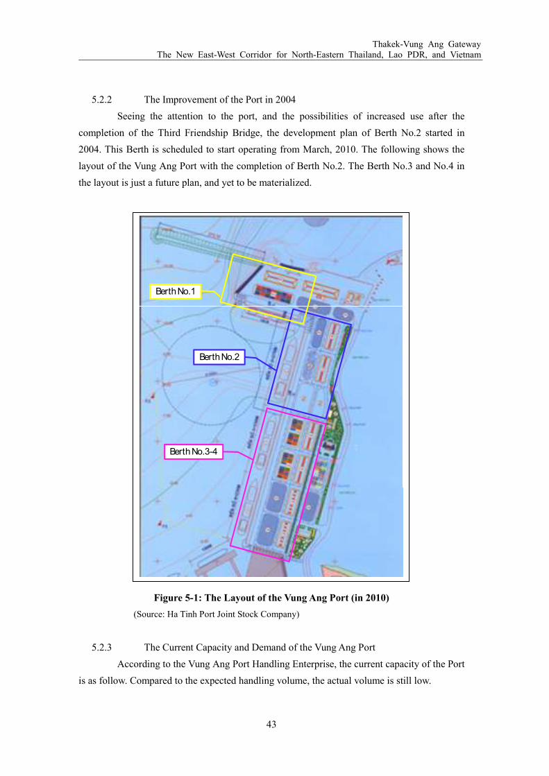
Thakek-Vung Ang Gateway The New East-West Corridor for North-Eastern Thailand, Lao PDR, and Vietnam
43
5.2.2 The Improvement of the Port in 2004
Seeing the attention to the port, and the possibilities of increased use after the
completion of the Third Friendship Bridge, the development plan of Berth No.2 started in
2004. This Berth is scheduled to start operating from March, 2010. The following shows the
layout of the Vung Ang Port with the completion of Berth No.2. The Berth No.3 and No.4 in
the layout is just a future plan, and yet to be materialized.
Figure 5-1: The Layout of the Vung Ang Port (in 2010)
(Source: Ha Tinh Port Joint Stock Company)
5.2.3 The Current Capacity and Demand of the Vung Ang Port
According to the Vung Ang Port Handling Enterprise, the current capacity of the Port
is as follow. Compared to the expected handling volume, the actual volume is still low.
Berth No.2
Berth No.1
Berth No.3-4

Thakek-Vung Ang Gateway The New East-West Corridor for North-Eastern Thailand, Lao PDR, and Vietnam
44
1. Area
1) Total Area: 17,740㎡
2) Storage: 3,200㎡
3) Yard: 7,040㎡(DFS 8,200㎡)
4) Roads Inside Port: 5,168㎡
5) Road Width: 10m
2. Water in Front of Berth
Turning Basin Port Anchorage
Breadth 230m 70m
Length 200.5m 200.5m
Depth -9.0m -10.0m
3. Berth
Berth No.1 Berth No.2
Length 185.5m 270m
Width 28.0m
Tide Diurnal Tide Diurnal Tide
Difference 2.0m
Height from Water +4.5m +4.5m
Depth -10.8m -13.0m
Vessel Accepted 46,000DWT 50,000DWT
4. Handling Rate
1) Bagged Cargo: 1,500tons per day
2) Bulk Cargo: 2,000-7,500 tons per day
3) General Cargo: 2,500tons per day
5.2.4 The Development Plan of the Son Duong Port
As introduced in the earlier chapter, there are two ports in the Vung Ang region. The
first is the Vung Ang Port, which is already in operation as explained above. The second is the
Son Duong Port, which is currently under construction. Although Son Duong started as a
temporary anchorage for Vung Ang users, the naturally deep sea port of Son Duong turned the
area into a large investment destination. Starting from July 2008, the Taiwanese Formosa

Thakek-Vung Ang Gateway The New East-West Corridor for North-Eastern Thailand, Lao PDR, and Vietnam
45
Group has been processing the construction of the Son Duong Port to make it as a specialized
port for steel production, ship-building, oil refining, warehousing, and oil services. The plan
was agreed between the Vietnam government and the Formosa Group as a part of the
requirement of starting a petrochemical and oil refinery project in the area. Under the plan, the
port will have a passage way 400m wide and 6,748m long, scheduled to finish by 2012. The
Formosa Group is expected to be the operator as well. Upon the completion, together with the
Vung Ang Port serving as a commercial port, it will become a Port Complex that can serve
wide varieties of industries.
Although the two ports, Vung Ang and Son Duong, are adjacent, the depth of water
is different. The average depth of the Son Duong Port is 10-12m, however some places could
be as much as 24m deep, and able to accommodate 200,000-400,000 DWT ships. This is very
favorable for heavy industries planning to come into the Vung Ang area: 200,000-300,000
DWT (coal and ore), 300,000 -400,000 DWT (crude oil), 30,000-50,000 DWT (oil products,
steel and others). Under the first construction phase, Formosa aims the Son Duong Port to
handle 30 million tons annually. If successful, the port will be upgraded to handle 60 million
tons per annum.
Figure 5-2: Locations of the Vung Ang Port and the Son Duong Port
(Source: Maritime Administration of Ha Tinh)
Vung Ang Port
Son Duong Port

Thakek-Vung Ang Gateway The New East-West Corridor for North-Eastern Thailand, Lao PDR, and Vietnam
46
Based on the meeting with three organizations in charge of managing the
development of the Vung Ang Port and Son Duong Port—namely the Maritime Administration
of Ha Tinh, Ha Tinh Port Joint Stock Company, and the Vung Ang Economic Zone
Management Board, which is in charge of managing the development of the Vung Ang Port
and the Son Duong Port—because many of the industries planned to invest in the area and use
the Son Duong Port in the future use oil and fire for production, it does not want the woodchip
storage yard be in the close vicinity of those industry to avoid any potentiality of fire.
Therefore, the JDI study team designated the Vung Ang Port as the main export port for
woodchips from central Laos, rather than using the Son Duong Port. In terms of the capacity
of the port facilities, the Vung Ang Port, which can accommodate up to 50,000DWT vessles, is
also well qualified to hold the Woodchip Maximum Vessel (WMV) intended to be used for the
export.
5.3 Industries in the Vung Ang Port
Although the Vung Ang Port has been receiving increasing attentions from investors
with the development of the Son Duong Port, until very recently, the main users of the Vung
Ang Port were mostly limited to woodchip industries. About 5km from the Port, there are two
woodchip storage yards, one owned by a Japanese trading company, and the other shared by a
Korean company and a local company. However, this industrial landscape at the Port is about
to change with the development of the Son Duong Port next to the Vung Ang Port, and the
Vung Ang Economic Zone (EZ) in the vicinity. In order to secure a position of the woodchip
industry’s transshipment throughout the Vung Ang Port, it is important to understand the
trends of other industries’ investment.
5.3.1 The Vung Ang Economic Zone
The idea of developing the area as an economic zone was long held, and approved by
the Prime Minister in April, 2006. The total area mounts to 22,781ha, situating in 9 southern
communes of Ky Anh district. The EZ is now eventful with 60 projects licensed, of which
total investment capital registered becomes above US$ 10 billion (VND 180,000 billion).
Some of the main projects include a steel mill project with US$ 8 billion investment by
Taiwanese Formosa Group, Tau Voi lake tourism service center valued about US$ 70 million,
Vung Ang I thermal electricity plant valued as US$ 1.2 billion, and a steel refining plant with
US$ 100 million investment by Ha Tinh Iron and Steel Joint Stock Company. In addition,
some other major projects which are to be licensed are US$ 12 billion petro-refining and
chemistry mill project invested by the Formosa Group, US$ 5 billion steel complex project

Thakek-Vung Ang Gateway The New East-West Corridor for North-Eastern Thailand, Lao PDR, and Vietnam
47
invested by TATA group, India, billet fining project invested by Thach Khe Steel JSC.,
industrial zone and vocational training school project invested by Dream City KVD Company
of Korea. Because of the possession of an ideal deep sea port, the Ha Tinh Province, one of the
poorest province in Vietnam, is about to become the center of foreign direct investment of
Vietnam.
5.3.2 Woodchip Companies
Although many industrial development projects are going on in the Vung Ang EZ,
until the completion of the factories, woodchips companies remained to be the main clients of
the Vung Ang Port. As introduced above, there are mainly three woodchip companies in the
area—Japanese, Korean, and Vietnamese. The Japanese company entered into the area first,
and handles the largest amount. The company keeps about 70,000 tons of woodchips at the
yard, but it says the supply cannot keep up with the demand. The main destination of shipping
is either to Japan or China. The Korean company also ships a part of woodchips to Japan.
In the future development plan of the Vung Ang Port planned by the Maritime
Administration of Ha Tinh Province, Berth No.5 is planned to be constructed next to the
woodchip yard currently owned by a Japanese trading company. However, there is no specific
time frame as to when to be built, thus until then, it needs to repeat unloading and reloading by
trucks several times, rather than directly conveying woodchips to ships from the stock yard.
The shipping cycle from Vietnam to Japan takes about 45 days, using 20 trucks per loading.
The distance between the yard and the Port makes the Japanese company to bear extra
transporting cost—once when collecting from individual timber suppliers, the next when
transporting to the ship from the yard. Thus, if the agro-forestry companies in the central Laos
were to make profitable transshipment, securing a closer woodchip storage yard to the
operating berths is crucial.
5.3.3 Thermal Power Plant
In the northern side of the Vung Ang Port, the Vung Ang Thermal Power Plant No.1
was started to be implemented from the end of 2006, and is still under construction. Being
invested by the Vietnam National Oil and Gas Group (Petro Vietnam), this is currently the
largest coal power plant in Vietnam. It comprises of two turbines with a combined capacity of
1,200MW, which is expected to contribute 8 billion KWH of electricity to the national grid per
year. Upon the completion, it will be the third power plant in Vietnam after those in Hanoi and
Ho Chi Minh. This Power Plant is expected to save power and cost of providing electricity to
central provinces rather than transmitting in a long distance either from Hanoi or Ho Chi Minh.
The construction is processed by the Vietnam Machinery Erection Corporation (Lilama) and

Thakek-Vung Ang Gateway The New East-West Corridor for North-Eastern Thailand, Lao PDR, and Vietnam
48
the Babcock & Wilcox Beijing Company, scheduled to be completed by 2013.
It was also reported that Lilama and PACO were approved by the Vietnamese
government to invest in the Vung Ang Thermal Power Plant No.2, and to create a Thermal
Power Plant Center having a total capacity of 4,800 MW with the capital of US$ 3 billion.
However, according to the local source, this development plan has not yet solidified. In
addition, according to the Ha Tinh Port Joint Stock Company, there is also a plan to develop
two berths for the power plant at the west of the Vung Ang Port. If completed, the power plant
will be an important electricity provider to industries expected to come into the Vung Ang
Economic Zone in the future.
5.3.4 Industries in the Son Duong Port
Because of the deep sea port’s capacity of berthing about 200,000-400,000 DWT size
ships, multi-national corporations like Formosa and TATA decided to conduct large scale
capital investment projects in the Vung Ang EZ. Although steel and oil industries are planning
to use the Son Duong Port in the future, for agro-forestry companies in central Laos, a
competition over available land for the woodchip storage yard is likely to happen between the
following industries.
1) Steel Industry
In the west of the Vung Ang Economic Zone, a steel rolling plant of Van Loi Corporation is
being under the completion stage that will provide products in the beginning of 2010. The
Vung Ang EZ Authority is also currently under the process of finalizing and giving investment
license to a steel project invested by TATA (India) having a capacity of 4.5 million tons/year,
with a total capital of 5 billion USD. In addition, there is another steel rolling project invested
by Thach Khe Iron Ore Joint Stock Company having a capacity of 2 million tons/year with a
total capital of 2 billion USD. Considering that the Van Loi Corporation is producing 500
thousand tons per year, and Formosa producing 7.5 million tons per year, all together, the
emersion of the large scale steel industry in Vung Ang will surely speed up the investment of
many auxiliary enterprises.
2) Oil and Petroleum Industry
In between the Son Duong Port and the Vung Ang Port, the Vung Ang Oil and Petroleum
Company is setting connected oil tanks and finishing off the construction of their oil center by
putting operation buildings. Once completed, it is ready to supply gas and petroleum to
industries coming in the Economic Zone, and addressing to the market in Laos and North
Eastern Thailand as well.

Thakek-Vung Ang Gateway The New East-West Corridor for North-Eastern Thailand, Lao PDR, and Vietnam
49
The Formosa group received a basic approval by the Vietnamese government on its 12.47
billion USD Petrochemical and Oil Refinery Project in the Vung Ang Economic Zone. The
refinery will be constructed at the 1,600 ha site next to their steel plant, now under
construction. The project was originally approved based on the condition that the group will
invest in the development of the Son Duong Port, which has started from 2008 as explained in
the chapter above. Once the project is completed, it is expected that the refinery will have a
capacity of producing 300,000 barrels of oil per day and 16 million tons of petrochemicals.
After coming into operation, the project will employ up to 9,000 workers and churn out a wide
range of products such as benzene, gasoline, ethylene and propylene.
3) Tourism
Although a concrete plan is not yet in picture, the area has a potential to grow its tourism
business. As in the chapter above, Tau Voi Lake Tourism Service Center was agreed to be
constructed by the EZ Authority in the Economic Zone. In addition, the completion of Road
No.12 connecting the Ha Tinh Province all the way to Thailand increased the possibility of
growing trans-national tourism plan experiencing varieties of culture and cuisine. The nature
around the area, if preserved along with industrial development, allows a growth of
eco-tourism and beach resort. The beach resort in the south of Vung Ang Port, which is
currently known only by locals, could be improved to attract tourists from wide areas.
4) Others
Other possible industries include the Metal Refining Industry using rich natural and material
resources in the area, such as Thach Khe iron ore, Titanium, and Manganese, Industries of
mechanics, motor producing, consumer goods production, electronics, construction materials,
ship building and repairing, labor consuming industries and other export oriented industries
that could also be competitors at the Vung Ang area for the woodchip industry.
5.4 Proposed Concept of the Woodchip based Processing, Storage and Exporting
Terminal: 2010-2020
Based on the site observation, and interviews to agro-forestry companies and
Vietnamese governmental organizations, the concept of the future development plan of the
Vung Ang Port was drawn as in the following paragraphs.

Thakek-Vung Ang Gateway The New East-West Corridor for North-Eastern Thailand, Lao PDR, and Vietnam
50
5.4.1 The Role of the Woodchip Company for the Development of Vung Ang
Corridor
Although Road No.12 is completed from Thakek to the Vung Ang Port, and Berth
No.2 will start its operation in March, 2010, and the area has been receiving more attentions
together with the development of the Son Duong Port, there has not yet been a serious user of
the Vung Ang Port. This is partly because; there is not yet an industry in the area that can
produce a collective volume of exporting goods. Therefore, the agro-forestry companies in
central Laos, expecting to produce about 1,000,000 tons of products per annum are so far the
largest potential users. Considering the cost of operating and maintaining two berths, for
Vietnam, they are the source for sustainable operation of the Port, at least until the heavy
industries start operating. Therefore, it is important to understand woodchip industries’
infrastructural demands at the Port and offer an efficient and economical exporting method.
If the Port can satisfy the earlier agro-forestry users, there may be more agro-forestry
users to be followed to take the same export route. In addition, increasing number of users will
also reward the two countries effort in developing and improving the road network. The
woodchip exports starting from 2012, is thus considered as an important milestone.
5.4.2 The Future Plan of Expanding the Vung Ang Port
Based on the Master Plan of the Vung Ang Port, which is under the process of
approval from the Chair of the People’s Committee of Ha Tinh Province, the Maritime
Administration, the Vung Ang Economic Zone Authority, and the Ha Tinh Port Joint Stock
Company have shown intentions to expand the Vung Ang Port by constructing four more
berths (No.3-No.6) in addition to the already existed two berths in the future. The
pre-feasibility study of Berth No.3 and No.4 was already conducted by Transport Engineering
Design Inc (TEDI), which is the engineering company for constructing Berth No.1 and No.2,
in 2008. According to the Maritime Administration, the development of Berth No.3 and 4 will
be allowed once investors are found.
5.4.3 The Development Plan of the Woodchip Storage Yard
Strategically, the location of the current two woodchip storage yards operating in the
Vung Ang area is not the most economical choice. Because there is about 5 km distance
between the storage yard currently operated and Berth No.1 and No.2, trade companies
operating in the current woodchip storage yard incur additional loading/unloading cost by first
collecting timbers from neighbor communities, and secondly when the ship arrives. For
agro-forestry companies in inland central Laos already incurring a large sum of transportation
cost, the cost of loading and unloading the goods twice may impose a critical economic burden

Thakek-Vung Ang Gateway The New East-West Corridor for North-Eastern Thailand, Lao PDR, and Vietnam
51
on agro-forestry companies’ decision of using the Vung Ang Port. Therefore, securing a site
near the operating berths is essential for both Laos and Vietnam. A closer storage yard to berth
enables direct transfer from the yard to ships through a conveyer belt and economical
loading/unloading process.
In this line, during the discussions with the Maritime Administration of Ha Tinh
Province, three possible sites were suggested as below by the JDI study team, and received the
permission to start a study on developing the site indicated in Option No.3.
Option 1: Behind Berth No.1
The site is already occupied by the oil jetty and tank yard owned by the Vung Ang Oil and
Petroleum Company, thus not available.
Option 2: the Bulk Yard at Berth No.2
The site is already partly occupied by ware houses and water supply tower, and the remaining
space is too limited. The Maritime Administration also fears that the space is too close from
the oil jetty and tanks, thus there may be a risk of woodchips catching fire. (However, in such
case, fires can be prevented by a proper management and equipments).
Option 3: the land behind Berth No.2
The site is currently not a land, but part of the sea. If this site were to be developed,
reclamation is necessary. According to the woodchip company in Laos, the company needs
about 5ha of land as a storage yard based on their woodchip production schedule. Since the
site in the backland of Berth No.3 has only about 3 ha, the study team proposed to use the
backland of Berth No.4 as well to secure 5 ha of land. During the field study, the research team
received a basic understanding from the Maritime Administration and the Ha Tinh Port Joint
Stock Company on conducting a study to build yard at the backland of Berth No.3 and No.4
for woodchip export.

Thakek-Vung Ang Gateway The New East-West Corridor for North-Eastern Thailand, Lao PDR, and Vietnam
52
Figure 5-3: Location of the 3 Possible Development Sites for a Woodchip Storage Yard
(Source: JDI Study Team)
In case of developing storage yard at the backland of Berth No.3 and No.4, along
with the cost of reclamation, pavement, and grading, and equipments (light, fire extinction,
and water), the cost of building bank protection should also be considered. This is because,
based on the wave study, although there is a 260m breakwater near Berth No.1, the position of
the stock yard can be affected by waves in certain season. The size of rocks to be used of the
bank protection could be the same as the ones used for Berth No.2. The extension of the
breakwater will be done when Berth No.3 is constructed in the future.
5.4.4 The Development Plan of Berth No.3
Considering the expected export volume of woodchips and other agro-forestry
products through the Vung Ang Port in the future, it is more efficient to construct a Berth that
is specialized for those industries in the future. However, since the berth operation cannot be
profitable unless products are exported at least 1,500,000tons per year through the port, it is
recommended to use Berth No.1 and No.2 until both berths reach to full capacity, or the export
volume of woodchips and other agro-forestry companies reached to 1,500,000tons per year. If
the economic efficiency of the Thakek-Vung Ang Gateway is proved, the JDI study team

Thakek-Vung Ang Gateway The New East-West Corridor for North-Eastern Thailand, Lao PDR, and Vietnam
53
estimates that by around 2020, the export volume of agro-forestry products reach to
1,500,000tons per year, and 2,000,000tons per year around 2025. Therefore, though the actual
condition will change according to the market, the development of Berth No.3 is
recommended to start to be in time of the 2020 operation.
In order to serve for agro-forestry industries, Berth No.3 needs to be able to
accommodate 51,000 DWT Woodchip Maximum Vessel (WMV) in the future. More
specifically, the berth should have 200m length, maximum of 11.5m draft, 270m of required
berth length, and -13m of a water depth. During the feasibility study of Berth No.3, a more
detailed study on the spec of Berth No.3 will be identified along with the estimated cost.
The location of Berth No.3 project site is blessed with so many advantages that it
only requires minimum protections from the impacts of winds and waves. First, the Ron Cape
Peninsula naturally protects the prevailing north to north-east waves from the East China Sea.
Berth No. 1, which has a length of 185.5m, and the existing breakwater near Berth No.1,
which has the length of 260m, also protects Berth No.3 by intruding waves diffracting from
north to north-north-west waves. Thus, the only protection that needs to be added when Berth
No.3 is constructed is the extension of the current breakwater for about 110 m.
Figure 5-4: Location of Breakwaters at the Vung Ang Port
(Source: JDI Study Team)
Berth No.1
Berth No.2
Berth No.3
Existing breakwater
Additional breakwater
Thakek-Vung Ang Gateway The New East-West Corridor for North-Eastern Thailand, Lao PDR, and Vietnam
54
Since the project site of Berth No.3 locates near Berth No.2, it is assumed that the
soil basin is as same as the data collected when constructed Berth No.2. Based on the
information from TEDI, which designed Berth No.2, the soil layers at the bottom of the sea is
consisted by dense fine sand. This is one of the best kinds of sand to be used for reclamation.
In addition, by using the soil at the sea basin, there is no need to bring sands from other area,
thus the cost of reclamation can be saved to the minimum. A more detailed action plan for the
development of Berth No.3 will be explained in later chapters.

Thakek-Vung Ang Gateway The New East-West Corridor for North-Eastern Thailand, Lao PDR, and Vietnam
55
6 SOCIO-ECONOMIC AND ENVIRONMENTAL IMPACTS OF THE
PROPOSED DEVELOPMENT PLAN
In this chapter, the Khammuon Province in Laos where woodchips are produced, and
the Ha Tinh Province in Vietnam, where the Vung Ang Port is located will be observed closer in
terms of socioeconomic, and environmental aspects. It is assumed that the two provinces will
largely benefit economically once the processing and exporting of agro-forestry products start.
However, it is also a concern that increased traffic on the road will degrade the environment in
the concerned region. When the actual development starts, it is recommended to conduct a
closer study on socioeconomic and environmental impacts.
6.1 The Socio-Economic and Environmental Data of Khammouane Province, Lao
PDR
The Khammouane Province is located in central Laos, sharing its border with
Bolikamxai to the north, and Savannakhet to the south. The province is also divided by the
Mekong River with Thailand in the west, and the Annamite Mountain Range with Vietnam in the
east. The total area of the Province is approximately 16,315 km2, and covers about 6% of the
country. The province is divided into nine districts, and has its provincial capital in the Thakek
City, which is about 4-5 hours drive from the Vientiane Capital of Laos. In this development plan,
the main population that will be influenced the most is assumed to be those living around the
projected area of the Agro-Forestry SEZ, and those living along Road No.12. In order to measure
the socioeconomic and environmental impacts to this population, two areas near the SEZ and
Road No.12 was identified: 1) Nakai Plateau, near the hydro power station and 2) Xe Bang Fai,
area along the Xe Bang Fai Rever.

Thakek-Vung Ang Gateway The New East-West Corridor for North-Eastern Thailand, Lao PDR, and Vietnam
56
Figure 6-1: Map of the Sample Population
(Source: JDI Study Team)
6.1.1 Population
The Khammouane Province has about 330,000 population, among which the sample
population covers about 47,000. Residents in the Khammouane Province are generally well-off
as the area becomes closer to the Mekong River, the border with Thailand, and less connected to
social infrastructures, such as education, health care, electricity, and water supply, toward the
mountainous area bordering with Vietnam. This is understandable considering that the capital,
Thakek, where political and economical activities mainly occur, locates near the Mekong River.
The population in the Nakai Plateau is much smaller having only 6,783, but the
ethnicity is more diverse. The two main ethnicities residing in the area are Brou (40%), and Tai
Bo (40%). On the contrary, Xe Bang Fai is populated mainly by Lao Tai. However, the ethnic
identity in this area is less pronounced since it is close to the capital, and the population is much
more mixed than rural areas.

Thakek-Vung Ang Gateway The New East-West Corridor for North-Eastern Thailand, Lao PDR, and Vietnam
57
6.1.2 Livelihood and Economy
In general, although the province is experiencing a steady growth in the economy,
Khammouane still remains as a poor province. Investments from foreign companies are
increasing, but most of it involves an exploitation of natural resources. Major economic sectors
are crops, animal husbandry, fishery, forestry and hydropower. However, in terms of
socio-economic aspect, because of the Nam Thuen II Hydro Power Project, and Lao-Viet’s
effort to connect the province with the Vung Ang Port, infrastructural development, such as road,
power, and water is improving.
The livelihood is distinctively different between the Nakai Plateu and Xe Bang Fai.
People in the Nakai Plateau are engaged into various economic activities including cultivation
of Swidden rice, fishing, livestock raising, hunting and fathering of forestry products. Since this
area is characterized under rain-fed condition, poor soils, adverse weather conditions, and lack
of modern technology, only 17% of the household can produce sufficient amount of rice. The
average household income in the Nakai Plateau is about $450/year, which is well below the
national poverty line of $800/year. Most of the households was without electricity during the
study conducted by ADB in 2004, however, this condition is planned to be solved by 2012 with
the start of rural poverty alleviation project funded by the World Bank. In addition, about 60%
of the household uses river or stream water as the only domestic water source.
The economic activity in the Xe Bang Fai area is more dependent on agriculture,
mainly paddy rice. About 84% of the villages are equipped with irrigation pumps. There are
some households also engaging in animal husbandry and fishing. In addition, the off-farm
income, such as shops and services, is considered more important in this area than other regions.
According to the study conducted by ADB, the average household income in the area was
$664/year, and about 40% of the population lived below the poverty line. Most of the
households are connected to the electricity grid, or at least planned to be connected soon. 40%
of the household relies on river for domestic water source.
6.1.3 Education and Health Care
In Nakai Plateau, schools are only functioning in larger villages, and the attendance
rate is very low. According to the research conducted in 2004 by ADB, 63% of the population
had no schooling at all, while 31% only had education until primary schools. Literacy level in
this region is generally higher among men than women. In the Xe Bang Fai area, the situation is
slightly better than the Nakai Plateu though schools often do not function due to a lack of
resources in this region too. Approximately 31.6% of adults are literate, and 12.4% went
secondary schools. 6% of them progressed to higher education. The lower Xe Bang Fai area has
the highest education levels among the province.

Thakek-Vung Ang Gateway The New East-West Corridor for North-Eastern Thailand, Lao PDR, and Vietnam
58
6.1.4 Environment
The forestry area of Khammouane is covering about 812,600 hectares, which is 47%
of the total area of the Province. Climate and the diversity of geological conditions in the area
have led to an extraordinarily high diversity of species, isolation and endemism. The Annamite
Mountains at the border with Vietnam are recognized as an area of global significance in terms
of biodiversity. In addition, the province also holds three National Biodiversity Conservation
Areas (NBCA): Nakai-Nam-Theun, Hin Nam No, and Phon Hin Poune NBCAs.
However, recently the forest diversity is degrading because of intense logging,
settlement expansion, and hunting. Between 1973-2003, logging reduced forest cover in the
reservoir area of the Nakai Plateau from 61% to 48%. Because of this, species is under an
increasing pressure of population decrease in the past three decades. In addition, a constant
shifting of cultivation area by villagers are also being the cause of forest and soil fertility
decreases. Since people tend to move their cultivation area due to weeds, pests, animals and
drought, a solution to those adverse situations becomes important for future environmental
protection.
6.2 The Environmental Impacts to the Khammouane Province
In terms of the development of Agro-Forestry SEZ, the environmental impacts seemed
to be low. The proposed land for the Agro-Forestry SEZ is close to the urban area of Thakek
surrounded by Road No.12 and 13, and not in the vicinity of three NBCAs. The closest facility
is an airport which is not commercially in use today. As a result, in terms of the impacts to
endangered species, it is assumed to be low. In addition, since the land has went through a
research by developers, and already been dedicated as a project site for an Industrial
Zone/Entertainment facilities site by the provincial government, it is assumed that no serious
environmental harm was identified by the provincial government as well by developing the area.
However, since the Agro-Forestry SEZ plan is different from the original industrial
zone/entertainment facilities proposal by the provincial government, it is recommended to
conduct another preliminary environmental impact analysis upon submitting a revised SEZ
proposal to MPI.
In terms of the future road improvement plan, and increasing traffic volume on Road
No.12, the highest concern is in the mountain area. As it is explained in the chapter above, The
Annamite Mountains at the border with Vietnam is known as houses for various species. In case
of widening roads or constructing tunnels in the mountain area, the impacts to inhabited
biodiversity should be carefully studied. In addition, increasing traffic volume on Road No.12 as
a result of the start of exports of agro-forestry products in a few years, and the opening of the

Thakek-Vung Ang Gateway The New East-West Corridor for North-Eastern Thailand, Lao PDR, and Vietnam
59
Third Friendship Bridge in 2011, it is possible to have more contacts with animals on the Road.
The awareness on careful driving should be raised in the area.
6.3 Socio-Economic Impacts in the Khammouane Province
The socio-economic impacts of the project to the area cannot be simply stated since,
the project site covers two distinctively contrasted region. The first region is Xe Bang Fai area
close to Thakek, where people have relatively better access to social infrastructures, and have
higher income in the province. The second region is the area midway between the Mekong
River and the Lao-Vietnam border called the Nakai Plateau. People in this area are well below
the national poverty line, and have a very limited access to social infrastructures. Therefore,
when conducting a feasibility study in the future, it is recommended to conduct a detail study on
the socio-economic impacts to people according to different residential areas. However, at this
stage, the expected impacts and changes to the society in general will be discussed.
6.3.1 Impacts to Income and Livelihood
The development of a woodchip storage yard and Berth No.3 at the Vung Ang Port
means a secure export route for agro-forestry companies in central Laos. For companies
operating in the land-locked country Laos, securing the export route leads to sustainable
operation of business. For Khammouane Province where there is no particular industry other
than forestry, the employment at forestry industries is crucial for the healthy economic activities
and livelihood of residents.
In 2007, the local employees at the woodchip company were 200 for ordinary business,
and increased to 4,000 when they need extra temporary workers for plantation. A same increase
in workers is expected to happen during the harvest season too. In addition, it is also important
to note that the woodchip company holds an intention of hiring local people as workers, rather
than bringing in workforce from surrounding countries. Since Laotian people are not skillful in
forestry business, this may result in extra cost and time for the woodchip company, at least in
the beginning. However, in turn, hiring local people also benefits the company by ensuring a
long-term labor source, as Laotian people have a limit to move across provinces frequently
without the permission from the government.
In terms of the livelihood, the benefit agro-forestry companies bring to the Province
seems large as well. Agro-forestry companies usually operate in an area in a long-period that
requires a healthy partnership with the local government and residents. As a result, their
intention to contribute to improve the surrounding environment and community is large. In fact,
the woodchip company operating in the area has contributed to the community by building
wells, roads, and community centers since its operation in 2005. It is also providing materials to

Thakek-Vung Ang Gateway The New East-West Corridor for North-Eastern Thailand, Lao PDR, and Vietnam
60
build schools, and offering assistance to conduct medical check-ups for local residents.
6.3.2 Impacts to Education and Health Care
The impacts to education will be more indirectly than the impacts to economy and
livelihood. It is a general statement that the more a family earns income, the higher the
education level is. This is because if a household earns sufficient income to support the family,
there is no need to use children as an additional labor. Thus, the economic benefit the
agro-forestry companies bring to the community will indirectly support households to attain
higher education. In addition, increased economic activity in the Province will ultimately
increase the presence of the Province among the central government, which may lead to an
increased budget allocation to the Province to improve social infrastructures, including
educational facilities.
On the contrary, increasing industrial activities at the Agro-Forestry SEZ, and traffic
volume will likely to increase health concerns in the region. Currently, the area rarely
experiences traffic jam, thus health care concerns regarding to gas emissions from vehicles is
absent. However, with the start of exports of agro-forestry products in a few years, and the
opening of the Third Friendship Bridge in 2011, the area is expected to receive more vehicles
passing by. Households in the Province tend to gather around the trunk road because it has a
higher chance of connecting to the electricity, as well as better accesses to hospitals, schools,
and shops. Therefore, unless certain measures taken, there is a chance that health concern rises
because of the increasing industrial activity. When a detailed research conducted in the future,
the measure on how to deal with negative impacts of increased traffic volume should be
addressed clearly.
6.4 The Socio-Economic Data of the Ha Tinh Province, Vietnam
The Ha Tinh Province is located in central Vietnam, about 340km south from Hanoi.
The Province is divided with 10 districts, and having its provincial capital in the Ha Tinh City.
For long, the Province had no particular industry, but small scale agriculture. However, this
situation is expected to change with the development of the Vung Ang Port, and the Son Duong
Port. Industries are gathering in the city, by seeing a lot of potential in the area a new hub port to
the Eastern Sea. The agro-forestry products from Laos will be the first large size export out from
the Vung Ang Port, and expected to last till the next few decades. Thus, it is expected that the
socio-economic impacts of the project, which was studied by the team, to the area will be large
and long-term.

Thakek-Vung Ang Gateway The New East-West Corridor for North-Eastern Thailand, Lao PDR, and Vietnam
61
6.4.1 Population
In 2008, the population of the province reached to about 1,300,000, among which 87%
lives in the rural area. The birth rate is generally higher in the urban area, and the death rate is
higher in the rural area. The Ky Ahn district, where the port locates, has about 173,000
population, which is the largest among the 12 districts of the province. Among the Ky Anh
district’s population, more than 90% lives in rural areas, largely engaged in agriculture.
6.4.2 Livelihood and Economy
While the whole country’s monthly average was $33 (VND636,000) in 2006, the
average monthly income in the central provinces of Vietnam was US$ 24.00 (VND476,000),
which is the second from the lowest of the country. This is mainly due to the poor natural
resources and soil, and harsh weather that largely affects residents’ standard of living when
many are engaging in agriculture. The province’s GDP accounts about only 0.7% of the national
GDP. However, the standard of living in the province is improving steadily. In 2007, the Pro
Poor Center (PPC), an NGO established by the local government of Ha Tinh Province to take
surveys on Basic Necessities Needs of people reported that, many of the households obtains
items that only a few people had between 1997-1998, when the first survey was conducted.
Items included are, televisions, motorbikes, bath rooms, toilets, and access to bank loans. The
changes indicated that what was thought as a luxury in the past, are now considered as basic
necessities.

Thakek-Vung Ang Gateway The New East-West Corridor for North-Eastern Thailand, Lao PDR, and Vietnam
62
Table 6-1: Changes of Possessions in 1997/98 to 2006
Items 1997/8 2006 Change
TV 24.5% 71.6% 47.1%
Motorbike 6.7% 47.3% 40.6%
Bathroom 16.9% 56.5% 39.6%
Toilet - built of stone 34.4% 68.1% 33.7%
Livestock vaccination 60.7% 92.1% 31.4%
Watch 48.7% 74.2% 25.5%
Access to VBA loans 41.9% 65.8% 23.8%
Meat once a week 51.3% 74.3% 23.0%
Pesticide pump 52.3% 74.8% 22.5%
Electric fan 73.7% 96.0% 22.3%
Well with well head 72.5% 89.3% 16.8%
Thick blanket 78.4% 94.0% 15.6%
3 meals a day 83.4% 96.0% 12.6%
Two compartment wooden wardrobe 21.8% 33.9% 12.1%
A new set of clothes each year 68.3% 73.5% 5.2%
Concrete rice drying yard 89.8% 94.8% 5.0%
Table and chairs made of good wood 28.0% 32.7% 4.7%
Wooden rice chest 89.4% 90.4% 1.0%
Bicycle 92.6% 93.0% 0.3%
Buffalo or cow 82.7% 82.4% -0.3%
Radio 36.6% 26.7% -9.9%
Stone built house 70.8% 58.6% -12.2%
1 sao of land per person 91.3% 69.6% -21.6%
% of all respondents who
had these items in
(Source: PPC)
For economic activity of the province, while agriculture remains the largest
contributor to the provincial gross output in 2007 by occupying 36% if the gross output,
industry and construction sector is also growing, reaching to as much as 34%. This is a large
difference compared to 43% to 26% (agriculture to industry/construction) in 2004. This may be
due to the large scale construction projects at the Vung Ang and Son Duong Ports, and the
construction of Road No.12.
6.4.3 Education and Health Care
In general, as the household income rises, the educational and health service level also
increases in the household. The Ha Tinh province is not an exception too. Between 2004-2008,
the attendance rate to the upper secondary schools, both public and private, increased from 67
million to 70 million. In the Ky Anh district, the attendance rate to the secondary schools is
8,138, which is the second most among the 12 districts in the province. This is assumed that

Thakek-Vung Ang Gateway The New East-West Corridor for North-Eastern Thailand, Lao PDR, and Vietnam
63
because of the presence of the port, more industry gathers in the district which enables
household to work at the site and generate stable income than those engaged in agriculture,
which yields could be influenced by seasonal differences. Another important difference in the
education section is that, in 2007, the first university in the province was established. Though
subjects taught at the university is still limited, this provided residents more chances to pursue
higher degrees.
The number of health facilities was also increased from 299 to 434 between 2004 and
2008. As a result, the number of doctors per 10,000 residents increased from 4.71 to 5.18, and
the number of bed per 10,000 residents increased from 27.40 to 30.76 between the same years.
In addition, all of the communes in 12 districts are now equipped with at least one medical
station, which was not accomplished in 2004. The next goal of the province is to improve the
quality of medical services at each station for more stable living for the people.
6.4.4 Environment
The environment of the Ha Tinh Province is laegely different between the area close
the border with Lao PDR and the area along the coast. As in the map , the area near the Lao
border is mountainous is covered by forests, grasslands, and scrubs. This area hosts the Vu Quan
National Park, which locates in the northern Annamite mountains and identified as the national
park in 2002. The national park is known as a home for new and rare species, such as deer and
antelope that was discovered in 1990s but not yet scientifically described. In addition, the park
is also a hole to 273 birds including 11 types of globally endangered species. The area,
especially in the lower elevation area, is now under a threat of forest clearance for agriculture,
hunting, timber extraction and grazing of livestock.
To the contrary, toward the coast, the land becomes largely used for agricultural
purposes. In 2008, the planted area of crops in the province reached 190,227 ha, among which
100,476 ha is a planted area of paddy. The Ky Anh district where the Vung Ang Port locates is
also largely a paddy field, producing 55,352 tons of paddy in 2008. The surrounding area of the
Vung Ang Port is also widely resided by farmers, and a few fishermen. In the long-term, the
Master Plan of the Vung Ang Economic Zone indicates that these farmers and fishermen will be
relocated to the residential area in the inland, which will be prepared by the Ha Tinh People’s
Committee, in the future. Paddy fields is planned to be turned into light industrial sites, and
entertainment facilities.
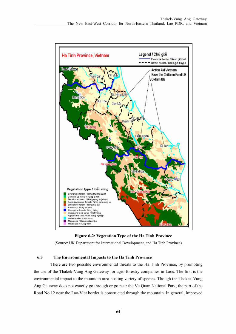
Thakek-Vung Ang Gateway The New East-West Corridor for North-Eastern Thailand, Lao PDR, and Vietnam
64
Figure 6-2: Vegetation Type of the Ha Tinh Province
(Source: UK Department for International Development, and Ha Tinh Province)
6.5 The Environmental Impacts to the Ha Tinh Province
There are two possible environmental threats to the Ha Tinh Province, by promoting
the use of the Thakek-Vung Ang Gateway for agro-forestry companies in Laos. The first is the
environmental impact to the mountain area hosting variety of species. Though the Thakek-Vung
Ang Gateway does not exactly go through or go near the Vu Quan National Park, the part of the
Road No.12 near the Lao-Viet border is constructed through the mountain. In general, improved

Thakek-Vung Ang Gateway The New East-West Corridor for North-Eastern Thailand, Lao PDR, and Vietnam
65
road network facilitates human settlement along the road. If human settlements along the Road
No.12 proceed, there is a chance that birds and mammals will be under the pressure of hunting
mainly due to the wild life trade. In addition, if a proper management would not be taken place,
illegal timber extraction and firewood collection could be result in speeding up the forest
clearance. Therefore, measures to reduce the impacts of the Road No.12 on biodiversity should
be implemented. In particular, human settlements into the buffer zone of the national park
should be strictly controlled. The enforcement of protected area management regulations,
particularly controls on hunting, timber extraction and firewood collection, should be
strengthened as well.
The second is the impact to the sea water. In order to export the increasing amount
woodchips through the Vung Ang Port, the number of vessels arriving to the port will surely
increase every year. Based on the rough estimate, by the time woodchips export amount exceeds
900,000 tons per year, the port receives about 30 vessels per year. If other agro-forestry
commodities were to export through the Vung Ang Port, the number of vessel arrivals will be
even larger. In creasing vessel arrivals could result in degradation of water quality if counter
measures on vessel disposals to sea, and oil leak would not be taken. To protect the sea against
such threats, restrictions on the anchorage of vessels older than 20 years, which is not usually
equipped with double vessel bottom to prevent oil leaking, could be a help.
6.6 The Socio-Economic Impacts to the Ha Tinh Province
6.6.1 Impacts to the Livelihood and Income
The socio-economical impact of exporting woodchips and other agricultural products
from Laos through the Vung Ang Port will likely to work in the same manner as in the
Khammouane Province in Laos. Increasing vessel arrivals at the Vung Ang Port could connect
to employments at the port to handle loading/unloading and docking of ships. However, since
vessel handling is not that labor intensive compared to harvesting of timbers for woodchips, the
impact to local employment could be lower than the Khammouane Province. Still, it could be an
alternative job for farmers and fishers that may need to change their specialization due to the
relocation of households. Another economic impact to the local area is the money dropped by
truck drivers. Since truck drivers drives in long distance, it is likely that they take meals or have
accommodations in the Ha Tinh Province. Though it may be small money, it can connect to
brisk economic activities in the area. Ultimately, if the woodchip export through the Vung Ang
Port succeeds, it could induce economic development of the area by calling in other industries
or investors to use the Port.

Thakek-Vung Ang Gateway The New East-West Corridor for North-Eastern Thailand, Lao PDR, and Vietnam
66
6.6.2 Impacts to Education and Health Care
As it is already discussed in Chapter 7.4.3, as the Vietnamese economy as a whole
develops, the educational and health service quality in the Ha Tinh Province has improved in the
past years. This indicates that higher income at households has contributed to children achieving
higher educational level or degrees, and better access to health services. However, the economic
impact of the increasing vessel handling at the Vung Ang Port, due to woodchip, to the local
area could take a few years, since the volume of export will grow only gradually. Still if the
woodchips were to export through the Vung Ang Port, it will lead to a periodical arrival of ships
to the port, which in turn results in stable employment at vessel handling operation. Stable
income at household level is always a positive contributor to attain higher education and
increase access to health services.

Thakek-Vung Ang Gateway The New East-West Corridor for North-Eastern Thailand, Lao PDR, and Vietnam
67
7 ECONOMIC ANALYSIS OF THE PORT DEVELOPMENT
7.1 Basic Conditions
The woodchip production and export plan of an agro-forestry company in Laos via the
Vung Ang Port as per below are set as premises to study the economic and financial impacts
from conducting the proposed project. The project aims for ultimately handing 1.5 million tons
of woodchip at the Vung Ang Port with an approach divided into two phases.
At the first phase, until when the trading volume of woodchips reached to 1.5 million
tons, the woodchip cargo is proposed to be exported by utilizing the existing Berth No.1 and
No.2. Suppose the woodchip trading volume grows up continuously and, if additional supply
sources from Vietnam taken in, the demand on using the Vung Ang Port, as an export
base/gateway for woodchips, would certainly increase. Thus the berth development specialized
for woodchip is supposed to be necessary in due course. Consequently, with the consideration of
the current status of the project, the economic and financial analysis of exporting woodchip 1) at
existing Berth No.2 and, subsequently, 2) from Berth No.3 after its development shall be studied.
At the outset, analysis on the conditions shall be stated, which will be followed by analysis on
the financial viability.
7.1.1 Export Volume Forecast of Woodchips
The production and export volume of woodchip is, initially, projected to start at the
level of 18,800 BDT/year, and ultimately increased to 1.5 million tons/year accordingly as
shown below.
Table 7-1: Export Volume Forecast of Woodchips
Year 1st 2nd 3rd 4th 5th 6th 7th 8th 9th 10th, onwards
No. Vessel per year 6 12 24 24 24 24 24 30 36 48
BDT (thousand) 188.0 377.0 755.0 755.0 755.0 755.0 755.0 944.0 1,132.0 1,510.0
GMT (thousand) 348.8 699.4 1,400.7 1,400.7 1,400.7 1,400.7 1,400.7 1,751.4 2,100.2 2,801.5
(Source: JDI Study Team)
Note: Woodchip is normally expressed in two weights:
(1) Green Metric Ton (GMT): this is actual weight of woodchip including moisture.
(2) Bone Dry Ton (BDT): this is used by Paper Company for only weighing fiber only excluding moisture of
woodchip.
(3) The conversion ratio between GMT and BDT is: 1.86 GMT = 1.0 BDT

Thakek-Vung Ang Gateway The New East-West Corridor for North-Eastern Thailand, Lao PDR, and Vietnam
68
7.1.2 Logistic Plan
The woodchip transported from central Laos via Road No.12 is proposed to be
unloaded from transportation trucks at the site of storage yard behind the proposed quay of
Berth No.3. The land behind Berth No.3 is planned to be developed in accordance with the port
master plan which is soon to be formulated, yet it is likely to be leased for the most prominent
user of the port and it should be taken into shape in such manner.
Once the woodchip carrier calls at the Vung Ang Port to pick up woodchips from the
storage yard, conveyer belts to load woodchips onto a vessel would be deployed for a
transportation purpose. The handling capacity of the proposed conveyer belts is deem to be
enough to load nearly 30,000 tons of woodchips within 72 hours.
7.2 Phase One: Vung Ang Port Storage Yard Development Project
Based on the projected export volume of woodchip, the first phase of the woodchip
handling shall be proposed to be carried out by utilizing the existing Berth No.1 and No.2 at the
Vung Ang Port. Beside it, a woodchip storage yard is required to be located at the nearest site of
the berth. Studying the suitable area for such a purpose, an ideal location was identified in the
area behind the prospective development site of Berth No.3. The required size of the storage
area is proposed to be 50,000 m² (=5 ha).
While the storage yard development is carried out by the port facility developer, the
ship loading facility is purchased and operated by each company. Hence, in the first phase of the
port area development project, the project cost is defined as a storage yard development cost,
which includes EIA study preparation, any civil and engineering services and land
preparation/construction costs. The operation cost is deemed to be only incurred from the
interest rate for the loan amount.
7.2.1 Construction Cost and Engineering/Civil Costs
(1) Preparation Cost
(i) EIA
Cost of EIA study preparation for the storage yard development is estimated as shown
in the Table 7-2.
Table 7-2: Estimated Preparation Cost of EIA
Item Unit Unit cost (USD) Amount (USD)
Professional Survey: Environmental Impact Study 1 10,000 10,000
(Source: JDI Study Team)

Thakek-Vung Ang Gateway The New East-West Corridor for North-Eastern Thailand, Lao PDR, and Vietnam
69
(ii) Detail design, civil and engineering service costs
In order to develop 5 ha storage yard and necessary utilities, a detail engineering design
work and tender documents preparation will be needed as soon as the land lease was
approved by Vietnamese responsible authorities. The estimated cost for
civil/engineering services and supervision is shown in Table 7-3.
Table 7-3: Estimated Cost for Civil Engineering Services and Supervision
Item Unit Unit cost (USD) Amount (USD)
Professional Survey: Civil 1 25,000 25,000
Professional Survey: Engineering 1 25,000 25,000
(Source: JDI Study Team)
(2) Construction cost
The estimated cost of the woodchip storage yard development project is:
Table 7-4: Construction Cost for the Woodchip Storage Yard
Item Unit Unit Price (USD) Amount (USD)
Land 1 2,000,000 2,000,000
Civil: Storage Area 50,000 (m²) 5,000,000 5,000,000
Civil: Weigh Bridge 1 5,000 5,000
Civil: Warehouse 1 35,000 35,000
Civil: Office 1 20,000 20,000
Civil: Paving and Roads 300 (m) 360 108,000
Electrical Distribution 300 (m) 240 72,000
Contingency 10% of total above 724,000 724,000
Total 7,964,000
(Source: JDI Study Team)
Note: The figure is based on the preliminary assumption thus subject to change when further
study was carried out.
Land needs to be procured. The reclamation and grading of the land, using 30 cm of
laterite on top, and firming the land with roller is proposed to be applied. For deploying loading
facilities (belt conveyers: 300-400m) onto the vessels, the ground is likely to require concrete
floor. Put fence around the land, build an office (70m²), and also a weigh bridge (16m²) and
access road may be required. The estimated total cost is $7.96 million as shown in the above
table.

Thakek-Vung Ang Gateway The New East-West Corridor for North-Eastern Thailand, Lao PDR, and Vietnam
70
(3) Total investment cost
The total investment cost is consisting of (1) EIA, (2) civil/engineering service and (3)
storage yard construction. The total investment cost is estimated as USD 5.56 million as shown
in below.
Table 7-5: Total Investment Cost of the Woodchip Storage Yard Development
Item Amount (USD)
1. Preparation cost 60,000
2. Construction cost 7,964,000
Total Investment Cost 8,024,000
(Source: JDI Study Team)
7.2.2 Operational Costs
Operation cost will be divided into two items: (1) Operation and Maintenance (O&M)
of storage yard and (2) Interest Rate for Loan.
(1) Administration cost and operation and management cost (O&M cost) of this project are
estimated 1% and 2% of the investment cost respectively as shown in Table 7-6 below:
Table 7-6: Operation Cost of the Woodchip Project Per Year
Item Cost per year (USD)
Administration 80,240
O&M cost 160,480
Total Cost 240,720
(Source: JDI Study Team)
(2) Bank loan and interest
Equity and bank loan share is assumed to be 30% and 70% respectively and exact amount for
equity and loan is as shown in the following.
Table 7-7: Equity and Loan for the Project (in USD)
Item 1st year Total (Share)
Equity 2,407,200 2,407,200 (30%
Loan 5,616,800 5,616,800 (70%)
Total 8,024,000 8,024,000 (100%)
(Source: JDI Study Team)

Thakek-Vung Ang Gateway The New East-West Corridor for North-Eastern Thailand, Lao PDR, and Vietnam
71
The loan for this project is planned to use JBIC or any other bank loans with the
following conditions:
Table 7-8: Loan Conditions for Project
Interest rate 6% per annum
Grace Period 1 years
Reimbursement Period 9 years
(Source: JDI Study Team)
7.2.3 Expected Revenue Projection from Woodchip Storage Yard Lease and Handling
at the Port
The expected revenue for the woodchip storage yard operation, which includes income
received by stock yard lease, royalty and stevedore charges, would go upto around $7.73 million
when the woodchip handling is done at the full operation of 1.5 million tons per year, whereas
the port operation revenue from woodchip handling is expected to increase and would reach
$1.61 million in full operation as shown in Table 7-9.
Table 7-9: Expected Revenue from Stock Yard Lease and Woodchip Handling at
Vung Ang Port
Year 1st 2nd 3rd 4th 5th 6th 7th 8th 9th 10th onwards
BDT (thousand) 188.0 377.0 755.0 755.0 755.0 755.0 755.0 944.0 1,132.0 1,510.0
Stock yard (thousand) 1,203.7 2,137.4 4,004.7 4,004.7 4,004.7 4,004.7 4,004.7 4,938.4 5,867.1 7,734.4
Port handling 201.6 403.1 806.2 806.2 806.2 806.2 806.2 1,007.8 1,209.3 1,612.4
(Source: JDI Study Team)
7.2.4 Financial Internal Rate of Return (FIRR)
1) Condition of financial analysis
The condition of financial analysis of this project is as follow:
(i) Schedule of preparation and construction
The preparation works of the project are proposed to start from August 2010
to December 2010 (5 months).
Construction period is estimated 12 months from January 2011 to December
2011.
(ii) Schedule of operation
Construction is assumed to be completed by December 2011 then operation is
estimated to start from January 2012.

Thakek-Vung Ang Gateway The New East-West Corridor for North-Eastern Thailand, Lao PDR, and Vietnam
72
(iii) Project life
Due to the nature of forestry products handling project, although the project is
likely to continue for a longer term (at least 50 years), in order to assess the
financial return from investment in reasonable period, it is set that only 10
years was used as the project life: 2011 to 2021.
(iv) Depreciation
Depreciation of machinery and equipments are considered 7 years.
Depreciation shall not be applied onto land.
(v) Tax
There is no discrepancy of corporate tax rates between domestic and foreign
companies in Vietnam. Hence corporate tax of 25% was applied for the
project.
(vi) Dividends and Re-investment
For this study, dividend will not be paid during the 20 years period and profit
shall be re-invested into the project and additional profit shall be kept as
accumulated retained earning.
2) Financial Internal Rate of Return
FIRR calculated under the aforesaid conditions comes to 26.02% as shown below.
The result indicates that the FIRR of this value is commercially viable. Furthermore
even adopting the discount rate of 12%, which is presumably a standard value in
Vietnam market, Net Present Value (NPV) could indicate a positive $21.4 million,
which becomes the accumulated income surplus against the accumulated cost in the
project period. The benefit cost ratio (B/C ratio) also comes to 1.95.
To sum up, even though the scope of the project was confined to the development of
a woodchip storage yard and its operation and maintenance, FIRR came to a
positive result of 20.25%, NPV of $16.9 million and B/C of 1.80.
Table 7-10: The Results of Financial Analysis for Each Project Components
Financial evaluation Project
NPV (mil. USD) FIRR (%) B/C
Integrate woodchip loading (Storage+Port handling)
21.40 26.02 1.95
Storage yards 16.91 20.25 1.80
(Source: JDI Study Team)
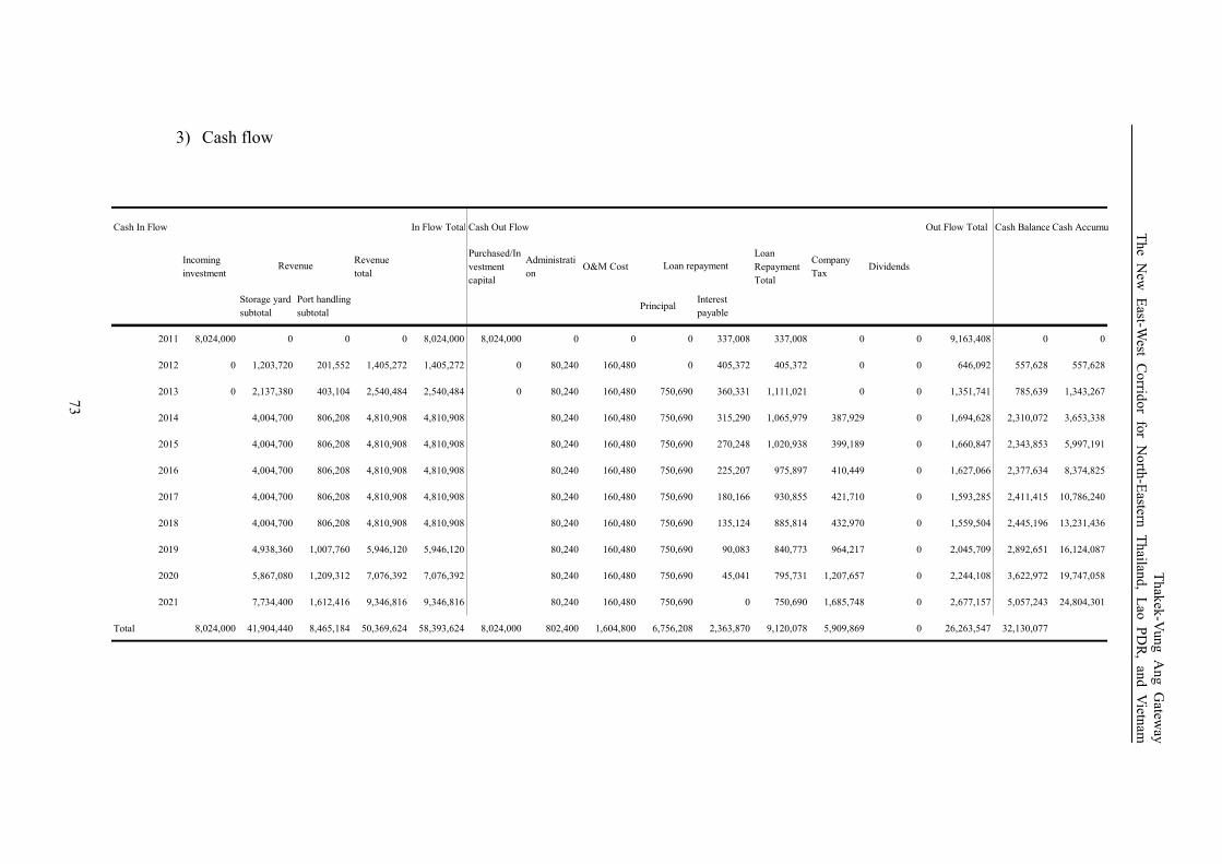
3) Cash flow
Cash In Flow In Flow Total Cash Out Flow Out Flow Total Cash Balance Cash Accumulation
Incoming
investment
Revenue
total
Purchased/In
vestment
capital
Administrati
onO&M Cost
Loan
Repayment
Total
Company
TaxDividends
Storage yard
subtotal
Port handling
subtotalPrincipal
Interest
payable
2011 8,024,000 0 0 0 8,024,000 8,024,000 0 0 0 337,008 337,008 0 0 9,163,408 0 0
2012 0 1,203,720 201,552 1,405,272 1,405,272 0 80,240 160,480 0 405,372 405,372 0 0 646,092 557,628 557,628
2013 0 2,137,380 403,104 2,540,484 2,540,484 0 80,240 160,480 750,690 360,331 1,111,021 0 0 1,351,741 785,639 1,343,267
2014 4,004,700 806,208 4,810,908 4,810,908 80,240 160,480 750,690 315,290 1,065,979 387,929 0 1,694,628 2,310,072 3,653,338
2015 4,004,700 806,208 4,810,908 4,810,908 80,240 160,480 750,690 270,248 1,020,938 399,189 0 1,660,847 2,343,853 5,997,191
2016 4,004,700 806,208 4,810,908 4,810,908 80,240 160,480 750,690 225,207 975,897 410,449 0 1,627,066 2,377,634 8,374,825
2017 4,004,700 806,208 4,810,908 4,810,908 80,240 160,480 750,690 180,166 930,855 421,710 0 1,593,285 2,411,415 10,786,240
2018 4,004,700 806,208 4,810,908 4,810,908 80,240 160,480 750,690 135,124 885,814 432,970 0 1,559,504 2,445,196 13,231,436
2019 4,938,360 1,007,760 5,946,120 5,946,120 80,240 160,480 750,690 90,083 840,773 964,217 0 2,045,709 2,892,651 16,124,087
2020 5,867,080 1,209,312 7,076,392 7,076,392 80,240 160,480 750,690 45,041 795,731 1,207,657 0 2,244,108 3,622,972 19,747,058
2021 7,734,400 1,612,416 9,346,816 9,346,816 80,240 160,480 750,690 0 750,690 1,685,748 0 2,677,157 5,057,243 24,804,301
Total 8,024,000 41,904,440 8,465,184 50,369,624 58,393,624 8,024,000 802,400 1,604,800 6,756,208 2,363,870 9,120,078 5,909,869 0 26,263,547 32,130,077
Loan repaymentRevenue
73
Thakek-Vung Ang Gatew
ay
The New East-W
est Corrid
or for North-Eastern
Thailan
d, Lao PDR, and Vietn
am

Thakek-Vung Ang Gateway The New East-West Corridor for North-Eastern Thailand, Lao PDR, and Vietnam
74
7.2.5 Sensitivity Analysis
According to the analysis, the major influence factors are accrued from the changes in
both investment cost and revenue from the project. The lease, the cost change in O&M and
administration, has the least impact because its value is relatively small, and its fluctuations are
estimated to be relatively stable against other price fluctuations. Moreover remarkable
fluctuations of gap between the highest FIRR and the lowest are found in the positive change of
the total investment and the negative change in revenue, which are 29.51% and 22.60%
respectively. Consequently it can be concluded that the project profitability would be most
directly impacted by changes in investment cost and revenue than other parameters. In other
words, it is indicated that these two elements are the critical factors for this project.
Table 7-11: Sensitivity Analysis on Phase 2 Project
-10% Base +10%
Investment total 29.51% 26.02% 22.92%
Revenue total 22.60% 26.02% 29.17%
O&M and administration cost total 26.23% 26.02% 25.81%
(Source: JDI Study Team)
7.2.6 Implications
Thakek-Vung Ang woodchip transportation project is very important for both Lao
PDR and Vietnam benefiting both countries by means of developing socio-economic status
along the corridor. Moreover, in order to explore establishing a globally competitive
woodchip industry in the region, an efficient and modern woodchip supply chain with
29.51%
26.02%
22.92%22.60%
26.02%
29.17%
26.23% 26.02% 25.81%
20.00%
22.00%
24.00%
26.00%
28.00%
30.00%
32.00%
-10% Base +10%
Investment Total
Sales revenue Total
Operation and Maintenance
cost

Thakek-Vung Ang Gateway The New East-West Corridor for North-Eastern Thailand, Lao PDR, and Vietnam
75
economical processing/handling system and optimal transportation system should be in
place between Laos and Vietnam, especially in road and port. This objective will be
achieved only when proper coordination and cooperation measures was placed between the
private sector’s initiative and the government’s commitment to work together towards the
main goal of developing a globally competitive woodchip industry in the corridor. For
instance, as we have stressed from times to times, the allocation of stock yard at the
backyard of the proposed Berth No.3 would be the part of the important element, which
would bring about the corridor’s potential for woodchip industry in the corridor to be
globally competitive. Yet the port development at Berth No.3 should wait until enough
volume of woodchip cargo can be attained so that the revenue from the port operation could
correspond to the investment cost.
7.3 Phase Two: Development Project of Berth No. 3
According to the projected export volume of woodchips from the Vung Ang Port, by the
time the volume reaches to 1.5 million ton per year, 48 vessels are supposed to approach the port,
which means 4 vessels would come per month. The estimated loading duration required for
woodchips onto the vessel is deemed to be 3 days. Hence, when such situation becomes visible, a
designated port for woodchip handing will be required.
The designated port development project is, thus, to be designed in the optimal area within
the distance where the cheapest transportation cost can be attained in that woodchip can be directly
loaded onto vessels by conveyer belts. Therefore, Berth No.3 next to the storage yard should be
considered as the best designated site for the port development project which can accommodate
frequently coming vessels for loading woodchip.
The land behind the sea front at Berth No.3 is already cleared and supposed to have been
reclaimed by the time Berth No.3 will be developed. The port will function as designated port
especially for woodchip handling and loading. The necessary facilities, project cost and operation
income from port operation as well as the FIRR from the project are to be studied in the following
part.
7.3.1 Financial Internal Rate of Return (FIRR)
1) Condition of financial analysis
The condition of financial analysis of this project is as follow:
i) Schedule of preparation and construction
This second phase project is supposed to start in accordance with the volume
expansion situation of woodchip handing at the existing Berth No.1 and No.2,
and tries to diversify and, ultimately, concentrate the woodchip handing
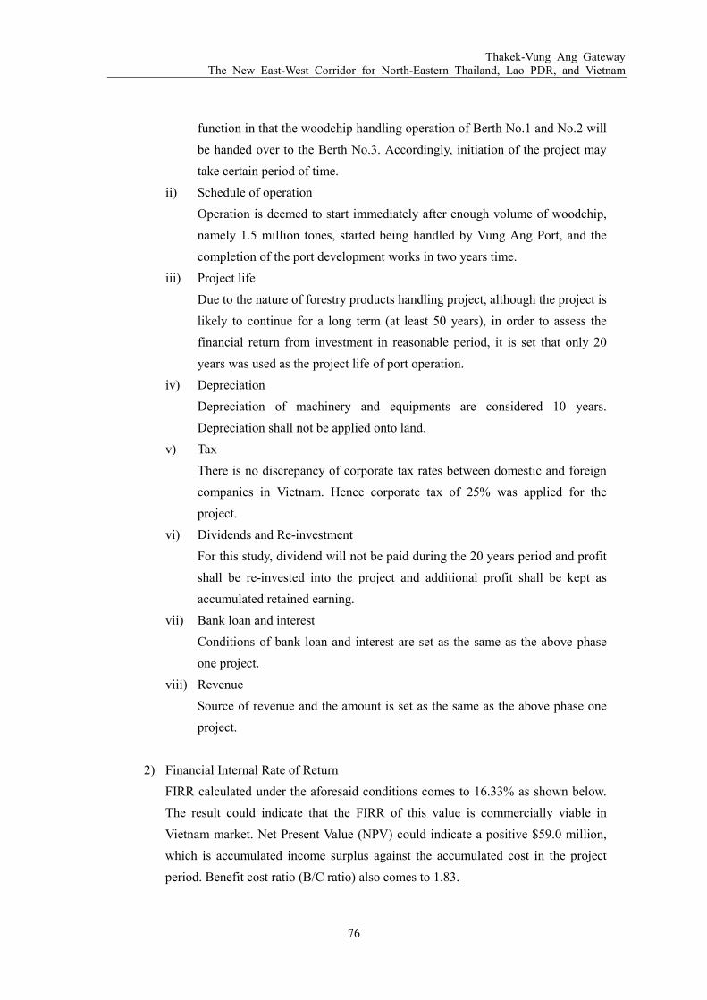
Thakek-Vung Ang Gateway The New East-West Corridor for North-Eastern Thailand, Lao PDR, and Vietnam
76
function in that the woodchip handling operation of Berth No.1 and No.2 will
be handed over to the Berth No.3. Accordingly, initiation of the project may
take certain period of time.
ii) Schedule of operation
Operation is deemed to start immediately after enough volume of woodchip,
namely 1.5 million tones, started being handled by Vung Ang Port, and the
completion of the port development works in two years time.
iii) Project life
Due to the nature of forestry products handling project, although the project is
likely to continue for a long term (at least 50 years), in order to assess the
financial return from investment in reasonable period, it is set that only 20
years was used as the project life of port operation.
iv) Depreciation
Depreciation of machinery and equipments are considered 10 years.
Depreciation shall not be applied onto land.
v) Tax
There is no discrepancy of corporate tax rates between domestic and foreign
companies in Vietnam. Hence corporate tax of 25% was applied for the
project.
vi) Dividends and Re-investment
For this study, dividend will not be paid during the 20 years period and profit
shall be re-invested into the project and additional profit shall be kept as
accumulated retained earning.
vii) Bank loan and interest
Conditions of bank loan and interest are set as the same as the above phase
one project.
viii) Revenue
Source of revenue and the amount is set as the same as the above phase one
project.
2) Financial Internal Rate of Return
FIRR calculated under the aforesaid conditions comes to 16.33% as shown below.
The result could indicate that the FIRR of this value is commercially viable in
Vietnam market. Net Present Value (NPV) could indicate a positive $59.0 million,
which is accumulated income surplus against the accumulated cost in the project
period. Benefit cost ratio (B/C ratio) also comes to 1.83.

Thakek-Vung Ang Gateway The New East-West Corridor for North-Eastern Thailand, Lao PDR, and Vietnam
77
Table 7-12: The Results of Financial Analysis for Each Project Components
Financial evaluation Project
NPV (mil. USD) FIRR (%) B/C
Phase two: Berth No.3 development
59.0 16.33 1.83
(Source: JDI Study Team)
7.3.2 Sensitivity Analysis
To evaluate the project in more comprehensive way, we conducted a sensitivity
analysis with fluctuating parameters on investment cost, O&M, and revenue at the rate of 10%
from the base case in order to assess the possible risks of the project. The results of calculations
are as follows.
The results of sensitivity analysis indicate that investment cost have the greatest
impact on FIRR. O&M cost has the least impact because its value is relatively minor. Moreover,
the gaps between the lower FIRR and the higher FIRR of the project resulting from fluctuations
in investment cost and O&M costs are 4.41% and 3.44% respectively. Consequently it can be
concluded that project profitability will be most directly impacted by changes in investment cost
rather than other parameters. In other words, this element is the critical factors for this project.
Table 7-13: Sensitivity Analysis on Phase 2 Project
-10% Base +10%
Investment total 18.73% 16.33% 14.32%
Revenue total 14.65% 16.33% 18.09%
O&M and administration cost total 16.42% 16.33% 16.25%
(Source: JDI Study Team)
18.73%
16.33%
14.32%
14.65%
16.33%
18.09%
16.42% 16.33% 16.25%
13.00%
14.00%
15.00%
16.00%
17.00%
18.00%
19.00%
-10% Base +10%
Investment Total
Sales revenue Total
Operation and Maintenance
cost

Thakek-Vung Ang Gateway The New East-West Corridor for North-Eastern Thailand, Lao PDR, and Vietnam
78
7.3.3 Cash Flow Analysis
As for the financial source of loan portion, provided the financial loan arrangement
was made from Vietnamese commercial banks, the project feasibility would turn dubious. On
the other hand, when JBIC yen loan was applied as the project financial scheme, the project
could be financially sound in order to attract private investor for port development and operation.
Hence in the cash flow analysis, yen loan arrangement could be claimed the most crucial
premising measure for the project to sustainable control by private sector throughout the project
life.
Figure. 7-1: Comparison between Interest Rates
(Source: JDI Study Team)
7.3.4 Implications
According to the analysis below, the phase two port development project can only attained
financial viability (supposed to be equal to the discount rate in Vietnam: 12%) only after the volume
of the handing cargo, which base line in this case of woodchip, reached 1.2 million BDT per year.
Consequently it can be stated that attaining financially meaningful outcome, at lease 1.5 million of
woodchip handling should need to be presented before investment on phase two project is actually
taken place. So as to attract such a large volume of cargo to the port, comparative advantage surely
need to be attained as its usability in port function. Vung Ang Port should have potentials for
handling Laotian agro forestry goods/products as their gateway.
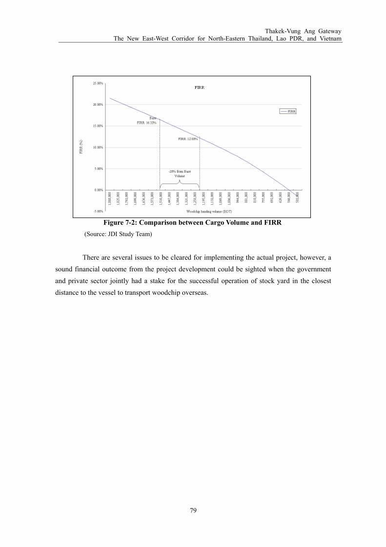
Thakek-Vung Ang Gateway The New East-West Corridor for North-Eastern Thailand, Lao PDR, and Vietnam
79
Figure 7-2: Comparison between Cargo Volume and FIRR
(Source: JDI Study Team)
There are several issues to be cleared for implementing the actual project, however, a
sound financial outcome from the project development could be sighted when the government
and private sector jointly had a stake for the successful operation of stock yard in the closest
distance to the vessel to transport woodchip overseas.

Thakek-Vung Ang Gateway The New East-West Corridor for North-Eastern Thailand, Lao PDR, and Vietnam
80
8 STAKEHOLDERS ANALYSIS
In order to process the development of woodchip storage yard at the backland of Berth
No.3 and No.4 on time of the start of woodchip export in 2012, and the development of Berth
No.3 when the woodchip export volume exceeds the capacity of Berth No.1 and No.2 in the
future, a proper analysis on the stakeholders of seaport development in Vietnam should be done
to identify the key players.
8.1.1 Stakeholder Analysis on National Level
In terms of the development of seaports in Vietnam, there are mainly three key
stakeholders that need to be addressed. The first is the Ministry of Transport (MOT) which is
the organization that decides the details speck of a seaport, and recommends to the Prime
Minister for the approval of development. The second is the Ministry of Planning and
Investment (MPI), which verifies the seaport investment plan after the Master Plan of the
seaport was approved by the Prime Minister through MOT. However, the final decision on the
investment will also ultimately come from the Prime Minister, based on the suggestions from
the Department of Infrastructure and Urban Development of MPI.
The third key stakeholder is the Ministry of Finance. The Ministry of Finance
approves on the budget of the investment project if public money is to be used for the
development. In case of the development of Berth No.3 at the Vung Ang Port, it is likely that the
development will be processed in Public Private Partnership (PPP) manner, since based on the
government’s conclusion No.25/TB-VPCP issued on January 29, 2010, the Vung Ang Port
Viet-Lao Joint Stock Company owns the right of developing new berths at the Vung Ang Port.
On this moment, the exact share between private and public sectors has not yet decided.

Thakek-Vung Ang Gateway The New East-West Corridor for North-Eastern Thailand, Lao PDR, and Vietnam
81
Figure 8-1: Organizational Structure of Maritime Business in Vietnam
(Source: JDI Study Team)
8.1.2 Stakeholder Analysis on Local Level
In the local level, there are three key stakeholders as well. The first is the Ha Tinh
Provincial People’s Committee, where the Vung Ang Economic Zone Authority has an office.
The second is the Maritime Administration of Ha Tinh, which is an organization under the
Vietnam Maritime Administration (Vinamarine) in the organizational chart above. This
organization will be the supervisor of the development work of the woodchip storage yard and
Berth No.3. The third key stakeholder is the Vung Ang Port Viet-Lao Joint Stock Company. As
stated above, this joint venture company between Vietnam and Laos holds the right to develop
Berth No.3 to No.6. Therefore, upon developing Berth No.3 in the future, an investor would
better form a joint venture company with them.
The Master Plan of Berth No.3 to No.6 was planned and designed by the Economic
Zone Authority and the Maritime Administration of Ha Tinh, and currently waiting for the
approval from the Chair of the Ha Tinh Province People’s Committee, which is planned to be
made between April and May of 2010. Once this Master Plan becomes effective, the study team
will verify whether the proposed development plan of the woodchip storage yard and Berth
No.3 complies with. If it does, the study team will request to conduct a Feasibility Study to draw
a detailed plan of the seaport to be submitted to MOT for the approval of the development.
Government of Vietnam
Vietnam National Shipping
Lines (Vinalines)
- VOSCO
- VINASHIP
- Vitranchart
- Other 4 corporates
Ministry of Finance
Vietnam Register of
Shipping
Maritime Service
Ministry of Plannning and
Investment
Vietnam Maritime
Administration
(Vinamarine)
Ministry of Transport
State Port Authorities
Quang Ming
Hai Phong
Da Nang
Vung Tau
Vung Ang
ShippingPort Operation

Thakek-Vung Ang Gateway The New East-West Corridor for North-Eastern Thailand, Lao PDR, and Vietnam
82
9 FUTURE ACTION PLAN
In July, 2006, the Vietnamese government enforced “Decree No.71/2006/ND-CP”
which rules apply to the management of seaports and maritime channels, and allows foreign
investors to develop and operate a port in Vietnam. Based on this decree, the study team
proposes to develop the woodchip stock yard by private investment, and Berth No.3 at the Vung
Ang Port by PPP with the Vung Ang Port Viet-Lao Joint Stock Company. The flow-chart below
shows the step on how seaport investment and development will be approved and processed.
Figure 9-1: The Flow-Chart of Seaport Investment and Development Approval
(Source: JDI Study Team)

Thakek-Vung Ang Gateway The New East-West Corridor for North-Eastern Thailand, Lao PDR, and Vietnam
83
Based on the above flow-chart, the action plan for the development of the woodchip
storage yard and Berth No.3 was divided into three phases: the first is the “Preparation Study
Phase”, the second is “Phase 1 Development Plan: 2010-2015”, and the third is “Phase 2
Development Plan: 2020 or after”. Each phase will be explained below.
9.1 Preparation Study Phase: 2010
This phase indicates the preparation period before the actual development of the yard
and the berth starts. First, after the approval of the Master Plan on the development of Berth
No.3-No.6 at the Vung Ang Port by the Chief Commissioner of the Ha Tinh Provincial People’s
Committee, the study team should work immediately to confirm whether the proposed
development of yard and Berth No.3 is in accordance with the Master Plan. Though, during the
field study conducted in December 2009, and March 2010, the JDI study team received
approval from Maritime Administration of Ha Tinh, and Ha Tinh Joint Stock Company on
assisting JDI to receive approval on starting feasibility research of the yard and Berth No.3
soon.
Secondly, the study team should conduct a feasibility study on the development of a
woodchip stock yard and Berth No.3 in order to arrange a detailed development plan to be
submitted to MOT for the governmental approval on conducting the development. The
feasibility study should not take more than six months, or at least should be finished within
2014, so that the construction of the storage yard will be in time for the start of woodchips
export from central Laos in 2012.
9.2 Phase 1 Development Plan: 2011-2012
Phase 1 should be dedicated to ensure a smooth start of woodchips export through the
Thakek-Vung Ang Gateway. Thus, Phase 1 is mainly divided into two objectives: the first is the
development of the Agro-Forestry Processing SEZ at Thakek, and the second is the
development of a Woodchip Storage Yard at the Vung Ang Port.
9.2.1 Agro-Forestry Processing SEZ in Thakek, Lao PDR
With the support from ADB and UNIDO, Laos is planning to start a nation-wide SEZ
Development Program within a few years. Considering the fact that 1) harvesting of Eucalyptus
and processing to woodchips is due to start from 2012, 2) the request from Lao Government to
process into woodchips at least a part of the harvest within Laos, and 3) the presence of rubber
and other agro-forestry production plantations in central Laos, the development plan of an
Agro-Forestry Processing SEZ is a pressing need, as well as a chance of profitable business for
Laos. Based on the discussions between JDI study team, and the governor of Khammouane

Thakek-Vung Ang Gateway The New East-West Corridor for North-Eastern Thailand, Lao PDR, and Vietnam
84
province, it was basically agreed to develop the SEZ in Thakek near the cross section of Road
No.12 and No.13. The project area is planned to have about 100ha, of which 50 ha will be
occupied by the woodchip company to process harvested timbers into woodchips. In order for
the company to start its operation from the early 2012, the SEZ must be constructed by the end
of 2011. Thus, a rough development schedule was planned as below.
Table 9-1: Rough Development Schedule of the Agro-Forestry SEZ in Thakek
Year 2010 2011 2012
Schedule 1) Planning and designing of the SEZ
2) Approval on the development from the Lao Government
3) Engineering Study
Construction of the SEZ Start of the operation of the woodchip processing factory.
(Source: JDI Study Team)
9.2.2 Woodchip Storage Yard at the Vung Ang Port
In Phase 1, because the woodchip export volume is still low, it is more reasonable and
cost-effectively to use Berth No.1 and No.2 as the export port, rather than start constructing a
new Berth and woodchip storage yard together. In order for the woodchip company in central
Laos to provide paper in a competitive price in the international market, it is necessary to make
up the extra transport cost it incurred by transporting woodchips by trucks all the way from
Laos to Vietnam. Therefore, constructing a woodchip storage yard in the vicinity of operating
berths is crucial to enable woodchips loaded onto vessels through automated conveyer belt
directly from the storage yard. During the field study at the Vung Ang Port, the backland of the
project area of Berth No.3 and No.4 was identified as the ideal location of the storage yard.
Once the Prime Minister approval on the development of woodchip storage yard and
Berth No.3 is issued, the construction of the woodchip yard should start immediately by using a
local construction company. Since no woodchip processing will be taking place at this woodchip
storage yard, the design of the space should be fairly simple. However, since the project area of
the yard is currently just open water, reclamation needs to be taken place. In order to speed up
the process and lower the cost, it is planned to use the same local engineering company which
designed Berth No.1 and No.2, and already has the knowledge of the appropriate method of
reclamation.
9.3 Phase 2 Development Plan: 2020 or after
At Phase 2, the development of Berth No.3 should take place to meet the increasing
woodchips and other agro-forestry products’ export demand. As per the timing, Phase 2 is
projected to be started when the handling volume at Berth No.1 and No.2 nears the full capacity,

Thakek-Vung Ang Gateway The New East-West Corridor for North-Eastern Thailand, Lao PDR, and Vietnam
85
or when the woodchip export volume reaches to 1,500,000 tons per year. At the volume of
1,500,000 tons per year, it is assumed that Berth No.3 can be operated as a specialized Berth for
woodchips and agro-forestry products, but still remain profitable. The actual construction
should be processed according to the development plan approved by the Prime Minister at the
beginning, unless special modification is necessary.
As stated earlier, the speck of the berth should be designed to accommodate
51,000DWT WMV, which should have about 13m depth of water, and 275m length of the berth.
In addition, if the Berth becomes a specialized port for agro-forestry products and woodchips, it
is possible to construct a permanent conveyer belt. Permanent conveyer belt will be more
economical in this case rather than the mobile conveyer belt, since vessels are expected to arrive
at least three times a month at the volume of 1,500,000 tons per year.
9.4 Possible Funding Scheme
In terms of the funding of processing the development of woodchip storage yard and
Berth No.3 at the Vung Ang Port, the following scheme is tentatively considered.
9.4.1 Funding for the Woodchip Storage Yard
Though a closer study needs to be taken in the future, the cost of developing a woodchip
storage yard at the backland of Berth No.3 and No.4 is roughly estimated to be about US$ 8 million,
including the reclamation of the coast. Since the cost is relatively low, it should be incurred by a
private sector. This will speed up the development process as well.
9.4.2 Funding for Berth No.3 at the Vung Ang Port
There are three possible methods of funding for the construction of Berth No.3 at the
Vung Ang Port as below.
1) Public Fund: This method is same as the construction of Berth No.1 and No.2. However, in
the Government’s conclusion No.25/TB-VPCP issued in January, 2010, it is stated that in
case of constructing additional berths at the Vung Ang Port, the Vung Ang Port Viet-Lao
Joint Stock Company is to ensure fund by itself.
2) Private Fund: The New Investment Law enforced in 2006 (Decree No.71/2006/ND-CP of
the Government) allows the private sector to develop own ports. However, in case of the
investment from foreign companies, it needs to form a joint venture with a local company
with no more than 49% share.
3) Public Private Partnership (PPP) Scheme: According to the Government’s conclusion
No.25/TB-VPCP, the operation of the Vung Ang Port was formally given to a joint stock

Thakek-Vung Ang Gateway The New East-West Corridor for North-Eastern Thailand, Lao PDR, and Vietnam
86
company called the Vung Ang Port Viet-Lao Joint Stock Company which is consisting of
seven Vietnamese and three Laotian partners. Since this joint company owns the right to
develop berth No.3-6, it is wiser for a private investor to form a joint venture with the Vung
Ang Port Viet-Lao Joint Stock Company, which has a connection with both Vietnamese and
Laotian government to lure partial funding from a public source. The JDI study team
considers option 3 to be the most advantageous and realistic.
9.5 Recommendation to the Vietnamese Government
Though the Vung Ang Port was started operating in 2001, and Berth No.2 is scheduled
to start operating in March, 2010, the port itself has not yet been widely used. Part of the reason
is that there is no large size industry in the central Vietnam that could be a potential user of the
Vung Ang Port. As a result, currently, the most frequent customers are the woodchip companies
based in Vietnam. Because of the natural advantage of the Son Duong Port, a lot of private
investors are turning their attentions to the Vung Ang area recently. However, the actual
investment is likely to take another few years as most companies are experiencing world wide
economic recessions from the end of 2008. Therefore, until industries potentially use the Vung
Ang Port for export/import purposes are developed, the agro-forestry companies in central Laos,
especially the woodchip company becomes the most tangible customer for the Vung Ang Port.
In addition to the size of the export volume, which is expected to reach more than a million tons
per year, the export of woodchips usually turns into a long-term relationship considering the
time frame of forestry products to grow. Therefore, the Vietnamese government should treat
them as the first priority.
In order for woodchip companies in central Laos to use the Vung Ang Port in
long-term, cost efficiency should be attained. One of the crucial components to reach
cost-efficiency is the location of the woodchip storage yard. If the storage yard is located in a
distance that requires loading and unloading by trucks, rather than using a conveyer belt, the
cost will be too high that the company cannot provide papers in internationally competitive
price. This will eventually lead to the suspension of the woodchip export from Laos. Losing a
customer who potentially exports in a volume exceeding 1 million tons per year will be a large
loss for Vietnamese economy, especially for the central regions which remains relatively poorer
than regions in south and north of the country. Therefore, a warm and continuous support for
should be provided by the Vietnamese government on following projects for the benefit of the
country.
1) Immediate construction of a woodchip storage yard at the backland of Berth No.3 and
No.4
Thakek-Vung Ang Gateway The New East-West Corridor for North-Eastern Thailand, Lao PDR, and Vietnam
87
2) Construction of Berth No.3 as a specialized port for agro-forestry industries in the
future
3) Improvement of the existing road and development of a new lane for Road No.12 in the
future
9.6 Recommendation to the Lao Government
Considering the volume to be handled, the success of the export of woodchips from
central Laos using the Thakek-Vung Ang Port Gateway has a potential to influence the
development of the agro-forestry industry in Laos. If a successful export model is established,
other companies in the agro-forestry industry as well as investors who have been unsure about
investing in the land-locked country Laos would be encouraged and convinced to follow the
same model. In order for Laos to reach this state, the cost-efficiency of exporting woodchips
from Laos should be attained.
The Lao government can assist this process by first, assisting the development of an
Agro-Forestry Processing Zone in Thakek, Khammouane Province. It is important to improve
the industrial environment for the woodchip industry to start exporting in the scheduled time
frame. In other words, in order to start exporting from 2012, the processing factory should be
completed at least by early moths of 2012. If a processing factory is opened on time, it would
contribute to the smooth export of woodchips as well as the creation of new employments for
local households having an annual income below the national poverty line.
The second area the Lao government could provide assistance, to ensure a favorable
export environment for a woodchip industry, is to improve the custom process at the border in
Na Phao. Currently, the custom process at Na Phao is manually conducted by only a few
officers, and the office hour is limited to day time. Considering the low volume of traffic
currently crossing the border, this situation is understandable. However, the current system is
certainly not efficient when a large number of 20 tons trucks are passing by in the future to
transport woodchips. Thus, an electronic custom system in international standard should be
implemented at the border. As explained in Chapter 4 above, the Lao government is now on the
process of implementing the ASYCUDA custom system supported by UN. The government
should make sure that Cha Lao at Na Phao is included as the border section the ASYCUDA
system is implemented.
Thakek-Vung Ang Gateway The New East-West Corridor for North-Eastern Thailand, Lao PDR, and Vietnam
88
10 CONCLUSION
The Thakek-Vung Ang Gateway has been receiving keen interests by Thailand, and
Laos as the shortest export gateway to the Pacific Ocean. By taking Road No.12, it is less than
300 km from the Thai/Lao border, and less than 150 km from the Lao/Viet border. Seeing a
potentiality in this gateway, three countries—Thailand, Laos, and Vietnam—has been working
closely to develop the Thakek-Vung Ang Gateway since the late 1990s to increase economic
interactions among them. Under the current plan, Thailand will complete the construction of the
Third Friendship Bridge between Nakhon Phanom in Thailand and Thakek in Laos. The
Khammouane Province in central Laos started the development plan of Agro-Forestry
Processing SEZ, and Vietnam is about to confirm the Master Plan of the expansion of the Vung
Ang Port to accommodate variety of industries in the future.
Though the trans-shipment through a port in central Vietnam has not yet widely known
among private investors, this effort among three countries has attracted agro-forestry companies
in central Laos which are looking for an economical transport route. Among them, the most
prospective actor is the woodchip companies which have completed about 30,000 ha plantation
by the end of 2009 to export woodchips to Japan, China, and Korea. This plantation size is so
large that within 10 years, the volume of woodchips produced in central Laos is expected to
reach near 1 million tons per year. For Laos, the woodchip production will be the promoter of
economic development to catch up with neighboring countries. For Vietnam, it will be the first
large size export through the Vung Ang Port, and if successful, a trigger to attract other
agro-forestry companies. For Japan, the main receiver of woodchips exported through Vietnam,
it will help to meet the domestic and international paper demand which is expected to grow
again together with the economic recovery. In order to ensure economic benefits of woodchip
exports, the following projects are identified as urgent needs.
1) Agro-Forestry Processing SEZ in Thakek, Laos:
A 100 ha industrial zone at the SEZ should receive approval from the national government
within 2010, and start construction in 2011, to be on time for the operation of woodchip
processing in 2012. This project should be processed under the Master Plan of the Thakek
SEZ (350 ha), which also includes residential and recreational zones.
2) Development of Woodchip Stock Yard:
A basic agreement among all stakeholders on the development of 5 ha storage yard at the
backland of Berth No.3 and No.4 at the Vung Ang Port should receive as soon as possible.
The storage yard should be located at the closest available land, so that woodchips can be
loaded to vessels directly by using a conveyer belt. Following that, a feasibility study and a

Thakek-Vung Ang Gateway The New East-West Corridor for North-Eastern Thailand, Lao PDR, and Vietnam
89
detail engineering design should be conducted within 2010. The construction of the 5 ha
storage yard should start in 2011, and should be completed within 2011 or early 2012.
In the later phases of the development, once Berth No.1 and No.2 reaches the full
capacity in the future (projected to be within 5-7 years), Berth No.3 should be constructed by
PPP scheme as specialized Berth for woodchips and other agro-forestry industries. The
profitability of operating a specialized berth is also assumed to be reached since the woodchip
exporting volume is likely to reach 1.5 million to 2.0 million tons by 2020.
Regarding to the financing scheme of above development projects, PPP scheme should
be taken utilizing the scheme allowed under the Governmental Decree No.71/2006/ND-CP.
Since the profitability of developing the woodchip storage yard and Berth No.3 is very realistic
due to the high demands from agro-forestry industries, it is assumed to be an attractive project
for private investors as well.
In addition to the development projects at the Vung Ang Port, in medium to long run,
additional public projects such as widening of Road No.12 will be required as the volume of
cargos passing the Thakek-Vung Ang Gateway increases. Because of the on-going investment
projects in the Son Duong Port, a further expansion of the Vung Ang Port and surrounding
special economic zone, and improvement on power, water and local access roads should also
taken place by either PPP or public funding to handle expanded economic activities in the
region.
In the next stage, the study team will further work to conduct following actions:
1) Detail Feasibility Study and Engineering Design work of Agro-Forestry Processing SEZ
2) Detail Feasibility Study and Engineering Design work of 5 ha woodchip storage yard and
Berth No.3 at the Vung Ang Port


APPENDIX
Appendix Index
1. Road Design Standard

Appendix 1: Road Design Standard
ラオス・ベトナム間(Thakek-Vung Ang港)ゲートウェイ開発準備調査
(タイ北東部、ラオス、ベトナムをつなぐ新東西回廊開発)
和文要約

1
1. 案件実施背景案件実施背景案件実施背景案件実施背景
東南アジア諸国の中にあって、ラオスは周辺国と比べて経済的に遅れを取ってき
たが、アジア開発銀行(ADB)主導で進められてきた「大メコン河地域経済協力プログラ
ム」によって、周辺国とのロジスティック・ネットワークが道路・鉄道開発により整備さ
れてきたこともあり、同国の経済発展にとってボトルネックとなっていた輸出経路の確保
が進み、その状況は大きく変わろうとしている。また、自国が持つ豊かな森林資源を活用
した産業が近年順調に成長を続けており、今後の更なる経済発展の牽引役として期待され
ている。ただ、四方を他国に囲まれたラオスは物資/製品の輸出入玄関口となる港湾までの
輸送コストがかさむことから、ラオスに生産拠点を持つ企業にとって物資/製品輸送コス
ト・時間の両面で有利な輸送経路の洗い出しが必要になってきている。本件にて提案され
ている太平洋へと抜ける「タケーク(Thakek)-ブンアン(Vung Ang)港間のゲートウェ
イ」もこの観点から、ラオス中部にて成長が見込まれる農林産業の製品輸出経路としての
役割を担うべく開発提案がされたものである。
2. 回廊回廊回廊回廊のののの概要概要概要概要
「タケーク-ブンアン港間のゲートウェイ」は、下記「図 1」に示されている通り、
ラオス中部のカンムアン県の中心都市であるタケークを起点に 12号線を通り、ナファオ(Na
Phao)にてラオス/ベトナムの国境を越え、一時的に 15号線(ホーチミン・ハイウェイ)を
経由した後、またベトナム側の 12号線を通り、ベトナム北中部のハティン省(Ha Tinh)の
ブンアン港へと抜ける輸出経路である。12号線は 2009年 6月に完成したばかりであり、こ
の完成をもってブンアン港は中部ラオスから最短距離にある港となった。他国の港まで物
資/製品を運び出すことを余儀なくされるラオスにとって、距離的な優位性は輸送経路の選
定にあたって重要となる。また、ラオスのカンムアン県と隣接するタイの北東 6 州もこの
ゲートウェイの優位性に注目し、2011 年の完成を目標に現在タケークとタイの Nakhon
Phanomをつなぐ第 3の友好橋の建設がタイ政府の資金によって進められている。この橋が
完成すれば、「タケーク-ブンアン港間ゲートウェイ」はタイ、ラオス、ベトナムの 3国を
結ぶこととなり、ADB の「大メコン河地域経済協力プログラム」下で進められているベト
ナムのダナン(Da Nang)港を輸出港としたゲートウェイに続く、新しい東西回廊として、
東南アジアの経済発展に大きく寄与する可能性を秘めている。

2
図図図図 1::::タケークタケークタケークタケーク~~~~ブンアンブンアンブンアンブンアン港港港港間間間間ゲートウェイゲートウェイゲートウェイゲートウェイ
輸出港となるブンアン港は 1996年にラオスとベトナム政府との間で、港を持たな
いラオスの輸出港として開発されることで合意され、2001 年に開港した。開港された際は
35,000DWTまでの船舶の入港が可能であったが、その後 2004年に第 1バースの拡張が行わ
れ 45,000DWTまでの船舶の受け入れが可能となった。さらに 2010年 3月より、50,000DWT
までの船舶が入港可能な第 2バースの運営が、ラオスとベトナムの企業 10社の合弁会社に
よって始まる予定である。
3. ラオスラオスラオスラオスのののの農林産業農林産業農林産業農林産業
2005年時点においてラオスの森林は全国土のおよそ 70%に当たる 16,142,000ha ま
VungAngPort
12
12
15
Thakek
Cha LaoAlternative
Route

3
で広がっており、内 1.4%が植林によるものである。植林面積はまだ大きくないものの、そ
の面積は 1990 年~2005 年の間に年率 5,500%の速度で広がっている。ラオス中央部におい
ては、中国、ベトナム、日本の民間企業が木材、ゴム、紙の原料となるウッドチップの生
産のために植林事業を行っている。本調査で焦点を当てたウッドチップの生産・輸出に関
しては、ウッドチップ用の植林がラオスでは 2005年から始まっており、そうした森林は通
常 7年周期で収穫されるため、最初のウッドチップの輸出が 2012年にも行われる予定であ
り、輸出玄関口となる港湾までのロジスティッグを早急に進める必要が出てきている。ま
た、ウッドチップ用の森林を植林している企業へのヒアリングを行ったところ、将来的な
輸出量は年間約百万トンにも上る見通しであり、ラオスにとっても、ベトナムにとっても
大きな経済効果を生むと予想されている。
よって、現状「タケーク-ブンアン港間ゲートウェイ」を輸出経路として使用し
た場合を想定すると、ラオス国内におけるウッドチップ加工場所の確保とブンアン港にお
けるウッドチップ保管ヤードの建設が急務となっており、また将来的に年間約百万トンに
も及ぶ輸出を支える道路・港の設備が輸出計画に合わせて順次実施されるようラオスとベ
トナム政府機関との調整を図っていくことも重要となる。
4. タケタケタケタケークークークーク----ブンアンブンアンブンアンブンアン港港港港間間間間ゲートウェイゲートウェイゲートウェイゲートウェイのののの利点利点利点利点
ブンアン港をゲートウェイ港とした輸出経路の利点はラオス中部からの距離的な
近さだけでなく、ブンアン港の東南アジアにおけるハブ港にもなりうる自然条件の良さに
もある。ブンアン港周辺の海底は元々深く、浚渫の必要がほぼない。また、港の南に位置
するロン・ケープ半島が自然の防波堤となり、波や風の影響も少ない。また、港自体が 2001
年に開港したばかりであり、またベトナム中部にはまだ大規模に輸出を行う産業が育って
いないため、港の利用頻度は高くなく、ラオスの輸出農林製品の一時保管ヤード建設のた
めに周辺の土地がまだ空いているという利点もある。
よって、本調査は「タケーク-ブンアン港間ゲートウェイ」におけるこれら利点
を踏まえて、ラオス中部の農林産業企業がこの回廊を使用した場合必要とされるインフラ
設備の確認とその開発計画への提言を行うと共に、ベトナム側からの協力を得て、ラオス・
ベトナム両国が裨益するような「タケーク-ブンアン港間ゲートウェイ」の開発を進めて
いくための施策への提言も試みたものである。
5. 短期短期短期短期開発開発開発開発計画計画計画計画
2012年からのウッドチップの輸出を予定通りに行うためには、2011年までに 2件
の開発案件を実施していかなければならない。まず最初に、植林が進められているカンム
アン県のタケークにおいてウッドチップ加工を行うための農林加工 SEZ(Agro-Forestry
Processing SEZ)を建設することである。この農林加工 SEZは、現在 ADBと国際連合

4
工業開発機関(UNIDO)により実施されているラオスでの全国 SEZ 開発計画策定調査
において、今後ラオスの経済を牽引していく 12の重要な SEZ群が提案されている中の
1つとして提案されているものである。本農林加工 SEZは現在カンムアン県政府より中
央政府に提案が行われている工業団地/ホテル/レクリエーション施設を含む 350ha の
SEZの 1部として開発を進める計画であり、土地については 12号線と 13号線が交わる
地点で既に確保されている。農林加工 SEZが完成すれば、およそ 50haをウッドチップ
加工用の工場が使用し、残りをゴムや木材加工企業が使用する計画である。
実施スケジュールとしては 2010年までにラオス中央政府より SEZ開発の正式
な許可を得て、フィージビリティ(FS)調査とエンジニアリング・デザインの実施を行
う予定である。また、2011 年までにウッドチップの加工工場の建設を終え、2012 年に
工場操業を始める計画である。
図図図図 2::::Thakekにおけるにおけるにおけるにおける農林加工農林加工農林加工農林加工 SEZのののの位置位置位置位置
次に開発が急がれるのは、ブンアン港におけるウッドチップの一時保管用のヤー
ドの建設である。ラオス国内にてウッドチップに加工された製品は輸出船が到着するまで

5
ここに一時的に集められる。ウッドチップの輸送コストを考えると、この保管ヤードの建
設地は、ウッドチップ搬出に使用される港湾バースに近接していなければならず、ヤード
から輸出船までチップを運ぶコストがかさむようなことがあれば、最終的に国際市場での
競争力を削ぐ結果となる。そのため、本件では現在運営されているバース No.2の隣に開発
予定であるバース No.3 と No.4 の後背地にウッドチップ保管ヤードを開発していくことを
提案し、ハティン省政府、ブンアン港の開発権を持つ Ha Tinh Port Joint Stock Companyと、
ハティン省海事局へ説明を重ね、最終的に基本合意を得たものである。この位置にヤード
が建設されれば、ヤードから船舶へとベルトコンベアーを使用して直接の積み出しが可能
となり、ウッドチップの船舶への搬入に際してトラックを使用した積み降しを行う場合よ
りも大幅なコストカットが見込まれうる。
なお、ヤード開発を実施に移すためには、まずベトナム政府運輸省(MOT)より
許可を得て FS 調査とエンジニアリング・デザインを 2010 年内に行い、その結果を受けて
正式に開発申請をMOTを通して首相に提出し、2011年内に許可を得て、開発を進めていく
必要がある。最終的に 2012年からの輸出に間に合うためには、ヤード開発は遅くとも 2012
年初頭に終わらせていなければならない。
図図図図 3::::ウッドチップヤードウッドチップヤードウッドチップヤードウッドチップヤード建設予定地建設予定地建設予定地建設予定地
Berth No.1
Berth No.2
Berth No.3
Woodchip Storage Yard

6
上記 2 件のインフラ開発計画を限られた期間で確実に実行していくためには、ラ
オス・ベトナム両政府からの協力が欠かせない。一方、このウッドチップの大規模輸出案
件が順調に実施されれば、ラオスにとっては経済開発を牽引役として地域産業の柱となり
え、またベトナムにとっては港の利用が進み、地域開発、雇用の創出が生み出され、国内
でも生活水準が比較的低水準となっている中部地域開発に大きく寄与する事業となりえる。
今後はこうした事業実施に係るメリットを強調しながら、両国にとって経済効果を最大限
に普及できるよう調整を図っていく必要がある。
5. 長期開発計画長期開発計画長期開発計画長期開発計画
上記の短期開発計画は、まず 2012年のウッドチップの輸出開始に焦点を当てた場
合の提案となる。しかし、ウッドチップ用の植林面積は現在も順調にラオス中部にて拡張
が進んでいることから、短期計画と合わせて長期の開発計画準備を進めていくことも重要
である。長期開発計画としては、以下の 2点があげられる。
1)ブンアン港におけるバース No.3の開発
現在計画されている具体的な積み出しスケジュールでは、ウッドチップが輸出さ
れる最初の数年はバース No.1と No.2を利用し、ウッドチップの輸出量が年間 1~1.5百万
トンを超え、2 つのバースでは処理しきれなくなると予想される 2020 年以降にウッドチッ
プ輸出専用埠頭となるバース No.3の建設を行う予定である。バース No.3の開発予定地は現
在ハティン省の正式な承認を待っている「ブンアン港マスタープラン」内でその位置がバ
ース No.2の横に既に定められており、今後はこのマスタープランに沿った開発計画を提案
していくことが必要である。バース No.3 の開発権は半官半民の Ha Tinh Port Joint Stock
Companyに委ねられていることから、開発計画は官民連携(PPP)にて行っていくことが最
適である。また、資金源としては国際協力銀行(JBIC)のローンを利用し、取扱量が年間
1.5百万トンを超えた場合十分な採算性を得られることが見込まれる。
2)12号線の整備・拡幅
ウッドチップのラオスからベトナムへの輸送は 20トントラックを使用することが
計画されており、2012年から輸出が開始されれば現時点では往来が少ない 12号線において
も大型トラックの往来が急激に増えることが予測されている。そのため、定期的に道路表
面の舗装を行うことが必要となってくる。また、将来的にウッドチップの輸出量が増える
につれて、現在片側 1車線となっている 12号線も片側 2車線となるよう拡幅することが必
要になってくる。この対応によって、12 号線上での渋滞や事故を防ぎ、輸出計画に大幅な
遅れを出すことを回避できる。開発資金源としては、道路の拡幅が必要になるまでにまだ
数年あることから、JICA技術協力資金を利用して進めていくことも視野に入れる。

7
このように、「タケーク-ブンアン港間ゲートウェイ」がラオス中部の農林企業の
輸出経路として長期的に利用されていくためには、輸出量の予測に合わせてインフラ整備
を進めていけるよう配慮していくことが必要になる。結果的に、経済発展が遅れているラ
オス中部、ベトナム中部双方に経済的効果が波及され、また最終的な紙の利用市場である
日本やその他の国々にとっても恩恵が広がるよう、まずウッドチップの輸出の初期段階を
支える港湾設備開発を短期開発計画に沿って実行していけるようにすることが直近の最重
要課題である。