THE STUDY ON COMMUNITY DEVELOPMENT PLAN …open_jicareport.jica.go.jp/pdf/11980356_01.pdf · THE...
78
MINISTRY OF RURAL DEVELOPMENT THE DEMOCRATIC REPUBLIC OF THE CONGO THE STUDY ON COMMUNITY DEVELOPMENT PLAN IN CATARACTES DISTRICT, BAS-CONGO PROVINCE IN THE DEMOCRATIC REPUBLIC OF THE CONGO FINAL REPORT JANUARY 2010 JAPAN INTERNATIONAL COOPERATION AGENCY NTC INTERNATIONAL CO., LTD.
Transcript of THE STUDY ON COMMUNITY DEVELOPMENT PLAN …open_jicareport.jica.go.jp/pdf/11980356_01.pdf · THE...

MINISTRY OF RURAL DEVELOPMENT THE DEMOCRATIC REPUBLIC OF THE CONGO
THE STUDY ON COMMUNITY DEVELOPMENT PLAN
IN CATARACTES DISTRICT,
BAS-CONGO PROVINCE
IN THE DEMOCRATIC REPUBLIC OF THE CONGO
FINAL REPORT
JANUARY 2010
JAPAN INTERNATIONAL COOPERATION AGENCY
NTC INTERNATIONAL CO., LTD.

PREFACE
In response to a request from the Government of the
Democratic Republic of Congo, the Government of Japan decided
to conduct a Study on Community Development Plan in Cataracts
District, Bas-Congo Province and entrusted the study to the Japan
International Cooperation Agency (JICA).
JICA selected and dispatched a study team headed by Mr. Akira
Iwamoto of NTC International Co., Ltd. between July 2008 and
December 2009.
The team held discussions with the officials concerned of
the Government of the Democratic Republic of Congo and conducted
field surveys at the study area. Upon returning to Japan, the
team conducted further studies and prepared this final report.
I hope that this report will contribute to the enhancement
of friendly relationship between our two countries.
Finally, I wish to express my sincere appreciation to the
officials concerned of the Government of the Democratic Republic
of Congo for their close cooperation extended to the study.
January 2010
Kiyofumi Konishi,
Director General
Economic Infrastructure Department
Japan International Cooperation
Agency

January 2010
Mr. Kiyofumi Konishi
Director General
Economic Infrastructure Department
Japan International Cooperation Agency
Letter of Transmittal
Dear Sir,
We are pleased to submit to you the final report on “The Study on Community Development Plan in Cataractes
District, Bas-Congo Province in the Democratic Republic of the Congo.” This report compiles the results of the study
which was conducted both in Congo and Japan during the period of 18 months from July 2008 to December 2009.
In this development study, with the purpose of realizing “the preparation and implementation of community
development plans led by local residents,” we have made efforts to propose a wide range of plans for “community road
improvement,” “improvement in livelihood through higher agricultural production, etc.” and “improvement in people’s living
conditions” as well as to “strengthen the capability of local residents and their organizations” to enable them to collectively
lead the implementation of those plans. We have carried out pilot projects, etc. to examine in detail the feasibility and
relevance of each of those plans and a system of collective management by local residents. In addition, since target areas are
in a country which is under post-conflict situations, Congo, special attention has been paid to the characteristics of the areas
through the PNA approach, so that this study would not contribute to the creation of any new conflict. And, based on the
results of the study, this report is compiled specifically around the community development plans to be led by local residents
collectively.
In submitting this report, we would like to express our heartiest appreciation for substantial cooperation and
advice provided during the study period by officials of the Japan International Cooperation Agency and the Ministry of
Foreign Affairs of Japan.
During the field study, we were also given thoughtful cooperation and support from diverse local administrative
institutions including the Ministry of Agriculture and Rural Development of Congo, the Bas-Congo Province and the
Kimpese sector. The JICA Office in Congo, the Embassy of Japan in Congo and other related institutions provided valuable
advice and support, too. In writing this, we would send our sincere gratitude to them for the helpful advice, cooperation and
support.
Finally, we hope that this report will contribute to an improvement in the local residents’ livelihood and basic
living conditions and an improvement in the community-level capability to endure any conflict as well. Ultimately, we hope
that people of the Democratic Republic of the Congo will be able to have fair dividend of peace.
Very truly yours,
Akira Iwamoto Team Leader
The Study on Community Development Plan in Cataractes District, Bas-Congo Province
in the Democratic Republic of the Congo

The Study on Community Development plan in Cataractes District, Bas-Congo Province in the Democratic Republic of the Congo
Final Report
l
Matadi
Boma
Kinshasa
Cataractes District Zone of intervention
Republic of Congo
Republic of Angola
Cabinda (Republic of Angola)
Bandundu
Kinshasa
Democratic Republic of the Congo
Location Map

The Study on Community Development plan in Cataractes District, Bas-Congo Province in the Democratic Republic of the CongoFinal Report
Study Area/Community/Zone
①Kimwana
Diadia III
②Ndembo
③Wene
④Nkondo
⑤Ndunguidi
⑥Kinanga
Betelemi
Mbinda
Nlolo
⑦Kisiama
⑧Mbanza Ndamba⑨Kilueka Site
Kipolo
Nzuudu
Kitobola
⑩Kilueka
DiakaneuaKlanika
Lombo
①Malanga Gare
②Malanga Cité
③Zamba
④Nkumba
⑤Nkenge
⑥Mawewe
⑦Kiasungua
⑩Mpete
⑪Nkondo Site
Kongo Dia Kati
Kinkanga
Mbombo
Ntaka
ConcessionNtonzi-Ntonzi
GAP Kiasungua
ConcessionMfula Mpinga
Lukala
Rive
r
Luku
nga R
iver
To Kinshasa
To Matadi
To Luozi
To Kasi
Railway
Cite de Kimpese
Lukara
To National Road
To Mbanza Ngungu
GAP Kitobola
Bridge No.1
Bridge No.2
Bridge No.3
Bridge No.4
Bridge No.5
Nlombua River
Nkeng
e Rive
r
Ndongua River
Luku
nga
Rive
r
National Road
Kimu River
Nene River
Langa River
Nsundi
Kokodiya
MbanzaNzovoII
Bambala
Luanika-ntala
Kinkuma
Zakimusi
Lubi
NkokoZamba2
Luenda
Camp Soeur
Luenda
NkemboII
Kivuni
Baya
Molokayi
Nkuaza
Mawete
NkalangaValaKiladi
Nkondo
Ndunga
Luzolo
Camp Muzala
Tubatadi
Ngembu
Vunda
Kitumba
Diadia II
Mongo a Kongo
Diadia I
LumuenoNtumbi
Kiyaya
Km 50
Nsumba
Lombo
Nkimbi 1
KinsafKinsende
Zulu-Mongo
Kidesu
NkankaNsona
KimvulLambu
Kifuku
Mbanza
Noki
Mbanza-Nkonda
Kimpanzu
Makanga
Kiula
⑧Lusasa⑨Kimpalukidi
Zone 1
Zone 2
Zone 3
Zone 4
Zone 5
Zone 6
Community around the Community RoadCommunity around the Community RoadRoad Rehabilitation by the Quick Impact ProjectRoad Rehabilitation by the Quick Impact Project
0 1 2 3 4 5 km 10 km0 1 2 3 4 5 km 10 km0 1 2 3 4 5 km 10 km
① Kimwana② Ndembo③ Wene④ Nkondo⑤ Ndunguidi⑥ Kinanga⑦ Kisiama⑧ Mbanza Ndamba⑨ Kilueka Site⑩ Kilueka
Zone4
Zone5
Zone6
10 villages around the Kilueka route① Malanga Gare② Malanga Cité③ Zamba④ Nkumba⑤ Nkenge⑥ Mawewe⑦ Kiasungua⑧ Lusasa⑨ Kimpalukidi⑩ Mpete⑪ Nkondo Site
Zone1
Zone2
Zone3
11 villages along the Nkondo route
Mt. Bangu
National Road
Provincial Road
Com
mun
ity R
oad
Community Community aroungaroung the Provincial Roadthe Provincial Road

Photographs of Rehabilitation work of Kilueka Route
(1) Condition on before and after rehabilitation of the road
Point Before After
280m : Beginning point
500m : Kimpese city
1,200m : No.1 Bridge
i

Point Before After
2,000m :
Section of
existing concretepavement
3,000m : Before Kimuana/ After
rehabilitation road closed
barrier is installed
4,000m : No.2 Bridge
5,050m : Existing crossing drainage (New
culvert is installed)
ii

Point Before After
7,500m : No.3 Bridge
9,500m : After Wene, water stayed on the surface of
existing road
10,600m : Before Nkondo, water stayed on the surface of
existing road
12,000m : Kinanga
iii

Point Before After
14,300m : Part of steepest slope (concrete pavement is
adopted)
15,000m: Part of steep slope
(Concrete pavement is
adopted)
16,000m: No.4 Bridge
iv

Point Before After
17,200m : Mbanza- ndamba ‒ Kilueka (Embankment is set)
18,000m :Kilueka (end point)
Rehabilitaiton work
Topographic servey Cutting and reclamation
v
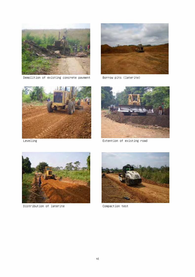
Demolition of existing concrete pavment Borrow pits (laterite)
Leveling Extention of existing road
Distribution of laterite Compaction test
vi

Finishing of laterite pavement Check of transverse slope
Finishing of laterite pavement (Kimpese city) Excavation for side ditches by manpower
Demolition of existing canal by manpower Seedling on slope of embankment
vii

Bridge work
Temporary road at bridge Demolition of a part of existing bridge
Paint of existing steel product (No.2 Bridge) Placing of reinforcement bar(No.3 bridge)
Foot path (No.1 Bridge) Cast of concrete (No.3 Bridge)
viii

Crossing drainage work
Placing of crossing culvert Cast of concrete for crossing canal
(Kishiama)
Concrete pavement
Concrete plant Slump test
Setting of base course (using crusher run) Casting and Finishing of concrete
ix

Workshop on maintenance for road
Training of maintenance of road for
supervisor(1)
Training of maintenance of road for
supervisor(2)
Training for villagers (each village) Explanation on equipment of road maintenance
Trainee who put what learnt at training into
practice
Practice of maintenance of side ditches
x

Pilot Project Pictures
Animal traction PP
Ranch for oxen during the training Familiarization of ox to the people
Oxen training Training of oxen for the plowing
Field is cultivated by the ox-plough Cart pulled by oxen
xi

Soil preparation and improvement PP, Introduction of new varieties PP
Improved nursery for selling in off season Introduction of natural insecticides with
local materials
Introduction of composting to the group members
Big eggplants. The effects of mulching with straw were verified.
Quality peppers were produced after teaching Harvest of tomatoes
xii

Promotion of rice cultivation PP
Rice field in Kimpese Nursery for promotion of rice cultivation PP
in Kimwana
Rice transplantation in Kimwana Rice harvest in Kimwana
Winnowing Rice harvest festival
xiii

Treatment and processing for postharvest PP
Commercialized honey in agro-processing center in Kimpese
Orange jam
Tomato puree Hot pepper paste
Transportation of farm products PP
Congolese typical cart. Two handles are attached in front and behind.
Japanese type of cart. It is more lighter than Congolese one.
xiv

Animal husbandry PP
Pig pen in Zamba Mixing forage
Feed the local materials (cassava leaves) Pig lets of improved variety
Schedule of the division of labor in Nkumba Thinner pig caused by the neglect of the group members
xv

Aquaculture and fish processing PP
Aquaculture pond in Kimpese Preparation for aquaculture in Zamba
Moringa tree PP
Moringa is for multiple uses.
Rooted cutting of Moringa tree.
Moringa leaves can be used for cook
Beekeeping PP
A villager of Malanga Cité who has the
experience of beekeeping
Commercialized honey
xvi

Forestry preservation and replantation PP, Roadside trees PP
After understanding the importance of forestry preservation, the members learned the method of raising seedlings
Filling the seedling pots with mixed soilwith ash
Nursery making with commonly available Transplanting seedling grown by themselves
Spontaneous seedling of Acacia in this area Seedling of mango
xvii

Improvement of cooking stoves and housekeeping PP
Three stone stove (left) and improved stove (right)
Improved stove made by a participant of workshop. (The bottom of pot can be burned because of square hole)
Improved stove with a round hole Improved stove with strengthened hole by useof metal basin
Improved stove is more used than the three stones stove in this household. Becoming a part of villagers’ life gradually.
Improved stove is safer for children than traditional one because of unexposed fire
xviii

Literacy education and book keeping PP
Training for teachers of literacy education PP
Participants getting good knowledge through the group discussion
Teachers hanging on the Lecturers Certificate and materials for literacy
education were presented at the end of
training
xix

Handicraft PP, Reuse of plastic bags
The villagers have had the conscious to throwplastic bags in a hole in the village.
The trial of making small handicrafts by using thrown plastic bags
Exchanging the idea for leaning methods in
group members
This handicraft was a great draw for Nkondo
site.
The group members with their works Bag, pot stand, hat, etc.
xx

Leisure activities PP
The players warming up before the match Every village leader and the leader of sector
were enjoying the football match.
Players of both teams were thanked after the
match.
The return match was played in another ground
in another day later.
Introduction of jumping rope for the girls The girls jumping better with a technique
gradually.
xxi

Improvement of health facilities PP
Situation of health center in Kinanga before
the repair
Health center after the repair. There is a
nurses' accommodation next to the center.
Repaired health center of Malanga Cité The training for health animators
The outcomes of discussions were shared The health animators seemed satisfied to have received the certificate of training
xxii

Maintenance and management of drinking water facilities PP
Villagers of Mawewe used to use standing
water
This source of water supply dried up in dry
season
Completed well of Mawewe. A padlock was
attached for the control
The well of Wene. The well of Wene. A well with pulley is easy to maintain.
xxiii

Improvement of educational facilities PP
The exterior of the school before the repair The exterior of the school after the repair
There were some places without roofs before the repair
Patching up with tin roof, rain is no longer a problem in the class
The concrete floors were repaired The students attending classes in the repaired classroom in new term
xxiv

Rehabilitation of feeder roads PP
The bridge in danger to cross by the vehicle
because of the holes
There were big holes before the repair
The bridge is repaired as a part of rehabilitation of feeder roads PP
The repaired bridge. Circulation of farm products or people between Ndunguidi and Kimpese was improved
xxv

ExplanationACCO Congo Drivers Association ACCO Association des Chauffeurs du Congo コンゴ運転手協会 An association in which drivers of trucks and taxies register
ADECOM Association of Community Development Mokili-Mwinda ADECOM Association de Developpement Communautaire
Mokili-Mwinda ADECOM(ローカルNGO) A local NGO of community development which aims to improvethe livelihoods of villagers by enhancing villagers' organizations.
ADFL Alliance of Democratic Forces for the Liberation ofCongo-Zaire AFDL Alliances des Forces Démocratiques pour la Libé
ration du Congo-Zaïre コンゴ・ザイール解放民主勢力連合Anti-Mobutu political alliance chaired by former presidentLaurent Kabila.
AfDB African Development Bank BAD Banque Africaine de Développement アフリカ開発銀行
A bank to opetate loans to affiliate countries, state-runcompanies, plivate companies, African regional banks, andguarantee of investiment loans by acquisition of stock (**)
AfDF African Development Fund FDA Fonds de Developpement de l'Africaine アフリカ開発基金
A fund which gives looser loans to complete AfDB, whichcontributes the social progress and governmental developmentwork of African states (**).
Agrisud Agrisud International Agrisud Agrisud Internationale Agrisud(仏籍国際NGO) An international NGO based on agricultural developmenttowards achievement of MDGs
AIDS Acquired Immunodeficiency Syndorome SIDA Syndrome Immuno-déficitaire Acquis 後天性免疫不全症候群(エイズ)
This is a desease when a person infected HIV (humanimmundeficiency virus) is infected and he/she might be die dueto opportunistic infections and malignancy following by thedestruction of helper T, which functions as human immune cells.The virus is transmitted through the blood or the biological fluid(**)
ANAPECO National Association of Parents of Students inDemocratic Republic of the Congo ANAPECO Association Nationale des Parents d’Elèves et é
tudiants de la République Démoratique du Congo コンゴ児童・生徒保護者協会National association of parents of students in the DemocraticRepublic of the Congo
APM Alliance of the Presidential Majority AMP Alliance pour la Majorité Présidentielle 与党連合
A pro-Kabila plitical alliance consist of many small politicalparties including PALU (Unified Lumunbist Party) led by MrGizenga, the third-ranked candidate of the presidential electionin 2006.
AU African Union UA Union Africaine アフリカ連合
A supranational organization as a soccessor of OAU. Itsupranationaly has a parliament, central bank, and judicial entity,and is aiming to realize the monetary union (**).
BDK Bundu dia Kongo BDK Bundu dia Kongo BDK A politico-religious group active in Bas Congo provinceBDM Bundu dia Mayala BDM Bundu dia Mayala BDM A political party active in Bas Congo provinceBTC Belgian Technical Cooperation CTB Coopération Téchnique Belge ベルギー技術協力公社 Belgian international technical cooperation agencyCAF Country Assistance Framework CAP Cadre d'Assistance Pays 国別援助枠組み An aid framework of donors
CAS Country Assistance Strategy SAP Stratégie d’Aide au Pays 国別援助戦略
An aid strategy of each country by the World Bank. It is a mid-term business plan which includes analysis of current situation ofbeneficial country, futer plan, and loan plan of the Bank.
CF Congolese Francs FC Franc Congolais コンゴ・フラン The currency of Congo
CG Consultative Group Meeting GC Groupe Consultatif 支援国会合
A consultative meeting where donors and internationalorganizations share the information about beneficial countriesthrough exchanging opinions and indication of aid intention inorder to progress a dialogue between the donors and the state(**).
CIDA Canadian International Development Agency ACDI Agence Canadienne de Développement Internationalカナダ国際開発庁A governmental agency responsible for Canada's developmentassistance and functions. (**) It implements a study of goodgovernance with CRAFOD.
CLER Local Road Maintenance Committees CLER Comités Locaux d'Entretien et de Réhabilitation desRoutes Rurales 道路維持管理委員会
An NPO which implements road meintenance with participationof loval people
List of Abbreviation
English French Japanese

Explanation
List of Abbreviation
English French Japanese
CNDP National Congress for the Defense of the People CNDP Congrès National pour la Défense du Peuple 人民防衛国民会議Anti-governmental militia led by a Hutu leader active in theeastern part of Congo
CONADER National Commission for Disarmament,Demobilisation and Reinsertion CONADER Commission Nationale de Désarmement, Dé
mobilisation et Réinsertion 国立武装解除・更正委員会 A national commission established to implement DDR
COPA Committee of Parents COPA Comité de Parents 保護者会 A parents association
CPMR Congolese People's Movement for the Republic MPCR Mouvement du Peuple Congolais pour la République 共和制国民運動 A movement for the republic
CRAFOD Regional Center of Support and Training forDevelopment CRAFOD Centre Régional d'Appui et Formation pour le Dé
veloppement CRAFOD(ローカルNGO) A local NGO supported by funds of a German protestant church
DAC Development Assistance Comittee CAD Comité d'Aide au Développement 開発援助委員会
One of the three committees of OECD. It holds plenary assemblyas needed and it exchanges information, arranges policies, andevaluates annual aid performance and policies of the membercountries.(**)
DDR Disarmament, Demobilization and Reintegration DDR Désarmement, Démobilisation et de Réintégration 武装解除・動員解除・社会復帰
At the same time to eliminate the recurrence of the competitionfactors, this will be conducted during the reconstruction effortswhen reconciliation between opposition groups is very important(**)
DDRRR Disarmament, Demobilisation, Repatriation,Resettlement and Reintegration DDRRR Désarmement, Démobilisation, Rapatriement,
Réinstallation et de la Réintégration武装解除・動員解除・帰還・再定住・社会復帰
Repatriation and Resettelement are added to DDR. In the case ofDemocratic Republic of the Congo, ex-combatants have beenrequired to return and resettle to neighboring countries becauseforeign troops from neighboring countries have engaged in abattle in the country.
DECO Direction of Community Development DECO Direction de Développement Communautaire 農村開発省コミュニティ開発局 One of Ministries of Congo
DfID Department for International Development DfID Département pour le Développement International 国際開発省
An organization of the United Kingdom which implement theOfficial Development Assistance. This has been upgraded to aministry (**)
DFLR Democratic Forces for the Liberation of Rwanda FDLR Forces Démocratiques de Libération du Rewanda ルワンダ解放民主軍An anti-ruwandan governmental Hutu militia based on easternpart of Congo
DPKO Department of Peace-Keeping Operations DOMP Département des Opérations de Maintien de la Paix 国連平和維持活動局An organization that indicates directions for peace keepingactivities and helps management by giving advice.
DRC Democratic Republic of the Congo RDC République Démocratique du Congo コンゴ民主共和国 Former Belgian colony. Indipendent since 1960 (*)
DVDA Directorate of Feeder Roads DVDA Direction des Voies de Desserte Agricole 農村開発省農道整備局
An organization under the authority of central manageal office ofrural development. It mainly gives technical supports on ruralroads.
DWB Doctors Without Borders MSF Médecins Sans Frontières 国境なき医師団A specialized NGO to medical support, established 1971 inFrance (**)
ECCAS Economic Community of Central African States CEEAC Communauté Economique des Etats de l'AfriqueCentrale 中部アフリカ諸国経済共同体
The economic community, established in 1983, which willpromote the economic development of central Africa. 11countries are the members of this.
ECGLC Economic Community of the Great Lakes Countries CEPGL Communauté Economique des Pays des Grands Lacs大湖諸国経済共同体An ecoonmic community consist of Democratic Republic of theCongo, Ruwanda and Brundi, established in 1976.
EITI Extractive Industries Transparency Initiative ITIE Initiative pour la Transparence des IndustriesExtractives 採取産業透明性イニシアティブ
International initiative that prevents corruption and bribery in thetrade of oil, gas, and mineral. It also aims to make tranparent thecash flow and request government's accountability.
EMI Evangelical Medical Institute IME Institut Médical Évangélique 福音派医療協会
An organization which has its office by the Evangelical MedicalInstitute at Kimpese. It implements projects of health sector inKimpete with the Ministry of Health.

Explanation
List of Abbreviation
English French Japanese
EU European Union UE Union Europoéenne 欧州連合
An organization which deepens and widens EC's economicintegration in addition to progres the integration of foreignaffaires, security and justice (*)
EUPOL EU Police Mission MPUE Mission de Police de l'Union Européenne 欧州連合警察ミッションA police mission set by EU to create a sustainable and effectivesysytem of civilian police
EUSEC EU's Security Sector Reform Mission EUSEC l'Union Européenne en Matière de Réforme duSecteur de la Sécurité
欧州連合治安分野改革支援ミッション
A supportve mission set by EU for the refom of security sector oCongo.
FAO Food and Agriculture Organisation of the UnitedNations FAO Organisation des Nations Unies pour l'Alimentation
et l'Agriculture 国連食糧農業機関A specialized organization of Unitad Nations to seek apermanent solution of agricultural and dietary problems (*)
FARDC Armed Forces of the Domocratic Republic of theCongo FARDC Forces Armées de la République Démocratique du
Congo コンゴ民主共和国軍 Governmental army
FLNC Front for the National Liberation of Congo FLNC Front de Libération Nationale du Congo コンゴ解放民族戦線An anti-Mobutu group which aims separation and independenceof Katanga province. This has its base in Angola
FNL Forces for National Liberation FNL Forces Nationales de Libération 国民解放戦線 Anti-governmental Hutu militiaGDM General Directorate of Migration DGM Direction Générale de Migration 移民局 General Directorate of Migration
GDP Gross Domestic Product PIB Produit Intérieur Brut 国内総生産The total new value which is created by domestic products in ayear (*)
GDRC Government of the Democratic Republic of theCongo GRDC Gouvernement de la République Démocratique du
Congo コンゴ民主共和国政府 The government of Democratic Republic of the Congo
GIS Geographical Information Systems SIG Système d'Information Géographique 地理情報システム
Together with GIS software, digitized several social informationis input on a map to analyze the data visually with overlayinginformation. (**)
GOJ Government of Japan GJ Gouvernement Japonais 日本国政府 The Government of Japan
GTZ German Agency for Technical Cooperation (DeutscheGesellschaft für Technische Zusammenarbeit) GTZ Coopération Technique Allemande ドイツ技術協力公社
A business corporation with a 100 % of financial contributionfrom Germany government which provides consaltant servicesand develops human resources by implementing commissions oftechnical cooperation projects from Germany Ministry ofEconomic Cooperation. **)
HDI Human Development Index IDH Indice de Développement Humain 人間開発指標
An index to measure a degree of human development with aspecial attention on multiple dimentions , particularly health andeducation.
HILM High Labor-Intensive Methods HIMO Haute Intensité de Main-d'œuvr 高度労働集約手法
Labor intensive work on road work introduced by BTC.Particularly, this will be employed for small and medium scaleroad rehabilitaion.by labor.
HIPCs Heavily Indebted Poor Countries PPTE Pays Pauvres Très Endettés 重債務貧困国The contries which were assigned as this by IMF and the WorldBank for redressal of debt(**)
HIV Human Immunodeficiency Virus VIH Virus de l'Immunodéficience Humaine ヒト免疫不全ウイルスThe pathogen of HIV. The blood and biological fruid transmit thevirus.(*)
ICAT International Committee for the Accompaniment othe Transition CIAT Comité International d’Accompagnement de l
Transition 移行政権国際支援委員会An international committee to support the regime transition ofCongo
IDPs Internally Displaced Persons PDI Personnes Déplacées Internes 国内避難民
People who have escaped from their home and have to endure alife as evacuees within theirs own country fleeing from conflictsor events equivalent to this (**)

Explanation
List of Abbreviation
English French Japanese
IMF International Monetary Fund FMI Fonds Monétaire International 国際通貨基金
This is a measre to promote the interchange of relatively short-term funds needed for other normal trade and financialtransactions through stabilization of cxchange rate, prevention ofcompetitive devaluation, and abolition of limitation and currencyexchange. (**)
IRC International Rescue Committee CIS Comité International de Secours 国際救済委員会(NGO)An international NGO of relief for victims of violent conflictand oppression, rehabilitation, protection of human rights, post-conflict development, and resettlement assistant. In theDemocratic Republic of Congo, the NGO worked with UNHCR
JICA Japan International Cooperation Agency JICA Agence Japonaise de Coopération Internationale 国際協力機構
An independent administrative agency for implementation ofofficial development aid such as technical cooperation, grant aidloans and loans. (**)
MDGs Millennium Development Goals OMDs Objectifs du Millénaire pour le Dévelopment ミレニアム開発目標
The international development goals, set by UN, OECD, theWorld Bank, and IMF, expanded and adopted at the UNGeneral Assembly in 2000. (**)
MDR Ministry of Rural Development MDR Ministère du Développement Rural 農村開発省 One of Congo's Ministries
MDRP Multi-Country Demobilisation and ReintegrationProgramme PMDR Programme Multi-Pays de Démobilisation et de
Réinsertion大湖地域における動員解除と社会復帰プログラム
A support program in the grate lake region for demobilization,repatriation, and reintegration of ex-militia
MINREST Ministry of the Scientific and Technical Research MINREST Ministère de la Recherche Scientifique et Technique 科学技術研究省 Ministry of the Scientific and Technical ResearchMLC Movement for the Liberation of Congo MLC Mouvement de la Liberation du Congo コンゴ解放運動(与党第一党) Movement for the liveration of Congo (The first ruling party)
MNC Congolese National Movement MNC Mouvement National Congolais コンゴ国民運動A political party who aimed to integrate the country andcontinent at the time of independence.
MONUC United Nations Organization Mission in theDemocratic Republic of the Congo MONUC Mission de l'Organisation des Nations Unies en
République Démocratique du Congo 国連コンゴ民主共和国ミッションA peace keeping force established to supervise the cease fire ofthe second Congo conflict
MPLA Popular Movement for the Liberation of Angola Party of Labor MPLA Mouvement Populaire de Libération de l'Angola アンゴラ解放人民運動 One of Angola's political parties
NASS National Agricultural Statistics Service SNSA Service National des Statistiques Agricoles 全米農業統計局The department of agricultural statistics run by the Department ofAgriculture of America.
NCR National Commission for Refugees CNR Commission Nationale pour les Réfugiés 国家難民委員会(内務省) National commission for Refugees (Ministry of Interior)
NEPAD New Partnership for African's Development NPDA Nouveau Partenariat pour le Développement del'Afrique
アフリカ開発のための新パートナーシップ
The objective of this is to declare the spirit of sharedresponsibility and mutual benefit towards revaival of Africancontinent in order to eliminate poverty in the Africa, andintegrate sustainable development and global economy by theleadership of the African continent
NFLA National Front for the Liberation of Angola FNLA Front National de Libération de l'Angola アンゴラ民族解放戦線One of Angolan political parties. It is an armed organization toachieve independence from Portugal
NGO Non-Governmental Organizations ONG Organisation Non Gouvernementale 非政府組織
An organization from the position of non-governmental and non-profit working for the benefit of others for public or sociallydisadvantaged. (**)
NIASR National Institute of Agronomic Studies andResearch INERA Institut National pour l’Etude et la Recherche
Agronomique 国立農業調査研究所(高等教育省) National Institute of Agronomic Studies and Research (Ministryof High education)
NTA National Transport Agency ONATRA Office National des Transports 運輸公社(運輸省) A state-run for transportation (Ministry of Transportation)
ODA Official Development Assistance APD Aide Publique au Développement 政府開発援助
The government-based economic cooperation for other countriesfor the purpose of economic and social development ofdeveloping countries. (**)

Explanation
List of Abbreviation
English French Japanese
PARSAR Agricultural and Rural Sector Rehabilitation SupportProject PARSAR Projet d'Appui à la Réhabilitation du Secteur
Agricole et Rural農業・農村セクター復興支援プロジェクト
A project to support reconstruction of agricultural and ruralsectors
PIRD Provincial Inspectorate for Rural Development IPDR Inspection Provinciale du Développement Rural 農村開発省州監督官An inspector who supervises activities of rural development atprovincial level
PKO Peace-Keeping Operations OMP Operation de maintien de la paix 国連平和維持活動
After reaching a cease-fire agreement, this aims to preventrecurrence of the conflict itself and to support resolving disputesthrough dialogue between warring parties by monitoring cease-fire and withdrawal of troops by the United Nations. (**)
PP Pilot Project PP Projet Pilote パイロット・プロジェクト An abbreviation used in this report
PPRD People's Party for Reconstruction andDemocracy PPRD Parti du Peuple Pour la Reconstruction et la Dé
mocratie 再建民主人民党(大統領与党) Current president's party
PRGF Poverty Reduction and Growth Facility FRPC Facilité pour la Réduction de la Pauvreté et laCroissance 貧困削減成長ファシリティ
One of IMF's loan institution based on a special financial fund. Adeveloping country receives a support for internatioal balance inexchange implementing the macro-economic adjustment policiesand structural adjustment policies.
PRSP Poverty Reduction Strategy Paper CSLP Document Stratégique de réduction de la pauvreté 貧困削減戦略文書A tree-year implementation plan to reduce poverty based on"Comprehensive Development Framework" (**
RCD Rally for Congolese Democracy RCD Rassemblement Congolais pour la Démocratie コンゴ民主連合 An alliance of anti-president's partiesREGIDESO Public Corporation of Water Distribution REGIDESO Régie de Distribution d'Eau 水供給公社(エネルギー省下部組織) Managing and mainteining water and sewerageRTNC Congolese National Radio and Television RTNC Radio Télévision Nationale Congolaise コンゴ国営テレビ・ラジオ局 The state own TV and radio station
SENATEC National Service for Appropriate Technology inRural Areas SENATEC Service National des Technologies appropriées en
milieu rural 国家農村適正技術局 National Service for Appropriate Technology in Rural Areas
SENHARU National Service for Rural Habitat SENHARU Service National pour l’Habitat Rural 国家農村居住局 National Service for Rural Habitat
SMP Staff Monitored Program PSP Programme de Surveillance Personnel スタッフ・モニター・プログラムA temporary program run by IMF in order to control its aids tobeneficialy countries.
SNCOOP National Service for Cooperatives and ProducerOrganizations SNCOOP Service National des Coopératives et Organisation
des Producteurs 国家住民組織局 National Service for Cooperatives and Producer Organizations
SNEL National Electrical Service SNEL Société Nationale d’Electricité 国家電気局 National Electrical ServiceSNHR National Service for Rural Hydrology SNHR Service National de l'Hydraulique Rural 国家水理局(農村開発省) The department of national (Ministry of Rural Development)
SNIR National Service for Rural Information SNIR Service National d'Informations Rurales 国家農村情報局(農村開発省) National Service for Rural Information (Ministry of RuralDevelopment)
SNV National Extension Service SNV Service National de Vulgarisation 国家普及局 National Extension Service
SSR Security Sector Reform RSS Réforme du secteur de la sécurité 安全保障部門改革
To promote the reform of the national institutions which have aformal mandate to ensure the safety of citizens and state fromviolence from military, police, and judiciary. etc in order toimprove security and policical stability in developing countries.(**)
SW Scope of Work ET Etendue des Travaux スコープ・オブ・ワーク
An agreement document based on preliminary study to determinethe scope of works, scheduling, and undertakings of thebeneficial government (**)
TICAD Tokyo International Conference on AfricanDevelopment CITDA Conférence Internationale de Tokyo sur le
Développement de l’Afrique アフリカ開発会議
An international conference organized and held in Japan withparticipation from OSACAL(Office of the Special Coordinatorfor Africa and the Least Development Countries), UNDP andGCA (Global Coalition for Africa ) (**)
UDEMO Union of Mobutist Democrats UDEMO Union des Démocrates Mobutistes モブツ派民主連合(与党) A political party led by the son of Mobutu former president
UNDP United Nations Development Programme PNUD Programme des Nations Uniespour le Développement 国連開発計画
A financing organization of the largest scale in the world in thesystem of the United Nations which plays the core role topromote technical cooperation (**)

Explanation
List of Abbreviation
English French Japanese
UNFPA United Nations Population Fund FNUAP Fonds des Nations Unies pour la Population 国連人口活動基金
An organization to provide technical assistance on population inorder to monitor the promotion of world populatoin action plan,improve educational opportunities and empower for women.(**
UNHCR United Nations High Commissioner for Refugees HCNUR Haut Commissariat des Nations Unies pour lesRéfugiés 国連難民高等弁務官事務所
An organization which provides international protection torefugees in the world, promoting volyntary return, and supportingassimilation of them to the new society to achieve a persistentresolution of the refugeee problems. (**)
UNICEF United Nations Children's Fund UNICEF Fonds des Nations Unies pour l'Enfance 国連児童基金
A fund for emergency aid during natural disasters and generalassistance to children through education, improvement ofnutrition, supplying drinking water, promoting welfare ofchildren and mothers in the health sector of developing countries(**)
UNIDO United Nations lndustrial Development Organization ONUDI Organisation des Nations Unies pour leDéveloppement Industriel 国連工業開発機関
A permanent otanization of the General Assembly of the UnitedNations which promotes industrialization of developing
UNITA National Union for the Total Independence of Angola UNITA Union nationale pour l'IndépendanceTotale de l'Angola, アンゴラ全面独立民族同盟 An armed group to achieve independence from Portugal
UNOCHA United Nations Office for the Coordination ofHumanitarian Affairs BCAH Bureau de la Coordination des Affaires
Humanitaires 国連人道問題調整官事務所
One of the United Nations' offices with its objective to propose,coodinate and progress the humanitarian aids at the emergency ofdisasters e.g. famine, earthquakes, floods, and internal conflicts.(**)
UNOPS United Nations Office for Project Services BNUSAP Bureau des Nations Unies pour les Services d'Appuiaux Projets 国連プロジェクト・サービス機関
An organization which aims to support achieving objectives ofmultilateral aids and beneficial countries cooperationg withUNHCR, ILO, and WHO etc. (**)
USAID United States Agency for International Development AEUDI Agence des États-Unis pour le DéveloppementInternational 米国政府国際開発庁
One of affiliated agencies of the Deparment of State andintegrated department which deals with nonmilitary assistance inintegrated fashion (**)
WFP United Nations World Food Programme PAM Programme Alimentaire Mondial 国連世界食糧計画
This organization started as a cooperative plan for multilateralfood aid between the United Nations and FAO, and plans adistribution plan based on a request (**)
WHO World Health Organization OMS Organisation Mondiale de la Santé 世界保健機関
An organization of the United Nations for prevention ofpandemic diseases, enhancement of health and nutricion, andpromotion of research through international cooperation (**)
(*):A Japanease dictoinary(**):A lexicon of international cooperation

ABSTRACT
Chapter 1 Introduction
The objectives of this Study are given as the following 3 components;
① To define measures to implement and extend resident-led community development; ② To mitigate the burden on the areas concerned created by the settlement of Angolan refugees, by attempting to strengthen the functions of communities through the process of the formulation of community development plans;
③ To ensure access, to promote exchange between communities and to increase the volume of physical distribution with a quick impact project (road rehabilitation).
The Study was based at Kimpese, a city of Cataractes district in Bas-Congo Province, about 220km southwest from Kinshasa, the capital city of the Democratic Republic of the Congo (DRC). The targeting area of the Study stretched out up to Nkondo site, 20km northwest direction from Kimpese including 11 villages, and Kilueka site, 18km northeast including 10 villages; therefore, there are 21 villages in which was conducted the Study. The Study was conducted during 18 months from July 2008 to December 2009. The counter part of the Study is the Ministry of Rural Development.
Chapter 2 Overview of the Democratic Republic of the Congo and the Study Area
2.1 Country Overview
The DRC is gradually recovering from intense conflict (1997 - 2007), which led to over 350 million
fatalities. In 2006, a democratic election was held in 40 years, and "Poverty Reduction Strategy Papers" (1st edition) was adopted in July. According to the conflict, the socio- economic situation of the DRC has been worsened and listed at 168th rank in 177 countries in the Human Development Indicators. The disparities between rural and urban areas have been a problem.
After the conclusion of the Pretoria Agreement in 2002, the situation of the DRC seemed to have
improved, but instability has not resolved due to the conflict over the presidential election, and sporadic conflicts involving neighboring countries.
2.2 Overview of the Bas-Congo Province and the Cataractes District
In the Bas-Congo province, with an area of 53,000 km2 of the territory with total population of
2,833,168, and population density 53 people / km2, 64.0 % of population live in rural areas. The province has 3 districts, 10 territories, 17 cities, 55 sectors, 366 blocks, and 6 local governments (3 in Boma, 3 in Matadi).
A - 1

Chapter 3 Existing Conditions of the Study Area
3.1 Socio-economic Conditions
The Study Area is located in Kimpese sector, and more than 90% of the population of Kimpese Sector
lives based on activities related to agriculture and animal husbandry. In addition, there are 2 sites of ex-refugee camps, Kilueka and Nkondo sites, where Angolans live, and they also live in Congolese villages.
The DRC’s basic land ownership system is based on Bakajika Act of 1967 and the law of land tenure
in 1973. In the former, the land ownership belongs to the state while the traditional customs are recognized in the latter.
3.2 Natural Conditions
The altitude around Kimpese is about 250 m to 400 m and there is the Bangu plateau with 700 ~ 800
m of altitude, and there are Lukunga river which has 6 tributaries of river at the foot of the mountain. The average annual precipitation is 1,614.2 mm (Mvuazi, INERA), average annual temperature is
24.5 ℃, annual average relative humidity is 77.9 %, and 94-99 % of annual rainfall is concentrated in the rainy season.
The main soil type of the Study Area is Ferralsols orthotypes, and the vegetation of the Study Area is
divided into savannah grassland, savannah shrub, and open forest.
Chapter 4 Existing Conditions of the Communities of the Study Area
4.1Actors Involved in Community Development in the Study Area
The actors are Directorate of Community Development of Ministry of Rural Development, Directorate
of Feeder Roads, the minister of Ministry of Agriculture, Rural Development, Fisheries, Animal Husbandry and Small and Medium Enterprise Promotion of Bas-Congo Province, inspectors of the Bas-Congo province, Cataractes district, and each inspector of Songololo territories, Kimpese sector as the smallest administration unit, international NGO operating with EU funds, Agrisud, local NGO called CRAFOD operating with funds from Germany’s Protestant Christian missions, and CLERs carrying out road maintenance programs with participation of villages.
4.2 Characteristics of the Target Communities
The population of the villages subject to this Study is 9,869 in total with the average population per
village of about 500. The major industry in the study area is agriculture and during the rainy season, cassava and maize are mainly grown, while during the dry season vegetables such as onions and tomatoes are mainly grown.
A - 2

In the Study Area, under the customary law, the ownership of land belongs to clans1. In principle, land
is not offered for sale and clan members called Mfumu a nsanda inherit the land from generation to generation by the matrilineal line. And there also are child villages or grandchild villages derived from their parent villages.
Public facilities such as schools or health facilities are commonly used by several villages. In this
Study, it was proposed to divide the Study Area into 6 zones in view of the flow of people and access to public services, etc.
4.3 Study Area’s Issues and Needs
The villagers of many villages mentioned that the fertile soil is their strength in the area of agriculture,
fruits trees and livestock. As for the living environment, most of the villages understand the fact that roads are in place is one of the strengths, and the public services including healthcare and education are within their village or within accessible distance. While, the issues listed include lack of seeds, tools and limited cultivation area in the agricultural area. In addition, poorly developed public facilities such as schools and health centers are issues commonly recognized by the villagers.
4.4 Analysis of Developmental Potential
There is room for improvement of agricultural productivity by the repair of the community roads.
Villagers living along the community roads directly connected to the national highway or provincial roads have a strong need for the repair of the community roads, which are directly connected to their life and livelihood. In the Study Area, it is easy to access to Kimpese where the main market of the sector. And, livestock and fruit trees are grown in villages not only for self-consumption but also as a valuable income source other than farm products.
It is verified that there are high demands for ensuring village water supply, maintenance of community
roads, installation of the mill, and improvement of roofing through workshops conducted in the villages. Although administrative services are insufficient in the region, the public facilities such as schools and health centers are installed for several villages.
4.5 Developmental Constraints
As impediments to development, land ownership issues pertaining to community road maintenance,
the delay of road construction work in the rainy season, and a shortage of budget for maintenance after the work are identified. In addition, non-mechanization of farming and means of transportation of products, a shortage of improved varieties of livestock, unused land which would be able to be used for paddy fields, and difficulties of operation for public facilities such as schools and health facilities due to lack of funding are recognized. Moreover, hygienic conditions have not been improved for anti-
1 People share a sense of connection through recognition that they have common ancestors. Generally, people’s identification is determined by tracking back paternal or maternal origin. In 3.1.2 (2) “Traditional Land Ownership” in this report, it is explained that the right to land management belongs to the lineage, but the word “clan” is used in this section, since it is considered that in the study area villagers are not necessarily aware of their own identification based on their lineage.
A - 3

malaria and water poisoning, which are the main disease in the Study Area.
4.6 Results of the Analysis of Communities in the Study Area
The potentials and impediments to development were arranged after the extraction of issues and needs
of the Study Area sorted by the fields.
Chapter 5 Plannning Orientation of Community Development Plan
5.1 Community Development Plan (design)
The contents of the community development plan were intended to items which the residents can implement development activities, and maintain and manage them by themselves. The development plan is consisted of 4 fields such as 1) rehabilitation of community roads, 2) improvement of 2) livelihood, 3) living environment, and 4) public facilities (services).
First of all, the Community roads field should be investigated and implemented because it directly
affects the improvement of livelihood and living environment. Secondly, needs for livelihood improvement by strengthening of agricultural production is considerable. As improvement of community roads, the program of improvement of livelihood is pointed out as issues should be solved preferentially. The improvement of living environment should be conducted on a parallel with implementation of livelihood improvement. On the other hands, regarding public facilities which will be shared between several villages such as health center and school, these facilities will be planed and implemented by zone level which composed by several villages.
Implementation system was established for the sustainable implementation of community
development plan.
5.2 Process from Implementation of Pilot Projects to Formulation of Community Development Plan
The basic concept of the Community Development Plan corresponds to the major issues of the
Community Development Plan in the Democratic Republic of the Congo. It will be verified through
implementation of PPs.
The budget required for O&M activities was considered to ensure the sustainability of development under
the proposed implementation system.
Chapter 6 Pilot Projects
6.1 Implementation Policy of Pilot Projects
Based on a concept of the community development, the establishment of community development
committees, road maintenance led by the committees, and the PP for community development for the villages along the community roads in the targeting area were implemented.
A - 4

6.2 Establishment of Community Development Committee in the Study Area
The community development committees consisted of Dukis (village chief) of villages along each
road were established considering the characteristics of the Study Area.
6.3 Road Maintenance under Initiative of Community Development Committee
Since maintenance of roads must be performed to keep them in good condition and to ensure lasting
effects of development, the tools for maintenance were distributed free of cost and no deposit was requested.
6.4 Implementation of Pilot Projects for Community Development
PPs were based on villagers’ participation, training of villagers in Kimpese, and presentation of
contents of each PP and encouragement of prioritization of PPs in each village were conducted.
For promotion and monitoring of implementation of PPs, PP animators were dispatched to villages for
advising villagers’ organizations of each PP for making action plans, proposing arrangement of villagers’ issues and appropriate PPs on them, introducing resource persons to make technical recommendations, and giving demonstrations on improved cooking stoves.
6.5 Implementation and Results of Pilot Project in Villages
PP evaluation workshops were organized and leaders of each villagers’ organization reported their
situation and exchanged their points of view. In those workshops, villagers’ self-initiative was recognized since they discussed the means of collection of management fee and management to sustain their activities.
The objectives, verified items, details of achievement, relevant sector, terms of achievement, expected
results, results and evaluation, feedback on the community development of each PP were integrated into the PP sheet, and the data about cattle ploughing, rice cultivation, animal husbandry, and replantation is summarized into a manual.
6.6 Project Evaluation
Benefits were calculated for PPs of improvement of livelihood.
6.7 Monitoring of Pilot Projects
In the currently assumed monitoring system, as shown in the figure below, 1) a group that performs
activities in a village reports to the village development committee, 2) the reported village development committee reports to the community development committee, and 3) the community development committee opens a general assembly to approve the content of activities. It is also important that advice and guidance on each of the activities are given by the sector staff and the sector chief.
A - 5

At the time of formulation of community development plan, a particular attention was paid on
"contents should be implemented by villagers themselves," "available local resources and human resources in the area should be used," and "issues which cannot be cope with by individuals should be implemented by group."
Similarly, the monitoring of PPs related to road maintenance is important as well. Daily maintenance
should be carried out for sustainable use of laterite pavement road, namely; ① cleaning of drainage, ② a simple repair of pavement, ③ restriction of traffic in the rainy season, and ④ mowing and cleaning around the road. The enhancement of villagers’ organization should be carried out, and activities should be monitored to continue the monitoring mentioned above.
6.8 Items Validated by Pilot Projects
According to the results of implementation of PPs, implementation system, target year for the
community development, and concrete technical contents of PP were arranged.
Chapter 7 Community Development Plan and Their Preparation Process
7.1 Concept of Community Development Plan and Setting of the Approach
For the community development plan, development vision, development objectives, and target period
as a basic concept have been decided as a basic policy after the analysis of major issues on development and impediment factors in the chapter 4 and 5. In addition, development programs have been decided and an implementation system has been installed as an approach to realize the concept. Then, the community development plan has been formulated based on above mentioned process.
The period of short-term plan was set for 3 years from 2010 to 2012, and this was allocated as a period
to build the basis of residents led community development. Within this period, high priority projects in target villages will be implemented and developed. The period of mid-term plan was set from 2013 to 2014, the model established during the short-term planning period should be improved by administration and NGO staff who would be trained during the precedent period. After this, the plan will start to horizontal spread with the same process of the short-term plan.
The development vision is "To meet the basic human needs (BHN) sustainably and to enhance
tolerance toward conflicts as a future vision of target villages within the target period. The development objective is "To ensure minimum income required to meet BHN" for improvement of livelihood area, "Villagers satisfied with life in their communities with improvement of living environment" for Improvement of living environment area, and "Villagers receiving benefits of public services continuously with improvement of public facilities" for improvement of public facilities area.
The contents of community development plan of the targeting area is consisted of; ① arrangement of community roads and reinforcement of villagers’ organizations which are the tool to promote
emerging effects of development components, and stabilizing the area, ② improvement of agricultural
A - 6

productivity, improvement in value addition to farm products, and diversification of incomes source in
order to improve livelihood, ③ improvement of living environment and natural environment in improvement of living environment area, and ④ arrangement of public facilities in the improvement of public facilities area. It is vital to integrally implement those contents for community development.
7.2 Process of Preparation of Community Development Plans
In a post-conflict country like DRC, an integrated development approach considering with
arrangement of financial resources for the maintenance of roads in order to increase potential sustainability of community development and conserve functions of rehabilitated roads. Therefore, it is desirable to apply the Kimpese Model, the approach proposed by the Study in which rehabilitation of Kilueka route and community development are integrally implemented.
Standing from this point of view, the study method of this Study, from a series of planning process up to the residents led plan formulation applied to the concrete planning process, is summarized as a guideline. After completion of this Study, it is expected that the method will be used to prepare a community development plan by counter parts themselves.
7.3 Preparation of Community Development Plan
The contents of community development plan and implementing priority projects in the Study Area
are summarized through the above mentioned method. The route community development plan, and development plan of each village have been formulated, and the volume of projects are calculated.
Chapter 8 Emergency reconstruction of the implementation
8.1 Flow of Project Implementation
The Study was conducted in the first year, and from preparation of bid tendering, selection of contractor, and implementation of the work in the second year was carried out based on the results of the precedent Study as the quick impact project.
8.2 Creation of Tender Documents and Selection of Contractors
The work was to rehabilitate Kilueka road, and laterite and concrete pavement were employed. The
ordering party is JICA representative office in the DRC, and administrator of the roads is Directorate of feeder roads in Matadi (Matadi DVDA) of the Ministry of Rural Development.
The bid tendering was held with the attendance of the chief of Matadi DVDA, and the contractual
negotiation was conducted with M. W. AFRITEC, then both parties closed a contract.
8.3 Details of the Work
The designing of the road was followed following procedure; grasping the current amount of traffic
and types of vehicles, an estimation of the amount of traffic and types of vehicles after rehabilitation, and setting of road specification. In addition, the types of work are preparation and clearance fee
A - 7

(installation of an office, running costs, etc.), cutting and reclamation, demolition of existing facilities, road earthwork, drainage, safety facilities, bridges, and temporary works.
8.4 Environmental and Social Considerations
There are no policies, procedures, and guidelines for environmental assessment in the DRC; therefore,
JICA’s social environmental consideration guideline was applied for this Study.
The Study on social environmental consideration is to assess, calculate, and evaluate the impacts on
environment and local society by this Study. Since only "rehabilitation of Kilueka road" was evaluated to have negative environmental changes, the lessening measures were taken on work which would give any negative impacts by the implementation of this project.
Chapter 9 Lessons Learned and Recommendations
9.1 Lessons from the Quick Impact Project
The rehabilitation of the community road between Kimpese and Kilueka was implemented as a quick
impact project. Length of 18 kilometers, width of 4.0 meters, road shoulder width of 0.5 meters, combination of laterite pavement (85% of the total length) and concrete pavement (15% of the same), five concrete bridges (of which four were rehabilitated), drainages installed along the entire route, and road crossing works 30 to 50 centimeters in width at 37 locations. An approximate costs are given below;
* Total construction cost US$ 2,545,400.61 ≒226,541,000 yen * Construction cost per kilometer US$ 141,400 per km ≒12,586,000 yen per km * Construction cost by work type Rate of US$1 = 89.00 yen Total Total (US$) Total (yen) Km unit/point (yen)
Laterite pavement 1,213,000 107,972,000 7,057,000
Concrete pavement 1,087,000 96,775,000 35,842,000
Bridges 57,890 5,152,000 1,030,000* The construction cost for pavement includes construction costs for road earthwork, main work, and construction of drainages. * The total construction cost includes, in addition to the above, costs for field management, demolition of existing facility, signs, and temporary works.
9.2 Continuation of Monitoring on Pilot Projects
In the Studies of first and second year was performed to establish plans mainly regarding resident-led
community development and road maintenance. At present, PPs implemented in relation to the community development plan have not demonstrated specific effects yet. Moreover, the community development plan established in this Study depends largely on farm products, which vary through time, and villagers or villagers’ organizations feed on them. Therefore, it is considered absolutely necessary to continue monitoring on the items checked through the PPs, in addition to monitoring in the rainy season performed in this Study period.
A - 8

9.3 Proposal for Future Community Development
In a post-conflict area such as the Study Area where the administrative service is not functioning, the
beneficiaries of the community road, drinking water facilities, educational facilities, and health facilities are not specific people but all the local residents. Therefore, it is advisable that the local residents perform maintenance through collaboration. For such initial investment and enhancement of capabilities required for maintenance, the implementation of projects are recommended, which listed in the following sections by using the Human Security Fund and through collaboration with the UN assistance agencies such as UNICEF and FAO.
The minister of Rural Development, which is the counterpart body of this Study strongly demand
Japan to continue its cooperation through the official development assistance after the end of the Study. For this reason, on the basis of results obtained in this Study and in order to contribute to establishing peace in the DRC, we recommend ensuring technology transfer needed to promote the restoration and improvement of communities, and setting up a financial cooperation that will achieve the desired results effectively.
A - 9

The study on Community Development Plan in Cataractes District,
Bas-Congo Province in the Democratic Republic of the Congo
Table of Contents Preface
Letter of Transmittance
Location map
Pictures
List of Abbreviations
Abstract
Introduction
Chapter 1 Introduction
1.1 Introduction ............................................................................................................. 1 - 1
1.2 Objectives of the Study ........................................................................................... 1 - 2
1.3 Study Area ............................................................................................................... 1 - 2
1.4 Process of Plan Formulation ................................................................................... 1 - 2
1.5 Schedule of the Study.............................................................................................. 1 - 4
1.6 Study Implementation Structure.............................................................................. 1 - 6
1.7 Composition of the Report ...................................................................................... 1 - 7
Section 1 Community Development Plan
Chapter 2 Overview of the Democratic Republic of the Congo and the Study Area
2.1 Country Overview ................................................................................................. 2 - 1
2.1.1 Administration ............................................................................................. 2 - 1
2.1.2 Socio-economic Situation and Conflicts...................................................... 2 - 2
2.1.3 Ministry of Agriculture and Rural Development ......................................... 2 - 4
2.2 Overview of the Bas-Congo Province and the Cataractes District........................ 2 - 4
2.2.1 Socio-economic Situation and Conflicts in the Province ............................ 2 - 4
2.2.2 Administrative Division............................................................................... 2 - 4
2.2.3 Policies of Community Development.......................................................... 2 - 5
2.2.4 Angolan Refugees........................................................................................ 2 - 6
Chapter 3 Existing Conditions of the Study Area
3.1 Socio-economic Conditions................................................................................... 3 - 1
3.1.1 Administrative Organization ..................................................................... 3 - 1
i

3.1.2 Socio-economic Situation ......................................................................... 3 - 1
3.1.3 Land Ownership ........................................................................................ 3 - 4
3.2 Natural Conditions ................................................................................................ 3 - 7
3.2.1 Topography ............................................................................................... 3 - 7
3.2.2 Meteorology .............................................................................................. 3 - 9
3.2.3 Hydrology ................................................................................................. 3 - 10
3.2.4 Pedology.................................................................................................... 3 - 11
3.2.5 Vegetation.................................................................................................. 3 - 12
Chapter 4 Existing Conditions of the Communities of the Study Area
4.1 Actors Involved in Community Development in the Study Area.......................... 4 - 1
4.1.1 Ministry of Rural Development................................................................ 4 - 1
4.1.2 Directorate of Community Development ................................................. 4 - 2
4.1.3 Other Related Institutions......................................................................... 4 - 3
4.2 Characteristics of the Target Communities............................................................ 4 - 4
4.2.1 Population ................................................................................................. 4 - 5
4.2.2 Means of Livelihood ................................................................................. 4 - 6
4.2.3 Land Use ................................................................................................... 4 - 10
4.2.4 Land Ownership ........................................................................................ 4 - 12
4.2.5 Water Use .................................................................................................. 4 - 14
4.2.6 Markets and Public Facilities (Schools and Medical Facilities) ............... 4 - 16
4.2.7 Existing Villagers’ Organizations ............................................................ 4 - 18
4.3 Study Area’s Issues and Needs .............................................................................. 4 - 18
4.3.1 Field Workshop ......................................................................................... 4 - 19
4.3.2 Joint Workshop.......................................................................................... 4 - 25
4.4 Analysis of Developmental Potential .................................................................... 4 - 27
4.4.1 Community Road Rehabilitation ............................................................. 4 - 27
4.4.2 Improvement in Agricultural Productivity ................................................ 4 - 29
4.4.3 Improvement in Value Addition to Farm Products.................................... 4 - 30
4.4.4 Diversification of Income Source ............................................................. 4 - 30
4.4.5 Improvement of Living Environment ....................................................... 4 - 31
4.4.6 Improvement of Natural Environment ...................................................... 4 - 31
4.4.7 Improvement of Public Facilities .............................................................. 4 - 31
4.5 Developmental Constraints ................................................................................... 4 - 32
4.5.1 Community Road Rehabilitation............................................................... 4 - 32
4.5.2 Improvement in Agricultural Productivity ................................................ 4 - 33
4.5.3 Improvement in Value Addition to Farm Products.................................... 4 - 33
4.5.4 Diversification of Income Source ............................................................. 4 - 34
ii

4.5.5 Improvement of Living Environment ....................................................... 4 - 34
4.5.6 Improvement of Natural Environment ...................................................... 4 - 35
4.5.7 Improvement of Public Facilities .............................................................. 4 - 35
4.6 Results of the Analysis of Communities in the Study Area................................... 4 - 36
Chapter 5 Planning Orientation of Community Development Plan
5.1 Community Development Plan (design) ............................................................... 5 - 1
5.1.1 Overview of the Community Development Plan (design) ........................ 5 - 1
5.1.2 Target Year of the Development and Items Relating to Each Field .......... 5 - 4
5.1.3 Implementation System............................................................................. 5 - 8
5.2 Process from Implementation of Pilot Projects to Formulation of Community Development
Plan........................................................................................................................ 5 - 9
5.2.1 Confirmation of Effects by Implementation of Pilot Projects................... 5 - 10
5.2.2 Verification of Contents of the Community Development Plan................ 5 - 10
5.2.3 Verification of Securing Management and Maintenance Expense by the Pilot Projects
................................................................................................................... 5 - 11
Chapter 6 Pilot Projects
6.1 Implementation Policy of Pilot Projects................................................................ 6 - 1
6.2 Establishment of Community Development Committee in the Study Area .......... 6 - 1
6.3 Road Maintenance under Initiative of Community Development Committee ...... 6 - 2
6.4 Implementation of Pilot Projects for Community Development........................... 6 - 6
6.4.1 Training for Briefing of Pilot Projects...................................................... 6 - 7
6.4.2 Priorities of Pilot Projects in Each Village ............................................... 6 - 9
6.4.3 Pilot Project Selection Criteria and Selection Results .............................. 6 - 9
6.4.4 Result of Pilot Project Briefing in Each Village ....................................... 6 - 13
6.4.5 Establishment of Villagers’ Organizations of Each Project in Villages.... 6 - 13
6.4.6 Assignment of Pilot Project Animators .................................................... 6 - 14
6.5 Implementation and Results of Pilot Projects in Villages ..................................... 6 - 15
6.6 Project Evaluation ................................................................................................. 6 - 15
6.7 Monitoring of Pilot Projects .................................................................................. 6 - 16
6.7.1 Monitoring System ................................................................................... 6 - 16
6.7.2 New Projects and Repayment................................................................... 6 - 18
6.7.3 Implementation of Monitoring ................................................................. 6 - 20
6.8 Items Validated by Pilot Projects........................................................................... 6 - 23
6.8.1 Implementation System of Community Development Plan ..................... 6 - 23
6.8.2 Target Year of Community Development Plan......................................... 6 - 24
6.8.3 Technical Criteria Identified in Pilot Projects .......................................... 6 - 24
iii

Chapter 7 Community Development Plans and Their Preparation Process
7.1 Concept of Community Development Plan and Setting of the approach.............. 7 - 1
7.1.1 Outline of the Concept of Community Development Plan.......................... 7 - 1
7.1.2 Preparation of Basic Concepts for Community Development Plan............. 7 - 4
7.1.3 Planning of a Basic Conception of Community Development Plan............ 7 - 5
7.1.4 Approaches to Realize the Concepts ........................................................... 7 - 9
7.2 Process of Preparation of Community Development Plans................................... 7 - 18
7.2.1 Background of the Preparation of the Community Development Plans...... 7 - 18
7.2.2 Steps in Implementation of the Community Development.......................... 7 - 19
7.3 Preparation of Community Development Plan...................................................... 7 - 26
7.3.1 Development Vision and Objectives............................................................ 7 - 27
7.3.2 Projects to be Implemented in the Community Development Plans ........... 7 - 28
7.3.3 Setting of Project Scales and Standards....................................................... 7 - 29
7.3.4 Community Development Plan of the Routes and Each village.................. 7 - 40
7.3.5 Action Plan .................................................................................................. 7 - 54
7.3.6 Project Evaluation of Each Project .............................................................. 7 - 55
Section 2 Quick Impact Project
Chapter 8 Implementation of a Quick Impact Project
8.1 Flow of Project Implementation.............................................................................. 8 - 1
8.2 Creation of Tender Documents and Selection of Contractors ................................. 8 - 2
8.2.1 Outline of Construction Work .................................................................... 8 - 2
8.2.2 Selection of Contractors............................................................................. 8 - 5
8.2.3 Steps from Contract Negotiation to End of Construction .......................... 8 - 5
8.3 Details of the Work.................................................................................................. 8 - 7
8.3.1 Road Design............................................................................................... 8 - 7
8.3.2 Construction Plan....................................................................................... 8 - 8
8.3.3 Construction Planning................................................................................ 8 - 9
8.3.4 Details of Construction .............................................................................. 8 - 9
8.4 Environmental and Social Considerations .............................................................. 8 - 15
8.4.1 Laws, Regulations and Organization Related to Environmental and Social Issues
................................................................................................................... 8 - 15
8.4.2 Methodology of the Study on the Environmental and Social Considerations
................................................................................................................... 8 - 17
8.4.3 Results of the Study on the Environmental and Social Considerations ..... 8 - 19
8.4.4 Land Issue During the Construction Period ............................................... 8 - 29
iv

Section 3 Lessons Learned and Recommendations
Chapter 9 Lessons Learned and Recommendations
9.1 Lessons from the Quick Impact Project .................................................................. 9 - 1
9.1.1 Approximate Costs..................................................................................... 9 - 1
9.1.2 Competence of Contractors........................................................................ 9 - 1
9.1.3 Employment of Villagers as Workers......................................................... 9 - 3
9.2 Continuation of Monitoring on Pilot Projects ............................................... 9 - 3
9.3 Proposal for Future Community Development ....................................................... 9 - 4
9.3.1 Recommendations on Adjustments with International Organizations Using the Funds
for Human Security ................................................................................... 9 - 5
9.3.2 Proposal for Future Cooperation of JICA .................................................. 9 - 6
v

Table
Table1.1 Personnel Allocation Schedule ....................................................................... 1 - 5
Table1.2 List of the Counterparts .................................................................................. 1 - 6
Table4.1 The number of officials of the Ministry of Agriculture, Rural Development, Fisheries,
Animal Husbandry and Small and Medium Enterprise Promotion of Bas-Congo Province
........................................................................................................................... 4 - 4
Table4.2 Living Conditions in the Target Villages ........................................................ 4 - 4
Table4.3 Population and the Number of Households.................................................... 4 - 6
Table4.4 Major Crops Grown during the Rainy Season................................................ 4 - 7
Table4.5 Major Crops Grown during the Dry Season................................................... 4 - 7
Table4.6 Current Status of Pig Husbandry .................................................................... 4 - 8
Table4.7 Replantation Schedule .................................................................................... 4 - 11
Table4.8 Villages and Clans in the Study Area ............................................................. 4 - 13
Table4.9 Result of Water Quality Test........................................................................... 4 - 15
Table4.10 Availability and Size of Markets and Public Facilities................................. 4 - 16
Table4.11 Strength of the Villages ................................................................................ 4 - 19
Table4.12 Villages’ Issues and Their Countermeasures ................................................ 4 - 22
Table4.13 Each Village’s Slogans ................................................................................. 4 - 24
Table4.14 Result of Joint Workshop ............................................................................. 4 - 26
Table4.15 Conditions of the Roads in Songololo Territory........................................... 4 - 28
Table4.16 Conditions of the Bridges along the Kimpese-Luozi Route (2004) ............. 4 - 28
Table5.1 Issues and proposed Measures of the Study Area........................................... 5 - 5
Table5.2 Comparison of Effects by rehabilitation of roads........................................... 5 - 5
Table5.3 Difference between Kilueka route and Nkondo route .................................... 5 - 7
Table5.4 Issues and measures related to livelihood improvement ................................ 5 - 7
Table5.5 Issues and Measures related to Improvement of Living Environment ........... 5 - 8
Table6.1 Maintenance system for the two routes .......................................................... 6 - 4
Table6.2 Pilot project implementation procedure ......................................................... 6 - 7
Table6.3 Pilot projects selected by the villages along the Kilueka route ...................... 6 - 11
Table6.4 Pilot projects selected by the villages along the Nkondo route ...................... 6 - 12
Table6.5 Assignment of pilot project animators ........................................................... 6 - 14
Table6.6 Project management sheet .............................................................................. 6 - 17
Table6.7 Arrangement of projects ................................................................................. 6 - 25
Table6.8 Technical receptivity evaluation criteria for each project............................... 6 - 26
Table6.9 Improvement standard and specifications assumed from validation items .... 6 - 27
Table7.1 Programs and projects by area........................................................................ 7 - 11
Table7.2 PDM Development plan for Kilueka route..................................................... 7 - 41
Table7.3 Village development plan ............................................................................... 7 - 44
vi

Table8.1 Flow of project implementation ..................................................................... 8 - 1
Table8.2 Progress of works ........................................................................................... 8 - 10
Table8.3 Scoping impacts rising from the Quick-Impact Project (road rehabilitation) 8 - 20
Table8.4 Mitigation Measures....................................................................................... 8 - 23
Figure
Figure2.1 Organization chart of the provincial Ministry of Agriculture, Rural Development,
Fisheries, Animal husbandry, Small and Medium Enterprises......................... 2 - 5
Figure3.1 Topography of Bas-Congo province............................................................. 3 - 8
Figure3.2 Precipitation and Temperature in Bas-Congo province ................................ 3 - 9
Figure3.3 Monthly precipitations and average temperatures(Mvuazi,INERA) ............ 3 - 9
Figure3.4 Hydrology of Bas-Congo province............................................................... 3 - 10
Figure3.5 Pedology of Bas-Congo province ................................................................. 3 - 11
Figure3.6 Vegetation of Bas-Congo province ............................................................... 3 - 12
Figure4.1 Flow of analysis of target communities ........................................................ 4 - 1
Figure4.2 Population distribution.................................................................................. 4 - 6
Figure4.3 Cultivation calendar ...................................................................................... 4 - 11
Figure4.4 Flow of villagers using markets and public facilities ................................... 4 - 17
Figure4.5 Road map of Bas-Congo province................................................................ 4 - 27
Figure5.1 Fixing of the community development plan (design) ................................... 5 - 2
Figure5.2 Effects of rehabilitation of roads................................................................... 5 - 6
Figure5.3 Relationships between PPs and community development plan .................... 5 - 9
Figure6.1 Flow of implementing pilot projects............................................................. 6 - 1
Figure6.2 Scope of community in view of roads and traffic of villagers...................... 6 - 2
Figure6.3 Monitoring flow............................................................................................ 6 - 16
Figure6.4 Flow of repayment for pilot projects (up to depositing) ............................... 6 - 18
Figure6.5 New project flow (approval of project and loan of project cost) .................. 6 - 19
Figure7.1 The Flow of preparation of the community development plan..................... 7 - 1
Figure7.2 Implementation procedures and activities for the preparation of community
development plans in the Study Area .................................................................... 7 - 3
Figure7.3 Programs for development vision and development objectives.................... 7 - 6
Figure7.4 Approach for realizing conception................................................................ 7 - 11
Figure7.5 Conceptual system of sustainable community development ........................ 7 - 17
Figure7.6 Steps in Implementation of Community Development................................. 7 - 19
Figure7.7 Target routes of the plan and the concept for the establishment of improvement sections
and project owners............................................................................................. 7 - 21
Figure7.8 Examples of resource maps (Nkondo on the Kilueka Route) ....................... 7 - 22
Figure7.9 Plan preparation units and their geographic relationships ............................ 7 - 25
vii

Figure7.10 Community development plan (short and medium term plan) ...................... 7 - 54
Figure9.1 Example of Community Development Projects regarding Evolution in and out of
Bas-Congo Province.............................................................................................. 9 - 8
Annex
Annex 2.1 Government Composition of the Democratic Republic of the Congo......... Annex 2 - 1
Annex 2.2 Formation of the Ministry of Agriculture .................................................... Annex 2 - 2
Annex 2.3 Formation of the Ministry of Rural Development ....................................... Annex 2 - 3
Annex 4.1 Existing villagers’ Organizations................................................................. Annex 4 - 1
Annex 5.1 Image Pictures of the Gradual Change of the Community .......................... Annex 5 - 1
Annex 6.1 Establishment of Community Development Committee ............................. Annex 6 - 1
Annex 6.2 Distributed Tools to Each Village for Road Maintenance ........................... Annex 6 - 2
Annex 6.3 Workshop for Road Maintenance ................................................................ Annex 6 - 3
Annex 6.4 Schedule of Training for Briefing of Projects and Instructors for This Training
...............................................................................................................................Annex 6 - 4
Annex 6.5 Results of reply for the priority of PP in each village.................................. Annex 6 - 5
Annex 6.6 The number of members of villagers’ organizations in each project ........... Annex 6 - 6
Annex 6.7 Attributions of Members of Villagers’ Organizations of Each Project ........ Annex 6 - 7
Annex 6.8 Procedures for Formation and Enhancement of Organizations ................... Annex 6 - 8
Annex 6.9 Internal Regulations of the Villagers’ Organizations of Each Project ......... Annex 6 - 9
Annex 6.10 Results of the Pilot Projects.......................................................................... Annex 6 - 10
Annex 6.11 Manual for PP implementation ..................................................................... Annex 6 - 11
Annex 6.12 Calculation of Project Effects ....................................................................... Annex 6 - 12
Annex 7.1 Resource Maps of Kilueka Route ................................................................ Annex 7 - 1
Annex 7.2 Resource Maps of Nkondo Route................................................................ Annex 7 - 2
Annex 8.1 List of Environmental Conservation Laws .................................................. Annex 8 - 1
viii

The Study on Community Development Plan in Cataractes District, Bas-Congo Province in the Democratic Republic of the Congo Final Report
Chapter 1 Introduction
1.1 Introduction
Bas-Congo Province, in which the Study Area is located, is one of the 11 provinces in the
Democratic Republic of the Congo (DRC) and the westernmost province of the DRC. It is bordered by the Republic of the Congo to the north, the Republic of Angola to the south, Kinshasa Province (including the capital, Kinshasa) and Bandundu Province to the east, and Cabinda Province of the Republic of Angola to the west. As the only province in the DRC facing the ocean (the Atlantic Ocean), it serves as the important base of the economic activities and physical distribution for the entire nation. Because of its geographic characteristics, it has experienced repeated influxes of refugees from Angola.
Bas-Congo Province is an agricultural area, since it has a warm climate all year round, high
precipitation despite having distinct rainy and dry season, and abundant water resources of the Congo River Basin. However, the stagnant economic activities such as agriculture and physical distribution in the province caused by the long years of civil war have had significant negative impact on the agricultural production and the employment situation. Exhaustion of the communities and increase in the number of people in poverty caused by underdeveloped basic living infrastructures are at critical levels.
In the 1960’s, the influx of refugees started in the Study Area, Kimpese Sector in Cataractes
District in the central part of the Bas-Congo Province, because of the civil war in Angola. While some of the refugees were deported back to Angola because of delicate political considerations of the governments of the DRC (GDRC) and Angola, many others have settled down in the area and co-exist with the local Congolese through marriage, etc. A large number of refugees immigrated into the area in the 1990’s and later, because of escalation of the Angolan civil war. The influx of the refugees has been increasing burden on local resources shared with the local residents. Under such circumstances, it has become important to strengthen the functions of and cooperation between the communities to create an order in the use and conservation of the local resources while promoting co-existence with the refugees. Therefore, improvement in agricultural productivity is urgently required for improving livelihood and basic living environment of the villagers, reducing the burden on the area which has increased because of the influx of refugees, enhancing tolerance toward community-level conflicts, ending conflicts in the entire nation, and providing the people with even a little distribution of peaceful living condition.
After JICA had implemented two project formulation studies, the DRC submitted request for
this Study in March 2007. In response to the request, a Preparatory Survey was implemented in May 2007. As the result of this survey, it was decided to implement this Study. S/W of this Study was
1 - 1

The Study on Community Development Plan in Cataractes District, Bas-Congo Province in the Democratic Republic of the Congo Final Report
concluded on May 14th, 2008.
While the title of this Study includes a phrase “The Study on Community Development Plan,” it
includes not only components included in an ordinary “Study” in the DRC but also components associated with formulation of the community development plans in the Study Area, a pilot project to collect information contributing to the formulation of the plans and rehabilitation of community roads so as to have a quick impact project.
1.2 Objectives of the Study
The objectives of this Study are as follows:
To define measures to implement and extend resident-led community development (Component 1) To mitigate the burden on the areas concerned created by the settlement of Angolan refugees,
by attempting to strengthen the functions of communities through the process of the formulation of community development plans (Component 1) To ensure access, to promote exchange between communities and to increase the volume of
physical distribution with a quick impact project (road rehabilitation) (Component 2)
1.3 Study Area
The Study Areas are located in the areas directly benefiting from the rehabilitation of two roads
originating from Kimpese, in Cataractes District, Bas-Congo Province, situated at about 220 km southwest of the capital, Kinshasa. One of the roads goes to 20 km northwest to Nkondo Site and the other goes to 18 km northeast to Kilueka Site. A total of 21 villages, eleven and ten along the former and the latter, respectively, were selected for the Study Area. In this Study Area, these two roads are referred to as Nkondo Route and Kilueka Route, respectively.
1.4 Process of Plan Formulation
The figure shown below indicates the flow of process of the formulation of community
development plans in the Study and the chapters describing the details of the process.
1 - 2

The Study on Community Development Plan in Cataractes District, Bas-Congo Province in the Democratic Republic of the Congo Final Report
Chapter 6
PP
Verifica-t
ion by
PPs
7.1.3
Basic
Conception of
Development plan
1) Developmen
vison
2) Developmen
objectives
Chapter 4 & 5
Major issues of community
development in DRC
7.3
Community
Development
Plan
7.3.1~7.3.6
7.2 Process for community development plan formulation
Chapter 4
Analysis of
the Study Area
Development potential
Impediment factors
7.1.4
Aproach for realizing conception
1) Formulation of
developme program
including community
oads rehabilitaion)
2) Construction of
mplementation system
Target year is difficult to be verified at present; it was estimated based on the residents’ viewpoints and the analysis of Study Area.
7.1.2
Basic concepts
1 - 3

The Study on Community Development Plan in Cataractes District, Bas-Congo Province in the Democratic Republic of the DRC Final Report
1.5 Schedule of the Study
Continuation and feedback:Sharing of the details of analysis and results of the Study:Issues requiring attention, details of the contents, etc.
2009FY 2009 (2nd year)
Dry season Rainy season Dry season Rainy seasonNovemberJuly October
【A】Component 1:Formulation ofcommunitydevelopmentplans
【B】Component 2:Implementationof an quickimpact project
【D】Reporting
DecemberJanuary February August SeptemberMarch April May JuneOctoberJuly August September2008
FY 2008 (1st year)
November December
Planning of an emergency reconstruction project
Survey and analysis of thecurrent conditions
Implementation of the quick impact project
Examination of the direction of communitydevelopment in the study areas
Selection of communities for which communitydevelopment plans are to be prepared
Assistance needs surveyof the communities
Analysis of issues, needs, developmentalpotential and impediments of the communities
Formulation of draft developmentplans
Planning of the detailedcontents of the project
Designing of the projectfacilities
Drafting of basicimplementation schedule
Project cost estimation
Preparation of tenderdocuments
Bidding and selection of thecontractor
Overall evaluationand suggestions
Implementation supervision
Assistance in establishment of resident-led maintenance mechanism
【A-1-④】
【A-2】
【A-3】
【A-4】
【A-5】
Preparation of PPimplementation schedule
Implementation of thebaseline study
Implementation and monitoring of PP
Mid-term evaluation of PP andmodification of draft development plans
Final Evaluation ofPP
【A-6】 【A-7】
【A-8】
【A-9】
【A-10】 【A-11】
【A-13】
【B-1】
【B-1-①】
【B-2】
【B-1-②】
【B-1-③】
【B-1-④】
【B-1-⑤】
【B-1-⑥】 【B-2-①】
【B-2-②】
【B-2-③】
Selection of communities in whichPP is to be implemented
Preparation of anInterim
Report
Explanation ofand discussion onthe InterimR
eport
Explanation ofand discussion onthe Progress
【D-6】Preparation of aProgress R
eport
【D-
Preparation of anInception R
eport
Explanation of anddiscussion on theInception R
eport
Collection and sorting
of relevant data andinform
ation
Examination of the
basic policy, process,and procedures of theStudy
【D-1】 【D-3】【D-2】 【D-4】 【D-7】 【D-8】 Preparation of a draft FinalR
eport
Preparation of theFinal R
eport
Explanation ofand discussion on the draft FinalR
eport
【D-9】 【D-10】 【D-11】
写真
Pilot Project Example 1Introduction of new varieties
写真
Pilot Project Example 2Promotion of rice cultivation
写真
Pilot Project Example 3Construction of shallow wells
写真
Pilot Project Example 4Improved cooking stoves
Analysis of the results of a survey ofAngolan refugees by UNHCR
Discussionwith JICA onthe contents ofPP
Finalization of the communitydevelopment plans【A-12】
Verification andfeedback
Verification andfeedback
Verification andfeedback
Pilot Project (PP)
写真
Current conditions of a road (nearNkondo)
写真
Community along a road (Kilueka)
Preparation forTraining in Japan【A-14】
Implem
entationof Training inJapan
【D-12】
Understanding and analysis of the current conditions of the study areas and communities
Survey on the current conditions of the study areas
Preparation of community profiles
Analysis of the characteristics of the communities
【A-1-①】
【A-1】
【A-1-②】
【A-1-③】
1 - 4

The Study on Community Development Plan in Cataractes District, Bas-Congo Province in the Democratic Republic of the DRC Final Report
This Study was implemented in two phases for about 18 months from July 2008 to December 2009. The table shown below indicates the personnel
allocation schedule.
Table 1.1 Personnel allocation schedule
9 1 2 3 4 5 9
NTCI 1
NTCI 2
NTCI 5
NTCI 2
NTCI 4
NTCI 5
NTCI 4
NTCI 3
NTCI 4
NTCI 6
NTCI 5(pioneer)
NTCI 5(pioneer)
NTCI 5
NTCI 5
Project Coordination NARUSAWAHiroshi
0.23
2.70
Second phase7
1.77
1.00
1.00
2.13 3.20
1.471.50
2.17
1.47
0.9
2.00
1.23 1.241.97
1.53
1.00
Survey of NaturalConditions/Villagers'
Organizations 2
Social Survey 1
Project Coordination SUMIHisako
ANDOKazuo
KATAYAMAYumiko
Interpreter
NARUSAWAHiroshi
SUZUKIGentaroInterpreter
TAKIGAWAEiichi
Road Planning/ ImplementationSupervision 2/ Maintenance 1
TAKEMOTOIsaburo
Design/Estimation/Implementation Supervision
1/ Maintenance 2
SHUKUYAKazumitsu
Social Survey 2
Social Survey 2 SUMIHisako
Team Leader/Community
Development
Community Support KONDOSachiko
1.00Assistant Team Leader/
Agricultural ProductivityImprovement
SATOFusashige
IWAMOTOAkira
1.231.80
Responsibility Name Affiliation Rating
0.50
2.00
Environmental and SocialConsiderations/Villagers'
Organizations 1
GUEYEMassamba
3.10
1.53
8
1.24
1.00 0.50
1.03 0.50
1.00
0.50
2009
0.50
126 10 11
2008First phase
1.53
1.53
1.50
7 8 10 11 12
1.17
0.97
0.57
2.00
1.53
1.00
1.53
1.50
2.00
1 - 5

The Study on Community Development Plan in Cataractes District, Bas-Congo Province in the Democratic Republic of the DRC Final Report
1.6 Study Implementation Structure
The counterpart organization of this Study is the Ministry of Rural Development (MDR) of the
central government. The Study Team had requested recommendation for candidate counterparts and early assignment of counterparts to MDR and Ministry of Agriculture, Rural Development, Fisheries, Animal Husbandry and Small and Medium Enterprise Promotion of Bas-Congo Province at the beginning of the Study for appropriate technology transfer. However, the DRC side demanded the Team to pay all the costs for dispatch of counterparts including their salaries. After the discussion between the Team and the Permanent Secretary of MDR of the central government and the Minister of Agriculture, Rural Development, Animal Husbandry, Fisheries and Small and Medium Enterprise Promotion of Bas-Congo Province, all the parties had agreed that the JICA Study Team would pay daily allowance of the counterparts and the DRC side would pay other costs including their salaries. It was decided that the central government would assign two counterparts, one in charge of support to women’s activities in rural areas and the other in charge of rural development, and the Bas-Congo Province Government would assign three counterparts, one each in charge of rural development, agricultural economics and economics. It was also decided that the person in charge of agricultural development of the Kimpese Sector Administration, who had been cooperating with the Team in its activities since the beginning of the Study, would be assigned as a counterpart of the Study. The technology transfer has been implemented continuously to these six counterparts, whose details are shown below.
As a part of the technology transfer, Training in Japan was implemented for 16 days from late
August to early September, 2009. Each participant used the knowledge of the governmental structure for rural development and measures to establish villagers’ organizations for community development acquired in the training to prepare an action plan. The prepared action plans were shared with relevant personnel in the DRC.
Table 1.2 List of the counterparts Name Field of specialty Affiliation Designation 1 Mrs. Josephine Pacifique LOKUMU
ESEMOTI Support to women’s
activities in rural areas MDR of the central government Conseil
2 Mr. MUNDEKE OLENGAWEDY Michel Rural Development
Directorate of Community Development, MDR of the central
government
Director of Community
Development 3 Mr. LUSIAMA MAKOBELE Andre Rural Development Ministry of Rural Development
of Bas-Congo Province* Acting Inspector
4 Mr. BIKAWA MAKIESE Agricultural economics Ministry of Rural Development of Bas-Congo Province* Conseil
5 Mr. LUTETE LUKANDA Germain Economics Bas-Congo Province Government Conseil
6 Mr. MUANDA NEKONO Honore Agronomy Kimpese Sector Head of the Rural
Development Section
* Official name is Ministry of Agriculture, Rural Development, Fisheries, Animal Husbandry and Small and Medium Enterprise Promotion of Bas-Congo Province
Other people associated with the Study on the DRC side belong to Ministry of Agriculture, Rural Development, Fisheries, Animal Husbandry and Small and Medium Enterprise Promotion of Bas-Congo Province and various administrations such as Cataractes District, Songololo Territoire and
1 - 6

The Study on Community Development Plan in Cataractes District, Bas-Congo Province in the Democratic Republic of the DRC Final Report
Kimpese Sector. Since the relevant personnel worked at different places far apart from each other, it was decided to hold report explanation meetings so that the people associated with the Study could learn the details of the Study and share the results of the Study. As the first round of the report explanation meeting, the Inception Report Explanation Meeting was held in Kinshasa and Matadi on July 30th and August 4th, 2008, respectively. The national TV station and a radio station broadcast the meeting in French and three local languages including Kikongo and informed not only the people associated with the Study and the residents of the Study Areas but also the people of the DRC in general about the implementation of the Study with the assistance of the government of Japan. As the second round of the Report Explanation Meeting, the Progress Report Explanation Meeting was held in Kimpese on February 12th, 2009. At this occasion, a field inspection tour to the Study Areas was implemented for the participants of the meeting.
1.7 Composition of the Report
This report consists of four divisions and ten chapters. Chapters 1 - 3 describe the background of
the Study and overview of the country and the Study Areas. In Chapter 4, the required practical scenario of community development is discussed with participatory analysis of the characteristics of the communities in the Study Areas. Chapter 5 presents a concept of resident-led community development plans, which include establishment of villagers’ organizations and their organizational structures, prepared using the results of the analysis. Chapter 6 describes implementation of a pilot project (PP) to verify the concept of community development described in Chapter 5 and the feedback from the implementation of PP to the community development plans. Chapter 7 proposes community development plans which have been prepared as a reference materials for the counterparts to prepare actual development plans. Chapter 8 describes the quick impact project (road rehabilitation). The outcomes of the Chapter 8 are reflected upon in the community development plans described in Chapter 7. In the end, Chapter 9 describes lessons learnt and suggestions from this Study.
Chapter 1. Introduction
Chapter 2. Overview of the Democratic Republic of the Congo and the Study Area
Chapter 3. Existing Conditions of the Study Area
Chapter 4. Existing Conditions of the Communities of the Study Area
Chapter 5. Planning Orientation of Community Development Plan
Chapter 8. Implementation of a Quick ImpactProjects Chapter 6. Pilot Projects
Chapter 7. Community Development Plans and Their Formulation Process
Chapter 9. Lessons Learned and Recommendations
1 - 7

The Study on Community Development Plan in Cataractes District, Bas-Congo Province in the Democratic Republic of the Congo Final Report
Chapter 2 Overview of the Democratic Republic of the Congo and the Study Area
2.1 Country Overview
2.1.1 Administration
The DRC is gradually recovering from intense conflict that shook the country from 1997 to
2007 and involved the neighboring states. In 2006, the first democratic election in the country in 40 years was held. This process, largely peaceful, led to the establishment of a new parliament and a new President and was warmly welcomed after years of turmoil.
In July 2006, the DRC adopted ’ Poverty Reduction Strategy Paper’. It revolves around five
pillars of development:
• To promote good governance and to consolidate peace through institutions building.
• To consolidate macroeconomic stability and growth.
• To improve access to social services and to reduce vulnerability.
• To fight HIV / AIDS.
• To support community dynamics.
The strategy sets out a framework for the programs of GDRC and their development partners.
These new policies have already produced significant results, especially for the economic stability of the country. Now the challenge is to initiate a process of sustainable development that will encourage development partners in the DRC to increase their assistance, to contribute materially on improving the living conditions of Congolese people, and to stimulate private investment.
A new government, expected for nearly a month, has been formed by the order of President
Joseph Kabila published on August 27th 2008. The composition of this third government since the 2006 election of President Kabila intervened to try to pacify the Eastern side of the country, rocked by renewal of hostilities between rebels and the Congolese army.
Lead by Adolphe Muzito (51 years), appointed Prime Minister on October 10, the government
has 53 members including 5 women (see composition in Annex 2.1 attached). The number of ministries were increased from 33 to 37. Sixteen people made their entry in the new government, which included three vice prime ministers, 37 ministers and 13 vice ministers. About the innovations, there was appointment of three vice prime ministers, the creation of a Ministry of decentralization, separation of the Ministry of Foreign Affairs and International Cooperation to Ministry of foreign affairs and Ministry of international cooperation, the separation of the Ministry of Agriculture and the Rural Development to The Ministry of agriculture and the Minsitry of rural development, the abolition of the minister of state with the president and that of the minister with the prime minister. The new
2 - 1

The Study on Community Development Plan in Cataractes District, Bas-Congo Province in the Democratic Republic of the Congo Final Report
government team received three essential tasks, including restoration of peace throughout the national territory, the country's reconstruction, and improvement of living conditions of people.
2.1.2 Socio-economic Situation and Conflicts
(1) Social Situation (social indicators)
After 10 years of war, the socio-economic situation in the DRC has been extremely deteriorated
and reached a lower level than in the 1980s. A repot says:
(Summary) The public school was destroyed during the civil war, and today the Government fails to provide public services in education. The public health system does not work, and many hospitals and health centers lack equipment and personnel. In many areas they are Christian missionaries that are helping. (PNA, 2008).
According to UNICEF, the average life expectancy at birth in the DRC is 46 years (2006). The
infant mortality rate under 5 years is 205 to 1,000 people (2006). This percentage has not changed since 1990 and has not improved. The rate of access to drinking water is 46% for the total population of 82% for urban areas and 29% for rural areas (2004), which shows a marked difference between the
two areas. The low access rates recorded in rural areas is the cause of waterborne diseases(PNA, 2008). The food problems related to poor nutrition are serious, leading to a rate of low birth weight of 12% between 1999 and 2006 (UNICEF, 2008).
The problem of HIV / AIDS is also serious. The estimated infection rate is 3.2%, and the
estimated patients are about 100 million people among the population aged 15-49 at the end of the year 2005 (UNICEF, 2008). In the 6 months preceeding February 2008, the epidemics of Ebola, cholera and other infectious diseases were the major issues in the Eastern Province and Katanga (PNA, 2008).
These social indicators, which are serious disadvantage in the development of social
infrastructure, are among the lowest in comparison with the other countries of Sub-Saharan Africa. The Human Development Index (HDI) of the DRC, which was announced by UNDP, the country is listed at 168th rank in 177 countries (2007-2008), which is also one of the lowest among neighboring countries like Angola (rank 162), Burundi (ranked 167) or Rwanda (ranked 161) (UNDP, 2008).
The national poverty rate is 71.3%. As for the aforementioned rate of access to drinking water,
there are a lot of disparities between the urban and rural areas comparing with 75.7% of poverty rate in the rural areas and that of 61.5% in the urban areas. This trend is also observed in the provinces especially in the Equatorial province (93.6%), the Bandundu province (89.1%), and the South Kivu province (84.7%) where a higher poverty rate was recorded, while Kinshasa has a lower rate of 42% (PNA, 2008), which constitutes a major flow of residents from the rural to the urban areas.
2 - 2

The Study on Community Development Plan in Cataractes District, Bas-Congo Province in the Democratic Republic of the Congo Final Report
(2) Economic Situation
The conflict begun in 1998 has reduced the productivity of the DRC and also decreased the
national income dramatically. Moreover, the conflict has increased the external debt, and more than three and half million people died from disease, hunger and violence. In response, foreign companies have reduced their activities following the uncertainty associated with conflict, lack of infrastructure and the difficult business environment.
However, after the conclusion of the Pretoria Agreement in 2002, the most belligerent forces
began to withdraw towards the end of that year, which allowed the DRC to recover slowly from the economic recession that lasted for about 20 years. First, the interim government began the restoration of good relations with the donor countries and international economic associations. Although the IMF has reduced its activities since late 2006 because of the excess use of the budget, President Kabila began to undertake reforms. Consequently, many economic activities have picked up the speed, but were not included in the GDP statistics, as most of them were rather in the informal sector. At the same time, reform of the mining sector, which takes a large share of exports and contributes an important economical position in Kinshasa, stimulates the growth of GDP.
The government tries to reform the security sector, although there are still problems in the long
term, such as unorganized laws, the existence of corruption, and the lack of government strategy. As some improvements have been observed, it is expected that there would be an increase in government revenues and budget support from other countries and donors, and foreign direct investment (CIA 2008).
(3) Conflict Situation
The DRC has experienced two civil wars in the 1990s. After the Cold War, Zaire and the United
States of America have dissolved their relationship, allowing Rwanda, the neighboring country, to invade the DRC to exterminate the extremist Hutu militias. Then the anti-Mobutu forces took control of the capital and placed Mr. Laurent Kabila to the presidency. The country then changed its name to the Democratic Republic of the Congo (the 1st civil war in DRC). Thereafter, the gulf between the group of President Kabila and the group of his former comrades in arms has widened, following a civil war between Kabila and the anti-Kabila. The anti-Kabila was backed by Rwanda and Uganda, while Kabila group was backed by Angola, Namibia and Zimbabwe (the 2nd civil war in the DRC (1998)) (BBC, 2008).
After the civil war, the Pretoria Agreement was concluded in 2002, and an interim government
was established. A poll for a new constitution was completed in December 2005, which entered into force in February 2006. The presidential and parliamentary elections followed in July 2006, and the current President Mr. Joseph Kabila was elected (PNA, 2008).
2 - 3

The Study on Community Development Plan in Cataractes District, Bas-Congo Province in the Democratic Republic of the Congo Final Report
However, the last opponent presidential candidate Mr. Bemba was not satisfied and led a major
battle in Kinshasa in March 2007, and the situation remained tense with repeated battles with the national army. Meanwhile, the eastern region of the DRC remained calm after the Pretoria Agreement, but thousands of people were fled following the battle between Rwanda's Hutu militia and the national army of the DRC in April 2008 (BBC, 2008). In addition, military rebels led by Commander Laurent Nkunda resumed conflict with the national army in the eastern region of DRC. The international community insists on a cease-fire and began peace mediations.
2.1.3 Ministry of Agriculture and Rural Development
With the formation of new government confirmed on 27/10/2008, an innovation made was the
separation of the Ministry of Agriculture and the Ministry of Rural Development into two distinct ministries. The formation of the two ministries at the central and provincial levels is shown in Annexes 2.2 and 2.3.
2.2 Overview of the Bas-Congo Province and the Cataractes District
2.2.1 Socio-economic Situation and Conflicts in the Province
The Bas-Congo province is one of the eleven provinces of the DRC with an area of 53,000 km2
or 2.3% of national territory and the population estimated at 2, 833,168, of whom 64% live in the rural areas and 36% in the urban areas. The population density is 53 inhabitants / km2.
The population in this Province lives in a state of extreme poverty with a per capita income of
U.S. $ 0.39 / day.
This province is known to rarely refuse the outsiders. The Bas-Congo province is dominated by
the Kongo ethnic group, a native group subdivided into 3 main tribes: the Bayombe (District of Lower River, the Bandibu (District of Cataractes) and Bantandu (District Lukaya). Several other tribes also exist which are: the Bawoyos (Territory of Muanda), the Besingombe (a part of the Cataracts district).
2.2.2 Administrative Division
The Bas-Congo province includes: 3 districts 2 cities 10 Territories 17 towns District of Bas-Fleuve
Administrative centre Tshela District of Cataractes:
Administrative centre Mbanza-Ngungu
District of Lukaya : Administrative centre Inkisi
Matadi Boma
Lukala Tshela Seke-Banza Mbanza-Ngungu Luozi Songololo Madimba Kasangule Kimvula Muanda
Kasangule Madimba Kintanu Mbanza-Ngungu Songololo Luozi Seke-Banza Kinzau-Mvuete Nsioni
Kimpese Lukala Muanda Lukala Tshela Inga Kwilu-Ngongo Kimvula
It also includes 55 sectors, 366 communities and 6 autonomous entities or communes (3 at Boma and 3 at Matadi).
2 - 4

The Study on Community Development Plan in Cataractes District, Bas-Congo Province in the Democratic Republic of the Congo Final Report
The administrative structure of the province includes two types of administrations. On the one
hand, the provincial government is made up of provincial branches of the central state. On the other hand, the territorial administration includes decentralized administrative entities (cities and territories) and local autonomous entities (districts, communes, towns, sectors, communities).
The Ministry of Rural Development, in charge of implementation of this Study, is the national
body for political guidance and strategy for all the activities. The central administration is headed by the General Secretariat represented in the Province by the Provincial Inspectors working under the Ministry of Agriculture, Rural Development, Fisheries, Livestock, Small and Medium Enterprises of Bas-Congo. The organizational structure of the provincial ministry is as follows:
Provincial inspection
D.R.
Provincial inspection AGRIPEL
ProvincialInspection PME
Provincial inspection
INDUSTRY
Provincial Minister
Minister office
Figure 2.1 Organization chart of the provincial Ministry of Agriculture, Rural Development,
Fisheries, Animal husbandry, Small and Medium Enterprises
2.2.3 Policies of Community Development
To help achieving its mission, the General Secretariat of Rural Development has normative and
specialized services. The Directorates of the normative and specialized services General Secretariat are represented in the province by normative offices supporting the provincial inspector in the implementation of its activities. The Office of Community Development under the Inspector of rural development is responsible for the promotion of self-promoted and self-managed structures including development NGOs, local initiatives for development, the various cooperatives, mutual development farmers' organizations in the rural area.
Community development activities are implemented on the ground in partnership with people
concerned with the provincial coordination under the inspector of rural development. For example, the Provincial Coordination of Direction of Feeder Roads (DVDA) is providing facilities and rehabilitation of agricultural feeder roads like Kiluaka road scheduled for reabilitation in this Study. In the province, community development process is running at a snail's pace due to the lack of financial and logistics that would have enabled to carry out actions on the ground.
2 - 5

The Study on Community Development Plan in Cataractes District, Bas-Congo Province in the Democratic Republic of the Congo Final Report
2.2.4 Angolan Refugees
The cause of the influx of Angolan refugees in the DRC is the civil war in Angola. Since the
three military powers, the MPLA (Popular Movement for the Liberation of Angola-Labor Party), the FNLA (National Front for the Liberation of Angola) and UNITA (National Union for the Total Independence of Angola) have started the war for independence in the country in 1961, the confusion began. The country was in a state of war until the assassination of Mr. Jonas Savimbi, leader of UNITA, in 2002, while the FNLA capitulated in 1984. Each time when a battle has arisen from this war, people fled to the neighboring countries, including the DRC. It is the reason that the influx of Angolan refugees in DRC took place several times in the past, particularly in the 1990s.
UNHCR supported refugee camps since 1990, but was asked to record Angolans living outside
camps in 2003. Accordingly, UNHCR has registered about 120,000 Angolan refugees (UNHCR, 2006). Those who were registered at that time had long lived in the region and were integrated into the society and therefore it is said that their situation may be different from the Angolan refugees of 1990s.
After registration, UNHCR has investigated the possibility of repatriation of Angolan refugees,
and nearly half of them wanted to return to their country while half wished to stay in the DRC. Therefore, UNHCR launched an operation to support the repatriation from 2003 to 2006 for the half who wanted to return, and almost all of them have returned. The others that have remained behind seem to be the ones who wanted to stay in the country. Nevertheless, UNHCR plans to reorganize a repartiation support operation, because of the budget allocated by the Angolan government.
The influx of Angolan refugees took place in 1961, 1972 and 1992 in the Bas-Congo province (UNHCR, 2006). As mentioned above, the refugees settled in camps are mainly those of the 1990s, but the camps also include few refugees of the previous periods.
2 - 6

The Study on Community Development Plan in Cataractes District, Bas-Congo Province in the Democratic Republic of the Congo Final Report
Chapter 3 Existing Conditions of the Study Area
3.1 Socio-economic Conditions
3.1.1 Administrative Organization
The Study Area is located in Kimpese Sector. The chief of the sector is the territorial executive
who manages the Sector. His office is constituted by:
① 1 Secretary in charge of personnel and administrative letters
② 1 Clerk of main registry office in charge of the collection of population statistics (birth, deceases, marriages, etc.). He/she collaborates with the registry office of each sector.
③ 1 Accountant who manages the budget and accounts (receipts and expenses)
④ 9 technical and 3 specialized sections.1
Each chief of section has staffs who help in collecting data or implementing the work throughout the Sector. The Sector is subdivided into groupings or communities. The chief of a groupings is in charge of the customary administration in the radius which is allocated to him. Furthermore, the Agglomeration is a centre having more than 1,000 people, which is setup with an auxiliary office of registry linking it to the neighboring villages which are under the supervision of the leader of agglomeration. The leader of agglomeration is in charge of the population census in his radius and other tasks entrusted to him by the main office; and also dealing with disagreement between people under his authority.
The village is managed by the Duki who represents his/her village through a village committee
composed of:
- Land owner. - Duki (Chief of village) - Secretary - Members or Advisers - Household: made up of father, mother and children; the father is the head of household but it happens from time to time that a widow becomes head of household if she does not remarry.
3.1.2 Socio-economic Situation
More than 90 % of the population of Kimpese Sector lives based on activities related to
agriculture and animal husbandry, taking advantage of the railway and the National Road 1 (Matadi-Kinshasa road). The basic facilities of the sector are very damaged and less equipped
1 The 9 technical sections are 1) Agriculture – Livestock, 2) Rural Development, 3) Environment, 4) Hygiene, 5) IPMEA, 6) Culture and Art, 7) Sport and Leisure, 8) Tourism, 9) Transport and communication. The 3 specialized sections are 1) Police, 2) ANR and 3) DGM
3 - 1

The Study on Community Development Plan in Cataractes District, Bas-Congo Province in the Democratic Republic of the Congo Final Report
including schools, health centres, roads and bridges. The rate of unemployment is very high. There are some rural organizations for mutual aid, which are very active in groups’ work or social problems. Markets and wholesalers are quasi nonexistent in Kimpese Sector. The access to drinking water is a problem in the majority of the villages across the Sector. Due to the small rural income, the access to schools and to health care is problematic, because on an average 40 % of the children do not complete their first school year, since they can not pay the school expenses, and 70 % of them die because of the lack of money for medical care.
(1) Social Conditions
In regard to the social conditions of the people of Bas-Congo, they are in a very advanced
deteriorated stage as mentioned below:
1) Health
- A low coverage of health care in rural areas.
- A high prevalence of the so-called poverty induced diseases such as HIV / AIDS (prevalence rate of 6.2% in 2005), malaria and tuberculosis.
- The resurgence of certain diseases such as meningitis, bloody and simple diarrhea. - The presence of some endemic diseases such as measles. - Deterioration of health infrastructure and equipment especially in rural areas.
2) Education
- A severe deterioration of school infrastructure - A total shortage of educational equipment - A very low enrollment of girls: 45.00% in primary schools, 37.90% in secondary schools, and
24.70% in higher education and university.
3) Infrastructure
- A network of agricultural feeder roads in completely deteriorated condition (13,474 km). - A very advanced deterioration of provincial highways and secondary roads (1,760 km). - National roads are operational, except the Boma-Muanda section, totaling 138 km.
4) Drinking water
- A very low coverage of drinking water : 33% in urban areas and 15% in rural areas. - Existence of waterborne diseases including: Poliomyelitis, typhoid fever, vermin’s, etc.
5) Energy
- Lowest coverage in electrical energy (0.82%), while Bas-Congo province is the largest producer of electricity nationwide and in the continent.
3 - 2

The Study on Community Development Plan in Cataractes District, Bas-Congo Province in the Democratic Republic of the Congo Final Report
6) Land
- Existence of land disputes, especially in Cataracts district.
(2) Economic Conditions
Bas-Congo province has enormous economic potential, but they are largely underexploited as
mentioned below.
- Little usage of vast fertile lands which can be used for agriculture and animal husbandry. - The presence of minerals not exploited (oil, diamonds, etc.). - A dense network of rivers. - A tropical climate favorable to agriculture and animal husbandry (humid rainy and dry seasons).
1) Industry
The industry is dominated by agribusiness, food, production of construction materials, oil and
hydroelectric power, or 253 units namely:
- Agro-industrial units: (Majority non functional) - Food industry units: - Construction materials units: - Manufacturing industry units:
17
181016
- Oil industry units: - Energy industry units: - Hotel units: - Service industry units: - Pharmaceutical industry units:
117
15744
1
2) Tourism
Several tourist sites capable of producing a considerable percentage of government receipts, but
are poorly maintained as shown below:
- Stanley’s historical baobab in Boma - Various caves: in Mbanza-Ngungu, in Kimpese, etc. - The Atlantic Coast: at Muanda - The Belvedere: Matadi - The monument bearer: Matadi - The ambient peak: Matadi - The Inga dam: at Seke-Banza - Etc.
3) Maritime
Bas-Congo province has two international river ports at Matadi and Boma to serve all the
country's imports and exports.
3 - 3

The Study on Community Development Plan in Cataractes District, Bas-Congo Province in the Democratic Republic of the Congo Final Report
(3) The socio-economic Constraints
Agriculture is the main activity for the vast majority of the population of Bas-Congo and
provides almost the entire consumed daily food ration. However, agricultural and animal production, one of the determinant factors of poverty reduction, shows a large deficit in Bas-Congo. The constraints which the agricultural sub-sector are facing are socio-cultural, socio-economic and socio-political factors. The socio-economic factors that are most important among them are summarized below.
- Insufficient number and aging of technical supervisors - Low processing area used by farmers (extensive agriculture) - Low level of agricultural mechanization - Use of rudimentary materials and insufficient agricultural inputs - Farmers lack of access to credit - Diseases (people and plants) - Inadequate supervision of peasant farmers (fewer extension staffs) - Incentives to early harvest partly due to theft - Poor conditions of feeder roads - Price not remunerative to producers (terms of trade between town and country are unfavorable) - Insecurity of farmers' health - Deviation from commercialization - Lack of support for agricultural research - Abandonment of crops with long growth cycle to the ones with short vegetative cycle - Lack of statistical data - Low involvement of men in agricultural production in some rural areas - No assessment of the contribution of women in agricultural production
3.1.3 Land Ownership
(1) Land Tenure System
The base of this system is based on BAKAJIKA Act of 1967, and the law of land tenure in 1973.
The former act mentioned above abolishes all forms of private land ownership, and claims that the State holds "all rights of ownership over all lands, including up to 20 km beneath the soil, forests, and mines throughout the territory”. The second law mentioned above allows the possession of certain types of private concessions permanently," and also recognizes the traditional laws that allow the user charges on "non-allocated land in rural areas." Land users are considered holding usufruct rights by such laws based on the traditional land tenure system. Under these laws, the land is classified as public lands and private lands.
Public lands: the usufruct of these lands cannot be sold or transferred as long as the change is
3 - 4

The Study on Community Development Plan in Cataractes District, Bas-Congo Province in the Democratic Republic of the Congo Final Report
not allowed by law for the land provided for public use or work.
e.g. Primary schools’ grounds, airports, hospitals and markets, etc.
Private land: private lands are divided into urban and rural lands for all except public lands
mentioned above.
Lands in the urban area mean the lands within the territory declared as urban area by law, and
other lands are considered as the rural area. The transfer and subdivision of the usufruct right of private land to companies or individuals are allowed. In addition, private lands are classified into five categories according to their usage.
a) Residential Zone b) Commercial Zone c) Industrial Zone d) Agricultural Zone e) Livestock Zone
The usufruct of private land may be acquired by the payment of the usufruct fee and taxes. In addition, the government allows the companies or individuals to acquire the usufruct of land, regardless of the nationality.
An applicant must negotiate with the owner of usufruct to acquire the right of usufruct. The
contract is concluded after the agreement of both the parties and after the local government has verified the legality of the contract. Following the conclusion of the contract, the applicant pays the owner in kind as pets, etc. or cash in an amount corresponding to the cost of the usufruct. Thereafter, the land authorities investigate the land. The authorization of the prefecture or the provincial administration is necessary for wider lands. The Minister of Land has the authority to sign on the land exceeding 1,000 hectares.
Eventually, the delimitation between the lands is defined, and is registered as private land owned
by a company or an individual for a term limit of 5 to 25 years or 30 years. This right may be extended.
(2) Form of land Ownership
Villages’ territories are scattered in Bas-Congo province, which create a complex mosaic of land.
In addition, multiple rights exist on the land and several forms of traditional land ownership similar to other parts of Africa. The head of lineage (blood, or clan) or lineage owns the rights to manage the land. As villages are mainly based on the lineage, one can say that the land is owned by each village. The reason for the dispersion of territories or the complicated mosaic arising from it is based on the following.
Firstly, the villages have enclaves which are the secret places where properties and cattle are
3 - 5

The Study on Community Development Plan in Cataractes District, Bas-Congo Province in the Democratic Republic of the Congo Final Report
hidden.
Secondly, the villages have remained divided. When a village is created on the basis of a lineage
and the number of people increases, there may be a limitation to maintain economic unity of the village, or social limitations caused by the looseness of the relationship. Accordingly, it is inevitable that the villages are divided. Thus, the villagers’ territory also dispersed several times.
Thirdly, the traditional belief of villagers on the land affects the current form of the territory. In
Bas-Congo province, people should keep any land inherited from their ancestors and never give it up. Consequently, they have the clear recognition of the right to their lands even if they do not use them.
(3) External pressure on the land during the colonial period
In addition to the aforementioned situation, external physical pressure was exerted on the land
during the colonial period in Bas-Congo. Firstly, there is a deprivation of rights to land by European livestock. European settlers have positively managed livestock breeding by the need to cover their own consumption needs when they immigrated, and livestock breeding was focused on Bas-Congo province. Therefore, an increase of the size of the ranch that Europeans managed decreased the amount of land that local people could use.
Secondly, there is a displacement of villages by the administration or for economic reasons. The
colonial government has moved to places along the road for administrative reasons. In addition, the villages have moved voluntarily to sell their agricultural products at high prices in the vicinity of a railway and a main road for transport to the city.
Thirdly, there has been an expansion of cultivated land based on the marketing of agricultural
products. The needs of marketing products have rapidly increased with colonization and growth of the city in the province of Bas-Congo. It has caused an increase in the food price. As a result, the production has been stimulated and led the expansion of cultivated area.
(4) Disputes over land and its influence
Based on the above considerations, the limitation of land has caused some tension.
However, the majority of land disputes stems from the lack of information on procedures for
acquiring land. Often, people are not sufficiently informed about the BAKAJIKA law and they still believe that they can inherit their ancestral lands on the basis of traditional law. Accordingly, people think that they can reclaim the land without any formalities whatsoever as soon as the occupant leaves or dies. Therefore, when the state allocates concessions to the new owners, there will be conflicts between the villagers and those who have newly acquired the usufruct.
These disputes over land are factors obstructing the development of society, economy, culture
and the rural community. For example, there were the followings.
3 - 6

The Study on Community Development Plan in Cataractes District, Bas-Congo Province in the Democratic Republic of the Congo Final Report
- Influx of villagers who lost land to the city and, accordingly, the depopulation of villages. - The relocation of villages or complete destruction of them. - Creation of "satellite villages" from disputes over land. Accordingly, an unstable social climate
appears in the rural areas. - Difficulty in applying modern principles of action on the natural environment and management of
land.
In the traditional form of land ownership in Bas-Congo province, villages’ territories have dispersed into mosaics. In addition, deprivation of land by European settlers, the relocation of villages, and pressures such as the expansion of cultivated land have taken place during the colonial period. In addition, the disputes on land occur frequently since the Land Law has not been informed to the population, which is a factor obstructing the development of the region.
3.2 Natural Conditions
3.2.1 Topography
Bas-Congo extends from the fall of Kintambo near Kinshasa on the downstream stretch of
Congo River basin to the Atlantic. Topographically the province can be divided into four areas: the coastal area of Bas-Fleuve District, the Mayombe area, Cataracts District area, and the eastern area; each area is characterized by different topographical features, as a result of geological movements from the past, various rock formations, and the Congo River.
The Coastal Area of Bas-Fleuve District
The coastal area of Bas-Fleuve, the only seaboard of the Congo, is located between Angola and
Cabinda, reduced to some 30 km of low coast, formed of marshy plains, around the cliff shelf bottom of Moanda (25-30m). Towards the interior after the Yema plateau (70m), it links to the vast Tchikay plateau (115 to 165 m) up to the Bakongo plateau (180 m south-west and 265 meters north-east). The staggered sandy plateaus end to the south on the estuary of the river up to Boma, and they construct many sand dunes and swamps luxuriated by mangrove after Boma. From the north side of them up to Cabinda border, the relief becomes more complicated, and forms hills or steep valleys.
3 - 7

The Study on Community Development Plan in Cataractes District, Bas-Congo Province in the Democratic Republic of the Congo Final Report
Study Area
The orientalarea
The areaaround Cataractes
The area Mayombe
The coastal area in Bas-Fleuve District
Source: Relief, ATLAS OF ZAIRE BAS, Bureau of Urban Planning Studies
Figure 3.1 Topography of Bas-Congo province
Cataracts District area
Cataracts region or central region of the province is characterized by a quieter relief, more
homogeneous plateaus and hills. The lands, schistose-sandstone plateaus, are separated by 2 parts by the Congo River with 30 falls stretching 132 km from Kintambo to Manyanga. In the northern side, there is Mayanga upland at 825 m of altitude around the summit of Mt. Kinzoye, and Bangu range lies at the southern side of the river. At the foot of Bangu trays and Manyanga, the depressed ground of limestone extends towards the Inkisi region where it is crossed by diagonal ridge of Mbanza-Ngungu, oriented from south-east to north-west which is the line sharing of water between the basin Kwilu and Inkisi.
The Study Area is located in this area. This relief can be divided into trays and hills, riverbed,
and alluvial range. The altitude around Kimpese is about 250 to 400 m, and there is the Bangu plateau (700 - 800 m) which is mentioned above by the northern side of the Study Area.
The Mayombe Area
The area is located at east of Boma, and there is a contrasting scenery between the uplands and
the mountainous lands. In the northern part of this area, high hills give a mountainous land-like landscape due to bluff river sides of dense streams, which create the characteristic features of Mayombe such as particular undulating areas. The Maduda area, northeast of Tshela, Maduda Mountains, Madiakoko, Masisi, and Koromazo, etc. (600 to 750 m) are forming secondary veins from north-northwest to south-southeast. By the eastern side of this area, Manianga uplands are formed with fragments of peneplain. In southern Mayombe, the area from Mt. Bangu (meaning “Cristal” in Kikongo), which is upheaved upon Seke Banza plateau and tableland, to Matadi gives a rolling
3 - 8

The Study on Community Development Plan in Cataractes District, Bas-Congo Province in the Democratic Republic of the Congo Final Report
landscape. This mountain range is formed by folded metamorphic rocks and massive granite. The vertical drop between south Cataract and the port of Matadi is 170 m, which is very large. There are 23 waterfalls and rapid streams through a stretch of 81 km.
The Oriental Area
In this area, flat upland around the Inkisi area extends from the eastern part of Bas-Congo
province up to Kwango river. In the east, the Bateke plateaus (1,000 m) forms an upland southward up to the border with Angola. In the west, there is a hill formed by limestone which stretches up to 750 m of altitude by the south and 650 m by the north. Narrow canals and deep ditches run between Black river and Maluku beyond the northern side of the Congo River.
3.2.2 Meteorology
Study Area
Source: Climate, ATLAS OF BAS-CONGO, office of Urban Planning Studies
Figure 3.2 Precipi
The climate of Bas-Congo is types:
tation and temperature in Bas-Congo province
divided into 2
ber (Aw: savan
INERA Mvuazi
0
50
100
150
200
250
300
Jan Feb Mar Apr May Jun Jul Aug Sep Oct Nov Dec
Precupitation(mm)
0
5
10
15
20
25
30
Temp.(℃)
Precipitation mm
Temp. Ave.
The dry season is from
mid-May to late Septemnah season, according to
Köppen’s climatic division) and the rainy season is from early October to early May. The rainy season is often interrupted by a small dry season between January and February. Figure 3.3 Monthly precipitations and
average temperatures (Mvuazi, INERA)
3 - 9

The Study on Community Development Plan in Cataractes District, Bas-Congo Province in the Democratic Republic of the Congo Final Report
The average annual precipitation over the past two decades is 1,614.2 mm (Mvuazi, INERA). The
rainfall is concentrated from
um temperature reaches up to 31.5 ℃in
March do
Source: Hydrography, ATLAS OF ZAIRE BAS, Bureau of Urban Planning Studies
vince
As mentioned earlie The basin area of whole river is 3,68 2
to north-east and
south-west, and then it r
94 to 99% in the rainy season.
The average annual temperature is 24.5 ℃. The maxim
whereas the minimum temperature drops wn to16.5 ℃ in July. The annual average relative humidity is 77.9%.
3.2.3 Hydrology
Bassin of Inkisi river
Congo river
Study Area
Figure 3.4 Hydrology of Bas-Congo pro
r, the Congo River crosses Bas-Congo province. 4,000 km which is the 2nd largest river in the world after Amazon river. Among the other
rivers crossing Bas-Congo province, Inkisi river is the most important although its basin area is very small comparing with the Congo River. Its headwaters are in Angola, and it forms several falls and rapid streams between Sanga and Zongo; eventually it flows into the Congo River.
In the Study Area, Lukunga river runs along the bottom of Mt. Bangu
uns to north-west to eventually inflow to the Congo River around Luozi. There are also several tributaries of Lukunga river which cross the two axes of Nkondo Site and Kilueka Site of this Study, namely Lukala, Nlombua, Ndongue, Nkeng, Nene and Kimu according to the order of the flow direction. Most of these tributaries are dry during the dry season, but there are some rivers, which the Study Team verified their flow throughout the year, that the local people use for irrigation and other domestic use such as drinking water.
3 - 10

The Study on Community Development Plan in Cataractes District, Bas-Congo Province in the Democratic Republic of the Congo Final Report
3 - 11
3.2.4 Pedology
Source: Pedology, ATLAS OF ZAIRE BAS, Bureau of Urban Planning Studies
Figure 3.5 Pedology of Bas-Congo province
Concerning the pedology of Bas-Congo province, the land is covered with tropical soils, especially Ferralsols, and Kaolinite which contains high iron and aluminium.
In the Study Area, the soil is mainly Ferralsols orthotypes and there are other five soil groups;
intergrades ferrisols, valley soils; recent tropical soils; and ferralsols undifferentiated.
1: Ferrisols orthotypes (sols ferrallitiques typiques), 2: Intergrades ferrisols / ferrasols et ferrisols indifférencies, 3: Intergrades ferrisols / ferralsols (sols ferrallitiques typiques rouge et jaune), 4: Ferrisols et ferraisols indifférencies, 5: Intergrades ferrisols / ferralsols et ferralsols indifférencies, 6: Ferralsols orthotypes (sols ferrallitiques lessivés, modal), 7: Arenoferrals et ferrasols indifférencies, 8: Intergrades ferrisols / ferralsols et arenoferrals, 9: Ferrisols et arenoferrals indifférencies, 10: Arenoferrals dominants et arenoferrals intergrades ferralsols (sols ferrallitiques lessivés pedzoliques), 11: Sols tropicaux récents (sols peu évolués d’apport), 12: Sols de vallée / sols tropicaux récent, sols bruns tropicaux (eutrophes) et ferralsols intergrades sols tropicaux récents indifférencies, 13: Sols tropicaux récent et hydrokaolisols indifférencies, 14: Sols tropicaux récent et ferralsols indifférencies, 15: Hydrokaolisols (sols hydromorphes minéraux), 16: Sols tropicaux récent, hydrokaolisols et arenoferrals indifférencies
1
2
3
4
5
6
7 15
8
14
9
11
12
10
13
16
Study Area

The Study on Community Development Plan in Cataractes District, Bas-Congo Province in the Democratic Republic of the Congo Final Report
3.2.5 Vegetation
Study Area
Tropical forests
Dense forest around equator
ource: Vegetation, ATLAS OF ZAIRE BAS, Bureau of Urban Planning Studies
Figure 3.6 Vegetation of Bas-Congo province
S
Bas-Congo province is a region dominated by grassy savannah. This savannah exists between outhern dense tropical forests and northern open tropical forests.
: savannah grassland, savannah and
shrub forest. The grassy s those of hyparrhenia of Andropogon
s
The vegetation of the Study Area is divided into three types
avannah is covered by luxuriant grasses, mainly(grass), and of sporobolus Loudetia.
3 - 12